the causes and environmental effects of land use conversion during agricultural restructuring in...
TRANSCRIPT
Journal of Geographical Sciences 14, 4 (2004) 488-494 ISSN: 1009-637X www.geog.cn
The causes and environmental effects of land use conversion during agricultural restructuring in Northeast China LIU Yansui l, GAN Hong t2, Jay GAO 3, DENG Xusheng t (1. Inst. of Geographic Sciences and Natural Resources Research, CAS, Beijing 100101, China; 2. Graduate School of Chinese Academy of Sciences, Beijing 100039, China; 3. School of Geography and Environmental Sciences, University of Auckland, Auckland, New Zealand)
Abstract: During the last decade of the 20th century, extensive conversion in agricultural land use took place in Northeast China. The goal of this study is to ascertain its spatial distribution and regional differentiation, determine its causes, and analyze its environmental impact. Especially we attempt to elucidate how institutional constraints have facilitated the change at a time of agrarian restructuring when newly emerging free market was hybridized with the former planned economy. Information on six categories of land use was mapped from interpretation of Landsat TM images recorded in 1990, 1995 and 2000. Most of land use changes took place during the first half of the decade, coinciding with abrupt and chaotic changes in government directives. Farmland was changed mainly to woodland, water body and built-up areas while woodland and grassland were converted chiefly to farmland. Spatially, the change from farmland to woodland was restricted to the west of the study area. The change from grassland to farmland took place in the grazing and farming interlocked west. These chaotic and occasionally conflicting changes were largely caused by lack of stability and consistency in agricultural land use policies promulgated. They have exerted adverse impacts on the local environment, including land degradation, increased flooding, and modified climate regime. Key words: land use conversion; agricultural restructuring; remote sensing; environmental effects; Northeast China
1 Introduct ion
Land use change has received lots of attention internationally (Tumer et d., 1994). Understanding of the mechanism of land use change and its adverse effect on the environment is conducive to understanding o f population, resources, environment and sustainable economic development on the global, national and regional scales. With the rapid rise in human population, human-induced changes in land use form an important component of regional environmental change. In China, to emphasize exceedingly an increase o f grain production would greatly induce the pressure on cropland and water resources, especially in the northern half of the country (Fischer and Sun, 2001).
As an effective means o f acquiring information about the resources and environment, multi-temporal satellite images and GIS have been widely used to monitor and detect land use change (Lo and Yang, 2002). With a medium spatial resolution, Landsat Thamatic Mapper (TM) data proved to be the most suitable and thus popular satellite data in this kind of applications (Seto et cd, 2002). These studies also focused on the spatial distribution of land use change and its environmental effects. The goal of this study is to demonstrate the negative impact o f institutional constrains on land use changes and allocation of limited agricultural resources in
Received: 2004-06-16 Accepted: 2004-08-30
Foundation: Knowledge Innovation Project of CAS, No.KZCX1-SW-19-01; National Natural Science Foundation of China, No.
40171007
Author: Liu Yansui (1965-), Ph.D. and Professor, specialized in land use, sustainable agriculture and rural development.
E-mail: [email protected]
The causes and environmental effects of land use conversion during 489
Northeast China in the last decade of the 20th century when the national economy went profound restructuring. Specially, we hope to achieve three objectives: (1) to reveal the dynamics and regional disparity of land use changes in Northeast China and to explore the driving mechanism behind these changes; (2) to shed light on how institutionalized and frequently changing or even conflicting land use policy has contributed to the observed land use changes; and (3) to analyze the relationship between the environment and the observed land use/cover changes, especially the impact of the latter on the former.
2 Study area and data source
2.1 Study area Northeast China encompasses three provinces of Heilongjiang, Jilin, and Liaoning. It has a total territory of 79.18 • 104 km 2 and a population of 1.06 • 108 distributed in 151 counties (cities). Of this land, 28.3% is used for cultivation of crops, including soybean, maize, rice, wheat, and sugar beet.
This area has been selected for study because it exemplifies many problems facing rural China at a transitional period when the national economy undergoes drastic restructuring. After the founding of New China in 1949, the Northeast became an important base for heavy industry, grain and timber production. During the reform era of the late 1970s the old collective production brigade farming system was abandoned in favor of the household responsibility system to unleash farmers' incentives for a higher productivity and more income. Most of the fertile soils of Northeast China made it an important "grain base" where large-scale state farms had been established. Associated with the over-emphasis on grain production was an increase in farmland achieved through zealous reclamation of grassland, marginal woodland, and wetland. In this era of hybrid market and planning economy, land use pattem depended largely upon government interference. Boosted by government's guarantee of grain price, total grain output in Northeast China has been maintained at 13% of national total for the last 20 years with 16.7% of the nation's total arable land.
At the same time, imminent changes in agriculture were not anticipated and prepared, as China was about to join the World Trade Organization (WTO). Such an oversight has created a discrepancy between national interest and local interest, and is directly responsible for the drastic surplus of common grain products in the domestic market, agricultural growth slowed down with farmers' income dwindling, forming the "New Northeast phenomenon" (Qu and Fan, 2003). Therefore, Northeast China is a textbook case to illustrate how land use changes have been subject to institutional directives and how shortsighted land use policy at the national level can have a devastating effect on land use changes and on the environment. The findings from this study will be of practical value to nation-wide makers of agricultural policy. 2.2 Data obtaining and processing The data of land use conversion in the study area were obtained t~om visual interpretation of Landsat TM and Enhanced TM Plus (ETM+) images recorded in 1990, 1995 and 2000 using on-screen digitisation. Prior to interpretation, the images were geometrically rectified at an accuracy of less than two pixels. A land use/land cover map was produced from the satellite images in each of the three years. A map of major land use changes between 1990 and 2000 was produced. Afterwards, the administrative boundary of the three provinces was overlaid with each map in ArcInfo 8.02.
Most of the detected patches of land use conversion were rather small in size. They would hardly register in a map of the three provinces. In order to effectively visualize these changes and show their spatial disparity, the change map of 1990 to 2000 was rasterized at a grid cell size of 1 knl 2 within which the magnitude and nature of land use changes were quantified using the model of land use dynamic degree (Liu, 1999; Liu et al., 2002). Therefore, the major land use conversion within each grid cell was revealed (Figure 2).
490 Liu Yansui, Gan Hong, Jay Gao et al.
Socio-economic data were collected from the statistical data released by the National Bureau of Statistics Bureau (NBS, 1991, 1996, 2001). These data covered land use and its return, land degradation, economic restructuring for some typical areas that were sampled in the ground. All of them have been standardised.
3 Land use convers ion and its causes
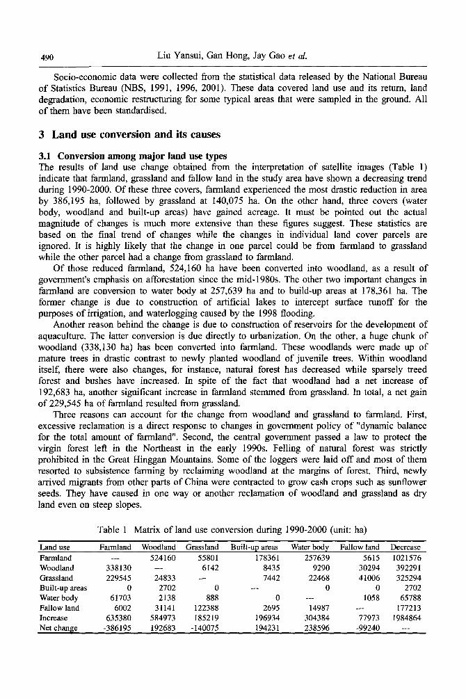
3.1 Conversion among major land use types The results of land use change obtained from the interpretation of satellite images (Table 1) indicate that farmland, grassland and fallow land in the study area have shown a decreasing trend during 1990-2000. Of these three covers, farmland experienced the most drastic reduction in area by 386,195 ha, followed by grassland at 140,075 ha. On the other hand, three covers (water body, woodland and built-up areas) have gained acreage. It must be pointed out the actual magnitude of changes is much more extensive than these figures suggest. These statistics are based on the final trend of changes while the changes in individual land cover parcels are ignored. It is highly likely that the change in one parcel could be from farmland to grassland while the other parcel had a change from grassland to farmland.
Of those reduced farmland, 524,160 ha have been converted into woodland, as a result of government's emphasis on afforestation since the mid-1980s. The other two important changes in farmland are conversion to water body at 257,639 ha and to build-up areas at 178,361 ha. The former change is due to construction of artificial lakes to intercept surface runoff for the purposes of irrigation, and waterlogging caused by the 1998 flooding.
Another reason behind the change is due to construction of reservoirs for the development of aquaculture. The latter conversion is due directly to urbanization. On the other, a huge chunk of woodland (338,130 ha) has been converted into farmland. These woodlands were made up of mature trees in drastic contrast to newly planted woodland of juvenile trees. Within woodland itself, there were also changes, for instance, natural forest has decreased while sparsely treed forest and bushes have increased. In spite of the fact that woodland had a net increase of 192,683 ha, another significant increase in farmland stemmed from grassland. In total, a net gain of 229,545 ha of farmland resulted from grassland.
Three reasons can account for the change from woodland and grassland to farmland. First, excessive reclamation is a direct response to changes in government policy of "dynamic balance for the total amount of farmland". Second, the central government passed a law to protect the virgin forest left in the Northeast in the early 1990s. Felling of natural forest was strictly prohibited in the Great Hinggan Mountains. Some of the loggers were laid off and most of them resorted to subsistence farming by reclaiming woodland at the margins of forest. Third, newly arrived migrants from other parts of China were contracted to grow cash crops such as sunflower seeds. They have caused in one way or another reclamation of woodland and grassland as dry land even on steep slopes.
Table 1 Matrix of land use conversion during 1990-2000 (unit: ha)
Land use Farmland Woodland Grassland Built-up areas Water body
Farmland --- 524160 55801 178361 257639 Woodland 338130 --- 6142 8435 9290 Grassland 229545 24833 --- 7442 22468 Built-up areas 0 2702 0 --- 0 Water body 61703 2138 888 0 --- Fallow land 6002 31141 122388 2695 14987 Increase 635380 584973 185219 196934 304384 Net change -386195 192683 -140075 194231 238596
Fallow land Decrease
5615 1021576 30294 392291 41006 325294
0 2702 1058 65788
--- 177213 77973 1984864
-99240 ---
The causes and environmental effects of land use conversion during 491
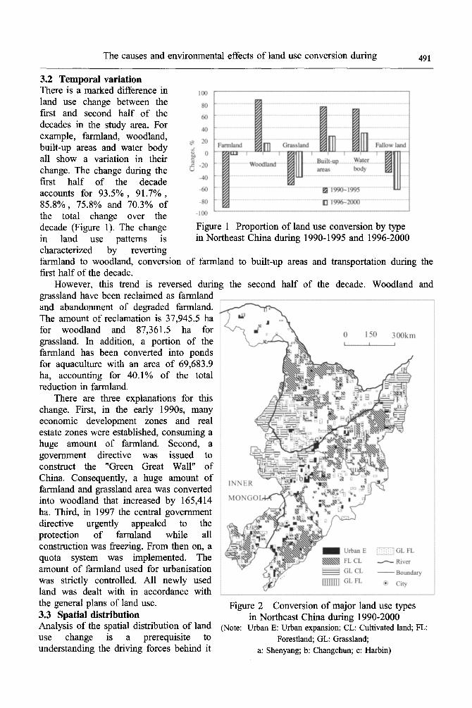
3.2 Temporal variation There is a marked difference in land use change between the first and second half of the decades in the study area. For example, farmland, woodland, built-up areas and water body all show a variation in their change. The change during the first half of the decade accounts for 93.5%, 91.7%, 85.8%, 75.8% and 70.3% of the total change over the decade (Figure 1). The change in land use patterns is characterized by reverting
Figure 1 Proportion of land use conversion by type in Northeast China during 1990-1995 and 1996-2000
farmland to woodland, conversion of farmland to built-up areas and transportation during the first half of the decade.
However, this trend is reversed during the second half of the decade. Woodland and grassland have been reclaimed as farmland and abandonment of degraded farmland. The amount of reclamation is 37,945.5 ha for woodland and 87,361.5 ha for grassland. In addition, a portion of the farmland has been converted into ponds for aquaculture with an area of 69,683.9 ha, accounting for 40.1% of the total reduction in farmland.
There are three explanations for this change. First, in the early 1990s, many economic development zones and real estate zones were established, consuming a huge amount of farmland. Second, a government directive was issued to construct the "Green Great Wall" of China. Consequently, a huge amount of farmland and grassland area was converted into woodland that increased by 165,414 ha. Third, in 1997 the central government directive urgently appealed to the protection of farmland while all construction was freezing. From then on, a quota system was implemented. The amount of farmland used for urbanisation was strictly controlled. All newly used land was dealt with in accordance with the general plans of land use. Figure 2 Conversion of major land use types 3.3 Spatial distribution in Northeast China during 1990-2000 Analysis of the spatial distribution of land (Note: Urban E: Urban expansion; CL: Cultivated land; FL: use change is a prerequisite to Forestland; GL: Grassland; understanding the driving forces behind it a: Shenyang; b: Changchun; c: Harbin)
492 Liu Yansui, Gan Hong, Jay Gao et cd.
at the regional scale, and to monitoring and predicting its dynamics in the future. The observed changes in land use over the study area exhibit a unique pattem of spatial distribution associated closely with regional landform.
Rapid development of towns and cities and some high-tech agro-zones occurred along the Shenyang and Harbin transportation corridor. This has led to the expansion of built-up areas. Because of topography, there was little change in land cover in Great and Little Hinggan Mountains and in the east where the land is hilly. Change from farmland to woodland took place in the west of the study area where grazing and farming are interlocked. To a large degree, this change was the benign outcome of "returning farmland to forestland". Most of the conversion of grassland into farmland took place in the west and in the Sanjiang Plain. In addition, about one third of the hilly grassland area in Northwest Liaoning Province has been reclaimed as farmland. The change from woodland to farmland took place in hilly areas around the margin of virgin forest (Figure 2). Besides, water body in Baicheng and Da'an in Jilin Province has also decreased. Expansion of grassland was restricted to the border of the agro-pastoral interlocked region in the western part of the study area where there is a severe problem of farmland degradation. Consequently, fallow land has also shown a trend of growth here.
4 Environmental effects of land use conversion
Land use changes in Northeast China have modified the regional environment in return. The issue of environmental degradation resulted from agrarian reform in Heilongjiang Province during 1978-1995 has been covered by Muldavin (1997). The following discussion will concentrate on the negative enviromnental changes that are associated closely with the changes in land use. 4.1 Land degradation
(1) The western part of the study area is a farming and grazing interlocked region having a semiarid climate (Liu and Gao, 2003). Despite the establishment of a wind break system known as "Green Great Wall" through afforestation, it has not been properly maintained and protected in the 1990s due to inadequate government funding. Illegal logging for timber and firewood has severely damaged it and reduced its effectiveness. Soil quality is one of the most important environmental factors in sustaining the global biosphere and developing sustainable agricultural practices (Fu, 2003). Tilled farmland with a denuded surface is much more vulnerable to soil erosion and land degradation than grassland. After land fertility is reduced to a certain extent, farming is no longer viable, resulting in farmland abandonment.
(2) Abandonment of farmland reclaimed from grassland fuels the advance of sand dunes that are crawling slowly eastwards from arid western China under the action of predominantly northwesterly wind regime, threatening the productive farmland in the Song-Liao Plain. The front of the dunes has reached the north of Nong'an county, the hinterland of the Song-Liao Plain. A sand belt formed in Liaoning Province is moving swiftly eastward and northeastward, merely 60 km away from the provincial capital Changchun. Another belt of mobile sand dunes measured 40 km long by 200-500 m wide has formed to the south of Harbin. Urgent action is needed to stop the advance of these sand dunes.
(3) Salinized land increased by 11,352 ha in Northeast China, most of which was found in Jilin Province. In its west salinized land had been expanding at an annual rate of 2.1% during 1900-2000 (Qiu eta]., 2003). Physiographically, most of the salinized land was distributed in the Song-Nen Plain where as much as 1.8 • 106 ha of land has been salinized. The majority of the newly salinized land was associated with change of grassland into farmland through land reclamation. Removal of surficial vegetation accelerated evaporation, bringing salt from deep down to the surface. Salinization has reduced farmland productivity. In the worst case, it has led to abandonment of the reclaimed farmland.
The causes and environmental effects of land use conversion during 493
4.2 Increased flooding The most frequent flooding takes place within the catchment of the Nenjiang River inside Jilin and Heilongjiang provinces. In contemporary history this zone was badly affected by only two torrent flooding events in 1969 and 1989. However, severe flooding has become much more frequent at a temporal interval of two to three years since the 1980s (Xu et al., 2003). The worst ever flooding in the recorded history occurred in 1998. This calamity affected 17.3 • 106 people and inundated 33.0 • 104 ha farmland.
To a large degree the increased frequency and magnitude of flooding can be traced back to inappropriate reclamation of wetland as rice paddy and to deforestation. Reclamation of marshland in the middle and lower reaches of the Nenjiang River as rice paddies to boost grain output is the cause for reduced wetland in the Sanjiang River Plain (Wang et al., 2003). Such a reclamation practice has drastically reduced the buffer zone for rainwater, causing water level of the River to rise sharply during heavy rainfall.
Massive scale changes in land cover has not only reduced forest coverage but also contributed to flooding. Since 1995 forest coverage in the watershed of the Nenjiang River decreased continuously from 61.11% to 58.1%. Deforestation and destruction of grassland have severely altered water distribution on land surface. Instead of percolating downward, most of the surface runoff enters the channel directly during heavy rain, carrying soil from denuded farmland with. Consequently, river channels are severely blocked by sedimentation of silt washed down from the reclaimed farmland while the riverbed is raised substantially debilitated the river system for coping with flooding. 4.3 Modified climatic regime Marshland in Northeast China has been in steady decline over the last 20 years as a consequence of its reclamation as dry field. For instance, 80% of the wetland along the banks of the Hulan River has been reclaimed. Wetland surface has an energy balance that differs drastically from the dry field surface in that more solar energy is consumed for evaporation. With its conversion into dry cropland, wetland areas will experience a climate warming locally as less energy is needed for evaporation, leaving more energy available for raising the air temperature. Reduced evaporation from wetland has also reduced the atmospheric moisture content and altered its circulation pattern in the atmosphere. During the 1960s summer temperature in the Sanjiang Plain region remained steady in spite of the warming trend in the northern hemisphere (Yan et a/., 2001). Since the mid-1970s spring, summer and annual temperatures all have showed signs of warming. By the late 1990s spring, autumn, winter as well as annual temperatures raised rapidly, a trend coinciding with reclaimed 1.95 • 106 ha of wetland as cultivated field.
5 Conclus ions
This study aims at the transformation of regional economy and the process of adjusting agricultural structure in Northeast China during the last decade. The extensive changes in land use in the Northeast were due largely to centralized decision-making behind land use. The majority of these changes were restricted to within farmland, woodland, grassland, water body, and built-up areas. There was a marked temporal disparity in these changes; most of the changes were confined to the first half of the decade, they were highly coincidental with a period when the national policies of land use went drastic revisions. Especially lack of consistency in government land use policy played a significant role in the chaotic and occasionally devastating changes identified in this study. The inconsistency between decision making at the macro-level and the objective of agricultural production at the micro-level is the internal force behind the rapid change in land use.
The detected changes in land use can be attributed to both climatic variation and institutional constraints. Climate warming created the natural environment ~'or grassland and fallow land to be changed to farmland, and dry land to paddies. In turn, changes in land use have adversely
494 Liu Yansui, Gan Hong, Jay Gao et al.
influenced the local environment by accelerating desertification in the ago-pas tora l interlocked west, causing salinization in the Song-Nen Plain, and exasperating flooding in the catchments area o f the Nenjiang and Songhua rivers.
Acknowledgements The authors would like to thank Prof. Paul Frederic at the University of Maine for his helpful suggestions on the earlier version of this paper.
References Fischer G, Sun L, 2001. Model based analysis of future land-use development in China. Agriculture Ecosystems
and Ent, ironment, 85(1-3): 163-176. Fu B J, Liu S L, Lu Y H et al., 2003. Comparing the soil quality changes of different land uses determined by two
quantitative methods. Journal of Environmental Sciences, 15(2): 167-172. Liu J Y, Deng X Z, Liu M L, 2002. Study on the spatial patterns of land-use change and analyses of driving
forces in northeastern China during 1990-2000. Chinese Geographical Science, 12(4): 299-308. Liu Y S, 1999. Optimal Regional Land Use Allocation. Beijing: Xueyuan Press, 55-56. (in Chinese) Liu Y S, Gao J, Yang Y F, 2003. A holistic approach towards assessment of severity of land degradation along
the Great Wall in northern Shaanxi Province, China. Environmental Monitoring and Assessment, 82(2): 187-202. Lo C P, Yang X, 2002. Drivers of land-use/land-cover changes and dynamic modeling for the Atlanta, Georgia
metropolitan area. Photogrammetric Engineering and Remote Sensing, 68( 10): 1073-1082. Muldavin J S S, 1997. Environmental degradation in Heilon~iang: policy reform and agrarian dynamics in China's
new hybrid economy. A nnals of the Association of A merican Geographers, 87(4): 579-613. Qiu S W, Zhang B, Wang Z C, 2003. Status, features and management practices of land desertification in the west
of Jilin Province. Scientia Geographica Sinica, 23(2): 188-192. (in Chinese) Qu W, Fan H Y, 2003. "New Northeast Phenomenon" and the strategies for increasing grain production and
agricultural income in Northeast China. Frontline of Social Science, (1): 70-76. (in Chinese) Seto K C, Woodcock C E, Song C eta/., 2002. Monitoring land-use change in the Pearl River Delta using Landsat
TM. International Journal of Remote Sensing, 23(10): 1985-2004. Turner I IB L, Meyer W B, Skole D L, 1994. Global land-use/land-cover change: towards an integrated study.
Ambio, 23(1): 91-95. Wang A H, Zhang S Q, Zhang B, 2003. A study on the change of spatial pattern of wetland in the Sanjiang Plain.
Acta Ecologica Sinica, 23(2): 237-243. (in Chinese) Xu S G, Dang L W, Mu Z L, 2003. Environment impact analysis of Nen River's severe flood in 1998. Journal of
Dalian University of Technology, 43(1): 114-118. (in Chinese) Yan M H, Deng W, Chert P Q, 2002. Climate change in the Sanjiang Plain disturbed by large scale reclamation.
Journal of Geographical Sciences, 12(4): 405-412. Yan M H, Deng W, Ma X H, 2001. Climate variation in the Sanjiang Plain disturbed by large scale reclamation
during the last 45 years. Acta Geographica Sin&a, 56(2): 159-170. (in Chinese)