the 2011 off the pacific coast of tohoku earthquake … earth planets space, 63, 663–667, 2011...
TRANSCRIPT
LETTER Earth Planets Space, 63, 663–667, 2011
The 2011 off the Pacific coast of Tohoku Earthquake related toa strong velocity gradient with the Pacific plate
Makoto Matsubara1 and Kazushige Obara2
1National Research Institute for Earth Science and Disaster Prevention, Tsukuba, Japan2Earthquake Research Institute, the University of Tokyo, Tokyo, Japan
(Received April 10, 2011; Revised May 15, 2011; Accepted May 18, 2011; Online published September 27, 2011)
We conduct seismic tomography using arrival time data picked by NIED Hi-net, including earthquakes off thecoast, outside the seismic network. For these offshore events, we use the NIED F-net focal depth. We detecttwo low-V zones in the uppermost subducting oceanic crust. The landward low-V zone with a large anomalycorresponds to the western edge of the coseismic slip zone of the 2011 off the Pacific coast of Tohoku Earthquake.The asperities of the previously known Off-Miyagi and Off-Fukushima earthquakes with magnitudes around 7.0are also located at the boundary of the low-V and the eastern high-V zones. The initial break point (hypocenter)is associated with the edge of a slightly low-V and low-Vp/Vs zone. The trenchward low-V and low-Vp/Vs zoneextending southwestward from the hypocenter may indicate the existence of a subducted seamount. The high-Vzone and low-Vp/Vs zone might have accumulated the strain and resulted in the huge coseismic slip zone of the2011 Tohoku Earthquake. The low-V and low-Vp/Vs zone is a slight fluctuation within the high-V zone andmight have acted as the initial break point of the 2011 Tohoku Earthquake.Key words: Seismic tomography, the 2011 off the Pacific coast of Tohoku Earthquake, high-V coseismic slipzone, seamount, NIED Hi-net, NIED F-net, low-V oceanic crust, asperity.
1. IntroductionThe 2011 off the Pacific coast of Tohoku Earthquake oc-
curred on March 11, 2011. There are few studies (e.g.Zhao et al., 2007) of the velocity structure near the Japantrench using data from inland seismic stations. It is diffi-cult to investigate the velocity structure beneath the oceanwith only the inland seismic stations because of the largeuncertainty in earthquake focal depth outside of the seismicnetwork. Zhao et al. (2007) estimated the velocity struc-ture near the Japan trench using the focal depths constrainedby sP converted waves. The broadband seismograph net-work (F-net) operated by National Research Institute forEarth Science and Disaster Prevention (NIED) determinesthe focal depths of events with magnitudes larger than 3.5using a Green’s function approach (Okada et al., 2004).For the events distant from the seismic network, the depthdetermined by NIED F-net is more reliable than that de-termined by the high sensitivity seismograph network (Hi-net) operated by NIED, since there are no stations abovethe hypocenter. However, NIED determines reliable arrivaltimes from those events at onshore stations. To use thosedata effectively, we combined the arrival time data pickedby NIED Hi-net and the focal depth determined by NIEDF-net. By using the distant events off the coast, we canobtain the velocity structure of the lower crust, the uppermantle, and the plate boundary from the trench to the island
Copyright c© The Society of Geomagnetism and Earth, Planetary and Space Sci-ences (SGEPSS); The Seismological Society of Japan; The Volcanological Societyof Japan; The Geodetic Society of Japan; The Japanese Society for Planetary Sci-ences; TERRAPUB.
doi:10.5047/eps.2011.05.018
arc.
2. Data, Method, Resolution, and Comparisonwith the Results of OBS
The target region, 20–48◦N and 120–148◦E, covers theJapanese Islands from Hokkaido to Okinawa. Matsubaraet al. (2008) used only the earthquakes at depths of 0–200 km within 50 km of Hi-net stations and some eventsat depths of 200–425 km outside of the network. In thepresent study, we use the events off the coast whose focaldepths are determined by NIED F-net. The depths of theevents off the coast are not well determined with only thestations in land. NIED F-net determines moment tensor so-lutions using long-period (20–50 s) waves by comparing theGreen’s function database calculated with intervals of 3 indepth and 5 km in the horizontal direction (Fukuyama etal., 1998) using a layered 1-D velocity structure. Some-times the NIED Hi-net system determines the depths of off-shore earthquakes deeper than the true depths because ofthe lack of stations above the hypocenters and traveltimedata of P- and S-waves observed at stations distributed onlyon the west side of the hypocenters. Those events are lo-cated deeper as they get close to the trench in spite of theplate boundary becoming shallower. Earthquakes with low-angle thrust focal mechanism determined by NIED F-nettend to get shallower close to the trench along the subduct-ing Pacific plate. We fix the depth of those events as de-termined by NIED F-net. We conduct seismic tomographywith those data and relocate only the horizontal location inthe inversion. A total of manually picked 4,622,346 P-waveand 3,062,846 S-wave arrival times for 100,733 earthquakes
663
664 M. MATSUBARA AND K. OBARA: STRONG VELOCITY GRADIENT WITH THE 2011 TOHOKU EARTHQUAKE
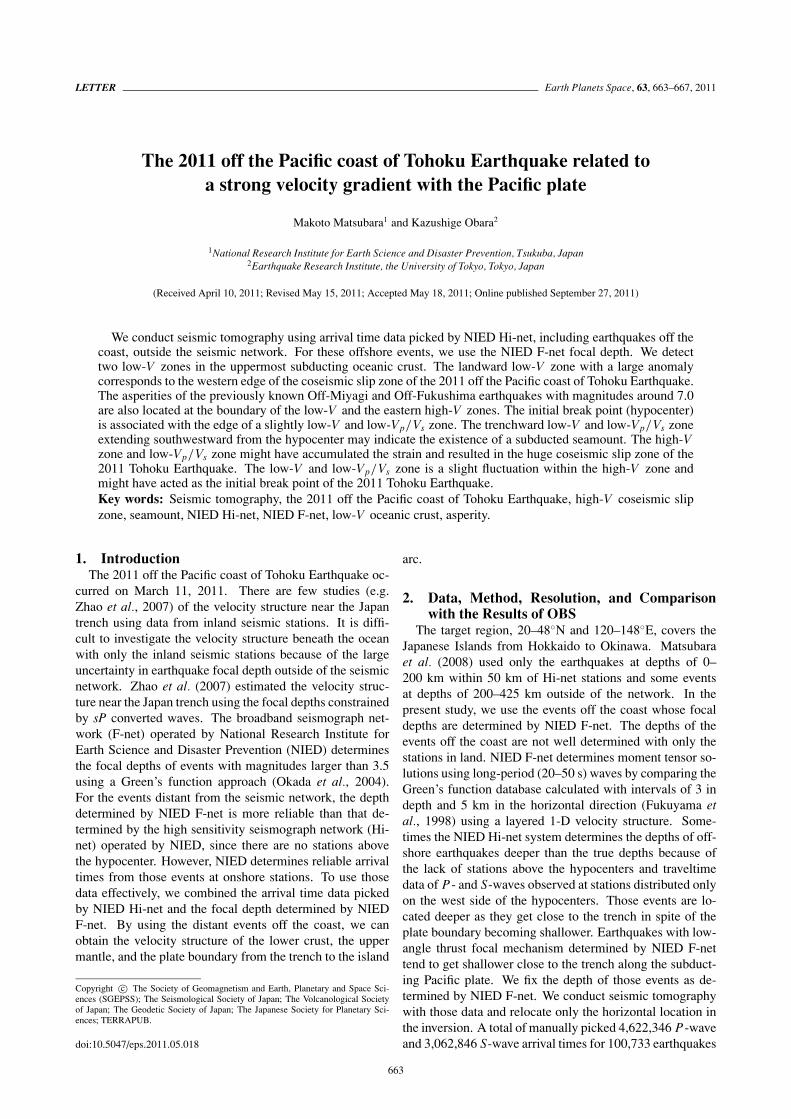
Fig. 1. Distribution of hypocenters and seismic stations used in thisstudy. Black dots and brown crosses denote the hypocenters and seismicstations, respectively. Blue lines denote the coastline and prefectureboundaries. Red lines show the plate boundaries at the surface.
Table 1. Grid interval and resolution size.
DepthGrid interval Resolution/Checkerboard pattern
Horizontal Vertical Horizontal Vertical
0–10 2.5 km 5 km
10–40 5 km 10 km
40–600.1◦ 10 km
0.2◦ 20 km
60–180 15 km 30 km
180–300 20 km 40 km
300– 25 km 50 km
recorded at 1,212 stations (Fig. 1) from October 2000 to Au-gust 2009 are available for use in the tomographic method.These stations are maintained by multiple organizations in-cluding NIED, the Japan Meteorological Agency (JMA),and universities. The details of this method are explainedin Matsubara et al. (2004, 2005). The data set consists ofmanually picked data; NIED picks the arrival time at sta-tions as distant from the epicenter as possible.
We follow the technique of Matsubara et al. (2004,2005), who introduced spatial velocity correlation and sta-tion corrections to the original code of Zhao et al. (1992).Grid nodes were placed with a separation smaller than thespatial resolution, with smoothing performed in order to sta-bilize the solution. The inverse problem is then solved withthe LSQR algorithm (Nolet, 1987) since we can assume ar-bitrary damping matrix with a combination of diagonal andsmoothing matrices.
We employ a 3D grid net to construct the velocity (slow-ness) structure. The grid spacing is shown in Table 1. The1D structure used in the routine determination of hypocen-
ters at NIED (Ukawa et al., 1984) is used as the initialmodel. We do not impose velocity discontinuities in thisstudy since incorrect configuration of the boundaries wouldlead to an incorrect solution.
We solve for the location and origin time of all the earth-quakes as well as the P and S-wave slowness at each gridpoint with more than 10 associated rays. In the final iter-ation, we estimate the P-wave slowness at 458,234 nodesand the S-wave slowness at 347,037 nodes. The inver-sion reduces the root mean square of the P-wave traveltimeresidual from 0.455 s to 0.187 s and that of the S-wave datafrom 0.692 s to 0.228 s after eight iterations.
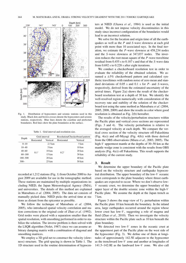
We conduct a checkerboard resolution test in order toevaluate the reliability of the obtained solution. We as-sumed a ±5% checkerboard pattern and calculated syn-thetic traveltimes with random noise of zero mean and stan-dard deviations of 0.05 s and 0.1 s for P- and S-waves,respectively, derived from the estimated uncertainty of thearrival times. Figure 2(a) shows the result of the checker-board resolution test at a depth of 30 km. We identify thewell-resolved region numerically with consideration of therecovery rate and stability of the solution of the checker-board test using the same method as Matsubara et al. (2004,2005, 2008, 2009) and show the results in color where goodresolution is obtained as Fig. 2(b) hereafter.
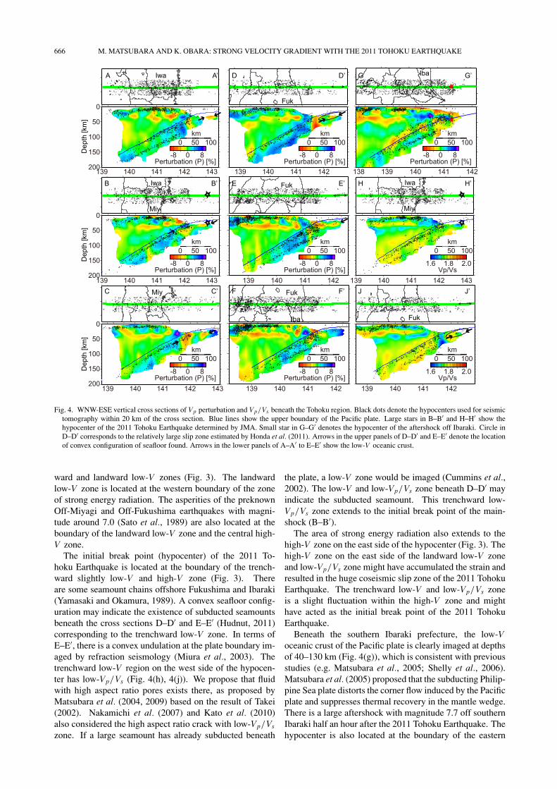
The results of the velocity/perturbation structures withinthe Pacific plate and vertical cross sections are represented(Figs. 3 and 4). The velocity perturbation is relative tothe averaged velocity at each depth. We compare the ver-tical cross section of the velocity structure off-Fukushima(Fig. 4(e)) and off-Miyagi (Fig. 4(b)) with those derivedfrom the OBS observations (Miura et al., 2003, 2005). Thehigh-V uppermost mantle at the depths of 30–50 km as themantle wedge zone is consistent with the results from OBSanalysis (Fig. 4(e)) off Fukushima. This result supports thereliability of the current study.
3. ResultWe determine the upper boundary of the Pacific plate
based on the velocity structure and earthquake hypocen-tral distribution. The upper boundary of the low-V oceaniccrust corresponds to the plate boundary where thrust earth-quakes are expected to occur. Where we don’t observe low-V oceanic crust, we determine the upper boundary of theupper layer of the double seismic zone within the high-VPacific plate. We assume the depth at the Japan trench as7 km.
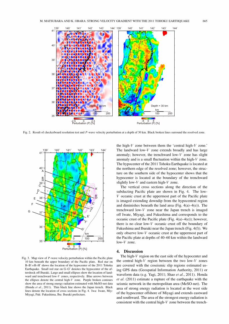
Figure 3 shows the map view of VP perturbation withinthe Pacific plate 10 km beneath the boundary. In the inlandarea, large earthquakes occurred around the region whoselower crust has low-V , suggesting a role of magma andfluid (Zhao et al., 2010). Then we investigate the velocitystructure within the Pacific plate such as 10 km beneath theplate boundary.
We detected two low-V zones in the oceanic crust atthe uppermost part of the Pacific plate on the west side ofthe hypocenter (Fig. 3). We define one of them at longi-tudes of approximately 142.5E adjacent to the hypocenteras the trenchward low-V zone and another at longitudes of141.5–142.0E as the landward low-V zone. We also call
M. MATSUBARA AND K. OBARA: STRONG VELOCITY GRADIENT WITH THE 2011 TOHOKU EARTHQUAKE 665
Fig. 2. Result of checkerboard resolution test and P-wave velocity perturbation at a depth of 30 km. Black broken lines surround the resolved zone.
Fig. 3. Map view of P-wave velocity perturbation within the Pacific plate10 km beneath the upper boundary of the Pacific plate. Red star onB–B′=H–H′ shows the location of the hypocenter of the 2011 TohokuEarthquake. Small red star on G–G′ denotes the hypocenter of the af-tershock off Ibaraki. Large and small ellipses show the location of land-ward and trenchward low-V zones, respectively. Blue arrows betweenthe ellipses denote the central high-V zone. Purple broken contoursshow the area of strong energy radiation estimated with MeSO-net data(Honda et al., 2011). Thin black line shows the Japan trench. Blacklines denote the location of cross sections in Fig. 4. Iwa: Iwate, Miy:Miyagi, Fuk: Fukushima, Iba: Ibaraki prefecture.
the high-V zone between them the ‘central high-V zone.’The landward low-V zone extends broadly and has largeanomaly; however, the trenchward low-V zone has slightanomaly and is a small fluctuation within the high-V zone.The hypocenter of the 2011 Tohoku Earthquake is located atthe northern edge of the resolved zone; however, the struc-ture on the southern side of the hypocenter shows that thehypocenter is located at the boundary of the trenchwardslightly low-V and eastern high-V zone.
The vertical cross sections along the direction of thesubducting Pacific plate are shown in Fig. 4. The low-V oceanic crust at the uppermost part of the Pacific plateis imaged extending downdip from the hypocentral regionand diminishes beneath the land area (Fig. 4(a)–4(e)). Thetrenchward low-V zone near the Japan trench is imagedoff Iwate, Miyagi, and Fukushima and corresponds to theoceanic crust of the Pacific plate (Fig. 4(a)–4(e)); however,there is no clear low-V oceanic crust off the boundary ofFukushima and Ibaraki near the Japan trench (Fig. 4(f)). Weonly observe low-V oceanic crust at the uppermost part ofthe Pacific plate at depths of 40–60 km within the landwardlow-V zone.
4. DiscussionThe high-V region on the east side of the hypocenter and
the central high-V region between the two low-V zonesare covered with the coseismic slip regions estimated us-ing GPS data (Geospatial Information Authority, 2011) orwaveform data (e.g. Yagi, 2011; Shao et al., 2011). Hondaet al. (2011) estimate a rupture of the earthquake with theseismic network in the metropolitan area (MeSO-net). Thearea of strong energy radiation is located at the west sideof the hypocenter offshore of Miyagi and extends eastwardand southward. The area of the strongest energy radiation isconsistent with the central high-V zone between the trench-
666 M. MATSUBARA AND K. OBARA: STRONG VELOCITY GRADIENT WITH THE 2011 TOHOKU EARTHQUAKE
Fig. 4. WNW-ESE vertical cross sections of Vp perturbation and Vp/Vs beneath the Tohoku region. Black dots denote the hypocenters used for seismictomography within 20 km of the cross section. Blue lines show the upper boundary of the Pacific plate. Large stars in B–B′ and H–H′ show thehypocenter of the 2011 Tohoku Earthquake determined by JMA. Small star in G–G′ denotes the hypocenter of the aftershock off Ibaraki. Circle inD–D′ corresponds to the relatively large slip zone estimated by Honda et al. (2011). Arrows in the upper panels of D–D′ and E–E′ denote the locationof convex configuration of seafloor found. Arrows in the lower panels of A–A′ to E–E′ show the low-V oceanic crust.
ward and landward low-V zones (Fig. 3). The landwardlow-V zone is located at the western boundary of the zoneof strong energy radiation. The asperities of the preknownOff-Miyagi and Off-Fukushima earthquakes with magni-tude around 7.0 (Sato et al., 1989) are also located at theboundary of the landward low-V zone and the central high-V zone.
The initial break point (hypocenter) of the 2011 To-hoku Earthquake is located at the boundary of the trench-ward slightly low-V and high-V zone (Fig. 3). Thereare some seamount chains offshore Fukushima and Ibaraki(Yamasaki and Okamura, 1989). A convex seafloor config-uration may indicate the existence of subducted seamountsbeneath the cross sections D–D′ and E–E′ (Hudnut, 2011)corresponding to the trenchward low-V zone. In terms ofE–E′, there is a convex undulation at the plate boundary im-aged by refraction seismology (Miura et al., 2003). Thetrenchward low-V region on the west side of the hypocen-ter has low-Vp/Vs (Fig. 4(h), 4(j)). We propose that fluidwith high aspect ratio pores exists there, as proposed byMatsubara et al. (2004, 2009) based on the result of Takei(2002). Nakamichi et al. (2007) and Kato et al. (2010)also considered the high aspect ratio crack with low-Vp/Vs
zone. If a large seamount has already subducted beneath
the plate, a low-V zone would be imaged (Cummins et al.,2002). The low-V and low-Vp/Vs zone beneath D–D′ mayindicate the subducted seamount. This trenchward low-Vp/Vs zone extends to the initial break point of the main-shock (B–B′).
The area of strong energy radiation also extends to thehigh-V zone on the east side of the hypocenter (Fig. 3). Thehigh-V zone on the east side of the landward low-V zoneand low-Vp/Vs zone might have accumulated the strain andresulted in the huge coseismic slip zone of the 2011 TohokuEarthquake. The trenchward low-V and low-Vp/Vs zoneis a slight fluctuation within the high-V zone and mighthave acted as the initial break point of the 2011 TohokuEarthquake.
Beneath the southern Ibaraki prefecture, the low-Voceanic crust of the Pacific plate is clearly imaged at depthsof 40–130 km (Fig. 4(g)), which is consistent with previousstudies (e.g. Matsubara et al., 2005; Shelly et al., 2006).Matsubara et al. (2005) proposed that the subducting Philip-pine Sea plate distorts the corner flow induced by the Pacificplate and suppresses thermal recovery in the mantle wedge.There is a large aftershock with magnitude 7.7 off southernIbaraki half an hour after the 2011 Tohoku Earthquake. Thehypocenter is also located at the boundary of the eastern
M. MATSUBARA AND K. OBARA: STRONG VELOCITY GRADIENT WITH THE 2011 TOHOKU EARTHQUAKE 667
low- and western high-V zones.
5. ConclusionWe combine the NIED F-net hypocentral and Hi-net ar-
rival time data and apply seismic tomography to estimatethe seismic velocity structure outside of the network. Weobtain the horizontal 20-km and vertical 10-km scale struc-ture near the Japan trench. There are two low-V zoneswithin the subducting oceanic crust. The landward low-Vzone with a large anomaly is consistent with the westernedge of the coseismic slip zone of the 2011 off the Pacificcoast of Tohoku Earthquake. The asperities of the previ-ously known Off-Miyagi and Off-Fukushima earthquakeswith magnitudes around 7.0 are also located at the boundaryof the landward low-V zone and the central high-V zone.The zone beneath the initial break point of the 2011 To-hoku Earthquake is associated with the edge of the slightlylow-V and low-Vp/Vs zone corresponding to the boundaryof the low- and high-V zone. The trenchward low-V andlow-Vp/Vs materials extending to the southwest from thehypocenter may indicate a subducted seamount. The high-V zone on the east side of the landward low-V zone andlow-Vp/Vs zone might have accumulated the strain and re-sulted in the huge coseismic slip zone of the 2011 TohokuEarthquake. The low-V and low-Vp/Vs zone is a slightfluctuation within the high-V zone and might have actedas the initial break point of the 2011 Tohoku Earthquake.
Acknowledgments. We used the seismic data provided by theNational Research Institute for Earth Science and Disaster Pre-vention, the Japan Meteorological Agency, Hokkaido University,Hirosaki University, Tohoku University, the University of Tokyo,Nagoya University, Kyoto University, Kochi University, KyushuUniversity, Kagoshima University, the National Institute of Ad-vanced Industrial Science and Technology, the Geographical Sur-vey Institute, Tokyo Metropolis, Shizuoka Prefecture, the HotSprings Research Institute of Kanagawa Prefecture, YokohamaCity, and the Japan Agency for Marine-Earth Science and Tech-nology. We are very grateful to David Shelly for kindly discussingand improving our paper. We also thank William Ellsworth forthe kind discussion and suggestions. We appreciate the many sug-gestions from the two anonymous reviewers. This study was sup-ported by the project on the Operation of Seismograph Networksfor the NIED. Some of the figures were drawn using Generic Map-ping Tools software (Wessel and Smith, 1995) and the softwarefor viewing 3D velocity structures beneath whole Japanese Islands(Matsubara, 2010).
ReferencesCummins, P. R., T. Baba, S. Kodaira, and Y. Kaneda, The 1946 Nankai
earthquake and segmentation of the Nankai Trough, Phys. Earth Planet.Inter., 132, 75–87, 2002.
Fukuyama, E., M. Ishida, D. S. Dreger, and H. Kawai, Automated seismicmoment tensor determination by using on-line broadband seismic wave-forms, Zisin (J. Seismol. Soc. Jpn.), 51, 149–156, 1998 (in Japanese withEnglish abstract).
Geospatial Information Authority, Coseismic slip distribution modelinferred from GEONET data, http://www.gsi.go.jp/cais/topic110315-index-e.html, 2011.
Honda, R., Y. Yukutake, H. Ito, M. Harada, T. Aketagawa, A. Yoshida, S.Sakai, S. Nakagawa, N. Hirata, K. Obara, and H. Kimura, A complexrupture image of the 2011 off the Pacific coast of Tohoku Earthquakerevealed by the MeSO-net, Earth Planets Space, 63, this issue, 583–588, 2011.
Hudnut, K., Deep bank subduction in the 2011 Tohoku earthquake?, EarthPlanets Space, 2011 (submitted).
Kato, A., T. Iidaka, R. Ikuta, Y. Yoshida, K. Katsumata, T. Iwasaki, S.
Sakai, C. Thurber, N. Tsumura, K. Yamaoka, T. Watanabe, T. Kunitomo,F. Yamazaki, M. Okubo, S. Suzuki, and N. Hirata, Variations of fluidpressure within the subducting oceanic crust and slow earthquakes,Geophys. Res. Lett., 37, L14310, doi:10.1029/2010GL043723, 2010.
Matsubara, M., Software for viewing 3D velocity structures beneath wholeJapan islands, Report of the National Research Institute for Earth Sci-ence and Disaster Prevention, 76, 1–9, 2010.
Matsubara, M., N. Hirata, H. Sato, and S. Sakai, Lower crustalfluid distribution in the northeastern Japan arc revealed by highresolution 3D seismic tomography, Tectonophysics, 388, 33–45,doi:10.1016/j.tecto.2004.07.046, 2004.
Matsubara, M., H. Hayashi, K. Obara, and K. Kasahara, Low-velocityoceanic crust at the top of the Philippine Sea and Pacific plates beneaththe Kanto region, central Japan, imaged by seismic tomography, J. Geo-phys. Res., 110, B12304, doi:10.1029/2005JB003673, 2005.
Matsubara, M., K. Obara, and K. Kasahara, Three-dimensional P- and S-wave velocity structures beneath the Japan Islands obtained by high-density seismic stations by seismic tomography, Tectonophysics, 454,86–103, doi:10.1016/j.tecto.2008.04.016, 2008.
Matsubara, M., K. Obara, and K. Kasahara, High-Vp/Vs zone accompa-nying non-volcanic tremors and slow slip events beneath southwest-ern Japan, Tectonophysics, 472, 6–17, doi:10.1016/j.tecto.2008.06.013,2009.
Miura, S., S. Kodaira, A. Nakanishi, T. Tsuru, N. Takahashi, N. Hirata,and Y. Kaneda, Structural characteristics controlling the seismicity ofsouthern Japan Trench fore-arc region, revealed by ocean bottom seis-mographic data, Tectonophysics, 363, 79–102, 2003.
Miura, S., N. Takahashi, A. Nakanishi, T. Tsuru, S. Kodaira, and Y.Kaneda, Structural characteristics off Miyagi forearc region, the JapanTrench seismogenic zone, deduced from a wide-angle reflection and re-fraction study, Tectonophysics, 407, 165–188, 2005.
Nakamichi, H., H. Watanabe, and T. Ohminato, Three-dimensional veloc-ity structures of Mount Fuji and the South Fossa Magna, central Japan,J. Geophys. Res., 112, B03310, doi:10.1029/2005JB004161, 2007.
Nolet, G., Seismic Tomography, D. Reidel Publishing Company, 386 pp,1987.
Okada, Y., K. Kasahara, S. Hori, K. Obara, S. Sekiguchi, H. Fujiwara,and A. Yamamoto, Recent progress of seismic observation networks inJapan—Hi-net, F-net, K-NET and KiK-net—, Earth Planets Space, 56,xv–xxviii, 2004.
Sato, R., K. Abe, Y. Okada, K. Shimazaki, and Y. Suzuki, Handbook ofEarthquake Fault Parameters in Japan, 390 pp., Kajima Shuppankai,Tokyo, 1989 (in Japanese)
Shao, G., X. Li, C. Ji, and T. Maeda, Preliminary result of theMar 11, 2011 Mw 9.1 Honshu Earthquake, http://www.geol.ucsb.edu/faculty/ji/big earthquakes/2011/03/0311/Honshu main.html, 2011.
Shelly, D. R., G. C. Berzoa, H. Zhang, C. H. Thurber, and S. Ide,High-resolution subduction zone seismicity and velocity structurebeneath Ibaraki Prefecture, Japan, J. Geophys. Res., 111, B06311,doi:10.1029/2005JB004081, 2006.
Takei, Y., Effect of pore geometry on VP/VS: from equilibrium geometryto crack, J. Geophys. Res., 107(B2), 2043, doi:10.1029/2001JB000522,2002.
Ukawa, M., M. Ishida, S. Matsumura, and K. Kasahara, Hypocenter de-termination method of the Kanto-Tokai observational network for mi-croearthquakes, Res. Notes Natl. Res. Cent. Disaster Prev., 53, 1–88,1984 (in Japanese with English abstract).
Wessel, P. and W. H. F. Smith, New version of generic mapping toolsreleased, Eos Trans. AGU, 79, 329, 1995.
Yagi, Y., Coseismic slip model of Off the Pacific Coast of Tohoku earth-quake, http://www.geol.tsukuba.ac.jp/ yagi-y/EQ/Tohoku/, 2011.
Yamazaki, T. and Y. Okamura, Subducting seamounts and deformation ofoverriding forearc wedges around Japan, Tectonophysics, 160, 207–229,1989.
Zhao, D., A. Hasegawa, and S. Horiuchi, Tomographic imaging of P andS wave velocity structure beneath northeastern Japan, J. Geophys. Res.,97, 19,909–19,928, 1992.
Zhao, D., Z. Wang, N. Umino, and A. Hasegawa, Tomographic imagingoutside a seismic network application to the northeast Japan arc, Bull.Seismol. Soc. Am., 97, 1121–1132, 2007.
Zhao, D., M. Santosh, and A. Yamada, Dissecting large earthquakes inJapan: Role of arc magma and fluids, Island Arc, 19, 4–16, 2010.
M. Matsubara (e-mail: [email protected]) and K. Obara