temporal and spatial changes of karst rocky desertification in ecological reconstruction region of...
TRANSCRIPT
ORIGINAL ARTICLE
Temporal and spatial changes of karst rocky desertificationin ecological reconstruction region of Southwest China
Qiyong Yang • Zhongcheng Jiang • Daoxian Yuan •
Zulu Ma • Yunqiu Xie
Received: 2 May 2013 / Accepted: 12 May 2014
� Springer-Verlag Berlin Heidelberg 2014
Abstract Karst rocky desertification (KRD), as a process
of soil degradation, is a limiting factor on enhancing the
life condition of people in Southwest China. Fortunately,
Chinese governments at different levels had taken it seri-
ously, and the ‘Green for Grain’ program was initiated to
treat and protect the fragile environment. In order to assess
the dynamic change of KRD and improve the treatment of
it in the future, Pingguo County, one of the ‘one hundred
typical counties for karst rocky desertification control in
China,’ was chosen as the study area. The results indicated
that the evolution process of KRD landforms in the county
might be divided into two phases: degradation phase
(1994–2001) and ecological reconstruction phase
(2001–2009). In the degradation phase, the area of non-
KRD landform decreased from 1,132.02 km2 in 1994 to
1,056.42 km2 in 2001. In this phase, the area of non-KRD
landform lost 5.51 % to KRD landforms, which mainly
transferred to slight KRD landform with an area of
35.55 km2 counting for 3.14 %. In another hand, the area
of non-KRD gained 27.85 km2, mainly from the slight
KRD landform. As a result the area of non-KRD was
reduced, meaning that the evolution of KRD became
serious. In this phrase, the dynamic change degree of the
slight KRD landform was the minimum, and the area of it
was the largest among the three KRD landforms.
Therefore, transition of slight KRD landform was the main
transition type in this phase. The area of slight KRD
landforms increased 38.77 km2 in the county, which
mostly took place in the middle and southwest karst
regions. In ecological reconstruction phase, the area of
non-KRD landform increased to 1,091.90 km2 in 2009. In
this phase, non-KRD landform gained an area of 22.82 km2
and lost an area of 26.73 km2, major of which from or to
the slight KRD landform. Therefore, the area of non-KRD
landform was increased, implying that the evolution of
KRD became alleviated. In this phase, transition of slight
KRD landform was also the dominant transition type. The
decreased area of slight KRD landform was the largest
among severe, moderate and slight KRD cases in the
southwest karst region, where the ecological reconstruction
projects were initiated. The efficient degrees of KRD
landforms in southwest karst region were the largest in the
four karst regions in this county. This study results may
provide a consultant for rocky desertification control and
ecological restoration in the future.
Keywords Ecological reconstruction � Karst rocky
desertification (KRD) � GIS � Dynamic change �Remote sensing
Introduction
Karst landform is a distinctive topography resulting from
the solution process of acidic water acting on carbonate
bedrocks (Yang et al. 2011a). The concept of karst rocky
desertification (KRD) was firstly proposed in the early
1980s (Williams 1993) and was then defined as a process
of land degradation involving serious soil erosion, exten-
sive exposure of bedrock, a drastic decrease in land
Q. Yang (&) � D. Yuan
School of Geographical Sciences, Southwest University,
Chongqing 400715, China
e-mail: [email protected]
Q. Yang � Z. Jiang (&) � D. Yuan � Z. Ma � Y. Xie
Key Laboratory of Karst Ecosystem and Treatment of Rocky
Desertification, Institute of Karst Geology, Chinese Academy of
Geological Sciences, Guilin 541004, China
e-mail: [email protected]
123
Environ Earth Sci
DOI 10.1007/s12665-014-3348-9

productivity and the appearance of a desert-like landscape
(Li et al. 2009; Wang et al. 2004). Among the three largest
continuous karst regions in the world, Southwest China
boasts the largest area of exposed carbonate and the most
complete array of karst landscape types (Yuan 1993, 1997),
which has become one of the most serious areas of poverty
and environmental degradation in China (Zhang et al.
2010). The region is also overpopulated, and the social
economy is laggard (Zhang et al. 2011). Therefore, people
have to overexploit forest for cultivated land and firewood,
leading to serious land degradation in the form of KRD.
Fortunately, the central and local governments had taken it
seriously, and the ‘Green for Grain’ program was initiated
to protect the fragile environment. After the Chinese gov-
ernment had appointed ‘one hundred typical counties for
karst rocky desertification control,’ they appointed another
‘two hundred typical counties for karst rocky desertifica-
tion control’ in 2011 and a series of important projects have
been carried out.
Many studies on the KRD about the definition (Wang
et al. 2004), causes (Liu et al. 2008; Xiong et al. 2008),
ecological-environmental effects (Zhang et al. 2011) and
preventive strategies (Jiang et al. 2008) have been done. In
addition, some studies about the spatial variability (Huang
and Cai 2006) and temporal variability (Yang et al. 2011a)
of KRD have been conducted. However, study on spatio-
temporal variability of KRD is rare, especially in the area
of KRD control. In this study, a typical county for karst
rocky desertification control, Pingguo County in Guangxi
Zhuang Autonomous Region of Southwest China, was
selected as the study area. The objectives of the study were
(1) to reveal the spatial–temporal variability of KRD in the
area of KRD treatment, and (2) to better understand the
transformation among all types of KRD landforms and to
master the treatment effect of KRD.
Study area
Pingguo County is located in the southwest portion
of Guangxi Zhuang Autonomous Region of Southwest
China (106�3602.5600–106�36028.3600E, 23�53025.8800–23�53040.9400N). It covers approximately an area of
2,485 km2 and includes twelve towns (Fig. 1). It has a
subtropical monsoon humid climate with a mean annual
temperature of 13–14 �C, and an annual mean precipitation
is 1,331 mm for the period from 1958 to 2006. The pre-
cipitation is abundant but seasonally uneven, over 86 % of
which falls during the rainy season (April–October). The
topography is characterized by typical karst peak-cluster
depression landscape (a combination of clustered peaks
with a common base) with the altitude ranging from 110 to
935 m above sea level. The bedrock includes limestone,
dolomite and impure carbonate rock. Karst soil is generally
thin and has an uneven distribution due to a slow soil
formation speed and large spatial variation across the ter-
rain (Li et al. 2003; Wang et al. 2008). Generally, soil
depth is about 20–40 cm on peak-cluster and 100 cm in
depression (Zhang et al. 2006).
With regards to population, this region was reported to
support 496,000 inhabitants in 2009, 82.71 % of which is
agricultural population. The capita farmland area is
0.041 ha, a figure much lower than that of the Chinese
national average of 0.117 ha. Per capita annual net income
of rural households was about 3,451 Yuan in 2009. The
study area is short of surface water resources, cultivated
land and firewood. It is considered to be one of the most
impoverished karst agricultural regions in the world and
was identified as one of the key districts targeted by the
Chinese central government for eliminating poverty in
‘China’s Agenda in twenty-first Century’.
Karst landform is widely spread in this county,
accounting for 62.28 % of the total area, which can be
divided into four karst regions: northeast, middle, east and
southwest karst regions (Fig. 1). The ecological construc-
tion projects were firstly implemented in Guohua Town in
the southwest karst region, then throughout the county. In
2001, The Guohua Ecological Experimental Area was
founded in southwest karst region in Pingguo County. In
the past, the vegetation coverage of southwest karst region
was only 10 % (Jiang et al. 2008), and the area of KRD
landforms accounted 45.22 % (severe, moderate and slight
KRD landforms accounted 2.14, 8.17 and 34.91 %,
respectively). After a series of important ecological
Fig. 1 The location of Pingguo County
Environ Earth Sci
123
construction projects, such as artificial induction of affor-
estation, karst water exploitation and storage, cultivating
ecological industry, karst soil improvement and grass
breeding, had been carried out, the vegetation coverage of
southwest karst region increased from 50 to 70 % in 2005
(Jiang et al. 2008). Today, the knowledge of protecting
karst environment was trained and propagandized widely
in the local people, and the ecological construction projects
have gradually popularized throughout the county.
Materials and methods
Data source and procession
Remote sensing data of November 5, 1994, November 16,
2001 and January 30, 2009 (synthesized satellite TM 5, 4, 3
images), geological map and digital elevation model
(DEM) with the spatial resolution of 30 m of Pingguo
County were adopted in the present case study. Geographic
information systems (GIS), remote sensing and statistical
techniques were utilized to examine the evolution. The
extraction of KRD was realized on the Environment for
Visualizing Images (ENVI4.6) by compiling programs
with Interactive Data Language (IDL). Spatial analyses of
transition matrix and thematic map were completed on GIS
environment (Arcmap9.2).
Karst rocky desertification (KRD)
KRD distribution was obtained by interpreting Landsat
Images from 1994, 2001 and 2009 in Pingguo County,
according to bedrock exposure rate and slope (Table 1).
The steps used to classify KRD landforms follow (Yang
et al. 2013): (a) extract slope data from DEM; (b) calculate
rock desertification index with desertification index model
(Fraster et al. 1992; Tong 2003; Yang et al. 2012) and
calculate bedrock exposure rate (Price 1993; Zhou et al.
2008; Yang et al. 2012); (c) interpret KRD.
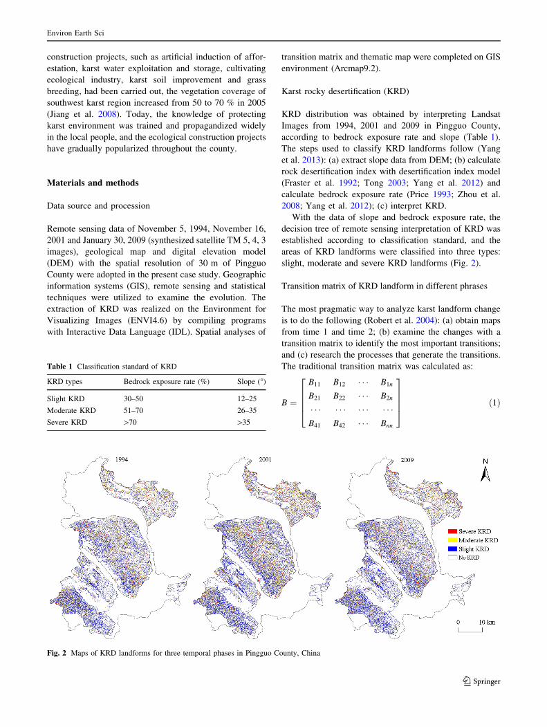
With the data of slope and bedrock exposure rate, the
decision tree of remote sensing interpretation of KRD was
established according to classification standard, and the
areas of KRD landforms were classified into three types:
slight, moderate and severe KRD landforms (Fig. 2).
Transition matrix of KRD landform in different phrases
The most pragmatic way to analyze karst landform change
is to do the following (Robert et al. 2004): (a) obtain maps
from time 1 and time 2; (b) examine the changes with a
transition matrix to identify the most important transitions;
and (c) research the processes that generate the transitions.
The traditional transition matrix was calculated as:
B ¼
B11
B21
� � �B41
B12
B22
� � �B42
� � �� � �� � �� � �
B1n
B2n
� � �Bnn
26664
37775 ð1Þ
Table 1 Classification standard of KRD
KRD types Bedrock exposure rate (%) Slope (�)
Slight KRD 30–50 12–25
Moderate KRD 51–70 26–35
Severe KRD [70 [35
Fig. 2 Maps of KRD landforms for three temporal phases in Pingguo County, China
Environ Earth Sci
123

wherein the rows display the area percentage of KRD
types of time 1 and the columns display the types of time
2. The notation Bij denotes the area percentage of the
landscape that experiences a transition from type i to type
j where the number of types is J. Entries on the diagonal
indicate persistence; thus, Bij denotes the area percentage
of the landscape that shows persistence of type j. Entries
off the diagonal indicate a transition from type i to a dif-
ferent type j.
Dynamic change degree of KRD
In order to reflect the changes of KRD spanning 15 years
and to assess the effect of KRD control, analysis of
dynamic degree and efficient degree was used in this study.
Dynamic degree of KRD mainly reflects the changes of
KRD landforms in a certain period of time in the study
area. Efficient degree is used to assess the effect of KRD
control after the ecological reconstruction projects had
been carried out in the county. They could be described as
follows (Li et al. 2008; Yang et al. 2011b):
Ki ¼Ub � Ua
Ua
� 1
T� 100 % ð2Þ
Ei ¼Ub � Ua
U� 100 % ð3Þ
where Ki is singer dynamic change degree of KRD; Ua and Ub
are the areas of time 1 and time 2 of KRD; T is the time span
from Ua and Ub; Ei is efficient degree of the control effect of
KRD; U is the area of the corresponding karst region.
Results
For purpose of understanding the spatiotemporal variability
of KRD in Pingguo County, it is necessary to first generally
describe KRD evolution from 1994 to 2009. Through
examining the evolution and transition process of KRD
landforms that took place in the year of 1994 and 2009, it
was found that the areas of KRD landforms reached a peak
in 2001 and then gradually decreased in the county
(Table 2). This trend was closely related to the policies
applied in karst areas of China. So, the evolution process of
KRD in the county was divided into two phases: degra-
dation phase (1994–2001) and ecological reconstruction
phase (2001–2009). And the slight KRD landform was the
major degradation type in the study area, not only because
of its largest area among the KRD landforms but of its
transition taking place (Tables 2, 4). Therefore, the fol-
lowing analysis was on the base of the two phases, and
analysis of slight KRD landform was used to illustrate
variability in the general KRD.
Quantity variability of KRD landforms
Generally, the area of KRD landform in karst areas of
Pingguo County tended to increase in the time period
spanning 15 years (1994–2009). However, the evolution of
KRD landforms was different in the two phases. In deg-
radation phase (1994–2001), the area of KRD increased
and the percentage of it increased from 26.86 to 31.74 %,
and the area of slight, moderate and severe KRD cases
increased from 279.40, 100.64 and 35.68 km2 to 318.17,
122.33 and 50.81 km2, respectively. In ecological recon-
struction phase (2001–2009), ecological reconstruction
measures have played an increasingly important role in the
study area. Percentage of area of KRD landform decreased
to 29.45 %, and the area of slight, moderate and severe
KRD landforms decreased to 304.94 km2, 110.12 and
40.77 km2, respectively (Fig. 2; Table 2).
Spatial characteristics of KRD landforms
KRD landforms in the 3 years had the same spatial dis-
tribution in the Pingguo County (Fig. 2). The areas of each
KRD landforms in the four karst regions were summarized
in Table 2. Severe KRD landforms mainly distributed in
middle and northeast karst regions, while moderate and
slight KRD cases distributed in middle and southwest
regions. In the four karst regions, the slight KRD landform
was the major degradation type, the areas of which were
larger than the sum of the other two KRD cases in the time
period spanning 15 years.
However, significant changes in spatial site and area for
various types of KRD landforms were obvious in the two
Table 2 Statistics of the KRD areas and the area percentage for
different KRD types in Pingguo County (km2)
Year Karst regions Severe Moderate Slight Non-KRD
1994 East 0.11 0.67 3.14 34.03
Middle 16.25 51.39 125.14 135.17
Northwest 12.76 23.57 48.17 591.15
Southwest 6.56 25.01 102.94 371.45
Pingguo County 35.68 100.64 279.40 1,132.02
2001 East 0.13 0.72 4.12 32.98
Middle 22.53 63.59 144.19 97.65
Northwest 18.14 31.22 55.39 570.91
Southwest 10.02 26.80 114.47 354.67
Pingguo County 50.81 122.33 318.17 1,056.42
2009 East 0.09 0.57 3.97 33.32
Middle 20.35 61.07 143.29 103.24
Northwest 16.95 26.42 54.59 577.70
Southwest 3.38 22.06 103.08 377.44
Pingguo County 40.77 110.12 304.94 1,091.90
Environ Earth Sci
123

phases. Table 3 summarized the areas changed of KRD
landforms in the four karst regions. In the degradation
phase, the areas of each KRD landforms increased in the
four karst regions. Except for the northeast region, the
increased areas of slight KRD landforms were larger than
those of severe and moderate KRD cases in the other three
karst regions. The area of slight KRD landforms increased
38.77 km2 in the county, which mostly occured in the
middle and southwest karst regions. In the ecological
reconstruction phase, the areas of the three KRD landforms
decreased 35.48 km2 in the four karst regions. The
decreased area of slight KRD landform was larger than that
of severe and moderate KRD cases and mainly took place
in southwest karst region. The decreased areas of the other
two KRD cases took place mostly in the middle and
southwest karst regions.
Types transition of KRD landforms
The transition of various types of KRD landforms for the
two phrases in Pingguo County is described as Table 4.
In the degradation phase, the area of non-KRD landform
in Pingguo County lost 62.37 km2 accounting 5.51 % of
non-KRD landform, which mainly transferred to slight and
moderate KRD landforms. The areas transferred to slight
and moderate karst KRD landforms accounted for 3.14 and
1.56 %, respectively. Meanwhile, the area of non-KRD
landform gained 27.85 km2, which mainly from slight and
moderate KRD landforms, counting for 1.58 and 0.68 %. So
the area of non-KRD landform was reduced, meaning that
the evolution of KRD landform became more serious. This
reason was that the gain areas of slight, moderate and severe
KRD landforms are larger than the loss areas. For example,
the area of slight KRD landform lost 2.24 %, while the area
of the case gained 2.35 %. In this phase, the loss and gain
percentage of slight KRD landform was the most obvious
among severe, moderate and slight KRD landforms.
In the ecological reconstruction phase, the area of non-
KRD landform in this county lost 26.73 km2 areas accounting
for the percentage of non-KRD landform 2.53 %, which
mainly transferred to slight and moderate KRD landforms.
The areas transferred to slight and moderate karst KRD
landforms accounted for 1.63 and 0.67 %, respectively. At the
same time, the area of non-KRD landform gained 41.73 km2
accounting for 3.95 %, which mainly gained from slight and
moderate KRD landforms, counting for 2.16 and 1.16 %,
respectively. Therefore, the area of non-KRD was increased,
indicating that the evolution of KRD landform became alle-
viated. This can also be seen from the transition of slight,
moderate and severe KRD landforms. In this phase, the loss
and gain percentage of slight KRD landform was also the
largest one among the three KRD landforms, and the loss of it
was greater than its gain by 0.52 %.
Dynamic degree of KRD landforms
Dynamic degrees of KRD landforms were calculated dur-
ing the two phases according to formula (2). As shown in
Table 5, in the degradation phase, except for non-KRD
landform, dynamic degrees of the three KRD landforms
were positive, which meant that the areas of all KRD
landforms increased in the phase. Though the dynamic
degree of slight KRD landform was the smallest with an
average annual 1.98 % rate, the increased area of it was the
largest one. While in the ecological reconstruction phase,
dynamic degrees of the three KRD landforms were nega-
tive, meaning that the area of KRD landforms decreased.
The dynamic degree of severe KRD landform was the
greatest, attaining -2.82 %; however, the decreased area
of it was the smallest one, because of too small initial area.
In the two phases, dynamic degree of slight KRD landform
was the smallest, but its area of transition was the largest.
Table 6 provides descriptive statistics related to the effi-
cient degree for the four karst regions. In the ecological
reconstruction phase, the decreased areas of each KRD
landforms in southwest karst region were not always the
largest one among the four karst regions (Table 3), but the
efficient degrees in this region were the largest. Both the
decreased area and efficient degree of the slight KRD land-
forms were the largest in the four karst regions. The results
indicate that karst rocky desertification is manageable and
the slight KRD landform was relatively easy to control.
Discussions
Pingguo County, a poor and undeveloped county of
Southwest China, is a typical peak-cluster depression area.
Table 3 Spatial changes of KRD in the degradation phase and eco-
logical reconstruction phase (km2)
Phases Karst
regions
Severe Moderate Slight Non-
KRD
1994–2001 East 0.02 0.05 0.98 -1.05
Middle 6.28 12.20 19.05 -37.52
Northwest 5.37 7.65 7.22 -20.24
Southwest 3.46 1.79 11.53 -16.78
Pingguo
County
15.13 21.69 38.77 -75.61
2001–2009 East -0.04 -0.15 -0.15 0.34
Middle -2.18 -2.52 -0.90 5.60
Northwest -1.19 -4.81 -0.79 6.79
Southwest -6.64 -4.74 -11.39 22.76
Pingguo
County
-10.04 -12.21 -13.23 35.48
Environ Earth Sci
123

In degradation phase (1994–2001), the areas of KRD
landforms increased and the percentage of it increased
from 26.86 to 31.74 %, and 5.51 % percentages of non-
KRD landform became into slight, moderate and severe
KRD cases. Because in a condition of poor and undevel-
oped, it required for the people to accelerate forest cutting
and firewood collecting to obtain more cultivated lands and
firewood. And after repeated felling, continuous reclama-
tion and herding, the soil gradually erodes and rock
exposes, and non-KRD transferred to KRD landforms. The
transformation from non-KRD to slight case was the largest
one, though the dynamic change degree of it was the
smallest one among severe, moderate and slight KRD
landforms. Destruction activities of people played an
important role on the evolution of desertification, which
was the main driving factor of KRD.
In ecological reconstruction phase (2001–2009), the
cycle of ‘poverty-destruction-KRD-more poverty’ attracted
high attention of the central and local governments, and the
‘Green for Grain’ program was initiated to protect the
fragile environment. This county has been appointed as one
of the ‘one hundred typical counties for karst rocky
desertification control in China,’ and many ecological
reconstruction measures have been carried out firstly in
southwest karst region. The Guohua Ecological Experi-
mental Area was founded in 2001 in southwest karst region
of Pingguo County, and a series of important projects have
been carried out since 2000, such as ‘Technology Devel-
opment and Demonstration of Karst Ecological Recon-
struction in China’s Tropical and Subtropical Karst Areas,’
‘Demonstration of Ecological Reconstruction of Karst
Peak-cluster depression’ and ‘National ‘Eleventh Five-
Year’ Plan Technology Support Program issues—fragile
ecosystems reconstruction of Karst mountain peak-cluster
areas’ (Jiang et al. 2009). A composite three-dimensional
eco-agricultural model for karst peak-cluster depression
was established in Guohua. The farmers’ income increased
by more than 20 %, and they need not to overexploit forest
for cultivated land and firewood. Therefore, the areas of
KRD landforms became reduced, and the area of slight,
moderate and severe KRD landform decreased to 2.63,
7.12 and 19.70 %, respectively. Therefore, measures of
ecological restoration are effective and obvious, and karst
rocky desertification is manageable.
Conclusions
1. The development of KRD over the 15-year span as a
whole underwent an evolution from fast to slow.
Table 4 Transition matrix of
KRD type comparing two maps
from different points in time in
Pingguo County (%)
Year Non-KRD Severe Moderate Slight Total Loss
1994–2001
Non-KRD 77.75 0.81 1.56 3.14 83.26 5.51
Severe 0.2 0.69 0.43 0.12 1.44 0.75
Moderate 0.68 0.25 2.58 0.54 4.05 1.47
Slight 1.58 0.3 0.36 9.01 11.25 2.24
Total 80.21 2.05 4.93 12.81 100 9.97
Gain 2.46 1.36 2.35 3.80 9.97
2001–2009
Non-KRD 77.69 0.23 0.67 1.63 80.22 2.53
Severe 0.63 1.06 0.25 0.11 2.05 0.99
Moderate 1.16 0.17 3.31 0.29 4.93 1.62
Slight 2.16 0.18 0.21 10.25 12.8 2.55
Total 81.64 1.64 4.44 12.28 100 7.69
Gain 3.95 0.58 1.13 2.03 7.69
Table 5 Dynamic change degree of KRD in Pingguo County (%)
Year Severe Moderate Slight Non-KRD
1994–2001 6.06 3.08 1.98 -0.95
2001–2009 -2.82 -1.43 -0.59 0.48
Table 6 Efficient degree of control KRD in the ecological reconstruction
phase (%)
Karst regions Severe Moderate Slight Non-KRD
East -0.10 -0.39 -0.40 0.88
Middle -0.66 -0.77 -0.27 1.71
Northwest -0.18 -0.71 -0.12 1.00
Southwest -1.31 -0.94 -2.25 4.50
Pingguo County -0.65 -0.79 -0.86 2.29
Environ Earth Sci
123

Severe KRD landform mainly distributed in middle
and northeast karst regions, while moderate and slight
KRD cases distributed in middle and southwest
regions. The evolution process of KRD in the county
might be divided into degradation phase and ecological
reconstruction phase. The slight KRD landform was
the main transition type with maximum area of gained
and lost in the two phases.
2. In the degradation phase, the process of KRD in Pingguo
County was faster than for the recovery process and the
situation of KRD had become worse. The area of KRD
landform increased by 75.59 km2 with an average annual
2.27 % rates. The area of slight KRD landforms
increased 38.77 km2 in the county, which mostly occu-
red in the middle and southwest karst regions.
3. In ecological reconstruction phase, the process of KRD
in the study area was slower than for the recovery
process and the situation of KRD had become better.
The area of KRD landform decreased by 35.48 km2
with an average annual 0.90 % rates. The decreased
area of slight KRD landform was larger than that of
severe and moderate KRD cases and mainly took place
in southwest karst region.
Acknowledgments This research was jointly sponsored by the
Guangxi Natural Science Foundation (Grant No.
2012GXNSFAA053186), and the Institute of Karst Geology, CAGS
(Grant No. 2012015), the Ministry of Water resources of China (Grant
No. 2005SBKK05), the Ministry of Science and Technology of China
(Grant No. 2010BAE00739), the Remote Sensing Survey and Ground
Monitoring on Karst Rocky Desertification in Southwest China (No.
1212011220958), and the Dynamic Assess and Survey on Under-
ground Stream in Representative Karst Area (NO. 1212011220959).
The authors sincerely thank the anonymous reviewers and the editors
for their constructive comments and suggestions on how to improve
the manuscript.
References
Fraster RS, Ferrare RA, Kaufman YJ, Markham BL, Mattoo S (1992)
Algorithm for atmospheric correction of aircraft and satellite
imagery. Int J Remote Sens 13:541–557
Huang Q, Cai YL (2006) Spatial pattern of karst rock desertification
in the Middle of Guizhou Province, Southwestern China.
Environ Geol 52:1325–1330
Jiang ZC, Li XK, Qin XQ, Lu SH, Luo WQ, Lan FN, Cao JH (2008)
Comprehensive improving technique to rocky desertification in
karst peak-cluster depression: a case study at Guohua Ecological
Experimental Area, Pingguo, Guangxi. Carsological Sinica
27(1):50–55
Jiang ZC, Li XK, Zeng FP, Qiu SJ, Deng Y, Luo WQ, Qin XQ, Xie
YQ, Lan FN (2009) Study of fragile ecosystem reconstruction
technology in the karst peak-cluster mountain. Acta Geoscientica
Sinica 30:155–166 (in Chinese with English abstract)
Li YB, Wang SJ, Rong L (2003) Problems of karst rocky deserti-
fication in southwest China. Resour Environ Yangtze Basin
12(6):593–598
Li XY, Xu HY, Ma YJ (2008) Land use/cover in the Qinghai Lake
watershed. J Nat Res 23:285–296 (in Chinese with English
abstract)
Li YB, Shao JA, Yang H, Bai XY (2009) The relations between land
use and karst rocky desertification in a typical karst area. China
Environ Geol 57(3):621–627
Liu YS, Wang JY, Deng XZ (2008) Rocky land desertification and its
driving forces in the karst areas of rural Guangxi. Southwest
China 5:350–357
Pontius Robert G Jr, Emily Shusas, Menzie McEachern (2004)
Detecting important categorical land changes while accounting
for persistence. Agric Ecosyst Environ 101:251–268
Price JC (1993) Estimating leaf area index from satellite data. IEEE
Trans Geosci Remote Sens 31(3):727–734
Tong LQ (2003) A method for extracting remote sensing information
from rocky desertification areas in southwest China. Remote
Sens Land Resour 4:35–38 (in Chinese with English abstract)
Wang SJ, Li RL, Sun CX, Zhang DF, Li FQ, Zhou DQ, Xiong KN,
Zhou ZF (2004) How types of carbonate rock assemblages
constrain the distribution of karst rocky desertified land in
Guizhou Province, PR China: phenomena and mechanisms.
Land Degrad Dev 15:123–131
Wang KL, Su YR, Zeng FP, Chen HS, Xiao RL (2008) Ecological
process and vegetation restoration in karst region of southwest
China. Res Agric Mod 29(6):641–645
Williams PW (1993) Environmental change and human impact on
karst terrains: an introduction. Catena Suppl 25:1–19
Xiong YJ, Qiu GY, Mo DK, Lin H, Sun H, Wang QX, Zhao SH, Yin J
(2008) Rocky desertification and its causes in karst areas: a case
study in Yongshun County, Hunan Province, China. Environ
Geol 57:1481–1488
Yang JJ, Gao XS, Wu GL, Feng SC, Zhou C (2011a) Research on
land use/cover change in county regions based on RS and
GIS——taking Huangzhong County as a kase. Remote Sens
Technol Appl 26:561–568 (in Chinese with English abstract)
Yang QQ, Wang KL, Zhang CH, Yue YM, Tian RC, Fan FD (2011b)
Spatio-temporal evolution of rocky desertification and its driving
forces in karst areas of Northwestern Guangxi, China. Environ
Earth Sci 64:383–393
Yang QY, Jiang ZC, Ma ZL, Luo WQ, Xie YQ, Cao JH (2013)
Relationship between karst rocky desertification and distance to
roadways in a typical karst area of Southwest China. Environ
Earth Sci 70:295–302
Yang QY, Jiang ZC, Ma ZL, Luo WQ, Yin H, Yu QW, Li WJ (2012)
Spatial variability of karst rock desertification based on geosta-
tistics and remote sensing. Trans CSAE 28:100–106 (in Chinese
with English abstract)
Yuan D (1993) The karst study of China. Geology Press, Beijing
Yuan D (1997) Rock desertification in the subtropical karst of South
China. Z Geomorph NF 108:81–90
Zhang W, Chen HS, Wang KL (2006) Spatial variability of surface
soil water in typical depressions between hills in karst region in
dry season. Acta Pedol Sin 43(4):554–562
Zhang PP, Hu YM, Xiao DN, Li XZ, Yin J, HE HS (2010) Rocky
desertification risk zone delineation in karst plateau area: a case
study in Puding county, Guizhou province. Chin Geogra Sci
20(1):84–90
Zhang MY, Wang KL, Liu HY, Zhang CH (2011) Responses of
spatial-temporal variation of karst ecosystem service values to
landscape pattern in northwest of Guangxi. China Chin Geogra
Sci 21(4):446–453
Zhou X, Wu H, Dang YN (2008) The information extraction method
of Guangxi rocky desertification based on the EOS-MODID.
Geol Chem Min 31(4):219–222
Environ Earth Sci
123