teaching architectural photogrammetry on the … · teaching architectural photogrammetry on the...
TRANSCRIPT
TEACHING ARCHITECTURAL PHOTOGRAMMETRY ON THE WEB WITH ARPENTEUR
Pierre GRUSSENMEYER*, Pierre DRAP**
*ENSAIS-LERGEC, Photogrammetry and Geomatics Group, Strasbourg, [email protected]
**MAP Gamsau, umr CNRS 694, Ecole d’Architecture, Marseille, [email protected]
Commission VI Education and Communications
KEY WORDS: Architecture, Education, Internet, Photogrammetry, Software.
ABSTRACTThe paper presents the main features of a digital photogrammetry software package running on the web, and its use forteaching photogrammetry. The network tool is called ARPENTEUR (Architectural PhotogrammEtry Network Tool forEdUcation and Research). Everybody can freely access ARPENTEUR via the internet (http ://www.arpenteur.net). Thissoftware is an extension of the TIPHON software (Traitement d’Images et PHOtogrammétrie Numérique) which hasbeen developed with the students of the Department of Surveying at ENSAIS-LERGEC (Engineering College of thePolytechnicum of Strasbourg) since 1996. Since 1998, in the frame of a joint project between ENSAIS-LERGEC andGAMSAU (laboratory of the French National Science Council located at the school of Architecture at Marseilles,France), the TIPHON software has been adapted to the Internet World to become platform-independent and available asan applet on the web by a simple internet browser like NestcapeTM Communicator. The software package is a Webbased tool since photogrammetric concepts are embedded in Web technology and JavaTM programming language.Different solutions are available for the orientation of the digital images. Images from different kinds of cameras (withfiducial marks, réseau cameras, non metric and digital cameras) can be used. The réseau crosses are measuredautomatically in the interior orientation. The measurements on the images are manual or semiautomatic by area basedcorrelation. The model resulting from the survey process can be visualized either on the internet-oriented VRML plug-ins, or inside the Microstation™ software package. Presently various examples from different projects mainly based onsmall and medium format images are accessible via the world wide web on our servers located in Marseilles andStrasbourg (France). The aim of the paper is :- to present shortly our concept of running photogrammetric software on the Internet by a simple browser;- to explain how users can handle examples usable for teaching architectural photogrammetry on the web (available atwww.arpenteur.net, user : isprs password: amsterdam) and set their personal projects on the web with ARPENTEUR.
RESUMEL’article présente les caractéristiques principales d'un logiciel de photogrammétrie numérique fonctionnant sur Internet.Le logiciel, qui est dédié à la photogrammétrie architecturale, s'appelle ARPENTEUR (Architectural PhotogrammEtryNetwork Tool for EdUcation and Research). Tout utilisateur peut librement accéder à ARPENTEUR par l'intermédiaired'Internet (http://www.arpenteur.net). Ce logiciel est une extension du logiciel TIPHON (Traitement d'Images etPHOtogrammétrie Numérique) qui avait été développé avec les étudiants de la Filière Topographie de l’ENSAIS-LERGEC (Ecole Nationale Supérieure des Arts et Industries du Polytechnicum de Strasbourg) depuis 1996. Depuis1998, dans le cadre d'un projet commun entre l’ENSAIS-LERGEC et le GAMSAU (laboratoire du CNRS implanté ausein de l'Ecole d’Architecture de Marseille), le logiciel TIPHON a été réécrit sous la forme d’applets pour être intégré àInternet et devenir indépendant des systèmes d’exploitation. Un simple navigateur comme NestcapeTM Communicatorpermet d’utiliser le logiciel sur le Web. Le logiciel est un véritable outil Internet puisque les conceptsphotogrammétriques développés en JavaTM intègrent les dernières technologies d’Internet. Différentes solutions sontdisponibles pour le calcul des orientations des images numériques. Différents types d’images (avec marques-repères,avec réseau, non métriques et numériques) peuvent être utilisées. Les croix de réseau sont mesurées automatiquementlors de l’orientation interne. Les mesures sur les images sont manuelles ou semi-automatiques par corrélation. Lesrésultats des traitements peuvent être visualisés soit en VRML, soit à l’aide du logiciel Microstation™. Des exemplesde différents projets constitués d’images de petits ou de moyens formats sont accessibles par Internet sur nos serveurssitués à Marseille et Strasbourg (France). Le but de cet article est:- de présenter brièvement notre concept de photogrammétrie sur Internet;- d’expliquer comment utiliser les exemples disponibles pour l’enseignement de la photogrammétrie architecturale(accessibles à l’adresse www.arpenteur.net, user : isprs password: amsterdam) et préparer ses projets personnels surInternet avec ARPENTEUR.
Grussenmeyer, Pierre
International Archives of Photogrammetry and Remote Sensing. Vol. XXXIII, Part B6. Amsterdam 2000.102
1 INTRODUCTION
Computer assisted methods are more and more developed in education and new technologies are used enthusiasticallyby students. Different approaches as well as techniques are available: educational course information system, e-mail,electronic lecture materials in Internet or on CD/diskette, computer assisted lecturing, computer assisted exercises anddistance learning (Artimo, 1998) & (Höhle, 1998). Photogrammetric software packages are usually WindowsTM orUnixTM based applications which are usually installed separately on individual computers. For each update, a newinstallation is required on each computer. For software packages available as applets on the Internet, the updating isdone directly on the server and the user always works with the latest release available by simple browser likeNestcapeTM Communicator. We discuss in this paper about digital photogrammetry by the use of such a Web-based toolcalled ARPENTEUR (as ARchitectural PhotogrammEtry Network Tool for EdUcation and Research).
ARPENTEUR (Drap & Grussenmeyer, 2000) take an interest in teaching photogrammetry because it can be easily usedfrom anywhere all over the world and with whatever operating system. As the applet is based on client-server relation,the software package is loaded through the network and runs on the client computer.In this paper, the management of a project as well as the description of an example of photogrammetric model based onsmall format images is described.
2 WEB-BASED PHOTOGRAMMETRY WITH ARPENTEUR
2.1 Chronology of ARPENTEUR
ARPENTEUR is the extension of a Windows™ application called TIPHON (as ‘Traitement d’Images etPHOtogrammétrie Numérique’) which has been developed since 1996 at the Departement of Surveying at ENSAIS-LERGEC Strasbourg. A first prototype of our web based tool has been presented at the ISPRS Comm. V Symposiumin Hakodate (Drap & Grussenmeyer, 1998).The aim of this project conducted by two French Research groups located in Marseilles (GAMSAU laboratory of theFrench National Science Council, located in the School of Architecture) and in Strasbourg (Photogrammetry andGeomatics group at ENSAIS-LERGEC) is to develop a digital photogrammetric workstation on the Web and a tooldedicated to architectural survey.ARPENTEUR is developed in Java which incorporates some of the most powerful new concepts in computer languagedesign. Java is a recent language in constant updating. At the moment (March 2000) we are using the JDK 1.1.8 (JavaDevelopment Kit). Our tool is operational from any hardware platform supporting a Web browser using this Java level.
2.2 Connection to the ARPENTEUR servers: www.arpenteur.net
The packages required on the computer are Netscape™ Communicator 4.51 on PC and Netscape™ Communicator 4.6on SUN™ workstations, as well as Cosmoplayer™ 2.1 as an additional VRML plug-in for the visualization of models.This plug-in is not required if ARPENTEUR is just used for teaching the orientation of photogrammetric models. AJava visualization tool in under development and should avoid in the future the installation of the plug-in.
We would like to inform users that a regular data flow on the Internet is required and that the loading time can beimportant because the software package and the image files are loaded through the network during the client-serverrelation. However once the files and images are loaded in the remote computer, the work is possible by the use of thedisk cache. The use of private Internet connections with 56K modems is of course not suited. We are convinced thatpresent limits of data flow will be overrun in the future by the coming Web Technology.
2.3 Using examples on the servers
By selecting the Web address www.arpenteur.net , the user will have the choice to start ARPENTEUR on one of thetwo servers located in Strasbourg or Marseilles. User name and password are required to have an access to personalprojects. By an anonymous login, all users will have access to different projects. By creating an own project, a directorywill be created on the server and examples will be copied in the user’s folder. Personal projects (images, control pointand camera files) can be up- and-downloaded on the server by FTP (see §3.5).The example described later (model : citadel_strasbg) is available by selecting: user: isprs password: amsterdam). Itis also copied in the personal folder by creating a new user in ARPENTEUR.
Grussenmeyer, Pierre
International Archives of Photogrammetry and Remote Sensing. Vol. XXXIII, Part B6. Amsterdam 2000. 103
3 PROJECT MANAGEMENT
3.1 ARPENTEUR’s main frame
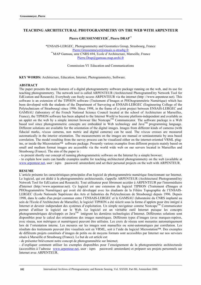
By starting the software package through the browser, the main frame of ARPENTEUR (figure 1) is loaded. The mainframe is divided into four parts :1. The model management window allows:
- the selection of an existing model in the current folder defined by the user’s name;- the loading of the data files and images in the remote computer.
2. The management of the orientation and measure process; the user can:- realize the different steps of the orientation (see § 3.3);- select a modeling module once the orientation is done.
3. The ‘System’ window is used:- to configure Arpenteur (e.g. correlation matrix), show results, create new models;- to up-and-download files between the server and the client;- to visualize data in a 3D viewer.
4. A window to display messages and events corresponding to the use of the software package
Figure 1. ARPENTEUR main frame available at http://www.arpenteur.net
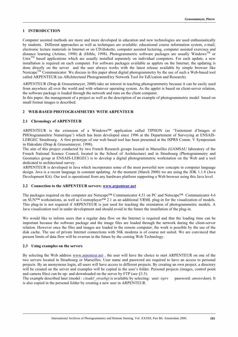
3.2 Select an existing model
Select the available models in the user’s folder
Load the selected model
Figure 2. Selection of a model in ARPENTEUR
Grussenmeyer, Pierre
International Archives of Photogrammetry and Remote Sensing. Vol. XXXIII, Part B6. Amsterdam 2000.104
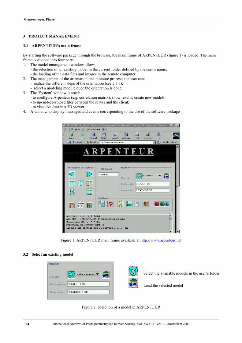
3.3 Orientation and measure
Figure 3. Orientation and measurewindow
Interior orientation (left image of the model)
Interior orientation (right image of the model)
Relative orientation of the model
Absolute orientation of the model
Absolute orientation based on distances and vertical lines
Control point and tie point measurement in preparation forthe bundle adjustment
Computation of the bundle adjustment (two or moreimages of a project)
Module for simple measurements (points, distances …)
Measurement process based on stone by stone surveying(architectural modeling), see an example in (Drap et al.,2000)Measurement process based on formalization of archi-tectural and geometrical knowledge, see an example in(Drap et al.,1999)
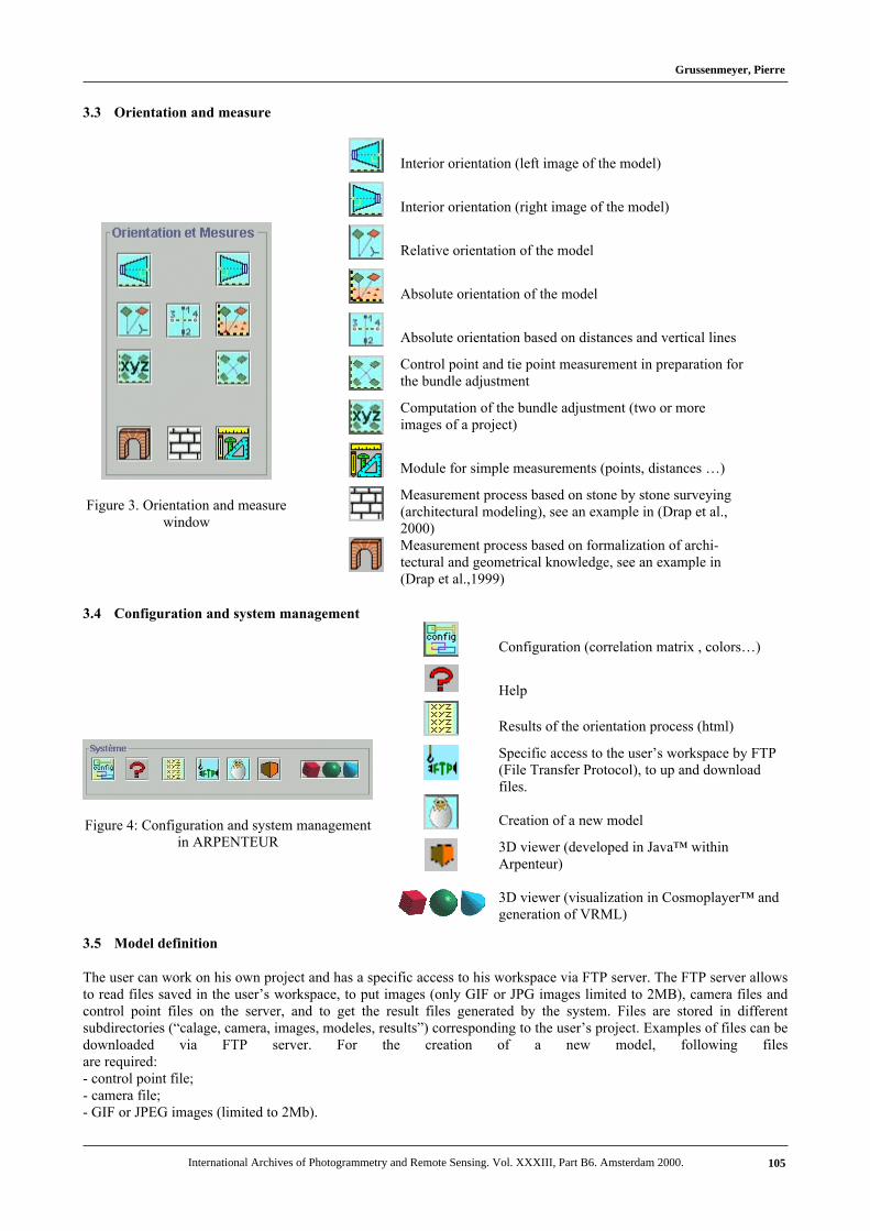
3.4 Configuration and system management
Figure 4: Configuration and system managementin ARPENTEUR
Configuration (correlation matrix , colors…)
Help
Results of the orientation process (html)
Specific access to the user’s workspace by FTP(File Transfer Protocol), to up and downloadfiles.
Creation of a new model
3D viewer (developed in Java™ withinArpenteur)
3D viewer (visualization in Cosmoplayer™ andgeneration of VRML)
3.5 Model definition
The user can work on his own project and has a specific access to his workspace via FTP server. The FTP server allowsto read files saved in the user’s workspace, to put images (only GIF or JPG images limited to 2MB), camera files andcontrol point files on the server, and to get the result files generated by the system. Files are stored in differentsubdirectories (“calage, camera, images, modeles, results”) corresponding to the user’s project. Examples of files can bedownloaded via FTP server. For the creation of a new model, following filesare required:- control point file;- camera file;- GIF or JPEG images (limited to 2Mb).
Grussenmeyer, Pierre
International Archives of Photogrammetry and Remote Sensing. Vol. XXXIII, Part B6. Amsterdam 2000. 105
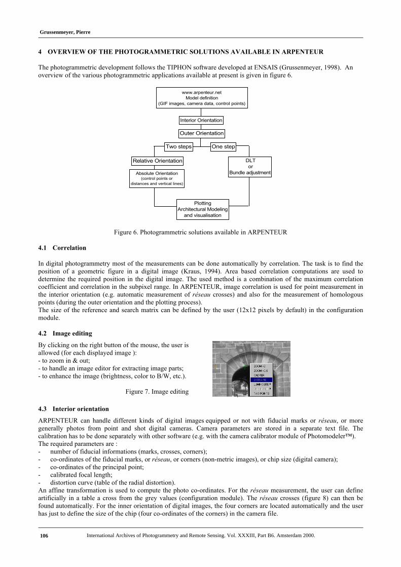
4 OVERVIEW OF THE PHOTOGRAMMETRIC SOLUTIONS AVAILABLE IN ARPENTEUR
The photogrammetric development follows the TIPHON software developed at ENSAIS (Grussenmeyer, 1998). Anoverview of the various photogrammetric applications available at present is given in figure 6.
Relative Orientation
Interior Orientation
DLT or
Bundle adjustmentAbsolute Orientation(control points or
distances and vertical lines)
Outer Orientation
Two steps One step
PlottingArchitectural Modeling
and visualisation
www.arpenteur.netModel definition
(GIF images, camera data, control points)
Figure 6. Photogrammetric solutions available in ARPENTEUR
4.1 Correlation
In digital photogrammetry most of the measurements can be done automatically by correlation. The task is to find theposition of a geometric figure in a digital image (Kraus, 1994). Area based correlation computations are used todetermine the required position in the digital image. The used method is a combination of the maximum correlationcoefficient and correlation in the subpixel range. In ARPENTEUR, image correlation is used for point measurement inthe interior orientation (e.g. automatic measurement of réseau crosses) and also for the measurement of homologouspoints (during the outer orientation and the plotting process).The size of the reference and search matrix can be defined by the user (12x12 pixels by default) in the configurationmodule.
4.2 Image editing
By clicking on the right button of the mouse, the user isallowed (for each displayed image ):- to zoom in & out;- to handle an image editor for extracting image parts;- to enhance the image (brightness, color to B/W, etc.).
Figure 7. Image editing
4.3 Interior orientation
ARPENTEUR can handle different kinds of digital images equipped or not with fiducial marks or réseau, or moregenerally photos from point and shot digital cameras. Camera parameters are stored in a separate text file. Thecalibration has to be done separately with other software (e.g. with the camera calibrator module of Photomodeler™).The required parameters are :- number of fiducial informations (marks, crosses, corners);- co-ordinates of the fiducial marks, or réseau, or corners (non-metric images), or chip size (digital camera);- co-ordinates of the principal point;- calibrated focal length;- distortion curve (table of the radial distortion).An affine transformation is used to compute the photo co-ordinates. For the réseau measurement, the user can defineartificially in a table a cross from the grey values (configuration module). The réseau crosses (figure 8) can then befound automatically. For the inner orientation of digital images, the four corners are located automatically and the userhas just to define the size of the chip (four co-ordinates of the corners) in the camera file.
Grussenmeyer, Pierre
International Archives of Photogrammetry and Remote Sensing. Vol. XXXIII, Part B6. Amsterdam 2000.106
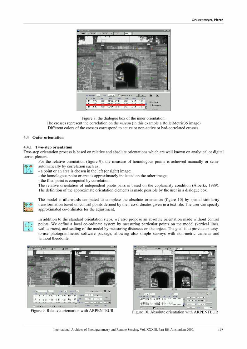
Figure 8. the dialogue box of the inner orientation.The crosses represent the correlation on the réseau (in this example a RolleiMetric35 image)Different colors of the crosses correspond to active or non-active or bad-correlated crosses.
4.4 Outer orientation
4.4.1 Two-step orientationTwo-step orientation process is based on relative and absolute orientations which are well known on analytical or digitalstereo-plotters.
For the relative orientation (figure 9), the measure of homologous points is achieved manually or semi-automatically by correlation such as :- a point or an area is chosen in the left (or right) image;- the homologous point or area is approximately indicated on the other image;- the final point is computed by correlation.The relative orientation of independent photo pairs is based on the coplanarity condition (Albertz, 1989).The definition of the approximate orientation elements is made possible by the user in a dialogue box.
The model is afterwards computed to complete the absolute orientation (figure 10) by spatial similaritytransformation based on control points defined by their co-ordinates given in a text file. The user can specifyapproximated co-ordinates for the adjustment.
In addition to the standard orientation steps, we also propose an absolute orientation made without controlpoints. We define a local co-ordinate system by measuring particular points on the model (vertical lines,wall corners), and scaling of the model by measuring distances on the object. The goal is to provide an easy-to-use photogrammetric software package, allowing also simple surveys with non-metric cameras andwithout theodolite.
Figure 9. Relative orientation with ARPENTEUR Figure 10. Absolute orientation with ARPENTEUR
Grussenmeyer, Pierre
International Archives of Photogrammetry and Remote Sensing. Vol. XXXIII, Part B6. Amsterdam 2000. 107
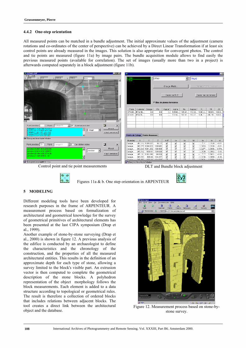
4.4.2 One-step orientation
All measured points can be matched in a bundle adjustment. The initial approximate values of the adjustment (camerarotations and co-ordinates of the center of perspective) can be achieved by a Direct Linear Transformation if at least sixcontrol points are already measured in the images. This solution is also appropriate for convergent photos. The controland tie points are measured (figure 11a) by image pairs. The bundle acquisition module allows to find easily theprevious measured points (available for correlation). The set of images (usually more than two in a project) isafterwards computed separately in a block adjustment (figure 11b).
Control point and tie point measurements DLT and Bundle block adjustment
Figures 11a & b. One step orientation in ARPENTEUR
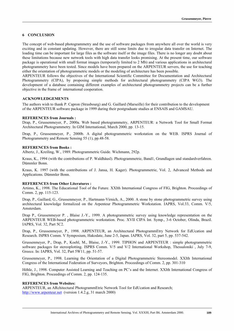
5 MODELING
Different modeling tools have been developed forresearch purposes in the frame of ARPENTEUR. Ameasurement process based on formalization ofarchitectural and geometrical knowledge for the surveyof geometrical primitives of architectural elements hasbeen presented at the last CIPA symposium (Drap etal., 1999).Another example of stone-by-stone surveying (Drap etal., 2000) is shown in figure 12. A previous analysis ofthe edifice is conducted by an archaeologist to definethe characteristics and the chronology of theconstruction, and the properties of all the measuredarchitectural entities. This results in the definition of anapproximate depth for each type of stone, allowing asurvey limited to the block's visible part. An extrusionvector is then computed to complete the geometricaldescription of the stone blocks. A polyhedronrepresentation of the object morphology follows theblock measurements. Each element is added to a datastructure according to topological or geometrical rules.The result is therefore a collection of ordered blocksthat includes relations between adjacent blocks. Thetool creates a direct link between the architecturalobject and the database.
Figure 12. Measurement process based on stone-by-stone survey.
Grussenmeyer, Pierre
International Archives of Photogrammetry and Remote Sensing. Vol. XXXIII, Part B6. Amsterdam 2000.108
6 CONCLUSION
The concept of web-based photogrammetry and the use of software packages from anywhere all over the world is veryexciting and in constant updating. However, there are still some limits due to irregular data transfer on Internet. Theloading time can be important for large files as the software itself or the image files. There is no longer any doubt aboutthese limitations because new network tools with high data transfer looks promising. At the present time, our softwarepackage is operational with small format images (temporarily limited to 2 Mb) and various applications in architecturalphotogrammetry have been tested. Since models have been prepared on the ARPENTEUR servers, the use for teachingeither the orientation of photogrammetric models or the modeling of architecture has been possible.ARPENTEUR follows the objectives of the International Scientific Committee for Documentation and ArchitecturalPhotogrammetry (CIPA), by proposing simple methods for architectural photogrammetry (CIPA WG3). Thedevelopment of a database containing different examples of architectural photogrammetry projects can be a furtherobjective in the frame of international cooperation.
ACKNOWLEDGEMENTS
The authors wish to thank P. Capron (Strasbourg) and G. Gaillard (Marseille) for their contribution to the developmentof the ARPENTEUR software package in 1999 during their postgraduate studies at ENSAIS and GAMSAU. REFERENCES from Journals :Drap, P., Grussenmeyer, P., 2000a. Web based photogrammetry, ARPENTEUR: a Network Tool for Small FormatArchitectural Photogrammetry. In GIM International, March 2000, pp. 13-15.
Drap, P., Grussenmeyer, P., 2000b. A digital photogrammetric workstation on the WEB. ISPRS Journal ofPhotogrammetry and Remote Sensing 55 (1), pp.48-58.
REFERENCES from Books : Albertz, J., Kreiling, W., 1989. Photogrammetric Guide. Wichmann, 292p. Kraus, K., 1994 (with the contributions of P. Waldhäusl). Photogrammetrie, Band1, Grundlagen und standardverfahren.Dümmler Bonn. Kraus, K. 1997 (with the contributions of J. Jansa, H. Kager). Photogrammetrie, Vol. 2, Advanced Methods andApplications. Dümmler Bonn. REFERENCES from Other Literatures : Artimo, K., 1998. The Educational Tool of the Future. XXIth International Congress of FIG, Brighton. Proceedings ofComm. 2, pp. 115-123.
Drap, P., Gaillard, G., Grussenmeyer, P., Hartmann-Virnich, A., 2000. A stone by stone photogrammetric survey usingarchitectural knowledge formalized on the Arpenteur Photogrammetric Workstation. IAPRS, Vol.33, Comm. V/5,Amsterdam.
Drap P., Grussenmeyer P. , Blaise J.-Y., 1999. A photogrammetric survey using knowledge representation on theARPENTEUR WEB-based photogrammetric workstation. Proc. XVII CIPA Int. Symp., 3-6 October, Olinda, Brazil.IAPRS, Vol. 32, Part 5C2.
Drap, P., Grussenmeyer, P., 1998. ARPENTEUR, an Architectural PhotogrammEtry Network for EdUcation andResearch. ISPRS Comm. V Symposium, Hakodate, June 2-5, Japan. IAPRS, Vol. 32, part 5, pp. 537-542.
Grussenmeyer, P., Drap, P., Koehl, M., Blaise, J.-Y., 1999. TIPHON and ARPENTEUR : simple photogrammetricsoftware packages for stereoplotting. ISPRS Comm. V/5 and V/2 International Workshop, Thessaloniki , July 7-9,Greece. In: IAPRS, Vol. 32, Part 5W11, pp. 51-57.
Grussenmeyer, P., 1998. Learning the Orientation of a Digital Photogrammetric Stereomodel. XXIth InternationalCongress of the International Federation of Surveyors, Brighton. Proceedings of Comm. 2, pp. 301-310
Höhle, J., 1998. Computer Assisted Learning and Teaching on PC’s and the Internet. XXIth International Congress ofFIG, Brighton. Proceedings of Comm. 2, pp. 124-135.
REFERENCES from Websites:ARPENTEUR, an ARchitectural PhotogrammEtric Network Tool for EdUcation and Research;http://www.arpenteur.net (version 1.4.2.g, 31 march 2000)
Grussenmeyer, Pierre
International Archives of Photogrammetry and Remote Sensing. Vol. XXXIII, Part B6. Amsterdam 2000. 109