table of contents - bataviaprojects.townofbatavia.com/wp-content/uploads/2015/02/townline... ·...
TRANSCRIPT
i
TABLE OF CONTENTS I. GENERAL ...................................................................................................................................... 1 II. PROJECT PLANNING AREA ...................................................................................................... 1 III. EXISTING FACILITIES ................................................................................................................ 2 IV. NEED FOR PROJECT ................................................................................................................... 2 V. ALTERNATIVES CONSIDERED ................................................................................................ 3 VI. RECOMMENDED ALTERNATIVE ............................................................................................. 5 VII. ANNUAL OPERATING BUDGET ............................................................................................... 7 VIII. MISCELLANEOUS INFORMATION .......................................................................................... 8 IX. CONCLUSIONS ............................................................................................................................. 8 LIST OF FIGURES FIGURE 1 PROJECT LOCATION MAP LIST OF APPENDICES APPENDIX A WATER DISTRICT MAP & DESCRIPTION APPENDIX B OPINION OF PROBABLE COSTS APPENDIX C UNIT DEFINITIONS APPENDIX D HEALTH DEPARTMENT CORRESPONDENCE APPENDIX E WATER SYSTEM MODEL APPENDIX F FARM AGREEMENTS
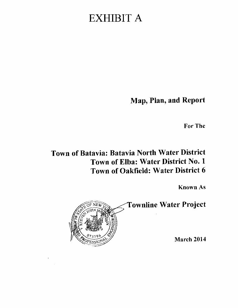
Map, Plan, and Report Towns of Batavia, Oakfield, & Elba Townline Water Project -1- March 2014
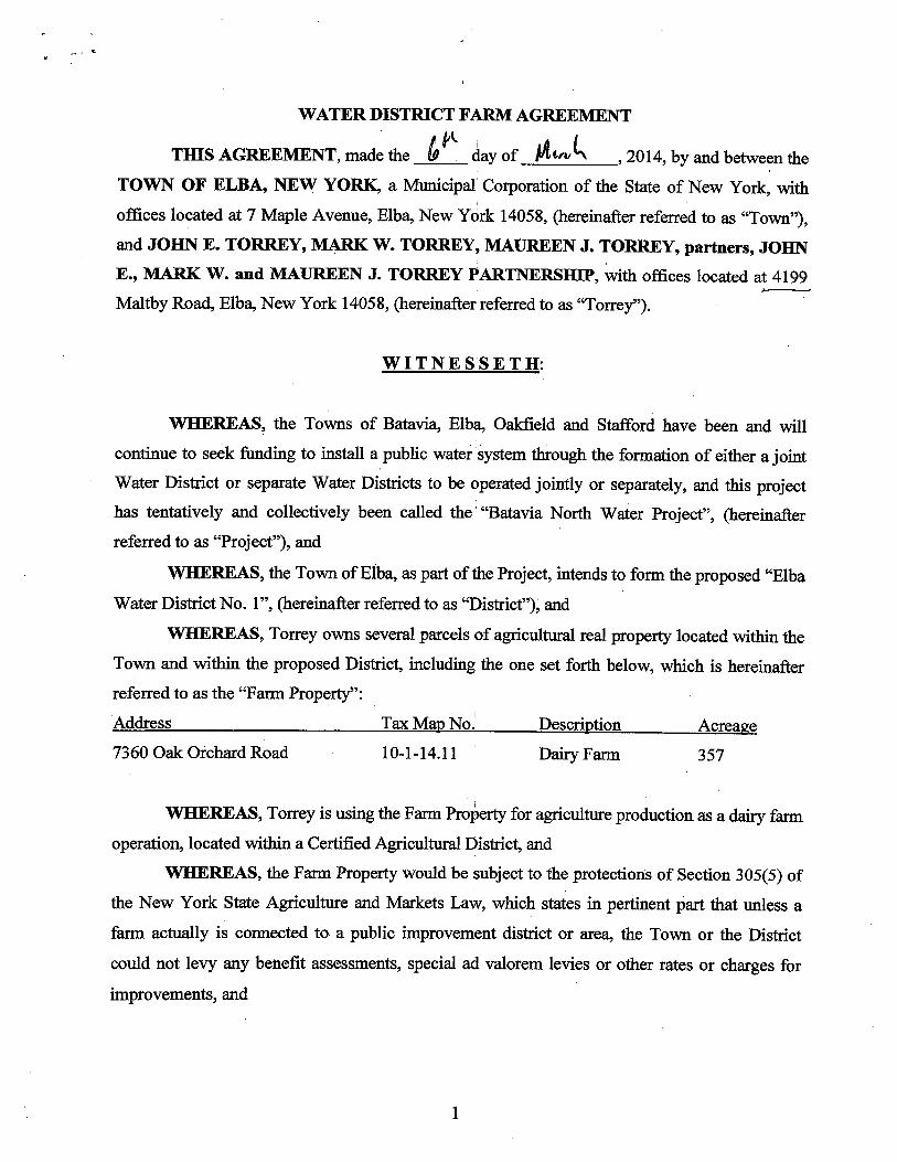
I. General The Towns of Batavia, Oakfield, and Elba have received interest in establishing a water district. A water district is a special use district required by Town Law where a specific area of the town receives a specific benefit. The cost for receiving this benefit will be borne solely by those prop-erty owners in that specific area. The purpose of this project is to provide safe and reliable potable water supply and fire protec-tion to residences in the proposed water districts. II. Project Planning Area
A. Location
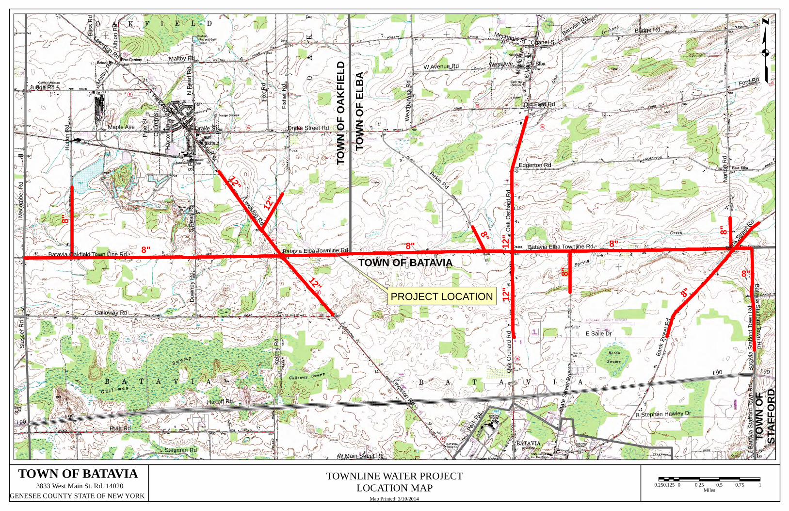
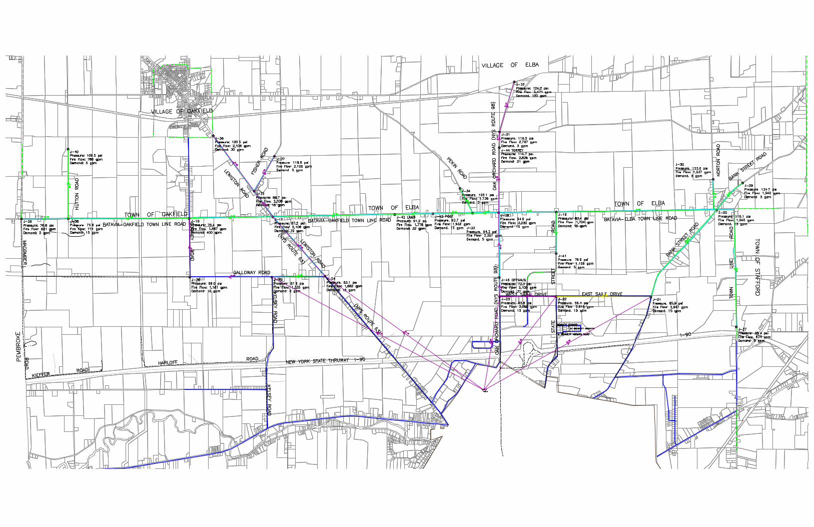
The project area has been identified through public interest. The Batavia North Water District, Oakfield Water District No. 6, and Elba Water District No. 1 will connect to ex-isting Town of Batavia water districts and include 104,700 linear feet of new 8-inch and 12-inch diameter water main. The water main will be installed along Batavia-Oakfield Townline Road, Hutton Road, Lewiston Road, Fisher Road, Batavia-Elba Townline Road, Pekin Road, Oak Orchard Road, State Street Road, Bank Street Road, Norton Road, and Batavia-Stafford Townline Road. The new water main will serve a total of ap-proximately 310 units and is shown as the solid red line in Figure 1.
B. Environmental Resources Present
There are farmlands present in the project area. All construction will be taking place in existing road-right of ways and proper construction mitigation and restoration efforts will be implemented based on standard practices common to the industry.
C. Growth Areas and Population Trends
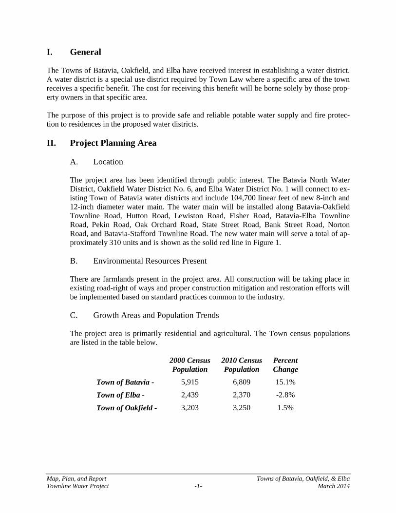
The project area is primarily residential and agricultural. The Town census populations are listed in the table below.
2000 Census Population
2010 Census Population
Percent Change
Town of Batavia - 5,915 6,809 15.1%
Town of Elba - 2,439 2,370 -2.8%
Town of Oakfield - 3,203 3,250 1.5%
Map, Plan, and Report Towns of Batavia, Oakfield, & Elba Townline Water Project -2- March 2014
III. Existing Facilities
A. Location Map
The existing private well area is shown by the location of the proposed facilities in Figure 1.
B. History
The entire area of the proposed water districts is presently served by private wells.
C. Condition of Facilities
The Towns of Batavia, Oakfield, and Elba have received complaints about the quality, and at times, quantity of the private water supplies in the area. From public input it is known that many wells in this area are contaminated with high levels of sulfur, iron, ni-trates, coliform, and high hardness level. Many of these wells require expensive treatment systems to make the water acceptable for domestic use.
D. Financial Status of any Operating Facilities
The residents of the entire area have private wells and furnish the operation and mainte-nance costs themselves.
E. Existing & Future Water Demand
The existing demands for the proposed service area are as follows: Average Day 50,300 gpd Maximum Day 100,600 gpd Peak Hour 201,200 gpd
The future demands for the proposed service area are anticipated to utilize a 2% increase per year. Although the 2010 census data indicates a 15% population growth for the Town of Batavia, analysis has shown that this number is inflated. The 2010 census data includes housing facilities that were not counted in the 2000 Census. The 2% increase being used takes into account more accurate population projections and the land use of the area.
IV. Need For Project
A. Health and Safety
The proposed water distribution project will provide safe potable water to the residents of the proposed water districts and will eliminate the health risks associated with the quality and quantity of ground water in the area.
Map, Plan, and Report Towns of Batavia, Oakfield, & Elba Townline Water Project -3- March 2014
The Genesee County Health Department began testing wells in the northeast area of the Town of Batavia in March 2010 due to suspected manure contamination. The initial find-ings showed both bovine and human bacteria present in the wells. The results from the northeast area of the Town of Batavia through April 28, 2010 include the following:
• 14 out of 38 tested positive for Bacteria • 12 out of 13 test results showed nitrate levels between 0.05 and 9.99 ppm, with
the remaining sample greater than 10 ppm.
As a result of the testing in the northeast area, the Town of Batavia initiated well testing in other areas with the following results:
• 11 out of 52 tested positive for Bacteria • 28 out of 47 test results showed nitrate levels between 0.05 and 9.99 ppm, and 3
out of 47 test results greater than 10 ppm. A letter from the New York State Department of Health has been included as Appendix D.
B. System O & M
A water distribution network will replace expensive individual water treatment units; this will reduce the operation and maintenance costs borne by the residents at this time. The Town of Batavia will provide operation and maintenance of the water districts.
C. Growth
While economic development is viewed as a project benefit, balancing economic devel-opment and land protection is necessary, critical, and provided for. The Town intends to limit water service connections within the boundaries of Agricultural Districts to only ag-ricultural structures or land and structures that have already been approved for development. Thus, there are no anticipated long-term impacts to the Agricultural Dis-tricts as a result of the proposed action including no change in use of agricultural/residential lands within the Agricultural District.
V. Alternatives Considered
A. Description
1. Alternative 1 – Null Alternative
This alternative proposes to “do nothing”. This would mean continued health risks for the residents of the proposed water districts.
2. Alternative 2 – New Water Distribution System
This proposed action includes the installation of approximately 104,700 linear feet of 8-inch and 12-inch water main along Batavia-Oakfield Townline Road, Hutton Road, Lewiston Road, Fisher Road, Batavia-Elba
Map, Plan, and Report Towns of Batavia, Oakfield, & Elba Townline Water Project -4- March 2014
Townline Road, Oak Orchard Road, State Street Road, Bank Street Road, Norton Road, and Batavia-Stafford Townline Road. The water main will be PVC as the Town of Batavia utilizes PVC for their standard material. Various water main diameters were analyzed and the selected sizes were chosen based on providing adequate fire flows and taking into account fu-ture service areas. The proposed water main will be installed in the right-of-way in order to provide services to the residents on each side of the roadways.
3. Alternative 3 – New Water Distribution System – New Source of Supply
The additional capital cost of a new treatment system along with the estab-lishment of a local source of supply would result in unit cost over $2,000 per year.
B. Design Criteria
The proposed Townline Water Project will be designed in accordance with New York State Department of Health standards and Ten State Standards to provide safe potable water and fire protection to the water district’s residents.
C. Map
Figure 1 shows the map of the proposed water system. The legal map and description for each water district has been provided in Appendix A.
D. Environmental Impacts
There are no anticipated environmental impacts associated with any of the alternatives. However, an environmental review has been undertaken for Alternative 2. All construc-tion will be done in existing road-right-of-ways and proper construction mitigation and restoration efforts will be implemented.
E. Land Requirements
There are no additional land requirements for Alternative 2. All water main construction is anticipated to take place within existing road right-of-ways.
F. Construction Problems
There is no known or anticipated construction problem for the new water district.
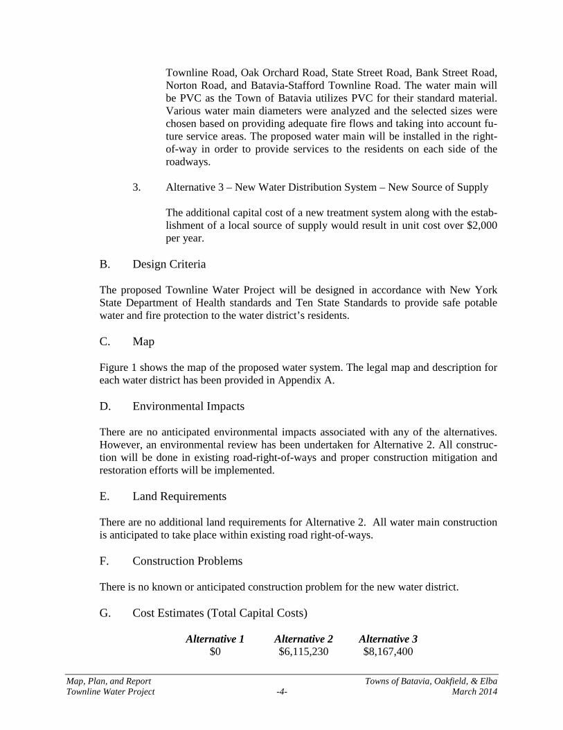
G. Cost Estimates (Total Capital Costs)
Alternative 1 Alternative 2 Alternative 3
$0 $6,115,230 $8,167,400
Map, Plan, and Report Towns of Batavia, Oakfield, & Elba Townline Water Project -5- March 2014
H. Advantages/Disadvantages
Alternative 2 is the most viable alternative as it is consistent with the goals and needs of the Towns of Batavia, Elba, and Oakfield. The advantage of Alternative 2 is as follows:
1. It will eliminate the ongoing health problems and risks associated with the quality
and quantity of ground water in the area. VI. Recommended Alternative
The recommended alternative is Alternative 2: New Water Distribution System.
A. Project Design
1. Water Supply
The proposed water districts will receive water from Genesee County through the Monroe County Water Authority and the City of Batavia Wa-ter Supplies.
2. Treatment
The City of Batavia Water Treatment Plant and the Monroe County Water Authority Shoremont Water Treatment Plant will provide treated water to the proposed water districts. The treated water will meet all the state and federal drinking water standards.
3. Storage
A 1.5 and dual 1.25 million gallon water storage tanks will provide the water storage needs for this proposed water districts. No additional storage is required for this service area.
4. Pumping Stations
Pumps located at the City of Batavia Water Treatment Plant and the MCWA’s North Road Pump Station, pump water to the storage tanks and the distribution network.
5. Distribution Layout
The distribution network is shown in Figure 1 at the end of this report for the project area. The Town of Batavia will be responsible for system oper-ation and maintenance.
Map, Plan, and Report Towns of Batavia, Oakfield, & Elba Townline Water Project -6- March 2014
6. Services
The portion of the water service from the right-of-way to the main line will be installed under this project. The portion from the right-of-way to the home will be the responsibility of the homeowner.
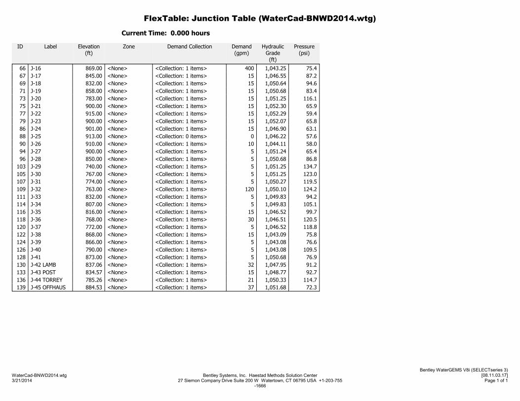
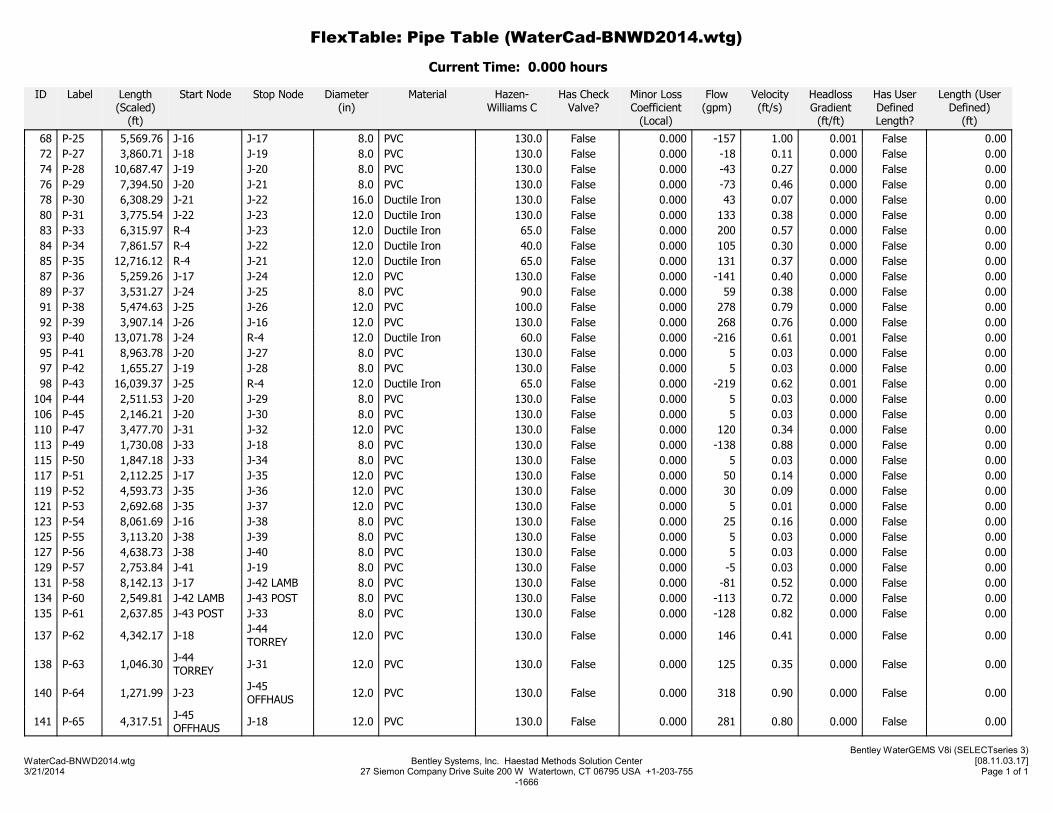
7. Hydraulic Calculations
The hydraulic conditions of the proposed system were calculated using the WaterCAD® hydraulic modeling software. They hydraulic analysis of the system includes the evaluation of available pressures and flows for the proposed Water District. Hydraulic analysis of the system included the evaluation of available pres-sures and flows during minimum day (average day ÷ 4), average day, maximum day (average day x 2), and peak hour (average day x 6) demand conditions. This analysis also evaluated the available fire flows under maximum day demands and determined the age of the water in the distri-bution system. The hydraulic analysis of the system indicates that adequate flows and pressures are available in the proposed system. Pressures in the new sys-tem range from 53 psi to 135 psi during average demand periods. Fire flows generally range from 631 gpm to 3,250 gpm in the proposed system. The project will meet NYSDOH standards and provide adequate fire flow.
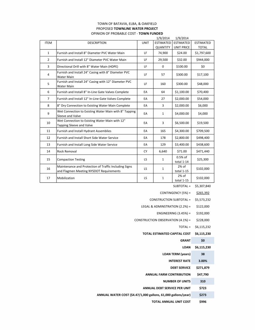
B. Cost Estimate
The estimated total capital cost for the Townline Water Project is detailed in Appendix B and summarized as follows: Construction cost with 5% Contingency $5,573,232 Legal & Administrative Costs $122,000 Engineering Costs $192,000 Total Estimated Project Cost $6,115,230
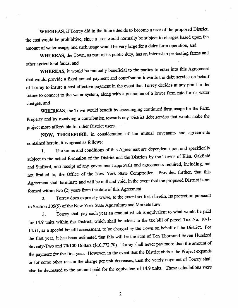
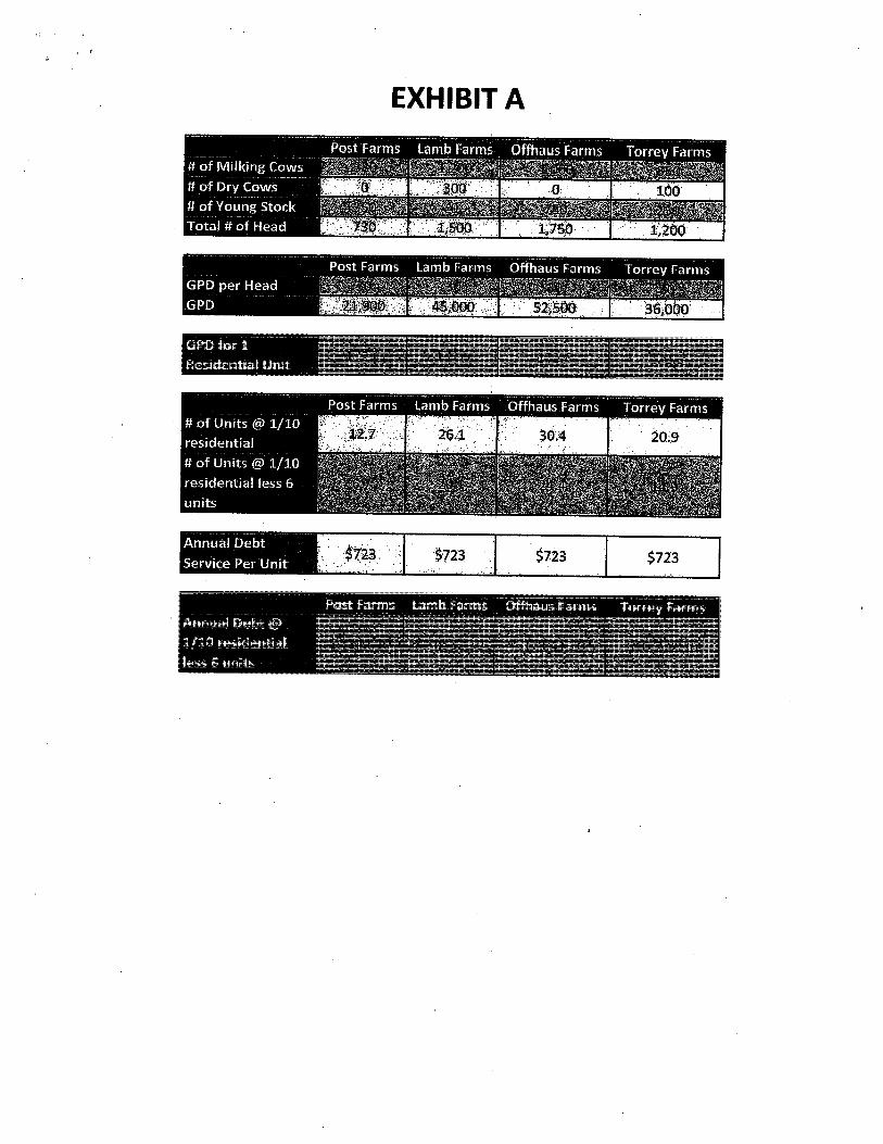
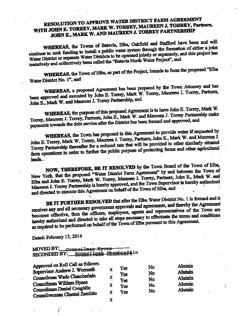
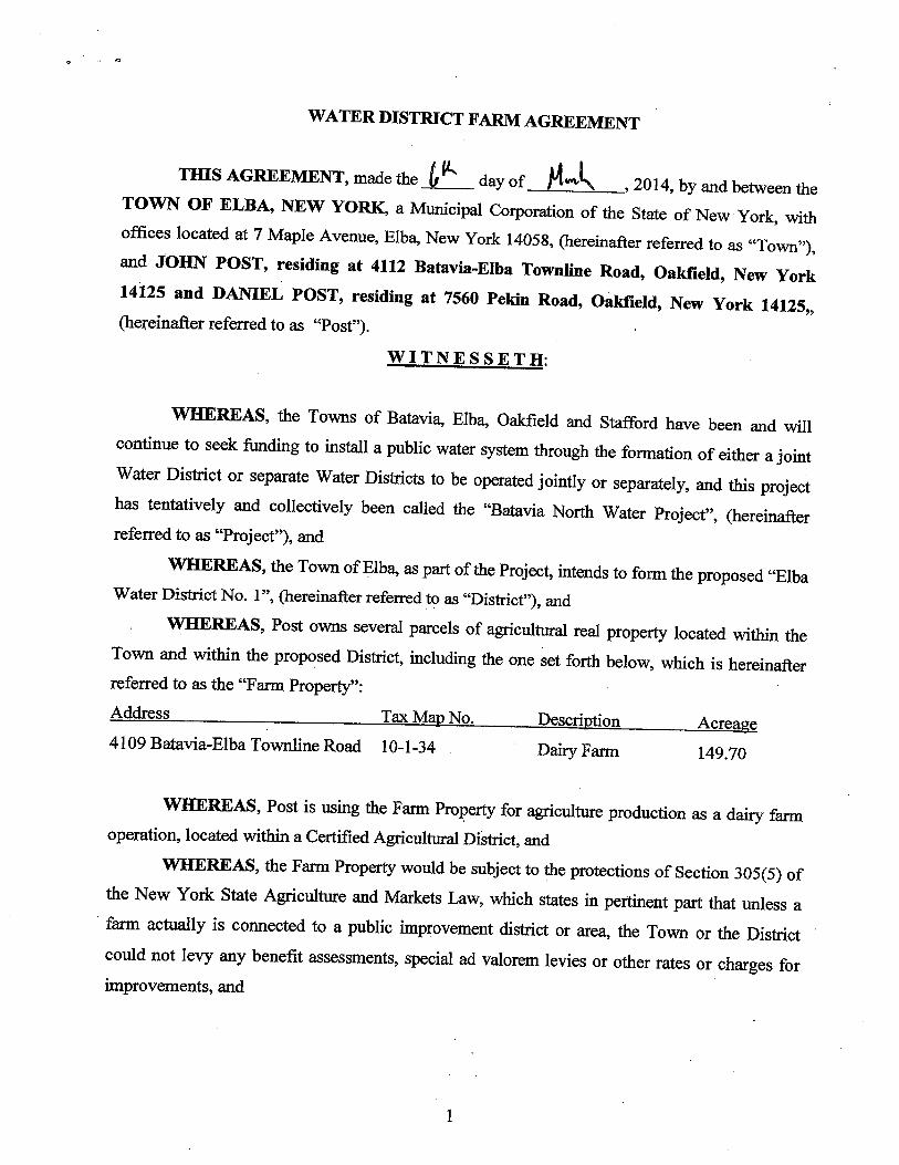
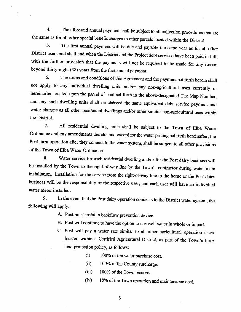
Services During Construction $228,000
Each District will bond separately for their share of the improvements. Several large dairy farms in the Town of Batavia and the Town of Elba have entered into agreements with their respective Towns to provide contributions to the project, making it more affordable to all. Those agree-ments are included as Appendix F. The funding and financing for the project will be provided by each of the proposed water dis-tricts. The total cost will be divided proportionally among the Districts so that every benefit unit in each district will pay equally toward the debt over the life of the bonding. Each District will own its proportionate share of the constructed facilities.
Map, Plan, and Report Towns of Batavia, Oakfield, & Elba Townline Water Project -7- March 2014
C. Town of Batavia Water Rate Information
• The current water rate is $4.47 per 1,000 gallons of water used
D. Definition of a Unit
The Water District Benefit Basis Unit Definition is included in Appendix C. A summary is as follows:
Residential Property - Single 1 Unit Residential property – Double 1.5 Units Residential Property – Triple 2.0 Units Developable Vacant Lot 0.1 Unit (Does not include land in Agricultural Districts or outside of the Smart Growth Area. These parcels are assessed a flat $10/year for the benefit of being in a Water District) Non-Residential – Based on required/actual water usage Where: Number of Units = Usage/300GPD VII. Annual Operating Budget A1. Proposed Batavia North Water District Unit Costs
The estimated average water district unit costs for the Town of Batavia are as fol-lows:
Total Capital Project Cost $6,115,230 District Share $3,081,191 Annual Debt Service (38 years, 3%) $136,988
Annual Debt after Farmer Contributions $104,813 Annual Farmer Contribution $32,175
Annual Debt Service/Unit (145 units) $723 Average Annual Water Cost/Unit $273 ($4.47/1,000 gallons @ 61,000 gal. /year) Total Estimated Average Unit Cost $996 per year
A2. Proposed Oakfield Water District No. 6 Unit Costs
The estimated average water district unit costs for the Town of Oakfield are as follows:
Total Capital Project Cost $6,115,230 District Share $1,268,248 Annual Debt Service (38 years, 3%) $56,385 Annual Debt Service/Unit (78 units) $723

Map, Plan, and Report Towns of Batavia, Oakfield, & Elba Townline Water Project -8- March 2014
Average Annual Water Cost/Unit $273 ($4.47/1,000 gallons @ 61,000 gal. /year) Total Estimated Average Unit Cost $996 per year
A3. Proposed Elba Water District No. 1 Unit Costs
The estimated average water district unit costs for the Town of Elba are as fol-lows:
Total Capital Project Cost $6,115,230 District Share $1,765,791 Annual Debt Service (38 years, 3%) $78,506
Annual Debt after Farmer Contributions $62,889 Annual Farmer Contribution $15,617
Annual Debt Service/Unit (87 units) $723 Average Annual Water Cost/Unit $273 ($4.47/1,000 gallons @ 61,000 gal. /year) Total Estimated Average Unit Cost $996 per year
B. Other Costs
Service line $ 8-20/LF Well abandonment or separation $ 200-600
VIII. Miscellaneous Information
A. Options for property owner’s well.
1. Abandon the well. 2. Keep well but separate it from public water plumbing. 3. Keep well and install backflow prevention.
B. Service line information
1. A service line (up to R.O.W. line) will be installed to all residents. 2. There will be no future hook up charge for those that do not connect right
away. IX. Conclusions The Towns of Batavia, Elba, and Oakfield are committed to providing safe and reliable potable water supply and fire protection to the residents in the project area. The Townline Water Project will be instrumental in achieving that goal.

Figure 1
Project Location Map
Maltby Rd
Ford Rd
Fishe
r Rd
Maco
mber
Rd
Norto
n Rd
Bridge Rd
Edgerton Rd
Drake Street Rd
Pekin Rd
Hutto
n Rd
Batavia Elba Townline Rd
Judge Rd
Lewiston Rd
Fox R
d
Maple Ave
Batavia Oakfield Town Line Rd
Oak O
rchard
Rd
S Pea
rl Rd
West Ave
N Pe
arl R
d
I 90
Weath
erwax
Rd
Albion
Rd
S Main St
Sluss
er Rd
W Avenue Rd
S Pea
rl St
Barrville Rd
N Pe
arl S
t
Bank Stree
t Rd
Park Ave
Bliss
Rd
Mechanic St
Churc
h St
Drake St
Chapel St
Batav
ia Sta
fford
Town
Rd
Cary Ave Old Ford Rd
Haxto
n Ln
Pine S
t
Maltby R
d
Batav
ia Sta
fford
Town
Rd
I 90
S Main
St
Lewiston Rd
Batavia Elba Townline Rd
Maple
Ave
8"12"
12"
8"
12"
12"
12"
8"
8"
8"
8"
I 90Pratt Rd
Galloway Rd
Lewiston Rd
Bank
Stree
t Rd
Kelse
y Rd
E Saile Dr
Oak O
rchard
Rd
Park R
d
Harloff Rd
State
Stree
t Rd
R Stephen Hawley Dr
Down
ey R
d
Stegman Rd
Batavia Stafford Town Rd
W Main Street Rd
I 90
TOWN OF BATAVIA3833 West Main St. Rd. 14020
GENESEE COUNTYSTATE OF NEW YORK
TOWNLINE WATER PROJECTLOCATION MAP 0.25 0 0.25 0.5 0.75 10.125
Miles
q
Map Printed: 3/10/2014
PROJECT LOCATION
TOWN
OF O
AKFIE
LDTO
WN O
F ELB
A
TOWN
OF
STAF
FORD
TOWN OF BATAVIA8" 8"
8"

Appendix A
Proposed District Map & Description
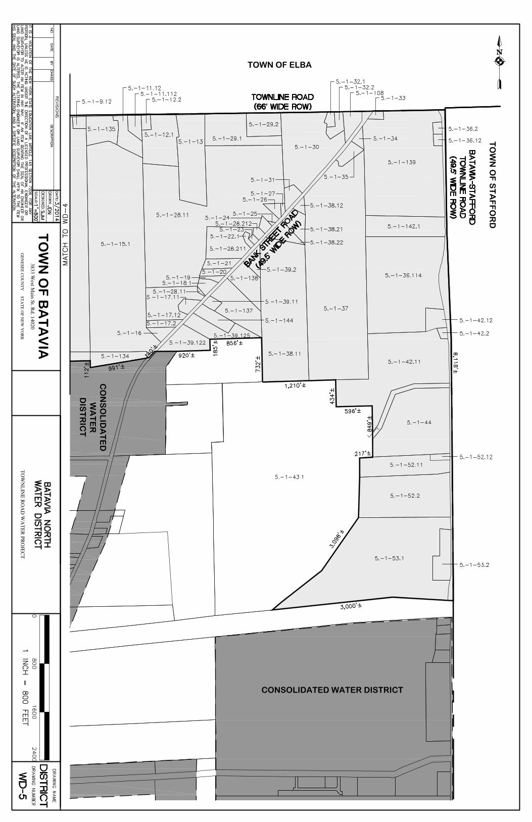
TOWN OF BATAVIA PROPOSED BATAVIA NORTH WATER DISTRICT
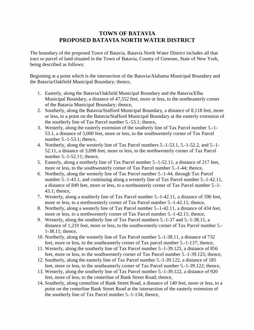
The boundary of the proposed Town of Batavia, Batavia North Water District includes all that tract or parcel of land situated in the Town of Batavia, County of Genesee, State of New York, being described as follows: Beginning at a point which is the intersection of the Batavia/Alabama Municipal Boundary and the Batavia/Oakfield Municipal Boundary; thence,
1. Easterly, along the Batavia/Oakfield Municipal Boundary and the Batavia/Elba Municipal Boundary, a distance of 47,552 feet, more or less, to the northeasterly corner of the Batavia Municipal Boundary; thence,
2. Southerly, along the Batavia/Stafford Municipal Boundary, a distance of 8,118 feet, more or less, to a point on the Batavia/Stafford Municipal Boundary at the easterly extension of the southerly line of Tax Parcel number 5.-53.1; thence,
3. Westerly, along the easterly extension of the southerly line of Tax Parcel number 5.-1-53.1, a distance of 3,000 feet, more or less, to the southwesterly corner of Tax Parcel number 5.-1-53.1; thence,
4. Northerly, along the westerly line of Tax Parcel numbers 5.-1-53.1, 5.-1-52.2, and 5.-1-52.11, a distance of 3,098 feet, more or less, to the northwesterly corner of Tax Parcel number 5.-1-52.11; thence,
5. Easterly, along a northerly line of Tax Parcel number 5.-1-52.11, a distance of 217 feet, more or less, to the southwesterly corner of Tax Parcel number 5.-1-44; thence,
6. Northerly, along the westerly line of Tax Parcel number 5.-1-44, through Tax Parcel number 5.-1-43.1, and continuing along a westerly line of Tax Parcel number 5.-1-42.11, a distance of 849 feet, more or less, to a northeasterly corner of Tax Parcel number 5.-1-43.1; thence,
7. Westerly, along a southerly line of Tax Parcel number 5.-1-42.11, a distance of 596 feet, more or less, to a northwesterly corner of Tax Parcel number 5.-1-42.11; thence,
8. Northerly, along a westerly line of Tax Parcel number 5.-1-42.11, a distance of 434 feet, more or less, to a northwesterly corner of Tax Parcel number 5.-1-42.11; thence,
9. Westerly, along the southerly line of Tax Parcel numbers 5.-1-37 and 5.-1-38.11, a distance of 1,210 feet, more or less, to the southwesterly corner of Tax Parcel number 5.-1-38.11; thence,
10. Northerly, along the westerly line of Tax Parcel number 5.-1-38.11, a distance of 732 feet, more or less, to the southeasterly corner of Tax parcel number 5.-1-137; thence,
11. Westerly, along the southerly line of Tax Parcel number 5.-1-39.125, a distance of 856 feet, more or less, to the southwesterly corner of Tax Parcel number 5.-1-39.125; thence,
12. Southerly, along the easterly line of Tax Parcel number 5.-1-39.122, a distance of 185 feet, more or less, to the southeasterly corner of Tax Parcel number 5.-1-39.122; thence,
13. Westerly, along the southerly line of Tax Parcel number 5.-1-39.122, a distance of 920 feet, more of less, to the centerline of Bank Street Road; thence,
14. Southerly, along centerline of Bank Street Road, a distance of 140 feet, more or less, to a point on the centerline Bank Street Road at the intersection of the easterly extension of the southerly line of Tax Parcel number 5.-1-134; thence,
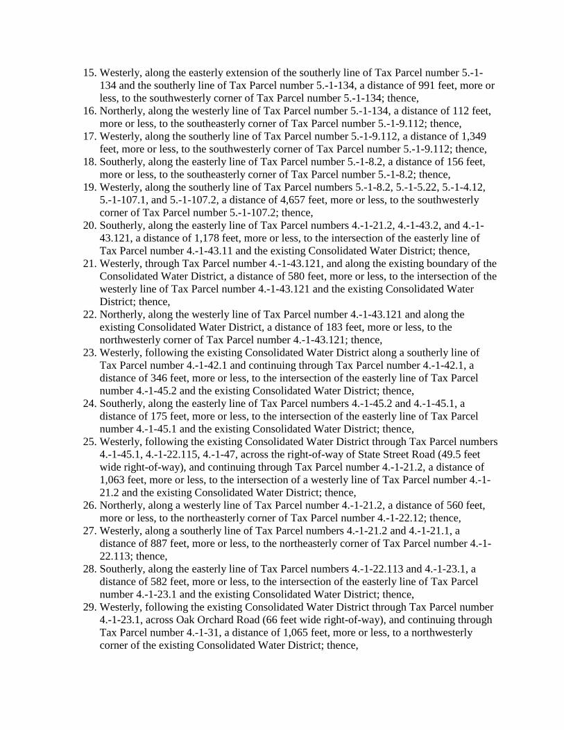
15. Westerly, along the easterly extension of the southerly line of Tax Parcel number 5.-1-134 and the southerly line of Tax Parcel number 5.-1-134, a distance of 991 feet, more or less, to the southwesterly corner of Tax Parcel number 5.-1-134; thence,
16. Northerly, along the westerly line of Tax Parcel number 5.-1-134, a distance of 112 feet, more or less, to the southeasterly corner of Tax Parcel number 5.-1-9.112; thence,
17. Westerly, along the southerly line of Tax Parcel number 5.-1-9.112, a distance of 1,349 feet, more or less, to the southwesterly corner of Tax Parcel number 5.-1-9.112; thence,
18. Southerly, along the easterly line of Tax Parcel number 5.-1-8.2, a distance of 156 feet, more or less, to the southeasterly corner of Tax Parcel number 5.-1-8.2; thence,
19. Westerly, along the southerly line of Tax Parcel numbers 5.-1-8.2, 5.-1-5.22, 5.-1-4.12, 5.-1-107.1, and 5.-1-107.2, a distance of 4,657 feet, more or less, to the southwesterly corner of Tax Parcel number 5.-1-107.2; thence,
20. Southerly, along the easterly line of Tax Parcel numbers 4.-1-21.2, 4.-1-43.2, and 4.-1-43.121, a distance of 1,178 feet, more or less, to the intersection of the easterly line of Tax Parcel number 4.-1-43.11 and the existing Consolidated Water District; thence,
21. Westerly, through Tax Parcel number 4.-1-43.121, and along the existing boundary of the Consolidated Water District, a distance of 580 feet, more or less, to the intersection of the westerly line of Tax Parcel number 4.-1-43.121 and the existing Consolidated Water District; thence,
22. Northerly, along the westerly line of Tax Parcel number 4.-1-43.121 and along the existing Consolidated Water District, a distance of 183 feet, more or less, to the northwesterly corner of Tax Parcel number 4.-1-43.121; thence,
23. Westerly, following the existing Consolidated Water District along a southerly line of Tax Parcel number 4.-1-42.1 and continuing through Tax Parcel number 4.-1-42.1, a distance of 346 feet, more or less, to the intersection of the easterly line of Tax Parcel number 4.-1-45.2 and the existing Consolidated Water District; thence,
24. Southerly, along the easterly line of Tax Parcel numbers 4.-1-45.2 and 4.-1-45.1, a distance of 175 feet, more or less, to the intersection of the easterly line of Tax Parcel number 4.-1-45.1 and the existing Consolidated Water District; thence,
25. Westerly, following the existing Consolidated Water District through Tax Parcel numbers 4.-1-45.1, 4.-1-22.115, 4.-1-47, across the right-of-way of State Street Road (49.5 feet wide right-of-way), and continuing through Tax Parcel number 4.-1-21.2, a distance of 1,063 feet, more or less, to the intersection of a westerly line of Tax Parcel number 4.-1-21.2 and the existing Consolidated Water District; thence,
26. Northerly, along a westerly line of Tax Parcel number 4.-1-21.2, a distance of 560 feet, more or less, to the northeasterly corner of Tax Parcel number 4.-1-22.12; thence,
27. Westerly, along a southerly line of Tax Parcel numbers 4.-1-21.2 and 4.-1-21.1, a distance of 887 feet, more or less, to the northeasterly corner of Tax Parcel number 4.-1-22.113; thence,
28. Southerly, along the easterly line of Tax Parcel numbers 4.-1-22.113 and 4.-1-23.1, a distance of 582 feet, more or less, to the intersection of the easterly line of Tax Parcel number 4.-1-23.1 and the existing Consolidated Water District; thence,
29. Westerly, following the existing Consolidated Water District through Tax Parcel number 4.-1-23.1, across Oak Orchard Road (66 feet wide right-of-way), and continuing through Tax Parcel number 4.-1-31, a distance of 1,065 feet, more or less, to a northwesterly corner of the existing Consolidated Water District; thence,
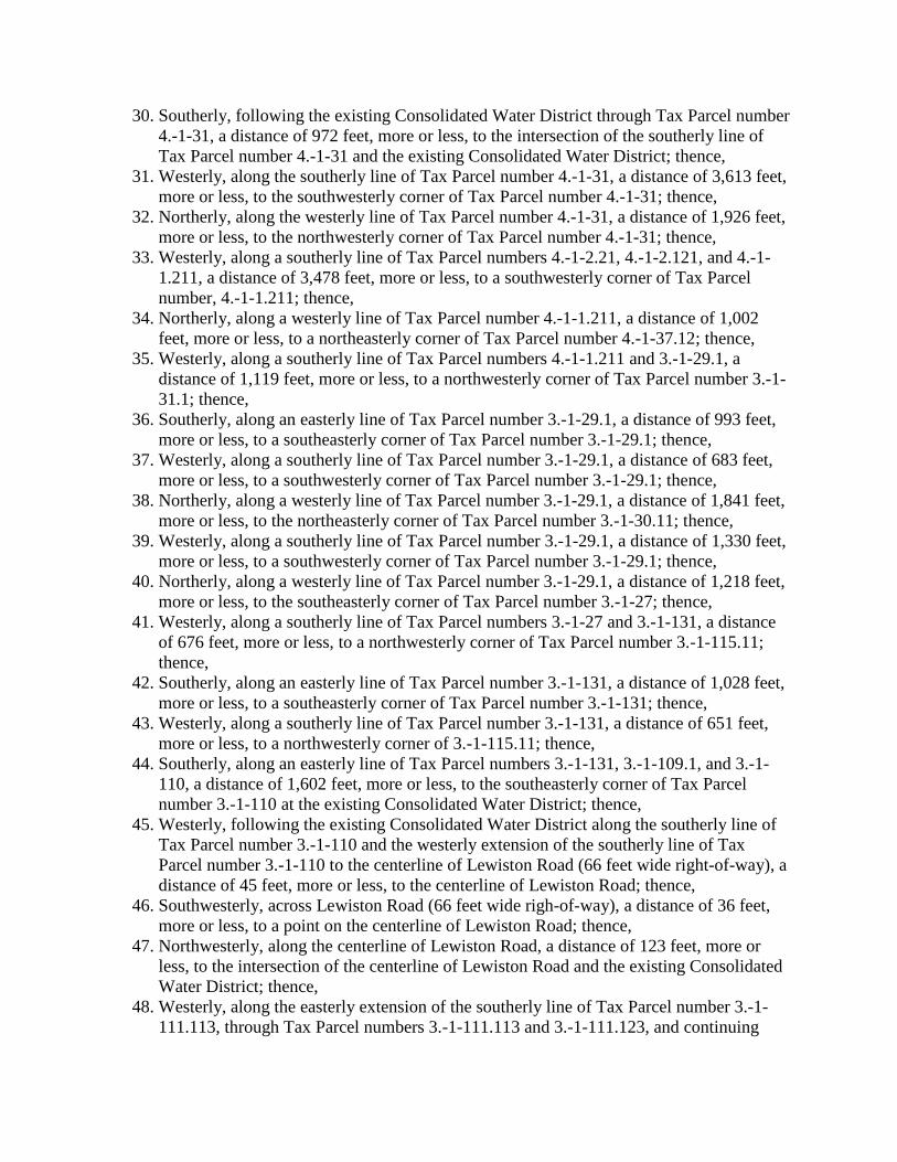
30. Southerly, following the existing Consolidated Water District through Tax Parcel number 4.-1-31, a distance of 972 feet, more or less, to the intersection of the southerly line of Tax Parcel number 4.-1-31 and the existing Consolidated Water District; thence,
31. Westerly, along the southerly line of Tax Parcel number 4.-1-31, a distance of 3,613 feet, more or less, to the southwesterly corner of Tax Parcel number 4.-1-31; thence,
32. Northerly, along the westerly line of Tax Parcel number 4.-1-31, a distance of 1,926 feet, more or less, to the northwesterly corner of Tax Parcel number 4.-1-31; thence,
33. Westerly, along a southerly line of Tax Parcel numbers 4.-1-2.21, 4.-1-2.121, and 4.-1-1.211, a distance of 3,478 feet, more or less, to a southwesterly corner of Tax Parcel number, 4.-1-1.211; thence,
34. Northerly, along a westerly line of Tax Parcel number 4.-1-1.211, a distance of 1,002 feet, more or less, to a northeasterly corner of Tax Parcel number 4.-1-37.12; thence,
35. Westerly, along a southerly line of Tax Parcel numbers 4.-1-1.211 and 3.-1-29.1, a distance of 1,119 feet, more or less, to a northwesterly corner of Tax Parcel number 3.-1-31.1; thence,
36. Southerly, along an easterly line of Tax Parcel number 3.-1-29.1, a distance of 993 feet, more or less, to a southeasterly corner of Tax Parcel number 3.-1-29.1; thence,
37. Westerly, along a southerly line of Tax Parcel number 3.-1-29.1, a distance of 683 feet, more or less, to a southwesterly corner of Tax Parcel number 3.-1-29.1; thence,
38. Northerly, along a westerly line of Tax Parcel number 3.-1-29.1, a distance of 1,841 feet, more or less, to the northeasterly corner of Tax Parcel number 3.-1-30.11; thence,
39. Westerly, along a southerly line of Tax Parcel number 3.-1-29.1, a distance of 1,330 feet, more or less, to a southwesterly corner of Tax Parcel number 3.-1-29.1; thence,
40. Northerly, along a westerly line of Tax Parcel number 3.-1-29.1, a distance of 1,218 feet, more or less, to the southeasterly corner of Tax Parcel number 3.-1-27; thence,
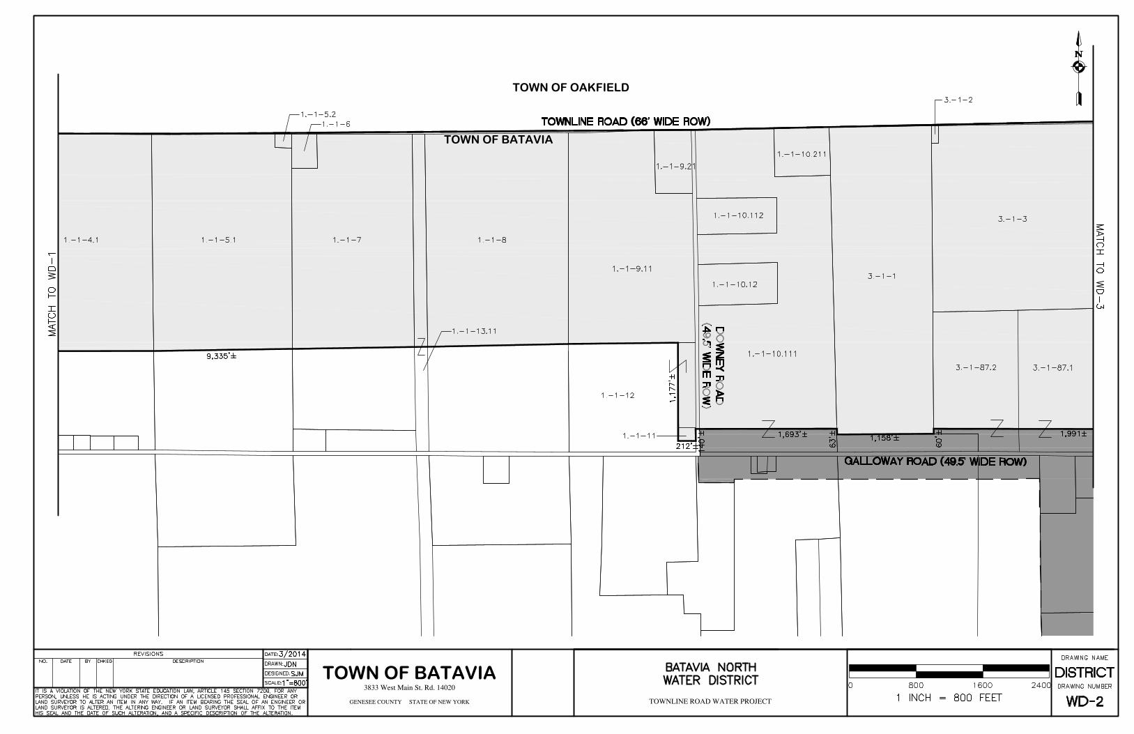
41. Westerly, along a southerly line of Tax Parcel numbers 3.-1-27 and 3.-1-131, a distance of 676 feet, more or less, to a northwesterly corner of Tax Parcel number 3.-1-115.11; thence,
42. Southerly, along an easterly line of Tax Parcel number 3.-1-131, a distance of 1,028 feet, more or less, to a southeasterly corner of Tax Parcel number 3.-1-131; thence,
43. Westerly, along a southerly line of Tax Parcel number 3.-1-131, a distance of 651 feet, more or less, to a northwesterly corner of 3.-1-115.11; thence,
44. Southerly, along an easterly line of Tax Parcel numbers 3.-1-131, 3.-1-109.1, and 3.-1-110, a distance of 1,602 feet, more or less, to the southeasterly corner of Tax Parcel number 3.-1-110 at the existing Consolidated Water District; thence,
45. Westerly, following the existing Consolidated Water District along the southerly line of Tax Parcel number 3.-1-110 and the westerly extension of the southerly line of Tax Parcel number 3.-1-110 to the centerline of Lewiston Road (66 feet wide right-of-way), a distance of 45 feet, more or less, to the centerline of Lewiston Road; thence,
46. Southwesterly, across Lewiston Road (66 feet wide righ-of-way), a distance of 36 feet, more or less, to a point on the centerline of Lewiston Road; thence,
47. Northwesterly, along the centerline of Lewiston Road, a distance of 123 feet, more or less, to the intersection of the centerline of Lewiston Road and the existing Consolidated Water District; thence,
48. Westerly, along the easterly extension of the southerly line of Tax Parcel number 3.-1-111.113, through Tax Parcel numbers 3.-1-111.113 and 3.-1-111.123, and continuing
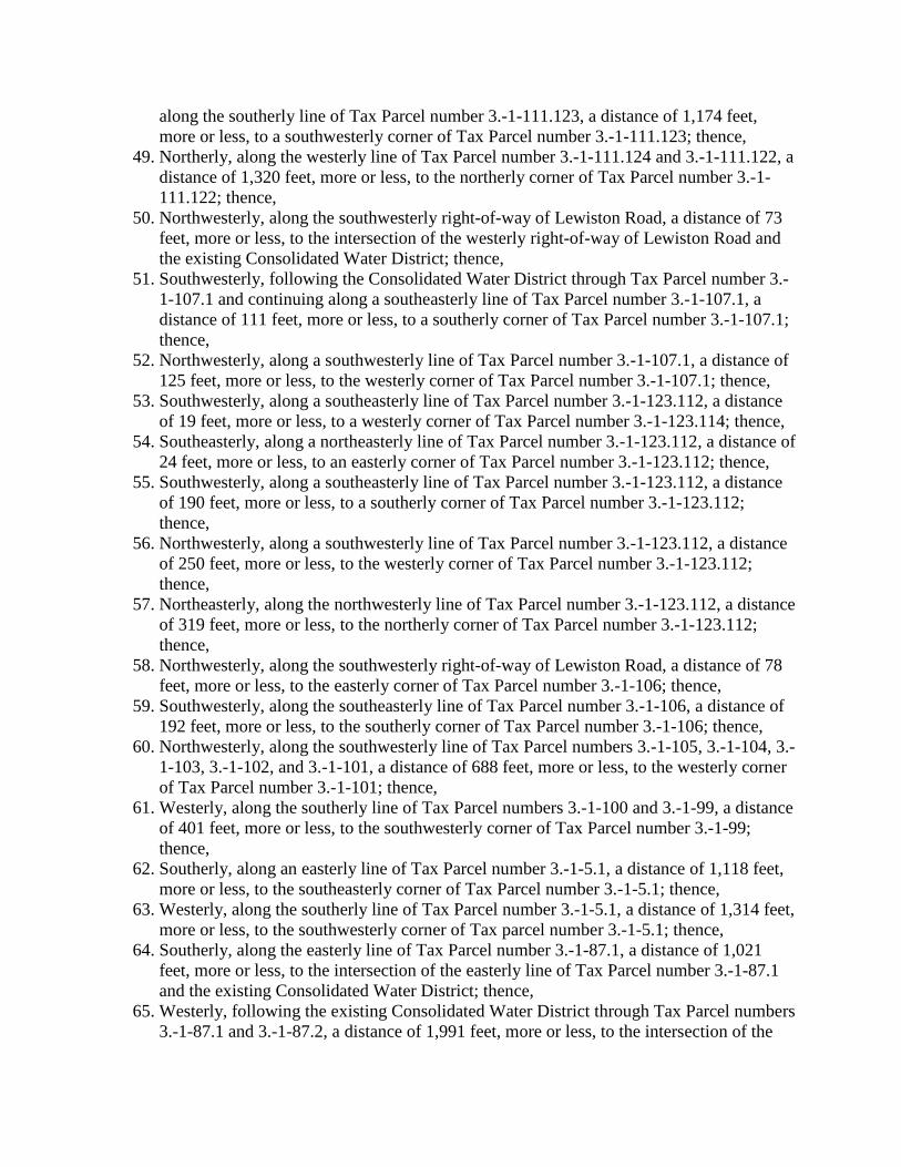
along the southerly line of Tax Parcel number 3.-1-111.123, a distance of 1,174 feet, more or less, to a southwesterly corner of Tax Parcel number 3.-1-111.123; thence,
49. Northerly, along the westerly line of Tax Parcel number 3.-1-111.124 and 3.-1-111.122, a distance of 1,320 feet, more or less, to the northerly corner of Tax Parcel number 3.-1-111.122; thence,
50. Northwesterly, along the southwesterly right-of-way of Lewiston Road, a distance of 73 feet, more or less, to the intersection of the westerly right-of-way of Lewiston Road and the existing Consolidated Water District; thence,
51. Southwesterly, following the Consolidated Water District through Tax Parcel number 3.-1-107.1 and continuing along a southeasterly line of Tax Parcel number 3.-1-107.1, a distance of 111 feet, more or less, to a southerly corner of Tax Parcel number 3.-1-107.1; thence,
52. Northwesterly, along a southwesterly line of Tax Parcel number 3.-1-107.1, a distance of 125 feet, more or less, to the westerly corner of Tax Parcel number 3.-1-107.1; thence,
53. Southwesterly, along a southeasterly line of Tax Parcel number 3.-1-123.112, a distance of 19 feet, more or less, to a westerly corner of Tax Parcel number 3.-1-123.114; thence,
54. Southeasterly, along a northeasterly line of Tax Parcel number 3.-1-123.112, a distance of 24 feet, more or less, to an easterly corner of Tax Parcel number 3.-1-123.112; thence,
55. Southwesterly, along a southeasterly line of Tax Parcel number 3.-1-123.112, a distance of 190 feet, more or less, to a southerly corner of Tax Parcel number 3.-1-123.112; thence,
56. Northwesterly, along a southwesterly line of Tax Parcel number 3.-1-123.112, a distance of 250 feet, more or less, to the westerly corner of Tax Parcel number 3.-1-123.112; thence,
57. Northeasterly, along the northwesterly line of Tax Parcel number 3.-1-123.112, a distance of 319 feet, more or less, to the northerly corner of Tax Parcel number 3.-1-123.112; thence,
58. Northwesterly, along the southwesterly right-of-way of Lewiston Road, a distance of 78 feet, more or less, to the easterly corner of Tax Parcel number 3.-1-106; thence,
59. Southwesterly, along the southeasterly line of Tax Parcel number 3.-1-106, a distance of 192 feet, more or less, to the southerly corner of Tax Parcel number 3.-1-106; thence,
60. Northwesterly, along the southwesterly line of Tax Parcel numbers 3.-1-105, 3.-1-104, 3.-1-103, 3.-1-102, and 3.-1-101, a distance of 688 feet, more or less, to the westerly corner of Tax Parcel number 3.-1-101; thence,
61. Westerly, along the southerly line of Tax Parcel numbers 3.-1-100 and 3.-1-99, a distance of 401 feet, more or less, to the southwesterly corner of Tax Parcel number 3.-1-99; thence,
62. Southerly, along an easterly line of Tax Parcel number 3.-1-5.1, a distance of 1,118 feet, more or less, to the southeasterly corner of Tax Parcel number 3.-1-5.1; thence,
63. Westerly, along the southerly line of Tax Parcel number 3.-1-5.1, a distance of 1,314 feet, more or less, to the southwesterly corner of Tax parcel number 3.-1-5.1; thence,
64. Southerly, along the easterly line of Tax Parcel number 3.-1-87.1, a distance of 1,021 feet, more or less, to the intersection of the easterly line of Tax Parcel number 3.-1-87.1 and the existing Consolidated Water District; thence,
65. Westerly, following the existing Consolidated Water District through Tax Parcel numbers 3.-1-87.1 and 3.-1-87.2, a distance of 1,991 feet, more or less, to the intersection of the
easterly line of Tax Parcel number 3.-1-1 and the existing Consolidated Water District; thence,
66. Southerly, along the easterly line of Tax Parcel number 3.-1-1, a distance of 60 feet, more or less, to the southeasterly corner of Tax Parcel number 3.-1-1; thence,
67. Westerly, along the southerly line of Tax Parcel number 3.-1-1, a distance of 1,158 feet, more or less, to the southwesterly corner of Tax Parcel number 3.-1-1; thence,
68. Northerly, along the westerly line of Tax Parcel number 3.-1-1, a distance of 63 feet, more or less, to the intersection of the westerly line of Tax Parcel number 3.-1-1 and the existing Consolidated Water District; thence,
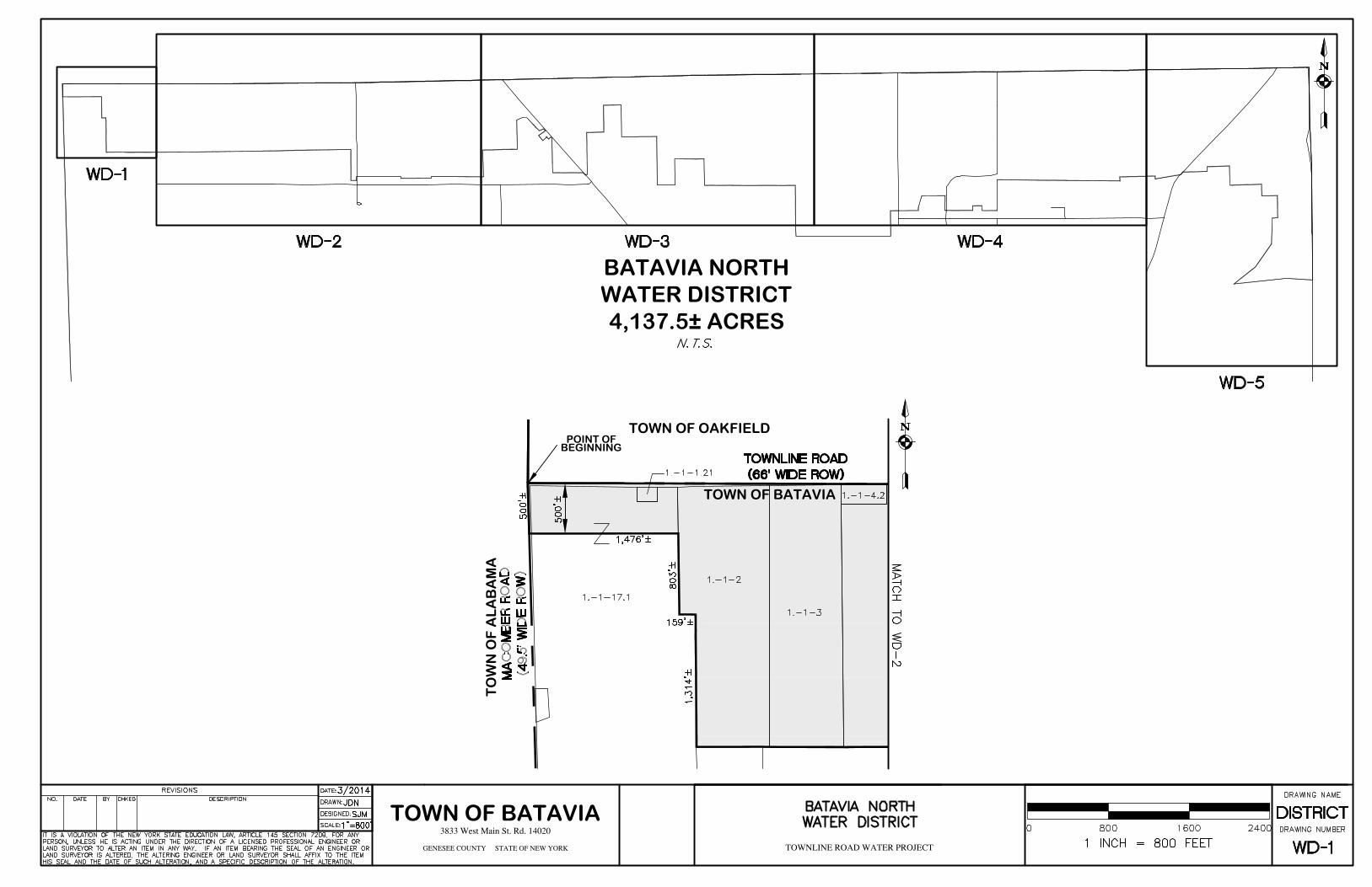
69. Westerly, following the existing Consolidated Water District through Tax Parcel number 1.-1-10.111 and continuing across Downey Road (49.5 feet wide right-of-way), a distance of 1,693 feet, more or less, to a point along the easterly line of Tax Parcel number 1.-1-11; thence,
70. Southerly, along the easterly line of Tax Parcel number 1.-1-11, a distance of 140 feet, more or less, to the southeasterly corner of Tax Parcel number 1.-1-11; thence,
71. Westerly, along the southerly line of Tax Parcel number 1.-1-11, a distance of 212 feet, more or less, to the southwesterly corner of Tax Parcel number 1.-1-11; thence,
72. Northerly, along the westerly line of Tax Parcel number 1.-1-11 and continuing through Tax Parcel number 1.-1-12, a distance of 1,177 feet, more or less, to a point along the southerly line of Tax Parcel number 1.-1-9.11; thence,
73. Westerly, along the southerly line of Tax Parcel numbers 1.-1-9.11 and 1.-1-8, through Tax Parcel number 1.-1-13.11, and continuing along the southerly line of Tax Parcel numbers 1.-1-7, 1.-1-5.1, 1.-1-4.1, 1.-1-3, and 1.-1-2, a distance of 9,335 feet, more or less, to a southwesterly corner of Tax Parcel number 1.-1-2; thence,
74. Northerly, along a westerly line of Tax Parcel number 1.-1-2, a distance of 1,314 feet, more or less, to a northeasterly corner of 1.-1-17.1; thence,
75. Westerly, along a southerly line of Tax Parcel number 1.-1-2, a distance of 159 feet, more or less, to a southwesterly corner of Tax Parcel number 1.-1-2; thence,
76. Northerly, along a westerly line of Tax Parcel number 1.-1-2, a distance of 803 feet, more or less, to the intersection of a line 500 feet south of the centerline of Townline Road (66 feet wide right-of-way) and the westerly line of Tax Parcel number 1.-1-2; thence,
77. Westerly, through Tax Parcel number 1.-1-17.1 and across Macomber Road (49.5 feet wide right-of-way), a distance of 1,476 feet, more or less, to the intersection of a line 500 feet south of the centerline of Townline Road and the Batavia/Alabama Municipal Boundary; thence,
78. Northerly, along the Batavia/Alabama Municipal Boundary, a distance of 500 feet, more or less, to the point of beginning.
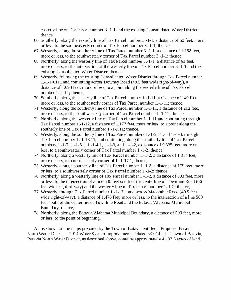
All as shown on the maps prepared by the Town of Batavia entitled, “Proposed Batavia
North Water District – 2014 Water System Improvements,” dated 3/2014. The Town of Batavia, Batavia North Water District, as described above, contains approximately 4,137.5 acres of land.
BEGINNINGPOINT OF
TOWN OF OAKFIELD
TOWN OF BATAVIA
TOWN OF BATAVIA
BATAVIA NORTHWATER DISTRICT4,137.5± ACRES
TO
WN
OF
AL
AB
AM
A
TOWN OF OAKFIELD
TOWN OF BATAVIA
TOWN OF BATAVIA
CONSOLIDATED WATER DISTRICT
TOWN OFOAKFIELD TOWN OF
ELBA
TOWN OF BATAVIA
TOWN OF BATAVIA

CONSOLIDATED WATER DISTRICT
TOWN OF ELBA
TOWN OFBATAVIA
TOWN OF BATAVIA
CONSOLIDATED WATER DISTRICT
CO
NS
OL
IDA
TE
DW
AT
ER
DIS
TR
ICT
TOWN OF ELBA
TO
WN
OF
ST
AF
FO
RD
TO
WN
OF
BA
TA
VIA
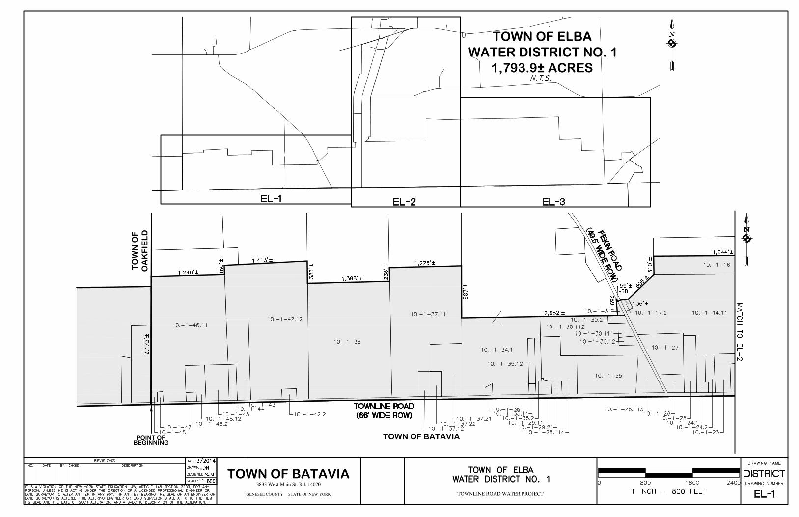
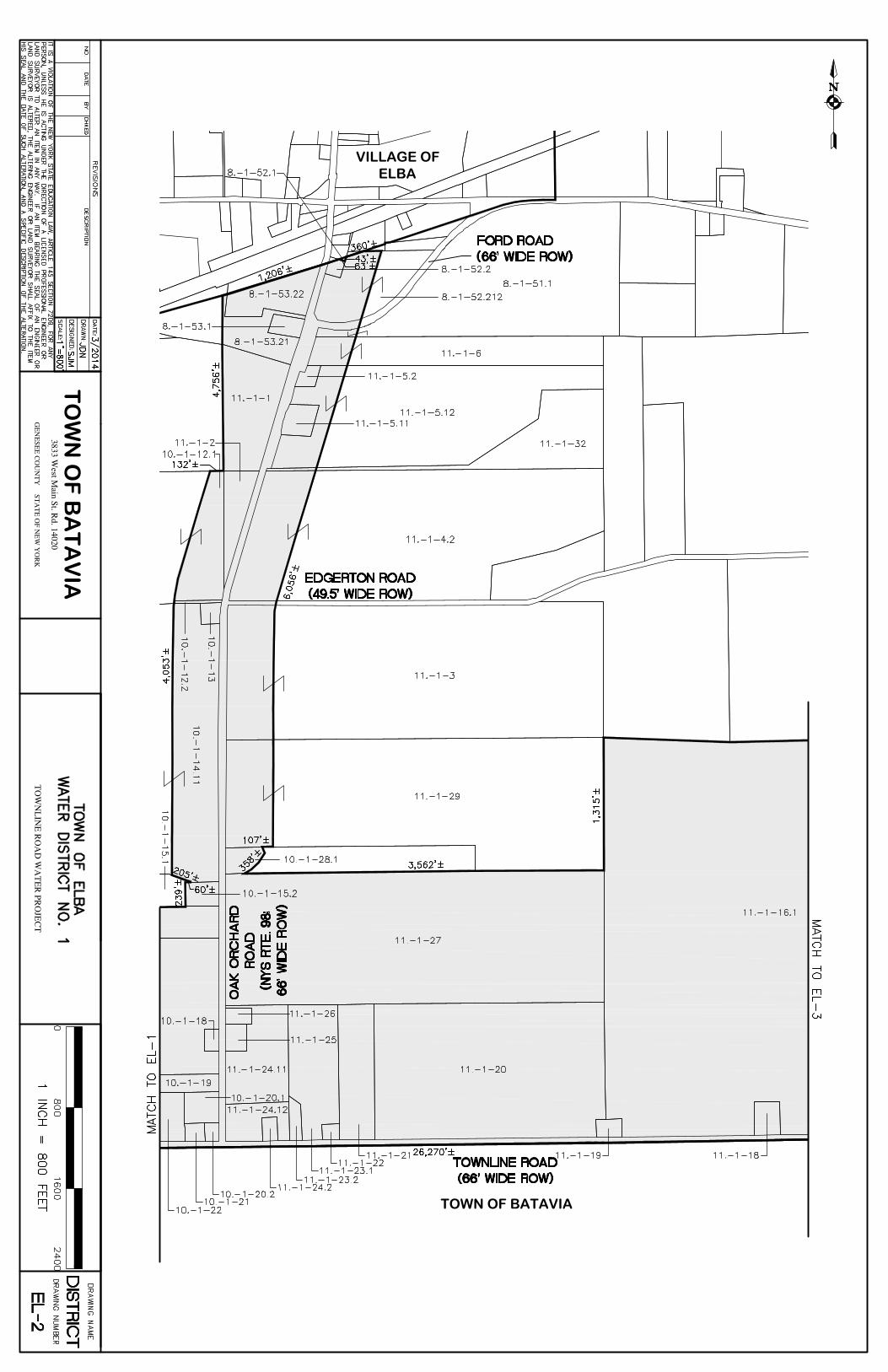
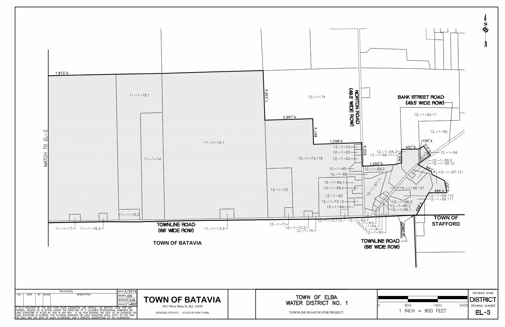
TOWN OF ELBA PROPOSED WATER DISTRICT NO. 1
The boundary of the proposed Town of Elba Water District No. 1 includes all that tract or parcel of land situated in the Town of Elba, County of Genesee, State of New York, being described as follows: Beginning at a point which is the intersection of the Elba, Batavia, and Oakfield Municipal Boundaries; thence,
1. Easterly, along the Elba/Batavia Municipal Boundary, a distance of 26,270 feet, more or less, to the northeasterly corner of the Batavia Municipal Boundary; thence,
2. Northerly, through the right-of-way of Batavia Stafford Townline Road (66' wide right-of-way) and continuing along the easterly line of Tax Parcel number 12.-1-59.111, a distance of 688 feet, more or less, to a southwesterly corner of Tax Parcel number 12.-1-57.121; thence,
3. Easterly, along the southerly line of Tax Parcel number 12.-1-57.121, a distance of 484 feet, more or less, to the southeasterly corner of Tax Parcel number 12.-1-57.121; thence,
4. Northerly, along the easterly line of Tax Parcel number 12.-1-57.121, a distance of 330 feet, more or less, to the northeasterly corner of Tax Parcel number 12.-1-57.121; thence,
5. Northwesterly, along the northeasterly line of Tax Parcel number 12.-1-57.121 and continuing through the right-of-way of Bank Street Road (49.5 feet wide right-of-way), a distance of 863 feet, more or less, to a point on the northwesterly right-of-way of Bank Street Road; thence,
6. Northeasterly, along the northwesterly right-of-way of Bank Street Road (49.5 feet wide right-of-way), a distance of 417 feet, more or less, to the easterly corner of Tax Parcel number 12.-1-56; thence,
7. Northwesterly, along the northeasterly line of Tax Parcel number 12.-1-56, a distance of 310 feet, more or less, to the northerly corner of Tax Parcel number 12.-1-56; thence,
8. Southwesterly, along the northwesterly line of Tax Parcel number 12.-1-56 and through Tax Parcel numbers 12.-1-55 and 12.-1-54.11, a distance of 159 feet, more or less, to the northeasterly corner of Tax Parcel number 12.-1-54.21; thence,
9. Westerly, along the northerly line of Tax Parcel number 12.-1-54.21, a distance of 457 feet, more or less, to the northwesterly corner of Tax Parcel number 12.-1-54.21; thence,
10. Southerly, along the westerly line of Tax Parcel number 12.-1-54.21, a distance of 366 feet, more or less, to the northeasterly corner of Tax Parcel number 12.-1-66.111; thence,
11. Westerly, along the northerly line of Tax Parcel numbers 12.-1-66.111 and 12.-1-68.2 and continuing through the right-of-way of Norton Road (49.5 feet wide right-of-way), a distance of 1,060 feet, more or less, to a point on the westerly right-of-way of Norton Road; thence,
12. Northerly, along the westerly right-of-way of Norton Road (49.5 feet wide right-of-way), a distance of 632 feet, more or less, to a northeasterly corner of Tax Parcel number 12.-1-73.115; thence,
13. Westerly, along a northerly line of Tax Parcel number 12.-1-73.115, a distance of 1,298 feet, more or less, to a southwesterly corner of Tax Parcel number 12.-1-74; thence,

14. Northerly, along an easterly line of Tax Parcel number 12.-1-73.115, a distance of 691 feet, more or less, to a northeasterly corner of Tax Parcel number 12.-1-73.115; thence,
15. Westerly, along a northerly line of Tax Parcel number 12.-1-73.115, a distance of 2,961 feet, more or less, to a southwesterly corner of Tax Parcel number 12.-1-74; thence,
16. Northerly, along the easterly line of Tax Parcel number 11.-1-13.1, a distance of 1,336 feet, more or less, to the northeasterly corner of Tax Parcel number 11.-1-13.1; thence,
17. Westerly, along the northerly line of Tax Parcel numbers 11.-1-13.1, 11.-1-15.1, and 11.-1-16.1, a distance of 7,815 feet, more or less, to the northwesterly corner of Tax Parcel number 11.-1-16.1; thence,
18. Southerly, along a westerly line of Tax Parcel number 11.-1-16.1, a distance of 1,315 feet, more or less, to the northeasterly corner of Tax Parcel number 11.-1-27; thence,
19. Westerly, along the northerly line of Tax parcel number 11.-1-27, a distance of 3,562 feet, more or less, to the southeasterly corner of Tax Parcel number 10.-1-28.1; thence,
20. Northerly, along the easterly line of Tax Parcel number 10.-1-28.1, a distance of 358 feet, more or less, to the northeasterly corner of Tax Parcel number 10.-1-28.1; thence,
21. Easterly, along the southerly line of Tax Parcel number 11.-1-29, a distance of 107 feet, more or less, to a point on the southerly line of Tax Parcel number 11.-1-29 that is 500 feet from the centerline of Oak Orchard Road (66 feet wide right-of-way); thence,
22. Northerly, along a line parallel to, and 500 feet distant easterly from, the centerline of Oak Orchard Road (66 feet wide right-of-way), a distance of 6,056 feet, more or less, to point on the northerly line of Tax Parcel number 8.-1-55.212; thence,
23. Westerly, along a northerly line of Tax Parcel number 8.-1-52.212, a distance of 360 feet, more or less, to a northwesterly corner of Tax Parcel number 8.-1-52.212; thence,
24. Southerly, along a westerly line of Tax Parcel number 8.-1-52.212, a distance of 43 feet, more or less, to the southeasterly corner of Tax parcel number 8.-1-52.1; thence,
25. Northwesterly, along the northeasterly line of Tax Parcel number 8.-1-52.2, a distance of 63 feet, more or less, to a northerly corner of Tax Parcel number 8.-1-52.2; thence,
26. Southwesterly, along the Town/Village of Elba Municipal Boundary, a distance of 1,206 feet, more or less, to a northwesterly corner of Tax Parcel number 8.-1-53.21; thence,
27. Southerly, along the westerly line of Tax Parcel numbers 8.-1-53.21 and 11.-1-1, a distance of 4,756 feet, more or less, to the southwesterly corner of Tax Parcel number 11.-1-1; thence,
28. Westerly, along the northerly line of Tax Parcel number 10.-1-12.1, a distance of 132 feet, more or less, to a point on the northerly line of Tax Parcel number 10.-1-12.1 that is 500 feet from the centerline of Oak Orchard Road (66 feet wide right-of-way); thence,
29. Southerly, along a line parallel to, and 500 feet distant westerly from, the centerline of Oak Orchard Road (66 feet wide right-of-way), a distance of 4,053 feet, more or less, to a point on the southerly line of Tax Parcel number 10.-1-14.11; thence,
30. Southeasterly, along a northeasterly line of Tax Parcel number 10.-1-15.1, a distance of 205 feet, more or less, to the easterly corner of Tax Parcel number 10.-1-15.1; thence,
31. Westerly, along a northerly line of Tax Parcel number 10.-1-15.2, a distance of 60 feet, more or less, to the northwesterly corner of Tax Parcel number 10.-1-15.2; thence,
32. Southerly, along the westerly line of Tax Parcel number 10.-1-15.2, a distance of 239 feet, more or less, to the southwesterly corner of Tax Parcel number 10.-1-15.2; thence,
33. Westerly, along the northerly line of Tax Parcel number 10.-1-16, a distance of 1,644 feet, more or less, to the northwesterly corner of Tax Parcel number 10.-1-16; thence,
34. Southerly, along the westerly line of Tax Parcel number 10.-1-16, a distance of 310 feet, more or less, to the southwesterly corner of Tax Parcel number 10.-1-16; thence,
35. Southwesterly, through Tax Parcel number 10.-1-14.11, a distance of 606 feet, more or less, to the northeasterly corner of Tax Parcel number 10.-1-17.2; thence,
36. Westerly, along the northerly line of Tax Parcel number 10.-1-17.2, a distance of 136 feet, more or less, to the northwesterly corner of Tax Parcel number 10.-1-17.2; thence,
37. Southwesterly, through and perpendicular to the right-of-way of Pekin Road (49.5 wide right-of-way), a distance of 50 feet, more or less, to a point on the westerly right-of-way of Pekin Road; thence,
38. Northwesterly, along the westerly right-of-way of Pekin Road (49.5 feet wide right-of-way), a distance of 59 feet, more or less, to the northerly corner of Tax Parcel number 10.-1-31; thence,
39. Southerly, along the westerly line of Tax Parcel number 10.-1-31 feet, more or less, to the southwesterly corner of Tax Parcel number 10.-1-31; thence,
40. Westerly, along the northerly line of Tax Parcel numbers 10.-1-30.2 and 10.-1-30.112, and continuing through Tax Parcel number 10.-1-34.1, a distance of 2,652 feet, more or less, to a point on an easterly line of Tax Parcel number 10.-1-37.1; thence,
41. Northerly, along an easterly line of Tax Parcel number 10.-1-37.1, a distance of 887 feet, more or less, to the northeasterly corner of Tax Parcel number 10.-1-37.1; thence,
42. Westerly, along the northerly line of Tax Parcel number 10.-1-37.11, a distance of 1,225 feet, more or less, to the northwesterly corner of Tax Parcel number 10.-1-37.1; thence,
43. Southerly, along the westerly line of Tax Parcel number 10.-1-37.1, a distance of 236 feet, more or less, to the northeasterly corner of Tax Parcel number 10.-1-38; thence,
44. Southerly, along the westerly line of Tax Parcel number 10.-1-37.1, a distance of 236 feet, more or less, to the northeasterly corner of Tax Parcel number 10.-1-38; thence,
45. Westerly, along the northerly line of Tax Parcel number 10.-1-38, a distance of 1,398 feet, more or less, to the northwesterly corner of Tax Parcel number 10.-1-38; thence,
46. Northerly, along the easterly line of Tax Parcel number 10.-1-42.12, a distance of 380 feet, more or less, to the northeasterly corner of Tax Parcel number 10.-1-42.12; thence,
47. Westerly, along the northerly line of Tax Parcel number 10.-1-42.12, a distance of 1,413 feet, more or less, to the northwesterly corner of Tax Parcel number 10.-1-42.12; thence,
48. Southerly, along a westerly line of Tax Parcel number 10.-1-42.12, a distance of 160 feet, more or less, to the northeasterly corner of Tax Parcel number 10.-1-46.11; thence,
49. Westerly, along the northerly line of Tax Parcel number 10.-1-46.11, a distance of 1,246 feet, more or less, to the northwesterly corner of Tax Parcel number 10.-1-46.11; thence,
50. Southerly, along the Elba/Oakfield Municipal Boundary, a distance of 2,173 feet, more or less, to the point of beginning.
All as shown on the maps prepared by the Town of Batavia entitled, "Town of Elba Water District No. 1," dated 3/2014. The Town of Elba Water District No. 1, as described above, contains approximately 1,793.9 acres of land.
BEGINNINGPOINT OF TOWN OF BATAVIA
TOWN OF BATAVIA
TOWN OF ELBAWATER DISTRICT NO. 1
1,793.9± ACRES
TO
WN
OF
OA
KF
IEL
D
VILLAGE OFELBA
TOWN OF BATAVIA
TO
WN
OF
BA
TA
VIA
BE
GIN
NIN
GP
OIN
T O
F
TOWN OF BATAVIA
TOWN OF BATAVIA
TOWN OFSTAFFORD

TOWN OF OAKFIELD PROPOSED WATER DISTRICT NO. 6
The boundary of the proposed Town of Oakfield, Water District No. 6 "West" includes all that tract or parcel of land situated in the Town of Oakfield, County of Genesee, State of New York, being described as follows: Beginning at a point which is the intersection of the Oakfield/Batavia Municipal Boundary and the Oakfield/Alabama Municipal Boundary; thence,
1. Easterly, along the Oakfield/Batavia Municipal Boundary, a distance of 21,299 feet, more or less, to a point on the Oakfield/Batavia Municipal Boundary at the intersection with the southerly extension of the easterly line of Tax Parcel number 8.-1-15; thence,
2. Northerly, along the southerly extension of the easterly line of Tax Parcel number 8.-1-15 and the Oakfield/Elba Municipal Boundary, a distance of 2,006 feet, more or less, to the northeasterly corner of Tax Parcel number 8.-1-12.1; thence,
3. Westerly, along the northerly line of Tax Parcel number 8.-1-12.1, a distance of 2,000 feet, more or less, to the northwesterly corner of Tax Parcel number 8.-1-12.1; thence,
4. Northerly, along an easterly line of Tax Parcel number 8.-1-13.1, a distance of 2,002 feet, more or less, to the northeasterly corner of Tax Parcel number 8.-1-13.1; thence,
5. Westerly, along the northerly line of Tax Parcel numbers 8.-1-13.1, 8.-1-45.12, 8.-1-89.1, across Fisher Road (49.5 feet wide right-of-way), and along the northerly line of Tax Parcel number 8.-1-89.21, a distance of 3,295 feet, more or less, to the northwesterly corner of Tax Parcel number 8.-1-89.21; thence,
6. Southerly, along the westerly line of Tax Parcel numbers 8.-1-89.21 and 8.-1-46.1, a distance of 344 feet, more or less, to the southwesterly corner of Tax Parcel number 8.-1-46.1; thence,
7. Westerly, along the northerly line of Tax Parcel number 8.-1-76, a distance of 1,464 feet, more or less, to the northwesterly corner of Tax Parcel number 8.-1-76; thence,
8. Northerly, along the easterly line of Tax Parcel number 8.-1-86.1, a distance of 3,060 feet, more or less, to the northeasterly corner of Tax Parcel number 8.-1-86.1; thence,
9. Westerly, along the northerly line of Tax Parcel number 8.-1-86.1, a distance of 1,799 feet, more or less, to the northwesterly corner of Tax Parcel number 8.-1-86.1; thence,
10. Southerly, along the westerly line of Tax Parcel number 8.-1-86.1 and the easterly line of the Village of Oakfield Municipal Boundary, across Lewiston Road (66 feet wide right-of-way), and along the westerly line of Tax Parcel numbers 8.-1-70, 8.-1-77, 8.-1-71, and 8.-1-73.1, a distance of 5,300 feet, more or less, to the southwesterly corner of Tax Parcel number 8.-1-73.1; thence,
11. Easterly, along a southerly line of Tax Parcel number 8.-1-73.1, a distance of 348 feet, more or less, to a northwesterly corner of Tax Parcel number 8.-1-47.111; thence,
12. Southerly, along a westerly line of Tax Parcel number 8.-1-47.111, a distance of 283 feet, more or less, to a southwesterly corner of Tax Parcel number 8.-1-47.111; thence,
13. Easterly, along a southerly line of Tax Parcel number 8.-1-47.111, a distance of 605 feet, more or less, to a northeasterly corner of Tax Parcel number 8.-1-47.12; thence,
14. Southerly, along a westerly line of Tax Parcel number 8.-1-47.111, a distance of 675 feet, more or less, to the southeasterly corner of Tax Parcel number 8.-1-47.12; thence,
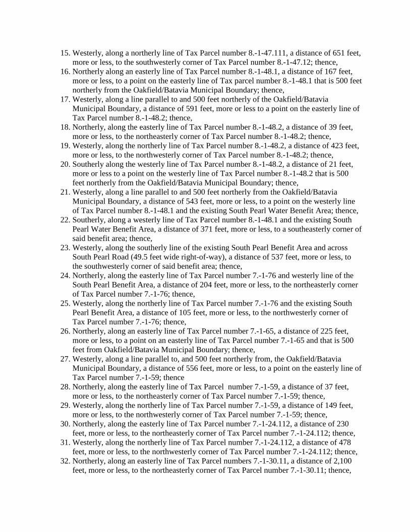
15. Westerly, along a northerly line of Tax Parcel number 8.-1-47.111, a distance of 651 feet, more or less, to the southwesterly corner of Tax Parcel number 8.-1-47.12; thence,
16. Northerly along an easterly line of Tax Parcel number 8.-1-48.1, a distance of 167 feet, more or less, to a point on the easterly line of Tax parcel number 8.-1-48.1 that is 500 feet northerly from the Oakfield/Batavia Municipal Boundary; thence,
17. Westerly, along a line parallel to and 500 feet northerly of the Oakfield/Batavia Municipal Boundary, a distance of 591 feet, more or less to a point on the easterly line of Tax Parcel number 8.-1-48.2; thence,
18. Northerly, along the easterly line of Tax Parcel number 8.-1-48.2, a distance of 39 feet, more or less, to the northeasterly corner of Tax Parcel number 8.-1-48.2; thence,
19. Westerly, along the northerly line of Tax Parcel number 8.-1-48.2, a distance of 423 feet, more or less, to the northwesterly corner of Tax Parcel number 8.-1-48.2; thence,
20. Southerly along the westerly line of Tax Parcel number 8.-1-48.2, a distance of 21 feet, more or less to a point on the westerly line of Tax Parcel number 8.-1-48.2 that is 500 feet northerly from the Oakfield/Batavia Municipal Boundary; thence,
21. Westerly, along a line parallel to and 500 feet northerly from the Oakfield/Batavia Municipal Boundary, a distance of 543 feet, more or less, to a point on the westerly line of Tax Parcel number 8.-1-48.1 and the existing South Pearl Water Benefit Area; thence,
22. Southerly, along a westerly line of Tax Parcel number 8.-1-48.1 and the existing South Pearl Water Benefit Area, a distance of 371 feet, more or less, to a southeasterly corner of said benefit area; thence,
23. Westerly, along the southerly line of the existing South Pearl Benefit Area and across South Pearl Road (49.5 feet wide right-of-way), a distance of 537 feet, more or less, to the southwesterly corner of said benefit area; thence,
24. Northerly, along the easterly line of Tax Parcel number 7.-1-76 and westerly line of the South Pearl Benefit Area, a distance of 204 feet, more or less, to the northeasterly corner of Tax Parcel number 7.-1-76; thence,
25. Westerly, along the northerly line of Tax Parcel number 7.-1-76 and the existing South Pearl Benefit Area, a distance of 105 feet, more or less, to the northwesterly corner of Tax Parcel number 7.-1-76; thence,
26. Northerly, along an easterly line of Tax Parcel number 7.-1-65, a distance of 225 feet, more or less, to a point on an easterly line of Tax Parcel number 7.-1-65 and that is 500 feet from Oakfield/Batavia Municipal Boundary; thence,
27. Westerly, along a line parallel to, and 500 feet northerly from, the Oakfield/Batavia Municipal Boundary, a distance of 556 feet, more or less, to a point on the easterly line of Tax Parcel number 7.-1-59; thence
28. Northerly, along the easterly line of Tax Parcel number 7.-1-59, a distance of 37 feet, more or less, to the northeasterly corner of Tax Parcel number 7.-1-59; thence,
29. Westerly, along the northerly line of Tax Parcel number 7.-1-59, a distance of 149 feet, more or less, to the northwesterly corner of Tax Parcel number 7.-1-59; thence,
30. Northerly, along the easterly line of Tax Parcel number 7.-1-24.112, a distance of 230 feet, more or less, to the northeasterly corner of Tax Parcel number 7.-1-24.112; thence,
31. Westerly, along the northerly line of Tax Parcel number 7.-1-24.112, a distance of 478 feet, more or less, to the northwesterly corner of Tax Parcel number 7.-1-24.112; thence,
32. Northerly, along an easterly line of Tax Parcel numbers 7.-1-30.11, a distance of 2,100 feet, more or less, to the northeasterly corner of Tax Parcel number 7.-1-30.11; thence,
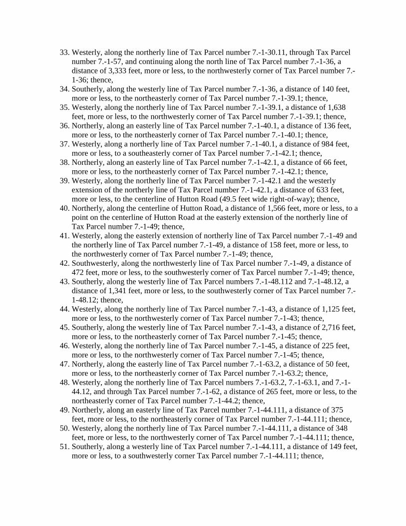
33. Westerly, along the northerly line of Tax Parcel number 7.-1-30.11, through Tax Parcel number 7.-1-57, and continuing along the north line of Tax Parcel number 7.-1-36, a distance of 3,333 feet, more or less, to the northwesterly corner of Tax Parcel number 7.-1-36; thence,
34. Southerly, along the westerly line of Tax Parcel number 7.-1-36, a distance of 140 feet, more or less, to the northeasterly corner of Tax Parcel number 7.-1-39.1; thence,
35. Westerly, along the northerly line of Tax Parcel number 7.-1-39.1, a distance of 1,638 feet, more or less, to the northwesterly corner of Tax Parcel number 7.-1-39.1; thence,
36. Northerly, along an easterly line of Tax Parcel number 7.-1-40.1, a distance of 136 feet, more or less, to the northeasterly corner of Tax Parcel number 7.-1-40.1; thence,
37. Westerly, along a northerly line of Tax Parcel number 7.-1-40.1, a distance of 984 feet, more or less, to a southeasterly corner of Tax Parcel number 7.-1-42.1; thence,
38. Northerly, along an easterly line of Tax Parcel number 7.-1-42.1, a distance of 66 feet, more or less, to the northeasterly corner of Tax Parcel number 7.-1-42.1; thence,
39. Westerly, along the northerly line of Tax Parcel number 7.-1-42.1 and the westerly extension of the northerly line of Tax Parcel number 7.-1-42.1, a distance of 633 feet, more or less, to the centerline of Hutton Road (49.5 feet wide right-of-way); thence,
40. Northerly, along the centerline of Hutton Road, a distance of 1,566 feet, more or less, to a point on the centerline of Hutton Road at the easterly extension of the northerly line of Tax Parcel number 7.-1-49; thence,
41. Westerly, along the easterly extension of northerly line of Tax Parcel number 7.-1-49 and the northerly line of Tax Parcel number 7.-1-49, a distance of 158 feet, more or less, to the northwesterly corner of Tax Parcel number 7.-1-49; thence,
42. Southwesterly, along the northwesterly line of Tax Parcel number 7.-1-49, a distance of 472 feet, more or less, to the southwesterly corner of Tax Parcel number 7.-1-49; thence,
43. Southerly, along the westerly line of Tax Parcel numbers 7.-1-48.112 and 7.-1-48.12, a distance of 1,341 feet, more or less, to the southwesterly corner of Tax Parcel number 7.-1-48.12; thence,
44. Westerly, along the northerly line of Tax Parcel number 7.-1-43, a distance of 1,125 feet, more or less, to the northwesterly corner of Tax Parcel number 7.-1-43; thence,
45. Southerly, along the westerly line of Tax Parcel number 7.-1-43, a distance of 2,716 feet, more or less, to the northeasterly corner of Tax Parcel number 7.-1-45; thence,
46. Westerly, along the northerly line of Tax Parcel number 7.-1-45, a distance of 225 feet, more or less, to the northwesterly corner of Tax Parcel number 7.-1-45; thence,
47. Northerly, along the easterly line of Tax Parcel number 7.-1-63.2, a distance of 50 feet, more or less, to the northeasterly corner of Tax Parcel number 7.-1-63.2; thence,
48. Westerly, along the northerly line of Tax Parcel numbers 7.-1-63.2, 7.-1-63.1, and 7.-1-44.12, and through Tax Parcel number 7.-1-62, a distance of 265 feet, more or less, to the northeasterly corner of Tax Parcel number 7.-1-44.2; thence,
49. Northerly, along an easterly line of Tax Parcel number 7.-1-44.111, a distance of 375 feet, more or less, to the northeasterly corner of Tax Parcel number 7.-1-44.111; thence,
50. Westerly, along the northerly line of Tax Parcel number 7.-1-44.111, a distance of 348 feet, more or less, to the northwesterly corner of Tax Parcel number 7.-1-44.111; thence,
51. Southerly, along a westerly line of Tax Parcel number 7.-1-44.111, a distance of 149 feet, more or less, to a southwesterly corner Tax Parcel number 7.-1-44.111; thence,
52. Westerly, along the northerly line of Tax Parcel numbers 7.-1-69 and 7.-1-71, a distance of 554 feet, more or less, to the northwesterly corner of Tax Parcel number 7.-1-71; thence,
53. Southerly, along the westerly line of Tax Parcel number 7.-1-71, a distance of 70 feet, more or less, to the northeasterly corner of Tax Parcel number 7.-1-72; thence,
54. Westerly, along the northerly line of Tax Parcel number 7.-1-72 and the westerly extension of the northerly line of Tax Parcel number 7.-1-72 and across Macomber Road (66 feet wide right-of-way), a distance of 232 feet, more or less, to a point on the Oakfield/Alabama Municipal Boundary; thence,
55. Southerly, along the Oakfield/Alabama Municipal Boundary, a distance of 346 feet, more or less, to the point of beginning.
All as shown on a map prepared by the Town of Batavia entitled, "Town of Oakfield Water District No. 6," dated 3/2014. The Town of Oakfield Water District No. 6 , as described above, contains approximately 1,367.4 acres of land.

BEGINNINGPOINT OF
WATER DISTRICT NO. 61,367.4 ACRES
TOWN OF OAKFIELD
TOWN OF BATAVIA
SOUTH PEARLWATER
BENEFIT AREA
TOWN OF BATAVIA
TO
WN
OF
AL
AB
AM
A

WATER DISTRICT NO. 6TOWN OF OAKFIELD
VILLAGE OFOAKFIELD
TOWN OF BATAVIA
TO
WN
OF
EL
BA
1,367.4± ACRES
SOUTH PEARLWATERBENEFIT AREA
TOWN OF BATAVIA
Appendix B
Opinion of Probable Cost
1/9/2014 1/9/2014ITEM DESCRIPTION UNIT ESTIMATED
QUANTITYESTIMATED UNIT PRICE
ESTIMATED TOTAL
1 Furnish and Install 8" Diameter PVC Water Main LF 74,900 $24.00 $1,797,600
2 Furnish and Install 12" Diameter PVC Water Main LF 29,500 $32.00 $944,000
3 Directional Drill with 8" Water Main (HDPE) LF 0 $100.00 $0
4Furnish and Install 24" Casing with 8" Diameter PVC Water Main
LF 57 $300.00 $17,100
5Furnish and Install 24" Casing with 12" Diameter PVC Water Main
LF 160 $300.00 $48,000
6 Furnish and Install 8" In-Line Gate Valves Complete EA 64 $1,100.00 $70,400
7 Furnish and Install 12" In-Line Gate Valves Complete EA 27 $2,000.00 $54,000
8 8" Dry Connection to Existing Water Main Complete EA 3 $2,000.00 $6,000
9Wet Connection to Existing Water Main with 8" Tapping Sleeve and Valve
EA 1 $4,000.00 $4,000
10Wet Connection to Existing Water Main with 12" Tapping Sleeve and Valve
EA 3 $6,500.00 $19,500
11 Furnish and Install Hydrant Assemblies EA 165 $4,300.00 $709,500
12 Furnish and Install Short Side Water Service EA 178 $2,800.00 $498,400
13 Furnish and Install Long Side Water Service EA 129 $3,400.00 $438,600
14 Rock Removal CY 6,640 $71.00 $471,440
15 Compaction Testing LS 10.5% of
total 1-14$25,300
16Maintenance and Protection of Traffic Including Signs and Flagmen Meeting NYSDOT Requirements
LS 12% of
total 1-15$102,000
17 Mobilization LS 12% of
total 1-15$102,000
SUBTOTAL = $5,307,840
CONTINGENCY (5%) = $265,392
CONSTRUCTION SUBTOTAL = $5,573,232
LEGAL & ADMINSTRATION (2.2%) = $122,000
ENGINEERING (3.45%) = $192,000
CONSTRUCTION OBSERVATION (4.1%) = $228,000
TOTAL = $6,115,232
TOTAL ESTIMATED CAPITAL COST $6,115,230
GRANT $0
LOAN $6,115,230
LOAN TERM (years) 38
INTEREST RATE 3.00%
DEBT SERVICE $271,879
ANNUAL FARM CONTRIBUTION $47,790
NUMBER OF UNITS 310
ANNUAL DEBT SERVICE PER UNIT $723
ANNUAL WATER COST ($4.47/1,000 gallons, 61,000 gallons/year) $273
TOTAL ANNUAL UNIT COST $996
TOWN OF BATAVIA, ELBA, & OAKFIELDPROPOSED TOWNLINE WATER PROJECT
OPINION OF PROBABLE COST - TOWN FUNDED
Appendix C
Unit Definitions

Water District Benefit Basis Unit Definition
Each single-family residential dwelling shall be considered one unit. Included in this category will be single-family houses, mobile homes, and manufactured homes. Multiple single-family dwellings on the same parcel of land will each be considered an individual unit. Each additional livable area for apartments, duplexes, triplexes, etc. will be assessed 0.5 units for each additional livable area above the base unit of one. Seasonal or non-continuous occupancy will not be taken into consideration when determining what constitutes a unit. Any facility will be considered as a minimum of one unit. All vacant land currently in a certified agricultural district is exempt and will not be assessed. All parcels of vacant land which are developable will each be assessed 0.1 units. All vacant parcels that are classified as "not developable," as set forth in this Map, Plan, and Report, shall be assessed the sum of Ten and No More Dollars ($10.00 and No More), per year. Non-residential, recreational, educational, commercial, industrial and agricultural facilities will be assigned an equivalent number of units based on the greater of the two methods as follows:
1. The average daily usage divided by 300 gpd (Average Daily Usage ÷ 300 = number of units).
2. Expected average daily usage (based on type of facility) divided by 300 gpd. Type of
facility and expected flow rates (gals/day) are listed below. (1):
Type of Facility Flow Rate Per Person Flow Rate Per Unit
(Gals./day) (Gals./day) Campgrounds (Recreational Vehicle - Per site) Sewered sites 100 Central Facilities Served Sites, 300' Radius 100 Peripheral Sites, 500' Radius 75 Subtractions from above No Showers 25 Dual Service (Central Facilities and Sewered facilities overlapping the central)
25
Campgrounds (Summer Camp) Central Facilities 50 Separate Facilities Toilet 10 Shower 25 Kitchen 10 Camps, Day 13 Add for lunch 3 Add for showers 5 Carwash, assuming no recycle Tunnel, Per Car 80 Rollover, per Car 40 Wandwash, per 5 minutes cycle 20
Churches - Per seat 3 (With Catering - add food service value)
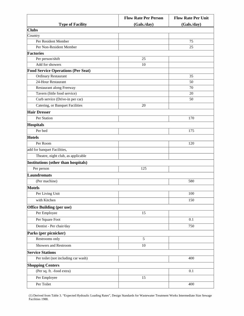
Type of Facility Flow Rate Per Person Flow Rate Per Unit
(Gals./day) (Gals./day) Clubs Country Per Resident Member 75 Per Non-Resident Member 25
Factories Per person/shift 25 Add for showers 10 Food Service Operations (Per Seat) Ordinary Restaurant 35 24-Hour Restaurant 50 Restaurant along Freeway 70 Tavern (little food service) 20 Curb service (Drive-in per car) 50
Catering, or Banquet Facilities 20
Hair Dresser Per Station 170
Hospitals Per bed 175
Hotels Per Room 120
add for banquet Facilities,
Theatre, night club, as applicable
Institutions (other than hospitals) Per person 125
Laundromats (Per machine) 580
Motels Per Living Unit 100
with Kitchen 150
Office Building (per use) Per Employee 15
Per Square Foot 0.1
Dentist - Per chair/day 750
Parks (per picnicker) Restrooms only 5
Showers and Restroom 10
Service Stations Per toilet (not including car wash) 400
Shopping Centers (Per sq. ft. -food extra) 0.1
Per Employee 15
Per Toilet 400
(1) Derived from Table 3. “Expected Hydraulic Loading Rates”, Design Standards for Wastewater Treatment Works Intermediate Size Sewage Facilities 1988.

Appendix D
Health Department Correspondence
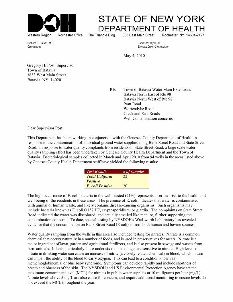
��������������������������������������� �������������������������������������������������������������������������������������������������������� �!�"�������##$����������������������������������%����&'()'*+&+,
����������� ������� ���������� ���������������� ��� �������� ��������������
��������
�� ����������������� ������
���������������
� ���! ����������� �
���������"#����
$%& ����������������!�� �������%'� ������
��������"���(�%�������$� �)
��������"���(�! ������$� �)
������$��*
!��� �*�+ �$��*
,� +���*�%����$��*�
! --�,����.��������/��/ ���
0 ������ ������������
�(���0 ����. ���(���1 �����+�������/��2��/��������(��( �� � � �,������0 ����. ������� �-�(����
� ����� �����( �/����.�������������*���*��-������*���� ������-� ���-�������+���� ��$��*���*����� ���� ��
$��*���3��� ����� ������� ��4��-����/�.�-���������.�� ��* ����������� ���� ��$��*����-��� ��/�- ���� ��
4��-������.�-���� ������(���1 ����* ���+ ��1��� � � �,������� �-�(�0 ����. �����*��( ���������
������������/� ���-���/�-���.�- ��/�-- /� *�������/(���*�5���-������.�)��� --������( ��� ���-��� *��1�� �
1��� � � �,������� �-�(�0 ����. ���������(�� ��� -* *��( ���--������� ��-��&
���������� ��� �������
�������� ����
��������
��
��������������� �
�( �(��(��//��� �/ ����%��/�-��1�/� ��������( �� --��� �� *�6�78�� �� � ������� ���������+�����( �( �-�(���*�
� --�1 ��������( �� ��* ��������( � ��� ������( ��� � �/ ����%��/�-����*�/�� ���(������ �����/����.���� *�
���(����.�-����(�.������� ����*�-�+ -��/��������*�� �� 9/��������������.������/(��������.��.���
��/-�* �1�/� ����+��������%��/�-��:;<&�<��/����������*��.���������*������( �/�.�-������������� ���� ��
$��*���*�/�� *��( ���� ������*��/�-�� *����*��/���--���. -- *�-�+ �.���� ������( ��������������( �
/����.��������/��/ ���������*�� ���� /��-�� ������1��"#�0:�=��!�*�����(�>�1���������(���� � �- *�
��* �/ ��(����( �/����.��������������+���� ��$��*�6%9/�-�8�������.�1��(�(�.�����*�1���� �����/ ��
!�� ��4��-������.�-�������.��( �� --������(����� ���-�����/-�* *�� ���������������� ����"����� ������/�..���
/( .�/�-��(����//����������--���������.1 ��������*�����*������ *������ � ������ ������. ������"����� ������
.�2������� *� ������-��������* ����*�����/�-����-�� ���-�? ������*�����-����� � ������� ��� ���*����� �����.�
���.����.�-����3�������������/�-��-���(�� ���* ����'�.���(������� ���� �� ������ ���������� ������(�- � -�����
������ ����*���+������� ��/���/��� ������/� �� ���������� �6��/-�� -��� -�� *�/( .�/�-8����1-��*���(�/(���������
/����.������( ��1�-��������( �1-��*����/������'�� �����(���/���- �*������/��*������+��������
. �( .��-�1�� .�������1-� �1�1�����*��. �����.���.��/���* � -�������*-����*���/-�* ��(���� ������
1� ��(���*�1-� � �������( ��+������( �"#�0:����*�@��%������. ���-����� /�����5� �/��(�� �� ���( �
.�'�.�.�/����.������- � -�6�,>8����������� �������1-�/���� ������-� ������.�--����.��� ��-�� ��6.�A>8��
"����� �- � -���1�� �;�.�A>��� ��-���/��� �����/��/ ������*�� 4��� ��**������-�.������������� ���� �- � -��*��
���� '/ *��( ��,>��(����(�����( �� ���
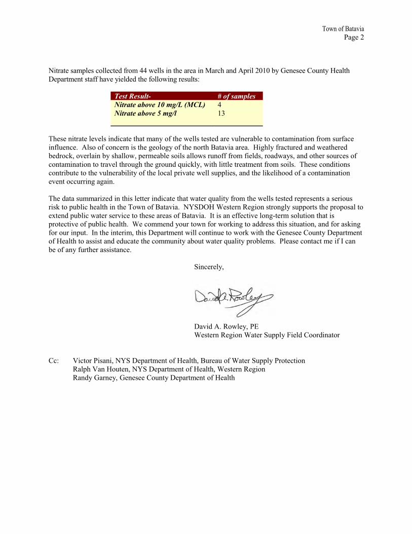
���������������
��� ��
"����� ���.�- ��/�-- /� *����.����� --������( ��� ��������/(���*�5���-���1��� � � �,������� �-�(�
0 ����. ���������(�� ��� -* *��( ���--������� ��-��&
���������� ��� �������
���������������������� !��" �
��������������#���� �
�( � ������� �- � -����*�/�� ��(���.��������( �� --��� �� *��� ���-� ��1- ����/����.�����������.������/ �
���-� �/ ���5-������/��/ �������( �� �-��������( �����(����������� �������(-�����/��� *���*�� ��( � *�
1 *��/+���� �-����1���(�--����� �. �1- ����-���--��������������.��� -*������*��������*���( ������/ �����
/����.��������������� -��(����(��( ������*�4��/+-������(�-���- ��� ��. ������.����-�����( � �/��*�������
/�����1�� �����( ���-� ��1�-��������( �-�/�-������� �� --�����-� �����*��( �-�+ -�(��*������/����.��������
� ����//�������������
�( �*������..���? *�����(���- �� ����*�/�� ��(������ ��4��-�������.��( �� --��� �� *�� �� � ������� ������
���+������1-�/�( �-�(�����( �������������������"#�0:��! �� ���$ �����������-������������( ��������-����
'� �*���1-�/���� ��� ���/ �����( � ��� ����������������3�������� �� /��� �-���9� �.���-�������(������
���� /��� ������1-�/�( �-�(���! �/�.. �*������������������+��������**� ����(����������������*�������+����
����������������3���( ���� ��.���(���0 ����. �����--�/������ �������+����(��( �� � � �,������0 ����. ���
���� �-�(�������������*� *�/�� ��( �/�..�������1������� ��4��-�������1- .�����- �� �/����/��. ����3�/���
1 ������������( ����������/ �
���/ � -��
0���*�5��$��- ����%
! �� ���$ �����!�� ������-��B� -*�,���*������
,/&� C�/������������"#��0 ����. ������� �-�(����� ������!�� ������-������ /����
$�-�(�C������� ���"#��0 ����. ������� �-�(��! �� ���$ ����
$��*������ ���� � � �,������0 ����. ������� �-�(
Appendix E
Water System Models

Fire Flow Node FlexTable: Fire Flow Report (WaterCad-BNWD2014.wtg)
Current Time: 0.000 hours
Is Fire Flow Run
Balanced?
Junction w/
Minimum Pressure (System)
Pressure (Calculated
System Lower Limit)(psi)
Pressure (System Lower
Limit)(psi)
Junction w/
Minimum
Pressure (Zone)
Pressure (Calculated Zone Lower Limit)(psi)
Pressure (Calculat
ed Residual)(psi)
Pressure (Residual Lower Limit)(psi)
Flow (Total Available)(gpm)
Flow (Total Needed)(gpm)
Fire Flow (Available)(gpm)
Fire Flow (Needed)(gpm)
Satisfies Fire Flow
Constraints?
Fire Flow Iterations
Label
TrueJ-267.8(N/A)J-267.820.020.01,8679001,467500True4J-16
TrueJ-260.0(N/A)J-260.021.520.02,1215152,106500True7J-17
TrueJ-417.9(N/A)J-417.920.020.03,2655153,250500True5J-18
TrueJ-4113.5(N/A)J-4113.520.020.01,7195151,704500True4J-19
TrueJ-270.0(N/A)J-270.050.620.01,5555151,540500True6J-20
TrueJ-2218.7(N/A)J-2218.720.020.02,9825152,967500True5J-21
TrueJ-2128.1(N/A)J-2128.120.020.02,8335152,818500True5J-22
TrueJ-2220.7(N/A)J-2220.720.020.03,1135153,098500True5J-23
TrueJ-2619.1(N/A)J-2619.120.020.01,6775151,662500True5J-24
TrueJ-2621.4(N/A)J-2621.420.020.01,3355001,335500True5J-25
TrueJ-2528.9(N/A)J-2528.920.020.01,1915101,181500True5J-26
TrueJ-2555.5(N/A)J-2555.520.020.0639505634500True3J-27
TrueJ-4133.5(N/A)J-4133.520.020.01,3725051,367500True4J-28
TrueJ-270.0(N/A)J-270.024.820.01,5455051,540500True6J-29
TrueJ-270.3(N/A)J-270.320.020.01,5425051,537500True4J-30
TrueJ-44 TORREY
23.4(N/A)J-44 TORREY
23.420.020.02,7725052,767500True4J-31
TrueJ-2732.4(N/A)J-2732.420.020.02,5916202,471500True4J-32
TrueJ-43 POST
27.8(N/A)J-43 POST
27.820.020.02,3725052,367500True4J-33
TrueJ-2643.8(N/A)J-2643.820.020.01,7445051,739500True4J-34
TrueJ-260.0(N/A)J-260.024.520.02,1215152,106500True7J-35
TrueJ-260.0(N/A)J-260.024.720.02,1365302,106500True6J-36
TrueJ-260.0(N/A)J-260.031.820.02,1115052,106500True7J-37
TrueJ-3920.9(N/A)J-3920.920.020.0726515711500True4J-38
TrueJ-3829.8(N/A)J-3829.820.020.0636505631500True3J-39
TrueJ-3810.0(N/A)J-3810.020.020.0791505786500True4J-40
TrueJ-2747.8(N/A)J-2747.820.020.01,1135051,108500True4J-41
TrueJ-2632.2(N/A)J-2632.220.020.01,8085321,776500True4J-42 LAMB
TrueJ-42 LAMB
29.2(N/A)J-42 LAMB
29.220.020.01,9475151,932500True4J-43 POST
TrueJ-4122.2(N/A)J-4122.220.020.02,8475212,826500True4J-44 TORREY
TrueJ-2221.4(N/A)J-2221.420.020.03,1375373,100500True5J-45 OFFHAUS
Page 1 of 127 Siemon Company Drive Suite 200 W Watertown, CT 06795 USA +1-203-755-1666
3/21/2014
Bentley WaterGEMS V8i (SELECTseries 3)[08.11.03.17]Bentley Systems, Inc. Haestad Methods Solution CenterWaterCad-BNWD2014.wtg
FlexTable: Junction Table (WaterCad-BNWD2014.wtg)
Current Time: 0.000 hours
Pressure(psi)
Hydraulic Grade(ft)
Demand(gpm)
Demand CollectionZoneElevation(ft)
LabelID
75.41,043.25400<Collection: 1 items><None>869.00J-1666
87.21,046.5515<Collection: 1 items><None>845.00J-1767
94.61,050.6415<Collection: 1 items><None>832.00J-1869
83.41,050.6815<Collection: 1 items><None>858.00J-1971
116.11,051.2515<Collection: 1 items><None>783.00J-2073
65.91,052.3015<Collection: 1 items><None>900.00J-2175
59.41,052.2915<Collection: 1 items><None>915.00J-2277
65.81,052.0715<Collection: 1 items><None>900.00J-2379
63.11,046.9015<Collection: 1 items><None>901.00J-2486
57.61,046.220<Collection: 0 items><None>913.00J-2588
58.01,044.1110<Collection: 1 items><None>910.00J-2690
65.41,051.245<Collection: 1 items><None>900.00J-2794
86.81,050.685<Collection: 1 items><None>850.00J-2896
134.71,051.255<Collection: 1 items><None>740.00J-29103
123.01,051.255<Collection: 1 items><None>767.00J-30105
119.51,050.275<Collection: 1 items><None>774.00J-31107
124.21,050.10120<Collection: 1 items><None>763.00J-32109
94.21,049.835<Collection: 1 items><None>832.00J-33111
105.11,049.835<Collection: 1 items><None>807.00J-34114
99.71,046.5215<Collection: 1 items><None>816.00J-35116
120.51,046.5130<Collection: 1 items><None>768.00J-36118
118.81,046.525<Collection: 1 items><None>772.00J-37120
75.81,043.0915<Collection: 1 items><None>868.00J-38122
76.61,043.085<Collection: 1 items><None>866.00J-39124
109.51,043.085<Collection: 1 items><None>790.00J-40126
76.91,050.685<Collection: 1 items><None>873.00J-41128
91.21,047.9532<Collection: 1 items><None>837.06J-42 LAMB130
92.71,048.7715<Collection: 1 items><None>834.57J-43 POST133
114.71,050.3321<Collection: 1 items><None>785.26J-44 TORREY136
72.31,051.6837<Collection: 1 items><None>884.53J-45 OFFHAUS139
Page 1 of 127 Siemon Company Drive Suite 200 W Watertown, CT 06795 USA +1-203-755-1666
3/21/2014
Bentley WaterGEMS V8i (SELECTseries 3)[08.11.03.17]Bentley Systems, Inc. Haestad Methods Solution CenterWaterCad-BNWD2014.wtg
FlexTable: Pipe Table (WaterCad-BNWD2014.wtg)
Current Time: 0.000 hours
Length (User Defined)(ft)
Has User Defined Length?
Headloss Gradient(ft/ft)
Velocity(ft/s)
Flow(gpm)
Minor Loss Coefficient (Local)
Has Check Valve?
Hazen-Williams C
MaterialDiameter(in)
Stop NodeStart NodeLength (Scaled)(ft)
LabelID
0.00False0.0011.00-1570.000False130.0PVC8.0J-17J-165,569.76P-2568
0.00False0.0000.11-180.000False130.0PVC8.0J-19J-183,860.71P-2772
0.00False0.0000.27-430.000False130.0PVC8.0J-20J-1910,687.47P-2874
0.00False0.0000.46-730.000False130.0PVC8.0J-21J-207,394.50P-2976
0.00False0.0000.07430.000False130.0Ductile Iron16.0J-22J-216,308.29P-3078
0.00False0.0000.381330.000False130.0Ductile Iron12.0J-23J-223,775.54P-3180
0.00False0.0000.572000.000False65.0Ductile Iron12.0J-23R-46,315.97P-3383
0.00False0.0000.301050.000False40.0Ductile Iron12.0J-22R-47,861.57P-3484
0.00False0.0000.371310.000False65.0Ductile Iron12.0J-21R-412,716.12P-3585
0.00False0.0000.40-1410.000False130.0PVC12.0J-24J-175,259.26P-3687
0.00False0.0000.38590.000False90.0PVC8.0J-25J-243,531.27P-3789
0.00False0.0000.792780.000False100.0PVC12.0J-26J-255,474.63P-3891
0.00False0.0000.762680.000False130.0PVC12.0J-16J-263,907.14P-3992
0.00False0.0010.61-2160.000False60.0Ductile Iron12.0R-4J-2413,071.78P-4093
0.00False0.0000.0350.000False130.0PVC8.0J-27J-208,963.78P-4195
0.00False0.0000.0350.000False130.0PVC8.0J-28J-191,655.27P-4297
0.00False0.0010.62-2190.000False65.0Ductile Iron12.0R-4J-2516,039.37P-4398
0.00False0.0000.0350.000False130.0PVC8.0J-29J-202,511.53P-44104
0.00False0.0000.0350.000False130.0PVC8.0J-30J-202,146.21P-45106
0.00False0.0000.341200.000False130.0PVC12.0J-32J-313,477.70P-47110
0.00False0.0000.88-1380.000False130.0PVC8.0J-18J-331,730.08P-49113
0.00False0.0000.0350.000False130.0PVC8.0J-34J-331,847.18P-50115
0.00False0.0000.14500.000False130.0PVC12.0J-35J-172,112.25P-51117
0.00False0.0000.09300.000False130.0PVC12.0J-36J-354,593.73P-52119
0.00False0.0000.0150.000False130.0PVC12.0J-37J-352,692.68P-53121
0.00False0.0000.16250.000False130.0PVC8.0J-38J-168,061.69P-54123
0.00False0.0000.0350.000False130.0PVC8.0J-39J-383,113.20P-55125
0.00False0.0000.0350.000False130.0PVC8.0J-40J-384,638.73P-56127
0.00False0.0000.03-50.000False130.0PVC8.0J-19J-412,753.84P-57129
0.00False0.0000.52-810.000False130.0PVC8.0J-42 LAMBJ-178,142.13P-58131
0.00False0.0000.72-1130.000False130.0PVC8.0J-43 POSTJ-42 LAMB2,549.81P-60134
0.00False0.0000.82-1280.000False130.0PVC8.0J-33J-43 POST2,637.85P-61135
0.00False0.0000.411460.000False130.0PVC12.0J-44 TORREY
J-184,342.17P-62137
0.00False0.0000.351250.000False130.0PVC12.0J-31J-44 TORREY
1,046.30P-63138
0.00False0.0000.903180.000False130.0PVC12.0J-45 OFFHAUS
J-231,271.99P-64140
0.00False0.0000.802810.000False130.0PVC12.0J-18J-45 OFFHAUS
4,317.51P-65141
Page 1 of 127 Siemon Company Drive Suite 200 W Watertown, CT 06795 USA +1-203-755-1666
3/21/2014
Bentley WaterGEMS V8i (SELECTseries 3)[08.11.03.17]Bentley Systems, Inc. Haestad Methods Solution CenterWaterCad-BNWD2014.wtg
Appendix F
Farm Agreements