table of contents - casino mining corporation · 2015-12-18 · casino mining corporation casino...
TRANSCRIPT
Casino Mining Corporation Casino Project
YESAB Registry # 2014-0002
Supplementary Information Report
B.12-i December 18, 2015
TABLE OF CONTENTS
WILDLIFE ............................................................................................................................................... B.12-1 B.12 –
B.12.1 INTRODUCTION ............................................................................................................................ B.12-1 B.12.2 FREEGOLD ROAD AND OTHER ACCESS ROADS .................................................................... B.12-5
B.12.2.1 R2-150 ................................................................................................................................ B.12-5 B.12.2.2 R2-151 ................................................................................................................................ B.12-6 B.12.2.3 R2-152 ................................................................................................................................ B.12-8 B.12.2.4 R2-153 ................................................................................................................................ B.12-9
B.12.3 EFFECTS ASSESSMENT FOR MAMMALS ............................................................................... B.12-11 B.12.3.1 R2-154 .............................................................................................................................. B.12-11 B.12.3.2 R2-155 .............................................................................................................................. B.12-15 B.12.3.3 R2-156 .............................................................................................................................. B.12-17 B.12.3.4 R2-157 .............................................................................................................................. B.12-19 B.12.3.5 R2-158 .............................................................................................................................. B.12-22 B.12.3.6 R2-159 .............................................................................................................................. B.12-22 B.12.3.7 R2-160 .............................................................................................................................. B.12-23 B.12.3.8 R2-161 .............................................................................................................................. B.12-23 B.12.3.9 R2-162 .............................................................................................................................. B.12-27 B.12.3.10 R2-163 .............................................................................................................................. B.12-27
B.12.3.11 R2-164 .............................................................................................................................. B.12-28 B.12.3.12 R2-165 .............................................................................................................................. B.12-29 B.12.3.13 R2-166 .............................................................................................................................. B.12-29 B.12.3.14 R2-167 .............................................................................................................................. B.12-30 B.12.3.15 R2-168 .............................................................................................................................. B.12-30 B.12.3.16 R2-169 .............................................................................................................................. B.12-32 B.12.3.17 R2-170 .............................................................................................................................. B.12-32 B.12.3.18 R2-171 .............................................................................................................................. B.12-35 B.12.3.19 R2-172 .............................................................................................................................. B.12-37 B.12.3.20 R2-173 .............................................................................................................................. B.12-38 B.12.3.21 R2-174 .............................................................................................................................. B.12-38 B.12.3.22 R2-175 .............................................................................................................................. B.12-39 B.12.3.23 R2-176 .............................................................................................................................. B.12-39 B.12.3.24 R2-177 .............................................................................................................................. B.12-40
B.12.4 EFFECTS ASSESSMENT FOR BIRDS ...................................................................................... B.12-46 B.12.4.1 R2-178 .............................................................................................................................. B.12-46 B.12.4.2 R2-179 .............................................................................................................................. B.12-47
Casino Mining Corporation Casino Project
YESAB Registry # 2014-0002
Supplementary Information Report
B.12-ii December 18, 2015
B.12.4.3 R2-180 .............................................................................................................................. B.12-48 B.12.4.4 R2-181 .............................................................................................................................. B.12-49 B.12.4.5 R2-182 .............................................................................................................................. B.12-50 B.12.4.6 R2-183 .............................................................................................................................. B.12-51 B.12.4.7 R2-184 .............................................................................................................................. B.12-57 B.12.4.8 R2-185 .............................................................................................................................. B.12-57
B.12.5 WILDLIFE MITIGATION AND MONITORING PLAN ................................................................... B.12-57 B.12.5.1 R2-186 .............................................................................................................................. B.12-57 B.12.5.2 R2-187 .............................................................................................................................. B.12-58 B.12.5.3 R2-188 .............................................................................................................................. B.12-59
LIST OF TABLES
Table B.12.1-1 Requests for Supplementary Information Related to Wildlife .............................................. B.12-2 Table B.12.2-1 Summary of initiatives related to caribou and thinhorn sheep ............................................. B.12-5 Table B.12.3-1 Change in caribou late winter habitat quality due to Project effects in the RSA ................ B.12-13 Table B.12.3-2 Summary of observations of wildlife sign by species along the proposed water pipeline route
............................................................................................................................................ B.12-24 Table B.12.3-3 Summary of PDA Monitoring Programs by Project Phase................................................. B.12-25 Table B.12.3-4 Projected Traffic Volumes during the Operations Phase ................................................... B.12-29 Table B.12.3-5 Grizzly bear licensed harvest and conflict bear kills by sex in GMAs that intersect the Project
(2005-2014) ........................................................................................................................ B.12-30 Table B.12.3-6 Average annual grizzly bear mortality (2005–2014) compared to 3% and 4% annual allowable
harvest estimates by sex .................................................................................................... B.12-32 Table B.12.3-7 Projected Traffic Volumes during the Operations Phase ................................................... B.12-32 Table B.12.3-8 Collared Pika Monitoring: Presence ................................................................................... B.12-33 Table B.12.4-1 Summary of key indicators and species/communities used to assess the effects of the
proposed Project on birds, including BCR4 priority designation and national conservation status ............................................................................................................................................ B.12-47
Table B.12.4-2 Change in Rusty Blackbird Habitat Quality Due to Project Effects in the LSA .................. B.12-48 Table B.12.4-3 Summary of alpine ecosites within the Casino Project local study area (LSA).................. B.12-49 Table B.12.4-4 Mitigations for identified bird species ................................................................................. B.12-49 Table B.12.4-5 Open Pit, TMF Pond and TMF Spillway Water Quality during TMF Discharge and Pit Discharge
phases ................................................................................................................................ B.12-54
Casino Mining Corporation Casino Project
YESAB Registry # 2014-0002
Supplementary Information Report
B.12-iii December 18, 2015
LIST OF FIGURES
Figure B.12.3-1 Klaza caribou herd late winter habitat at Project maximum disturbance .......................... B.12-14 Figure B.12.3-2 Comparison of the Wildlife Zone of Influence to the Noise Levels of the Casino Mine during
Daytime Operation ............................................................................................................. B.12-16 Figure B.12.3-3 Theoretical zone of influence ............................................................................................ B.12-18 Figure B.12.3-4 Fortymile Caribou Herd Range ......................................................................................... B.12-21 Figure B.12.3-5 Yukon River water pipeline alignment wildlife detections and trail locations .................... B.12-26 Figure B.12.3-6 Collared pike observations and suitable habitat ............................................................... B.12-34 Figure B.12.3-7 Wolverine detections during the snow tracking surveys ................................................... B.12-36 Figure B.12.3-8 Dall’s Sheep Regional Distribution .................................................................................... B.12-43 Figure B.12.3-9 Dawson range sheep distribution and flight routes to the Casino Project ........................ B.12-45 Figure B.12.4-1 Pollutant Removal Mechanisms in Constructed Wetlands (UN-HABITAT, 2008) ............. B.12-52 Figure B.12.5-1 Schematic of the Adaptive Wildlife Mitigation and Monitoring Process ............................. B.12-59
Casino Mining Corporation Casino Project
YESAB Registry # 2014-0002
Supplementary Information Report
B.12-1 December 18, 2015
WILDLIFE B.12 –
B.12.1 INTRODUCTION
On January 27, 2015, the Executive Committee requested that CMC provide supplementary information to the Casino Project (YESAB Project No. 2014-0002) to enable the Executive Committee to commence Screening. The Executive Committee considered comments from various First Nations, Decision Bodies and regulators on the adequacy of the Project Proposal in the preparation of the Adequacy Review Report (ARR). CMC provided a Supplementary Information Report (SIR-A) on March 16, 2015. Subsequently, the Executive Committee issued a second Adequacy Review Report (ARR No.2) on May 15, 2015. This document addresses comments related to the terrestrial environment and wildlife.
Most of the information requests in ARR No. 2 were requesting further elaboration on the information provided by CMC in SIR-A. Since CMC had provided adequate information in SIR-A, and it was unclear exactly what the additional information request was concerning, and sometimes its relevance to an effects adequacy review, CMC suggested that YESAB convene a technical workshop for the YESAB executive committee and technical reviewers to provide CMC with further clarification on their requests in ARR No.2. In preparation for that workshop, CMC met with YESAB in July 2015 to identify the need for additional discussion to the written information requests so that further responses would adequately address YESAB’s concerns. During the July workshop, YESAB determined that the workshop’s discussions would be limited to the following Information Requests (noted in Table B.12.1-1):
• R2-150
• R2-151
• R2-154
• R2-162
• R2-167
• R2-176
• R2-177
• R2-178
• R2-180
YESAB directed CMC to address the 30 remaining information requests as written responses with no further discussion provided at the workshop.
On October 1, 2015, the technical working group meeting included YESAB staff, YESAB wildlife consultants, technical reviewers from Yukon Government Department of Environment, Little Salmon/Carmacks First Nation, Selkirk First Nation, Tr’ondëk Hwëch’in First Nation, and Environment Canada. The objectives of the workshop were to:
1. Have the proponent (CMC) provide background review of the information provided in the Project Proposal and Supplementary Information Report (SIR-A) to address the 9 specific information requests;
2. Clarify with reviewers additional information required to meet the requests of the Executive Committee for proposal adequacy; and
3. Identify an approach to responding to the 9 information requests.
The daylong workshop provided CMC some clarification on the information requests, and the information for the nine requests are presented herein.
Casino Mining Corporation Casino Project
YESAB Registry # 2014-0002
Supplementary Information Report
B.12-2 December 18, 2015
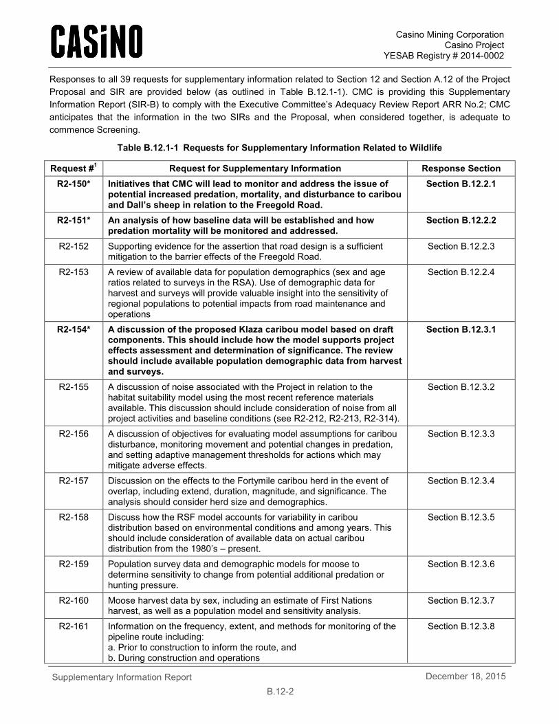
Responses to all 39 requests for supplementary information related to Section 12 and Section A.12 of the Project Proposal and SIR are provided below (as outlined in Table B.12.1-1). CMC is providing this Supplementary Information Report (SIR-B) to comply with the Executive Committee’s Adequacy Review Report ARR No.2; CMC anticipates that the information in the two SIRs and the Proposal, when considered together, is adequate to commence Screening.
Table B.12.1-1 Requests for Supplementary Information Related to Wildlife
Request #1 Request for Supplementary Information Response Section R2-150* Initiatives that CMC will lead to monitor and address the issue of
potential increased predation, mortality, and disturbance to caribou and Dall’s sheep in relation to the Freegold Road.
Section B.12.2.1
R2-151* An analysis of how baseline data will be established and how predation mortality will be monitored and addressed.
Section B.12.2.2
R2-152 Supporting evidence for the assertion that road design is a sufficient mitigation to the barrier effects of the Freegold Road.
Section B.12.2.3
R2-153 A review of available data for population demographics (sex and age ratios related to surveys in the RSA). Use of demographic data for harvest and surveys will provide valuable insight into the sensitivity of regional populations to potential impacts from road maintenance and operations
Section B.12.2.4
R2-154* A discussion of the proposed Klaza caribou model based on draft components. This should include how the model supports project effects assessment and determination of significance. The review should include available population demographic data from harvest and surveys.
Section B.12.3.1
R2-155 A discussion of noise associated with the Project in relation to the habitat suitability model using the most recent reference materials available. This discussion should include consideration of noise from all project activities and baseline conditions (see R2-212, R2-213, R2-314).
Section B.12.3.2
R2-156 A discussion of objectives for evaluating model assumptions for caribou disturbance, monitoring movement and potential changes in predation, and setting adaptive management thresholds for actions which may mitigate adverse effects.
Section B.12.3.3
R2-157 Discussion on the effects to the Fortymile caribou herd in the event of overlap, including extend, duration, magnitude, and significance. The analysis should consider herd size and demographics.
Section B.12.3.4
R2-158 Discuss how the RSF model accounts for variability in caribou distribution based on environmental conditions and among years. This should include consideration of available data on actual caribou distribution from the 1980’s – present.
Section B.12.3.5
R2-159 Population survey data and demographic models for moose to determine sensitivity to change from potential additional predation or hunting pressure.
Section B.12.3.6
R2-160 Moose harvest data by sex, including an estimate of First Nations harvest, as well as a population model and sensitivity analysis.
Section B.12.3.7
R2-161 Information on the frequency, extent, and methods for monitoring of the pipeline route including: a. Prior to construction to inform the route, and b. During construction and operations
Section B.12.3.8
Casino Mining Corporation Casino Project
YESAB Registry # 2014-0002
Supplementary Information Report
B.12-3 December 18, 2015
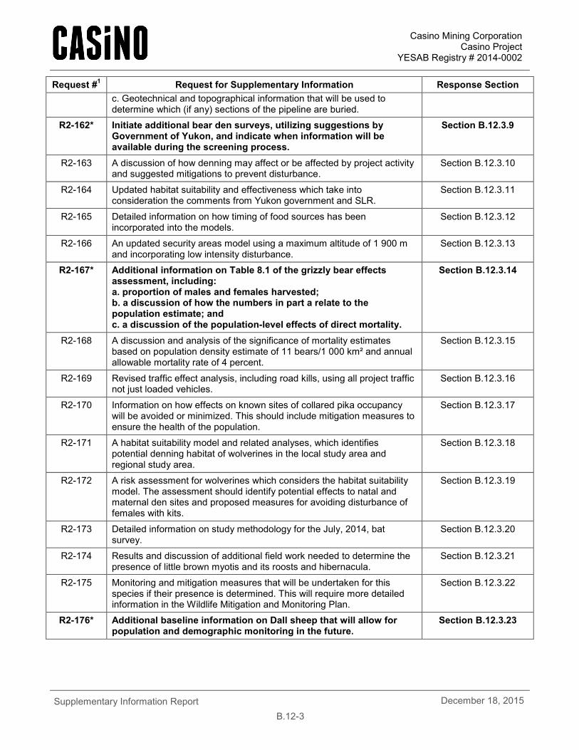
Request #1 Request for Supplementary Information Response Section c. Geotechnical and topographical information that will be used to determine which (if any) sections of the pipeline are buried.
R2-162* Initiate additional bear den surveys, utilizing suggestions by Government of Yukon, and indicate when information will be available during the screening process.
Section B.12.3.9
R2-163 A discussion of how denning may affect or be affected by project activity and suggested mitigations to prevent disturbance.
Section B.12.3.10
R2-164 Updated habitat suitability and effectiveness which take into consideration the comments from Yukon government and SLR.
Section B.12.3.11
R2-165 Detailed information on how timing of food sources has been incorporated into the models.
Section B.12.3.12
R2-166 An updated security areas model using a maximum altitude of 1 900 m and incorporating low intensity disturbance.
Section B.12.3.13
R2-167* Additional information on Table 8.1 of the grizzly bear effects assessment, including: a. proportion of males and females harvested; b. a discussion of how the numbers in part a relate to the population estimate; and c. a discussion of the population-level effects of direct mortality.
Section B.12.3.14
R2-168 A discussion and analysis of the significance of mortality estimates based on population density estimate of 11 bears/1 000 km² and annual allowable mortality rate of 4 percent.
Section B.12.3.15
R2-169 Revised traffic effect analysis, including road kills, using all project traffic not just loaded vehicles.
Section B.12.3.16
R2-170 Information on how effects on known sites of collared pika occupancy will be avoided or minimized. This should include mitigation measures to ensure the health of the population.
Section B.12.3.17
R2-171 A habitat suitability model and related analyses, which identifies potential denning habitat of wolverines in the local study area and regional study area.
Section B.12.3.18
R2-172 A risk assessment for wolverines which considers the habitat suitability model. The assessment should identify potential effects to natal and maternal den sites and proposed measures for avoiding disturbance of females with kits.
Section B.12.3.19
R2-173 Detailed information on study methodology for the July, 2014, bat survey.
Section B.12.3.20
R2-174 Results and discussion of additional field work needed to determine the presence of little brown myotis and its roosts and hibernacula.
Section B.12.3.21
R2-175 Monitoring and mitigation measures that will be undertaken for this species if their presence is determined. This will require more detailed information in the Wildlife Mitigation and Monitoring Plan.
Section B.12.3.22
R2-176* Additional baseline information on Dall sheep that will allow for population and demographic monitoring in the future.
Section B.12.3.23
Casino Mining Corporation Casino Project
YESAB Registry # 2014-0002
Supplementary Information Report
B.12-4 December 18, 2015
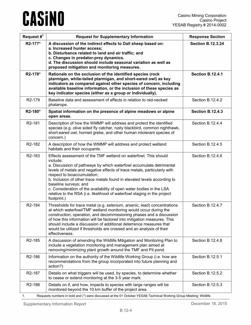
Request #1 Request for Supplementary Information Response Section R2-177* A discussion of the indirect effects to Dall sheep based on:
a. Increased hunter access; b. Disturbance related to land and air traffic; and c. Changes in predator-prey dynamics. d. The discussion should include seasonal variation as well as proposed mitigation and monitoring measures.
Section B.12.3.24
R2-178* Rationale on the exclusion of the identified species (rock ptarmigan, white-tailed ptarmigan, and short-eared owl) as key indicators as compared against other species of concern, including available baseline information, or the inclusion of these species as key indicator species (either as a group or individually).
Section B.12.4.1
R2-179 Baseline data and assessment of effects in relation to red-necked phalarope.
Section B.12.4.2
R2-180* Spatial information on the presence of alpine meadows or alpine open areas.
Section B.12.4.3
R2-181 Description of how the WMMP will address and protect the identified species (e.g. olive sided fly catcher, rusty blackbird, common nighthawk, short-eared owl, horned grebe, and other human intolerant species of concern.)
Section B.12.4.4
R2-182 A description of how the WMMP will address and protect wetland habitats and their occupants.
Section B.12.4.5
R2-183 Effects assessment of the TMF wetland on waterfowl. This should include: a. Discussion of pathways by which waterfowl accumulate detrimental levels of metals and negative effects of trace metals, particularly with respect to bioaccumulation; b. Inclusion of other trace metals found in elevated levels according to baseline surveys; and c. Consideration of the availability of open water bodies in the LSA relative to the RSA (i.e. likelihood of waterfowl staging in the project footprint.)
Section B.12.4.6
R2-184 Thresholds for trace metal (e.g. selenium, arsenic, lead) concentrations at which waterfowl/TMF wetland monitoring would occur during the construction, operation, and decommissioning phases and a discussion of how this information will be factored into mitigation measures. This should include a discussion of additional deterrence measures that would be utilized if thresholds are crossed and an analysis of their effectiveness.
Section B.12.4.7
R2-185 A discussion of amending the Wildlife Mitigation and Monitoring Plan to include a vegetation monitoring and management plan aimed at removing/minimizing plant growth around the TMF and Pit pond.
Section B.12.4.8
R2-186 Information on the authority of the Wildlife Working Group (i.e. how are recommendations from the group incorporated into future planning and action?)
Section B.12.5.1
R2-187 Details on what triggers will be used, by species, to determine whether to cease or extend monitoring at the 3-5 year mark.
Section B.12.5.2
R2-188 Details on if, and how, impacts to species with large ranges will be monitored beyond the 10 km buffer of the project area.
Section B.12.5.3
1. Requests numbers in bold and (*) were discussed at the 01 October YESAB Technical Working Group Meeting: Wildlife
Casino Mining Corporation Casino Project
YESAB Registry # 2014-0002
Supplementary Information Report
B.12-5 December 18, 2015
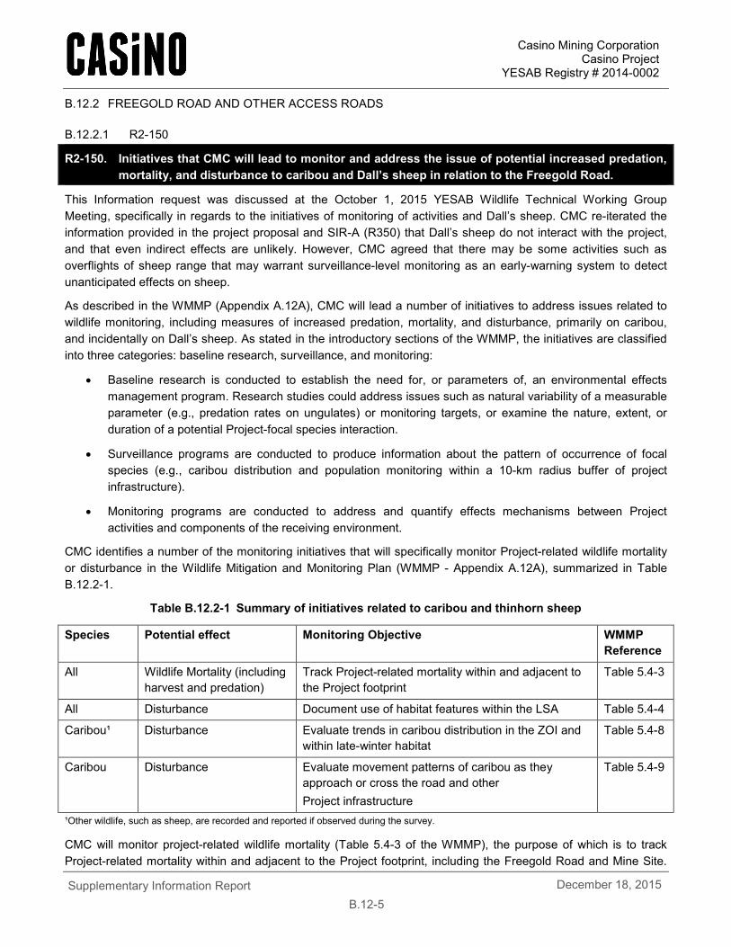
B.12.2 FREEGOLD ROAD AND OTHER ACCESS ROADS
B.12.2.1 R2-150
R2-150. Initiatives that CMC will lead to monitor and address the issue of potential increased predation, mortality, and disturbance to caribou and Dall’s sheep in relation to the Freegold Road.
This Information request was discussed at the October 1, 2015 YESAB Wildlife Technical Working Group Meeting, specifically in regards to the initiatives of monitoring of activities and Dall’s sheep. CMC re-iterated the information provided in the project proposal and SIR-A (R350) that Dall’s sheep do not interact with the project, and that even indirect effects are unlikely. However, CMC agreed that there may be some activities such as overflights of sheep range that may warrant surveillance-level monitoring as an early-warning system to detect unanticipated effects on sheep.
As described in the WMMP (Appendix A.12A), CMC will lead a number of initiatives to address issues related to wildlife monitoring, including measures of increased predation, mortality, and disturbance, primarily on caribou, and incidentally on Dall’s sheep. As stated in the introductory sections of the WMMP, the initiatives are classified into three categories: baseline research, surveillance, and monitoring:
• Baseline research is conducted to establish the need for, or parameters of, an environmental effects management program. Research studies could address issues such as natural variability of a measurable parameter (e.g., predation rates on ungulates) or monitoring targets, or examine the nature, extent, or duration of a potential Project-focal species interaction.
• Surveillance programs are conducted to produce information about the pattern of occurrence of focal species (e.g., caribou distribution and population monitoring within a 10-km radius buffer of project infrastructure).
• Monitoring programs are conducted to address and quantify effects mechanisms between Project activities and components of the receiving environment.
CMC identifies a number of the monitoring initiatives that will specifically monitor Project-related wildlife mortality or disturbance in the Wildlife Mitigation and Monitoring Plan (WMMP - Appendix A.12A), summarized in Table B.12.2-1.
Table B.12.2-1 Summary of initiatives related to caribou and thinhorn sheep
Species Potential effect Monitoring Objective WMMP Reference
All Wildlife Mortality (including harvest and predation)
Track Project-related mortality within and adjacent to the Project footprint
Table 5.4-3
All Disturbance Document use of habitat features within the LSA Table 5.4-4
Caribou¹ Disturbance Evaluate trends in caribou distribution in the ZOI and within late-winter habitat
Table 5.4-8
Caribou Disturbance Evaluate movement patterns of caribou as they approach or cross the road and other Project infrastructure
Table 5.4-9
¹Other wildlife, such as sheep, are recorded and reported if observed during the survey.
CMC will monitor project-related wildlife mortality (Table 5.4-3 of the WMMP), the purpose of which is to track Project-related mortality within and adjacent to the Project footprint, including the Freegold Road and Mine Site.
Casino Mining Corporation Casino Project
YESAB Registry # 2014-0002
Supplementary Information Report
B.12-6 December 18, 2015
Any ungulate mortality due to interactions with the Project facilities, Project vehicles, predation or harvest will be recorded and reported as part of the WMMP reporting commitments.
CMC will also monitor potential caribou disturbance, as measured by habitat use and movement, through a number of monitoring initiatives (Table 5.4-4, Table 5.4-8, Table 5.4-9 of the WMMP). The purpose of disturbance monitoring is to document wildlife use of habitat features, distribution within the zone of influence (ZOI) and late winter habitat, and evaluate movement of caribou across Project infrastructure to quantify and monitor changes from baseline conditions. Disturbance monitoring for thinhorn sheep (Dall’s sheep) is not proposed because the Project does not directly interact with sheep in the area.
CMC has committed to support wildlife research where significant questions related to Project effects remain, including, as outlined in Section 6 of the WMMP, to address information and knowledge gaps about wildlife, vegetation, habitat, and industrial disturbance that are not addressed by the Project-specific mitigation actions and monitoring program identified in the WMMP. There may be broader wildlife and terrestrial environmental science needs to help improve mining mitigation, First Nations knowledge, or general regional knowledge gaps. Although the information may not be specific to the Casino Project, CMC recognizes the need to develop partnerships to improve regional ecological knowledge that will help to improve understanding and future decision making.
The Executive Committee has requested information on the potential of the Project to facilitate wolf access to caribou and sheep. CMC recognizes that estimating predation (measure as predation rate or kill rate) is more in the realm of wildlife management or academic research conducted at the landscape/population scale and generally outside the scope of environmental assessment and therefore the WMMP does not specifically identify initiatives to monitor natural predation of ungulates by wolves, nor are there monitoring initiatives specifically for thinhorn sheep. However, if the Wildlife Working Group (as described in the WMMP) determines that the Project poses a significant risk of wolves affecting the local sheep or caribou population, then CMC will develop a predation baseline research initiative with input and participation from group members. Monitoring initiatives were not developed specifically for sheep because the project does not directly interact with sheep and multispecies wildlife monitoring initiatives were considered suitable for monitoring indirect effects of the project on sheep (i.e., harvest). Currently, the risk to the local sheep population is considered low (see responses to requests R2-151 and R2-177 for further information).
B.12.2.2 R2-151
R2-151. An analysis of how baseline data will be established and how predation mortality will be monitored and addressed.
This Information request was discussed at the October 1, 2015 YESAB Wildlife Technical Working Group Meeting, and it was generally agreed that predation mortality data typically do not exist for most wildlife populations, even where the data are directly relevant such as where it may be most useful for population-level modelling and harvest management. To our knowledge, that level of information has never been requested for, available to, or considered relevant to, a mine project effects assessment. The discussion with the wildlife technical working group acknowledged that collection of these data are technically difficult, multi-year, and would likely require a specific and focused study. The end of that study (i.e., an estimate of predator-caused mortality with some amount of variability), while interesting from an ecological point of view, may not necessarily be relevant to the prediction of the Casino Project’s effects on wildlife.
For follow-up, CMC has committed to monitoring Project-related wildlife mortality as part of the Wildlife Mitigation and Monitoring Plan (Appendix A.12A). The plan does not currently include monitoring of natural predation of ungulates for the reasons outlined in the discussion below.
Casino Mining Corporation Casino Project
YESAB Registry # 2014-0002
Supplementary Information Report
B.12-7 December 18, 2015
Wolves are the main predator in the region capable of using human infrastructure to access ungulate prey species. CMC will initiate research programs if surveillance and monitoring programs identify unexpected changes to ungulate predation by wolves or the issue is determined to be a significant concern by the Wildlife Working Group.
Yukon thinhorn sheep populations seem independent of wolf numbers and sheep are not a target prey species for wolves in most areas of the Yukon (Hayes et al. 2003). Sheep become a more important part of wolf diet in areas where moose are less abundant (e.g., the Coast Mountains; Hayes et al. 1991). As moose are relatively abundant in the Project area, the risk of increased wolf predation on the Dawson Range thinhorn sheep population is low.
Predation by wolves on caribou is a factor limiting population growth and density of many large ungulates. The primary prey species of wolves in the majority of south and central Yukon is moose. Generally, caribou are a secondary prey species of wolves, but wolves are the primary predator of caribou. Wolves prey disproportionately on moose calves (Hayes et al. 2000) and caribou calves (Gauthier and Theberge, 1985; 1986), thereby limiting population growth of these prey. The Aishihik and Finlayson wolf control programs in Yukon have clearly shown the link between wolf predation and caribou population growth (Hayes et al. 2003); both programs occurred in areas where moose are likely the primary prey species for wolves (Hayes et al. 2000), but the caribou populations showed a clear response to wolf removal.
The Project is not expected to significantly change the wolf-prey dynamics in the region. The Project will not cause the type of land disturbance that increases the abundance of alternate prey, nor will it cause a significant change in predator access to caribou ranges; an effect that has be documented in Alberta where extensive land disturbance has increased the number of moose and deer resulting in a greater number of wolves and a change in wolf distribution, ultimately increasing wolf predation on local caribou populations (Wasser et al. 2011, James et al. 2004). The effect has not been documented along any transportation corridor in the Yukon; however, there are anecdotal observations of wolves using the Robert Campbell Highway east of Ross River. If the effect does exist in Yukon, then the magnitude of the effect is likely small and is masked by other effects from disturbance, hunting or collisions. Alternate prey and predator access mechanisms of facilitated predation are discussed further below.
Alternate prey
Deer and moose are the alternate prey species that have been suggested as supporting larger populations of wolves. Within the RSA deer are known to occupy habitats along the Yukon River and are considered relatively scarce, while moose are ubiquitous and occur at moderate densities throughout the RSA. Forestry and agriculture are examples of industries that likely result in landscape-level changes that can cause increases in alternate prey population densities that could result in increased predator abundance. The Project will not result in landscape scale disturbance that will significantly increase the quantity and quality of habitats that will result in greater number of moose. Consequently, the Project is unlikely to result in increased abundance or changes in distribution of alternate prey species that would increase the number or distribution of wolves in the area.
Predator access
During winter, wolves use areas that have hard packed or shallow snow to more easily travel in search of prey. Features that provide natural movement corridors for wolves are streams and exposed areas, such as ridges, where ice provides a solid flat surface and wind removes or hardens snow, respectively. Human infrastructure or activities that provide similar advantages include plowed or packed roads and trails. Trails, cut lines and roads provide less advantage to wolves when they are not packed (e.g., by snowmobiles) or plowed (Kiem et al., 2014).
The proposed Freegold Road upgrade and extension is currently an active transportation corridor used by placer miners, exploration companies, trappers and dog mushers to access or recreate the region during the winter. Placer mining and exploration companies mobilize equipment and supplies late in the winter when snow depths
Casino Mining Corporation Casino Project
YESAB Registry # 2014-0002
Supplementary Information Report
B.12-8 December 18, 2015
are greatest (March and April), and travel the Freegold Road to approximately the confluence of Hayes Creek and the Selwyn River. Trappers are most active earlier in the winter when animal fur is in prime condition. The extent of trapper use of the Freegold Road is currently unknown. Dog mushers use trails starting as soon a snow and ice condition permits. The extent of musher use of the Freegold Road is currently unknown, but there is a portion of the Freegold Road that is part of the Yukon Quest trail.
The Wildlife Baseline Report describes wolves currently using the entire length of the existing Freegold Road and winter road to travel. The portion of the proposed road from the Selwyn River to the Mine Site is the only segment of road that is currently not used by humans during winter as a travel route. Furthermore, vehicle traffic on the Freegold Road will be considerably more frequent than existing conditions once the project is operational, which is expected to limit wildlife use of the Freegold Road, so wolves will not be able to freely travel the road and disturbance will likely keep wolves away from the road.
B.12.2.3 R2-152
R2-152. Supporting evidence for the assertion that road design is a sufficient mitigation to the barrier effects of the Freegold Road.
Road design is only a component of mitigation (in this instance, mitigation by design) considered for reducing the barrier/filter effect of a road and road traffic through wildlife habitat. CMC did not intend to assert that road design alone was sufficient mitigation to the barrier effects of the Freegold Road. In fact, CMC described a multistage process to minimize potential effects on wildlife through route selection, road design (e.g., road design speed, embankment slope and height, construction of wildlife crossings) and road operation (e.g., road signs), which is consistent with the standard road ecology approach suggested in the Handbook of Road Ecology (van der Ree et al. 2015). Further discussion to elaborate on this approach to mitigation is provided below.
Roads can affect wildlife through mortality, loss/degradation of habitat, or barriers/filters to movement. CMC’s primary objective for mitigating potential effects of the Freegold Road on wildlife is to reduce the risk of mortality through road collisions. CMC is confident that the proposed road design and mitigation measures will be sufficient to reduce mortality risk of local wildlife. The secondary objectives were to minimize effects of habitat loss and barriers to movement. The potential effects of habitat loss and barriers to movement of the proposed Freegold Road construction and use on wildlife cannot be completely mitigated. Nine years of caribou road crossing monitoring of the Misery Road in the NWT found that (Rescan, 2011):
1. The road was a semi-permeable barrier to caribou movement during winters. The road provided little restrictions to caribou movement during the snow-free season.
2. 57% of caribou groups that approached the road during winter were deflected from the crossing.
3. Snowbank height was the primary factor increasing the likelihood of caribou being deflected from crossing the road. Snowbanks greater than 1.5 m tall seemed to restrict caribou movement across the road.
4. Road use and vehicle type (including ore haul trucks) did not affect the probability of caribou crossing the road.
The study cautions that sample sizes were low and EKATI implements road closures during caribou migrations and controls vehicle activity on roads as a precautionary measure.
CMC’s mitigation measures are consistent with the Misery Road monitoring results and best management practices from other jurisdictions, including:
• Roads are designed to be lower profile (i.e., flatter) minimizing the potential to act as a barrier. Lower profile roads (shallower and shorter embankments) have been used as design features in the NWT to increase the
Casino Mining Corporation Casino Project
YESAB Registry # 2014-0002
Supplementary Information Report
B.12-9 December 18, 2015
permeability of industrial roads for caribou, minimizing barrier effects. This is considered a best management practice as there is evidence that caribou are not blocked by high road embankments (Miller, 1985). Slopes in the range of 3:1 and 5:1 are generally considered acceptable to allow caribou crossing.
• Where road embankments are high or steep, wildlife crossings will be constructed to allow easier movement of wildlife. Crossing will be designed to have a shallower embankment grade, and will be built with finer materials.
• The road will be gated to control access, minimizing traffic volume thereby reducing the potential barrier effect caused by higher traffic volumes.
• Snow management will be conducted to ensure that roadside snowbanks are less than 1 m tall to allow animals to more easily move across the road surface. Evidence from caribou crossings of industrial roads in the NWT found that caribou are deflected from crossing roads when roadside snowbanks are greater than 1.5 m tall, and are undeterred when snowbanks were less than 0.5 m tall (Rescan, 2011).
The route selection details are provided in Section 4.8.4.2, with information on the alternative access road alignments provided in Appendix A.4B. Road design criteria are provided in Appendix 4B. Mitigations and monitoring are further detailed in the WMMP in Appendix A.12A.
B.12.2.4 R2-153
R2-153. A review of available data for population demographics (sex and age ratios related to surveys in the RSA). Use of demographic data for harvest and surveys will provide valuable insight into the sensitivity of regional populations to potential impacts from road maintenance and operations
A review of available population demographics were detailed in the Wildlife Baseline Report (Appendix A.12B), and for the purposes of the supplementary information request are summarized below. The available harvest data is for licensed hunting only; First Nations harvest is not reported, and data are not available. Additionally, harvest statistics for individual registered trapline concessions (RTCs) are considered private, and hence are not available to CMC.
Caribou
Data from the fall 2012 herd composition survey (Hegel, 2013) found low calf recruitment (14 calves/100 cows) and adult sex ratios (27 bulls/100 cows). These results suggest a declining population that is experiencing heavy hunting pressure, but are inconsistent with other data and the accuracy of the composition data is suspect (Hegal, 2013). Previous surveys resulted in sex ratios typically from 40–50 bulls/100 cows (Hegel, 2013).
Also, the 2012 calf recruitment is the lowest calf to cow ratio ever reported for the Klaza Caribou Herd (KCH). Past recruitment surveys averaged about 25 calves/100 cows (range 17–47). Boreal caribou recruitment rates that indicate positive population growth are 26–29 calves/100 cows (Environment Canada, 2008); however, a review of the demography of Yukon’s northern mountain population (NMP) herds indicates that the threshold for positive population growth is 20–25 calves/100 cows (Hegel, 2013). The most recent data suggest that the herd has been increasing in size since 2000, and the harvest data indicates that the herd experiences little harvest pressure. The timing of the 2012 composition survey was consistent with other composition surveys, but the fall of 2012 was warmer than usual (up to 20°C), and the caribou groups may not have adequately mixed prior to the survey (Hegel, pers. Comm.). The results of the fall 2013 survey have not yet been released to provide further information on the sex and calf ratios.
Casino Mining Corporation Casino Project
YESAB Registry # 2014-0002
Supplementary Information Report
B.12-10 December 18, 2015
Licensed harvest is only of bull animals, which averages 6.7 animals/year of the total range of the herd (Hegel, 2013). First Nations harvest is un-reported and is hence available for publication. The current harvest rate is approximately 0.6% of the 2012 population estimate, where a sustainable harvest rate is considered to be 2–3%.
Moose
Moose surveys were conducted in the Casino area by Government of Yukon in 1987, 2003, 2007 and 2011. An estimate of moose composition could not be determined in 1987 and 2003 due to low sample size (O’Donoghue et al., 2008). However, the surveys in 2007 and 2011 indicate that the number of mature bulls to adult cows (75 bulls/100 cows) was slightly higher than the Yukon average (67 bulls/100 cows) at the time of survey and above the minimum target level of 30 bulls/100 cows. In 2011 the observed number of calves in the population was low (4%), suggesting low calf survival; however, this composition index is likely biased because the survey was aimed at determining moose distribution in the survey area (O’Donoghue and Bellmore, 2011).
Licensed harvest of moose is only of bull moose. Four of the seven Game Management Subzones (GMS) around the Project are closed, with mean yearly harvest averaging 2.6 animals/year over the last ten years in the open three GMSs. First Nations harvest of moose is not published and not available to CMC.
Dall’s Sheep
The current population estimates for Dall’s sheep in the Yukon is 20,000 (Government of Yukon, 2013). Dall’s sheep are considered a valued sport-hunting resource in the Yukon. Hunters usually target old, large trophy rams. Historically, there were few harvest reports of Dall’s sheep in the Dawson Range and harvest since 1979 has been limited to GMSs 523, 524, and 526, with the majority of reports coming from guided non-resident hunts. Sheep hunting remains open across the GMSs overlapping with the RSA; however, harvest in the last ten years has been limited to GMS 523 only, with a mean yearly harvest of 0.7 animals. Licensed hunters are restricted to one full curl ram per year. First Nation harvest statistics are unknown. Demographics are not conducted for Dall’s sheep surveys, however, studies suggest there are usually 40–60 rams for every hundred “nursery sheep” (Yukon Renewable Resources, 1996).
Wood Bison
A population census of the Yukon’s Aishihik bison herd is typically conducted every two years, with the first survey in 1998 estimating close to 500 animals and the latest survey in 2014 estimating 1,470 animals (Jung and Egli, 2014). Two other transboundary herds occur seasonally in southeastern Yukon, known as the Nahanni and Nordquist herds (Government of Yukon, 2012). The percentage of calves in the 2014 survey was 22.7%, higher than the normal 19.9% (Jung and Egli, 2014).
Since 1998, more than 1,700 animals have been harvested, with about 60 per cent of these being male and 40 per cent being female. In the 2014–2015 season, 177 bison were taken: 119 males and 58 females (Environment Yukon, 2015).
Wood bison are expected to occur in the southern sections of the RSA only, due to limited suitable habitat. During the 2011 aerial ungulate survey, 18 bison, in two groups, were observed on the south edge of the RSA in their winter range on the edge of their core range. During the 2012 late winter survey, 23 bison in four groups were observed in the southern section of the regional study area, located in river valleys or on snow-free south-facing slopes.
Mule Deer
There is no population estimate of mule deer in the Yukon; however, their abundance is expected to be much lower than neighboring provinces and territories, but increasing. Due to their small population, mule deer harvest is by permit hunt only for all GMSs and is subject to a bag limit of one male deer per year (Environment Yukon,
Casino Mining Corporation Casino Project
YESAB Registry # 2014-0002
Supplementary Information Report
B.12-11 December 18, 2015
2015). Between four and ten deer (mule and white-tailed deer) have been harvested each year since the hunt began, with ten being harvested in 2014 (Environment Yukon, 2015). There are no records of mule deer being harvested in the RSA.
Grizzly Bear
There is limited available information on grizzly bear distribution or abundance in the Project area. Grizzly bear densities for the project area are unknown; however, Markel and Larsen (1988) estimated densities between 10 to 16 bears/1,000 km², based on studies completed in nearby areas. The working estimate for the two ecoregions that overlap the study area is 15 grizzly bears/1,000 km² (Maraj pers. comm.). Grizzly bears are assumed to use the entire RSA as they have been harvested from all GMSs that intersect the Project footprint, with the exception of GMS 510. In the last ten years of available harvest data, a total of 11 bears were taken in GMSs 522–524 and 526. All cubs and female grizzly bears with cubs are protected from hunting (Environment Yukon, 2015).
Black Bear
The population of black bear in the Yukon is approximately 10,000 animals (Environment Yukon, 2015). Between 2010 and 2013, a total of 13 black bears were observed in the RSA during the baseline programs. Of these, six black bears were observed during the den surveys, one was photographed by a remote wildlife camera and six were observed incidentally during other baseline surveys. A total of 66 black bear observations were recorded between August 2008 and August 2013 in the Casino Project wildlife log. In the last ten years of available harvest data, a total of 19 bears were taken in GMSs 509–511, 522–524 and 526 in the RSA. Sex specific data is not available. All cubs and female grizzly bears with cubs are protected from hunting (Environment Yukon, 2015).
Furbearers
Furbearing species present in the RSA include wolf, wolverine, lynx, marten, coyote, and red fox. Other mammals considered furbearers and which are likely present in the RSA, but are not described further include red squirrel, mink, muskrat, otter, weasel, and beaver. It is unlikely that fisher or Arctic fox occur in the Project RSA. Furbearer data in the Project area are primarily limited to harvest and/or trapline data, with some incidental sightings recorded during baseline or other regional studies, though no sex specific data is provided. Snow tracking surveys were conducted to examine the distribution of furbearers in the LSA, which provided the desired presence/absence data to determine whether these species were present, but do not provide sex specific data.
B.12.3 EFFECTS ASSESSMENT FOR MAMMALS
B.12.3.1 R2-154
R2-154. A discussion of the proposed Klaza caribou model based on draft components. This should include how the model supports project effects assessment and determination of significance. The review should include available population demographic data from harvest and surveys.
This Information request was discussed at the October 1, 2015 YESAB Wildlife Technical Working Group Meeting. CMC clarified at the meeting that the Klaza caribou model was a habitat-based resource selection probability function (RSF) model that does not incorporate population demographic data, nor correlate habitat effects to population demographics. It was further discussed among the technical participants that the link between habitat and population demographics is a “fundamental ecological question” that is beyond the scope and ability of this project’s effects assessment to address.
Habitat models are valuable tools for landscape management and planning. The output of habitat models is the quantification of a species’ habitat in a spatially-explicit format. The information can be visualized in maps making it accessible and interpretable to a broader audience. Habitat suitability models are particularly valuable for
Casino Mining Corporation Casino Project
YESAB Registry # 2014-0002
Supplementary Information Report
B.12-12 December 18, 2015
environmental assessment because potential effects can be communicated in terms of changes in habitat availability for the study species.
A limitation of habitat suitability models is that the availability of habitat (i.e., quantity) does not directly reflect the population demographics of the study species. For example, an abundance of high quality habitat does not necessarily directly correspond to high rates of recruitment or survival. The lack of a link between wildlife habitat and demographics is particularly true in the Yukon where populations rarely exist at the carrying capacity of the habitat because of predation and animal populations being subject to a number of stochastic variables, commonly environmental, that affect population demographics. The relationship between habitat and demographics is a fundamental ecological question and is outside the scope of environmental assessment.
The Government of Yukon completed a late winter habitat model for the Klaza caribou herd and provided a report detailing the methods and results to CMC. YESAB can request this report from the Department of Environment (Environment Yukon). Environment Yukon used a resource selection probability function (RSPF) to model late winter caribou habitat. The model uses caribou locations as the dependent variable and a number of land cover and terrain characteristics as independent variables to estimate habitat suitability as a probability of use at the scale of the habitat model input units (900 m²).
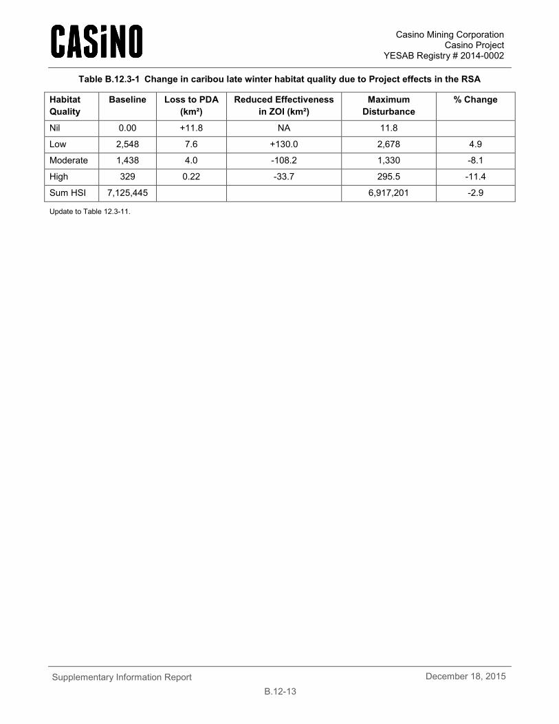
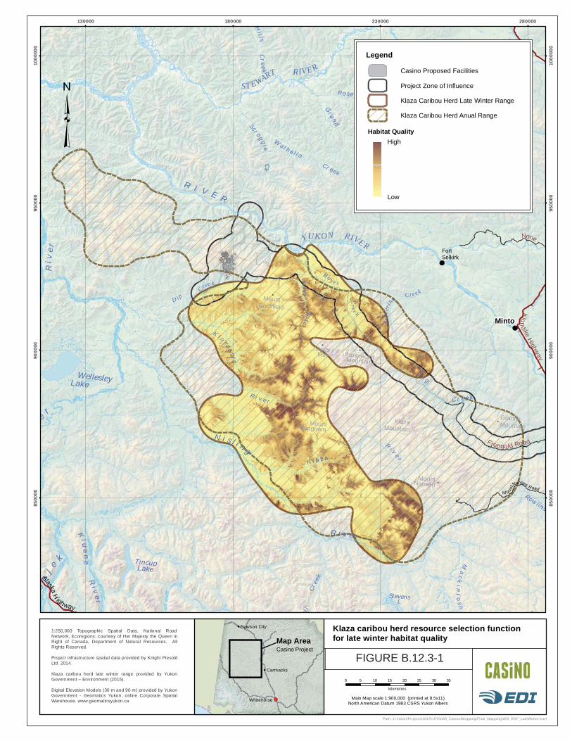
Environment Yukon’s model provides a similar output to the model used to assess Project effects on the Klaza caribou herd in Section 12.3.3. Table B.12.3-1 provides an update to the assessment of project effects on caribou habitat and Figure B.12.3-1 allows for visualization of the update, replacing Table 12.3-11 and Figure 12.3-1 in the Project proposal. The update includes an expanded herd range (Appendix A.12B, section 3.1.1) and a late winter range (Hegel, 2015). The methods used to predict potential project effects are provided in Section 12.3.3.3 of the Proposal. The zone of influence used to assess the potential Project effects on caribou habitat loss considers noise (see response to request R2-155). The updated assessment of potential Project effects indicates that the Casino Project will not have a significant adverse effect on caribou late winter habitat. The change in the availability of low, moderate and high quality winter habitat, considering loss to the footprint and zone of influence is +4.9%, -8.1% and -11.4%, respectively (Table B.12.3-1). The total effect is predicted to be -2.9% of caribou late winter habitat units.
During the October 1, 2015 technical meeting, Environment Yukon noted that the thresholds used to determine the significance of potential project effects may not be applicable to northern mountain caribou. The thresholds used to assess the project’s effect on the Klaza caribou herd’s habitat are from a detailed study of the effect of habitat changes on a number of woodland caribou herds that are part of the Boreal Population (Environment Canada, 2008). The results indicated that caribou populations have a high probability of persistence when total habitat disturbance (natural and anthropogenic) are less than 15% of a herd’s range. CMC used this as a threshold for determining the significance of the effect of the Casino Project on caribou late winter habitat — a 15% loss of habitat was assumed to be a high magnitude effect. Reid et al. (2013) reviewed the application of the Environment Canada model to the Carcross caribou herd and found that model was not applicable to the Carcross caribou herd, primarily due to the abundance of non-forested habitat types within the herd’s range. However, in the absence of other ecological or legislated thresholds for northern mountain caribou, the Environment Canada (2008) study remains the most applicable threshold currently available for woodland caribou.
Casino Mining Corporation Casino Project
YESAB Registry # 2014-0002
Supplementary Information Report
B.12-13 December 18, 2015
Table B.12.3-1 Change in caribou late winter habitat quality due to Project effects in the RSA
Habitat Quality
Baseline Loss to PDA (km²)
Reduced Effectiveness in ZOI (km²)
Maximum Disturbance
% Change
Nil 0.00 +11.8 NA 11.8
Low 2,548 7.6 +130.0 2,678 4.9
Moderate 1,438 4.0 -108.2 1,330 -8.1
High 329 0.22 -33.7 295.5 -11.4
Sum HSI 7,125,445 6,917,201 -2.9
Update to Table 12.3-11.
ProspectorMountain
ApexMtn
MountNansen
GraniteMountain
MountCockfield
KlazaMountain
MountLangham
on
j e
k
Ri v
er
e
r
Stevens L
d
Ma
ck
int
os h
ell
Cre
ek
R I V E R
K l o t as s i n
N i s l i n gR
i v e r
WellesleyLake
R i v e r
Tincup Lake
Riv
er
Rowlinso
Reid Lakes
Cre ek
Ck
Lak e
Hil ls
Cre ek
Cre ek
Kl u
an
e
P ira teW
al h a l l a
Scro ggi e
R i v e r
K l a z a
B i g
C r e e k
Cre ekRo s e bu d
Creek
Grand
Va l le y Cre ek
Se l wyn
River W
olve
r ine
Cr eek
YUK ON RIVE R
Hay e s
Cr e e k
D ip
Cree k
ST EWART RIVER
None
Klondike
Highway
Freegold Road
Minto
FortSelkirk
M ount
Nansen Road
AlaskaH
ighway
130000 180000 230000 280000
8500
00
8500
00
9000
00
9000
00
9500
00
9500
00
1000
000
1000
000
0 5 10 15 20 25 30 35
kilometres
Path: J:\Yukon\Projects\2015\15Y0043_Casino\Mapping\Final_Mapping\450_RSF_LateWinter.mxd
Legend
Casino Proposed Facilities
Project Zone of Influence
Klaza Caribou Herd Late Winter Range
Klaza Caribou Herd Anual Range
High
Low
Habitat Quality
1:250,000 Topographic Spatial Data, National RoadNetwork, Ecoregions; courtesy of Her Majesty the Queen inRight of Canada, Department of Natural Resources. AllRights Reserved.
Project infrastructure spatial data provided by Knight PiesoldLtd. 2014.
Klaza caribou herd late winter range provided by YukonGovernment – Environment (2015).
Digital Elevation Models (30 m and 90 m) provided by YukonGovernment - Geomatics Yukon; online Corporate SpatialWarehouse. www.geomaticsyukon.ca Main Map scale 1:900,000 (printed at 8.5x11)
North American Datum 1983 CSRS Yukon Albers
Drawn:
MPFigure:
112/11/2015Date:Checked:
GP/MS
Klaza caribou herd resource selection functionfor late winter habitat quality
Dawson City
Carmacks
Whitehorse
Map AreaCasino Project
FIGURE B.12.3-1
Casino Mining Corporation Casino Project
YESAB Registry # 2014-0002
Supplementary Information Report
B.12-15 December 18, 2015
B.12.3.2 R2-155
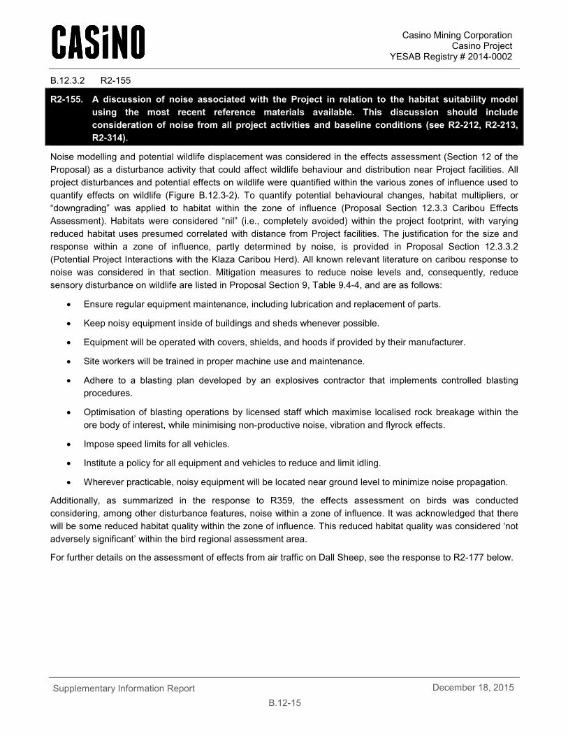
R2-155. A discussion of noise associated with the Project in relation to the habitat suitability model using the most recent reference materials available. This discussion should include consideration of noise from all project activities and baseline conditions (see R2-212, R2-213, R2-314).
Noise modelling and potential wildlife displacement was considered in the effects assessment (Section 12 of the Proposal) as a disturbance activity that could affect wildlife behaviour and distribution near Project facilities. All project disturbances and potential effects on wildlife were quantified within the various zones of influence used to quantify effects on wildlife (Figure B.12.3-2). To quantify potential behavioural changes, habitat multipliers, or “downgrading” was applied to habitat within the zone of influence (Proposal Section 12.3.3 Caribou Effects Assessment). Habitats were considered “nil” (i.e., completely avoided) within the project footprint, with varying reduced habitat uses presumed correlated with distance from Project facilities. The justification for the size and response within a zone of influence, partly determined by noise, is provided in Proposal Section 12.3.3.2 (Potential Project Interactions with the Klaza Caribou Herd). All known relevant literature on caribou response to noise was considered in that section. Mitigation measures to reduce noise levels and, consequently, reduce sensory disturbance on wildlife are listed in Proposal Section 9, Table 9.4-4, and are as follows:
• Ensure regular equipment maintenance, including lubrication and replacement of parts.
• Keep noisy equipment inside of buildings and sheds whenever possible.
• Equipment will be operated with covers, shields, and hoods if provided by their manufacturer.
• Site workers will be trained in proper machine use and maintenance.
• Adhere to a blasting plan developed by an explosives contractor that implements controlled blasting procedures.
• Optimisation of blasting operations by licensed staff which maximise localised rock breakage within the ore body of interest, while minimising non-productive noise, vibration and flyrock effects.
• Impose speed limits for all vehicles.
• Institute a policy for all equipment and vehicles to reduce and limit idling.
• Wherever practicable, noisy equipment will be located near ground level to minimize noise propagation.
Additionally, as summarized in the response to R359, the effects assessment on birds was conducted considering, among other disturbance features, noise within a zone of influence. It was acknowledged that there will be some reduced habitat quality within the zone of influence. This reduced habitat quality was considered ‘not adversely significant’ within the bird regional assessment area.
For further details on the assessment of effects from air traffic on Dall Sheep, see the response to R2-177 below.
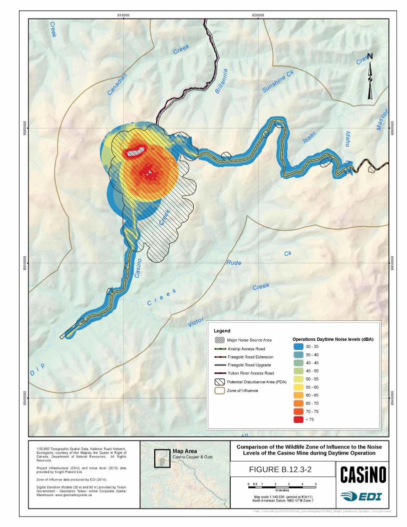
FIGURE B.12.3-2
Casino Mining Corporation Casino Project
YESAB Registry # 2014-0002
Supplementary Information Report
B.12-17 December 18, 2015
B.12.3.3 R2-156
R2-156. A discussion of objectives for evaluating model assumptions for caribou disturbance, monitoring movement and potential changes in predation, and setting adaptive management thresholds for actions which may mitigate adverse effects.
The objectives of the caribou monitoring identified in the WMMP are to evaluate:
• Trends in distribution within the zone of influence and late winter habitat (Table 5.4-8 of the WMMP).
• Movement patterns of caribou as they approach or cross the road and other Project infrastructure (Table 5.4-9 of the WMMP).
CMC has committed to monitor caribou winter distribution and movement adjacent to the Project footprint. The WMMP does not currently include objectives for monitoring predation of moose and caribou, for the reasons outlined in the response to request R2-151.
While the prediction of potential Project effects are generally conservative (i.e., predicted higher magnitude of effects at larger spatial extents than are likely), to account for uncertainty in the prediction of the extent and magnitude of these effects, monitoring initiatives were provided in the WMMP to increase certainty in effects prediction and inform adaptive effects management. The WMMP identifies the objectives for monitoring changes in caribou distribution and movement, and includes adaptive management thresholds. The adaptive management effect thresholds identified in the WMMP are based on the habitat effects and movement thresholds used to define the predicted effect of the Project in Table 12.1-5 and Section 12.3.3.3 of the submission. For example, the goal of the mitigation programme for caribou, outlined in Table 5.4-8 of the WMMP, is that the Project will have a ‘not significant’ effect on caribou distribution in the late winter, as caribou use of late winter habitat was observed in baseline studies. The threshold for action is that caribou occurrence within the ZOI is equivalent to the predictions made in the Project impact assessment. Therefore, if the distribution of caribou deviates at all from baseline, and the deviation is likely due to project disturbance, then CMC will implement corrective action measures, which will start with additional caribou movement monitoring.
Disturbance
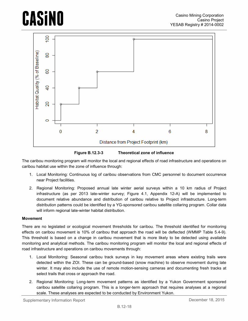
An area of particular uncertainty is the extent and magnitude of caribou disturbance, represented by the zone of influence. The zone of influence used to assess potential Project effects assumes a reduction in habitat quality as a function of distance from the Project footprint. Figure B.12.3-3 provides a schematic of the predicted change in habitat quality as a percentage of baseline conditions at distances from the Project footprint. For example, if the modeled probability of caribou using a particular habitat unit (pixel) is 0.5 at baseline conditions and the habitat unit is 1.5 km from the project footprint, then the probability of caribou using the habitat unit drops to 0.2 (40% of 0.5), corresponding to a 60% reduction in habitat quality.
The assumption of a zone of influence is that the mechanism causing the reduction in habitat use/quality is some form of sensory disturbance (e.g., noise, smell). Zones of influence for any species are dependent on how animals (e.g., caribou) perceive their surroundings, individual experiences and other factors. Documented zones of influence come from regional caribou studies, not controlled experiments; consequently, the mechanisms causing the zone of influence will never be completely understood.
Casino Mining Corporation Casino Project
YESAB Registry # 2014-0002
Supplementary Information Report
B.12-18 December 18, 2015
Figure B.12.3-3 Theoretical zone of influence
The caribou monitoring program will monitor the local and regional effects of road infrastructure and operations on caribou habitat use within the zone of influence through:
1. Local Monitoring: Continuous log of caribou observations from CMC personnel to document occurrence near Project facilities.
2. Regional Monitoring: Proposed annual late winter aerial surveys within a 10 km radius of Project infrastructure (as per 2013 late-winter survey; Figure 4.1, Appendix 12-A) will be implemented to document relative abundance and distribution of caribou relative to Project infrastructure. Long-term distribution patterns could be identified by a YG-sponsored caribou satellite collaring program. Collar data will inform regional late-winter habitat distribution.
Movement
There are no legislated or ecological movement thresholds for caribou. The threshold identified for monitoring effects on caribou movement is 10% of caribou that approach the road will be deflected (WMMP Table 5.4-9). This threshold is based on a change in caribou movement that is more likely to be detected using available monitoring and analytical methods. The caribou monitoring program will monitor the local and regional effects of road infrastructure and operations on caribou movements through:
1. Local Monitoring: Seasonal caribou track surveys in key movement areas where existing trails were detected within the ZOI. These can be ground-based (snow machine) to observe movement during late winter. It may also include the use of remote motion-sensing cameras and documenting fresh tracks at select trails that cross or approach the road.
2. Regional Monitoring: Long-term movement patterns as identified by a Yukon Government sponsored caribou satellite collaring program. This is a longer-term approach that requires analyses at a regional scale. These analyses are expected to be conducted by Environment Yukon.
Casino Mining Corporation Casino Project
YESAB Registry # 2014-0002
Supplementary Information Report
B.12-19 December 18, 2015
B.12.3.4 R2-157
R2-157. Discussion on the effects to the Fortymile caribou herd in the event of overlap, including extend, duration, magnitude, and significance. The analysis should consider herd size and demographics.
The Fortymile caribou herd was estimated to include about 500,000 caribou during the early 1900s (McDonald and Cooley, 2004) and was likely one of the largest migratory caribou herds in North America. The population was nearly extirpated as it collapsed to roughly 5,000–10,000 animals by the 1970s. As the herd shrank, its annual range contracted to an area primarily in Alaska. The Project does not interact with the current range of the Fortymile caribou herd. The Fortymile Caribou Herd is a migratory herd that started to reoccupy its winter range in Yukon in 2002. The herd was estimated at approximately 51,675 animals in 2010 (Alaska Department of Fish and Game, 2012) and it is expected to grow in number and reoccupy more of its historic range in Yukon. The winter of 2013-/2014 marked the first year that the entire Forty Mile caribou herd reoccupied its historic winter range in the Yukon for the first time in several decades. The herd broke into a couple of subgroups and spread out over a fairly wide area – some animals went up into the Dempster Hwy corridor, others around the Top of the World Hwy, and others south towards White River. Approximately 10,000 Fortymile caribou were in the Dawson Range/White Gold area for the winter, mostly at higher elevations (i.e. subalpine/alpine).
In mid-October 2014, the entire herd crossed into the Yukon heading west towards the Dawson Range, but hit the White River and turned north. No collared Forty Mile Caribou were found in the Dawson Range during fall 2014 telemetry surveys conducted by Yukon Government. There have been a few reports of small numbers of Forty Mile caribou scattered through the White Gold area and Dawson Range, but the majority of the herd are wintering around 60 Mile area, Top of the World area, and along the Yukon River downstream of Dawson (western portion of the range). Reports from October 2015 indicate that the herd has returned to the Dawson region.
It is unknown how the distribution of the Fortymile herd will change in the coming years. The Project occupies none of the Fortymile Caribou Herd’s current range (Figure B.12.3-4), but is part of the herd’s historic winter range. If the herd continues to grow and expand its range, then the herd will likely spatially and temporally overlap with the Project during winters. If the herd increases use of the historic range, then the Project will have a greater interaction with a small portion of the herd’s annual range. While there is currently no interaction or information to support an assessment, a discussion on the extent, duration, magnitude, and significance of effects on the Fortymile heard is provided below.
Extent: The Project does not spatially or temporally interact with the Fortymile caribou herd; consequently, there is no effects pathway for assessing Project effects on the herd.
Duration: The Project could overlap with the winter range of the Fortymile caribou herd, if the herd continues to extend its range into the Yukon. Migratory caribou tend to move most during the spring and fall, but also remain active during the winter. Migratory caribou do not return to the same wintering areas each year. The Fortymile herd is expected to be somewhat unpredictable in where they winter within their annual range. Caribou from the herd could interact with the Project at times during the winter, but not every winter. Consequently, the duration of the Project’s interaction with Caribou will be variable among and within years, but entirely restricted to the winter months.
Magnitude: The herd was estimated at approximately 51,675 caribou in 2010 (Alaska Department of Fish and Game, 2012). Management efforts to further increase the size population, such as a hunting ban in Yukon, are currently in affect in Yukon. Alaska harvests approximately 1,000 caribou from the herd annually. The Tr'ondëk Hwëch'in First Nation will likely start to harvest caribou from the herd and the Yukon Government will start to license harvest of the herd in the near future.
Casino Mining Corporation Casino Project
YESAB Registry # 2014-0002
Supplementary Information Report
B.12-20 December 18, 2015
Migratory herds tend be concentrated during calving season and disbursed during the winter. As the Project is within the historic winter range, it is unlikely that the entire herd would be affected by the Project during any year; however, portions of the herd could occur near the mine site or along the road during any year if the year range continues to expand.
Mitigation measures: Caribou mitigation measures identified in the WMMP (Appendix A.12B) will mitigate potential Project effects on the Fortymile caribou herd. Monitoring efforts identified in the WMMP and the Yukon Government’s participation in the Wildlife Working Group will provide CMC with the information needed to determine when the herd is present in the Project area.
Significance: The significance of the Project’s potential effect on the Fortymile caribou herd is currently assessed as not significant as the Project does not spatially or temporally interact with the herd. If the herd continues to expand its range into the Project area, then the tools for monitoring presence of the herd and mitigation measures are available to adaptively manage potential effects.
CMC will track Fortymile caribou presence in the RSA through communication with Environment Yukon. CMC will be a stakeholder in the conservation of the Fortymile Caribou Herd’s winter habitat if the herd continues to expand its distribution into the Dawson Range. Measures identified in the Proposal for mitigating effects on the Klaza Caribou Herd will also apply to the Fortymile Caribou Herd.
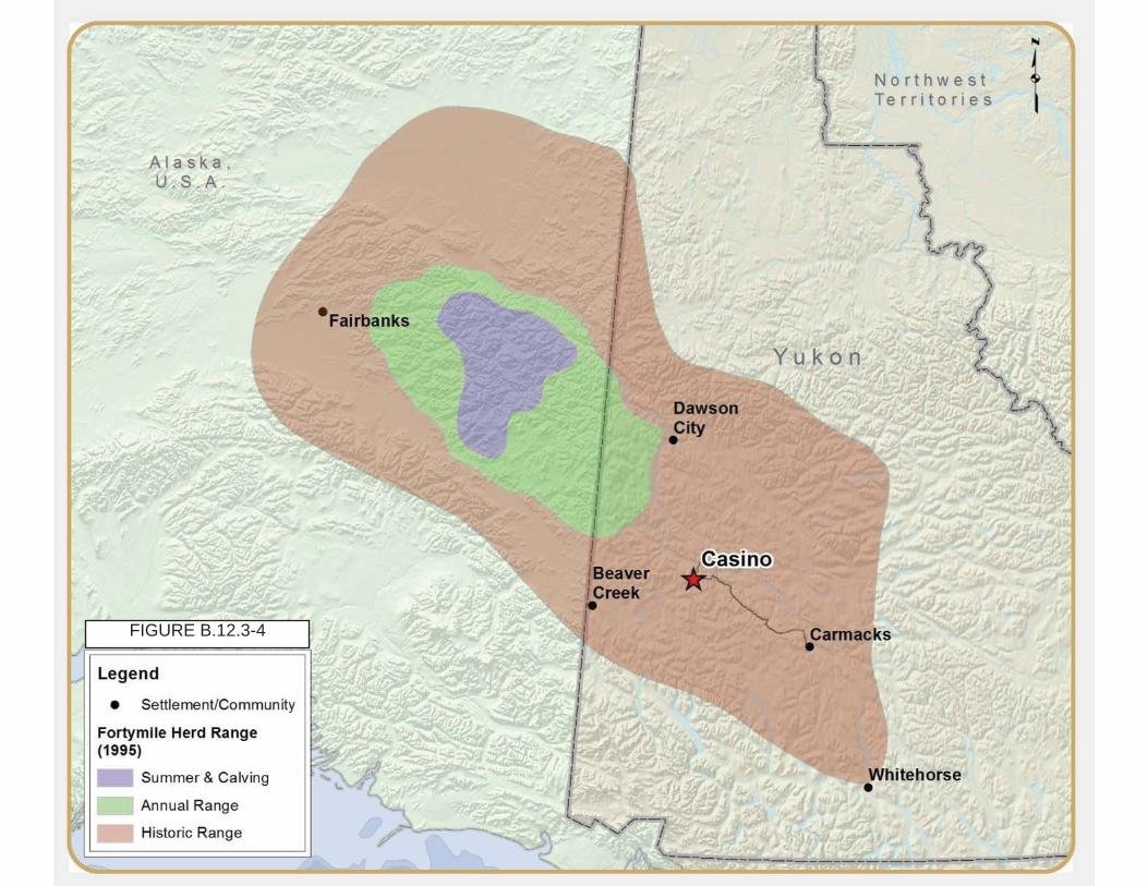
FIGURE B.12.3-4
Casino Mining Corporation Casino Project
YESAB Registry # 2014-0002
Supplementary Information Report
B.12-22 December 18, 2015
B.12.3.5 R2-158
R2-158. Discuss how the RSF model accounts for variability in caribou distribution based on environmental conditions and among years. This should include consideration of available data on actual caribou distribution from the 1980’s – present.
Yukon Government’s ungulate biologist reviewed the concordance of the late winter habitat model with the aerial survey and older collar data, and determined that the caribou locations generally agree with the model (Hegel 2015).
The model inputs and methods are described by Hegel (2015). It is based on habitat use data from the recent collaring program (3 winters of data), but not survey locations or the VHF collar locations — all are actual caribou locations. The recent GPS collar location data are not compatible with survey data or older collar data because the quality (accuracy and frequency) of the spatial data acquired from the modern collars is much greater. Caribou ecology is not expected to have changed much in the past twenty-five years (habitat requirements during winter should be the same), so the results of the late-winter habitat model should be applicable. Only the land cover variables (fire history and lichen cover) have changed since the original surveys, as all other variables are unchanging terrain variables.
The model output provides an indication of caribou habitat selection based on the terrain and land cover variables included in the model. Variation in environmental conditions among years is not directly accounted for in the model; however, the use of multiple years of data allows the model to include some variation in environmental conditions. Hegel (2015) states “Overall, the RSF indicated higher quality habitat at mid-range elevation and slope values, in more easterly and southerly areas, areas with higher lichen and ruggedness values, and unburned areas”.
B.12.3.6 R2-159
R2-159. Population survey data and demographic models for moose to determine sensitivity to change from potential additional predation or hunting pressure.
Moose surveys were conducted in the Casino area by Government of Yukon in 1987, 2003, 2007 and 2011. An estimate of moose composition could not be determined in 1987 and 2003 due to low sample size (O’Donoghue et al., 2008). However, the surveys in 2007 and 2011 indicate that the number of mature bulls to adult cows (75 bulls/100 cows) was slightly higher than the Yukon average (67 bulls/100 cows) at the time of survey and above the minimum target level of 30 bulls/100 cows. In 2011 the observed number of calves in the population was low (4%), suggesting low calf survival; however, this composition index is likely biased because the survey was aimed at determining moose distribution in the survey area (O’Donoghue and Bellmore, 2011).
Licensed harvest of moose is only for bull moose. Four of the seven Game Management Subzones (GMS) around the Project are closed, with mean yearly harvest averaging 2.6 animals/year over the last ten years in the open three GMSs. First Nations harvest of moose is not published and not available for use by CMC.
CMC does not intend to develop a moose population demographic model for the Project area. The sensitivity of the local moose population to increased harvest pressure is already established by the Government of Yukon. Additional modeling will not inform the assessment of the Project’s effect on the local population of moose because moose harvest in the region is not expected to change from baseline conditions as a result of the Project. Moose harvest is managed by the Yukon Government.
Yukon Government’s annual allowable harvest (AAH) of 2% to 5% is assumed to ensure moose populations remain viable and robust to changes in harvest pressure. The sensitivity of moose population to changes in harvest pressure should be minimal if the harvest rates remain below the identified thresholds. This AAH has
Casino Mining Corporation Casino Project
YESAB Registry # 2014-0002
Supplementary Information Report
B.12-23 December 18, 2015
officially been used to manage harvest in Yukon since 1996. The highest ten year average annual harvest rate during the last ten years within a GMA that intersects the Project is 1.3% of moose the population estimate.
B.12.3.7 R2-160
R2-160. Moose harvest data by sex, including an estimate of First Nations harvest, as well as a population model and sensitivity analysis.
Licensed harvest of moose is only of bull moose. Four of the seven Game Management Subzones (GMS) around the Project are closed, with mean yearly harvest averaging 2.6 animals/year over the last ten years in the open three GMSs. First Nations harvest of moose is not published or available for use.
Yukon Government’s annual allowable harvest (AAH) of 2% to 5% is assumed to ensure moose populations remain viable and robust to changes in harvest pressure. The sensitivity of moose population to changes in harvest pressure should be minimal the harvest rates remain below the identified thresholds. This AAH has been used to manage harvest in Yukon since 1996, and potentially earlier. All current harvest rates within GMAs within RSA are ≤1.3% of moose population estimates.
CMC does not intend to develop a moose population demographic model for the Project area. The sensitivity of the local moose population to increased harvest pressure is already established by the Government of Yukon, and they manage the harvest of moose. Additional modeling will not further inform the assessment of the Project’s effect on the local population of moose because moose harvest in the region is not predicted to change from baseline conditions as a result of the Project.
Licensed harvest of moose in Yukon is restricted to males. Four of the seven Game Management Subzones (GMS) around the Project are closed. The average annual harvest is 2.6 animals/year over the last ten years in the three open GMSs. First Nations harvest of moose is not published and not available for use by CMC.
Yukon Government’s annual allowable harvest (AAH) of 2% to 5% is assumed to ensure moose populations remain viable and robust to changes in harvest pressure. The sensitivity of moose population to changes in harvest pressure should be minimal if the harvest rates remain below the identified thresholds. This AAH has officially been used to manage harvest in Yukon since 1996. The highest ten year average annual harvest rate during the last ten years within a GMA that intersects the Project is 1.3% of moose the population estimate.
Given that harvest is managed as discussed above and the discussion about predation (see R2-150 and R2-151), it is CMC’s position that the information necessary for assessing the Casino Project’s effect on moose has been provided in the Project proposal and follow-up information requests.
B.12.3.8 R2-161
R2-161. Information on the frequency, extent, and methods for monitoring of the pipeline route including:
a. Prior to construction to inform the route, and
b. During construction and operations
c. Geotechnical and topographical information that will be used to determine which (if any) sections of the pipeline are buried.
To establish the potential of the project’s interaction with wildlife along the proposed Yukon River water pipeline, two biologists traveled the entire length of the route looking for signs of wildlife use. The proposed water pipeline occurs within the range and habitat of most animals that occur in the region, so the purpose was to document the presence of wildlife features such as mineral licks, concentration of track, trails, or other features.
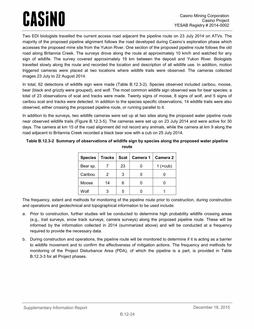
Casino Mining Corporation Casino Project
YESAB Registry # 2014-0002
Supplementary Information Report
B.12-24 December 18, 2015
Two EDI biologists travelled the current access road adjacent the pipeline route on 23 July 2014 on ATVs. The majority of the proposed pipeline alignment follows the road developed during Casino’s exploration phase which accesses the proposed mine site from the Yukon River. One section of the proposed pipeline route follows the old road along Britannia Creek. The surveys drove along the route at approximately 10 km/h and watched for any sign of wildlife. The survey covered approximately 19 km between the deposit and Yukon River. Biologists travelled slowly along the route and recorded the location and description of all wildlife use. In addition, motion triggered cameras were placed at two locations where wildlife trails were observed. The cameras collected images 23 July to 22 August 2014.
In total, 62 detections of wildlife sign were made (Table B.12.3-2). Species observed included caribou, moose, bear (black and grizzly were grouped), and wolf. The most common wildlife sign observed was for bear species; a total of 23 observations of scat and tracks were made. Twenty signs of moose, 8 signs of wolf, and 5 signs of caribou scat and tracks were detected. In addition to the species specific observations, 14 wildlife trails were also observed, either crossing the proposed pipeline route, or running parallel to it.
In addition to the surveys, two wildlife cameras were set up at two sites along the proposed water pipeline route near observed wildlife trails (Figure B.12.3-5). The cameras were set up on 23 July 2014 and were active for 30 days. The camera at km 15 of the road alignment did not record any animals, while the camera at km 9 along the road adjacent to Britannia Creek recorded a black bear sow with a cub on 25 July 2014.
Table B.12.3-2 Summary of observations of wildlife sign by species along the proposed water pipeline route
Species Tracks Scat Camera 1 Camera 2
Bear sp. 7 23 0 1 (+cub)
Caribou 2 3 0 0
Moose 14 6 0 0
Wolf 3 5 0 1
The frequency, extent and methods for monitoring of the pipeline route prior to construction, during construction and operations and geotechnical and topographical information to be used include:
a. Prior to construction, further studies will be conducted to determine high probability wildlife crossing areas (e.g., trail surveys, snow track surveys, camera surveys) along the proposed pipeline route. These will be informed by the information collected in 2014 (summarized above) and will be conducted at a frequency required to provide the necessary data.
b. During construction and operations, the pipeline route will be monitored to determine if it is acting as a barrier to wildlife movement and to confirm the effectiveness of mitigation actions. The frequency and methods for monitoring of the Project Disturbance Area (PDA), of which the pipeline is a part, is provided in Table B.12.3-3 for all Project phases.
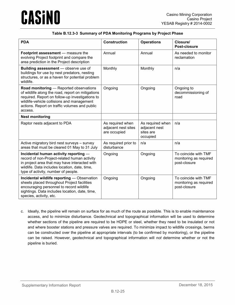
Casino Mining Corporation Casino Project
YESAB Registry # 2014-0002
Supplementary Information Report
B.12-25 December 18, 2015
Table B.12.3-3 Summary of PDA Monitoring Programs by Project Phase
PDA Construction Operations Closure/ Post-closure
Footprint assessment — measure the evolving Project footprint and compare the area prediction in the Project description
Annual Annual As needed to monitor reclamation
Building assessment — observe use of buildings for use by nest predators, nesting structures, or as a haven for potential problem wildlife.
Monthly Monthly n/a
Road monitoring — Reported observations of wildlife along the road, report on mitigations required. Report on follow-up investigations to wildlife-vehicle collisions and management actions. Report on traffic volumes and public access.
Ongoing Ongoing Ongoing to decommissioning of road
Nest monitoring
Raptor nests adjacent to PDA As required when adjacent nest sites are occupied
As required when adjacent nest sites are occupied
n/a
Active migratory bird nest surveys – survey areas that must be cleared 01 May to 31 July
As required prior to disturbance
n/a n/a
Incidental human activity reporting — record of non-Project-related human activity in project area that may have interacted with wildlife. Data includes location, date, time, type of activity, number of people.
Ongoing Ongoing To coincide with TMF monitoring as required post-closure
Incidental wildlife reporting — Observation sheets placed throughout Project facilities encouraging personnel to record wildlife sightings. Data includes location, date, time, species, activity, etc.
Ongoing Ongoing To coincide with TMF monitoring as required post-closure
c. Ideally, the pipeline will remain on surface for as much of the route as possible. This is to enable maintenance access, and to minimize disturbance. Geotechnical and topographical information will be used to determine whether sections of the pipeline are required to be HDPE or steel, whether they need to be insulated or not and where booster stations and pressure valves are required. To minimize impact to wildlife crossings, berms can be constructed over the pipeline at appropriate intervals (to be confirmed by monitoring), or the pipeline can be raised. However, geotechnical and topographical information will not determine whether or not the pipeline is buried.
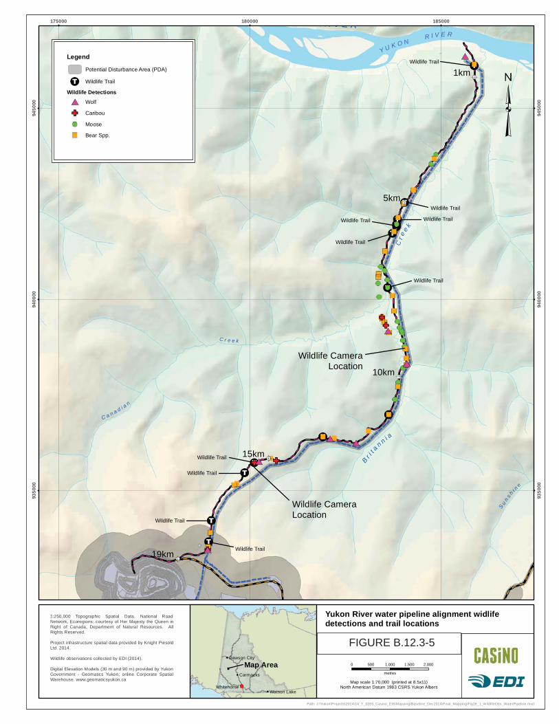
C a n a d i a n
Su
ns h
i ne
C r e e k
R I V E R
Br i
t a
n n i a
Cre
e k
1km
5km
10km
15km
19km
175000 180000 185000
9350
00
9350
00
9400
00
9400
00
9450
00
9450
00
1:250,000 Topographic Spatial Data, National RoadNetwork, Ecoregions; courtesy of Her Majesty the Queen inRight of Canada, Department of Natural Resources. AllRights Reserved.
Project infrastructure spatial data provided by Knight PiesoldLtd. 2014.
Wildlife observations collected by EDI (2014).
Digital Elevation Models (30 m and 90 m) provided by YukonGovernment - Geomatics Yukon; online Corporate SpatialWarehouse. www.geomaticsyukon.ca Map scale 1:70,000 (printed at 8.5x11)
North American Datum 1983 CSRS Yukon Albers
0 500 1,000 1,500 2,000
metres
Drawn:
MPFigure:
16.112/12/2014Date:Checked:
MS
Yukon River water pipeline alignment widlifedetections and trail locations
Legend
Potential Disturbance Area (PDA)
Wildlife Trail
Wildlife Detections
Wolf
Caribou
Moose
Bear Spp.
Wildlife CameraLocation
Wildlife CameraLocation
Wildlife Trail
Wildlife Trail
Wildlife TrailWildlife Trail
Wildlife Trail
Wildlife Trail
Wildlife Trail
Wildlife Trail
Wildlife Trail
Wildlife Trail
Y U K O NR I V E R
Path: J:\Yukon\Projects\2014\14_Y_0285_Casino_EIS\Mapping\Baseline_Dec2014\Final_Mapping\Fig16_1_WildlifeObs_WaterPipeline.mxd
Dawson City
Watson Lake
Carmacks
Whitehorse
Map Area
MP/LG FIGURE B.12.3-5
Casino Mining Corporation Casino Project
YESAB Registry # 2014-0002
Supplementary Information Report
B.12-27 December 18, 2015
B.12.3.9 R2-162
R2-162. Initiate additional bear den surveys, utilizing suggestions by Government of Yukon, and indicate when information will be available during the screening process.
This Information request was discussed at the October 1, 2015 YESAB Wildlife Technical Working Group Meeting. It was also discussed further at a meeting between the wildlife discipline lead (EDI) and Yukon Environment in a follow-up meeting on November 2, 2015. Between the parties, it was agreed another survey to locate areas consistently used by bears for denning could provide information for site-specific mitigation that may be addressed by project design. It is recognized that low snowfall in the area does lower confidence in the information provided by den emergence surveys.
The Project area receives relatively little snow, and snow in the high suitability denning habitat within the LSA is almost entirely melted by the time bears are emerging in the spring, making identification of bear dens used the previous winter difficult. Nine excavations, all possible bear dens, were documented during the 2012 den survey. The excavations were not ground-truthed and there was no snow in the area; consequently, it is not clear if these are digs or dens. If they were dens, then it is not known whether they were used the previous winter.
Environment Yukon and YESAB are requesting an additional year of surveys for bear emergence. CMC’s consultants met with Environment Yukon’s carnivore biologist on November 2, 2015 to discuss concerns about the survey method and potential alternative methods. Environment Yukon suggested that when survey conditions are not adequate for conducting emergence surveys, then fall surveys might be a suitable alternative.
In response to these requests and discussion, CMC will conduct a second year of bear surveys, before final engineering design and construction. CMC will further engage with Environment Yukon input before planning a second year of bear surveys.
B.12.3.10 R2-163
R2-163. A discussion of how denning may affect or be affected by project activity and suggested mitigations to prevent disturbance.
Based on discussions with Environment Yukon’s carnivore biologist (November 2, 2015), the denning period for family groups can occur from the end of September to mid-June. Males and females without cubs typically den for a shorter period but denning for each bear/family group is highly dependent on local snow conditions and weather patterns.
The Project has the potential to affect denning grizzly bears by reducing the amount of available denning habitat and by disturbing denning bears, including bears that are searching for potential denning locations, primarily during the construction period.
Mitigations to reduce Project effects on grizzly bears are listed in the Project Proposal, the Wildlife Mitigation and Monitoring Plan (Appendix A.12A) and the Waste Management Plan (Appendix A.22A). The Project Proposal states that to reduce Project effects on grizzly bears, CMC will reduce the risk of increased mortality of grizzly bears by avoiding active dens, where they are known to occur, during the denning period (November through to mid-May). Undiscovered site-specific features (e.g. active den sites) will be dealt with on a case-by-case basis. CMC realizes that dealing with unknown dens on a case-by-case basis could have effects on construction schedules during the construction stage of the Project. CMC acknowledges that the range of denning could be from end of September until mid-June, beyond the dates of October to April/May described in Section 12.3.5 in the Project Proposal.
Casino Mining Corporation Casino Project
YESAB Registry # 2014-0002
Supplementary Information Report
B.12-28 December 18, 2015
B.12.3.11 R2-164
R2-164. Updated habitat suitability and effectiveness which take into consideration the comments from Yukon government and SLR.
Below are responses to the comments by YG and SLR, as provided in Section 9.2.3.2 of the ARR-2. The consideration of these comments does not require an update to the grizzly bear habitat suitability and effectiveness models for reasons described below.
1. Yukon Government disputes the classification of alpine habitat as unsuitable or zero, citing bear tenacity in digging through snow, presence of carcasses, and areas of little to no snow (as evidenced by the lack of snow cover during spring den surveys).
The habitat effectiveness model defined alpine habitat as that at high elevations associated with mountainous conditions throughout Yukon. Dwarf shrubs, herb/cryptograms and low-growing and scattered krummholtz trees are the predominant vegetation condition. In very high elevation areas, bare rock, colluvium or ice/snow may be the dominant conditions. Alpine habitat provides suitable habitat for denning and includes forage species such as mountain cranberry, crowberry, Hedysarum, sedges and grasses. Alpine habitat provides habitat for prey, including thinhorn sheep, woodland caribou, marmots and ground squirrels and storage of carcasses from winter kills.
Ratings for alpine habitat were considered zero in spring (late March through May) as there is little habitat available in alpine areas until the snow melts, except for winter kills; 1.0 in summer (June to mid-August) due to the importance of alpine and subalpine zones; and 0.5 in fall (mid-August through October). The habitat rating is then used in the habitat rating component for the habitat effectiveness model.
These ratings are comparable to ratings used in other environmental assessments, for example the KSM Project, which assigned ratings of low and very low to habitats at high elevations (Rescan, 2010). The zero rating assigned for spring is a reflection of grizzly bears choices of habitat which is primarily based on availability of forage during the growing season (Gyug, et al., 2004). Alpine areas in late March through May tend to still be snow covered in Yukon. However, during summer and fall, grizzly bear habitat can include coniferous forests, subalpine willow belts, and open alpine meadows. Also for comparison, the habitat assessment conducted by Victoria Gold did not asses any habitat before May or after October (Stantec, 2011), therefore effectively assigning all habitat in March through May a value of zero.
2. With respect to the incorporation of seasonality into the model, Yukon Environment comments that typical modelling is based around the availability of food sources (pre-berry vs. berry). How modeling considers these, and other aspects of habitat, can alter model outcomes.
CMC chose a three season approach instead of the two season approach mentioned by YG. No analytical deficiencies were identified by any parties, and CMC considers the model adequate for effects assessment.
3. SLR notes that road traffic modeling should not be limited to only loaded trucks. This has the potential to artificially reduce the modelled impacts of the road on bears.
CMC assumes this comment is in relation to the effects assessment provided in Section 12, which states that the Freegold Road Extension will have a relatively low traffic volume (128 vehicles daily at peak operation). This value is inclusive of empty and loaded trucks, however, the estimate was short 12 empty vehicles. As detailed in the response to R2-11, the updated value represents 136 vehicles, empty and loaded (Table B.12.3-4 - updated Table 4.4-5 of the Proposal). This minor update does not change the impact assessment, and the conclusion of that assessment, is still relevant to the updated value.
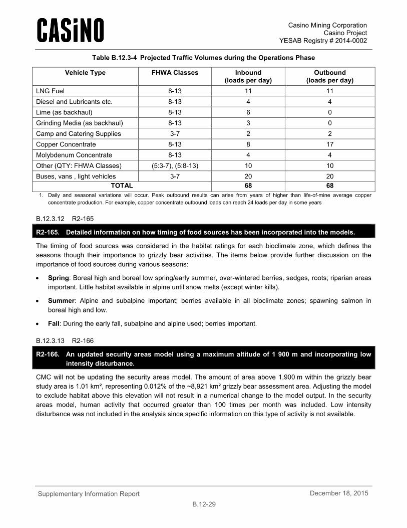
Casino Mining Corporation Casino Project
YESAB Registry # 2014-0002
Supplementary Information Report
B.12-29 December 18, 2015
Table B.12.3-4 Projected Traffic Volumes during the Operations Phase
Vehicle Type FHWA Classes Inbound (loads per day)
Outbound (loads per day)
LNG Fuel 8-13 11 11 Diesel and Lubricants etc. 8-13 4 4 Lime (as backhaul) 8-13 6 0 Grinding Media (as backhaul) 8-13 3 0 Camp and Catering Supplies 3-7 2 2 Copper Concentrate 8-13 8 17 Molybdenum Concentrate 8-13 4 4 Other (QTY: FHWA Classes) (5:3-7), (5:8-13) 10 10 Buses, vans , light vehicles 3-7 20 20
TOTAL 68 68 1. Daily and seasonal variations will occur. Peak outbound results can arise from years of higher than life-of-mine average copper
concentrate production. For example, copper concentrate outbound loads can reach 24 loads per day in some years
B.12.3.12 R2-165
R2-165. Detailed information on how timing of food sources has been incorporated into the models.
The timing of food sources was considered in the habitat ratings for each bioclimate zone, which defines the seasons though their importance to grizzly bear activities. The items below provide further discussion on the importance of food sources during various seasons:
• Spring: Boreal high and boreal low spring/early summer, over-wintered berries, sedges, roots; riparian areas important. Little habitat available in alpine until snow melts (except winter kills).
• Summer: Alpine and subalpine important; berries available in all bioclimate zones; spawning salmon in boreal high and low.
• Fall: During the early fall, subalpine and alpine used; berries important.
B.12.3.13 R2-166
R2-166. An updated security areas model using a maximum altitude of 1 900 m and incorporating low intensity disturbance.
CMC will not be updating the security areas model. The amount of area above 1,900 m within the grizzly bear study area is 1.01 km², representing 0.012% of the ~8,921 km² grizzly bear assessment area. Adjusting the model to exclude habitat above this elevation will not result in a numerical change to the model output. In the security areas model, human activity that occurred greater than 100 times per month was included. Low intensity disturbance was not included in the analysis since specific information on this type of activity is not available.
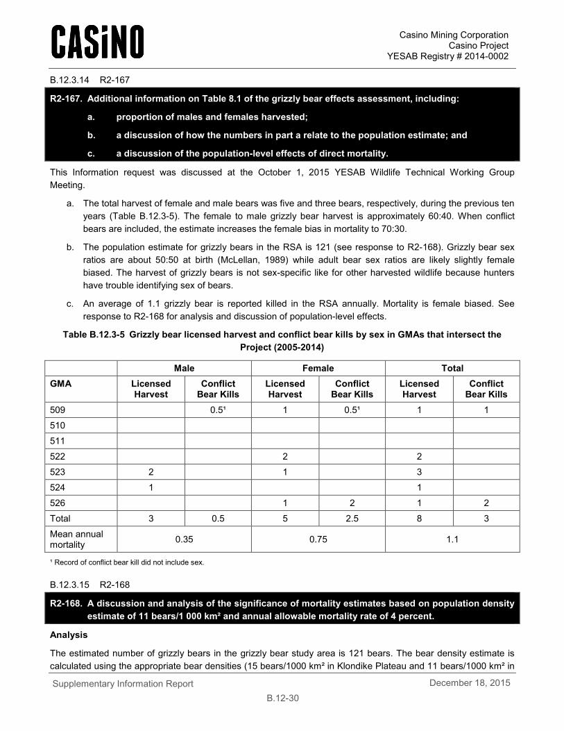
Casino Mining Corporation Casino Project
YESAB Registry # 2014-0002
Supplementary Information Report
B.12-30 December 18, 2015
B.12.3.14 R2-167
R2-167. Additional information on Table 8.1 of the grizzly bear effects assessment, including:
a. proportion of males and females harvested;
b. a discussion of how the numbers in part a relate to the population estimate; and
c. a discussion of the population-level effects of direct mortality.
This Information request was discussed at the October 1, 2015 YESAB Wildlife Technical Working Group Meeting.
a. The total harvest of female and male bears was five and three bears, respectively, during the previous ten years (Table B.12.3-5). The female to male grizzly bear harvest is approximately 60:40. When conflict bears are included, the estimate increases the female bias in mortality to 70:30.
b. The population estimate for grizzly bears in the RSA is 121 (see response to R2-168). Grizzly bear sex ratios are about 50:50 at birth (McLellan, 1989) while adult bear sex ratios are likely slightly female biased. The harvest of grizzly bears is not sex-specific like for other harvested wildlife because hunters have trouble identifying sex of bears.
c. An average of 1.1 grizzly bear is reported killed in the RSA annually. Mortality is female biased. See response to R2-168 for analysis and discussion of population-level effects.
Table B.12.3-5 Grizzly bear licensed harvest and conflict bear kills by sex in GMAs that intersect the Project (2005-2014)
Male Female Total GMA Licensed
Harvest Conflict
Bear Kills Licensed Harvest
Conflict Bear Kills
Licensed Harvest
Conflict Bear Kills
509 0.5¹ 1 0.5¹ 1 1
510
511
522 2 2
523 2 1 3
524 1 1
526 1 2 1 2
Total 3 0.5 5 2.5 8 3
Mean annual mortality 0.35 0.75 1.1
¹ Record of conflict bear kill did not include sex.
B.12.3.15 R2-168
R2-168. A discussion and analysis of the significance of mortality estimates based on population density estimate of 11 bears/1 000 km² and annual allowable mortality rate of 4 percent.
Analysis
The estimated number of grizzly bears in the grizzly bear study area is 121 bears. The bear density estimate is calculated using the appropriate bear densities (15 bears/1000 km² in Klondike Plateau and 11 bears/1000 km² in
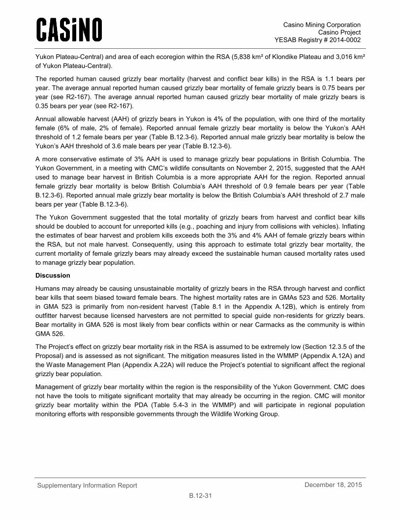
Casino Mining Corporation Casino Project
YESAB Registry # 2014-0002
Supplementary Information Report
B.12-31 December 18, 2015
Yukon Plateau-Central) and area of each ecoregion within the RSA (5,838 km² of Klondike Plateau and 3,016 km² of Yukon Plateau-Central).
The reported human caused grizzly bear mortality (harvest and conflict bear kills) in the RSA is 1.1 bears per year. The average annual reported human caused grizzly bear mortality of female grizzly bears is 0.75 bears per year (see R2-167). The average annual reported human caused grizzly bear mortality of male grizzly bears is 0.35 bears per year (see R2-167).
Annual allowable harvest (AAH) of grizzly bears in Yukon is 4% of the population, with one third of the mortality female (6% of male, 2% of female). Reported annual female grizzly bear mortality is below the Yukon’s AAH threshold of 1.2 female bears per year (Table B.12.3-6). Reported annual male grizzly bear mortality is below the Yukon’s AAH threshold of 3.6 male bears per year (Table B.12.3-6).
A more conservative estimate of 3% AAH is used to manage grizzly bear populations in British Columbia. The Yukon Government, in a meeting with CMC’s wildlife consultants on November 2, 2015, suggested that the AAH used to manage bear harvest in British Columbia is a more appropriate AAH for the region. Reported annual female grizzly bear mortality is below British Columbia’s AAH threshold of 0.9 female bears per year (Table B.12.3-6). Reported annual male grizzly bear mortality is below the British Columbia’s AAH threshold of 2.7 male bears per year (Table B.12.3-6).
The Yukon Government suggested that the total mortality of grizzly bears from harvest and conflict bear kills should be doubled to account for unreported kills (e.g., poaching and injury from collisions with vehicles). Inflating the estimates of bear harvest and problem kills exceeds both the 3% and 4% AAH of female grizzly bears within the RSA, but not male harvest. Consequently, using this approach to estimate total grizzly bear mortality, the current mortality of female grizzly bears may already exceed the sustainable human caused mortality rates used to manage grizzly bear population.
Discussion
Humans may already be causing unsustainable mortality of grizzly bears in the RSA through harvest and conflict bear kills that seem biased toward female bears. The highest mortality rates are in GMAs 523 and 526. Mortality in GMA 523 is primarily from non-resident harvest (Table 8.1 in the Appendix A.12B), which is entirely from outfitter harvest because licensed harvesters are not permitted to special guide non-residents for grizzly bears. Bear mortality in GMA 526 is most likely from bear conflicts within or near Carmacks as the community is within GMA 526.
The Project’s effect on grizzly bear mortality risk in the RSA is assumed to be extremely low (Section 12.3.5 of the Proposal) and is assessed as not significant. The mitigation measures listed in the WMMP (Appendix A.12A) and the Waste Management Plan (Appendix A.22A) will reduce the Project’s potential to significant affect the regional grizzly bear population.
Management of grizzly bear mortality within the region is the responsibility of the Yukon Government. CMC does not have the tools to mitigate significant mortality that may already be occurring in the region. CMC will monitor grizzly bear mortality within the PDA (Table 5.4-3 in the WMMP) and will participate in regional population monitoring efforts with responsible governments through the Wildlife Working Group.
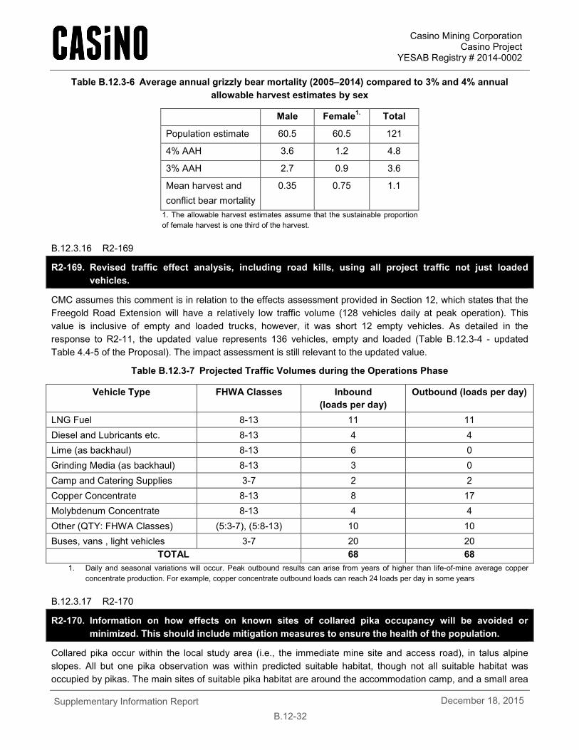
Casino Mining Corporation Casino Project
YESAB Registry # 2014-0002
Supplementary Information Report
B.12-32 December 18, 2015
Table B.12.3-6 Average annual grizzly bear mortality (2005–2014) compared to 3% and 4% annual allowable harvest estimates by sex
Male Female1. Total
Population estimate 60.5 60.5 121
4% AAH 3.6 1.2 4.8
3% AAH 2.7 0.9 3.6
Mean harvest and conflict bear mortality
0.35 0.75 1.1
1. The allowable harvest estimates assume that the sustainable proportion of female harvest is one third of the harvest.
B.12.3.16 R2-169
R2-169. Revised traffic effect analysis, including road kills, using all project traffic not just loaded vehicles.
CMC assumes this comment is in relation to the effects assessment provided in Section 12, which states that the Freegold Road Extension will have a relatively low traffic volume (128 vehicles daily at peak operation). This value is inclusive of empty and loaded trucks, however, it was short 12 empty vehicles. As detailed in the response to R2-11, the updated value represents 136 vehicles, empty and loaded (Table B.12.3-4 - updated Table 4.4-5 of the Proposal). The impact assessment is still relevant to the updated value.
Table B.12.3-7 Projected Traffic Volumes during the Operations Phase
Vehicle Type FHWA Classes Inbound (loads per day)
Outbound (loads per day)
LNG Fuel 8-13 11 11 Diesel and Lubricants etc. 8-13 4 4 Lime (as backhaul) 8-13 6 0 Grinding Media (as backhaul) 8-13 3 0 Camp and Catering Supplies 3-7 2 2 Copper Concentrate 8-13 8 17 Molybdenum Concentrate 8-13 4 4 Other (QTY: FHWA Classes) (5:3-7), (5:8-13) 10 10 Buses, vans , light vehicles 3-7 20 20
TOTAL 68 68 1. Daily and seasonal variations will occur. Peak outbound results can arise from years of higher than life-of-mine average copper
concentrate production. For example, copper concentrate outbound loads can reach 24 loads per day in some years
B.12.3.17 R2-170
R2-170. Information on how effects on known sites of collared pika occupancy will be avoided or minimized. This should include mitigation measures to ensure the health of the population.
Collared pika occur within the local study area (i.e., the immediate mine site and access road), in talus alpine slopes. All but one pika observation was within predicted suitable habitat, though not all suitable habitat was occupied by pikas. The main sites of suitable pika habitat are around the accommodation camp, and a small area
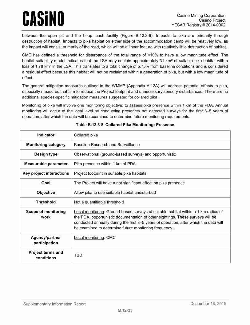
Casino Mining Corporation Casino Project
YESAB Registry # 2014-0002
Supplementary Information Report
B.12-33 December 18, 2015
between the open pit and the heap leach facility (Figure B.12.3-6). Impacts to pika are primarily through destruction of habitat. Impacts to pika habitat on either side of the accommodation camp will be relatively low, as the impact will consist primarily of the road, which will be a linear feature with relatively little destruction of habitat.
CMC has defined a threshold for disturbance of the total range of <10% to have a low magnitude effect. The habitat suitability model indicates that the LSA may contain approximately 31 km² of suitable pika habitat with a loss of 1.78 km² in the LSA. This translates to a total change of 5.73% from baseline conditions and is considered a residual effect because this habitat will not be reclaimed within a generation of pika, but with a low magnitude of effect.
The general mitigation measures outlined in the WMMP (Appendix A.12A) will address potential effects to pika, especially measures that aim to reduce the Project footprint and unnecessary sensory disturbances. There are no additional species-specific mitigation measures suggested for collared pika.
Monitoring of pika will involve one monitoring objective: to assess pika presence within 1 km of the PDA. Annual monitoring will occur at the local level by conducting presence/ not detected surveys for the first 3–5 years of operation, after which the data will be examined to determine future monitoring requirements.
Table B.12.3-8 Collared Pika Monitoring: Presence
Indicator Collared pika
Monitoring category Baseline Research and Surveillance
Design type Observational (ground-based surveys) and opportunistic
Measurable parameter Pika presence within 1 km of PDA
Key project interactions Project footprint in suitable pika habitats
Goal The Project will have a not significant effect on pika presence
Objective Allow pika to use suitable habitat undisturbed
Threshold Not a quantifiable threshold
Scope of monitoring work
Local monitoring: Ground-based surveys of suitable habitat within a 1 km radius of the PDA, opportunistic documentation of other sightings. These surveys will be conducted annually during the first 3–5 years of operation, after which the data will be examined to determine future monitoring frequency.
Agency/partner participation
Local monitoring: CMC
Project terms and conditions TBD
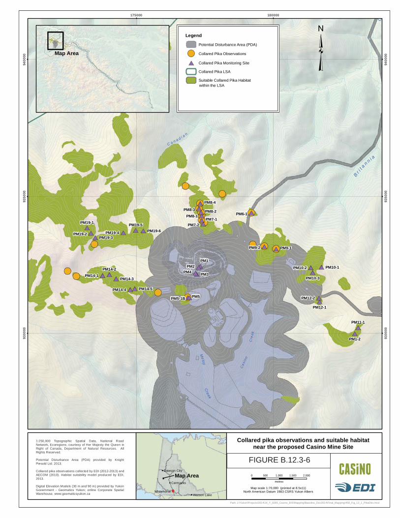
C a n a d i a n
C r e e k
Creek
Br i
t a
n n i a
C
Meloy
PM1PM2
PM3PM4
PM1-2
PM10-3
PM12-1
PM10-1
PM14-3
PM14-5
PM19-3PM19-6
PM11-1
PM14-2
PM19-1 PM19-5
PM10-2
PM12-2
PM14-1
PM14-4
PM19-2 PM19-4
PM5-1B
PM7-2
PM8-1
PM5
PM7-1
PM8-2
PM8-4
PM9-1
PM6-1PM8-3
PM9-2
175000 180000
9300
00
9300
00
9350
00
9350
00
9400
00
9400
00
1:250,000 Topographic Spatial Data, National RoadNetwork, Ecoregions; courtesy of Her Majesty the Queen inRight of Canada, Department of Natural Resources. AllRights Reserved.
Potential Disturbance Area (PDA) provided by KnightPiesold Ltd. 2013.
Collared pika observations collected by EDI (2012-2013) andAECOM (2010). Habitat suitability model produced by EDI,2013.
Digital Elevation Models (30 m and 90 m) provided by YukonGovernment - Geomatics Yukon; online Corporate SpatialWarehouse. www.geomaticsyukon.ca
Map scale 1:70,000 (printed at 8.5x11)North American Datum 1983 CSRS Yukon Albers
0 500 1,000 1,500 2,000
metres
Path: J:\Yukon\Projects\2014\14_Y_0285_Casino_EIS\Mapping\Baseline_Dec2014\Final_Mapping\450_Fig_12_1_PikaObs.mxd
Dawson City
Watson Lake
Carmacks
Whitehorse
Map Area
Drawn:
MP/LGFigure:
12.112/12/2014Date:Checked:
MAS
Collared pika observations and suitable habitatnear the proposed Casino Mine Site
Legend
Potential Disturbance Area (PDA)
Collared Pika Observations
Collared Pika Monitoring Site
Collared Pika LSA
Suitable Collared Pika Habitat
Map Area
Cas
ino
Cre
ek
within the LSA
FIGURE B.12.3-6
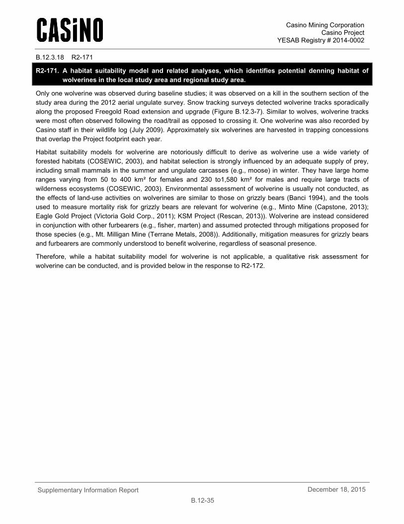
Casino Mining Corporation Casino Project
YESAB Registry # 2014-0002
Supplementary Information Report
B.12-35 December 18, 2015
B.12.3.18 R2-171
R2-171. A habitat suitability model and related analyses, which identifies potential denning habitat of wolverines in the local study area and regional study area.
Only one wolverine was observed during baseline studies; it was observed on a kill in the southern section of the study area during the 2012 aerial ungulate survey. Snow tracking surveys detected wolverine tracks sporadically along the proposed Freegold Road extension and upgrade (Figure B.12.3-7). Similar to wolves, wolverine tracks were most often observed following the road/trail as opposed to crossing it. One wolverine was also recorded by Casino staff in their wildlife log (July 2009). Approximately six wolverines are harvested in trapping concessions that overlap the Project footprint each year.
Habitat suitability models for wolverine are notoriously difficult to derive as wolverine use a wide variety of forested habitats (COSEWIC, 2003), and habitat selection is strongly influenced by an adequate supply of prey, including small mammals in the summer and ungulate carcasses (e.g., moose) in winter. They have large home ranges varying from 50 to 400 km² for females and 230 to1,580 km² for males and require large tracts of wilderness ecosystems (COSEWIC, 2003). Environmental assessment of wolverine is usually not conducted, as the effects of land-use activities on wolverines are similar to those on grizzly bears (Banci 1994), and the tools used to measure mortality risk for grizzly bears are relevant for wolverine (e.g., Minto Mine (Capstone, 2013); Eagle Gold Project (Victoria Gold Corp., 2011); KSM Project (Rescan, 2013)). Wolverine are instead considered in conjunction with other furbearers (e.g., fisher, marten) and assumed protected through mitigations proposed for those species (e.g., Mt. Milligan Mine (Terrane Metals, 2008)). Additionally, mitigation measures for grizzly bears and furbearers are commonly understood to benefit wolverine, regardless of seasonal presence.
Therefore, while a habitat suitability model for wolverine is not applicable, a qualitative risk assessment for wolverine can be conducted, and is provided below in the response to R2-172.
T a l b o t
Stevens L
Ma
ck
int
os
hC
k
Ty
rrel
l
K l o t as s
i n
N i s l i n gR
i v e r
R i v e r
Tincup Lake
Ck
D
Cre ek
W al h a l l a
R i v e r
K l a z a
B i g
C r e e k
Ro s e bu d
Se lwy
nR
iver Wol
ver i
neCr eek
YUKON RIVE R
Ha y es
Cr e e k
D ip
Cree k
ST EWART RIVER
Klondike Highway
StewartCrossing
PellyCrossing
Carmacks
Minto
FortSelkirk
180000 230000 280000
8500
00
8500
00
9000
00
9000
00
9500
00
9500
00
1000
000
1000
000
1:250,000 Topographic Spatial Data, National RoadNetwork, Ecoregions; courtesy of Her Majesty the Queen inRight of Canada, Department of Natural Resources. AllRights Reserved.
Potential Disturbance Area (PDA) provided by KnightPiesold Ltd., Sept., 2013.
2012 – 2013 snow tracking surveys (EDI).
Wildlife Key Areas, Digital Elevation Models (30 m and 90 m)provided by Yukon Government - Geomatics Yukon; onlineCorporate Spatial Warehouse. www.geomaticsyukon.ca Map scale 1:800,000 (printed at 8.5x11)
North American Datum 1983 CSRS Yukon Albers
0 5 10 15 20 25
kilometres
Path: J:\Yukon\Projects\2014\14_Y_0285_Casino_EIS\Mapping\Baseline_Dec2014\Final_Mapping\450_Fig_11_2_Wolverine.mxd
Dawson City
Watson Lake
Carmacks
Whitehorse
Map Area
Drawn:
MP/LGFigure:
11.212/12/2014Date:Checked:
MAS
Wolverine detections during the snowtracking surveys
Legend
Settlement/Community
Highway
Potential Disturbance Area (PDA)
Wolverine Presence (2012 - 2013)
Snow Track Survey Extent
Wildlife Regional Study Area
FIGURE B.12.3-7
Casino Mining Corporation Casino Project
YESAB Registry # 2014-0002
Supplementary Information Report
B.12-37 December 18, 2015
B.12.3.19 R2-172
R2-172. A risk assessment for wolverines which considers the habitat suitability model. The assessment should identify potential effects to natal and maternal den sites and proposed measures for avoiding disturbance of females with kits.
Potential effects
Potential effects on wolverine can be considered under five key issues:
• Change in habitat availability;
• Degradation of habitat;
• Displacement;
• Mine features acting as attractants; and
• Mortality.
Change in habitat availability and degradation of habitat are more likely to occur during construction, whereas displacement, features acting as attractants and mortality are equally as likely to occur during operations and closure. All five effects are unlikely to occur during post-closure.
Wolverine use a wide variety of forested habitats (COSEWIC, 2003), and habitat selection is strongly influenced by an adequate supply of prey, including small mammals in the summer and ungulate carcasses, e.g., moose in winter. They have large home ranges varying from 50 to 400 km² for females and 230 to1,580 km² for males and require large tracts of wilderness ecosystems (COSEWIC, 2003).
Wolverines are sensitive to the presence of humans and are likely to be affected by the effects of road noise. Wolverines are curious, and will investigate campsites, food caches and cabins when humans are not present (COSEWIC 2003). Thus, despite their innate curiosity, the presence of a permanent workforce and waste management handling procedures will make wolverine visits to the area of mine operations unlikely.
There is an increased risk for vehicle collisions with wolverine, though it is unlikely to have a large effect on the population because wolverines tend to avoid open areas. Though major high traffic volume highways have been reported to be a significant source of mortality for wolverines (COSEWIC, 2003), the traffic on the Freegold Road extension is not expected to have a low to nil magnitude scale of effect.
Mitigation
Wolverines use a wide variety of habitat and effects on them are likely to result from disturbance and the presence of humans in the LSA. The increase in traffic associated with project is not expected to affect current wolverine use of the LSA. Measures to mitigate against the effect of noise from construction activities, equipment operations, mine activities and traffic on wildlife in the LSA, as described in the WMMP, will minimize displacement of wolverine in adjacent habitat.
Application of general mitigation measures for wildlife year-round (e.g., waste management) will mitigate most potential Project effects on wolverine (e.g., avoid attraction to mine site), thereby reducing the potential for human-wildlife conflict, as outlined in the Waste and Hazardous Materials Management Plan provided in Appendix A.22A and in the WMMP (Appendix A.12A). Both documents provide mitigation measures that aim to reduce Project effects and summarize monitoring that could trigger adaptive management if unanticipated effects are detected. The Waste and Hazardous Materials Management Plan (Appendix A.22A) includes year round waste management which will reduce attractants throughout all seasons. This plan will be implemented year round and includes a number of mitigations that will reduce the potential for attracting all wildlife, including grizzly
Casino Mining Corporation Casino Project
YESAB Registry # 2014-0002
Supplementary Information Report
B.12-38 December 18, 2015
bears and wolverine. Section 5.4.6 in the updated WMMP (Appendix A.12A) includes den site monitoring for wolverine. If it becomes apparent that mitigation specific to reducing encounters with wolverine are necessary, this can be readily accommodated through the adaptive management approach described in the WMMP.
Residual Effects
Project development will cause changes in habitat availability for furbearers and will likely result in displacement and mortality for some individuals within the project footprint. There will be a temporary loss of habitat for the construction and operations phases of the Project, though some habitat will be restored during reclamation, there will be a net loss of habitat around the mine site and therefore there is a residual effect. However, as wolverine use a large and varied habitat, the overall effects on wolverine associated with changes in habitat availability are minor.
While there is a small possibility that individuals may be displaced from habitat directly affected by the project, reclamation at mine closure is intended to restore habitat comparable to pre-mine conditions and will provide habitat connectivity through revegetation. Some suitable habitat will be permanently lost to the open pit and TMF. The effects on wolverine directly associated with displacement are expected to be minor. Given the above mitigation measures, mortalities could still occur, however, the overall effect of incidental mortality on wolverine populations is predicted to be minor and not significant.
B.12.3.20 R2-173
R2-173. Detailed information on study methodology for the July, 2014, bat survey.
Surveys to assess the presence of the little brown bat at the proposed mine site were conducted during July 2014. Two EDI biologists surveyed potential roosting habitat at the proposed Casino mine site for signs of bat use. Since most of the area is above treeline, the only potential habitat identified was the camp buildings. Each building was visually assessed for bat presence. No signs of bats were found in the camp buildings.
A bat detector was also set up to monitor and record any ultrasonic echolocation calls of bats. The bat detector was an Anabat SD1 system, made by Titley Scientific, and is based on frequency division (Corben, 2004). The detectors were attached to a cable microphone with the microphone set in a protective PVC tube sleeve. The microphones were angled down over a reflective plexi-glass plate, mounted at 45° to horizontal, resulting in the microphone sampling an area parallel to the ground. The Anabat detector was installed on the top of a silo approximately 10 m above the ground. This site was chosen since it is slightly lower in elevation then the camp, and closer to treeline and wetter habitat. It was also the only free standing infrastructure suitable for unobstructed bat monitoring. The anabat detector recorded ultrasonic acoustic detections for a total of six days. No bat calls where recorded in this time.
B.12.3.21 R2-174
R2-174. Results and discussion of additional field work needed to determine the presence of little brown myotis and its roosts and hibernacula.
During the construction phase, pre-clearing surveys will be conducted by a qualified biologist. Preclearing surveys will include searching for potential roost sites. If bat roosts are detected, site-specific avoidance measures and a mitigation plan will be developed.
Casino Mining Corporation Casino Project
YESAB Registry # 2014-0002
Supplementary Information Report
B.12-39 December 18, 2015
B.12.3.22 R2-175
R2-175. Monitoring and mitigation measures that will be undertaken for this species if their presence is determined. This will require more detailed information in the Wildlife Mitigation and Monitoring Plan.
During the construction phase, pre-clearing surveys will be conducted by a qualified biologist. Preclearing surveys will include searching for potential roost sites. If bat roosts are detected, site-specific avoidance measures and a mitigation plan will be developed.
B.12.3.23 R2-176
R2-176. Additional baseline information on Dall sheep that will allow for population and demographic monitoring in the future.
This Information request was discussed at the October 1, 2015 YESAB Wildlife Technical Working Group Meeting. CMC reiterated that Dall’s sheep did not interact with the project, but the group discussed the potential for indirect interaction. There was no consensus among the group of whether or not there would be indirect interaction given the distance (>~4 km) of known occupied range from the proposed Freegold Road extension. CMC was referred to a draft range assessment by Yukon Government that could have additional demographic data. There was some suggestion about the potential disturbances from aircraft overflights were not adequately addressed in the effects assessment, and that issue was not explicitly brought forward in this information request. The group did agree overall that more discussion on the issue, as requested by YESAB, may better inform the effects assessment. That discussion is provided below.
CMC provided substantial details of Dall’s sheep in Section 5 of the Wildlife Baseline Report (Appendix A.12B), including data on all sheep surveys conducted since 1974, and a discussion of distribution, abundance and harvest in the Dawson Range area. The Government of Yukon has since conducted a range assessment for thinhorn sheep in the Dawson Range (Hayes, 2015), which considers the same data used by CMC, and provides further details on the relationship between human and natural disturbance types, population trends, predator/prey dynamics, forest succession trajectories and how all these factors may affect the population’s range.
The following demographic data was provided by Hayes (2015) for the Dawson Range sheep population based primarily on a 2013 sheep survey:
• Current population is at minimum 70 sheep (maximum count in 2013, but considered incomplete);
• The sex ratio is approximately 54 rams per 100 nursery sheep; and
• Recruitment is approximately 20 lambs per 100 nursery sheep.
As studies of the Dall sheep in the Dawson range have occurred over 40 years, and the range has been constrained in the area south east of the Project, direct project interactions with the Dall’s sheep are not predicted. However, CMC will continue to support Yukon based wildlife research, primarily conducted by Environment Yukon. Territorial sheep range assessments may be conducted at intervals by Environment Yukon, and CMC will support this research to continue to provide information on the health of the sheep in the Dawson Range.
The Project does not directly interact with the Dawson Range sheep population, however, there may be indirect interactions through possible increased predator access and disturbance from aircraft. These indirect interactions are discussed further in the response to R2-177 below.
Casino Mining Corporation Casino Project
YESAB Registry # 2014-0002
Supplementary Information Report
B.12-40 December 18, 2015
Suggestions provided by Hayes (2015) to reduce effects of potential aerial disturbance (e.g., locating ground and aerial activities to lower elevations and away from the alpine) will be implemented to mitigate the potential interactions of the Project with the Dawson Range thinhorn sheep population. Wildlife monitoring initiatives will further reduce the risk of the Project indirectly affecting thinhorn sheep (see response to R2-150 and R2-151). CMC will provide monitoring of the sheep population, if determined necessary by the Wildlife Working Group.
B.12.3.24 R2-177
R2-177. A discussion of the indirect effects to Dall sheep based on:
a. Increased hunter access;
b. Disturbance related to land and air traffic; and
c. Changes in predator-prey dynamics.
d. The discussion should include seasonal variation as well as proposed mitigation and monitoring measures.
The proposed Project does not directly interact with thinhorn (Dall’s) sheep in the region. However, indirect interactions of the Project with thinhorn sheep could occur through three mechanisms:
1. Increased hunter access,
2. Increased predator access, and
3. Disturbance from aircraft.
These mechanisms are discussed further below.
Hunter Access
CMC intends to operate the Freegold Road extension as a private industrial road with policies that limit the public’s ability to travel the proposed road. A manned gate will be installed at the Big Creek crossing to manage access. The gate will prohibit public access of the Freegold Road beyond KM 83, mitigating the potential adverse effect of increased mortality risk due to harvest. Users of the Freegold Road extension will be granted access by the Casino Project Road Use Plan, and associated Traffic Management Plan (draft provided in Appendix A.22E).
The following commitments outline how CMC will mitigate the potential harvest effects on wildlife (including thinhorn sheep): Commitment
no. Commitment
6 CMC will work with First Nations to arrange for access as appropriate consistent with the access road management plan as approved by First Nations and Yukon Government.
16 Road Use Plan • CMC will develop a final plan prior to construction and operations. • The final plan will include a table of commitments with mitigation measures developed
through the environmental assessment process, and terms and conditions of any applicable licences, permits and approvals required for Project operation.
• It is the intent of CMC to negotiate a Freegold Road Extension Access Management Agreement with the Government of Yukon, SFN and LSCFN to address how the private road and access control could be managed to meet the Project requirements with consideration of existing tenure holders and individuals.
88 To mitigate potential effects on wildlife from construction, operation and closure and
Casino Mining Corporation Casino Project
YESAB Registry # 2014-0002
Supplementary Information Report
B.12-41 December 18, 2015
Commitment no.
Commitment
decommissioning of the Freegold Road upgrade and extension, CMC will:
• Design road embankment heights and materials to allow for wildlife movement; • Manage snow embankments along the road to allow wildlife easier crossing of the Freegold
road and reduce the likelihood of wildlife getting trapped between embankments, mitigating potential barrier effects and mortality risk;
• Control access of non-project personnel to the road by installing and manning a gate, mitigating mortality risk;
• Radio communication among drivers to warn others when wildlife are observed along the road, mitigating mortality risk; and
• Implement measures to prevent and manage spills to reduce the potential for wildlife exposure to contaminants, mitigating reduced health.
91 CMC will mitigate the risk of increased caribou mortality from harvest by managing the Freegold Road extension as a private industrial road by:
• Restricting access to the road during operation by installing a continuously manned gate at Big Creek;
• Decommissioning the road during the reclamation and closure phase; and • Development of a wildlife management working group, including regulators and
stakeholders, to provide advice to governments on mitigation, monitoring and adaptive management strategies.
123 Access Mitigation - A Road Use Plan (Section 22) will be developed for the Project in coordination with First Nations and the Yukon Government which will include: • No public access on the Freegold Road Extension or access by permit, as directed and
agreed by the Yukon and First Nation governments. • Controlled, gated, manned access at the new bridge over Big Creek or as otherwise
agreed. • A stakeholder communication /engagement plan to ensure concerns are identified and
addressed. 126 A monitoring program will be implemented to ensure that local land users are not gaining access
to the Freegold Road Extension via alternative routes.
Predation
The local thinhorn sheep population could experience higher predation rates indirectly from human infrastructure via two mechanisms:
1. Landscape changes increasing the availability of suitable habitat for alternate prey resulting in a larger prey density in the region, thus creating a larger predator population and increased predation on sheep.
2. Predators, primarily wolves, increasing the use of linear features (roads and trails) as corridors for foraging during winter because of easier travel on packed or cleared snow, resulting in higher sheep mortality closer to linear features.
In response to 1. CMC had conducted an assessment on the possibility of increasing the abundance of alternate prey species, which was provided in the response to R315 (section A.12.3.1.1). The assessment indicates that the project will not result in landscape changes that will increase the abundance of alternate prey species.
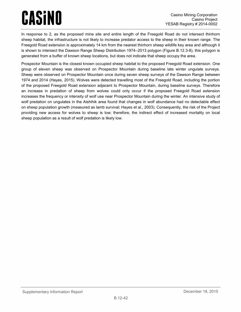
Casino Mining Corporation Casino Project
YESAB Registry # 2014-0002
Supplementary Information Report
B.12-42 December 18, 2015
In response to 2, as the proposed mine site and entire length of the Freegold Road do not intersect thinhorn sheep habitat, the infrastructure is not likely to increase predator access to the sheep in their known range. The Freegold Road extension is approximately 14 km from the nearest thinhorn sheep wildlife key area and although it is shown to intersect the Dawson Range Sheep Distribution 1974–2013 polygon (Figure B.12.3-8), this polygon is generated from a buffer of known sheep locations, but does not indicate that sheep occupy the area.
Prospector Mountain is the closest known occupied sheep habitat to the proposed Freegold Road extension. One group of eleven sheep was observed on Prospector Mountain during baseline late winter ungulate surveys. Sheep were observed on Prospector Mountain once during seven sheep surveys of the Dawson Range between 1974 and 2014 (Hayes, 2015). Wolves were detected travelling most of the Freegold Road, including the portion of the proposed Freegold Road extension adjacent to Prospector Mountain, during baseline surveys. Therefore an increase in predation of sheep from wolves could only occur if the proposed Freegold Road extension increases the frequency or intensity of wolf use near Prospector Mountain during the winter. An intensive study of wolf predation on ungulates in the Aishihik area found that changes in wolf abundance had no detectable effect on sheep population growth (measured as lamb survival; Hayes et al., 2003). Consequently, the risk of the Project providing new access for wolves to sheep is low; therefore, the indirect effect of increased mortality on local sheep population as a result of wolf predation is likely low.
FIGURE B.12.3-8
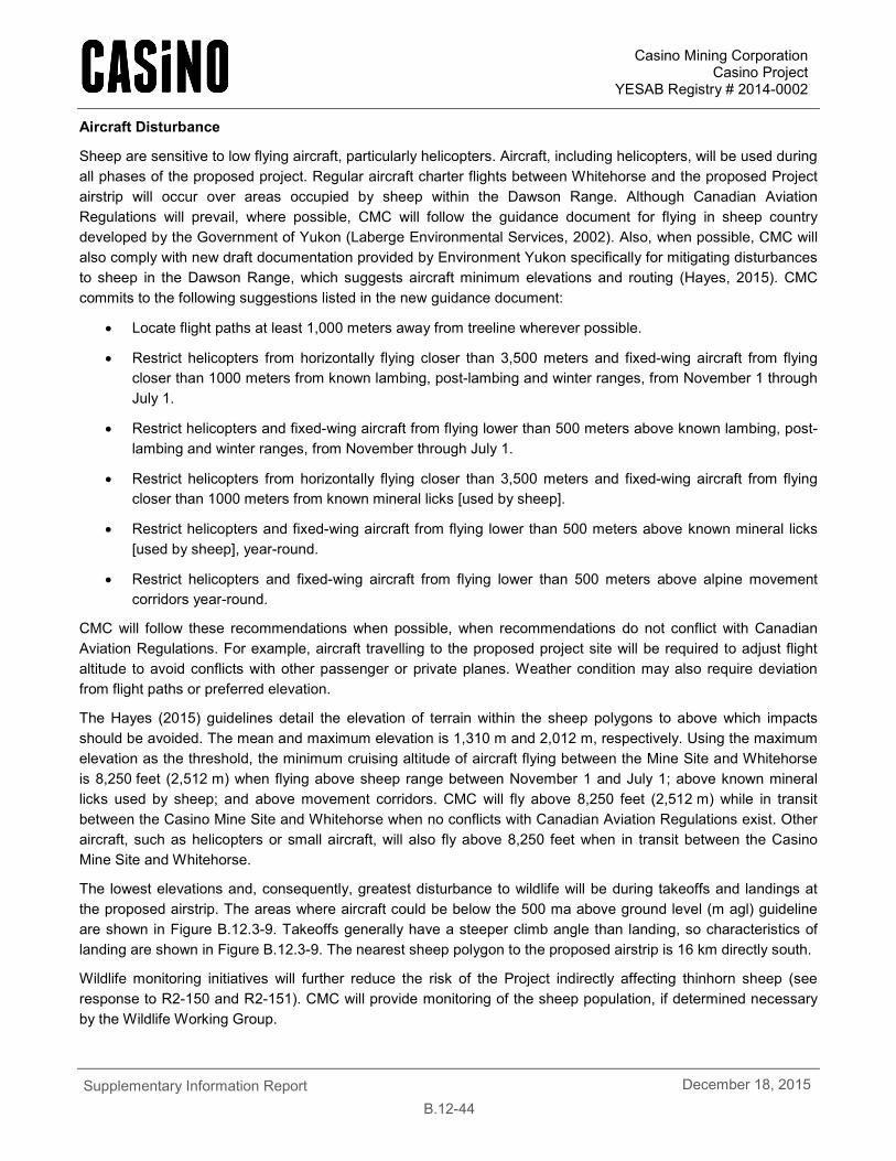
Casino Mining Corporation Casino Project
YESAB Registry # 2014-0002
Supplementary Information Report
B.12-44 December 18, 2015
Aircraft Disturbance
Sheep are sensitive to low flying aircraft, particularly helicopters. Aircraft, including helicopters, will be used during all phases of the proposed project. Regular aircraft charter flights between Whitehorse and the proposed Project airstrip will occur over areas occupied by sheep within the Dawson Range. Although Canadian Aviation Regulations will prevail, where possible, CMC will follow the guidance document for flying in sheep country developed by the Government of Yukon (Laberge Environmental Services, 2002). Also, when possible, CMC will also comply with new draft documentation provided by Environment Yukon specifically for mitigating disturbances to sheep in the Dawson Range, which suggests aircraft minimum elevations and routing (Hayes, 2015). CMC commits to the following suggestions listed in the new guidance document:
• Locate flight paths at least 1,000 meters away from treeline wherever possible.
• Restrict helicopters from horizontally flying closer than 3,500 meters and fixed-wing aircraft from flying closer than 1000 meters from known lambing, post-lambing and winter ranges, from November 1 through July 1.
• Restrict helicopters and fixed-wing aircraft from flying lower than 500 meters above known lambing, post-lambing and winter ranges, from November through July 1.
• Restrict helicopters from horizontally flying closer than 3,500 meters and fixed-wing aircraft from flying closer than 1000 meters from known mineral licks [used by sheep].
• Restrict helicopters and fixed-wing aircraft from flying lower than 500 meters above known mineral licks [used by sheep], year-round.
• Restrict helicopters and fixed-wing aircraft from flying lower than 500 meters above alpine movement corridors year-round.
CMC will follow these recommendations when possible, when recommendations do not conflict with Canadian Aviation Regulations. For example, aircraft travelling to the proposed project site will be required to adjust flight altitude to avoid conflicts with other passenger or private planes. Weather condition may also require deviation from flight paths or preferred elevation.
The Hayes (2015) guidelines detail the elevation of terrain within the sheep polygons to above which impacts should be avoided. The mean and maximum elevation is 1,310 m and 2,012 m, respectively. Using the maximum elevation as the threshold, the minimum cruising altitude of aircraft flying between the Mine Site and Whitehorse is 8,250 feet (2,512 m) when flying above sheep range between November 1 and July 1; above known mineral licks used by sheep; and above movement corridors. CMC will fly above 8,250 feet (2,512 m) while in transit between the Casino Mine Site and Whitehorse when no conflicts with Canadian Aviation Regulations exist. Other aircraft, such as helicopters or small aircraft, will also fly above 8,250 feet when in transit between the Casino Mine Site and Whitehorse.
The lowest elevations and, consequently, greatest disturbance to wildlife will be during takeoffs and landings at the proposed airstrip. The areas where aircraft could be below the 500 ma above ground level (m agl) guideline are shown in Figure B.12.3-9. Takeoffs generally have a steeper climb angle than landing, so characteristics of landing are shown in Figure B.12.3-9. The nearest sheep polygon to the proposed airstrip is 16 km directly south.
Wildlife monitoring initiatives will further reduce the risk of the Project indirectly affecting thinhorn sheep (see response to R2-150 and R2-151). CMC will provide monitoring of the sheep population, if determined necessary by the Wildlife Working Group.
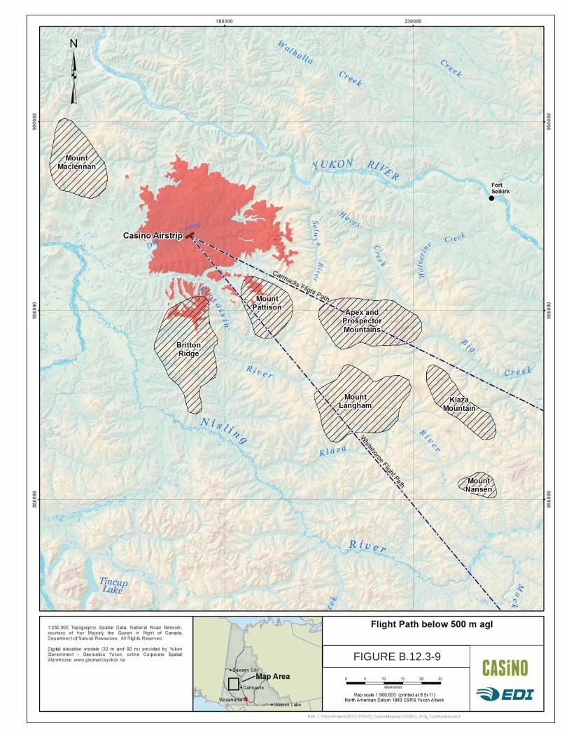
FIGURE B.12.3-9
Casino Mining Corporation Casino Project
YESAB Registry # 2014-0002
Supplementary Information Report
B.12-46 December 18, 2015
B.12.4 EFFECTS ASSESSMENT FOR BIRDS
B.12.4.1 R2-178
R2-178. Rationale on the exclusion of the identified species (rock ptarmigan, white-tailed ptarmigan, and short-eared owl) as key indicators as compared against other species of concern, including available baseline information, or the inclusion of these species as key indicator species (either as a group or individually).
Four key indicators were selected to assess potential Project effects on birds, which included assessments of nine focal bird species and two bird communities. The key indicators were selected to be representative of the diversity of bird species in the area and based on likely project interactions. Key indicators specific for birds are:
• Cliff-nesting raptors;
• Bird species at risk;
• Passerine birds; and
• Waterfowl.
The short-eared owl was assessed with other species at risk (horned grebe, olive-sided flycatcher and rusty blackbird), and a habitat assessment was conducted to assess impacts, and presented in Section 12.3.7 Passerine and Bird Species at Risk Effects Assessment of the Project Proposal.
White-tailed and rock ptarmigan are two of the 77 priority species identified for Bird Conservation Region 4 (BCR4; Environment Canada, 2013). There are 211 regularly-occurring bird species in BCR4. The majority of the BCR4 priority species are known or likely to occur in the Project area. The identification of a bird species as a priority species for BCR4 is not a criteria for selection of key indicators for the environment assessment of Project effects on birds. Environment Canada (2013) identifies:
“priority species” from all regularly occurring bird species in each BCR subregion. Species that are vulnerable due to population size, distribution, population trend, abundance and threats are included because of their “conservation concern.” Some widely distributed and abundant “stewardship” species are also included. Stewardship species are included because they typify the national or regional avifauna and/or because they have a large proportion of their range and/or continental population in the subregion (i.e. BCR 4 in Canada); many of these species have some conservation concern, while others may not require specific conservation effort at this time. Species of management concern are also included as priority species when they are at (or above) their desired population objectives but require ongoing management because of their socio-economic importance as game species or because of their impacts on other species or habitats.
The diverse rationale for identification of priority species and the large number of species makes inclusion of BCR4 priority species impractical for environmental assessment; consequently, the identification of a bird species as a priority species was not a criteria of inclusion as a focal species. Species of conservation concern, defined as listed on the SARA or as assessed by COSEWIC, was the primary criteria for inclusion of particular species (e.g., short-eared owls). An assessment of environmental effects is required by the SARA for listed species (section 79 [2]). The BCR4 priority species and national conservation status of each species assessed in the Project Proposal are summarized in Table B.12.4-1.
Rationale for excluding species as key indicators, even when there is a known potential Project interaction (e.g., white-tailed and rock ptarmigan) includes:
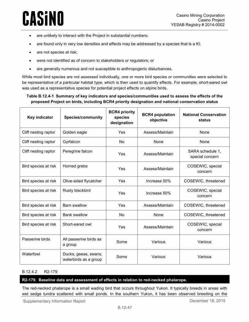
Casino Mining Corporation Casino Project
YESAB Registry # 2014-0002
Supplementary Information Report
B.12-47 December 18, 2015
• are unlikely to interact with the Project in substantial numbers;
• are found only in very low densities and effects may be addressed by a species that is a KI;
• are not species at risk;
• were not identified as of concern to stakeholders or regulators; or
• are generally numerous and not susceptible to anthropogenic disturbances.
While most bird species are not assessed individually, one or more bird species or communities were selected to be representative of a particular habitat type, which is then used to quantify effects. For example, short-eared owl was used as a representative species for potential project effects on alpine birds.
Table B.12.4-1 Summary of key indicators and species/communities used to assess the effects of the proposed Project on birds, including BCR4 priority designation and national conservation status
Key indicator Species/community BCR4 priority
species designation
BCR4 population objective
National Conservation status
Cliff nesting raptor Golden eagle Yes Assess/Maintain None
Cliff nesting raptor Gyrfalcon No None None
Cliff nesting raptor Peregrine falcon Yes Assess/Maintain SARA schedule 1, special concern
Bird species at risk Horned grebe Yes Assess/Maintain COSEWIC, special concern
Bird species at risk Olive-sided flycatcher Yes Increase 50% COSEWIC, threatened
Bird species at risk Rusty blackbird Yes Increase 50% COSEWIC, special concern
Bird species at risk Barn swallow Yes Assess/Maintain COSEWIC, threatened
Bird species at risk Bank swallow No None COSEWIC, threatened
Bird species at risk Short-eared owl Yes Assess/Maintain
COSEWIC, special concern
Passerine birds All passerine birds as a group Some Various Various
Waterfowl Ducks, geese, swans, waterbirds as a group Some Various Various
B.12.4.2 R2-179
R2-179. Baseline data and assessment of effects in relation to red-necked phalarope.
The red-necked phalarope is a small wading bird that occurs throughout Yukon. It typically breeds in areas with wet sedge tundra scattered with small ponds. In the southern Yukon, it has been observed breeding on the
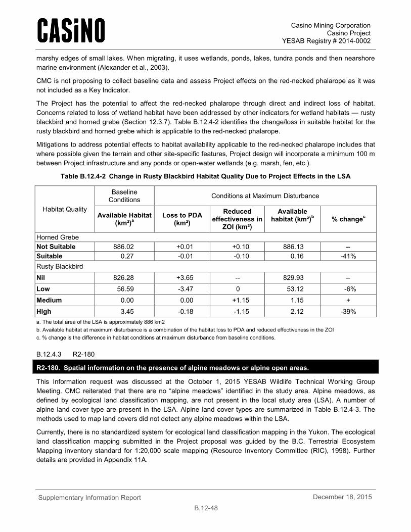
Casino Mining Corporation Casino Project
YESAB Registry # 2014-0002
Supplementary Information Report
B.12-48 December 18, 2015
marshy edges of small lakes. When migrating, it uses wetlands, ponds, lakes, tundra ponds and then nearshore marine environment (Alexander et al., 2003).
CMC is not proposing to collect baseline data and assess Project effects on the red-necked phalarope as it was not included as a Key Indicator.
The Project has the potential to affect the red-necked phalarope through direct and indirect loss of habitat. Concerns related to loss of wetland habitat have been addressed by other indicators for wetland habitats — rusty blackbird and horned grebe (Section 12.3.7). Table B.12.4-2 identifies the change/loss in suitable habitat for the rusty blackbird and horned grebe which is applicable to the red-necked phalarope.
Mitigations to address potential effects to habitat availability applicable to the red-necked phalarope includes that where possible given the terrain and other site-specific features, Project design will incorporate a minimum 100 m between Project infrastructure and any ponds or open-water wetlands (e.g. marsh, fen, etc.).
Table B.12.4-2 Change in Rusty Blackbird Habitat Quality Due to Project Effects in the LSA
Habitat Quality
Baseline Conditions Conditions at Maximum Disturbance
Available Habitat (km²)a
Loss to PDA (km²)
Reduced effectiveness in
ZOI (km²)
Available habitat (km²)b % changec
Horned Grebe Not Suitable 886.02 +0.01 +0.10 886.13 -- Suitable 0.27 -0.01 -0.10 0.16 -41% Rusty Blackbird
Nil 826.28 +3.65 -- 829.93 --
Low 56.59 -3.47 0 53.12 -6%
Medium 0.00 0.00 +1.15 1.15 +
High 3.45 -0.18 -1.15 2.12 -39% a. The total area of the LSA is approximately 886 km2 b. Available habitat at maximum disturbance is a combination of the habitat loss to PDA and reduced effectiveness in the ZOI c. % change is the difference in habitat conditions at maximum disturbance from baseline conditions.
B.12.4.3 R2-180
R2-180. Spatial information on the presence of alpine meadows or alpine open areas.
This Information request was discussed at the October 1, 2015 YESAB Wildlife Technical Working Group Meeting. CMC reiterated that there are no “alpine meadows” identified in the study area. Alpine meadows, as defined by ecological land classification mapping, are not present in the local study area (LSA). A number of alpine land cover type are present in the LSA. Alpine land cover types are summarized in Table B.12.4-3. The methods used to map land covers did not detect any alpine meadows within the LSA.
Currently, there is no standardized system for ecological land classification mapping in the Yukon. The ecological land classification mapping submitted in the Project proposal was guided by the B.C. Terrestrial Ecosystem Mapping inventory standard for 1:20,000 scale mapping (Resource Inventory Committee (RIC), 1998). Further details are provided in Appendix 11A.
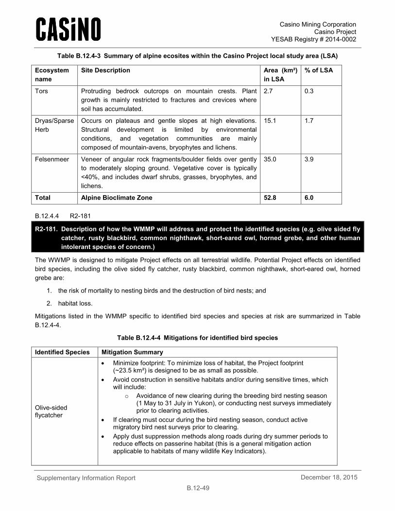
Casino Mining Corporation Casino Project
YESAB Registry # 2014-0002
Supplementary Information Report
B.12-49 December 18, 2015
Table B.12.4-3 Summary of alpine ecosites within the Casino Project local study area (LSA)
Ecosystem name
Site Description Area (km²) in LSA
% of LSA
Tors Protruding bedrock outcrops on mountain crests. Plant growth is mainly restricted to fractures and crevices where soil has accumulated.
2.7 0.3
Dryas/Sparse Herb
Occurs on plateaus and gentle slopes at high elevations. Structural development is limited by environmental conditions, and vegetation communities are mainly composed of mountain-avens, bryophytes and lichens.
15.1 1.7
Felsenmeer Veneer of angular rock fragments/boulder fields over gently to moderately sloping ground. Vegetative cover is typically <40%, and includes dwarf shrubs, grasses, bryophytes, and lichens.
35.0 3.9
Total Alpine Bioclimate Zone 52.8 6.0
B.12.4.4 R2-181
R2-181. Description of how the WMMP will address and protect the identified species (e.g. olive sided fly catcher, rusty blackbird, common nighthawk, short-eared owl, horned grebe, and other human intolerant species of concern.)
The WWMP is designed to mitigate Project effects on all terrestrial wildlife. Potential Project effects on identified bird species, including the olive sided fly catcher, rusty blackbird, common nighthawk, short-eared owl, horned grebe are:
1. the risk of mortality to nesting birds and the destruction of bird nests; and
2. habitat loss.
Mitigations listed in the WMMP specific to identified bird species and species at risk are summarized in Table B.12.4-4.
Table B.12.4-4 Mitigations for identified bird species
Identified Species Mitigation Summary
Olive-sided flycatcher
• Minimize footprint: To minimize loss of habitat, the Project footprint (~23.5 km²) is designed to be as small as possible.
• Avoid construction in sensitive habitats and/or during sensitive times, which will include:
o Avoidance of new clearing during the breeding bird nesting season (1 May to 31 July in Yukon), or conducting nest surveys immediately prior to clearing activities.
• If clearing must occur during the bird nesting season, conduct active migratory bird nest surveys prior to clearing.
• Apply dust suppression methods along roads during dry summer periods to reduce effects on passerine habitat (this is a general mitigation action applicable to habitats of many wildlife Key Indicators).

Casino Mining Corporation Casino Project
YESAB Registry # 2014-0002
Supplementary Information Report
B.12-50 December 18, 2015
Identified Species Mitigation Summary
Rusty blackbird Horned grebe Red-necked Phalarope
• Minimize footprint: To minimize loss of habitat, the Project footprint (~23.5 km²) is designed to be as small as possible.
• Avoid construction in sensitive habitats and/or during sensitive times, which will include:
o Avoidance of new clearing during the breeding bird nesting season (1 May to 31 July in Yukon), or conducting nest surveys immediately prior to clearing activities.
• If clearing must occur during the bird nesting season, conduct active migratory bird nest surveys prior to clearing.
• Where possible given the terrain and other site-specific features, Project design will incorporate a minimum 100 m buffer between Project infrastructure and any ponds or open-water wetlands (e.g. marsh, fen etc.).
o In addition to protecting rusty blackbirds, the 100 m buffer will also benefit other species at risk which may be nesting (e.g. horned grebe) or foraging (e.g. bank swallow and common nighthawk (if present)) in these habitats. Furthermore, the 100 m buffer will help maintain riparian shrub and riparian forest communities which were identified as high value habitats for passerine species as a group.
• Apply dust suppression methods along roads during dry summer periods to reduce effects on passerine habitat (this is a general mitigation action applicable to habitats of many wildlife Key Indicators).
B.12.4.5 R2-182
R2-182. A description of how the WMMP will address and protect wetland habitats and their occupants.
Wetlands in the LSA have been identified in the Bird Baseline Report as high quality habitat for the Key Indicator species rusty blackbird. Wetlands are identified as sensitive habitat features and clearing in these areas will be avoided where possible. All wetlands located outside of the Project footprint will remain undisturbed.
Although not specifically listed in the WMMP, Section 12.3.7.4 of the Project Proposal includes the following mitigation that will reduce the effects on wetland habitats and their occupants:
• Where possible given the terrain and other site-specific features, Project design will incorporate a minimum 100 m buffer between Project infrastructure and any ponds or open-water wetlands (e.g. marsh, fen etc.).
In addition to protecting rusty blackbirds, the 100 m buffer will also benefit other species at risk which may be nesting (e.g. horned grebe) or foraging (e.g. bank swallow and common nighthawk (if present)) in these habitats. Furthermore, the 100 m buffer will help maintain riparian shrub and riparian forest communities which were identified as high value habitats for passerine species as a group.
In addition, Section 4.2 Construction Mitigation of the WMMP states:
• Construction mitigation actions aim to reduce or remove potential effects to wildlife and wildlife habitat during this time, and will include:
o Avoid construction in sensitive habitats and/or during sensitive times, which will include:
o Avoidance of new clearing during the breeding bird nesting season (1 May to 31 July in Yukon), or conducting nest surveys immediately prior to clearing activities.
o If clearing must occur during the bird nesting season, CMC commits to conducting active migratory bird nest surveys prior to clearing.
Casino Mining Corporation Casino Project
YESAB Registry # 2014-0002
Supplementary Information Report
B.12-51 December 18, 2015
B.12.4.6 R2-183
R2-183. Effects assessment of the TMF wetland on waterfowl. This should include:
a. Discussion of pathways by which waterfowl accumulate detrimental levels of metals and negative effects of trace metals, particularly with respect to bioaccumulation;
b. Inclusion of other trace metals found in elevated levels according to baseline surveys; and
c. Consideration of the availability of open water bodies in the LSA relative to the RSA (i.e. likelihood of waterfowl staging in the project footprint.)
Constructed wetland treatment systems (CWTS) are distinctly different from wetlands that provide habitat for wildlife, or are intended to compensate or reclaim/restore impacted wetlands. Instead, a treatment wetland is designed to remove compounds from water, using natural processes to either degrade the compounds into benign forms, or sequester them into the soils rendering them less bioavailable.
Pathways that constituents of concern may reach wildlife include the water, vegetation, sediments, and invertebrates living in the wetland (e.g., benthic invertebrates). However, in a treatment wetland, the constituents of concern are systematically rendered lower in bioavailability, thereby decreasing these pathways for exposure. For example, plant uptake of metals and metalloids is minimized by mineralization of these elements through coupled biogeochemical processes (catalyzed by beneficial microbes), which turns these elements into compounds that cannot be uptaken into plants, and even if the sediments are ingested, the elements are in a low- or non-bioavailable form.
Another important aspect of the design of treatment wetlands is that in contrast to habitat wetlands, treatment wetlands should be designed to deter wildlife. In many cases, wildlife including waterfowl can be deterred from treatment wetlands by doing the opposite of what is recommended for design or restoration of habitat wetlands. For example: steep inclines on the shores and armouring with riprap; no open water; monocultures of plants (no diversity); and even fences. Where appropriate, wildlife-attracting wetlands can also be built downstream of or nearby the treatment wetland to provide a preferential habitat and attract the wildlife away from the water requiring treatment.
These design aspects that deter wildlife are also important features that positively influence the treatment capacity of the wetland. Specifically, the steep banks allow for consistent hydraulic retention time as accretion progresses; armouring prevents erosion; open water is often counterproductive for treatment; and monocultures provide consistency and predictability of treatment.
a. Pathways of effects
Constructed wetlands are a complex ecosystem of plants microbes, and sediment that together act as a biogechemical filter, efficiently removing dilute contaminants from very large volumes of wastewater (LeDuc and Terry, 2005), as shown in Figure B.12.4-1. Depending on the exact structure of the constructed wetlands at the North and South TMF, there is potential for these areas to be used by waterfowl from approximately April through October; foraging within the TMF and nesting along the edges of the TMF is considered a possibility.
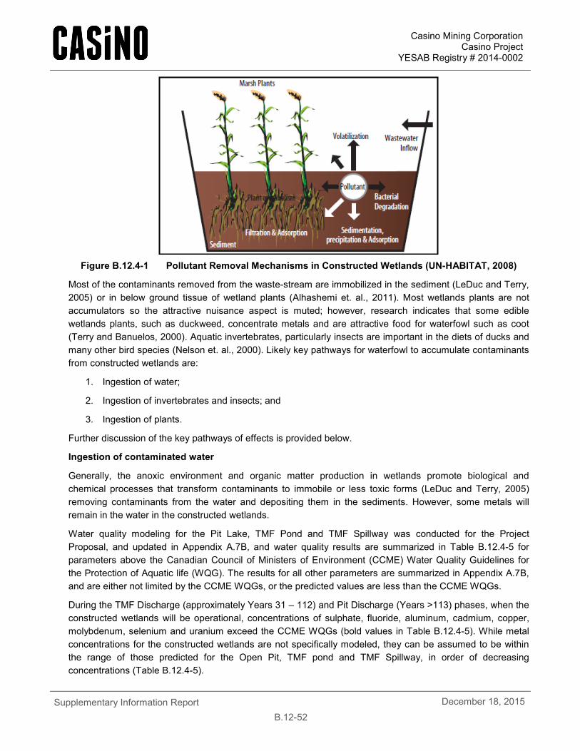
Casino Mining Corporation Casino Project
YESAB Registry # 2014-0002
Supplementary Information Report
B.12-52 December 18, 2015
Figure B.12.4-1 Pollutant Removal Mechanisms in Constructed Wetlands (UN-HABITAT, 2008)
Most of the contaminants removed from the waste-stream are immobilized in the sediment (LeDuc and Terry, 2005) or in below ground tissue of wetland plants (Alhashemi et. al., 2011). Most wetlands plants are not accumulators so the attractive nuisance aspect is muted; however, research indicates that some edible wetlands plants, such as duckweed, concentrate metals and are attractive food for waterfowl such as coot (Terry and Banuelos, 2000). Aquatic invertebrates, particularly insects are important in the diets of ducks and many other bird species (Nelson et. al., 2000). Likely key pathways for waterfowl to accumulate contaminants from constructed wetlands are:
1. Ingestion of water;
2. Ingestion of invertebrates and insects; and
3. Ingestion of plants.
Further discussion of the key pathways of effects is provided below.
Ingestion of contaminated water
Generally, the anoxic environment and organic matter production in wetlands promote biological and chemical processes that transform contaminants to immobile or less toxic forms (LeDuc and Terry, 2005) removing contaminants from the water and depositing them in the sediments. However, some metals will remain in the water in the constructed wetlands.
Water quality modeling for the Pit Lake, TMF Pond and TMF Spillway was conducted for the Project Proposal, and updated in Appendix A.7B, and water quality results are summarized in Table B.12.4-5 for parameters above the Canadian Council of Ministers of Environment (CCME) Water Quality Guidelines for the Protection of Aquatic life (WQG). The results for all other parameters are summarized in Appendix A.7B, and are either not limited by the CCME WQGs, or the predicted values are less than the CCME WQGs.
During the TMF Discharge (approximately Years 31 – 112) and Pit Discharge (Years >113) phases, when the constructed wetlands will be operational, concentrations of sulphate, fluoride, aluminum, cadmium, copper, molybdenum, selenium and uranium exceed the CCME WQGs (bold values in Table B.12.4-5). While metal concentrations for the constructed wetlands are not specifically modeled, they can be assumed to be within the range of those predicted for the Open Pit, TMF pond and TMF Spillway, in order of decreasing concentrations (Table B.12.4-5).
Casino Mining Corporation Casino Project
YESAB Registry # 2014-0002
Supplementary Information Report
B.12-53 December 18, 2015
Elevated levels of trace metals have been shown to cause detrimental effects to waterfowl including reduced reproductive success, physical deformities, impaired biological functions, reduced growth rates and even death. However, effects vary widely depending on the particular element, the level of exposure, interactions with other elements, and in many cases, by species. CCME WQGs are generally derived from the most sensitive species likely to be exposed to the specific pathway, often freshwater biota, which are sensitive to elevated metal concentrations; whereas birds and mammals are comparatively less sensitive (Kadlec and Wallace, 2009).
Of the elements predicted to be present in elevated levels within the constructed wetlands, selenium is of particular concern due to documented toxicological effects to waterfowl at relatively low concentrations and its tendency to bioaccumulate within the environment. Selenium uptake by birds occurs primarily through diet and is driven by bioaccumulation of selenium within the food chain. Selenium is an essential dietary requirement, but has a very narrow range between beneficial concentrations and toxic levels (Harding, 2007). At very high levels, selenium can cause adult mortality; however, it more commonly results in reproductive effects such as reduced hatchability and developmental abnormalities. Several studies have attempted to determine selenium toxicity thresholds for birds based on dissolved concentrations within water, for example, Adams et al (2000) suggested that a threshold of 6.8 µg/L would protect 90% of species and sites from adverse effects, while Skorupa (1998) proposed that selenium concentrations of less than 5 µg/L were necessary to protect birds and fish. However, it is generally accepted that water concentrations are not entirely predictive of selenium toxicity (Luoma and Presser, 2009). The bioaccumulation of metals is a complex process and can be influenced by a number of factors. The effect of selenium on birds and on aquatic life has been shown to vary significantly between sites and among species (Adams et al., 2000), and is affected by the form in which selenium is present, interactions with other trace metals, the complexity of the local food web and levels of trophic transfer among other factors (Ohlendorf, 2003; Luoma and Presser, 2009).
Post-closure selenium concentrations in the constructed wetlands range from 4.3 – 5.2 µg/L, which is comparable to the selenium continuous concentration criterion of 5 µg/L set by the US EPA (2004). These levels are well below concentrations that could be expected to cause acute toxicity. They are just above some of the recommended thresholds for aquatic birds, but given differences in site conditions and species, it is unclear whether these concentrations will result in effects to the local bird population. There are instances where levels similar to those predicted within the TMF were shown to cause reproductive effects. The following points highlight some examples from the literature:
• At the Martin Reservoir in Texas, unauthorized discharge from settling ponds associated with a coal-fired electric plant resulted in selenium levels within the reservoir between 1 to 34 µg/L with an overall average of 2.6 µg/L and an average of about 5 µg/L in the primary impact areas; seven to eight years after the discharge, studies found high levels of selenium within red-winged blackbird eggs and an associated depression of more than 50% in hatchability (Skorupa, 1998).
• At the Richmond Oil Refinery in Texas, an experimental program was conducted to treat wastewater using constructed wetlands. Selenium concentrations ranged from approximately 20 µg/L at the inflow to 5 µg/L at the outflow. Studies found high levels of selenium within bird tissues and documented a more than 30% increase in the occurrence of deformed embryos in mallard nests and 10% increase in the occurrence of deformed embryos in the nests of American coots (Skorupa, 1998).
However, there are also examples within the literature of similar or higher concentrations of selenium having no detrimental effect on birds:
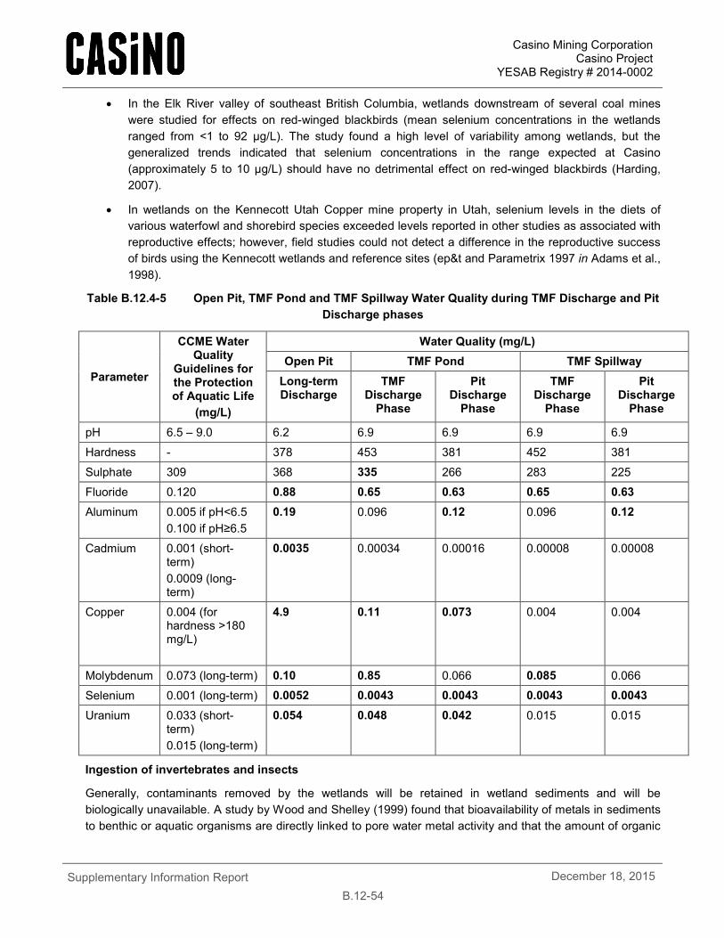
Casino Mining Corporation Casino Project
YESAB Registry # 2014-0002
Supplementary Information Report
B.12-54 December 18, 2015
• In the Elk River valley of southeast British Columbia, wetlands downstream of several coal mines were studied for effects on red-winged blackbirds (mean selenium concentrations in the wetlands ranged from <1 to 92 µg/L). The study found a high level of variability among wetlands, but the generalized trends indicated that selenium concentrations in the range expected at Casino (approximately 5 to 10 µg/L) should have no detrimental effect on red-winged blackbirds (Harding, 2007).
• In wetlands on the Kennecott Utah Copper mine property in Utah, selenium levels in the diets of various waterfowl and shorebird species exceeded levels reported in other studies as associated with reproductive effects; however, field studies could not detect a difference in the reproductive success of birds using the Kennecott wetlands and reference sites (ep&t and Parametrix 1997 in Adams et al., 1998).
Table B.12.4-5 Open Pit, TMF Pond and TMF Spillway Water Quality during TMF Discharge and Pit Discharge phases
Parameter
CCME Water Quality
Guidelines for the Protection of Aquatic Life
(mg/L)
Water Quality (mg/L) Open Pit TMF Pond TMF Spillway
Long-term Discharge
TMF Discharge
Phase
Pit Discharge
Phase
TMF Discharge
Phase
Pit Discharge
Phase
pH 6.5 – 9.0 6.2 6.9 6.9 6.9 6.9
Hardness - 378 453 381 452 381
Sulphate 309 368 335 266 283 225
Fluoride 0.120 0.88 0.65 0.63 0.65 0.63 Aluminum 0.005 if pH<6.5
0.100 if pH≥6.5 0.19 0.096 0.12 0.096 0.12
Cadmium 0.001 (short-term) 0.0009 (long-term)
0.0035 0.00034 0.00016 0.00008 0.00008
Copper 0.004 (for hardness >180 mg/L)
4.9 0.11 0.073 0.004 0.004
Molybdenum 0.073 (long-term) 0.10 0.85 0.066 0.085 0.066
Selenium 0.001 (long-term) 0.0052 0.0043 0.0043 0.0043 0.0043 Uranium 0.033 (short-
term) 0.015 (long-term)
0.054 0.048 0.042 0.015 0.015
Ingestion of invertebrates and insects
Generally, contaminants removed by the wetlands will be retained in wetland sediments and will be biologically unavailable. A study by Wood and Shelley (1999) found that bioavailability of metals in sediments to benthic or aquatic organisms are directly linked to pore water metal activity and that the amount of organic
Casino Mining Corporation Casino Project
YESAB Registry # 2014-0002
Supplementary Information Report
B.12-55 December 18, 2015
carbon in the sediment is the largest driver of metal bioavailability. Wetlands have large amounts of available organic carbon due to the biogeochemical cycling occurring as wetlands plants grow and senesce annually.
Similarly to the assessment of the effect of metal concentrations in water, studies of invertebrate assemblages associated with constructed wetlands indicate that while concentrations of most metals (e.g., aluminum, arsenic, mercury, silver) remain below harmful concentrations, selenium may accumulate to harmful concentrations (Nelson et. al., 2000). As modeled selenium concentrations in the constructed wetlands are below the selenium continuous concentration criterion of 5 µg/L set by the US EPA (2004), selenium bioaccumulation is not of concern for the constructed wetlands.
Organic mercury is also typically of concern, as organic mercury compounds are the principle source of environmental mercury poisoning because these compounds bioaccumulate in aquatic food chains, and both predator birds and mammals are poisoned (Terry and Banuelos, 2000). However, modeled mercury concentrations in the open pit, TMF pond and TMF spillway (0.000015 – 0.000022 mg/L) are well below the CCME WQG of 0.00026 mg/L, and hence do not occur at concentrations likely to cause effects.
Ingestion of wetland plants
While wetland sediments are known to act as a sink for heavy metals (Sheoran and Sheoran, 2006; Baldwin and Hodaly, 2003; August et al., 2002), wetland plants support microbially mediated transformations of contaminants by supplying fixed-carbon as an energy source for bacteria and by altering the chemical environment in their rhizosphere (LeDuc and Terry, 2005). Bioaccumulation in plants is also considered to some extent a metal removal pathway. Most wetlands plants are not accumulators so the attractive nuisance aspect is muted; however, research indicates that some edible wetlands plants, such as duckweed, concentrate metals and are attractive food for waterfowl such as coot (Terry and Banuelos, 2000). Metal uptake by plants growing in wetlands treating mine-impacted waters has been sparsely studied with records of metal uptake by Carex aquatilis and C. rostrata (August et al., 2002; Stoltz and Greger, 2002; Nyquist and Greger. 2009), Juncus maritimus and J. effuses (Conesa et al., 2011; Rahman et al., 2011), Typha latifolia and T. domingensis (Mitsh and Wise, 1998; Taylor and Crowder, 1983; Maine et al., 2006), Phragmites australis (Batty and Younger, 2004; Stoltz and Greger, 2002; Nyquist and Greger, 2009) Eichhornia crassipes (Maine et al 2006) and Salix Sp. (Stoltz and Greger, 2002). In most of these cases heavy metals were reported to be largely found in plant roots with minimal or no uptake into shoots. Uptake by wetlands plants can be strongly affected by the water chemistry, the plant species (Deng et al., 2004, Sheoran, 2006), as well as the redox conditions and geochemistry in the wetland substrate (Sobolewski, 2010).
To assess the potential for metal accumulation in constructed wetlands and to determine the best plants for use in the TMF wetland, CMC has initiated studies with both the Yukon College and Contango Strategies Limited. The results of the initial study conducted at the Yukon College was provided in Appendix A.4K, and included a discussion of the availability of contaminants to wildlife in constructed wetlands. The review concluded that metal uptake potential in aboveground shoots should be well characterized in constructed wetlands that are used for mine closure.
b. Baseline water quality studies indicate that exceedances of the Canadian Council of Ministers of the Environment (CCME) guidelines for the protection of freshwater aquatic life were observed for a total of ten parameters (cadmium, copper, aluminum, iron, uranium, fluoride, zinc, lead, pH and silver) throughout the project area. The number of exceedances was highest for aluminum, cadmium, copper and iron. With the exception of uranium, exceedances were most numerous in the summer season (May to October), indicating a seasonal trend related to hydrological factors such as snow melt and stream flow. The predicted water quality in the TMF wetlands (as inferred by modeled water quality for the Open Pit, TMF pond and TMF Spillway) for parameters that are predicted to exceed CCME WQGs are summarized in Table B.12.4-5.
Casino Mining Corporation Casino Project
YESAB Registry # 2014-0002
Supplementary Information Report
B.12-56 December 18, 2015
c. The LSA contains no lakes and open-water wetlands and pond habitats are generally infrequent and small. The RSA, as defined in the Bird Baseline Report (Appendix 12B), is the entire LSA plus a 5 km buffer on all Project components including the mine site, Yukon River access road and the Freegold Road extension. Within the RSA <0.1% contains lakes or ponds 0.5 to 10 ha in size.
As a result, the study area does not contain a high density or diversity of waterfowl (i.e. ducks, swans, and geese) and other waterbirds (e.g. loons, grebes, gulls). Species such as Canada goose, mallard, green-winged teal, bufflehead, and goldeneye can be expected in small wetlands within the study area, particularly in the Dip Creek drainage to the southwest of the mine site. Harlequin duck and common merganser may also be found along larger streams and rivers within the project area including Big Creek, Hayes Creek, and the Selwyn River; while herring gull can be found along the portion of the study area which is adjacent to the Yukon River. In total, 17 species of waterfowl and other waterbirds are expected within the LSA, seven of which were confirmed present, however, numbers are very low. The 2013 bird surveys located only three mallards, three American green-winged teal, and one herring gull over more than 80 hours of field surveys throughout the entire LSA.
Shorebirds within the study area are separated into two broad groups based on their habitat requirements: (1) those which breed in wetlands and along stream margins, and (2) those which breed in upland tundra habitats. The most common shorebirds in the LSA are spotted sandpiper that occurs regularly along the large streams and rivers, and solitary sandpiper, which is typically found at small ponds and wetlands. Other wetland and stream-oriented species that may occur at low densities in the LSA include semipalmated plover, wandering tattler, lesser yellowlegs, least sandpiper, and Wilson’s snipe, although only Wilson’s snipe was confirmed present. Tundra-related species such as American golden-plover, whimbrel, and upland sandpiper occur in low densities within high elevation tundra plateaus within the region (Frisch 1983). Intensive surveys of the tundra habitats near Prospector Mountain, Apex Mountain, and Magpie Creek by Frisch (1983) also revealed a number of surfbirds within this area which is a unique observation for the central Yukon as this species is typically found further north. The 2013 breeding bird surveys confirmed the presence of upland sandpiper within the LSA. Surveyors also recorded a surfbird calling on the northeast slopes of Prospector Mountain, just outside of the LSA. In total, 11 shorebird species have the potential to be found within the LSA.
Use of tailings and other water bodies associated with a mining operation by waterfowl is not uncommon and has been documented at mine sites within the Yukon. At the Faro Mine Complex monitoring in the fall of 2009 and the summer of 2010 documented waterfowl in groups of one to 24 ducks using several of the pits and ponds irregularly throughout the spring, summer and fall seasons. Details on habitat use, duration of stay and behaviour (i.e. feeding, nesting, etc.) is unknown; however, some of the water bodies that waterfowl were observed using are documented to have relatively low pH (2 to 5) and elevated concentrations of several metals (Ecological Logistics and Research Ltd,. 2011). At the Wolverine Mine in southeastern Yukon, weekly monitoring was conducted at the tailings facility during the fall of 2010, and the spring and fall of 2011 and 2012. These surveys documented waterfowl (including mallards, scaup, goldeneye and swans) landing on the tailings pond and occupying areas surrounding the tailings facility (Yukon Zinc Corporation 2011, 2012 and 2013). During Yukon Zinc’s monitoring at the Wolverine Mine in 2012, it was noted that the tailings pond was the only available open water body during early spring which is likely why it attracted waterfowl (Yukon Zinc Corporation 2013). Although waterfowl were found to use this tailings facility, the number of individuals and number of species were much less then was observed at reference lakes.

Casino Mining Corporation Casino Project
YESAB Registry # 2014-0002
Supplementary Information Report
B.12-57 December 18, 2015
B.12.4.7 R2-184
R2-184. Thresholds for trace metal (e.g. selenium, arsenic, lead) concentrations at which waterfowl/TMF wetland monitoring would occur during the construction, operation, and decommissioning phases and a discussion of how this information will be factored into mitigation measures. This should include a discussion of additional deterrence measures that would be utilized if thresholds are crossed and an analysis of their effectiveness.
Two types of waterfowl may interact with waterbodies with high concentrations of metals: 1) transient migratory birds, which may only spend one or two days in waterbodies in the RSA during spring and fall migration, and 2) resident wetland birds which will spend several months in the RSA during the breeding season. During operations, mitigations will be implemented to prevent birds from spending any significant time in the TMF pond. Waterfowl observed using the tailings facility at Wolverine Mine were successfully deterred using bear bangers and other deterrent devices (Yukon Zinc Corporation 2011, 2012 and 2013). Other Deterrence measures can include wildlife fencing to keep wildlife out, scare crows, cannons, or any other proven methods at the time the risk is identified.
During closure, when activities at the site will be minimal, it is expected that wetland-associated wildlife will be attracted to and use the area after the mine has closed and the wetland has become established. There are no toxicological effects expected from use of the wetland and no further mitigation for wildlife is expected; however, if water quality monitoring results exceed acceptable standards (i.e., those predicted in the water quality model, as detailed in the response to R2-183 above), wildlife monitoring in the vicinity of TMF will be conducted.
B.12.4.8 R2-185
R2-185. A discussion of amending the Wildlife Mitigation and Monitoring Plan to include a vegetation monitoring and management plan aimed at removing/minimizing plant growth around the TMF and Pit pond.
The intent of the closure plan for the Casino Project is to return the landscape back to landforms that are self-sustaining and ecologically appropriate. Removing plant growth around the TMF and pit pond are not viable closure techniques as they require on-going maintenance. Monitoring of the TMF and open pit lake (throughout operations and post-closure) and open pit lake (post-closure) will be conducted as part of the PDA/Facility-Specific Monitoring, and will include determination of any wildlife attraction, an assessment of the risks if wildlife are using it, and the need for deterrence measures, if required. Further details are provided in the WMMP in Appendix A.12A
B.12.5 WILDLIFE MITIGATION AND MONITORING PLAN
B.12.5.1 R2-186
R2-186. Information on the authority of the Wildlife Working Group (i.e. how are recommendations from the group incorporated into future planning and action?)
Once established, CMC intends for the Wildlife Working Group to participate in the following:
• Review of wildlife baseline data collected to date;
• Review of Wildlife Mitigation and Monitoring Plan;
• Finalization of Wildlife Mitigation and Monitoring Plan, in advance of submission to the Yukon Government as part of the Wildlife Protection Plan to be submitted as part of the Quartz Mining Licence application;
Casino Mining Corporation Casino Project
YESAB Registry # 2014-0002
Supplementary Information Report
B.12-58 December 18, 2015
• During construction and operations, conduct annual tours with the Wildlife Working Group to oversee ongoing monitoring, discuss monitoring results, assess mitigation effectiveness and plan work for the following year;
• Review of annual Wildlife Mitigation and Monitoring Plan Annual Reports.
The intent is to involve the Wildlife Working Group in all aspects of wildlife protection, mitigation and monitoring through involvement in the development of the Wildlife Mitigation and Monitoring Plan once the Project has been approved.
B.12.5.2 R2-187
R2-187. Details on what triggers will be used, by species, to determine whether to cease or extend monitoring at the 3-5 year mark.
CMC will review the results of annual monitoring every three to five years and include in a detailed report the following information:
• An examination of trends in variability of wildlife distribution and abundance relative to natural trends;
• An analysis of measured wildlife responses to Project-related disturbances, including habitat use and measures of barriers/filters to wildlife movement;
• A description of how Project effects monitoring contributes to cumulative effects monitoring in the region;
• Detailed analyses of other variables as identified in individual monitoring programs as the Project evolves; and
• Description of changes to monitoring programs, statistical procedures, and proposed changes to mitigation activities to adaptively manage for unforeseen effects.
To address environmental and Project changes through time, an adaptive management approach is adopted for this mitigation and monitoring plan. It is anticipated that the plan will evolve and be adjusted to incorporate practical and workable solutions to minimize Project effects on wildlife and support regional wildlife research and management initiatives. The changes may be a result of inadequacies in the sampling methods or from increased awareness of environmental personnel, regulators, First Nations, or other public concerns. An adaptive approach means that increasing monitoring or changes to the monitoring program can occur if unanticipated adverse effects are detected, to further understand effects, or to change mitigation practices. Concomitantly, if no effects are detected over a reasonable time period, some mitigation and monitoring tasks may be removed from the program so that the resources may be applied elsewhere. To facilitate adaptive management and react to changing environmental and Project conditions, a process needs to be established to ensure regular review of the WMMP that includes regular and transparent reporting (Figure B.12.5-1).
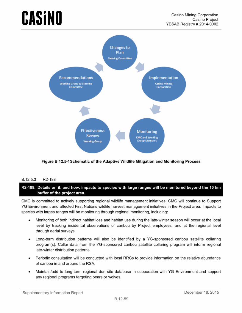
Casino Mining Corporation Casino Project
YESAB Registry # 2014-0002
Supplementary Information Report
B.12-59 December 18, 2015
Figure B.12.5-1 Schematic of the Adaptive Wildlife Mitigation and Monitoring Process
B.12.5.3 R2-188
R2-188. Details on if, and how, impacts to species with large ranges will be monitored beyond the 10 km buffer of the project area.
CMC is committed to actively supporting regional wildlife management initiatives. CMC will continue to Support YG Environment and affected First Nations wildlife harvest management initiatives in the Project area. Impacts to species with larges ranges will be monitoring through regional monitoring, including:
• Monitoring of both indirect habitat loss and habitat use during the late-winter season will occur at the local level by tracking incidental observations of caribou by Project employees, and at the regional level through aerial surveys.
• Long-term distribution patterns will also be identified by a YG-sponsored caribou satellite collaring program(s). Collar data from the YG-sponsored caribou satellite collaring program will inform regional late-winter distribution patterns.
• Periodic consultation will be conducted with local RRCs to provide information on the relative abundance of caribou in and around the RSA.
• Maintain/add to long-term regional den site database in cooperation with YG Environment and support any regional programs targeting bears or wolves.

Casino Mining Corporation Casino Project
YESAB Registry # 2014-0002
Supplementary Information Report
B.12-60 December 18, 2015
• If stakeholders are interested or concerned about broader regional-level wildlife issues, a collaborative approach and participation by CMC can be considered for monitoring outside of the RSA.
CMC recognizes that there are information and knowledge gaps about wildlife, vegetation, habitat, and industrial disturbance that are not addressed by the Project-specific mitigation actions and monitoring program identified in the WMMP. There may be broader wildlife and terrestrial environmental science needs to help improve mining mitigation, First Nations knowledge, or general regional knowledge gaps. Although the information may not be specific to the Casino Project, CMC recognizes the need to develop partnerships to improve regional ecological knowledge that will help to improve understanding and future decision making.