surveys geomatics - stantecannouncements.stantec.com/ecard/surveysgeomatics100128/sg_broc… ·...
TRANSCRIPT

Global Expertise. Local Delivery.
SurvEyS/GEomaticS

Stantec, founded in 1954, provides professional design and consulting services in planning, engineering, architecture, surveying, economics, and project management. continually striving to balance economic, environmental, and social responsibilities, we are recognized as a world-class leader and innovator in the delivery of sustainable solutions. We support public and private sector clients in a diverse range of markets in the infrastructure and facilities sector at every stage, from initial concept and financial feasibility to project completion and beyond.
Firmly committed to continuous innovation, Stantec adopts a fully integrated approach to projects. our multidisciplinary practice areas serve public and private sector clients in a diverse range of markets. We work in partnership with our clients as one team to offer infinite solutions.
onE tEam.inFinitE SoLutionS.
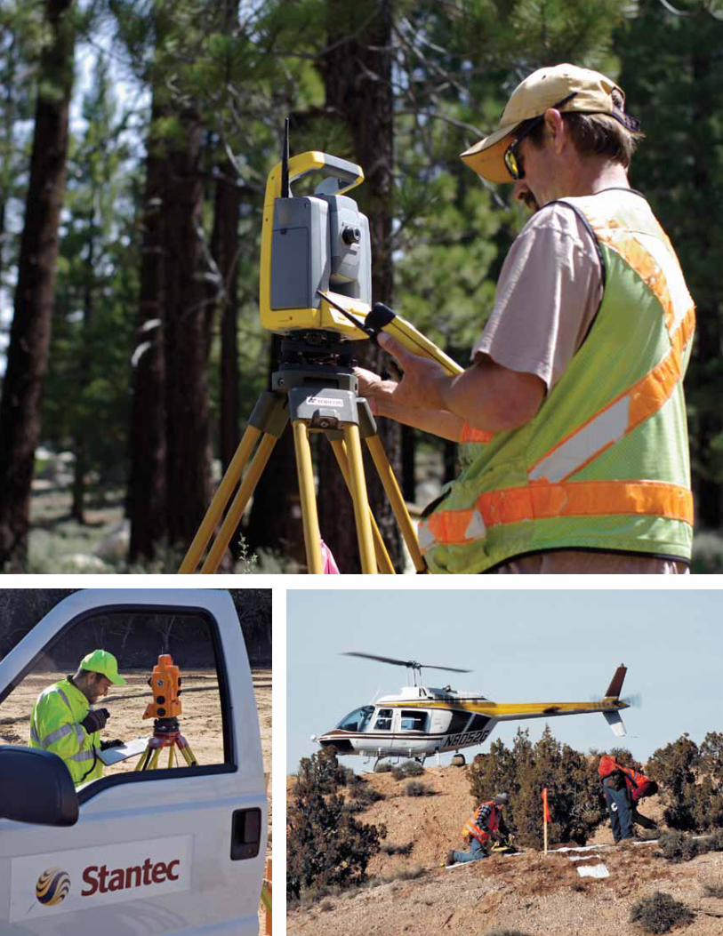
OPPOSITE CLOCKWISE FROM TOP LEFT:
Dyer mountain Ski resort | Lassen County, California
Loblaws – richmond road | Ottawa, Ontario
Fernley Levee Break Laser Scanning | Fernley, Nevada

Stantec provides the full range of surveys/geomatics services encompassing the measurement, layout, representation, analysis, management, retrieval, and display of spatial information describing the earth’s physical features, land parcel boundaries, and the built environment.
the knowledge of Stantec’s professional and technical surveys/geomatics staff is applied to services including boundary and cadastral surveys, aLta/acSm, topographic mapping, construction stakeout, geodetic and control surveys, route surveys, as-builts, water rights, photogrammetry, and hydrographic surveys, as well as subsurface utility engineering (SuE), Geographic information System (GiS) services, and 3D laser scanning (3DLS). Specialized services include environmental surveying in support of projects involving remediation, landfills, unexploded ordnance, vegetation and habitat, wildlife, wildfire burns, wetlands, and more.
our comprehensive surveys/geomatics services may be performed on a wide range of projects focusing on residential, commercial, industrial, transportation, utility and power, recreational, environmental, and institutional projects for public and private sector clients. our staff is capable of effectively performing work in locations that range from major urban settings to the most remote and challenging environments by effectively addressing the logistical and safety considerations inherent in each situation.
SurvEyS/GEomaticS
OPPOSITE CLOCKWISE FROM TOP:
montgomery Estates | South Lake Tahoe, California
orchard Hills | Irvine, California
yucca mountain GPS Survey | Southern Nevada

vegetation; and elevation information in the form of contour lines and spot elevations. the vertical information can be represented as a Digital terrain model (Dtm) or Digital Elevation model (DEm), along with horizontal information represented as caD data, for direct use in design and planning application software.
topographic mapping is the process of measuring three-dimensional locations of natural and manmade features within a site and preparing a graphic representation of the site’s conditions.
topo maps have many uses and serve as the basis for land planning, route planning, civil engineering design, architectural design, watershed and drainage analysis, visualization renderings, and geological exploration. this mapping is integral to work on projects including residential, commercial, and industrial developments; airports; roads and highways; rail and light rail; recreation facilities; water and wastewater infrastructure; mining; and more.
Field survey measurements are commonly made with conventional or GPS survey techniques or by 3D laser scanning to gather 3D locations for all features of interest. Specialized computer software is then used to process the data and create the topo maps.
topographic maps depict information on manmade features such as buildings, roadways, fences, and utilities; natural features such as watercourses and
TOP:
reno tahoe international airport Survey | Reno,
Nevada
BOTTOM:
north carolina Department of transportation | Winston-
Salem, North Carolina
toPoGraPHic maPPinG
surveys are accomplished for public and private sector clients

TOP:
GPS control network | Ottawa, Ontario
BOTTOM:
Davison army airfield | Fort Belvoir, Virginia
GEoDEtic anD controL SurvEySStantec has extensive expertise in providing geodetic and control survey services, ranging from localized control networks for construction and mapping to permanent high-precision control stations for inclusion in regional or nationwide control networks. Work has been successfully performed on a wide range of projects for private, municipal, and government clients.
Localized control work generally utilizes plane survey techniques, while those involving larger areas must incorporate geodetic survey principles to account for the size, shape, and characteristics of the earth. Stantec’s geodesists and geodetic surveyors rely on satellite based GPS (Global Positioning System) technology and specialized techniques to achieve the required high-precision results for these large-scale projects.
control surveys support aerial mapping projects, where precise positions are set on temporary target panel points that will be visible in aerial imagery to guide photogrammetric mapping.
GPS observations can also be made on ground control points during the photo mission for subsequent processing of airborne GPS data collected within the aircraft.
control surveys are provided to guide mapping and construction stakeout work for projects such as residential and commercial developments, roads and highways, underground infrastructure, utility transmission lines, airport facilities, and high-rise building construction.
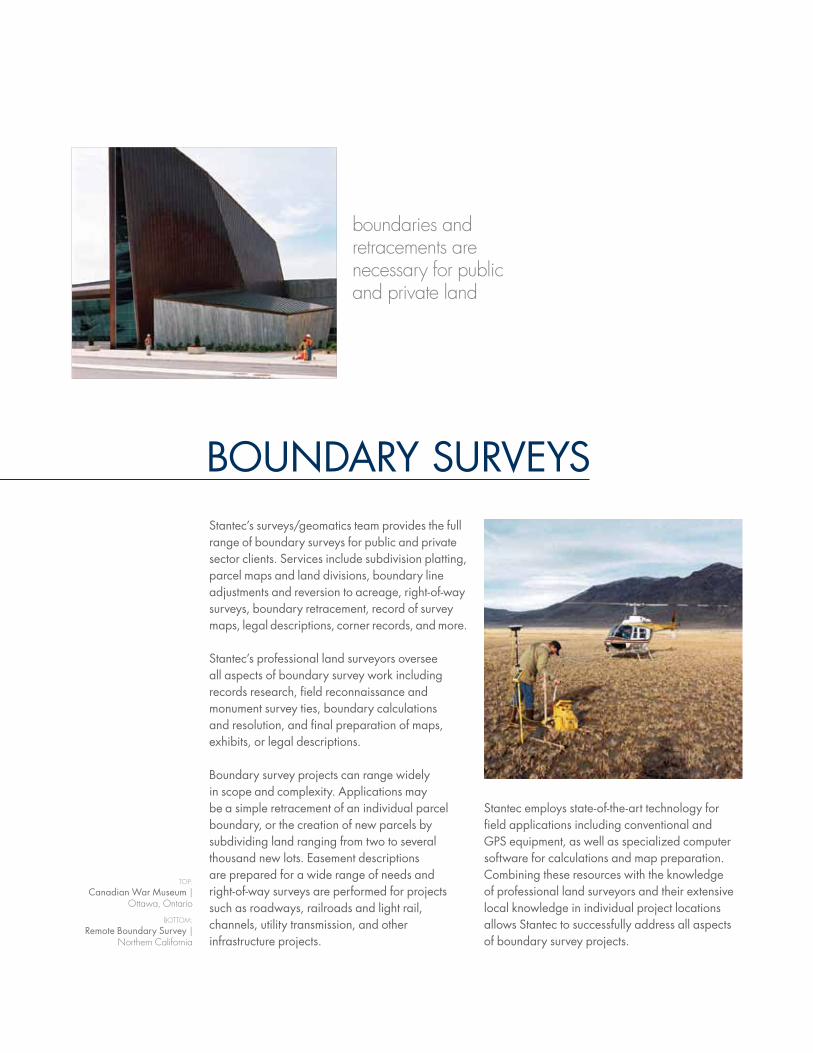
Stantec employs state-of-the-art technology for field applications including conventional and GPS equipment, as well as specialized computer software for calculations and map preparation. combining these resources with the knowledge of professional land surveyors and their extensive local knowledge in individual project locations allows Stantec to successfully address all aspects of boundary survey projects.
Stantec’s surveys/geomatics team provides the full range of boundary surveys for public and private sector clients. Services include subdivision platting, parcel maps and land divisions, boundary line adjustments and reversion to acreage, right-of-way surveys, boundary retracement, record of survey maps, legal descriptions, corner records, and more.
Stantec’s professional land surveyors oversee all aspects of boundary survey work including records research, field reconnaissance and monument survey ties, boundary calculations and resolution, and final preparation of maps, exhibits, or legal descriptions.
Boundary survey projects can range widely in scope and complexity. applications may be a simple retracement of an individual parcel boundary, or the creation of new parcels by subdividing land ranging from two to several thousand new lots. Easement descriptions are prepared for a wide range of needs and right-of-way surveys are performed for projects such as roadways, railroads and light rail, channels, utility transmission, and other infrastructure projects.
BounDary SurvEyS
boundaries and retracements are necessary for public and private land
TOP:
canadian War museum | Ottawa, Ontario
BOTTOM:
remote Boundary Survey | Northern California
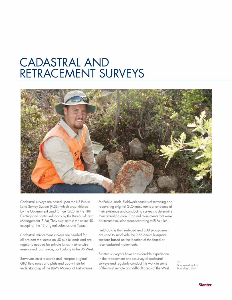
caDaStraL anDrEtracEmEnt SurvEyS
for Public Lands. Fieldwork consists of retracing and recovering original GLo monuments or evidence of their existence and conducting surveys to determine their actual position. original monuments that were obliterated must be reset according to BLm rules.
Field data is then reduced and BLm procedures are used to subdivide the PLSS one-mile-square sections based on the location of the found or reset cadastral monuments.
Stantec surveyors have considerable experience in the retracement and resurvey of cadastral surveys and regularly conduct this work in some of the most remote and difficult areas of the West.
cadastral surveys are based upon the uS Public Land Survey System (PLSS), which was initiated by the Government Land office (GLo) in the 18th century and continued today by the Bureau of Land management (BLm). they exist across the entire uS, except for the 13 original colonies and texas.
cadastral retracement surveys are needed for all projects that occur on uS public lands and are regularly needed for private lands in otherwise unsurveyed rural areas, particularly in the uS West.
Surveyors must research and interpret original GLo field notes and plats and apply their full understanding of the BLm’s manual of instructions
TOP:
Sanpete mountain Boundary | Utah

aLta/acSm LanD titLE SurvEyS
other specific requirements as requested. When research and field surveying tasks are completed, an official aLta/acSm Land title Survey map is created to depict all required information.
aLta/acSm land title surveys can be completed for many types of projects including commercial and industrial development, master planned communities, individual residences, retail and mall developments, and public utility facilities, to name a few.
Stantec’s surveys/geomatics professionals have extensive knowledge and experience with aLta/acSm national requirements, as well as the local conditions that allows them to effectively advise clients and address their specific project needs.
experience and technology promote accurate deliverables
LEFT:
Stantec Surveyor and Equipment | Raleigh,
North Carolina
RIghT:
Glen Eagle Square Shopping center | Chadds Ford,
Pennsylvania
Stantec provides survey services that adhere to the american Land title association/american congress on Surveying and mapping (aLta/acSm) minimum Standard Detail requirements. the resulting maps present the legal components of the property including record boundary, easements, rights-of-way, and other encumbrances, as well as the physical site conditions of improvements and potential patterns of use.
Services for aLta/acSm land title surveys differ according to individual project needs and may include land area/boundary, monuments, topographic features, FEma flood zone designations, site improvements, buildings, adjacent property owners, access, parking areas, utility locations, easements and rights-of-way, evidence of use patterns, and
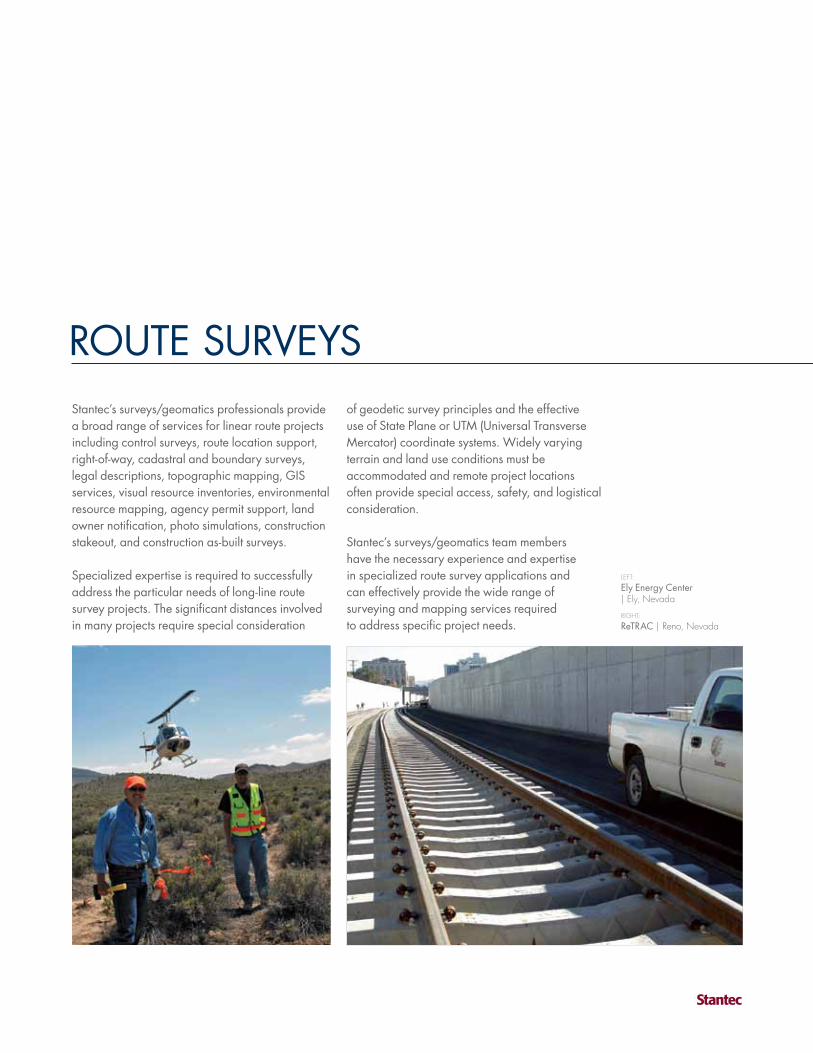
routE SurvEySof geodetic survey principles and the effective use of State Plane or utm (universal transverse mercator) coordinate systems. Widely varying terrain and land use conditions must be accommodated and remote project locations often provide special access, safety, and logistical consideration.
Stantec’s surveys/geomatics team members have the necessary experience and expertise in specialized route survey applications and can effectively provide the wide range of surveying and mapping services required to address specific project needs.
Stantec’s surveys/geomatics professionals provide a broad range of services for linear route projects including control surveys, route location support, right-of-way, cadastral and boundary surveys, legal descriptions, topographic mapping, GiS services, visual resource inventories, environmental resource mapping, agency permit support, land owner notification, photo simulations, construction stakeout, and construction as-built surveys.
Specialized expertise is required to successfully address the particular needs of long-line route survey projects. the significant distances involved in many projects require special consideration
LEFT:
Ely Energy center | Ely, Nevada
RIghT:
retrac | Reno, Nevada

SuBSurFacE utiLity EnGinEErinGStantec provides site surveys, coordination with utility owners, and/or utility exposure to locate subsurface utilities during design and construction. the four levels of quality services are dependent on client need and may include locating, the highest level of accuracy; designating, which utilizes surface geophysical methods to identify utilities; surface visible survey, which involves verifying research completed from existing records out in the field; and records research, which is strictly the use of available utility records to establish underground utilities. our highly skilled technicians then convert field data into caD files for analysis, which shows the position of critical utilities in 3D, allowing for a more accurate pre-design base drawing.
the highest level of accuracy services includes locating, which is the actual exposure of the facility being surveyed and includes data such as material type, surface elevation, utility size and capacity, outside dimensions, and configurations. typical designating is performed using various electromagnetic equipment.
specialized skills are beneficial for all types of surveys
TOP:
Subsurface utility Engineering | Raleigh,
North Carolina
BOTTOM:
Subsurface utility Engineering | Raleigh,
North Carolina
For subsurface features that cannot be magnetically located, Stantec utilizes its Ground Penetrating radar (GPr), which is a non-invasive geophysical method for viewing subsurface features and is one of the most effective tools for subsurface mapping and designating.
Stantec can provide subsurface utility engineering services for a variety of public and private projects including transportation, institutional, educational, development, and utility.

EnvironmEntaL SurvEyinGStantec has provided a variety of professional services for environmental surveying projects including remediation projects, wetland inventory and location surveys, hydrologic studies, soil sampling events, landfill closures, active landfills, stream relocation and stream-bank stabilization surveys, underground nuclear waste storage facility surveying, and monitoring well and core hold location mapping projects.
Stantec can assist with Superfund remediation projects by providing surveying services to support the cleanup and disposal of contaminated soils and materials. these projects implement the use of surveying to provide topographic, volumetric, and boundary surveys, as well as construction staking services.
TOP:
SWm Ditches rtK GPS Survey | Virginia Beach, Virginia
BOTTOM:
Brian Head alpine creek | Brian head, Utah
unexploded ordnance (uXo) projects involve the location and removal of unexploded ordnance and include surveying services to provide grid mapping and boundary surveying. Stantec can also provide active landfill and landfill closure surveys, which involve topographic, volumetric, and boundary surveys, as well as construction stakeout.
Stantec professionals use conventional, GPS, and 3D laser scanning technology to produce 3D digital terrain mapping to provide our clients with topographic and volumetric information, which can be delivered in the most appropriate format for our client.

HyDroGraPHic SurvEySHydrographic surveys are performed to map shorelines and bed surfaces beneath a waterway or bodies of water including streams, channels, rivers, reservoirs, lakes, and ocean bays, as well as to establish water depth. Depending on the type of watercourse and the required information, a variety of techniques and watercrafts are used including motorized boats, pontoons, rafts, and ScuBa. Depth soundings are integrated with GPS positions to generate a digital terrain model (Dtm) and contours of the bed and shore. Deliverables include Dtm surfaces, thalweg profiles (deepest part of the channel), cross-sections, and water volumes. Stantec owns and operates several types of equipment specific to hydrographic surveying including boats and high frequency depth sounders coupled with dual-frequency GPS receivers.
LEFT:
Hydrographic Surveying | Edmonton, Alberta
RIghT:
Donner Lake Hydrographic Survey | California
Stantec has experience providing hydrographic survey services for a variety of project types including environmental, transportation, and industrial applications. Projects have been completed for bridge design, outfall scour hole mapping, environmental impact assessments, water intake design, reservoir volumes, and road and canal design.

conStruction StaKEoutStantec’s team of surveys/geomatics professionals provide the full range of construction stakeout services including earthwork grading and excavation, underground utilities, roadways and bridges, airport facilities, houses and buildings, tunnels, slope staking, and quantity surveying and calculations. Different techniques are used dependent on the project type and all have their own unique set of challenges.
Slope staking requires knowledge of the theoretical location of “daylight” and “catch” points and is a specialized technique used for hillside projects. airport stakeout is a very precise and higher level of survey, as are multi-acre buildings such as large warehousing projects that require a very
our services are employed from project inception to project completion
TOP:
chester county ymca | East goshen, Pennsylvania
accurate grade over a substantial area. Highrise construction stakeout requires guiding the placement of steel vertically and requires exact precision.
For buildings and houses, our surveyors work initially on the plot plan, stake locations for buildings and infrastructure during construction, and also certify after construction that it meets the requirements of the plans. roadway, channel, transmission line, utility/communications, and railroad staking is also performed to delineate grading and construction over long distances.
Stantec has the experience in all types of construction stakeout projects to properly guide and verify construction.

3D LaSEr ScanninG3DLS uses scanning instruments to transmit laser light and collect reflected return data, which is then processed to generate information about a target’s surface. Stantec uses land based scanning techniques to produce 3D topographic visuals of the ground surface and the constructed environment. 3DLS uses “time of flight” measurements between the instrument and the target surface, creating myriad 3D points that are then analyzed and processed to create a highly accurate map product.
Stantec utilizes 3DLS on projects that require high definition and precision using rapid data collection techniques. it is utilized for projects
3D laser scanning and gIS systems are important new technologies
LEFT:
Geological mapping 3D Laser Scanning | Portland,
Colorado
RIghT:
cornell university | Ithaca, New York
including as-built surveys, transportation projects, infrastructure, industrial inventories, environmental projects, power generation, and historical architectural surveying, to name a few. 3DLS is particularly effective in applications where access is limited or hazardous to survey personnel. the resulting digital data is compatible with design and analysis software such as caD and GiS, enabling high definition digital terrain models (Dtms) and mapping products.
Stantec’s 3DLS capabilities and experience are regularly used to serve public and private sector clients throughout north america.
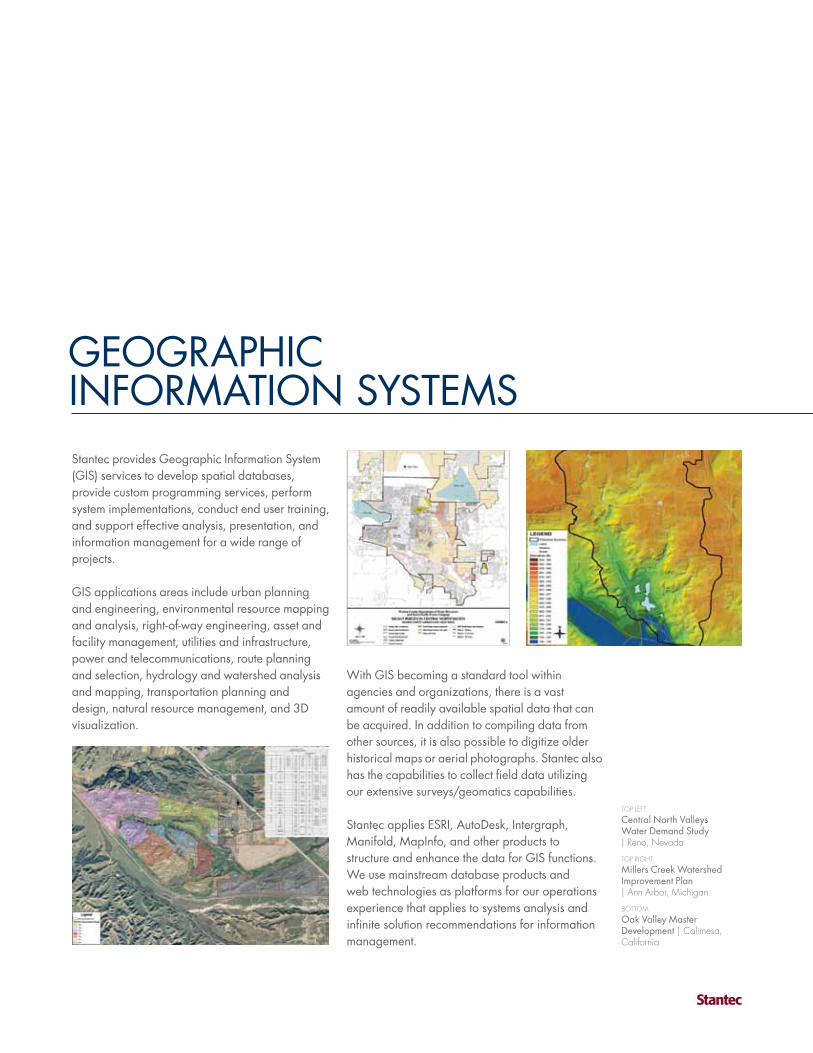
GEoGraPHic inFormation SyStEmSStantec provides Geographic information System (GiS) services to develop spatial databases, provide custom programming services, perform system implementations, conduct end user training, and support effective analysis, presentation, and information management for a wide range of projects.
GiS applications areas include urban planning and engineering, environmental resource mapping and analysis, right-of-way engineering, asset and facility management, utilities and infrastructure, power and telecommunications, route planning and selection, hydrology and watershed analysis and mapping, transportation planning and design, natural resource management, and 3D visualization.
TOP LEFT:
central north valleys Water Demand Study | Reno, Nevada
TOP RIghT:
millers creek Watershed improvement Plan | Ann Arbor, Michigan
BOTTOM:
oak valley master Development | Calimesa, California
With GiS becoming a standard tool within agencies and organizations, there is a vast amount of readily available spatial data that can be acquired. in addition to compiling data from other sources, it is also possible to digitize older historical maps or aerial photographs. Stantec also has the capabilities to collect field data utilizing our extensive surveys/geomatics capabilities.
Stantec applies ESri, autoDesk, intergraph, manifold, mapinfo, and other products to structure and enhance the data for GiS functions. We use mainstream database products and web technologies as platforms for our operations experience that applies to systems analysis and infinite solution recommendations for information management.

PHotoGrammEtryStantec offers aerial mapping through comprehensive soft-copy photogrammetric services, relying on specialized software and hardware, together with the experience of our mapping specialists. Projects range from drawings of simple planimetric features, such as building outlines and curb alignments, to detailed three-dimensional digital terrain modeling, which can be used to produce true-to-scale digital images, known as orthphotos. Specializing in aerial triangulation, digital terrain modeling, digital image stereo compilation, and orthophotography, Stantec provides these services as stand-alone projects or integrated with our overall surveying and engineering services.
Stantec’s highly experienced mapping specialists furnish clients with totally integrated mapping services. our photogrammetrists, certified by the american Society of Photogrammetry and remote Sensing (aSPrS), work closely with our Professional Land Surveyors and their field survey crews for precision ground control and mapping Qa/Qc procedures. Sophisticated in-house
committed to excellence, consistency, and efficiency
TOP:
Water Street mills | Stonington, Connecticut
BOTTOM:
orthophoto with Planimetric overlay | New York, New York
technology supports every effort, allowing us to provide enhanced efficiency, coordination, and cost-effectiveness.
Stantec is keenly aware of the importance of gathering accurate data on schedule, whether we are providing photogrammetric services for our own in-house disciplines or directly for external clients. By offering the total range of services in-house, our clients are assured of our commitment to excellence and client satisfaction.

FRONT COVER FROM LEFT TO RIghT:
Stantec Surveyor and Equipment | Edmonton,
Alberta
Walton Developments | Calgary, Alberta
orchard Hills | Irvine, California
BACK COVER FROM LEFT TO RIghT:
muldrow army Heliport | Lexington, Oklahoma
i-19/Duval mine road interchange | Sahuarita,
Arizona
Battery Park city as-Built | New York, New York

cm
-cD
-mrc
-2008Jun
02-P1v1