supporting document – transportation existing conditions
TRANSCRIPT
onemilegrid.com.au 1/59 Keele Street, Collingwood, VIC 3066 (03) 9939 8250
Hawksburn Activity Centre Transport Assessment – Background and Existing Conditions
14118TIA001F-F.docx
19 February 2015
Hawksburn Activity Centre Transport Assessment – Background and Existing Conditions 14118TIA001F-F.docx 19 February 2015 Page 2
onemilegrid ABN: 79 168 115 679
(03) 9939 8250
1/59 Keele Street
COLLINGWOOD, VIC 3066
www.onemilegrid.com.au
DOCUMENT INFORMATION
Prepared For David Lock Associates
File Name 14118TIA001F-F.docx Report Date 19 February 2015
Prepared By Ross Hill Authorised By James Dear
Signature
Signature
© One Mile Grid Pty Ltd. This document has been prepared by onemilegrid for the sole use and benefit of the client as per the terms of engagement. It may not
be modified or altered, copied, reproduced, sold or transferred in whole or in part in any format to any person other than by agreement. onemilegrid does not
assume responsibility or liability to any third party arising out of use or misuse of this document.
Hawksburn Activity Centre Transport Assessment – Background and Existing Conditions 14118TIA001F-F.docx 19 February 2015 Page 3
CONTENTS
1 INTRODUCTION .......................................................................................................................................................................................5
2 EXISTING CONDITIONS ............................................................................................................................................................................5 2.1 Overview ...................................................................................................................................................................................................................... 5 2.2 Traffic ........................................................................................................................................................................................................................... 26 2.3 Parking ........................................................................................................................................................................................................................ 26 2.4 Public Transport ......................................................................................................................................................................................................... 26 2.5 Pedestrians ................................................................................................................................................................................................................. 27 2.6 Bicycles ...................................................................................................................................................................................................................... 27 2.7 Loading ....................................................................................................................................................................................................................... 27 2.8 Crashes ....................................................................................................................................................................................................................... 28 3 DOCUMENTATION REVIEW ......................................................................................................................................................................29 3.1 Stonnington Cycling Strategy .................................................................................................................................................................................. 29 3.2 Chapel ReVision Transport Strategy ........................................................................................................................................................................ 29 3.3 Sustainable Transport Policy .................................................................................................................................................................................... 30 3.4 Inner Melbourne Action Plan ................................................................................................................................................................................... 30 3.5 Stonnington Bicycle Parking Report ........................................................................................................................................................................ 34
FIGURES
Figure 1 Study Area ............................................................................................................................................................................................................................. 6 Figure 2 Road Hierarchy and Traffic Volumes ............................................................................................................................................................................... 7 Figure 3 Malvern Road Cross-Section ............................................................................................................................................................................................. 8 Figure 4 Road Speed Zones .............................................................................................................................................................................................................. 9 Figure 5 Road Restrictions and Traffic Management Devices ................................................................................................................................................. 10 Figure 6 Pedestrian Facilities ........................................................................................................................................................................................................... 11 Figure 7 Bicycle Facilities .................................................................................................................................................................................................................. 12 Figure 8 Share Car Locations .......................................................................................................................................................................................................... 13 Figure 9 General Parking Restrictions - Weekday ....................................................................................................................................................................... 14 Figure 10 Parking Occupancy – Weekday: General ................................................................................................................................................................... 15 Figure 11 Parking Occupancy – Weekday: May Road Car Park and Malvern Road On-Street Parking .......................................................................... 16 Figure 12 General Parking Restrictions - Saturday ........................................................................................................................................................................ 17 Figure 13 Parking Occupancy – Saturday: General .................................................................................................................................................................... 18 Figure 14 Parking Occupancy – Saturday: May Road Car Park and Malvern Road On-Street Parking ........................................................................... 19 Figure 15 Retail Loading Locations .................................................................................................................................................................................................. 20 Figure 16 SmartRoads Road User Hierarchy Map ......................................................................................................................................................................... 21
Hawksburn Activity Centre Transport Assessment – Background and Existing Conditions 14118TIA001F-F.docx 19 February 2015 Page 4
Figure 17 Crash Locations – Last 5 Calendar Years (2009-2013) ................................................................................................................................................ 22 Figure 18 TravelSmart Map ................................................................................................................................................................................................................ 23 Figure 19 Public Transport Provision ................................................................................................................................................................................................. 24 Figure 20 Pedestrian Generators and Desire Lines ....................................................................................................................................................................... 25 Figure 21 IMAP – Walking Framework .............................................................................................................................................................................................. 31 Figure 22 IMAP - Regional Bicycle Network ................................................................................................................................................................................... 32 Figure 23 IMAP - Potential Public Transport Network Improvements......................................................................................................................................... 33 Figure 24 Bicycle Parking Report – Recommended additional bicycle parking locations .................................................................................................. 34
Hawksburn Activity Centre Transport Assessment – Background and Existing Conditions 14118TIA001F-F.docx 19 February 2015 Page 5
1 INTRODUCTION
Stonnington City Council has identified the Malvern Road – Hawksburn Activity Centre as a priority project, and has appointed a consultant
team lead by David Lock Associates to prepare a Structure Plan to guide the future development within the activity centre for the coming 10-20
year period.
onemilegrid has been requested by David Lock Associates to provide transport, traffic and parking input into the Hawksburn Structure Plan.
2 EXISTING CONDITIONS
2.1 Overview
An extensive on-site review of the existing traffic conditions within and immediately surrounding the study areas has been undertaken, with
various traffic and parking surveys undertaken, as detailed below:
SCATS traffic volume date for a one week period in the first week of September 2014, at the intersections of:
Surrey Road/Malvern Road;
Williams Road/Malvern Road; and
Malvern Road near Chatsworth Road.
Midblock traffic volume and speed surveys for a one week period in the first week of December 2014, at the following locations:
Mathoura Road, north of Malvern Road; and
Chatsworth Road, south of Malvern Road.
Peak Hour Turning movement counts at the intersection of Malvern Road with Chatsworth Road and Mathoura Road, on Thursday 4th
December 2014; and
Car Park Occupancy surveys of all parking within the study area, on Thursday 4th and Saturday 6th December 2014.
Further traffic volume information for local streets has been provided by Council.
The results of the on-site review, surveys and Council information are illustrated in the following figures.

Hawksburn Activity Centre Transport Assessment – Background and Existing Conditions 14118TIA001F-F.docx 19 February 2015 Page 6
Figure 1 Study Area
Copyright Melway Publishing
Hawksburn Activity Centre Transport Assessment – Background and Existing Conditions 14118TIA001F-F.docx 19 February 2015 Page 7
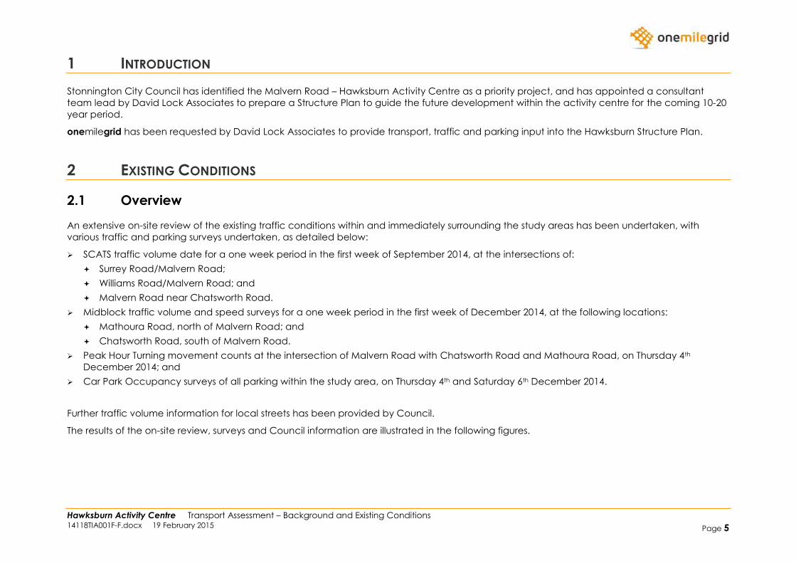
Figure 2 Road Hierarchy and Traffic Volumes
Primary Arterial Roads
Connector Roads
Local Roads
Laneway
Pedestrian/Cycle Link
Traffic Volume (vehicles
per day – direction) 9999
Hawksburn Activity Centre Transport Assessment – Background and Existing Conditions 14118TIA001F-F.docx 19 February 2015 Page 8
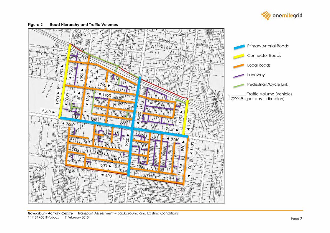
Figure 3 Malvern Road Cross-Section
Hawksburn Activity Centre Transport Assessment – Background and Existing Conditions 14118TIA001F-F.docx 19 February 2015 Page 9
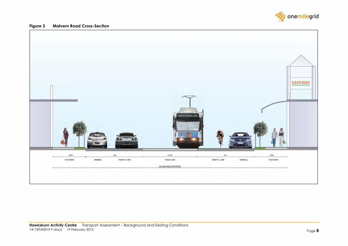
Figure 4 Road Speed Zones
60km/h
50km/h (default)
40km/h
40km/h Area Zone
Hawksburn Activity Centre Transport Assessment – Background and Existing Conditions 14118TIA001F-F.docx 19 February 2015 Page 10
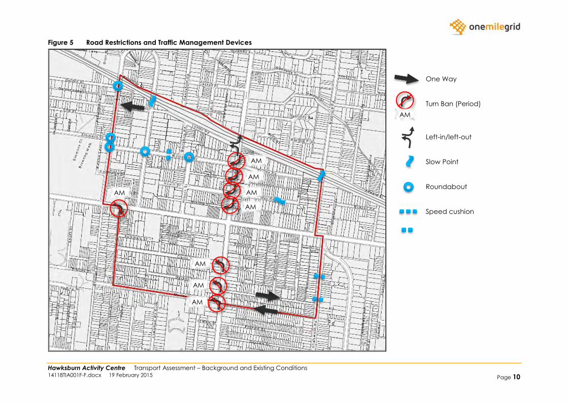
Figure 5 Road Restrictions and Traffic Management Devices
One Way
Turn Ban (Period)
Left-in/left-out
Slow Point
Roundabout
Speed cushion
AM
AM
AM
AM
AM
AM
AM
AM
AM
Hawksburn Activity Centre Transport Assessment – Background and Existing Conditions 14118TIA001F-F.docx 19 February 2015 Page 11
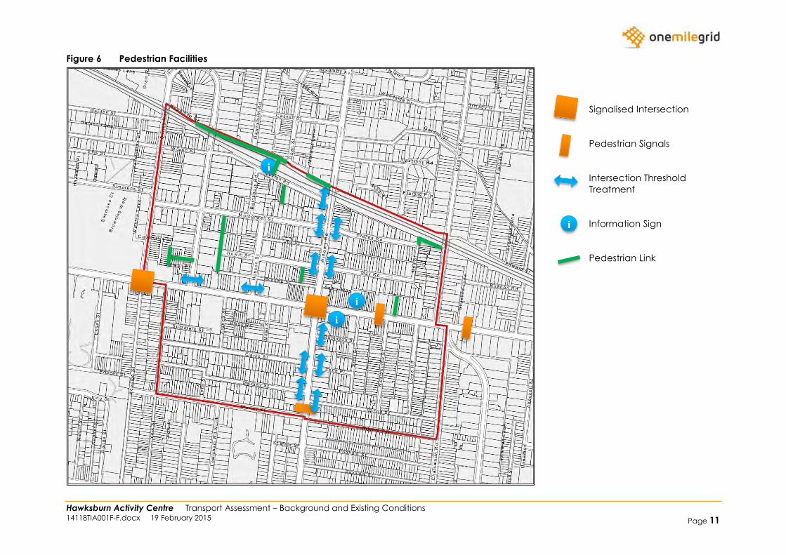
Figure 6 Pedestrian Facilities
Signalised Intersection
Pedestrian Signals
Intersection Threshold
Treatment
Information Sign
Pedestrian Link
i
i
i
i
Hawksburn Activity Centre Transport Assessment – Background and Existing Conditions 14118TIA001F-F.docx 19 February 2015 Page 12
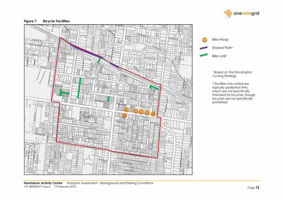
Figure 7 Bicycle Facilities
Bike Hoop
Shared Path1
Bike Link2
1 Based on the Stonnington
Cycling Strategy
2 The Bike Links noted are
typically pedestrian links
which are not specifically
intended for bicycles, though
bicycles are not specifically
prohibited
Hawksburn Activity Centre Transport Assessment – Background and Existing Conditions 14118TIA001F-F.docx 19 February 2015 Page 13
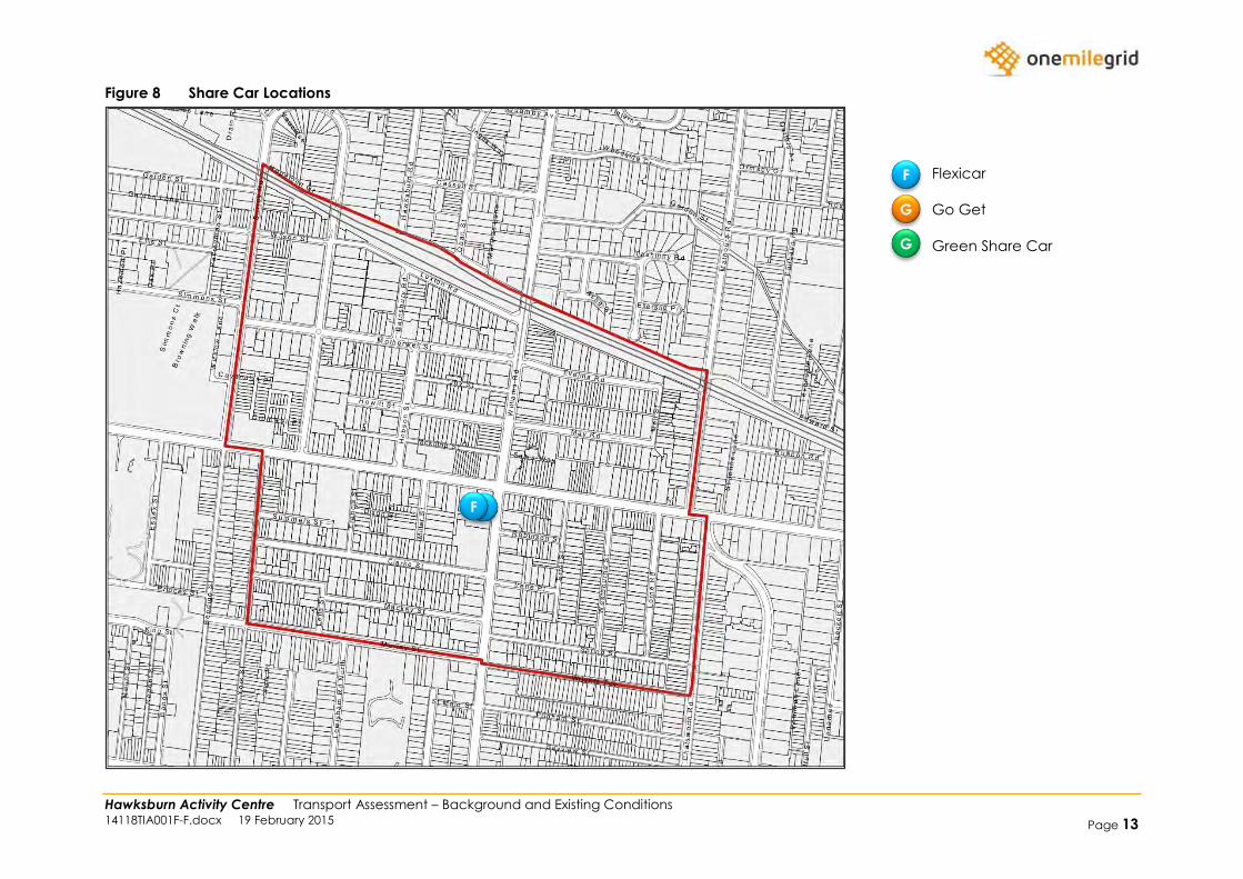
Figure 8 Share Car Locations
Flexicar
Go Get
Green Share Car
F
G
G
F F
Hawksburn Activity Centre Transport Assessment – Background and Existing Conditions 14118TIA001F-F.docx 19 February 2015 Page 14
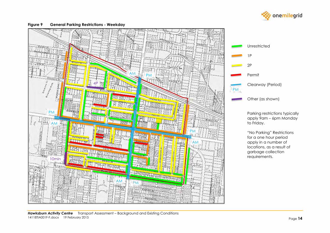
Figure 9 General Parking Restrictions - Weekday
Unrestricted
1P
2P
Permit
Clearway (Period)
Other (as shown)
Parking restrictions typically
apply 9am – 6pm Monday
to Friday.
“No Parking” Restrictions
for a one hour period
apply in a number of
locations, as a result of
garbage collection
requirements.
PM
AM
PM AM
PM AM
PM
AM
PM
10min
4P
Hawksburn Activity Centre Transport Assessment – Background and Existing Conditions 14118TIA001F-F.docx 19 February 2015 Page 15
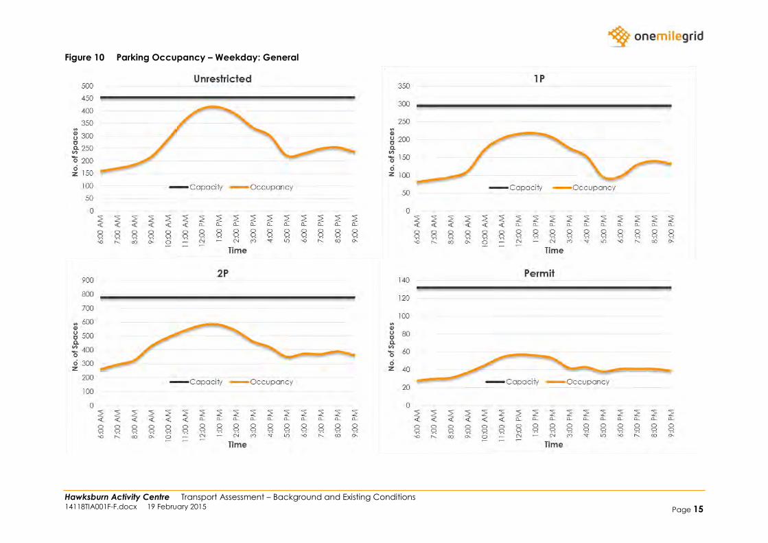
Figure 10 Parking Occupancy – Weekday: General
Hawksburn Activity Centre Transport Assessment – Background and Existing Conditions 14118TIA001F-F.docx 19 February 2015 Page 16
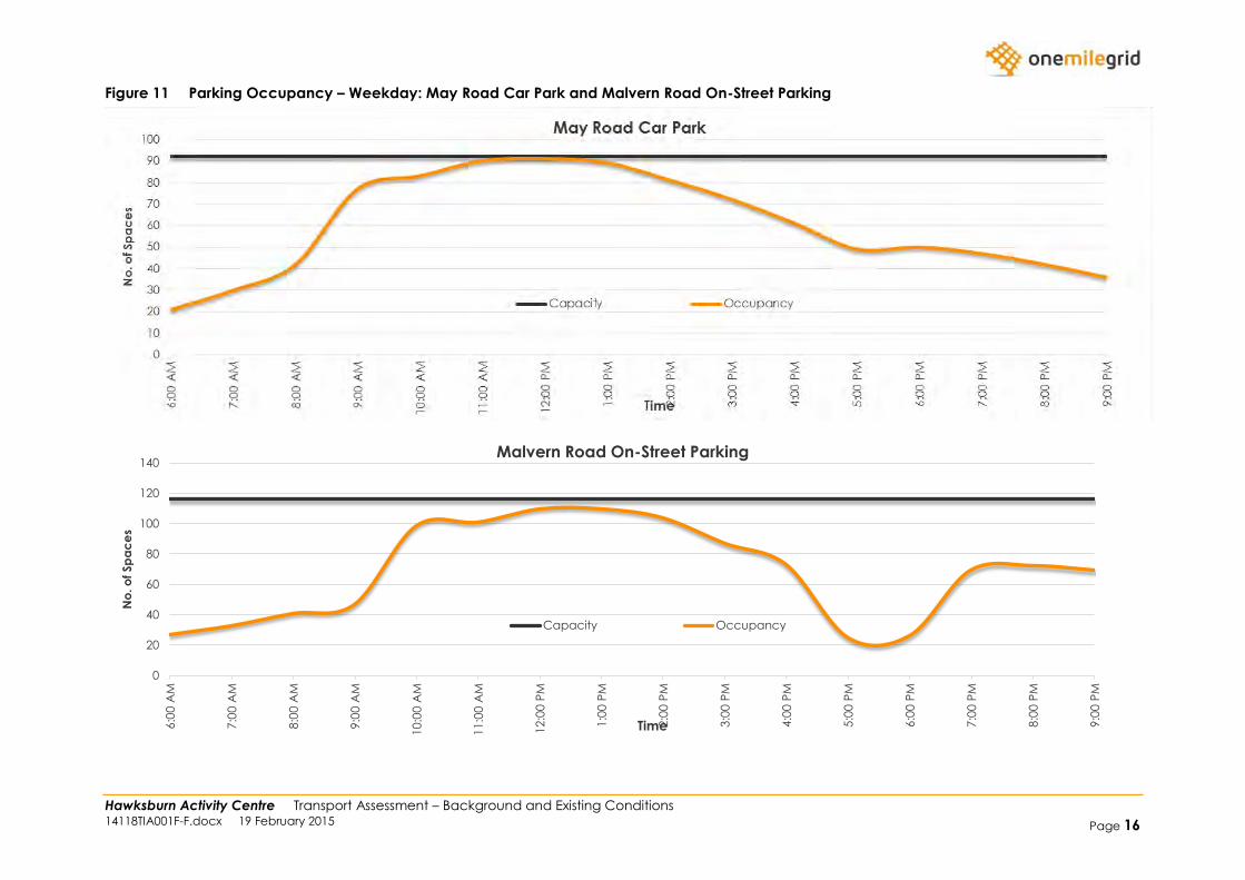
Figure 11 Parking Occupancy – Weekday: May Road Car Park and Malvern Road On-Street Parking
0
20
40
60
80
100
120
140
6:0
0 A
M
7:0
0 A
M
8:0
0 A
M
9:0
0 A
M
10:0
0 A
M
11:0
0 A
M
12:0
0 P
M
1:0
0 P
M
2:0
0 P
M
3:0
0 P
M
4:0
0 P
M
5:0
0 P
M
6:0
0 P
M
7:0
0 P
M
8:0
0 P
M
9:0
0 P
M
No
. o
f Sp
ac
es
Time
Malvern Road On-Street Parking
Capacity Occupancy
Hawksburn Activity Centre Transport Assessment – Background and Existing Conditions 14118TIA001F-F.docx 19 February 2015 Page 17
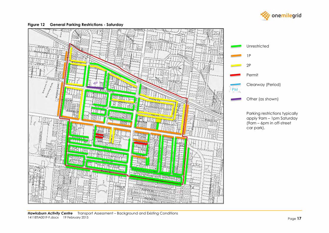
Figure 12 General Parking Restrictions - Saturday
Unrestricted
1P
2P
Permit
Clearway (Period)
Other (as shown)
Parking restrictions typically
apply 9am – 1pm Saturday
(9am – 6pm in off-street
car park).
PM
4P

Hawksburn Activity Centre Transport Assessment – Background and Existing Conditions 14118TIA001F-F.docx 19 February 2015 Page 18
Figure 13 Parking Occupancy – Saturday: General
Hawksburn Activity Centre Transport Assessment – Background and Existing Conditions 14118TIA001F-F.docx 19 February 2015 Page 19
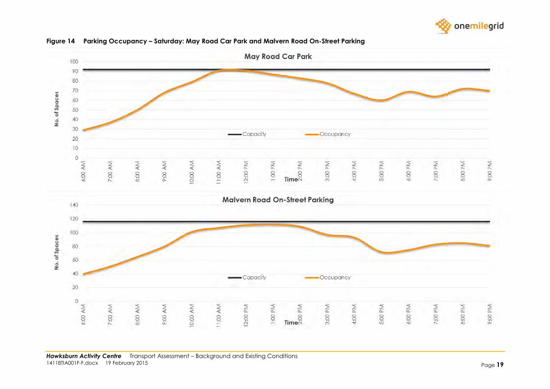
Figure 14 Parking Occupancy – Saturday: May Road Car Park and Malvern Road On-Street Parking

Hawksburn Activity Centre Transport Assessment – Background and Existing Conditions 14118TIA001F-F.docx 19 February 2015 Page 20
Figure 15 Retail Loading Locations
On-Street Loading
Zones
Retail/Commercial
Land Use
Rear Laneway
Access
Front Loading
Required
Hawksburn Activity Centre Transport Assessment – Background and Existing Conditions 14118TIA001F-F.docx 19 February 2015 Page 21
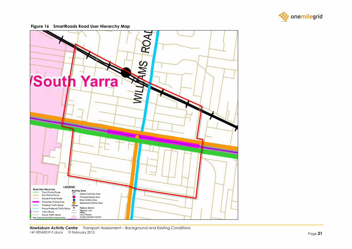
Figure 16 SmartRoads Road User Hierarchy Map
Hawksburn Activity Centre Transport Assessment – Background and Existing Conditions 14118TIA001F-F.docx 19 February 2015 Page 22
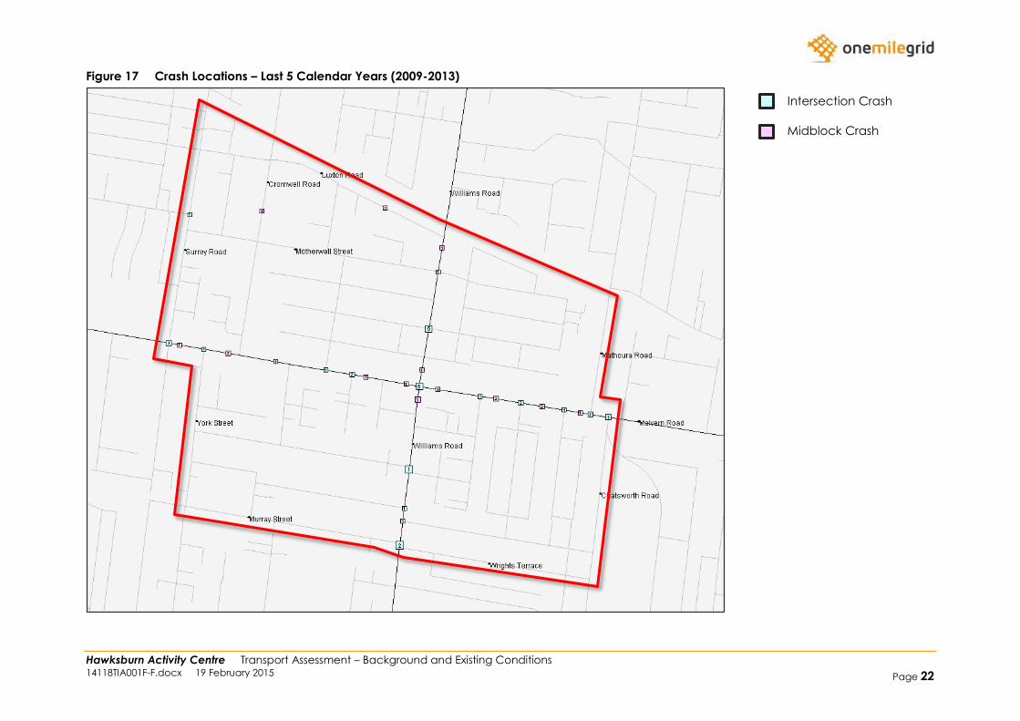
Figure 17 Crash Locations – Last 5 Calendar Years (2009-2013)
Intersection Crash
Midblock Crash

Hawksburn Activity Centre Transport Assessment – Background and Existing Conditions 14118TIA001F-F.docx 19 February 2015 Page 23
Figure 18 TravelSmart Map
Hawksburn Activity Centre Transport Assessment – Background and Existing Conditions 14118TIA001F-F.docx 19 February 2015 Page 24
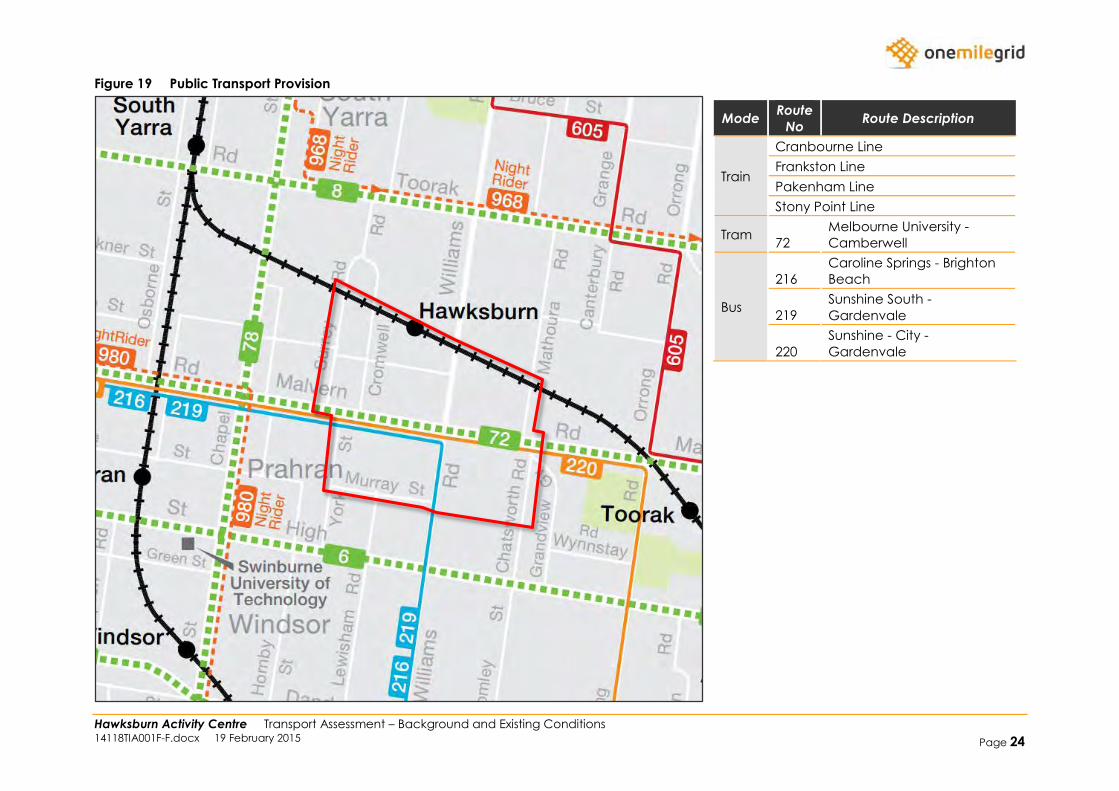
Figure 19 Public Transport Provision
Mode Route
No Route Description
Train
Cranbourne Line
Frankston Line
Pakenham Line
Stony Point Line
Tram 72
Melbourne University -
Camberwell
Bus
216
Caroline Springs - Brighton
Beach
219
Sunshine South -
Gardenvale
220
Sunshine - City -
Gardenvale
Hawksburn Activity Centre Transport Assessment – Background and Existing Conditions 14118TIA001F-F.docx 19 February 2015 Page 25
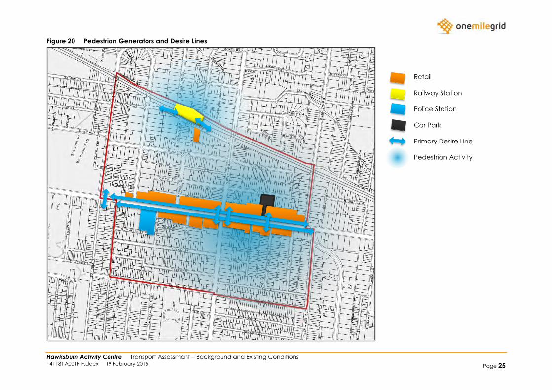
Figure 20 Pedestrian Generators and Desire Lines
Retail
Railway Station
Police Station
Car Park
Primary Desire Line
Pedestrian Activity
Hawksburn Activity Centre Transport Assessment – Background and Existing Conditions 14118TIA001F-F.docx 19 February 2015 Page 26
2.2 Traffic
Malvern Road and Williams Road provide obvious barriers, with traffic volumes of in excess of 15,000 vehicles per day, splitting the precinct into
four quadrants.
Despite this, traffic speeds are well controlled in the area, particularly the western portion, with area speed limit signage controlling all local
roads. It is understood that an expansion of the 40km/h area speed limit is being contemplated to the south eastern quadrant.
Traffic congestion in the area is largely limited to the Malvern Road/Williams Road intersection, with some queuing of traffic observed at the
signalised intersection of Malvern Road with Surrey Road, and at the sign controlled intersections of Malvern Road with Mathoura Road and
Chatsworth Road.
2.3 Parking
Parking on Malvern Road and within the May Road car park was observed to be highly utilised during observations, which is supported by
parking survey information, which suggests that both Malvern Road and the May Road car park are effectively at capacity between
approximately 10:00am and 2:00pm on Weekdays and Saturdays.
The surrounding area is well provided for in terms of parking restrictions, with a good mix of unrestricted, permit restrictions and time-restricted
parking.
Parking is largely unrestricted on Saturdays (or Sundays).
2.4 Public Transport
Limited usage of public transport was observed in the area outside of the commuter peak periods, although noting that observations were
undertaken during Christmas and school holiday periods.
It is noted that a large number of train services express through Hawksburn Station, particularly during peak periods.
Hawksburn Activity Centre Transport Assessment – Background and Existing Conditions 14118TIA001F-F.docx 19 February 2015 Page 27
2.5 Pedestrians
Pedestrian activity in the area was observed to primarily occur along Malvern Road, and predominantly within the eastern section of the study
area. Some pedestrian activity outside of commuter peak periods was observed in the vicinity of Hawksburn Station, although activity in this
area is concentrated to peak commuter times.
Limited pedestrian activity was observed traveling between the station and Malvern Road, or through other areas of the precinct, though it is
noted that observations occurred largely over the Summer holiday period.
2.6 Bicycles
It is shown above that there is limited bicycle facilities in the area, limited to a few bicycle parking rails on Malvern Road, despite the fact that
Malvern Road is nominated as a bicycle priority route. Some bicycle usage was observed during inspections, though due to the time of year
(being outside school periods), bicycle usage was expected to be below normal.
A number of bicycles were observed parked on Malvern Road, utilising either the bicycle parking rails provided, or pedestrian fencing or sign
poles.
Similarly, a number of bicycles were observed to be parked near Hawksburn Station, utilising street furniture in the area for bicycle parking.
2.7 Loading
The vast majority of retail premises fronting Malvern Road have access to a rear laneway, although the laneway is typically narrow, with limited
opportunity for turning or passing vehicles. Consequently, any loading operations via the rear laneway would typically be restricted to small
vans and utility vehicles. Observations suggest that loading activity rarely occurs via the rear laneways, with the exception of Woolworths, which
has a large formal loading area to the rear, with access assisted via the adjacent car parking area and laneway.
A number of on-street loading areas are provided within the area, predominantly along Malvern Road.
Given the size of the retail premises along Malvern Road, on-street loading and parking areas are expected to accommodate the majority of
loading activity.
Hawksburn Activity Centre Transport Assessment – Background and Existing Conditions 14118TIA001F-F.docx 19 February 2015 Page 28
2.8 Crashes
A total of 31 crash locations (where each intersection, or each length of road between intersections is considered to be a location), were
recorded in the precinct, with crashes occurring within the most recent 5 year period. Of note, 12 locations recorded more than one crash,
listed below in order of number of crashes:
1. Malvern Road/Williams Road – 5
2. Williams Road/May Road – 5
3. Malvern Road/Surrey Road – 3
4. Williams Road, south of Malvern Road – 3
5. Malvern Road/Chatsworth Road – 3
6. Malvern Road, between York Street and Cromwell Road – 2
7. Malvern Road/Miller Street – 2
8. Malvern Road, between Errol Street and Westbourne Street – 2
9. Malvern Road/Westbourne Street – 2
10. Malvern Road, between Westbourne Street and Lorne Road – 2
11. Malvern Road/Mathoura Road – 2
12. Williams Road/Murray Street/Wrights Terrace – 2
Higher crash rates are typically expected on Arterial Roads, and at or near signalised intersections.
Of the above locations, the crash rate at the intersection of Williams Road and May Road appears to be inflated, though a review of the Crash
data identifies that four of the five crashes involved southbound vehicles, and rear-end, side-swipe or overtaking crashes. It is anticipated that
these are likely due to traffic congestion from the Malvern Road intersection, and not specific to May Road.
No trends are observable from the remaining crashes.
Hawksburn Activity Centre Transport Assessment – Background and Existing Conditions 14118TIA001F-F.docx 19 February 2015 Page 29
3 DOCUMENTATION REVIEW
3.1 Stonnington Cycling Strategy
The Cycling Strategy outlines Council’s vision for cycling as:
Cycling will be widely undertaken in Stonnington, whether for fun, fitness or travel – providing health, economic, social and
environmental benefits to the community. Participation will be encouraged by facilities, programs and services.
Travel throughout Stonnington by bicycle will be easy and safe, supported by a comprehensive network of accessible and convenient
paths, laneways and trails that are accompanied by facilities that provide for resting and storing / securing bicycles. It will be particularly
easy to access local facilities and gathering places.
The five year aspirational network for Stonnington does not identify any additional bicycle routes through the subject area, although notes that
Malvern Road and Williams Road (incorrectly) are on VicRoads Proposed Principal and Priority bicycle network.
It is also noted within the Strategy that the majority of the subject area is within 1km of one or more Major Activity Centres (South Yarra, Toorak
Village or Prahran, Windsor).
The Action Plan identifies the following actions within the Hawksburn study area:
Prepare advocacy material to present to Metro Trains to explore the need and opportunity for the installation of long-stay bicycle parking
facilities at all rail stations in Stonnington;
Liaise with VicRoads regarding the need to provide for improved and safer cyclist travel [on Malvern Road] from Punt Road to Burke Road;
and
Various area wide initiatives to encourage bicycle usage.
3.2 Chapel ReVision Transport Strategy
The following points are noted within the Chapel ReVision Transport Strategy, in relation to the Hawksburn study area.
As a means of removing non-local traffic from Chapel Street, a preferred traffic route is identified around the Chapel Street area, and
includes Williams Road through the study area, and Malvern Road east of Williams Road. To assist traffic movements, intersection treatment
and signal priority works are recommended at the Malvern Road and Williams Road intersection. Malvern Road, west of Williams Road is
noted as a Local access route.
Hawksburn Activity Centre Transport Assessment – Background and Existing Conditions 14118TIA001F-F.docx 19 February 2015 Page 30
3.3 Sustainable Transport Policy
The Sustainable Transport Policy provides a number of Principles to guide Council’s activities, including the following:
Deliver Priority;
Moderate the Impact of Cars;
Increase Connections;
Improve Safety;
Raise Profile;
Foster Community Involvement;
Advocate on Behalf of the Community;
Build Relationships;
Provide Leadership; and
Monitor Progress.
It is noted that the priority of transport modes is nominated as follows:
Walking;
Cycling;
Public Transport;
Commercial vehicles serving local businesses and institutions;
Multiple-occupancy vehicles; and
Single-occupancy vehicles.
3.4 Inner Melbourne Action Plan
The Inner Melbourne Action Plan (IMAP) is a collaborative partnership between the Cities of Melbourne, Port Phillip, Stonnington, Yarra and
Maribyrnong.
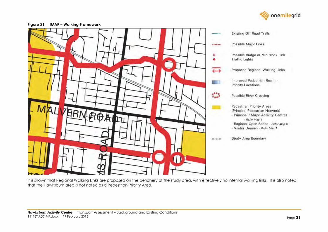
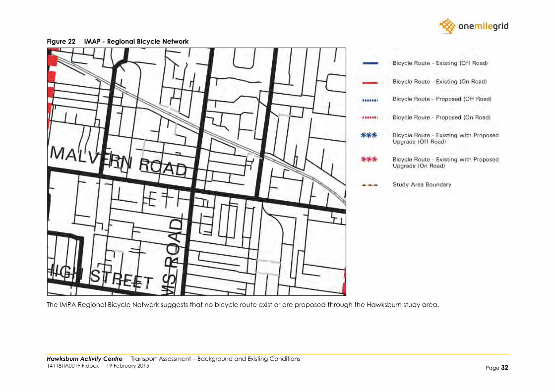
IMAP have developed a number of strategies and Action Plans, including the Walking Framework shown in Figure 21, the Regional Bicycle
Network shown in Figure 22, and the Potential Public Transport Network Improvements shown in Figure 23.
Hawksburn Activity Centre Transport Assessment – Background and Existing Conditions 14118TIA001F-F.docx 19 February 2015 Page 31
Figure 21 IMAP – Walking Framework
It is shown that Regional Walking Links are proposed on the periphery of the study area, with effectively no internal walking links. It is also noted
that the Hawksburn area is not noted as a Pedestrian Priority Area.
Hawksburn Activity Centre Transport Assessment – Background and Existing Conditions 14118TIA001F-F.docx 19 February 2015 Page 32
Figure 22 IMAP - Regional Bicycle Network
The IMPA Regional Bicycle Network suggests that no bicycle route exist or are proposed through the Hawksburn study area.
Hawksburn Activity Centre Transport Assessment – Background and Existing Conditions 14118TIA001F-F.docx 19 February 2015 Page 33
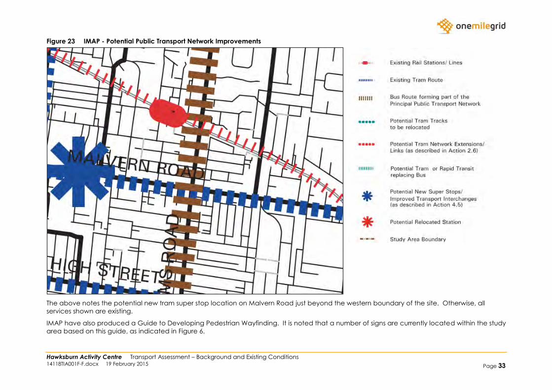
Figure 23 IMAP - Potential Public Transport Network Improvements
The above notes the potential new tram super stop location on Malvern Road just beyond the western boundary of the site. Otherwise, all
services shown are existing.
IMAP have also produced a Guide to Developing Pedestrian Wayfinding. It is noted that a number of signs are currently located within the study
area based on this guide, as indicated in Figure 6.
Hawksburn Activity Centre Transport Assessment – Background and Existing Conditions 14118TIA001F-F.docx 19 February 2015 Page 34
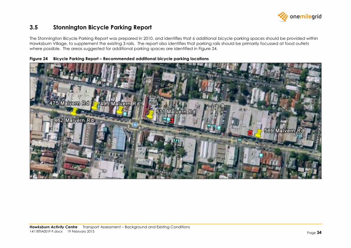
3.5 Stonnington Bicycle Parking Report
The Stonnington Bicycle Parking Report was prepared in 2010, and identifies that 6 additional bicycle parking spaces should be provided within
Hawksburn Village, to supplement the existing 3 rails. The report also identifies that parking rails should be primarily focussed at food outlets
where possible. The areas suggested for additional parking spaces are identified in Figure 24.
Figure 24 Bicycle Parking Report – Recommended additional bicycle parking locations