supplementary environmental information - scottish … · supplementary environmental information...
TRANSCRIPT

Supplementary EnvironmentalInformation
Llandinam Windfarm Repowering and Extension
April 2013
Non-Technical Summary

Non-Technical Summary
April 2013 Llandinam Windfarm Repowering and Extension Non-Technical Summary 2013
Page 1
Preface
1. This document comprises a Non-Technical Summary of the original Environmental Statement (ES) (hereafter referred to as the ‘original ES’) and two Supplementary Environmental Information (SEI) reports, one in 2011 (hereafter referred to as the ‘2011 SEI’) and another in 2013 (hereafter referred to as the ‘2013 SEI’). These documents have been prepared in support of a S36 application for the proposed repowering and extension of the Penrhyddlan & Llidiartywaun windfarm in Powys, mid Wales (hereafter referred to as “Llandinam Windfarm” or “the Development”).
2. The original ES, submitted in support of the Section 36 application in May 2008, consisted of the following documents:
• Volume I, the principal ES document;
• Volume II, containing the Landscape and Visual assessment figures;
• Volume III, containing a series of Technical Appendices to supplement the content of the ES; and
• A Non-Technical Summary (which is superseded and replaced by this document).
3. In addition to the above, the original ES was accompanied by a Design & Access Statement
and a Planning Appraisal.
4. Following receipt of comments from the Department for Energy and Climate Change (DECC), Powys County Council (PCC), and other interested parties in regards to the original ES, further information was gathered on the existing environmental conditions at the application site and the design layout amended to further reduce its impact on the environment.
5. The 2011 SEI presented the findings of these additional surveys and an assessment of the revised proposals and comprised:
• Volume I, the principal SEI document;
• Volume II, providing a series of Technical Appendices, to supplement the content the principal SEI document;
• Volume III, the Landscape and Visual assessment figures (revised in light of the changes to the design layout); and
• A Non-Technical Summary document (which is superseded and replaced by this document).
In addition to the above, a revised and updated Planning Appraisal was presented, which superseded the Planning Appraisal submitted as part of the application in May 2008.

Non-Technical Summary
April 2013 Llandinam Windfarm Repowering and Extension Non-Technical Summary 2013
Page 2
6. The 2013 SEI presents the findings of an assessment of further changes made to the Development in response to stakeholder comments and in advance of a Public Inquiry to commence in June 2013. It should be read in conjunction with the original ES and the 2011 SEI.
7. The 2013 SEI comprises the following documents:
• Volume I, the principal SEI document;
• Volume II parts 1 and 2, providing a series of Technical Appendices, to supplement the content the principal SEI document;
• Volume III, parts 1 and 2, including the Landscape and Visual assessment figures (revised in light of the changes to the design layout); which supersedes the original ES and the 2011 SEI;
• A Non-Technical Summary (this document) which supersedes the NTSs submitted alongside the original ES and the 2011 SEI
8. Further copies of all these reports may be obtained from:
CeltPower Ltd C/o ScottishPower Renewables Cathcart Business Park Spean Street Glasgow G44 4BE Tel: +44(141) 614 0449
9. This Non-Technical Summary is available free of charge upon request. Printed copies of the original ES and 2011 SEI can be supplied at a cost of £350 and the 2013 SEI at a cost of £350. In addition all documents are available (as PDF files for screen viewing only) on CD/DVD for £20.
10. Members of the public can view the 2013 SEI at the following locations from the date of this notice during normal office hours:
Customer Service Point, Powys County Council, Back Lane, Newton, Powys, SY16 2NZ 0845 055 2155 [Mon – Thurs: 09.00 – 7.00 Fri: 09.00 – 16.30]
Customer Service Point, Powys County Council, The Gwalia, Llandrindod Wells, Powys, LD1 6AA 01597 827342 [Mon – Thurs: 09.00 – 7.00 Fri: 09.00 – 16.30]
Customer Service Point, Powys County Council, Neuadd Maldwyn, Severn Road, Welshpool, Powys, SY21 7AS 0845 602 7032 [Mon – Thurs: 08.30 – 17.00 Fri: 08.30 – 16.30]
Customer Service Point, Powys County Council, Mount Street, Llandidloes, Powys, SY18 6EY 01686 412855 [Mon: 10.00 – 14.00, Tues: 16.30 – 19.00, Wed: 10.00 – 17.00, Thurs: 16.30 – 19.00, Fri: 10.00 – 17.00, Sat: 10.00 – 14.00]

Non-Technical Summary
April 2013 Llandinam Windfarm Repowering and Extension Non-Technical Summary 2013
Page 3
1.0 Introduction 1.1 Background 1. The original ES, the 2011 SEI, the 2013 SEI and this Non-Technical Summary accompany
an application to the Department of Energy and Climate Change (DECC) for consent under Section 36 of the Electricity Act 1989 (Ref. NTS-1) to generate electricity from the repowering and extension of Llandinam windfarm, and an application for deemed planning permission for the same operation under Schedule 2(3) of the Town and Country Planning Act 1990 (Ref. NTS-2).
2. The Section 36 application was originally submitted in May 2008 on behalf of CeltPower Limited, which is a partnership between ScottishPower Renewables (UK) Limited and Eurus Energy UK Limited. The application remains undetermined.
3. The effect of the decommissioning and subsequent repowering and extension of the existing Llandinam windfarm on the receiving environment was studied systematically through the EIA process, the results of which were presented within the original ES in May 2008.
4. The 2011 SEI was prepared to present the findings of additional survey information undertaken since May 2008 and an assessment of the changes made to the plans for the Development in response to stakeholder comments.
5. The 2013 SEI was prepared to present the findings of an assessment of further changes made to the Development in response to further stakeholder comments since the 2011 SEI, and in advance of a Public Inquiry to commence in June 2013.
6. This Non-Technical Summary provides a concise overview of the information presented in the original ES, 2011 SEI and 2013 SEI.
1.2 Overview of the Development 1. The Development is located approximately 7 kilometres (km) east of Llanidloes and 12 km
southwest of Newtown, approximately 12 km from the Wales / England border in an area of the Rhyddhwell hills characterised by an extensive upland plateau 500 metres (m) above ordnance datum (AOD). Figure NTS-1 shows the Development Site in the context of the surrounding area, including the local road network and local settlements.
2. The Development Site comprises an area of approximately 1,307 hectares (ha) and is roughly 6.5 km in length and of varying width, up to 3 km at the widest point, including the area of the existing Llandinam windfarm and extending it approximately 1 km to the north, northwest and northeast, whilst generally maintaining the southern boundary of the existing windfarm. It also includes the land either side of the site access road to the windfarm from the A483, for improvements and upgrades to this road. The site is privately owned by a number of landowners and predominantly constitutes open grazing land, with some small patches of woodland on the eastern periphery, and blanket peat in the central area.
3. The Development comprises 34 wind turbines (reduced from 42 in the original ES and 39 in the 2011 SEI) with total installed capacity of up to 102 MW.

Non-Technical Summary
April 2013 Llandinam Windfarm Repowering and Extension Non-Technical Summary 2013
Page 4
2.0 EIA Process and Scoping 1. The Development is classified as “EIA development” under the Electricity Works
(Environmental Impact Assessment) (England and Wales) (EIA Regulations) (Ref. NTS-3), since it is a power generating station with a capacity of more than 50 MW and is located in a sensitive area and/or considered likely to have significant environmental effects (if not properly mitigated).
2. The content of the original ES, 2011 SEI and 2013 SEI have been led by extensive consultation with stakeholders, dating back to 2006.
3. CeltPower Limited initially sought a “scoping opinion” from the Department of Trade and Industry (now DECC) requesting that it state, in writing, its opinion as to the content of the original ES. This was received on the 8th June 2006, and the original ES was prepared on the basis of the information contained within this response.
4. Other consultees have included the relevant local authorities (Powys County Council, as well as Radnorshire and Montgomeryshire District Councils), Countryside Council for Wales (CCW), Welsh Government, Royal Society for the Protection of Birds (RSPB), local community councils, and many others.
5. Public exhibitions were held in Newtown, Dolfor, and Llandinam on three consecutive days in December 2007. Members of the public were invited to view the proposals as they were at that time. Comments received from these exhibitions were taken into consideration in the Development layout design and in the production of the original ES. A further round of public consultations was undertaken following the submission of the Section 36 Application in May and June 2008.
6. Based upon the scoping opinion and consultation responses, the following key environmental aspects were assessed as part of the original ES and both the 2011 and 2013 SEI reports:
• Landscape and Visual;
• Ornithology;
• Ecology;
• Traffic and Transport;
• Archaeology and Cultural Heritage;
• Noise;
• Geology, Hydrogeology and Hydrology;
• Land Use, Recreation and Socio Economics; and
• Other issues including Climate, Air Quality, Telecommunications and Television, Telecommunications and Aviation, and Ice Throw.
7. These aspects are reported in greater detail in Sections 6 – 14 of this 2013 NTS document.

Non-Technical Summary
April 2013 Llandinam Windfarm Repowering and Extension Non-Technical Summary 2013
Page 5
8. The key stakeholders were all consulted on the contents of the original ES after its submission alongside the planning application in May 2008. These consultee comments have been taken into account when amending the Development, which are discussed further in sections 3 and 4 of this 2013 NTS document.
9. Also updated is the assessment of potential cumulative effects as a result of more recent windfarm and other developments, specifically mid Wales grid connections, which have come forward with sufficient detail available in the public domain.
3.0 Site Selection and Design Evolution 1. The existing Penrhyddlan & Llidiartywaun windfarm has been operating on this site since
1992 – over 20 years.
2. There are three principal benefits to the repowering and development of an existing windfarm site:
• Information from construction and operation of the existing windfarm was available to inform decisions relating to the design of the Development;
• A certain amount of site infrastructure (including a significant amount of on site tracks) can be retained for use, thus minimising the amount of new infrastructure required; and
• The existing windfarm is an established landscape feature. The existence of this in the present baseline is particularly relevant in terms of the potential visual impact and influence of the Development, as the Development will effectively replace an existing windfarm. Regardless, the layout has still carefully considered the integration of a fewer number of larger turbines into the landscape.
3. In particular, eight turbines in the northwest of the site were removed from the iteration of the Development presented in the original ES; turbines T22, T23 and T24 (and associated infrastructure) were removed as part of the 2011 SEI, followed by turbines T19, T20, T21, T25 and T26 for the 2013 SEI. Although this represents a reduction in the energy generating capacity of the Development, it is a direct response to comments from PCC and CCW to reduce the level of visual impact on receptors to the north of the Site. In particular the Council’s landscape and visual consultants (Capita Symonds) noted that the layout in the original ES caused an unacceptable impact on the rim of low hills and ridges, including the Waun Ddubarthog ridge to the north of the site. The Clwyd-Powys Archaeological Trust (CPAT) also recommended the removal of the most prominent turbines in the north of the Site due to the predicted impact these turbines had on the Caersws Basin Historical Landscape, and their removal also addresses a number of comments raised by members of the public.
4. The removal of the turbines has significantly reduced the indirect effect on all high value sites found between the 3 km to 10 km band, especially those located in the northern regions. The removal of these same turbines has also significantly decreased the indirect impacts on the conservation areas of the towns of Llandinam and Llanidloes, to a level where the visibility of turbines would be minor, or virtually negligible given screening from treecover and the urban environment.
5. In addition 12 wind turbines presented in the original ES were relocated in the 2011 SEI (T3, T4, T7, T8, T13, T14, T18, T25, T30, T36, 40, and 41), with no further changes, other than removal of turbines, made to turbine locations in the 2013 SEI. These amendments

Non-Technical Summary
April 2013 Llandinam Windfarm Repowering and Extension Non-Technical Summary 2013
Page 6
included: avoiding areas of slightly deeper peat and valley mire habitat, utilising more of the existing tracks, taking account of comments from CPAT and Cadw on certain turbines indirectly affecting the Pewgwyn Mawr Collection of scheduled prehistoric monuments, and moving further turbines following re-consultation with MLL Telecom to address effects on their communication links not raised during earlier consultations.
6. The 2011 SEI moved the location of the electrical substation approximately 35 m north of its position in the original ES, bringing it closer to the existing control building and to locate it at the field boundary (and downsizing of the substation), the relocation of the two permanent meteorological masts to take account of the proposed changes to the wind turbines mentioned above, and a revision to the access track layout. No changes have been made to the substation as part of the 2013 SEI.
7. Changes as a result of turbine removal and rationalisation of track design resulted in a reduction in the required construction of new track from 19 km in the original ES, to 11.6 km in the 2011 SEI, and to 9.8 km (including turning areas) in the 2013 SEI. This reduction of 9.2 km of track minimises the impacts on ecological and hydrological receptors such as deep peat and valley mire habitat.
8. The 2013 SEI makes changes to a section of the abnormal load route. On the A470 at Talgarth, the route will now continue on the A470 northwards to Builth Wells, then take the A483 northwards to Crossgates. This avoids the village of Eardisley and reduces impacts on the highway network. The new route through Builth Wells will require the installation of a temporary bailey bridge crossing the River Wye. There would also be minor changes to the land take at and along the access to the Site from the A483 to provide opportunities for further passing places.

Non-Technical Summary
April 2013 Llandinam Windfarm Repowering and Extension Non-Technical Summary 2013
Page 7
4.0 Project Description 1. The design layout for the Development is presented in Figure NTS-2 and comprises the
following main components: • Dismantling of the existing site (decommissioning)
- Dismantling and removal of the existing 102 wind turbines and associated infrastructure;
- Upgrading of a number of the existing hardstandings and the existing tracks to allow for crane access during dismantling;
• Repowering and Extension
- Erection of 34 proposed wind turbines - Crane hardstanding areas ; - Upgrading and construction of on-site access tracks, turning areas, and
associated watercourse crossings and drainage works; - Upgrading of the site access from the A483 road; - Construction of an on-site substation; - Installation of two Permanent Power Performance Assessment (PPA)
meteorological masts; and - Installation of on-site underground cabling.
2. In addition to the above infrastructure components, construction will involve:
• Three temporary construction compound and laydown areas;
• Temporary Power Performance Assessment (PPA) meteorological masts; and
• Eight ‘Borrow Pits’, from which stone can be used for the creation of onsite access tracks etc.
3. The project will comprise of four phases within its lifecycle, including:
• Dismantling and removal of the existing turbines;
• Site preparation and construction of the repowering and extension proposal;
• Operation; and
• Decommissioning of the repowering and extension project at the end of its planned 25-year operational life.
4. The decommissioning of the existing windfarm and construction will be phased so that at different parts of the site, civil engineering work will be continuing on for example the creation of access tracks, while turbines are being erected at a different location. Decommissioning/construction will require a 25-month period, and for the purposes of the environmental assessment it has been assumed site mobilization will begin at the end of 2015, and construction in 2016.
5. The permanent land-take for Development infrastructure is approximately 28.9 ha, 2.2% of
the total site area of approximately 1,307 ha. This excludes temporary construction

Non-Technical Summary
April 2013 Llandinam Windfarm Repowering and Extension Non-Technical Summary 2013
Page 8
elements (the laydown areas or the contractor compound) which will be restored following construction, and minor works along the access road from the A483.
6. The Development will comprise 34 three-bladed horizontal axis wind turbines with a height
envelope of up to 122 m to blade tip, and a total installed capacity of up to 102MW. A range of turbines is commercially available; the final choice of turbine will be based upon attaining maximum wind yield from the Development whilst adhering to the technical and environmental constraints posed by the site. The “candidate” turbine, on which assessments have been based, is the Siemens SWT-2.3-82 with a hub height of 80 m and rotor diameter of 82.4 m, thus giving a total height to blade tip of 121.2 m (compared with 45.5 m for the existing turbines). Other turbines of similar physical size with outputs of up to 3 MW are available.
7. Following feedback from the landscape and visual and cultural heritage assessments, three
of these turbines (T29, T30 and T42), on the western side of the site, will have a reduced hub height of 70m (giving an overall tip height of 111.2 m) to minimise visual impacts from the northwest of the site.
8. The Development will require site tracks to be constructed. Where possible, existing tracks
will be upgraded and used for the Development, however an additional 9.8 km of new tracks (including turning areas) will also be required, with associated watercourse crossings (largely via culverts); this is a reduction from the 19 km of new track proposed in the original ES. The existing tracks are constructed from graded stone and the proposed additional tracks will be of similar construction.
9. The application covers a 25-year period of operation, at the end of which a 12 to 18 month
period will be required for decommissioning and site restoration of the site.
5.0 Planning Policy Context 1. The Development Site lies within the Powys Unitary Authority. The Development Plans for
these areas contain specific policies relating to windfarm development, as outlined below. 2. The Powys Unitary Development Plan (UDP) (Ref. NTS-4) was adopted in March 2010 and
extensively covers wind power developments. Policy E3 encourages support for wind energy developments, as long as they are not deemed to “unacceptably adversely affect the environmental and landscape quality of Powys, either on an individual basis or in combination with other proposed or existing developments. Where the cumulative impact of proposals in combination with other approved or existing windfarms would be significantly detrimental to overall environmental quality they will be refused”. Further support is attributed to wind power developments under policy E4, which seeks to emphasise the advantages that wind farms hold over most other electricity generation technologies in that it is very easy to decommission wind turbines and fully re-instate sites.
3. Since the submission of the original ES application for the Development in May 2008,
national guidance in Wales has been updated. This takes the form of Planning Policy Wales (Edition 4) published in February 2011 (PPW4). The changes to these sections are that they establish markedly different targets to those established in previous versions of PPW for renewable energy. The revised targets accurately reflect those set out in the Energy Policy Statement of March 2010 (EPS) (Ref. NTS-5) which itself takes into account the UK Renewable Energy Strategy (2009) (Ref. NTS-6) and the EU Renewable Energy Directive (2009) (Ref. NTS-7).

Non-Technical Summary
April 2013 Llandinam Windfarm Repowering and Extension Non-Technical Summary 2013
Page 9
4. Since the submission of the 2011 SEI, national guidance in Wales has been updated. This
takes the form of Planning Policy Wales (Edition 5) published in November 2012 (PPW5). The changes translate the commitment of the Welsh Government to sustainable development into the planning system. Powys County Council also published its Preferred Strategy for the Powys Local Development Plan (LDP); however it currently contains no policies on renewable energy. The LDP is not due to be adopted until December 2014.
5. The Development Site lies almost entirely within Strategic Search Area (SSA) C (Newtown
South), as extended by Powys County Council in line with guidance in Annex D of the Welsh Government Technical Advice Note (TAN) 8. TAN 8 also provides support for proposals to re-power existing projects, whether they are within SSAs or not, provided that the environmental and landscape impacts are acceptable.
6. The Planning Act 2008 introduced the requirement to prepare National Policy Statements
(NPSs) for Energy to speed up the process of determining proposals for energy infrastructure, including proposals for electricity generation larger than 50 MW (onshore). The NPSs of specific relevance to the Development are NPS EN-1 (the Overarching Statement) (Ref. NTS-8) and NPS EN-3 (Renewable Energy Infrastructure) (Ref. NTS-9) which were formally adopted in July 2011. Whilst the application for consent for the Development was made under Section 36 of the Electricity Act, the Development will be determined by the Energy Minister within the DECC and, as such, these documents are still an important consideration for the Development.
6.0 Landscape and Visual 9. The landscape and visual impact assessment covers a study area that includes the
Development Site as well as the entire area within a 30 km radius of the outermost turbines.
10. A large portion of the 30 km study area comprises an undulating plateau landscape, generally rising to a height of around 500 m AOD. On the western edge of the study area lies Plynlimon, rising to a height of 752 m AOD, with the glaciated mountain terrain of Snowdonia to the northwestern edge.
11. Steep valleys intersect the broad plateau, principally draining into the River Severn and River Wye to the north and south of the application site respectively.
12. The assessment within the study area covers an array of landscape designations including Snowdonia National Park, the Shropshire Hills Area of Outstanding Natural Beauty (AONB), Historic Parks and Gardens as well as numerous national and regional cycleways, footpaths and bridleways. By reference to the CCW’s LANDMAP survey, a total of 22 generic Landscape Character Types (LCT) have been identified within the study area, along with 2 Regional Character Areas (RCAs) and 45 Landscape Character Areas (LCAs).
13. There are a number of sensitive visual receptors such as settlements, travel routes and miscellaneous recreational attractions that are considered in this assessment as the views from them may be affected by the Development. The significance of effects on the landscape and visual resource has been assessed through consideration of the sensitivity of the landscape or visual receptor, and the magnitude of change resulting from the Development. Sensitivity is an expression of the ability of a landscape or view to accommodate the type of development proposed. The magnitude of change expresses the scale of change on a landscape or view that will result from the Development.

Non-Technical Summary
April 2013 Llandinam Windfarm Repowering and Extension Non-Technical Summary 2013
Page 10
14. The existing landscape and visual context of the study area includes the exiting turbines at the Llandinam windfarm, as well as several other windfarms in the area. An updated assessment is provided of potential cumulative effects as a result of more recent windfarm and other developments, specifically mid Wales grid connections, which have come forward.
15. In order to minimise landscape and visual impacts, detailed consideration has been given at the conceptual design stage to ensure that the turbine layout relates to the plateau landscape and forms a coherent grouping when viewed from the surrounding landscape. In addition, the design layout of the Development has taken into account stakeholder comments on the original ES and 2011 SEI and amended the design, principally through removal of a total of 8 turbines (compared with the layout in the original ES) all located in the north and northwest extent of the proposed windfarm layout. The effect of which is to minimise the impact on the rim of low hills and ridges, including the Waun Ddubarthog ridge and the Caersws Basin Historical Landscape to the north of the Site, as well as associated sites such as Plas Dinam house and garden.
16. As a proposed mitigation measure incorporated in the layout development phase of the original ES, three of the 34 proposed turbines have been designed with 10 m reduction in hub height, to 70 m, giving an overall maximum height to blade tip of 111.2 m
17. The assessment indicates that significant landscape and visual effects are predicted to occur at 4 of the 26 viewpoints selected for the assessment as a result of the Development, as follows:
• Pant-y-dwr, 7 km southwest of the Development;
• Grach, 2 km south of the Development;
• ‘Riverside Café’ alongside the A470, 3.5 km west of the Development; (not sig) and
• Caersws, 5.5 km north of the Development. (sig vis,not landscape)
18. At Viewpoint 13, Grach, the slight movement to one of the turbines (T41) results in an additional blade tip being visible from this footpath on Glyndwr’s Way. This results in a moderate magnitude of change of major/moderate effect for high sensitivity walkers on this footpath, representing a change to the effect assessed in the original ES. The effect would be less apparent on the lower part of the hill, increasing with ascent up the path.
19. No significant effects are predicted upon the Snowdonia National Park or the Shropshire Hills AONB due to the Development. However, there are predicted to be significant effects upon the access land spanning the Development Site itself, as well as that on the north face of Garreg Llwyd, 5 km northwest of Rhayader.
20. An assessment has also been made of the potential impacts upon landscape fabric associated with works required to accommodate larger abnormally loaded vehicles to the application site and trunk road during the construction phase, this has been updated in the current 2013 SEI. The works would comprise removal of some roadside vegetation at a limited number of locations along the access route on the minor roads between the A483 and the site; and three laybys on the A438 between Glasbury and Llandrindod Wells along the trunk road network.
21. At a small number of locations, shrubs and some trees would be removed. Most of this vegetation consists of shrubs and sections of gappy and poorly maintained hedgerow. However in a small number of locations, replacement planting may be required, and where

Non-Technical Summary
April 2013 Llandinam Windfarm Repowering and Extension Non-Technical Summary 2013
Page 11
possible the removed sections of hedgerow / trees would be replaced using similar plant species. For example at one point there will be a group of 10-15 trees that needs to be removed. With regards to construction of the laybys, loss of significant vegetation would also be limited, as in the most part this would involve removal of the existing roadside verge ground cover. Overall, the accommodation works on the access route would not give rise to any significant effects on landscape fabric and would have limited effects on the wider landscape character and related visual amenity of the study area due to the localised and small scale of the vegetation removal.
22. The 2013 SEI includes provision for a temporary river crossing near Builth Wells., however the location of this is not finalised. A high level assessment has shown that there is a potential for significant, although temporary, effects on landscape character and visual amenity. The bridge will be temporary however and is expected to be present for approximately 12 months during construction.
23. The assessment of cumulative effects indicates that there will be significant cumulative effects (upon both landscape character area and visual amenity) associated with the interaction between the Development and other operational, consented or proposed windfarms. Of the 26 viewpoints assessed, a total of 8 are predicted to incur significant effects on landscape character, and 13 on visual amenity. Effects at the remaining viewpoints that were assessed are therefore not considered to be significant.
24. Although the proposed turbines will give rise to significant effects on landscape and visual amenity, they will be seen from a very similar area to that from where the existing windfarm is currently viewed.
7.0 Ornithology 1. The Development Site supports an assemblage of birds typical of unimproved acidic
grassland, mire, and heathland habitats in Wales. Two species of high Nature Conservation Importance forage within the Site and breed in surrounding area: red kite and peregrine. Other species of high importance use the area for foraging only, e.g. hen harrier, goshawk, merlin, and golden plover. Species of moderate importance that are present include kestrel, a modest population of skylark and small numbers of curlew and song thrush. The Development does not appear to be located on a regularly used migration route or corridor used for local movements by wildfowl or waders.
2. The significance of the potential effects of the Development on birds was determined by integrating scales of Nature Conservation Importance and effects magnitude in a reasoned way. In making judgements on significance, consideration was given to the status of, and trends within, national and regional populations.
3. Additional survey work was undertaken in the summer of 2008, and this formed a part of the 2011 SEI. These additional surveys served to supplement the information that was gathered and included as part of the original assessment (reported in the original ES), and covered additional areas in response to consultee comments received on the contents of the original ES. The effect of accommodation works needed along the abnormal load vehicle route was also considered and found not to have any discernible adverse effects on bird populations, given that the scale of loss will be undetectable in the context of the size of the habitats occupied by local bird populations.
4. The ornithological assessment for the 2013 SEI has used the same 2008 data used in the 2011 SEI. The baseline data is still valid, as the Development and its environs are

Non-Technical Summary
April 2013 Llandinam Windfarm Repowering and Extension Non-Technical Summary 2013
Page 12
unremarkable for their ornithological interest, and no major changes in land management since the baselines surveys are known. In addition, a decline in the breeding curlew population over several decades, and a probable declined in kestrel numbers since 2008 is likely to over-estimate populations of these birds.
5. Measures to ensure non-significant effects on breeding attempts by red kite and peregrine were incorporated into the project design. These involved creating exclusion zones around nest sites known to be used by these species in order to reduce the risk of disturbance and collision. A Breeding Bird Protection Plan (BBPP) was prepared as part of the 2011 SEI, outlining key objectives which CeltPower Limited will adopt in order to protect breeding birds during the construction phase of the Development. The 2013 SEI has revised and extended the BBPP to include curlew; this is in recognition of CCW’s concern over possible disturbance of breeding curlew during decommissioning and construction phases of the Development. Embedded mitigation, through the BBPP will ensure that breeding curlew will not be adversely affected by the Development through disturbance creating potential adverse displacement effects during decommissioning of existing turbines, construction of the proposed turbines, and decommissioning of the proposed turbines. No requirement for the mitigation proposed by CCW for breeding curlew during operation has been identified as there is no evidence that breeding curlew are displaced during operation
6. Disturbance of birds and their habitats during decommissioning of the existing windfarm, construction, and decommissioning of the Development is predicted to have negligible or low magnitude short-term adverse effects on existing bird populations. Any disturbance of birds due to the operation of the Development, and any risk of collision with rotating rotor blades, are predicted to have negligible or low magnitude long-term adverse effects on existing bird populations.
7. The reduction in turbine numbers should be viewed as embedded mitigation, and as such will likely result in even fewer red kites and kestrels being killed by collision with rotating turbine blades by the Development. The beneficial effects of reduced land take in the latest design iteration will not have any material influence on bird populations due to the relatively small loss of habitat through land take
8. Furthermore, the cumulative effects of the Development and other existing and planned developments in the area are judged unlikely to have a significant effect on existing bird populations.
9. Overall, it is concluded that the decommissioning of the existing windfarm and subsequent construction and operation of the Development would not have a significant effect on birds. This applies to both onsite and off site effects, including those associated with the construction traffic movements along the trunk roads and site access roads.
8.0 Ecology 1. The potential significant effects of the Development on habitats and terrestrial and aquatic
populations was determined based on scales of Nature Conservation Importance and effects magnitude, using commonly adopted methods.
2. The main habitat type on the site is acid grassland, classified by type as a split between ‘unimproved’, and ‘poor semi-improved’ varieties, together accounting for over 40% of the entire study area, which included additional land to the south and southeast of the Development Site. There is a significant amount of valley mire and bog habitat, and

Non-Technical Summary
April 2013 Llandinam Windfarm Repowering and Extension Non-Technical Summary 2013
Page 13
development within these areas has deliberately avoided such areas where possible, both from a technical feasibility and ecological protection perspective.
3. Whilst the type of valley mire found in the study area is widespread in the uplands of mid Wales, it provides a functional value over and above its vegetation value. The effect on valley mire on the site due to the Development is anticipated to be major when assessing effects at a local scale, although taken as a whole, the residual effect on integrity of the habitats onsite is only considered to be a moderate effect, and therefore not significant (based on the significance criteria used for assessing ecology impacts outlined in the original ES). The 2013 SEI design change resulted in a reduction of five turbines and associated infrastructure effects on peatland habitats from the 2011 SEI. In addition, the 2013 SEI also details mitigation measures which will reduce impacts on valley mire and other peatland habitats further. Although the design changes are considered to result in a reduced effect than the layout presented in the 2011 SEI (and original ES), the significance of the residual impacts remains broadly the same to that presented in the 2011 SEI, as discussed below.
4. The ecological assessment undertaken as part of the original ES provided details of surveys which were undertaken for otter, water vole, bats, badger, brown hare, and great crested newts, in addition to more generic reptile and aquatic species surveys. Signs of otter and water vole presence and activity were recorded, and as such, stringent water protection measures will be enforced in order to protect otter, water vole, and fisheries, particularly during the decommissioning/construction phase. Following implementation of these measures, residual effects on these species are predicted to be of negligible to minor adverse significance, with no residual effects on great crested newts or water voles.
5. As part of the 2011 SEI submission, a Species Protection Plan and an outline Habitat Management Plan have both been prepared, detailing the protected species interests in the Development site and procedures by which species and habitats can be protected and enhanced during the construction and operational phases of the Development.
6. The 2011 SEI responded to comments on the original ES and undertook additional survey and assessment works for National Vegetation Classification (NVC), Valley Mire habitat, Bats, Great Crested Newts and White-clawed Crayfish.
7. The 2013 SEI has responded to new comments raised by consultees as well as design changes, most noticeably: providing further information on the baseline conditions of valley mire and other peatland habitats; providing further details on mitigation proposals to avoid effects on the River Wye Special Area of Conservation (SAC), which is located approximately 11 km south east of the Site; an updated Bat Technical Report; and Phase I habitat surveys for an abnormal loads crossing point as well as an update to the access track.
8. Despite the decommissioning of the existing windfarm and construction and operation of the Development having the potential to generate minor impacts on a number of the key fauna species under assessment, mitigation measures have been included to ensure that risks associated with intrusive site works and the operation of the site are minimised. For example, a licensed ecologist will be present on site during the decommissioning and construction period to ensure all site work is conducted with suitable consideration for local biodiversity.
9. The ecological impacts associated with the construction traffic movements to the application site (in particular abnormal load vehicles) have also been considered. A total of 1.5 ha of land take is estimated to be required along the access road between the A483 and windfarm

Non-Technical Summary
April 2013 Llandinam Windfarm Repowering and Extension Non-Technical Summary 2013
Page 14
(approximately 4 km in length), which predominantly comprises grass verge, gorse shrub and small sections of poorly maintained hedge. In addition, a few trees would have to be removed, including one tree with the potential to support bats. Appropriate mitigation measures (outlined in the 2013 SEI) will be put in place such that there will be no residual impact on protected species.
10. The works required offsite along the trunk road are likely to be limited to the cutting back of vegetation (e.g. over-hanging trees or tree lines/hedges that may need trimming back) and two areas where relatively small scale road widening will be needed. In general, the works required do not appear to be much beyond those that would be carried out through standard highway maintenance.
11. In addition to this road widening, there will also be three off-road holding points created along the trunk road route, comprising an area of less than 0.14 ha for each location. All three locations presently accommodate areas of grass verge, a few immature planted trees and sections of hedgerow. Although these locations also have the potential to support Dormice and breeding birds, appropriate mitigation measures have been outlined in the 2011 SEI in order to avoid any significant residual effects on these protected species.
12. The 2013 SEI reports the results of an Extended Phase I Survey which was undertaken in requirement to explore potential abnormal roads crossing points of the River Wye, the results of which are reported in Technical Appendix A8-3. It concludes that the site conditions have remained unchanged since surveys undertaken to inform the 2011 SEI.
13. Bats continue to utilise the Development Site despite the occurrence of a large operational windfarm. Their continued presence, over what constitutes sub-optimum habitat for this species, suggests that local populations have been sustained. The 2013 SEI concluded that the repowering and extension of the Development, utilizing larger but fewer turbines would not have a significant effect on the sustainment of local bat populations.
14. The cumulative effect of the Development in conjunction with other windfarms in the area has also been assessed. These applications will also each be subject to a full EIA, and as such ecological effects will be assessed during consideration of these applications. In terms of habitat loss and impacts on species, the Development will, in combination with other schemes, lead to an increase in the loss of habitats; however, even the combined habitat loss is unlikely to affect the integrity of the resource at a regional level or above. Consequently, it is anticipated that the potential cumulative effects will be of minor adverse significance.
15. The 2013 SEI reassesses the cumulative impact on valley mires and on the River Wye SAC. The impact on valley mires will represent a moderate adverse impact, which is not considered to be significant under the terms of the EIA Regulations. The cumulative impact on River Wye SAC is also assessed as being not significant.
16. Overall, it is concluded that the decommissioning of the existing windfarm, site preparation and construction, operation, and decommissioning phases of the Development would not give rise to any significant adverse effects, following the implementation of appropriate mitigation measures.

Non-Technical Summary
April 2013 Llandinam Windfarm Repowering and Extension Non-Technical Summary 2013
Page 15
9.0 Traffic, Access and Transport
1. Technical studies have been undertaken to identify potential access routes to the Site for the wind turbine components (e.g., tower sections, nacelle, blades, substation components), which will require the use of specialised heavy transport vehicles (abnormal loads), as well as Light/Heavy Goods Vehicles (LGVs/HGVs). Abnormal loads will not be required for dismantling the existing windfarm due the smaller size of the various turbine components; HGV’s will be used instead.
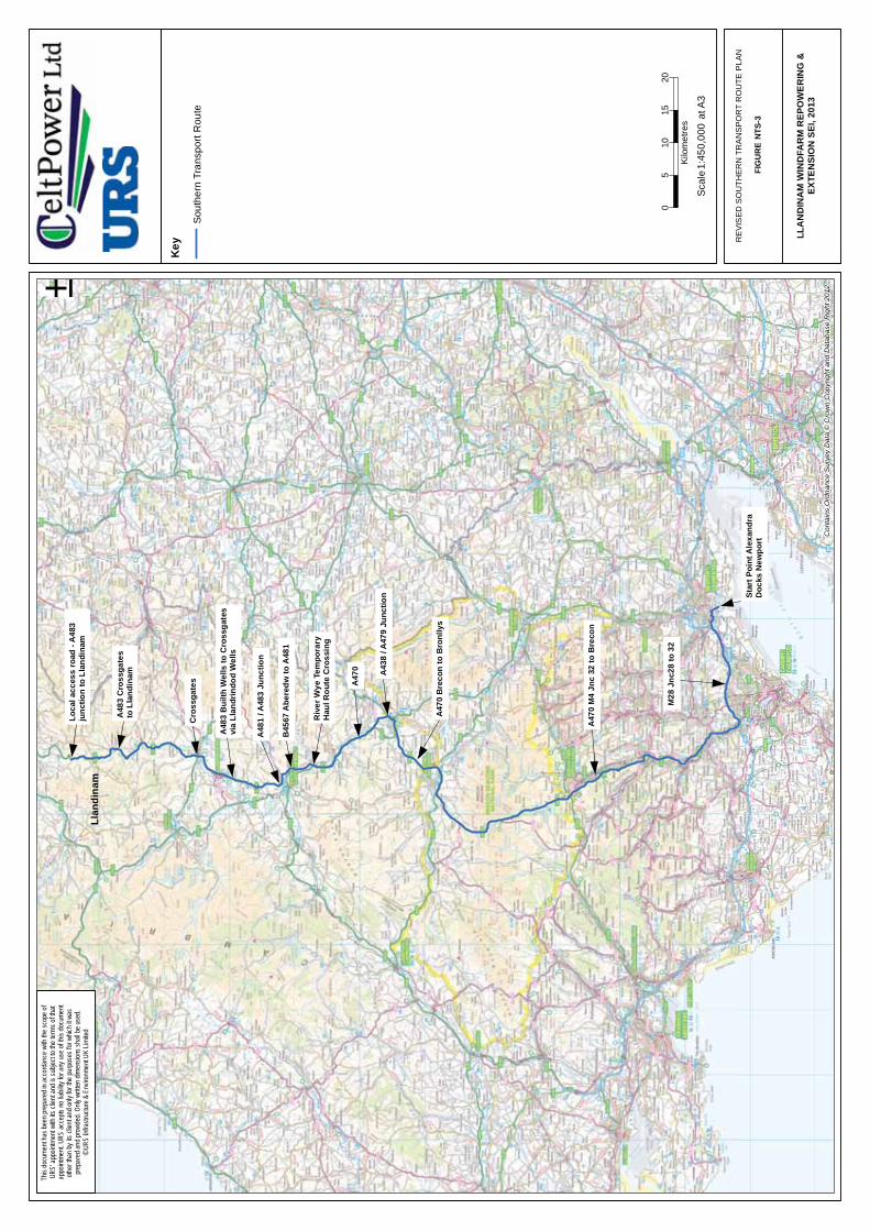
2. It is anticipated that the turbine towers, nacelles, blades and substation transformers will be delivered by sea to Newport Docks, South Wales, and from there transported north by road along a preferred route known as the ‘Revised Southern Transport Route‘ (revised in the 2013 SEI, and as illustrated in Figure NTS-3). The ‘Revised Southern Transport Route’ is both deliverable and avoids the constraints posed by the route via Eardisley.
3. A Draft Traffic Management Plan (TMP) was prepared for the Southern Transport Route as part of the 2011 SEI. This will be revised in advance of the Public Inquiry in June 2013. The Draft TMP demonstrates that the Revised Southern Transport Route can provide a viable, safe and efficient means of transport for all turbine components to the Development Site from Newport Docks, South Wales. In conjunction with a carriageway lowering scheme at the A483 railway over-bridge at Crossgates and a temporary new crossing of the River Wye South East of Builth Wells, minimal highway improvements and traffic management measures are required to allow the largest abnormal loads to use this route.
4. The potential effects of traffic from the Development relate to increasing vehicle volumes on roads in and around the surrounding communities, and the resulting impact to motorists, pedestrians and cyclists alike. Potential effects have been assessed against the criteria within the Institute of Environmental Management and Assessment’s (IEMA) “Guidelines for the Environmental Assessment of Road Traffic” (Ref. NTS-10).
5. The effects will be temporary in nature, arising only during the decommissioning/construction period. Where required, ‘worst-case’ scenario assumptions have been made, particularly with reference to specific months of intensive construction activity, which should lead to an overestimate of actual impacts.
6. Total traffic flow increases are not likely to exceed 2% at 17 of the 20 traffic count locations considered in the assessment, with the other 3 count locations (all along the A483 between Crossgates and Newtown) predicted to have a maximum increase of 3 – 6% during peak construction activity.
7. The Development is not considered to have the potential for significant impacts against any of the criteria under the terms of the industry-accepted guidance given the nature of the works associated with the Development and the temporary duration of these works.
8. As regards cumulative impact with other developments none of the other sites identified is likely to produce significant construction traffic at the same time as the Development. This is for a variety of reasons e.g. other sites require longer lead time to allow a grid connection to be made, require large areas of forestation to be cleared or are not so advanced in the planning process. For this reason it is considered very unlikely that these other sites will contribute traffic movements during the construction of the Development.
9. The additional traffic flows due to the Development are anticipated to lead to a temporary effect of minor significance, following production and implementation of the suggested

Non-Technical Summary
April 2013 Llandinam Windfarm Repowering and Extension Non-Technical Summary 2013
Page 16
Traffic Management Plan. The impact on the trunk road network in terms of percentage increases or actual vehicle flows will be negligible. The effects associated with levels of traffic anticipated during the operation and decommissioning phases of the Development are also considered to be of negligible significance.
10.0 Cultural Heritage 1. An assessment of the likely impacts on cultural heritage was undertaken through a desk
based archaeological investigation, supplemented by fieldwork and detailed analysis of the potential impacts.
2. The desk based assessment and field visit recorded a total of 82 archaeological data points within the Development Site. Of these, only six sites are high value status sites (Scheduled Ancient Monuments) and each is prehistoric in date including one Iron Age settlement. None of these high value sites are predicted to be impacted by the decommissioning of the existing windfarm or construction, operation, and decommissioning of the Development.
3. These high value features have been protected by incorporation into the constraints mapping process. As a result, all structures associated with the Development have been sited so as to minimise potential disturbance to these archaeological features. As a result no known archaeological sites of any value will be directly affected by the Development.
4. Because of the prehistoric nature of this upland landscape and the high potential for buried prehistoric features and deposits, an archaeological watching brief will be maintained by a suitably qualified archaeologist during all excavation works associated with decommissioning of the existing windfarm and the construction of the Development in the areas of Waun Lluest Owain and Waun Ddu barthog.
5. Important archaeological sites will also be fenced off so as to ensure that the sites are adequately protected to prevent any possibility of any unplanned access by machines and equipment during any phase of the project.
6. With regards to indirect impacts within the Development Site, consideration has been made to the siting of turbines not to compromise the inter-visible group setting between the three burial cairns of Pegwyn Mawr and Domen Ddu. Design alterations included in the 2011 SEI reduced the impact to minor adverse; the design changes as part of the 2013 SEI have not changed this conclusion.
7. The 2011 SEI saw adjustments in the design layout of the Development, in light of the comments received on the original ES. The removal of three turbines in the northwest of the Site reduced the potential impact upon the Caersws Basin Historical Landscape, whilst several others turbines were relocated to take into account the inter-visibility between local cairn groups. The 2013 SEI has reduced this impact further, through removal of a further five turbines in the northwest of the Site.
8. For features up to 10 km beyond the Development Site, the predicted indirect impacts are predominantly of minor significance due to the visibility of the Development, although an impact of moderate adverse significance is predicted from the indirect visual impact on Caersws Basin and Clywedog Valley Registered Historic Landscapes. These effects will be ‘long term’ and reversible in nature however, lasting for the lifetime of the Development.
9. As part of the Revised Southern Transport Route, the 2013 SEI makes proposals for the construction a new temporary bridge and haulage road across the River Wye. An

Non-Technical Summary
April 2013 Llandinam Windfarm Repowering and Extension Non-Technical Summary 2013
Page 17
Archaeological Desk-based Assessment was undertaken as to examine the potential effects of the proposal; land adjacent to the roadside farmsteads is most likely to be adversely impacted by the Development as it holds the most potential for previously unrecorded archaeology. A series of phased archaeological works and associated mitigation measures are proposed in the 2013 SEI which will be agreed with CPAT to minimise (or avoid) this impact.
10. Following implementation of the mitigation measures outlined in the original ES and SEI’s, no significant effects are predicted on any cultural heritage or archaeological sites associated with the Development. Mitigation measures have been set out to preserve sites in-situ, where practicable, and to offset the predicted direct effects through an appropriate watching brief strategy to be agreed with CPAT.
11. Overall, the impact of the Development on the cultural heritage resource is not anticipated to be significant in terms of the requirements of the EIA Regulations.
11.0 Noise and Vibration 1. A noise impact assessment has been undertaken assessing the noise contribution from the
decommissioning, construction, and operational phases of the Development. In the case of decommissioning and construction noise, relevant impact assessment criteria in the form of absolute limit values were derived from accepted environmental noise guidance. For the operational phase, noise limits were also set for neighbouring residential properties based on accepted guidance (this is known as the ETSU-R-97 guidance).
2. In response to consultation with PCC, the assessment has increased the number of representative dwellings in the Garn Forest area, from two in the original ES and 2011 SEI to four in the 2013 SEI. Besides this the assessment methodology and noise limits have remained the same during the preparation of these three documents.
3. The decommissioning and construction noise assessment has determined that noise emissions during these activities may be audible at various times throughout the decommissioning and construction programme, but will remain within the set limits. The operational noise assessment also demonstrated that the noise limits would be met at all of the neighbouring residential properties identified. In practice, the levels of noise and vibration associated with all phases of development will be lower compared to the original ES and 2011 SEI, due to the removal of a total of 8 turbines since the original ES in 2008.
4. The cumulative effect of noise emissions from other existing, consented, or proposed windfarms in the area (including the Llaithddu, Hirddywel and Neuadd Goch windfarms) was also considered, along with the Development, and it was shown that the derived operational noise limits would be met at nearby dwellings. The original ES was unable to provide an accurate assessment of the cumulative effects of the Development and Llaithddu windfarm proposal on the baseline conditions, due to an absence of data for these other schemes at the time. However this was rectified in the 2011 SEI, and it was able to consider this cumulative assessment. The 2011 SEI demonstrates that both the quiet day-time and night-time derived noise limits at the assessment locations can still be met at all properties across all wind speeds during operation of the Development. In addition to the developments considered in the 2011 SEI, the 2013 SEI assesses the cumulative impact of the Hirddywel and Neuadd Goch windfarms. For both of these there is expected to be a negligible contribution to cumulative effects at the residential assessment locations.
Non-Technical Summary
April 2013 Llandinam Windfarm Repowering and Extension Non-Technical Summary 2013
Page 18
5. Worst-case cumulative construction traffic on existing roads would correspond to a minor effect when assessed in line with standard methodologies and criteria. At some locations under some wind conditions and for a certain proportion of the time, the windfarm noise may be audible; however, it will still be at an acceptable level according to the applicable guidance. These conclusions remain applicable for the 2013 SEI.
12.0 Hydrology, Hydrogeology and Geology 1. The Development Site is located above glacial till, typically sandy gravelly clay with some
cobbles and boulders. Overlying the glacial soils, a variable thickness of peat is recorded to be present locally. The depth of peat at the site is shallow, noted to range from 0.10 m to 0.85 m in general and up to 1.40 m and 2.10 m locally. Updated peat probing indicates approximately 60% of samples show peat to be <50 cm in depth and that previous peat depths had been overestimated on the site. A quantity of alluvium may be present along some watercourses. The overall thickness of the superficial deposits is likely to be variable across the site with rock noted at surface at a number of locations.
2. The site is located within the catchments of the River Severn and the River Wye. A number of small mostly seasonal watercourses drain the site plateau, in the most part to the west and north towards the River Severn and also to the southeast towards the River Ithon, which leads to the River Wye.
3. The potential impacts associated with the Development that could occur without proper mitigation and management, are as follows:
• Reduced surface runoff to local areas, through alteration of drainage patterns;
• Increased surface runoff, increasing the potential for flooding, thereby increasing the risk of instability of peat deposits and causing damage to soils, vegetation and wildlife;
• Erosion, causing soil removal and deposition, riverbank and peat mobilisation, and damage to riparian habitats;
• Sedimentation of watercourses, which may alter the flood capacity, increase turbidity, and smother aquatic and riparian flora and fauna;
• Availability of groundwater for private drinking supplies may be adversely impacted; and
• Failure of peat deposits, due to construction related activities where local peat depths and topographic and hydrological conditions allow.
4. In order to avoid and minimise the above effects, a site-specific draft Environmental Management and Pollution Prevention Plan (EMPPP) was produced as part of the 2011 SEI and updated for the 2013 SEI, outlining measures by which to reduce the potential impact of the Development on the surrounding watercourses.
5. The 2013 SEI includes an assessment from a site inspection which confirmed that the good practice construction and operation procedures of the existing wind farm have resulted in minimal environmental harm.
6. A number of mitigation measures have been identified within the original ES and SEI’s, which will minimise any significant adverse effects outlined above. These have been updated in the 2013 SEI. Following the application of these mitigation measures, the

Non-Technical Summary
April 2013 Llandinam Windfarm Repowering and Extension Non-Technical Summary 2013
Page 19
residual effects are considered to be of negligible significance, corresponding with an insignificant effect on local geology, hydrology, and hydrogeology. In addition, there are not considered to be any significant cumulative effects when taking into account the other nearby developments.
13.0 Land Use, Recreation and Socio-Economics 1. Socio-economic impacts have been considered in the context of their overall impact on the
immediate surrounding area and the wider community in the context of policy guidance and baseline conditions.
2. The Development Site is in a relatively unpopulated area; as of 2006, Powys County was home to a combined population of just over 130,000 residents. While the site as it stands may provide some recreational benefits to the area, with a number of bridleways and footpaths across and in the vicinity of the Development Site, there are no organised activities on the Site itself.
3. The Development Site is not currently extensively used for tourism, although some local people and visitors use the footpaths and bridleways that traverse it. All turbines maintain minimum distances from public rights of way. Given that the Development is a proposed windfarm repowering and extension, it is considered that it will have little effect on tourism, many local people will be accustomed to having a windfarm in the vicinity, and the results of research undertaken into the impacts of windfarms on tourism suggest that there is no evidence that the presence of windfarms serve to deter tourists; some studies have found the opposite to be true. Effects on tourism and recreation were assessed as being of negligible significance.
4. The site has areas of open access land and common land within its boundary to which the public at present have access as of right for recreation. The applicant will seek to limit impact during the construction phase and once the repowered windfarm is operational the overall degree of public access at the site will be similar to that enjoyed at present as a minimum. Replacement land will be provided where any infrastructure sits on existing common land. The release of land from the common and its replacement will be the subject of a future application. The overall effects on public recreation are therefore likely to be negligible. Since common land is to be replaced, the impact on exercise by commoners of rights of common is likely to be negligible.
5. The Development is predicted to support up to 175 jobs during the decommissioning and construction phase. There will also be opportunities for local businesses to provide goods and services during the construction process (including, for example, aggregates for construction, plant hire and transportation of construction materials), and the Applicant will implement a programme of encouraging the involvement of local businesses in the procurement process. A 2013 Report ‘Economic Opportunities for Wales from Future Onshore Wind Development’ (Ref. NTS-11) produced by Rengeneris Consulting and Cardiff Business School sets out the potential ‘significant and steady stream of economic benefits’ accruing if Wales realises its onshore wind targets. This development would play and early and important role in contributing to that. There is the potential for a significant beneficial effect associated with the renewable energy contribution and employment generation of the Development in conjunction with other windfarm schemes considered as part of the cumulative impact assessment.
14.0 Other Issues
Non-Technical Summary
April 2013 Llandinam Windfarm Repowering and Extension Non-Technical Summary 2013
Page 20
1. Other issues relating to the design and operation of the windfarm raised during the scoping and consultation process have been addressed below.
14.1 Carbon Balance 1. The key advantage of generating energy from a renewable source is the reduction in
greenhouse gas emissions, namely carbon dioxide (CO2), associated with traditional, fossil fuel generated energy. The potential reduction in CO2 emissions due to avoiding the need to use fossil fuels as a result of operating the Development for 25 years, are estimated to be within the range 1.96 million tonnes CO2 and 5.25 million tonnes CO2. This net carbon saving is considered to be a substantial global long-term environmental benefit.
2. The “CO2 payback time”, which can be thought of as the period of windfarm operation required until there is a net saving of CO2, has been estimated to be between 0.3 years and 1.7 years. This is a substantially shorter time period than the 25-year operational period applied for.
14.2 Air Quality 1. The Development, when operating, will not generate any emissions to air and operational
traffic emissions will be negligible, so the operational Development will therefore not affect local air quality. Activities undertaken during site preparation and construction will include increased road traffic and disturbance to the soil and underlying rock, which have the potential to create temporary adverse effects. Taking into account the distance from the Site to residential properties, local air quality impacts of the Development construction traffic are considered to be negligible.
14.3 Telecommunications and Aviation 1. OFCOM were contacted to determine if any registered public mobile communications
network links might be affected by the Development. Consultations have been conducted with all the operators; T-mobile, Orange, cable & wireless, BT, CSS, JRC, MLL, Airwave MMO2 and Dyfed Powys Police, and it was concluded that none of these network links nor their buffer zones fell within or near the boundary of the Development Site. The Development layout in the 2011 and 2013 SEI has also taken account of consultation with MML Telecom.
2. The BBC windfarm assessment tool indicated that, while the signals from Llandinam transmitter may be affected at a small number of properties, the vast majority of these have access to an alternative service. By its nature, it is not possible to reliably predict the extent to which TV and radio reception problems will actually occur, and therefore appropriate mitigation measures will be provided where required, targeting those specific properties that are affected following the installation of the Development. Such measures may include re-alignment of aerials or provision of a satellite by which to receive a signal, and CeltPower Limited are committed to the provision of such mitigation measures where required.
3. Radars used by various civil and military aerodromes and by NERL (National Air Traffic Services En Route Plc) have the potential to ‘see’ wind turbines. Following assessment, and with no objections received from the MoD, the CAA, or NERL, no significant impact upon defence and civil aviation interests is anticipated.

Non-Technical Summary
April 2013 Llandinam Windfarm Repowering and Extension Non-Technical Summary 2013
Page 21
14.4 Ice Throw 1. The safety risk associated with ice throw from wind turbine blades has been assessed for
the Development based on the Garrad Hassan European Icing Map and guideline ice throw calculation methods. The potential for ice throw conditions is estimated to occur only 12 times per year in mid-Wales, and due to the remote nature of the Site, the only potential receptors of ice throw impacts are the pubic rights of way. An assessment of this risk indicates that, as a minimum, a distance of 84 metres between the footpath or bridleway and the nearest turbine, is required, although with appropriate warning signs, a 50-60m buffer would suffice.
2. All of the 34 turbines achieve a minimum separation distance of 121.2 m (the height from ground to blade tip) to the nearest footpath or bridleway, which is recommended by TAN 8 and is more than adequate with respect to the static ice-fall distance of 84 m. As a result of incorporating public rights of way/bridleways into the environmental constraints modelling process at an early stage, the threat of ice throw from the Development is not anticipated to be significant.
14.5 Shadow Flicker 1. Shadow flicker is the effect of light levels in a room quickly decreasing and increasing as the
shadow of a turbine blade falls across the window. DECC provides a general rule that shadow flicker will not be an issue if there is a separation of 10 rotor diameters or more between wind turbines and nearby dwellings (824 m for the candidate turbine for the Development). The revised layout has resulted in every turbine being located at a minimum distance of 10 rotor diameters from the nearest property. As such, the potential impact of shadow flicker resulting from the proposed Development is considered negligible, and not significant.
References
Ref. NTS-1 HMSO, 1989. “The Electricity Act 1989”.
Ref. NTS-2 HMSO, 1990. “Town and Country Planning Act 1990”.
Ref. NTS-3 HMSO, 2000. “Electricity Works (Environmental Impact Assessment) (England and Wales) Regulations 2000”.
Ref. NTS-4 Powys County Council, 2010 “Powys Unitary Development Plan, 2001 – 2016 Written Statement” March 2010
Ref. NTS-5 Welsh Assembly Government, 2010 “Energy Policy Statement” http://wales.gov.uk/docs/desh/policy/100331energystatementen.pdf
Ref. NTS-6 Department of Energy and Climate Change, 2009 “UK Renewable Energy Strategy (UKRES)”
Ref. NTS-7 European Union, 2009/28/EC Renewables Directive http://eur-lex.europa.eu/JOHtml.do?uri=OJ:L:2009:140:SOM:EN:HTML
Ref. NTS-8 Department of Energy and Climate Change, June 2011, Overarching National Policy Statement for Energy (EN-1)

Non-Technical Summary
April 2013 Llandinam Windfarm Repowering and Extension Non-Technical Summary 2013
Page 22
Ref. NTS-9 Department of Energy and Climate Change, June 2011, National Policy Statement for Renewable Energy Infrastructure (EN-3)
Ref. NTS-10 Institute of Environmental Management and Assessment. “Guidelines for the Environmental Assessment of Road Traffic – Guidance Notes No. 1”.2006
Ref. NTS-11 Rengeneris Consulting and Cardiff Business School “Economic Opportunities for Wales from Future Onshore Wind Development”. 2013

LLA
ND
INA
M W
IND
FAR
M R
EPO
WER
ING
&EX
TEN
SIO
N S
EI, 2
013

!
!!
!
!
!
!
!
!
!
!!!
!
!
!
!
!
!
!
!
!
!
!
!
!
!
!
!
!
!
!
!
!
# V
# V
Met
Mas
t 1
Met
Mas
t 2
BP-BBP
-C
BP-A
BP-D
BP-G
BP-H
T9
T8
T7
T6 T5
T4
T3 T2
T1
T42T4
1T40
T39
T38
T37
T36
T35
T34
T33
T32
T31
T30T29
T28
T27
T18
T17 T16
T15
T14
T13
T12
T11 T1
0
Key !
Prop
osed
Tur
bine
Loc
atio
n
# VPr
opos
ed M
eteo
rolo
gica
l Mas
t
New
Tra
ck R
equi
red
Exis
ting
Trac
k to
be
Util
ised
Turn
ing
Area
Borro
w P
its
Con
tract
or C
ompo
und
Layd
own
Are
a
Subs
tatio
n
Cra
ne H
ards
tand
ing
Are
as
Appl
icat
ion
Site
Bou
ndar
y
050
01,
000
1,50
025
0
Met
res
±
PR
OP
OS
ED
TU
RB
INE
LO
CAT
ION
S, M
ET
MA
ST
LOC
ATIO
NS
, BO
RR
OW
PIT
S, C
OM
PO
UN
D A
RE
AS
,CR
AN
EH
AR
D S
TAN
DIN
G A
RE
AS
AN
D A
CC
ES
S T
RA
CK
SFI
GU
RE
NTS
-2
LLA
ND
INA
M W
IND
FAR
M R
EPO
WER
ING
&EX
TEN
SIO
N S
EI, 2
013
This
docu
ment
has b
een p
repa
red i
n acc
orda
nce w
ith th
e sco
pe of
UR
S' ap
point
ment
with
its cl
ient a
nd is
subje
ct to
the te
rms o
f that
appo
intme
nt. U
RS ac
cepts
no lia
bility
for a
ny us
e of th
is do
cume
ntoth
er th
an by
its cl
ient a
nd on
ly for
the p
urpo
ses f
or w
hich i
t was
pr
epar
ed an
d pro
vided
. Only
writt
en di
mens
ions s
hall b
e use
d.©
URS
Infra
struc
ture &
Env
ironm
ent U
K Lim
ited
Rep
rodu
ced
from
Ord
nanc
e Su
rvey
dig
ital m
ap d
ata
© C
row
n co
pyrig
ht 2
013.
All
right
s re
serv
ed. L
icen
ce n
umbe
r 010
0031
673
Turb
ine
Cen
tre
Coo
rdin
ates
Turb
ine
IDEa
stin
gN
orth
ing
130
4785
2837
942
3044
8128
3439
330
4498
2839
294
3045
4828
4326
530
4423
2847
636
3043
8628
5159
730
4698
2855
428
3043
8528
3015
930
4133
2835
2310
3040
8728
3964
1130
4018
2844
8112
3040
2528
4798
1330
4015
2852
0914
3042
7428
5670
1530
4632
2859
2516
3036
6428
4023
1730
3631
2843
9718
3036
7528
4904
2730
3755
2835
4828
3027
2328
2965
2930
2389
2828
7730
3023
5428
2512
3130
2929
2822
5232
3030
5328
1850
3330
2929
2812
7734
3026
4428
0879
3530
2696
2815
1236
3024
9128
1086
3730
2671
2824
0838
3022
7228
2124
3930
2706
2818
8240
3022
8228
1665
4130
2182
2812
1042
3021
3228
0837
Met
eoro
logi
cal M
ast
130
3477
2854
662
3019
5728
0950
1:25
,000
at A
3Sc
ale
BP
-EB
P-E
BP
-FB
P-F
Star
t Poi
nt A
lexa
ndra
Doc
ks N
ewpo
rt
M28
Jnc
28 to
32
A47
0 M
4 Jn
c 32
to B
reco
n
A47
0 B
reco
n to
Bro
nlly
s
A43
8 / A
479
Junc
tion
A47
0
Riv
er W
ye T
empo
rary
Hau
l Rou
te C
ross
ing
A48
3 B
uilth
Wel
ls to
Cro
ssga
tes
via
Llan
drin
dod
Wel
ls
B45
67 A
bere
dw to
A48
1
Cro
ssga
tes
A48
1 / A
483
Junc
tion
A48
3 C
ross
gate
sto
Lla
ndin
am
Loca
l acc
ess
road
- A
483
junc
tion
to L
land
inam
Llan
dina
m
Key
Sout
hern
Tra
nspo
rt R
oute
05
1015
20
Kilo
met
res
±
RE
VIS
ED
SO
UTH
ER
N T
RA
NS
PO
RT
RO
UTE
PLA
N
FIG
UR
E N
TS-3
LLA
ND
INA
M W
IND
FAR
M R
EPO
WE
RIN
G &
EXTE
NSI
ON
SEI
, 201
3C
onta
ins
Ord
nanc
e S
urve
y D
ata
© C
row
n C
opyr
ight
and
Dat
abas
e R
ight
201
2
This
docu
ment
has b
een p
repa
red i
n acc
orda
nce w
ith th
e sco
pe of
UR
S' ap
point
ment
with
its cl
ient a
nd is
subje
ct to
the te
rms o
f that
appo
intme
nt. U
RS ac
cepts
no lia
bility
for a
ny us
e of th
is do
cume
ntoth
er th
an by
its cl
ient a
nd on
ly for
the p
urpo
ses f
or w
hich i
t was
pr
epar
ed an
d pro
vided
. Only
writt
en di
mens
ions s
hall b
e use
d.©
URS
Infra
struc
ture &
Env
ironm
ent U
K Lim
ited
1:45
0,00
0 a
t A3
Scal
e