submarine groundwater discharge - unescounesdoc.unesco.org/images/0013/001344/134436e.pdf ·...
TRANSCRIPT
Management implications,measurements and effects
Prepared forInternational Hydrological Program (IHP)
Intergovernmental Oceanographic Commission (IOC)
byScientific Committee on Oceanic Research (SCOR)
Land-Ocean Interactions in the Coastal Zone (LOICZ)
IHP-VI, SERIES ON GROUNDWATER NO. 5IOC MANUALS AND GUIDES NO. 44
Submarine groundwater
discharge
IHP
IAEA
The designations employed and the presentationof material throughout the publication do notimply the expression of any opinion whatsoeveron the part of UNESCO in particular concerningthe legal status of any country, territory, city orarea or of its authorities, or the delineation of itsfrontiers or boundaries.
Published and printed in 2004 by the United Nations Educational, Scientific and Cultural Organization7, place de Fontenoy, 75352 Paris 07 SP
Layout and typesetting by Marina Rubio, 93200 Saint-Denis
ISBN 92-9220-006-2
© UNESCO 2004
(SC-2004/WS/4)
P r e f a c e
It would not be surprising that as a coastal planner, manager, or decision maker, you may not beaware of the growing realization of the importance of submarine groundwater discharge (SGD).Even if you are aware, you may not know how to decide whether or not SGD is relevant to the particular coast for which you are responsible. Furthermore, should you decide SGD isimportant, you may not know how to measure it. Groundwater discharge in the coastal zone is,as yet, insufficiently studied and difficult to measure. In this brochure, we present an overviewof SGD, its implications for coastal managers, the difficulty in its assessment, and a briefsummary of current activities by some international scientific organizations in this field.
International Coastal Hydrology Research Team
➜ The International Hydrological Program (IHP), UNESCO’s intergovernmental scientific co-operative program in water resources, is a vehicle through which Member States can upgradetheir knowledge of the water cycle and thereby increase their capacity to better manage anddevelop their water resources. IHP also aims at the improvement of the scientific andtechnological basis for the development of methods for the rational management of waterresources, including the protection of the environment.
➜ The Intergovernmental Oceanographic Commission (IOC), another member of the UNESCOfamily, has focused on promoting marine scientific investigations and related ocean servicessince its inception in 1960. The IOC focuses on four major themes. These are to: (1) develop,promote and facilitate international oceanographic research programs to improve our under-standing of critical global and regional ocean and coastal processes; (2) ensure effectiveplanning, establishment and co-ordination of an operational global ocean observing system;(3) provide international leadership for education and training programs and technicalassistance; and (4) ensure that ocean data and information obtained through research,observation and monitoring are efficiently handled and made widely available.
➜ The International Atomic Energy Agency (IAEA) is an independent intergovernmental, scienceand technology-based organization, in the United Nations family, that serves as the globalfocal point for nuclear co-operation. The IAEA has spearheaded the effort to build trainedmanpower and to facilitate the use and application of isotope hydrology in many of itsMember States. For example, the IAEA’s Isotope Hydrology Section has played a critical role inmethodological developments and applications in the tracing of groundwater and surfacewater via isotopic techniques.
➜ The Land-Ocean Interactions in the Coastal Zone (LOICZ ) is a core project of the InternationalGeosphere-Biosphere Program (IGBP); its objectives are to describe and understand theinteractive physical, chemical and biological processes that regulate the coastal zone portion ofthe Earth System, the environment provided for life, the changes occurring in the system, andthe influences of human actions.
Co n t e n t s
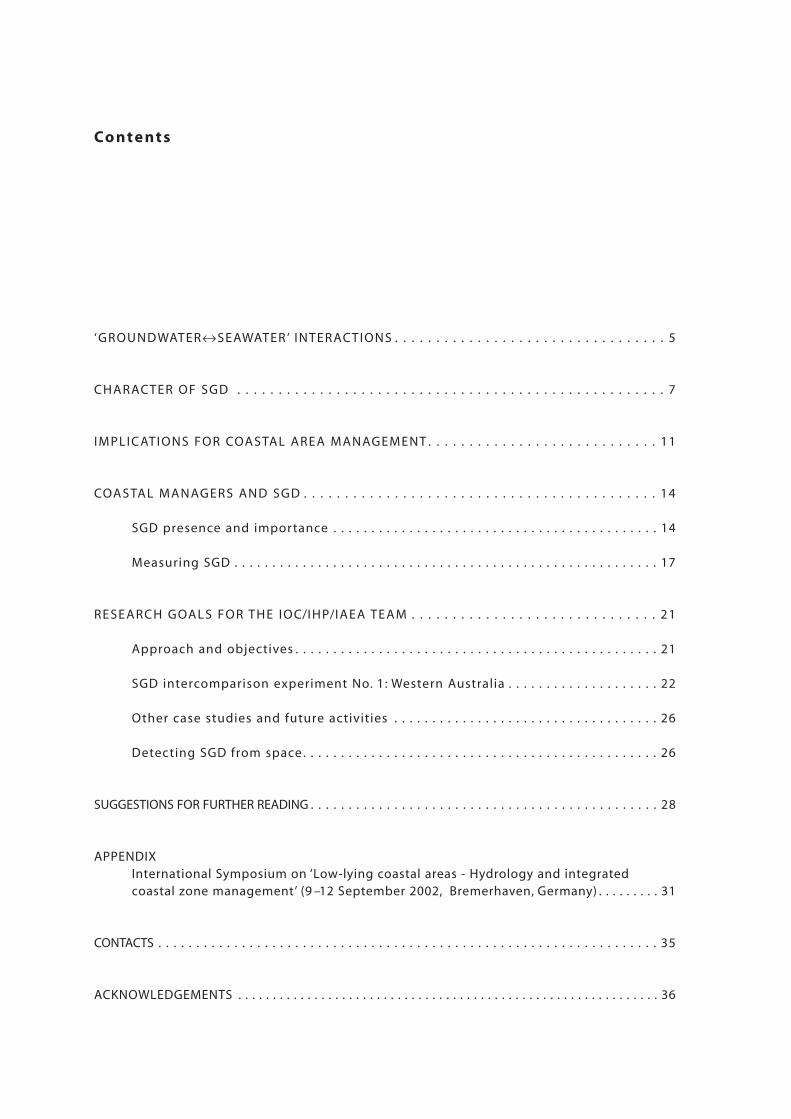
‘GROUND WATER↔SEAWATER ’ INTER ACTIONS . . . . . . . . . . . . . . . . . . . . . . . . . . . . . . . . . 5
CHAR ACTER OF SGD . . . . . . . . . . . . . . . . . . . . . . . . . . . . . . . . . . . . . . . . . . . . . . . . . . . . 7
IMPLICATIONS FOR COASTAL AREA MANAGEMENT . . . . . . . . . . . . . . . . . . . . . . . . . . . . 11
COASTAL MANAGERS AND SGD . . . . . . . . . . . . . . . . . . . . . . . . . . . . . . . . . . . . . . . . . . . 14
SGD presence and importance . . . . . . . . . . . . . . . . . . . . . . . . . . . . . . . . . . . . . . . . . . . 14
Measuring SGD . . . . . . . . . . . . . . . . . . . . . . . . . . . . . . . . . . . . . . . . . . . . . . . . . . . . . . . . 17
RESEARCH GOALS FOR THE IOC/IHP/IAEA TEAM . . . . . . . . . . . . . . . . . . . . . . . . . . . . . . 21
Approach and objectives . . . . . . . . . . . . . . . . . . . . . . . . . . . . . . . . . . . . . . . . . . . . . . . . 21
SGD intercomparison experiment No. 1: Western Australia . . . . . . . . . . . . . . . . . . . . 22
Other case studies and future activities . . . . . . . . . . . . . . . . . . . . . . . . . . . . . . . . . . . 26
Detecting SGD from space . . . . . . . . . . . . . . . . . . . . . . . . . . . . . . . . . . . . . . . . . . . . . . . 26
SUGGESTIONS FOR FURTHER READING . . . . . . . . . . . . . . . . . . . . . . . . . . . . . . . . . . . . . . . . . . . . . . 28
APPENDIXInternational Symposium on ‘Low-lying coastal areas - Hydrology and integrated coastal zone management’ (9 –12 September 2002, Bremerhaven, Germany) . . . . . . . . . 31
CONTACTS . . . . . . . . . . . . . . . . . . . . . . . . . . . . . . . . . . . . . . . . . . . . . . . . . . . . . . . . . . . . . . . . . . 35
ACKNOWLEDGEMENTS . . . . . . . . . . . . . . . . . . . . . . . . . . . . . . . . . . . . . . . . . . . . . . . . . . . . . . . . . . . . . 36
‘ G R O U N D WAT E R ↔↔S E AWAT E R ’I N T E R AC T I O N S
‘It is ... clear that submarine groundwater discharge is widespread and, in some areas, of greater ecological significance than surface runoff ’(R. E. Johannes, 1980)
Knowledge concerning the undersea discharge of groundwater has existed for manycenturies. The Roman geographer, Strabo, who lived from 63 B.C. to 21 A.D., men-tioned a submarine spring (fresh groundwater) four kilometers from Latakia, Syria(Mediterranean) near the island of Aradus. Water from this spring was collectedfrom a boat, utilizing a lead funnel and leather tube, and transported to the city as asource of fresh water. Other historical accounts tell of water vendors in Bahraincollecting potable water from offshore submarine springs for shipboard andlanduse, Etruscan citizens using coastal springs for ‘hot baths’ (Pausanius, ca. 2nd century A.D.) and submarine ‘springs bubbling fresh water as if from pipes’along the Black Sea (Pliny the Elder, ca. 1st century A.D.). Thus, while the existenceof submarine springs has been realized for many years, the information was largelyanecdotal and not driven by scientific curiosity.
The subject has been neglected scientifically because of the difficulty infinding and measuring these features. We realize now that submarine groundwaterdischarge is more than a mere curiosity and its occurrence can be more subtle thanthe dramatic manifestations noted by our ancestors. Globally, groundwater seepagehas been estimated to be a few percent of the total freshwater flux. One recentestimate suggests 2,400 km3 freshwater discharge per year (~6% of the world's riverdischarge) with 1,500 km3 per year from the continents, and 900 km3 per yearbeing contributed from the world's islands. Undiscovered springs or slow, diffuseseepage through a sandy sea floor can still be important discharges. Importantbecause they not only carry fresh water to the coastal zone but also can carrypollutants from anthrogenic sources on land into the ocean by an unseen pathway.
Managers, as well as scientists, need to be careful when talking or readingabout ‘submarine groundwater discharge’ (SGD) because SGD is a term that may beapplied to more than one phenomenon and because some designations may refer todischarges that may not be too important to a coastal zone manager while othersmay be critical. In its broadest sense, SGD is applied to any and all flows of waterupwards across the sea floor, from the ocean bottom into the overlying water. (Sinceflow can also occur in the opposite direction, an even more general term– ‘Submarine Pore Water Exchange’ – may be used to describe any water flow acrossthe sea floor.) Groundwater discharge may be pure freshwater entering the oceanfrom a coastal aquifer, or it may be recirculated seawater, or some combination of
5
➜
the two. In a more narrow sense, it is sometimes used to mean only the freshwatercomponent of that outflow.
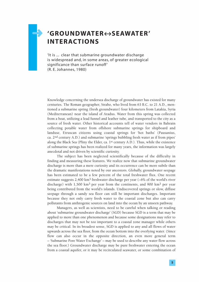
This brochure is specifically concerned with the flow of SGD in the coastalzone, its effects, and implications for coastal managers. We will use the term SGD here to represent all direct discharge of subsurface fluids out across theseafloor (Figure 1). So SGD has two components, the fresh groundwater dischargeoriginating on land, and recirculated seawater. It is that component of SGD from the land that poses the greatest concern for coastal zone managers because thiscomponent is most likely to carry pollutants. The recirculated water may be lessproblematic although it can still be called SGD.
Submarine groundwater discharge➜➜
6
Figure 1. Schematic depiction (no scale) of processes associated with submarine groundwater discharge.Arrows indicate fluid movement.
Source: Diagram modified from M. Taniguchi et al., Hydrological Processes, 2002 (in press).
C H A R AC T E R O F S G D
‘... these marvels of the sea (submarine springs) are justifiablyclassified as neglected phenomena of coastal hydrology’(F. A. Kohout, 1966)
A basic driver of freshwater SGD is the amount of rainfall received by the drainagebasin, coupled with evapotranspiration rates and the surface geology (particularlythe surface infiltration capacity) but flow through coastal marine sediments canoccur for a variety of reasons. Flow may be induced by the terrestrial hydraulic gra-
dient as well as by marine processes such as wave set-up, tidally driven oscillations,density-driven convection, and thermal convection. The mix will be different in different regions. It will depend, for example, on the hydraulic conductivity,hydraulic head, groundwater catchment area, recharge rates and many other factors.Density-coupled modeling of the saltwater interface indicates that seawater re-circulation rates of 60% and more can occur due to dispersion and mixing withinthe aquifer even when wave and tidal effects are ignored. Since wave-induced andtidal effects are rarely completely absent, a great deal of seawater recirculation mustoccur on a global scale, while the local effects of freshwater SGD can be dominantin nearshore environments.
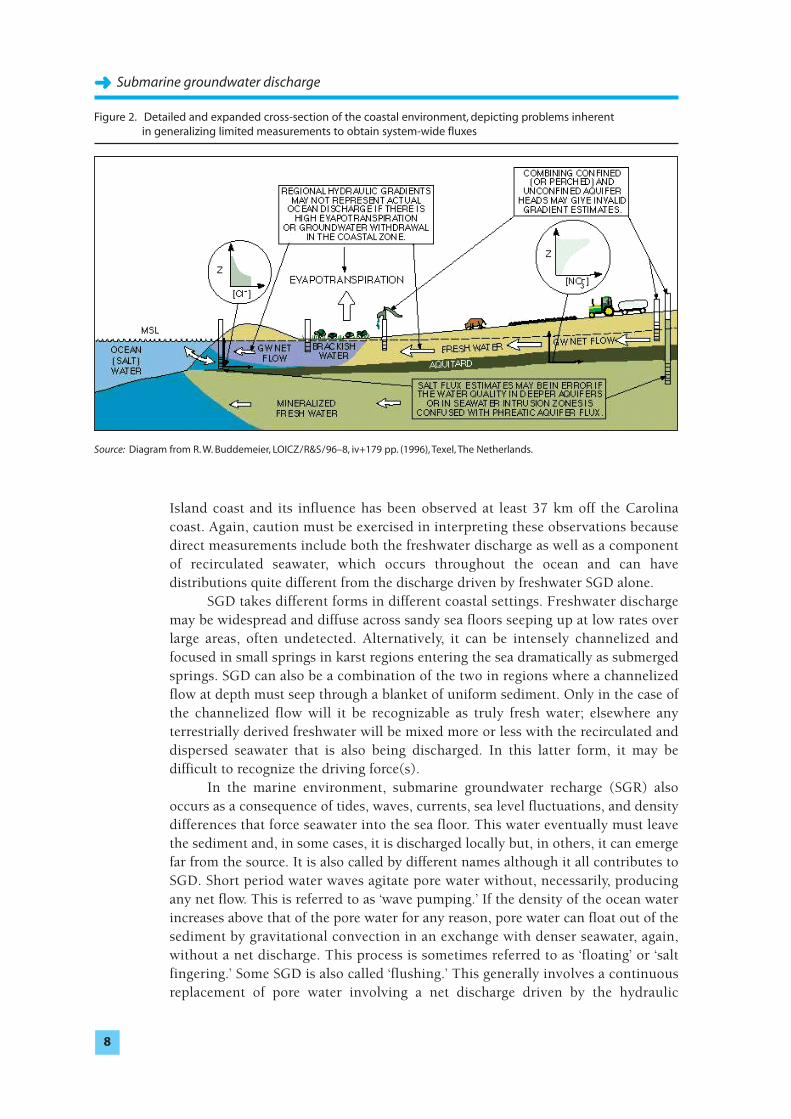
The issue is how much water is transported to the coast via surface drainageas compared with subsurface flows. Human use of surface water and groundwaterfor agricultural, industrial and domestic purposes and subsequent wastewater treat-ment, reuse and disposal practices significantly impact the magnitude of bothsurface and subsurface discharges to the marine environment (Figure 2). The inter-
actions result in variable and dynamic rates of groundwater discharge. As a general rule, the highest freshwater SGD tends to be found closest to
shore. In some places, a well defined, seepage face is found, often in the intertidalzone. In other cases, the distribution has often been described as decreasing expo-
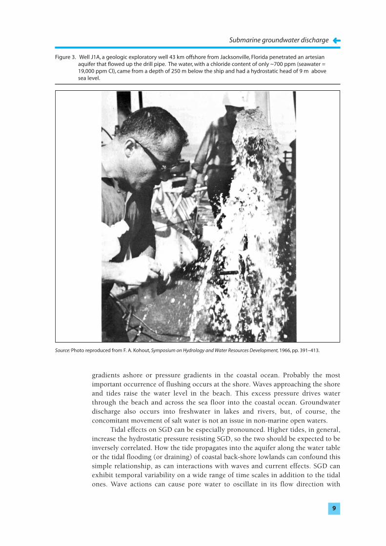
nentially from shore and often at a rate so that most of the flow occurs within100 m or so of the shoreline, but this distance can be quite variable. The geologicalconditions might be such that substantial flow occurs kilometers offshore, as withthe occurrence of springs or seeps. SGD occurring far offshore would be reflected byhydraulic heads in the aquifer at the coast that are significantly greater than meansea level (with the exception of channelized aquifers, e.g., karst or volcanic terrain).In such cases, the aquifer must be sealed above by an aquitard (i.e. a layer resistantto groundwater flows) that prevents SGD at the coast; the saltwater interface which is an indicator of where SGD occurs will be located offshore. A famousexample of the discovery of a freshwater aquifer offshore occurred about 45 km offJacksonville, Florida during the test drilling for the original Joint OceanographicInstitutes Deep Earth Sampling Project (Figure 3).
In areas where seepage occurs through permeable sediments, seepage may below, yet a small upward leakage over a wide area could make an important con-
tribution to the coastal ocean. Seepage has been observed some 8 km off the Long
7
➜
Submarine groundwater discharge➜➜
8
Island coast and its influence has been observed at least 37 km off the Carolinacoast. Again, caution must be exercised in interpreting these observations becausedirect measurements include both the freshwater discharge as well as a componentof recirculated seawater, which occurs throughout the ocean and can havedistributions quite different from the discharge driven by freshwater SGD alone.
SGD takes different forms in different coastal settings. Freshwater dischargemay be widespread and diffuse across sandy sea floors seeping up at low rates overlarge areas, often undetected. Alternatively, it can be intensely channelized andfocused in small springs in karst regions entering the sea dramatically as submergedsprings. SGD can also be a combination of the two in regions where a channelizedflow at depth must seep through a blanket of uniform sediment. Only in the case ofthe channelized flow will it be recognizable as truly fresh water; elsewhere anyterrestrially derived freshwater will be mixed more or less with the recirculated anddispersed seawater that is also being discharged. In this latter form, it may bedifficult to recognize the driving force(s).
In the marine environment, submarine groundwater recharge (SGR) alsooccurs as a consequence of tides, waves, currents, sea level fluctuations, and densitydifferences that force seawater into the sea floor. This water eventually must leavethe sediment and, in some cases, it is discharged locally but, in others, it can emergefar from the source. It is also called by different names although it all contributes toSGD. Short period water waves agitate pore water without, necessarily, producingany net flow. This is referred to as ‘wave pumping.’ If the density of the ocean waterincreases above that of the pore water for any reason, pore water can float out of thesediment by gravitational convection in an exchange with denser seawater, again,without a net discharge. This process is sometimes referred to as ‘floating’ or ‘saltfingering.’ Some SGD is also called ‘flushing.’ This generally involves a continuousreplacement of pore water involving a net discharge driven by the hydraulic
Figure 2. Detailed and expanded cross-section of the coastal environment, depicting problems inherent in generalizing limited measurements to obtain system-wide fluxes
Source: Diagram from R. W. Buddemeier, LOICZ/R&S/96–8, iv+179 pp. (1996), Texel, The Netherlands.
Submarine groundwater discharge
➜➜9
gradients ashore or pressure gradients in the coastal ocean. Probably the mostimportant occurrence of flushing occurs at the shore. Waves approaching the shoreand tides raise the water level in the beach. This excess pressure drives waterthrough the beach and across the sea floor into the coastal ocean. Groundwaterdischarge also occurs into freshwater in lakes and rivers, but, of course, theconcomitant movement of salt water is not an issue in non-marine open waters.
Tidal effects on SGD can be especially pronounced. Higher tides, in general,increase the hydrostatic pressure resisting SGD, so the two should be expected to beinversely correlated. How the tide propagates into the aquifer along the water tableor the tidal flooding (or draining) of coastal back-shore lowlands can confound thissimple relationship, as can interactions with waves and current effects. SGD canexhibit temporal variability on a wide range of time scales in addition to the tidalones. Wave actions can cause pore water to oscillate in its flow direction with
Figure 3. Well J1A, a geologic exploratory well 43 km offshore from Jacksonville, Florida penetrated an artesian aquifer that flowed up the drill pipe. The water, with a chloride content of only ~700 ppm (seawater = 19,000 ppm Cl), came from a depth of 250 m below the ship and had a hydrostatic head of 9 m above sea level.
Source: Photo reproduced from F. A. Kohout, Symposium on Hydrology and Water Resources Development, 1966, pp. 391–413.
Submarine groundwater discharge➜➜
10
periods of seconds to minutes, whereas tides act on time scales of hours to weeksand can set-up equally persistent discharge patterns. Long-term patterns can also beestablished by other large-scale sea level variations and by changes in the onshorehydraulic gradients, as due, for example, to variations in recharge or the inverseeffect of changes in barometric pressure on water tables. All these conspire toproduce SGD that is both spatially and temporally dynamic on a variety of scalesand pose a dilemma for coastal zone managers trying to make sense out of specificmeasurements provided to them by their technicians.
For the coastal manager, the quality of SGD is of great concern, regardless of whether the water itself is fresh or marine. The chemistry of SGD is typicallychanged during its passage through the aquifer and sediments. Nutrient, radio-
isotope, trace and minor element composition of the water escaping from the seafloor assumes distinctive signatures, even in the absence of recognizable anthro-
pogenic contamination. As coastal groundwaters are often contaminated withsewage, fertilizers, pathogens, pesticides or industrial wastes, SGD can be animportant pathway for diffuse pollution to the ocean. The contaminant inputs andtheir potential and actual environmental impacts on coastal ecology are key reasonswhy SGD should be considered in coastal management.
11
I M P L I C AT I O N S F OR COA S TA L A R E AM A N AG E M E N T
‘Recent work suggests that hydrologic flow from continents to oceans may be more important than has generally beenappreciated’ (L. M. Cathles, 1987)
Traditionally, hydrogeologists have stood at the shoreline and looked landward.Their principal concern was to find potable fresh water reserves for coastal popu-
lations. At the coastline, threats to this supply came from salt-water contamination.Although this concern remains an issue of over-riding importance, hydrogeologistsrecently have started to look seaward at the way the groundwater in the coastalaquifers drives a flow of water seeping upwards across the sea floor. Oceano-
graphers, on the other hand, have long stood at the shoreline and looked seawardwondering what are the main pathways for the transfer of terrestrial chemicals tothe sea. They are now coming to appreciate the impacts of terrestrial groundwaterhydrology. A coastal zone manager must integrate both these viewpoints.
SGD can be the principal component of freshwater to the coastal zone inareas where surface runoff is small or variable. The discharge of potable wateracross the sea floor may be considered a waste, especially in arid regions. In suchplaces, the detection of SGD may provide new sources of potable or agriculturalwater. Indeed, until relatively recently, most studies of submarine springs weredriven almost exclusively by water resources objectives. People in Greece have put up a barrier to trap fresh SGD offshore to from a freshwater ‘lake’ at sea. And modern versions of the ancient lead funnel, referred to in the introduction, have been designed. Even if the captured water isn't entirely fresh it may be lessexpensive to desalinate than undiluted seawater. It should be kept in mind, how-
ever, that reclaiming freshwater directly from the sea is quite difficult andexpensive. Another approach is to stem the loss before it reaches the sea. In Japan,for instance, underground ‘dams’ have been installed to impede channelized SGD involcanic or karst terrains.
SGD, controlled or not, serves an important purpose. Groundwater found incoastal aquifers is not static. It is constantly flowing and must continually dischargeas it is replenished by rainwater or recharged from surface water. If plants do nottake it up, this water eventually reaches the ocean, either indirectly through riverflow or directly in the form of SGD. The flow is driven by the elevation of thegroundwater on land (the hydraulic head). The influence of the hydraulic headdoes not necessarily end at the coast but may continue offshore, moving water inthe submerged part of the aquifer as well. The underground motion of wateractually has two complementary parts. One is SGD and the other is the seawaterintrusion into the coast. SGD is responsible for limiting salt-water intrusion into theaquifer so its nature can determine the reliability and extent of potable water
➜
Submarine groundwater discharge➜➜
12
supplies near the coast. Reducing SGD, for example by excessive pumping fromcoastal aquifers, increases saltwater intrusion.
In addition to its critical role in holding back saltwater intrusion, SGDdeserves the attention of coastal zone mangers because of its quality. Becausegroundwater typically has higher concentrations of dissolved solids than mostterrestrial surface waters, SGD often makes a disproportionately large contributionto the flux of dissolved constituents. Most chemicals entering the coastal zone fromland pass through a ‘chemically reactive ribbon.’ Importantly, the largest share of thebiogeochemical reactions, which affect carbon, nitrogen, and phosphorus budgets,enters from the landward edge of the ribbon corresponding to that part of the seafloor where SGD is typically most important. Some of the most serious problemsarise where SGD is carrying pollutants and nutrients, especially nitrogen, from theland into restricted coastal waters. Pollutant input via SGD has been the cause ofeutrophication of coastal ponds in, for example, New England and in coastal canalsin Florida. In addition, the fresh component of SGD interacts with and influencesthe recirculation of seawater, which can affect coastal water quality and nutrientsupplies to nearshore benthic habitats, coastal wetlands, breeding and nestinggrounds.
The effects of SGD in supplying dissolved constituents or, perhaps, in merelyreducing salinity have been implicated in the occurrence of nuisance algal bloomsof, for example, brown tide in New York, which devastated the local scallopindustry. The distribution of SGD can also affect benthic habitats. Areas of eelgrassbeds have been reduced and the opportunistic growth of macroalgae increased. Insome places, low-salinity seeps may provide particular habitats on the sea floorespecially for fishery stock. Also, SGD may actually produce changes in morphologyor substrates that serve as microhabitats. Very rapid seepage can destabilize sedi-ments, either on the sea floor or at the coastline, by sapping. SGD throughsediments with a high organic content can accelerate the release of methane into theoverlying water. Organic-rich SGD could lead to hypoxia in open water andcontribute to the ‘greenhouse’ gases causing global warming.
Knowledge of the impacts in the coastal zone can be the basis for land-useplanning and may place limits on development. SGD in some regions can endangercompliance with international or regional conventions on pollution source controls.
Another use of better estimates of SGD would be in the calculation of non-point sources of nutrients or chemical contaminants into embayments receivingSGD. In some places this has been a factor in deciding the degree of development tobe allowed. From a management point of view, it is important to determine whatfraction of SGD is manmade because altering human activity could control thisfraction. In principal, however, there are several types of actions that could be takento achieve specific goals. Pumping to decrease the hydraulic gradients and reduceflow or artificial recharge to increase the flow may be possible. Artificial recharge iswidely practiced to reduce intrusion by building hydraulic barriers, which increaseoutflow. Such techniques have been used in coastal California for at least 30 years.Land use and pollution sites in source areas might be controlled to alter the qualityof SGD, invoking a range of concepts in wellhead and aquifer protection.
The Western Australian State Government, for example, is looking into waysto reduce nitrogen inputs via groundwater to Jervoise Bay, near Perth. Currently,
ammonium-rich or nitrate-rich groundwater plumes discharge to the CockburnSound/Jervoise Bay area. A ‘pump-and treat’ option is being explored to capture thenutrient plume entering the bay. The in situ remediation technology is innovativeand involves establishment of an in situ bio-treatment wall system across the flowpath of nitrogen-rich groundwater as it moves toward the marine environment.Through the initial discharge quantification and mapping, it is proposed to select a‘hot spot’ plume and further quantify plume dimensions and fluxes to the marineenvironment, so selection of locations can be finalized and an appropriate finalpilot-scale design developed. For ammonium, the treatment barrier would consistof a dual treatment/delivery system in the path of the plume. One treatment woulddeliver oxygen and induce bacterial nitrification of the ammonium to nitrite/nitratespecies as the groundwater moves past, and the other would deliver a reductant toinduce bacterial denitrification of the nitrate to nitrogen gas, again as groundwatermoves past. The concept would allow a single down-gradient installation that couldachieve discharge of cleaned groundwater beyond the treatment zone to the marineenvironment, without hydraulic pumping and aboveground treatment. For nitratein groundwater, only delivery of a reductant would be required, but with the sameclean-up effect. An innovative oxygen and reductant deliver mechanism is to beused – this is currently being patented by the Land and Water Division of Australia'sCommonwealth Scientific and Industrial Research Organization (CSIRO).
Submarine groundwater discharge
➜➜13
COA S TA L M A N AG E R S A N D S G D
‘The submarine outflow of groundwater ... is usually the mostpoorly documented component of the freshwater supply and rarely measured directly’ (H. Bokuniewicz, 1980)
SGD presence and impor tance
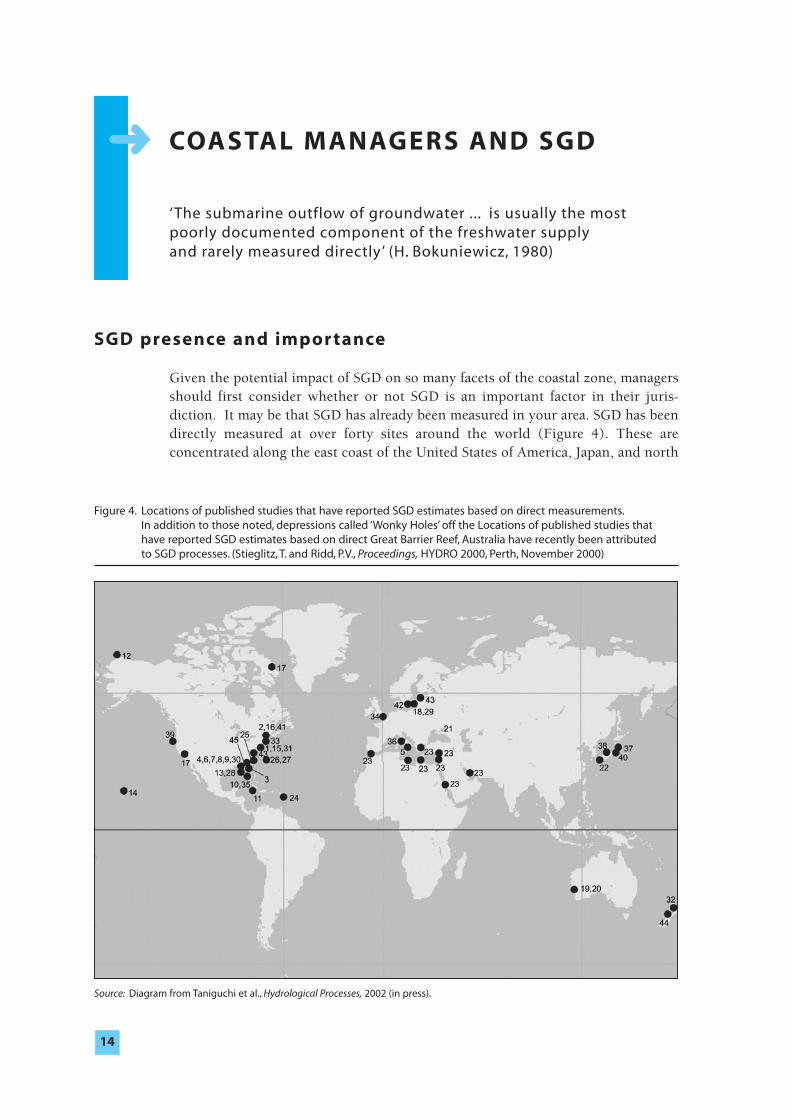
Given the potential impact of SGD on so many facets of the coastal zone, managersshould first consider whether or not SGD is an important factor in their juris-
diction. It may be that SGD has already been measured in your area. SGD has beendirectly measured at over forty sites around the world (Figure 4). These areconcentrated along the east coast of the United States of America, Japan, and north
14
➜
Figure 4. Locations of published studies that have reported SGD estimates based on direct measurements.In addition to those noted, depressions called ‘Wonky Holes’ off the Locations of published studies that have reported SGD estimates based on direct Great Barrier Reef, Australia have recently been attributed to SGD processes. (Stieglitz, T. and Ridd, P.V., Proceedings, HYDRO 2000, Perth, November 2000)
Source: Diagram from Taniguchi et al., Hydrological Processes, 2002 (in press).
and Italian coasts of Europe, but include some sites in Australia, the Bay of Bengal,the South Pacific, Africa, Hawaii, California, Alaska and Canada. Regionally, thegroundwater flux has been estimated to be equivalent to 20 to 35% of the totalfreshwater inflow along the coast of Long Island, 30% off the south coast of CapeCod, Massachusetts, 40% off the Carolina coast and 500 to 1,500 times the fluvialinput off the coast of Rhode Island. These estimates may be deceiving to the coastalzone manager because they include not only freshwater from the land, whichcarries away potable water and may supply pollutants to the coastal ocean, but alsoseawater that is recirculated through the sediments by the groundwater dischargewhich may not have any serious impacts. SGD, therefore, may range from nearlyentirely fresh water to undiluted, albeit chemically altered, seawater.
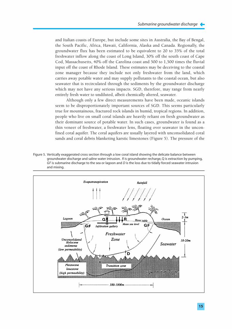
Although only a few direct measurements have been made, oceanic islandsseem to be disproportionately important sources of SGD. This seems particularlytrue for mountainous, fractured rock islands in humid, tropical regions. In addition,people who live on small coral islands are heavily reliant on fresh groundwater astheir dominant source of potable water. In such cases, groundwater is found as athin veneer of freshwater, a freshwater lens, floating over seawater in the uncon-
fined coral aquifer. The coral aquifers are usually layered with unconsolidated coralsands and coral debris blanketing karstic limestones (Figure 5). The pressure of the
Submarine groundwater discharge
➜➜15
Figure 5. Vertically exaggerated cross section through a low coral island showing the delicate balance between groundwater discharge and saline water intrusion. R is groundwater recharge, Q is extraction by pumping,GF is submarine discharge to the sea or lagoon and D is the loss due to tidally forced seawater intrusion and mixing.
ocean tides reaches easily into these permeable aquifers, mixing salt and freshgroundwater. Mixing depletes the amount of potable water in the lens.
The loss of freshwater for island peoples can determine their survival onparticular islands and, the availability of freshwater is a delicate balance betweenthe net recharge of rainwater (less evapotranspiration and human's withdrawals)and SGD. Island fresh groundwater can also be contaminated not only by humansbut also by nature. Coconut trees, for example, supply both nitrogen and dissolvedorganic carbon to groundwater that leads to the generation of hydrogen sulfide fromthe reduction of sulfate. SGD delivers these and other dissolved chemicals to thesurrounding sea, but the importance of these discharges are unknown.
Submarine groundwater discharge can dominate inflows in restricted seas or embayments. For example, karst comprises 60% of the shoreline of theMediterranean and is estimated to contribute 75% of its freshwater input – much ofthis input must be via SGD. In places where rivers are small or nonexistent, SGDmay be the principal way for freshwater to enter the coastal ocean as, for example,in the northeastern Yucatan Peninsula, Mexico.
If nothing else, the recent compilation of all studies available in the literaturethat reported SGD estimates by direct measurements shows that many areas of the world remain unstudied. As yet, there are no published accounts of directmeasurements in South America, Africa, India, or China. Future studies by IHP,IOC, IAEA, and other organizations will likely focus on some of these regions.
Where SGD has not been measured, there may be other clues to its impor-
tance. Several potential indirect indicators of freshwater submarine discharge havebeen suggested but not yet widely applied. The water might be distinguished by itscolor, temperature, salinity, or some other geochemical fingerprint. Escapinggroundwater, for example, might stain surrounding sediments red by the oxidationof iron or itself be colored by tiny gas bubbles. Because groundwater tends to be atthe average annual air temperature, cold-water anomalies in the open water duringthe summer and warm water anomalies during the winter, as might be detected byinfrared aerial photography, can be an indicator of SGD. Salinity anomalies havealso long been used to identify subsea freshwater seeps. The presence of elevatedlevels of radium, radon, methane, hydrogen sulfide or carbon dioxide may also beindicative of a SGD.
Particular site conditions may also provide clues to the occurrence of SGD.The presence of coastal ponds or unconsolidated coastal bluffs, which may maintaina high hydraulic head near shore, may be other indicators. Growths of freshwatercoastal vegetation may indicate regions of high SGD offshore. It has also beensuggested that the presence of barite, oxidized shells, or beach rock may indicatethe occurrence of groundwater discharges. In Great South Bay (Long Island, NewYork, United States of America), there occurs a phenomenon known as ‘anchor ice’,in which the bay floor freezes while the saline open waters of the bay is still ice free.This is attributed to the presence of fresh water in the sediments maintained bySGD. Anchor ice is also reported to occur in the Baltic. Alternatively, in coastal areasthat are covered with ice in the water, like the Schlei estuary in northern Germany,ice-free spots, sometimes called ‘wind-spots’, can be found above the SGD ofrelatively warm freshwater. In Eckernforde Bay (southeast Baltic Sea) pockmarks inthe fine-grained sediments of the sea floor have been identified as a bathymetric
Submarine groundwater discharge➜➜
16
Submarine groundwater discharge
➜➜17
expression of groundwater seeps. Along the east Australian coast, pits in the seafloor, knows as ‘wonky holes’, are created by SGD through permeable paleo-
channels. These pits are found 8 to 10 kilometers from shore; are 20 or 30 metersacross and 4 or 5 meters deep, large enough to cause problems for bottom trawlingfishermen.
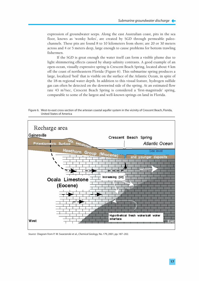
If the SGD is great enough the water itself can form a visible plume due tolight shimmering effects caused by sharp salinity contrasts. A good example of anopen-ocean, visually expressive spring is Crescent Beach Spring, located about 4 kmoff the coast of northeastern Florida (Figure 6). This submarine spring produces alarge, localized ‘boil’ that is visible on the surface of the Atlantic Ocean, in spite ofthe 18-m regional water depth. In addition to this visual feature, hydrogen sulfidegas can often be detected on the downwind side of the spring. At an estimated flowrate 43 m3/sec, Crescent Beach Spring is considered a ‘first-magnitude’ spring,comparable to some of the largest and well-known springs on land in Florida.
Figure 6. West-to-east cross-section of the artesian coastal aquifer system in the vicinity of Crescent Beach, Florida,United States of America
Source: Diagram from P. W. Swarzenski et al., Chemical Geology, No. 179, 2001, pp. 187–202.
Measuring SGD
‘Measurements or estimates of groundwater and associated chemical fluxes,especially over substantial areas or time periods, are notoriously uncertain’(R.W. Buddemeier, 1996)
How large is SGD? There are many ways to answer this question (even if we don'treally know the answer!).
If you have reason to believe that SGD is important in your jurisdiction, ameasurement program may be warranted. Measurements of SGD can be presentedin several different ways – as a velocity of flow across the seabed, as a volume flux offlow per square meter of seafloor, or as the volume flow per meter of shoreline. Animportant flow rate might be 50 liters per square meter per day, corresponding to aflow at the sediment water interface of 5 cm/day or 5.8 x 10⁻⁵ cm/sec. This mightalso result in a total flow of some thousands of liters per meter of shoreline per day,depending on the distribution of SGD offshore.
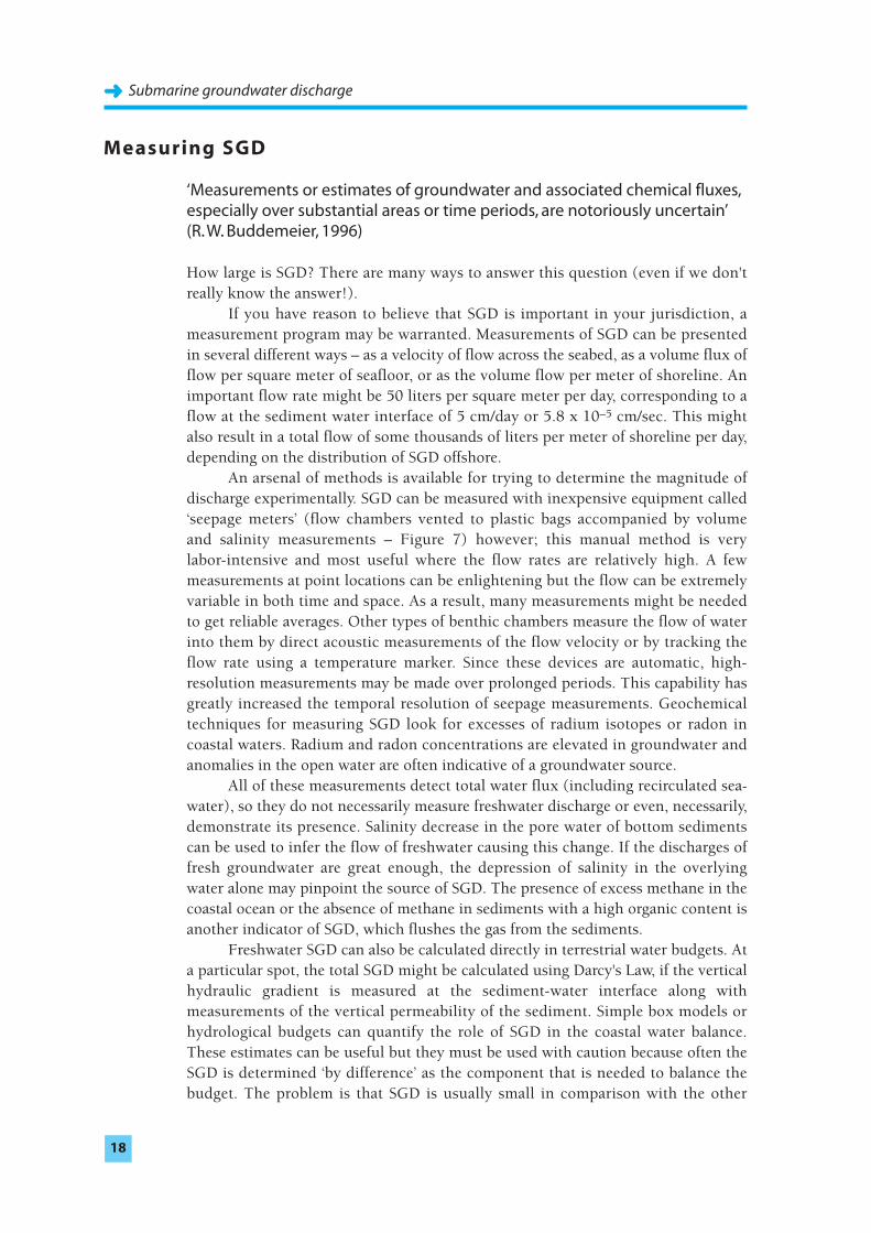
An arsenal of methods is available for trying to determine the magnitude ofdischarge experimentally. SGD can be measured with inexpensive equipment called‘seepage meters’ (flow chambers vented to plastic bags accompanied by volume and salinity measurements – Figure 7) however; this manual method is very labor-intensive and most useful where the flow rates are relatively high. A fewmeasurements at point locations can be enlightening but the flow can be extremelyvariable in both time and space. As a result, many measurements might be neededto get reliable averages. Other types of benthic chambers measure the flow of waterinto them by direct acoustic measurements of the flow velocity or by tracking theflow rate using a temperature marker. Since these devices are automatic, high-resolution measurements may be made over prolonged periods. This capability hasgreatly increased the temporal resolution of seepage measurements. Geochemicaltechniques for measuring SGD look for excesses of radium isotopes or radon incoastal waters. Radium and radon concentrations are elevated in groundwater andanomalies in the open water are often indicative of a groundwater source.
All of these measurements detect total water flux (including recirculated sea-
water), so they do not necessarily measure freshwater discharge or even, necessarily,demonstrate its presence. Salinity decrease in the pore water of bottom sedimentscan be used to infer the flow of freshwater causing this change. If the discharges offresh groundwater are great enough, the depression of salinity in the overlyingwater alone may pinpoint the source of SGD. The presence of excess methane in thecoastal ocean or the absence of methane in sediments with a high organic content isanother indicator of SGD, which flushes the gas from the sediments.
Freshwater SGD can also be calculated directly in terrestrial water budgets. Ata particular spot, the total SGD might be calculated using Darcy's Law, if the verticalhydraulic gradient is measured at the sediment-water interface along withmeasurements of the vertical permeability of the sediment. Simple box models orhydrological budgets can quantify the role of SGD in the coastal water balance.These estimates can be useful but they must be used with caution because often theSGD is determined ‘by difference’ as the component that is needed to balance thebudget. The problem is that SGD is usually small in comparison with the other
Submarine groundwater discharge➜➜
18
parts of the water balance and the SGD estimate may be on the same order as theerrors of the other components. Thus, the combined uncertainties in the knownterms (precipitation, recharge rate, evapotranspiration, etc.) usually make theuncertainty in SGD estimated by difference unacceptably large. In the Caspian Sea,for example, various estimates of SGD differ by as much as a factor of 150. Recentattempts to quantify the amount of total underground fluid flow into Florida Bay
Submarine groundwater discharge
➜➜19
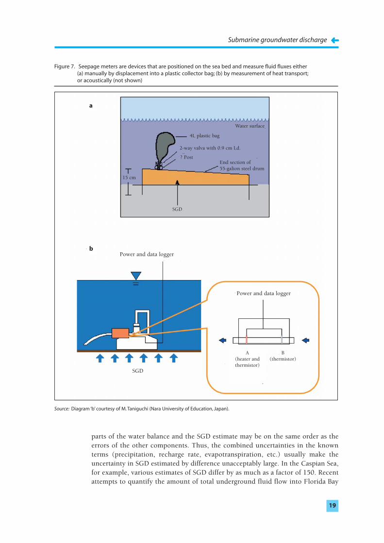
Figure 7. Seepage meters are devices that are positioned on the sea bed and measure fluid fluxes either (a) manually by displacement into a plastic collector bag; (b) by measurement of heat transport;or acoustically (not shown)
Source: Diagram ‘b’ courtesy of M. Taniguchi (Nara University of Education, Japan).
Water surface
4L plastic bag
2-way valva with 0.9 cm Ld.
? Post
15 cm
SGD
SGD
Power and data logger
Power and data logger
A(heater and thermistor)
B(thermistor)
End section of55-galion steel drum
a
b
by modeling vary by 3–4 orders of magnitude! Hence, models are useful forinvestigating SGD but they probably are not yet a substitute for directmeasurements.
Care also must be exercised in interpreting mathematical models, eitheranalytical or numerical, for the following reasons. Models typically are designed toforecast the characteristics of the potable water supply. As a result, they oftenoversimplify the salt water/freshwater transition. They may assume a discontinuous,stationary boundary, the saline groundwater may be assumed to be stationary, or theboundary may be allowed to move and the salt water to flow but not to mix withfresh water. Such assumptions are simplifications that can be more or lessappropriate, depending both on the model's intended use and the actual geohydro-
logic conditions. The recirculation of seawater is an important component of theSGD but is rarely taken into account in hydrological models. Even if the model doesallow the recirculation of seawater, offshore data for calibration, verification, anddriving the model is usually sparse. Fortunately, new approaches to coastalhydrologic models, with due consideration to both salt-water intrusion and SGD,are being developed and show great promise.
Submarine groundwater discharge➜➜
20

R E S E A R C H G OA L S F OR T H E I O C/I H P/I A E A T E A M
‘Data on groundwater discharge ... are so deficient that no valid estimate of its magnitude is possible’ (R. L. Nace, 1970)
Approach and objectives
The Intergovernmental Oceanographic Commission, together with the Inter-
national Hydrologic Program and the International Atomic Energy Agency, haveformed a team and an approach to address remaining problems in the developmentof this field and to expand the scope into coastal management issues. Thesubmarine groundwater discharge project intends to: (1) solve the measurementproblem by comparing and standardizing existing techniques as well as exploringnew methods, including remote sensing; (2) improve hydrogeologic models so SGDand salt-water intrusion may be considered together; (3) contribute to the LOICZtypological approach so that results from well-studied areas can be extended tolesser known shorelines; (4) inform the scientific community, coastal planners, andmanagers about SGD and its implications; and (5) engage in capacity building inareas of the world where studies of SGD are particularly lacking (Asia, Africa, andSouth America).
The IHP/IOC/IAEA team will achieve the educational and capacity-buildinggoals of the SGD Project by conducting symposiums and training workshops. Thetraining workshops will be directed towards scientists from developing countries,especially those where SGD measurements have yet to be made.
As discussed throughout this document, assessing groundwater fluxes andtheir impacts on the near-shore marine environment is very difficult, as there is nosimple means to gauge the submarine groundwater flux. To meet this challenge, aseries of groundwater discharge assessment intercomparison experiments is beingconducted with base support from IOC-IHP and significant financial support fromnational science agencies. These experiments are conducted using many of the sametechniques at each site, so that the results will be comparable from location tolocation. The sites for these experiments will be selected based on a variety ofcriteria including logistics, background information, amount of SGD expected, andhydrological and geological characteristics. Each intercomparison exercise involvesas many methodologies as possible, including various hydrogeological modelingapproaches, ‘direct’ measurements (seepage meters of varying design, piezometers),natural tracer studies (radium isotopes, radon, methane, etc.), and artificial tracers(e.g., SF6). Approximately five such intercomparisons will be held in a variety ofhydrologic/coastal environments (karst, coastal plain, volcanic, etc.) over the nextseveral years.
21
➜
SGD intercomparison experiment No. 1: Western Australia
The first such experiment was held in Cockburn Sound, near Perth, WesternAustralia during Nov. 25–Dec. 6, 2000. Cockburn Sound is a marine embaymentprotected from the open Indian Ocean by reefs, a chain of islands and a man-madecauseway. The area has recently been the subject of extensive environmental assess-
ment in order to address strategic environmental management and the managementof waste discharges into Perth's coastal waters. Much of Perth's commercial andindustrial activity is focused along the southern metropolitan coastline and theshoreline of Cockburn Sound. Influx of pollutants to the nearshore marine environ-
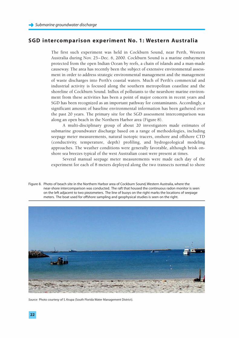
ment from these activities has been a point of major concern in recent years andSGD has been recognized as an important pathway for contaminants. Accordingly, asignificant amount of baseline environmental information has been gathered overthe past 20 years. The primary site for the SGD assessment intercomparison wasalong an open beach in the Northern Harbor area (Figure 8).
A multi-disciplinary group of about 20 investigators made estimates ofsubmarine groundwater discharge based on a range of methodologies, includingseepage meter measurements, natural isotopic tracers, onshore and offshore CTD(conductivity, temperature, depth) profiling, and hydrogeological modelingapproaches. The weather conditions were generally favorable, although brisk on-shore sea breezes typical of the west Australian coast were present at times.
Several manual seepage meter measurements were made each day of theexperiment for each of 8 meters deployed along the two transects normal to shore
Submarine groundwater discharge➜➜
22
Figure 8. Photo of beach site in the Northern Harbor area of Cockburn Sound, Western Australia, where the near-shore intercomparison was conducted. The raft that housed the continuous radon monitor is seen on the left adjacent to two piezometers. The line of buoys on the right marks the locations of seepage meters. The boat used for offshore sampling and geophysical studies is seen on the right.
Source: Photo courtesy of S. Krupa (South Florida Water Management District).
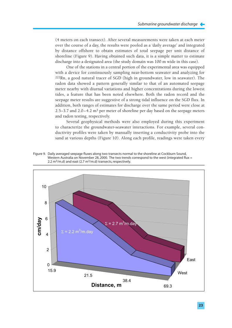
(4 meters on each transect). After several measurements were taken at each meterover the course of a day, the results were pooled as a ‘daily average’ and integratedby distance offshore to obtain estimates of total seepage per unit distance ofshoreline (Figure 9). Having obtained such data, it is a simple matter to estimatedischarge into a designated area (the study domain was 100 m wide in this case).
One of the stations in a central portion of the experimental area was equippedwith a device for continuously sampling near-bottom seawater and analyzing for222Rn, a good natural tracer of SGD (high in groundwater, low in seawater). Theradon data showed a pattern generally similar to that of an automated seepagemeter nearby with diurnal variations and higher concentrations during the lowesttides, a feature that has been noted elsewhere. Both the radon record and theseepage meter results are suggestive of a strong tidal influence on the SGD flux. Inaddition, both ranges of estimates for discharge over the same period were close at2.5–3.7 and 2.0–4.2 m3 per meter of shoreline per day based on the seepage metersand radon testing, respectively.
Several geophysical methods were also employed during this experiment to characterize the groundwater-seawater interactions. For example, several con-
ductivity profiles were taken by manually inserting a conductivity probe into thesand at various depths (Figure 10). Along each profile, readings were taken every
Submarine groundwater discharge
➜➜23
15.921.5
38.4
69.3
West
East
0
2
4
6
8
10
cm
/da
y
Distance, m
= 2.2 m3/m.day
= 2.7 m3/m.day
Figure 9. Daily averaged seepage fluxes along two transects normal to the shoreline at Cockburn Sound,Western Australia on November 28, 2000. The two trends correspond to the west (integrated flux = 2.2 m3/m.d) and east (2.7 m3/m.d) transects, respectively.
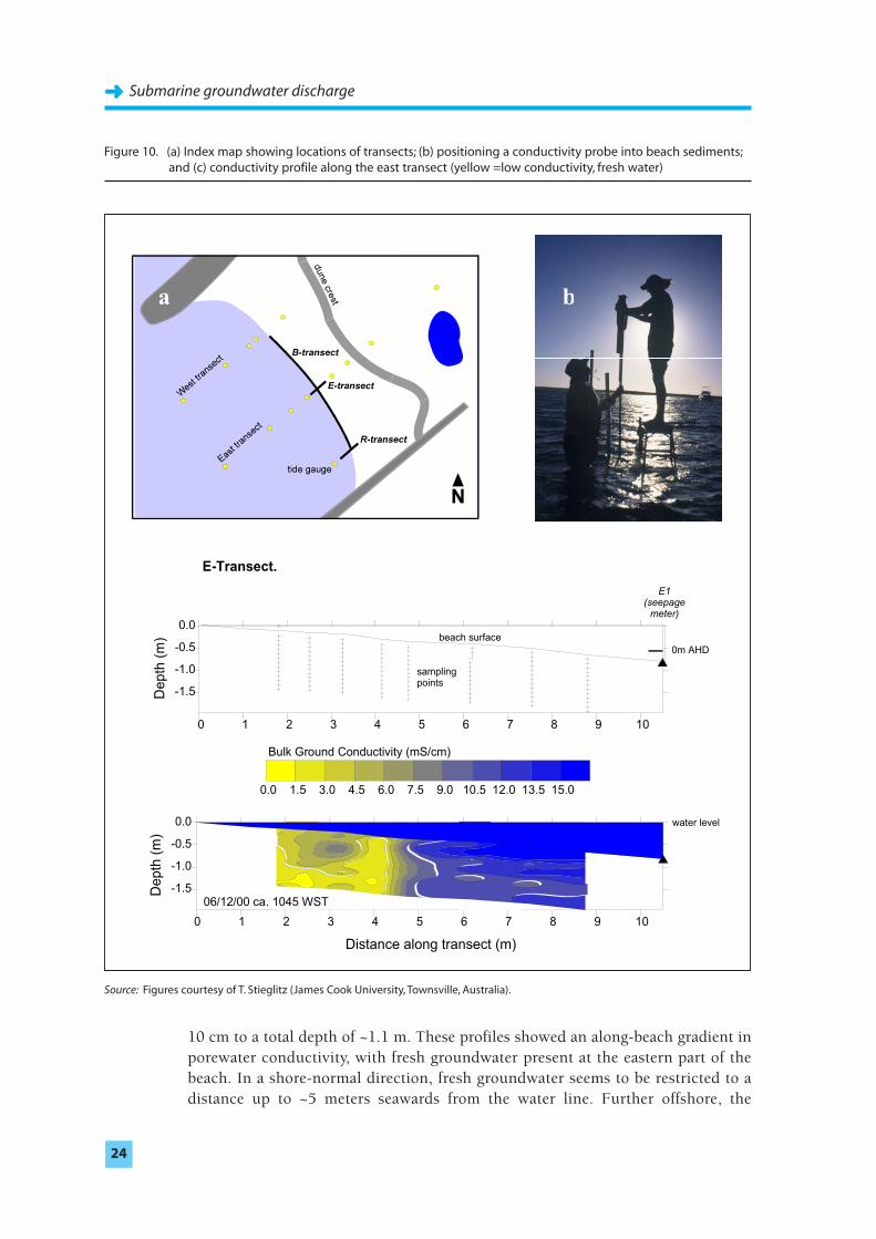
10 cm to a total depth of ~1.1 m. These profiles showed an along-beach gradient inporewater conductivity, with fresh groundwater present at the eastern part of thebeach. In a shore-normal direction, fresh groundwater seems to be restricted to adistance up to ~5 meters seawards from the water line. Further offshore, the
Submarine groundwater discharge➜➜
24
a b
c E-Transect.
Bulk Ground Conductivity (mS/cm)
0.0 1.5 3.0 4.5 6.0 7.5 9.0 10.5 12.0 13.5 15.0
E1(seepagemeter)
0 1 2 3 4 5 6 7 8 9 10
-1.5
-1.0
-0.5
0.0
Dep
th (
m) beach surface
samplingpoints
0m AHD
0 1 2 3 4 5 6 7 8 9 10
Distance along transect (m)
-1.5
-1.0
-0.5
0.0
Dep
th (
m)
06/12/00 ca. 1045 WST
water level
Figure 10. (a) Index map showing locations of transects; (b) positioning a conductivity probe into beach sediments;and (c) conductivity profile along the east transect (yellow =low conductivity, fresh water)
Source: Figures courtesy of T. Stieglitz (James Cook University, Townsville, Australia).
conductivity appears to be that of seawater or of water only slightly reduced inconductivity compared to seawater.
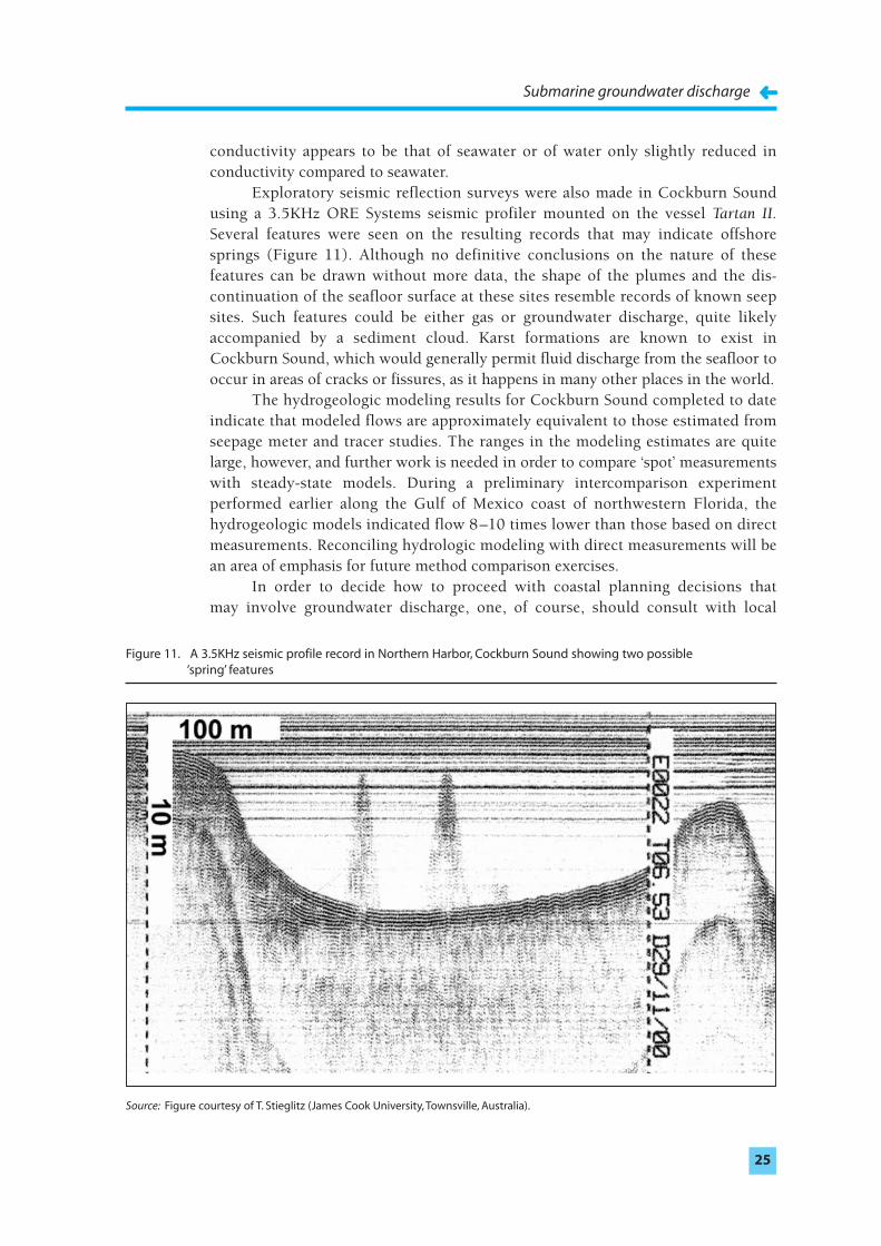
Exploratory seismic reflection surveys were also made in Cockburn Soundusing a 3.5KHz ORE Systems seismic profiler mounted on the vessel Tartan II.Several features were seen on the resulting records that may indicate offshoresprings (Figure 11). Although no definitive conclusions on the nature of thesefeatures can be drawn without more data, the shape of the plumes and the dis-
continuation of the seafloor surface at these sites resemble records of known seepsites. Such features could be either gas or groundwater discharge, quite likelyaccompanied by a sediment cloud. Karst formations are known to exist inCockburn Sound, which would generally permit fluid discharge from the seafloor tooccur in areas of cracks or fissures, as it happens in many other places in the world.
The hydrogeologic modeling results for Cockburn Sound completed to dateindicate that modeled flows are approximately equivalent to those estimated fromseepage meter and tracer studies. The ranges in the modeling estimates are quitelarge, however, and further work is needed in order to compare ‘spot’ measurementswith steady-state models. During a preliminary intercomparison experimentperformed earlier along the Gulf of Mexico coast of northwestern Florida, thehydrogeologic models indicated flow 8–10 times lower than those based on directmeasurements. Reconciling hydrologic modeling with direct measurements will bean area of emphasis for future method comparison exercises.
In order to decide how to proceed with coastal planning decisions that may involve groundwater discharge, one, of course, should consult with local
Submarine groundwater discharge
➜➜25
Figure 11. A 3.5KHz seismic profile record in Northern Harbor, Cockburn Sound showing two possible ‘spring’ features
Source: Figure courtesy of T. Stieglitz (James Cook University, Townsville, Australia).
hydrogeologists. In should be realized, however, that this is a relatively new field ofstudy. Techniques are not yet standardized nor completely tested. The status of theintercomparison experiments, principal findings, and relevant references in theliterature may be found at http://www.jhu.edu/~scor/wg112.htm and from IOC/IHP(see SGD link at http://ioc.unesco.org/icam/).
Other case studies and future activities
After the Cokburn Sound case study in Australia other intercomparison exper-
iments have been conducted in others areas; Sicily (Italy) in 2001, Long Islands(United States of America) in 2002. One campaign has been conducted in Brazilend of 2003. The results of all these experiments will be the subject of a moredetailed publication. Some of these experiments have been supported by the IAEAmarine laboratory located in Monaco.
SGD are considered strategic freshwater resources in the arid and semi-aridcountries of the Mediterranean region. In the eighties the European Communitiesfinanced a research project to evaluate and map the existence of submarine springsin the coastal areas of Spain, Sicily and Greece. The Blue Plan programme hasestimated that the Mediterranean Sea receives from its basins a discharge of anaverage of 520 billion cubic meters of freshwater each year; a quarter of thisquantity is provided by submarine groundwater discharge (J. Margat, Plan Bleu,Mediterranean Action Plan, 1996).
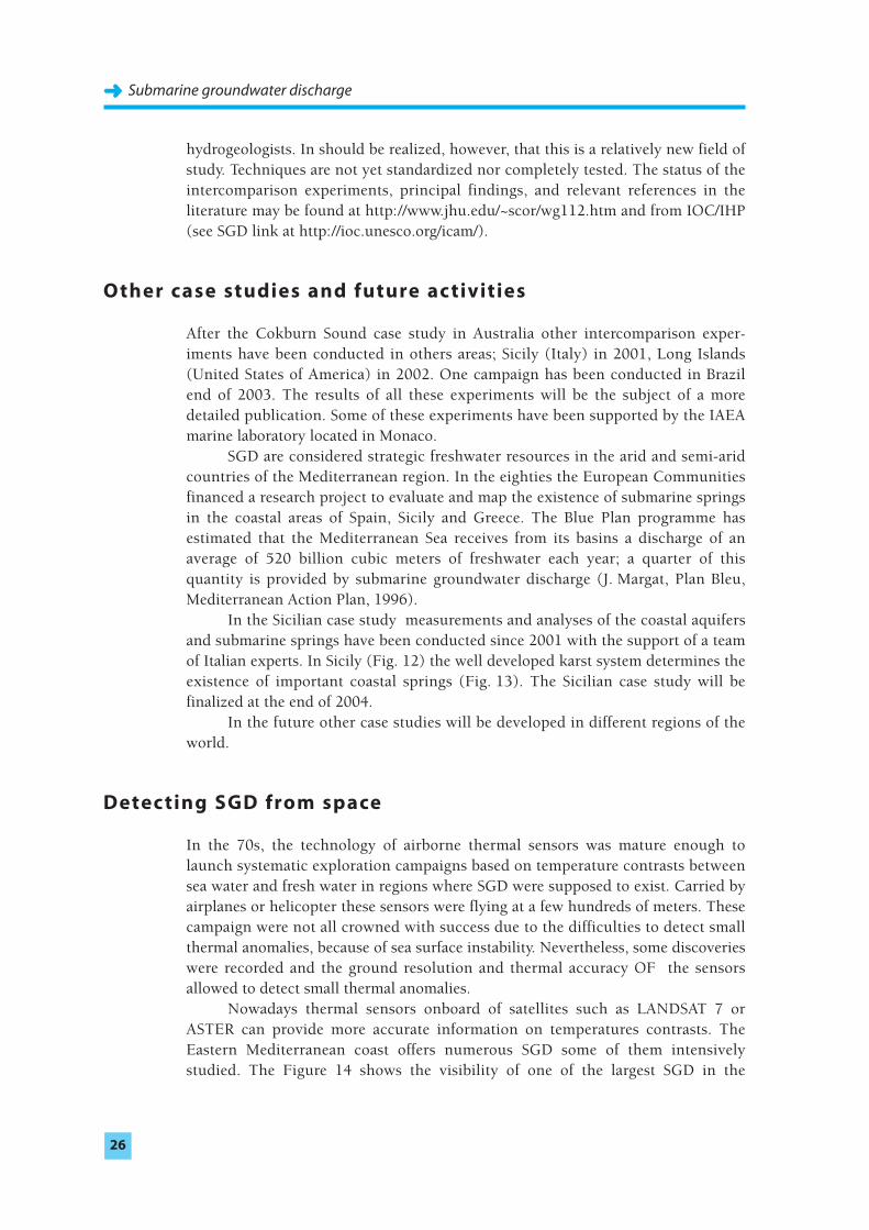
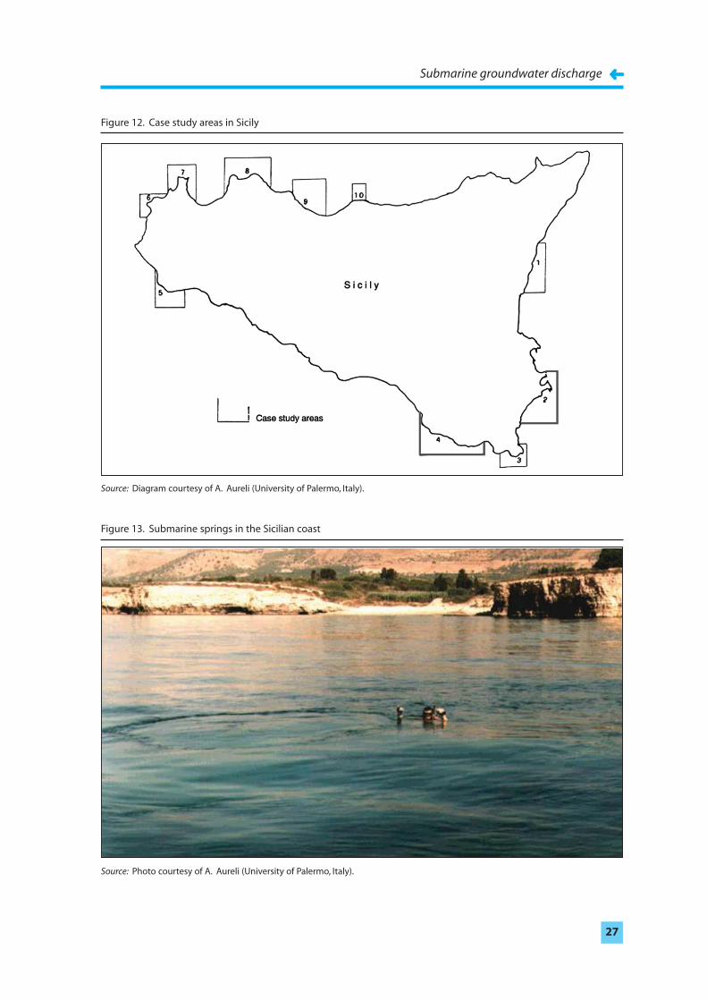
In the Sicilian case study measurements and analyses of the coastal aquifersand submarine springs have been conducted since 2001 with the support of a teamof Italian experts. In Sicily (Fig. 12) the well developed karst system determines theexistence of important coastal springs (Fig. 13). The Sicilian case study will befinalized at the end of 2004.
In the future other case studies will be developed in different regions of theworld.
Detecting SGD from space
In the 70s, the technology of airborne thermal sensors was mature enough tolaunch systematic exploration campaigns based on temperature contrasts betweensea water and fresh water in regions where SGD were supposed to exist. Carried byairplanes or helicopter these sensors were flying at a few hundreds of meters. Thesecampaign were not all crowned with success due to the difficulties to detect smallthermal anomalies, because of sea surface instability. Nevertheless, some discoverieswere recorded and the ground resolution and thermal accuracy OF the sensorsallowed to detect small thermal anomalies.
Nowadays thermal sensors onboard of satellites such as LANDSAT 7 orASTER can provide more accurate information on temperatures contrasts. TheEastern Mediterranean coast offers numerous SGD some of them intensivelystudied. The Figure 14 shows the visibility of one of the largest SGD in the
Submarine groundwater discharge➜➜
26
Submarine groundwater discharge
➜➜27
Figure 12. Case study areas in Sicily
Figure 13. Submarine springs in the Sicilian coast
Source: Diagram courtesy of A. Aureli (University of Palermo, Italy).
Source: Photo courtesy of A. Aureli (University of Palermo, Italy).
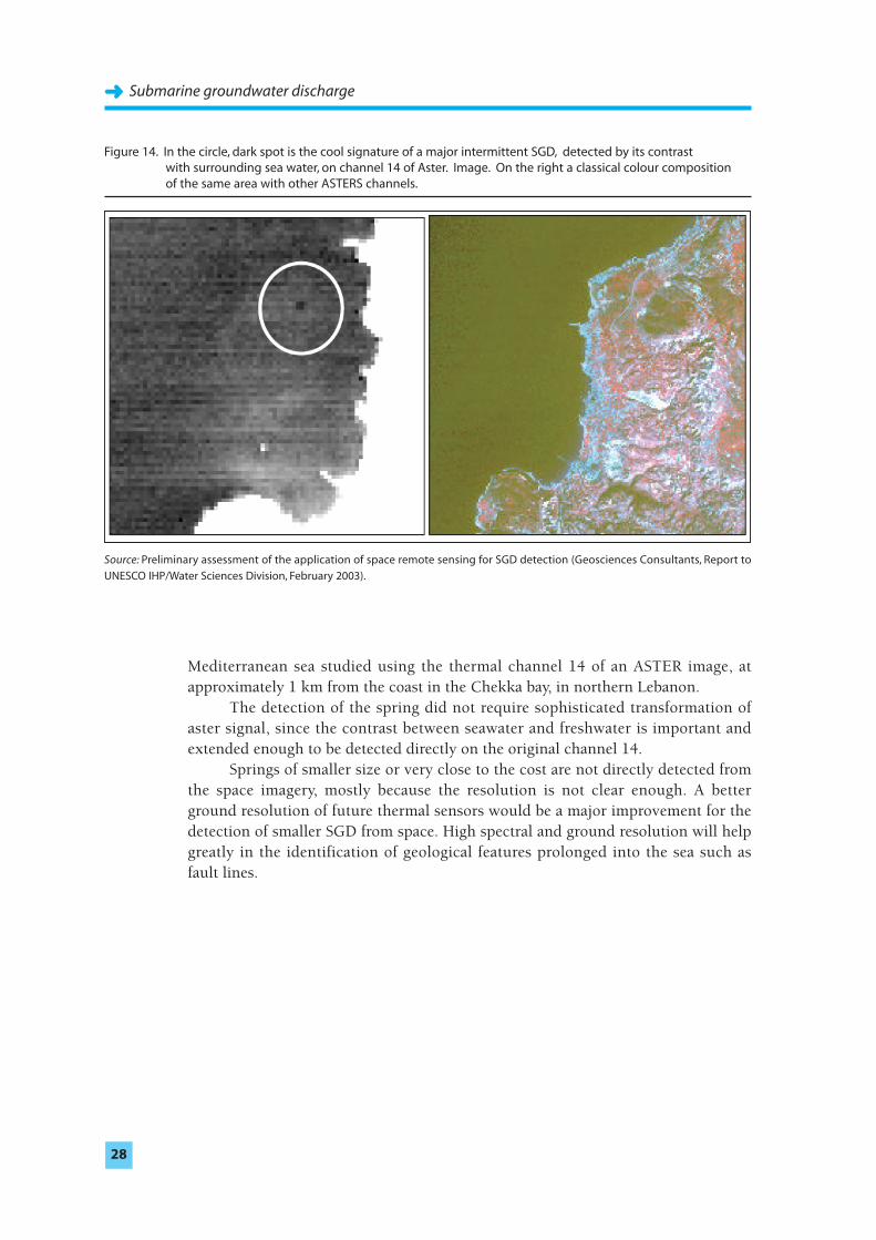
Mediterranean sea studied using the thermal channel 14 of an ASTER image, atapproximately 1 km from the coast in the Chekka bay, in northern Lebanon.
The detection of the spring did not require sophisticated transformation ofaster signal, since the contrast between seawater and freshwater is important andextended enough to be detected directly on the original channel 14.
Springs of smaller size or very close to the cost are not directly detected fromthe space imagery, mostly because the resolution is not clear enough. A betterground resolution of future thermal sensors would be a major improvement for thedetection of smaller SGD from space. High spectral and ground resolution will helpgreatly in the identification of geological features prolonged into the sea such asfault lines.
Submarine groundwater discharge➜➜
28
Figure 14. In the circle, dark spot is the cool signature of a major intermittent SGD, detected by its contrast with surrounding sea water, on channel 14 of Aster. Image. On the right a classical colour composition of the same area with other ASTERS channels.
Source: Preliminary assessment of the application of space remote sensing for SGD detection (Geosciences Consultants, Report to
UNESCO IHP/Water Sciences Division, February 2003).
Suggestions for further readingBOKUNIEWICZ, H. and PAVLIK, B., 1990. Groundwater Seepage along a Barrier Island.
Biogeochemistry, No. 10, pp. 257–276.
BUDDEMEIER, R. W. (ed.), 1996. Groundwater Discharge in the Coastal Zone: Proceedings of an International Symposium. LOICZ/R&S/96-8, iv+179 pp. LOICZ, Texel, TheNetherlands.
BURNETT, W. C.; TANIGUCHI, M. and OBERDORFER, J., 2001. Measurement and significance ofthe direct discharge of groundwater into the coastal zone. Journal of Sea Research,No. 46/2, pp.109–116.
CABLE, J. E.; BURNETT W. C.; CHANTON J. P. and WEATHERLY, G. L., 1996. Estimatinggroundwater discharge into the northeastern Gulf of Mexico using radon-222. Earth andPlanet. Sci. Lett., No. 144, pp. 591–604.
FREEZE, R. A. and CHERRY, J. A., 1979. Groundwater. Prentice-Hall, Englewood Cliffs, N. J.604 pp.
JOHANNES, R. E., 1980. The ecological significance of the submarine discharge ofgroundwater. Mar. Ecol. Prog. Ser., No. 3, pp. 365–373.
LEE, D. R., 1977. A device for measuring seepage flux in lakes and estuaries. Limnol.Oceanogr., 22, pp. 140–147.
MARGAT, J., 1996. Plan Bleu, Mediterranean Action Plan.
MOORE, W., 1996. Large groundwater inputs to coastal waters revealed by 226Ra
enrichments. Nature, No. 380, pp. 612–614.
MOORE, W. S., 1999. The subterranean estuary: a reaction zone of ground water and seawater, Marine Chemistry, No. 65, pp. 111–125.
VALIELA, I. and D’ELIA C., 1990. Groundwater inputs to coastal waters. Special IssueBiogeochemistry, No. 10, 328 pp.
ZEKSTER, I. S.; IVANOV V. A. and MESKHETELI A.V., 1973. The problem of direct groundwaterdischarge to the seas. J. Hydrol., No. 20, pp. 1–36.
Submarine groundwater discharge
➜➜29
Appendix
International Symposium
Low-lying coastal areas
Hydrology and integrated coastal zone management
9 – 12 September 2002, Bremerhaven, Germany
Low-lying coastal areas including small islands are among the most intensively usedregions in all countries. More than 60 % of today’s world population of approxi-mately six billion people live there. Coastal areas are not only among the mostdensely populated regions of the earth, they are also subject to extraordinarilyintensive use through industrial and commercial sites, agriculture, aquaculture andtourism. This intensive exploitation has considerable impact on hydrologicalconditions in coastal regions. Problems arise from conflicts between different usesof coastal land and waters, overexploitation of coastal resources, discharge of wastesand effluents into coastal waters, elevated risk of storm damage, increasing stress bysea level change and growth of coastal population.
The IHP/OHP National Committees of Germany and the Netherlands in co-operation with UNESCO, WMO and IAEA conducted this symposium inBremerhaven from 9 to 12 September 2002 to address emerging coastal zone issues.The aim of the symposium was to increase public and political awareness of thevulnerability of coastal zones and to discuss tools and measures for sustainablewater management in coastal areas at an expert level. Main topics of the symposiumwere tools for coastal zone management, groundwater and measures for integratedcoastal zone management. Keynote lectures introduced the focus of the conference.
The participants came from 20 countries and organisations like UNESCO,WMO, UN-ESCWA and the global change science community. The conferencesupported IHP-VI Focal area 3.4 Small islands and coastal zones. At the end of thesymposium the participants summarized their conclusions and made the followingrecommendations.
The Conference recognizes that
low-lying coastal areas are crucial to the development of nature and of society. They
• are heterogeneous domains, dynamic in space and time;• comprise less than 20% of the earth’s surface;• contain more than 60% of the human population;• are the location of 70% of cities with more than 1.6 million inhabitants;
Submarine groundwater discharge➜➜
30
• yield 90% of the global fisheries;• produce about 25% of global biological productivity;• host previous and fragile natural biotopes;• are the major sink for sediments;• are very vulnerable to natural hazards and the effects of climate change;• are areas where seawater intrusion threatens freshwater resources and where
submarine groundwater discharge is an important pathway for both fresh-
water and nutrients;• are a zone where integrated management is complex but achievable;• are areas where there should be strong commitment and support from
national governments and international organisations;• are a zone in which both freshwater and salt water play a paramount role;• pose considerable problems such as population growth, pollution and degra-
dation of natural resources. They are exposed to natural hazards, and theglobal climate change and sea level rise are likely to exacerbate many of theseproblems;
• will be affected by human efforts to adapt to the changing environmentalconditions.
The Conference agrees that
• a number of valuable scientific and operational tools, methodologies andmodels are available to address water-related issues in low-lying coastal areas;
• there is a strong need to integrate the available tools to solve the complexmultidisciplinary problems in integrated coastal zone management;
• there is a lack of easily available and easily accessible data on the hydrologicalcycle in low-lying coastal areas;
• submarine groundwater discharge is the expression at the sea floor of the processes that drive both salt water in and freshwater out under theshoreline. Although inseparable in nature, these two processes are currentlybeing investigated by separate groups using different methodologies;
• submarine groundwater discharge should be consistently and explicitlyintegrated into coastal water budgets;
• there exist possibilities to conduct multinational, multidisciplinary, multi-spatial and multitemporal research work to solve complex coastal problemsusing expertise, equipment, data and methodologies from various nations;
• great threats and water problems will be posed for low-lying coastal areas inthe near future;
• human adaptation to the consequences of global environment needs to beintegrated more strongly into existing frameworks of coastal planning inorder to build adaptive capacity and to avoid maladaptation;
• the conference has highlighted the need for a stronger integration of aspectsof social vulnerability into integrated coastal zone management (ICZM);
• knowledge management is important for the diverse and vast knowledgealready available.
Submarine groundwater discharge
➜➜31
The Conference recommends that
• UNESCO enhance its efforts, for example in education and training, tocontribute to a better understanding of all water-related processes which playan important role for a sustainable development of low-lying coastal areas.
• UNESCO further enhance the coordinated implementation of cross-cuttingprojects, and education and training activities between IHP, MAB, IOC, IGCP,CSI and MOST 1 under the leadership of IHP.
• UNESCO invite other GOs and NGOs to contribute to its water-relatedprojects in low-lying coastal areas.
• UNESCO take the initiative to establish regional sub-centres and make use ofthe expertise in the universities and advanced research centres of thenumerous (developing) countries for its various projects and activities.
• WMO encourage the strengthening and improvement of hydrologicalmonitoring in low-lying coastal areas.
• UNESCO/WMO explore methods to promote integrated approaches tocoastal zone management.
• UNESCO, in recognition of local, regional and global efforts towards theadvancement of coastal change sciences, establish and/or strengthen its linkswith the scientific community, e.g. the relevant programmes under the EarthSystem Science Partnership of IGBP, IHDP, WCRP and DIVERSITAS 2.
• UNESCO/WMO promote awareness of the key issues and approaches tocoastal zone management and uses knowledge management to developefficient communication strategies.
The Conference suggests the following activities and projects:
• The initiation of a project on submarine groundwater discharge that willinvestigate the pathways for freshwater and nutrients to the coastal zone inan integrated fashion. This can best be done by development of type or‘flagship’ sites for extrapolation to larger areas. These sites would becharacterized by joint studies using hydrological modelling, geophysics,geochemical tracers and other approaches.
Submarine groundwater discharge➜➜
32
1 IHP : International Hydrological ProgrammeMAB : Man and the BiosphereIOC : Intergovernmental Oceanographic CommissionIGCP : International Geological Correlation ProgrammeCSI : Coastal Regions and Small IslandsMOST : Management of Social Transformations Programme
2 IGBP : International Geosphere-Biosphere ProgrammeIHDP : International Human Dimensions Programme on Global Environmental ChangeWCRP : World Climate Research ProgrammeDIVERSITAS : An Integrated Programme of Biodiversity Science
• The initiation of a submarine groundwater recharge project to investigate theprocess, potential and possibilities for sustainable use of the coastal areas ofthe world. Studies could make use of remote and in situ data and the resultscould be published as a handbook of detailed investigations and later as anatlas.
• Specialized thematic workshops such as submarine groundwater discharge,salt water intrusion, remote sensing and GIS for ICZM, so that national levelspecialists could interact with international experts for further detailedresearch work.
• The initiation of projects and meetings which explore efficient mechanismsfor integrating scientific, engineering, social and institutional analyses of thecoastal zone to reduce conflicts and promote better management.
• The initiation of a project that will investigate the sediment transportsstarting from the catchment areas through the rivers to and along the coast,including the problem of coastal erosion.
• The development of ‘knowledge portals’ whereby a team is assigned to buildsuch portals. Possible topics are hydrogeomorphology, land use, socio-economic aspects and groundwater.
IHP/OHP-SekretariatBundesanstalt für GewässerkundeKaiserin-Augusta-Anlagen 15-1756068 KoblenzGermany
Submarine groundwater discharge
➜➜33
Contacts
Alice AureliUNESCO-IHP
Intergovernmental Hydrological Programme
1, rue Miollis
75732 Paris Cedex 15, France
Fax: (33) 1 45 68 58 11
Pradeep AggarwalIsotope Hydrology Section
International Atomic Energy Agency (IAEA)
Wagramer Strasse
P.O.Box 100
A-1400 Vienna, Austria
Fax: (43) 126007
Julian BarbièreUNESCO-IOC
Intergovernmental Oceanographic Commision
1, rue Miollis
75732 Paris Cedex 15, France
Fax: (33) 1 45 68 58 12
Bill BurnettSCOR/LOICZ
Department of Oceanography
Florida State University
Tallahassee, FL 32306-4320, United States of America
Fax: 850 644 2581
Pavel PovinecIAEA
Marine Environment Laboratory
19, Avenue des Castellans
BP 800, MC-98012 Monaco Cedex
Fax: (33) 92 05 77 44
Richard GuilladeDirector of Geosciences Consultants
157 rue des Blains
92220 Bagneux, France
Fax: (33) 1 46646161
Submarine groundwater discharge➜➜
34
Acknowledgements
SCOR is the leading non-governmental organization for the promotion and co-ordination of international oceanographic activities. SCOR does not have the resources to fund research directly; therefore, SCOR science activities focus on promoting international co-operation in planning and conductingoceanographic research, and solving methodological and conceptual problems thathinder research. Scientists from the thirty-seven SCOR member nations participatein SCOR working groups such as Working Group 112, ‘Magnitude of SubmarineGroundwater Discharge andits Influence on CoastalOceanographic Processes.’
The objectives of LOICZ (Land-Ocean Interactions in the Coastal Zone), a coreproject of the International Geosphere-Biosphere Program (IGBP), are to describeand understand the interactive physical, chemical and biological processes thatregulate the coastal zone portion of the Earth System, the environment provided for life, the changes occurring in the system, and the influences of human actions. The global network of LOICZ researcherscontributes scientific knowledge and skills to understandingmaterial fluxes and the controlling biogeochemical process in the coastal zone and the implications of human dimensions.
Submarine groundwater discharge
➜➜35