structural geology along the northwestern …...structural geology along the northwestern columbia...
TRANSCRIPT

WASHINGTON DIVISION OF GEOLOGY AND EARTH RESOURCES
Raymond Lasmanis, State Geologist
STRUCTURAL GEOLOGY
ALONG THE NORTHWESTERN
COLUMBIA RIVER BASALT MARGIN,
WASHINGTON
by
Newell P. Campbell
WASHINGTON DIVISION OF GEOLOGY AND EARTH RESOURCES
OPEN FILE REPORT 88-5
November 1988
This report has not been edited or reviewed for conformity with
Division of Geology and Earth Resources standards and nomenclature
•• WASHINGTON STATE DEPARTMENT OF
,,.,.,~-"' Natural Resources Bnan Boyle - Commissioner ot Public Lands Art Stearns - Supervisor


CONTENTS
Page
Summary. . . . . . . . . . . . . . . . . . . . . . . . . . . . . . . . . . . . . . . . . . . . . . . 1 Stratigraphy....................................... 1 Structural Geology................................. 2
Introduction.......................................... 4 Purpose............................................ 4 Location and Physiography.......................... 4 Previous Investigations............................ 7 Technique and Procedure............................ 7
Stratigraphy.......................................... 9 Introduction....................................... 9 Pre- Te rti a r:, Rocks......... . . . . . . . . . . . . . . . . . . . . . . . . 11
Chiwaukum Graben--Chelan block (Wenatchee area}. 11 Stuart block (Swauk Pass area) .•••••••••.••• ~ ••. 11 Manastash River block (Manastash and Taneum
River drainages)......................... . . . . . . 11 Rimrock Lake inlier (Tieton River drainage) .•... 11
Lower and Middle Tertiary Rock Units .•...••...•..•• 12 Chiwaukum Graben (Wenatchee area) •.•.••.•......• 12 Roslyn Basin (Swauk Pass to Cle Elum) ••••.•..... 14 Manastash River block ••.•••••.••..•.•••...••..•. 16 N aches Basin.................................. . . 16
Columbia River Basalt Group •.•.•••.••.•••••.••••... 18 Upper Ellensburg Formation .••••.••••.••••••...•.••. 19 Lan d's 1 i de Deposits. . . . . . . . . . . . . . . . . . . . . . . . . . . . . . . . . 19 Eastward Extent of Tertiary Sediments .••.•••...•••• 20
Structural Geology................................... 21 Introduction....................................... 21 Chiwaukum Graben (Wenatchee Area) •.•••..•.••••..•.• 23
Small Pre-Columbia River Basalt Faults ••.••••.•• 23 Normal faults ................................ 23 Thrust and high angle reverse faults .••...••• 24 Upward extent of faults •••••....•.•••.•.•.••. 24
Entiat and Eagle Creek fault systems ..•••.•...•• 24 Eagle Creek anticline ••••.•••...••..••••.....•.. 25 Vertical extent of Entiat fault •..•••••..•...... 25 Post-basalt faulting •••••..••••.•••..••.•.••••.. 26 Downward extent of post-basalt faulting ....•.... 26
Leavenworth Fault (Swauk Pass Area) ..•.•......•...• 27 Leavenworth fault system •.•••.••.•.•.••...•..••• 27 Post-basalt deformation •.•.••.••.•..•..•....•.•. 30
Faults Associated With The Straight Creek-Owl System (Cle Elum Area) •.•.•••..••.......•.••.....• 32
Small pre-Columbia River basalt faults .....••... 32 The Olympic-Wallowa Lineament •..••....•...•••..• 33 The Straight Creek Fault System ••...........•..• 33 Post-Basalt Faulting .••....•..•....••.....•..•.. 34
Naches-Little Naches River Area .•.........•...•.... 35
i i i

Rimrock Lake Area.................................. 39 Pre-Tertiary Faults ••••.•••••••••••••••••••••••• 39 Faults in Early and Middle Tertiary Rocks ••••••. 39 Post-Basalt Faulting •••••••••.••••••••.••••••••• 40
Summary and Recommendations For Further Study ••.•••••• 41 Ack now 1 edge men ts o o 9 •• o ••• o $ •• c ••• e • o •• f) •• o ••••••• o •• o • 4 3 References. 0 ••••• 0 ••• 0 ••• C, 0 C ••••• e. $ •••••••• 0 ••••••• 0. 44 Appendix I (Discussion of Unanswered Questions,
Area Tectonics)..................................... 53 True thickness of the Chumstick Formation •••••••••• 53 The Entiat fault: Its nature and possible
southern extent.................................. 54 Restricted occurrence of Chumstick and
Wenatchee rocks east of the Columbia River .•••••. 55 The Nature of the Leavenworth fault system ••••••••• 56 Extent of the Leavenworth fault system under
the bas alt .................... o o................. 57 Nature of the Olympic-Wallowa Lineament •••••••••••• 58 Naches River structural trend ..•••..•.••..••••••••. 59 Mechanism of deformation of the Columbia
River basalt at the margin •••..••••••••.••.••..•• 60 Appendix II (Locations and Comments of Critical
Exposures in the Study Area) ••••••••••••.•••••••• 62 Wenatchee quadrangle ••••••••••••••.••.••••••••••.•• 62 Wenatchee Heights quadrangle ••••••••••••••••••••••• 66 Monitor quadranglee .... 19 •••••••••••••••••• oe••••••• 68 Cashmere quadrangle •••••••.•••••••.•••••••••.•..••• 69 Rock Island Dam quadrangle •••••••••••••••••.••••••. 69 Rock Island quadrangle ••••••••••••••••••••••.•••••• 70 Malaga quadrangle ••••••••••••••••••••••••.••••••••• 70 West Bar quadrangleo ...................... 0 ......... 71 Mission Peak quadrangle ..•••••••••.••.•••••••.••••. 72 Li bert.Y quadrangle .......... o ........ f) o............ 76 Colockum Pass quadrangle ••••••••••••.••••.••••••••• 85 Thorp quadrangle . . o ••••••••••••••••• ~.............. 85 Cle Elum quadrangle •••.••••.•••••.••••.••••••...•.• 85 Easton quad ra ngl e.................................. 89 Manastash Lake quadrangle .•••••.••.••••••••••••...• 92 Cliffdell quadrangle •••.•••••••••••••••••••.•..•••• 93 Old Scab Mtn. quadrangle .••.••••••.••.••••••••••••• 97 Timberwolf Mtn. quadrangle ••••..•....••.•..•.••.••• 99 Meeks Table quadrangle •••••••••....•.••.••..••••••• 99 Nile quadrangle.................................... 100 Rimrock Lake quadrangle .•••••••••••••••.••..•••.•.• 100 Foundation Ridge quadrangle ••••••..••••.••••••.•.•• 101 Darland Mtn. quadrangle .•••..••.••.••••••.••••.•..• 101
Appendix Illo •••••••• o ••••• "ll•••oo••••oo•••••••••••••• 103 Rock uni ts .. e •• 0 0. 0. 0 ... 0 •••• CC ••• 0 ••• 0 •••••• 0..... 103 Map coverage of study area •••.......•••••..•.•..... 106 Map S.Ymbols ........ c•••o••························· 107 Correlation chart •.•••••.••••••.....•••.•...•••••.. 108
i V

Figure 1
Figure 2
Figure 3
Figure 4
Figure 5
Figure 6
Figure 7
Figure 8
Figure 9
Figure 10
Figure 11
Figure 12
Figure 13
Figure 14
Figure 15
ILLUSTRATIONS
Location map of the study area .••..••••...•••••
Map of the northwest Columbia River basalt margin showing major structural
Page
5
elements..................................... 6
Stratigraphic correlation chart of rock found along the northwest Columbia River basalt margin ............................... .
Proposed models explaining movement on the Leavenworth fault ................... o ••••••••
Stream drainage and structure map on both sides of the Naches River structural
10
31
trend......................................... 36
Diagrammatic profiles across the Naches River structural trend....................... 38
Sketch map of contact between Wenatchee and Chumstick Formations at East Wenatchee....... 65
Photo of pitcher syncline along Squilchuck Creek........................................ Pl ate 1
Photo of headwall of a recent landslide on lower Stemilt Creek showing exposed rock uni ts........................................ Plate 1
Photo of recent landslide and diamictite capping Wenatchee and Chumstick Formations, lower Stemilt Creek .•.•••.••••••. Plate 1
Photo of fault near Rock Island Dam ••.•...•••.. Plate 1
Photo of close up of fault at Rock Island Dam ................................... Plate 1
Photo of small faults cutting basalt on Badger Mountain.............................. Plate 1
Photo of west rim of Badger Mountain showing lack of faulting ••.•.•.••.•• ~ ••..•... Plate 1
Photo of panorama of Wenatchee area from Alcoa Peak................................... Plate 1
V

Figure 16
Figure 17
Figure 18
Figure 19
Figure 20
Figure 21
Figure 22
Figure 23
Figure 24
Figure 25
Figure 26
Figure 27
Figure 28
Figure 29
Figure 30
Figure 31
Photo of fault crossing Jumpoff road near Laure 1 Hi 11 .•....•...........•....••.....•.. G Plate 1
Photo of Tarpiscan fault along lower Tarpiscan Creek •••••••••••••••••••••••••••••• Plate 1
Sketch showing Swauk and Chumstick Formations, near the Mission Ridge ski area Chalet ••••..•••.•.....•.••••..•... e..... 7 3
Photo of shearing in Chumstick Formation megaconglomerate, Mission Ridge ski area •.••. Plate 2
Small faults in Chumstick Formation, Mission Ridge ski area road.................. 75
Photo showing possible fault north of Mission Peak •• &C,•••••oe••••«>•••••••••••e••••o Plate 2
Photo showing fault offset east of the Mission Ridge ski area •.•••••••••••.••••••••• Plate 2
Photo of Mission Peak as seen from E 11 e nsburg................................... Plate 2
Interpretive profile sketch of rocks and structure along Fifes road................... 77
Sketch map of fault locations on lower Ruby Creek................................... 79
Photo of Chumstick Formation megaconglomerate on Tiptop road ••••.••.•..... Plate 2
Interpretive profile sketch of the structure and rocks in the Ruby Creek area......................................... 82
Possible fault near Road 1205, Table Mountain area................................. 83
Photo of view of Rosenmeier fault from Road 2008G ..............•........•........... Plate 2
Photo of two faults cutting Swauk Formation rocks, Road 2102, Liberty area .••.• Plate 2
Photo of Easton Ridge from Peoh Point showing splays of the Straight Creek f au 1 t •............................ o.......... Pl ate 2
vi
Figure 32
Figure 33
Figure 34
Figure 35
Figure 36
Figure 37
Figure 38
Figure 39
Figure 40
Figure 41
Figure 42
Figure 43
Figure 44
Figure 45
Figure 46
Photo of Columbia River basalt margin seen from Peoh Point........................ Plate 3
Photo looking northeast from above Manastash Ridge showing the basalt margin •••• Plate 3
Sketch of small fault in Manastash Formation rocks, Taneum Creek................ 87
Photo of linear depressions in Columbia River basalt on Manastash Ridge ••.••••.••..•• Plate 3
Near-vertical Columbia River basalt at Longmire meadow, Little Naches River......... 91
Photo of Devils Slide and exposures of Fifes Peak volcanics, upper Milk Creek ••....• Plate 3
Photo of folding in Fifes Peak Formation and the Columbia River Basalt Group along Roe k Creek................................. . . Plate 3
Photo of looking northwestward along the Naches River at remnants of the Edgar Rock volcano................................. Plate 3
Photo of upper Umtanum Ridge showing Columbia River Basalt Group-Naches Formation relationships •.•••••.••••.•••...•.. Plate 3
Photo of small fault in Naches Formation rocks along Milk Creek road •••••.••••••••.•.• Plate 4
Photo of small fault(?) juxtaposing Columbia River basalt and Fifes Peak volcanics, upper Nile Creek •.•••.••.•••.••••. Plate 4
Diagrammatic sketch showing Fifes Peak Formation rocks, upper Nile Creek............ 98
Photo of fault offsetting basalt near Little Bald Mountain .••..•.••...••.•.•....... Plate 4
View looking eastward at Cleman Mountain and associated fault •••.••.••..•..•.••..••••. Plate 4
Photo of Divide Ridge and Rimrock Lake showing rock units........................... Plate 4
Vii
Figure 47
Figure 48
Figure 49
Photo of view from above Wildcat Creek showing dissimilar folds in Columbia River basalt and Fifes Peak Formation along Bethel Ridge ••••••••••••••••••••••••••• Plate 4
Photo of rock units visible on Bethel Ridge as seen from Wildcat Creek drainage ••.• Plate 4
Photo of Divide Ridge between Blue Slide and Darland Mtn. seen from Bear Creek road ••• Plate 4
viii

Table 1
Table 2
Table 3
P 1 ate 1
Plate 2
Plate 3
Plate 4
Plate 5
Plate 6
P 1 ate 7
Plate 8
TABLES
Comparison chart of Tertiary sedimentary rock units.
Abbreviated discussions of major structural elements used in this report.
Characteristics of faults within the Leavenworth fault zone.
PLATES
Page
13
22
28
Figures 8, 9, 10, 11, 12, 13, 14, 15, 16, and 17
Figures 19, 21, 22, 23, 26, 29, 30, and 31
Figures 32, 33, 35, 37, 38, 39, and 40
Figures 41, 42, 44, 45, 46, 47, 48, and 49
Geologic map of the northeastern portion of the study area: Cashmere, Rocky Reach Dam, Monitor, Wenatchee, Rock Island, Malaga NE, Mission Peak, Wenatchee Heights, Malaga, Rock Island Dam, Naneum Canyon, Colockum Pass, Stray Gulch, and West Bar 7.5' quadrangles.
Geologic map of the east-central portion of the study area: Liberty and Thorp 15 1 quadrangles.
Geologic map of the west-central portion of the study area: Cle Elum and Easton 15' quadrangles.
Geologic map of the southwestern portion of the study area: Old Scab Mtn., Cliffdell, Manastash Lake, Timberwolf Mtn., Meeks Table, Nile, Rimrock Lake, Tieton Basin, Weddle Canyon, Darland Mtn., and Foundation Ridge 7.5' quadrangles.
ix


SUMMARY
This study examines the structural geology along the northwestern margin of the Columbia River basalt between Wenatchee and Darland Mountain, west of Yakima {Fig. 1). The objective of this report is to compare structures in the Columbia River Basalt Group with pre-basalt structures including those in the Chiwaukum graben; the Leavenworth, Entiat, and Straight Creek fault zones; and the White River-Naches River structural trend.
Field work for this study, from 1983 to 1985, involved mapping and compilation in 41, 1:24,000 quadrangles. All previous mapping was re-plotted at this scale for ease in interpretation {Appendix III).
Stratigraphy
Stratigraphy in the study area is complex and varies considerably from north to south along the basalt margin due to a series of sedimentary basins that existed in early Tertiary time. The basins are now roughly separated by a seri~s of tectonic "blocks" or uplifts exposing pre-Tertiary rocks {Fig. 2). In this report, three basins, the Chiwaukum, Roslyn, and Naches basins, contain thick Tertiary sedimentary and volcaniclastic rocks separated by the adjoining Stuart, Manastash, and Rimrock blocks. Figure 3 provides a gross stratigraphic correlation across the basins along the basalt margin.
The early Tertiary sedimentary record north of the White River-Naches River structure is dominated by fluvial-deltaic sediments that exhibit similar characteristics in the field. The Naches, Manastash, Swauk, Roslyn, Chumstick, and Wenatchee Formations are often indistinguishable in small outcrops {or well cuttings) leading to confusion in unraveling the structural setting.
South of the White River-Naches River structure, volcanics comprise much of the pre-basalt section. Fluvial-deltaic sediments of early Tertiary age are limited to isolated outcrops between underlying pre-Tertiary metamorphics and overlying volcaniclastics of the Ohanapecosh, Stevens Ridge, and Fifes Peak Formations.
1

Pre-basalt rocks seen along the northwest margin extend far beneath the Columbia River basalt and can be correlated with rocks encountered in exploratory gas wells recently drilled by Shell Oil Company. Volcaniclastics of Cascade province origin are mostly limited to the west side of the Naneum-Hog Ranch axis but fluvial-deltaic sediments extend at least 80 km southeast of the basalt margin.
Structural Geology
Deformation along the basalt margin is more complicated with increasing age. Although faults occur along the entire margin, they are concentrated in five distinct areas: the Chiwaukum graben, the Leavenworth fault system, the Straight Creek-Olympic-Wallowa lineament (OWL) system, the Little Naches-Naches River area, and the Rimrock Lake region. In spite of the intense deformation of pre-basalt rocks, few faults displace Columbia River basalt at the margin--there are far fewer faults than in the interior of the Yakima fold belt. Folding in basalt at the margin is subdued with dips usually less than 5 degrees. The orientation of fold axes in basalt often does not align with pre-basalt fold axes.
Deformation in the Chiwaukum graben consists of high angle faults of moderate displacement and associated tight folds. None of the faults, including the Entiat fault, continue into Columbia River basalt. However, one major fault (Tarpiscan thrust) does displace basalt south of the margin and may extend northward into pre-basalt rocks near Wenatchee.
The Leavenworth fault system marks the southeast edge of the Chiwaukum graben. This fault displaces Columbia River basalt for a few kilometers to the southeast but vertical offset is only a few meters. The Leavenworth fault in pre-basalt rocks appears to extend under the Columbia River basalt, turning south and becoming part of the Naneum-Hog Ranch cross-structure. This cross-fold continues at least as far south as Rattlesnake Ridge (Fig. 2).
The Straight Creek fault turns southeastward toward the basalt margin and splays into a series of high-angle faults that pass under the Columbia River basalt, aligning with northwest-southeast trending basalt folds. Only one splay, the Taneum Lake fault, displaces basalt and continues as the Manastash Ridge fault. This part of the margin is the only part of the study area where pre-basalt and post-basalt structures are in alignment.
2

The relationship between the Olympic-Wallowa lineament and the Straight Creek fault is unclear. Splays of the Straight Creek fault produce uplifted blocks that compare in orientation to the northwestern segment of the Cle Elum-Wallula lineament (CLEW) and can account for the northwest-southeast orientation of the Yakima folds without involving the OWL (at least as far south as the Naneum-Hog Ranch axis).
Topographic alignment of the Naches and Little Naches Rivers is due to a major cross-Cascades feature, the White River-Naches River structural trend. The two rivers form a straight valley system due to faulting that separates two terranes of dissimilar structure, stratigraphy, and topography. Folds and faults to the northeast show northwest-southeast alignment in both basalt and pre-basalt rocks. Southeast of the White River-Naches River structural trend, pre-basalt structures run nearly north-south while Columbia River basalt folds and faults trend east-west. The White-Naches trend continues southeastward displacing the Columbia River basalt at least as far as Naches (Figs. 2, 5, and 6).
In the Rimrock Lake area, a displaced terrane, known as the Rimrock inlier, marks the southernmost exposures of pre-Tertiary rocks in the Cascade Range. This highly sheared metamorphic complex (ophiolite?) is in direct contact with Columbia River basalt in the Darland Mountain area.
This study raises several questions concerning area tectonics. Discussions of unanswered questions are addressed in Appendix I. Topics include:
Chumstick Formation thickness and occurrence
Nature of the Entiat Fault Motion and extent of the Leavenworth
fault zone Location and extent of the OWL The White River-Naches River
structural trend Mechanism of deformation of the
Columbia River basalt at the margin
Locations and comments of critical exposures referred to in the report are described in Appendix II.
3

INTRODUCTION
Purpose
The portion of central Washington encompassing the northwestern boundary of the Columbia River basalt has been previously studied by numerous workers. These studies, carried out over a 90-year span, embrace a wide variety of geologic topics and include numerous discussions and conflicting ideas concerning the structural geology.
The objective of this study is to examine the structural geology of the area along the northwestern margin of the Columbia River basalt and determine the effect of pre-basalt structures on the Columbia River Basalt Group and to compare the orientation of pre-basalt and post-basalt folds and faults. This report will examine closely the Chiwaukum graben, the splays of the Straight Creek fault system, the Olympic-Wallowa lineament, and the Naches River-White River structural trend and associated features. These features may extend far under the Columbia River basalt; therefore, it is important to examine the deformation along the basalt margin in detail. These structures are also of importance because of the recent interest in the mineral resource potential of the Columbia Basin. Both pre-basalt and post-basalt deformation may have played a major role in localizing hydrocarbons under the basalt.
A considerable number of tectonic models exists for the evolution and deformation of the Columbia Basin. Although this study makes no attempt to propose a new tectonic model, it is hoped that some of the material presented will help to improve and upgrade existing models.
In view of differences in mapping and other concepts from previous work, it is necessary to review recent work in the area. This report does not attempt to revise previous geologic mapping (generally very good) except for those problems and conflicts which directly affect the position and age of faulting in the study area.
Location and Physiography
The study area includes that portion of Washington covered by the following 1:100,000 maps: southeastern segment of the Chelan sheet; eastern part of the Wenatchee sheet; eastern half of the Mt. Rainier sheet; and the western part of the Yakima map. The area lies generally southwest of Wenatchee and west of Yakima, Washington (Fig. 1), and includes parts of the Wenatchee Mountains, Naneum, Jumpoff, Manastash, Umtanum, Bethel, and Divide Ridges (Fig. 2) (1:24,000 map coverage is shown in Appendix III).
4

/ /
/ /
/ /
/
// STUDY AREA
WASHINGTON
0 10 20
\ \ \ \ \
30
KILOMETERS
47°30'
Figure 1 Location map of the study area.
5

Figure 2
I.EGENO
METHOW GRABEN
__.__ ,--f- ftJCIINj..,_(lllllY .. P--=o ..... J
.,_,!,,,.,__ l'AUl.f ..... ~aac« 0 _.,.
NACHES RIVER
"BASIN"
Generalized geologic map of the Yakima Fold Belt in the northwest part of the Columbia Basin showing rocks and major structural elements. Descriptions of these features are given in the text (Table 2) and i n Append i x I .
6

Elevations range from 2127 mat Darland Mountain to less than 250 m along the Columbia River south of Malaga. The vegetation varies from sagebrush and grass in the eastern, lower part to thick timber cover at higher elevations.
The northern half of the study area is completely covered by the Tabor and others (1982) 1:100,000 Wenatchee geologic map. The southern half includes a wide variety of geologic mapping at various scales (discussed below). Three maps are used to provide most of the base geology for Part II; Bentley (1977), Frizzell and others (1984) and Niesen and Gusey (1983).
Previous Investigations
Russell (1893, 1900), Smith (1903) and Smith and Calkins (1904, 1906) did the first geological mapping in the area and developed an early stratigraphy. More detailed geology was established during the period 1930-1970. Among the publications relevant to this study are: Abbott (1955), Alexander (1956), Chappell (1936), Foster (1957 and 1960), Rector (1962), Stout (1964), Fiske and others (1963), Swanson (1964 and 1967), Rosenmeier (1968), Willis (1953) and Waters (1932).
More recently many geological studies, especially thesis work, have been conducted. Detailed wo~k on the stratigraphy includes: Buza (1977, 1979), Ellingson (1972), Frizzell (1979), Frizzell and Tabor (1977}, Gresens (1976a, 1977, 1978), Gresens and others (1977, 1981), Hammond and others (1977}, Hauptman (1983}, Luker (1985), Schreiber (1981}, Swanson (1964, 1967), Swanson and others (1979), Walker (1980}, Tabor and Frizzell (1977}, Tabor and others (1984}, Whetten (1976), and Shultz (1987). Structural analyses and interpretations by Bayley (1965}, Bentley (1977), Gresens (1976b, 1979, 1980, 1982a}, Kienle and others (1977), Goetsch (1978), Johnson (1983), Rosenmeier (1968), Tabor and others (1982, 1984} and Tabor (1986) added to current knowledge of the area. Swanson (1974, 1977), Hammond (1980), Bentley and others (1980), Clayton (1980), Gresens (1975, 1983), Laravie (1976), Tabor and others (1982), Swanson (1978), Swanson and Clayton (1983), Niesen and Gusey (1983), Frizzell and others (1984), Waitt (1978), and Whetten (1980) mapped in the area while Gresens (1983), Lewellen and others (1985), Patton and Cheney (1971), and Simmons and others (1974) discussed economic mineral deposits.
Technique and Procedure
Work began in March 1983 and continued into September 1985. This project used the Wenatchee 1:100,000 geologic map by Tabor and others (1982) as the base map for the northern one-third of the area and the Niesen and Gusey (1983} reconnaissance geologic
7

map as the base for the southern part. (This unpublished map is a combination of all previous geologic mapping plus some original mapping within the Naches Ranger District plotted on a 1 inch= 1 mile fireman's map.) The Washington Public Power Supply System maps by Bentley (1977) and the Frizzell and others (1984) map are used to show areas not covered by the above two maps.
The above map data have been enlarged and plotted at the 1:24,000 scale for field use and ease in reading (Appendix III). It was necessary to add some detailed mapping where critical structural conditions existed but, in general, previous mapping was adequate for this study.
The following summarizes the procedure used to examine the structural geology of the area:
1. Prior to field work, all known faults were examined using high resolution aerial photos provided by Rockwell Hanford Corporation and Battelle Northwest, Richland, Washington.
2. All known geology is plotted at the 1:24,000 scale. Faults are coded in order to separate faults mapped by each previous worker. These include: Bentley (1977), Frizzell and others (1984), Goetsch (1978), Gresens (1983), Lewellen and others (1985), Miller (1985), Niesen and Gusey (1983), Schreiber (1981), Shultz (1987), Swanson (1964 and 1967), and Tabor and others (1982), Walker (1980). Lineaments obtained from photo examination are also shown.
3. Field studies were conducted to become familiar with all rock unit lithologies and to examine previously mapped structures. Locations critical to the study are plotted on the maps with a location number. The geology at each location is described in detail in Appendix II.
8

STRATIGRAPHY
Introduction
The stratigraphy of the study area, especially the early Tertiary sedimentary units, is complicated and only moderately well understood. Numerous papers written on the stratigraphy in this area have tended to confuse the problem. This may have been the result of working only small areas without studying the entire regional stratigraphy. Fortunately, an important publication emphasizing regional stratigraphy (Tabor and others, 1984) resolved many of the correlation problems in the northern half of the study area. There are no similar reports on the southern part of this project.
Stratigraphic units vary considerably from north to south along the basalt margin. This is due to a series of sedimentary basins that existed in early Tertiary time {and perhaps in pre-Tertiary time). At present, the basins are roughly separated by tectonic "blocks" or uplifts more fully described in the Structural Geology section below. In general, older rock units and thinner sedimentary sections are found in the uplifted blocks while thicker, younger deposits occupy the basins in between. Along the basalt margin discussed in this report three basins, the Chiwaukum graben, the Roslyn basin (Teanaway River block of Tabor and others, 1984) and the Naches basin {north part is the Cabin Creek block of Tabor and others, 1984) contain thicker early Tertiary sediments while the adjoining uplifts, the Chelan, Mt. Stuart, and Manastash River blocks (Tabor and others, 1984), and the Rimrock Lake inlier (Miller, 1985) expose pre-Tertiary rocks (Fig. 2).
(Although the term graben is used exclusively in previous literature, the Chiwaukum graben is not a true graben in strict structural terms. A better name, based on evidence presented below, is Chiwaukum basin. However, in keeping with previous descriptions, the word graben will continue to be used in this report.)
Figure 3 shows stratigraphic sections in basinal areas and attempts to provide a gross stratigraphic correlation across blocks and basins along the basalt margins (see also Appendix III correlation chart). It is beyond the scope of this paper to revise or correct the present stratigraphic nomenclature. General descriptions of major rock units for each basin are presented below. For more details, the reader is referred to Hammond and others (1977) and Tabor and others (1982, 1984).
9

M.Y. 16 _
18 _
20_ 22_
24_
26_ 28 _ 30_ 32_
34_
36_ 38_
40_ 42_
44_
46_ 48_ 50_ 52_ 54_
Naches Basin Roslyn Basin 2
1 Counbia River 1
r Basalt Group :
FIFES PEAK
FORMATION STEVENS
RIDGE
FORMATION
: Columbia River : 1 Basalt Group 1
WILDCAT CREEK FACIEi+/ I HUCKLEBERRY MOUNTAIN
? FACIES r--·---,
SPENCER
CREEK
ROCKS
? LOOKOUT OHANAPECOSH
sito!~~NE FORMATION I ?=i_?_J
FROST MT. BASALT
TANEUM
FORMATION
MANASTASH FORMATION
_?_ ~~, ASTASH
~TION
r-?--, I ROSLYN I
I FORMATION I
LJ TEANAWAY
FORMATION
SILVER PASS VOLCANICS
Chiwaukum Graben
WENATCHEE FORMATION
: Columbia River ; 1 Basalt Group 1
PRE - TERTIARY BASEMENT ROCKS
RUSSELL RANCH FORMATION [ 120 J
STUART BATHOLITH? [93]
INGALLS COMPLEX? (150]
Figure 3
INDIAN CREEK GNEISS [155]
INGALLS COMPLEX? (150]
SWAKANE GNEISS ? [>600]
l MANASTASH RIVER AND CABIN CREEK BLOCKS OF TABOR AND OTHERS [1984]
2 SWAUK BASIN I JOHNSON, 1985)
Stratigraphic correlation of pre-basalt rock units found along the northwest Columbia River basalt margin. Numbers are in millions of years. Modified from data by Vance and others (1987), Johnson (1985), Tabor and others (1982, 1984). Gresens (1983), Schreiber (1981), Walker (1980).
10

Pre-Tertiary Rocks
Chiwaukum Graben-Chelan Block (Wenatchee Area)
The Swakane Biotite Gneiss is the basement rock underlying the Wenatchee area. The Swakane Biotite Gneiss is exposed north of the city in the southern part of the Chelan block and extends for an unknown distance westward under the Chiwaukum graben. Waters (1932) described the Swakane Biotite Gneiss in detail. The rocks are strongly foliated and deformed fine-grained gneiss containing quartz, plagioclase, orthoclase, and biotite, and weathering a light red-brown.
Stuart Block (Swauk Pass Area}
The oldest rocks in the Swauk Pass area--between the Chiwaukum graben and the Roslyn "basin"--are the Ingalls metamorphic complex and the Mount Stuart batholith, both of Mesozoic age. The Mount Stuart batholith lies northwest of the study area but granodiorite clasts, assumed to be from the intrusion, can be found in the Swauk and Chumstick conglomerates in the Swauk Pass area. Serpentinite, peridotite, and metasedimentary or metavolcanic rocks of the Ingalls complex are exposed at the western edge of the area; clasts from these rocks occur in conglomerates of the Swauk Formation.
Manastash River Block {Manastash and Taneum River Drainages)
Within the Manastash River block are schist, amphibolite, metagabbro, and quartz diorite of pre-Tertiary age. These units have been given various names and positions such as the Easton schist (Stout, 1964), the Lookout Mountain Formation (Bentley and others, 1977), the "amphibolite unit" (Goetsch, 1978), and "low-medium grade metamorphic rocks" (Tabor and others, 1984). Pre-Tertiary rocks are further complicated by tectonic shearing and mylonitization which has produced greenstones, serpentinites, and other deformed rocks. The age and correlation of these rocks with others in the study area are unknown. Tabor and others (1982) suggest an age of pre-Jurassic for the schists.
Rimrock Lake Inlier (Tieton River Drainage)
South of the Manastash River block along the basalt margin, other pre-Tertiary rocks occur south of the Naches basin and along the flank of the Goat Rocks area. These rocks are termed the Rimrock Lake inlier by Miller (1985). These pre-Tertiary rocks include: the Indian Creek gneiss and amphibolite, the Russell Ranch Formation, the Peninsula plagiogranite, and an unnamed greenstone that is probably part of the Russell Ranch Formation (Swanson, 1978). The entire section may be part of an ophiolite sequence. The Indian Creek gneiss and amphibolite is
11

dated at 155 m.y. (Hammond and others, 1977). The Russell Ranch Formation is made up of argillite, graywacke and greenstone. Clayton (1983) and Miller (1985) report a Jura-Cretaceous age for the Russell Ranch Formation. The Peninsula plagiogranite (tonalite and trondhjemite) is of unknown age (Swanson, 1964). All four units are apparently in fault contact with each other so that stratigraphic relationships are unknown.
Lower and Middle Tertiary Rock Units
Chiwaukum Graben (Wenatchee Area)
Several authors, notably Gresens (1983, 1977, 1975), Tabor and others (1982), Whetten and others (1977), Gresens and others (1977), and Patton and Cheney (1971), have described the sedimentary rocks in the immediate Wenatchee area. Several discrepancies exist in rock unit nomenclature. Patton and Cheney (and all previous reports) include all Tertiary sedimentary rocks in the Swauk Formation whereas Tabor and others subdivide the sedimentary sequence into Chumstick and Wenatchee Formations, while Gresens recognizes three units--Swauk, Chumstick and Wenatchee.
The early and middle Tertiary sedimentary rocks around Wenatchee (here restricted to the Chiwaukum graben northeast of the Leavenworth fault) are difficult to distinguish in the field. Large scale exposures can be identified, but in small outcrops, especially those involved with landslides, identification becomes much more difficult. Table 1 summarizes the characteristics of the three formations (see Tables in Gresens, 1983, for additional data). The Chumstick and Wenatchee Formations can usually be distinguished, but there is a problem identifying the Swauk (?) Formation of Gresens (1983). The Swauk (?) Formation near Wenatchee is distinctly different from the Swauk west of the Leavenworth fault near Swauk Pass. I am unable to tell Gresens' Swauk (?) Formation from Chumstick rocks in the Wenatchee area. In addition to the differences shown in Table 1, conglomerates in the Swauk (?) compare closely with those of the Chumstick. Both contain clasts of coarse gneiss and granitics but are lacking metasediments common in the Swauk Formation to the west. Secondary alteration of feldspar and mica in Chumstick rocks can produce a rock similar to the Swauk (?) of Gresens. In my opinion, the "Swauk (?)" at Wenatchee is part of the Chumstick and may be:
a facies derived from local erosion
material moved in by a landslide during Chumstick time
Chumstick slightly altered by hydrothermal fluids during the emplacement of the gold and quartz veins.
12

Table 1. Comparison Chart of Tertiary Sedimentary Rock Units*
GRESENS' SWAUK (?) CHARACTERISTICS WENATCHEE FORMATION CHUMSTICK FORMATION FORMATION (WEN. AREA) SWAUK FORMATION ROSLYN FORMATION
Aqe Earl_y 01 i qocene Mid-Late Eocene Mid-Eocene(?) Early Eocene Mid-late Eocene
Date 34 my (fission tr.) 45 my (fission tr.) none 50 mv (fission tr.) (?) 46
Position (with angular unconformity angular unconformity angular unconformity fault contact only angular unconformity respect to other or fault contact or fault contact or fault contact except for Roslyn only(?) units) only onlv onlv
Attitude (dip) qentle to moderate steep steep oentle to steep gentle to moderate
Sandstone Color white to light grey ye 11 ow, buff, 1 ight grey light-medium grey white to ye 11 ow white-grey and brown
Associated Shale red and grey dark grey to black few dark grey abundant dark grey grey-black, Color varigated carbonaceous (few carbonaceous to black abundant coal
1 iaht brown) carbonaceous
Feldspar Type low percentage potassium feldspar potassium feldspar both plagioclase potassium feldspar plagioclase common absent and k-spar abundant
Mica Type large muscovite biotite abundant, biotite abundant, biotite abundant, biotite common(?) flakes, little or no fresh to partly completely fresh to partly biotite, low chloritized chloritized altered weathering
Carbonate matrix usually free matrix will often matrix may effervesce usually carbonate carbonate free of calcite effervesce free (occasional caliche)
Other Features minor tuff and zeolitic and no zeolites or tuffaceous in some tuffs in tuffaceous shales tuffaceous in lower tuffs (?) upper part lower part (?)
part
Maximum Thickness 300 m 7,000 m (?) unknown 2,200 m + 2,500 m +
Agent of mostly fluvial lacustrine and fluvial fl uvia 1 fluvial and Deposition fluvial lacustrine
*Data gathere·d from various publications.

Since all of the Swauk (?) identified by Gresens lies in or near the mineralized Wenatchee gold district, the last explanation seems the most logical.
The "Swauk (?)" is in part bounded by thrust faults {Gresens, 1983; Patton and Cheney, 1971). I was unable to examine the thrusts in detail near the L-D Mine due to access problems but the thrusts, if they exist, cannot have vertical displacements of more than a few hundred meters (confirmed by Gresens, 1983). It is difficult to imagine a thin wedge of Swauk in an imbricate thrust zone brought up through at least 1500 m of Chumstick Formation. Tabor and others (1982) do not show thrust faults in the area of the gold belt.
Roslyn Basin (Swauk Pass to Cle Elum)
Rocks in the Roslyn basin (southwest of the Leavenworth fault) include the Swauk, Teanaway and Roslyn Formations. These are described in several publications, especially Tabor and others (1982, 1984), Walker (1980) and Frizzell (1979). The Swauk Formation (age 51-52 m.y.} is a medium-dark feldspathic fluvial sandstone containing numerous siltstone and conglomeratic facies. Although separated into three lithologic units--shale, sandstone, and conglomerate by Tabor and others (1982)--intermixing of all sizes of sediment occurs throughout the Swauk section. Therefore examination of large outcrops is usually necessary to successfully distinguish the Swauk from nearby Chumstick and Roslyn Formations.
Table 1 compares the characteristics of the above formations. The Leavenworth Fault separates the Roslyn and Chumstick Formations which are never in direct contact but are considered to be equivalent in age.
Both Chumstick and Swauk Formations are subdivided into three lithologic units: shale, sandstone, and conglomerate facies. It is important to recognize that one rock type does not completely dominate each facies. For example, the Swauk shale facies, while containing a high percentage of shale, also includes numerous sand layers and some conglomerate. Therefore, clear recognition of each facies depends on finding large exposures. Where small outcrops are exposed, it is difficult to distinguish one "facies" from another and errors in structural interpretation can easily be made. For a specific example, see Loe. L-1, Liberty quadrangle, in Appendix II.
The conglomerates associated with Chumstick and Swauk rocks are of special significance. Along the Leavenworth fault, thick sequences of both Chumstick and Swauk conglomerate occur; the largest clast sizes are found close to fault planes. Chumstick conglomerate contains subangular to round granitic and gneissic clasts to 2 min diameter. The granitics are usually quartz
14

monzonite or diorite locally but not associated with the Stuart batholith (Loe. M-2, Mission Peak quadrangle and Loe. L-5, Liberty quadrangle). Gneiss appears to be derived from the Swakane Biotite Gneiss. (In the Wenatchee area, the Chumstick conglomerate contains a higher percentage of Swakane clasts.)
The Swauk conglomerate contains well-rounded clasts less than 0.25 min size and composed of granite, schist, gneiss, and numerous clasts from the Ingalls Creek metamorphic complex (Loe. L-4, Liberty quadrangle). Thus Swauk and Chumstick conglomerate can usually be separated in the field, unlike many of the finer-grained units. An exception may be along the Leavenworth fault where reworked Swauk conglomerate is found in Chumstick gravels (Sam Johnson, pers. comm., June, 1985).
Previous maps, including Tabor and others (1982), consistently show faults separating the Swauk and Chumstick Formations. Therefore, age determination by stratigraphic superposition alone is not feasible. Deposition of fluvial sediments could have been continuous from Swauk time into late Chumstick time (at least 51 m.y. until 42 m.y.) with the Leavenworth fault movement placing the two units in contact. Robert Bentley (pers. comm., November, 1983) suggests that the contact between Swauk and Chumstick rocks is a true unconformity and that only minor faulting has occurred along the contact. (See discussion in structural geology section.) In any case, the stratigraphic-structural relationships along the Leavenworth fault zone are complex and poorly understood.
The Teanaway Formation of Tabor and others (1984) unconformably overlies the Swauk and consists of about 10 per cent basalt flows and 90 per cent pyroclastics and sediments. Dates of 47-48 m.y. are given for the Teanaway Formation (Tabor and others, 1982).
Overlying the Teanaway Formation is a massive, white to yellow, arkosic sandstone known as the Roslyn Formation. These rocks (age 42-46 m.y.) are fluvial, deltaic sediments containing numerous coal deposits. The Roslyn has been subdivided into 3 units totaling more than 2500 min thickness (Walker, 1980). Outcrops of the Roslyn Formation are thickest in the center of the basin at Cle Elum; the Shell I-29 Bissa well east of Ellensburg penetrated more than 2000 m of Roslyn under the Columbia River basalt (Campbell, 1985).
A post-Roslyn sedimentary unit, tentatively called Wenatchee (?) Formation by Tabor and others (1982) crops out in a small area along lower Swauk Creek just beneath the Columbia River basalt. The outcrops consist of red and greenish-yellow variegated shales and siltstones and lack the muscovite-rich quartz sandstones typical of the Wenatchee Formation at Wenatchee. They more closely resemble fine grained sediments of
15

the upper Ohanapecosh (Wildcat Creek) Formation. I conclude that they are not Wenatchee, but are either locally derived fluvial sediments, or related to upper Ohanapecosh (Wildcat Creek) sediments. Similar rocks were intersected by the Shell Oil Co. 1-33 Yakima Minerals well to the south. The 32 m.y. date of Frizzell and Vance (1985) fits either Ohanapecosh or Wenatchee rocks; but based on structural considerations (Campbell, 1985), I believe that no Wenatchee Formation should exist west of the Naneum high.
Manastash River Block
The elevated "block" between the Roslyn and Naches basins contains several Lower and Middle Tertiary units: The Manastash-Swauk Formation, Taneum Formation, and Frost Mountain basalt. (Alternate stratigraphic interpretations exist--see Tabor and others, p. 36-39, 1984). The Manastash and Swauk are considered age-equivalent. The Taneum Formation, orginally called the Taneum Andesite by Smith (1903), consists of gray, green and brown dacite and rhyolite flows, tuff, and breccias (Tabor and others, 1984).
Above the Taneum Formation is the Frost Mountain basalt, mostly olivine basalt flows. Tabor and others (1984) now consider these flows to be equivalent in age to the Teanaway Formation.
Sedimentary and volcaniclastic material that appears to be stratigraphically higher than the Frost Mountain basalt may be part of the Naches Formation. Faulting separates the two rock units and I was unable to determine their exact relationship. Tabor and others, 1984 (p. 389), discuss this problem in detail.
Naches Basin
The Naches basin, which in part includes the Cabin Creek block of Tabor and others {1984), contains a wide variety of lower and middle Tertiary volcanic and sedimentary rocks. A major through-going structure separates the basin into two parts and affects the stratigraphy, especially the older rocks. The major rock units present near the basalt margin are: Spencer Creek sandstone, Lookout Creek sediments, Naches Formation, Ohanapecosh Formation, Wildcat Creek sediments, Stevens Ridge Formation, Mount Aix volcanics, and Fifes Peak Formation.
The Spencer Creek-Lookout Creek sediments are subgraywacke sandstones with minor amounts of conglomerate, tuff, shale and siltstone. Both units occur in isolated outcrops and are difficult to correlate with other rock units. One date of 42 m.y. is given by Schreiber (1981) on tuffs low in the section of Spencer Creek rocks. The Spencer Creek-Lookout Creek rocks may be correlative with the Manastash Formation or the lower Naches
16

Formation. They are important economically because they represent (along with Wildcat Creek sediments) the only exposed potential petroleum reservoir rocks south of the Naches River structure.
The Naches Formation crops out only north of the Little Naches River. It consists of hig_hly mixed lithologies--arkosic sandstones, tuffs, breccias, bas.~~lt and rhyolite lavas. The diverse composition of the Naches~Formation and heavy vegetative cover make correlation and mapping of this unit very difficult. Outcrops are limited to a few logging roads and high ridges. If this unit were located in an area where exposures were better, it would almost certainly be divided into several formations. Most workers--Hammond (1980), Tabor and others (1984)--have divided the Naches Formation into several facies, but in the field, complex structures coupled with heavy cover make separation of these facies extremely difficult. The Naches Formation is dated be twee n 3 5 a n d 3 9 m . y • ( Ta b o r a n d o the r s , 19 8 4 ) •
Above the Naches Formation is the Ohanapecosh Formation, mainly exposed south of the Little Naches River along the basalt margin. Rocks previously mapped by Niesen and Gusey (1983) and others as the Stevens Ridge Formation along the lower Naches River may be deformed Ohanapecosh Formation. The Ohanapecosh is made up of andesites plus minor basalt and rhyolite flows, volcaniclastic tuff-breccias and lahars. Mapped as part of the Ohanapecosh Formation are the Wildcat Creek sediments, green and violet volcaniclasttis,and sandstones of Swanson (1964) and Clayt.on (1983). The·,Ohanapecosh Formation is between 30 and 36 m.y.; Wildcat Creek sediments date at 33 m.y. (Schreiber, 1981). Ohanapecosh rocks do not crop out no~th of the Little Naches River along the basalt margin; however the Huckleberry Mountain unit of Frizzell and others (1984), thought to be equivalent in age to Ohanapecosh rocks, overlies the Naches Formation west of the study area. The exact relationship between the Ohanapecosh Formation and the Naches Formation at the margin is unknown.
The Stevens Ridge Formation, consisting of rhyodacitic ashflow tuffs and volcanic breccias, is dated at 28-30 m.y. (Schreiber, 1981). Recent work by Vance (1982) indicates that part of the Stevens Ridge Formation is as young as 22 m.y. and thus overlaps with Fifes Peak volcanics. The Stevens Ridge Formation does not extend as far east as the basalt margin but is an impontant unit along the Cascade crest. The Mount Aix volcanics and rhyodacite complex (age 27 m.y.) should be included as part of the Stevens Ridge Formation.
The Fifes Peak Formation is an important rock unit found along the basalt margin. The Fifes Peak Formation is made up of brown-black andesite lava flows, volcanic breccias and lahars, and yellow-orange pumice and tuff. At least 3 eruption centers are now recognized in the area: at Fifes Peak in the Ravens
17

Roost area, at Edgar Rock near Cliffdell, and in the Trout Lodge-Bethel Ridge area. Old Fifes Peak volcanic centers can be recognized by: visible cone and apron remnants; dips radiating away from the vent area; and andesitic dike swarms associated with the volcano. Previous mapping by Swanson (1964, 1978), Hammond (1980), Carkin (1985), and others have split the Fifes Peak Formation into at least 9 rock units based on rock type and vent source.
The age relationship between volcanoes is unknown but it is assumed that all three eruptive centers were formed contemporaneously. Some interfingering of the volcano aprons is evident.
Columbia River Basalt Group
The margin of the Columbia River basalt forms an irregular pattern along the western edge of the Columbia Basin (Figure 2). Several small outliers are evidence that the basalt once extended somewhat farther west than at present, but not much farther--landsliding has isolated small patches of basalt near the margin. An exception is the Wenatchee area where basalts may have extended westward several kilometers (Wenatchee and Wenatchee Heights quadrangles, Appendix II). Grande Ronde basalt, R2 and N2, form the margin lavas; Saddle Mountains and Wanapum flows do not extend to the margin edge. Although landslides and other debris obscure most contacts between basalt and pre-basalt rocks, the Columbia River basalt is nearly everywhere unconformable with underlying rocks.
The extent and position of the Columbia River basalt was mainly controlled by the pre-basalt topography, but other influences such as the position of old Fifes Peak volcanic cones locally were factors. The best example is at the Edgar Rock volcano where Columbia River basalt flowed around the cone and continued westward along the present Little Naches River drainage (Cliffdell and Easton quadrangles}. The basalt, especially Grande Ronde R2 flows, thins at the edges of the old cones (Fig. 48}.
The present basalt margin extends farther west along the ridges than in nearby valleys. Profiles show that the Grande Ronde R2 thickens over ridge crests and thins across present dry valleys (N2 varies less). Therefore, the basalt margin seems to show inverted topography with the ridges (i.e., Manastash Ridge) extending farther west because they represent former filled valleys. These effects are more pronounced in the southern half of the study area.
18

Upper Ellensburg Formation
The upper Ellensburg Formation in this report includes all rhyodacite pumicites and lahars lying above the Columbia River basalt. In the Rattlesnake Creek drainage, where the basalt laps against the Fifes Peak Formation, the Ellensburg Formation covers Fifes Peak volcanics as well. Schreiber (1981) has mapped a large caldera complex in the Rattlesnake Peaks area that contains rhyodacite volcanics. However, Schreiber dates these rocks at 27.8 +/- 1.4 m.y., far too old to be related to the Ellensburg Formation. Volcanic rocks identical to those found in upper Ellensburg lahars (pink and gray rhyodacites) also exist in the Rattlesnake Peaks area in the vicinity of Old Scab Mountain. At least one date of 8.79 +/- .2 m.y. taken from an andesite intrusion along the Bumping River matches dates on nearby Ellensburg rocks (Smith and others, 1988a). This area is the only place in the Cascade Range where I have found possible volcanic source rocks for the Ellensburg Formation. Outcrops on upper Rattlesnake Creek close to this area contain the coarsest known lahars. This area or the unmapped area immediately to the north of Old Scab Mountain may be the sole source for all volcanic-derived Ellensburg sediments deposited in the Columbia Basin. Luker (1985), however, considers the Tatoosh Pluton to be the most likely source of the lahars and Karl Fecht (pers. comm., July, 1984) suggests that other sources may exist for the finer volcanic sediments found in the basin center. Although presently not completely understood, pre-Ellensburg drainage patterns along the Cascade foothills may show that most, if not all, of the finer volcanic fractions came from the Rattlesnake Peaks area as well (non-volcanic sediment found in the Columbia Basin probably came from the ancestral Columbia River). Smith and others (1988a, 1988b) discuss sources for the Ellensburg Formation in detail.
Ellensburg-type rocks also are found as interbeds within and beneath the Columbia River basalt. While pre-basalt Ellensburg pumicites exist near Thorp (Bristol beds of Bentley, 1977), many of the pre-basalt sediments previously mapped as Ellensburg Formation beneath the basalt margin west of Yakima are actually pumicites and tuffs related to the apron facies of various Fifes Peak volcanoes (Loe. CD-13 and CD-14, Cliffdell quadrangle).
Landslide Deposits
Landslides are very common along the basalt margin and involve both Columbia River basalt and pre-basalt rocks. The unconsolidated nature of many of the early-middle Tertiary sediments, steep dips, high precipitation, and deep weathering combine to produce numerous slides. Slide debris masks many critical exposures and makes accurate mapping difficult.
19

Eastward Extent of Tertiary Sediments
The eastward extent of early-middle Tertiary sediments under the Columbia River basalt is poorly known. Gresens and Stewart (1981) suggest that Swauk and Roslyn sediments extend far to the south and east under the basalt. Buza (1976) and Hauptman (1983) indicate the source of the sediment in the Wenatchee Formation lies east and southeast of known exposures. Magnetotelluric data from the Pasco basin show that a sedimentary layer exists under the basalt there (RHO-BW-ST-19P, 1983).
Based on the few good outcrops observed, the Wenatchee Formation could be confined to the local Wenatchee area. In my opinion, Wenatchee sediments thin and become finer grained to the south and east of the type section and may extend under the basalt for only a few kilometers. Channel direction indicators measured by Hauptman may not be completely valid considering the small area of·wenatchee exposures and potential for complex meanders.
The Chumstick Formation appears to thin only slightly toward the southeast and should extend much farther under the basalt toward the center of the Columbia Basin. Field evidence is obviously lacking, and more geophysical evidence is needed.
Direct evidence is limited to four exploratory gas wells drilled by Shell Oil Company in 1981-84. Logs and cuttings are presently available for all four wells. The 1-33 Yakima Minerals well located north of Yakima (sec. 33-15N-19E), was drilled to a depth of 16,199 feet. The well is thought to have cut Wildcat Creek sediments and other Ohanapecosh rocks, Roslyn, Teanaway, and Swauk Formations (Campbell and Banning, 1985). The Shell 1-29 Bissa (29-18N-21E) probably intersected Roslyn and Cretaceous (?) rocks and bottomed in granite at 14,960 feet. The Shell 1-9 BN (9-15N-25E) Saddle Mountains well cut Wenatchee Formation rocks and bottomed in Chumstick Formation at 17,518 feet. The above data therefore indicate that early-middle Tertiary rocks extend at least 50 km east of the basalt margin. The extent of pre-Tertiary rocks is too speculative to make any predictions.
Based on the above well log data, it appears that the Naches, Taneum, Stevens Ridge, Mt. Aix, and Fifes Peak Formations do not extend for any distance under the basalt. The Ohanapecosh is the most widespread of the Cascade-type volcaniclastic units but appears to be restricted by the Naneum-Hog Ranch high. Tertiary fluvial-deltaic sediments (Roslyn, Chumstick, etc.) extend southeastward beyond the Naneum high as far as the center of the Columbia Basin (Campbell and Banning, 1985).
20
STRUCTURAL GEOLOGY
Introduction
The structural geology of the study area is complex and, despite much previous mapping and structural analysis, is not completely understood. Where previous mapping overlaps, there are disagreements in numbers, locations, and types of faults present. I examined nearly all of these faults in an attempt to resolve the conflicts. This section describes general observations while more specific comments on each fault can be found in Appendix II.
In general, deformation is more complicated and intense with age. Pre-Tertiary rocks are highly deformed, early and middle Tertiary sediments less deformed, while Columbia River basalts (at least along the margin) are only slightly deformed. Tabor (1982, 1984), Bentley (1977), Frizzell (1984), Gresens (1983), and Hammond (1980) map and describe the structures in this area in detail and include information on previous mapping.
Faulting and folding are associated with five distinct structural provinces along the margin: (1) the Chiwaukum graben (Wenatchee area), (2) the Leavenworth fault system, (3) the Straight Creek-OWL system (Cle Elum area), (4) the Little NachesNaches River area, and (5) structures occurring south of the Naches River system (Rimrock Lake area). This report describes differences among the areas and subdivides the structures into categories based on size and age.
From a tectonic standpoint, the northwestern Columbia River basalt margin is of great importance because it contains several major structural elements that converge into and affect the Yakima fold belt and underlying pre-basalt rocks. These elements --OWL; CLEW; Naneum-Hog Ranch cross-structure; Leavenworth, Entiat and Straight Creek faults; White River-Naches River structure; and the Rimrock inlier--are discussed throughout the report. Although it is not the purpose of this study to discuss regional tectonics, some background material is provided on each of the above structural elements in Table 2, along with references for further reading. Locations of these features are shown in Figure 2.
21

TABLE 2
major structural in Fig. 2; key
Abbreviated discussions of report. Locations are shown each discussion.
YAKIMA FOLD BELT
The Yakima fold belt comprises the western half of the Columbia Basin. It is characterized topographically and structurally by generally east-west trending narrow anticlinal ridges with intervening, broad, flat, sediment-filled, synclinal valleys. Anticlines are mostly upright asymmetric folds with sharp, angular hinge 1 ines. Many anticlines change symmetry along strike; some segments are doubly plunging. Synclines are structurally simple basins often fi 11 ed with post-Miocene sedi-ments which limits structural interpretation. Faulting, except for some small-displacement strikeslip cross-faults, tends to parallel and be associated with oversteepened anticlinal limbs. These faults are either smal 1-displacement high angle structures or low angle thrusts. A zone of NW-SE deformation, the CLEW, extends diagonally across the Yakima fold belt along the Olympic-Wallowa Lineament. To the northeast and southwest of the CLEW, the Yakima folds trend nearly east-west and decrease in ampli-tude from west to east. Within the CLEW most folds trend north-westward. (Caggiano and others, 1983; Kienle and others, 1977)
LEAVENWORTH FAULT ZONE
The Leavenworth fault zone is a series of N\1-SE trending high angle faults and associated tight folds that marks the S\I side of the Chiwaukum graben. The amount of vertical offset varies (see Fig. 41 but may exceed 1000 m with throw probably decreasing to the southeast. There is little or no direct evidenca for strikeslip motion. Near the basalt margin, the fault separates Tertiary sediments of the Chum-stick Formation (graben side) from the Swauk Formation. To the southwest, the fault passes under the C:lumbia River basalt in alignment with the Naneum-Hog Ranch cross-structure. Faulting in basalt as soc i ated with the Leavenworth fault continues for about 20 km but vertical offset is only a few meters. The Leavenworth fault and associated structures are assumed to continue under the basalt along the Naneum-Hog Ranch cross-structure and to have been a factor in the development of that fold. (Tabor and others, 1982; Gresens and Stewart, 1981)
ENTIAT FAULT
The Entiat Fault is a NW-SE trending structure that forms the NE edge of the Chiwaukum graben. The fault runs for more than 100 km and is easily visible as a straight escarpment on topograph-ic maps. The fault separates pre-Tertiary metamorphic rocks from Tertiary sedimentary rocks with vertical offset exceeding 1000 m. There is evidence for considerable strike-sl Ip movement along this fault. Throw appears to lesson to the SE and the fault probably dies out at Wenatchee before reaching the Columbia River basalt margin. (Tabor and others, 1980, 1982)
OLYMPIC-WALLOWA LINEAMENT (Olll.)
The OWL is a NW-SE-trending topographic feature that extends for 520 km from the Strait of Juan de Fuca to the Wallowa Mountains in northeast Oregon. Although originally defined as a narrow topographic feature, more recent studies show it is a broader linear zone of deformation and discontinuities extending across the Cascade Range and Columbia Basin. The feature is one of a family of major northwest-trending structures that cross the western Cordillera (Brothers Fault Zone, Oregon-Nevada Line, Walker Lane, and Las Vegas Shear Zone are other examples). The DIil. has a complex geologic history dating back to pre-Tertiary time. The portion of the OWL that crosses the Columbia Basin is known as the Cle ElumWallula Lineament (CLEW). Suggestions that the OWL represents a boundary between continental and oceanic crust are not supported by geophysical studies. (Caggiano and others, 1983; Raisz, 1945)
STRAIGHT CREEK FAULT
The Straight Creek fault extends southward from Canada to central Washington in the Cascade Range. Except for its southern end, the fault separates low grade metamorphic rocks on the west from high grade metamorphic rocks and granites of the core of the North Cascades to the east. At its southern end, the fault turns SE, splaying into several faults and associated fault blocks. Here the faults separate early Tertiary sedimentary and volcanic rocks. The SE swing of the Straight Creek fault brings it into alignment with the OWL; splays of the fau 1 t have been previously grouped with both the CLEW and the DIil.. There is no present evidence that the Straight Creek fault continues to the south-- it appears to turn SE and pass under the basalt margin in the Cle Elum area. Although the Straight Creek fault to the north is regarded as a large scale strike-slip fault, splays at the southeast end show little direct evidence of strikeslip motion. Instead there is a large component of vertical motion along the faults that have formed horst and grabenlike blocks. The Straight Creek fault passes under the Columbia River basalt merging with the CLEW. One splay, the Taneum Lake fault, continues into the basalt as the Manastash Fault. (Tabor and others, 1984; Kienle and others, 1977)
R IMROCK INLIER
The Rimrock inlier is a large block of preTertiary metamorphic rocks exposed around Rimrock Lake. Th!? rocks consist of argillite, greenstones, metaconglomerates, and gneiss aligned in north-northwest trending lithological belts that are highly sheared and separated by high angle faults. The Rimrock inlier contains the southernmost pre-Tertiary rocks exposed in the Cascade Range. Faults within the inlier trend NlOE to N30W and show no direct evidence of strike-slip motion. The rocks may be in part ophiolitic but both island-arc and deep-sea environments are present, suggesting long-distance transport. (Miller, 1985)
22
used in this follow
elements references
CLE ELUM-WALLULA LINEAMENT (CLEW)
The CLEW is that part of the OWL which crosses the Yakima fold belt and the Columbia Basin. Fold a.es within the CLEW trend In a NW-SE direction in contrast to an east-west direction for the rest of the Yakima fold belt. The CLEW extends from the east flank of the Cascade Range near Cle Elum to Wallula Gap, a dis-tance of more than 200 km. The width of the CLEW varies from 10 to 40 km. In the northwestern part of the CLEW, three faulted antic 1i na 1 ridges comprise the CLEW. These structures merge northward into pre-basalt struc-tures related to the Straight Creek fault system. To the southeast toward the basin center, the CLEW narrows and is defined by sharp southeastward bends in the anticlinal ridges. The nature and effects of the CLEW on pre-basalt rock are largely unknown. (Kienle and others, 1977; Tabor, 1986)
NANEUM-HOG RANCH CROSS-STRUCTURE
Also known as the Naneum high and the Hog Ranch axis, this feature is a broad southward-trending fold in Columbia River basalt that crosses the Yakima fold belt at nearly right angles. The fold begins at the b-asalt margin on Naneum Ridge SW of Wenatchee, trends southeast for about 12 km and then turns almost due south toward Prosser. The south-plunging Naneum-Hog Ranch structure passes under five Yakima folds and the CLEW and probably continues as far as the Horseheaven Hills anticline. To the northwest, the structure merges with the Leavenworth fault system. The NaneumHog Ranch structure was active as late as middle Miocene as seen by thinning of Columbia River basalt and elevated pre• basalt rocks across the fold. East-west trending Yakima folds pass over the NaneumHog Ranch cross-structure with no apparent offset. (Tabor and others, 1982; Campbell and Banning, 1985)
WHITE RIVER-NACHES RIVER STRUCTURE
This feature, also known as the White River-Naches River fault zone, Is a 100 km long NW-SE trending feature that runs from near North Bend across the Cascade Range toward Yakima. The structure follows the White, Little Naches, and Naches Rivers and accounts for their strong NW-SE alignment. The structure is characterized by one or more high angle faults and associated steep dips (drag?) in nearby bedding. There is no direct evidence of strike-slip motion on this fault. In the Little Naches area, the fault separates early Tertiary sedimentary rocks from middle and late Tertiary volcanic rocks--the fault may cut off the northernmost end of the pre-Tertiary Rimrock inlier. No splays of the Straight Creek fault are known south of this structure. To the southeast, the fault zone extends into Columbia River basalt and can be traced on the surface as far as Naches. The character of the fault zone changes in the basalt from high angle (normal?) to a folded thrust. (Frizzel 1 and others, 1984; this report)

Chiwaukum Graben (Wenatchee Area}
The Wenatchee area consists of that portion of the Chiwaukum graben east of the Leavenworth fault zone and includes all small pre-basalt faults near the city of Wenatchee, the Entiat fault system, and all post-Columbia River basalt faults found along Jumpoff Ridge eastward to Badger Mountain.
Small Pre-Columbia River Basalt Faults
Both high angle reverse (thrust?} and normal faults are mapped in Tertiary sedimentary rocks in the Wenatchee area. The displacement and length of these structures is very difficult to estimate (present maps show little or no fault dip information}, but most of the faults probably have offsets of less than 300 m and mapped lengths not exceeding 7 km.
Normal Faults.
Normal faults are common in Tertiary sedimentary rocks in the Wenatchee area. Most align with pre-basalt folding (see Wenatchee quadrangle} at approximately N50W and are shown to have nearly vertical fault planes. Contacts between the Wenatchee and Chumstick Formations are often shown as fault bounded. Unfortunately, due to landslides and other Quaternary cover and to the loosely consolidated nature of the Wenatchee and Chumstick sediments, almost no good fault plane exposures exist. (Fault plane evidence is so poor that one could make a good case for placing angular unconformities rather than faulting along many of the Wenatchee-Chumstick contacts.} Not one good exposure showing slickenslides or other directional indicators could be found; therefore, the amount of strike-slip motion (if any} occurring on any of these faults is unknown. One possible exception is in upper Dry Gulch (Loe. 8, Wenatchee quadrangle} where there appears to be sub-horizontal drag on rocks of the Chumstick Formation.
The lack of marker horizons in the Chumstick Formation makes determination of vertical offset difficult for those faults cutting only Chumstick rocks. There may well be many more faults in the Chumstick than previously mapped, but the lack of detailed knowledge of the Chumstick stratigraphy makes faulting difficult to map. A case in point is the thickness of Chumstick shown on cross-section A-A 1 in Tabor and others (1982}. Projecting the total thickness of Chumstick from the Leavenworth Fault to the crest of the Eagle Creek anticline indicates a possible thickness of 6 km! It seems likely that faults have duplicated the section in several places. (See Unanswered Questions section below.) Location of these faults awaits unraveling of the stratigraphy.
23

Where faults form contacts between Wenatchee and Chumstick rocks or occur within Wenatchee rocks, vertical offset can sometimes be determined. In most faults the offset is only a few hundred meters or less. Examples are Locs. B, G, and N, Wenatchee quadrangle; and Locs. 3 and 7, Wenatchee Heights quadrangle.
Thrust and High Angle Reverse Faults.
Patton and Cheney (1971) and Gresens (1983) indicate that faults in the Dry Gulch-Squilchuck River area are thrusts, a view not shared by Tabor and others (1982). I examined these faults in detail except at the L-D (Golden King) mine and adjacent gold mining property, where recent mining activities have destroyed many exposures and prevented access. I was unable to find direct evidence of thrusts except in one locality in Dry Gulch (Wenatchee quadrangle, Location H). At this location, rocks of the Chumstick Formation appear to be thrust eastward over Wenatchee Formation rocks with a fault plane dip of perhaps 50SW. Vertical offset is probably less than 300 m and shortening is only a few hundred meters. Gresens (1983) indicates vertical offset of 250-275 m for this fault. The faults at the L-D Mine may well be thrust (or high angle reverse) but are likely of small displacement having insufficient throw to bring Swauk rocks to the surface (if Swauk rocks truly underlie the Chumstick here). A more convincing rationale for thrust faulting would be the possibility of a large thrust east of the gold belt through the city of Wenatchee (see Wenatchee quadrangle and Unanswered Questions section).
Upward Extent of Faults.
The faults described above do not extend upward or eastward into younger Columbia River basalt or Quaternary sediments. There is no relationship to any structure seen on Jumpoff Ridge (SE} or Badger Mountain (E), nearby ridges capped by Columbia River basalt. These faults are not aligned with folds within the basalt and therefore appear unrelated to tectonic events that occurred after deposition of the Columbia River basalt. One possible exception is the fault at Locations 7 and 9, Wenatchee Heights quadrangle, which lines up with a small monocline in basalt on Jumpoff Ridge.
Entiat and Eagle Creek Fault Systems
The Entiat fault is a major NW-SE fault that marks the northeastern boundary of the Chiwaukum graben. I examined this fault in detail only along the southeastern 15 km to where it
, apppears to die out near the Columbia River. Along this part of the fault, the fault zone is poorly exposed. The best locality for viewing the fault within the study area is along a new roadcut at Location O (Wenatchee quadrangle), but even here 100 m
24

of covered slope separate the Chumstick Formation and Swakane Gneiss. Good exposures of the Entiat fault may be seen at SW 1/4, SW 1/4, Sec. 31, T26N, Rl9E, where Johnson (1983) has indicated evidence for intermittent dip-slip and right lateral strike-slip motion.) Shearing in the gneiss closest to the fault seems unrelated to normal faulting as postulated by previous workers. Whetten (1976), and Whetten and Waitt (1978) show a double normal fault along part of the Entiat fault system. This double normal fault cannot be verified at the extreme southern end as slides and other debris almost completely obscure the fault zone there. Gresens (1983), Johnson (1983) and Tabor and others (1980) postulate strike-slip motion along the Entiat fault. While such movement may have occurred based on regional geologic relationships, at the southern end of the fault there is no field evidence for strike-slip movement.
Eagle Creek Anticline
The Eagle Creek anticline contains a core of Swakane Gneiss bounded on either side by faults. Again, good exposures of the faults are difficult to find along the southeastern end of the fold. One good exposure is at Nahahum Canyon (Loe. 8, Cashmere quadrangle) where a continuous section is exposed on either side of the fault. My observations and a separate examination by Robert Bentley (pers. comm., May, 1983) indicate that the main fault is high angle reverse with dip-slip movement. The vertical offset is unknown and there is no evidence of strike-slip motion.
Vertical Extent of Entiat Fault
Vertical displacement on the Entiat fault decreases to the southeast and the fault cannot be traced east of the Columbia River. The throw of the Entiat fault is down to the southwest, unlike other faults downstream along the Columbia River. Previous suggestions that the Entiat fault follows the Columbia Gorge downstream from Wenatchee are unfounded. Much more evidence is available that down-to-the-east faults parallel the Columbia south of Wenatchee {see the following sections; and Tabor and others, 1982). If the trace of the Entiat fault is projected southeastward toward the margin of the Columbia River basalt, there is no evidence for faulting in the basalt. Reidel (1983) has inferred an alignment of the Smyrna cross-structure in the Saddle Mountains with the Entiat fault, and Gresens and Stewart (1983) contend that the fault extends far to the south under the basalt.
I see no clear evidence that the Entiat fault continues southeastward beyond Wenatchee. Rather, it appears to die out there. If the Entiat fault does continue, it should curve southward similar to the Leavenworth fault system (Figure 2). The Entiat fault, if it continues under the basalt, would be expected to curve toward Sentinel Gap rather than Smyrna Bench.
25

Post-Basalt Faulting
Faults are common in the Columbia River Basalt Group, especially along east-trending ridges in the interior of the Yakima fold belt. Faults are less common along the basalt margin in the Wenatchee area. However, Tabor and others (1982) mapped several faults that reach the present edge of the basalt and this study located several additional faults (Loe. R-1, Rock Island quadrangle; Loe. W-3, West Bar quadrangle; Loe. X-4, Malaga quadrangle). In addition, two known faults shown on the Wenatchee 1:100,000 map were extended northward toward the basalt margin (Loe. W-2, West Bar quadrangle). One of the faults informally named the Tarpiscan fault (Loe. W-3) may be important because it appears to parallel the Naneum-Hog Ranch axis for a considerable distance. The fault may extend into pre-basalt rocks at its north end--to the south the fault appears to extend as far as Whiskey Dick Mountain.
None of the above faults appear to have vertical displacements exceeding 100 m. Tabor and others (1982) do not show thrust or high angle reverse faults. During this study, at least two faults are shown to be thrusts or high angle reverse (Loe. Y-4, Rock Island Dam quandrangle; Loe. W-3, West Bar quadrangle). Horizontal shortening on these faults is unknown.
Strike-slip motion may occur along faults in the Columbia River basalt, but I have been unable to find any sub-horizontal slickensides or any other evidence for horizontal motion. Numerous lineaments that cut the basalt show on air photos of the area. Most of these trend between due north and N60W. The lineaments occasionally line up with a pre-basalt fault. In the basalts south and east of Wenatchee, these lineaments proved very difficult to find on the ground due to a combination of soil cover, agricultural alternations and landslides. Another major problem is that most lineaments cut high MgO, normal (N2) Grande Ronde basalt flows which are very difficult to separate in the field.
Downward Extent of Post-Basalt Faulting
Roland Tabor (pers. comm., 1983 and 1985) believes that older structures are reflected in the Columbia River basalt along the margin in a gross way. While true along some parts of the basalt margin (see discussion below) in the Wenatchee area, the relationship is unclear. Assuming that Columbia River basalt once covered the Wentchee area several kilometers west of the present basalt margin, it should be possible to extend postbasalt faulting downward and westward into pre-basalt rocks.
26

However, this has proven to be extremely difficult and, at present, not one post-basalt fault can be correlated to an older fault. The orientation of post- and pre-basalt faulting seems to be unrelated in the area south and east of Wenatchee (not true at Mission Ridge, see below). The reason for this is unclear.
Folding in pre-basalt rocks is tight and usually faultbounded while folds in the nearby Columbia River basalts are broad, gentle warps. This could mean that the forces which formed the older structures were not active (or only mildly active) during post-basalt deformation and that the stress which deformed the basalt did not re-activate old structures. One possible explanation is that, at least around Wenatchee, the basalt was being folded without visually affecting the underlying Tertiary sedimentary rocks--a very minor case for "thin-skin" tectonics. Another possibility is that strike-slip motion along older faults could cause warping of the basalt without showing visible, vertical displacement of older rocks. Strike-slip faulting along the Entiat fault is suggested by several workers (see summary by Gresens, 1983, and Johnson, 1983). However, direct field evidence for such motion in the study area is difficult to find. More detailed structural analysis of prebasalt faulting is required before reasonable interpretations can be made.
Leavenworth Fault (Swauk Pass Area}
Includ~d in the Swauk Pass area is the Leavenworth fault system plus those pre-basalt structures southwest of the Chiwaukum graben. All post-Columbia River basalt faults from Mission Ridge west along the basalt margin to Table Mountain are included in the area (Fig. 2}. Structures along this southeast side of the graben show different characteristics from those along the northeast margin.
Leavenworth Fault System
The Leavenworth fault zone marks the southwestern edge of the Chiwaukum "graben" and is a major factor in both vertical offset and separation of various sedimentary rock units. The fault system as previously mapped trends approximately NSOW and consists of subparallel faults in a zone as much as 2 km wide. Individual fault planes usually do not extend the length of the fault system, but rather die out laterally and are replaced by other irregular, staggered faults along strike. Topographic expression along the fault zone varies with the kind of rock. Since several rock units are involved, a prominent ridge is not developed as along the Entiat fault; individual fault planes are difficult to observe on aerial photographs. Table 3 shows fault characteristics based on previous mapping for faults within the Leavenworth system.
27

TABLE 3
Characteristics of faults within the Leavenworth fault zone, Highway 97 to Mission Peak. (Data assembled from observations along previously mapped faults.)
1. Where faults are shown cutting Tertiary sedimentary rocks, beds near the fault zone are usually vertical or near vertical. This may be due to fault drag or severe arching at the apex of the crest of an anticline.
2. Faults involving the Ingalls Creek metamorphic complex invariably have sheared serpentinite at or near the fault plane.
3. There is poor topographic expression adjacent to most faults--faults are difficult to trace on air photos. This may be due to nearly equal weathering resistance between Swauk and Chumstick rocks.
4. The fault plane is almost never visible and is represented by a covered interval, even in road cuts. This may be due to low resistance to weathering caused by crushing or shearing. Therefore, the orientation of the fault plane and direction of motion is usually not obtainable. Many fault planes may be more sinuous than the straight line pattern shown on geologic maps (see Liberty quadrangle). However, many faults show parallel alignment of sedimentary features indicating near vertical fault planes.
5. In faults involving Chumstick or Swauk rocks, secondary(?) slickensides are often found away from the main fault plane (but within 100 m of that plane). These sub-horizontal slickensides dip 0-25 NE and are oriented perpendicular to the main fault--that is, N40E to N50E.
6. vertical offset is very difficult to determine due to lack of stratigraphic marker beds, and horizontal offset can almost never be estimated.
7. All Swauk-Chumstick and most Swauk-Ingalls Creek contacts are shown as faults. Tabor and others (1982) show some nonfaulted Swauk-Ingalls contacts where irregular contacts suggest an unconformity rather than a fault. These appear to be similar to those shown bounded by faults.
8. The difficulty in distinguishing small outcrops of each facies--sandstone, shale, and conglomerate--in Swauk and Chumstick rocks suggests that problems likely exist in present structural interpretations.
28

One common criterion seen along many faults within the Leavenworth fault zone is the presence of nearly vertical sedimentary beds close to the fault plane. This has probably led past mappers to place a fault whenever Swauk or Chumstick rocks have nearly vertical dips--a practice that at times may be questionable (see Loe. L-1, Liberty quadrangle).
Where the Leavenworth fault involves the Ingalls Creek complex, invariably a zone of sheared serpentenite occurs near or at the fault plane. When Chumstick or Swauk rocks are faulted, the coarsest conglomerates are usually nearest the fault and secondary, sub-horizontal slickensides can often be found within 100 m of the fault plane. The slickensides commonly trend at right angles to the main fault (approximately N40E}.
Fault planes are usually covered or masked by debris-slickensides and other direction indicators are seldom visible. Present maps show fault plane dips as vertical or near vertical, usually between 650 and 850 to the northeast (Tabor and others, 1982; Alexander, 1956; and Willis, 1953). Vertical offset varies with each fault segment but has been previously estimated to exceed 1000 min several places (Willis, 1953; Alexander, 1956). The lack of detailed stratigraphy and marker beds in Swauk and Chumstick rocks prevents measurement of vertical offset in many places. Several locations where large faults are mapped may actually be folded unconformities (Bentley, November, 1983, pers. comm.). For further discussion, see Locations L-4, L-2, Liberty quadrangle; and Unanswered Questions section}.
Most previous studies indicate normal, northeast-down motion for faults in the Leavenworth fault system, or intermittent strike-slip movement consistent with the development of a graben or extensional basin (Gresens, 1983; Johnson, 1983; and others}. However, Alexander (1956) indicates possible high angle reverse faulting along segments of the Leavenworth fault and compression within the Chiwaukum graben. Robert Bentley (pers. comm., August, 1983) has suggested that several faults may be high angle reverse, southwest-down faults. His interpretation (Loe. M-3, Mission Peak quadrangle} indicates compression rather than extension along the principle stress direction, northeastsouthwest. This may help explain the discrepancy between Chumstick thickness and basement depth (see Unanswered Questions section}. Sam Johnson (pers. comm., June, 1985) suggests two opposite motions--the first elevating the Chiwaukum graben and shedding sediments to the southwest and the second lowering the graben and covering initial faulting with reworked clasts (Figure 4 ) .
An interesting problem involving the Chumstick "megaconglomerate" exists along the Leavenworth fault zone (Loe. M-3, Mission Peak quadrangle; and Loe. L-5, Liberty quadrangle}. Large 1-2 m blocks of coarse granitic clasts (diorite-
29

granodiorite) are found along the fault. Some of the "conglomerates" appear to have been rounded by grinding between shear zones rather than by weathering. These granites have no known surface source. Xenoliths in the clasts indicate that the blocks may have come from the top of a nearby intrusive body not presently exposed. One possible location of this intrusion may be under the Columbia River basalt on upper Naneum Ridge. Another is the floor of the Chiwaukum graben if it were elevated as Johnson (above) suggests. More work is needed to resolve this question.
Post-Basalt Deformation
The Leavenworth fault system, between Highway 97 and Mission Peak, contains numerous large displacement faults that trend S50E toward Naneum Ridge, aligning with the Naneum Ridge anticline covered by Columbia River basalt (Fig. 4). Faults of the Leavenworth system align with, and presumably cut into, the Columbia River basalt in at least two locations (Loe. L-9, Liberty quadrangle; Loe. M-5, Mission Ridge quadrangle). However, vertical offset in the basalt is only 200 m or less compared with more than 1000 m mapped in pre-basalt rocks. Several photo lineaments in the basalt also align with pre-basalt rocks and are occasionally visible in the field.
Overall, the trend of the Leavenworth fault zone under the basalt is marked by a limited number of low displacement faults into basalt and a broad upwarp, the Naneum anticline. Clearly, most of the vertical movement along the Leavenworth fault involving pre-basalt rock took place prior to the deposition of Columbia River basalt, yet significant uplift occurred after the basalt was extruded. Even allowing for a pre-basalt high under Naneum Ridge (perhaps as much as 500 m suggested by the elevation of Chumstick rocks at Wenatchee and proposed by Rosenmeier, 1968), one still must account for about 1000 m of uplift. It is difficult to visualize this much uplift without significant faulting in the basalt, especially compared to the faulting along folds of the Yakima fold belt south of Ellensburg. It would seem that uplift should reactivate older faults and yet none have been mapped on Naneum Ridge (one possible exception being Locations 9 and 10, Liberty quadrangle).
30

NORTHEAST
NORTHEAST
NORTHEAST
Figure 4
+++++ +++• ...
SOUTHWEST
SOUTHWEST
TABOR
LARGE VERTICAL THROW ALONG SINGLE FAULT PLANE.
PRO-EXPLAINS LARGE RELIEF ON STUART BLOCK.
CON-EVIDENCE FOR LARGE FAULT LACKING AT THE MARGIN, SAND CREEK TO MISSION RIDGE.
BENTLEY
FOLDED UNCONFORMITY WITH A SMALL lOR NO) FAULT. VERTICAL OFFSET TAKEN UP BY DISTRIBUTED SHEAR IN Ts AND KJi, SOUTHWEST OF FAULT.
PRO-EXPLAINS APPARENT LACK OF OFFSET ON FAULT.
CON-FIELD EVIDENCE FOR FOLDED UNCONFORMITY WEAK.
JOHNSON
TWO FAUL TS. FIRST FAULT (1) SHOVES GRABEN SIDE UP, SHEDDING DIORITE TO SOUTHWEST. SECOND FAULT (2) , ABOUT 1 km SOUTHWEST, LOWERS GRABEN AND COVERS FIRST FAULT WITH CONGLOMERATE.
PRO- -EXPLAINS SOURCE OF MEGACONGLOMERATE AT MISSION RIDGE.
CON-REVERSAL OF FAULT DOES NOT FIT ALL OUTCROPS ALONG EXPOSED FAULT.
Proposed models ~xplaining movement on the Leavenworth fault near the basalt margin. Tc. Chumstick Fm.: Ts. Swauk Fm.: KJi. Ingalls complex.
31

The Naneum Ridge anticline turns southward and merges with the Hog Ranch cross-structure east of Ellensburg (Campb~ll & Banning, 1985). Photo lineaments and surface faults also turn southward along the same trend (Figure 2). It seems reasonable to assume that significant lower and middle Tertiary sediments and associated pre-basalt faulting extend under the Hog Ranch axis. The Shell Oil Company 1-29 Bissa well contains Roslyn and pre-Teritary rocks at depths indicating that a pre-basalt high extends as far south as Whiskey Dick Mountain (Campbell & Banning, 1985). Further to the south, the Naneum-Hog Ranch high is crossed by structures comprising the Cle Elum-Wallula lineament (CLEW). Depending on the movement and age of the Cle Elum-Wallula lineament, this high may be offset or continue southward. A topographic high, perhaps a continuing expression of this feature, can be traced as least as far as the Rattlesnake Hills.
Faults Associated With The Straight Creek And OWL Systems (Cle Elum Area)
The Cle Elum area consists of that portion of the basalt margin south of Swauk Pass including Table and Lookout Mountains and Cle Elum and Manastash Ridges. The area contains the Olympic-Wallowa lineament (OWL) and southeastward splays of the Straight Creek fault as described by Tabor and others (1984). Columbia River basalt laps onto the Teanaway River, Manastash River, and Cabin Creek blocks of Tabor and others, 1984 (Fig. 2).
Small Pre-Columbia River Basalt Faults
Normal faults are mapped in Tertiary rocks west of Table Mountain in the Cle Elum ridge area, and on Manastash ridge (Stout, 1965; Bentley, 1977; Tabor and others, 1982; and Lewellen and others, 1985). In addition, mapping by St. Joseph Corp. geologists (unpublished data, 1984) show faulting in the Liberty area. Good fault plane exposures are scarce due to sliding and the unconsolidated nature of Tertiary sediments. Although most faults are shown as normal, subhorizontal slickensides are visible near some faults (Locs. L-13 & L-14, Liberty quadrangle). Not enough evidence is available at present to judge if some of these faults are reverse, thrust, or strike-slip. Vertical displacement along these faults, when discernible, is usually less than 100 m. None of the faults cut the Columbia River basalt at the margin.
A special case is the fault mapped by Bentley (1977) on Manastash Ridge (Loe. CD-3, Cliffdell quadrangle; and ML-1, Manastash quadrangle) as cutting both basalt and older rocks (Fifes Peak). A close examination of this area shows that the
32

fault cuts Columbia River basalt 5 km east of the basalt margin but dies out before reaching the edge of the basalt. Reexaminations of the fault by Bentley (pers. comm., July, 1984) and B. Carkin (pers. comm., August, 1984) confirm that the fault does not cut Fifes Peak rocks.
The Olympic-Wallowa Lineament
In 1945, Raisz described a line of faulting and folding, extending from the Olympic Mountains to the Wallowa range in Oregon, that he termed the Olympic-Wallowa lineament (OWL). Highly deformed pre-Tertiary and early Tertiary rocks exist along Manastash and Cle Elum ridges in the vicinity of the OWL but many of these structures are now thought to be related to splays of the southeast curving Straight Creek fault (Tabor and others, 1984).
Within the Columbia River basalt at the margin, the OWL is less obvious. Most workers (see Bentley, 1977} would place the main trend of the OWL along the north flank of the Manastash anticline. However, at the basalt margin on Manastash ridge, faulting in the basalt is restricted to a small vertical (?} fault having less than 100 m of offset (Loe. CE-7, Cle Elum quadrangle). Following this structure southeastward along Manastash ridge, the folding and faulting become more intense-very complex faulting and folding exists at Vanderbilt Gap on Interstate I-82. It appears that post-basalt deformation here is similar to other areas of the northwest Columbia Basin in that folds and faults increase in intensity toward the basin center. The reason for this is unknown.
The location of the Olympic-Wallowa lineament is open to interpretation. There is some evidence that a more logical place to put the OWL is at a major structural break along the Little Naches-Naches River trend (see discussion below}. In any case, movement along the OWL must have been more intense in pre-basalt time but additional movement along this trend continued after the eruption of the Columbia River basalt structure within the Columbia River basalt alignment with the OWL.
The Straight Creek Fault System
The Straight Creek fault is a major structure extending from Canada to at least as far as Snoqualmie Pass in central Washington. Attempts have been made to extend the fault further south toward White Pass (see discussion by Schreiber, 1981}. To date, there seems to be little or no evidence to extend the Straight Creek fault south of the Little Naches-Naches River drainage (Fig. 2}. Instead, as shown by Tabor and others (1984)
33

and Frizzell and others (1984), the Straight Creek fault turns southeastward, splaying into a series of sub-parallel faults. The Little Naches-Naches structural trend probably marks the southernmost limit of Straight Creek splays.
Tabor and others (1984), while aligning the Straight Creek fault splays with the Olympic-Wallowa lineament, indirectly imply that the OWL may not exist along the basalt margin (see unanswered question section). In any case, all of the major faults mapped in pre-basalt rocks in the Manashtash and Teanaway River blocks can be traced northwestward into splays of Straight Creek fault.
Numerous workers have mapped pre-Tertiary faults along Cle Elum and Manastash Ridges. I have located (and coded) at least 18 faults mapped by Stout (1964), Bentley (1977}, Goetsch (1978), Hammond (1980}, Tabor and others (1982, 1984), Frizzell and others (1984), and Lewellen and others (1985), and have added several photo lineaments not included on older maps. Dense vegetation and lack of exposures make it very difficult to accurately identify and locate faults in this area. In general the denser the ground cover, the more faults that are mapped. New logging roads built in the past few years have added new exposures and, in my opinion, eliminated some of the faults previously mapped here. Every previous map agrees on one major fault location--the Taneum Lake fault of Goetsch (1978) (Loe. E-2, Easton quadrangle). This fault, shown by Tabor and others (1984, p. 37) as the main branch of the Straight Creek fault, is the only fault in this area that cuts Columbia River basalt at the basalt margin. All other pre-basalt faults either die out or pass beneath the basalt (Fig. 27). The Taneum Lake fault displaces basalt at Loe. CE-7 and continues eastward, becoming the Manastash fault (Bentley 1977}. Other pre-basalt faults do not appear to have been reactivated in post-basalt time, again raising the question of how the Columbia River basalt was elevated to its present position on the ridges (see unanswered questions section below).
Post-Basalt Faulting
Faults are common in the Columbia River basalt in the interior of the Yakima fold belt. For unknown reasons, far fewer faults exist in the basalt along its northwest margin. In addition, folding in the basalt is more intense in the interior of the fold belt than at the margin and most major folds flatten or die out before reaching the edge of the basalt.
Tabor and others (1982} and Bentley (1977) show small faults cutting the basalt near the margin (Lacs. CE-3, CE-8, Cle Elum quadrangle; ML-1, Manastash Lake quadrangle). None of these
34

faults appear to align with pre-basalt structures. No fault extends downward into pre-basalt rocks except for the Taneum Lake fault described above.
Air photos show a series of linears (Loe. CE-10, Cle Elum quadrangle) on Manastash Ridge about 5-10 km from the basalt margin. These linears trend approximately N45W and N15W and are visible from the air as soil, tree, and grass filled linear depressions (Fig. 35). On the ground the depressions appear as soil filled troughs 5-30 m wide and up to several km long. No direct rock contacts were seen and it is not known if the features represent faults or fractures. The linears do not extend westward as far as the edge of the basalt margin but they do align with the Frost Creek fault of Lewellen and others (1985).
Naches-Little Naches River Area
The Naches River between Nile Creek and Cliffdell flows in a rather straight southeasterly direction. The Little Naches River, a major tributary joining the Naches River 5 km northwest of Cliffdell, maintains the same direction (Fig. 5). The two rivers form a nearly straight valley system that separates two terranes of dissimilar structure, stratigraphy and topography.
Northeast of the Little Naches-Naches valley, faults and folds in Naches Formation and older rocks are alig~ed with splays of the Straight Creek fault system, approximately N60W. The Fifes Peak Formation and Columbia River Basalt Group also show northwest-southeast folding and faulting, mainly near or just north of the Naches River valley system.
Southwest of the Naches-Little Naches River drainage rocks of the Naches Formation are absent. Ohanapecosh rocks are the dominant Tertiary rock unit here (Fifes Peak volcanics and Columbia River basalts are found on both sides of the trend). South of the Naches River drainage and continuing to Darland Mountain, the structures show alignment changes. Faults in preTertiary and early-Tertiary rocks run in a N5E to N20W direction while middle and late Tertiary rocks reflect Miocene folding--the drainage and structure is often aligned east-west. Figure 5 clearly shows the topographic differences on either side of the Naches River drainage.
35

Figure 5
/
-;~~RIVER BASALT MARGIN
-
eEllensburg
Yakima•
0 5 10
KILOMETERS
Comparison of drainage and structure patterns on both sides of the Naches-Little Naches Rivers. East-west drainage and fold alignment with few faults characterize the area southwest of the rivers. To the northeast, splays of the Straight Creek fault system control the drainage. The two areas are joined along the Naches River structural trend.
36

No obvious single fault plane follows the Naches River drainage from Bear Creek (northwest limit of this study) southeast to Nile Creek. However, faulting is implied in Columbia River basalt at Longmire Meadows (Loe. E-9, Easton quadrangle) at Quartz Creek (Loe. E-4, Easton quadrangle) and at Rock Creek (Loe. ML-4, Manastash Lake quadrangle). Faulting in the Fifes Peak Formation is difficult to trace due to heavy cover and the brecciated nature of the rocks but oversteepened dips 0.5 km southeast of Cliffdell along the northwest flank of the Edgar Rock volcanic cone and sharp folding in the Fifes Peak at Catchup Creek (Loe. CD-15, Cliffdell quadrangle) suggest that upward flexure took place along the same trend. Shearing in older rocks at Gold Creek (Loe. CD-12, Cliffdell quadrangle) in Ohanapecosh (?) rocks indicate continued movement over a long period of time. Figure 6 shows a series of diagrammatic profiles across the Naches drainage along the river to illustrate the existence of this system.
Frizzell and others (1984, p. 9) state that faulting along the southwest side of the Manastash Ridge block has offset the Columbia River basalt more than 1,000 m. Part of this apparent offset may be due to folding. Basalt deposition was probably never continous from Quartz Mountain to the Little Naches River. Further east along the basalt margin at the mouth of Rock Creek, where basalt outcrops are continuous from the crest of Manastash Ridge to the Naches River, vertical offset due to faulting is less than 100 m (see Easton and Manastash Lake quadrangles).
There is no direct evidence of strike-slip motion on the Naches River structural trend and thrusting cannot be proven. However, the trend aligns with a major folded thrust mapped by Bentley and Powell (pers. comm., 1983) along the south flank of Cleman Mountain as far east as Naches, Washington.
West of the study area, the Naches structural trend aligns with the White River fault mapped by Hammond (1965) and Frizzell and others (1984), a major fault continuing at least 50 km in a northwest direction. The total length of the entire fault system, from near Enumclaw to Naches, Washington, exceeds 90 km.
It is suggested that the White River-Little Naches-Naches River structural trend marks a major boundary between tectonic blocks of completely different origin and composition. It is also suggested that the Olympic-Wallowa lineament (OWL) would be better placed along this drainage than at Manastash Ridge. Tabor (pers. comm., September, 1985) states that the CLEW portion of the OWL does not continue westward of the Straight Creek fault. Tabor suggests that the OWL may be deflected to the south along
37

SOUTHWEST A 12" -
SOUTHWEST B
4km
4km
NORTHEAST A'
4" -
NORTHEAST B'
A. NACHES STRUCTURAL TREND AT ROCK CREEK. NOT TO SCALE. LOOKING NORTHWEST. Tfp, FIFES PEAK FORMATION; Tgr
2, GRANDE
RONDE BASALT- REVERSED; Tes, ELLENSBURG FORMATION INTERBED· Tgn2, GRANDE RONDE BASALT-NORMAL; Tt111, UPPER ELLENSBURG FORMATION; Oal, ALLUVIUM.
B. THE NACHES STRUCTURAL TREND NEAR SAWMILL FLAT. Tn, NACHES FORMATION; Tfp, FIFES PEAK FORMATION; Tgn 2', GRANDE RONDE BASALT;Qls, LANDSLIDE; Teu, UPPER ELLENSBURG FORMATION. LOOKING NORTHWEST, NOT TO SCALE.
SOUTHWEST C ~ a:
:J: w U> c( -z a:
C. THE LITTLE NACHES RIVER VALLEY AT LONGMIRE MEADOW SHOWING THE WHITE RIVER-NACHES RIVER FAULT ZONE AND NACHES RIVER SYNCLINE UN COLUMBIA RIVER BASAL Tl. FAUL TING HAS SHEARED AND DRAGGED THE COLUMBIA RIVER BASALT INTO A NEARLY VERTICAL POSITION. LOOKING NORTHWEST, SKETCH NOT TO SCALE. Tn, NACHES FORMATION; Tfp, FIFES PEAK FORMATION; Tgn 2 , COLUMBIA RIVER BASALT; Ols, LANDSLIDES.
SOUTHWEST D
Figure 6
80"
5km
7km
NORTHEAST D'
go7 D. THE LITTLE NACHES RIVER WEST
OF PROFILE C AND BEYOND THE MARGIN OF THE COLUMBIA RIVER BASALT. THE WHITE RIVERNACHES RIVER FAULT ZONE AND SPLAYS OF THE STRIGHT CREEK FAULT DISPLACE THE NACHES FORMATION. Tn, NACHES FORMATION; Tfp, FIFES PEAK FORMATION; Qls, LANDSLIDE. LOOKING NORTHWEST, NOT TO SCALE.
Diagrammatic profiles across the Naches River structural trend at various places along the Naches-Little Naches River canyon. Not to scale.
38

the White River fault as it crosses the batholithic arch (crest of the Cascades) •. Wal sh (1985) gives evidence for the continuation of the White River fault westward toward the Olympic Mountains. This study would now extend the White River trend eastward well into the basalt. Obviously more detailed work is needed to further define these structures.
Rimrock Lake Area
The area designated in this report as the Rimrock Lake area includes that portion of the basalt margin from the Naches River drainage southward to Darland Mountain. It includes Bethel and Divide Ridges and the Rattlesnake, Tieton, and Ahtanum drainages (see maps, Appendix III and Figure 2).
Pre-Tertiary Faults
Faults associated with pre-Tertiary rocks occur at Locs. RL-1 and RL-3, Rimrock Lake quadrangle, and DM-3, Darland Mtn. quadrangle, along both sides of Rimrock Lake and at the head of North Ahtanum Creek. This ar~a contains the Rimrock Lake inlier of Miller (1985). Nearly all exposures of pre-Tertiary rocks show evidence of faulting, usually near their contacts. The trends of these structures range from N5E to N30W. Unfortunately only small outcrops of pre-Tertiary rocks exist and are mapped as vertical but exposures are too limited to determine if any strike-slip movement has occurred. Miller (1985) finds only poor evidence for strike-slip motion on one fault. There is no evidence that any pre-Tertiary faults cut Columbia River basalt, including a fault mapped near Blue Slide (Loe. DM-3, Darland Mtn. quadrangle).
Shearing in older rocks such as the Russell Ranch Formation generally was in a north-northwest direction. Miller (1985) does not address the origin of the rocks within the Rimrock inlier but both Robert Deacon (pers. comm., December, 1986) and Daryl Gusey (pers. comm., February, 1985) suggest that the inlier represents an exotic block of displaced Mesozoic terrane--perhaps an ophiolitic complex.
Faults in Early and Middle Tertiary Rocks
Several faults cutting pre-basalt sediments exist near the basalt margin. Faults are more common in the Ohanapecosh Formation than in younger rocks--Mt. Aix volcanics and the Fifes Peak Formation. The faults usually trend between NlOW and N40W but there is no consistent direction and the faults do not resemble the patterns seen on Manastash Ridge to the north. Also, there are fewer faults than in the Cle Elum area. Faulting seems more related to vertical uplift rather than to strikeslip motion occurring along the Straight Creek fault system.
39

Only one fault in this area clearly extends upward into Columbia River basalt. This fault (Loe. OS-1, Old Scab Mtn. quadrangle) cuts Ohanapecosh sediments (Wildcat Creek?), Fifes Peak volcanics, and Grande Ronde basalt at the basalt margin. Vertical offset is less than 100 m. in the basalt and the fault dies out 6 km. to the east. (A second small fault may cut basalt and Fifes Peak rocks at Loe. CD-13, Cliffdell quadrangle, on upper Nile Creek. Offset is less than 30 m.)
Post-Basalt Faulting
In spite of extensive landsliding along the Columbia River basalt margin, good exposures of the edge of the basalt exist on cliffs from the Naches River to Darland Mountain. Over this distance of more than 50 km almost no faults (other than Loe. OS-1 described above) cut the basalt at the margin. Folding in the basalt is quite gentle with dips usually less than so.
The dominant force responsible for raising the basalt along the margin to its present position appears to be broad arching of pre-basalt rocks of the Cascade Range along a hinge line near the basalt margin with little or no re-activiation of pre-basalt faulting. Folding and faulting in the basalt becomes intense only to the east, well within the interior of the Yakima fold belt.
40

SUMMARY AND RECOMMENDATIONS FOR FURTHER STUDY
Deformation of pre-basalt stratigraphic centers along the northwest Columbia River basalt margin is associated with five distinct structural areas: the Chiwaukum graben, the Leavenworth fault system, the Straight Creek-OWL fault system, the White River-Naches River structural trend, and the area of the Rimrock Lake inlier.
The Chiwaukum graben is bounded by the Entiat and Leavenworth faults. The Entiat fault appears to die out before reaching the basalt margin.
Faults and folds associated with pre-basalt rocks south and east of Wenatchee (northeast side of graben} do not extend upward into Columbia River basalt and appear unrelated to folding and faulting in post-basalt time. Faults and folds in the Swauk Pass area (Leavenworth fault system--southwest side of the graben) align with and extend upward into deformed Columbia River basalt. The Leavenworth fault system "high" turns southward and is reflected in the Naneum anticline and Hog Ranch cross-structure. Faulting associated with the Leavenworth high carries upward into the basalt but vertical offset is small compared to pre-basalt faulting. Post-basalt faults are less numerous and to date cannot be trace southward of Whiskey Dick Mountain.
Pre-basalt folds associated with the Straight Creek fault align with basalt folds along Manastash and Cle Elum Ridges (CLEW). Splays of the Straight Creek fault pass under the basalt and affect the direction (northwest-southeast) of fold axes in the basalt in the area of the CLEW. No evidence was found to continue the Straight Creek fault south of the Naches River drainage.
Between Table Mountain and Darland Mountain along the basalt margin only three major pre-basalt faults pass upward in the Columbia River basalt. Other faults associated with pre-basalt rocks generally appear unrelated to faulting in post-basalt time.
The structure of pre-Columbia River basalt rocks changes dramatically across the Naches-Little Naches River structural trend; structures north of the Naches River drainage are aligned northwest-southeast and are related to splays of the Straight Creek fault. Rocks and structures southwest of the Naches River drainage align mostly north-south or in some cases east-west. The through-going Naches River-White River structure may represent a logical position for the Olympic-Wallowa lineament.
41

This study has raised a number of unanswered questions (see Appendix I) concerning area and regional tectonics. In order to better understand these problems, the following studies are suggested:
1. Continued mapping along selected parts of the basalt margin--in the Methow and Republic grabens and at the continuation of the OWL southeast of the Columbia Basin in the Wallowa Mountains near Lewiston.
2. Additional work on the White River-Naches River structural trend to determine its nature and extent under the Columbia River basalt. Both mapping and geophysical work are needed.
3. A reassessment of the Taneum Lake fault--the only fault in the area of the OWL to continue into basalt--to determine if it represents part of the Straight Creek fault system or is really a part of the through-going OWL.
4. More mapping along the Tarpiscan fault trend (p. 67) is needed to determine its extent and how it affects prebasalt rocks. This fault, which parallels the Naneum-Hog Ranch axis may involve Chumstick and Wenatchee rocks beneath the basalt at least as far as Whiskey Dick Mountain.
42

ACKNOWLEDGMENTS
Field studies for this project were funded by NORCUS grants in 1983 and 1984. Rockwell Hanford Corporation provided chemical analyses, field equipment, drafting, and secretarial support while Battelle Northwest furnished photo supplies and equipment.
I thank Rowland Tabor, Robert Bentley, Tim Walsh, Joe Caggiano, Daryl Gusey, Robert Deacon and John Watkinson for their valuable reviews. Shirley Bonneville and Colleen Hargraves spent long hours typing the original manuscript.
A special thanks to Steve Reidel who provided much needed enthusiasm, expert advice, and valuable suggestions on area tectonics and stratigraphy.
43

REFERENCES
Abbott, A. T., 1953, The geology of the northwest portion of the Mt. Aix quadrangle, Washington: University of Washington Doctor of Philisophy thesis, 256 p., 6 plates
Alexander, Frank, 1956, Stratigraphic and structural geology of the Blewett-Swauk area, Washington: University of Washington Master of Science thesis, 64 p., 3 plates.
Bayley, E. P., Jr., 1965, Bedrock geology of the Twin Peaks area--an intrusive complex near Wenatchee, Washington: University of Washington Master of Science thesis, 47 p., 2 plates.
Bentley, R. D., 1977, Western Columbia Plateau margin studies, Tieton River to Yakima River: Shannon and Wilson Inc., in Washington Public Power Supply System PSAR for WPPSS Nuclear Project 1 & 4, Amendment 23, subappendix 2RD.
Buza, J. W., 1977, Dispersal patterns of lower and middle Tertiary sedimentary rocks in portions of the Chiwaukum graben, eastcentral Cascade Range, Washington: University of Washington Master of Science thesis, 40 p.
Buza, J. W., 1979, Dispersal patterns and paleogeographic implications of lower and middle Tertiary fluviatile sandstones in the Chiwaukum graben, east-central Cascade Range, Washington. In Armentrout, J.M.; Cole, M. R.; Ter Best, Harry, Jr., editors, 1979, Cenozoic paleogeography of the western United States; Pacific Coast Paleogeography Symposium 3: Society of Economic Paleontologists and Mineralogists Pacific Section, p. 63-73.
Caggiano, J. A.; Duncan, D. W., Editors, and others, 1983, Preliminary interpretation of the tectonic stability of the reference repository location, Cold Creek syncline, Hanford site: Rockwell Hanford Operations RHO-BW-ST-19 P, 1 vol., 5 plates.
Campbell, N. P., 1975, A geologic road log over Chinook, White Pass, and Ellensburg to Yakima Highways: Washington Division of Geology and Earth Resources Information Circular 54, 82 p.
Campbell, N. P., and Banning, D. L., 1985, Stratigraphy and hydrocarbon potential of the Northwestern Columbia Basin based on recent drilling activities: Rockwell Hanford Operations SO-BWI-ST-265.
Chappell, W. M., 1936, Geology of the Wenatchee quadrangle: University of Washington Doctor of Philosophy thesis, 249 p., 1 plate, 6 overlays.
44

Clayton, Geoff, 1980, Geology of the White Pass-Tumac Mountain area, Washington: Washington Division of Geology and Earth Resources Open File Report 80-8, 1 sheet, scale 1:24,000.
Crowell, J. c., and Link, M. H., editors, 1982, Geologic history of Ridge Basin, Southern California: Society of Economic Paleontologists & Mineralogists, Pacific Section, 104 p.
Ellingson, J. A., 1972, The rocks and structure of the White Pass area, Washington: Northwest Science, v. 46, no. 1, p. 9-24.
Fiske, R. S.; Hopson, c. A.; Waters, A. c., 1963, Geology of Mount Rainier National Park, Washington: U.S. Geological Survey Professional Paper 444, 93 p.
Foster, R. J., 1957, Tertiary geology, central Cascade Mountains, Washington: Dissertation Abstracts, v. 17, no. 19, p. 1982.
Foster, R. J., 1960, Tertiary geology of a portion of the central Cascade Mountains, Washington: Geological Society of America Bulletin, v. 71, no. 2, p. 99-125.
Frazer, G. T., 1985, Stratigraphy, sedimentology, and structure of the Swauk Formation in the Swauk Pass area, Washington: Washington State University Master of Science thesis, 219 p., 4 plates.
Frizzell, V. A., Jr.; Tabor, R. W., 1977, Stratigraphy of Tertiary arkoses and their included monolitholgic fanglomerates and breccias in the Leavenworth Fault zone, central Cascades, Washington (abstract): Geological Society of America Abstracts with Programs, v. 9, no. 4, p. 421.
Frizzell, V. A., Jr., 1979, Petrology and stratigraphy of Paleogene nonmarine sandstones, Cascade Range, Washington: U.S. Geological Survey Open-File Report 79-1149, 151 p., 3 plates.
Frizzell, V. A., Jr.; Tabor, R. W.; Booth, D. B.; Ort, K. M.; Waitt, R. 8., Jr., 1984, Preliminary geologic map of the Snoqualmie Pass 1:100,000 quadrangle, Washington: U.S. Geological Survey OpenFile Report 84-693, 43 p., 1 plate, scale 1:100,000.
Goetsch, s. A., 1978, The metamorphic and structural history of the Quartz Mountain-Lookout Mountain area, Kittitas County, central Cascades, Washington: University of Washington Master of Science thesis, 86 p., 1 plate.
Gresens, R. L., 1975, Geologic mapping of the Wenatchee area: Washington Division of Geology and Earth Resources Open File Report 75-6, 2 sheets, scale 1:24,000.
45

Gresens, R. L., 1976a, A new Tertiary formation near Wenatchee, Washington (abstract): Geological Society of America Abstracts with Programs, v. 8, no. 3, p. 376-377.
Gresens, R. L., 1976b, Unusual structural features associated with midTertiary deformation near Wenatchee, Washington (abstract): Geological Society of America Abstracts with Programs, v. 8, no. 6, p. 892-893.
Gresens, R. L., 1977, Tertiary stratigraphy of the central Cascade Mountains, Washington State; Part IV, Wenatchee Formation, In Brown, E. H.; Ellis, R. c., editors, 1977, Geological excursions in the Pacific Northwest; Geological Society of America annual meeting: Western Washington University, p. 109-126.
Gresens, R. L., 1978, Regional significance of a late Eocene/early Oligocene erosion surface exposed in central Washington State (abstract): Geological Society of America Abstracts with Programs, v. 10, no. 3, p. 107-108.
Gresens, R. L., 1979, Timing of Cenozoic igneous and tectonic events on the eastern flank of the Cascade Range in central Washington (abstract): Geological Society of America Abstracts with Programs, v. 11, no. 3, p. 80.
Gresens, R. L., 1980, Deformation of the Wenatchee Formation and its bearing on the tectonic history of the Chiwaukum graben, Washington, during Cenozoic time: Geological Society of America Bulletin, v. 91, no. 1, p. I4 - I7, II 115 - II 155.
Gresens, R. L., 1982a, Early Cenozoic geology of central Washington State; I, Summary of sedimentary, igneous, and tectonic events: Northwest Science, v. 56, no. 3, p. 218-229.
Gresens, R. L., 1982b, Early Cenozoic geology of central Washington State; II, Implications for plate tectonics and alternatives for the origin of the Chiwaukum graben: Northwest Science, v. 56, no. 4, p. 259-264.
Gresens, R. L., 1983, Geology of the Wenatchee and Monitor quadrangles, Chelan and Douglas Counties, Washington: Washington Division of Geology and Earth Resources, Bulletin 75, 75 p., 3 plates.
Gresens, R. L.; Naeser, C. W.; Whetten, J. T., 1981, Stratigraphy and age of the Chumstick and Wenatchee Formations--Tertiary fluvial and lacustrine rocks, Chiwaukum graben, Washington; Summary: Geological Society of America Bulletin, v. 92, no. 5; part I, p. 233-236; part II, p. 841-876.
Gresens, R. L.; Stewart, R. J., 1981, What lies beneath the Columbia Plateau?: Oil and Gas Journal, v. 79, rio. 31, p. 157-158, 160, 164.
46

Gresens, R. L.; Whetten, J. T.; Tabor, R. W.; Frizzell, v. A., Jr., 1977, Tertiary stratigraphy of the central Cascade Mountains, Washington State; Part I, Summary of the stratigraphy, structure, and geologic history of early to middle Tertiary continental deposits. In Brown, E. H.; Ellis, R. C., editors, 1977, Geological excursions in the Pacific Northwest; Geological Society of America annual meeting: Western Washington University, p. 84-88.
Hagood, M. c., 1985, Structure and evolution of the Horse Heaven Hills in south-central Washington: Portland State University Master of Science thesis, 201 p., 1 plate.
Hammond, P. E., 1963, Structure and stratigraphy of the Keechelus volcanic group and associated Tertiary rocks in the west-central Cascade Range, Washington: University of Washington Doctor of Philosophy thesis, 294 p., 2 plates.
Hammond, P. E., 1980, Reconnaissance geologic map and cross sections of southern Washington Cascade Range latitude 4503o'N.-47015 1 N., longitude 120045•w.-122022.5 1 W.: Portland State University Department of Earth Sciences, 31 p., 2 sheets, scale 1:125,000.
Hammond, P. E.; Bentley, R. D.; Brown, J.C.; Ellingson, J. A.; Swanson, D. A., 1977, Volcanic stratigraphy and structure of the southern Cascade Range, Washington. In Brown, E. H.; Ellis, R. c., editors, 1977, Geological excursions in the Pacific Northwest; Geological Society of America annual meeting: Western Washington University, p. 127-169.
Hauptman, J. L., 1983, The sedimentology of the Wenatchee Fonnation-Late Paleogene fluvial and lacustrine strata of the east-central Cascade Range, Washington State: University of Washington Master of Science thesis, 164 p.
Johnson, P. E., 1983, The origin of the Chiwaukum graben, Chelan County, Washington: Washington State University Master of Science thesis, 96 p., 1 plate.
Kienle, C. F., Jr.; Bentley, R. D.; Anderson, J. L., 1977, Geologic reconnaissance of the Cle Elum-Wallula Lineament and related structures; Shannon and Wilson Inc., in Washington Public Power Supply System PSAR for WPPSS Nuclear Project 1 and 4, Amendment 23, 33 p.
Laravie, J. A., 1976, Geologic field studies along the eastern border of the Chiwaukum graben, central Washington: University of Washington Master of Science thesis, 56 p., 1 plate.
47
Lewellen, D. G.; Walker, c. W.; Cushman, C. D., 1985, Geology and coal potential of the Taneum-Manastash area, Kittitas County, Washington: Washington Division of Geology and Earth Resources Open File Report, 83-9, 79 p., 2 plates.
Luker, J. A., Jr., 1985, Sedimentology of the Ellensburg Formation northwest of Yakima, Washington: Eastern Washington University Master of Science thesis, 184 p.
Miller, R. B., 1985, The pre-Tertiary Rimrock Lake inlier, southern Cascades, Washington: Washington Division of Geology and Earth Resources Open File Report 85-2, 16 p., 1 plate.
McClincy, M. J., 1986, Tephrostratigraphy of the middle Eocene Chumstick Formation, Cascade Range, Douglas County, Washington: Portland State University Master of Science thesis, 125 p., 2 plates. (The study area is actually in Chelan County.)
Niesen, P. L., and Gusey, Daryl, 1983, Reconnaissance geologic map of the Naches Ranger District, Washington: U.S. Forest Service, Naches, Washington, unpublished map.
Patton, T. C.; Cheney, E.S., 1971, L-D gold mine, Wenatchee, Washington--New structural interpretation and its utilization in future exploration: Society of Mining Engineers of AIME Transactions, v. 250, no. 1, p. 6-11.
Raisz, E. J., 1945, The Olympic-Wallowa lineament: American Journal of Science, v. 243-A, p. 479-485.
Rector, R. J., 1962, Geology of the east half of the Swauk Creek mining district: University of Washington Master of Science thesis, 73 p., 2 plates.
Reidel, s. P., 1984, The Saddle Mountains--The evolution of an anticline in the Yakima fold belt: American Journal of Science, v. 284, no. 8, p. 942-978.
Roberts, J. W., 1985, Stratigraphy, sedimentology, and structure of the Swauk Formation, along Tronsen Ridge central Cascades, Washington: Washington State University Master of Science thesis, 188 p., 2 plates.
Rosenmeier, F. J., 1968, Stratigraphy and structure of the Table Mountain-Mission Peak area in the Wenatchee Mountains, central Washington: University of Washington Master of Science thesis, 44 p., 1 plate.
Russell, I. c., 1893, A geological reconnaissance in central Washington: U.S. Geological Survey Bulletin 108, 108 p.
48

Russell, I. c., 1900, A preliminary paper on the geology of the Cascade Mountains in northern Washington: U.S. Geological Survey 20th Annual Report, Part 2, p. 83-210.
Schreiber, s. A., 1981, Geology of the Nelson Butte area, southcentral Cascade Range, Washington: University of Washington Master of Science thesis, 81 p., 1 plate.
Shultz, J.M., 1987, Geology of the Timberwolf Mountain area, southcentral Cascades, Washington: Western Washington University Master of Science thesis.
Silling, R. M., 1979, A gravity study of the Chiwaukum graben: University of Washington Master of Science thesis, 100 p.
Simmons, G. C.; Van Noy, R. M.; Zilka, N. T., 1974, Mineral resources of the Cougar Lakes--Mount Aix study area, Yakima and Lewis Counties, Washington; with a section on interpretation of aeromagnetic data, by Willard E. Davis: U.S. Geological Survey Open-File Report 74-243, 80 p., 3 plates.
Smith, G. o., 1903, Geology and physiography of central Washington: U.S. Geological Survey Professional Paper 19, 39 p.
Smith, G. O.; Calkins, F. c., 1904, A geological reconnaissance across the Cascade Range near the forty-ninth parallel: u.s·. Geological Survey Bulletin 235, 103 p.
Smith, G. A.; Campbell, N. P.; Deacon, M. W.; Shafiquallah, M., 1988a, Eruptive style and location of volcanic centers in the Miocene Washington Cascade Range: Reconstruction from the Sedimentary Record: submitted to Geology.
Smith, G. A.; Shafiquallah, M.; Campbell, N. P.; Deacon, M. W., 1988b, K-Ar and fission-track dates for Neogene rocks on the east flank of the central Washington Cascade Range: submitted to Journal of Geology.
Smith, G. o.; Calkins, F. c., 1906, Description of the Snoqualmie quadrangle (Washington): U.S. Geological Survey Geologic Atlas of the United States, Folio No. 139, 14 p.
Stout, M. L., 1964, Geology of a part of the south-central Cascade Mountains, Washington: Geological Society of America Bulletin, v. 75, no. 4, p. 317-334.
Swanson, D. A., 1965, The middle and late Cenozoic rocks of the Tieton River area, south-central Washington: The Johns Hopkins University Doctor of Philosophy thesis, 329 p., 3 plates.
49

Swanson, D. A., 1967, Yakima Basalt of the Tieton River area, southcentral Washington: Geological Society of America Bulletin, v. 78, no. 9, p. 1077-1109.
Swanson, D. A., 1978, Geologic map of the Tieton River area, Yakima County, south-central Washington: U.S. Geological Survey Miscellaneous Field Studies Map MF-968, 1 sheet, scale 1:48,000.
Swanson, D. A.; Clayton, G. A., 1983, Generalized geologic map of the Goat Rocks wilderness and roadless areas (6036, Parts A, C, and D), Lewis and Yakima Counties, Washington: U.S. Geological Survey Open-File Report 83-357, 10 p., 1 plate, scale 1:48,000.
Swanson, D. A.; Wright, T. L.; Hooper, P.R.; Bentley, R. D., 1979, Revisions in stratigraphic nomenclature of the Columbia River Basalt Group: U.S. Geological Survey Bulletin 1457-G, 59 p.
Tabor, R. W., 1986, Changing concepts of geologic structure and the problems of siting nuclear reactors: Examples from Washington State: Geology, v. 14, p. 738-742.
Tabor, R. W.; Frizzell, V. A., Jr., 1977, Tertiary stratigraphy of the central Cascade Mountains, Washington State; Part II, Stratigraphy of the Swauk, Silver Pass, Teanaway, and Roslyn Formations. In Brown, E. H.; Ellis, R. c., editors, 1977, Geological excursions in the Pacific Northwest; Geological Society of America annual meeting: Western Washington University, p. 88-100.
Tabor, R. W.; Frizzell, V. A., Jr.; Whetten, J. T.; Swanson, D. A.; Byerly, G. R.; Booth, D. B.; Hetherington, M. J.; Waitt, R. B., Jr., 1980, Preliminary geologic map of the Chelan 1:100,000 quadrangle, Washington: U. s. Geological Survey Open-File Report 80-841, 46 p., 1 plate, scale 1:100,000.
Tabor, R. W.; Waitt, R. 8., Jr.; Frizzell, v. A., Jr.; Swanson, D. A.; Byerly, G. R.; Bentley, R. D., 1982, Geologic map of the Wenatchee 1:100,000 quadrangle, central Washington: U.S. Geological Survey Miscellaneous Investigations Series Map I-1311, 1 sheet, scale 1:100,000, with 26 p. text.
Tabor, R. W.; Frizzell, V. A., Jr.; Vance, J. A.; Naeser, c. w., 1984, Ages and stratigraphy of lower and middle Tertiary sedimentary and volcanic rocks of the central Cascades, Washington--Application to the tectonic history of the Straight Creek Fault: Geological Society of America Bulletin, v. 95, no. 1, p. 26-44.
Taylor, s. B., 1985, Stratigraphy, sedimentology, and paleogeography of the Swauk Formation in the Liberty area, central Cascades, Washington: Washington State University Master of Science thesis, 199 p., 2 plates.
50

Vance, J. A., 1982, Cenozoic stratigraphy and tectonics of the Washington Cascades (abstract): Geological Society of America Abstracts with Programs, v. 14, no. 4, p. 241.
Waitt, R. B., Jr., 1978, Post-Miocene stratigraphy and tectonism of parts of the Great Columbia Plain and adjacent Cascades, Washington: In Anonymous, 1978, Tectonics and seismicity of the Columbia Plateau workshop: Rockwell Hanford Operations, 11 p.
Walker, c. W., 1980, Geology and energy resources of the Roslyn-Cle Elum area, Washington: Washington Division of Geology and Earth Resources Open File Report 80-1, 59 p., 25 plates.
Walsh, T. J.; Logan, R. L., 1985, Geological and geophysical expression of the Olympic-Wallowa Lineament (OWL) near North Bend, Washington (abstract): Geological Society of America Abstracts with Programs, v. 17, no. 6, p. 416.
Warren, w. c., 1941, Relation of the Yakima basalt to the Keechelus andesitic series: Journal of Geology, v. 49, no. 8, p. 795-814.
Waters, A. c., 1932, A petrologic and structural study of the Swakane gneiss, Entiat Mountains, Washington: Journal of Geology, v. 40, no. 6, p. 604-633.
Whetten, J. T., 1976, Tertiary sedimentary rocks in the central part of the Chiwaukum graben, Washington (abstract): Geological Society of America Abstracts with Programs, v. 8, no. 3, p. 420.
Whetten, J. T., 1977a, Tertiary stratigraphy of the central Cascade Mountains, Washington State; Part III, Rocks of the Chumstick Creek and Nahahum Canyon areas. In Brown, E. H.; Ellis, R. C., editors, 1977, Geological excursions in the Pacific Northwest; Geological Society of America annual meeting: Western Washington University p. 100-109.
Whetten, J. T., 1977b, Sedimentology and structure of part of the Chiwaukum graben, Washington (abstract): Geological Society of America Abstracts with Programs, v. 9, no. 4, p. 527.
Whetten, J. T.; 1980, Preliminary bedrock geologic map of the Chiwaukum 4 SE quadrangle, Chiwaukum graben, Washington: U.S. Geological Survey Open-File Report 80-723, 6 p., 1 sheet, scale 1:24,000.
Whetten, J. T.; Laravie, J. A., 1976, Preliminary geologic map of the Chiwaukum 4 NE quadrangle, Chiwaukum graben, Washington: U.S. Geological Survey Miscellaneous Field Studies Map MF-794, 1 sheet, scale 1:24,000.
51

Whetten, J. T.; Waitt, R. B., Jr., 1978, Preliminary geologic map of the Cashmere quadrangle, Chiwaukum lowland, Washington: U.S. Geological Survey Miscellaneous Field Studies Map MF-908, 1 sheet, scale 1:24,000.
Willis, C. L., 1953, The Chiwaukum graben--A major structure of central Washington: American Journal of Science, v. 251, no. 11, p. 789-797.
52

APPENDIX I: DISCUSSION OF UNANSWERED QUESTIONS, AREA TECTONICS
Several anomalous features in the study area exist with regard to local and regional tectonics. There are presently conflicts between existing literature and the field evidence I observed. The following discussion is based partly on facts and partly on my interpretation of the field evidence and is presented in hope that some of these discussions will stimulate future work in the area.
True Thickness Of The Chumstick Formation
The Chumstick Formation is considered by several authors to have great thickness. Gresens (1983) gives a thickness of 5400 m to 6700 m and the cross section in Tabor and others (1983) implies a thickness of about 6 km. There is conflicting evidence. Silling (1979) in a geophysical study across the Chiwaukum graben, concludes basement rocks lie only about 2 km down. Chappell (1936) suggested a combination of isoclinal folds and thrusts to account for the apparent thickness of Chumstick rocks. Johnson (1983) cites lack of metamorphism of rocks deposited near the bottom of the section as evidence against a 6 km thickness.
Two possible explanations can account for the apparent thickness of the Chumstick Formation. First, bedding planes visible in the Chumstick may not represent the true thickness. Jim Evans (pers. comm., June, 1985) considers the Chumstick Formation to be a series of alluvial fans stacked en echelon as the graben opened. A similar situation has occurred in the Ridge Basin area of Southern California where shingle-like deposits of breccia are deposited in a depression created as an opening between two fault systems. The deposition center migrated along strike as the basin opened, creating "conveyor-belt" deposits. The apparent thickness of the breccia is 11,000 feet, but the true thickness is only one-third as thick (Crowell and Link, 1982).
Second, faulting may have duplicated part of the Chumstick Formation giving an error in thickness. Thrust (or high angle reverse) faulting seems the most likely possibility. Although recent work on tuffs within the Chumstick Formation by McClincy (1986) shows non-duplication of these marker beds by faulting, in many places within the graben the stratigraphy is still not known in enough detail for accurate location within the section; therefore, duplication is possible. Evidence for thrust faulting is as follows:
53

Examination of the fault on the northeast side of the Eagle Creek anticline {Loe. 8, Cashmere quadrangle) suggests high angle reverse or thrust motion.
Both Gresens (1983) and Patton and Cheney (1971) have indicated thrust faulting in Swauk {?) and Chumstick rocks west of Wenatchee.
Gresens (1983) explains the location of Chumstick rocks east of the Entiat fault by thrusting.
One can explain the high relief in Chumstick rocks due west of Wenatchee by thrusting (see below).
A major thrust fault in Columbia River basalts at Tarpiscan Creek (West Bar quadrangle, Location W-3) might reflect an older structure.
There is some evidence for high angle reverse faulting along the Leavenworth fault.
Although the final answer awaits the completion of the detailed stratigraphic study by Evans (and others) and seismic profile of Chiwaukum graben rocks, I suggest that the true thickness of the Chumstick Formation will prove to be less than that previously published--perhaps in the range of 1,500-2,500 m.
The Entiat Fault: Its Nature and Possible Southern Extent
The Entiat fault, a prominent topographic linear break, is surprisingly difficult to find. Although good exposures of the fault occur on upper Van Creek to the north, the Entiat fault in this study area is never exposed. Landslides, loess, and other debris cover the scarp, and in only one place (Wenatchee quadrangle, Loe. 0) are the Chumstick and Swakane Biotite Gneiss in close contact. At Location O, approximately 100 m of covered interval separate the two rock types and rocks there {or other structures related to the direction of motion of the Entiat fault) show little shearing.
The Entiat fault dies out rapidly to the southeast and cannot be seen east of the Columbia River at Wenatchee. As stated previously, I find no field or photo evidence that the Entiat fault extends eastward beyond the margin of the Columbia River basalt. One can make a slightly better case for extending the anticline in Swakane Biotite Gneiss eastward under Badger Mountain and a "Chiwaukum syncline" under the basalt just east of the Columbia River; but, to do this, one must spread the
54

anticline eastward and the syncline southward. (Dip meter data from the Shell 1-29 and 1-9 wells suggest that structural unconformities between basalt and pre-basalt rocks continue southeast beneath the basalt.} In any case, I cannot justify continuing the Entiat fault under the Columbia River basalt based on local field evidence.
Restricted Occurrence Of Chumstick And Wenatchee Rocks East Of The Columbia River
A prominent escarpment of Tertiary sedimentary rocks is exposed west of Wenatchee from Malaga northward to the Wenatchee River. These rocks, dominated by the Chumstick Formation, rise as much as 300 m above the city as shown on the Wenatchee quadrangle. East of the Columbia River only a few small outcrops of Wenatchee and Chumstick Formations are exposed. These outcrops are east of the projection of the Entiat fault (Tabor and others, 1982; Gresens, 1983). Three explanations are possible. First, erosion by the Spokane floods may have stripped away the Tertiary sediments. This seems unlikely as the westward bend in the Columbia River at Wenatchee indicates that erosion should remove more rock on the outside (west side) than the east side of the river. Even though the rocks west of Wenatchee are supported in part by more resistant intrusive rocks, significant Tertiary sedimentary rocks should still exist east of the Columbia.
Second, Tertiary sediments may never have been deposited to any extent east ·of the Columbia River. Gresens (1983) proposes thrust faulting moved limited volumes of Tertiary sedimentary rocks onto Swakane Biotit~ Gneiss east of the Entiat fault.
Third, landslides may cover much thicker sections of Chumstick and Wenatchee sediment east of the river. However, landslides cover Chumstick rocks west of the Columbia River but the sediments are well exposed in many places. Therefore, they should be visible on the east side as well.
I suggest that the escarpment of Tertiary sedimentary rocks west of Wenatchee is, at least in part, due to faulting. A major thrust (or high angle reverse) fault runs northward along the west side of the Columbia River from Tarpiscan Creek toward Malaga (Loe. W-3, West Bar quadrangle}. The logical extension of this fault further to the north could elevate Chumstick rocks west of Wenatchee relative to the exposures of Wenatchee Formation rocks east of the Columbia River at East Wenatchee (Loe. L, Wenatchee quadrangle}.
55

Tabor (pers. comm., November, 1984) disagrees. He would account f-0r the lack of Teritary sedimentary rocks east of the Columbia River by a two-stage erosion process. Erosion prior to landsliding in Columbia River basalt (and perhaps pre-basalt) removed pre-basalt rocks down to the level of the old landslides (unit Tdyo on maps). A change in base level caused downcutting and formation of the present canyon. Rocks east of the river were removed more easily due to their having been faulted. After removal by erosion and canyon cutting, large slides of basalt off nearby ridges covered the Tertiary rocks. Tabor feels that there is no evidence of a tectonically controlled topography.
The differences in interpretation are important in assessing the distribution of Wenatchee and Chumstick rocks under the Columbia River basalt. Tabor's model implies wide distribution of Wenatchee Formation rocks and a much thicker section of Chumstick sediments across an Oligocene basin later covered by Columbia River basalt. My proposal would restrict Wenatchee rocks to the vicinity of the Chiwaukum graben and reduce the overall thickness of Chumstick rocks projected under the basalt. This suggests at least some compression of Chiwaukum graben rocks between the Leavenworth and Entiat Faults; but east of Wenatchee, with reduced relief on the Entiat fault, Chumstick rocks could "spill out" to the east and occupy a much wider area but with a greatly reduced thickness. The southward bending of the Leavenworth Fault and other structures beneath the basalt will also affect the distribution (see below).
The Nature Of The Leavenworth Fault System
Surprisingly little detailed information exists for faults within the Leavenworth system (one exception is Johnson, 1983). Part of the reason for this is due to thick vegetation and alluvial cover, resulting in scarcity of fault plane exposures; part is due to lack of detailed stratigraphy to provide marker beds. Within the fault zone, large faults are shown between Ingalls Creek-Swauk and Swauk-Chumstick contacts. (Smaller faults are usually mapped within individual units.) The intensity of defor-mation of the rocks varies with age--Ingalls Creek rocks are the most deformed.
At least three different models have been proposed to explain the character and movement of the Leavenworth Fault. Tabor and others (1982) and Tabor (pers. comm., June, 1985) believe the Leavenworth fault to be a vertical or near-vertical fault with a large amount of throw on a single fault plane. Bentley (pers. comm., September, 1983 and June, 1985) envisions a folded unconformity with a small Leavenworth fault and little offset; most vertical offset is by distributed shear in Tertiary rocks. Sam Johnson (pers. comm., June, 1985) believes two faults are involved. The first moved the graben basement up against Swauk rocks, shedding conglomerates to the southwest. The second
56

fault reversed movement, ra1s1ng the Swauk with respect to the graben and covering the first fault with debris. Figure 4 illustrates my impression of each model.
While large vertical offset seems justified along the fault west of Leavenworth, at the basalt margin the Leavenworth fault appears to have only a moderate amount of vertical offset. Additional vertical throw could be distributed along numerous faults in the Swauk Formation to the southwest (Locs. L-1, L-13, L-14, Liberty quadrangle), but evidence for an unconformity is weak.
After examining many of the faults, I conclude that not enough information is presently available to determine the motion and offset on most of the faults of the Leavenworth fault system. When details are so poorly known that previous workers cannot even agree on the direction of dip and motion of the fault plane, then further speculation is premature. Development of detailed stratigraphy and large-scale mapping are necessary to further unravel the structure. Such work is badly needed in order to under-stand the origin of the graben and also to make a better interpretation of the Leavenworth structure beneath the basalt.
Extent Of The Leavenworth Fault System Under The Basalt
The Leavenworth fault system extends beneath the Naneum anticline. in Columbia River basalt (Tabor and others, 1982; Figure 2). High resolution aerial photos show a number of faults and lineaments that extend from the underlying older Tertiary sedimentary rocks into the basalt. These structures turn southward and merge with the Hog Ranch cross-structure (Fig. 2). The Naneum-Hog Ranch cross-fold continues at least as far as the Rattlesnake Hills anticline and may continue into the Horse Heaven Hills (Hagood, 1985).
Field evidence for continuation of faulting southward in the basalt is more difficult to obtain due to forest and loess cover, but in several locations older faults can be traced upward into the basalt, and at least one fault turns south along the Naneum anticline (Locs. W-3 and W-4, West Bar quadrangle; and C-1, Colockum quadrangle). Obviously the amount of vertical relief on these faults in basalt is much less than in older rocks in the Leavenworth fault system, but the evidence is clear that a major structural trend continues southeastward at least as far as the Rattlesnake Hills. However, post-basalt faulting associated with this anticlinal cross-structure can be traced only as far south as Whiskey Dick Mountain.
57

Nature Of The Olympic-Wallowa Lineament
The Olympic-Wallowa lineament (OWL) has long been recognized as a major through-going topographic feature in Washington {Raisz, 1945). This feature shows strong alignment in pre-basalt rocks both northwest and southeast of the Columbia Basin (Table 2). Within the basin, strong deformation along Manastash Ridge and abrupt bending of the ends of Umtanum, Yakima, and Rattlesnake Ridges (and associated faulting) is considered to be evidence for continued deformation along the OWL (Figure 2). A second term, the CLEW (Cle Elum-Wallula Lineament) is used by Kienle and others (1977) to describe deformation solely within the basalt that aligns with the OWL.
Immediately northwest of the Columbia River basalt margin, on Manastash and Cle Elum Ridges, numerous northwest trending faults and shear zones have been related to the OWL. Tabor and others (1984) show that the Straight Creek fault turns southeast and splays into a series of fault blocks and now doubt must be cast as to whether the OWL affects early Tertiary rocks here or if deformation is solely related to the Straight Creek fault system. Coincidental alignment of these fault splays and the OWL further to the northwest may have led previous workers erroneously to conclude that a through-going structure continued across the basalt into Oregon. Obviously, the Straight Creek fault may merge with, or be cut off by, the OWL and this problem needs to be resolved.
Within the Columbia River basalt, deformation that has been associated with the CLEW is more intense at the southeast part of the Columbia Basin than at the northwest margin (that is, along Rattlesnake Ridge). In addition, the Naneum-Hog Ranch cross structure seems unaffected by a through-going fault system. It is difficult to imagine how sharp bending could occur along the east ends of the ridges (that is, Rattlesnake and Yakima Ridges) without affecting the Naneum structure, if bending relates to the OWL.
Further west along the CLEW, approaching the northwest basalt margin, deformation becomes less intense until, at the margin (Loe. CE-7, Cle Elum quadrangle), little folding of the basalt exists and only a small fault marks the CLEW. It is suggested that the OWL, if it exists at all across the Columbia Basin, is confined to older, pre-Tertiary rocks and that it has not affected Tertiary sediments or Columbia River basalt to any degree. (A better place to run the OWL under the basalt may be along the Naches River drainage--see below.) The apparent offset
58

of early Tertiary rocks is due strictly to southeast splays of the Straight Creek fault system. These faults pass under the Columbia River basalt for at least a few kilometers but probably die out against the Naneum high. East of the Naneum high, a fault or structural system unrelated to the OWL is responsible for offset of the Umtanum, Yakima, and Rattlesnake Ridges and deformation at Wallula Gap.
Naches River Structural Trend
As stated earlier, the Naches-Little Naches River forms a southeast trending drainage that extends for more than 50 km in a nearly straight line. Rocks and structures are distinctly different on opposite sides of the drainage. The Naches-Little Naches River line seems to mark the southwesternmost part of the Straight Creek fault splays--it corresponds to the southwest edge of the Cabin Creek block of Tabor and others (1984). Rocks and structures southwest of the Naches-Little Naches canyon show none of the northwest alignment but instead are orientated either north-south or east-west. The Naches drainage clearly marks a major boundary between two distinctly different "blocks" within the Cascade Range.
Unfortunately, due to time considerations, it was not possible to trace this trend northwestward toward the Cascade Range crest to determine to what extent this structural trend merges with the White River fault of Frizzell and others (1984). Their map shows the White River fault truncating Fifes Peak Formation and Stevens Ridge Formation, juxtaposing both against older rocks of the Huckleberry Mountain Formation. Based on this map and that of Tabor and others (1984, p. 28), the Little Naches alignment at Bear Creek is well west of the Straight Creek splay system. Therefore, the White River-Naches trend may be related to the Olympic-Wallowa lineament.
The Naches-Little Naches structural trend continues southeast into the Columbia River basalt and can be traced as far as Cleman Mountain (Figs. 2 and 5). Southwest of Cleman Mountain the structure, if it exists, is not visible at the surface of the basalt. The Washington State gravity map shows little evidence for a continuation of this trend past Cleman Mountain. High quality magnetotelluric and other geophysical data are needed to show evidence for a continuation of this trend. This feature, like splays of the Straight Creek fault, may die out against the Naneum-Hog Ranch cross-structure.
Direction of movement along the Naches-Little Naches trend is unclear. Tabor (pers. comm., 1985) suggests north tilting of the block south of the White River fault. Frizzell and others (1984) show south-side-down motion along the fault and my mapping shows similar motion. There is no evidence of strike-slip motion; and the total vertical offset is unknown. The manner in
59

which rocks southwest of the Naches River tie into the rest of the Cascade structure is also not known. In my opinion, this feature is a valid and important structure that need a great deal more study in order to understand its true significance. Better under- standing of this area will contribute much to the understanding of area tectonics.
Mechanism Of Deformation Of The Columbia River Basalt At The Margin
There is a distinct lack of faults cutting the Columbia River basalt along its northwest margin, as compared to prebasalt rocks. There are also fewer faults along the margin than on many anticlines in the interior of the Yakima fold belt. In fact, some faults appear to die out as they approach the basalt margin from the south (Tabor and others 1982; Niesen and Gusey, 1983).
Numerous studies of the tectonics of the Columbia Basin and the deformation of the Yakima fold belt are available (see summaries by Caggiano, 1983, and Hagood, 1985). Most of these studies attempt to explain the strong deformation of the Columbia River basalt within the interior of the Yakima fold belt but pay scant attention to the mildly deformed basalt margin. Tabor (pers. comm., Rockwell tectonics workshop, 1982) suggested that block faulting of pre-basalt rocks has caused folding in the basalt at the margins. Tabor projects these "blocks" under the basalt for at least several tens of kilometers.
At least one of these "blocks", the Naneum-Hog Ranch high, extends far under the basalt as shown in Fig. 2. Along the Naneum high, in at least two places, pre-basalt structures align with those in the basalt. Within the CLEW, there is fair alignment of pre-basalt folds with deformation in the Columbia River basalt. A major problem elsewhere along the margin is that many pre-basalt structures do not align with those in the basalt. This is especially true south of the Naches River drainage. In addition there is little evidence for re-activation of pre-basalt faults during basalt time--it would seem logical that uplift and folding of basalt would show renewed motion along older structures, but this is not the case.
Tight folds and thrusts in the Yakima folds can be traced northwestard to the margin, where the faults disappear and the folds flatten until dips are less than 50. At the margin, prebasalt rocks are tightly folded with structures usually oriented in a completely different direction. Present tectonic models do not account for all of these changes across the western Columbia Basin. Forces affecting the interior of the Yakima fold belt appear to me not to be affecting the basalt and pre-basalt rocks along the northwest margin in the same way. (Naneum high and Taneum Lake faults are exceptions.)
60

It is not the intent of this report to discuss regional tectonics and the origin of the Columbia Basin, but a workable tectonic model must include an explanation for the structural dissimilarity between basalt and pre-basalt rocks at the margin. Three possibilities are considered:
1. Although large pre-basalt faults do not often displace basalt, folding of the Columbia River basalt at the margin may be accomplished by distributed shear-slippage on a number of small faults, folds, and bedding planes not visible due to poor exposures. This would seem likely in the area of the CLEW where pre-basalt structures parallel those in basalt.
2. When folds in basalt do not mimic those in pre-basalt rocks, a decollement between basalt and pre-basalt rocks might help explain the lack of alignment.
3. One cannot completely eliminate the possibility that the Columbia River basalt poured out across the Columbia Basin at an elevation much higher {5,000 feet-6,000 feet) than its present elevation and that folding is due to subsidence after the basalt was erupted. Collapse or sinking of the basin could produce more intense deformation in the center of the basin than at the edges. The Rimrock Lake area contains basalt resting on a pre-Tertiary high and seems to support this possibility (Clayton and Gusey, pers. comm., August, 1985). Deacon (pers. comm., December, 1986) has suggested that subsidence of the basin at elevations slightly above sea level coupled with broad arching of the Cascades along a hinge line near the western basalt margin would give similar results. No matter which mechanism is used, features seen along the northwestern margin seem to be best explained by subsidence rather than entirely by compression.
61

APPENDIX II LOCATIONS AND COMMENTS OF CRITICAL EXPOSURES
IN THE STUDY AREA
Wenatchee Quadrangle
Loe. A. 19-22N-20E. Wenatchee-Chumstick fault contact. The fault contact between Wenatchee Formation and Chumstick Formation rocks here is mostly covered by landslides. There is a topographic break along the internal fault (both in Tabor and others, 1982; and Gresens, 1983) but this break may be due to sliding. The orange colored sediments here are typical Chumstick; Wenatchee rocks are mostly obscured.
Loe. B. 20-20N-20E. Possible fault drag, u~per Dry Gulch. As viewed from the south, the fault on the nort side of upper Dry Gulch appears to show drag caused by strike-slip motion. This apparent drag on Chumstick rocks that dip soo-6oosw, is best seen from the ridge south of Dry Gulch. The apparent drag could also be caused by a sharp bend in the fault plane but the fault is shown to be relatively straight on previous maps.
Loe. c. 20 and 29-22N-20E. Old landslides on divide south of Dry Gulch. The identification of an older diamictite (Tdyo) capping this ridge by Tabor and others {1982) is correct. In order to show that basalt outcrops here are not continuous, individual blocks of basalt are shown in blue on the map with block sizes in meters. Block sizes on this divide range from 1 to 10 m and include both entablature and colonnade fragments. There are some blocks of Chumstick Formation as well. I find no evidence of any fault cutting the old diamictite here.
Loe. D. Not shown on map.
Loe. E. 21-22N-20E. Large slide block of diamictite. The only place on this divide when Columbia River basalt looks as if it might be in place. A solid flow top covers several hundred square meters here. The basalt blocks elsewhere on this divide are rotated entablature and colonnade pieces usually less than 10 m thick--indicating a thin flow was involved in the sliding process. A sample of phyric basalt collected here was chemically indentified as Grande Ronde (Tgn2).
Loe. F. 22-22N-20E. Exposures of Swauk (?) Formation at the L-D Mine. The Swauk (?) of Gresens (1983) exposed here resembles the Chumstick Formation more than the Swauk Formation west of the Leavenworth fault. The rock is highly sheared and altered; the Swauk-Chumstick "problem" will not be resolved without much additional work. My own guess is that the Chumstick is so thick here (at least 1,500 m) that the underlying Swauk Formation
62

should not be exposed anywhere around Wenatchee. Cores from the old Wenatchee Heights well and recent drill cores from the Asamera gold prospect may help in solving this problem.
Loe. G. 21-22N-20E. Chumstick-Wenatchee fault contact. This is a typical mapped fault contact placing Chumstick Formation against Wenatchee rocks--no fault plane exposed due to debris cover. I am unable to distinguish the Swauk (?) of Gresens (1983) from the overlying Wenatchee Formation here, and I see no evidence for thrusting along this segment of the fault.
Loe. H. 21-22N-20E. Possible thrust fault in Ory Gulch. This. is the only place that one of Gresens' high angle reverse (thrust) faults is visible. The Wenatchee Formation can be seen low on the north wall of Ory Gulch canyon, in a dozer cut at the powder house above the silica mine; it appears to lie under steeply dipping Chumstick sediments. I place this fault contact 100-200 m east of the fault shown by Gresens (1983). This fault does not cut the diamictite above. I am unable to locate a second fault mapped by Gresens.
Loe. I. 20-22N-2E. Exposure of thrust faulting north of Ory Gulch. The contact between Wenatchee and Chumstick rocks is poorly exposed here (as usual). A second fault shown by Gresens (1983) is not visible. Gresens may have located this fault on the basis of duplication of red and gray shales in the Wenatchee Formation. Landslides mapped here as Tdyo (old diamictite) by Tabor and others (1982) appear more recent than other slides shown as Tdyo in this same area.
Loe. J. 15-22N-20E. Fault evidence, mouth of Dry Gulch. Faults that cut through the old L-D mine property are very difficult to see due to mining and prospecting activities. Diane Groody, Asamera Co. geologist (personal communication, April, 1983), states that fault breccia is visible in the small tertiary intrusive at Loe. J and also in drill cores beneath Ory Gulch valley. Groody also says that there is no direct evidence of thrusting or strike-slip movement here. We both agree that there is little or no evidence for a second fault here.
Even assuming that these two faults do exist, it is difficult to envision enough throw to slice out 1000+ m of Chumstick rocks in order to expose Swauk (?) in the thrust plate. (Nearby Chumstick exposures at Squilchuck Creek are 1000-1500 m thick.)
63

Loe. K. 8-22N-20E. Swauk (?) exposures at Number Two Canyon. Exposures of the Swauk (?) Formation of Gresens (1983) (not accepted by Tabor and others 1982) look to me very much like Chumstick sediments and not like the Swauk Formation west of the Leavenworth fault. Yet the rocks here do appear more weathered (that is, biotite) than the nearby Chumstick Formation. This may be a local facies of Chumstick, perhaps weathered from a local intrusive or altered by hydrothermal activity.
Loe. L. 23-23N-20E. Wenatchee-Swakane contact, East Wenatchee. The Wenatchee Formation unconformably overlies the Swakane Biotite Gneiss here. The actual contact is obscured and there is no obvious fault contact, as suggested by Gresens (1983). Compared to the Pitcher Canyon section, the Wenatchee Formation here contains the typical lower red and gray shale sequence but most of the upper sand-stone facies is missing. Hauptman (1983) discusses the lithologies of the Wenatchee Formation in detail. There are still questions concerning the source of this unit. In my opinion, it is difficult to determine the extent and origin of these sediments from a few isolated outcrops. The Wenatchee Formation may be confined to the local area.
The top of the Wenatchee Formation here is at least 100 m lower than west of the city (and the Entiat fault). This may indicate uplift of the area west of Wenatchee after deposition of the Wenatchee Formation and also confirms that no vertical movement took place .on the Entiat fault after the Wenatchee Formation was deposited.
Loe. M. 12-23-20E. Basalt outcrop at Rainy Sprin6s. The Columbia River basalt is mapped as being in placey Gresens here but is shown on Tabor's map as part of an old landslide (Qlso}. This outcrop and all other basalt out-crops that I checked in the East Wenatchee area are clearly involved in sliding. The entire slope east of the Columbia River is composed of mixed basalt and interbed debris with many secondary and tertiary slides originating from the older slide mass. I would be suspicious of any small outcrop east of the Columbia River here as being involved in sliding.
Loe. N. 26-23N-20E. Fault contact between Wenatchee and Chumstick rocks. This interesting gully contains a small anticline in Wenatchee rocks (including fault drag) that shows the Wenatchee Formation down with respect to Chumstick. I see no reason to show this as a thrust fault. The amount of vertical offset is unknown. An enlarged sketch map is provided in Figure 7 .
Because of the limited exposures here, one can't forget the possibility that these outcrops may be part of a slide block--a block of Columbia River basalt just up canyon is not in place.
64

Figure 7
LOESS COVERED
200m
Loe. N. 26-23N-20E. Sketch map of contact between Wenatchee and Chumstick Formations at East Wenatchee showing details near the fault. Bedrock outcrops shown in dashed pattern: Tc. Chumstick Formation: Tw. Wenatchee Formation.
65

Loe. o. 17-23N-20E. Entiat fault exposure, School Road. No direct exposures of the Entiat fault exist near Wenatchee, but two new road cuts show that the fault does not follow a straight line here as previously mapped. At Loe. 0, a covered zone 100 m wide must contain the scarp but there is no evidence of breccia, gouge, or slickensides and the amount of strike-slip (if any) can't be determined. This is the best outcrop on the southern 15 km of the fault. There could possibly be a second fault within the Swakane Biotite Gneiss (as Whetten, 1980, indicates further to the northwest), but landslides and other debris mask critical exposures. There is no chance that the Entiat fault swings anywhere near the L-D mine, as suggested by mine geologists.
Wenatchee Heights Quadrangle
Loe. 1. 29-22N-20E. Fault in Pitcher Canyon. Tabor and others (1982) show a fault here but I see only very poor exposures of Chumstick north of the old school. There is an abrupt change in dip across the "fault" but rotation of a slide block could account for the dip variation.
Loe. 2. 29-22N-20E. Slide blocks of Columbia River basalt. Solid patches shown on the map are exposures of large blocks of basalt with numbers indicating the size of the blocks in meters. At this location, it appears that a more recent slide (Qdy) swept through an older diamictite (Tdyo) and fragmented the basalt blocks into smaller pieces (0.5- 1 m.). The recent slide gives a "fault-scarp" appearance on each side of Qdy. The faults shown here on Gresens' map do not extend upward into slide debris-neither Qdy nor Tdyo.
Loe. 3. 29-22N-20E. Fault contact north of Pitcher Canyon. The fault as shown by Tabor and others 1982, does not cut the old diamictite (Tdyo). The best evidence here for faulting is poss i bl e drag on a Te rt i a r y s i 1 1 • The new s 1 i de ( Q dy ) has stripped away Tdyo and part of the Chum-stick Formation, thus accounting for the "graben" between this fault and the one at Loe. 1.
Loe. 4. 32-22N-20E. Fault contact south of Pitcher Canyon. I can't find this fault. The fault may have been inferred here because the Chumstick Formation seems slightly higher topographically to the west. Springs that appear to align with the fault plane also could be associated with landslides. Wenatchee and Chumstick rocks are difficult to distinguish here and identification is further confused by sliding.
Loe. 5. 33-22N-20E. Small fault south of Pitcher Canyon. This fault does not cut the old diamictite (Tdyo) and the fault is very hard to see in underlying Chumstick rocks.
66

Loe. 6. 28-22N-20E. Fault north of s1uilchuck Creek. This fault probably exists as there is a di ference in dip in Chumstick rocks on opposite sides of the fault. Vertical offset is probably small but there are no marker beds to indicate the throw. Large masses of Tdyo blocks support the divide here.
Loe. 7. 33-22N-20E. Fault at Halvorson Loop Road. This is the best place to see a fault contact between Wenatchee and Chumstick Formations. Even so, there are still no slickensides or breccia visible nor is the actual fault plane exposed. The exposures are not as good on nearby Squilchuck Road and the fault is not exposed at all to the south on Wena1chee Heights Road.
L<>c:.~. ?6:2?N:?ClE •........... Wer1atcJ1eeJi~j~~-ts viewpoint. This is an excellent place to see steeply dipp1ng Chumstick, old diamictite, the L-D Mine, and the fault-bounded Pitcher Syncline (Fig. 8, Plate 1). Also visible is the non-continuation of the fault on the west side of the Pitcher Syncline (Loe. G., Wenatchee quadrangle) southward toward Squilchuck Creek. This fault should cross the nose of the ridge (in Chumstick) in the NE 1/4 of Sec. 28 and continue toward the observer. This is one reason to consider an angular unconformity instead of a fault. If the fault does exist, as seen from this viewpoint, there is no reason to make it a thrust.
Basalt blocks around this location are disrupted and clearly part of the old diamictite (Tdyo) covering Wenatchee Heights. This location is also the site of the old oil well which penetrated Tdyo and.~ay have cut mineralized Swauk (?) rocks.
Loe. 9. 14-21N-20E. Fault at upser Stemilt Creek. Tabor and others (1982) infer a fault hereue to dip differences between opposing Wenatchee and Chumstick rocks. The Wenatchee Formation here is very broken and sheared--this could be due to the intrusion of a nearby dike or the outcrop may be involved in a slide block. If the fault is real, it crosses the Stemilt Road somewhere along a 1 km stretch where slide debris dominates the outcrops. There seems to be, at best, poor evidence for faulting here.
Loe. 10. 2-21N-20E. Basalt breccia, Stemilt Creek. A mass of old basalt breccia can be seen west of Stemilt Creek (best viewed from, the lower Stemilt grade). The breccia, part of Tdyo, consists of 0.25-1.0 m columns cemented with caliche. There are no phenocrysts and no vesicular fragments in the clasts. This breccia w~, apparently lithified elsewhere and then transported with the rest of the diamictite. Other basalt blocks occur as far as 100 m below the ridge crest.
Loe. 11. 25-22N-20E. Possible fault, lower Stemilt Creek. A slight offset in Wenatchee rocks (10-20 m) is visible from across Stemilt Canyon. The best view of the fault (and slide) is from
67

the orchard road passing Wood Reservoir. The fault is covered by landslide debris but Wenatchee rocks appear slightly offset on either side of the landslide. This fault may be an extension of one of the faults mapped by Gresens in Sec. 28, Wenatchee Quad, 2 km north.
The headwall of a recent (historic times) landslide shows an excellent profile of the Wenatchee Heights divide--with no sign of in-place basalt. (See sketch of headwall, Figs. 9 and 10, Plate 1). The Chumstick-Wenatchee angular unconformity is quite visible from this point. When walking over outcrops and slide blocks at Loe. 11, Chumstick and Wenatchee sediments are very hard to distinguish. The Wenatchee Formation here seems to be thinning to the south but its exact distribution under the basalt is unknown. Based on outcrops along the margin, I would expect Chumstick rocks to extend much farther under the basalt to the southwest.
Loe. 12. 35-21N-20E. Photo lineament, Wenatchee Heights area. As viewed from both Jumpoff Peak and the ground, this photo lineament is not visible except for possible gully alignment in the center of Sec. 35.
Monitor Quadrangle
Loe. V. 18-22N-20E. Intrusive and fault, Number Two Canyon. As can be seen from the Monitor quadrangle, each mapper places this fault in a different place. There is breccia in the intrusive rocks at the top of the ridge north of Number Two Canyon and Gresens (1983) may have used these and other breccia zones in the tertiary intrusive when placing the fault. This results in a wiggly fault trace that follows the trend of the intrusion. However, air photos show a very straight lineament cutting through this area that does not follow the intrusion.
Loe. W. 13-22N-19E. Photo lineament, Number Two Canyon. Photos show a well developed lineament extending northwest from the fault shown by Tabor and others (1982) and Gresens (1983) at Loe. 1 and 2 (Wenatchee Heights quadrangle). This lineament crosses Number Two Canyon and heads toward Horse Lake Mountain. I can't find any evidence of this lineament on the ground and it appears to die out before reaching the Horse Lake Mountain Road in Sec. 10.
68

Cashmere Quadrangle
Loe. C-8. 34-24N-19E. Faults in lower Nahahum Canyon. This is one of the few good places to see fault contacts in the study area. The Swakane Biotite Gneiss is faulted against the Chumstick Formation. Best exposures are in road cuts at the top of the ridge. The fault plane dips 600SE while nearby shears in the gneiss seem to dip 750NE. &ob Bentley (pers. comm., 1983) sees a reverse (thrust) fault her~~-I agree. At least two other small faults are exposed in roadcuis between the ridge top and the lower switchback. These are f~ Chumstick Formation rocks. It is possible to visually trace the main fault for about 1 km NW of the ridge but the small faults are covered.
'· ~ . . Rock Island Dam Quadr~~~le
Loe Y-1. 29-21N-22E. Fault near mouth of Walling Canyon. The fault contact is between the Hammond invasive flow and another Tgn2 flow. There are no slickensides or breccia visible and vertical throw does not exceed 100 m. The vertical offset can't be large because there is little offset of the top of the Grande Ronde from one side of the Columbia River Gorge to the other and because Tgr2 flows are exposed along the fault down river. There is no evidence of strike-slip motion. This fault is quite difficult to s,~ at the point where it crosses Colockum Creek, and there seems :,~o be no way to determine the dip of t_he fault plane here. ~~·
Loe. Y-2. 17-21N-22E\._' Fault at Dry Gulch. Exposures of the Hammond flow and assotiated interbed are terminated by a fault with a throw not exceeding 20 m here. This assumes the same interbed is present in ttt':e. narrow gully east of the highway. The throw on this fault appear~ to be greater to the north but is still less than 100 m. Unfortunately, there seems to be no way to determine the dip of the fault plane here or to compare the relationship of this fault with the Tarpiscan fault to the south. Projecting the Tarpiscan fault northward to this location shows that it should be west of the road at the base of steep basalt cliffs.
Loe. Y-3. 34-21N-22E. Fault near the mouth of Moses Coulee. After much searching, I still can't find this fault.
Loe. Y-4·· 9-21N-22E. Fault at Rock Island Dam. This fault, visible~~long Highway 28 at road level, dips from 180 to 320NW--a reverse fault, north side up. A 3-6 m shear zone is present at road level (s~e sketch and photos, Figs. 11 and 12, Plate 1). The vertical offset of the Hammond flow is about 50 mat road level but offset appears to decrease up-section. The amount of shortening along the "thrust" is unknown. Tabor and others (1982) show this fault as normal or at least not a thrust.
69

Rock Island Quadrangle
Loe. R-1. 21-23N-21E. Possible fault at Badaer Mountain Road. Two possible faults exist east of the Badger ountain road, visible from where the power lines cross the highway (Fig. 13, Plate 1). There appears to be about 20 m of vertical offset on the Beaver Creek, Keane Ranch and Hammond flows but slides cover the lower part of the Grande Ronde section. These are the only faults along the northern part of the Badger Mountain escarpment. The only other fault along these cliffs is a possible small fault in Sec. 1-22N-21E--remarkable when one considers the amount of vertical uplift of the Badger Mountain anticline in post-basalt time (Figs. 14 and 15, Plate 1).
Malaga Quadrangle
Loe. X-1. 6-21N-21E. Photo lineament, Stemilt Hill area. This photo lineament lines up with a prominent contact between two ages of landslides mapped by Tabor and others (1982). The lineament also aligns nicely with several other topographic "breaks" associated with ~liding. From the ground, there is no clear evidence for a fault.
Loe. X-2. 2-21N-21E. View from Alcoa Peak. From the top of Alcoa Peak looking north in afternoon light is a good view of Wenatchee Heights, the Columbia River and Badger Mountain (Fig. 15, Plate 1). The Chumstick and Wenatchee Formations stand about 200 m above Wenatchee rocks east of the river suggesting possible offset by faulting. Badger Mountain cliffs are remarkably free from faulting. The Badger Rim anticline can be seen to the east; the crest extends northwestward across the face of the basalt cliffs. A southeast projection of the Entiat fault would cut diagonally across this fold.
The photo lineament shown here does not show on the cliff face north of Alcoa Peak--upper flows of Grande Ronde basalt are not offset. This is very likely a "road" linear along the jeep trail to Alcoa Peak.
Loe. X-3. 8-21N-21E. Possible fault at Scrabble Peaks. There is a possible fault with 10-20 m vertical offset in Grande Ronde basalt just east of Laurel Hill (Scrabble Peak). On photos, this fault lines up nicely with a slide below the ridge crest to the north and with a "groove" in the old diamictite on the south side of Wenatchee Heights. From the ground, this alignment does not appear significant and the fault does not cut either landslide.
Loe. X-4. 18-21N-21E. Fault on Jumpoff Road (see also Wenatchee Heights quadrangle}. This fault cuts Grande Ronde basalt where Jumpoff Road crosses the top of the ridge. The fault is best seen from Wenatchee Heights in late afternoon light. The upthrown block (east) has elevated Laurel Hill and produced drag
70

on the basalt. This is not a monocline as Tabor and others (1982) indicate. There appears to be approximately 50-100 m of vertical offset on the fault (Fig. 16, Plate 1). From Jumpoff Road, the fault is very difficult to trace due to vegetative cover and talus. The fault can't be followed for more than 2 km to the southeast where it becomes the Laurel Hill monocline of Tabor and others (1982). No trace of the fault can be seen northwest of Jumpoff Ridge.
West Bar Qu~dfangle
Loe. W-1. 18-20N-22E. Small fault, u~peer Tar§iscan Road. This fault shown by Tabor and others (1982)~1n Gran e Ronde basalt has less than 50 m vertical offset and continues to the south for at least 3 km. The displacement seems to be greater to the south, true of most faults in this area. The reason for this is unknown.
Loe. W-2. 17-20N-22E. Syncline at Tar~iscan Road. The syncline shown by Tabor and others (1982) is pro ably related to faulting here and connects with a fault shown on their map several km farther south (see West Bar quadrangle). To the north of Tarpiscan Creek, it eventually becomes a true syncline. Again, fault displacement increases to the south.
Loe. W-3. 17-20N-22E. Tarpiscan Thrust Fault. This is a major thrust or high ahgle reverse fault not shown on the map of Tabor and others (1982). The fault places Grande Ronde basalt (reverse polarity) on top of th~ Hammond invasive flow (Tgn2). The horizontal shortening is unknown (Fig. 17, Plate 1). The fault appears to extend as far north as Lone Pine Canyon (3 km) but was not checked beyond this point;· To the south the Tarpiscan fault connects with a fault shown by Tabor and others at Stray Gulch (Loe. W-4). Could this thrust fault follow northward along the west wall of the Columbia River Gorge and pass into older rocks at Wenatchee? This question remains unanswered, but is important in assessing regional geology here. Since the fault parallels the Naneum-Hog Ranch axis, pre-basalt rocks between the two structures could be affected.
Marker beds are scarce in the basalt but one unusual brecciated flow may be a good marker for detailed work that is badly needed here. Chemical analysis of several flows showed promise in establishing a detailed stratigraphy necessary to trace the fault~northward toward Wenatchee.
Loe. W-4. 33-20N~22E. Fault at Brewton-Stray Gulch junction. The fault at Stray .Gulch has a 30 m wide breccia zone with vertical slickensides dipping 500-700 to the west. This reverse fault connects northward with the Tarpiscan Creek fault and continues to the south for several km. Tabor and others (1982) show this segment of the fault cutting Frenchman Springs basalt
71
in one place but not another. The entire fault, informally called the Tarpiscan fault, needs to be studied in great detail to determine its relationship with pre-basalt rocks and how it ties in with the uplift of the Naneum anticline.
Mission Peak Quadrangle
Loe. M-1. 6-20N-20E. Small fault on Naneum Ridge. On the northeast side of Naneum-Jumpoff Ridge, a small fault appears to cut Columbia River basalt. The fault is best viewed from cliffs 1 km to the southwest. I can't determine the orientation of the fault plane from a distance and at the site there is no breccia or slickensides visible. This appears to be a minor fault with less than 10 m offset and is not aligned with the Leavenworth fault system.
Loe. M-2. 24-21N-19E. Mission Ridie Ski Area. Exposures of Swauk (sandstone facies) and Chumst1ck megaconglomerate and at least two faults of the Leavenworth fault system can be seen here. A small outcrop of Swauk Formation lies just north of the ski hut and dips soo south (Fig. 18). The Swauk here is very friable and consists of sub-rounded quartz with mixed biotite and muscovite. The sandstone is crossbedded with 0.1-2 m black shale lenses and a few round sandstone "clasts." This outcrop could be confused with Chumstick and, though mapped as Swauk by Tabor and others (1982), may in fact be Chumstick.
The Chumstick "mega-conglomerate" contains sub-rounded to angular granitic clasts in a coarse biotite-rich sandy matrix. Clast sizes range up to 2 min diameter. The conglomerate contains many shears that dip 4Q0-6QONE and have vertical slickensides (Fig. 19, Plate 2). Shearing rather than weathering may have created the conglomerate by rolling blocks between shears. There are many xenoliths in the diorite indicating erosion from the top or sides of the intrusion {?). This outcrop appears to be very close to an unexposed intrusive body, perhaps under Mission Ridge to the south. The Shell 1-29 Bissa well intersected granitic rocks associated with the Naneum high (Campbell and Banning, 1985). Johnson (pers. comm., 1985} would have the source of the megaconglomerate come from the base of the graben to the north (see discussion, Leavenworth fault). Tabor (pers. comm., 1984) calls the clasts tonalite and believes they could have come from the Stuart batholith. The problem is yet to be resolved.
Although Tabor and others (1982) place a major fault between the conglomerate and the Swauk Formation, the fault may be through the conglomerate rather than west of it. The conglomerate grades rapidly into a sandstone facies north along the road, perhaps too rapidly not to be fault controlled (Fig. 18).
72

SOUTHWEST NORTHEAST
Figure 18
ROAD LEVEL
200m
Loe. M-2. 24-21N-19E. Sketch showing 6wauk and Chumstick Formations in road cuts northeast of the Mission Ridge ski hut. The "main" Leavenworth fault of Tabor and others (1982) is obscured here. Ts, Swauk Formation sandstone facies; Tee, Chumstick Formation megaconglomerate; Qls, landslides.
73

Loe. M-3. 24-21N-19E. Small faults at Mission Ridge Ski Area. One hundre~ meters north of Loe. M-2., exposures of Chumstick sandstone facies show small offsets by low angle faults. The average dip of the rocks is 7QONE--the faults dip 300NE. These faults have sub-horizontal slickensides developed on at least one fault. Small 1-3 m offsets in shale lenses can be seen in the road cut (Fig. 20).
Slide debris covers the Chumstick immediately to the north but 0.5 km north (at the hairpin turn, Sec. 13), the Chumstick sandstone also shows sub-horizontal slickensides that strike N40E and dip 2sosE. These orientations are similar to those elsewhere along the Leavenworth fault zone (see Liberty quadrangle) and to me indicate compression of Chiwaukum "graben" during part of its history.
Robert Bentley (pers. comm., 1983) has examined the structures here and at Loe. M-1 and suggests that the large amount of vertical offset on the Leavenworth fault indicated by previous authors may be in error. Bentley thinks that the apparent offset here and other places along the fault zone may really be a folded unconformity between Tertiary units with only minor vertical offset caused by faulting. For more discussion of this problem, see discussion of Leavenworth fault and various locations in the Liberty quadrangle.
Loe. M-4. 35-21N-19E. Photo lineament, southwest of Wenatchee Mountain. Aerial photos show a lineament cutting both landslides and Grande Ronde basalt here. From the ground, I can't see this feature exposed in either slide debris or Tgn2. However, there is still a need to explain why Peak 6835 and Mission Peak rise above the dip slope of the Grande Ronde (Tgn2) along Naneum Ridge (see Loe. M-6 and Fig. 23). A fault may exist here because exposures of the Hammond flow appear to ·be downdropped with respect to other nearby outcrops (Fig. 21, Plate 2, center of Sec. 26). This block is mapped as part of a landslide by Tabor and others (1982) and others. If the Hammond flow (Tgh) is in place, then a fault is present between this outcrop and Mission Peak, since Tgh should be much higher in cliffs just north of the peak.
It is very difficult to understand the sharp bend in the Naneum Ridge anticline here as shown by Tabor and others (1984). This bend may really be an offset of the fold by some sort of northwest trending cross-structure or two parallel anticlines with a flat syncline in between. A cross-structure would help explain the apparent elevation problem of Grande Ronde along the ridge crest. With dips in the basalt here seldom greater than lo, fold orientation is often suspect.
74

SOUTH-SOUTHWEST NORTH-NORTHEAST
Figure 20
<lls
DARK SHALE LENS ROAD LEVEL SLICKENSIDES
30m
Loe. M-3. Chumstick road cuts 11 ma in 11
24-21N-19E. Sketch of small faults in Formation, Mission Ridge ski area. These are less than 200 m northeast of the
Leavenworth fault of Tabor and others (1982) and within 100 seen in Figure
m of the coarse megaconglomerates 19.
75

Loe. M-5. 25-21N-19E. Leavenworth Fault northwest of Wenatchee Mountain. Two faults associated with the Leavenworth fault zone appear to cut through the basalt cliffs northwest of Wenatchee Mountain. This is best seen from the base of chairlift no. 2, looking east. There is approximately 100 m of vertical offset on the southernmost fault (Fig. 22, Plate 2). Farther to the southeast, this fault dies out rapidly, before reaching Jumpoff Ridge.
The lower, northernmost fault extends farther to the southwest. A photo lineament across Qlso (old landslide) lines up with this fault. The lineament continues to the southwest onto Jumpoff Ridge (see Loe. C-1, Colockum Pass quadrangle}. The fault may displace basalt at Jumpoff Ridge but the vertical offset is only a few meters.
It is difficult to determine which fault is the "main" Leavenworth fault. Neither of the above two faults or the fault at Loe. M-1 continue eastward (and upward) causing major offset of the basalt. One would expect that a major fault zone should be involved in the uplift of Naneum Ridge in post-basalt time, but folding in basalt may account for all of the uplift.
Loe. M-6. Sec. 34 and 35-21N-19E. Possible fault at Peak 6835. A small fault may cut basalt south of Peak 6835, parallel to Naneum Ridge. The apparent offset is best seen from Loe. L-10, Liberty quadrangle, during midday light. There is probably only 10-15 m vertical offset, but this is enough to explain the unusual elevation of Peak 6835 and Mission Peak. When viewed from the south, Mission Peak stands well above the projection of the Grande Ronde dip slope along Naneum Ridge (Fig. 23, Plate 2). Landslides on both sides of the fault prevent following it for any distance. Other explanations for the unusual elevation seem less likely. Peak 6835 is not caused by an erosion remnant of a higher flow because the highest flow east of the peak can be traced eastward to Naneum Ridge where it is the uppermost flow. Likewise there is no pinchout of flows against Peak 6835.
Liberty Quadrangle
Loe. L-1. 15, 16, 21, 22-22N-18E. Structural problems on Fife Road. Three facies of the Swauk; Tse {conglomerate), Tssh Tsfiale), and Tss (sandstone) are all mapped by Tabor and others (1982) along a three mile stretch of Fife Road. The outcrops along Fife Road show several folds in the Swauk Formation here. If all the facies shown on the map are real, then several faults must cut the rocks here as there is not enough room to fold the entire Swauk section within the horizontal distance involved (Fig. 24). If, however, the shale and conglomerate are just a
76

SOUTHWEST NORTHEAST
Figure 24
4km
Loe. L-1. 15, 16, 21, 22-22N-18E. Sketch profile of an area on Fife Road between Highway 97 and Red Hill in Secs. 15, 16, 21, and 22, T22N, R18E. The Swauk Formation, here mapped into four facies by Tabor and others (1982), is deformed into small, tight folds. If the mapping is correct, not enough room exists to fit all units without faulting. Small faults typical of these are found throughout the Swauk Formation. Movement on these small faults, rather than by reactivation of major faults, may account for folding in basalt {see also Figs. 4 and 30). Tse, Swauk conglomerate; Ts, Swauk sandstone; Tssh, Swauk shale; Tsa, Swauk arkose. Not to scale.
77

small part of the Swauk sandstone facies (I can't tell because of limited exposure), then folding can account for all changes in the dip. This is a classic illustration of the need for marker horizons in the Swauk and Chumstick. In many places in the study area, it is not even possible to trace units across a small fold.
Loe. L-2. 7, 8-22N-18E. Faults on u.s.F.S. Road 7204, up er Ruby Creek. Tabor and others map a maJor au t contact between Ingalls rocks and the Swauk Formation. The Ingalls Creek complex is very brecciated and sheared near the fault contact, but the actual fault is covered here. The Swauk 100-300 m east along the road from the "main fault" contains good sub-horizontal slickensides that dip 5-35NW and strike N30W. These slickensides may be related to a second fault shown on the Tabor and others (1982) map but more likely are similar to other faults in the Leavenworth zone in having shearing nearly perpendicular to the strike of the main fault.
The conflicting views of Bentley (folded unconformity), Johnson (double movement along two faults), Tabor (large vertical fault) for the deformation along the Leavenworth fault are discussed in the structural section above (Fig. 4). The true nature of the movement along the fault may never be known but detailed mapping along both sides of the fault to establish detailed stratigraphy is the first step. Critical exposures can be seen here, Loe. L-4 at Ruby Creek, Loe. L-5 on Tiptop Road, Loe. L-7 at Road 2339C, new logging roads south of upper Sand Creek (Sec. 3 and 10, 22N, 18E), and on Tumwater Mountain west of Leavenworth town. Logging operations in the area are continuing to pro¥ide new road cuts to examine the fault; however, sliding and vegetative cover will typically mask fresh exposures within one year after road construction.
Loe. L-3. 3-21N-18E. Fault at up~er Tronsen Road. This fault is typical of those mapped in Swau Formation rocks in this area. The actual fault is covered but beds near the projected fault plane are vertical. The displacement and orientation of the fault are unknown. Previous mappers seem to always place a fault where rocks are vertical or near vertical. Tabor (pers. comm., November 1984) states that many anticlines in the Swauk are faulted near their apex and beds tend to steepen, not flatten at the fold apex when faults are present.
Loe. L-4. 36-23N-17E. Fault on lower Ruby Creek. The lower Ruby Creek area contains good exposures of a major fault segment previously mapped as part of the Leavenworth fault zone. Figure 25 shows that the fault can be seen at three points: at the mouth of Ruby Creek (B) and along a poor road branching south from the Ruby Creek road 1 km from the mouth of Ruby Creek (A and C). At points A and B, sheared serpentinite of the Ingalls complex is in contact with Swauk conglomerate although soil and other debris mask critical exposure of the fault plane. At C,
78

Figure 25
1km
Loe. L-4. 36-23N-17E. Sketch map of fault locations on lower Ruby Creek. KJi; Ingalls complex; Ts, Swauk Formation - sandstone facies; Tse, Swauk Formation - conglomerate facies. Points A, Band C referred to in text.
79

Swauk rocks are cut by a possible second fault. For another interpretation of the structure see discussions, Loe. L-2 and section on the Leavenworth fault system.
Sheared serpentinite is often very close to, or involved in, the contact between Ingalls rocks and the Swauk Formation. This relationship seems too consistent not to be connected to faulting.
Loe. L-5. 30-22N-18E. Fault on Tiptop Road. A possible fault contact is exposed along the Tiptop lookout road between Ingalls metamorphic rocks and the Chumstick megaconglomerate (Fig. 26, Plate 2). The Chumstick here has subangular to round clasts of granite and gneiss up to 1 min diameter that are in near contact with sheared serpentinite. As usual, the main fault zone is covered, but within 200 m of the fault are slickensides in the Chumstick that strike N50E and dip 25osE. Bentley (pers. comm., 1983) again considers this to be a folded unconformity with minor faulting.
Whether a fault or not~ two problems require explanation: (1) What is the age of the shearing in the serpentinite and is the serpentinite the result of faulting, or does the fault (if it exists) follow the zone of least resistance--in this case, the serpentinite? (2) What is the relationship of the northeast trending sub-horizontal slickensides to the Leavenworth fault zone and does it indicate major compression of the Chiwaukum graben?
Loe. L~6. 19-23N-18E. Fault on lower Tiptop Road. Tabor and others (1982) have mapped a fault cutting Chumstick rocks along lower Tiptop road. Again, these are near-vertical beds close to the fault, but the actual fault plane is covered. Visible fault planes are consistently lacking along these fault segments, perhaps due to increased weathering near the fault plane from shattering of the rocks.
Loe. L-7. Center, 30-23N-18E. Swauk-Chumstick contact at Road 7201. This is another good place to see Swauk and Chumstick conglomerates mapped in approximate fault contact. The lithologic differences between the two units can be seen here. My interpretation of which conglomerates are Swauk varies from the description given by Tabor and others (1982). Detailed pebble counts are needed to distinguish the various conglomerates in the study area. Johnson (pers. comm., 1985) believes that these conglomerates may have been reworked across the fault at least twice. If true, then Chumstick and Swauk conglomerates cannot be distinguished.
80

There are many near-vertical slickensides in Swauk rocks near the fault contact (actual fault plane is covered). Most of these slickensides trend N65W and dip 450NE. This is one of the few places where slickensides (other than the sub-horizontal, northeast trending set) can be seen near a fault in the Leavenworth zone.
If all of the faults mapped by Tabor and others {1982) are assumed to be real, then an interpretive cross-section between Ruby Creek at Sec. 36, T23N, R17E, and the west edge of Sec. 28, T23N, R18E, is shown in Fig. 27. Vertical relief is not to scale.
Loe. L-8. East edge, 33-23N-18E. Small faults on Camas Creek road. Small faults can be seen in the Swauk Formation in road cuts on upper Camas Creek Road. The main fault, mapped by Tabor, placing Chumstick against Swauk, is 0.5 km to the north and not exposed along this road. I can't find the Chumstick red conglomerate facies here as shown on the Tabor and others {1982) map and believe that all conglomerate in this area is Swauk in age. This problem may be resolved by Johnson's theory of reworked conglomerates (see Loe. L-7).
Loe. L-9. 12-21N-18E. Fault on Road 1205. Road 1205 branches north from the Beehive road and affords a good view of Swauk Formation-Columbia River basalt relationships when viewed in morning light. Drive 2 km north of Road 1205 from the Beehive junction. The view shows that the fault mapped by Rosenmeier {1968) is real (Fig. 28). The fault plane is never exposed but vertical offset must be a minimum of 200 m. The Swauk Formation is 70 m higher than the Columbia River basalt, and there is at least 130 m of basalt exposed in the cliff. (See also Loe. L-10 for additional comments on this fault.} Tabor {pers. comm., November, 1984) believes that no fault exists here and that simple onlap of basalt onto an older Swauk hill explains this relationship. However, both here and eastward along the fault, a relatively thick sequence of basalt flows lies close to Swauk contacts--within a few meters in Sec. 20, T21N, R19E. For this to occur, the Swauk "hill" would need a near-vertical cliff along the south side, unlikely considering the nature of Swauk rocks. In addition, the Rosenmeier structure follows a very straight line and aligns with the Naneum Creek monocline to the east where the fault presumably continues in older rocks under the basalt.
Loe. L-10. NW 1/4, 3-20N-18E. View of fault from Road 125. A small meadow north of Road 125 is a good place to see the fault mapped by Rosenmeier in 1968. The view, in midday light, is facing the northern, upthrown block and confirms a minimum of 200 m vertical offset on the fault (Fig. 29, Plate 2). Offset on the Columbia River basalt, where the fault trends into Naneum Ridge, appears to be minimal but should be rechecked.
81

Figure 27
SOUTHWEST NORTHEAST
4km
Loe. L-7. 30-23N-18E. Idealized profile of the area between Ruby Creek (36-23N-17E) and the west edge of Sec. 28-23N-18E, assuming all mapped faults exist. KJi, Ingalls complex; Tc, Chumstick Formation-sandstone facies; Tcf, Chumstick Formation-conglomerate facies; Tse, Swauk Formationconglomerate facies.
82

Figure 28
NORTHEAST
ELE.5926'
I
Ts
HANEY MEADOWS I
1-- -----._ __ SOUTHWEST
ELE. 5700'
I
ROSENMEIER(1968) INTERPRETATION -FAULT
ELE. 5926' ELE.5700'
I r ---
TABOR AND OTHERS (1982) INTERPRETATION· PINCHOUT
2km
Loe. L-9. 12-21N-18E. Possible fault on Road 1205 near Haney Meadows. Two possible interpretations of the structure originally mapped by Rosenmeier (1968). Ts. Swauk Formation: Tgn2 . Grande Ronde basalt (N2 ). see discussion. page 68.
83
Figure 29 (Plate 2) also shows a potential fault along the north side of Peak 6835 (see comments, Loe. M-6). The fault probably has a vertical throw of less than 15 m.
Loe. L-11. 19-22N-19E. Faults along Devils Creek Trail. On the Devils Creek trail (Trail 1220), major faults have been mapped cutting Swauk and Chumstick rocks. This is a good place to see a fault zone contact between Swauk conglomerate and Chumstick sandstone, as mapped by Tabor and others (1982) and described in Gresens (1983). There is a large breccia zone in Swauk conglomerate containing extension fractures filled with quartz veinlets. There are slickensides on both sides of the fault that strike N25E and dip 22-260 to the northeast. However, if the breccia zone is the actual fault contact, then the rocks on both sides of the fault are Swauk conglomerate, not Chumstick against Swauk as previously mapped. A prominent photo lineament appears east of the breccia zone and seems to separate Swauk and Chumstick, but I see no sign of this lineament from the trail.
Loe. L-12, 29, 30, 32-21N-18E. Photo lineament near Liberty. A photo lineament that appears to cut Swauk rocks and continue southeastward, possibly displacing basalt along a ridge in Sec. 8, T20N, R18E, cannot be confirmed on the ground. The best place to see this lineament is along Road 118 in Section 30. Although numerous small faults showing possible left-lateral slickensides (strike northwest, dip 3QONW) occur in Swauk sediments here, the lineament is probably a Teanaway dike. This dike, which does show slickensides along the southeast side, is visible near the end of the road and appears to continue as far as Road 115. The dike is not visible along Road 113 to the south. There is no evidence from the ground that basalt is displaced in Section 8. A second photo lineament that cuts both pre-basalt and basalt rocks at Lion Rock in Sec. 4, T20N, R18E, is not visible on the ground. Both features may be related to fracture patterns in the Columbia Basin described by Bentley in various publications (see especially Poisel Butte Geologic Map, in press).
Loe. L-13. 25-21N-17E. Unusual fault along Road 2102B. Two faults are visible in road cuts on Road 115. Fig. 30 (Plate 2) shows the relationship between these faults. The northeast fault shows subhorizontal slickensides and wedges a block of Swauk sandstone into black Swauk shale. This does not appear to be a slide block. Neither fault seems to be a major feature, but this structure aligns with a northwest trending photo lineament that roughly parallels those described at Loe. L-13. Small faults 1 ike these are used as evidence by Bentley for uplift by distributed shear.
84

Colockum Pass Quadrangle
Loe. C-1. 8 and 9-20N-20E. Lineaments on Jumpoff Ridge. Three southeast trending photo lineaments cut across Jumpoff Ridge here and two of these line up with major Leavenworth faults to the northwest. The center lineament aligns with an old burn and thus may be a "vegetation" lineament. From the ground, the southwesternmost lineament is obscured by vegetation over most of its length but shows a small amount of vertical offset occasionally. This lineament continues for at least 15 km to the south and curves from a S45E trend to nearly due south, matching the alignment of Naneum Ridge anticline.
The northeastern lineament is not visible on top of the ridge but, viewed from 1 km to the west, indicates a small amount of vertical offset. All vertical displacements are much less than those along corresponding faults near the Mission Ridge ski area. It is not possible to measure any strike-slip motion without much more detailed work.
Thorp Quadrangle
Loe. TH-1. 30-20N-18E. Fault at mouth of Green Canyon. A fault mapped at the mouth of Green Canyon by Tabor and others (1982) does not appear to cut pre-basalt rocks. I was unable to trace this fault in either direction from the canyon due to heavy timber cover and landslide debris. In my opinion, the fault is a minor feature.
Cle Elum Quadrangle
Loe. CE-1. 10-19N-15E. Structure around Peoh Point. Peoh Point is a good place to see a major fault (part of Straight Creek system) running along Easton Ridge (Fig. 31, Plate 2) and heading toward observer (in morning light). Looking east in afternoon light, one can see the Cle Elum Ridge monocline and Lookout Mountain fold (Fig. 32, Plate 3). The view east clearly shows that large displacement faults have offset pre-basalt rocks-especially if Swauk and Manastash rocks are equivalent, as suggested by Tabor and others (1984) and Walker (1980). There is no evidence that any of the older faults cut Columbia River basalt (Fig. 33, Plate 3). Vegetation and slide debris make mapping very difficult here. One photo lineament shows a possible fault just north of Peoh Point but this can't be confirmed on the ground, and the lineament does not continue into the basalt. The Cle-Elum Ridge monocline aligns nicely with one splay of this fault zone.
85

Loe. CE-2. 17-19N-16E. Faulting along the Cle Elum Ridge monocline. Careful checking at the margin of the basalt along the north side of Cle Elum Ridge reveals no evidence of faulting in the basalt. There is faulting at the mouth of Taneum Creek (see Loe. CE-3) but this fault dies out and does not reach the edge of the Columbia River basalt. The Cle Elum Ridge monocline either dies out or turns southward and merges with the Manastash Ridge structure--its relationship to Kittitas Valley is unclear.
Because this point is one of the few places along the margin where dips in basalt exceed 50, I agree with Tabor (lecture, Rockwell Tectonics Conference, 1982) that there should be a major fault in basalt through this area, but find only evidence for folding.
Loe. CE-3. 36-19N-16E. Fault on Taneum Road. A 5-m-wide band of fault breccia cuts across Taneum Road here. There are no slickensides and the trace of the fault is obscured in both directions after a few hundred m. Vertical offset is probably less than 100 meters. A fault located at the mouth of Wagner Canyon 5 km to the south-east may be a continuation of this fault. This fault is typical of many found along the margin-faulting is visible in the basalt 10-40 km away from the margin but at the margin no faulting exists.
Loe. CE-4. 28-19N-15E. Fault contact on Road 122. A fault contact between phyllite of the Easton Schist and the Manastash Formation probably exists here although the actual fault plane is covered. Bentley (1977) and Lewellen and others (1985) place a fault here but Tabor (1982) shows no fault at this location. No slickensides or breccia are visible. Manastash rocks dip 72SW near the fault. Fault offset or motion is unknown but the contact between rock units does form a rather straight line across several small ridges so the fault plane (or contact) must be near vertical. Lewellen and others (1985) show this (called Frost Creek fault) offset by several southwest-trending cross structures.
Loe. CE-5. 33-19N-15E. Contact between Taneum Andesite and Manastash Formation. This is a good, probably unfaulted, contact between these two units. The Manastash Formation here is quite similar in character to the Swauk. Thirty meters east of the contact is a small overturned fold in Manastash sandstone and shale--several small offsets occur in these rocks (Fig. 34).
Loe. CE-6. 35-19N-15E. Basalt margin at Gnat Flat. There is no evidence of faulting in the Columbia River Basalt Group along the margin between Gnat Flat and the north fork of Manastash Ridge. Faults placed in older rock by Lewellen and others (1985) Tabor and others (1982), Bentley (1977), and Stout (1964) do not cut the basalt here. I was unable to find much evidence for another pre-basalt fault shown by the above mappers in Section 5, 9, 10,
86

Figure 34
WEST EAST
Loe. CE-5. 33-19N-15E. Profile and sketch map of small fault near the Manastash (Tm)-Taneum andesite (Tta) contact along the Taneum Creek Road.
87

T18N, R15E--the fault ends before reaching the Quartz MountainTamarack Spring Road. Lineaments discussed at Loe. CE-10 do not cut basalt or older rock in the Gnat Flat area.
Loe. CE-7. 26-18N-15E. Fault at Manastash Creek. There is a continuation of the Taneum Lake fault (main branch, Straight Creek fault of Tabor and others, 1984} into Columbia River basalt here. The fault probably cuts basalt near Manastash Creek. The top of Tgr2 is approximately 120 m. higher in Sec. 35, Tl8N, R15E (Manastash Lake quadrangle) than on the ridge north of Manastash Creek in Sec. 26. I would continue this fault into basalt and eastward to align with Bentley's (1977) Manastash Ridge fault. Landslide debris -obscures the fault west of the basalt margin, but the fault aligns with the Taneum Lake fault 4 km to the northwest.
Loe. CE-8. 36-18N, 15E. Small fault in basalt at Manastash Creek. This small fault, running north-south has vertical offset of less than 50 m. Bentley (pers. comm., July, 1984)) would extend this fault southward as far as Nile Creek (Nile quadrangle) based on air photo interpretation. I did not search for this structure south of Manastash Ridge.
Loe. CE-9. 12, 13-18N-15E. Fault on the north fork of Manastash Creek. I was unable to find extensions of either the north-south fault discussed in Loe. CE-8 or the northwest-southeast trending fault described in Loe. CE-6.
Loe. CE-10. 14, 15, 22, 23, 26-18N-19E. Photo lineaments near Cle Elum Ridge. A series of photo lineaments can be seen on the flat portion of Cle Elum Ridge between Manastash and Taneum Creeks. On photos these features are composed of two sets: one set trends N40-50W, the other N15-25W. The lineaments stop at least 5 km from the edge of the basalt margin. From the air these features consist of tree- and grass-lined depressions 10-30 m wide and up to 5 km long (Fig. 35, Plate 3). On the ground, the depressions are loess-filled and direct observation of the bedrock is not possible. There seems to be no vertical offset and the horizontal movement, if any, is unknown.
The significance of these features is unknown, as is their relationship to pre-basalt structures. The depressions do align with the Frost Creek fault of Lewellen and others (1985} (Loe. CE-4} to the west although none continue as far west as the basalt margin. More work is needed on these lineaments and their relationship to similar structures south of Yakima.
88

Easton Quadrangle
Loe. E-1. 7-18N-15E. Exeosures of Frost Mountain basalt. Good exposures of Frost Mountain basalt are visible in cuts on a logging road (115) off Road 3100 and north of Frost Mountain. The west end of a fault mapped by Tabor and others (1982) south of Frost Mountain (Sec. 6) is not visible on this road, but the fault may die out before reaching the road.
Loe. E-2. 12-18N-14E. Exposures of the Taneum Lake Fault. The Taneum Lake fault (main branch, Straight Creek fault of Tabor and others 1984, and Frizzell and others 1984) crosses the Quartz Mountain road, placing sheared green-schist and phyllite against the Frost Mountain basalt. The actual fault plane is obscured here. In general, the best exposures of this fault are west of the Quartz Mountain road high on the ridge, while outcrops east of here are mostly covered by vegetation and slide debris.
Loe. E-3. 28-18N-14E. Fault along Road 1901. The fault plane shown by Niesen and Gusey (1983) and others is not visible here but abrupt changes in dip suggest a fault and related small syncline in Naches Formation rocks here. There is little clearcut stratigraphy in Naches sediments so it is hard to put offset into perspective. Rocks here are yellow-brown sandstones and siltstones with black shale and some gray tuffs. There is no sign of the cross fault mapped by Hammond (1980). I can't find evidence of either fault on nearby logging roads--721 and 722.
Loe. E-4. 33-18N-14E. Fault associated with Columbia River basalt. A brecciated zone in Columbia River basalt is visible near the end of Road 715. Other breccias can be seen in Sec. 33 on Road 1901 and in nearby outcrops northwest of the road. The breccia is very close to the Naches Formation-Columbia River Basalt Group contact but appears to be fault breccia rather than invasive breccia. The offset and displacement of this fault are unknown but from the air it appears to align with nearvertically-dipping basalt on Road 750 at Longmire Meadows (Loe. E-9). The breccia in Sec. 33 may also align with shearing at Loe. CD-15 (Cliffdell quadrangle). Those alignments suggest that significant vertical uplift occurred northeast of the fault, raising Naches rocks against Fifes Peak volcanics and Columbia River basalt. The amount of strike-slip motion, if any, is unknown.
Loe. E-5. 16-18N-14E. Fault on Upper Quartz Creek. A new extension of logging road 1901 exposes sandstone and shale of the Naches Formation in contact with basalt within the Naches Formation (?). Hammond (1980), Niesen and Gusey (1983) and Frizzell and others (1984) show a major fault at this location. Vertical sediments are in contact with northeast dipping basalt. No fault plane is visible but rocks are highly brecciated and fractured at the fault. Offset is difficult to measure due to
89
lack of stratigraphic control. Detailed work on the Naches stratigraphy is badly needed in the Little Naches River drainage.
Loe. E-6. 13-18N-13E. Road cuts in Naches Formation. Road 751 is a good place to see rocks of the sandstone facies of the Naches Formation. Several small faults cut these rocks along the road, especially near the upper end.
Loe. E-7. 2, 10-18N-13E. Faults and stratigraphy along Road 1926. Road 1926, a new (1984) logging road approximately roTTowing the Mt. Clifty trail, is an excellent place to examine sediments of the Naches Formation. Alternating layers of black shale and white sandstone are visible about half way up the road--the exact thickness of this unit is still speculative. At the upper end of the road, sheared black shale and sandstone are in fault contact with white rhyolite (Naches Formation). Slickensides here dip 680, S600W--south side is down. This is one of perhaps only two major faults between the crest of Manastash Ridge and the Little Naches River that has raised the ridge to its present height. At least 9 faults have been mapped along the southwest flank of Manastash Ridge by various workers, but I believe most are either non-existent or have small vertical offset.
A small fault is visible on the lower part of Road 1926b at the u.s.F.S. barricade. The fault cuts black shale and sandstone in the Naches Formation.
Loe. E-8, 29, 32-19-13E. Faults along Bear Creek Road. A fault cutting the Naches Formation can be seen on a side road off Road 1911. This fault has slickensides striking both N30W and NlOE in sheared andesite breccia and associated sediments. This fault probably aligns with a fault on Bear Creek in Section 32, where slickensides and gouge in the fault appear to run approximately north-south. The relationship of this cross-fault to the main, northwest-southeast trending fault system is unknown.
Loe. E-9. 24-18N-13E. Possible fault at Longmire Meadow. Cuts in Road 750 show Columbia River basalt dipping sous just north of the Little Naches River. At least 5 flows are involved (unless fault duplicated) and breccia, as well as small shears, occurs within the basalt. The exact position of the major fault is unknown but could be either north or south of this road cut (Fig. 36). Exposures are poor on both sides of the ridge. This structure aligns with those at the mouth of Quartz Creek and on Road 1903 (see Loe. E-4).
90

NORTH
so• \ PILLOWS
RED WEATHER ZONE
so• \ YELLOW WEATHERED ZONE 0.5 m WIDE FAULT
BRECCIA ZONE 75•\ WEATHERED ZONE 0
0 0
0
CURVE IN ROAD
Figure 36
COVERED
ROAD LEVEL CURVE IN ROAD
100m
Loe. E-9. 24-18N-13E. Sketch of near-vertical Columbia River basalt at Longmire Meadow. Little Naches River. If not fault duplicated, at least five flows are present in this section. Looking east. not to scale.
SOUTH

Manastash Lake Quadrangle
Loe. ML-1. 24-17N-15E. Fault along Hog Ranch Road. Exposure of a fault in the Columbia River Basalt Group here is marked by both breccia and slickensides. Slickensides dip 4oosw in a direction SlOW. The fault strikes N65ow and is down to the southwest. The fault offsets invasive breccia and other debris thought to be located near the base of the basalt. A second smaller fault is exposed 0.5 km southwest of the larger feature, along Hog Ranch Road. The larger fault appears to die out about 4 km to the west, before reaching the margin of the basalt.
Loe. ML-2. 29-17N-15E. Fifes Peak Formation alonf Road 1721. This is one of several good places to see various acies in the Fifes Peak Formation north of the Naches River. Several zones in the upper Fifes Peak here superficially resemble the invasive zones associated with the edge of the Columbia River Basalt Group. Breccias and other flow debris in the Fifes Peak formation tend to obscure faults (due to shifting of loose breccia?) and make it difficult to obtain accurate attitudes.
Loe. ML-3. 4-16N-15E. Fifes Peak-Columbia River Basalt contact. The 1720-1721 road junction is near the contact between Fifes Peak volcaniclastics and overlying Columbia River Basalt Group. At this location only a few meters of cover hide the actual contact. In most places, extensive landsliding masks contacts along the edge of the basalt.
Loe. ML-4. 17-16N-15E. Structure at the Naches River-Rock Creek Junction. The straight alignment of the Naches River here suggests some sort of structure paralleling the drainage. From this view the Columbia River basalt appears to be offset by faulting (see Locs. ML-6 and ML-7}. Grande Ronde basalt (Tgn2) appears to be down to the northeast but the underlying Fifes Peak Formation at this point shows little, if any, evidence for faulting. This is the easternmost exposure of the Edgar Rock volcano, an old cone in Fifes Peak rocks. Dips average about 300 on either side of the Naches River--typical of the cone remnants everywhere except at Cliffdell. Careful checking of Fifes Peak rocks here may show evidence of uplift or faulting.
Loe. ML-5. 5-17N-15E. Viewpoint of Devils Slide. Road 1708 just above Milk Lake is an excellent place (early morning light) to see stratigraphy and structure of Fifes Peak rocks exposed in Devils Slide (Fig. 37, Plate 3). Bentley {1977) shows a fault cutting the Fifes Peak Formation here but in rechecking in 1983, removed the fault (pers. comm., July, 1984). The apparent fault visible on the west edge of the slide headwall is a~tually a channel fill in Fifes Peak volcaniclastics. The channel fill is
92

Fifes Peak basalt unrelated to the Columbia River basalt (Carkin, 1985, and see also Loe. CD-3 and CD-5). The view from Milk Lake also shows tilted Fifes Peak pyroclastics of the Edgar Rock apron facies.
This part of the cone was elevated along with Manastash Ridge-the source of these sediments is to the southwest at the Edgar Rock volcano.
Loe. ML-6. 17-16N-15E. Fault in Columbia River basalt along Naches River. Fault breccia and slickensides in basalt occur along the highway just east of the mouth of Rock Creek. One shear plane strikes N80E and dips 400~-~slickensides on this plane dip 30-40 in a S50W direction. ~This fault aligns well with those at the mouth of Nile Creek (Loe. NI-1) and with a major fault mapped by Bentley (unpublished map data) along the south flank of Cleman Mountain. Figure 6 shows a diagrammatic N-S cross section through this area which indicates a high-angle reverse fault in basalt.
Loe. ML-7. 32-16N-15E. Overview of structure along Rock Creek. The end of Road 559 is a great place to see Fifes Peak Formation and Columbia River Basalt Group structural relationships between Manastash Ridge and the Naches River, especially in late afternoon light. Fifes Peak volcanics are deformed into a syncline and then turned up toward the southwest to form the northeast flank of the Edgar Rock volcanic units (Fig. 38, Plate 3). The Columbia River basalt is unconformable with Fifes Peak rocks here. To the southeast, the fault along the Naches river described at Loe. ML-6 is apparent (see also Fig. 45, Plate 4).
Cliffdell Quadrangle
Loe. CD-1. 25-17N-14E. Mapped contact base of Fifes Peak Formation. The contact between Fifes Peak and underlying Ohanapecosh (?) volcanics is placed here by Niesen and Gusey (1983) and by Abbott (1953) who called them Stevens Ridge. I question that these rocks are Stevens Ridge, but am unsure of their origin. They are probably either hydrothermally altered and sheared Ohanapecosh volcanics or pre-Tertiary rocks. A recent but perhaps questionable K-Ar date showed the rocks as Fifes Peak in age (Neil Johnson, pers. comm., October, 1986). I believe that the rocks are less widespread than previously mapped and should be restricted to outcrops low in the Naches Valley-the contact on the map is modified accordingly. Carkin (1985) tentatively- iRcludes these rocks with the Fifes Peak Formation and also subdivides the Fifes Peak Formation into two parts, the Edgar Rock mem~er and the Nile Creek member. I recognize a cone facies and an apron facies for the Edgar Rock volcano and believe that similar facies exist for both the Fifes Peak cone and the Tieton cone of Swanson (1978).
93

Loe. CD-2. 24-17N-14E. Syncline in Fifes Peak rocks. A northwest-southeast trending syncline in Fifes Peak rocks here confuses the location of possible Fifes Peak volcanic centers. I would place the center of a major Fifes Peak volcanic cone approximately 4 km south of this location in the SE 1/4 of Sec. 35, T17N, R14E. This old cone, informally called the Edgar Rock volcano (where good exposures of the cone facies exist), has been partially removed by erosion but probably rose at least 1,000 m above the present topography (Fig. 39, Plate 3). Carkin (1985} has mapped a radial dike swarm related to the volcano and an apron facies can be seen at various points around the old cone (Locs. ML-2, ML-5, CD-14), further evidence for its existence. The cone may have been modified somewhat by uplift or faulting along the Naches River as shown by oversteepened dips near Cliffdell. Typical dips of the cone facies average 25-350 on all sides but at Cliffdell they are as much as 550, suggesting movement after emplacement of the cone.
Loe. CD-3, 7, 8-17N-15E. Possible faulting at Devils Slide. There is little evidence that a major fault cuts the Fifes Peak Formation at Devils Slide. If such a fault exists as mapped by Bentley (1977), it must lie north of the slide and solely within the Milk Creek drainage. If so, there is no sign that the Columbia River Basalt Group is offset along Manastash Ridge northwest of Devils Slide (Fig. 40, Plate 3). Bentley (pers. comm., 1983) has removed this fault from his maps; in my opinion, the fault does not exist. The fault at Loe. ML-1 probably dies out before reaching the basalt margin, typical of many faults in basalt.
Smaller faults with offsets of less than 5 m can be seen in the eastern half of the Devils Slide headwall (Fig. 37) and a small amount of fault breccia is visible west of the slide at the sharp bend in Road 1703. There is no evidence of faulting farther to the west in Sec. 12 or 13, Tl7N, R14E.
Loe. CD-4. 14-17N-14E. Fault in Fifes Peak rocks north of Cliffdell. Bentley (1977) shows a north-south trending fault crossing Road 1705. Vertical beds, fault gouge, and abundant shearing confirm the presence of this structure although vertical offset of Fifes Peak rocks is unknown. After examining this· fault, I believe that the trend of the structure is about N60W rather than north-south. A N60W trend matches faults in older rocks in the area and this fault aligns with a photo lineament to the northwest. The photo lineament lies along a steeply dipping Fifes Peak-Columbia River Basalt Group contact in Sec. 14. Southwest of this location, the photo lineament extends into Fifes Peak volcanics toward Road 1705. More work is needed on stratigraphy and structure in this area.
94

Loe. CD-5. 7-17N-15E. Lower view of Devils Slide from the Milk Creek Drainage. The end of an unnamed road off Road 580 is a good place to get a close-up view of the east end of Devils Slide (Fig. 37, Plate 3). The Fifes Peak Formation here contains alternating layers of fine volcaniclastics, breccia and andesite. Only a few small faults cut this section, near the east end of the headwall.
Loe. CD-6. 11-14E-17N. Faults in Milk Creek drainage. I can't find either the north-south fault or the east-west fault shown by Bentley (1977). There is no visible offset in Naches rocks here and both Fifes Peak and Naches rocks have the same approximate dip and strike in this area. No large-scale faults appear to cross this area. Fifes Peak breccias seem to thin toward the north here--they may have been buttressed against a high (Manastash Ridge?) composed of pre-Fifes Peak rocks.
Loe. CD-7. 3-17N-14E. Fault trojected to cross Road 585. Fifes Peak Formation rocks exposed a ong this road show no sign of the fault mapped by Frizzell and others (1984). Road 565 to the north contains Naches rocks but there is no evidence of faulting in these sediments in this area. However, the fault projected by Frizzell and others (1984) does align with a photo lineament northwest of here in Sec. 4 and both align with fault breccia near the Columbia River Basalt Group-Fifes Peak Formation contact in Catchup Creek. From the air it is clear that some sort of structure exists along this trend, but the exact location and movement will require more detailed work. Figure 6 shows one possible interpretation across the Naches River about 2 km southeast of this location.
Loe. CD-8. 1-17-14E. Small fault on Milk Creek Road. A small fault is visible in Naches rocks on Road 1708 (Fig. 41, Plate 4). This fault puts massive Naches volcaniclastics against coalbearing and shale-rich Naches sediments. The offset is unknown but there are sub-horizontal slickensides on the fault plane that dip 150N in a NlOE direction. A second fault about 200 m up the road is indicated by abrupt changes in dips across a covered area.
Loe. CD-9. 27-17N-14E. Quarry on Road 1761. This fault probably does not exist. The only basis for putting a fault here is that Grande Ronde basalt is lower than nearby Fifes Peak rocks. Since the basalt was probably forced to flow around a volcanic cone here to reach the Little Naches River, elevation differences are not important. The proposed fault does not cut the upper Ellensburg Formation in Sec. 33 and I see no other evidence of faulting anywhere along this trend.
Loe. CD-10. 3-16N-14E. View of old volcanic cone. Road 224 is a good place to see exposures of Fifes Peak rocks and the approximate eruptive center of the Edgar Rock volcano. The
95

center of this cone is thought to be about 2 km northeast of this point--in the vicinity of the Union Gospel Mission village. The lower end of Road 224 exposes sheared and altered rocks of unknown age. I have mapped these rocks as Ohanapecosh (?). Hydrothermal alteration and shearing have modified the original volcanics.
Loe. CD-11. 1-14E-16N and 36-15N-14E. Exeosures of older volcanics on the Naches R;ver. This location is a good place to see Ohanapecosh (?) rocks in the Naches drainage. Mapped as Stevens Ridge Formation by Abbott (1953), as lower Keechelus by Warren (1941), and Naches Formation by Bentley (1977) and Hammond (1980), these rocks do not resemble either Naches or Stevens Ridge rocks to the west. Carkin (1985) has called these rocks un-differentiated Tertiary volcanics. The rocks are green-brown andesite flows and volcaniclastics that are sheared, hydrothermally altered and cut by numerous andesite dikes and quartz veins (part of the radial dike swarm of Carkin, 1985). The dikes and veins here (trend or strike?) N60-80E and dip 75-asos. A second set of dikes and shears run N20-30E and dip 60-750SW. The Fifes Peak-Ohanapecosh (?) contact needs careful checking along the Naches River, both for evidence of faulting and location. Figure 6 shows a diagrammatic cross-section of rocks at this location.
Loe. CD-12. 36-17N-14E. Structure along Highway 410 near Cliffdell. Exposures of altered and sheared Ohanapecosh (?) rocks along Highway 410 here indicate a possible old fault zone. Fault breccia, gouge, and mineralization as well as quartz and calcite veins are present. If this is a fault, there is little or no evidence that the fault directly displaces Fifes Peak rocks to the west at Edgar Rock. However, dips on the breccias related to the old volcano at Edgar Rocks north of Cliffdell are much steeper (50-600) than elsewhere within the cone facies (25-300). This suggests that the rocks here are over-steepened due to uplift along this part of the Naches River--indirect evidence for the continued movement in Fifes Peak time. Figure 6 shows a diagrammatic cross section for this part of the Naches River structure.
Loe. CD-13. Nile Creek. of the Fifes River Basalt
17-16N-14E. Small fault dis~lacing basalt on upper A small fault along Road 160 places volcaniclastics Peak Formation apron complex against the Columbia Group (Fig. 42, Plate 4).
The fault plane is nearly vertical with only a few meters of offset, south side down. The sediments underlying the basalt here, near the western edge of the basalt, consist of yellow pumice and sand clearly related to the Edgar Rock volcano apron facies (see Loe. CD-14). The basalt is partially invasive along this road. These yellow sediments are easily confused with Ellensburg Formation lahars but here there is no evidence of any
96

Ellensburg pumicites below the basalt. Between Manastash Creek and Rimrock Lake sediments mapped by Bentley (1977) as Ellensburg Formation are actually fine-grained volcaniclastics and tuffs related to the apron facies of Fifes Peak volcanoes.
Loe. CD-14. 3, 4, 16, 17-16N-14E. Ex~osures of Fifes Peak facies, Roads 1600, 1672 and 224. Arive from Road 1600 at the upper Nile northeastward along Roads 1617 and 1724a toward the Naches River affords an excellent place to see the relationships among upper Ellensburg lahars, Columbia River basalt, and Fifes Peak volcanic facies. Figure 43 shows the relationships between rock units. White, upper Ellensburg lahars rest on 1 or 2 flows of basalt, while underneath yellow pumicites of the apron facies (Nile Creek member of Carkin, 1985) of the Edgar Rock volcano appear at first glance to be a basalt interbed. However, the basalt pinches out along Road 166 while the yellow sediments continue northeast toward the Naches River. Lahars of the upper Ellensburg contain pink-gray rhyodacites while sediments of the Fifes Peak apron facies have black andesite clasts. Ellensburg lahars probably originated in the Mount Aix area (see Loe. MT-1). Further northeast the yellow pumicites interfinger with coarse breccias of the cone facies (Edgar Rock member of Carkin, 1985) and dips increase from 50 to 350 as one proceeds toward the volcanic center.
Loe. C0-15. 4-17N-14E. Fault breccia near the Little Naches Campground. Breccia along the Little Naches road near the mouth of the river is partially involved in a slide block and partially in place. Part of the breccias here are invasive and separation of fault breccia from invasive breccia is difficult. Fault breccia on the ridge north of the river is on trend with a photo lineament shown on the map. This lineament also aligns with breccia near the mouth of Catchup Creek. From the air the lineament seems to mark a fault cutting both Columbia River basalt and Fifes Peak rocks, but on the ground the fault is less obvious. The structure in this area is quite complicated and needs further checking.
Old Scab Mtn. Quadrangle
Loe. OS-1. 25-17N-13E. Fault northeast of Little Bald Mountain. This fault is one of the few faults cutting the Columbia River Basalt Group at the margin that can be traced into older rocks. The fault is visible along Road 366 where it places Fifes Peak breccias against Grande Ronde basalt. A possible second fault, marked by breccia, is visible lower on the same road. This fault dies out to the southeast. Vertical offset at Road 370 is about 120 m but appears to be 30 m or less at the Bald Mountain-Nile Road junction. To the northwest, the fault is visible along cliffs in the NW 1/4 of Sec. 25, running into Fifes Peak volcaniclastics. The fault continues across the Bumping River but was not traced north of American Ridge.
97

SOUTHWEST CENTER, SECTION 17
NORTHEAST CENTER, SECTION 3
I I WHITE LAHARS (Teu)
Figure 43
Tgn 2 BASALT
YELLOW PUMICITE (Tfp)
I CONE FACIES 30-40" DIPS (Tfea) I APRON FACIES 5-25° DIPS (Tfec)
6km
Loe. CD-14. 3. 4, 16. 17-16N-14E. Diagrammatic sketch along roads 166. 1617. and 1724A showing the relationship between the upper Ellensburg Fm. (Teu). Columbia River basalt (Tgn2), and the Edgar Rock cone and apron facies of the Fifes Peak Formation (Tfp). View looking NW. not to scale.
98

Loe. OS-2. 22-17N-13E. Vieweoint on Road 1802. Road 1802 is a good place (in late evening light) to see the fault described in Loe. OS-1 and overall structure of the Little Bald Mountain area (Fig. 44, Plate 4). The fault and an anticline west of the fault are quite visible in Fifes Peak rocks. About 200 m of vertical offset is visible between basalt on Little Bald Mountain and basalt on the ridge below. Two facies of the Fifes Peak Formation are visible but it is not known if both facies are related to the Edgar Rock cone or the cone at Fifes Peaks, west of this study area (Bumping Lake quadrangle).
Timberwolf Mtn. Quadrangle
Southeast part, T15N, R13E. Possible new Fifes Peak Formation cone. Shultz (1987) suggests that Fifes Peak Formation volcanics aiicrassociated intrusives are part of an old volcano, perhaps a satellite cone to the Tieton volcano. A major intrusive complex north of the old Timberwolf Mountain lookout could be the feeders to the flows mapped by Shultz. Clearly if this volcano existed, it was much smaller than the nearby Tieton cone, or the Edgar Rock volcano to the north.
Meeks Table Quadrangle
Loe. MT-1. 1-15N-14E. Rhyodacite flow on upser Ellensburg Formation. In two places on Road 1601 a rhyo acite flow cuts across the top of the upper Ellensburg Formation at Rattlesnake Creek. This section is quite close to the source of the lahars as extremely large clasts are found in the section. Samples have been submitted for age dating. A date on the flow would put an upper age limit on the section--significant because an upper age for eruption of Ellensburg lahars has never been established.
The origin of the sediment in the Ellensburg Formation has been debated by numerous workers in the past. Schreiber (1981) suggests that a large caldera in the Rattlesnake Peaks-Mt. Aix area west of this section is the source of the Ellensburg Formation rhyodacites and Luker (1985) considers the lahars to have come from the Tatoosh pluton. Distinctive pink-gray rhyodacite flows of Ellensburg composition have yet to be found in place. In my opinion, Ellensburg lahars and pumicites were erupted from a single source near the Mount Aix area (not necessarily from a caldera). Nowhere in the Ellensburg Formation are there lahars coarser than in the upper Rattlesnake Creek drainage, and their compositon is unique to this area. (See discussion in Smith and others, 1988a.) The finer sediments found in the Pasco Basin probably have several sources (upper Columbia River drainage is one possibility) but the coarser fraction seems to have come entirely from this one locality.
99

Nile Quadrangle
Loe. NI-1. 21-16N-15E. Fault at Nile Road-Highway 410 junction. Slickensides and breccia on the north side of the road in the Columbia River Basalt Group are related to the Cleman Mountain structure. The basalt here dips s1osw--slickensides strike N30W and dip 25-3sosw. This location is further evidence that a major fault along the south flank of Cleman Mountain (Bentley, pers. comm., July, 1984) continues to the basalt margin and aligns with a major structure along the Naches-Little Naches drainage (see Locs. ML-4 and ML-6, and Fig. 45, Plate 4).
Rimrock Lake Quadrangle
Loe. RL-1. 1, 12-13N-13E. Faults alon9 Rimrock Lake. Faults involving pre-Tertiary rocks are mappe on both sides of Rimrock Lake (Miller, 1985; Swanson 9 1978). The fault placing greenstone rocks against argillite of the Russell Ranch Formation is best seen along the south side of the lake. The greenstoneplagiogranite contact is not well exposed anywhere in this area. The irregular nature of this boundary in the vicinity of the pennisula (Sec. 6-13N-14E) and at Loe. DM-6 suggests that the plagiogranite may have intruded the greenstone and the contact is not faulted. Fault zones are usually debris covered and few clues exist for the orientation and displacement of the faults.
Loe. RL-2. 1-13N-13E. View of Divide Ridge. Road 378 is a good location (in evening light} to see exposures of basalt cliffs along Divide Ridge (Fig. 46, Plate 4). There is no evidence of any faults cutting the Columbia River basalt along the entire part of the ridge, from Jumpoff Peak to Blue Slide lookout. From here, a large landslide is visible all along the base of the basalt cliffs. Red and white patches in the slide are either outcrops or slide blocks of the Spencer Creek sediments (tuffs and basalts of Milk Creek are included in the Spencer Creek Formation for this project).
Loe. RL-3. 25-14N-13E. Viewpoint toward Bethel Ridge. In evening light, Road 1362 gives a good view of cliffs along the south side of Bethel Ridge. Again, there is no evidence here of faulting in either the Columbia River basalt or the Fifes Peak Formation. Swanson (1978) has mapped a syncline extending westward across the basalt into Fifes Peak rocks. From this viewpoint (and from the air) there appears to be an angular unconformity between the basalt and Fifes Peak breccias. The syncline in Fifes Peak volcanics does not appear to extend upward into Columbia River basalt (Fig. 47, Plate 4}. Dips in the Fifes Peak are much steeper than in the basalt, as expected. Figure 48, Plate 4, shows the apron facies of the Tieton volcano and views of unbroken basalt along Bethel Ridge.
100

Foundation Ridge Quadrangle
Loe. FR-1. 29-13N-14E. Viewpoints on Road 131. Good views north toward the Cash Prairie-Bethel Ridge area are visible from Road 1202. In noon light no faults are visible in Columbia River basalt along this part of the ridge. This road also shows good views of Divide Ridge in the Dome Peak area. No faults are visible.
Loe. FR-2. 16-13N-14E. Access to Grande Ronde section on Divide ~e. Road 1201 approaches to within 2 km of thick exposures of ~ton Divide Ridge. The section exposes basalt of N1, R2, and N2 polarity. A thick interbed is present between N1 and R2 basalts--interbeds are rare in the basalt along the basalt margin in this part of the study area. From a hydrologic standpoint, it would be valuable to compare the sediments of this interbed with interbeds that might exist in the Shell 1-33 Yakima Mineral well in Yakima Canyon.
There is no evidence that the fault located by Gusey (pers. comm., October, 1984) continues upward into basalt along Divide Ridge (see Loe. DM-6), although it does align with Reynolds Creek to the east. Blocks of tuff and basalt (mapped as part of the Spencer Creek sediments for this report) in this vicinity seem to be involved in slide blocks. It is difficult to be sure if any of the sediments are in place wit~in thi~ massive slide.
Darland Mtn. Quadrangle
Loe. DM-1. 19-13N-14E. Faultinf along Road 1324. Good evidence exists for a fault between Russel Ranch argillites and greenstones along Rimrock Lake. Further south most contacts are covered by slides or vegetation. The fault mapped along Road 1206 by Swanson (1978) is typical. I would place the fault approximately 200 m farther west than Swanson, but good outcrops are scarce here. Between the creek and the road, this fault does not cut basalt and probably does not cut Spencer Creek rocks.
Loe. DM-2. 4-12N-13E. Fault at Blue Lake. A fault shown by Swanson (1978) dividing white tuffaceous breccias and plagiogranites crosses the Green Lake road and passes near Blue Lake to the northwest. Miller (1985) omits this fault, at least in the Ahtanum Creek drainage. The tuff-breccias are mapped as Spencer Creek by Niesen and Gusey (1983) and lower Tertiary (?) volcanics by Swanson (1978). Plagio-granite near the fault contact appears somewhat sheared but a fault plane is not exposed. Both ends of the fault are covered by landslide debris and faulting does not cut basalt to the southeast along Whites Ridge. Niesen and Gusey (1983) show this fault cutting Grande Ronde basalt near Blue Slide lookout, but I was unable to find any evidence of faulting in the basalt (see also Loe. DM-3 and DM-5).
101
Loe. DM-3. 4-12N-13E. Structure at Blue Lake and Blue Slide Lookout. There is no evidence that the northwest trending fault described in Loe. DM-2 cuts basalt at Blue Lake. Lower basalt units {R2) carry around the hill on both sides of the fault at the same elevation--a confusing series of landslide blocks seem to be faulted but no offset exists here.
Loe. DM-4. 14-12N-13E. Rocks along the upper North Fork Road, Ahtanum Creek. The geology of pre- asalt rocks in the north fork, Ahtanum Creek drainage, is not well known. Exposures of Russell Ranch rocks and breccias of unknown age crop out amid the massive slide that occupies most of the drainage. Detailed mapping is needed in this area. These are the southeasternmost exposures of pre-Tertiary rocks in the area. Several outcrops of breccia, tentatively correlated with Fifes Peak rocks, occur along the North Fork road. The breccias contain gneiss, granite, andesite, and red and green argillite in a sandy matrix.
Loe. DM-5. 31-13N-13E. View of northwest Divide Rid~e. Road 1040 affords a good view across the Tieton River tote north side of upper Divide Ridge. In evening light, any pre-Tertiary faulting, if it exists at Loe. DM-3, clearly does not displace Columbia River basalt (Fig. 49, Plate 4). One small fault may cut basalt in Sec. 18, 2 km west of Darland Mountain--this fault was not checked on the ground. No other faults appear to cut Grande Ronde basalt in this area. The unconformable relationships between the Russell Ranch Formation and the Columbia River basalt are visible here.
Loe. DM-6. 19-13N-14E. Structural relationships along Road 1206. Structural and stratigraphic relationships are confused in tnTs area by massive landslides and thick timber cover. Even new logging roads seldom show if rocks are in place or part of a slide block. Drill hole data here show that the slide is about 15 m thick in many places.
I was unable to locate the fault shown by Swanson {SE 1/4 of Sec. 19, Foundation Ridge quadrangle) and have found exposures of plagiogranite west of that fault. It seems likely that the contact between Russell Ranch greenstone and plagiogranite is not a fault contact. Mylonite near the base of the Spencer Creek conglomerate facies indicates a fault in the SW 1/4 of Sec. 20 but the fault does not cut the upper Spencer Creek tuffs. On the basis of drill hole data, Gusey {pers. comm., October, 1984) has found an east-west fault that offsets Spencer Creek rocks and plagiogranite. Vertical offset of this north-side-down fault is at least 60 m. The relationship between this fault and the northwest trending fault in Russell Ranch rocks is unknown. The fault apparently does not offset basalt to the east on Divide Ridge.
102

QUATERNARY
Qal Ql Qaf Qfs Qg
Qls
Qb Qta
PLIOCENE
Tdyy Tdyo
*Tt
Teu
MIOCENE
APPENDIX III ROCK UNITS
(Not in complete stratigraphic order. See correlation charts for correct sequence.)
- Stream alluvium - Loess - Alluvial fan deposits - Flood sediments - Glacial deposits, undifferentiated
Qkim - Kittitas outwash Qkst - Swauk prairie till Qksm - Swauk prairie outwash, mainstream Qkss - Swauk prairie outwash, sidestream Qlm - Lookout Mountain Ranch Drift
- Landslides Qdy - younger diamictite Qlsb - large block slides Qlso - older landslides
- Quaternary olivine basalt flows - Tieton andesite flow
- Younger diamictite - Older diamictite - Thorp gravel
Tts - sidestream facies Ttm - mainstream facies
- Upper Ellensburg Formation
Tes - Ellensburg Formation interbed *Tgu - Columbia River basalt, undifferentiated
Tf - Frenchman Springs flow Tgr Grande Ronde basalt
Tgh - Hammond invasive flow Tgk - Keane Ranch flow Tgb - Beaver Creek flow Tghc - Howard Creek flow Tgn2 - normal polarity Tgr2 - reversed polarity Tgn1 - normal polarity
*Symbol may appear on some cross-sections, but not on the maps.
103

Tfp
OLIGOCENE
Tsr Tow To Thm Tw
EOCENE
Tn Tl C Tse v
*Tr
Tc
Tbf Ttb Tap Tta Tm Ts
*Tx
- Fifes Peak Formation, undifferentiated Tffu - from Fifes Peak Volcano Tfec - cone facies of Edgar Rock Volcano Tfea - apron facies of Edgar Rock Tfu - unknown origin Tftu - Tieton cone, undifferentiated Tftc - Tieton volcano, cone facies Tfta - Tieton volcano, apron facies
- Stevens Ridge Formation - Mt. Aix volcanics - Wildcat Creek sediments - Ohanapecosh Formation - Huckleberry Mountain volcanics (=To?) - Wenatchee Formation
- Naches Formation - Lookout Creek sandstone - Spencer Creek/Lookout Creek sediments
(includes Milk Creek tuffs) - Roslyn Formation
Tru - upper member Trm - middle member Trl - lower member
- Chumstick Formation Ten - Nahahum Canyon member
Tcf - Chumstick fanglomerate *Tee - Chumstick conglomerate
- Frost Mountain basalt - Teanaway Formation - Peoh Point andesite - Taneum Formation - Manastash Formation - Swauk Formation, sandstone facies
Tsf - Swauk fanglomerate Tse - Swauk conglomerate Tsa - Swauk arkose facies Tssh - Swauk shale facies Tsp - Silver Pass volcanics
- Rocks of unknown age Txs - arkosic sandstone Txb - high-Al basalt Txa - conglomerate of Ahtanum Creek
104

PRE TERTIARY
PTu - Tectonic complex - phyllite, greenstone, serpentine
PJmg - greenstone PJmp - phyllite
PTlm - metamorphic rocks in Lookout Mtn. area, schist, amphibolite, and associated intrusives
PTr - Russell Ranch Formation PTrc - conglomerate facies PTrg - greenstone facies
PTi - Indian Creek gneiss and amphibolite KJi - Ingalls Complex Sg - Swakane gneiss
INTRUSIVE ROCKS
Ti Intrusives of various ages
105

MAP COVERAGE OF STUDY AREA
,-------------, PLATE 5
~ ~~~ ;-;l;T;-6 -- ' <)~ ~ ~ ~~J. ~
1-Q ~ ~~~ \ 1v ~ ~ ~~Q ~ .,,~ '1-
~ ~ ~ .,,
~ ----------- LIBERTY ATE7
'\ ~ \ ~~~ "' 1-'\ ~.,, .....
~ <)~ '1-.,,.,. <?i. ~~ " ~~ -s.~~
Pl
~~ ~ IP '\ ~ "c.~ "TiJ.~G, ~~ <'ct1J.
~ .....
~~ ~ :,s. ~ IS)
EASTON CLE ELUM THORP
~ C'} I\ ,i. <) ~ <,~ ...... ~~ '¢
"f .,,<Si ~ ~, <
~ • ~ .>-'\ ~ ~ ~.A~~ .,,~'% <'~ • ~~ <'~IP.
,<I,
~ ~ ('I~
<~ ~~ ..... .,,~~ .,,'f:~ If)..,_~ ~~~ ~· '1- ;.z.
<) ,,(\ I .,, OG. I 1-~ ~~ 1,?. ~ .,, ..... I -~ ~'o I
~ I I PLATE81 L- ---- --- :..J,
106

MAP SYMBOLS
------- - -- --- -- ........... .
CONTACT- DASHED WHERE APPROXIMATELY LOCATED; DOTTED WHERE INFERRED
---'----- --_ 1 .... . . FAULT - BAR AND BALL ON DOWNTHROWN
SIDE; DASHED WHERE APPROXIMATELY LOCATED; DOTTED WHERE INFERRED
---+t------........ . ANTICLINE - DASHED WHERE APPROXIMATELY
LOCATED; DOTTED WHERE INFERRED
+ + + ,+ --A-.& .•.•.•.
THRUST FAULT - SAWTEETH ON UPPER PLATE; DASHED WHERE APPROXIMATELY LOCATED;
DOTTED WHERE INFERRED
--t -----········ SYNCLINE - DASHED WHERE APPROXIMATELY
LOCATED; DOTTED WHERE INFERRED
_....._ ______ 1 __ ············.
MONOCLINE - BEND UP, ARROW ON STEEP LIMB POINTING DOWN DIP; DASHED WHERE APPROXIMATELY LOCATED; DOTTED WHERE INFERRED
-----r············· MONOCLINE - BEND DOWN, ARROW ON STEEP LIMB POINTING DOWN DIP; DASHED
WHERE APPROXIMATELY LOCATED; DOTTED WHERE INFERRED
SHEAR ZONE LARGE SCALE FRACTURE ZONE
::,.., ""4..17
DIRECTION OF LANDSLIDE MOVEMENT STRIKE AND DIP OF FOLIATION
STRIKE AND DIP OF BEDS
...a.!5 INCLINED
''"'I-fLINEAMENTS
+ VERTICAL
• HORIZONTAL
.p..20
OVERTURNED
e E-7, B
LOCATIONS OF AREAS DISCUSSED IN APPENDIX 11
SOURCES OF MAP DATA
® BENTLEY @@ NIESEN AND GUSEY
© CAMPBELL ® SCHREIBER
® FRIZZELL AND OTHERS 0 SHULTZ
@ GOETSCH ® SWANSON
@ GRESENS © TABOR AND OTHERS
© LEWELLEN AND OTHERS ® WALKER
® MILLER
107

CORRELATION CHART
MY 0
1
4
5
? Ob
a., Oaf QI
Tt Ttm ) Tu
?. ? ?
Teu 10 14-+-----,.--"T"""-...&..,....-..;:.Tf.;....--f
Tar
16
Tgh
Tgk
Tab Tghc
Tes
20 -+----,---....-T ... fta,---,-----. .Tf• Tftc Tffu
22
25
Tf11e Tftu Tfu
Ts
27+-------------J 29 +---.--... 30
?
QUATERNARY UNITS
(lg Okim Qfs
Okst Obin Ok• Olm
TERTIARY BEDROCK
32
34
36
38
40
42
44
46
48
50
Tscv ~]
Txa
52-+-__ ...._..,
54
Tr Trm
Tri
Tbf
011 Ody
Tgu
?B? Tcf
Tee I I
L- --1-...J
PRE-TERTIARY BEDROCK
70
90 -?-r-?-,-?--,
130 PTr I PTrc PTrg
150-1-------1-:=""~ PTi
165
,1 I I PJmg
I PTlm PTu
PJmp
108
Tdyy
Tdvo
Ti
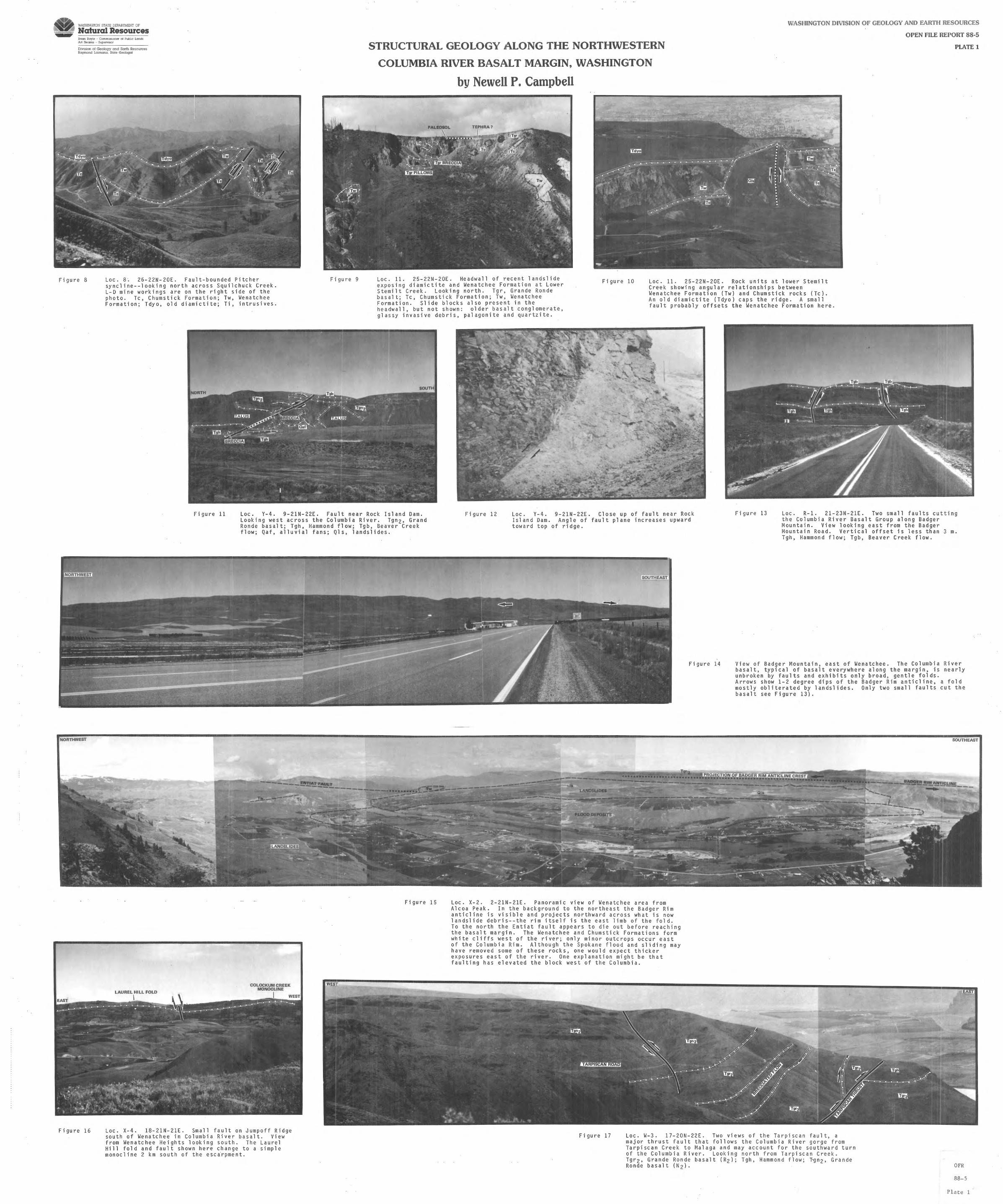
V.ASHINGTON STATE DEPARTMEN7 OF
Natural Resources Bnan Boyle- - Cor.i rr.:~;1oner o f Pub lic: Lar.da Ar! S1earns . Super vi sor
Div1s:on ol Geology and Earth Resources Raymond La:~maru:;. Slate Geologisl
Figure 8 Loe. 8 ; 26 - 22N-20 E. Fault-bounded Pitche r sy nc lin e--loo kin g north ac r oss Sq u i l chuck Creek. L- D mine work i ngs are on t he right s i de of t he ph oto . Tc, Churnst i c k For mation; Tw, Wenatchee Format i on; Tdyo, ol d diarnictit e ; Ti, i ntrus i ves .
Figure 9
STRUCTURAL GEOLOGY ALONG THE NORTHWE'.STERN
COLUMBIA RIVER BASALT MARGIN, WASHINGTON
WASHINGTON DIVISION OF GEOLOGY AND EARTH RESOURCES
OPEN FILE REPORT 88-5
PLATE 1
by Newell P. Campbell
Loe. 11. 25 - 22 N- 20E . Hea dwall of r ecent landsl i de ex posing diarnict it e and Wenatch ee Fo r mat i on at Lower Stemilt Creek . Look i ng no r th . Tgr , Gra nd e Ro nde basalt; Tc , Churns tic k Forma ti on; Tw, Wenatchee Formation . Slide bloc ks al so present i n the he adwall , but not s hown: olde r ba s alt con gl omerate, gl assy invasive debris, pa l ago ni t e a nd quartzite.
Figure 10 Loe . 11 . 25 - 22N-20E . Rock uni ts a t lower Stemilt Cr eek showing angula r relationship s between Wenatchee Formation (Tw) and Ch umstic k r ocks (Tc) . An old diarnict i te ( Tdy o ) ca ps the ridge . A srnal 1 fault probably offsets the Wen a tc hee Formatio n here.
Figure 11 Loe. Y-4. 9-21N-22E , Fa ult near Rock Is l and Darn . Looking west ac ross the Co l umb i a River . Tgn2, Gra nd Ron de basalt; Tgh, Hammond fl ow ; Tgb, Beaver Cree k f l ow ; Qaf , a ll uvi al fans ; Qls, l a nds l i des .
Fi gure 12 Lac . Y- 4 . 9-21N - 22E. Cl o se up of f a ult near Rock Island Darn . Ang l e of fault pl a ne i nc r eas es upward tow ard t op of ri dge .
Fi gure 13 Loe. R- 1. 21 - 23N - 21E. Two srn a l l f au lts cut ti ng th e Co l umb i a Riv e r Basalt Group al ong Badger Mountain. View l ooki ng east from the Ba dg e r Mounta i n Road . Ve r tica l of fset is l e ss than 3 rn. Tg h , Hammond f low ; Tgb , Beave r Cree k flow .
NORTHWEST
Figure 16
-------~!_MT "--T
. ------------
LAUREL HILL FOLD
I
COLOCKUM CREEK MONOCLINE
I
Loe . X- 4 . 18 - 21N - 21E . Smal l fault on J umpoff Ridge so ut h of Wenatchee i n Columbia River basa lt . View from Wena t chee He i ghts l ook in g south. The Laurel Hill fold and fau l t shown here change to a simp l e rn onoc l i ne 2 km south of t he escfrpment.
WE
Figure 15
SOUTHEAST
Figure 14 Vi ew of Badge r Mo un tai n, east of Wen atc hee. The Co l umb i a Rive r basa l t , typica l of basalt every where a long th e mar gi n, i s nea r l y unbrok en by fau l t s and ex hib i ts on l y broad , ge ntle fold s . Ar ro ws show 1- 2 degree di ps of t he Ba dge r Rim anti c l i ne , a fo ld mo s t l y ob l ite r ated by l ands l ides . On ly t wo small fault s cut the basalt see Fi gu re 13).
Loe . X- 2 . 2-2 1N- 21 E. Panoram i c view of Wenatche e area from Alc oa Pea k. In the backgro und to the northeast the Badger Rim ant i c l ine i s visib l e and projects nort hwa r d across what is now landsl i de deb r is- - the rim itse l f is th e east l imb of the fo l d . To t he north the Ent i at f au l t app ears to di e out before r eaching the basalt ma r gin . The Wenatchee and Churn s tick Formations form white c l if f s west of th e ri ver ; onl y mi nor outcrops occur east of th e Columb i a Rim . Although the Spo kane f lood and s li ding may have removed s ome of these rocks , one would exp ect th i cker e xpos ures ea st of the ri ver . One e xplanation might be that faulting has e l evated the block west of the Columbi a .
Figure 17 Loe . W- 3. 17 - 20N-22E . Two view s of t he Tarp i scan fault, a major t hr ust f au l t that fo l lows the Columbia Ri ver gorg e f r om Tarp i scan Cr ee k to Ma l aga and may accou nt fo r the southward turn of the Columb i a Ri ver. Loo king nor t h from Tarp i sc a n Creek . Tgr2 , Gr ande Ronde basalt (R2l; Tgh , Hammond flo w; T-gn 2 , Grand e Ro nde basalt ( N2 ) .
SOUTHEAST
------'!.!!!2.!!.f!!..~.lfJ:!NE - ----
OFR
88- 5
P l ate 1

~~ \\\l'.SHINGTON STATE DEPARTMENT OF
~- Natural Resources EP
!lr,on Bo~· le · Comm:ssio:aer o l ?Jbhc l.a:"lds Art S:earn5 Supcrv1~or
D1V1sion of Geology and Earth Resources Raym:l:id Losmanis. 51ale Geolog1£t
STRUCTURAL GEOLOGY ALOJNG THE NORTHWESTERN
COLUMBIA RIVER BASALT MARGIN, WASHINGTON
WASHINGTON DIVISION OF GEOLOGY AND EARTH RESOURCES
OPEN FILE REPORT 88-5
PLATE 2
Figure 19
!~ORTH
Figure 26
by Newell P. Campbell
Loe. M-2 . 24-21N-19E. Shears in Chumst ick Formation megaconglomerate , Mission Ridge ski area . Shearing (arrows) may be partly responsible for forming the large clasts here.
MISSION PEAK
I
Figure 22 Loe. M-4. 25-21N-19E . View lo oki ng east from Mission Ridge ski slopes at the Leavenwort h fault zone. Two small (?) faults cut the basalt here; offset is le ss than 30m. The lower fault dies out within 3 km, but the upper fault continues along the crest of the Naneum Ridge anticline for approximately 25 km. Offset on the upper fault along its length is only 1-2 m. Tcf , Chumstick fanglomerate; Tgn2, Grande Ronde Basalt .
Loe . L-5. 30-22N-18E. Chumstick Formation megaconglomerate exposed on Tiptop road . See Figure 19 for comparison with Mission Ridge area.
WEST
WEST 30" ....
EAST ./,.,,,/'
,,,,/'
,,,,/'
200 m FAULT PLANE (SLICKENSIDES)
,,,,"'
,,.,,"'
Figure 30 Loe. L-13. 25 - 21N-17E. Sketch and photo of faults along Road 2102, Liberty area. Fault contacts in shale and sandstone units of the Swauk Formation. Note large variation in slickenside (lines) orientations. Numerous small faults in the Swauk Formation, near Lib erty and Swauk Pass , provide evide nce for post-Miocene uplift of basalt by distributed shear.
Figure 21 Loe. M-4. 35-21N-19E. Photo showing possible f ault north of Mission Peak. Tabo r and others (1982) map Tgh (Hammond flow) at A as a slide block. The block appears in place; if so, a fault exists between A and 8 . Looking north from Wenatchee Mountain.
SOUTH
Figure 29
Figure 23 Loe. M-6. 34 and 35-21N-19E. Mission Peak as seen from Ellensburg. A small fault may be responsible for this peak being higher than the rest of Naneum Ridge.
Loe. L-10. 3-20N-18E. View looking north at the Rosenmeier fault and Mission Peak from Road 2008G. Although disputed by Tabor and others (1982), a fau lt seems necessary to account for the offset in basalt between Tabl e Mountain (A) and Mission Peak (B). Dips on basalt at A are toward older rocks (C); the contact mu st be either a channel fill or a fault. The Rosenmeier fault merges with the Naneum Creek monocline to the east. Ts, Swauk Fm .; Tgn2, Grande Ronde basalt; Ql s, landslides.
Figure 31
/ I I \ • •
,..., .,,.-/ \ \ \
Loe . CE-1. 10-19N-15E. Easton Ridge from Peoh Point showing projected splays of the Straight Creek fault toward the basalt margin. Note the sharp turn in Easton Ridge . Looking northwest.
NORTHE~
EAST
OFR