stream morphology and water quality based restoration plan...
TRANSCRIPT
Stream Morphology and Water Quality Based Restoration Plan for the Paradise Creek Watershed
Phase I Technical Report for the Paradise Creek Watershed Assessment
Prepared by Robert Limbeck, Watershed Scientist Delaware River Basin Commission, West Trenton, NJ
For the Brodhead Watershed Association, Henryville, PA
February 2005
This project was funded by a Pennsylvania Growing Greener Watershed Grant
Paradise Watershed Restoration Plan, February 2005 2
Contents STREAM MORPHOLOGY AND WATER QUALITY BASED RESTORATION PLAN FOR THE PARADISE CREEK WATERSHED...........................................................................................................................................................................................3
INTRODUCTION ......................................................................................................................................................................................3 LEVEL I STREAM MORPHOLOGY OF THE PARADISE CREEK WATERSHED ..............................................................................................4 STREAM CHANNEL STABILITY ASSESSMENT AND RESTORATION OPPORTUNITIES ................................................................................5 RESTORATION OPTIONS .........................................................................................................................................................................8 RECOMMENDATIONS..............................................................................................................................................................................9 LOWER PARADISE CREEK SUB-WATERSHED POTENTIAL RESTORATION SITES ...................................................................................10 BUTZ RUN SUB-WATERSHED POTENTIAL RESTORATION SITES...........................................................................................................11 CRANBERRY CREEK SUB-WATERSHED POTENTIAL RESTORATION SITES ............................................................................................12 LOWER SWIFTWATER CREEK SUB-WATERSHED POTENTIAL RESTORATION SITES ..............................................................................14 LOWER SWIFTWATER CREEK SUB-WATERSHED POTENTIAL RESTORATION SITES ..............................................................................15 UPPER SWIFTWATER CREEK SUB-WATERSHED POTENTIAL RESTORATION SITES ...............................................................................17 FOREST HILLS RUN SUB-WATERSHED POTENTIAL RESTORATION SITES .............................................................................................18 UPPER PARADISE CREEK SUB-WATERSHED POTENTIAL RESTORATION SITES.....................................................................................20 DEVILS HOLE CREEK SUB-WATERSHED POTENTIAL RESTORATION SITES ..........................................................................................23 TANK CREEK/YANKEE RUN SUB-WATERSHED POTENTIAL RESTORATION SITES................................................................................25 REFERENCES ........................................................................................................................................................................................26 APPENDIX A: LONGITUDINAL PROFILES OF PARADISE WATERSHED STREAMS...................................................................................27 APPENDIX B: PARADISE CREEK WATERSHED STREAM SEGMENTS AND FEATURES. ...........................................................................32
Paradise Watershed Restoration Plan, February 2005 3
Stream Morphology and Water Quality Based Restoration Plan for the Paradise Creek Watershed
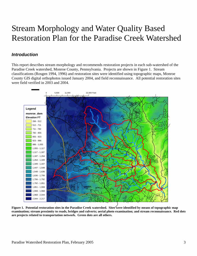
Introduction This report describes stream morphology and recommends restoration projects in each sub-watershed of the Paradise Creek watershed, Monroe County, Pennsylvania. Projects are shown in Figure 1. Stream classifications (Rosgen 1994, 1996) and restoration sites were identified using topographic maps, Monroe County GIS digital orthophotos issued January 2004, and field reconnaissance. All potential restoration sites were field verified in 2003 and 2004.
!(
!(!(!(
!(
!(!(!(!(!( !(!(
!(!(!(
!(
!(
!(
!(
!(
!(
!(!(!(!(
!(
!(
!(
!(
191
80
447
380
196
715
611314
423
940
390
940
380
314
80
390
0 11,000 22,0005,500 Feet
¯Legendmonroe_demElevation FT
266 - 512
512 - 711
711 - 782
782 - 855
855 - 923
923 - 986
986 - 1,055
1,055 - 1,117
1,117 - 1,187
1,187 - 1,264
1,264 - 1,349
1,349 - 1,447
1,447 - 1,548
1,548 - 1,636
1,636 - 1,706
1,706 - 1,792
1,792 - 1,851
1,851 - 1,908
1,908 - 1,968
1,968 - 2,044
2,044 - 2,217
Figure 1. Potential restoration sites in the Paradise Creek watershed. Sites were identified by means of topographic map examination; stream proximity to roads, bridges and culverts; aerial photo examination; and stream reconnaissance. Red dots are projects related to transportation network. Green dots are all others.
Paradise Watershed Restoration Plan, February 2005 4
Paradise Creek headwaters begin upon the Pocono Plateau in Mount Pocono Borough, and Barrett, Coolbaugh and Tobyhanna Townships in Monroe County, Pennsylvania. Headwater streams flow steeply off of the plateau into the Valley and Ridge physiographic province before joining with the main stem of Paradise Creek. The Brodhead Watershed Association (2002) provided the following introductory description of the Paradise Creek watershed. Draining approximately 44.5 square miles, Paradise Creek is about nine miles long, flowing in a southeasterly direction through Paradise Township before joining Brodhead Creek. Most streams in the watershed are closely paralleled by highways, but the riparian zone is mostly intact as much riparian land is owned by fishing clubs. Major tributaries include Devils Hole Creek, Cranberry Creek, Butz Run, Swiftwater Creek and Forest Hills Run. Paradise Creek boasts a healthy population of native and stocked trout. Streams in the watershed are mostly high-gradient, with the exception of headwater streams atop the Pocono Plateau and those streams within the main Paradise Creek valley bottom. Base flow is plentifully supplied by springs, wetlands, and glacial overburden soils and geology. Devils Hole Creek, a tributary of the Paradise, is designated as Exceptional Value by the Pennsylvania Department of Environmental Protection. The Paradise, along with the Brodhead, is credited as the birthplace of American trout fishing tradition. Paradise Valley is home to the first licensed trout hatchery in Pennsylvania.
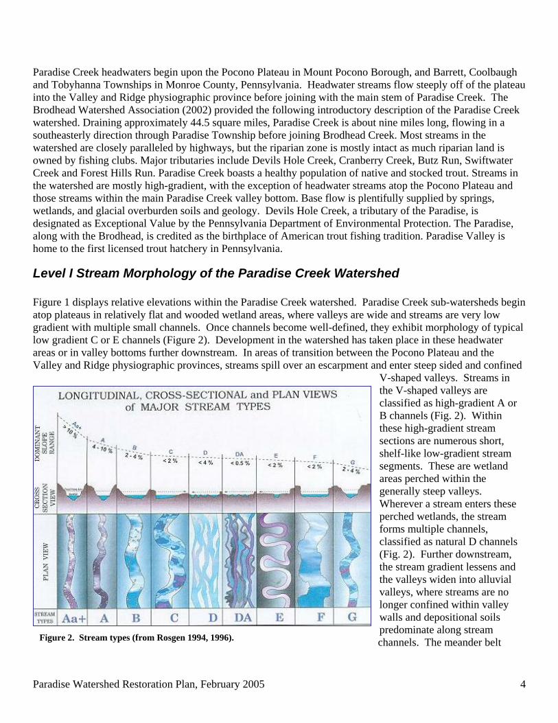
Level I Stream Morphology of the Paradise Creek Watershed Figure 1 displays relative elevations within the Paradise Creek watershed. Paradise Creek sub-watersheds begin atop plateaus in relatively flat and wooded wetland areas, where valleys are wide and streams are very low gradient with multiple small channels. Once channels become well-defined, they exhibit morphology of typical low gradient C or E channels (Figure 2). Development in the watershed has taken place in these headwater areas or in valley bottoms further downstream. In areas of transition between the Pocono Plateau and the Valley and Ridge physiographic provinces, streams spill over an escarpment and enter steep sided and confined
V-shaped valleys. Streams in the V-shaped valleys are classified as high-gradient A or B channels (Fig. 2). Within these high-gradient stream sections are numerous short, shelf-like low-gradient stream segments. These are wetland areas perched within the generally steep valleys. Wherever a stream enters these perched wetlands, the stream forms multiple channels, classified as natural D channels (Fig. 2). Further downstream, the stream gradient lessens and the valleys widen into alluvial valleys, where streams are no longer confined within valley walls and depositional soils predominate along stream channels. The meander belt Figure 2. Stream types (from Rosgen 1994, 1996).
Paradise Watershed Restoration Plan, February 2005 5
width of most streams increases dramatically once the streams are no longer confined by steep-sided valleys. Extensive and probably natural bank erosion was observed in stream segments transitioning from high to low gradient. Dramatic examples of such erosion can be seen on Swiftwater Creek and Devils Hole Creek. Consult the appendices for a more detailed description of Level I morphology. Appendix A contains longitudinal elevation profiles of Paradise Creek and its tributary streams. Appendix B shows a MS Excel workbook prepared for this study that contains a stream mileage system, various landmarks along stream corridors, and all mapped stream segments with their local slope and predicted stream type. Most segments were field verified by visual observation of stream pattern (Rosgen Level I analysis). Many remote locations were missed by field reconnaissance and stream classification was predicted using only maps and aerial photos. DRBC is completing a GIS layer of Paradise Watershed stream types linked to the National Hydrographic Dataset (NHD). Computer files are available from DRBC upon request.
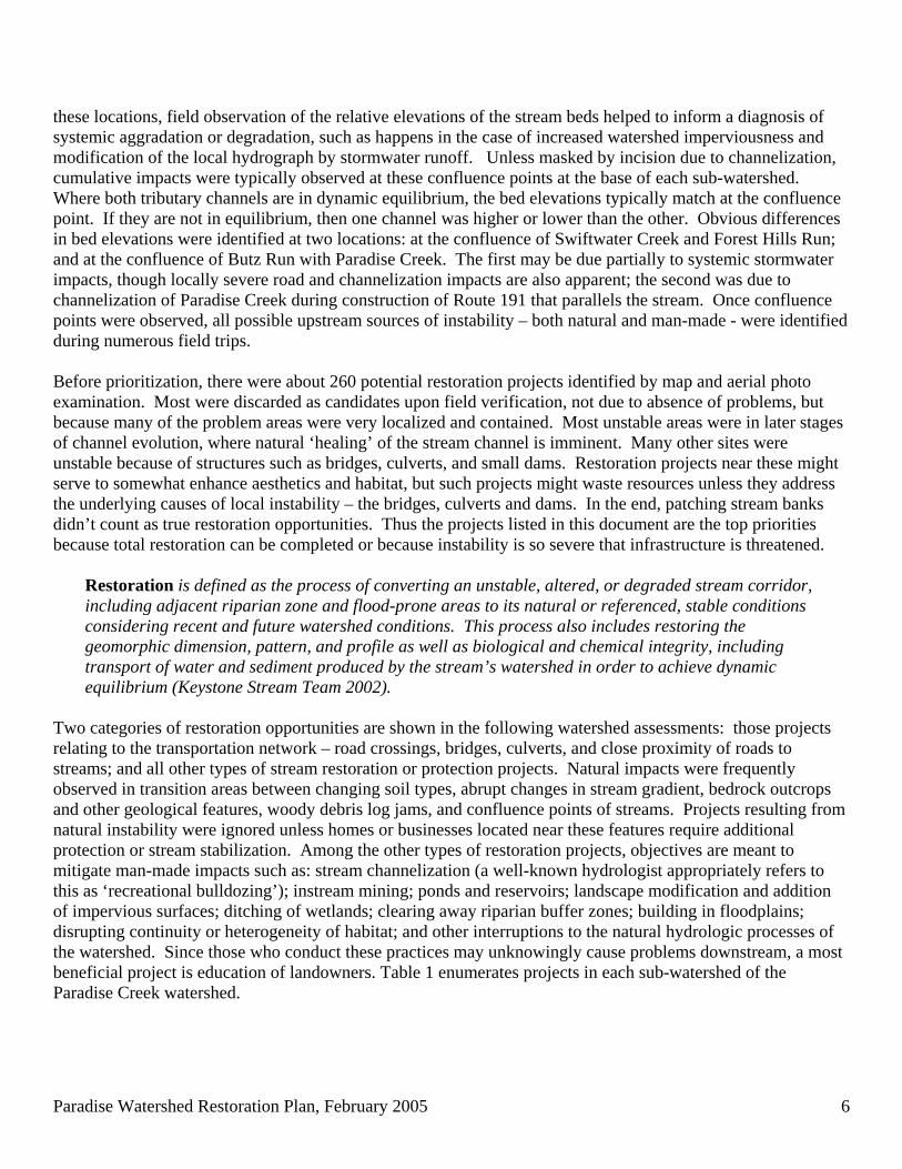
Stream Channel Stability Assessment and Restoration Opportunities This survey of Paradise Creek watershed fluvial geomorphology was conducted to identify locations in the watershed where streams are severely unstable. For this report, instability is defined as localized loss of dynamic equilibrium of the stream channel. According to Pennsylvania’s Keystone Stream Team (2002) a stream is “in equilibrium” or stable when it can carry the sediment load supplied by the watershed without changing dimension (cross sectional area, width, depth, shape), pattern (sinuosity, meander pattern), or profile (longitudinal pattern and slope) and without aggrading (building up of bottom materials) or degrading (incising into the landscape and abandoning the natural floodplain). At the locations identified in this report, field evidence of instability was verified by observation of channel evolution status (See Figure 3; Schumm, Harvey and Watson 1984; Simon 1989, Simon and Downs 1995).
Figure 3. Channel Evolution Model (Schumm, Harvey and Watson 1984; field observation checklist adapted by Randy Sewell, VHB, Inc., Williamsburg, VA) Verification was performed according to methods described by Thorne et al. (1997, 1998) and Rosgen (2001) and included observation of severity and extent of stream incision or degradation; extreme stream bank or point bar erosion; excess sedimentation or aggradation through interruption of natural sediment transport capacity; over-widening of the channel relative to depth; channel braiding; formation of mid-channel sediment bars; erosion of the stream bed or head-cutting; and leaning or fallen old, large trees. Localized effects of bridge crossings, culverts, dams, stream bank stabilization projects, habitat improvement structures, and some land uses include symptoms mentioned above as well as blockage of fish passage. Many segments of streams were identified where the riparian zone has been reduced due to land use activities. Diagnosis of instability was begun by visiting the confluence locations of all streams in the watershed. At
Paradise Watershed Restoration Plan, February 2005 6
these locations, field observation of the relative elevations of the stream beds helped to inform a diagnosis of systemic aggradation or degradation, such as happens in the case of increased watershed imperviousness and modification of the local hydrograph by stormwater runoff. Unless masked by incision due to channelization, cumulative impacts were typically observed at these confluence points at the base of each sub-watershed. Where both tributary channels are in dynamic equilibrium, the bed elevations typically match at the confluence point. If they are not in equilibrium, then one channel was higher or lower than the other. Obvious differences in bed elevations were identified at two locations: at the confluence of Swiftwater Creek and Forest Hills Run; and at the confluence of Butz Run with Paradise Creek. The first may be due partially to systemic stormwater impacts, though locally severe road and channelization impacts are also apparent; the second was due to channelization of Paradise Creek during construction of Route 191 that parallels the stream. Once confluence points were observed, all possible upstream sources of instability – both natural and man-made - were identified during numerous field trips. Before prioritization, there were about 260 potential restoration projects identified by map and aerial photo examination. Most were discarded as candidates upon field verification, not due to absence of problems, but because many of the problem areas were very localized and contained. Most unstable areas were in later stages of channel evolution, where natural ‘healing’ of the stream channel is imminent. Many other sites were unstable because of structures such as bridges, culverts, and small dams. Restoration projects near these might serve to somewhat enhance aesthetics and habitat, but such projects might waste resources unless they address the underlying causes of local instability – the bridges, culverts and dams. In the end, patching stream banks didn’t count as true restoration opportunities. Thus the projects listed in this document are the top priorities because total restoration can be completed or because instability is so severe that infrastructure is threatened.
Restoration is defined as the process of converting an unstable, altered, or degraded stream corridor, including adjacent riparian zone and flood-prone areas to its natural or referenced, stable conditions considering recent and future watershed conditions. This process also includes restoring the geomorphic dimension, pattern, and profile as well as biological and chemical integrity, including transport of water and sediment produced by the stream’s watershed in order to achieve dynamic equilibrium (Keystone Stream Team 2002).
Two categories of restoration opportunities are shown in the following watershed assessments: those projects relating to the transportation network – road crossings, bridges, culverts, and close proximity of roads to streams; and all other types of stream restoration or protection projects. Natural impacts were frequently observed in transition areas between changing soil types, abrupt changes in stream gradient, bedrock outcrops and other geological features, woody debris log jams, and confluence points of streams. Projects resulting from natural instability were ignored unless homes or businesses located near these features require additional protection or stream stabilization. Among the other types of restoration projects, objectives are meant to mitigate man-made impacts such as: stream channelization (a well-known hydrologist appropriately refers to this as ‘recreational bulldozing’); instream mining; ponds and reservoirs; landscape modification and addition of impervious surfaces; ditching of wetlands; clearing away riparian buffer zones; building in floodplains; disrupting continuity or heterogeneity of habitat; and other interruptions to the natural hydrologic processes of the watershed. Since those who conduct these practices may unknowingly cause problems downstream, a most beneficial project is education of landowners. Table 1 enumerates projects in each sub-watershed of the Paradise Creek watershed.
Paradise Watershed Restoration Plan, February 2005 7
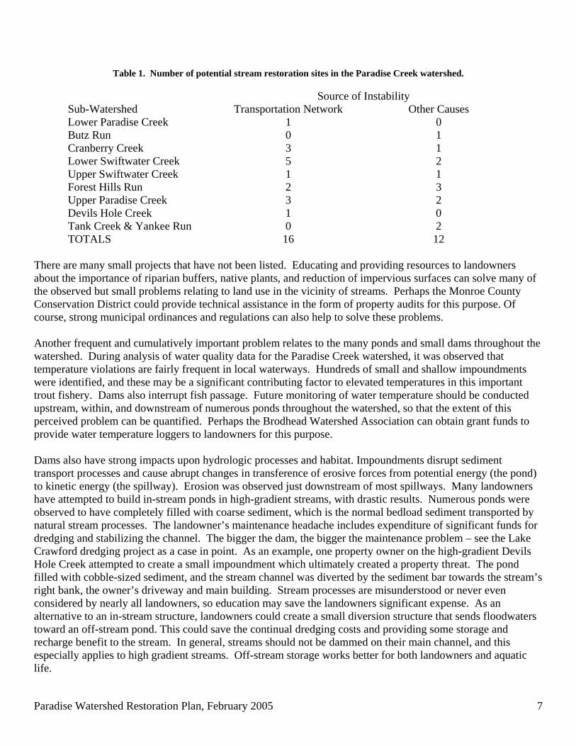
Table 1. Number of potential stream restoration sites in the Paradise Creek watershed.
Source of Instability Sub-Watershed Transportation Network Other Causes Lower Paradise Creek 1 0 Butz Run 0 1 Cranberry Creek 3 1 Lower Swiftwater Creek 5 2 Upper Swiftwater Creek 1 1 Forest Hills Run 2 3 Upper Paradise Creek 3 2 Devils Hole Creek 1 0 Tank Creek & Yankee Run 0 2 TOTALS 16 12
There are many small projects that have not been listed. Educating and providing resources to landowners about the importance of riparian buffers, native plants, and reduction of impervious surfaces can solve many of the observed but small problems relating to land use in the vicinity of streams. Perhaps the Monroe County Conservation District could provide technical assistance in the form of property audits for this purpose. Of course, strong municipal ordinances and regulations can also help to solve these problems. Another frequent and cumulatively important problem relates to the many ponds and small dams throughout the watershed. During analysis of water quality data for the Paradise Creek watershed, it was observed that temperature violations are fairly frequent in local waterways. Hundreds of small and shallow impoundments were identified, and these may be a significant contributing factor to elevated temperatures in this important trout fishery. Dams also interrupt fish passage. Future monitoring of water temperature should be conducted upstream, within, and downstream of numerous ponds throughout the watershed, so that the extent of this perceived problem can be quantified. Perhaps the Brodhead Watershed Association can obtain grant funds to provide water temperature loggers to landowners for this purpose. Dams also have strong impacts upon hydrologic processes and habitat. Impoundments disrupt sediment transport processes and cause abrupt changes in transference of erosive forces from potential energy (the pond) to kinetic energy (the spillway). Erosion was observed just downstream of most spillways. Many landowners have attempted to build in-stream ponds in high-gradient streams, with drastic results. Numerous ponds were observed to have completely filled with coarse sediment, which is the normal bedload sediment transported by natural stream processes. The landowner’s maintenance headache includes expenditure of significant funds for dredging and stabilizing the channel. The bigger the dam, the bigger the maintenance problem – see the Lake Crawford dredging project as a case in point. As an example, one property owner on the high-gradient Devils Hole Creek attempted to create a small impoundment which ultimately created a property threat. The pond filled with cobble-sized sediment, and the stream channel was diverted by the sediment bar towards the stream’s right bank, the owner’s driveway and main building. Stream processes are misunderstood or never even considered by nearly all landowners, so education may save the landowners significant expense. As an alternative to an in-stream structure, landowners could create a small diversion structure that sends floodwaters toward an off-stream pond. This could save the continual dredging costs and providing some storage and recharge benefit to the stream. In general, streams should not be dammed on their main channel, and this especially applies to high gradient streams. Off-stream storage works better for both landowners and aquatic life.
Paradise Watershed Restoration Plan, February 2005 8
Restoration Options Several factors were considered during prioritization of projects. First, the solutions should be appropriate to the natural stream characteristics. There are many options. What works best, looks best, and costs least? For example, rip-rap may be unsightly overkill for stabilization of low gradient streams, and bioengineering techniques may be unsuitable in high-velocity streams. Some vendors now offer software providing menus of restoration options according to stream and landscape characteristics. Rosgen (1996) provides a very useful table of stream management characteristics according to observed stream types. The Society for Ecological Restoration also provides excellent guidance for conception, organization, implementation, and assessment of restoration projects (Clewell et al. 2000). Second, unstable streams can naturally regain equilibrium over time if left alone, so it is possible, and in many cases preferable, to let nature take its course. Examination of the channel evolution status of a stream reach perceived as unstable may reveal that ‘healing’ is imminent. The ‘do nothing’ option should be the first consideration. It is critical to ensure that upstream causes and processes are addressed if restoration efforts are to succeed. Unfortunately many funding agencies want immediate action and will not pay for the data collection necessary to verify upstream causes and quantify their effects. It is tempting to address the symptoms of disequilibrium by patching one eroded stream bank, but restoration measures may repeatedly fail if upstream conditions persist or worsen. Properties at high risk obviously get high priority for patching and stabilizing stream banks, but this should be viewed as a temporary measure to be followed by more comprehensive restoration. Using a comprehensive watershed view, it may be possible to save money by grouping a number of contiguous sites into one restoration project. Within a stream reach targeted for restoration, project planning takes place in consideration of the whole range of hydrologic conditions: channel-forming flows, low flows, and flood conditions. This assessment of equilibrium or natural stability of the stream channel took place by looking at characteristics of the stream formed by the most effective channel-forming flood. This is typically the bankfull flood that occurs at a frequency of about 2 of every 3 years. The bankfull flood is the key to popular natural stream channel design techniques using instream structures constructed to ensure that the stream maintains dynamic equilibrium. When assessing restoration options, however, the hydrologic extremes were also considered. How does the stream channel ecologically function under extreme low-flow conditions? Is there a well-defined low-flow channel? This is important for survival and movement of aquatic species such as the wild populations of trout that inhabit streams of the Paradise Creek watershed. On the other hand, restoration measures tied to bankfull are not meant to protect property damage resulting from larger floods. Hurricane Ivan hit the Paradise Creek watershed in 2003, and extensive damage was observed that cannot be considered simple instability. For the projects identified in the following watershed assessments, restoration or protection measures should provide three main benefits: 1. Sustain fish passage, refuge and water quality during droughts by restoring habitat at low flow; 2. Maintain equilibrium of the stream channel by creating a natural bankfull flood channel; and 3. Protect homes and businesses from large floods by other means designed well above the bankfull elevation.
Paradise Watershed Restoration Plan, February 2005 9
Recommendations 1. Gather reference reach data from Butz Run, an E channel, to serve as a design template for future natural
stream restoration of low-gradient streams throughout the Poconos. During Spring of 2005, the reference reach will be measured by cooperative efforts of DRBC, MCCD, MCPC, and others using methods described by Harrelson et. al (1994). Reference reach data will be analyzed using RiverMorph Stream Restoration Software (RiverMorph, LLC, Louisville, KY), and distributed to relevant agencies and interested parties.
2. Work with the PA Department of Transportation, Monroe County, and municipal road maintenance agencies
to install river-friendly bridges and culverts during future infrastructure maintenance and repair. This has been done in some maintenance districts by members of the Keystone Stream Team.
3. Educate landowners about protection of the riparian corridor, stormwater impacts, and stream channel
maintenance. This can be completed as part of the Paradise Creek project or future grant-funded activity (WREN grants, Coldwater Heritage grants, etc.)
4. Improve and share the assessment data set – this Level I survey only begins to document visual observations
throughout the watershed. Recommended ‘next steps’ would be: to collect detailed morphology of known impacted and reference stream segments; improve the GIS layers for the stream network; conduct additional aerial photo surveys; assemble partnerships to design and implement the restoration projects listed herein. It is anticipated that surveys of many impacted segments will be conducted during restoration project implementation throughout Pennsylvania, and these data should be shared among restoration practitioners. It became obvious during this survey that the Commonwealth must improve GIS layers of the stream networks – many unmapped channels were found, and those that have been digitized are highly inaccurate.
5. Implement more intensive water temperature monitoring within a program designed to reduce temperature
stress upon trout throughout the watershed. Funding can surely be found to provide water temperature loggers (these are small, dependable, and inexpensive) to landowners. Such temperature data can be assembled and analyzed to quantify and reduce the effects of impoundments, parking lot runoff, and reduced riparian buffers upon water quality of the Paradise Creek. The objective of such an effort is to maintain a healthy and viable trout population in the watershed, and to reduce the frequency of violation of PA water quality standards, and to maintain or improve coldwater fisheries habitat. A similar effort has been successfully implemented by the Pequannock River Coalition in northern New Jersey (http://www.pequannockriver.org).
Paradise Watershed Restoration Plan, February 2005 10
Lower Paradise Creek Sub-Watershed Potential Restoration Sites
!(
!(!(
!(
!(
!(
!(191
715
447
314
0 3,400 6,8001,700 Feet
¯
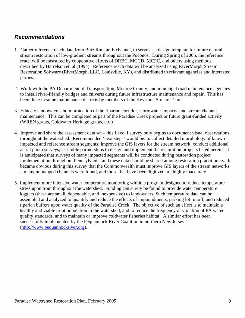
Figure 4 – Potential restoration sites in the Lower Paradise sub-watershed. Sites were identified by means of topographic map examination; stream proximity within 150 feet of roads, bridges and culverts; aerial photo examination and field verification.
Restoration Projects Road (1 red)
Observation Action 1. Paradise Creek along Route 191 (4 segments): extensive channelization. Improve habitat within incised channel.
Install habitat improvement structures.
Paradise Watershed Restoration Plan, February 2005 11
Butz Run Sub-Watershed Potential Restoration Sites
!(
!(!(
!(
!(
!(
!(715
314191
0 4,000 8,0002,000 Feet
¯
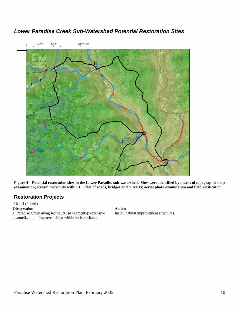
Figure 5 – Potential restoration sites in the Butz Run sub-watershed. Sites were identified by means of topographic map examination; stream proximity within 150 feet of roads, bridges and culverts; aerial photo examination and field verification.
Restoration Projects Other (1 green)
Observation Action 1. Butz Run in Parcel 3571 just upstream of forest and abrupt gradient change entering hemlock valley.
Document reference reach morphology of E channel.
Paradise Watershed Restoration Plan, February 2005 12
Cranberry Creek Sub-Watershed Potential Restoration Sites
!(!( !(
!(!(
!(
!(
!(
!(
!(
!(
!(
!(
!(
!(
191
447
940
390
611
390
0 5,500 11,0002,750 Feet
¯
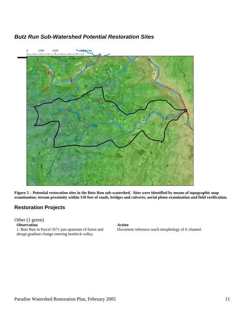
Figure 6 – Potential restoration sites in the Cranberry Creek sub-watershed. Sites were identified by means of topographic map examination; stream proximity within 150 feet of roads, bridges and culverts; aerial photo examination and field verification.
Restoration Projects Road (3 red) Observation Action 1. Cranberry Creek at Browns Hill Road crossing – multiple culverts, blockages, undersized.
Road crossing is being renovated (proposed project as of January 2005)
2. Cranberry Ck at Cranberry Creek Road crossing – culvert effects.
Crossing frequently floods, culvert undersized. Road runoff is potential problem. Possible project.
3. Cranberry Ck UNT7 (R) at Route 191 crossing – culvert effects.
Road runoff should be captured and treated.
Other (1 green) Observation Action 4. Cranberry Ck (L) through parcel 8534 peat mining operation, extreme channelization.
See 8534 Aerial Photo. Extensive disturbance of stream channel, mitigation necessary once mining operation is completed.
Paradise Watershed Restoration Plan, February 2005 13
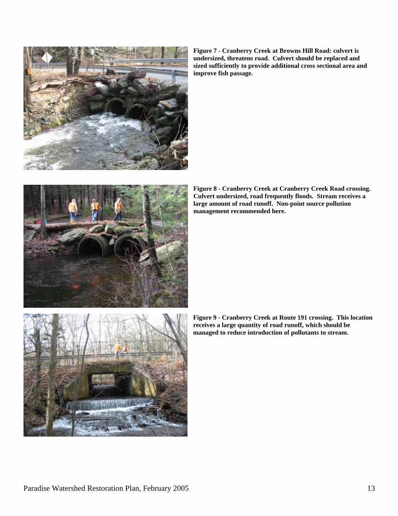
Figure 7 - Cranberry Creek at Browns Hill Road: culvert is undersized, threatens road. Culvert should be replaced and sized sufficiently to provide additional cross sectional area and improve fish passage.
Figure 8 - Cranberry Creek at Cranberry Creek Road crossing. Culvert undersized, road frequently floods. Stream receives a large amount of road runoff. Non-point source pollution management recommended here. Figure 9 - Cranberry Creek at Route 191 crossing. This location receives a large quantity of road runoff, which should be managed to reduce introduction of pollutants to stream.
Paradise Watershed Restoration Plan, February 2005 14
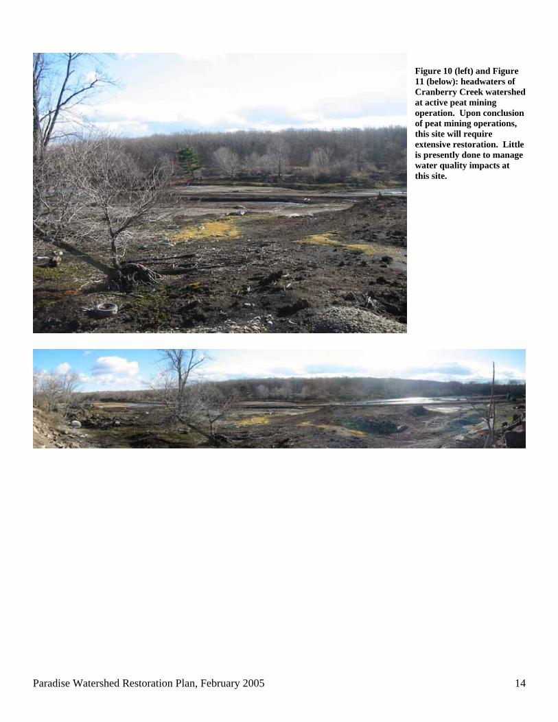
Figure 10 (left) and Figure 11 (below): headwaters of Cranberry Creek watershed at active peat mining operation. Upon conclusion of peat mining operations, this site will require extensive restoration. Little is presently done to manage water quality impacts at this site.
Paradise Watershed Restoration Plan, February 2005 15
Lower Swiftwater Creek Sub-Watershed Potential Restoration Sites
!(!(
!(!( !(
!(
!(
!(
!(
!(
!(!(!(
314
611
715
191
314
611
0 3,300 6,6001,650 Feet
¯
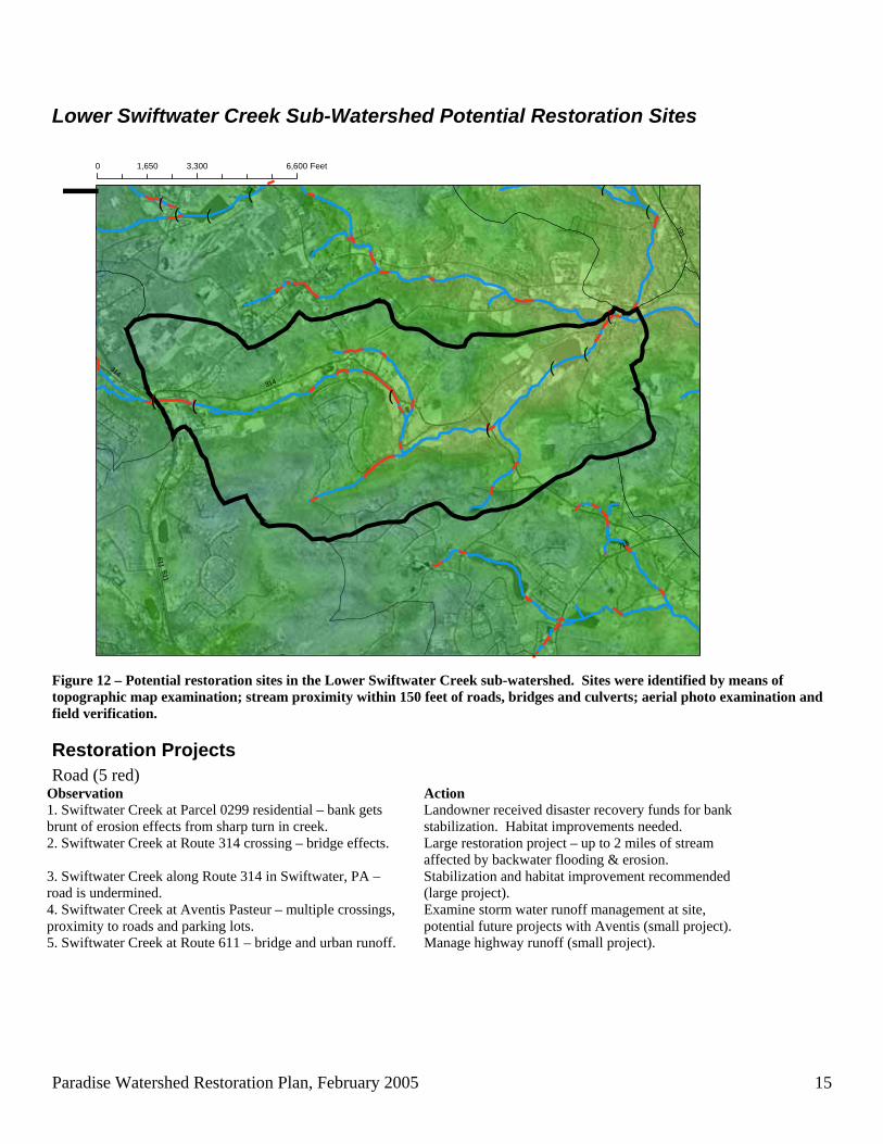
Figure 12 – Potential restoration sites in the Lower Swiftwater Creek sub-watershed. Sites were identified by means of topographic map examination; stream proximity within 150 feet of roads, bridges and culverts; aerial photo examination and field verification.
Restoration Projects Road (5 red)
Observation Action 1. Swiftwater Creek at Parcel 0299 residential – bank gets brunt of erosion effects from sharp turn in creek.
Landowner received disaster recovery funds for bank stabilization. Habitat improvements needed.
2. Swiftwater Creek at Route 314 crossing – bridge effects. Large restoration project – up to 2 miles of stream affected by backwater flooding & erosion.
3. Swiftwater Creek along Route 314 in Swiftwater, PA – road is undermined.
Stabilization and habitat improvement recommended (large project).
4. Swiftwater Creek at Aventis Pasteur – multiple crossings, proximity to roads and parking lots.
Examine storm water runoff management at site, potential future projects with Aventis (small project).
5. Swiftwater Creek at Route 611 – bridge and urban runoff. Manage highway runoff (small project).
Paradise Watershed Restoration Plan, February 2005 16
Other (2 green) Observation Action 6. Swiftwater Creek at Lake Swiftwater outlet – dam effects. Install fish passage structure. 7. Swiftwater Creek upstream of Lake Swiftwater – bar deposition, sediment transport interruption.
Detailed assessment from 314 to Lake Swiftwater, perhaps restore as part of Rt. 314 project #2.
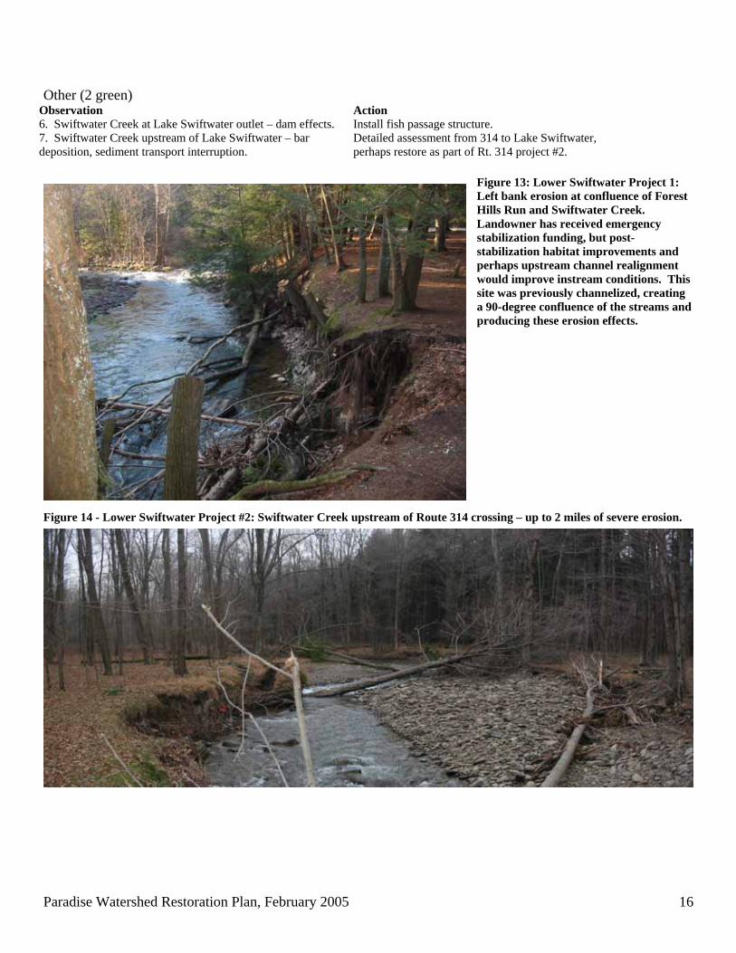
Figure 13: Lower Swiftwater Project 1: Left bank erosion at confluence of Forest Hills Run and Swiftwater Creek. Landowner has received emergency stabilization funding, but post-stabilization habitat improvements and perhaps upstream channel realignment would improve instream conditions. This site was previously channelized, creating a 90-degree confluence of the streams and producing these erosion effects.
Figure 14 - Lower Swiftwater Project #2: Swiftwater Creek upstream of Route 314 crossing – up to 2 miles of severe erosion.
Paradise Watershed Restoration Plan, February 2005 17
Upper Swiftwater Creek Sub-Watershed Potential Restoration Sites
!(
!(
!(
!(!(
!(!(
!(
380
611
314
940
196
80
314
380
940
0 4,600 9,2002,300 Feet
¯
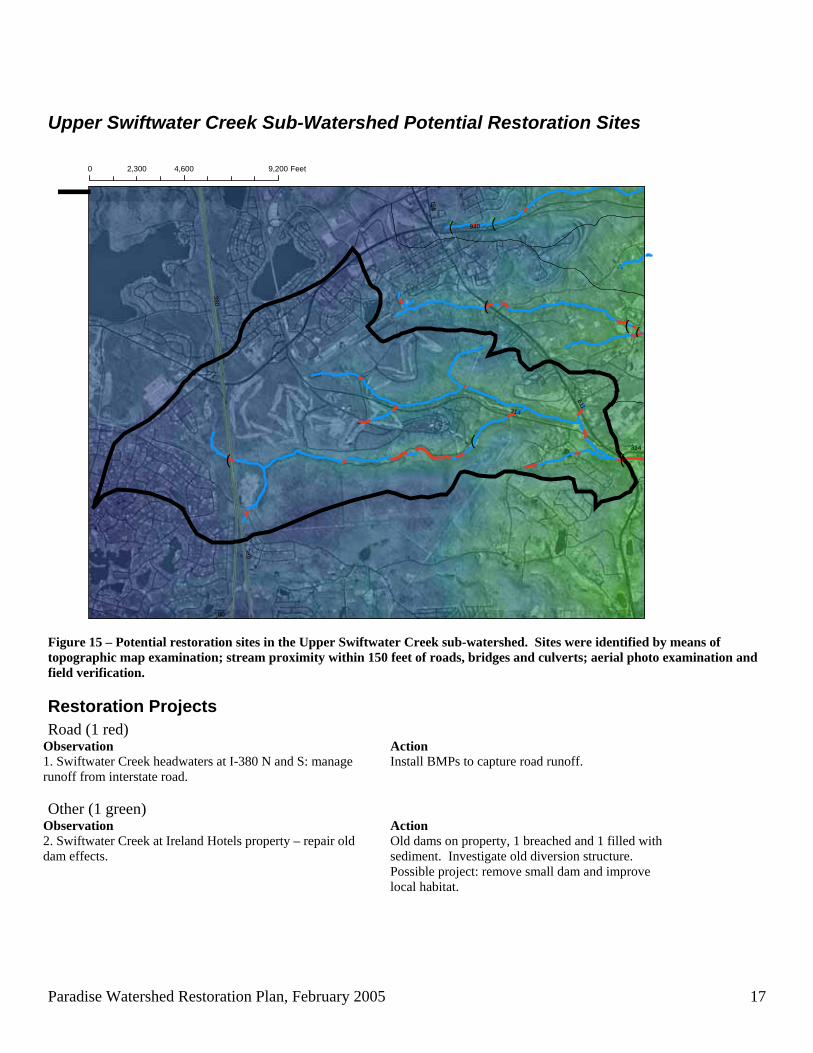
Figure 15 – Potential restoration sites in the Upper Swiftwater Creek sub-watershed. Sites were identified by means of topographic map examination; stream proximity within 150 feet of roads, bridges and culverts; aerial photo examination and field verification.
Restoration Projects Road (1 red)
Observation Action 1. Swiftwater Creek headwaters at I-380 N and S: manage runoff from interstate road.
Install BMPs to capture road runoff.
Other (1 green)
Observation Action 2. Swiftwater Creek at Ireland Hotels property – repair old dam effects.
Old dams on property, 1 breached and 1 filled with sediment. Investigate old diversion structure. Possible project: remove small dam and improve local habitat.
Paradise Watershed Restoration Plan, February 2005 18
Forest Hills Run Sub-Watershed Potential Restoration Sites
!(!(!(
!(
!(!( !(
!(!(
!(
!(!(!(
!(
!(
!(
!(!(!(
!(
!(
!(
611314
191
196
390
940
715
314
940
0 5,250 10,5002,625 Feet
¯
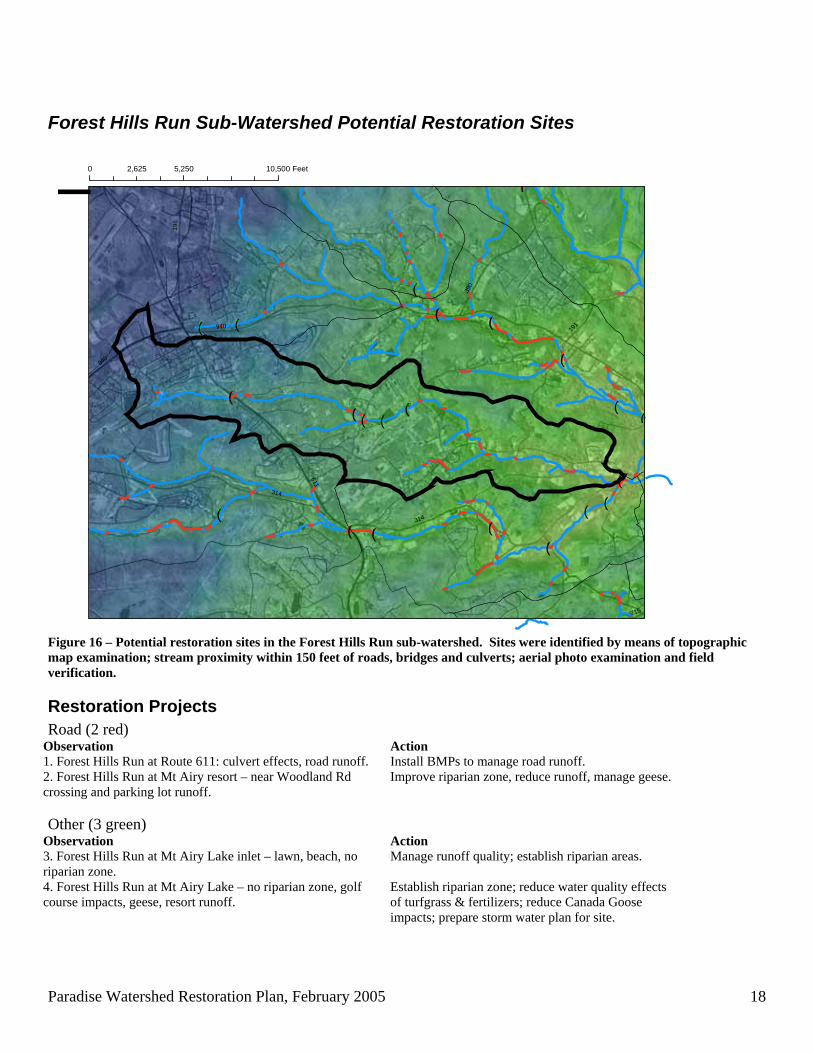
Figure 16 – Potential restoration sites in the Forest Hills Run sub-watershed. Sites were identified by means of topographic map examination; stream proximity within 150 feet of roads, bridges and culverts; aerial photo examination and field verification.
Restoration Projects Road (2 red)
Observation Action 1. Forest Hills Run at Route 611: culvert effects, road runoff. Install BMPs to manage road runoff. 2. Forest Hills Run at Mt Airy resort – near Woodland Rd crossing and parking lot runoff.
Improve riparian zone, reduce runoff, manage geese.
Other (3 green)
Observation Action 3. Forest Hills Run at Mt Airy Lake inlet – lawn, beach, no riparian zone.
Manage runoff quality; establish riparian areas.
4. Forest Hills Run at Mt Airy Lake – no riparian zone, golf course impacts, geese, resort runoff.
Establish riparian zone; reduce water quality effects of turfgrass & fertilizers; reduce Canada Goose impacts; prepare storm water plan for site.
Paradise Watershed Restoration Plan, February 2005 19
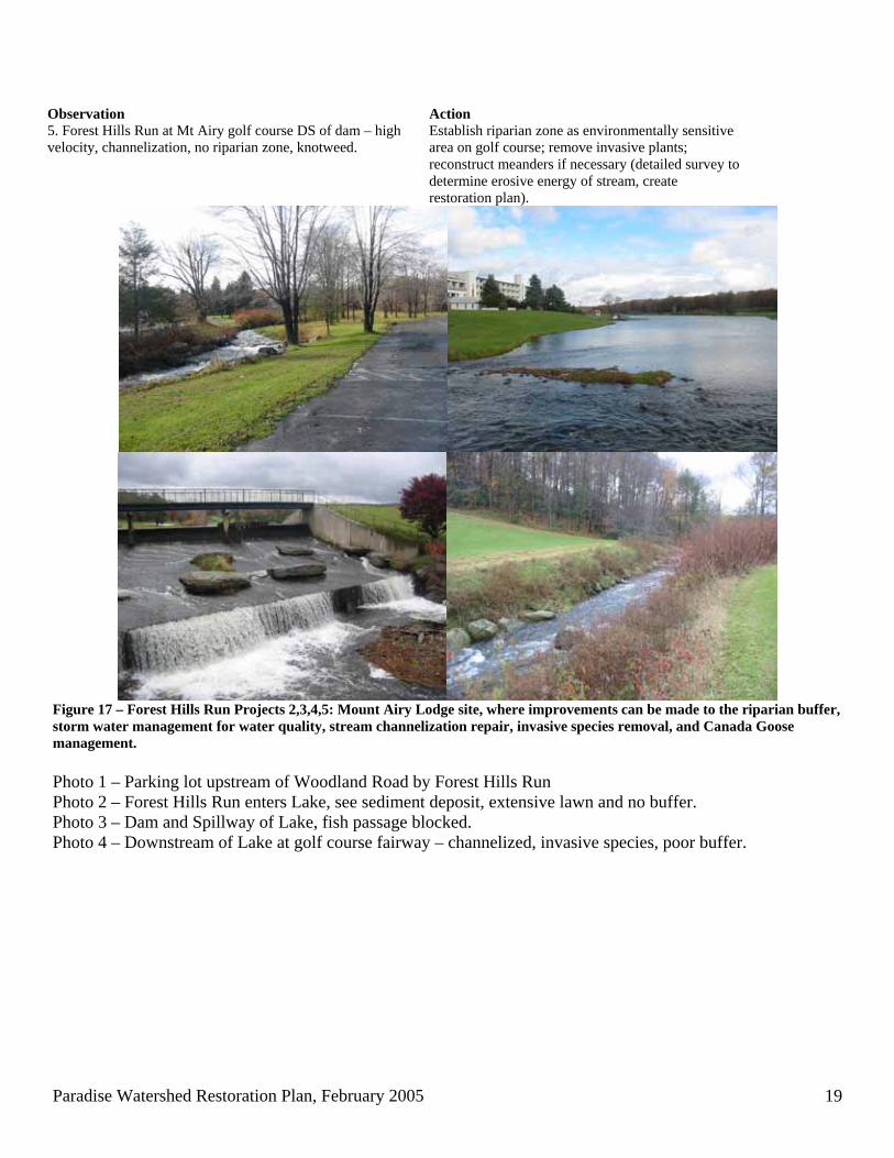
Observation Action 5. Forest Hills Run at Mt Airy golf course DS of dam – high velocity, channelization, no riparian zone, knotweed.
Establish riparian zone as environmentally sensitive area on golf course; remove invasive plants; reconstruct meanders if necessary (detailed survey to determine erosive energy of stream, create restoration plan).
Figure 17 – Forest Hills Run Projects 2,3,4,5: Mount Airy Lodge site, where improvements can be made to the riparian buffer, storm water management for water quality, stream channelization repair, invasive species removal, and Canada Goose management. Photo 1 – Parking lot upstream of Woodland Road by Forest Hills Run Photo 2 – Forest Hills Run enters Lake, see sediment deposit, extensive lawn and no buffer. Photo 3 – Dam and Spillway of Lake, fish passage blocked. Photo 4 – Downstream of Lake at golf course fairway – channelized, invasive species, poor buffer.
Paradise Watershed Restoration Plan, February 2005 20
Upper Paradise Creek Sub-Watershed Potential Restoration Sites
!(
!(!( !(
!(!(
!(
!(
!(
!(
!(
!(
!(
!(191
940
390
611
314
611
0 3,900 7,8001,950 Feet
¯
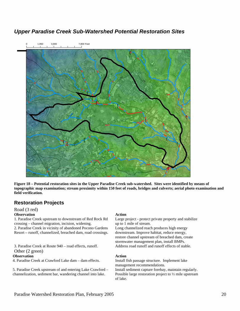
Figure 18 – Potential restoration sites in the Upper Paradise Creek sub-watershed. Sites were identified by means of topographic map examination; stream proximity within 150 feet of roads, bridges and culverts; aerial photo examination and field verification.
Restoration Projects Road (3 red) Observation Action 1. Paradise Creek upstream to downstream of Red Rock Rd crossing – channel migration, incision, widening.
Large project - protect private property and stabilize up to 1 mile of stream.
2. Paradise Creek in vicinity of abandoned Pocono Gardens Resort – runoff, channelized, breached dam, road crossings.
Long channelized reach produces high energy downstream. Improve habitat, reduce energy, restore channel upstream of breached dam, create stormwater management plan, install BMPs.
3. Paradise Creek at Route 940 – road effects, runoff. Address road runoff and runoff effects of stable. Other (2 green)
Observation Action 4. Paradise Creek at Crawford Lake dam – dam effects. Install fish passage structure. Implement lake
management recommendations. 5. Paradise Creek upstream of and entering Lake Crawford – channelization, sediment bar, wandering channel into lake.
Install sediment capture forebay, maintain regularly. Possible large restoration project to ½ mile upstream of lake.
Paradise Watershed Restoration Plan, February 2005 21
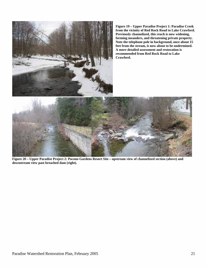
Figure 19 – Upper Paradise Project 1: Paradise Creek from the vicinity of Red Rock Road to Lake Crawford. Previously channelized, this reach is now widening, forming meanders, and threatening private property. Note the telephone pole in background, once about 15 feet from the stream, is now about to be undermined. A more detailed assessment and restoration is recommended from Red Rock Road to Lake Crawford.
Figure 20 – Upper Paradise Project 2: Pocono Gardens Resort Site – upstream view of channelized section (above) and downstream view past breached dam (right).
Paradise Watershed Restoration Plan, February 2005 22
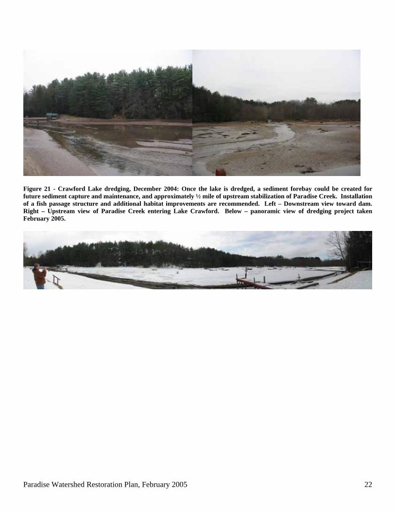
Figure 21 - Crawford Lake dredging, December 2004: Once the lake is dredged, a sediment forebay could be created for future sediment capture and maintenance, and approximately ½ mile of upstream stabilization of Paradise Creek. Installation of a fish passage structure and additional habitat improvements are recommended. Left – Downstream view toward dam. Right – Upstream view of Paradise Creek entering Lake Crawford. Below – panoramic view of dredging project taken February 2005.
Paradise Watershed Restoration Plan, February 2005 23
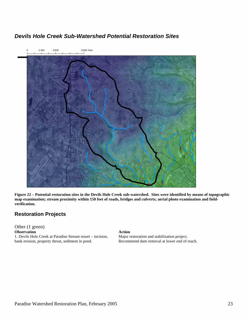
Devils Hole Creek Sub-Watershed Potential Restoration Sites
!(
!(
1 96
611
191
390
940
1910 4,800 9,6002,400 Feet
¯
Figure 22 – Potential restoration sites in the Devils Hole Creek sub-watershed. Sites were identified by means of topographic map examination; stream proximity within 150 feet of roads, bridges and culverts; aerial photo examination and field-verification.
Restoration Projects Other (1 green) Observation Action 1. Devils Hole Creek at Paradise Stream resort – incision, bank erosion, property threat, sediment in pond.
Major restoration and stabilization project. Recommend dam removal at lower end of reach.
Paradise Watershed Restoration Plan, February 2005 24
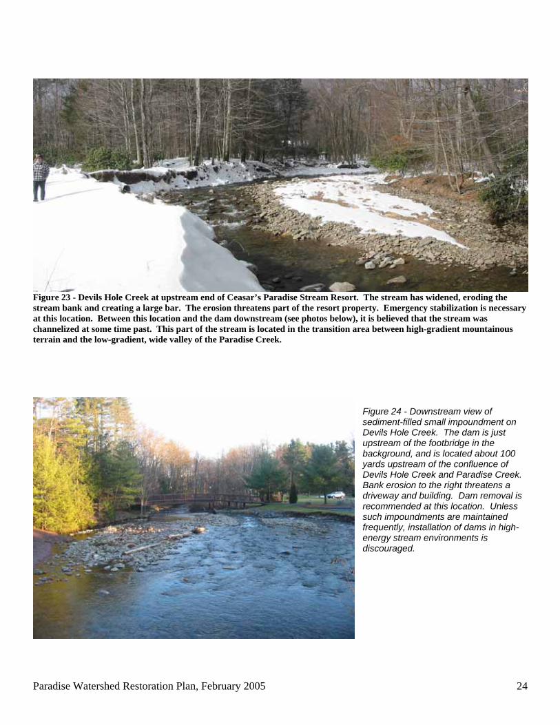
Figure 23 - Devils Hole Creek at upstream end of Ceasar’s Paradise Stream Resort. The stream has widened, eroding the stream bank and creating a large bar. The erosion threatens part of the resort property. Emergency stabilization is necessary at this location. Between this location and the dam downstream (see photos below), it is believed that the stream was channelized at some time past. This part of the stream is located in the transition area between high-gradient mountainous terrain and the low-gradient, wide valley of the Paradise Creek.
Figure 24 - Downstream view of sediment-filled small impoundment on Devils Hole Creek. The dam is just upstream of the footbridge in the background, and is located about 100 yards upstream of the confluence of Devils Hole Creek and Paradise Creek. Bank erosion to the right threatens a driveway and building. Dam removal is recommended at this location. Unless such impoundments are maintained frequently, installation of dams in high-energy stream environments is discouraged.
Paradise Watershed Restoration Plan, February 2005 25
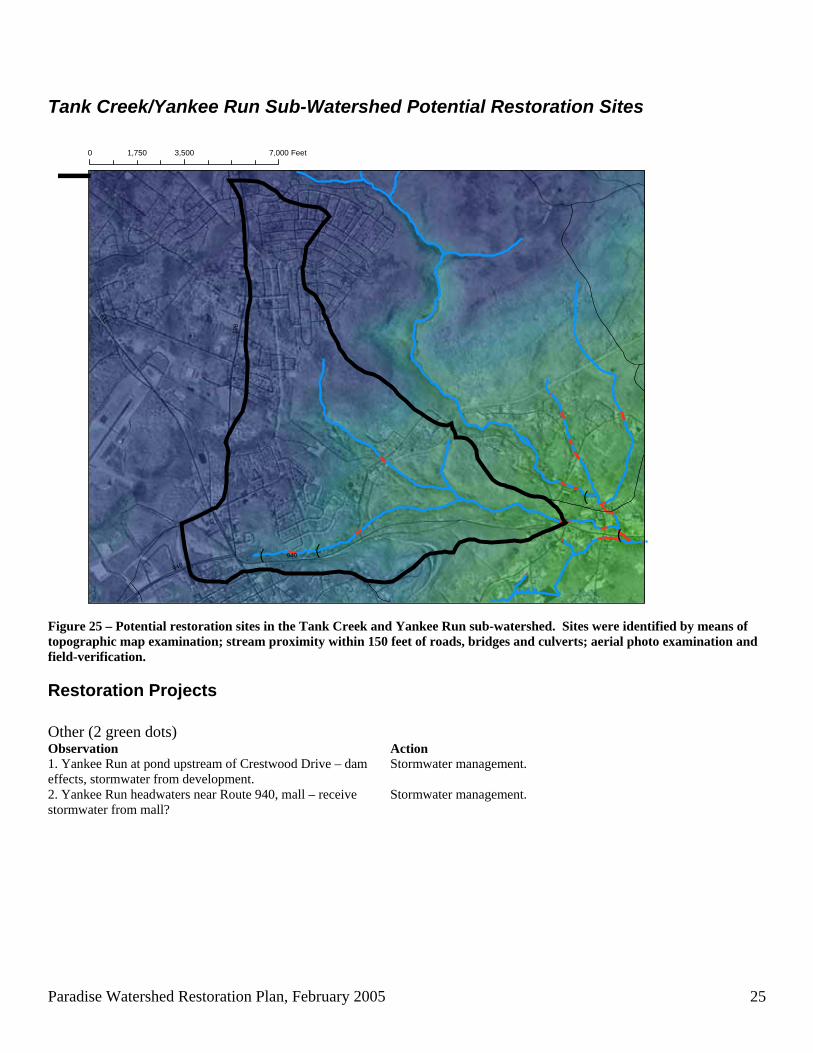
Tank Creek/Yankee Run Sub-Watershed Potential Restoration Sites
!(!(
!(
!(
196
611
940940
0 3,500 7,0001,750 Feet
¯
Figure 25 – Potential restoration sites in the Tank Creek and Yankee Run sub-watershed. Sites were identified by means of topographic map examination; stream proximity within 150 feet of roads, bridges and culverts; aerial photo examination and field-verification.
Restoration Projects Other (2 green dots) Observation Action 1. Yankee Run at pond upstream of Crestwood Drive – dam effects, stormwater from development.
Stormwater management.
2. Yankee Run headwaters near Route 940, mall – receive stormwater from mall?
Stormwater management.
Paradise Watershed Restoration Plan, February 2005 26
References Brodhead Watershed Association and Bloss Associates. 2002. Brodhead Watershed Conservation Plan.
Brodhead Watershed Association, Henryville, PA. Clewell, A., J. Rieger, and J. Munro. 2000. A Society for Ecological Restoration Publication:
Guidelines for Developing and Managing Ecological Restoration Projects. Society for Ecological Restoration, Tuscon, AZ. Document available via web at http://www.ser.org/reading_resources.asp
Harrelson, C.C., J.P. Potyondy, and C.L. Rawlins. 1994. Stream Channel Reference Sites: An Illustrated Guide
to Field Technique. General Technical Report RM-245, U.S. Department of Agriculture, Forest Service, Fort Collins, CO.
Keystone Stream Team and Alliance for the Chesapeake Bay. 2003. Guidelines for Natural Stream Channel
Design for Pennsylvania Waterways. Canaan Valley Institute, Davis, WV. March 2003 edition accessed via web at http://www.canaanvi.org
Rosgen, D.L. 1994. A classification of natural rivers. Catena 22: 169-199. Rosgen, D.L. 1996. Applied River Morphology. Printed Media Companies, Minneapolis, MN. Rosgen, D.L. 2001. A stream channel stability assessment methodology. In: Proceedings of the Seventh
International Sedimentation Conference, Reno, NV. Schumm, S.A., M.D. Harvey and C.C. Watson. 1984. Incised Channels: Morphology, Dynamics and Control.
Water Resources Publications, Littleton, CO. Simon, A. 1989. A model of channel response in disturbed alluvial channels. Earth Surface Processes and
Landforms 14(1): 11-26. Simon, A. and P.W. Downs. 1995. An interdisciplinary approach to evaluation of potential instability in
alluvial channels. Geomorphology 12: 215-232. Thorne, C.R., R.D. Hey, and M.D. Newson, eds. 1997. Applied Fluvial Geomorphology for River Engineering
and Management. John Wiley and Sons, New York. Thorne, C.R. 1998. Stream Reconnaissance Handbook: Geomorphological Investigation and Analysis of River
Channels. John Wiley and Sons, Chichester, England. 133 p.