strategic flood risk - meath county development plan 2013 …strategic flood risk assessment (sfra)....
TRANSCRIPT


Strategic Flood Risk Assessment for County Meath Draft Meath County Development Plan
2013-2019 May 2012
Meath County Council County Hall Navan County Meath

Appendix 6 SFRA- V1.3.doc i
JBA Consulting 24 Grove Island Corbally Limerick Ireland
JBA Project Manager Ross Bryant BSc MSc CEnv MCIWEM C.WEM
Contract This report describes work commissioned by Meath County Council, by a letter dated 24th November 2011. Rosalie Scanlon and Ross Bryant of JBA Consulting carried out this work.
Prepared by ................................................ Rosalie Scanlon BE MIEI
Engineer
Reviewed by ............................................... Ross Bryant BSc MSc CEnv MCIWEM C.WEM
Team Leader
Approved by ................................................ Jonathan Cooper BEng MSc DipCD CEng MICE MCIWEM C.WEM MloD
Director
Purpose This document has been prepared as an SFRA for Meath County Council.

County Development Plan Review SFRA
Appendix 6 SFRA- V1.3.doc ii
LIST OF FIGURES.......................................................................................................... IV
LIST OF TABLES............................................................................................................ IV
ABBREVIATIONS ............................................................................................................V
1. INTRODUCTION..........................................................................................................1
1.1 COMMISSION....................................................................................................................................................1 1.2 SCOPE AND OBJECTIVES .....................................................................................................................................1 1.3 REPORT STRUCTURE ..........................................................................................................................................1
2. STUDY BACKGROUND.................................................................................................3
2.1 INTRODUCTION .................................................................................................................................................3 2.2 DRAINAGE CATCHMENTS....................................................................................................................................3 2.3 PEOPLE, PROPERTY AND INFRASTRUCTURE............................................................................................................5 2.4 ENVIRONMENT..................................................................................................................................................5 2.5 FLOOD POLICY AND LEGISLATION.........................................................................................................................6 2.5.1 EU Water Framework Directive ...........................................................................................................6 2.5.2 EU Floods Directive ...............................................................................................................................6
2.6 PLANNING AUTHORITIES.....................................................................................................................................7 2.6.1 Local Area Plan Settlements.................................................................................................................8
3. THE PLANNING SYSTEM & FLOOD RISK MANAGEMENT GUIDELINES.......................9
3.1 INTRODUCTION .................................................................................................................................................9 3.2 DEFINITION OF FLOOD RISK ................................................................................................................................9 3.2.1 Likelihood of Flooding.........................................................................................................................10 3.2.2 Consequences of Flooding..................................................................................................................10
3.3 DEFINITION OF FLOOD ZONES ...........................................................................................................................10 3.4 OBJECTIVES AND PRINCIPLES OF THE PLANNING GUIDELINES .................................................................................11 3.5 THE SEQUENTIAL APPROACH AND JUSTIFICATION TEST .........................................................................................12 3.6 SCALES AND STAGES OF FLOOD RISK ASSESSMENT ...............................................................................................13 3.7 SFRA AND SEA ..............................................................................................................................................14
4. DATA COLLECTION AND AVAILABILITY...................................................................16
4.1 OVERVIEW......................................................................................................................................................16 4.2 FEM FRAMS FLOOD OUTLINES .......................................................................................................................17 4.3 NATIONAL PFRA STUDY FLUVIAL FLOOD OUTLINES .............................................................................................18 4.4 JFLOW® FLOOD MAPPING ..............................................................................................................................18 4.5 NATIONAL CFRAM PROGRAMME.....................................................................................................................19 4.6 LOCAL FLOOD STUDIES.....................................................................................................................................19 4.7 REGIONAL FLOOD RISK APPRAISAL OF THE GREATER DUBLIN AREA ........................................................................20 4.8 SOIL AND GROUNDWATER VULNERABILITY MAPS ................................................................................................21 4.9 HISTORIC FLOOD REVIEW .................................................................................................................................22 4.9.1 Drainage Districts and Benefitting Lands..........................................................................................25
4.10 WALKOVER SURVEY.......................................................................................................................................26
5. SOURCES OF FLOODING...........................................................................................27
5.1 FLUVIAL FLOODING..........................................................................................................................................27 5.2 COASTAL / ESTUARIAL FLOODING ......................................................................................................................28 5.3 PLUVIAL FLOODING..........................................................................................................................................28 5.4 GROUNDWATER FLOODING ..............................................................................................................................29 5.5 FLOODING FROM DRAINAGE SYSTEMS................................................................................................................29 5.6 FLOODING FROM RESERVOIRS AND OTHER ARTIFICIAL SOURCES.............................................................................29

County Development Plan Review SFRA
Appendix 6 SFRA- V1.3.doc iii
6. FLOOD RISK MANAGEMENT ASSETS ........................................................................31
7. FLOOD ZONE MAPPING ............................................................................................32
7.1 NATIONAL BROADSCALE FLOOD MAPPING; PFRA AND JFLOW............................................................................33
8. FLOODING IMPACTS.................................................................................................34
8.1 FLOODING IMPACTS ON PEOPLE ........................................................................................................................34 8.2 FLOODING IMPACTS ON PROPERTY AND INFRASTRUCTURE ....................................................................................34 8.3 FLOODING IMPACTS ON THE ENVIRONMENT........................................................................................................35 8.4 CLIMATE CHANGE............................................................................................................................................36 8.4.1 Climate Change and Flood Risk Assessment.....................................................................................37
9. FLOOD RISK MANAGMENT .......................................................................................38
9.1 MANAGEMENT OF FLOOD RISK FROM A PLANNING PERSPECTIVE...........................................................................38 9.2 FLOOD RISK POLICIES AND OBJECTIVES...............................................................................................................38 9.2.1 Specific Development Planning Applications....................................................................................38
9.3 FLOOD MANAGEMENT ACTION PLAN.................................................................................................................39 9.4 POLICY RELATING TO MANAGEMENT OF SURFACE WATER ....................................................................................39 9.4.1 Overland Flow Routes.........................................................................................................................40 9.4.2 Sustainable Drainage Systems (SuDS)...............................................................................................40
9.5 FLOOD MITIGATION MEASURES AT SITE DESIGN..................................................................................................40
10. DEVELOPMENT ZONING AND SETTLEMENT REVIEW.............................................41
10.1 LAND USE ZONING OBJECTIVES .......................................................................................................................41 10.2 REVIEW OF FLOOD RISK AT SETTLEMENTS IN COUNTY MEATH.............................................................................42
11. SFRA REVIEW AND MONITORING..........................................................................45
APPENDIX A SETTLEMENT REVIEW
County Development Plan Review SFRA
Appendix 6 SFRA- V1.3.doc iv
LIST OF FIGURES
FIGURE 2‐1 RIVERS AND CATCHMENTS IN CO. MEATH ....................................................................................................3 FIGURE 2‐2 RIVER BASIN DISTRICTS ..............................................................................................................................7 FIGURE 2‐3 GREATER DUBLIN AREA..............................................................................................................................8 FIGURE 3‐1 SOURCE PATHWAY RECEPTOR MODEL .........................................................................................................9 FIGURE 3‐2 SEQUENTIAL APPROACH PRINCIPLES IN FLOOD RISK MANAGEMENT...............................................................12 FIGURE 3‐3 DEVELOPMENT PLAN PREPARATION WHERE FLOOD RISK IS SCOPED AS AN ISSUE...............................................15
LIST OF TABLES TABLE 2‐1 RIVER LENGTHS IN CO. MEATH .....................................................................................................................4 TABLE 2‐2 COUNTY MEATH SPECIAL AREAS OF CONSERVATION (SACS) ............................................................................5 TABLE 2‐3 COUNTY MEATH SPECIAL PROTECTION AREAS (SPAS).....................................................................................5 TABLE 2‐4 COUNTY MEATH NATURAL HERITAGE AREAS (NHAS) ......................................................................................5 TABLE 3‐1 PROBABILITY OF FLOODING ........................................................................................................................10 TABLE 3‐2 DEFINITION OF FLOOD ZONES .....................................................................................................................11 TABLE 3‐3 MATRIX OF VULNERABILITY VERSUS FLOOD ZONE..........................................................................................13 TABLE 3‐4 FLOOD RISK STAGES REQUIRED PER SCALE OF STUDY UNDERTAKEN ....................................................................14 TABLE 4‐1 MODEL DATA AVAILABLE ...........................................................................................................................16 TABLE 4‐2 OTHER DATA AVAILABLE ............................................................................................................................17 TABLE 4‐3 SETTLEMENT HIERARCHY ............................................................................................................................20 TABLE 4‐4 SIGNIFICANT FLOOD EVENTS IN COUNTY MEATH...........................................................................................25 TABLE 6‐1 FLOOD RISK MANAGEMENT ASSETS IN MEATH .............................................................................................31 TABLE 7‐1 MODEL DATA USED IN THE PREPARATION OF SFRA FLOOD ZONE MAPS..........................................................33 TABLE 8‐1 PROPERTIES FLOOD ZONES A AND B............................................................................................................35 TABLE 8‐2 ALLOWANCES FOR FUTURE SCENARIOS (100 YEAR TIME HORIZON) ................................................................37 TABLE 10‐1 SUMMARY CLASSIFICATION OF VULNERABILITY ...........................................................................................41 TABLE 10‐2 SUMMARY RESULTS FROM THE SETTLEMENT REVIEW ..................................................................................44 TABLE 11‐1 SFRA REVIEW TRIGGERS .........................................................................................................................45

County Development Plan Review SFRA
Appendix 6 SFRA- V1.3.doc v
ABBREVIATIONS 1D One Dimensional (modelling)
2D Two Dimensional (modelling)
AEP Annual Exceedance Probability
AFA Area for Further Assessment
CDP County Development Plan
CFRAM Catchment Flood Risk Assessment and Management Study
DD Drainage District
DTM Digital Terrain Model
DoEHLG Department of the Environment, Heritage and Local Government
E CFRAM Eastern Catchment Flood Risk Assessment and Management Study
EPA Environmental Protection Agency
FEH Flood Estimation Handbook
FEM FRAMS Fingal East Meath Flood Risk Assessment and Management Study
FRA Flood Risk Assessment
FRAM Flood Risk Assessment and Management Study
FRR Flood Risk Review
FSU Flood Studies Update
GDA Greater Dublin Area
GDSDS Greater Dublin Strategic Drainage Study
GSI Geological Survey of Ireland
HDA Habitats Directive Assessment
HPW High Priority Watercourse
ICPSS Irish Coastal Protection Strategy Study
JBA JBA Consulting – Engineers & Scientists
JFLOW 2D hydraulic modelling package developed by JBA and used to create the Flood Zone Mapping
LA Local Authority
LAP Local Area Plan
MPW Medium Priority Watercourse
NHA Natural Heritage Area
NW CFRAM North-West Catchment Flood Risk Assessment and Management Study
NB CFRAM Neagh-Bann Catchment Flood Risk Assessment and Management Study
OPW Office of Public Works

County Development Plan Review SFRA
Appendix 6 SFRA- V1.3.doc vi
OSi Ordnance Survey Ireland
PFRA Preliminary Flood Risk Assessment
pNHA Proposed Natural Heritage Area
RPG Regional Planning Guidelines
SAC Special Area of Conservation, protected under the EU Habitats Directive
SEA Strategic Environmental Assessment
SFRA Strategic Flood Risk Assessment
SPA Special Protection Area for birds, protected under the EU Habitats Directive
SuDS Sustainable Drainage Systems

County Development Plan Review SFRA
Appendix 6 SFRA- V1.3.doc vii
This page is intentionally left blank.

Strategic Flood Risk Assessment for County Meath Chapter 1
Appendix 6 SFRA- V1.3.doc 1
1. INTRODUCTION
1.1 Commission
JBA Consulting was commissioned by Meath Local Authorities in November 2011 to undertake a Strategic Flood Risk Assessment (SFRA). This study is to inform the Meath County Development Plan for 2013 – 2019.
This report details the SFRA for the county and has been prepared in accordance with the requirements of the planning guidelines, The Planning System and Flood Risk Management1.
1.2 Scope and Objectives
Under The Planning System and Flood Risk Management guidelines (OPW/DoEHLG, 2009), the purpose for the SFRA is detailed as being "to provide a broad (wide area) assessment of all types of flood risk to inform strategic land-use planning decisions. SFRAs enable the LA to undertake the sequential approach, including the Justification Test, allocate appropriate sites for development and identify how flood risk can be reduced as part of the development plan process".
The objectives of this SFRA have expanded on the above statement as follows:
• To provide for an improved understanding of flood risk issues within the development plan;
• To detail the appropriate scope or level of detail necessary for a strategic flood risk assessment of a county development plan;
• To carry out a flood risk assessment based on existing datasets and survey work, as appropriate, leading to a suite of flood risk maps that support the application of the sequential approach, in areas within the development envelope, where there may be tension between development pressures and avoidance of flood risk;
• To inform, where necessary, the application of the Justification Test;
• To produce guidance on where surface water should be managed and appropriate criteria to be used in the consideration of site-specific flood risk assessments.
The SFRA will include the preparation of Flood Zone mapping, that fulfil the recommendations of The Planning System and Flood Risk Management – Guidelines for Planning Authorities (OPW/DoEHLG, 2009). This SFRA will inform the County Development Plan 2013 – 2019 (and subsequent Local Area Plans and Town Development Plans) policies and zonings and will be used as a decision tool in development management and assessment of planning applications and flood risk assessments.
1.3 Report Structure
This SFRA considers the broader settlement strategy of the Greater Dublin Area Regional Planning Guidelines and countywide policies and objectives of the County Development Plan.
This report gives a brief background to the study area; explains the concepts and definitions of flood risk terms; reviews the indicators of flood risk based on the data available; details the methodology behind the preparation of the Flood Zone Mapping and discusses recommended
1 The Planning System and Flood Risk Management, Guidelines for Planning Authorities, DEHLG and OPW, November 2009.

Strategic Flood Risk Assessment for County Meath Chapter 1
Appendix 6 SFRA- V1.3.doc 2
policies and objectives for flood risk management in relation to the Meath County Development Plan. The SFRA includes a review of flood risk in each settlement indicating where, application of these policies is adequate to allow future development or where high development pressures require a more detailed assessment of flood risk at Local Area or Town Plan stage.
Strategic Flood Risk Assessment for County Meath Chapter 2
Appendix 6 SFRA- V1.3.doc 3
2. STUDY BACKGROUND
2.1 Introduction
The study area comprises the whole of County Meath, and to give context to the study, this chapter provides an overview of the study area, the drainage catchment, the population and the nature of settlement. The county falls under the jurisdiction of the Mid-East Regional Planning Authority. The Mid East and the Dublin area are known as the Greater Dublin Area.
2.2 Drainage Catchments
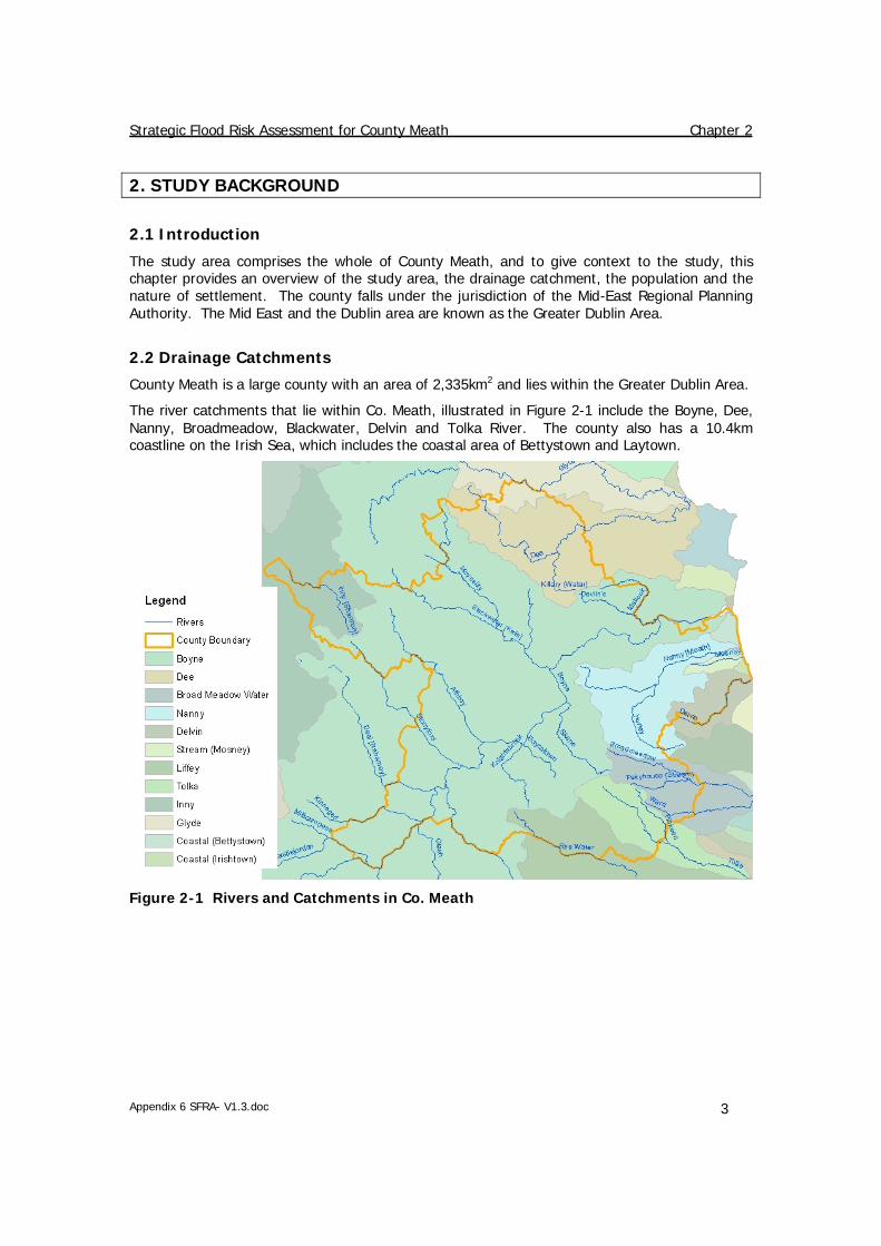
County Meath is a large county with an area of 2,335km2 and lies within the Greater Dublin Area.
The river catchments that lie within Co. Meath, illustrated in Figure 2-1 include the Boyne, Dee, Nanny, Broadmeadow, Blackwater, Delvin and Tolka River. The county also has a 10.4km coastline on the Irish Sea, which includes the coastal area of Bettystown and Laytown.
Figure 2-1 Rivers and Catchments in Co. Meath

Strategic Flood Risk Assessment for County Meath Chapter 2
Appendix 6 SFRA- V1.3.doc 4
River Name Length 2[km]
Boyne 82.4
Blackwater [Kells] 31.5
Nanny [Meath] 31.5
Dee 31.3
Athboy 30.5
Moynallty 25.4
Skane 19.4
Broadmeadow 17.8
Hurley 16.3
Stonyford 15.7
Knightsbrook 15.2
Inny [Shannon] 14.7
Tolka 14.7
Mattock 12.1
Yellow [Blackwater (Kells)] 11.4
Devlin's 11.3
Fairyhouse (Stream) 11.0
Killary (Water) 10.7
Pinkeen 10.7
Kinnegad (Kilwarden) 9.2
Rye Water 8.9
Boycetown 8.9
Mosney 8.6
Ward 8.4
Blackwater [Longwood] 8.4
Deel [Raharney] 7.1
Delvin 6.8
Castlejordan 4.9
Glyde 1.6
Table 2-1 River Lengths in Co. Meath
2 Note: River lengths are based on the digitised length of river within the County Meath boundary.

Strategic Flood Risk Assessment for County Meath Chapter 2
Appendix 6 SFRA- V1.3.doc 5
2.3 People, Property and Infrastructure
The county has a population of 184,135 based on final figures from the 2011 Census3. This is an increase of 21,203 (13%) on the population recorded in the 2006 Census of 162,831.
2.4 Environment
There are a number of environmental designations in place in County Meath and there are listed in the following three tables.
SAC Site Name Site Code
Killyconny Bog (Cloghbally) 000006
Rye Water Valley/Carton 001398
White Lough, Ben Loughs and Lough Doo 001810
Boyne Coast and Estuary 001957
Lough Bane and Lough Glass 002120
River Boyne and River Blackwater 002299
Moneybeg and Clareisland Bogs 002340
Mount Hevey Bog 002342
Table 2-2 County Meath Special Areas of Conservation (SACs)
SPA Site Name Site Code
Lough Sheelin 004065
Boyne Estuary 004080
River Boyne and River Blackwater 004232
River Nanny Estuary and Shore 004158
Table 2-3 County Meath Special Protection Areas (SPAs)
NHA Site Name Site Code
Jamestown Bog 001324
Girley Bog 001580
Molerick Bog 001582
Table 2-4 County Meath Natural Heritage Areas (NHAs)
There are also 27 proposed Natural Heritage Areas (pNHAs) in County Meath.
3 Source: www.cso.ie Census 2011 Final Results

Strategic Flood Risk Assessment for County Meath Chapter 2
Appendix 6 SFRA- V1.3.doc 6
2.5 Flood Policy and Legislation
Historically, flood risk management in Ireland focused on land drainage improvements for the purposes of agricultural activities. The Browne Commission (Report of The Drainage Commission 1938-1940) which examined flooding and the improvement of land through drainage resulted in the development of the Arterial Drainage Act 1945, which aimed to consolidate previous drainage legislation. The Act led to the establishment of a central drainage authority, within the OPW, with responsibility for the provision and maintenance of arterial drainage on a catchment wide basis. The 1945 Act was amended in 1995 to permit the provision of schemes to benefit urban areas.
The Planning and Development Act 2000-2011 legislates to provide for proper planning and sustainable development. Under Section 28 of this Act, the Minister of The Environment, Heritage and Local Government issued guidelines, The Planning System and Flood Risk Management Guidelines for Planning Authorities, which give guidance on the consideration of flood risk in the preparation of development plans, local area plans and in the assessment of planning applications. The content of these guidelines, along with an introduction to the concepts and definitions of flood risk, are discussed in detail in Chapter 3.
A review of national flood policy, was undertaken by an Inter-Departmental Review Group, lead by the Minister of State. The Report of the Flood Policy Review Group, which was published in 2004, considers the roles and responsibilities of various bodies in relation to flood risk management and sets out a new policy for flood risk management in Ireland. The recommended policies focus on managing flood risk, rather than relying only on flood protection measures. A catchment wide approach is recommended in the preparation of flood risk and hazard maps and flood risk management plans. These recommendations tie in with the requirements of the EU Floods Directive and the National CFRAM Programme is currently underway to achieve these objectives. The EU legislation relating to water policy and flood risk management is outlined in Sections 2.5.1 and 2.5.2 below.
2.5.1 EU Water Framework Directive The European Water Framework Directive4 was adopted in 2000, in a new and innovative step, to manage and protect water, based on natural and topographical boundaries rather than national or political boundaries. The Directive is an integrated approach to water policy that considers all aspects of the water environment from groundwater, rivers, lakes, estuaries, transitional waters and coastalwaters. It set environmental objectives that deals with a full range of pressures that threaten water resources i.e pollution, abstraction, flow regulation/transfer and habitat impacts. The Directive is implemented in six year recurring cycles, through the preparation and publication of River Basin Management Plans (RBMPs). The WFD was transposed in Irish law in 2003 by the European Communities (Water Policy) Regulations 20035.
2.5.2 EU Floods Directive The European Floods Directive6 was adopted in November 2007 and set out requirements for each member state, to assess, manage and reduce flood risk. The Directive requires member states to carry out a preliminary flood risk assessment to identify areas at risk of flooding by 2011, to undertake detailed hydraulic modelling and produce flood risk and hazard maps by 2013 and to establish management plans focused on prevention, protection and preparedness by 2015. The EU ‘Floods’ Directive was transposed into Irish law by the European Communities (Assessment and Management of Flood Risks) Regulations 20107. The Regulations set out the
4 EU Water Framework Directive (2000/60/EC) 5 European Communities (Water Policy) Regulations SI 722/2003 6 EU Floods Directive (2007/60/EC) 7 European Communities (Assessment and Management of Flood Risks) Regulations 2010 (SI 122/2010)

Strategic Flood Risk Assessment for County Meath Chapter 2
Appendix 6 SFRA- V1.3.doc 7
responsibilities of the OPW and other public bodies in the implementation of the Directive and details the process for implementation of the measures set out in the flood risk management plans.
An integrated approach is necessary between the WFD and the Floods Directive. Coordination in the preparation of the river basin management plans (RBMPs) and flood risk management plans (FRMPs) is essential and public participation and consultation should be integrated where possible.
Currently, in line with the above legislation the National CFRAM Programme is underway, with Flood risk assessment and management (CFRAM) studies being carried out across seven river basin districts in Ireland. As illustrated in the Figure 2-2 below County Meath lies across three river basin districts; Eastern, Neagh Bann and Shannon. More information on the CFRAM programme is available on www.cfram.ie.
Figure 2-2 River Basin Districts
2.6 Planning Authorities
The Regional Planning Guidelines for the Greater Dublin Area 2010 – 2022, combines two regional authorities; Dublin Regional Authority and the Mid-East Regional Authority. The guidelines cover the councils of Dun Laoghaire-Rathdown, Dublin City, Fingal and South Dublin in

Strategic Flood Risk Assessment for County Meath Chapter 2
Appendix 6 SFRA- V1.3.doc 8
the Dublin Region and Kildare, Meath and Wicklow County Council areas in the Mid-East Region. The RPGs breakdown the overall objectives of the National Spatial Strategy to a regional level and inform the subsequent Development Plans in each Council area.
Figure 2-3 Greater Dublin Area
2.6.1 Local Area Plan Settlements The settlements within County Meath that will be addressed by individual Local Area Plans and Town Development Plans are listed below:
• Ashbourne • Athboy • Ballivor • Bettystown • Carlanstown • Carnaross • Clonard • Crossakeel • Donacarney • Donore • Drogheda South • Drumconrath • Duleek • Dunboyne Clonee Pace
• Dunshaughlin • Enfield • Gibbstown • Gormanston • Julianstown • Kells • Kentstown • Kilbride • Kilcock • Kildalkey • Kilmainhamwood • Kilmessan • Laytown • Longwood
• Maynooth Environs • Mornington • Mornington East • Moynalty • Navan • Nobber • Oldcastle • Rathcairn • Rathmolyon • Ratoath • Slane • Stamullen • Summerhill • Trim
Strategic Flood Risk Assessment for County Meath Chapter 3
Appendix 6 SFRA- V1.3.doc 9
3. THE PLANNING SYSTEM & FLOOD RISK MANAGEMENT GUIDELINES
3.1 Introduction
Prior to discussing the management of flood risk, it is helpful to understand what is meant by the term. It is also important to define the components of flood risk in order to apply the principles of the Planning System and Flood Risk Management in a consistent manner.
The Planning System and Flood Risk Management: Guidelines for Planning Authorities, published in November 2009, describe flooding as a natural process that can occur at any time and in a wide variety of locations. Flooding can often be beneficial, and many habitats rely on periodic inundation. However, when flooding interacts with human development, it can threaten people, their property and the environment.
This Section (3) will firstly outline the definitions of flood risk and the Flood Zones used as a planning tool; a discussion of the principles of the planning guidelines and the management of flood risk in the planning system follows.
3.2 Definition of Flood Risk
Flood risk is generally accepted to be a combination of the likelihood (or probability) of flooding and the potential consequences arising. Flood risk can be expressed in terms of the following relationship:
Flood Risk = Probability of Flooding x Consequences of Flooding
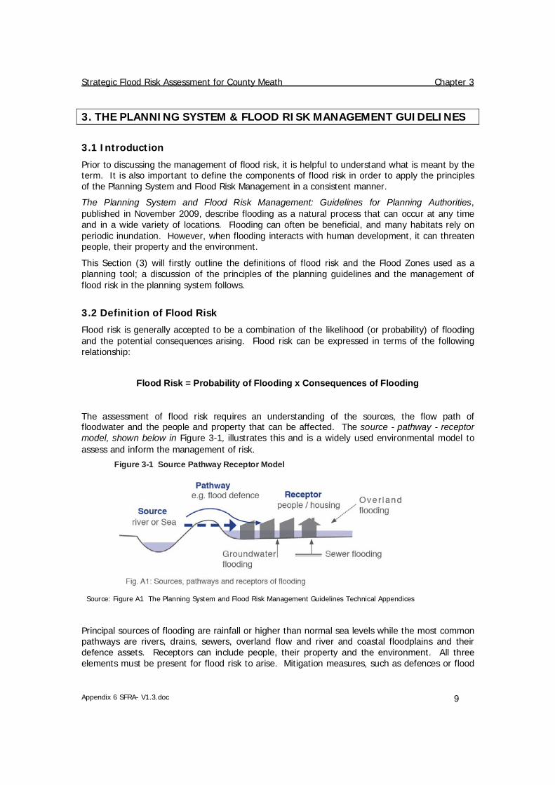
The assessment of flood risk requires an understanding of the sources, the flow path of floodwater and the people and property that can be affected. The source - pathway - receptor model, shown below in Figure 3-1, illustrates this and is a widely used environmental model to assess and inform the management of risk.
Figure 3-1 Source Pathway Receptor Model
Source: Figure A1 The Planning System and Flood Risk Management Guidelines Technical Appendices
Principal sources of flooding are rainfall or higher than normal sea levels while the most common pathways are rivers, drains, sewers, overland flow and river and coastal floodplains and their defence assets. Receptors can include people, their property and the environment. All three elements must be present for flood risk to arise. Mitigation measures, such as defences or flood

Strategic Flood Risk Assessment for County Meath Chapter 3
Appendix 6 SFRA- V1.3.doc 10
resilient construction, have little or no effect on sources of flooding but they can block or impede pathways or remove receptors.
The planning process is primarily concerned with the location of receptors, taking appropriate account of potential sources and pathways that might put those receptors at risk.
3.2.1 Likelihood of Flooding
Likelihood or probability of flooding or a particular flood event is classified by its annual exceedance probability (AEP) or return period (in years). A 1% AEP flood indicates the flood event that will occur or be exceeded on average once every 100 years and has a 1 in 100 chance of occurring in any given year.
Return period is often misunderstood to be the period between large flood events rather than an average recurrence interval. Annual exceedance probability is the inverse of return period as shown in Table 3-1.
Return Period (Years) Annual Exceedance Probability (%)
2 50
100 1
200 0.5
1000 0.1 Table 3-1 Probability of Flooding
Considered over the lifetime of development, an apparently low-frequency or rare flood has a significant probability of occurring. For example:
• A 1% flood has a 22% (1 in 5) chance of occurring at least once in a 25-year period - the period of a typical residential mortgage;
• And a 53% (1 in 2) chance of occurring in a 75-year period - a typical human lifetime.
3.2.2 Consequences of Flooding
Consequences of flooding depend on the hazards caused by flooding (depth of water, speed of flow, rate of onset, duration, wave-action effects, water quality) and the vulnerability of receptors (type of development, nature, e.g. age-structure, of the population, presence and reliability of mitigation measures etc).
The Planning System and Flood Risk Management guidelines provides three vulnerability categories, based on the type of development, which are detailed in Table 3.1 of the Guidelines, and are summarised as:
• Highly vulnerable, including residential properties, essential infrastructure and emergency service facilities;
• Less vulnerable, such as retail and commercial and local transport infrastructure; • Water compatible, including open space, outdoor recreation and associated
essential infrastructure, such as changing rooms.
3.3 Definition of Flood Zones
In the Planning System and Flood Risk Management guidelines, Flood Zones are used to indicate the likelihood of a flood occurring. These Zones indicate a high, moderate or low probability of flooding from fluvial or tidal sources and are defined below in Table 3-2.

Strategic Flood Risk Assessment for County Meath Chapter 3
Appendix 6 SFRA- V1.3.doc 11
It is important to note that the definition of the Flood Zones is based on an undefended scenario and does not take into account the presence of flood protection structures such as flood walls or embankments. This is to allow for the fact that there is a residual risk of flooding behind the defences due to overtopping or breach and that there may be no guarantee that the defences will be maintained in perpetuity.
It is also important to note that the Flood Zones indicate flooding from fluvial and tidal sources and do not take other sources, such as groundwater or pluvial, into account, so an assessment of risk arising from such sources should also be made.
Zone Description
Zone A
High probability of flooding.
This zone defines areas with the highest risk of flooding from rivers (i.e. more than 1% probability or more than 1 in 100) and the coast (i.e. more than 0.5% probability or more than 1 in 200).
Zone B
Moderate probability of flooding.
This zone defines areas with a moderate risk of flooding from rivers (i.e. 0.1% to 1% probability or between 1 in 100 and 1 in 1000) and the coast (i.e. 0.1% to 0.5% probability or between 1 in 200 and 1 in 1000).
Zone C
Low probability of flooding.
This zone defines areas with a low risk of flooding from rivers and the coast (i.e. less than 0.1% probability or less than 1 in 1000).
Table 3-2 Definition of Flood Zones
3.4 Objectives and Principles of the Planning Guidelines
The Planning System and Flood Risk Management guidelines describes good flood risk practice in planning and development management. Planning authorities are directed to have regard to the guidelines in the preparation of Development Plans and Local Area Plans, and for development control purposes.
The objective of the Planning System and Flood Risk Management guidelines is to integrate flood risk management into the planning process, thereby assisting in the delivery of sustainable development. For this to be achieved, flood risk must be assessed as early as possible in the planning process. Paragraph 1.6 of the Guidelines states that the core objectives are to:
• "avoid inappropriate development in areas at risk of flooding; • avoid new developments increasing flood risk elsewhere, including that which may
arise from surface run-off; • ensure effective management of residual risks for development permitted in
floodplains;

Strategic Flood Risk Assessment for County Meath Chapter 3
Appendix 6 SFRA- V1.3.doc 12
• avoid unnecessary restriction of national, regional or local economic and social growth;
• improve the understanding of flood risk among relevant stakeholders; and • ensure that the requirements of EU and national law in relation to the natural
environment and nature conservation are complied with at all stages of flood risk management".
The guidelines aim to facilitate 'the transparent consideration of flood risk at all levels of the planning process, ensuring a consistency of approach throughout the country.’ SFRAs therefore become a key evidence base in meeting these objectives.
The Planning System and Flood Risk Management guidelines works on a number of key principles, including:
• Adopting a staged and hierarchical approach to the assessment of flood risk; • Adopting a sequential approach to the management of flood risk, based on the
frequency of flooding (identified through Flood Zones) and the vulnerability of the proposed land use.
3.5 The Sequential Approach and Justification Test
Each stage of the FRA process aims to adopt a sequential approach to management of flood risk in the planning process.
Where possible, development in areas identified as being at flood risk should be avoided; this may necessitate de-zoning lands within the development plan. If de-zoning is not possible, then rezoning from a higher vulnerability land use, such as residential, to a less vulnerable use, such as open space may be required.
Source: The Planning System and Flood Risk Management (Figure 3.1)
Figure 3-2 Sequential Approach Principles in Flood Risk Management
Where rezoning is not possible, exceptions to the development restrictions are provided for through the Justification Test. Many towns and cities have central areas that are affected by flood risk and have been targeted for growth. To allow the sustainable and compact development of these urban centres, development in areas of flood risk may be considered necessary. For development in such areas to be allowed, the Justification Test must be passed.

Strategic Flood Risk Assessment for County Meath Chapter 3
Appendix 6 SFRA- V1.3.doc 13
The Justification Test has been designed to rigorously asses the appropriateness, or otherwise, of such developments. The test is comprised of two processes; the Plan-making Justification Test, and the Development Management Justification Test. The latter is used at the planning application stage where it is intended to develop land that is at moderate or high risk of flooding for uses or development vulnerable to flooding that would generally be considered inappropriate for that land.
Table 3-3 shows which types of development, based on vulnerability to flood risk, are appropriate land uses for each of the Flood Zones. The aim of the SFRA is to guide development zonings to those which are 'appropriate' and thereby avoid the need to apply the Justification Test.
Flood Zone A Flood Zone B Flood Zone C
Highly vulnerable development (Including essential infrastructure) Justification Test Justification Test Appropriate
Less vulnerable development Justification Test Appropriate Appropriate
Water-compatible development Appropriate Appropriate Appropriate
Source: Table 3.2 of The Planning System and Flood Risk Management
Table 3-3 Matrix of Vulnerability versus Flood Zone
3.6 Scales and Stages of Flood Risk Assessment
Within the hierarchy of regional, strategic and site-specific flood-risk assessments, a tiered approach ensures that the level of information is appropriate to the scale and nature of the flood-risk issues and the location and type of development proposed, avoiding expensive flood modelling and development of mitigation measures where it is not necessary. The stages and scales of flood risk assessment are shown in Table 3-4 and comprise:
• Regional Flood Risk Appraisal (RFRA) – a broad overview of flood risk issues across a region to influence spatial allocations for growth in housing and employment as well as to identify where flood risk management measures may be required at a regional level to support the proposed growth. This should be based on readily derivable information and undertaken to inform the Regional Planning Guidelines.
• Strategic Flood Risk Assessment (SFRA) – an assessment of all types of flood risk informing land use planning decisions. This will enable the Planning Authority to allocate appropriate sites for development, whilst identifying opportunities for reducing flood risk. This SFRA will revisit and develop the flood risk identification undertaken in the RFRA, and give consideration to a range of potential sources of flooding. An initial flood risk assessment, based on the identification of Flood Zones, will also be carried out for those areas, which will be zoned for development. Where the initial flood risk assessment highlights the potential for a significant level of flood risk, or there is conflict with the proposed vulnerability of development, then a site specific FRA will be recommended, which will necessitate a detailed flood risk assessment.
• Site Specific Flood Risk Assessment (FRA) – site or project specific flood risk assessment to consider all types of flood risk associated with the site and propose appropriate site management and mitigation measures to reduce flood risk to and from the site to an acceptable level. If the previous tiers of study have been undertaken to appropriate levels of detail, it is highly likely that the site specific FRA will require detailed channel and site survey, and hydraulic modelling.

Strategic Flood Risk Assessment for County Meath Chapter 3
Appendix 6 SFRA- V1.3.doc 14
Scale of Assessment Flood Risk Identification
Initial Flood Risk
Assessment
Detailed Flood Risk
Assessment
Regional Flood Risk Appraisal U U
Strategic Flood Risk Assessment - County
P U
Strategic Flood Risk Assessment - City / town
P
Site Specific Flood Risk Assessment
Key: P = Probably needed to meet the requirements of the Justification Test U = Unlikely to be needed
= Required to be undertaken Source: The Planning System and Flood Risk Management (Table A3)
Table 3-4 Flood risk stages required per scale of study undertaken
3.7 SFRA and SEA
As detailed in the Planning System and Flood Risk Management guidelines, the steps in the development plan process and its Strategic Environmental Assessment (SEA) need to be supported by appropriate analysis of flood risk. The SEA process addresses any likely significant effects on the environment and their amelioration, from the implementation of development plans through all stages of the plan-making process.
The SEA report will consider the environmental effects of the Development Plan, including flood management policies and recommendations. These will be assessed against environmental criteria for the plan area and the SEA will detail mitigation measures and future monitoring requirements.
A summary of the likely effects of the plan on the environment, through exposing new development and their occupants to potential flood risks and any adverse impacts as a result, will be addressed in the SEA process and summarised in the environmental report element of the overall development plan. The integration of the SFRA with the SEA and wider Development Plan process is shown in Figure 3-3.

Strategic Flood Risk Assessment for County Meath Chapter 3
Appendix 6 SFRA- V1.3.doc 15
Source: Fig 4.2 of the Planning Guidelines and Flood Risk Management
Figure 3-3 Development Plan Preparation where flood risk is scoped as an issue

Strategic Flood Risk Assessment for County Meath Chapter 4
Appendix 6 SFRA- V1.3.doc 16
4. DATA COLLECTION AND AVAILABILITY
4.1 Overview
There are a number of valuable sources of flood data available for County Meath, including major projects such as the Fingal East Meath FRAMS, broadscale flood mapping such as the national PFRA study and other local studies such as the Tolka River Flood Study. The following lists the datasets used to compile the county flood map and gives an assessment of the data quality and the confidence in its accuracy.
Description Coverage Quality Confidence Used
MODEL DATA
AFEM FRAMS Flood Outlines Fingal East Meath
High High Yes
Irish Coastal Protection Strategy Study (ICPSS) tidal flood outlines
Whole coastline of county
High High No; Meath coast was modelled in detail under FEM FRAMS
National PFRA Study Flood Outlines
Countywide Moderate Moderate Yes
JFLOW® Flood Mapping Countywide Moderate Moderate Yes
Eastern CFRAM FRR and North West Neagh Bann CFRAM FRR (Verified PFRA)
Countywide (but only for specific FRR sites)
Moderate Moderate Yes
Tolka River Flood Study Dunboyne Clonee Pace
High High Yes
Kilcock Flood Study Kilcock High High Yes
Swan River Flood Risk Assessment
Navan (south west)
High High Yes
Mornington Flood Alleviation Study
Mornington East
High High Yes
Table 4-1 Model Data Available

Strategic Flood Risk Assessment for County Meath Chapter 4
Appendix 6 SFRA- V1.3.doc 17
Description Coverage Quality Confidence Used
OTHER DATA
Regional Flood Risk Appraisal Midlands and South East Region
Moderate (but broadscale)
Low Reviewed
Alluvial Soil Maps Full Study Area
Moderate Low Used in the RFRA to provide initial assessment
Groundwater vulnerability maps Broadscale, County wide
Moderate Low Initial assessment of groundwater vulnerability.
Historic Flood Records including photos, aerial photos and reports.
Broad, spot coverage
Various Various Yes indirectly to validate Flood Zones & identify other flood sources
Historic Flood Outlines Tolka River Unknown Unknown Yes indirectly to validate Flood Zones
Benefiting Land Maps and Drainage Districts
Whole county Low Low Indirectly to validate modelled outlines.
Walkover Survey Selected locations
Moderate Low Yes to validate outlines at key settlements
Table 4-2 Other Data Available
A description of each dataset is given in the following sections. How this data has been used and the methodology behind the preparation of the Flood Zone map for the County Meath SFRA is explained in more detail in Chapter 7.
4.2 FEM FRAMS Flood Outlines
Fingal County Council along with project partners Meath County Council and the Office of Public Works (OPW) commissioned the Fingal East Meath Flood Risk Assessment and Management Study (FEM FRAMS) in 2008 to investigate the high levels of existing flood risk in the Fingal East Meath area. The study included detailed hydraulic modelling of 23 rivers and streams, 3 estuaries and the Fingal and Meath coastline. The watercourses are defined as High Priority Watercourses (HPW) or Medium Priority Watercourses (MPW) and modelled in according detail. The FEM FRAMS models developed consist of 1D river models, 1D-2D linked models and 2D coastal models. The model results were used to map flood outlines for a range of scenarios, including the current and future, defended and undefended scenarios.

Strategic Flood Risk Assessment for County Meath Chapter 4
Appendix 6 SFRA- V1.3.doc 18
4.3 National PFRA Study Fluvial Flood Outlines
The Preliminary Flood Risk Assessment (PFRA) is a national screening exercise that was undertaken to identify areas at potential flood risk. The PFRA is a requirement of the EU Floods Directive and the publication of this work will lead to, and inform, more detailed assessment that will be undertaken as part of the Catchment Flood Risk Assessment and Management (CFRAM) studies. The PFRA study considered flooding from a number of sources; fluvial, tidal, pluvial and groundwater and prepared a suite of broadscale flood maps.
For the preparation of the PFRA fluvial flood maps, flood flow estimates were calculated at nodes every 500m intervals along the entire river network. (The river network is the EPA 'blue-line' network, which, for the most part, matches the rivers mapped at the 1:50,000 scale Discovery Series OS mapping). This flow estimation was based on the OPW Flood Studies Update research programme. An assumption was made that the in-channel flow equates to the mean annual flood and so the out of bank flow for a particular AEP event was determined by deducting the mean annual flood from the flood flow estimate for that probability event.
Using the OPW's 5m national digital terrain model (DTM) a cross section was determined at 100m spacings. The Manning's equation, a hydraulic equation for normal flow was used to calculate a flood level which was then extrapolated across the DTM to determine the flood extent. This exercise was completed for all river catchments greater than 1km2.
This methodology does not take into account defences, channel structures or channel works. Potential sources of error in the mapping include local errors in the DTM or changes to the watercourse flow route due to an error in mapping or new development.
The PFRA mapping was completed as part of a desk based study and was put on display for public consultation and comment. A site based review of the PFRA, at selected sites, is ongoing as the National CFRAM programme continues. In County Meath at selected Flood Risk Review Sites, the PFRA outlines have been reviewed by RPS Consulting as part of the Flood Risk Review stage of the Eastern CFRAM and by JBA Consulting as part of the Flood Risk Review for the North-West and Neagh-Bann CFRAM.
4.4 JFLOW® Flood Mapping
JBA developed software, known as JFLOW®8 to undertake multi-scale two dimensional hydraulic fluvial and tidal flood modelling. The fluvial flood mapping process involved two stages, hydrology and hydraulic modelling. JBA Consulting developed in-house software tools to interpolate catchment descriptors from a number of environmental datasets and produced an automated method for calculating design flows. The method used to calculate flows was based on the Flood Estimate Handbook (FEH)9 Statistical Method and is in line with the methods of the Flood Studies Update (FSU) which is currently under development. Index flows were generated at 300m intervals along the entire river network. Annual Maximum flow data from the OPW Hydrodata10 website were used to adjust the index flows by allocating 'donor' gauges, whereby local gauges are used to compare and adjust index flows for a given catchment. Pooled data was used to generate growth curves and determine flood flows for different return periods.
JFLOW®, a two dimensional hydraulic modelling software, was used to simulate overland flooding. Cross sections were generated at each inflow point to define the extent of the area over which to route the flow. Flow was routed over a digital terrain model and this was the OSi national 10m height model with updated height data in over 30 urban areas. This process was
8 JFLOW® is a registered UK trade mark in the name of Jeremy Benn Associates Limited 9 Flood Estimation Handbook, Institute of Hydrology, 1999 10 www.opw.ie/hydro

Strategic Flood Risk Assessment for County Meath Chapter 4
Appendix 6 SFRA- V1.3.doc 19
completed for all river catchments greater than 10km2 and in some urban areas, including Trim, Drogheda and Dunboyne in Co. Meath, greater than 3km2.
JFLOW® results were subject to several iterations of manual checking and model re-runs. However the accuracy of the flood mapping is directly correlated to the DTM and individual flow structures such as bridges, culverts, weirs and sluices are not explicitly modelled.
4.5 National CFRAM Programme
Following on from the PFRA study, the OPW commenced appointment of consultants to carry out a more detailed flood risk assessment on key flood risk areas. This work will be undertaken under the national CFRAM programme across seven river basin districts in Ireland. The CFRAM programme commenced with three pilot studies covering the River Lee, Fingal East Meath area and the River Dodder. A further 6 studies are currently underway in the East, South-East, South-West, West, North-West and Neagh-Bann regions.
County Meath mainly falls under the jurisdiction of the Eastern CFRAM but also falls under the study area of the Fingal East Meath (FEM FRAMS), the North West and Neagh Bann CFRAM and the Shannon CFRAM. The FEM FRAMS was a pilot study that has been completed and detailed model output and flood maps are available for this area (see section 4.2 above). The initial Flood Risk Review (FRR) stage of the Eastern and North-West Neagh-Bann CFRAM has been completed and this included a site based review of the PFRA flood outlines at a number of settlements. Following this review, any sites recommended as an Area for Further Assessment (AFA) will be included in the subsequent detailed assessment stage of each CFRAM study. Detailed flood risk and hazard maps will be produced for all AFAs and under the EU Floods Directive, will be available by the end of 2013 with Management Plans by the end of 2015.
4.6 Local Flood Studies
Local studies were made available to inform the flood mapping process and these are:
• Tolka River Flooding Study – this study was commissioned by Dublin City Council in association with Fingal County Council, Meath County Council and the Office of Public Works (OPW) in 2002. The recommendations for the flood relief scheme have now been constructed and protect a significant area in and around the Dunboyne, Clonee, Pace settlement. Based on the outcome of this study, the existing 1% AEP predicted flood extent has been used while compiling the flood map, indication is provided of the areas that are benefiting from the defences. The predicted flood extents are available on the OPW website, www.floodmaps.ie.
• Flood Risk Assessment and Management Study for the River Rye Water, Kilcock. – this study was commissioned by a consortium of landowners in Kilcock. The study assesses existing and future flood risk in the area. The modelled flood extents for the existing scenario was reviewed and used in the compilation of the County Meath flood map, indication is provided of the areas that will potentially benefit from defences, once implemented. The scheme has been approved by OPW, Kildare County Council and Meath County Council and has entered the planning process.
• Swan River Flood Risk Assessment – this study was commissioned by Meath County Council to assess flood risk associated with the Swan River. The initial study, carried out by RPS Consulting which assessed current flooding was followed by a scenario impact analysis which looked at measures to alleviate flooding upstream of the old railway embankment. Options proposed included the replacement of under-capacity culverts and the construction of flood defences. Modelled flood extents, representing the existing flood scenario, were used to inform the preparation of the county wide Flood Zone map,
Strategic Flood Risk Assessment for County Meath Chapter 4
Appendix 6 SFRA- V1.3.doc 20
indication is provided of the areas that will potentially benefit from the defences once constructed (during 2012).
• Mornington Flood Alleviation Study – this study was commissioned to investigate the potential mitigation of Mornington from the impacts of flooding. It was completed to feasibility phase in 2003 and has subsequently been constructed. The scheme is operational but at the time of writing (April 2012) is awaiting the completion of a pumping station.
4.7 Regional Flood Risk Appraisal of the Greater Dublin Area
The Greater Dublin Area Regional Planning Guidelines (RPG) 2010 – 202211, put forward the overall planning strategy for the Mid-East and Dublin areas. Chapter 9 of the RPG, contains a Regional Flood Risk Appraisal (RFRA), which sets out the key policy recommendations with regard to avoiding and managing flood risk in the Greater Dublin Area.
The RPG identify the settlement hierarchy of the towns within the region. It is important that this is considered when identifying development potential; to ensure growth at a suitable and sustainable level within each settlement, appropriate to their position in the hierarchy. Table 4-3, below shows the towns in County Meath which are identified in the Regional Planning Guidelines Settlement Hierarchy.
Settlements in Co. Meath Hierarchy
Navan, Drogheda (environs) Large Growth Towns I
Dunboyne Large Growth Towns II Ashbourne, Dunshaughlin12, Kells, Trim Moderate Sustainable Growth Towns
Table 4-3 Settlement Hierarchy
The RFRA makes reference to the Catchment and Flood Risk Assessment and Management Programme (CFRAM) that are currently underway. Once completed these studies will be a valuable source of data for flood risk management and planning. RFRA lists the following datasets available to inform flood risk management in County Meath:
• Individual area flood studies including the Tolka Flooding Study, The Greater Dublin Strategic Drainage Study and the Fingal East Meath Catchment Flood Risk Assessment and Management (FEMFRAM) Study (ongoing at the time of publication of the RPG and has since been completed);
• Flood Relief Schemes at Mornington, Tolka, Rye Water, Duleek, Boyne, Broadmeadow and Ward;
• Records of historical flood locations displayed on the OPW's national flood hazard mapping website, www.floodmaps.ie (see 4.9 below);
• Soils maps - Teagasc national soils mapping shows locations of alluvial deposits (see 4.8 below);
11 Downloadable from the Regional Planning Guidelines for the Greater Dublin Area website. http://www.rpg.ie/ 12 As stated in the RPGs, Dunshaughlin will become a Moderate Sustainable Growth Town following the granting of permission of a railway order for the Navan Rail Line Phase II, including a station at Dunshaughlin.

Strategic Flood Risk Assessment for County Meath Chapter 4
Appendix 6 SFRA- V1.3.doc 21
• Irish Coastal Protection Strategy Study, providing flood and erosion risk maps for the entire Meath coastline (ongoing at the time of publication of the RPG, the coastal risk in County Meath has since been covered in more detail in the FEM FRAMS)
Based on the available data the RFRA identified that key towns in the GDA could be vulnerable to flooding, particularly along the coast, estuaries and lands proximate to the rivers flowing through the area. This includes the growth towns in the settlement and economic hierarchy. The RFRA states the importance of Development and Local Area Plans for all areas of new development in the GDA being informed by the outputs of the CFRAM studies and by flood risk assessments for the areas in question, so that the flood risk potential of these locations fully informs the planning process, using the most recent data available.
The Strategic Policy and recommendations for regional flood risk management identified by the RFRA are as follows:
Strategic Policy FP1 'That flood risk be managed pro-actively at all stages in the planning process avoiding development in flood risk areas where possible and by reducing the risks of flooding to and from existing and future development.'
Strategic Recommendations • FR1 - New developments should be avoided in areas at risk of flooding. Alongside this,
the RFRA recognises the need for continuing investment and development within the urban centres of flood vulnerable designated growth towns and the City and for this to take place in tandem with the completion of CFRAM Studies and investment in comprehensive flood protection and management.
• FR2 - Development and Local Area Plans should include a Strategic Flood Risk Assessment and all future zoning of land for development in areas at risk of flooding should follow the sequential approach set out in the Departmental Guidance on Flood Risk Management. All Flood Risk Assessments and CFRAM studies should take place in coordination and consultation with adjoining local authorities and regions and in coordination with the relevant River Basin Management Plans.
• FR3 - Local authorities should take the opportunities presented to optimise improvements in biodiversity and amenity when including policies and actions in development plans/local area plans (such as flood plain protection and SuDS) for existing and future developments.
• FR4 - Plans and projects associated with flood risk management that have the potential to negatively impact on Natura 2000 sites will be subject to a Habitats Directive Assessment (HDA) according to Article 6 of the habitats directive and in accordance with best practice and guidance.
The RPGs seek to emphasise the need to protect the natural flood plains and riparian centres of all rivers that have not already been built on; this should be explicitly stated and spatially designated in all future Development and Local Area Plans. Where CFRAM data is not yet available, Local Authorities are to identify these areas using other data from the OPW and existing studies and historical information and with additional studies where necessary. Land required for current and future flood management should be safeguarded from development.
4.8 Soil and Groundwater Vulnerability Maps
National soil and groundwater maps are available from Teagasc and the Geological Survey of Ireland (GSI).

Strategic Flood Risk Assessment for County Meath Chapter 4
Appendix 6 SFRA- V1.3.doc 22
The Teagasc soil maps indicate locations of mineral alluvium deposits which is a good indicator of flood risk and this information was used in the RFRA (see section 4.7). Based on the Teagasc soils maps, there are some alluvium soils deposits within the Boyne catchment, mainly to the south west of County Meath.
Groundwater vulnerability maps, derived by the GSI, indicate the vulnerability index, which is based on a number of parameters including the following:
• Sub-soils that overlie the groundwater;
• Type of recharge - whether point or diffuse;
• Thickness of the unsaturated zone through which the contaminant moves.
The more vulnerable the groundwater is to contamination (i.e. passage of contaminants down through the soil), the more chance there is of the groundwater rising to the surface and causing flooding.
The GSI mapping indicates that much of the groundwater in Meath is moderately to extremely vulnerable to contamination. The extremely and highly vulnerable areas are focussed in the north-west of the county, around Kells and Oldcastle.
Athboy, Carlanstown, Carnaross, Clonard, Crossakeel, Donore, Drumconrath, Dunboyne Clonee Pace, Kells, Kilmainhamwood, Laytown, Moynalty, Navan, Oldcastle, Slane and Trim all over-lie 'highly' or 'extremely' vulnerable groundwater.
Although there are no flood records listing 'groundwater' as a source of flooding, it is often difficult to distinguish groundwater and surface water in the historical records.
The PFRA study also investigated groundwater flood risk on a national level and based on the draft results of that study groundwater is not considered a risk in County Meath. It is recommended that future flooding events are monitored for source.
4.9 Historic Flood Review
Records of past flooding are useful for looking at the sources, seasonality, frequency and intensity of flooding. Historical records are mostly anecdotal and incomplete, but are useful for providing background information. The flood history of County Meath will be summarised in this section, and referred to in the assessment of flood risk to individual settlements.
The OPW hosts a National Flood Hazard Mapping website13 that makes available information on areas potentially at risk from flooding. This website provides information on historical flood events across the country and formed the basis of the RFRA.
Information is provided in the form of reports and newspaper articles which generally relate to rare and extreme events. Since the establishment of the hazard mapping website, more records are available which identify more frequent and often recurring events. These tend to include memos and meeting records from local authority area engineers, often relating to road flooding.
Date of Flood Description
1922 or (1924) Coastal area of Meath (N.B. The Dublin Coastal Flooding Protection Project Final Report (2005) has reported this extreme tidal event in 1924 whereas the Mornington District Surface Water & Flood
13 www.floodmaps.ie

Strategic Flood Risk Assessment for County Meath Chapter 4
Appendix 6 SFRA- V1.3.doc 23
Date of Flood Description
Protection Scheme Final Preliminary Report (2004) has reported this anecdotal event in 192214.)
December 1954 Navan, Julianstown, Minnistown, Piltown and Drogheda were affected by flooding. Intense flooding on the Nanny River washed away the bridge on the Drogheda Road.
November 1965 Flooding on the River Boyne at Trim. Photographs show flooding of roads and residential properties.
December 1978 Widespread flooding occurred throughout the country. An Irish Times article notes that Meath was among the counties worst affected. Guests were evacuated from the El Molino hotel at Julianstown; the hotel's ground flood was flooded by over one foot of water from the adjoining River Nanny.
The Evening Press (Dublin) reported that homes were evacuated and factories 'scrambled to save their stock' in Navan as flood waters from the Rivers Blackwater and Boyne left some parts of the town with floods of 'up to seven feet.' People were evacuated from homes on Boyne Road; traffic was diverted on the Dublin Road; Academy Street was impassable and at Mill Lane, water from the Blackwater flowed through some premises. Clonsilla village also suffered from flooding.
A report by the OPW Hydrometric Section on the flooding in the Boyne catchment estimated the return period to be 5 years on the River Boyne at Navan (drained catchment), 20 years on the River Blackwater at Liscarton (undrained catchment) and 50 years on the River Boyne at Slane (undrained catchment).
December 1981 Laytown was affected by flooding.
August 1986 (Hurricane Charlie). The OPW National overview of flooding on 5-6 August 1986 notes that on the Nanny River catchment there was extensive flooding north of Ashbourne on the Hurley River tributary and the stretch of the main river between Duleek and Julianstown 'was a vast lake with many farms and roads under water.' A large new housing estated in the village of Duleek adjacent to the main Dublin-Drogheda Road via Ashbourne was reported to have flooded to a depth of 1.0m when the Nanny 'burst its banks and overflowed through low lying areas'. The main road at this point was flooded to a depth of 0.3m for some hours.
In the Broadmeadow catchment, the OPW report states, 'some flooding of tributaries in the Ratoath area of Co. Meath was aggravated by unavoidable delays in carrying out overdue channel maintenance. Otherwise, the catchment performed adequately although serious damage of the river banks and the protection works in the vicinity of weirs and bridges is reported.'
Extensive and severe flooding of the lands upstream of Clonee and Dunboyne was reported in the Tolka catchment, with many roads in
14 Fingal East Meath Flood Risk Assessment and Management Study Hydrology Report, (Halcrow Barry, January 2010)

Strategic Flood Risk Assessment for County Meath Chapter 4
Appendix 6 SFRA- V1.3.doc 24
Date of Flood Description
the area flooded.
February 1990 Photographs show flooding of the River Boyne at Navan, Broadboyne Bridge and Slane.
October 1993 Photograph shows flooding at Dromconrath. The Duleek Flood Study Report (Nicholas O'Dwyer, 1996) describes the flooding at Duleek caused by the Nanny and Parmadden rivers, and notes that flooding of the Millrace Estate in Duleek was contributed to by surcharging of the drainage network. Flood extents are provided for the River Nanny at Duleek.
November 2000 Widespread flooding caused problems nationwide, with the east coast bearing the brunt of the storm. The Evening Herald reported that flooding in Dunboyne was so severe that residents were standing by to be evacuated. The N4 route was closed between Enfield and Maynooth and the N2 between Slane and Ashbourne was also closed due to flooding.
The Drogheda Independent reported that the River Nanny overflowed its banks at Julianstown, flooding the Old Mill Hotel to a depth of nearly 4 feet. Some 30 properties were reported to be flooded on the coast road between Laytown, Bettystown and Mornington. Several schools in East Meath were forced to close due to flooding including Laytown, Donacarney, Julianstown, Stackallen, Kenstown and Cushinstown. Meath County Council's Emergency Plan was brought into action. Duleek was flooded from the River Nanny, but the Millrace housing estate was reported to survive the flooding as 'defence work carried out three years ago worked magnificently.'
Photographs show flooding of the River Tolka at Dunboyne and Batterstown; the Skane at Dowdstown and Dunshaughlin, and the Boyne at Navan and Trim,
February 2002 A report on the flood event prepared by Meath County Council stated that the East Coast experienced extreme high tide conditions. 22-25 houses were reported to be flooded in the Bettystown and Mornington areas.
The tidal event which occurred along the East Coast of Ireland on 1 February 2002 was reported as being the highest since records began in 1924 and was 1m above the tide tables predicted value.
November 2002 Photographs show flooding of the River Tolka at Dunboyne; the River Boyne at Trim, Navan, Bective, Bellinter, Broadboyne and Blackcastle, and the River Blackwater at Navan.
The Broadmeadow and Skane catchments were also affected; EPA reports provide assessments of hydrometric data for these catchments from the event.
Flood Extents for the River Tolka are available for this flood event. The River Tolka Flood Study (RPS MCOS, 2003) was prepared as an extension of the Greater Dublin Strategic Drainage Study (GDSDS). The study includes analysis of the November 2002 event. A flood

Strategic Flood Risk Assessment for County Meath Chapter 4
Appendix 6 SFRA- V1.3.doc 25
Date of Flood Description
alleviation scheme for the River Tolka was designed as part of the study.
January 2005 Photographs show flooding of the Rye Water in the Newtown area of Kilcock.
August 2008 Photographs show flooding at Drumconrath on 6 August 2008. Photographs also show flooding of the Brundlestown area, Trim, Slane, Cannistown, Dowdstown, Navan, Bellinter, Tullaghanstown, Cloycavan, Bloomsbury Bridge, Kilcock, Meath Hill, Summerhill and Kells from 16-20 August.
November 2009 Photographs show flooding of Dee tributary at Nobber, River Blackwater at Kells, Moynalty River at Moynalty, River Nanny at Follistown and Balrath to Duleek.
October 2011 On October 24th 2011 a severe rainfall event triggered flooding that affected parts of eastern Ireland, Greater Dublin was particularly badly affected. In Meath, the heavy rains caused numerous but minor flooding events at various locations throughout the Kells Electoral area. None of these events warranted road closures or significant intervention. The sole exception to this was the flooding event in Drumcondra, four private houses and a community hall were flooded as a result.
Table 4-4 Significant Flood Events in County Meath15
4.9.1 Drainage Districts and Benefitting Lands Drainage districts and benefitting land maps are a useful tool to highlight areas where maintenance or drainage works are undertaken or have been required in the past.
Several hundred minor drainage improvement schemes, on localised stretches of river, were first established under the 1842 Arterial Drainage Act. Some of these schemes were then subsumed into Arterial Drainage Schemes under the 1945 Arterial Drainage Act, but circa 172 schemes remain standalone and are known as Drainage Districts (DD). Maintenance responsibilities, for these drainage districts, remains with the local authorities and the OPW conduct a policing role.
The 1945 Act considers drainage improvement based on the whole river catchment rather than the piecemeal approach that had been adopted previously. The Act set up the process of Arterial Drainage Schemes and provides for the maintenance of these works. It also implements a number of drainage and flood reduction related measures such as approval procedures for bridges and weirs and iterates reporting requirements for Drainage Districts.
The Arterial Drainage Act was originally established to deal with land drainage issues and by definition focused on agricultural land in rural areas. In 1995, in response to serious urban flooding the Act was amended to allow for the provision of flood relief schemes in urban areas.
Benefitting land maps were prepared to identify areas that would benefit from land drainage schemes and typically indicate low-lying land adjacent to rivers and streams. Drainage district maps, similar to the Benefiting Land Maps, were prepared with respect to the Land Commission Embankments and Drainage District Works that pre-dated the Arterial Drainage Schemes that commenced in 1945.
15 Source: OPW www.floodmaps.ie, FEM FRAMS

Strategic Flood Risk Assessment for County Meath Chapter 4
Appendix 6 SFRA- V1.3.doc 26
The following lists the drainage districts that exist in County Meath and the areas identified as benefitting lands.
Drainage Districts • Lough Crew DD • Owenroe & Moynalty DD • Ward DD • Curragha DD • Garristown&Devlin DD • Nanny DD • Kilcock DD • Nanny Upper DD • Hurley River DD
Benefitting Lands • Boyne • Broadmeadow & Ward • Duleek (Nanny) • Glyde & Dee • Inny • Ring Ryewater • Ryewater • Ballycowan DD
4.10 Walkover Survey
A walkover survey, along with consultation with local authority personnel was carried out at a number of selected locations to help assess flood risk. In particular, the sites visited were settlements where only broadscale flood mapping, and no other detailed data, was available. Information collated on the site visits was used to inform the Flood Zone mapping process.

Strategic Flood Risk Assessment for County Meath Chapter 5
Appendix 6 SFRA- V1.3.doc 27
5. SOURCES OF FLOODING This SFRA has reviewed flood risk from fluvial, pluvial and groundwater sources. It also considers flooding from drainage systems, reservoirs and canals and other artificial or man-made systems. The study has also considered residual risk associated with various flood alleviation scheme throughout the county, although it is important to note that flood risk is assessed based on undefended scenarios (see definitions in Chapter 3).
The focus of the study is on risk from fluvial and tidal flooding. There are two main reasons for this decision. Firstly, the review of historical floods shows rivers to be the most common and most damaging. Secondly, Flood Zones in the Planning System and Flood Risk Management guidelines are defined on the basis of fluvial, and where appropriate, tidal flood risk. In addition, the SFRA should be based on readily derivable information, and records and indicators for fluvial flood risk are generally more abundant than for other sources of flooding.
5.1 Fluvial Flooding
Flooding of watercourses is associated with the exceedance of channel capacity during higher flows. The process of flooding on watercourses depends on a number of characteristics associated with the catchment including; geographical location and variation in rainfall, steepness of the channel and surrounding floodplain and infiltration and rate of runoff associated with urban and rural catchments. Generally there are two main types of catchments; large and relatively flat or small and steep, the two giving two very different responses during large rainfall events.
In a large, relatively flat catchment, flood levels will rise slowly and natural floodplains may remain flooded for several days, acting as the natural regulator of the flow. In small, steep catchments, local intense rainfall can result in the rapid onset of deep and fast-flowing flooding with little warning. Such “flash” flooding, which may only last a few hours, can cause considerable damage and possible threat to life.
The form of the floodplain, either natural or urbanised, can influence flooding along watercourses. The location of buildings and roads can significantly influence flood depths and velocities by altering flow directions and reducing the volume of storage within the floodplain. Critical structures such as bridges and culverts can also significantly reduce capacity creating pinch points within the floodplain. These structures are also vulnerable to blockage by natural debris within the channel or by fly tipping and waste.
Rivers are the primary cause of flooding in Meath; historically, some 60% of events are attributed to fluvial sources ranging from the major rivers, such as the Boyne, Nanny and the Tolka, to the smaller tributaries and watercourses.
Fluvial flood risk has primarily been identified through interpretation of Flood Zones A and B based on the best available data, as detailed in the previous Chapter. This includes detailed modelling from the FEM FRAMS and other local studies, broadscale modelling from the PFRA study and JBA’s in-house modelling, historic data, site walkover and consultation with the Local Authority.
Flood risk to specific settlements is discussed in Chapter 10 and identifies settlements that will benefit from a more detailed flood risk assessment at a local area development plan stage. Outside of the zoned settlements there is the potential for developments which must also be allocated according to the principles of the Planning System and Flood Risk Management guidelines, it is recommended that all development should be screened for flood risk.

Strategic Flood Risk Assessment for County Meath Chapter 5
Appendix 6 SFRA- V1.3.doc 28
5.2 Coastal / Estuarial Flooding
Coastal flooding is caused by higher sea levels than normal, largely as a result of storm surges, resulting in the sea overflowing onto the land. Coastal flooding is influenced by the following three factors, which often work in combination:
• High tide level
• Storm surges caused by low barometric pressure exacerbated by high winds (the highest surges can develop from hurricanes); and
• Wave action, which is dependent on wind speed and direction, local topography and exposure.
Estuarial flooding may occur due to a combination of tidal and fluvial flood mechanisms, i.e. interaction between rivers and the sea, with tide levels being dominant in most cases. A combination of high flow in rivers and a high tide will prevent water flowing out to sea, causing increase in water levels inland, which may flood over river banks.
Coastal erosion of the foreshore and the shoreline is intimately linked with coastal flooding. The loss of natural coastal defences, such as sand due to erosion (or mechanical removal of sand) can increase the risk of flooding in coastal areas. The Planning Guidelines state that coastal erosion should therefore be considered in coastal areas within the planning process.
5% of the flood events recorded in County Meath have been attributed to coastal/estuarine flooding. The coastal settlements of Mornington, Bettystown and Laytown have historically all been susceptible to coastal/estuarine flooding.
Coastal flood risk has primarily been identified through interrogation of the modelled extents of Flood Zones A and B provided by the FEMFRAM Study, which in turn incorporated data from the Irish Coastal Protection Strategy Study (ICPSS).
5.3 Pluvial Flooding
Flooding of land from surface water runoff is usually caused by intense rainfall that may only last a few hours. The resulting water follows natural valley lines, creating flow paths along roads and through and around developments and ponding in low spots, which often coincide with fluvial floodplains in low lying areas. Any areas at risk from fluvial flooding will almost certainly be at risk from surface water flooding.
The PFRA study considered pluvial flood risk and produced a national set of pluvial flood maps. The PFRA flood maps, including pluvial source flooding, are available for viewing online at the following link http://www.cfram.ie/pfra/interactive-mapping.
SFRAs require a strategic assessment of the likelihood of surface water flooding for which overland routing is suitable and appropriate. This includes consideration of the following:
• Are there zoned lands which may need to accommodate and retain surface water flow routes?
• Are there zoned lands which might discharge upstream of an area vulnerable to surface water flooding?
Whilst the potential for surface water flow paths or ponding should not necessarily impede or restrict development, applications in such areas need to consider drainage thoroughly to ensure risks do not increase in the future. Any development proposals must not impact negatively on flood risk elsewhere. A detailed drainage assessment should be undertaken for specific applications. Using the available datasets a preliminary assessment of the potential for specific

Strategic Flood Risk Assessment for County Meath Chapter 5
Appendix 6 SFRA- V1.3.doc 29
zoned lands to contribute, or be vulnerable to surface water flooding, should be undertaken based on local ground topography on a site by site basis.
5.4 Groundwater Flooding
Groundwater flooding is caused by the emergence of water originating from underground, and is particularly common in karstic landscapes. This can emerge from either point or diffuse locations. The occurrence of groundwater flooding is usually very local and unlike flooding from rivers and the sea, does not generally pose a significant risk to life due to the slow rate at which the water level rises. However, groundwater flooding can cause significant damage to property, especial in urban areas and pose further risks to the environment and ground stability.
Groundwater flooding can persist over a number of weeks and poses a significant but localised issue that has attracted an increasing amount of public concern in recent years. In most cases groundwater flooding cannot be easily managed or lasting solutions engineered, although the impact on buildings can be mitigated through various measures.
The groundwater vulnerability maps, by GSI, are a useful dataset to consider when assessing the potential for groundwater flooding (see Chapter 1).
As part of the EU Floods Directive, the national PFRA study, considered groundwater flooding and produced a suite of maps. Based on the draft results of that study groundwater is not considered a risk in County Meath.
5.5 Flooding from Drainage Systems
Flooding from artificial drainage systems occurs when flow entering a system, such as an urban storm water drainage system, exceeds its discharge capacity, it becomes blocked or it cannot discharge due to a high water level in the receiving watercourse.
Flooding in urban areas can also be attributed to sewers. Sewers have a finite capacity which, during certain load conditions, will be exceeded. In addition, design standards vary and changes within the catchment areas draining to the system, in particular planned growth and urban creep, will reduce the level of service provided by the asset. Sewer flooding problems will often be associated with regularly occurring storm events during which sewers and associated infrastructure can become blocked or fail. This problem is exacerbated in areas with under-capacity systems. In the larger events that are less frequent but have a higher consequence, surface water will exceed the capacity of the sewer system and flow across the surface of the land, often following the same flow paths and ponding in the same areas as overland flow.
Foul sewers and surface water drainage systems are spread extensively across the urban areas with various interconnected systems discharging to treatment works and into local watercourses.
There are limited records of flooding from drainage systems in Meath; the Duleek Flood Study Report (Nicholas O'Dwyer, 1996), refers to surcharging of the drainage network contributing to flooding of the Millrace Estate (Duleek) during the October 1993 flood event. It is likely that similar incidents occur throughout the county.
Whilst information on such incidents can give an idea of those areas with limited drainage capacity, it is only a record of the hydraulic inadequacies of the sewer systems, not properties at risk of flooding. Therefore it has limiting usefulness in predicting future flooding.
5.6 Flooding from Reservoirs and other Artificial Sources
Reservoirs can be a major source of flood risk, as demonstrated in the 2009 flooding, when waters from the Inniscarra dam flooded significant sections of Cork. Whilst the probability of

Strategic Flood Risk Assessment for County Meath Chapter 5
Appendix 6 SFRA- V1.3.doc 30
dam failure or breach occurring is very small, the consequences of such an event can be devastating thereby presenting a risk of flooding which has to be considered. However, Meath does not have any large reservoirs or artificial detention basins, removing the risk of flooding due to breach.
The Royal Canal connects the River Liffey in Dublin with the River Shannon at Clondra in County Longford, and passes through Kilcock and Enfield in the south-west of County Meath. The total length of the main navigation is 146km; approximately 17km of this length is through Meath. The Canal is currently under the control of Waterways Ireland.
Water levels in the canal are controlled by locks, with water eventually discharging into the River Liffey in Dublin.
The Royal Canal was reopened to navigation in recent months, having previously fallen into disrepair. The Waterways Ireland Water Controller for the canal reported that for most of its length, the channel is contiguous with the surrounding floodplain. There is an area of embanked channel at Longwood in south-west County Meath, with embankments on both banks. At this location the canal runs some distance outside the development boundary, so it is unlikely that any zoned lands would be put at risk in the event of a canal breach. There are no records of flooding associated with this stretch of the canal. The Water Controller is responsible for controlling water levels on the canal and inspecting the embankments on a weekly basis.

Strategic Flood Risk Assessment for County Meath Chapter 6
Appendix 6 SFRA- V1.3.doc 31
6. FLOOD RISK MANAGEMENT ASSETS The condition of existing flood management assets is an important consideration for local authority planners when allocating new development. The Planning System and Flood Risk Management guidelines considers that defended areas (i.e. those areas that are protected to some degree against flooding by the presence of a formalised flood defence) are still at risk of flooding due to the risk of overtopping or breach, and therefore sites within these areas must be assessed with respect to the adequacy of the defences.
Should defended areas be identified, the consideration of residual risk, i.e. the likelihood of flooding occurring as a result of breach or overtopping, forms an important element of the SFRA.
Flood defences have been identified at the following locations in County Meath:
River/Location Defence Tolka River and Castle Stream, Dunboyne Clonee
Road bridge replacement and repairs, railway bridge underpinning, stream upgrade, embankments and walls, general channel maintenance.
Broadmeadow River, Ratoath Raised flood embankments on both banks. These defences are associated with the Somerville housing development and are considered informal.
Broadmeadow Tributary at Ashbourne
Informal defences along both banks of tributary, consisting of masonry walls which form part of houses and garden/park walls.
River Nanny at Duleek Earth embankments and walls have been constructed in the left bank floodplain, alongside Abbeylands and Mill Race housing developments.
Parmadden Tributary at Duleek Defences on both banks, consisting of earth embankments and concrete walls.
Meath Coastline 10.5km of coastal defence assets along the Meath Coastline. Mornington River, Bettystown Flood defence embankments and flap valves as a barrier to
incoming tide. Mornington East Flood defences to protect the urban area.
Table 6-1 Flood Risk Management Assets in Meath
It should be noted that in addition to the existing schemes mentioned above there may be other flood defence assets that are not listed.
There are also two pending schemes in Navan and Kilcock. In Navan the Swan River Flood Risk Assessment has recommended a mitigation scheme that will be constructed in 2012. In Kilcock a scheme has been approved by OPW, Kildare County Council and Meath County Council, it is now under the planning process.

Strategic Flood Risk Assessment for County Meath Chapter 7
Appendix 6 SFRA- V1.3.doc 32
7. FLOOD ZONE MAPPING As discussed in Chapter 1, various sources of data are available and were used to compile a countywide flood map, indicating Flood Zones A and B. Data of the highest confidence was used as first preference, moderate next and low where no other data was available. Table 7-1 lists the settlements in County Meath (in alphabetical order), indicates the source of modelled data available within each settlement development boundary, indicates where a site walkover was carried out and comments on the data used to define the Flood Zones for the purposes of this SFRA.
LOCATION FEM FRAMS
OTHER MODEL CFRAM PFRA JFLOW SITE
VISITCOMMENT ON SFRA FLOOD ZONE MAPPING
Ashbourne Y Y Y
FEM FRAMS outlines used with additional watercourse modelled under PFRA included
Athboy Y Y Y Verified PFRA from E CFRAM FRR
Ballivor Y Y Y Y Based on site walkover PFRA and JFLOW flood outlines modified
Bettystown Y Y Y
FEM FRAMS outlines used with additional watercourse modelled under PFRA included
Carlanstown Y Y Y Based on site walkover PFRA outlines used in mapping
Carnaross Not at fluvial flood risk
Clonard Y Y Y Based on site walkover, JFLOW outline modified and used in mapping
Crossakeel Not at fluvial flood risk
Donacarney Not at fluvial flood risk
Donore Not at fluvial flood risk
Drogheda South Y Y Y
Based on site walkover, JFLOW outline modified and used with PFRA for additional coverage
Drumconrath Y Y Y Based on previous flood history, JFLOW extended and used in mapping
Duleek Y Y Y
FEM FRAMS outlines used with additional watercourse modelled under PFRA included
Dunboyne Clonee Pace Y Y Y
Tolka River Flood Study predictive modelled extents used in mapping with PFRA and JFLOW to fill gaps
Dunshaughlin Y Y Y FEM FRAMS
Enfield Not at fluvial flood risk
Gibbstown Y Less than 1km2 of JLFOW outlines within development boundary
Gormanston Y Y Y FEM FRAMS
Julianstown Y Y Y
FEM FRAMS outlines used with additional watercourse modelled under PFRA included
Kells Y Y Y Based on site walkover, PFRA outlines used in mapping
Kentstown Y Y Y FEM FRAMS
Kilbride Y Y Y Verified PFRA from E CFRAM FRR
Kilcock Y Y Y Kilcock FRA model extents used in mapping
Kildalkey Y Y Y Verified PFRA from E CFRAM FRR Kilmainham-wood Y Y Y Verified PFRA from NB CFRAM FRR

Strategic Flood Risk Assessment for County Meath Chapter 7
Appendix 6 SFRA- V1.3.doc 33
LOCATION FEM FRAMS
OTHER MODEL CFRAM PFRA JFLOW SITE
VISITCOMMENT ON SFRA FLOOD ZONE MAPPING
Kilmessan Y Y Y
Based on E CFRAM FRR, modified JFLOW outline and PFRA used in mapping
Laytown Y Y Y FEM FRAMS
Longwood Y Y Y Y
Following site walkover and E CFRAM FRR recommendations, modified PFRA used in mapping
Maynooth Environs Y Y Y
Following site walkover, PFRA outlines used in mapping
Mornington Y Y Y Based on site walkover, JFLOW modified and used in mapping
Mornington East Y Y Y Y
Mornington East Flood Alleviation Study and FEM FRAMS results used in mapping
Moynalty Y Y Y Based on site walkover, JFLOW modified and used in mapping
Navan Y Y Y Verified PFRA from E CFRAM FRR plus Swan River FRA
Nobber Y Y Y
Based on site walkover, JFLOW outlines used in mapping with additional PFRA watercourses included
Oldcastle Not at fluvial flood risk
Rathcairn Not at fluvial flood risk
Rathmolyon Not at fluvial flood risk
Ratoath Y Y Y
FEM FRAMS outlines used with additional watercourse modelled under PFRA included
Slane Y Y Y Verified PFRA from E CFRAM FRR
Stamullen Y Y Y FEM FRAMS
Summerhill Y Based on site walkover, not at fluvial flood risk.
Trim Y Y Y Verified PFRA from E CFRAM FRR Table 7-1 Model Data used in the Preparation of SFRA Flood Zone Maps
FEM FRAMS data is of the highest quality and this data takes precedence over other modelled data. A number of settlements in County Meath, were subject to a flood risk review under the initial stages of the National CFRAM studies, which considered the accuracy of the draft flood outlines produced as part of the National PFRA study. The findings of this FRR were considered and unless otherwise stated the PFRA output, verified at these settlements, was adopted in the preparation of the SFRA Flood Zones.
Site visits were conducted to verify flood mapping within settlements where additional clarification was required.
7.1 National Broadscale Flood Mapping; PFRA and JFLOW
This section, details the methodology behind the available National broadscale mapping, PFRA and JFLOW, highlighting the limitations of each approach. In general, a review of JFLOW® flood extents in comparison to PFRA has shown that JFLOW®, due to the methodology applied, tends to show a more realistic route of flooding and compares well with detailed modelling from the FEM FRAMS and other local studies, although for smaller watercourses JFLOW® is more conservative. An advantage of the PFRA, is that the model covers rivers with catchments greater than 1km2 (10km2 and 3km2 for JFLOW®; see Chapter 1).

Strategic Flood Risk Assessment for County Meath Chapter 8
Appendix 6 SFRA- V1.3.doc 34
8. FLOODING IMPACTS Flood impacts may be direct or indirect, immediate or long term and may affect households and communities, individuals as well as the environment, infrastructure and economy of an area. In the following sections, the impacts of flooding to people, property, infrastructure and the environment is discussed, and assessed in the context of County Meath.
8.1 Flooding Impacts on People
Flooding has a wide range of social impacts which may be difficult to delineate as they are interconnected, cumulative and often not quantifiable.
In small urban or steep upland catchments which have a very rapid response to rainfall, or with flooding due to infrastructure failure, flood waters can rise very quickly and put life at risk. Even shallow water flowing at 2m/s can knock children and many adults off their feet and vehicles can be moved by water of 300mm depth. The risks rise if the flood water is carrying debris.
The impact on people as a result of the stress and trauma of being flooded, or even of being under the threat of flooding, can be immense. Long-term impacts can arise due to chronic illnesses and stress. Flood water contaminated by sewage or other pollutants (e.g. chemicals stored in garages or commercial properties) is particularly likely to cause such illnesses, either directly as a result of contact with the polluted flood water or indirectly as a result of sediments left behind.
The degree to which populations are at risk from flooding is not solely dependent upon proximity to the source of the threat or the physical nature of the flooding. Social factors also play a significant role in determining risk. Although people may experience the same flood, in the same area, at the same time, their levels of suffering are likely to differ greatly as a result of basic social differences. These differences will affect vulnerability in a variety of ways, including an individual or community’s response to risk communication (flood warning) and physical and psychological recovery in the aftermath of a flood. How individuals and communities experience the impact will also vary depending on their awareness of the risk of flooding, preparedness for the flood event and the existence or lack of coping strategies.
Impacts of flooding on people are difficult to measure and quantify. There is currently no spatially referenced dataset of social vulnerability, although, in time, the census could be adapted into the format of the Social Flood Vulnerability Index, as used in the UK16.
For the purposes of this SFRA, the impacts of flooding on people must be inferred from the number of properties at risk of flooding.
8.2 Flooding Impacts on Property and Infrastructure
Flooding can cause severe property damage. Flood water is likely to damage internal finishes, contents, electrical and other services and possibly cause structural damage. The physical effects can have significant long-term impacts, with re-occupation sometimes not possible for over a year. The costs of flooding are increasing, partly due to increasing amounts of electrical and other sophisticated equipment within developments.
The damage flooding can cause to businesses and infrastructure, such as transport or utilities like electricity and water supply, can have significant detrimental impacts on local and regional economies. The long term closure of businesses, for example, can lead to job losses and other economic impacts.
16 Office of Public Works (2008) Flood Risk Assessment Indicators, Methods and Datasets - Scoping Study, Final Report.

Strategic Flood Risk Assessment for County Meath Chapter 8
Appendix 6 SFRA- V1.3.doc 35
The vulnerability of buildings is important to understand in terms of their occupants and their type. For example, it is much more difficult to evacuate the old and ill from hospitals and care homes than people working in offices or industrial areas. Building types that need to be operational during and post flood, such as ambulance stations and emergency response centres are also vulnerable as if the services they provide are disrupted by flooding it will place the immediate community at greater risk.
In Meath, 3.9% of all properties recorded in the An Post Geodirectory are located within Flood Zone A or B (refer to Section 3.3 for Flood Zone definition), it should be noted that, as specified under The Planning System and Flood Risk Management – Guidelines for Planning Authorities (OPW/DoEHLG, 2009), flood risk in Zone A and B is considered irrespective of the impact of any flood mitigation schemes. Never the less, this is a relatively low level of existing risk to urban areas. The breakdown of property type by Flood Zone is shown in Table 8-1.
Property Type No. (and % of Total Properties*) in Flood Zones A and B
Residential 2252 (3.3%)
Commercial 185 (0.27%) Both 195 (0.28%) Total 2632 (3.9%)
*% of total properties is % of the total number of all properties in County Meath
Table 8-1 Properties Flood Zones A and B
Transport and strategic utilities infrastructure can be particularly vulnerable to flooding because interruption of their function can have widespread effects well beyond the area of flooding. For example, flooding of primary roads or railways can deny access to areas for the duration of the flooding, as well as causing damage to the road or railway. Flooding of water distribution infrastructure, such as pumping stations, or of electricity sub-stations can result in loss of water or power over large areas. This can magnify the impact of flooding beyond the immediate community and reinforces why decisions to locate development in floodplain should be taken very carefully.
Placing new development or regenerating in flood risk areas has additional short and long term costs. The need to build resistant and resilient properties could significantly increase overall costs of development, whilst ongoing maintenance and insurance increase future expenditure.
8.3 Flooding Impacts on the Environment
Environmental impacts can be significant and include soil erosion, bank erosion, land sliding and damage to vegetation as well as the impacts on water quality, habitats and flora and fauna caused by bacteria and other pollutants carried by floodwater.
Flooding can have a beneficial role in natural habitats. Many wetland habitats are dependent on annual flooding for their sustainability and can contribute to the storing of flood waters to reduce flood risk elsewhere. It is important to recognise the value of maintenance or restoration of natural riparian zones such as grasslands which protect the soils from erosion and ‘natural’ meadows which can tolerate flood inundation. The use of Green Infrastructure throughout the river centre can also play a vital role in enhancing the river environment as well as safeguarding land from future development, protecting people and buildings from flooding and reducing flood risk downstream.
A natural floodplain can help accommodate climate change and improve the quality of rivers and associated wetlands to help achieve ‘good status’ by 2015 under the Water Framework Directive. Meeting WFD objectives involves not only ecosystems, water quality, drought and flood impact

Strategic Flood Risk Assessment for County Meath Chapter 8
Appendix 6 SFRA- V1.3.doc 36
considerations but also the physical characteristics and morphology of the river channel, floodplain and associated structures.
In Meath, of the eight designated SACs, four lie wholly or partly within Flood Zone A and B, and have been designated for the water based components of the habitats. These are the Moneybeg and Clareisland Bogs, River Boyne and River Blackwater, Boyne Coast and Estuary, and the Rye Water Valley/Carton.
All four SPAs are within modelled or potential Flood Zones A and B; again, these have been designated for the water based components of the habitats. The SPAs are Lough Sheelin, Boyne Estuary and River Nanny Estuary and Shore.
None of the NHAs lie within Flood Zones A or B; however, sixteen of the pNHA sites do lie within these zones.
Development in the designated sites will be constrained by the SAC and SPA objectives, but would also be required to pass the Justification Test if proposed in the vicinity of the watercourses.
8.4 Climate Change
The Planning System and Flood Risk Management guidelines recommends that a precautionary approach to climate change is adopted due to the level of uncertainty involved in the potential effects. A significant amount of research into climate change has been undertaken on both a national and international front. This section will briefly examine some of the key findings of the research to date.
The Intergovernmental Panel on Climate Change (IPCC) was established in 1988 and its first report in 1990 justified concern about the effects of climate change on a scientific basis. The more recent IPCC Fourth Assessment Report 200717 concludes that climate change is unequivocal. It projects a global average sea level rise of between 0.18m and 0.59m for different SRES emissions scenarios, up to the end of the century. (SRES refers to the IPCC Special Report on Emissions Scenarios, published in 2000. The scenarios explore different demographic, economic and technological forces and resultant greenhouse gas emissions.)
More specific advice on the expected impacts of climate change and the allowances to be provided for future flood risk management in Ireland is given in the OPW draft guidance18. Two climate change scenarios are considered. These are the Mid-Range Future Scenario (MRFS) and the High-End Future Scenario (HEFS). The MRFS is intended to represent a "likely" future scenario based on the wide range of future predictions available. The HEFS represents a more "extreme" future scenario at the upper boundaries of future projections. Based on these two scenarios the OPW recommended allowances for climate change are given in Table 8-2 over page.
17 Inter-Governmental Panel on Climate Change (IPCC), 4th assessment report. "Climate Change 2007". 18 OPW Assessment of Potential Future Scenarios, Flood Risk Management Draft Guidance, 2009
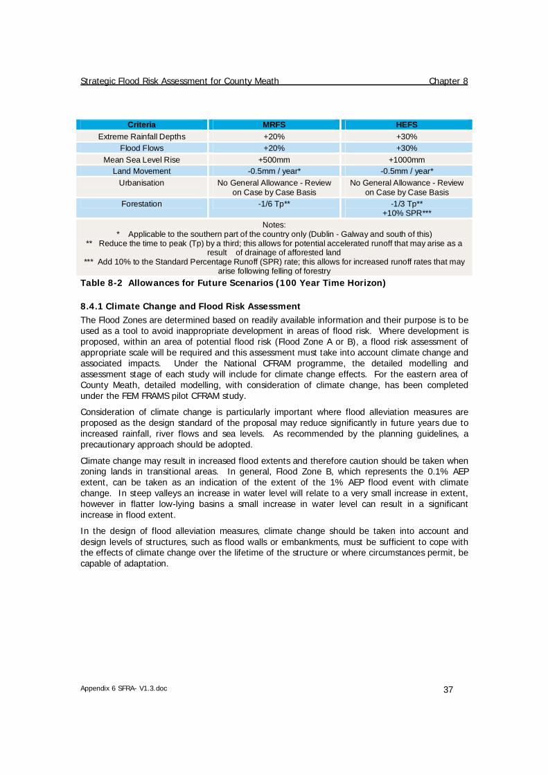
Strategic Flood Risk Assessment for County Meath Chapter 8
Appendix 6 SFRA- V1.3.doc 37
Criteria MRFS HEFS Extreme Rainfall Depths +20% +30%
Flood Flows +20% +30% Mean Sea Level Rise +500mm +1000mm
Land Movement -0.5mm / year* -0.5mm / year* Urbanisation No General Allowance - Review
on Case by Case Basis No General Allowance - Review
on Case by Case Basis Forestation -1/6 Tp** -1/3 Tp**
+10% SPR*** Notes:
* Applicable to the southern part of the country only (Dublin - Galway and south of this) ** Reduce the time to peak (Tp) by a third; this allows for potential accelerated runoff that may arise as a
result of drainage of afforested land *** Add 10% to the Standard Percentage Runoff (SPR) rate; this allows for increased runoff rates that may
arise following felling of forestry Table 8-2 Allowances for Future Scenarios (100 Year Time Horizon)
8.4.1 Climate Change and Flood Risk Assessment The Flood Zones are determined based on readily available information and their purpose is to be used as a tool to avoid inappropriate development in areas of flood risk. Where development is proposed, within an area of potential flood risk (Flood Zone A or B), a flood risk assessment of appropriate scale will be required and this assessment must take into account climate change and associated impacts. Under the National CFRAM programme, the detailed modelling and assessment stage of each study will include for climate change effects. For the eastern area of County Meath, detailed modelling, with consideration of climate change, has been completed under the FEM FRAMS pilot CFRAM study.
Consideration of climate change is particularly important where flood alleviation measures are proposed as the design standard of the proposal may reduce significantly in future years due to increased rainfall, river flows and sea levels. As recommended by the planning guidelines, a precautionary approach should be adopted.
Climate change may result in increased flood extents and therefore caution should be taken when zoning lands in transitional areas. In general, Flood Zone B, which represents the 0.1% AEP extent, can be taken as an indication of the extent of the 1% AEP flood event with climate change. In steep valleys an increase in water level will relate to a very small increase in extent, however in flatter low-lying basins a small increase in water level can result in a significant increase in flood extent.
In the design of flood alleviation measures, climate change should be taken into account and design levels of structures, such as flood walls or embankments, must be sufficient to cope with the effects of climate change over the lifetime of the structure or where circumstances permit, be capable of adaptation.

Strategic Flood Risk Assessment for County Meath Chapter 9
Appendix 6 SFRA- V1.3.doc 38
9. FLOOD RISK MANAGMENT Following the Planning Guidelines, development should always be located in areas of lowest flood risk first, and only when it has been established that there are no suitable alternative options should development (of the lowest vulnerability) proceed. In such instances, consideration of suitable flood risk mitigation and management measures is necessary. It may be technically feasible to mitigate or manage flood risk at site level, however the potential impacts on the surrounding community must also be considered.
A strategic approach to the management of flood risk is required to consider the impact of flooding on a catchment wide basis.
As discussed in Chapter 1, under the CFRAM programme, detailed modelling will be undertaken that will lead to the publication of flood hazard maps for a number of settlements that have been identified as an Area for Further Assessment (AFA). The CFRAM will also result in the publication of a Flood Risk Management Plan that will include management and mitigation options to deal with flood risk in the future. This work has been completed for Fingal East Meath as part of the pilot CFRAM study, FEM FRAMS.
9.1 Management of Flood Risk from a Planning Perspective
The Planning Guidelines recommend a sequential approach. This works well where there are no constraints to development and there is an ample source of developable land. In some areas, development may be constrained due to its location adjacent to the river and natural flood plain. Spatial planning objectives for the area must coincide with the overall flood management strategy. Flood risk management policies must allow a sustainable approach to development without increasing exposure to flood risk whilst considering the mitigation and management of flood risk to existing communities.
9.2 Flood Risk Policies and Objectives
The policies and objective of the planning authority will include consideration of the following:
• The Planning System and Flood Risk Management, Guidelines for Planning Authorities.
• The content of this SFRA; the Flood Zones and their use as a planning tool. • The triggers for review of the SFRA as set out in Chapter 11. • The recommendations of the FEM FRAMS, which was published in draft format in
November 2011. • The recommendations of the Eastern, Neagh-Bann and Shannon CFRAM studies
upon completion. These studies will result in recommended mitigation and management measures, with an expected publication date by end 2015.
9.2.1 Specific Development Planning Applications The following outlines the key requirements relating to the management of development in areas at risk of flooding:
• All development at potential risk of flooding will require an appropriately detailed flood risk assessment. As a minimum this will include a "Stage 1 - Identification of Food Risk"; where flood risk is identified a "Stage 2 - Initial FRA" will be required and depending on the scale and nature of the risk a "Stage 3 - Detailed FRA" may be required.

Strategic Flood Risk Assessment for County Meath Chapter 9
Appendix 6 SFRA- V1.3.doc 39
• All development should have regard to the surface water management policies in the Greater Dublin Strategic Drainage Study (GDSDS). Compliance with the recommendations contained in Technical Guidance Document, Volume 2, Chapter 4 of the Greater Dublin Strategic Drainage Study shall be required in all instances.
• All development proposals, within or incorporating areas at moderate to high flood risk, that are vulnerable to flooding will require the application of the development management justification test in accordance with Box 5.1 of the Planning Guidelines, The Planning System and Flood Risk Management.
• The planning authority will explore opportunities to include flood alleviation proposals and upgrades that benefit the county and / or local area as a whole, as part of specific development applications.
Any proposal that is considered acceptable in principle shall demonstrate the use of the sequential approach in terms of the site layout and design and, in satisfying the Justification Test, the proposal will demonstrate that appropriate mitigation and management measures are put in place.
9.3 Flood Management Action Plan
There are various levels of flood management plans and these include the overall strategy for the river catchment, the emergency response plan of the local authority and the flood risk management plan at a site specific level.
Strategic Flood Risk Management Plan - this will be informed by the detailed assessment of areas at significant flood risk, upon completion of the CFRAM programme. A Strategic Countywide FRMP will pull together the recommendations from each CFRAM in the Eastern, Neagh-Bann and Shannon river basin districts, including the FEM FRAMS. The formulation of a management plan is particularly important in any areas reliant on protection from flood defences. The management plan must consider residual risk and an effective emergency response should the defences fail due to overtopping or breach. Under the CFRAM programme, flood risk management options will be explored for all areas that will undergo detailed modelling i.e. Areas for Further Assessment (AFA). Under the EU Floods Directive, the CFRAM programme is due for completion by the end of 2015.
FEM FRAMS FRMP – the draft FEM FRAMS Flood Risk Management Plan was published in November 2011 for public consultation. This plan “identifies viable structural and non-structural options for managing the flood risks within the study area as a whole and for localised high-risk areas.” The recommendations of this plan will be incorporated into the future planning objectives for the relevant areas.
Site Specific FRMP - this will be specific to the development and associated activities. A site specific FRMP, which may include an emergency plan, will be required for any development proposal that is granted approval in an area of flood risk.
9.4 Policy Relating to Management of Surface Water
Development has the potential to cause an increase in impermeable area and an associated increase in surface water runoff rates and volumes. This can lead to potential increase in flood risk downstream due to overloading of existing drainage infrastructure.
Managing surface water discharges from new development is crucial in managing and reducing flood risk to other development downstream. The management of surface water is an important concern for all development sites. Compliance with the recommendations contained in Technical Guidance Document, Volume 2, Chapter 4 of the Greater Dublin Strategic Drainage Study (GDSDS) shall be required in all instances.

Strategic Flood Risk Assessment for County Meath Chapter 9
Appendix 6 SFRA- V1.3.doc 40
9.4.1 Overland Flow Routes Underground drainage systems have a finite capacity and regard should be given to events larger than the design capacity of the network. This should be considered along with potential surface water flows that may enter a development site from the surrounding area. Master planning should ensure that existing flow routes are maintained, through the use of green infrastructure. Floor levels should at a minimum be 300mm above adjacent roads and hard standing areas to reduce the consequences of any localised flooding.
9.4.2 Sustainable Drainage Systems (SuDS) A specific requirement of the EU Water Framework Directive is that surface water discharge is controlled and managed so that any impact on its receiving environment is mitigated. This can be achieved through the use of Sustainable Drainage Systems (SuDS). SuDS can reduce the rate of runoff through a combination of infiltration, storage and conveyance (slowing down the movement of water). Sustainable drainage can be achieved through the use of green infrastructure such green roofs and pervious pavements, rainwater harvesting, soakaways, swales and detention basins, ponds and wetlands.
The effectiveness of flow management scheme within a single site is heavily limited by the land use and site characteristics including (but not limited to) topography, geology and available area. As such, surface water design and management must be carried out at a site specific level for any proposed development.
9.5 Flood Mitigation Measures at Site Design
Any development proposal in an area at moderate or high risk of flooding that is considered acceptable in principle must demonstrate that appropriate mitigation measures can be put in place and that residual risks can be managed to acceptable levels.
To ensure that adequate measures are put in place to deal with residual risks, proposals should demonstrate the use of flood-resistant construction measures that are aimed at preventing water from entering a building and that mitigate the damage floodwater causes to buildings. Alternatively, designs for flood resilient construction may be adopted where it can be demonstrated that entry of floodwater into buildings is preferable to limit damage caused by floodwater and allow relatively quick recovery.
Further detail on flood resilience and flood resistance are included in the Technical Appendices of the Planning Guidelines, The Planning System and Flood Risk Management.19
19 The Planning System and Flood Risk Management Guidelines for Planning Authorities, Technical Appendices, November 2009

Strategic Flood Risk Assessment for County Meath Chapter 10
Appendix 6 SFRA- V1.3.doc 41
10. DEVELOPMENT ZONING AND SETTLEMENT REVIEW
10.1 Land Use Zoning Objectives
The purpose of zoning is to indicate to property owners and members of the public the types of development, which the Planning Authority considers most appropriate in each land use category.
Zoning is designed to reduce conflicting uses within areas, to protect resources and, in association with phasing, to ensure that land suitable for development is used to the best advantage of the community as a whole.
The zoning objectives can be related to the vulnerability classifications in the Planning System and Flood Risk Management guidelines; highly vulnerable, less vulnerable and water compatible. The vulnerability of the land use, coupled with the Flood Zone in which it lies indicates the appropriateness of the development and guides the need for application of the Justification Test.
A summary of land zoning types and their respective vulnerabilities are shown in the table below. It is important to note that this table is provided as a general guide and the specific development types within the zoning objective must be considered individually, and with reference to Table 3-1 of the Planning System and Flood Risk Management guidelines. For example, in planning terms a guest house or hotel is permitted in principle under the 'Tourism' zoning, but are considered to be highly vulnerable to flooding. The vulnerability class does not take into account economic damages; for example, high-tech manufacturing would be permitted under the 'Enterprise and Employment' zoning objective and could pass the Justification Test within Flood Zones A or B (See Section 3.3 for Flood Zone definition), but the costs associated with flooding of such a development may point to its preferential location within Flood Zone C.
Town Development Plans and Local Area Plans will be reviewed following the publication of the County Development Plan
Vulnerability Class Land use and types of development include:
Highly vulnerable development (including essential infrastructure)
Garda, ambulance and fire stations
Hospitals and schools;
Dwelling houses, student halls of residence and hostels.
Less vulnerable development Buildings used for: retail, leisure, warehousing, commercial, industrial and non-residential institutions;
Land and building used for agriculture and forestry;
Local transport infrastructure.
Water-compatible development Flood control infrastructure;
Amenity open space, outdoor sports and recreation and essential facilities such as changing rooms;
Lifeguard and coastguard stations.
Table 10-1 Summary Classification of Vulnerability

Strategic Flood Risk Assessment for County Meath Chapter 10
Appendix 6 SFRA- V1.3.doc 42
10.2 Review of Flood Risk at Settlements in County Meath
The following summarises the findings of the settlement review. The review considered potential for future development within the development boundary of each settlement based on the extent of flood risk and the availability of development lands. The review also considers the development pressure on the settlement as indicated by the current land use zoning maps.
The full discussion and commentary on flood risk management and its interaction with future development is provided in Appendix A.
A consideration of flood risk management is essential when the land use zoning maps for each settlement are being reviewed. If flood risk can be avoided, development zoning can proceed without the need for a SFRA at LAP or Town Plan stage. In the majority of cases, it will not be possible to completely avoid flood risk i.e. historically town centres originate on the banks of major rivers. Mitigation and management of flood risk must be considered to allow continued development of an area without increasing exposure to flood risk. In some areas this may be a relatively straight forward process that can use the general polices and recommendation of the countywide SFRA. For areas with a significant proportion of zoned land in Flood Zone A and B this will require more detailed consideration at LAP or Town Plan stage.
SETTLEMENT CONCLUSION
Ashbourne No SFRA required. Implement Flood Risk Management policies from CDP and any FEM FRAMS recommendations
Athboy No SFRA required Implement Flood Risk Management policies from CDP
Ballivor SFRA required at LAP stage Bettystown SFRA required at LAP stage, taking into account any recommendations of the
FEM FRAMS Carlanstown No SFRA required
Implement Flood Risk Management policies from CDP Carnaross No SFRA required
Implement Flood Risk Management policies from CDP Clonard SFRA required at LAP stage Crossakeel No SFRA required
Implement Flood Risk Management policies from CDP Donacarney No SFRA required
Implement Flood Risk Management policies from CDP Donore No SFRA required
Implement Flood Risk Management policies from CDP Drogheda South
Joint SFRA with Louth County Council / Drogheda Borough Council required
Drumconrath SFRA required at LAP stage. Duleek SFRA required at LAP stage, taking into account any recommendations of the
FEM FRAMS Dunboyne Clonee Pace
SFRA required at LAP stage.
Dunshaughlin No SFRA required Implement Flood Risk Management policies from CDP and any FEM FRAMS recommendations
Enfield No SFRA required Implement Flood Risk Management policies from CDP
Gibbstown No SFRA required

Strategic Flood Risk Assessment for County Meath Chapter 10
Appendix 6 SFRA- V1.3.doc 43
SETTLEMENT CONCLUSION
Implement Flood Risk Management policies from CDP Gormanston No SFRA required
Implement Flood Risk Management policies from CDP and any FEM FRAMS recommendations
Julianstown No SFRA required Implement Flood Risk Management policies from CDP and any FEM FRAMS recommendations
Kells No SFRA required Implement Flood Risk Management policies from CDP
Kentstown No SFRA required Implement Flood Risk Management policies from CDP and any FEM FRAMS recommendations
Kilbride No SFRA required Implement Flood Risk Management policies from CDP
Kilcock Further examination in line with The Planning System and Flood Risk Management – Guidelines for Planning Authorities” (OPW/DoEHLG, 2009) may be required.
Kildalkey No SFRA required Implement Flood Risk Management policies from CDP
Kilmainham-wood
No SFRA required Implement Flood Risk Management policies from CDP
Kilmessan SFRA required at LAP stage. Laytown No SFRA required
Implement Flood Risk Management policies from CDP and any FEM FRAMS recommendations
Longwood SFRA required for LAP stage Maynooth Environs
No SFRA required Implement Flood Risk Management policies from CDP
Mornington No SFRA required Implement Flood Risk Management policies from CDP
Mornington East
SFRA required at LAP stage.
Moynalty No SFRA required Implement Flood Risk Management policies from CDP
Navan SFRA required at Development Plan stage Nobber SFRA required at LAP stage Oldcastle No SFRA required
Implement Flood Risk Management policies from CDP Rathcairn No SFRA required
Implement Flood Risk Management policies from CDP Rathmolyon No SFRA required
Implement Flood Risk Management policies from CDP Ratoath No SFRA required
Implement Flood Risk Management policies from CDP and any FEM FRAMS recommendations
Slane No SFRA required. Implement Flood Risk Management policies from CDP
Stamullen No SFRA required Implement Flood Risk Management policies from CDP and any FEM FRAMS

Strategic Flood Risk Assessment for County Meath Chapter 10
Appendix 6 SFRA- V1.3.doc 44
SETTLEMENT CONCLUSION
recommendations Summerhill No SFRA required.
Implement Flood Risk Management policies from CDP Trim SFRA required at Development Plan stage Table 10-2 Summary Results from the Settlement Review

Strategic Flood Risk Assessment for County Meath Chapter 11
Appendix 6 SFRA- V1.3.doc 45
11. SFRA REVIEW AND MONITORING An update to the SFRA will be triggered by the six year review cycle that applies to Local Authority development plans. In addition there are a number of other potential triggers for an SFRA review and these are listed in the table below.
There are a number of key outputs from possible future studies and datasets, which should be incorporated into any update of the SFRA as availability allows. Not all future sources of information should trigger an immediate full update of the SFRA; however, new information should be collected and kept alongside the SFRA until it is updated.
In addition, information on insurance claims from water related issues, i.e. flooding, could be compiled, if available.
Trigger Source Possible Timescale
Catchment Flood Risk Assessment and Management (CFRAM) Flood Hazard Mapping
OPW under the Floods Directive
2013
Catchment Flood Risk Assessment and Management (CFRAM) Plan
OPW 2015
Flood maps of other sources, such as canal breach and drainage networks
Various Unknown
Significant flood events Various Unknown
Changes to Planning and / or Flood Management Policy DoEHLG / OPW Unknown
Detailed FRAs Various Unknown
Flood Defence Feasibility / Design Reports Likely to be local authority and the OPW
Unknown
Table 11-1 SFRA Review Triggers

Strategic Flood Risk Assessment for County Meath Chapter 11
Appendix 6 SFRA- V1.3.doc 46
This page is intentionally left blank.

Appendices
Appendix A – Settlement Review

A Settlement Review
Contents
Appendix 6 SFRA (Appendix A) -V1.3.doc
A.1 Ashbourne ................................................................................................................1 A.2 Athboy ......................................................................................................................2 A.3 Ballivor......................................................................................................................3 A.4 Bettystown................................................................................................................4 A.5 Carlanstown ..............................................................................................................5 A.6 Carnaross..................................................................................................................5 A.7 Clonard .....................................................................................................................5 A.8 Crossakeel ................................................................................................................5 A.9 Donacarney...............................................................................................................5 A.10 Donore......................................................................................................................5 A.11 Drogheda Southern Environs.....................................................................................5 A.12 Drumconrath.............................................................................................................5 A.13 Duleek ......................................................................................................................5 A.14 Dunboyne Clonee Pace..............................................................................................5 A.15 Dunshaughlin ............................................................................................................5 A.16 Enfield ......................................................................................................................5 A.17 Gibbstown.................................................................................................................5 A.18 Gormanston ..............................................................................................................5 A.19 Julianstown ...............................................................................................................5 A.20 Kells..........................................................................................................................5 A.21 Kentstown.................................................................................................................5 A.22 Kilbride .....................................................................................................................5 A.23 Kilcock ......................................................................................................................5 A.24 Kildalkey ...................................................................................................................5 A.25 Kilmainhamwood.......................................................................................................5 A.26 Kilmessan..................................................................................................................5 A.27 Laytown ....................................................................................................................5 A.28 Longwood .................................................................................................................5 A.29 Maynooth Environs....................................................................................................5 A.30 Mornington ...............................................................................................................5 A.31 Mornington East........................................................................................................5 A.32 Moynalty ...................................................................................................................5 A.33 Navan .......................................................................................................................5 A.34 Nobber......................................................................................................................5 A.35 Oldcastle ...................................................................................................................5 A.36 Rathcairn ..................................................................................................................5 A.37 Rathmolyon...............................................................................................................5 A.38 Ratoath .....................................................................................................................5 A.39 Slane ........................................................................................................................5 A.40 Stamullen..................................................................................................................5 A.41 Summerhill................................................................................................................5 A.42 Trim..........................................................................................................................5

Appendix 6 SFRA (Appendix A) -V1.3.doc 1
A.1 Ashbourne
Settlement Area 585.53 Ha
Zoning within Flood Zone A and/or B? Yes
Area for Further Assessment under CFRAM programme?
FEM FRAMS
© Ordnance Survey Ireland & Government of Ireland, Meath 2012/31/CCMA The Flood Zone mapping has been produced in accordance with the Planning Guidelines and therefore ignores the impact of flood protection structures. Areas protected by flood defences still carry a residual risk of flooding due to overtopping or breach, there may also be no guarantee of maintenance in perpetuity. Areas that benefit from defences are annotated separately. Note that Flood Zone mapping is only reproduced within the settlement development boundary. Flood Zone A – Fluvial: 1 in 100 year or 1% AEP, Tidal: 1 in 200 year or 0.5% AEP. Flood Zone B – 1 in 1000 year or 0.1% AEP.
Flood Zone mapping data source FEM FRAMS
Historical Flooding Broadmeadow Ashbourne Nov 2002 Broadmeadow Ashbourne Aug 1986
Comment Two watercourses flow through Ashbourne with their confluence just east of Milltown Bridge. Flood risk in Ashbourne is well defined based on detailed modeling carried out under FEM FRAMS. The Flood Zones will not hinder future development and zoning for new development in areas of high flood risk can be avoided. Flood risk can be managed by adopting the policies set out in the County Development Plan, the recommendations of the Planning Guidelines and any additional management measures specified by the FEM FRAMS.
Conclusion No SFRA required. Implement Flood Risk Management policies from CDP and any FEM FRAMS recommendations.
LegendSettlement Development Boundary
Area benefitting from defences
Flood Zone A
Flood Zone B

Appendix 6 SFRA (Appendix A) -V1.3.doc 2
A.2 Athboy
Settlement Area 197.9 Ha
Zoning within Flood Zone A and/or B? Yes
Area for Further Assessment under CFRAM programme?
Eastern CFRAM Study
© Ordnance Survey Ireland & Government of Ireland, Meath 2012/31/CCMA The Flood Zone mapping has been produced in accordance with the Planning Guidelines and therefore ignores the impact of flood protection structures. Areas protected by flood defences still carry a residual risk of flooding due to overtopping or breach, there may also be no guarantee of maintenance in perpetuity. Areas that benefit from defences are annotated separately. Note that Flood Zone mapping is only reproduced within the settlement development boundary. Flood Zone A – Fluvial: 1 in 100 year or 1% AEP, Tidal: 1 in 200 year or 0.5% AEP. Flood Zone B – 1 in 1000 year or 0.1% AEP. Flood Zone mapping data source Eastern CFRAM Flood Risk Review (PFRA)
Historical Flooding Mullaghstones N51 Recurring (minor surface water issue)
Comment The Athboy River runs through the settlement and development has established on both sides of the river. Flood risk can be managed by adopting the policies set out in the County Development Plan and the recommendations of the Planning Guidelines. As this is an Area for Further Assessment under the Eastern CFRAM, further review is required following the publication of the Eastern CFRAM flood hazard mapping and subsequent management plans.
Conclusion No SFRA required Implement Flood Risk Management policies from CDP
LegendSettlement Development Boundary
Flood Zone A
Flood Zone B

Appendix 6 SFRA (Appendix A) -V1.3.doc 3
A.3 Ballivor
Settlement Area 101.68 Ha
Zoning within Flood Zone A and/or B? Yes
Area for Further Assessment under CFRAM programme?
Eastern CFRAM Study
© Ordnance Survey Ireland & Government of Ireland, Meath 2012/31/CCMA The Flood Zone mapping has been produced in accordance with the Planning Guidelines and therefore ignores the impact of flood protection structures. Areas protected by flood defences still carry a residual risk of flooding due to overtopping or breach, there may also be no guarantee of maintenance in perpetuity. Areas that benefit from defences are annotated separately. Note that Flood Zone mapping is only reproduced within the settlement development boundary. Note that Flood Zone mapping is only reproduced within the settlement development boundary. Flood Zone A – Fluvial: 1 in 100 year or 1% AEP, Tidal: 1 in 200 year or 0.5% AEP. Flood Zone B –1 in 1000 year or 0.1% AEP. Flood Zone mapping data source Eastern CFRAM Flood Risk Review (PFRA)
Historical Flooding No
Comment Two watercourses flow through Ballivor from the east and north, and the Flood Zones will restrict development the south, east and west of the core. Further review of land use zonings is required at LAP stage. As an Area for Further Assessment under Eastern CFRAM, further review is required following the publication of the Eastern CFRAM flood hazard mapping and subsequent management plans.
Conclusion SFRA required at LAP stage
LegendSettlement Development Boundary
Flood Zone A
Flood Zone B

Appendix 6 SFRA (Appendix A) -V1.3.doc 4
A.4 Bettystown
Settlement Area 313.84 Ha
Zoning within Flood Zone A and/or B? Yes
Area for Further Assessment under CFRAM programme?
FEM FRAMS
© Ordnance Survey Ireland & Government of Ireland, Meath 2012/31/CCMA The Flood Zone mapping has been produced in accordance with the Planning Guidelines and therefore ignores the impact of flood protection structures. Areas protected by flood defences still carry a residual risk of flooding due to overtopping or breach, there may also be no guarantee of maintenance in perpetuity. Areas that benefit from defences are annotated separately. Note that Flood Zone mapping is only reproduced within the settlement development boundary. Flood Zone A – Fluvial: 1 in 100 year or 1% AEP, Tidal: 1 in 200 year or 0.5% AEP. Flood Zone B – 1 in 1000 year or 0.1% AEP.
Flood Zone mapping data source FEM FRAMS & PFRA
Historical Flooding Mentioned - Mornington November 2000 and Piltown Meath Recurring
Comment Flood risk in Bettystown is well defined in the southern end of the settlement as this watercourse was modelled under the FEM FRAMS. Significant flood risk is identified that will be a constraint to expansion of existing developed areas. It is recommended that flood risk and management options for the settlement are considered in more detail at the Lap stage, and take into account the recommendations of the FEM FRAMS and any potential overlap with the Mornington Flood Alleviation Study.
Conclusion SFRA required at LAP stage, taking into account any recommendations of the FEM FRAMS
LegendSettlement Development Boundary
Flood Zone A
Flood Zone B

Appendix 6 SFRA (Appendix A) -V1.3.doc 5
A.5 Carlanstown
Settlement Area 62.68 Ha
Zoning within Flood Zone A and/or B? Yes
Area for Further Assessment under CFRAM programme?
No
© Ordnance Survey Ireland & Government of Ireland, Meath 2012/31/CCMA The Flood Zone mapping has been produced in accordance with the Planning Guidelines and therefore ignores the impact of flood protection structures. Areas protected by flood defences still carry a residual risk of flooding due to overtopping or breach, there may also be no guarantee of maintenance in perpetuity. Areas that benefit from defences are annotated separately. Note that Flood Zone mapping is only reproduced within the settlement development boundary. Flood Zone A – Fluvial: 1 in 100 year or 1% AEP, Tidal: 1 in 200 year or 0.5% AEP. Flood Zone B – 1 in 1000 year or 0.1% AEP.
Flood Zone mapping data source PFRA
Historical Flooding No
Comment The Moynalty River flows along the south west boundary of the settlement. The Flood Zones will not hinder future development and zoning for new development in areas of high flood risk can be avoided. Flood risk can be managed by adopting the policies set out in the County Development Plan and the recommendations of the Planning Guidelines.
Conclusion No SFRA required Implement Flood Risk Management policies from CDP
LegendSettlement Development Boundary
Flood Zone A
Flood Zone B

Appendix 6 SFRA (Appendix A) -V1.3.doc 6
A.6 Carnaross
Settlement Area 29.23 Ha
Zoning within Flood Zone A and/or B? No
Area for Further Assessment under CFRAM programme?
No
© Ordnance Survey Ireland & Government of Ireland, Meath 2012/31/CCMA The Flood Zone mapping has been produced in accordance with the Planning Guidelines and therefore ignores the impact of flood protection structures. Areas protected by flood defences still carry a residual risk of flooding due to overtopping or breach, there may also be no guarantee of maintenance in perpetuity. Areas that benefit from defences are annotated separately. Note that Flood Zone mapping is only reproduced within the settlement development boundary. Flood Zone A – Fluvial: 1 in 100 year or 1% AEP, Tidal: 1 in 200 year or 0.5% AEP. Flood Zone B – 1 in 1000 year or 0.1% AEP.
Flood Zone mapping data source n/a
Historical Flooding No
Comment No fluvial flood risk identified and no flood history.
Conclusion No SFRA required Implement Flood Risk Management policies from CDP
LegendSettlement Development Boundary
Flood Zone A
Flood Zone B

Appendix 6 SFRA (Appendix A) -V1.3.doc 7
A.7 Clonard
Settlement Area 63.3 Ha
Zoning within Flood Zone A and/or B? Yes
Area for Further Assessment under CFRAM programme?
No
© Ordnance Survey Ireland & Government of Ireland, Meath 2012/31/CCMA The Flood Zone mapping has been produced in accordance with the Planning Guidelines and therefore ignores the impact of flood protection structures. Areas protected by flood defences still carry a residual risk of flooding due to overtopping or breach, there may also be no guarantee of maintenance in perpetuity. Areas that benefit from defences are annotated separately. Note that Flood Zone mapping is only reproduced within the settlement development boundary. Flood Zone A – Fluvial: 1 in 100 year or 1% AEP, Tidal: 1 in 200 year or 0.5% AEP. Flood Zone B – 1 in 1000 year or 0.1% AEP.
Flood Zone mapping data source JFlow
Historical Flooding No
Comment The Kilwarden River and associated Flood Zones restrict development to the north and east. If future development can be avoided in Flood Zones flood risk can be managed by adopting the policies set out in the County Development Plan and the recommendations of the Planning Guidelines. However as a large area of the development area is within Flood Zone A it is recommended that an SFRA is completed at LAP stage.
Conclusion SFRA required at LAP level
LegendSettlement Development Boundary
Flood Zone A
Flood Zone B

Appendix 6 SFRA (Appendix A) -V1.3.doc 8
A.8 Crossakeel
Settlement Area 22.72 Ha
Zoning within Flood Zone A and/or B? No
Area for Further Assessment under CFRAM programme?
No
© Ordnance Survey Ireland & Government of Ireland, Meath 2012/31/CCMA The Flood Zone mapping has been produced in accordance with the Planning Guidelines and therefore ignores the impact of flood protection structures. Areas protected by flood defences still carry a residual risk of flooding due to overtopping or breach, there may also be no guarantee of maintenance in perpetuity. Areas that benefit from defences are annotated separately. Note that Flood Zone mapping is only reproduced within the settlement development boundary. Flood Zone A – Fluvial: 1 in 100 year or 1% AEP, Tidal: 1 in 200 year or 0.5% AEP. Flood Zone B – 1 in 1000 year or 0.1% AEP.
Flood Zone mapping data source n/a
Historical Flooding No
Comment No fluvial flood risk identified and no flood history.
Conclusion No SFRA required Implement Flood Risk Management policies from CDP
LegendSettlement Development Boundary
Flood Zone A
Flood Zone B

Appendix 6 SFRA (Appendix A) -V1.3.doc 9
A.9 Donacarney
Settlement Area 97.85 Ha
Zoning within Flood Zone A and/or B? No
Area for Further Assessment under CFRAM programme?
No
© Ordnance Survey Ireland & Government of Ireland, Meath 2012/31/CCMA The Flood Zone mapping has been produced in accordance with the Planning Guidelines and therefore ignores the impact of flood protection structures. Areas protected by flood defences still carry a residual risk of flooding due to overtopping or breach, there may also be no guarantee of maintenance in perpetuity. Areas that benefit from defences are annotated separately. Note that Flood Zone mapping is only reproduced within the settlement development boundary. Flood Zone A – Fluvial: 1 in 100 year or 1% AEP, Tidal: 1 in 200 year or 0.5% AEP. Flood Zone B – 1 in 1000 year or 0.1% AEP.
Flood Zone mapping data source JFlow
Historical Flooding Donacarney School R150 Recurring
Comment No fluvial flood risk identified. Some potential for isolated areas of surface water ponding, recurring flooding reported on R150 near Donacarney school
Conclusion No SFRA required Implement Flood Risk Management policies from CDP
LegendSettlement Development Boundary
Flood Zone A
Flood Zone B

Appendix 6 SFRA (Appendix A) -V1.3.doc 10
A.10 Donore
Settlement Area 40.35 Ha
Zoning within Flood Zone A and/or B? No
Area for Further Assessment under CFRAM programme?
No
© Ordnance Survey Ireland & Government of Ireland, Meath 2012/31/CCMA The Flood Zone mapping has been produced in accordance with the Planning Guidelines and therefore ignores the impact of flood protection structures. Areas protected by flood defences still carry a residual risk of flooding due to overtopping or breach, there may also be no guarantee of maintenance in perpetuity. Areas that benefit from defences are annotated separately. Note that Flood Zone mapping is only reproduced within the settlement development boundary. Flood Zone A – Fluvial: 1 in 100 year or 1% AEP, Tidal: 1 in 200 year or 0.5% AEP. Flood Zone B – 1 in 1000 year or 0.1% AEP.
Flood Zone mapping data source n/a
Historical Flooding No
Comment No fluvial flood risk identified and no flood history.
Conclusion No SFRA required Implement Flood Risk Management policies from CDP
LegendSettlement Development Boundary
Flood Zone A
Flood Zone B

Appendix 6 SFRA (Appendix A) -V1.3.doc 11
A.11 Drogheda Southern Environs
Settlement Area 691.77 Ha
Zoning within Flood Zone A and/or B? Yes
Area for Further Assessment under CFRAM programme?
No (but Drogheda, Co Louth is an Area for Further Assessment)
© Ordnance Survey Ireland & Government of Ireland, Meath 2012/31/CCMA The Flood Zone mapping has been produced in accordance with the Planning Guidelines and therefore ignores the impact of flood protection structures. Areas protected by flood defences still carry a residual risk of flooding due to overtopping or breach, there may also be no guarantee of maintenance in perpetuity. Areas that benefit from defences are annotated separately. Note that Flood Zone mapping is only reproduced within the settlement development boundary. Flood Zone A – Fluvial: 1 in 100 year or 1% AEP, Tidal: 1 in 200 year or 0.5% AEP. Flood Zone B – 1 in 1000 year or 0.1% AEP.
Flood Zone mapping data source PFRA & JFlow
Historical Flooding R152 South of Drogheda Recurring Marsh Road, Drogheda Recurring Railway Bridge on R152, Drogheda Recurring Colp West Recurring
Comment The flood zones will restrict the expansion of existing development to the south of the settlement area. Based on the settlement’s location on the border with County Louth, an SFRA is recommended considering the wider Drogheda area. Further review is required following the publication of the Eastern CFRAM flood hazard mapping and subsequent management plans.
Conclusion Joint SFRA with Drogheda Borough Council / Louth County Council required
LegendSettlement Development Boundary
Flood Zone A
Flood Zone B

Appendix 6 SFRA (Appendix A) -V1.3.doc 12
A.12 Drumconrath
Settlement Area 48.47 Ha
Zoning within Flood Zone A and/or B? Yes
Area for Further Assessment under CFRAM programme?
No
© Ordnance Survey Ireland & Government of Ireland, Meath 2012/31/CCMA The Flood Zone mapping has been produced in accordance with the Planning Guidelines and therefore ignores the impact of flood protection structures. Areas protected by flood defences still carry a residual risk of flooding due to overtopping or breach, there may also be no guarantee of maintenance in perpetuity. Areas that benefit from defences are annotated separately. Note that Flood Zone mapping is only reproduced within the settlement development boundary. Flood Zone A – Fluvial: 1 in 100 year or 1% AEP, Tidal: 1 in 200 year or 0.5% AEP. Flood Zone B – 1 in 1000 year or 0.1% AEP.
Flood Zone mapping data source JFlow
Historical Flooding Drumconrath Oct 1993; Dee Catchment Drumconrath Co. Meath August 2008; 24th October 2011
Comment Development is restricted by the River and the natural topography of the land. Recent flooding of properties highlighted flood risk in this area. In light of the recent flooding and based on the natural constraints to expansion of the settlement, it is recommended that flood risk and management options for Drumconrath are assessed in more detail at LAP stage.
Conclusion SFRA required at LAP stage.
LegendSettlement Development Boundary
Flood Zone A
Flood Zone B

Appendix 6 SFRA (Appendix A) -V1.3.doc 13
A.13 Duleek
Settlement Area 274.17 Ha
Zoning within Flood Zone A and/or B? Yes
Area for Further Assessment under CFRAM programme?
FEM FRAMS
© Ordnance Survey Ireland & Government of Ireland, Meath 2012/31/CCMA The Flood Zone mapping has been produced in accordance with the Planning Guidelines and therefore ignores the impact of flood protection structures. Areas protected by flood defences still carry a residual risk of flooding due to overtopping or breach, there may also be no guarantee of maintenance in perpetuity. Areas that benefit from defences are annotated separately. Note that Flood Zone mapping is only reproduced within the settlement development boundary. Flood Zone A – Fluvial: 1 in 100 year or 1% AEP, Tidal: 1 in 200 year or 0.5% AEP. Flood Zone B – 1 in 1000 year or 0.1% AEP.
Flood Zone mapping data source FEM FRAMS
Historical Flooding Nanny Duleek -Nov 2000, Sept 1975, Jan 1992, June 1993 and Mar 1980
Comment The Nanny River has a significant history of flooding and through Duleek has been subject to a detailed flood risk study. The recommendations of the study have now resulted in the construction of flood defences to help protect recent development at Abbeylands, Mill Race and Oakleigh. These areas are indicated on the figure above. It is recommended that the site is assessed in more detail at LAP stage, taking into account the specifics presented in the Flood Relief Study and the FEM FRAMS. This should consider overall management of flood risk in the settlement and assess the residual risk in defended areas.
Conclusion SFRA required at LAP stage, taking into account any recommendations of the FEM FRAMS
LegendSettlement Development Boundary
Area benefitting from defences
Flood Zone A
Flood Zone B
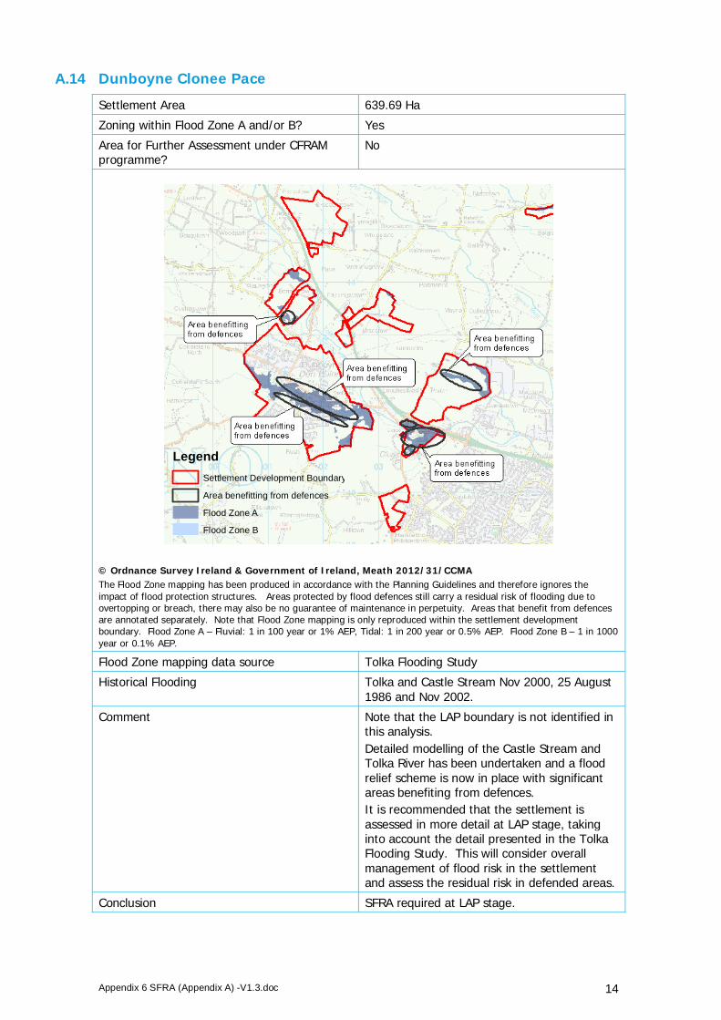
Appendix 6 SFRA (Appendix A) -V1.3.doc 14
A.14 Dunboyne Clonee Pace
Settlement Area 639.69 Ha
Zoning within Flood Zone A and/or B? Yes
Area for Further Assessment under CFRAM programme?
No
© Ordnance Survey Ireland & Government of Ireland, Meath 2012/31/CCMA The Flood Zone mapping has been produced in accordance with the Planning Guidelines and therefore ignores the impact of flood protection structures. Areas protected by flood defences still carry a residual risk of flooding due to overtopping or breach, there may also be no guarantee of maintenance in perpetuity. Areas that benefit from defences are annotated separately. Note that Flood Zone mapping is only reproduced within the settlement development boundary. Flood Zone A – Fluvial: 1 in 100 year or 1% AEP, Tidal: 1 in 200 year or 0.5% AEP. Flood Zone B – 1 in 1000 year or 0.1% AEP.
Flood Zone mapping data source Tolka Flooding Study
Historical Flooding Tolka and Castle Stream Nov 2000, 25 August 1986 and Nov 2002.
Comment Note that the LAP boundary is not identified in this analysis. Detailed modelling of the Castle Stream and Tolka River has been undertaken and a flood relief scheme is now in place with significant areas benefiting from defences. It is recommended that the settlement is assessed in more detail at LAP stage, taking into account the detail presented in the Tolka Flooding Study. This will consider overall management of flood risk in the settlement and assess the residual risk in defended areas.
Conclusion SFRA required at LAP stage.
LegendSettlement Development Boundary
Area benefitting from defences
Flood Zone A
Flood Zone B
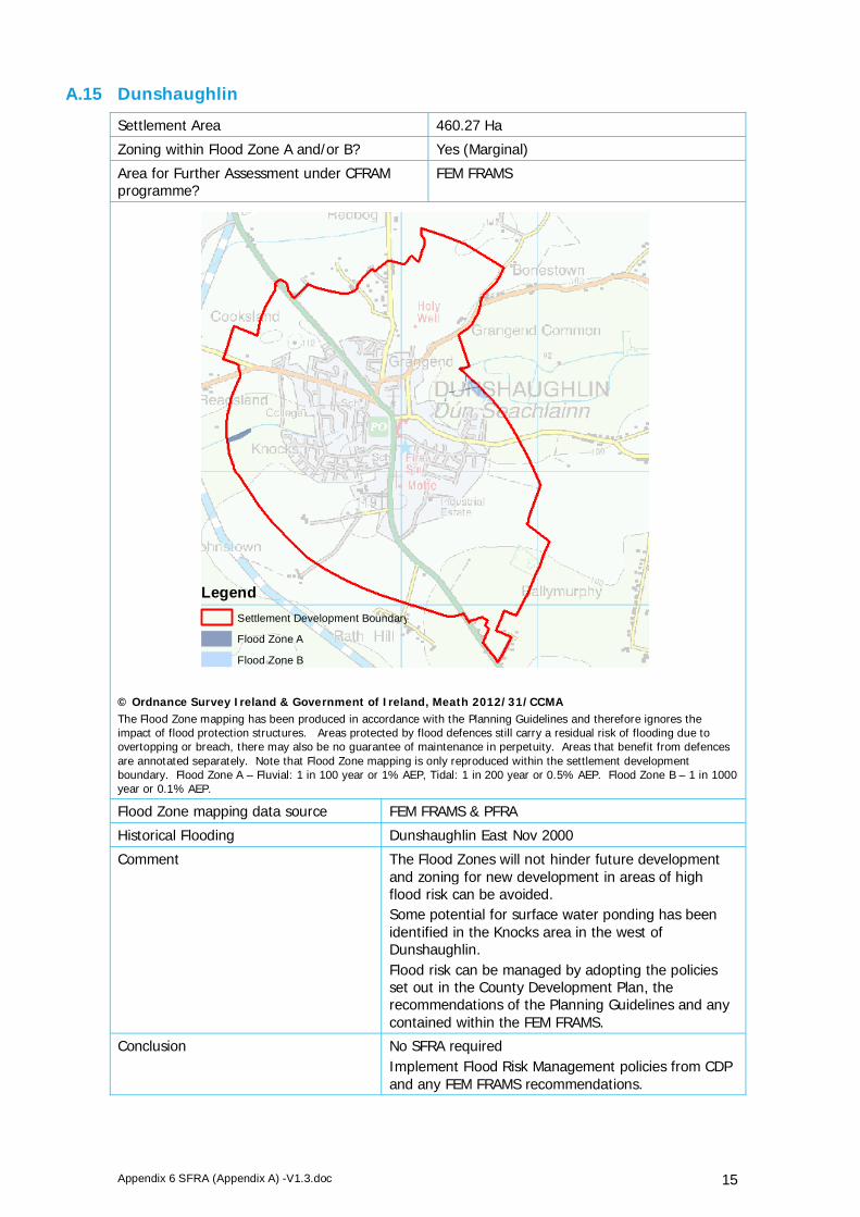
Appendix 6 SFRA (Appendix A) -V1.3.doc 15
A.15 Dunshaughlin
Settlement Area 460.27 Ha
Zoning within Flood Zone A and/or B? Yes (Marginal)
Area for Further Assessment under CFRAM programme?
FEM FRAMS
© Ordnance Survey Ireland & Government of Ireland, Meath 2012/31/CCMA The Flood Zone mapping has been produced in accordance with the Planning Guidelines and therefore ignores the impact of flood protection structures. Areas protected by flood defences still carry a residual risk of flooding due to overtopping or breach, there may also be no guarantee of maintenance in perpetuity. Areas that benefit from defences are annotated separately. Note that Flood Zone mapping is only reproduced within the settlement development boundary. Flood Zone A – Fluvial: 1 in 100 year or 1% AEP, Tidal: 1 in 200 year or 0.5% AEP. Flood Zone B – 1 in 1000 year or 0.1% AEP.
Flood Zone mapping data source FEM FRAMS & PFRA
Historical Flooding Dunshaughlin East Nov 2000
Comment The Flood Zones will not hinder future development and zoning for new development in areas of high flood risk can be avoided. Some potential for surface water ponding has been identified in the Knocks area in the west of Dunshaughlin. Flood risk can be managed by adopting the policies set out in the County Development Plan, the recommendations of the Planning Guidelines and any contained within the FEM FRAMS.
Conclusion No SFRA required Implement Flood Risk Management policies from CDP and any FEM FRAMS recommendations.
LegendSettlement Development Boundary
Flood Zone A
Flood Zone B

Appendix 6 SFRA (Appendix A) -V1.3.doc 16
A.16 Enfield
Settlement Area 199.96 Ha
Zoning within Flood Zone A and/or B? No
Area for Further Assessment under CFRAM programme?
No
© Ordnance Survey Ireland & Government of Ireland, Meath 2012/31/CCMA The Flood Zone mapping has been produced in accordance with the Planning Guidelines and therefore ignores the impact of flood protection structures. Areas protected by flood defences still carry a residual risk of flooding due to overtopping or breach, there may also be no guarantee of maintenance in perpetuity. Areas that benefit from defences are annotated separately. Note that Flood Zone mapping is only reproduced within the settlement development boundary. Flood Zone A – Fluvial: 1 in 100 year or 1% AEP, Tidal: 1 in 200 year or 0.5% AEP. Flood Zone B – 1 in 1000 year or 0.1% AEP.
Flood Zone mapping data source n/a
Historical Flooding Main Street, Enfield Recurring (minor surface water issue)
Comment The Royal Canal runs through Enfield. The Flood Zones map fluvial and tidal flood risk. They do not take into account flood risk from artificial / manmade channels. However, as the Canal does not comprise significant embankments flood risk is not considered as being high. Therefore management of flood risk can be achieved through the adoption of the policies set out in the CDP. Some potential for surface water ponding in the north-east and south-west of the settlement.
Conclusions No SFRA required Implement Flood Risk Management policies from CDP
LegendSettlement Development Boundary
Flood Zone A
Flood Zone B

Appendix 6 SFRA (Appendix A) -V1.3.doc 17
A.17 Gibbstown
Settlement Area 44.1 Ha
Zoning within Flood Zone A and/or B? No
Area for Further Assessment under CFRAM programme?
No
© Ordnance Survey Ireland & Government of Ireland, Meath 2012/31/CCMA The Flood Zone mapping has been produced in accordance with the Planning Guidelines and therefore ignores the impact of flood protection structures. Areas protected by flood defences still carry a residual risk of flooding due to overtopping or breach, there may also be no guarantee of maintenance in perpetuity. Areas that benefit from defences are annotated separately. Note that Flood Zone mapping is only reproduced within the settlement development boundary. Flood Zone A – Fluvial: 1 in 100 year or 1% AEP, Tidal: 1 in 200 year or 0.5% AEP. Flood Zone B – 1 in 1000 year or 0.1% AEP.
Flood Zone mapping data source n/a
Historical Flooding No
Comment No fluvial flood risk identified and no flood history.
Conclusions No SFRA required Implement Flood Risk Management policies from CDP
LegendSettlement Development Boundary
Flood Zone A
Flood Zone B

Appendix 6 SFRA (Appendix A) -V1.3.doc 18
A.18 Gormanston
Settlement Area 197.71 Ha
Zoning within Flood Zone A and/or B? No
Area for Further Assessment under CFRAM programme?
FEM FRAMS
© Ordnance Survey Ireland & Government of Ireland, Meath 2012/31/CCMA The Flood Zone mapping has been produced in accordance with the Planning Guidelines and therefore ignores the impact of flood protection structures. Areas protected by flood defences still carry a residual risk of flooding due to overtopping or breach, there may also be no guarantee of maintenance in perpetuity. Areas that benefit from defences are annotated separately. Note that Flood Zone mapping is only reproduced within the settlement development boundary. Flood Zone A – Fluvial: 1 in 100 year or 1% AEP, Tidal: 1 in 200 year or 0.5% AEP. Flood Zone B – 1 in 1000 year or 0.1% AEP.
Flood Zone mapping data source FEM FRAMS
Historical Flooding No
Comment The Flood Zones will not hinder future development and zoning for new development in areas of high flood risk can be avoided. Flood risk can be managed by adopting the policies set out in the County Development Plan, the recommendations of the Planning Guidelines and any contained within the FEM FRAMS.
Conclusion No SFRA required Implement Flood Risk Management policies from CDP and any FEM FRAMS recommendations.
LegendSettlement Development Boundary
Flood Zone A
Flood Zone B

Appendix 6 SFRA (Appendix A) -V1.3.doc 19
A.19 Julianstown
Settlement Area 115.57 Ha
Zoning within Flood Zone A and/or B? Yes
Area for Further Assessment under CFRAM programme?
FEM FRAMS
© Ordnance Survey Ireland & Government of Ireland, Meath 2012/31/CCMA The Flood Zone mapping has been produced in accordance with the Planning Guidelines and therefore ignores the impact of flood protection structures. Areas protected by flood defences still carry a residual risk of flooding due to overtopping or breach, there may also be no guarantee of maintenance in perpetuity. Areas that benefit from defences are annotated separately. Note that Flood Zone mapping is only reproduced within the settlement development boundary. Flood Zone A – Fluvial: 1 in 100 year or 1% AEP, Tidal: 1 in 200 year or 0.5% AEP. Flood Zone B – 1 in 1000 year or 0.1% AEP.
Flood Zone mapping data source FEM FRAMS
Historical Flooding No
Comment The majority of current land use zonings are appropriate. Flood risk can be managed by adopting the policies set out in the County Development Plan, the recommendations of the Planning Guidelines and any contained within the FEM FRAMS.
Conclusion No SFRA required Implement Flood Risk Management policies from CDP and any FEM FRAMS recommendations.
LegendSettlement Development Boundary
Flood Zone A
Flood Zone B

Appendix 6 SFRA (Appendix A) -V1.3.doc 20
A.20 Kells
Settlement Area 507.93 Ha
Zoning within Flood Zone A and/or B? Yes
Area for Further Assessment under CFRAM programme?
No
© Ordnance Survey Ireland & Government of Ireland, Meath 2012/31/CCMA The Flood Zone mapping has been produced in accordance with the Planning Guidelines and therefore ignores the impact of flood protection structures. Areas protected by flood defences still carry a residual risk of flooding due to overtopping or breach, there may also be no guarantee of maintenance in perpetuity. Areas that benefit from defences are annotated separately. Note that Flood Zone mapping is only reproduced within the settlement development boundary. Flood Zone A – Fluvial: 1 in 100 year or 1% AEP, Tidal: 1 in 200 year or 0.5% AEP. Flood Zone B – 1 in 1000 year or 0.1% AEP.
Flood Zone mapping data source PFRA
Historical Flooding No
Comment Development to the north of the town is restricted by the Blackwater River, however the majority Flood Zone A and B lies outside the development boundary. The Flood Zones will not hinder future development and zoning for new development in areas of high flood risk can be avoided. Flood risk can be managed by adopting the policies set out in the County Development Plan and the recommendations of the Planning Guidelines.
Conclusion No SFRA required Implement Flood Risk Management policies from CDP
LegendSettlement Development Boundary
Flood Zone A
Flood Zone B

Appendix 6 SFRA (Appendix A) -V1.3.doc 21
A.21 Kentstown
Settlement Area 75.22 Ha
Zoning within Flood Zone A and/or B? Yes
Area for Further Assessment under CFRAM programme?
FEM FRAMS
© Ordnance Survey Ireland & Government of Ireland, Meath 2012/31/CCMA The Flood Zone mapping has been produced in accordance with the Planning Guidelines and therefore ignores the impact of flood protection structures. Areas protected by flood defences still carry a residual risk of flooding due to overtopping or breach, there may also be no guarantee of maintenance in perpetuity. Areas that benefit from defences are annotated separately. Note that Flood Zone mapping is only reproduced within the settlement development boundary. Flood Zone A – Fluvial: 1 in 100 year or 1% AEP, Tidal: 1 in 200 year or 0.5% AEP. Flood Zone B – 1 in 1000 year or 0.1% AEP.
Flood Zone mapping data source FEM FRAMS
Historical Flooding Kentstown on CR390 Recurring (minor local drainage issue)
Comment The River Nanny restricts development to the south. However, the Flood Zones will not hinder future development to the north and zoning for new development in areas of high flood risk can be avoided. Flood risk can be managed by adopting the policies set out in the County Development Plan, the recommendations of the Planning Guidelines and any contained within the FEM FRAMS.
Conclusion No SFRA required Implement Flood Risk Management policies from CDP and any FEM FRAMS recommendations.
LegendSettlement Development Boundary
Flood Zone A
Flood Zone B

Appendix 6 SFRA (Appendix A) -V1.3.doc 22
A.22 Kilbride
Settlement Area 61.52 Ha
Zoning within Flood Zone A and/or B? Yes
Area for Further Assessment under CFRAM programme?
No
© Ordnance Survey Ireland & Government of Ireland, Meath 2012/31/CCMA The Flood Zone mapping has been produced in accordance with the Planning Guidelines and therefore ignores the impact of flood protection structures. Areas protected by flood defences still carry a residual risk of flooding due to overtopping or breach, there may also be no guarantee of maintenance in perpetuity. Areas that benefit from defences are annotated separately. Note that Flood Zone mapping is only reproduced within the settlement development boundary. Flood Zone A – Fluvial: 1 in 100 year or 1% AEP, Tidal: 1 in 200 year or 0.5% AEP. Flood Zone B – 1 in 1000 year or 0.1% AEP.
Flood Zone mapping data source Eastern CFRAM Flood Risk Review (PFRA)
Historical Flooding Kilbride Recurring
Comment The Ward River bisects the development area of Kilbride. Further review is required, however based on the rural nature of the settlement, the Flood Zones will not hinder future development and zoning for new development in areas of high flood risk can be avoided. Flood risk can be managed by adopting the policies set out in the County Development Plan and the recommendations of the Planning Guidelines.
Conclusion No SFRA required Implement Flood Risk Management policies from CDP
LegendSettlement Development Boundary
Flood Zone A
Flood Zone B
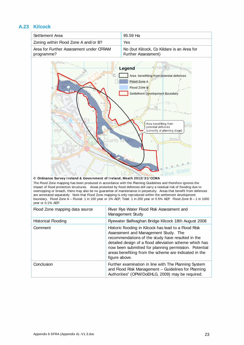
Appendix 6 SFRA (Appendix A) -V1.3.doc 23
A.23 Kilcock
Settlement Area 95.59 Ha
Zoning within Flood Zone A and/or B? Yes
Area for Further Assessment under CFRAM programme?
No (but Kilcock, Co Kildare is an Area for Further Assessment)
© Ordnance Survey Ireland & Government of Ireland, Meath 2012/31/CCMA The Flood Zone mapping has been produced in accordance with the Planning Guidelines and therefore ignores the impact of flood protection structures. Areas protected by flood defences still carry a residual risk of flooding due to overtopping or breach, there may also be no guarantee of maintenance in perpetuity. Areas that benefit from defences are annotated separately. Note that Flood Zone mapping is only reproduced within the settlement development boundary. Flood Zone A – Fluvial: 1 in 100 year or 1% AEP, Tidal: 1 in 200 year or 0.5% AEP. Flood Zone B – 1 in 1000 year or 0.1% AEP.
Flood Zone mapping data source River Rye Water Flood Risk Assessment and Management Study
Historical Flooding Ryewater Balfeaghan Bridge Kilcock 18th August 2008
Comment Historic flooding in Kilcock has lead to a Flood Risk Assessment and Management Study. The recommendations of the study have resulted in the detailed design of a flood alleviation scheme which has now been submitted for planning permission. Potential areas benefiting from the scheme are indicated in the figure above.
Conclusion Further examination in line with The Planning System and Flood Risk Management – Guidelines for Planning Authorities” (OPW/DoEHLG, 2009) may be required.
LegendArea benefitting from potential defences
Flood Zone A
Flood Zone B
Settlement Development Boundary

Appendix 6 SFRA (Appendix A) -V1.3.doc 24
A.24 Kildalkey
Settlement Area 54.85 Ha
Zoning within Flood Zone A and/or B? Yes
Area for Further Assessment under CFRAM programme?
No
© Ordnance Survey Ireland & Government of Ireland, Meath 2012/31/CCMA The Flood Zone mapping has been produced in accordance with the Planning Guidelines and therefore ignores the impact of flood protection structures. Areas protected by flood defences still carry a residual risk of flooding due to overtopping or breach, there may also be no guarantee of maintenance in perpetuity. Areas that benefit from defences are annotated separately. Note that Flood Zone mapping is only reproduced within the settlement development boundary. Flood Zone A – Fluvial: 1 in 100 year or 1% AEP, Tidal: 1 in 200 year or 0.5% AEP. Flood Zone B – 1 in 1000 year or 0.1% AEP.
Flood Zone mapping data source Eastern CFRAM Flood Risk Review (PFRA)
Historical Flooding No
Comment This settlement was not included as an Area for Further Assessment in the Eastern CFRAM Flood Risk Review; indicating that flood risk in the settlement is manageable, from a planning perspective. The Flood Zones will not hinder future development and zoning for new development in areas of high flood risk can be avoided. Flood risk can be managed by adopting the policies set out in the County Development Plan and the recommendations of the Planning Guidelines.
Conclusion No SFRA required Implement Flood Risk Management policies from CDP
LegendSettlement Development Boundary
Flood Zone A
Flood Zone B

Appendix 6 SFRA (Appendix A) -V1.3.doc 25
A.25 Kilmainhamwood
Settlement Area 31.08 Ha
Zoning within Flood Zone A and/or B? Yes
Area for Further Assessment under CFRAM programme?
No
© Ordnance Survey Ireland & Government of Ireland, Meath 2012/31/CCMA The Flood Zone mapping has been produced in accordance with the Planning Guidelines and therefore ignores the impact of flood protection structures. Areas protected by flood defences still carry a residual risk of flooding due to overtopping or breach, there may also be no guarantee of maintenance in perpetuity. Areas that benefit from defences are annotated separately. Note that Flood Zone mapping is only reproduced within the settlement development boundary. Flood Zone A – Fluvial: 1 in 100 year or 1% AEP, Tidal: 1 in 200 year or 0.5% AEP. Flood Zone B – 1 in 1000 year or 0.1% AEP.
Flood Zone mapping data source Neagh-Bann CFRAM Flood Risk Review (PFRA)
Historical Flooding Kilmainhamwood CR104 Recurring
Comment Development is constrained to the north and east by the River to the west by elevated ground. This settlement was not included as an Area for Further Assessment in the NorthWest NeaghBann CFRAM Flood Risk Review; indicating that flood risk in the settlement is manageable, from a planning perspective. Flood risk can be managed by adopting the policies set out in the County Development Plan and the recommendations of the Planning Guidelines.
Conclusion No SFRA required Implement Flood Risk Management policies from CDP
LegendSettlement Development Boundary
Flood Zone A
Flood Zone B

Appendix 6 SFRA (Appendix A) -V1.3.doc 26
A.26 Kilmessan
Settlement Area 68.78 Ha
Zoning within Flood Zone A and/or B? Yes
Area for Further Assessment under CFRAM programme?
No
© Ordnance Survey Ireland & Government of Ireland, Meath 2012/31/CCMA The Flood Zone mapping has been produced in accordance with the Planning Guidelines and therefore ignores the impact of flood protection structures. Areas protected by flood defences still carry a residual risk of flooding due to overtopping or breach, there may also be no guarantee of maintenance in perpetuity. Areas that benefit from defences are annotated separately. Note that Flood Zone mapping is only reproduced within the settlement development boundary. Flood Zone A – Fluvial: 1 in 100 year or 1% AEP, Tidal: 1 in 200 year or 0.5% AEP. Flood Zone B – 1 in 1000 year or 0.1% AEP.
Flood Zone mapping data source Eastern CFRAM Flood Risk Review (PFRA) & JFlow
Historical Flooding No
Comment Based on the proportion of land within Flood Zone A and the constraint to development within the settlement boundary, it is recommended that flood risk and management options are assessed in more detail at LAP stage.
Conclusion SFRA required at LAP stage.
LegendSettlement Development Boundary
Flood Zone A
Flood Zone B

Appendix 6 SFRA (Appendix A) -V1.3.doc 27
A.27 Laytown
Settlement Area 171.43 Ha
Zoning within Flood Zone A and/or B? Yes
Area for Further Assessment under CFRAM programme?
FEM FRAMS
© Ordnance Survey Ireland & Government of Ireland, Meath 2012/31/CCMA The Flood Zone mapping has been produced in accordance with the Planning Guidelines and therefore ignores the impact of flood protection structures. Areas protected by flood defences still carry a residual risk of flooding due to overtopping or breach, there may also be no guarantee of maintenance in perpetuity. Areas that benefit from defences are annotated separately. Note that Flood Zone mapping is only reproduced within the settlement development boundary. Flood Zone A – Fluvial: 1 in 100 year or 1% AEP, Tidal: 1 in 200 year or 0.5% AEP. Flood Zone B – 1 in 1000 year or 0.1% AEP.
Flood Zone mapping data source FEM FRAMS
Historical Flooding Laytown Recurring, Laytown Feb 2002 Alverno Heights, Laytown Recurring
Comment The Flood Zones will not hinder future development and zoning for new development in areas of high flood risk can be avoided. Flood risk can be managed by adopting the policies set out in the County Development Plan, the recommendations of the Planning Guidelines and any contained within the FEM FRAMS.
Conclusion No SFRA required Implement Flood Risk Management policies from CDP and any FEM FRAMS recommendations.
LegendSettlement Development Boundary
Flood Zone A
Flood Zone B

Appendix 6 SFRA (Appendix A) -V1.3.doc 28
A.28 Longwood
Settlement Area 11.43 Ha
Zoning within Flood Zone A and/or B? Yes
Area for Further Assessment under CFRAM programme?
Eastern CFRAM Area for Further Assessment
© Ordnance Survey Ireland & Government of Ireland, Meath 2012/31/CCMA The Flood Zone mapping has been produced in accordance with the Planning Guidelines and therefore ignores the impact of flood protection structures. Areas protected by flood defences still carry a residual risk of flooding due to overtopping or breach, there may also be no guarantee of maintenance in perpetuity. Areas that benefit from defences are annotated separately. Note that Flood Zone mapping is only reproduced within the settlement development boundary. Flood Zone A – Fluvial: 1 in 100 year or 1% AEP, Tidal: 1 in 200 year or 0.5% AEP. Flood Zone B – 1 in 1000 year or 0.1% AEP.
Flood Zone mapping data source Eastern CFRAM Flood Risk Review (PFRA)
Historical Flooding Yes, some recent flooding of a housing estate to the south of the settlement boundary.
Comment Development to the south is restricted by the River Blackwater and its tributary. This settlement is an Area for Further Assessment under the Eastern CFRAM and the flood risk in this area will be defined in more detail on publication of the Eastern CFRAM flood hazard mapping. It is recommended that flood risk and management options for this settlement are assessed in more detail at LAP stage and a review of the land use zoning carried out. Further review following the publication of the Eastern CFRAM flood hazard mapping and subsequent management plans.
Conclusion SFRA required for LAP stage
LegendSettlement Development Boundary
Flood Zone A
Flood Zone B

Appendix 6 SFRA (Appendix A) -V1.3.doc 29
A.29 Maynooth Environs
Settlement Area 140.73 Ha
Zoning within Flood Zone A and/or B? Yes
Area for Further Assessment under CFRAM programme?
No
© Ordnance Survey Ireland & Government of Ireland, Meath 2012/31/CCMA The Flood Zone mapping has been produced in accordance with the Planning Guidelines and therefore ignores the impact of flood protection structures. Areas protected by flood defences still carry a residual risk of flooding due to overtopping or breach, there may also be no guarantee of maintenance in perpetuity. Areas that benefit from defences are annotated separately. Note that Flood Zone mapping is only reproduced within the settlement development boundary. Flood Zone A – Fluvial: 1 in 100 year or 1% AEP, Tidal: 1 in 200 year or 0.5% AEP. Flood Zone B – 1 in 1000 year or 0.1% AEP.
Flood Zone mapping data source PFRA
Historical Flooding No
Comment The Flood Zones will not hinder future development and zoning for new development in areas of high flood risk can be avoided. Flood risk can be managed by adopting the policies set out in the County Development Plan and the recommendations of the Planning Guidelines.
Conclusion No SFRA required Implement Flood Risk Management policies from CDP
LegendSettlement Development Boundary
Flood Zone A
Flood Zone B

Appendix 6 SFRA (Appendix A) -V1.3.doc 30
A.30 Mornington
Settlement Area 28.99 Ha
Zoning within Flood Zone A and/or B? Yes
Area for Further Assessment under CFRAM programme?
Eastern CFRAM Area for Further Assessment
© Ordnance Survey Ireland & Government of Ireland, Meath 2012/31/CCMA The Flood Zone mapping has been produced in accordance with the Planning Guidelines and therefore ignores the impact of flood protection structures. Areas protected by flood defences still carry a residual risk of flooding due to overtopping or breach, there may also be no guarantee of maintenance in perpetuity. Areas that benefit from defences are annotated separately. Note that Flood Zone mapping is only reproduced within the settlement development boundary. Flood Zone A – Fluvial: 1 in 100 year or 1% AEP, Tidal: 1 in 200 year or 0.5% AEP. Flood Zone B – 1 in 1000 year or 0.1% AEP.
Flood Zone mapping data source PFRA & JFlow
Historical Flooding Mornington West Recurring
Comment A large proportion of land lies within Flood Zone A however flood risk can be managed by adopting the policies set out in the County Development Plan and the recommendations of the Planning Guidelines.
Conclusion No SFRA required Implement Flood Risk Management policies from CDP
LegendSettlement Development Boundary
Flood Zone A
Flood Zone B

Appendix 6 SFRA (Appendix A) -V1.3.doc 31
A.31 Mornington East
Settlement Area 159.6 Ha
Zoning within Flood Zone A and/or B? Yes
Area for Further Assessment under CFRAM programme?
FEM FRAMS
© Ordnance Survey Ireland & Government of Ireland, Meath 2012/31/CCMA The Flood Zone mapping has been produced in accordance with the Planning Guidelines and therefore ignores the impact of flood protection structures. Areas protected by flood defences still carry a residual risk of flooding due to overtopping or breach, there may also be no guarantee of maintenance in perpetuity. Areas that benefit from defences are annotated separately. Note that Flood Zone mapping is only reproduced within the settlement development boundary. Flood Zone A – Fluvial: 1 in 100 year or 1% AEP, Tidal: 1 in 200 year or 0.5% AEP. Flood Zone B – 1 in 1000 year or 0.1% AEP.
Flood Zone mapping data source Mornington Flood Alleviation Study and FEM FRAMS
Historical Flooding Mornington February 2002 and October 2011. Mornington/Bettystown Nov 2000
Comment A flood alleviation scheme has now been constructed in Mornington and protects a large proportion of the urban area, as identified in the figure above. The scheme is awaiting the completion of a single pumping station at the time of going to press (April 2012). A large proportion of the settlement lies within Flood Zones A or B (necessarily ignoring the impact of flood defences). It is recommended that the site is assessed in more detail at LAP stage, taking into account the detail presented in the Flood Alleviation Study and FEM FRAMS. This will consider overall management of flood risk in the settlement and assess the residual risk in defended areas.
Conclusion SFRA required at LAP stage.
LegendSettlement Development Boundary
Area benefitting from defences
Flood Zone A
Flood Zone B

Appendix 6 SFRA (Appendix A) -V1.3.doc 32
A.32 Moynalty
Settlement Area 30.7 Ha
Zoning within Flood Zone A and/or B? Yes
Area for Further Assessment under CFRAM programme?
No
© Ordnance Survey Ireland & Government of Ireland, Meath 2012/31/CCMA The Flood Zone mapping has been produced in accordance with the Planning Guidelines and therefore ignores the impact of flood protection structures. Areas protected by flood defences still carry a residual risk of flooding due to overtopping or breach, there may also be no guarantee of maintenance in perpetuity. Areas that benefit from defences are annotated separately. Note that Flood Zone mapping is only reproduced within the settlement development boundary. Flood Zone A – Fluvial: 1 in 100 year or 1% AEP, Tidal: 1 in 200 year or 0.5% AEP. Flood Zone B – 1 in 1000 year or 0.1% AEP.
Flood Zone mapping data source JFlow
Historical Flooding Moynalty Co Meath 18th Nov 2009 and recurring.
Comment The Moynalty River restricts development to the south and east of the settlement. A large proportion of the settlement area lies within Flood Zone A. Flood risk can be managed by adopting the policies set out in the County Development Plan and the recommendations of the Planning Guidelines.
Conclusion No SFRA required Implement Flood Risk Management policies from CDP
LegendSettlement Development Boundary
Flood Zone A
Flood Zone B
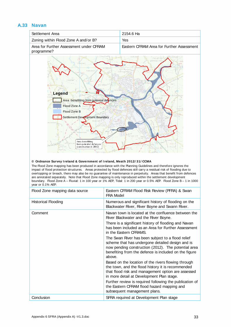
Appendix 6 SFRA (Appendix A) -V1.3.doc 33
A.33 Navan
Settlement Area 2154.6 Ha
Zoning within Flood Zone A and/or B? Yes
Area for Further Assessment under CFRAM programme?
Eastern CFRAM Area for Further Assessment
© Ordnance Survey Ireland & Government of Ireland, Meath 2012/31/CCMA The Flood Zone mapping has been produced in accordance with the Planning Guidelines and therefore ignores the impact of flood protection structures. Areas protected by flood defences still carry a residual risk of flooding due to overtopping or breach, there may also be no guarantee of maintenance in perpetuity. Areas that benefit from defences are annotated separately. Note that Flood Zone mapping is only reproduced within the settlement development boundary. Flood Zone A – Fluvial: 1 in 100 year or 1% AEP, Tidal: 1 in 200 year or 0.5% AEP. Flood Zone B – 1 in 1000 year or 0.1% AEP.
Flood Zone mapping data source Eastern CFRAM Flood Risk Review (PFRA) & Swan FRA Model
Historical Flooding Numerous and significant history of flooding on the Blackwater River, River Boyne and Swann River.
Comment Navan town is located at the confluence between the River Blackwater and the River Boyne. There is a significant history of flooding and Navan has been included as an Area for Further Assessment in the Eastern CFRAMS. The Swan River has been subject to a flood relief scheme that has undergone detailed design and is now pending construction (2012). The potential area benefiting from the defence is included on the figure above. Based on the location of the rivers flowing through the town, and the flood history it is recommended that flood risk and management option are assessed in more detail at Development Plan stage. Further review is required following the publication of the Eastern CFRAM flood hazard mapping and subsequent management plans.
Conclusion SFRA required at Development Plan stage
LegendArea benefitting from potential defences
Flood Zone A
Flood Zone B
Settlement Development Boundary

Appendix 6 SFRA (Appendix A) -V1.3.doc 34
A.34 Nobber
Settlement Area 57.9 Ha
Zoning within Flood Zone A and/or B? Yes
Area for Further Assessment under CFRAM programme?
No
© Ordnance Survey Ireland & Government of Ireland, Meath 2012/31/CCMA The Flood Zone mapping has been produced in accordance with the Planning Guidelines and therefore ignores the impact of flood protection structures. Areas protected by flood defences still carry a residual risk of flooding due to overtopping or breach, there may also be no guarantee of maintenance in perpetuity. Areas that benefit from defences are annotated separately. Note that Flood Zone mapping is only reproduced within the settlement development boundary. Flood Zone A – Fluvial: 1 in 100 year or 1% AEP, Tidal: 1 in 200 year or 0.5% AEP. Flood Zone B – 1 in 1000 year or 0.1% AEP.
Flood Zone mapping data source JFlow
Historical Flooding Dee Nobber Recurring Dee Nobber Nov 2000
Comment Within the settlement boundary development is restricted to the north west. Further review of the land use zoning is required. Flood risk and management options will be assessed in more detail at LAP stage.
Conclusion SFRA required at LAP stage
LegendSettlement Development Boundary
Flood Zone A
Flood Zone B

Appendix 6 SFRA (Appendix A) -V1.3.doc 35
A.35 Oldcastle
Settlement Area 126.7 Ha
Zoning within Flood Zone A and/or B? No
Area for Further Assessment under CFRAM programme?
No
© Ordnance Survey Ireland & Government of Ireland, Meath 2012/31/CCMA The Flood Zone mapping has been produced in accordance with the Planning Guidelines and therefore ignores the impact of flood protection structures. Areas protected by flood defences still carry a residual risk of flooding due to overtopping or breach, there may also be no guarantee of maintenance in perpetuity. Areas that benefit from defences are annotated separately. Note that Flood Zone mapping is only reproduced within the settlement development boundary. Flood Zone A – Fluvial: 1 in 100 year or 1% AEP, Tidal: 1 in 200 year or 0.5% AEP. Flood Zone B – 1 in 1000 year or 0.1% AEP.
Flood Zone mapping data source n/a
Historical Flooding Store Road, Oldcastle Recurring
Comment No fluvial risk identified. OPW benefitting lands mapping indicates some coverage. Historic flooding records indicate recurring flooding at Store Street - a likely surface water source.
Conclusion No SFRA required Implement Flood Risk Management policies from CDP
LegendSettlement Development Boundary
Flood Zone A
Flood Zone B

Appendix 6 SFRA (Appendix A) -V1.3.doc 36
A.36 Rathcairn
Settlement Area 47.01 Ha
Zoning within Flood Zone A and/or B? No
Area for Further Assessment under CFRAM programme?
No
© Ordnance Survey Ireland & Government of Ireland, Meath 2012/31/CCMA The Flood Zone mapping has been produced in accordance with the Planning Guidelines and therefore ignores the impact of flood protection structures. Areas protected by flood defences still carry a residual risk of flooding due to overtopping or breach, there may also be no guarantee of maintenance in perpetuity. Areas that benefit from defences are annotated separately. Note that Flood Zone mapping is only reproduced within the settlement development boundary. Flood Zone A – Fluvial: 1 in 100 year or 1% AEP, Tidal: 1 in 200 year or 0.5% AEP. Flood Zone B – 1 in 1000 year or 0.1% AEP.
Flood Zone mapping data source n/a
Historical Flooding No
Comment No fluvial risk identified and no record of historic flooding.
Conclusion No SFRA required Implement Flood Risk Management policies from CDP
LegendSettlement Development Boundary
Flood Zone A
Flood Zone B

Appendix 6 SFRA (Appendix A) -V1.3.doc 37
A.37 Rathmolyon
Settlement Area 52.6 Ha
Zoning within Flood Zone A and/or B? No
Area for Further Assessment under CFRAM programme?
No
© Ordnance Survey Ireland & Government of Ireland, Meath 2012/31/CCMA The Flood Zone mapping has been produced in accordance with the Planning Guidelines and therefore ignores the impact of flood protection structures. Areas protected by flood defences still carry a residual risk of flooding due to overtopping or breach, there may also be no guarantee of maintenance in perpetuity. Areas that benefit from defences are annotated separately. Note that Flood Zone mapping is only reproduced within the settlement development boundary. Note that Flood Zone mapping is only reproduced within the settlement development boundary. Flood Zone A – Fluvial: 1 in 100 year or 1% AEP, Tidal: 1 in 200 year or 0.5% AEP. Flood Zone B – 1 in 1000 year or 0.1% AEP.
Flood Zone mapping data source n/a
Historical Flooding No
Comment No fluvial risk identified and no record of historic flooding.
Conclusion No SFRA required Implement Flood Risk Management policies from CDP
LegendSettlement Development Boundary
Flood Zone A
Flood Zone B

Appendix 6 SFRA (Appendix A) -V1.3.doc 38
A.38 Ratoath
Settlement Area 540.7 Ha
Zoning within Flood Zone A and/or B? Yes
Area for Further Assessment under CFRAM programme?
FEM FRAMS
© Ordnance Survey Ireland & Government of Ireland, Meath 2012/31/CCMA The Flood Zone mapping has been produced in accordance with the Planning Guidelines and therefore ignores the impact of flood protection structures. Areas protected by flood defences still carry a residual risk of flooding due to overtopping or breach, there may also be no guarantee of maintenance in perpetuity. Areas that benefit from defences are annotated separately. Note that Flood Zone mapping is only reproduced within the settlement development boundary. Flood Zone A – Fluvial: 1 in 100 year or 1% AEP, Tidal: 1 in 200 year or 0.5% AEP. Flood Zone B – 1 in 1000 year or 0.1% AEP.
Flood Zone mapping data source FEM FRAMS & PFRA
Historical Flooding No
Comment The Flood Zones will not hinder future development and zoning for new development in areas of high flood risk can be avoided. Flood risk can be managed by adopting any measures outlined in the FEM FRAMS and policies set out in the County Development Plan and the recommendations of the Planning Guidelines.
Conclusion No SFRA required. Implement Flood Risk Management policies from CDP and any FEM FRAMS recommendations.
LegendSettlement Development Boundary
Area benefitting from defences
Flood Zone A
Flood Zone B

Appendix 6 SFRA (Appendix A) -V1.3.doc 39
A.39 Slane
Settlement Area 208.3 Ha
Zoning within Flood Zone A and/or B? Yes
Area for Further Assessment under CFRAM programme?
No
© Ordnance Survey Ireland & Government of Ireland, Meath 2012/31/CCMA The Flood Zone mapping has been produced in accordance with the Planning Guidelines and therefore ignores the impact of flood protection structures. Areas protected by flood defences still carry a residual risk of flooding due to overtopping or breach, there may also be no guarantee of maintenance in perpetuity. Areas that benefit from defences are annotated separately. Note that Flood Zone mapping is only reproduced within the settlement development boundary. Flood Zone A – Fluvial: 1 in 100 year or 1% AEP, Tidal: 1 in 200 year or 0.5% AEP. Flood Zone B – 1 in 1000 year or 0.1% AEP.
Flood Zone mapping data source Eastern CFRAM Flood Risk Review (PFRA)
Historical Flooding Patrick's Terrace, Slane/N51 Recurring, Boyne Slane Nov 2002, Boyne Drogheda to Slane Recurring, Boyne Slane Feb 1990.
Comment Development is restricted to the south and west by the River Boyne and tributary and by elevated ground (the Hill of Slane) to the north. The Flood Zones will not hinder future development and zoning in areas of high flood risk can be avoided. Flood risk can be managed by adopting the policies set out in the County Development Plan and the recommendations of the Planning.
Conclusion No SFRA required. Implement Flood Risk Management policies from CDP.
LegendSettlement Development Boundary
Flood Zone A
Flood Zone B

Appendix 6 SFRA (Appendix A) -V1.3.doc 40
A.40 Stamullen
Settlement Area 186.6 Ha
Zoning within Flood Zone A and/or B? Yes
Area for Further Assessment under CFRAM programme?
FEM FRAMS
© Ordnance Survey Ireland & Government of Ireland, Meath 2012/31/CCMA The Flood Zone mapping has been produced in accordance with the Planning Guidelines and therefore ignores the impact of flood protection structures. Areas protected by flood defences still carry a residual risk of flooding due to overtopping or breach, there may also be no guarantee of maintenance in perpetuity. Areas that benefit from defences are annotated separately. Note that Flood Zone mapping is only reproduced within the settlement development boundary. Flood Zone A – Fluvial: 1 in 100 year or 1% AEP, Tidal: 1 in 200 year or 0.5% AEP. Flood Zone B – 1 in 1000 year or 0.1% AEP.
Flood Zone mapping data source FEM FRAMS
Historical Flooding Delvin Stamullin Recurring
Comment The Flood Zones will not hinder future development and zoning for new development in areas of high flood risk can be avoided. Flood risk can be managed by adopting the policies set out in the County Development Plan, the recommendations of the Planning Guidelines and any contained within the FEM FRAMS.
Conclusion No SFRA required. Implement Flood Risk Management policies from CDP and any FEM FRAMS recommendations.
LegendSettlement Development Boundary
Flood Zone A
Flood Zone B

Appendix 6 SFRA (Appendix A) -V1.3.doc 41
A.41 Summerhill
Settlement Area 97.22 Ha
Zoning within Flood Zone A and/or B? No
Area for Further Assessment under CFRAM programme?
No
© Ordnance Survey Ireland & Government of Ireland, Meath 2012/31/CCMA The Flood Zone mapping has been produced in accordance with the Planning Guidelines and therefore ignores the impact of flood protection structures. Areas protected by flood defences still carry a residual risk of flooding due to overtopping or breach, there may also be no guarantee of maintenance in perpetuity. Areas that benefit from defences are annotated separately. Note that Flood Zone mapping is only reproduced within the settlement development boundary. Flood Zone A – Fluvial: 1 in 100 year or 1% AEP, Tidal: 1 in 200 year or 0.5% AEP. Flood Zone B – 1 in 1000 year or 0.1% AEP.
Flood Zone mapping data source n/a
Historical Flooding No
Comment No fluvial risk identified and no historic records of flooding.
Conclusion No SFRA required. Implement Flood Risk Management policies from CDP.
LegendSettlement Development Boundary
Flood Zone A
Flood Zone B

Appendix 6 SFRA (Appendix A) -V1.3.doc 42
A.42 Trim
Settlement Area 720.9 Ha
Zoning within Flood Zone A and/or B? Yes
Area for Further Assessment under CFRAM programme?
Eastern CFRAM Area for Further Assessment
© Ordnance Survey Ireland & Government of Ireland, Meath 2012/31/CCMA The Flood Zone mapping has been produced in accordance with the Planning Guidelines and therefore ignores the impact of flood protection structures. Areas protected by flood defences still carry a residual risk of flooding due to overtopping or breach, there may also be no guarantee of maintenance in perpetuity. Areas that benefit from defences are annotated separately. Note that Flood Zone mapping is only reproduced within the settlement development boundary. Flood Zone A – Fluvial: 1 in 100 year or 1% AEP, Tidal: 1 in 200 year or 0.5% AEP. Flood Zone B – 1 in 1000 year or 0.1% AEP.
Flood Zone mapping data source Eastern CFRAM Flood Risk Review (PFRA)
Historical Flooding Boyne Trim, 1965, 1978, 1993, 1995, 2000, 2002, 2005, 2008. Navangate Street, Trim Recurring.
Comment Trim is located on the banks of the River Boyne. There is a significant history of flooding and Trim has been included as an Area for Further Assessment in the Eastern CFRAM study. Based on the location of the river flowing through the town, and the flood history it is recommended that flood risk and management option are assessed in more detail at Development Plan stage. Further review is required following the publication of the Eastern CFRAM flood hazard mapping and subsequent management plans.
Conclusion SFRA required at Development Plan stage
LegendSettlement Development Boundary
Flood Zone A
Flood Zone B