strategic flood risk assessment (sfra) - sligo · 2019-08-23 · strategic flood risk assessment...
TRANSCRIPT
Draft Sligo County Development Plan 2017-2023 for public consultation – September 2016 Strategic Flood Risk Assessment (SFRA)
1
Strategic Flood Risk Assessment (SFRA) of the Draft Sligo County Development Plan 2017-2023
This document contains the Strategic Flood Risk Assessment (SFRA) for the Draft Sligo County Development Plan 2017-2023 (hereafter referred to as “the Plan”). The purpose of this SFRA is to support the Strategic Environmental Assessment of the Draft Plan and inform the policies and objectives of the Plan. Its content and format are derived from the guidance provided in The Planning System and Flood Risk Management - Guidelines for Planning Authorities, (DEHLG) November 2009.
A two-stage assessment of flood risk was undertaken, as recommended in the above-mentioned Guideline.
The first stage involves the identification of flood risk and is based on a variety of data sources, which are detailed in Section 3 of this report. This stage identifies the towns and villages in the County which are susceptible to flooding and for which a Stage 2 SFRA is required.
The second stage deals in more detail with the villages where a flood risk has been identified and appraises the adequacy of existing information in order to prepare indicative flood zone maps. This stage also highlights potential development areas that require more detailed assessment on a site-specific level.
The flood risk in the towns of Ballymote, Enniscrone, Tobercurry and Sligo town will be addressed in detail in separate strategic flood risk assessments as part of preparing or reviewing the respective Local Area Plans.
1.1 Flooding context Flooding is an environmental phenomenon which, as well as causing economic and social impacts, could, in certain circumstances, pose a risk to human health or even life, as well as to homes and infrastructure. Parts of County Sligo are vulnerable to flooding, as evidenced by recent flooding events of December 2015.
Local conditions, such as low-lying lands and slow surface water drainage, increase the risk of flooding. This risk can be increased by human actions such as clearing of natural vegetation to make way for agriculture, draining of bog and wetland areas, the development of settlements in the flood plains of rivers and on low-lying or eroding coastlines, as well as by changing weather patterns.
Inadequately planned infrastructural development, culverting, forestry operations and urban development in floodplains can also give rise to flood hazards.
Definition of flood risk
Flood risk is generally accepted to be a combination of the likelihood (or probability) of flooding and the potential consequences arising. Flood risk can be expressed in terms of the following relationship:
Flood Risk = Probability of Flooding x Consequences of Flooding
Draft Sligo County Development Plan 2017-2023 for public consultation – September 2016 Strategic Flood Risk Assessment (SFRA)
2
1.2 Climate change It is widely accepted that climate change is a reality which is happening on an ongoing basis. In Ireland it is manifesting itself in the form of changes in average temperature and rainfall intensity, greater frequency of extreme weather events and subtle changes to the ecosystem.
Although the impacts of climate change cannot be fully predicted, it is expected that the changes in Ireland’s climate will result in higher risk of flooding, both inland and at coastal locations (through rising sea levels), and the occurrence of more intense rainfall events and storm activity.
Due to the uncertainty surrounding the potential effects of climate change a precautionary approach is recommended in the Guidelines:
• Recognise that significant changes in the flood extent may result from an increase in rainfall or tide events and accordingly adopt a cautious approach to zoning land in these potential transitional areas.
• Ensure that the levels of structures designed to protect against flooding, such as flood defences, land-raising or raised floor levels are sufficient to cope with the effects of climate change over the lifetime of the development they are designed to protect.
• Ensure that structures to protect against flooding and the development protected are capable of adaptation to the effects of climate change when there is more certainty about the effects and still time for such adaptation to be effective.
The National Climate Change Adaptation Framework – Building Resilience to Climate Change (NCCAF) (DoECLG, 2012) emphasizes the importance of integrating climate change considerations into development plans, especially in zoning land for development. As local authorities review their development plans, they are now required to integrate climate change adaptation and mitigation objectives into their plans. Local development planning will, in effect, become the mechanism for the delivery of local climate adaptation action and local authorities may adopt a regional approach by working together. In their development plans, planning authorities will need to specify the measures being taken to reduce local vulnerability and to avail of positive climatic effects.
Having regard to current national policy and planning legislation, the CDP seeks to increase County Sligo’s resilience to climate change by promoting sustainable development in general and through appropriate policies in relation to flood risk assessment and management, and protection against coastal flooding and erosion (refer to Volume 1 of the CDP 2017-2023, Section 10.4 Coastal environment and 10.7 Flood Risk Management).
Draft Sligo County Development Plan 2017-2023 for public consultation – September 2016 Strategic Flood Risk Assessment (SFRA)
3
1.3 Flood risk management and the planning system
1.3.1 Flood Risk Management Guidelines for Planning Authorities
Following on from the EU Directive 2007/60/EC on the assessment and management of flood risks, the DoEHLG and the Office of Public Works (OPW) published ‘The Planning System and Flood Risk Management – Guidelines for Planning Authorities’ in November 2009 (henceforth referred to as the Guidelines).
The Guidelines introduced mechanisms for the incorporation of flood risk identification, assessment and management into the planning process. Implementation of the Guidelines is intended to be achieved through actions at the national, regional, local authority and site-specific levels. Planning authorities are required to have regard to the Guidelines in carrying out their functions under the Planning Acts.
1.3.2 Principles of flood risk management
The key principles of flood risk management set out in the flood guidelines are to:
• avoid development that will be at risk of flooding or that will increase the flooding risk elsewhere, where possible;
• substitute less vulnerable uses, where avoidance is not possible; and,
• mitigate and manage the risk, where avoidance and substitution are not possible.
The Guidelines follow the principle that development should not be permitted in flood risk areas, particularly floodplains, except where there are no alternative and appropriate sites available in lower risk areas that are consistent with the objectives of proper planning and sustainable development.
Development in areas which have the highest flood risk should be avoided and/or only considered in exceptional circumstances (through a prescribed Justification Test) if adequate land or sites are not available in areas which have lower flood risk. Most types of development would be considered inappropriate in areas which have the highest flood risk. Only water-compatible development such as docks and marinas, dockside activities that require a waterside location, amenity open space, outdoor sports and recreation and essential transport infrastructure that cannot be located elsewhere would be considered appropriate in these areas.
The Guidelines divide land uses and development types into three categories: highly vulnerable development (including essential infrastructure), less vulnerable development and water-compatible development.

Draft Sligo County Development Plan 2017-2023 for public consultation – September 2016 Strategic Flood Risk Assessment (SFRA)
4
1.3.3 The flood risk assessment process
The Guidelines recommend that a staged approach is adopted when undertaking a flood risk assessment, carrying out only such appraisal as is needed for the purposes of decision-making at the regional, development and local area plan level, and also at the site specific level.
Stage 1: Flood risk identification – This stage identifies any flooding or surface water management issues relating to a plan area or proposed development site that may warrant further investigation.
Stage 2: Initial flood risk assessment – If a flood risk issue is deemed to exist arising from Stage 1, the assessment proceeds to Stage 2, which confirms the sources of flooding, appraises the adequacy of existing information and determines the extent of additional surveys and the degree of modelling that will be required. Stage 2 must be sufficiently detailed to allow the application of the sequential approach (as described in Section 1.3.5 below) within the flood risk zone.
Stage 3: Detailed risk assessment – Where Stages 1 and 2 indicate that a proposed development area may be subject to a significant flood risk, a Stage 3 detailed flood risk assessment must be undertaken. This will involve assessing flood risk issues in sufficient detail, including the provision of a quantitative appraisal of potential flood risk to a proposed or existing development, of its potential impact on flood risk elsewhere and of the effectiveness of any proposed mitigation measures. Such an assessment should be informed by the use of hydraulic modelling.
1.3.4 Flood zones
Flood zones are geographical areas within which the likelihood of flooding is in a particular range. They are a key tool in flood risk management within the planning process as well as in flood warning and emergency planning.
There are three types or levels of flood zones defined for the purposes of implementing the Flood Risk Management Guidelines:
Flood Zone A – where the probability of flooding from rivers and the sea is highest (greater than 1% or 1 in 100 for river flooding or 0.5% or 1 in 200 for coastal flooding);
Flood Zone B – where the probability of flooding from rivers and the sea is moderate (between 0.1% or 1 in 1000 and 1% or 1 in 100 for river flooding and between 0.1% or 1 in 1000 year and 0.5% or 1 in 200 for coastal flooding); and
Flood Zone C – where the probability of flooding from rivers and the sea is low (less than 0.1% or 1 in 1000 for both river and coastal flooding). Flood Zone C covers all areas of the Plan which are not in zones A or B.
Flood zones are generated without the inclusion of climate change factors and only account for inland and coastal flooding. They should not be used to suggest that any areas are free from flood risk, as they do not account for potential flooding from rain or storms and for groundwater flooding. Similarly, flood defences should be ignored in determining flood zones, as defended areas still carry a residual risk of flooding from overtopping, failure of the defences and deterioration due to lack of maintenance.
Draft Sligo County Development Plan 2017-2023 for public consultation – September 2016 Strategic Flood Risk Assessment (SFRA)
5
1.3.5 The sequential approach
The Guidelines recommend a sequential approach which ensures that new development is directed towards land that is at a low risk of flooding.
The key principles of the risk-based sequential approach to managing flood hazard and potential risk in the planning system are as follows:
• Avoid development in areas at risk of flooding.
• If this is not possible, consider substituting a land use that is less vulnerable to flooding.
• Only when both avoidance and substitution cannot take place should consideration be given to mitigation and management of risks, subject to the Justification Test.
1.3.6 Justification Test
The comparison of flood zones with existing or proposed zoning may reveal conflicts between high-risk areas and areas zoned for development that would be vulnerable to flooding. In such cases, the Planning Authority must subject each site to the Justification Test. The Test has been designed to rigorously assess the appropriateness, or otherwise, of particular developments being considered in areas of moderate or high flood risk.
1.4 Disclaimer It is important to note that compliance with the requirements of the Guidelines on Flood Risk Management and of the Floods Directive 2007/60/EC is a work in progress and is based on emerging and incomplete data, as well as estimates of the locations and likelihood of flooding. The Catchment-based Flood Risk Assessment and Management Plans (CFRAMs) have yet to be published.
As a result, strategic flood risk assessment in County Sligo is based essentially on the PFRAs and local knowledge (where available).
Accordingly, all information in relation to flood risk is provided only for general guidance. It may be substantially altered in light of future data and analysis.
All landowners and developers are advised that Sligo County Council and its agents cannot accept any responsibility for losses or damages arising due to assessments of the vulnerability to flooding of lands, uses and developments.
Prior to making planning or development decisions, owners, users and developers are advised to take all reasonable measures to assess the risk of flooding on lands in which they have an interest.
Draft Sligo County Development Plan 2017-2023 for public consultation – September 2016 Strategic Flood Risk Assessment (SFRA)
6
2. County Sligo study area The study area is the whole of County Sligo with a focus on 32 settlements for which individual mini-plans are included in Volume 2 of the CDP.
2.1 Planning policy
2.1.1 Sligo County Development Plan 2017-2023
The Draft Sligo County Development Plan 2017-2023 contains land use zoning for 32 settlements as follows: Aclare, Ballinacarrow, Ballinafad, Ballincar, Ballintogher, Ballygawley, Ballysadare, Banada, Bellaghy, Bunnanadden, Carney, Castlebaldwin, Cliffony, Cloonacool, Collooney, Coolaney, Culfadda, Curry, Dromore West, Drumcliff, Easky, Geevagh, Gorteen, Grange, Monasteraden, Mullaghmore, Ransboro, Rathcormack, Riverstown, Rosses Point, Tourlestrane, Strandhill.
The Draft Plan contains policies and objectives for various sectors including economic development, infrastructure, housing and environment, heritage and amenities and housing. Section 10.7 of the Draft Plan has been informed by the recommendations made in Section 6.2 of this report.
2.1.3 Local area plans
Local area plans for Ballymote and Enniscrone have been reviewed in recent years (2012 and 2014 respectively). Each LAP was accompanied by a SFRA.
LAPs will be prepared for Tobercurry and the Gateway City of Sligo. Separate SFRAs will be prepared for these LAPs. No zoning of land is proposed for either of these two settlements in this CDP.
The general flood risk management policies recommended in this report and incorporated into the Draft Plan will apply to all LAPs in the County.
2.2 Sources of flooding in Sligo The main source of flooding in the county is fluvial flooding arising due to rivers bursting their banks. Fluvial flooding occurs when a river overtops its banks due to the main channel capacity being exceeded or due to a blockage in the channel.
However, the recent flood event in December 2015, which caused significant damage to properties and numerous road closures across the county, was caused in part by pluvial flooding, whereby the capacity of the ground to absorb the amount of rainfall experienced in a short period was exceeded.
Draft Sligo County Development Plan 2017-2023 for public consultation – September 2016 Strategic Flood Risk Assessment (SFRA)
7
Pluvial flooding occurs when overland flow cannot infiltrate into the ground, when drainage systems, including aquifers, exceed their capacity or are blocked and when the water cannot discharge due to a high water level in the receiving watercourse.
The two flood types combined in 2015. The heavy rain in November 2015 raised both ground water table levels and river levels and reduced the capacity of land and rivers to absorb the extreme rainfall experienced in December. Hence, rivers burst their banks and low-lying land became flooded.
Tidal and coastal flooding affects the County’s coastal areas and is caused by ocean storm waves and winds reaching our shores. There has been an increase in storm severity and frequency in the last 15 years. Storms not only bring high waves to the shoreline, but also elevated water levels through storm surges, which allow waves to alter beach levels and directly attack the dunes and cliffs during the high tidal phase. Impacts were particularly evident after coastal storms along the west coast of Ireland during the winter of 2013-2014, when water levels were frequently more than 1 m higher than the predicted astronomical tide. The predicted sea level rise (of at least 0.5 m) by the year 2100 will exacerbate the problems.
Flooding of low-lying coastal areas is likely to worsen as a result. Coastal erosion will accelerate along softer shorelines, which will have a devastating effect on existing development and infrastructure.
Recommendations in relation to flood protection in coastal areas, as made in Section 6.2 of this SFRA, have been included in Chapter 10 of the Draft CDP as flood risk management policies.
Draft Sligo County Development Plan 2017-2023 for public consultation – September 2016 Strategic Flood Risk Assessment (SFRA)
8
3. Stage 1 SFRA - flood risk identification The purpose of the first stage of a SFRA is to identify the following:
• flooding or surface water management issues within the zoned areas of the County;
• whether these areas warrant further investigation;
• whether a Stage 2 SFRA (initial flood risk assessment) is required.
The Stage 1 SFRA was a desk-based exercise based on existing information on flood risk indicators and involved consulting with a range of sources as detailed in Section 3.1 below.
3.1 Available data on flood risk The following available sources of information were analysed in order to screen for flood hazard and flood risk in the county:
• Preliminary Flood Risk Assessment maps - which delineate areas potentially prone to flooding from fluvial, coastal, pluvial, groundwater and lakes;
• CFRAM programme;
• Irish Coastal Protection Strategy Study (ICPSS) 2012;
• OPW National Flood Hazard Mapping (www.floodmaps.ie);
• Historical Flood Risk Indicator Mapping;
• OPW Benefitting Land Maps;
• Mineral Alluvial Soil mapping/Wetland database;
• Aerial Photography;
• Public Consultation;
• Working knowledge from Area Engineers;
• Flood event in December 2015.
Appendix A of this Report compiles this information as it applies to each of the Mini-Plan areas and identifies the villages where further assessment is required.
3.1.1 Preliminary Flood Risk Assessment maps
Following on from the European Directive 2007/60/EC, the national CFRAM (Catchment Flood Risk Assessment and Management) programme commenced in Ireland in 2011. It aims to assess flood risk, through the identification of flood hazard areas and associated impacts of flooding.
The first stage of the CFRAM process was the production of a series of maps for the entire country indicating projected extent of flooding for a given probability based on different types of flooding.
Draft Sligo County Development Plan 2017-2023 for public consultation – September 2016 Strategic Flood Risk Assessment (SFRA)
9
These Preliminary Flood Risk Assessment (PFRA) flood maps were produced across the whole of Ireland and the methodology used was necessarily broad brush.
The maps provide an indication of areas that may be prone to flooding. It is important to note at this stage of the SFRA that they should not be used as the sole basis for preparing flood zones maps. They are appropriate for a Stage 1 Flood Risk Identification to identify areas where further assessment would be required if development is being considered within or adjacent to the flood extents shown.
The objective of the PFRA was to identify areas where the risks associated with flooding might be significant (referred to as Areas for Further Assessment or ‘AFAs’).
3.1.2 CFRAM programme
More detailed assessment of the AFAs was undertaken through the CFRAM Studies to more accurately assess the extent and degree of flood risk, and, where the risk is significant, to develop where possible measures to manage and reduce the risk.
Flood hazard areas have been identified as being potentially at risk from significant flooding, including areas that have experienced significant flooding in the past. They also take account of issues such as climate change, land use practices and future development.
Flood maps are one of the main outputs of the studies indicating modelled flood extents for flood events of a range of annual exceedance probability (AEP).
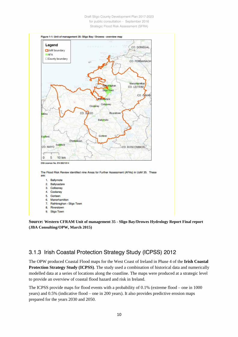
Flood Risk Review reports (FRR) were prepared by JBA Consulting on behalf of the OPW for the following areas (2011) which were identified as being subject to significant flooding from the PFRA maps: Ballysadare and environs; Drumcliff and Carney; Sooey; Riverstown; Grange; Collooney; Tobercurry; Coolaney; Willowbrook; Charlestown; Gorteen; Rathbraughan; Sligo town centre.
Of these, 8 went forward in the process for further assessment and modelling - Sligo town; Rathbraghan; Collooney; Riverstown; Ballymote; Gorteen: Coolaney and Ballysadare.
Flood zones A and B have been drawn for these areas (albeit in draft form and not yet in the public domain). Of these, only 2 were deemed significant enough to warrant further investigation and the preparation of flood risk management plans: Sligo town/Rathbraghan and Coolaney.
Draft Sligo County Development Plan 2017-2023 for public consultation – September 2016 Strategic Flood Risk Assessment (SFRA)
10
Source: Western CFRAM Unit of management 35 - Sligo Bay/Drowes Hydrology Report Final report (JBA Consulting/OPW, March 2015)
3.1.3 Irish Coastal Protection Strategy Study (ICPSS) 2012
The OPW produced Coastal Flood maps for the West Coast of Ireland in Phase 4 of the Irish Coastal Protection Strategy Study (ICPSS). The study used a combination of historical data and numerically modelled data at a series of locations along the coastline. The maps were produced at a strategic level to provide an overview of coastal flood hazard and risk in Ireland.
The ICPSS provide maps for flood events with a probability of 0.1% (extreme flood – one in 1000 years) and 0.5% (indicative flood – one in 200 years). It also provides predictive erosion maps prepared for the years 2030 and 2050.
Draft Sligo County Development Plan 2017-2023 for public consultation – September 2016 Strategic Flood Risk Assessment (SFRA)
11
The identified areas of potentially significant coastal erosion in County Sligo are:
• Marley's Point to Strandhill
• Raghly
• Streedagh Point to Cliffony
The ICPSS maps should not be used to assess the flood hazard and risk associated with individual properties or point locations or to replace detailed local flood risk assessment. Local factors such as flood defence schemes have not been accounted for.
3.1.4 OPW National Flood Hazard Mapping (www.floodmaps.ie)
The OPW launched the www.floodmaps.ie website in 2006 on foot of a recommendation from the Flood Policy Review Group established in 2002 following serious flooding in many parts of Ireland. The website provides information about the location of known flood events in Ireland and shows supporting information in the form of reports, photos and press articles about those floods. The main purpose is to provide flooding information to the public and to Planning Authorities, developers and engineers around the country.
This website has not been updated to reflect recent events in County Sligo and hence its usefulness for this SFRA is limited.
3.1.5 Historical flood risk indicator mapping
6” Ordnance Survey maps include areas which are marked as being “Liable to Floods”. The exact areas are not delineated but they give an indication of areas which have undergone flooding in the past. The OS maps relevant for the each mini-plan area have been analysed for evidence of past flooding.
3.1.6 OPW Benefitting Land Maps
These maps were prepared to identify areas that would benefit from land drainage schemes. They therefore typically represent low-lying land near rivers and streams that would be expected to be prone to flooding.
3.1.7 Mineral alluvial-soil mapping/wetlands database
Alluvial soils are fine-grained fertile soils deposited by water flowing over flood plains or in river beds. They are generally indicative of low lying land or land prone to flooding. The Wetland Survey commissioned by Sligo County Council’s Heritage Office between 2008 and 2011 also provides valuable information on potential floodplains or other areas prone to flooding.
Draft Sligo County Development Plan 2017-2023 for public consultation – September 2016 Strategic Flood Risk Assessment (SFRA)
12
3.1.8 Aerial photography
Orthophotography from two sources: the Ordnance Survey (2000, 2005) and Bing Maps http://www.bing.com/maps/ (November 2011- March 2012) were examined for each mini-plan area. Sligo County Council commissioned an aerial photography survey of the December 2015 flood events. This provided useful photographs of the flood extent of affected areas.
3.1.9 Public consultations
As part of the Plan making process, a Pre-Draft Consultation Paper was published to highlight all relevant issues for the proposed Plan. Written submissions were invited as part of the process. Thirty submissions were received, none of which referred to flooding as an issue.
3.1.10 Local Authority personnel
Each mini-plan area was discussed with the relevant Area Engineer.
3.1.11 Flood event in December 2015
In November and December 2015, County Sligo experienced an exceptional amount of rainfall resulting in flooding in areas not known to have flooded in living memory. Both pluvial and fluvial flooding events were recorded and damage to existing properties, while limited, did occur. The main consequence of the flood events was road closures all over the county. On zoned land within the Mini-Plan areas, flooding events largely coincided with available information such as the CFRAM studies or the PFRA maps.
3.2 Circular PL 2/2014 In August 2014, the Department of Environment, Community and Local Government issued the Circular PL2/2014 relating to the use of OPW flood mapping in assessing planning applications, and including clarifications of advice contained in the 2009 Guidelines. This Circular states:
“The draft CFRAM flood maps, in their current form, remain subject to an unknown amount of change before they can be robustly relied upon for any decision making processes. It would therefore be premature to rely solely on these draft outputs for planning and development management purposes. In this regard, it would be prudent both for planning authorities and for planning applicants to have due regard to the issue of flood risk and to the information provided in the maps, and that where a flood risk is indicated in an area under consideration for development, request that the applicant undertakes site specific flood risk assessment by an appropriately qualified Chartered Engineer. In essence, planning authorities are requested to be prudent in the use of the draft PFRA or CFRAM flood maps as the sole basis for deciding on planning applications (i.e. to
Draft Sligo County Development Plan 2017-2023 for public consultation – September 2016 Strategic Flood Risk Assessment (SFRA)
13
refuse planning applications), to make use of site inspections and/or knowledge of local areas, to request a site specific flood risk assessment by an appropriately qualified engineer where appropriate and to also generally use their professional judgement in this regard.”
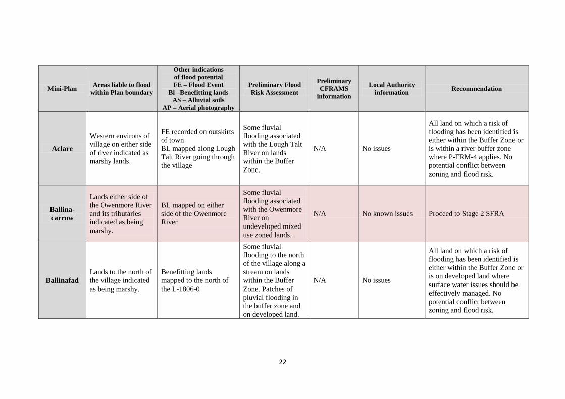
3.3 Assessment The County Development Plan 2017-2023 contains mini-plans for 32 villages in the county. Each of these areas has been assessed for flood risk by analysing the readily available data listed in Section 3.1 above. Appendix A comprises a matrix of the 32 villages and sets out the findings from the listed sources of available information.
This information was compared to the zoning set out in the County Development Plan 2011-2017, to identify any potential conflict between flooding risk and zoning for development. Any village where the zoning conflicted with a potential for flood risk proceeded to Stage 2 – initial flood risk assessment.
The zoning of land in thirteen of the villages, as per the County Development Plan 2011-2017, conflicted with an identified potential for flooding. These villages are: Ballinacarrow; Ballysadare; Bellaghy; Bunnannadden; Carney; Collooney; Coolaney; Curry; Drumcliff; Gorteen; Grange; Rathcormack; Riverstown.
Flood risk in the remaining villages was not deemed significant enough to pose a conflict to existing or proposed zoning or existing development. Five villages (Ballintogher, Ransboro, Dromore West, Geevagh and Strandhill) were identified as being at risk of pluvial (rainfall) flooding on selected sites. Such flood risk can be addressed through site development works and does not necessitate a sequential approach to zoning. These sites should be subject to a specific flood risk assessment to address surface water management issues on the site prior to any development being permitted.
The available flood risk information from the PFRA and ICPSS maps for all 32 villages in the CDP is included in each mini-plan, in Volume 2 of the Draft County Development Plan 2017-2023. The information is presented on the Designations Map for each village.
3.4 Conclusion After considering the available information and the identification of potential flood risk issues, it was considered necessary to proceed to a Stage 2 SFRA with regard to thirteen of the villages where land is zoned for development.
Draft Sligo County Development Plan 2017-2023 for public consultation – September 2016 Strategic Flood Risk Assessment (SFRA)
14
4. Stage 2 SFRA - Initial Flood Risk Assessment
4.1 Initial flood risk assessment The purpose of this stage is to ensure that all relevant flood risk issues are assessed and potential conflicts between flood risk and development are addressed to the appropriate level of detail.
The Stage 1 SFRA identified thirteen villages where the zoning as per the County Development Plan 2011-2017 conflicts with a potential for flooding. These villages are: Ballinacarrow; Ballysadare; Bellaghy; Bunnannadden; Carney; Collooney; Coolaney; Curry; Drumcliff; Gorteen; Grange; Rathcormack; Riverstown.
A Stage 2 SFRA for these villages was undertaken to:
• confirm the sources of flooding that may affect zoned and adjacent areas;
• appraise the adequacy of existing information as identified by the Stage 1 SFRA.
The Stage 2 SFRA was prepared using information derived from site walkovers, aerial photography of the recent flooding event in December 2015 and flood zone mapping from the CFRAM studies prepared by JBA Consulting on behalf of the OPW.
Indicative flood zone maps scoping the extent of the risk of flooding were also prepared for these thirteen villages.
4.2 Site walkovers The zoned areas identified as being at a risk from flooding from the Stage 1 SFRA were inspected on foot by experienced professionals to examine the potential source and direction of flood paths, locations of topographic and built features that coincide with the flood indicator related boundaries and to identify standing water and vegetation indicative of surface water ponding. The purpose of these inspections were to determine whether the Stage 1 findings were valid and whether land needed to be re-zoned or de-zoned.
Local knowledge informed the assessment and was provided by the local Council engineers and planners who attended the relevant site walkovers.
The findings of the Flood Risk Review Reports and the PFRA fluvial mapping boundaries, at certain locations, were found to be generally consistent with what was observed on the ground during site walkovers and ‘ground-truthing’.
No actual flooding was encountered on site visits, but potential sources were identified. Ground conditions indicated whether the land could be at a high risk of flooding by reason of its low-lying nature, proximity to the source, or vegetation cover.
Appendix B of this Report documents the findings of the Stage 2 SFRA for specific sites in each of the thirteen villages and includes the SFRA recommendations in respect of these locations. These recommendations have all been integrated into the Draft Plan.
Draft Sligo County Development Plan 2017-2023 for public consultation – September 2016 Strategic Flood Risk Assessment (SFRA)
15
4.3 Delineation of the flood zones The flood zones extents have been prepared in accordance with the Planning System and Flood Risk Assessment Guidelines and have been largely derived from the draft CFRAM maps where available.
Flood zones for areas that are outside of the scope of the CFRAM Studies are supplemented by fluvial mapping from the earlier OPW Preliminary Flood Risk Assessment (PFRA) Report, corroborated by the results of site walkovers and discussion with experienced local authority officials. These areas should be treated with caution as the PFRA mapping is not as comprehensive as the CFRAM mapping.
It is important to note that the flood zones indicate flooding from fluvial and tidal sources and do not take other sources, such as groundwater or pluvial, into account, so an assessment of risk arising from such sources should also be made. The flood zones were drawn without the inclusion of climate change factors. Due to the uncertainty surrounding the potential effects of climate change, a precautionary approach is recommended. The Guidelines recommend that where mathematical models are not available, climate change flood extents can be assessed by using the Flood Zone B outline as a surrogate for Flood Zone A with allowance for the possible impacts of climate change.
4.4 Application of the sequential approach Having identified the areas of flood risk within the mini-plan areas and delineated indicative flood zones, the next step is to apply the sequential approach to land use planning. The areas of flood risk were overlaid on the current zoning for each settlement. This identified where flood risk management and future development may be in conflict.
The Guidelines recommend that areas within Flood Zone A or Flood Zone B should be zoned appropriately, as outlined in Tables 3.1 and 3.2 of the Guidelines.
In the case of zoned lands that were shown to be at a risk of flooding by the PFRA maps, and where this was corroborated by local knowledge and site walkovers, the sequential approach was applied and land was either de-zoned completely or re-zoned to a less vulnerable use as per the Guidelines.
Where vulnerable developments were proposed in Zones A and B, the next stage of the sequential approach recommended alternative uses via the Justification Test. The Justification Test was applied to the villages of Ballysadare, Collooney and Riverstown, where highly vulnerable uses had previously been proposed on Flood Zones A or B (as per the CFRAM studies). Changes were made to the zoning of affected sites in these villages on the basis of the recommendation of this SFRA.
For the full Justification Test for these villages, please refer to Appendix C of this report.
In the case of land identified in the PFRA maps as being at risk of flooding but where local knowledge and site walkovers did not identify a flood risk, the land was not de-zoned or re-zoned. However, as a precaution, each relevant mini-plan includes an objective to require a site-specific flood risk assessment to be undertaken prior to permitting any development.
All other areas are considered Flood Zone C and do not limit any development potential.
Draft Sligo County Development Plan 2017-2023 for public consultation – September 2016 Strategic Flood Risk Assessment (SFRA)
16
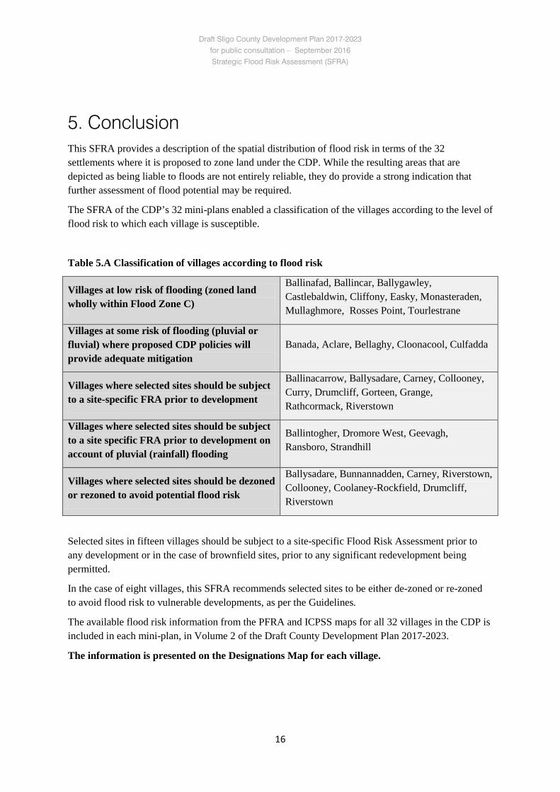
5. Conclusion This SFRA provides a description of the spatial distribution of flood risk in terms of the 32 settlements where it is proposed to zone land under the CDP. While the resulting areas that are depicted as being liable to floods are not entirely reliable, they do provide a strong indication that further assessment of flood potential may be required.
The SFRA of the CDP’s 32 mini-plans enabled a classification of the villages according to the level of flood risk to which each village is susceptible.
Table 5.A Classification of villages according to flood risk
Villages at low risk of flooding (zoned land wholly within Flood Zone C)
Ballinafad, Ballincar, Ballygawley, Castlebaldwin, Cliffony, Easky, Monasteraden, Mullaghmore, Rosses Point, Tourlestrane
Villages at some risk of flooding (pluvial or fluvial) where proposed CDP policies will provide adequate mitigation
Banada, Aclare, Bellaghy, Cloonacool, Culfadda
Villages where selected sites should be subject to a site-specific FRA prior to development
Ballinacarrow, Ballysadare, Carney, Collooney, Curry, Drumcliff, Gorteen, Grange, Rathcormack, Riverstown
Villages where selected sites should be subject to a site specific FRA prior to development on account of pluvial (rainfall) flooding
Ballintogher, Dromore West, Geevagh, Ransboro, Strandhill
Villages where selected sites should be dezoned or rezoned to avoid potential flood risk
Ballysadare, Bunnannadden, Carney, Riverstown, Collooney, Coolaney-Rockfield, Drumcliff, Riverstown
Selected sites in fifteen villages should be subject to a site-specific Flood Risk Assessment prior to any development or in the case of brownfield sites, prior to any significant redevelopment being permitted.
In the case of eight villages, this SFRA recommends selected sites to be either de-zoned or re-zoned to avoid flood risk to vulnerable developments, as per the Guidelines.
The available flood risk information from the PFRA and ICPSS maps for all 32 villages in the CDP is included in each mini-plan, in Volume 2 of the Draft County Development Plan 2017-2023.
The information is presented on the Designations Map for each village.
Draft Sligo County Development Plan 2017-2023 for public consultation – September 2016 Strategic Flood Risk Assessment (SFRA)
17
6. Flood risk management in the CDP
6.1 Flood risk management principles The County Development Plan contains policies and/or objectives intended to manage flood risk and the formulation of the 32 Mini-Plans has taken into account the key principles of the risk-based sequential approach to managing flood hazard and potential risk in the planning system as outlined in the Flooding Guidelines.
These principles are as follows:
1. Avoid development in areas at risk of flooding.
2. If this is not possible, consider substituting a land use that is less vulnerable to flooding.
3. Only when both avoidance and substitution cannot take place should consideration be given to mitigation and management of risks.
4. The identification of policies and practices to be adopted within the County during the lifetime of this County Development Plan, including:
• Where relevant, requiring developments to comply with the Planning System and Flood Risk Management - Guidelines for Planning Authorities.
• Where relevant, requiring developments to use Sustainable Urban Drainage Systems in accordance with best current practice.
• Encouraging the creation of opportunities for enhancement of bio-diversity and amenities in necessary flood risk responses.
6.2 Policies addressing flood risk at the county level This section suggests measures to be considered for inclusion as policies or objectives in the Sligo County Development Plan 2017-2023. These measures will contribute towards both flood risk management in the county and compliance with the Flood Risk Management Guidelines.
Recommended Flood Risk Management Policies
P-FRM-1 Protect and enhance the County’s floodplains, wetlands and coastal areas subject to flooding and ensure that no removal of sand dunes, beach sand or gravel is undertaken. These areas represent a vital green infrastructure, which provides space for storage and conveyance of floodwater, enabling flood risk to be more effectively managed and reducing the need to provide flood defences in the future.
P-FRM-2 Direct strategically significant growth, projects and infrastructure to areas with a low risk of flooding.
Draft Sligo County Development Plan 2017-2023 for public consultation – September 2016 Strategic Flood Risk Assessment (SFRA)
18
P-FRM-3 Zone land for development in areas with a high or moderate risk of flooding only where it can be clearly demonstrated, on a solid evidence base, that the zoning will satisfy the justification test set out in chapter 4 of the Planning System and Flood Risk Management Guidelines.
P-FRM-4 Maintain a 20-metre-wide flood protection zone around lakes and along both sides of all rivers, and a 100-metre-wide flood protection zone from soft shorelines. Development proposals will be required to maintain these flood protection zones free from development.
Exceptions may be considered for strategic road projects, river banks enhancement works, bridge and road repair works, in the case of brownfield sites, development on lands zoned subject to policy P-FRM-3 and in cases where the maintenance of the flood protection zone is not practically achievable. Such cases will be assessed on an individual basis and a reduced width may be accepted.
P-FRM-5 Restrict development in areas at risk of flooding unless:
– it is demonstrated that there are wider sustainability grounds for appropriate development;
– the flood risk can be managed to an acceptable level without increasing flood risk elsewhere;
– the overall flood risk is reduced, where possible.
Developments considered necessary in order to meet the objectives of this Plan, or required on wider sustainability grounds, will be subject to the development management justification test outlined in chapter 5 of the Planning System and Flood Risk Management Guidelines.
Measures such as flood compensation storage works or new hard-engineered flood defences alone will not be acceptable as justification for development in flood risk areas. Such measures will only be considered as part of a proposal if the development is warranted by the justification test on planning and sustainability grounds in the first instance, and where no alternative site is available.
P-FRM-6 Require development proposals, where appropriate, to be accompanied by a detailed flood risk assessment in accordance with the provisions of the DoEHLG’s Planning System and Flood Risk Management Guidelines for Planning Authorities and to address flood risk management in the detailed design of development, as set out in Appendix B of the Guidelines.
P-FRM-7 Assess flood risk in Local Area Plans in accordance with the DoEHLG’s Planning System and Flood Risk Management Guidelines for Planning Authorities in a manner that is appropriate to the scale and circumstances of each area and having regard to the priorities set out in the SFRA that accompanies this Plan.
Draft Sligo County Development Plan 2017-2023 for public consultation – September 2016 Strategic Flood Risk Assessment (SFRA)
19
Recommended coastal protection policies
P-CP-2 Require that any development within the coastal zone is appropriately sited, having regard to coastal flooding, future shoreline erosion, predicted sea-level rise and OPW flood mapping.
P-CP-3 Require that detailed flood risk assessment is carried out in relation to development proposals within the coastal zone and particularly on all low-lying areas, where appropriate.
P-CP-4 Establish natural buffers at the coast, particularly in conjunction with the preparation of local area plans and mini-plans.
6.3 SFRA review and monitoring An update of the SFRA will be triggered by the six-year review cycle that applies to Local Authority development plans. In addition, there are a number of other potential triggers for an SFRA review, including significant flood events, changes to planning or flood management policy, and reviews of CFRAM mapping.
Detailed, site-specific FRAs may be submitted to support planning applications in areas at risk of flooding. Whilst these reports will not trigger a review of the Flood Zone Maps or SFRA, they should be retained and reviewed as part of the next cycle of the development plan.

21
Appendix A
Indications of potential flood risk in each mini-plan area
and identification of requirement for Stage 2 SFRA
22
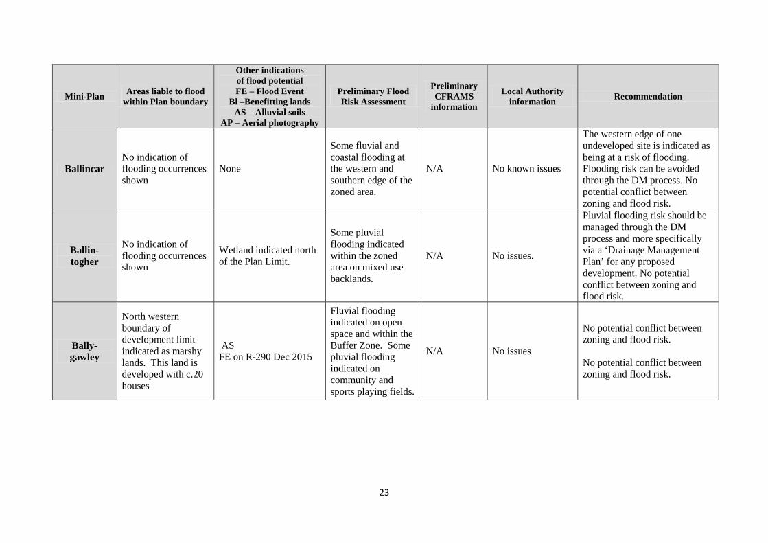
Mini-Plan Areas liable to flood within Plan boundary
Other indications of flood potential FE – Flood Event
Bl –Benefitting lands AS – Alluvial soils
AP – Aerial photography
Preliminary Flood Risk Assessment
Preliminary CFRAMS
information
Local Authority information Recommendation
Aclare
Western environs of village on either side of river indicated as marshy lands.
FE recorded on outskirts of town BL mapped along Lough Talt River going through the village
Some fluvial flooding associated with the Lough Talt River on lands within the Buffer Zone.
N/A No issues
All land on which a risk of flooding has been identified is either within the Buffer Zone or is within a river buffer zone where P-FRM-4 applies. No potential conflict between zoning and flood risk.
Ballina-carrow
Lands either side of the Owenmore River and its tributaries indicated as being marshy.
BL mapped on either side of the Owenmore River
Some fluvial flooding associated with the Owenmore River on undeveloped mixed use zoned lands.
N/A No known issues Proceed to Stage 2 SFRA
Ballinafad Lands to the north of the village indicated as being marshy.
Benefitting lands mapped to the north of the L-1806-0
Some fluvial flooding to the north of the village along a stream on lands within the Buffer Zone. Patches of pluvial flooding in the buffer zone and on developed land.
N/A No issues
All land on which a risk of flooding has been identified is either within the Buffer Zone or is on developed land where surface water issues should be effectively managed. No potential conflict between zoning and flood risk.
23
Mini-Plan Areas liable to flood within Plan boundary
Other indications of flood potential FE – Flood Event
Bl –Benefitting lands AS – Alluvial soils
AP – Aerial photography
Preliminary Flood Risk Assessment
Preliminary CFRAMS
information
Local Authority information Recommendation
Ballincar No indication of flooding occurrences shown
None
Some fluvial and coastal flooding at the western and southern edge of the zoned area.
N/A No known issues
The western edge of one undeveloped site is indicated as being at a risk of flooding. Flooding risk can be avoided through the DM process. No potential conflict between zoning and flood risk.
Ballin-togher
No indication of flooding occurrences shown
Wetland indicated north of the Plan Limit.
Some pluvial flooding indicated within the zoned area on mixed use backlands.
N/A No issues.
Pluvial flooding risk should be managed through the DM process and more specifically via a ‘Drainage Management Plan’ for any proposed development. No potential conflict between zoning and flood risk.
Bally-gawley
North western boundary of development limit indicated as marshy lands. This land is developed with c.20 houses
AS FE on R-290 Dec 2015
Fluvial flooding indicated on open space and within the Buffer Zone. Some pluvial flooding indicated on community and sports playing fields.
N/A No issues
No potential conflict between zoning and flood risk. No potential conflict between zoning and flood risk.
24
Mini-Plan Areas liable to flood within Plan boundary
Other indications of flood potential FE – Flood Event
Bl –Benefitting lands AS – Alluvial soils
AP – Aerial photography
Preliminary Flood Risk Assessment
Preliminary CFRAMS
information
Local Authority information Recommendation
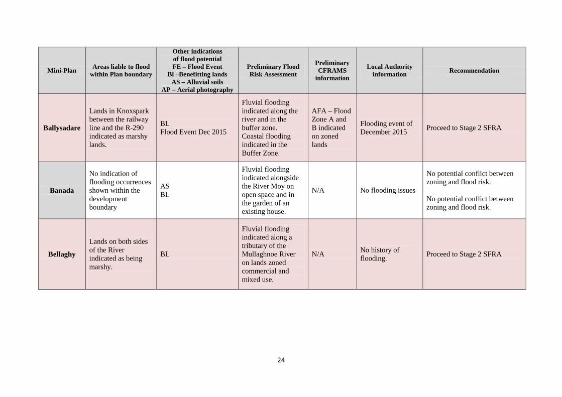
Ballysadare
Lands in Knoxspark between the railway line and the R-290 indicated as marshy lands.
BL Flood Event Dec 2015
Fluvial flooding indicated along the river and in the buffer zone. Coastal flooding indicated in the Buffer Zone.
AFA – Flood Zone A and B indicated on zoned lands
Flooding event of December 2015 Proceed to Stage 2 SFRA
Banada
No indication of flooding occurrences shown within the development boundary
AS BL
Fluvial flooding indicated alongside the River Moy on open space and in the garden of an existing house.
N/A No flooding issues
No potential conflict between zoning and flood risk. No potential conflict between zoning and flood risk.
Bellaghy
Lands on both sides of the River indicated as being marshy.
BL
Fluvial flooding indicated along a tributary of the Mullaghnoe River on lands zoned commercial and mixed use.
N/A No history of flooding. Proceed to Stage 2 SFRA
25
Mini-Plan Areas liable to flood within Plan boundary
Other indications of flood potential FE – Flood Event
Bl –Benefitting lands AS – Alluvial soils
AP – Aerial photography
Preliminary Flood Risk Assessment
Preliminary CFRAMS
information
Local Authority information Recommendation
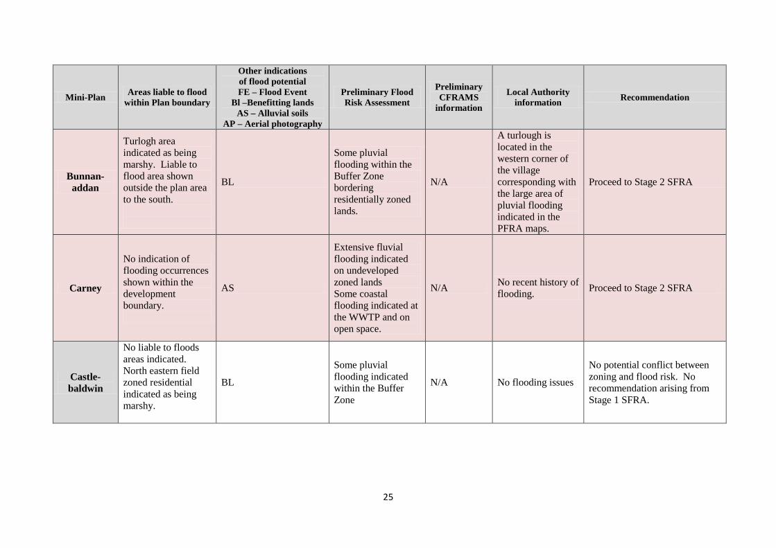
Bunnan-addan
Turlogh area indicated as being marshy. Liable to flood area shown outside the plan area to the south.
BL
Some pluvial flooding within the Buffer Zone bordering residentially zoned lands.
N/A
A turlough is located in the western corner of the village corresponding with the large area of pluvial flooding indicated in the PFRA maps.
Proceed to Stage 2 SFRA
Carney
No indication of flooding occurrences shown within the development boundary.
AS
Extensive fluvial flooding indicated on undeveloped zoned lands Some coastal flooding indicated at the WWTP and on open space.
N/A No recent history of flooding. Proceed to Stage 2 SFRA
Castle-baldwin
No liable to floods areas indicated. North eastern field zoned residential indicated as being marshy.
BL
Some pluvial flooding indicated within the Buffer Zone
N/A No flooding issues
No potential conflict between zoning and flood risk. No recommendation arising from Stage 1 SFRA.
26
Mini-Plan Areas liable to flood within Plan boundary
Other indications of flood potential FE – Flood Event
Bl –Benefitting lands AS – Alluvial soils
AP – Aerial photography
Preliminary Flood Risk Assessment
Preliminary CFRAMS
information
Local Authority information Recommendation
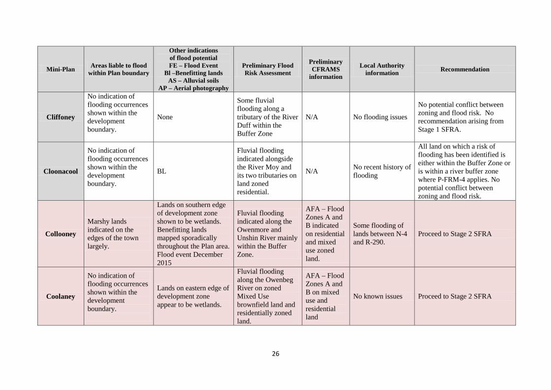
Cliffoney
No indication of flooding occurrences shown within the development boundary.
None
Some fluvial flooding along a tributary of the River Duff within the Buffer Zone
N/A No flooding issues
No potential conflict between zoning and flood risk. No recommendation arising from Stage 1 SFRA.
Cloonacool
No indication of flooding occurrences shown within the development boundary.
BL
Fluvial flooding indicated alongside the River Moy and its two tributaries on land zoned residential.
N/A No recent history of flooding
All land on which a risk of flooding has been identified is either within the Buffer Zone or is within a river buffer zone where P-FRM-4 applies. No potential conflict between zoning and flood risk.
Collooney
Marshy lands indicated on the edges of the town largely.
Lands on southern edge of development zone shown to be wetlands. Benefitting lands mapped sporadically throughout the Plan area. Flood event December 2015
Fluvial flooding indicated along the Owenmore and Unshin River mainly within the Buffer Zone.
AFA – Flood Zones A and B indicated on residential and mixed use zoned land.
Some flooding of lands between N-4 and R-290.
Proceed to Stage 2 SFRA
Coolaney
No indication of flooding occurrences shown within the development boundary.
Lands on eastern edge of development zone appear to be wetlands.
Fluvial flooding along the Owenbeg River on zoned Mixed Use brownfield land and residentially zoned land.
AFA – Flood Zones A and B on mixed use and residential land
No known issues Proceed to Stage 2 SFRA
27
Mini-Plan Areas liable to flood within Plan boundary
Other indications of flood potential FE – Flood Event
Bl –Benefitting lands AS – Alluvial soils
AP – Aerial photography
Preliminary Flood Risk Assessment
Preliminary CFRAMS
information
Local Authority information Recommendation
Culfadda
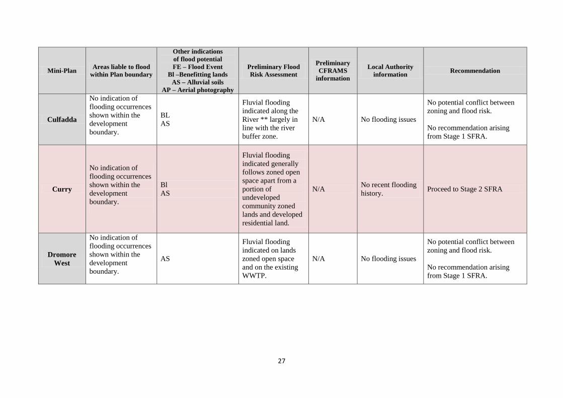
No indication of flooding occurrences shown within the development boundary.
BL AS
Fluvial flooding indicated along the River ** largely in line with the river buffer zone.
N/A No flooding issues
No potential conflict between zoning and flood risk. No recommendation arising from Stage 1 SFRA.
Curry
No indication of flooding occurrences shown within the development boundary.
Bl AS
Fluvial flooding indicated generally follows zoned open space apart from a portion of undeveloped community zoned lands and developed residential land.
N/A No recent flooding history. Proceed to Stage 2 SFRA
Dromore West
No indication of flooding occurrences shown within the development boundary.
AS
Fluvial flooding indicated on lands zoned open space and on the existing WWTP.
N/A No flooding issues
No potential conflict between zoning and flood risk. No recommendation arising from Stage 1 SFRA.
28
Mini-Plan Areas liable to flood within Plan boundary
Other indications of flood potential FE – Flood Event
Bl –Benefitting lands AS – Alluvial soils
AP – Aerial photography
Preliminary Flood Risk Assessment
Preliminary CFRAMS
information
Local Authority information Recommendation
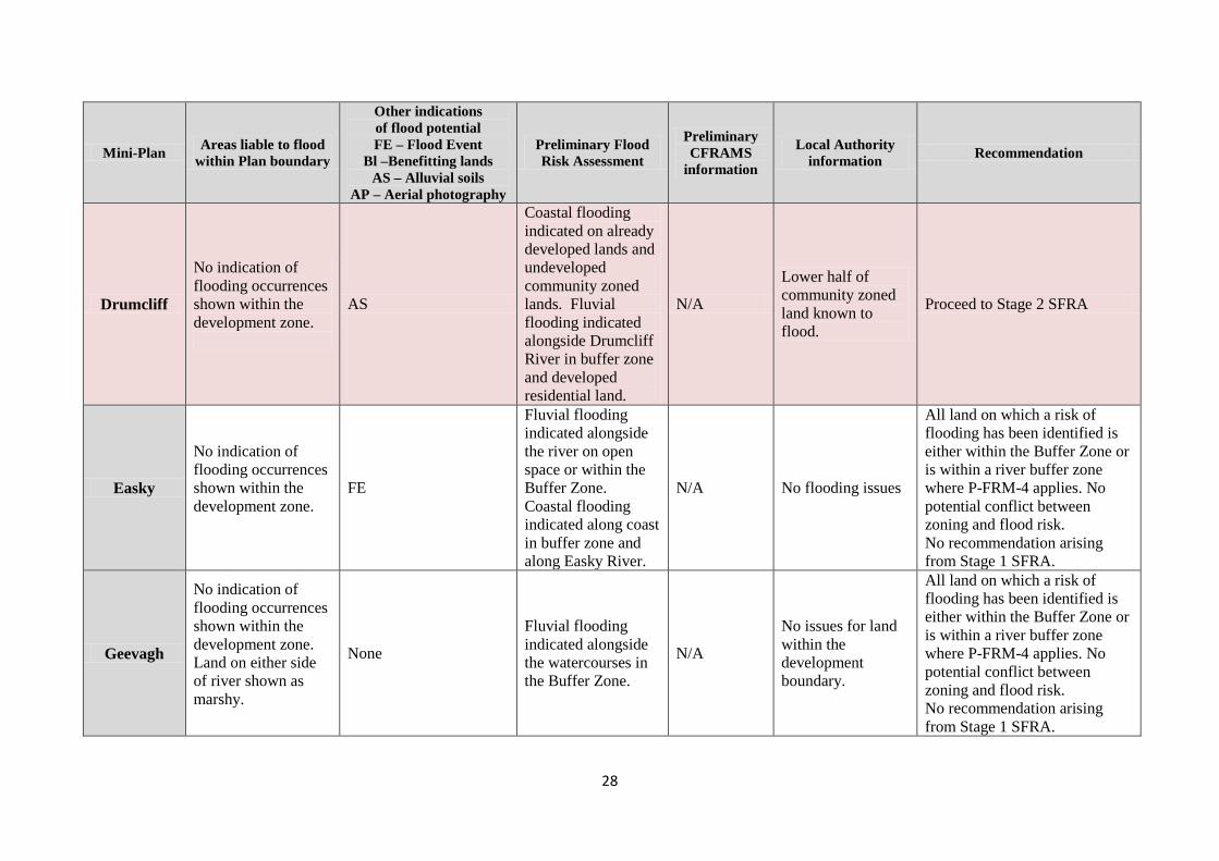
Drumcliff
No indication of flooding occurrences shown within the development zone.
AS
Coastal flooding indicated on already developed lands and undeveloped community zoned lands. Fluvial flooding indicated alongside Drumcliff River in buffer zone and developed residential land.
N/A
Lower half of community zoned land known to flood.
Proceed to Stage 2 SFRA
Easky
No indication of flooding occurrences shown within the development zone.
FE
Fluvial flooding indicated alongside the river on open space or within the Buffer Zone. Coastal flooding indicated along coast in buffer zone and along Easky River.
N/A No flooding issues
All land on which a risk of flooding has been identified is either within the Buffer Zone or is within a river buffer zone where P-FRM-4 applies. No potential conflict between zoning and flood risk. No recommendation arising from Stage 1 SFRA.
Geevagh
No indication of flooding occurrences shown within the development zone. Land on either side of river shown as marshy.
None
Fluvial flooding indicated alongside the watercourses in the Buffer Zone.
N/A
No issues for land within the development boundary.
All land on which a risk of flooding has been identified is either within the Buffer Zone or is within a river buffer zone where P-FRM-4 applies. No potential conflict between zoning and flood risk. No recommendation arising from Stage 1 SFRA.
29
Mini-Plan Areas liable to flood within Plan boundary
Other indications of flood potential FE – Flood Event
Bl –Benefitting lands AS – Alluvial soils
AP – Aerial photography
Preliminary Flood Risk Assessment
Preliminary CFRAMS
information
Local Authority information Recommendation
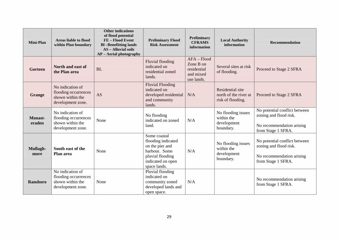
Gorteen North and east of the Plan area BL
Fluvial flooding indicated on residential zoned lands.
AFA – Flood Zone B on residential and mixed use lands.
Several sites at risk of flooding. Proceed to Stage 2 SFRA
Grange
No indication of flooding occurrences shown within the development zone.
AS
Fluvial Flooding indicated on developed residential and community lands.
N/A Residential site north of the river at risk of flooding.
Proceed to Stage 2 SFRA
Monast-eraden
No indication of flooding occurrences shown within the development zone.
None No flooding indicated on zoned land.
N/A
No flooding issues within the development boundary.
No potential conflict between zoning and flood risk. No recommendation arising from Stage 1 SFRA.
Mullagh-more
South east of the Plan area None
Some coastal flooding indicated on the pier and harbour. Some pluvial flooding indicated on open space lands.
N/A
No flooding issues within the development boundary.
No potential conflict between zoning and flood risk. No recommendation arising from Stage 1 SFRA.
Ransboro
No indication of flooding occurrences shown within the development zone.
None
Pluvial flooding indicated on community zoned developed lands and open space.
N/A No recommendation arising from Stage 1 SFRA.
30
Mini-Plan Areas liable to flood within Plan boundary
Other indications of flood potential FE – Flood Event
Bl –Benefitting lands AS – Alluvial soils
AP – Aerial photography
Preliminary Flood Risk Assessment
Preliminary CFRAMS
information
Local Authority information Recommendation
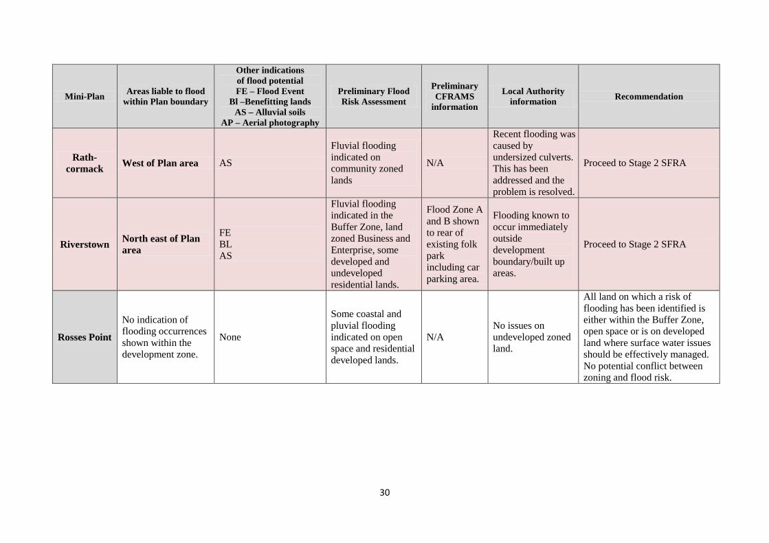
Rath-cormack West of Plan area AS
Fluvial flooding indicated on community zoned lands
N/A
Recent flooding was caused by undersized culverts. This has been addressed and the problem is resolved.
Proceed to Stage 2 SFRA
Riverstown North east of Plan area
FE BL AS
Fluvial flooding indicated in the Buffer Zone, land zoned Business and Enterprise, some developed and undeveloped residential lands.
Flood Zone A and B shown to rear of existing folk park including car parking area.
Flooding known to occur immediately outside development boundary/built up areas.
Proceed to Stage 2 SFRA
Rosses Point
No indication of flooding occurrences shown within the development zone.
None
Some coastal and pluvial flooding indicated on open space and residential developed lands.
N/A No issues on undeveloped zoned land.
All land on which a risk of flooding has been identified is either within the Buffer Zone, open space or is on developed land where surface water issues should be effectively managed. No potential conflict between zoning and flood risk.
31
Mini-Plan Areas liable to flood within Plan boundary
Other indications of flood potential FE – Flood Event
Bl –Benefitting lands AS – Alluvial soils
AP – Aerial photography
Preliminary Flood Risk Assessment
Preliminary CFRAMS
information
Local Authority information Recommendation
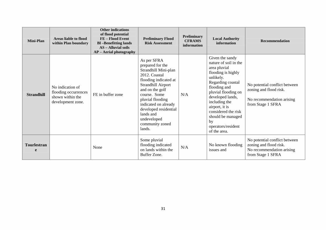
Strandhill
No indication of flooding occurrences shown within the development zone.
FE in buffer zone
As per SFRA prepared for the Strandhill Mini-plan 2012. Coastal flooding indicated at Strandhill Airport and on the golf course. Some pluvial flooding indicated on already developed residential lands and undeveloped community zoned lands.
N/A
Given the sandy nature of soil in the area pluvial flooding is highly unlikely. Regarding coastal flooding and pluvial flooding on developed lands, including the airport, it is considered the risk should be managed by operators/resident of the area.
No potential conflict between zoning and flood risk. No recommendation arising from Stage 1 SFRA
Tourlestrane None
Some pluvial flooding indicated on lands within the Buffer Zone.
N/A No known flooding issues and
No potential conflict between zoning and flood risk. No recommendation arising from Stage 1 SFRA

33
Appendix B
Stage 2 Strategic Flood Risk Assessment
for 13 mini-plans
34
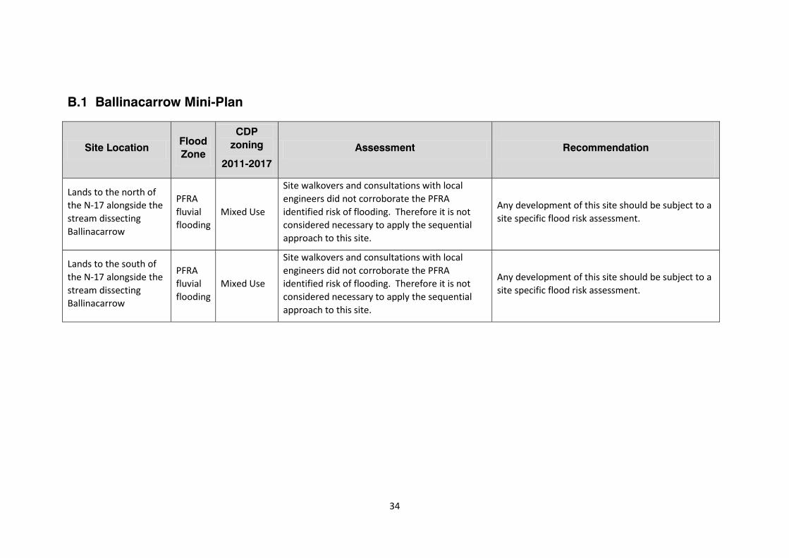
B.1 Ballinacarrow Mini-Plan
Site Location Flood Zone
CDP zoning
2011-2017
Assessment
Recommendation
Lands to the north of the N-17 alongside the stream dissecting Ballinacarrow
PFRA fluvial flooding
Mixed Use
Site walkovers and consultations with local engineers did not corroborate the PFRA identified risk of flooding. Therefore it is not considered necessary to apply the sequential approach to this site.
Any development of this site should be subject to a site specific flood risk assessment.
Lands to the south of the N-17 alongside the stream dissecting Ballinacarrow
PFRA fluvial flooding
Mixed Use
Site walkovers and consultations with local engineers did not corroborate the PFRA identified risk of flooding. Therefore it is not considered necessary to apply the sequential approach to this site.
Any development of this site should be subject to a site specific flood risk assessment.
35
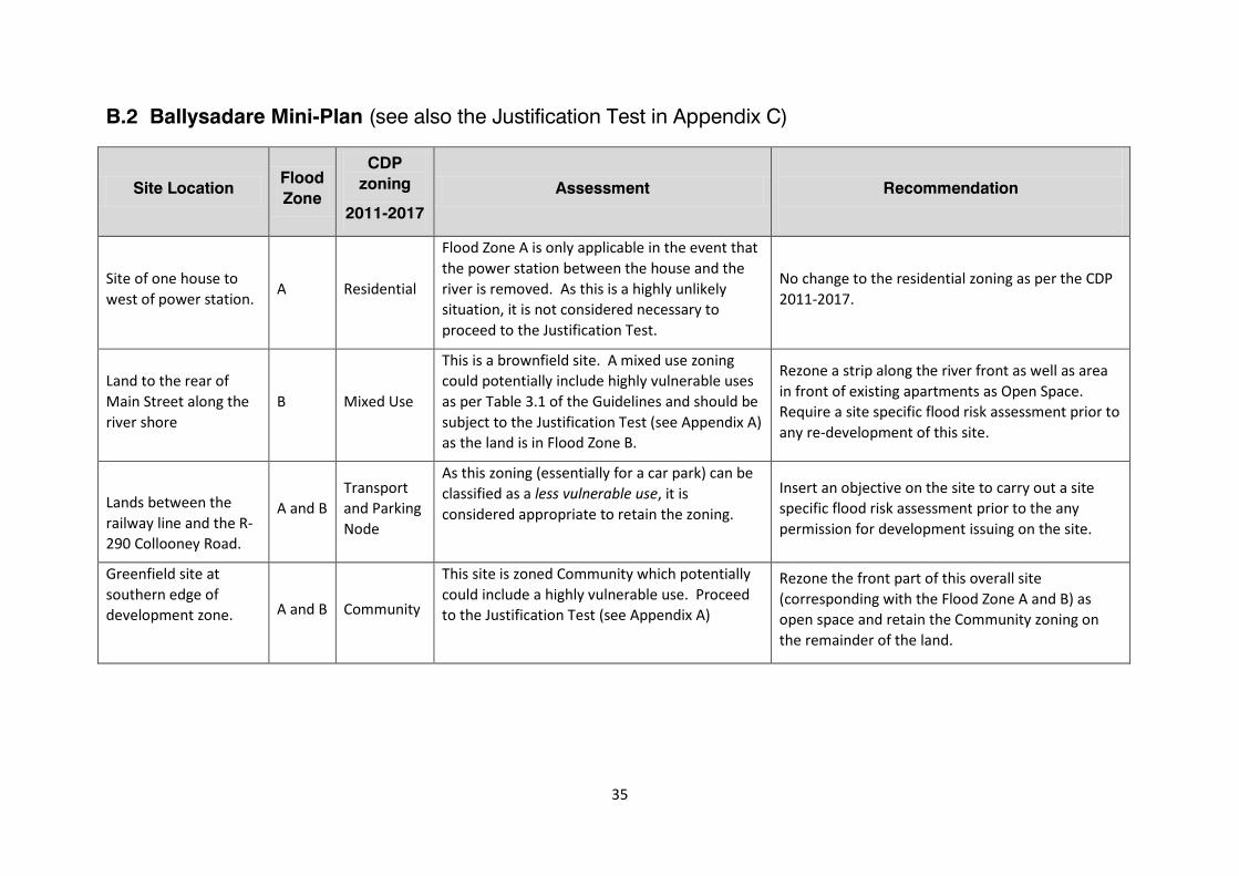
B.2 Ballysadare Mini-Plan (see also the Justification Test in Appendix C)
Site Location Flood Zone
CDP zoning
2011-2017
Assessment
Recommendation
Site of one house to west of power station. A Residential
Flood Zone A is only applicable in the event that the power station between the house and the river is removed. As this is a highly unlikely situation, it is not considered necessary to proceed to the Justification Test.
No change to the residential zoning as per the CDP 2011-2017.
Land to the rear of Main Street along the river shore
B Mixed Use
This is a brownfield site. A mixed use zoning could potentially include highly vulnerable uses as per Table 3.1 of the Guidelines and should be subject to the Justification Test (see Appendix A) as the land is in Flood Zone B.
Rezone a strip along the river front as well as area in front of existing apartments as Open Space. Require a site specific flood risk assessment prior to any re-development of this site.
Lands between the railway line and the R-290 Collooney Road.
A and B Transport and Parking Node
As this zoning (essentially for a car park) can be classified as a less vulnerable use, it is considered appropriate to retain the zoning.
Insert an objective on the site to carry out a site specific flood risk assessment prior to the any permission for development issuing on the site.
Greenfield site at southern edge of development zone.
A and B Community
This site is zoned Community which potentially could include a highly vulnerable use. Proceed to the Justification Test (see Appendix A)
Rezone the front part of this overall site (corresponding with the Flood Zone A and B) as open space and retain the Community zoning on the remainder of the land.
36
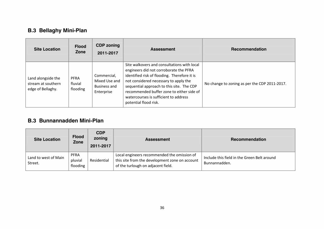
B.3 Bellaghy Mini-Plan
Site Location Flood Zone
CDP zoning
2011-2017 Assessment
Recommendation
Land alongside the stream at southern edge of Bellaghy.
PFRA fluvial flooding
Commercial, Mixed Use and Business and Enterprise
Site walkovers and consultations with local engineers did not corroborate the PFRA identified risk of flooding. Therefore it is not considered necessary to apply the sequential approach to this site. The CDP recommended buffer zone to either side of watercourses is sufficient to address potential flood risk.
No change to zoning as per the CDP 2011-2017.
B.3 Bunnannadden Mini-Plan
Site Location Flood Zone
CDP zoning
2011-2017
Assessment
Recommendation
Land to west of Main Street.
PFRA pluvial flooding
Residential Local engineers recommended the omission of this site from the development zone on account of the turlough on adjacent field.
Include this field in the Green Belt around Bunnannadden.
37
B.4 Carney Mini-Plan
Site Location Flood Zone
CDP zoning
2011-2017
Assessment
Recommendation
Field to east of Lissadell Park
PFRA pluvial flooding
Residential
Site walkovers and consultations with local engineers did not corroborate the PFRA identified risk of flooding. Therefore it is not considered necessary to apply the sequential approach to this site.
Re-zone narrow strip of this land adjacent to the tree belt as Open Space to a) accommodate flooding risk and b) to provide protection to the tree belt. The remainder of the site shall remain zoned for residential development subject to the findings of a site specific flood risk assessment to be carried out prior to any development being permitted on the site.
Field to south east of Lissadell Park.
PFRA pluvial flooding
Mixed Use
Site walkovers and consultations with local engineers did not corroborate the PFRA identified risk of flooding. Therefore it is not considered necessary to apply the sequential approach to this site.
Re-zone narrow strip of this land adjacent to the tree belt as Open Space to a) accommodate flooding risk and b) to provide protection to the tree belt. The remainder of the site shall remain zoned for mixed use subject to the findings of a site specific flood risk assessment to be carried out prior to any development being permitted on the site.
Site between existing cottages and Carney River
PFRA pluvial flooding
Mixed Use
As this site is in close proximity to the river and a well used public open space as well as being in a flood risk area, it is considered appropriate to re-zone this area as open space.
Re-zone this area as open space.
Site of Yeats United Football Club
PFRA pluvial flooding
Community This site is in use as a football pitch. Any significant redevelopment of this site should be subject to a site specific flood risk assessment.
No recommendation. Any significant redevelopment of this site should be subject to a site specific flood risk assessment.
38
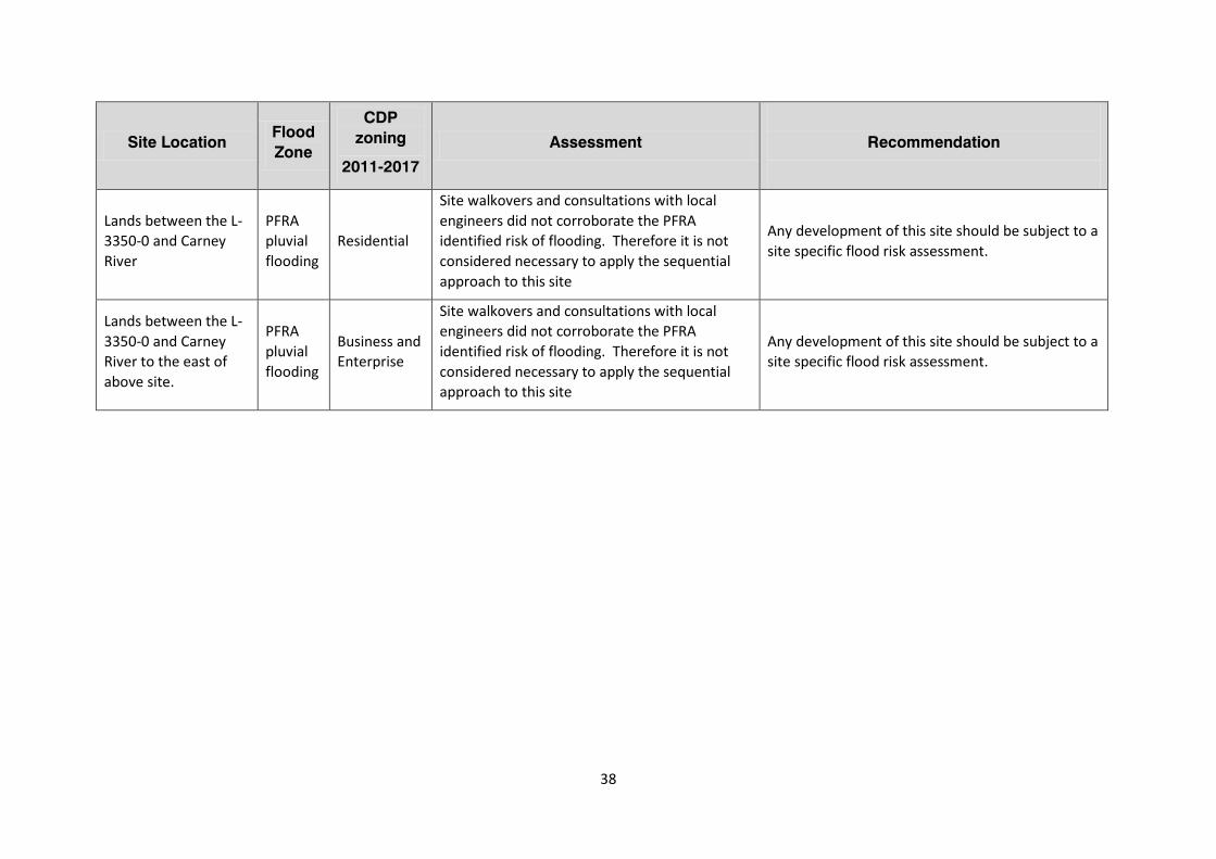
Site Location Flood Zone
CDP zoning
2011-2017
Assessment
Recommendation
Lands between the L-3350-0 and Carney River
PFRA pluvial flooding
Residential
Site walkovers and consultations with local engineers did not corroborate the PFRA identified risk of flooding. Therefore it is not considered necessary to apply the sequential approach to this site
Any development of this site should be subject to a site specific flood risk assessment.
Lands between the L-3350-0 and Carney River to the east of above site.
PFRA pluvial flooding
Business and Enterprise
Site walkovers and consultations with local engineers did not corroborate the PFRA identified risk of flooding. Therefore it is not considered necessary to apply the sequential approach to this site
Any development of this site should be subject to a site specific flood risk assessment.
39
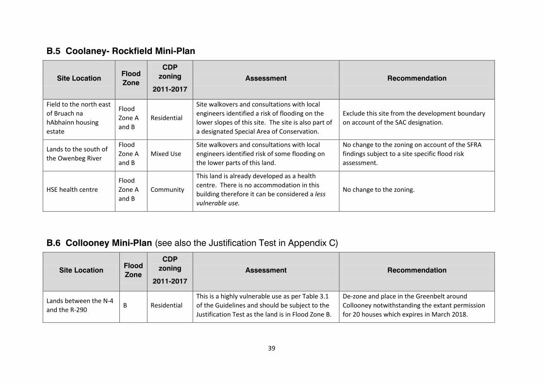
B.5 Coolaney- Rockfield Mini-Plan
Site Location Flood Zone
CDP zoning
2011-2017
Assessment
Recommendation
Field to the north east of Bruach na hAbhainn housing estate
Flood Zone A and B
Residential
Site walkovers and consultations with local engineers identified a risk of flooding on the lower slopes of this site. The site is also part of a designated Special Area of Conservation.
Exclude this site from the development boundary on account of the SAC designation.
Lands to the south of the Owenbeg River
Flood Zone A and B
Mixed Use Site walkovers and consultations with local engineers identified risk of some flooding on the lower parts of this land.
No change to the zoning on account of the SFRA findings subject to a site specific flood risk assessment.
HSE health centre Flood Zone A and B
Community
This land is already developed as a health centre. There is no accommodation in this building therefore it can be considered a less vulnerable use.
No change to the zoning.
B.6 Collooney Mini-Plan (see also the Justification Test in Appendix C)
Site Location Flood Zone
CDP zoning
2011-2017
Assessment
Recommendation
Lands between the N-4 and the R-290 B Residential
This is a highly vulnerable use as per Table 3.1 of the Guidelines and should be subject to the Justification Test as the land is in Flood Zone B.
De-zone and place in the Greenbelt around Collooney notwithstanding the extant permission for 20 houses which expires in March 2018.
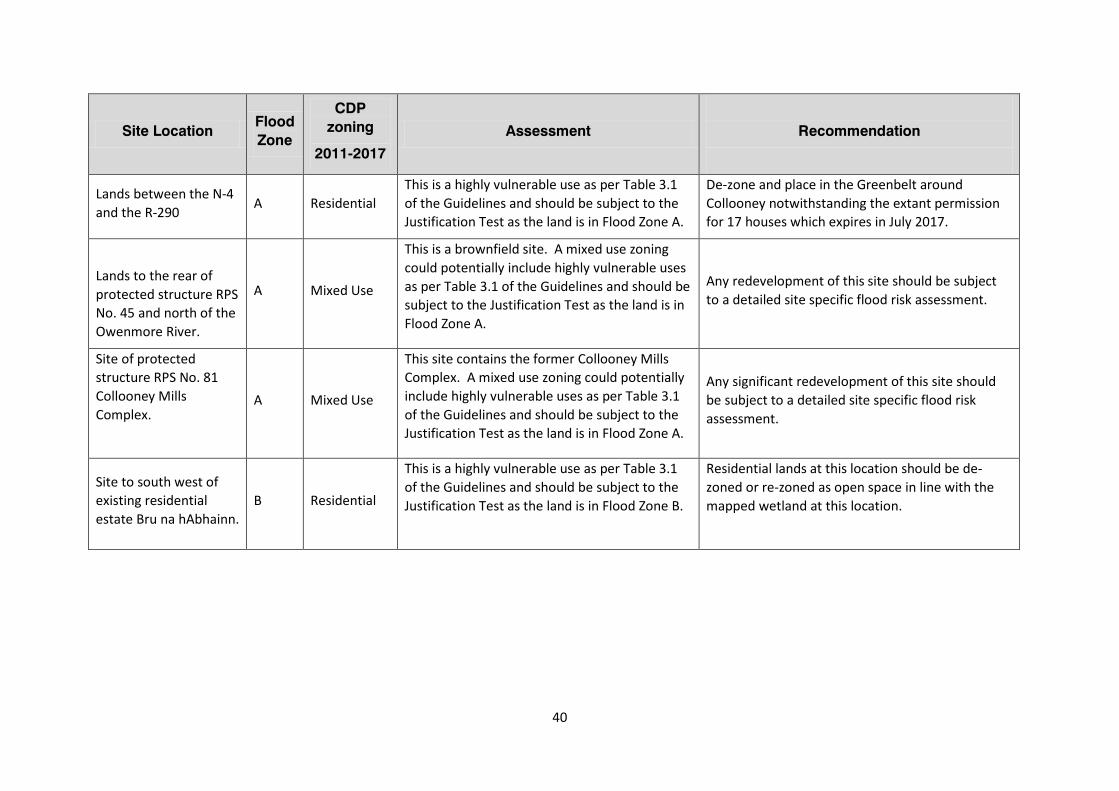
40
Site Location Flood Zone
CDP zoning
2011-2017
Assessment
Recommendation
Lands between the N-4 and the R-290 A Residential
This is a highly vulnerable use as per Table 3.1 of the Guidelines and should be subject to the Justification Test as the land is in Flood Zone A.
De-zone and place in the Greenbelt around Collooney notwithstanding the extant permission for 17 houses which expires in July 2017.
Lands to the rear of protected structure RPS No. 45 and north of the Owenmore River.
A Mixed Use
This is a brownfield site. A mixed use zoning could potentially include highly vulnerable uses as per Table 3.1 of the Guidelines and should be subject to the Justification Test as the land is in Flood Zone A.
Any redevelopment of this site should be subject to a detailed site specific flood risk assessment.
Site of protected structure RPS No. 81 Collooney Mills Complex.
A Mixed Use
This site contains the former Collooney Mills Complex. A mixed use zoning could potentially include highly vulnerable uses as per Table 3.1 of the Guidelines and should be subject to the Justification Test as the land is in Flood Zone A.
Any significant redevelopment of this site should be subject to a detailed site specific flood risk assessment.
Site to south west of existing residential estate Bru na hAbhainn.
B Residential
This is a highly vulnerable use as per Table 3.1 of the Guidelines and should be subject to the Justification Test as the land is in Flood Zone B.
Residential lands at this location should be de-zoned or re-zoned as open space in line with the mapped wetland at this location.
41
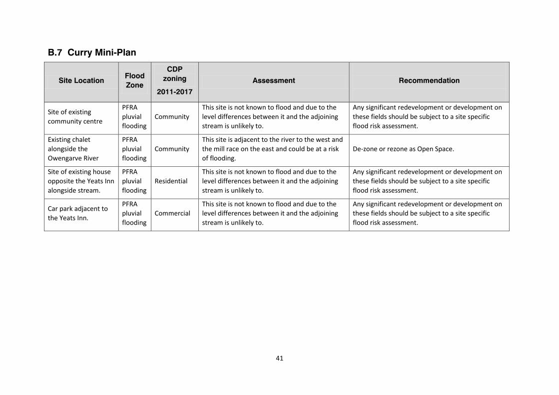
B.7 Curry Mini-Plan
Site Location Flood Zone
CDP zoning
2011-2017
Assessment
Recommendation
Site of existing community centre
PFRA pluvial flooding
Community This site is not known to flood and due to the level differences between it and the adjoining stream is unlikely to.
Any significant redevelopment or development on these fields should be subject to a site specific flood risk assessment.
Existing chalet alongside the Owengarve River
PFRA pluvial flooding
Community This site is adjacent to the river to the west and the mill race on the east and could be at a risk of flooding.
De-zone or rezone as Open Space.
Site of existing house opposite the Yeats Inn alongside stream.
PFRA pluvial flooding
Residential This site is not known to flood and due to the level differences between it and the adjoining stream is unlikely to.
Any significant redevelopment or development on these fields should be subject to a site specific flood risk assessment.
Car park adjacent to the Yeats Inn.
PFRA pluvial flooding
Commercial This site is not known to flood and due to the level differences between it and the adjoining stream is unlikely to.
Any significant redevelopment or development on these fields should be subject to a site specific flood risk assessment.
42
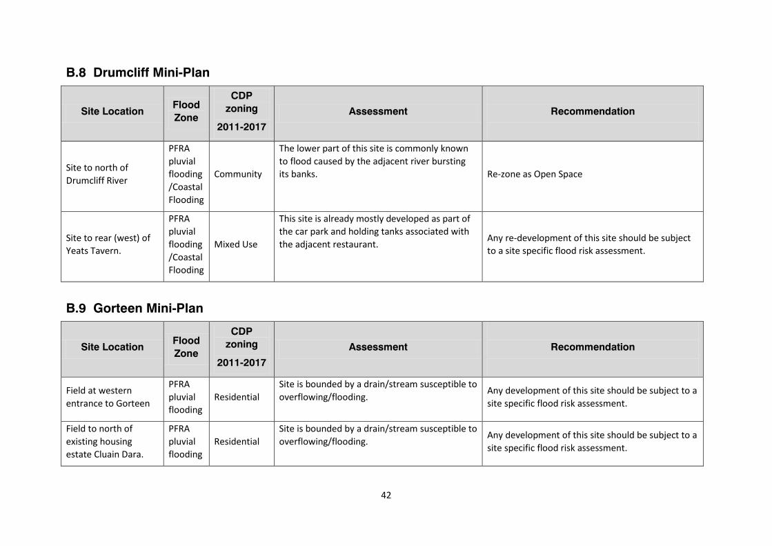
B.8 Drumcliff Mini-Plan
Site Location Flood Zone
CDP zoning
2011-2017
Assessment
Recommendation
Site to north of Drumcliff River
PFRA pluvial flooding/Coastal Flooding
Community
The lower part of this site is commonly known to flood caused by the adjacent river bursting its banks. Re-zone as Open Space
Site to rear (west) of Yeats Tavern.
PFRA pluvial flooding/Coastal Flooding
Mixed Use
This site is already mostly developed as part of the car park and holding tanks associated with the adjacent restaurant. Any re-development of this site should be subject
to a site specific flood risk assessment.
B.9 Gorteen Mini-Plan
Site Location Flood Zone
CDP zoning
2011-2017
Assessment
Recommendation
Field at western entrance to Gorteen
PFRA pluvial flooding
Residential Site is bounded by a drain/stream susceptible to overflowing/flooding.
Any development of this site should be subject to a site specific flood risk assessment.
Field to north of existing housing estate Cluain Dara.
PFRA pluvial flooding
Residential Site is bounded by a drain/stream susceptible to overflowing/flooding.
Any development of this site should be subject to a site specific flood risk assessment.
43
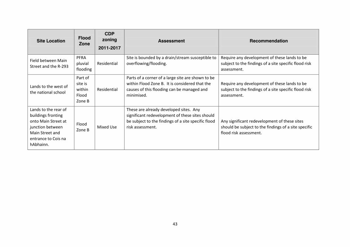
Site Location Flood Zone
CDP zoning
2011-2017
Assessment
Recommendation
Field between Main Street and the R-293
PFRA pluvial flooding
Residential Site is bounded by a drain/stream susceptible to overflowing/flooding.
Require any development of these lands to be subject to the findings of a site specific flood risk assessment.
Lands to the west of the national school
Part of site is within Flood Zone B
Residential
Parts of a corner of a large site are shown to be within Flood Zone B. It is considered that the causes of this flooding can be managed and minimised.
Require any development of these lands to be subject to the findings of a site specific flood risk assessment.
Lands to the rear of buildings fronting onto Main Street at junction between Main Street and entrance to Cois na hAbhainn.
Flood Zone B Mixed Use
These are already developed sites. Any significant redevelopment of these sites should be subject to the findings of a site specific flood risk assessment.
Any significant redevelopment of these sites should be subject to the findings of a site specific flood risk assessment.
44
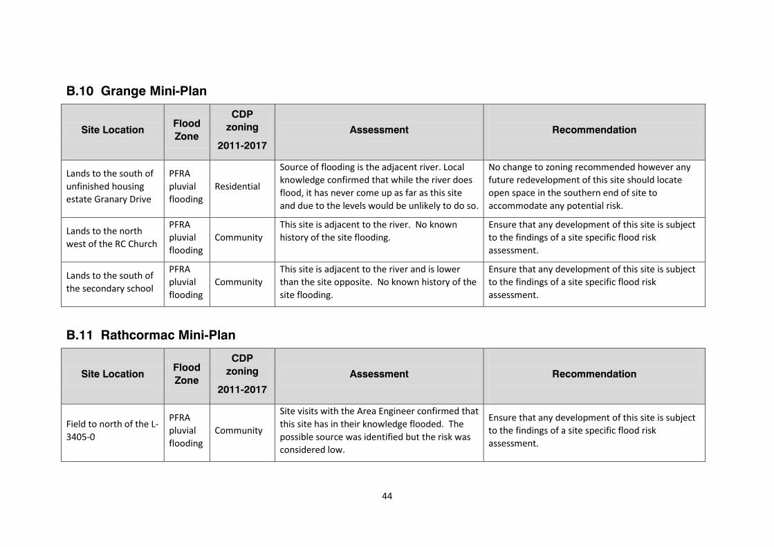
B.10 Grange Mini-Plan
Site Location Flood Zone
CDP zoning
2011-2017
Assessment
Recommendation
Lands to the south of unfinished housing estate Granary Drive
PFRA pluvial flooding
Residential
Source of flooding is the adjacent river. Local knowledge confirmed that while the river does flood, it has never come up as far as this site and due to the levels would be unlikely to do so.
No change to zoning recommended however any future redevelopment of this site should locate open space in the southern end of site to accommodate any potential risk.
Lands to the north west of the RC Church
PFRA pluvial flooding
Community This site is adjacent to the river. No known history of the site flooding.
Ensure that any development of this site is subject to the findings of a site specific flood risk assessment.
Lands to the south of the secondary school
PFRA pluvial flooding
Community This site is adjacent to the river and is lower than the site opposite. No known history of the site flooding.
Ensure that any development of this site is subject to the findings of a site specific flood risk assessment.
B.11 Rathcormac Mini-Plan
Site Location Flood Zone
CDP zoning
2011-2017
Assessment
Recommendation
Field to north of the L-3405-0
PFRA pluvial flooding
Community
Site visits with the Area Engineer confirmed that this site has in their knowledge flooded. The possible source was identified but the risk was considered low.
Ensure that any development of this site is subject to the findings of a site specific flood risk assessment.
45
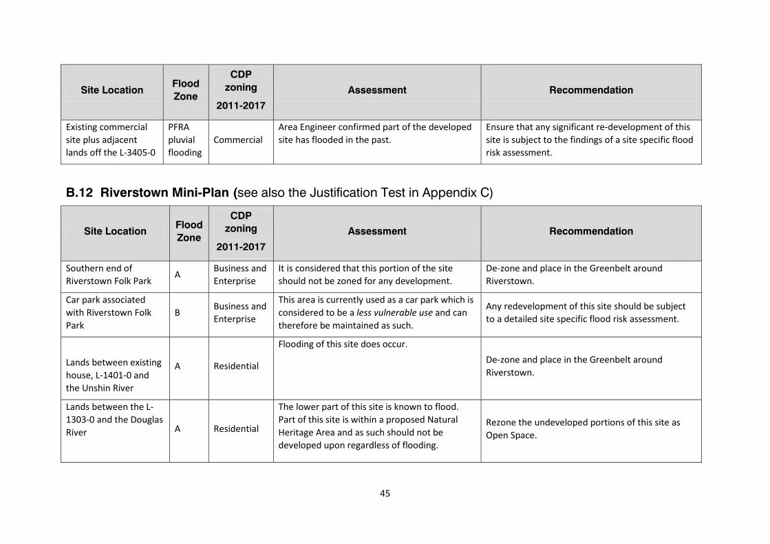
Site Location Flood Zone
CDP zoning
2011-2017
Assessment
Recommendation
Existing commercial site plus adjacent lands off the L-3405-0
PFRA pluvial flooding
Commercial Area Engineer confirmed part of the developed site has flooded in the past.
Ensure that any significant re-development of this site is subject to the findings of a site specific flood risk assessment.
B.12 Riverstown Mini-Plan (see also the Justification Test in Appendix C)
Site Location Flood Zone
CDP zoning
2011-2017
Assessment
Recommendation
Southern end of Riverstown Folk Park A Business and
Enterprise It is considered that this portion of the site should not be zoned for any development.
De-zone and place in the Greenbelt around Riverstown.
Car park associated with Riverstown Folk Park
B Business and Enterprise
This area is currently used as a car park which is considered to be a less vulnerable use and can therefore be maintained as such.
Any redevelopment of this site should be subject to a detailed site specific flood risk assessment.
Lands between existing house, L-1401-0 and the Unshin River
A Residential
Flooding of this site does occur. De-zone and place in the Greenbelt around Riverstown.
Lands between the L-1303-0 and the Douglas River
A Residential
The lower part of this site is known to flood. Part of this site is within a proposed Natural Heritage Area and as such should not be developed upon regardless of flooding.
Rezone the undeveloped portions of this site as Open Space.

47
Appendix C
Justification tests for selected sites
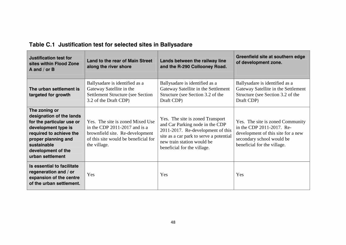
48
Table C.1 Justification test for selected sites in Ballysadare
Justification test for sites within Flood Zone A and / or B
Land to the rear of Main Street along the river shore
Lands between the railway line and the R-290 Collooney Road.
Greenfield site at southern edge of development zone.
The urban settlement is targeted for growth
Ballysadare is identified as a Gateway Satellite in the Settlement Structure (see Section 3.2 of the Draft CDP)
Ballysadare is identified as a Gateway Satellite in the Settlement Structure (see Section 3.2 of the Draft CDP)
Ballysadare is identified as a Gateway Satellite in the Settlement Structure (see Section 3.2 of the Draft CDP)
The zoning or designation of the lands for the particular use or development type is required to achieve the proper planning and sustainable development of the urban settlement
Yes. The site is zoned Mixed Use in the CDP 2011-2017 and is a brownfield site. Re-development of this site would be beneficial for the village.
Yes. The site is zoned Transport and Car Parking node in the CDP 2011-2017. Re-development of this site as a car park to serve a potential new train station would be beneficial for the village.
Yes. The site is zoned Community in the CDP 2011-2017. Re-development of this site for a new secondary school would be beneficial for the village.
Is essential to facilitate regeneration and / or expansion of the centre of the urban settlement.
Yes Yes Yes
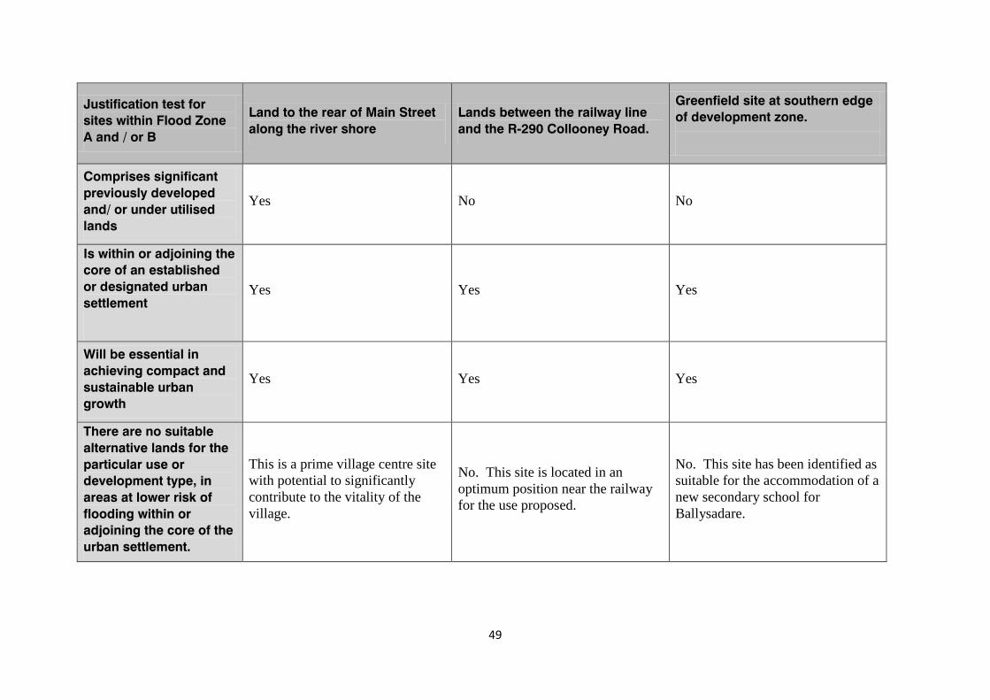
49
Justification test for sites within Flood Zone A and / or B
Land to the rear of Main Street along the river shore
Lands between the railway line and the R-290 Collooney Road.
Greenfield site at southern edge of development zone.
Comprises significant previously developed and/ or under utilised lands
Yes No No
Is within or adjoining the core of an established or designated urban settlement
Yes Yes Yes
Will be essential in achieving compact and sustainable urban growth
Yes Yes Yes
There are no suitable alternative lands for the particular use or development type, in areas at lower risk of flooding within or adjoining the core of the urban settlement.
This is a prime village centre site with potential to significantly contribute to the vitality of the village.
No. This site is located in an optimum position near the railway for the use proposed.
No. This site has been identified as suitable for the accommodation of a new secondary school for Ballysadare.
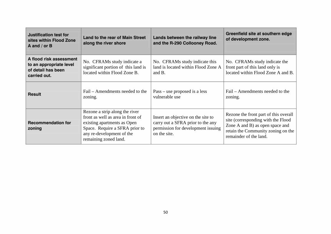
50
Justification test for sites within Flood Zone A and / or B
Land to the rear of Main Street along the river shore
Lands between the railway line and the R-290 Collooney Road.
Greenfield site at southern edge of development zone.
A flood risk assessment to an appropriate level of detail has been carried out.
No. CFRAMs study indicate a significant portion of this land is located within Flood Zone B.
No. CFRAMs study indicate this land is located within Flood Zone A and B.
No. CFRAMs study indicate the front part of this land only is located within Flood Zone A and B.
Result Fail – Amendments needed to the zoning.
Pass – use proposed is a less vulnerable use
Fail – Amendments needed to the zoning.
Recommendation for zoning
Rezone a strip along the river front as well as area in front of existing apartments as Open Space. Require a SFRA prior to any re-development of the remaining zoned land.
Insert an objective on the site to carry out a SFRA prior to the any permission for development issuing on the site.
Rezone the front part of this overall site (corresponding with the Flood Zone A and B) as open space and retain the Community zoning on the remainder of the land.
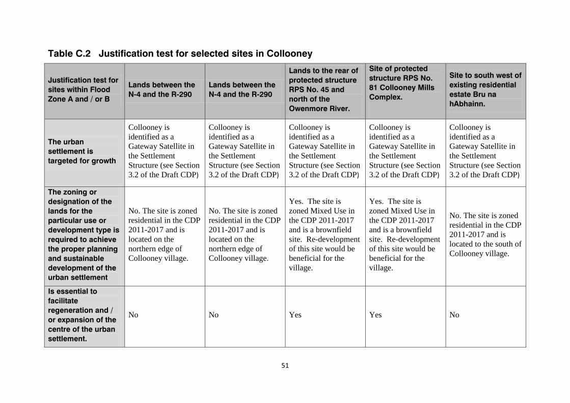
51
Table C.2 Justification test for selected sites in Collooney
Justification test for sites within Flood Zone A and / or B
Lands between the N-4 and the R-290
Lands between the N-4 and the R-290
Lands to the rear of protected structure RPS No. 45 and north of the Owenmore River.
Site of protected structure RPS No. 81 Collooney Mills Complex.
Site to south west of existing residential estate Bru na hAbhainn.
The urban settlement is targeted for growth
Collooney is identified as a Gateway Satellite in the Settlement Structure (see Section 3.2 of the Draft CDP)
Collooney is identified as a Gateway Satellite in the Settlement Structure (see Section 3.2 of the Draft CDP)
Collooney is identified as a Gateway Satellite in the Settlement Structure (see Section 3.2 of the Draft CDP)
Collooney is identified as a Gateway Satellite in the Settlement Structure (see Section 3.2 of the Draft CDP)
Collooney is identified as a Gateway Satellite in the Settlement Structure (see Section 3.2 of the Draft CDP)
The zoning or designation of the lands for the particular use or development type is required to achieve the proper planning and sustainable development of the urban settlement
No. The site is zoned residential in the CDP 2011-2017 and is located on the northern edge of Collooney village.
No. The site is zoned residential in the CDP 2011-2017 and is located on the northern edge of Collooney village.
Yes. The site is zoned Mixed Use in the CDP 2011-2017 and is a brownfield site. Re-development of this site would be beneficial for the village.
Yes. The site is zoned Mixed Use in the CDP 2011-2017 and is a brownfield site. Re-development of this site would be beneficial for the village.
No. The site is zoned residential in the CDP 2011-2017 and is located to the south of Collooney village.
Is essential to facilitate regeneration and / or expansion of the centre of the urban settlement.
No No Yes Yes No
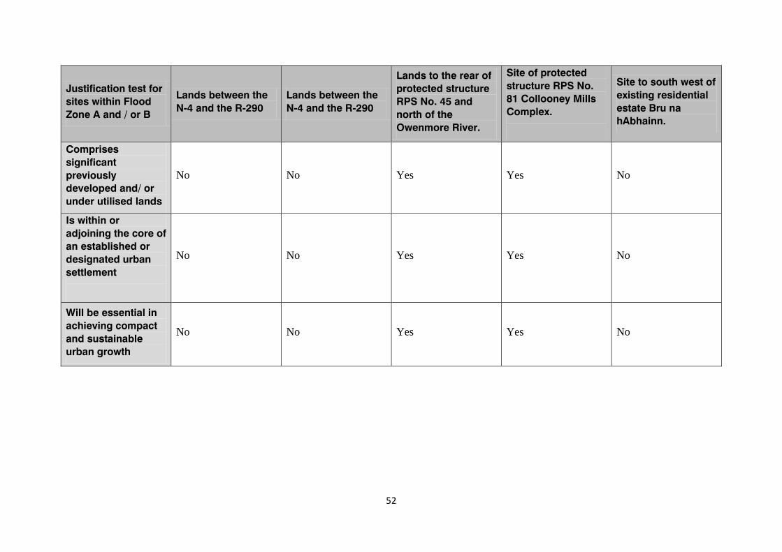
52
Justification test for sites within Flood Zone A and / or B
Lands between the N-4 and the R-290
Lands between the N-4 and the R-290
Lands to the rear of protected structure RPS No. 45 and north of the Owenmore River.
Site of protected structure RPS No. 81 Collooney Mills Complex.
Site to south west of existing residential estate Bru na hAbhainn.
Comprises significant previously developed and/ or under utilised lands
No No Yes Yes No
Is within or adjoining the core of an established or designated urban settlement
No No Yes Yes No
Will be essential in achieving compact and sustainable urban growth
No No Yes Yes No
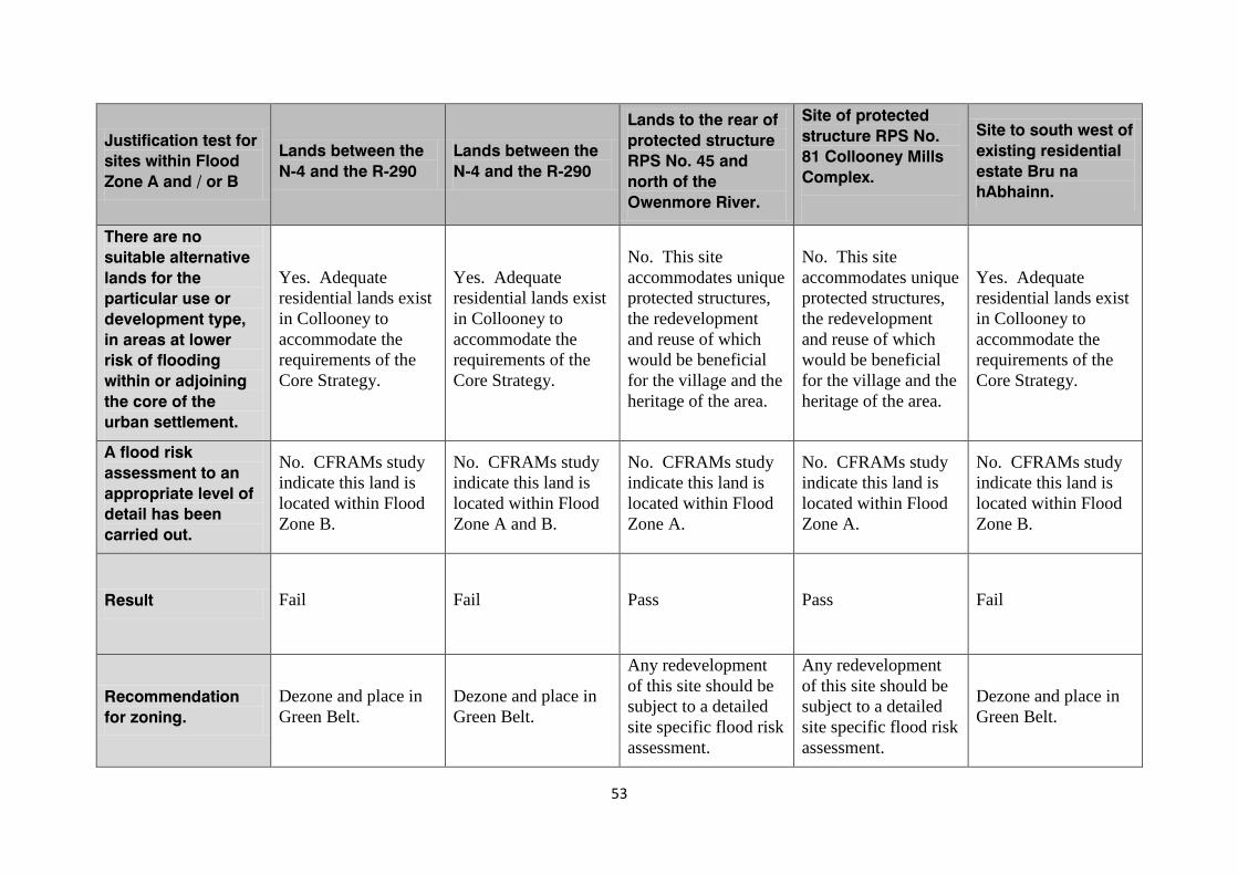
53
Justification test for sites within Flood Zone A and / or B
Lands between the N-4 and the R-290
Lands between the N-4 and the R-290
Lands to the rear of protected structure RPS No. 45 and north of the Owenmore River.
Site of protected structure RPS No. 81 Collooney Mills Complex.
Site to south west of existing residential estate Bru na hAbhainn.
There are no suitable alternative lands for the particular use or development type, in areas at lower risk of flooding within or adjoining the core of the urban settlement.
Yes. Adequate residential lands exist in Collooney to accommodate the requirements of the Core Strategy.
Yes. Adequate residential lands exist in Collooney to accommodate the requirements of the Core Strategy.
No. This site accommodates unique protected structures, the redevelopment and reuse of which would be beneficial for the village and the heritage of the area.
No. This site accommodates unique protected structures, the redevelopment and reuse of which would be beneficial for the village and the heritage of the area.
Yes. Adequate residential lands exist in Collooney to accommodate the requirements of the Core Strategy.
A flood risk assessment to an appropriate level of detail has been carried out.
No. CFRAMs study indicate this land is located within Flood Zone B.
No. CFRAMs study indicate this land is located within Flood Zone A and B.
No. CFRAMs study indicate this land is located within Flood Zone A.
No. CFRAMs study indicate this land is located within Flood Zone A.
No. CFRAMs study indicate this land is located within Flood Zone B.
Result Fail Fail Pass Pass Fail
Recommendation for zoning.
Dezone and place in Green Belt.
Dezone and place in Green Belt.
Any redevelopment of this site should be subject to a detailed site specific flood risk assessment.
Any redevelopment of this site should be subject to a detailed site specific flood risk assessment.
Dezone and place in Green Belt.
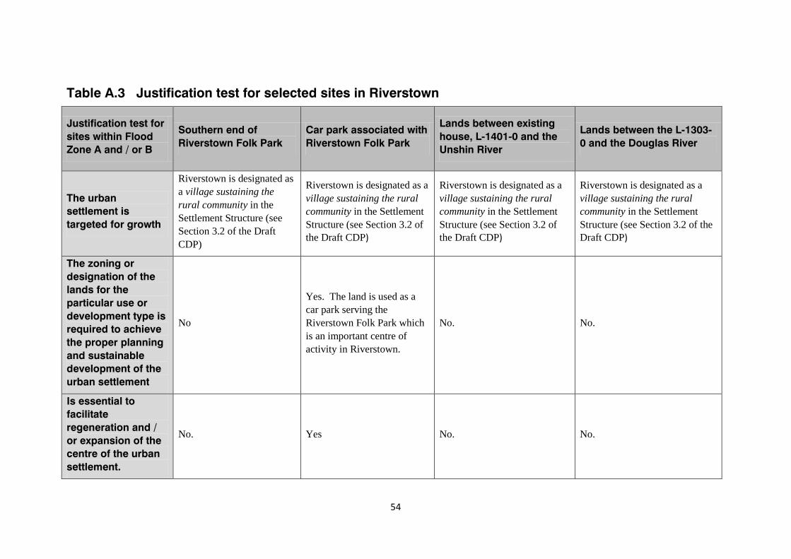
54
Table A.3 Justification test for selected sites in Riverstown
Justification test for sites within Flood Zone A and / or B
Southern end of Riverstown Folk Park
Car park associated with Riverstown Folk Park
Lands between existing house, L-1401-0 and the Unshin River
Lands between the L-1303-0 and the Douglas River
The urban settlement is targeted for growth
Riverstown is designated as a village sustaining the rural community in the Settlement Structure (see Section 3.2 of the Draft CDP)
Riverstown is designated as a village sustaining the rural community in the Settlement Structure (see Section 3.2 of the Draft CDP)
Riverstown is designated as a village sustaining the rural community in the Settlement Structure (see Section 3.2 of the Draft CDP)
Riverstown is designated as a village sustaining the rural community in the Settlement Structure (see Section 3.2 of the Draft CDP)
The zoning or designation of the lands for the particular use or development type is required to achieve the proper planning and sustainable development of the urban settlement
No
Yes. The land is used as a car park serving the Riverstown Folk Park which is an important centre of activity in Riverstown.
No. No.
Is essential to facilitate regeneration and / or expansion of the centre of the urban settlement.
No. Yes No. No.
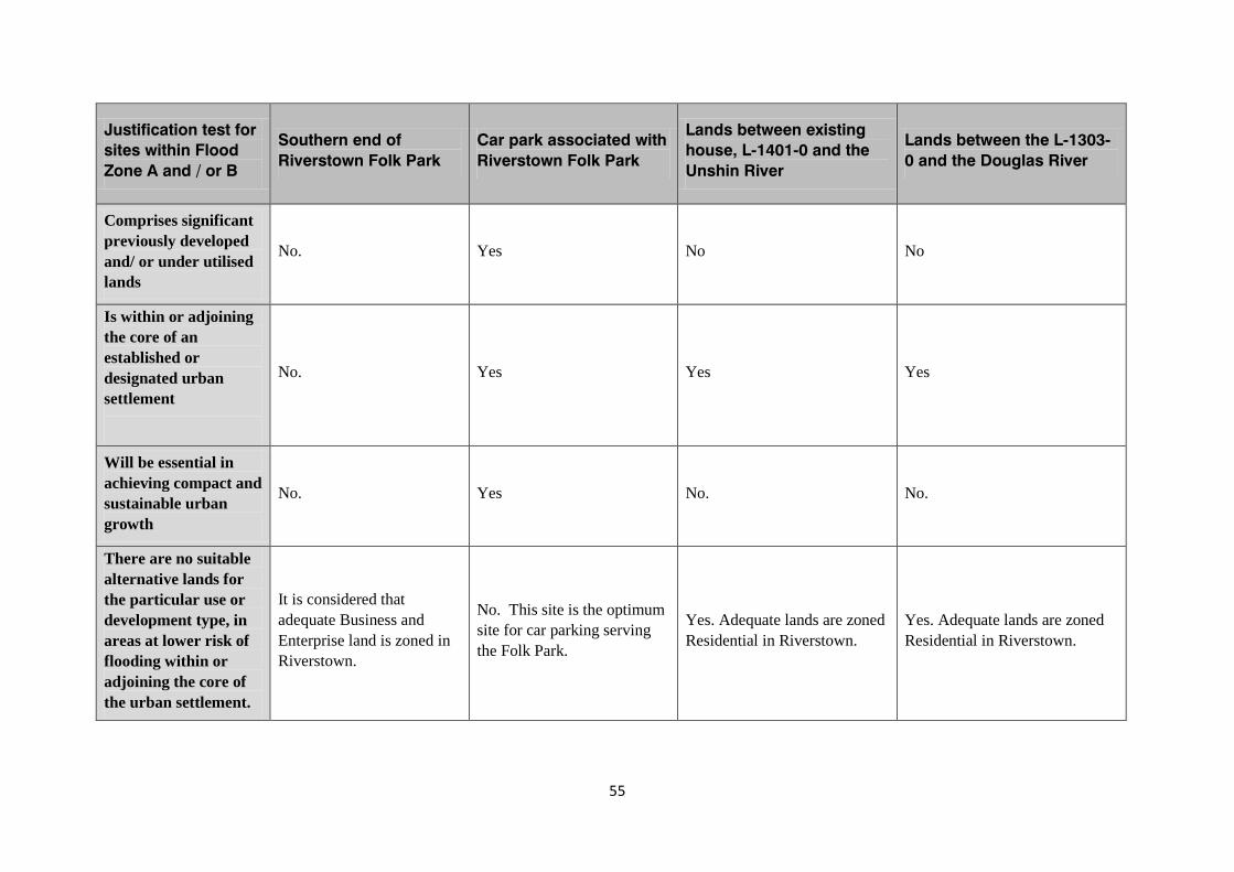
55
Justification test for sites within Flood Zone A and / or B
Southern end of Riverstown Folk Park
Car park associated with Riverstown Folk Park
Lands between existing house, L-1401-0 and the Unshin River
Lands between the L-1303-0 and the Douglas River
Comprises significant previously developed and/ or under utilised lands
No. Yes No No
Is within or adjoining the core of an established or designated urban settlement
No. Yes Yes Yes
Will be essential in achieving compact and sustainable urban growth
No. Yes No. No.
There are no suitable alternative lands for the particular use or development type, in areas at lower risk of flooding within or adjoining the core of the urban settlement.
It is considered that adequate Business and Enterprise land is zoned in Riverstown.
No. This site is the optimum site for car parking serving the Folk Park.
Yes. Adequate lands are zoned Residential in Riverstown.
Yes. Adequate lands are zoned Residential in Riverstown.
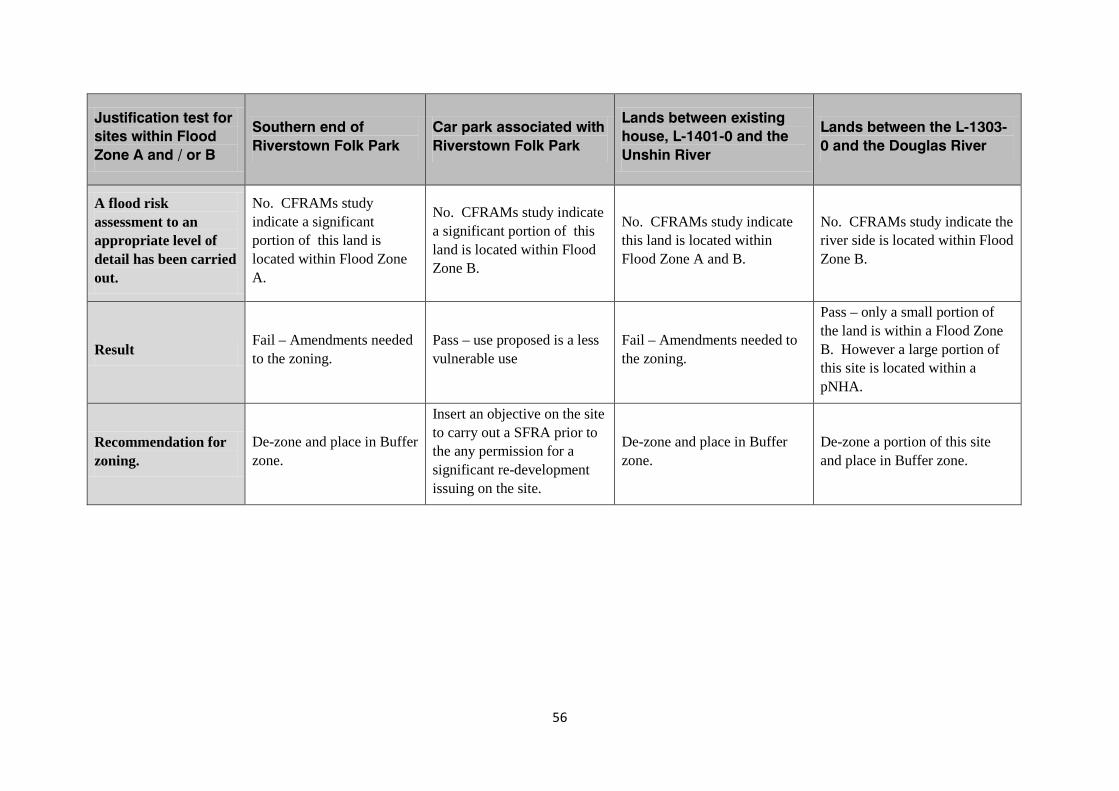
56
Justification test for sites within Flood Zone A and / or B
Southern end of Riverstown Folk Park
Car park associated with Riverstown Folk Park
Lands between existing house, L-1401-0 and the Unshin River
Lands between the L-1303-0 and the Douglas River
A flood risk assessment to an appropriate level of detail has been carried out.
No. CFRAMs study indicate a significant portion of this land is located within Flood Zone A.
No. CFRAMs study indicate a significant portion of this land is located within Flood Zone B.
No. CFRAMs study indicate this land is located within Flood Zone A and B.
No. CFRAMs study indicate the river side is located within Flood Zone B.
Result Fail – Amendments needed to the zoning.
Pass – use proposed is a less vulnerable use
Fail – Amendments needed to the zoning.
Pass – only a small portion of the land is within a Flood Zone B. However a large portion of this site is located within a pNHA.
Recommendation for zoning.
De-zone and place in Buffer zone.
Insert an objective on the site to carry out a SFRA prior to the any permission for a significant re-development issuing on the site.
De-zone and place in Buffer zone.
De-zone a portion of this site and place in Buffer zone.