straight baselines: thailand - state baselines: thailand introduction the government of thailand, on...
TRANSCRIPT
3
STRAIGHT BASELINES: THAILAND
Introduction
The Government of Thailand, on June 12, 1970, decreed a system of straight baselines for three sectors of the national coastline: The text of the declaration is as follows:
Special Edition Page 4 Royal Government Gazette
Special Vol. 87 Part 52 12 June 2513 [1970]
ANNOUNCEMENT OF THE OFFICE OF THE PRIME MINISTER
Subject: Base Lines and Internal Waters of Thailand
The Cabinet has deemed it suitable to assert the base lines and internal waters of Thailand as follows:
[See map for coordinates of 3 Areas]
And asserting the water areas within the said base lines to be the internal waters of Thailand as per details in the map attached hereto.
Thailand has adhered to these claims since time immemorial.
Amended on 11th June 2513Field Marshall Thanom Kittikachorn Prime Minister
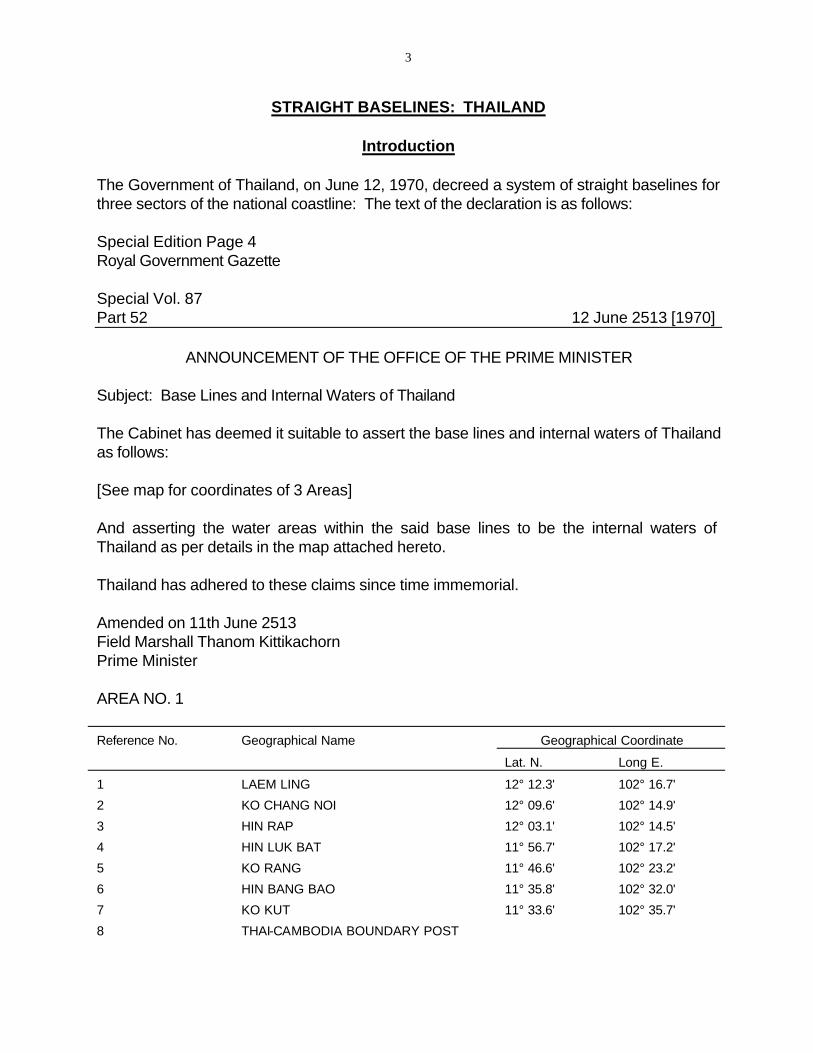
AREA NO. 1
Reference No. Geographical Name Geographical
Lat. N.
Coordinate
Long E.
1 LAEM LING 12° 12.3' 102° 16.7'
2 KO CHANG NOI 12° 09.6' 102° 14.9'
3 HIN RAP 12° 03.1' 102° 14.5'
4 HIN LUK BAT 11° 56.7' 102° 17.2'
5 KO RANG 11° 46.6' 102° 23.2'
6 HIN BANG BAO 11° 35.8' 102° 32.0'
7 KO KUT 11° 33.6' 102° 35.7'
8 THAI-CAMBODIA BOUNDARY POST
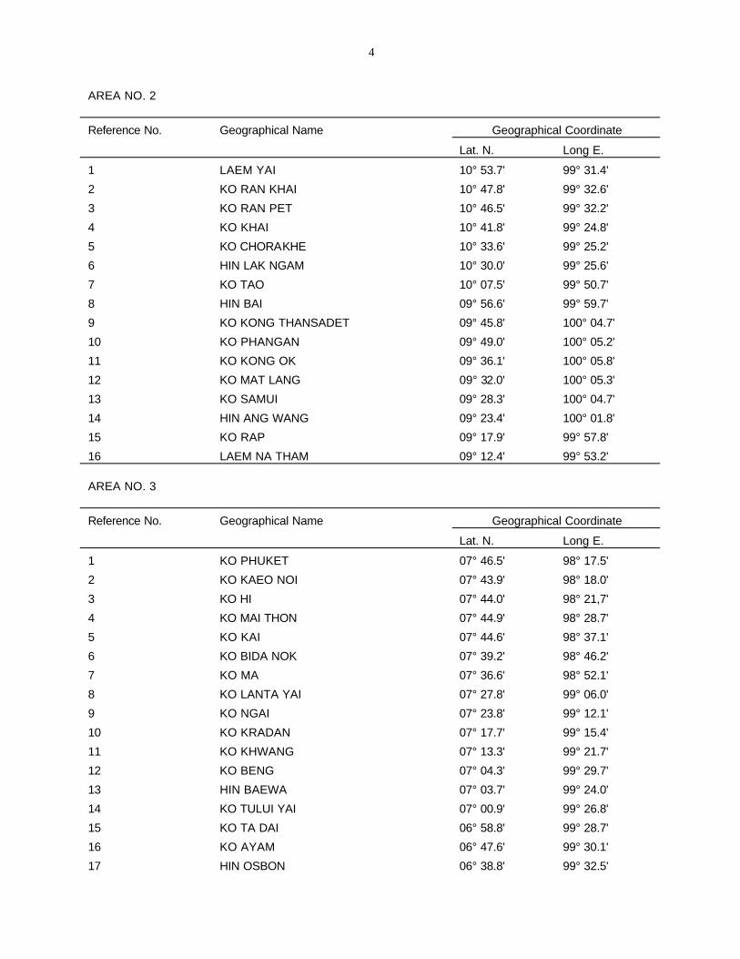
4
AREA NO. 2
Reference No.
1
2
3
4
5
6
7
8
9
10
11
12
13
14
15
16
AREA NO. 3
Geographical Name
LAEM YAI
KO RAN KHAI
KO RAN PET
KO KHAI
KO CHORAKHE
HIN LAK NGAM
KO TAO
HIN BAI
KO KONG THANSADET
KO PHANGAN
KO KONG OK
KO MAT LANG
KO SAMUI
HIN ANG WANG
KO RAP
LAEM NA THAM
Geographical
Lat. N.
10° 53.7'
10° 47.8'
10° 46.5'
10° 41.8'
10° 33.6'
10° 30.0'
10° 07.5'
09° 56.6'
09° 45.8'
09° 49.0'
09° 36.1'
09° 32.0'
09° 28.3'
09° 23.4'
09° 17.9'
09° 12.4'
Coordinate
Long E.
99° 31.4'
99° 32.6'
99° 32.2'
99° 24.8'
99° 25.2'
99° 25.6'
99° 50.7'
99° 59.7'
100° 04.7'
100° 05.2'
100° 05.8'
100° 05.3'
100° 04.7'
100° 01.8'
99° 57.8'
99° 53.2'
Reference No.
1
2
3
4
5
6
7
8
9
10
11
12
13
14
15
16
17
Geographical Name
KO PHUKET
KO KAEO NOI
KO HI
KO MAI THON
KO KAI
KO BIDA NOK
KO MA
KO LANTA YAI
KO NGAI
KO KRADAN
KO KHWANG
KO BENG
HIN BAEWA
KO TULUI YAI
KO TA DAI
KO AYAM
HIN OSBON
Geographical
Lat. N.
07° 46.5'
07° 43.9'
07° 44.0'
07° 44.9'
07° 44.6'
07° 39.2'
07° 36.6'
07° 27.8'
07° 23.8'
07° 17.7'
07° 13.3'
07° 04.3'
07° 03.7'
07° 00.9'
06° 58.8'
06° 47.6'
06° 38.8'
Coordinate
Long E.
98° 17.5'
98° 18.0'
98° 21,7'
98° 28.7'
98° 37.1'
98° 46.2'
98° 52.1'
99° 06.0'
99° 12.1'
99° 15.4'
99° 21.7'
99° 29.7'
99° 24.0'
99° 26.8'
99° 28.7'
99° 30.1'
99° 32.5'
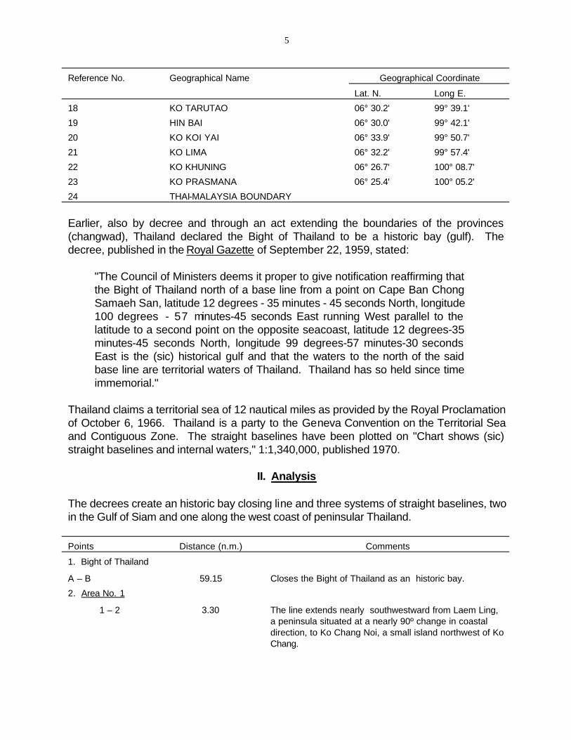
5
Reference No. Geographical Name Geographical Coordinate
Lat. N. Long E.
18 KO TARUTAO 06° 30.2' 99° 39.1'
19 HIN BAI 06° 30.0' 99° 42.1'
20 KO KOI YAI 06° 33.9' 99° 50.7'
21 KO LIMA 06° 32.2' 99° 57.4'
22 KO KHUNING 06° 26.7' 100° 08.7'
23 KO PRASMANA 06° 25.4' 100° 05.2'
24 THAI-MALAYSIA BOUNDARY
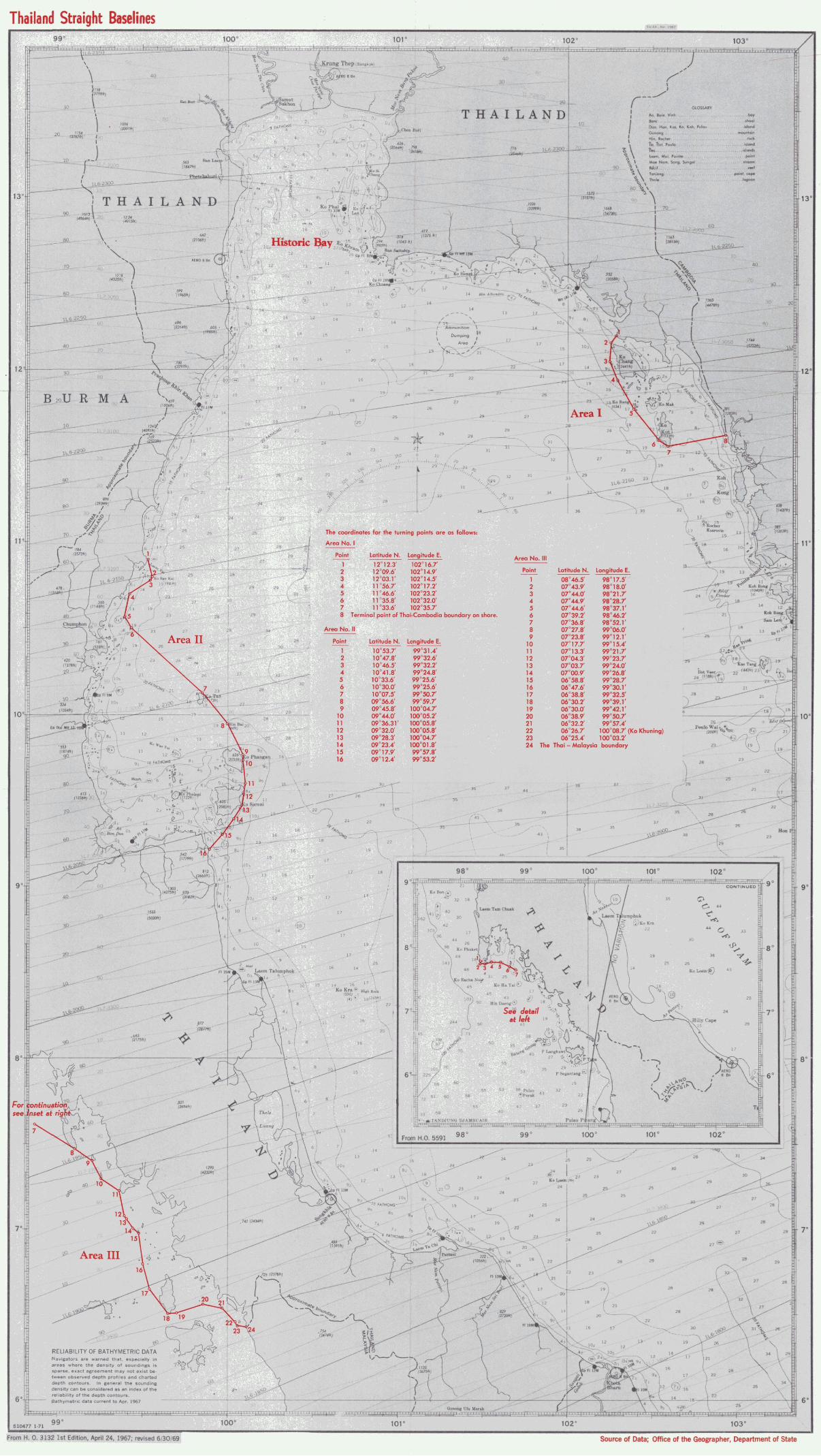
Earlier, also by decree and through an act extending the boundaries of the provinces (changwad), Thailand declared the Bight of Thailand to be a historic bay (gulf). The decree, published in the Royal Gazette of September 22, 1959, stated:
"The Council of Ministers deems it proper to give notification reaffirming that the Bight of Thailand north of a base line from a point on Cape Ban Chong Samaeh San, latitude 12 degrees - 35 minutes - 45 seconds North, longitude 100 degrees - 57 minutes-45 seconds East running West parallel to the latitude to a second point on the opposite seacoast, latitude 12 degrees-35 minutes-45 seconds North, longitude 99 degrees-57 minutes-30 seconds East is the (sic) historical gulf and that the waters to the north of the said base line are territorial waters of Thailand. Thailand has so held since time immemorial."
Thailand claims a territorial sea of 12 nautical miles as provided by the Royal Proclamation of October 6, 1966. Thailand is a party to the Geneva Convention on the Territorial Sea and Contiguous Zone. The straight baselines have been plotted on "Chart shows (sic) straight baselines and internal waters," 1:1,340,000, published 1970.
II. Analysis
The decrees create an historic bay closing line and three systems of straight baselines, two in the Gulf of Siam and one along the west coast of peninsular Thailand.
Points Distance (n.m.) Comments
1. Bight of Thailand
A – B 59.15 Closes the Bight of Thailand as an historic bay.
2. Area No. 1
1 – 2 3.30 The line extends nearly southwestward from Laem Ling, a peninsula situated at a nearly 90º change in coastal direction, to Ko Chang Noi, a small island northwest of Ko Chang.

6
Points Distance (n.m.) Comments
2 – 3 6.25 Connect Chang Noi with Hin Rap (Hin Rai), a rock 2.4 nautical miles due west of Ko Chang. The line makes an angle of c. 18º to the general direction of Ko Chang.
3 – 4 6.95 Joins Hin Rap with Hin Luk Bat, a rock situated 2 n.m. west of the southwest point of Ko Chang. Segment parallels coast of Ko Chang.
4 – 5 11.75 Connects Hin Luk Bat with southwest cape of Ko Rang. Line extends generally parallel to the trend of the island group.
5 – 6 13.85 Joins Rang with Hin Bang Bao, a small rock offshore of Ko Kut. Line continues trend of segments 3 – 4 and 4 – 5.
6 – 7 4.25 Connects Hin Bang Bao with Laem Thian, the south cape of Ko Kut, the second largest and southernmost island of the group.
7 – 8 19.65 Joins Ko Kut with the terminus of the Cambodia-Thailand land boundary. The islands covered by the straight baseline system screen over 80% of the mainland shore on the western side. It is estimated that the land/water ratio enclosed by the straight baselines is approximately 1:5.
Subtotal 66.00
3. Area No. II
1 – 2 5.90 Connects the mainland peninsula of Laem Yai with the island of Ko Ran Khai, at an angle of c. 30° to the general direction of the shoreline. Ran Kai is c. 4.4 nautical miles from the mainland.
2 – 3 1.20 Connects the adjacent island of Ko Ran Pet. Segment within 5° of the general direction of the mainland. Ran Pet is 4.75 n.m. from mainland.
3 – 4 3.70 Trending towards the mainland at an angle of c. 32°, joins Ko Ran Pet with Ko Khai, situated approximately 1.25 n.m. from the mainland.
4 – 5 8.35 Connects Ko Khai with Ko Chorakhe at an angle of c. 10° to the general direction of the coast. The reef to the west of the island extends to within 5.0 n.m. of the coast.
5 – 6 4.25 Trends away from the mainland at an angle of nearly 60°. In sector 1-6, approximately a dozen, small islands exist in 30 n.m.. with no degree of continuous coverage of screening.
6 – 7 33.75 Joins Hin Lak Ngam, a small island, 9.0 n.m. from the mainland with Ko Tao's north cape. The island is significant in size (4.2 n.m. x 2.5 n.m.) but isolated (35 n.m. from the mainland.)
7 – 8 14.00 With the previous segment, continues same azimuth begun with segment 5 – 6. Joins Ko Tai with Hin Bai.
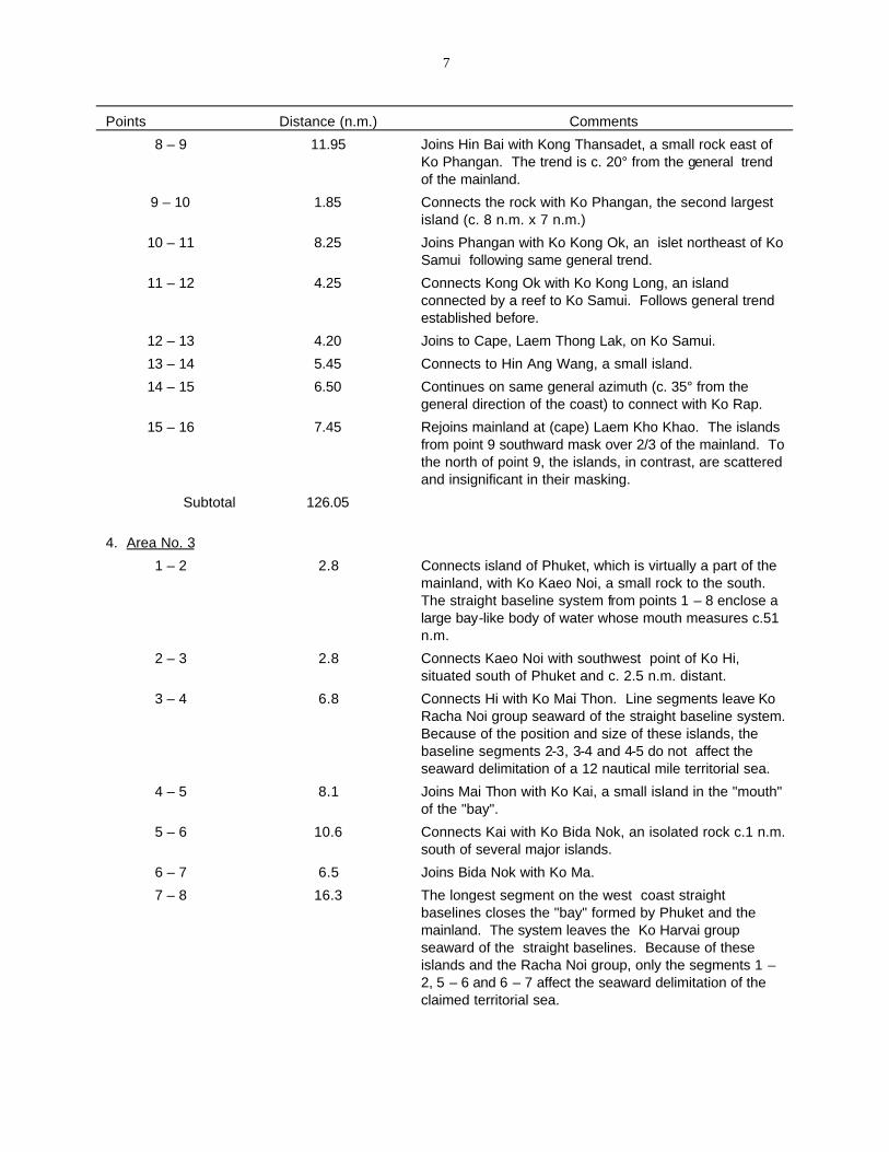
7
Points Distance (n.m.) Comments
8 – 9 11.95 Joins Hin Bai with Kong Thansadet, a small rock east of Ko Phangan. The trend is c. 20° from the general trend of the mainland.
9 – 10 1.85 Connects the rock with Ko Phangan, the second largest island (c. 8 n.m. x 7 n.m.)
10 – 11 8.25 Joins Phangan with Ko Kong Ok, an islet northeast of Ko Samui following same general trend.
11 – 12 4.25 Connects Kong Ok with Ko Kong Long, an island connected by a reef to Ko Samui. Follows general trend established before.
12 – 13 4.20 Joins to Cape, Laem Thong Lak, on Ko Samui.
13 – 14 5.45 Connects to Hin Ang Wang, a small island.
14 – 15 6.50 Continues on same general azimuth (c. 35° from the general direction of the coast) to connect with Ko Rap.
15 – 16 7.45 Rejoins mainland at (cape) Laem Kho Khao. The islands from point 9 southward mask over 2/3 of the mainland. To the north of point 9, the islands, in contrast, are scattered and insignificant in their masking.
Subtotal 126.05
4. Area No. 3
1 – 2 2.8 Connects island of Phuket, which is virtually a part of the mainland, with Ko Kaeo Noi, a small rock to the south. The straight baseline system from points 1 – 8 enclose a large bay-like body of water whose mouth measures c.51 n.m.
2 – 3 2.8 Connects Kaeo Noi with southwest point of Ko Hi, situated south of Phuket and c. 2.5 n.m. distant.
3 – 4 6.8 Connects Hi with Ko Mai Thon. Line segments leave Ko Racha Noi group seaward of the straight baseline system. Because of the position and size of these islands, the baseline segments 2-3, 3-4 and 4-5 do not affect the seaward delimitation of a 12 nautical mile territorial sea.
4 – 5 8.1 Joins Mai Thon with Ko Kai, a small island in the "mouth" of the "bay".
5 – 6 10.6 Connects Kai with Ko Bida Nok, an isolated rock c.1 n.m. south of several major islands.
6 – 7 6.5 Joins Bida Nok with Ko Ma.
7 – 8 16.3 The longest segment on the west coast straight baselines closes the "bay" formed by Phuket and the mainland. The system leaves the Ko Harvai group seaward of the straight baselines. Because of these islands and the Racha Noi group, only the segments 1 – 2, 5 – 6 and 6 – 7 affect the seaward delimitation of the claimed territorial sea.
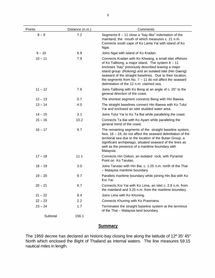
8
Points Distance (n.m.) Comments
8 – 9 7.2 Segments 8 – 11 close a "bay-like" indentation of the mainland, the mouth of which measures c. 21 n.m. Connects south cape of Ko Lanta Yai with island of Ko Ngai.
9 – 10 6.9 Joins Ngai with island of Ko Kradan.
10 – 11 7.9 Connects Kradan with Ko Khwang, a small islet offshore of Ko Talibong, a major island. The system 8 – 11 encloses "bay" previously described leaving a major island group (Rokong) and an isolated islet (Hin Daeng) seaward of the straight baselines. Due to their location, the segments from No. 7 – 11 do not affect the seaward delimitation of the 12 n.m. claimed sea.
11 – 12 7.6 Joins Talibong with Ko Beng at an angle of c. 25° to the general direction of the coast.
12 – 13 0.7 The shortest segment connects Beng with Hin Baewa.
13 – 14 4.0 The straight baselines connect Hin Baewa with Ko Tului Yai and enclosed an islet studded water area.
14 – 15 3.1 Joins Tului Yai to Ko Ta Bai while paralleling the coast.
15 – 16 10.2 Connects Ta Bai with Ko Ayam while paralleling the general trend of the coast.
16 – 17 9.7 The remaining segments of the straight baseline system, Nos. 16 – 24, do not affect the seaward delimitation of the territorial sea due to the location of the Butan Group, a significant archipelago, situated seaward of the lines as well as the presence of a maritime boundary with Malaysia.
17 – 18 11.1 Connects Hin Osbon, an isolated rock, with Pyramid Point on Ko Tarutao.
18 – 19 3.0 Joins Tarutao with Hin Bai, c. 1.25 n.m. north of the Thai – Malaysia maritime boundary.
19 – 20 9.7 Parallels maritime boundary while joining Hin Bai with Ko Koi Yai.
20 – 21 6.7 Connects Koi Yai with Ko Lima, an islet c. 2.8 n.m. from the mainland and 3.25 n.m. from the maritime boundary.
21 – 22 8.4 Joins Lima with Ko Khuning.
22 – 23 2.2 Connects Khuning with Ko Prasmana.
23 – 24 1.7 Terminates the straight baseline system at the terminus of the Thai – Malaysia land boundary.
Subtotal 156.1
Summary
The 1959 decree has declared an historic-bay closing line along the latitude of 12º 35' 45" North which enclosed the Bight of Thailand as internal waters. The line measures 59.15 nautical miles in length.
9
The 1970 decree established three distinct systems of straight baselines: 1) the Northeast Gulf of Siam; 2) the Western Gulf of Siam; and 3) Western Peninsular Thailand. The Area No. 1 System contains seven segments which total 66.0 nautical miles. The longest is 19.65 nautical miles while the shortest measures 3.30 nautical miles. The average length of a segment is 9.43 n.m. The islands, masking over three-quarters of the mainland coast, could be considered screening although the land/water relationship is comparatively high, 1:5.
Area 2 contains 15 segments which total 126.05 nautical miles. The longest segment is 33.75 nautical miles while the shortest measures 1.20 nautical miles. The average length of a segment is 8.40 nautical miles. The system encloses two distinct insular areas. North and west of point No. 9, the islands are small and scattered; the land/water ratio would be judged excessively high. South of No. 9, the islands are larger, more closely grouped and, with a similar chain situated to the west, could be considered as fringing islands.
Area No. 3 contains 23 segments which total 156.10 nautical miles in length. The longest segment measures 16.3 nautical miles while the shortest is 0.7 nautical miles. The average segment length equals 6.80 nautical miles. The system encloses a large number of scattered islands which are situated relatively close to the mainland. Because of the significant number of excluded islands, seaward of the straight baseline system, the straight baselines do not extend the territorial sea appreciably. In fact, nearly 2/3 of the segments of the system do not affect the seaward limit of the territorial sea.
ERRATA
The following corrections should be noted to the point values printed on the attached map:
Area No. II
No. 5 99º 25.2' East No. 11 09º 36.1' North
Area No. III
No. 1 07º 46.5' North No. 7 07º 36.6' North No. 12 99º 29.7' East No. 20 06º 33.9' North No. 23 100º 05.2' East
Bight of Thailand (bay closing line omitted):
Line connects 12º 35' 45" N, 100º 57' 45" E, and 12º 35' 45" N, 99º 57' 30" E.