stop 3.2: pleistocene slip rate along the owens valley ... mountain_ovf... · eric kirby - oregon...
TRANSCRIPT
2017 FOP Stop 3.2
Stop3.2:PleistoceneslipratealongtheOwensValleyfaultEricKirby-OregonStateUniversity
Ithaslongbeenrecognizedthatgeode7cstrainratesacrosstheOwensValleyarerela7velyhigh(SavageandLisowski,1980;1995),andmodelsofelas7cstrainaccumula7onanywherefrom~4–7mm/yrofshearatdepthtoexplaintheseobserva7ons(e.g.,Ganetal.,2000).Theseresultsexceedpaleoseismices7matesofLatePleistocene-HoloceneslipalongtheOwensValleyfaultzoneof1–3mm/yr(Haddonetal.,2016;BaconandPezzopane,2007;BeanlandandClark,1994;Biermanetal.,1995;Leeetal.,2001;LubetkinandClark,1988).Someworkersarguethatthisdiscrepancyreflectselevatedpost-seismicsurfacedeforma7onfollowingthe1872OwensValleyearthquake(Dixonetal.,2003;Malservisietal.,2001),butsuchaprotractedtransientsignalisratherunusual,evenforalargeevent.
Atthisstop,wewilldiscusstheLatePleistoceneslipratealongtheprimarystrandofthenorthernOwensValleyfaultwheredisplacedlavaflowsalongtheeasternflankoftheCraterMountainvolcaniccomplexprovideconstraintsondisplacementoverthepast60-80ka(Kirbyetal.,2008).
DrivingQuesBon:• Whatisthelong-termsliprateoftheOwensValleyfault?
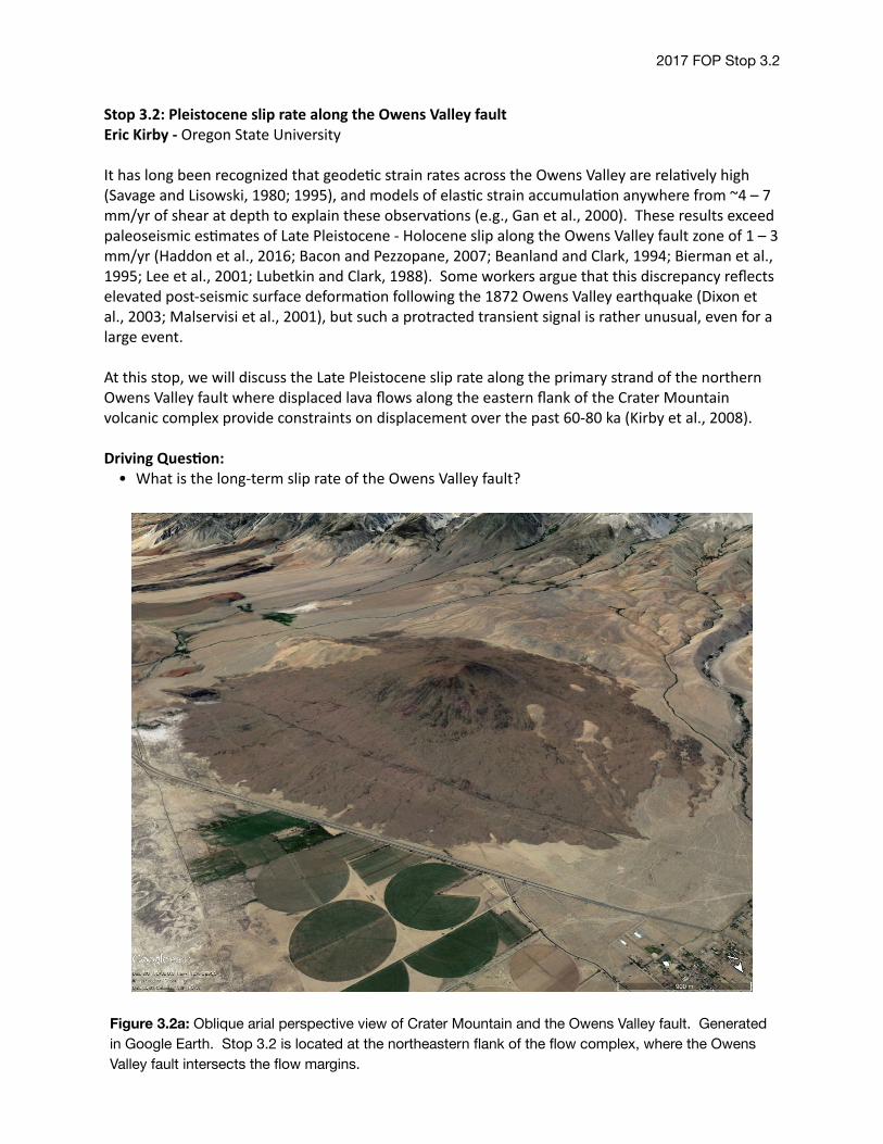
Figure 3.2a: Oblique arial perspective view of Crater Mountain and the Owens Valley fault. Generated in Google Earth. Stop 3.2 is located at the northeastern flank of the flow complex, where the Owens Valley fault intersects the flow margins.
2017 FOP Stop 3.2
DisplacementoftheCraterMountainflowcomplexAlongmostofitslength,thetraceofthe1872rupturealongtheOwensValleyfaultrunsnearorwithinthefloodplainoftheOwensRiver,andlong-termmarkersoffaultdisplacementarerela7velyrare(BeanlandandClark,1994;Haddonetal.,2016).SouthofthetownofBigPine(Figure3.2a),thefaultdisplacesbasal7clavaflowsalongtheeasternflankofCraterMountain.Althoughcorrela7onofindividualflowmarginsacrossthefaultisdifficult,apparentright-lateralsepara7onofthecontactbetweentheflowcomplexandalluvialfansisobservedatthenortheasterncornerofthecone(Figure3.2a).Thefaultgeometryatthissiteisconsistentwithasmallreleasingstep.
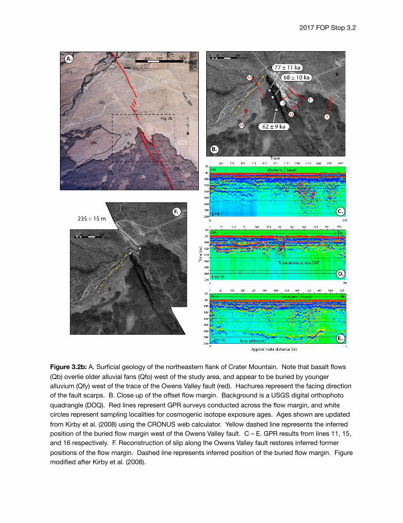
Dextralsepara7onoftheflowmarginobservedatthesurfaceisapproximately235±15m(Figure3.2b).Kirbyetal.(2008)usedground-penetra7ngradarsurveystotryanddeterminethesubsurfacegeometryofbasaltsurfaces.Keyobserva7onsareasfollows:• Westofthefault,theflowmarginisshallowlyburiedbeneatharela7velyyoungalluvialfandeposit.
• Eastofthepull-apartbasin,themarginoftheflowdoesnotappeartobeburied,andthatthesurfaceexposureisinterpretedtoreflecttheformerterminusoftheflow.
• Surveysdonotrevealstrongreflectorswithinthatpull-apartbasinthatmightbeassociatedwithburiedflows.
Theseobserva7onsleadustoconcludethatthesurfaceexposuresoftheflowterminiprovideareasonablemarkerwithwhichtoevaluatefaultslip.
Theageoftheflowsurfacewases7matedusingtheconcentra7onsofcosmogenic36Clinsamplestakenfromwell-preservedremnantsoftheflowsurface.Sampleswereselectedtominimizethechanceofburialbyeolianoralluvialmaterialandwerecollectedfromoutcropsthatexhibitedglassysurfacesandropyflowtextureswhosepreserva7onsuggestsminimalsurfaceloweringsinceflowemplacement.Threesampleswerecollectedatthissite,westofthefault(Figure2),andthreeaddi7onalsampleswerecollectedfromflowsonthesouthwesternsideoftheventcomplex,neartheRedMountainfault.ForthisFOPtrip,wehaveupdatedtheagesusingthemostrecentcalibra7onsof36Clproduc7onincorporatedintotheCRONUSwebcalculator(Marreroetal.,2016a;2016b;Borchersetal.,2016;Phillipsetal.,2016).Thesixagesfrombothsamplelocali7esoverlapwithin2sigmauncertain7es,andindicatethattheflowis73±9ka,similartotheagedeterminedbyKirbyetal.(2008)of70±14ka.NotethattheseagesaresignificantlyyoungerthanaK/Arageof290±40kadeterminedbyTurrinandGillespie(1986),butaresimilartounpublished3HeexposureagesobtainedbyJ.StoneandA.Gillespieof35-115ka(A.Gillespie,personalcommunica7on2004).Notably,flowswestoftheFishSpringsHills,ontheSWflankofCraterMountain,buryLatePleistocenealluvialfansthataredatedto120-150ka(Zehfussetal.,2001),andmustthereforebeyoungerthanthesedeposits(seestop3.3).
TheseresultsimplythattheminimumslipratesontheOwensValleyfaultduringthis7meperiodhavebeen~2.7mm/yr.Ourdatapermitslipratesashighas~3.9mm/yr.Notably,eventhelowestslipratepermimedbyouragesishigherthanrecentes7matesofHolocene–LatePleistocenesliprates(Haddonetal.,2016;BaconandPezzopane,2007).Therateisconsistent,however,withthehighendofsomepreviouses7mates(BeanlandandClark,1994;Leeetal.,2001).Whetherthedifferencebetweenthewell-determinedHoloceneratesof0.6–1.6mm/yr(e.g,Haddonetal.,2016)andtheseratesrepresentaperiodofrapidslippriorto~20-25karemainsuncertain(Kirbyetal.,2008).
2017 FOP Stop 3.2
Figure 3.2b: A. Surficial geology of the northeastern flank of Crater Mountain. Note that basalt flows (Qb) overlie older alluvial fans (Qfo) west of the study area, and appear to be buried by younger alluvium (Qfy) west of the trace of the Owens Valley fault (red). Hachures represent the facing direction of the fault scarps. B. Close up of the offset flow margin. Background is a USGS digital orthophoto quadrangle (DOQ). Red lines represent GPR surveys conducted across the flow margin, and white circles represent sampling localities for cosmogenic isotope exposure ages. Ages shown are updated from Kirby et al. (2008) using the CRONUS web calculator. Yellow dashed line represents the inferred position of the buried flow margin west of the Owens Valley fault. C – E. GPR results from lines 11, 15, and 16 respectively. F. Reconstruction of slip along the Owens Valley fault restores inferred former positions of the flow margin. Dashed line represents inferred position of the buried flow margin. Figure modified after Kirby et al. (2008).
2017 FOP Stop 3.2
ReferencesBacon,S.N.andPezzopane,S.K.,2007,A25,000yearrecordofearthquakesontheOwensValleyfaultnearLone
Pine,California:Implica7onsforrecurrenceintervals,slipratesandsegmenta7onmodels:GeologicalSocietyofAmericaBulle4n,v.119,p.823-847.
Beanland,S.,andClark,M.M.,1994,TheOwensValleyfaultzone,easternCalifornia,andsurfaceruptureassociatedwiththe1872earthquake,U.S.GeologicSurveyBulle7n,p.29.
Bellier,O.,andZoback,M.L.,1995,RecentstateofstresschangeintheWalkerLanezone,westernBasinandRangeprovince,UnitedStates:Tectonics,v.14,no.3,p.564-593.
Bierman,P.R.,Gillespie,A.R.,andCaffee,M.W.,1995,Cosmogenicagesforearthquakerecurrenceintervalsanddebrisflowfandeposi7on,OwensValley,California:Science,v.270,p.447-449.
Borchers,B.,Marrero,S.,Balco,G.,Caffee,M.,Goehring,B.,Lioon,N.,Nishiizumi,K.,Phillips,F.,Schaefer,J.,andStone,J.,2016,Geologicalcalibra7onofspalla7onproduc7onratesintheCRONUS-Earthproject:QuaternaryGeochronology,v.31,p.188-198.
Dixon,T.H.,Miller,M.,Farina,F.,Wang,H.,andJohnson,D.,2000,Present-daymo7onoftheSierraNevadablockandsometectonicimplica7onsfortheBasinandRangeprovince,NorthAmericanCordillera:Tectonics,v.19,no.1,p.1-24.
Dixon,T.H.,Norabuena,E.,andHotaling,L.,2003,PaleoseismologyandGlobalPosi7oningSystem:Earthquake-cycleeffectsandgeode7cversusgeologicfaultslipratesintheEasternCaliforniashearzone:Geology,v.31,no.1,p.55-58.
Gan,W.,Svarc,J.L.,Savage,J.C.,andPrescom,W.H.,2000,Strainaccumula7onacrosstheEasternCaliforniaShearZoneatla7tude36°30'N:JournalofGeophysicalResearch,v.105,p.16,229-16,236.
Gillespie,A.R.,1991,QuaternarysubsidenceofOwensValley,California,inHall,C.A.,ed.,NaturalHistoryofeasternCaliforniaandhigh-al7tuderesearch:LosAngeles,WhiteMountainResearchSta7onProceedings,p.356-382.
Haddon,E.K.,Amos,C.B.,Zielke,O.,Jayko,A.S.,andBurgmann,R.,2016,SurfaceslipduringlargeOwensValleyearthquakes:Geochemistry,Geophysics,Geosystems,v.17,p.2239-2269.
Kirby,E.,Anadakrishnan,S.,Phillips,F.,Marrero,S.,2008,LatePleistoceneslipratealongtheOwensValleyfault,easternCalifornia:GeophysicalResearchLe>ers,v.35,L01304,doi:10.1029/2007GL031970.
Lee,J.,Spencer,J.,andOwen,L.,2001,HoloceneslipratesalongtheOwensValleyfault,California:Implica7onsfortherecentevolu7onoftheEasternCaliforniaShearZone:Geology,v.29,no.9,p.819-822.
Lubetkin,L.K.C.,andClark,M.M.,1988,LateQuaternaryac7vityalongtheLonePinefault,easternCalifornia:GeologicSocietyofAmericaBulle4n,v.100,p.755-766.
Malservisi,R.,Furlong,K.P.,andDixon,T.H.,2001,InfluenceoftheearthquakecycleandlithosphericrheologyonthedynamicsoftheEasternCaliforniashearzone:GeophysicalResearchLe>ers,v.28,p.2731-2734.
Marrero,S.M.,Phillips,F.M.,Borchers,B.,Lioon,N.,Aumer,R.,andBalco,G.,2016a,Cosmogenicnuclidesystema7csandtheCRONUScalcprogram:QuaternaryGeochronology,v.31,p.160-187.
Marrero,S.M.,Phillips,F.M.,Caffee,M.W.,andGosse,J.C.,CRONUS-Earthcosmogenic36Clcalibra7on:QuaternaryGeochronology,v.31,p.199-219.
Phillips,F.M.,Argento,D.C.,Balco,G.,Caffee,M.W.,Clem,J.,Dunai,T.J.,Finkel,R.,Goehring,B.,Gosse,J.C.,Hudson,A.M.,Jull,A.J.T.,Kelly,M.A.,Kurz,M.,Lal,D.,Lioon,N.,Marrero,S.M.,Nishiizumi,K.,Reedy,R.C.,Schaefer,J.,Sotne,J.O.H.,Swanson,T.,andZreda,M.G.,2016,TheCRONUS-EarthProject:ASynthesis:QuaternaryGeochronology,v.31,p.119-154.
Savage,J.C.,andLisowski,M.,1980,Deforma7oninOwensValley,California:Bulle4noftheSeismologicalSocietyofAmerica,v.70,no.4,p.1225-1232.
Savage,J.C.andLisowski,M.,1995,Strainaccumula7oninOwensValley,California,1974to1988:Bulle4noftheSeismologicalSocietyofAmerica,v.85,no.1,p.151-158.
Turrin,B.andGillespie,A.,1986,K/Aragesofbasal7cvolcanismoftheBigPineVolcanicField,California:Implica7onsforglacialstra7graphyandneotectonicsoftheSierraNevada:GeologicalSocietyofAmericaAbstractswithPrograms,v.18,p.414.