status quo in austria
DESCRIPTION
Status quo in Austria. Barbara K é ri • DISC´12 Vukovar December 12, 2012. charts. Full Inland ENC coverage (330.8 km) Publication of IENCs according IECDIS Standard 2.1 – March 2011 Topographical data fully updated – March 2012. IENC updates. Facility information. Bridge cross-sections. - PowerPoint PPT PresentationTRANSCRIPT

Status quo in Austria
Barbara Kéri • DISC´12
Vukovar December 12, 2012

charts
• Full Inland ENC coverage (330.8 km)• Publication of IENCs according IECDIS
Standard 2.1 – March 2011• Topographical data fully updated – March 2012

IENC updates

Facility information

Bridge cross-sections

Paper charts
• huge effort to produce the paper chart
• lack of automatism
• NEWADA duo

DoRIS News
• End of the distribution of mobile transponders (31.12.2011) ->
• Inland AIS equipment obligation (01.01.2012)
• Keep on enhancing the already available services for all users and improve reliability of data
• The international data exchange will be one big step further

EU projects
• IRIS EU 2 IRIS EU 3
• NEWADA NEWADA duo

IRIS Europe 3

Motivation:Support Fairway and Traffic Authorities and RIS Providers in enhancing their RIS related services towards the fairway users, and to enable a common quality level of pan-European services
Duration: 01/2012 – 12/2014 (3 years)
Budget: 10,5 Mio. EUR (aiming for 50% co-funding by TEN-T)
Overview

Objectives:• Providing a cooperative implementation environment• Sharing expertise in the day-to-day project work• Solving challenges of European interest in a European environment• Demonstrating / evaluating new RIS technologies and services• Elaborating / implementing quality levels for RIS data exchange• Providing transition support from pilot impl. to regular operation• Enabling countries tackling national priorities by involving logistics
Overview

Improvement of Fairway Information Services– bathymetric IENCs, transient (dynamic) water level models, standardized
IENC data exchange, RIS reference data mgmt.
Enhanced Traffic and Transport Information Services– virtual reference stations, navigational support systems, low cost fuel
saving device, mobile RIS applications, incident mgmt. services
Objectives

Quality of Information Services for RIS– Improvement of operation, service level agreements
International RIS data exchange– Organisational and legal framework for internat. RIS Data Exchange– Enhancement of interfaces for logistics and authorities – Enhancement of Interconnections with European Services– Interoperability between RIS and Maritime Information Services
Objectives

Expected Impacts
Harmonised implementation of RIS in Europe will make another major step forward– Enhanced services for governmental and logistics users– Geographical extension of RIS– Ensuring minimum service levels
Thus IRIS Europe 3 will contribute to an increase of safety, efficiency and environmental friendliness of Inland Navigation

optimisation of processes
Monitoring• Continuous monitoring and surveying
of the riverbed (bathymetry)• Identification of shallow areas (fords)• Water gauges (hydrology)
Informing• Customer-oriented information on the
current status of the fairway• Different information tools: NtS, RIS
websites, information at locks, ECDIS charts etc.
Planning• Analysis of surveying results• Development of fairway
maintenance plan• Planning of specific inter-
ventions
Implementing• Dredging of shallow areas
by assigned dredging / river engineering companies
• Monitoring of works / performance

KWSM
• Customer orientated waterway management
• Improving of internal processes and procedures
• KWSM managing board out of– via donau (strategic & operational)– OSB

…..
K01 Infrastruktur-Grundlagen bereitstellen
K04 Donauschifffahrt entwickeln
K05 Hochwasserschutz durchführen
K03 Binnenschifffahrtsinformationsdienste bereitstellen
K02 Wasserstraße managen
K07 Liegenschaften und Gebäude managen
MS06 Personal MS09 ITMS08 Öffentlich-keitsarbeit / PR
MS07 Rechnungs-wesen
MS10 Backoffice
MS01 Unterneh-mensstrategie
MS02 Unterneh-menscontrolling
MS03 Revision
MS12.2 Prozess-management MS12.4 UMS
MS12 Managementsysteme
MS04 Recht
MS
11 E
ntw
ickl
un
g
un
d In
no
vati
on
MS12.1 Programm / Projektmgnt.
K06 Ökologischen Zustand erhalten und verbessern
K08 Beratungsleistungen / sonstige Dienstleistungen erbringen
MS12.3 KWSM
Management- und Support-prozesse
MS05 Beschaffung
Kernprozesse
MS12.5 EMS
Processmanagement

aims of processmgmt.
• initiate organisational thinking
• more user orientated
• increase efficiency– identification of gaps and redundancies
• supporting knowledge transfer

Hydrographic Surveying
• Increased use of multi beam – Measurement of app. 400 river kilometers per year, 30% – 40%
measured with multi beam
• More frequent measurements in critical sections and developement of a profile database – data storage back to 2005– profile distance 25 m (standard 50 m)
• Data analysis of critical sections
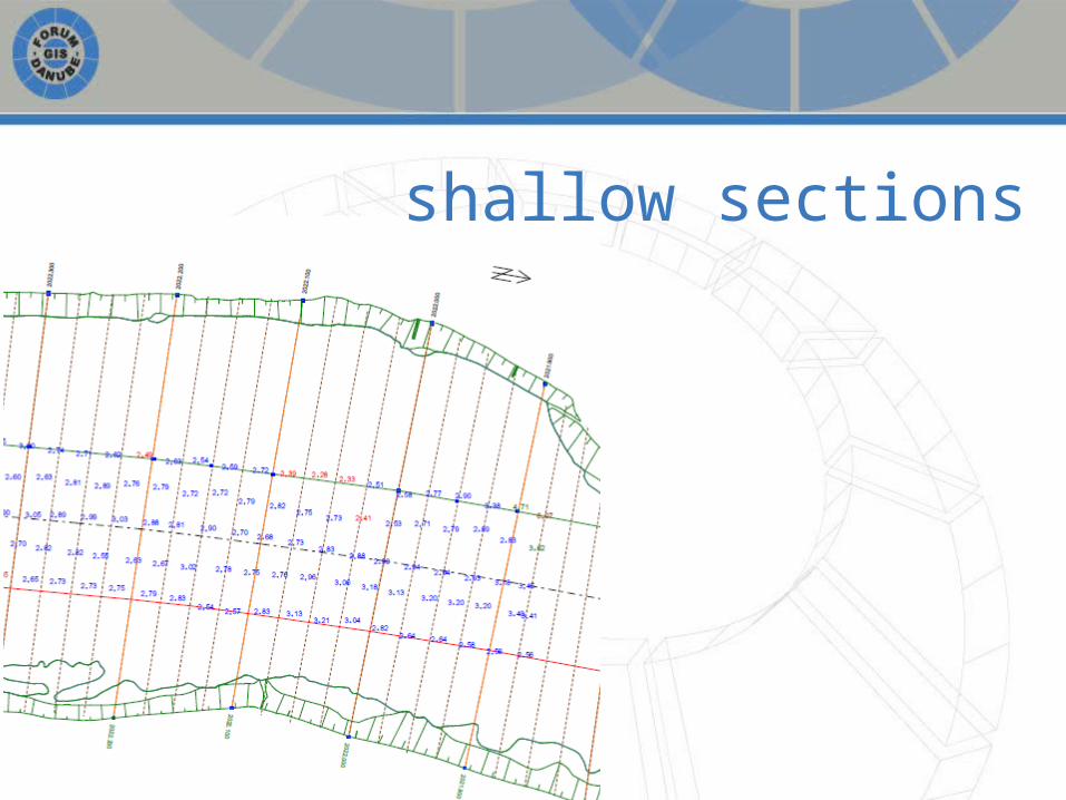
shallow sections

Regelsbrunn
