status of the world's soil resources. chapter 15: regional
TRANSCRIPT

INTERGOVERNMENTALTECHNICAL PANEL ON SOILS
INTERGOVERNMENTALTECHNICAL PANEL ON SOILS
Main Report
Status of the
World’sSoil Resources
© F
AO
| G
iuse
ppe
Biz
zarr
i
Chapter 15 Regional Assessment of Soil Change in the Southwest Pacific

Status of the World’s Soil Resources | Main Report Disclaimer and copyright
Disclaimer and copyright
Recommended citation:FAO and ITPS. 2015. Status of the World’s Soil Resources (SWSR) – Main Report. Food and Agriculture Organization of the United Nationsand Intergovernmental Technical Panel on Soils, Rome, Italy The designations employed and the presentation of material in this information product do not imply the expression of any opinion whatsoever on the part of the Food and Agriculture Organization of the United Nations (FAO) concerning the legal or development status of any country, territory, city or area or of its authorities, or concerning the delimitation of its frontiers or boundaries.The mention of specific companies or products of manufacturers, whether or not these have been patented, does not imply that these have been endorsed or recommended by FAO in preference to others of a similar nature that are not mentioned.
The views expressed in this information product are those of the author(s)and do not necessarily reflect the views or policies of FAO.
ISBN 978-92-5-109004-6
© FAO, 2015
FAO encourages the use, reproduction and dissemination of material in this information product. Except where otherwise indicated, material may be copied, downloaded and printed for private study, research and teaching purposes, or for use in non-commercial products or services, provided that appropriate acknowledgement of FAO as the source and copyright holder is given and that FAO’s endorsement of users’ views, products or services is not implied in any way.
All requests for translation and adaptation rights, and for resale and other commercial use rights should be made via www.fao.org/contact-us/licence-request or addressed to [email protected].
FAO information products are available on the FAO website www.fao.org/publications
and can be purchased through [email protected].

| 476Status of the World’s Soil Resources | Main Report 476Regional Assessment of Soil Changesin the Southwest Pacific
15 | Regional Assessment of Soil Change in the Southwest Pacific
Regional Coordinator/Lead Author: N.J. McKenzie (ITPS/Australia)Contributors: J.A. Baldock (Australia), M.R. Balks (New Zealand), M. Camps Arbestain (ITPS/New Zealand),
L.M. Condron (New Zealand), M. Elder-Ratutokarua (Secretariat Pacific Community/Fiji), M.J. Grundy (Australia), A.E. Hewitt (New Zealand), F.M. Kelliher (New Zealand), J.F. Leys (Australia), N.J. McKenzie (ITPS/Australia), R.W. McDowell (New Zealand), R.J. Morrison (Fiji/Australia), N.R. Schoknecht (Australia).

| 477Status of the World’s Soil Resources | Main Report 477Regional Assessment of Soil Changesin the Southwest Pacific
15.1 | Introduction
The Southwest Pacific region includes the 22 island nations of the Pacific1, New Zealand and Australia (Figure 15.1). The landscapes of the region are very diverse ranging from a large continental land mass through to tens of thousands of small islands across the enormous expanse of the southwest Pacific Ocean. There are extensive ancient flat lands through to some of the youngest and most tectonically active landscapes on the planet. Temperature and rainfall ranges are large because of the breadth of latitudes and elevations. As a consequence, the soils of the region are also diverse. The strongly weathered soils in humid tropical areas and the vast expanses of old soils across the Australian continent are particularly susceptible to disturbance and this is where some of the more intractable problems of soil management occur today.
15.2 | The major land types in the region
The major land types in the region owe their origin to the relative movement of the Earth’s lithospheric plates, and in particular to the interaction between the Australian and Pacific Plates. The breakup of the supercontinent of Gondwana included the separation, around 96 million years ago, of the Australian Plate from the Antarctic Plate. The Australian Plate includes the present day island continent of Australia, Papua New Guinea, a small part of the South Island of New Zealand, and some islands including New Caledonia and Norfolk Island. The Australian Plate is moving northwards at approximately 70 mm yr-1, colliding with the Eurasian Plate. This has created the mountains of Indonesia and Papua New Guinea, the highest peaks being Puncak Jaya (4 848 m) and Mt Wilhelm (4 509 m) respectively. The Pacific Plate is moving westwards towards the Australian Plate. Movement along the transform boundary of these plates has created the Southern Alps of New Zealand (Aoraki/Mt Cook 3 724 m) and related geological activity has resulted in substantial volcanic activity around the aptly named Pacific Rim of Fire. New Zealand straddles the boundary of the Australian and Pacific Plate. Most of the island nations of the Pacific are volcanic in origin and exist today as either hilly or mountainous features formed by the volcanoes themselves, or as atoll islands.
1 These countries are American Samoa, Cook Islands, Federated States of Micronesia, Fiji, French Polynesia, Guam, Kiribati, Marshall Islands, Nauru, New Caledonia, Niue, Northern Mariana Islands, Palau, Papua New Guinea, Pitcairn Islands, Samoa, Solomon Islands, Tokelau, Tonga, Tuvalu, Vanuatu, and Wallis and Futuna.

| 478Status of the World’s Soil Resources | Main Report 478Regional Assessment of Soil Changesin the Southwest Pacific
Figure 15.1 | Nations in the Southwest Pacific region and the extent of Melanesia, Micronesia and Polynesian cultures. Figure based on base map imagery: exclusive economic zone boundaries (EEZ)v 8 2014, Natural Earth 11 3.2.0
Ancient landscapes
After separating from Antarctica, the Australasian landmass moved northwards into warmer latitudes at the same time that the globe was cooling during the Pleistocene. The development of the circumpolar Southern Ocean further moderated the climate of the Australasian landmass. The resulting relative stability meant that biological evolution and soil development occurred on similar timescales and without major phases of interruption. This is in contrast to much of the Northern Hemisphere where repeated glaciations renewed landscapes and ensured that large areas have relatively young soils. This long history of soil development has many implications today for land management in the region.
Low-relief landscapes of Australasia
The western two-thirds of the Australian continent are dominated by ancient landscapes and strongly weathered soils. Some of these soils bear the imprint of previous climates with some unexpected patterns of soil distribution – very acid leached soils (normally associated with humid regions) now occur in deserts, and deeply weathered soil profiles (tens of metres deep) occur in Mediterranean climates with limited leaching. Vast areas of sandy soils have formed from the predominantly acid-igneous and sedimentary parent materials. Nutrient status is very poor and micronutrient deficiencies are common. In the south, substantial quantities of salt have accumulated in the low relief landscapes. As a consequence, sodic and saline soils are widespread and human-induced salinity is a major land management problem.
Uplifted and eroded continental margins
The soils and landscapes of the eastern third of Australia are dominated by the influence of the Great Escarpment (Ollier, 1982) – a landscape feature that extends for 3 000 km from Northern Queensland to Victoria. The Great Escarpment was formed by uplift associated with the passive continental margin to the east. Inland of the Escarpment, the soils and landscapes tend to be older but more clay-rich than in the west

| 479Status of the World’s Soil Resources | Main Report 479Regional Assessment of Soil Changesin the Southwest Pacific
of the country. The undulating and low relief landscapes also have saline and sodic soils. Large sedimentary basins (e.g. Murray–Darling Basin) have moderately fertile soils although the current climate is highly variable.
The elevated tablelands adjacent to the Great Escarpment have significant areas of basalt and their associated alluvial landscapes have some of Australia’s best soils for agriculture. Likewise, the dissected landscapes to the east and south of the Great Escarpment where most Australians live are much younger. The coastal river systems have fertile alluvial landscapes.
The remnants in New Caledonia, Papua New Guinea and New Zealand
The areas of the Australian Plate in New Caledonia, Papua New Guinea and New Zealand share ecosystems with a common evolutionary origin (e.g. Antarctic flora including Araucaria and Nothofagus). They typically have high levels of biodiversity although the above-ground systems are much better documented that those in the soil. These remnant areas are on the more tectonically active fringes of the Australian Plate and they have greater relief as a result.
Young active landscapes
New Zealand
The tectonically active landscapes of New Zealand can be broadly divided into the axis of high mountain ranges, the basin and range provinces on either side of these ranges, the Taupo Volcanic Zone on the North Island, and the lowlands and sedimentary basins. Only 15 percent of the land area is flat. The climate of the country ranges from sub-tropical in the north to sub-Antarctic in the far south. Sixty percent of New Zealand is >300 m above sea-level and there are about 3 000 mid-latitude mountain glaciers.
A climate sequence of Luvisols, dystric Cambisols and Podzols cover 69 percent of the country and are derived from sedimentary rocks (greywacke, sandstone, siltstone and mudstone as colluvium, alluvium and loess). Significant soils in the remaining areas include vitric Andosols derived from rhyolytic tephra (North Island) and silandic Andosols, Nitisols and Ferralsols derived from andesitic tephra and basalt (mainly on the North Island).
Papua New Guinea
Papua New Guinea has five major landscape regions (Löffler, 1977, 1979). The Southern Plains and Lowlands, up to 400 km wide, are in the west of the country. Most of this region is less than 30 m above sea level and includes the extensive alluvial plains of the Fly River. There are two mountainous regions that occupy the majority of the country. The Central Ranges run the length of the mainland and have very high relief with many peaks between 3 000 m and 4 000 m. The Northern Ranges run parallel and descend to a discontinuous and narrow coastal plain. Between these ranges are the plains, lowlands and wetlands of the Inter-montane Trough, many of which are associated with the Sepik River. The Islands Region is diverse and includes active volcanoes (e.g. New Britain) particularly along the Northern Bismarck Island Arc. Fringing coral reefs and raised coral limestone landforms are common in this tectonically active area.
Island landscapes and atolls
As noted earlier, most of the smaller islands in Melanesia, Micronesia and Polynesia are volcanic in origin. Those with hilly or mountainous features were formed by the volcanoes themselves and they may have fringing coral reefs, elevated coral platforms, or both. The low lying atoll islands have been formed by corals growing on extinct seamounts or volcanoes that have eroded or subsided. Many of the atoll islands are only a few meters above sea level and are therefore vulnerable to sea-level rise.

| 480Status of the World’s Soil Resources | Main Report 480Regional Assessment of Soil Changesin the Southwest Pacific
15.3 | Climate
The climate of the region is strongly influenced by circulation patterns and processes in the Pacific Ocean (the Southern Oscillation) that bring La Niña conditions associated with floods and cyclones and El Niño conditions that are associated with droughts. A similar circulation pattern in the Indian Ocean (the Indian Ocean Dipole) influences drought across southern Australia. The Southern Annular Mode of the Southern Ocean affects weather and climate in New Zealand and southern Australia. These large-scale circulation processes interact with the landscape (e.g. through orographic processes and in accord with the scale of the land mass) to exert a strong control on land use and management across the region. Some of the most significant features are as follows.
• Australia has a very high year-to-year rainfall variability, and major droughts and wet periods occur on a decadal scale. Resilient systems of land and water resource management are essential to deal with this level of climate variability.
• Landscapes in the tropics and sub-tropics experience cyclones and very high intensities of rainfall especially in coastal areas. Maintenance of surface cover is essential to avoid extremely high rates of soil erosion.
• The wet-dry tropics of northern Australia and some Pacific Islands receive most of their rainfall in three consecutive months and the remainder of the year is severely water-limited. This restricts options for land use unless some form of irrigation is possible. The harsh climate, in conjunction with the ancient and strongly weathered soils, largely accounts for the dramatic difference in land use and population density of Northern Australia when compared to nearby Indonesia and Papua New Guinea.
In some parts of the region, there is a sensitive interplay between rainfall, evaporation and the capacity of soil to store water. Many soils in southern Australia have a limited capacity to store water and this makes them especially vulnerable to small changes in the distribution and amount of rainfall. As a consequence, relatively small changes in rainfall and temperature caused by climate change are having a significant impact on farming systems and water resources (Reisinger et al., 2014). Likewise, sea-level rise caused by global warming (Nurse et al., 2014) creates an immediate and serious threat to thousands of low lying atoll islands in the region.
15.4 | Land use
15.4.1 | Historical context
The history of human settlement has occurred in several distinct waves over a very long period. In every case the impact on soils has been substantial and in some cases catastrophic. The earliest records indicate that human arrival occurred in Papua New Guinea and Australia at least 45 000 years BP. At this time, sea levels were much lower and a land bridge connected the two countries forming the single continent of Sahul. This continent was widely colonized by 35 000 years BP (O’Connell and Allen 2004).
It is difficult to assess the impact on soils caused by the initial colonization of the region, particularly by the Australian Aborigines, because it coincides with a period of rapid climate change towards the end of the Pleistocene. In Australia, major changes in fire, vegetation, and wildlife occurred (Roberts, Jones and Smith, 1990; Roberts et al., 1994; Bowler et al., 2003; Turney et al., 2001). The cumulative effect on soils caused by humans and other environmental drivers during this time may rival the later direct impact caused by Europeans, although the latter has been concentrated into a very short period.

| 481Status of the World’s Soil Resources | Main Report 481Regional Assessment of Soil Changesin the Southwest Pacific
The broad area of Near Oceania (including present-day Papua New Guinea, Solomon Islands, Vanuatu, New Caledonia and Fiji) was occupied by peoples that were to remain relatively isolated for more than 25 000 years giving rise to the remarkably diverse cultures and languages of Melanesia – for example, more than 800 languages are still spoken today in Papua New Guinea. It is likely that agriculture was invented in the New Guinea highlands at about the same time (10 000 years BP) as it appeared in other parts of the world, and that agricultural development and plant domestication in New Guinea was independent of what happened elsewhere in the world until about 3 500 years BP (Denham et al., 2003).
The Polynesian and Micronesian peoples arrived in relatively recent times and their ancestors were primarily from East Asia. The development of sailing approximately 3 000 years BP enabled their colonization of the islands in Remote Oceania as far east as Tonga and Samoa where Polynesian culture then developed (Friedlaender et al., 2008).
When the Polynesian Maoris first arrived in New Zealand c. 1200 CE, most of the land was covered by dense forest which they began to clear by burning to facilitate settlement and hunting (McGlone, 1989). Most of the forest clearance occurred between 1350 and 1550, with impacts on soils and landscapes that were greatest in the drier east coast regions of both main islands. By 1840 just prior to large scale European settlement, the forest cover had been reduced from 85 percent (23 million ha) to 53 percent (14.3 million ha) (Condron and Di, 2002).
15.4.2 | Nineteenth and twentieth centuries
European colonization was widespread across the region during the nineteenth and twentieth century. The impact on soils in many districts, particularly in Australia and New Zealand, was profound and in some areas initially catastrophic. In Australia, the severity of soil degradation, particularly in the 100 years after 1850, was extreme, culminating in the dust bowl years of the 1930s and 1940s. In New Zealand, the clearing of steep hill country led to widespread erosion and sedimentation in river systems.
Other countries in the region (e.g. Papua New Guinea, Fiji, French Polynesia) went through distinct phases of land use in this period. Subsistence shifting-agriculture was disrupted by European commercial farming (e.g. pastoralism, coconut plantations, cotton and coffee) which often involved widespread clearing of the tropical lowland forests. Sugar cane industries were established in some countries and the logging of the indigenous timber resource was widespread. Urban areas expanded and in some countries agriculture spread onto more marginal lands with intensification of land use being widespread.
The legacy of the early and destructive phases of land use is still evident throughout the region. Many landscape processes take decades to stabilize after a change in land use and as a consequence, the full extent of soil change caused by prior land use across the region has yet to be fully expressed. The most significant and potentially irreversible causes of soil change across the region are discussed in the following paragraphs.
Clearing: In Australia, the removal of deep-rooted native vegetation and its replacement with annual crops and perennial pastures has in most cases led to a net loss of organic carbon, nutrients and less efficient use by plants of the available rainfall. This can lead to rising groundwater levels and, in some cases, to dryland salinity. The time between initial disturbance and the longer term equilibrium for different soil properties can range from a few decades (e.g. organic carbon in light-textured soils (Sanderman, Farquharson and Baldock, 2010) through to many decades or centuries (e.g. dryland salinity in regional-scale groundwater systems (NLWRA, 2001b)). Conversely, in New Zealand, carbon and nitrogen stocks increase (in particular in hill country with low stocking rates) while C:N ratios decline when converting from native vegetation to pasture (Schipper and Sparling, 2011; Sparling et al., 2014).

| 482Status of the World’s Soil Resources | Main Report 482Regional Assessment of Soil Changesin the Southwest Pacific
Mining: Major disruptions to landscapes were caused by mining, beginning with the gold-rush era (from the 1850s onwards) in Australia and New Zealand. Alluvial landscapes in particular were dug up, turned over, sluiced and degraded. Enormous quantities of sediments were generated and soils and river systems were damaged irreparably. The environmental controls around mining operations in these two countries have improved in more recent decades but this has not been the case elsewhere in the region.
Mining operations on various Pacific islands have had major environmental and social impacts. Examples include the Ok Tedi (see below) and Porgera mines in Papua New Guinea, extensive strip mining for phosphorus in the small country of Nauru where >90 percent of the original soils have been removed (Morrison and Manner, 2005), and the ill-fated Bougainville Copper mine.
During the last decade, the area of land used for mining and extraction of energy resources (e.g. coal and coal seam gas) has expanded significantly in eastern Australia. This has generated conflicts and difficult policy decisions on land use because some of the highest potential areas for coal and coal seam gas coincide with high-quality agricultural land (Chen and Randall, 2013).
Excessive cultivation and compaction: This was widespread during the first half of the 20th century and it is still a problem in some parts of the region. The economic cost of compaction caused primarily by heavy machines and animals is likely to be large but it remains unquantified.
Grazing: Excessive grazing damages soil quickly because removal of cover leads directly to erosion. It can also permanently remove nutrients unless replenished with fertilizer. Large areas across the Australian rangelands have been affected (Bastin, 2008). In New Zealand, conversion of forested hill country to pastures has had a large impact on soil erosion.
Rabbits and other feral animals: Wild grey rabbits were introduced to Australia in 1860 and within a decade they reached plague proportions. Their main effect was to exacerbate over-grazing caused by stock, leading to bare ground and erosion by water and wind. Rabbit plagues continued throughout the first half of the 20th century and were particularly devastating during the 1940s. Numbers were reduced greatly when in 1950 the myxomatosis virus was introduced. The pest gradually increased again in the following decades but was again reduced when the calici virus was released in the 1990s. Rabbits and other feral animals (e.g. goats and pigs) degrade soils in other parts of the region. They are a significant problem in New Zealand and on sub-Antarctic islands such as Macquarie Island which has been severely eroded in recent decades because of rabbits.
15.4.3 | Contemporary land-use dynamics
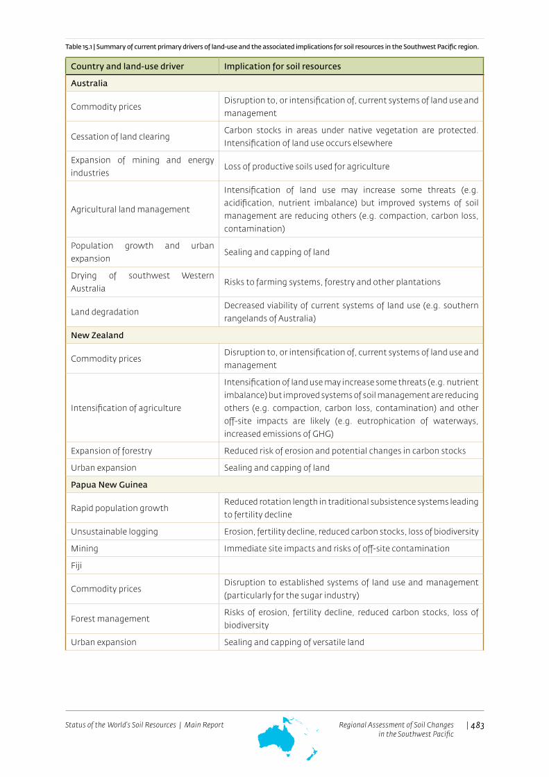
At the end of the twentieth century, diverse systems of land use operated throughout the Southwest Pacific ranging from traditional systems (e.g. subsistence shifting-agriculture in Papua New Guinea and some of the Pacific Islands) through to technologically advanced systems (e.g. highly mechanized agriculture in Australia and New Zealand). While the general patterns of land use have been relatively stable for several decades, significant changes are continuing. Those with the greatest impact on soil resources are summarised in Table 15.1. There are large differences in the degree of economic development in the region (Table 15.2) as the region contains some of the world’s poorest nations and some of the richest. There are also large differences within nations. Twenty percent of Australia is owned and managed by economically disadvantaged Indigenous Australians (SOE, 2011). Approximately 5.6 percent of New Zealand is Maori land, a major contributor to New Zealand’s economy. About 26 percent of Maori businesses are in the primary sector, principally farming, forestry and horticulture. In some countries (e.g. Solomon Islands and Vanuatu) increasing rural populations have led to significantly greater use of productive land in the subsistence shifting-cultivation systems with much reduced fallow periods and subsequent declines in soil quality.
Primary industries play a major role in most countries. The development of mineral and energy resources has been a key driver of economic growth, particularly in Australia and Papua New Guinea. New Zealand and Australia are major exporters of agricultural products.
| 483Status of the World’s Soil Resources | Main Report 483Regional Assessment of Soil Changesin the Southwest Pacific
Country and land-use driver Implication for soil resources
Australia
Commodity pricesDisruption to, or intensification of, current systems of land use and management
Cessation of land clearingCarbon stocks in areas under native vegetation are protected. Intensification of land use occurs elsewhere
Expansion of mining and energy industries
Loss of productive soils used for agriculture
Agricultural land management
Intensification of land use may increase some threats (e.g. acidification, nutrient imbalance) but improved systems of soil management are reducing others (e.g. compaction, carbon loss, contamination)
Population growth and urban expansion
Sealing and capping of land
Drying of southwest Western Australia
Risks to farming systems, forestry and other plantations
Land degradation Decreased viability of current systems of land use (e.g. southern rangelands of Australia)
New Zealand
Commodity pricesDisruption to, or intensification of, current systems of land use and management
Intensification of agriculture
Intensification of land use may increase some threats (e.g. nutrient imbalance) but improved systems of soil management are reducing others (e.g. compaction, carbon loss, contamination) and other off-site impacts are likely (e.g. eutrophication of waterways, increased emissions of GHG)
Expansion of forestry Reduced risk of erosion and potential changes in carbon stocks
Urban expansion Sealing and capping of land
Papua New Guinea
Rapid population growthReduced rotation length in traditional subsistence systems leading to fertility decline
Unsustainable logging Erosion, fertility decline, reduced carbon stocks, loss of biodiversity
Mining Immediate site impacts and risks of off-site contamination
Fiji
Commodity prices Disruption to established systems of land use and management (particularly for the sugar industry)
Forest managementRisks of erosion, fertility decline, reduced carbon stocks, loss of biodiversity
Urban expansion Sealing and capping of versatile land
Table 15.1 | Summary of current primary drivers of land-use and the associated implications for soil resources in the Southwest Pacific region.

| 484Status of the World’s Soil Resources | Main Report 484Regional Assessment of Soil Changesin the Southwest Pacific
Solomon Islands
Unsustainable logging Erosion, fertility decline, reduced carbon stocks, loss of biodiversity
Low Lying Atoll Islands
Local production of fresh food Improved management of limited soil resources
Sea-level rise Salinization, loss of soil resources
Urban expansion Sealing and capping of land
CountryPopulation 2015Thousands
Population 2050Thousands
GDP per capita USD(2009-2013)
Australia 23 923 33 735 67 468
New Zealand 4 596 5 778 41 556
Melanesia
Fiji 893 918 4 572
New Caledonia 263 364 -
Papua New Guinea 7 632 13 092 2 088
Solomon Islands 584 1010 1 954
Vanuatu 264 473 3 303
Total Melanesia 9 636 15 858
Polynesia
American Samoa 56 62 -
Cook Islands 21 24 -
French Polynesia 283 337 -
Niue 1 1 -
Samoa 193 242 3 647
Tokelau 1 1 -
Tonga 106 140 4 427
Tuvalu 10 12 3 861
Wallis and Futuna Islands 13 13 -
Total Polynesia 684 832
Micronesia
Federate States of Micronesia 104 130 3 235
Kiribati 106 156 1 651
Marshall Islands 53 67 3 325
Nauru 10 11 -
Northern Mariana Islands 55 52 -
Palau 21 28 11 810
Total Micronesia 519 671
Table 15.2 | Current population, project population (UNDESA, 2013) and Gross Domestic Product per capita (World Bank, 2014) for countries of the region.

| 485Status of the World’s Soil Resources | Main Report 485Regional Assessment of Soil Changesin the Southwest Pacific
15.5 | Threats to soils in the region
15.5.1 | Erosion by wind and water
The rates of soil erosion occurring today in Australia and New Zealand are significantly less than in previous decades. The situation in the rest of the region is less clear. Very fast rates of erosion are occurring in countries with uncontrolled land clearing and logging (e.g. Papua New Guinea and the Solomon Islands). Unsustainable rates of erosion are also likely to be occurring in marginal and hilly lands used for agriculture in some Pacific countries, for example Fiji (Liedtke, 1989).
Soil erosion by wind is a significant problem in Australia and an account of trends and current status is presented below. It is not common elsewhere in the region because of the humid climate, although drier areas in New Zealand (primarily on the South Island) are prone to wind erosion (Eyles, 1983).
Australia
Current rates of soil erosion by water in Australia are much less than the peak periods just after land clearing. In many parts of the country, widespread gully erosion occurred during this time and the hydrological regime of many river systems was changed. In southern Australia, gully and river bank erosion are the dominant sources of sediment supplied to streams. Gully erosion in southern Australia has now been largely stabilised, but gullies are still actively forming in northern Queensland and in some agricultural regions of Western Australia (NLWRA, 2001a).
Despite the apparent stabilization, current rates of soil erosion by water across much of Australia now exceed soil formation rates by a factor of at least several hundred and, in some areas, several thousand. As a result, the expected half-life of soils (the time for half the soil to be eroded) in some upland areas used for agriculture ranges from less than a century to several hundred years. The latest assessment concluded that soil erosion by water in Australia is still at unsustainable rates, but there are large uncertainties about the time until soil loss will have a critical impact on agricultural productivity (SOE, 2011; Bui et al., 2010; Bui, Hancock and Wilkinson, 2011). Environmental impacts of excessive sedimentation and nutrient delivery on inland waters, estuaries and coasts are already occurring.
It is estimated that up to 10 million ha of land have less than 500 years until the soil’s A-horizon (effectively the more fertile topsoil) will be lost to erosion. Most of this land is in humid subtropical Queensland. Integrated studies of soil formation and erosion using a variety of techniques will be needed to better understand the extent, severity and significance of the problem. However, it is clear that a concerted program of soil conservation is essential to control this chronic form of land degradation across large areas of Australia. The problem is arguably having its greatest environmental impact on the World Heritage listed Great Barrier Reef. The latest scientific consensus is that the decline of marine water quality associated with terrestrial runoff from the adjacent catchments is a major cause of the current poor state of many of the key marine ecosystems of the Great Barrier Reef. The main source of excess nutrients, fine sediments and pesticides from Great Barrier Reef catchments is diffuse source pollution from agriculture (Brodie et al., 2013).

| 486Status of the World’s Soil Resources | Main Report 486Regional Assessment of Soil Changesin the Southwest Pacific
Figure 15.2 | Change in the percentage area of all land prepared for crops and pastures under different tillage practices in Australia, 1996-2010 Source: SOE, 2011.
Land management practices have improved significantly during the past few decades, due to better grazing practices, adoption of conservation tillage, enforcement of forestry codes and soil conservation measures in engineering (e.g. relating to road construction and urban development).
Ground-based monitoring of management practices and land cover along with data on land-management practices (SOE, 2011) reveal a pattern of:
• more careful grazing and maintenance of effective land cover at critical times of the year • improved adoption of conservation practices, especially across the cropping lands of southern Australia• an associated large decline in the amount of tillage in farming systems (Figure 15.2)
New Zealand
Soil loss by erosion is a major problem in many areas of New Zealand due to a combination of factors including soil type, topography and climate, as well as the type and associated intensity of land use (especially pastoral agriculture).
Eyles (1983) provided the first systematic inventory of soil erosion in New Zealand and made the following observations and estimates. Surface erosion occurs mainly on the South Island. In 1983 sheet erosion affected 10 million ha of the country, while wind erosion affected 3 million ha (the total area of New Zealand is approximately 27 million ha). Mass movement occurred mainly on the North Island and slip erosion was estimated to affect 7 million ha. Fluvial erosion also occurred mainly in the North Island with rill and gully erosion estimated to affect 2 million ha. The study concluded that a total of 9 million ha of farmed land in New Zealand was at risk of significant erosion, although the level of risk was variable. The large scale afforestation of hill country and steep-land pasture since 1983 (see case study below) will have substantially reduced rates of soil erosion (especially sheet and slip erosion). However, forest harvesting results in significant soil disturbance and this will increase the risk of erosion when the first rotation forest is harvested and the second rotation established.
Dymond (2010) analysed erosion rates in order to refine the national carbon budget because soil erosion in New Zealand results in the large export of sediment and particulate organic carbon (POC) directly to the sea. The North Island of New Zealand was estimated to export 1.9 (−0.5/+1.0) million tonnes of POC per year to the sea, and to sequester 1.25 (−0.3 /+0.6) million tonnes of carbon per year from the atmosphere through
| 487Status of the World’s Soil Resources | Main Report 487Regional Assessment of Soil Changesin the Southwest Pacific
regenerating soils. The South Island was estimated to export 2.9 (−0.7/+1.5) million tonnes of POC per year, and to sequester approximately the same amount. Dymond (2010) assumed that exported carbon is buried at sea with an efficiency of 80 percent. This gives New Zealand a net carbon sink of 3.1 (−2.0/+2.5) million tonnes per year (equivalent to about 45 percent of New Zealand’s fossil fuel carbon emissions in 1990). There is essentially a ’conveyor-belt’ transfer of carbon from the atmosphere to soils regenerating from erosion and to the sea floor where carbon is permanently buried. The large magnitude of the net sink is primarily due to tectonically driven uplift and erosion combined with high biological productivity. The degree to which other elevated and humid islands in the Pacific can operate as a net sink has not been determined.
Pacific Islands
The high rainfall and steep lands in many of the larger Pacific Island countries make them vulnerable to soil erosion. Understanding the significance of this erosion requires information on both rates of soil formation and the baseline rates of sediment movement in different landscapes. The latter can be much larger than in temperate regions and relatively fast rates of erosion around 50 tonnes ha-1 yr-1 have been recorded in heavily forested landscapes in Fiji (Glatthaar, 1988; Liedtke, 1989) and Samoa (Terry, Garimella and Kostaschuk, 2002; Terry, Kostaschuk and Garimella, 2006). Tropical cyclones, intense rainstorms, steep slopes and landslides are key factors.
The desire for economic development has led to increasing areas of good quality soil being used for cash crops such as coffee and cocoa and for cattle production. These factors in conjunction with population pressures are forcing small-scale agriculture onto steeper less suitable lands. Logging, whether managed or illegal, increases the pressure even further. Condron and Di (2002) indicate that rates of soil loss by erosion in these areas are typically between 10 to 90 tonnes ha-1 yr-1 (see also Asquith, Kooge and Morrison, 1994; Liedtke, 1989). Accelerated soil erosion has also been associated with plantations, particularly on marginal sloping land.
Although most atolls are away from the cyclone belt in the Southwest Pacific, a few have been severely eroded by large storms. The impacts are devastating as much of the limited soil resource is washed away, and also what is left becomes highly salinized and of limited productive capacity. This was particularly noted on Funafuti, Tuvalu following cyclone Bebe in 1972 (Maragos, Baines and Beveridge, 1973).
Sub-Antarctic Islands
Several sub-Antarctic islands in the Southwest Pacific region continue to have high rates of soil erosion. Macquarie Island, for example, is an isolated island in the Southern Ocean that provides a critical habitat for migratory species. Macquarie Island has been severely eroded and approximately AUD $25 million has been spent in recent years on habitat restoration programmes, mainly for the eradication of rabbits.
15.5.2 | Soil organic carbon change
Most of the region experienced large losses of soil carbon when land was first cleared for agriculture. The major phases of clearing in each country were noted above. In some countries clearing associated with uncontrolled logging continues today, for example in Papua New Guinea and the Solomon Islands (Moorehead, 2011). The initial disruption to soil caused by clearing usually results in a significant loss of nutrients. Organic matter is oxidised and the removal of surface cover (litter and protective vegetation) makes the soil more prone to erosion. Stores and cycles of nutrients adjust under the new land use, but in most cases the net loss of nutrients and leakage are greater than under natural conditions. Most studies indicate that across the region soil carbon typically reduces to 20–70 percent of the pre-clearing amount (e.g. Sanderman and Baldock, 2010). Opportunities for restoring some of this very large stock of carbon have been a focus of soil research in Australia and New Zealand during the last decade.

| 488Status of the World’s Soil Resources | Main Report 488Regional Assessment of Soil Changesin the Southwest Pacific
Australia
In their review of replicated Australian field trials with time-series data, Sanderman and Baldock (2010) concluded that, although the implementation of more conservative land-management practices will lead to a relative gain in soil carbon, absolute soil carbon stocks may still be on a trajectory of slow decline. There are also inevitable trade-offs between agricultural production (e.g. carbon exports in the form of crops, fibre and livestock) and carbon sequestration (capture and storage) in soils.
SOE (2011) provides a district-by-district assessment of trends in soil carbon for Australia. The assessment concluded the following.
• The time since clearing is a key factor determining current trends. For example, large parts of Queensland are still on a declining trend because widespread clearing for agriculture was still occurring in the 1990s.
• Few regions have increasing soil carbon stores.• Regions with intensifying systems of land use (e.g. northern Tasmania) have decreasing stores.• Most regions with a projected drying climate have declining trends.• The savannah landscapes of northern Australia have significant potential for increasing soil carbon
stores, but this requires changes in grazing pressures and fire regimes. • Some of the extensive cropping lands in southern Australia with weathered and naturally infertile soils
have not experienced as large a loss of soil carbon since clearing (e.g. generally a 30–70 percent loss and sometimes <30 percent loss) because they had small carbon stores at the time of European occupation and have not changed substantially (although soil biodiversity has undoubtedly changed). Many of these soils have also benefited from the addition of fertiliser and the correction of trace element deficiencies.
A comprehensive study of soil carbon stocks across a wide range of climates, soils and management systems by Baldock, Macdonald and Sanderman, (2013) confirmed that broad patterns of soil carbon variation correlate with first order drivers such as climate and soil type. It also demonstrated that increasing soil stocks in some environments is difficult. For example, results from both trial and commercial grower sites throughout Queensland indicate that no-till systems are not capable of increasing soil organic carbon in either Queensland grain or sugarcane systems. However, no-till may be capable of slowing carbon loss following a period of carbon input from, for example, a pasture ley (Page et al., 2013).
The study also revealed that no individual management practice has the same influence on 0-0.3 m soil carbon stocks across all agricultural regions. Statistically significant differences in 0-0.3 m soil carbon stocks were often not detected despite strong variations in the management practices assessed (e.g. continuous pasture versus continuous cropping). The results suggest that differences in the way individual landowners implement practices in response to personal preferences or business requirements may contribute significantly to the size of stocks. Poor application of a particular management practice which on average has the capability to increase soil carbon may result in a loss of soil carbon. Equally, a very good application of a practice that is found to decrease soil carbon on average may result in increased soil carbon stocks if levels of carbon capture and return to the soil are high enough (Cowie et al., 2013; Page et al., 2013; Cotching et al., 2013; Badgery et al., 2013; Davy and Koen, 2013; Wilson and Lonergan, 2013). These findings have implications for policies and incentive schemes that reward farmers for storing additional organic carbon. Schemes that rely on compliance with a general management practice may not be effective.

| 489Status of the World’s Soil Resources | Main Report 489Regional Assessment of Soil Changesin the Southwest Pacific
New Zealand
The importance of soil erosion to the soil carbon balance of New Zealand was noted earlier. Significant progress has also been made in estimating the carbon balance of different land uses. Trotter et al. (2004) estimated that New Zealand’s major vegetation types combined to make the total land area a small net carbon source (Table 15.3). A similar conclusion was reported by Tate et al. (2005).
As indicated in Table 15.3, ‘improved’ grassland is New Zealand’s most widespread land use but there are large differences in carbon exchange rates within this land type. For example, detailed measurements by Mudge et al. (2011) over two years demonstrated that a dairy farm with mineral soil was a net C sink (year 1 = 590 ± 560 kg C ha-1 yr-1; year 2 = 900 ± 560 kg C ha-1 yr-1) while Nieeven et al. (2005) and Campbell et al. (2015), using similar eddy covariance methods, demonstrated that other dairy farms with drained peat soil were net C sources (-1061 ± 500 kg C ha-1 yr-1 and 2940 C ha-1 yr-1 respectively).
Vegetation type
Area
(million
ha)
Net
carbon
exchange
(T g y-1)
Source or
sink
Native forest 5.8 -8 Source
Planted forest 1.6 +5 Sink
Scrubland 3.7 -2 Source
Native (tussock) grassland 4.3 +7 Sink
‘Improved’ grassland (ryegrass and white clover) 6.7 -6 Source
Unimproved grassland (species other than ryegrass and white clover) 3.4 +3 Sink
Total for New Zealand 25.5 -1 Source
Table 15.3 | Estimated annual land–atmosphere (net) carbon (C) exchange rate for New Zealand’s major vegetation types. Source: Trotter et al., 2004.
Schipper et al. (2014) reported the results of repeated sampling of 148 soil profiles across New Zealand over a 20-40 year period under improved pasture grazed by dairy cattle and dry stock (e.g. beef cattle and sheep). For soils on flat land, C stock of the uppermost 0.3 m depth decreased significantly over time (by 5 ± 21 tonnes C ha-1, n = 125 profiles). For silandic Andosols and Gleysols, C stock of the uppermost 0.3 m depth decreased significantly over time (by 14 ± 20 tonnes C ha-1 for silandic Andosols (mean ± standard deviation, n = 32), and by 8 ± 14 tonnes C ha-1 for Gleysols (n = 25 profiles). Soils of these groups had the highest (initial) C stocks (178 ± 31 tonnes C ha-1 for the uppermost 0.3 m depth of silandic Andosols, 101 ± 28 tonnes C ha-1 for the Gleysols and 96 ± 28 tonnes C ha-1 for the other soils, n = 91 profiles). For soils in hill country, C stock of the uppermost 0.3 m depth increased significantly over time (by 14 ± 22 tonnes C ha-1, n = 23 profiles).
There have been some studies of potential causal factors of temporal change in soil C stock in New Zealand, including fertility and fertiliser application, irrigation and erosion.
• Fertility and fertiliser application: Phosphorus (P) fertiliser application and P and nitrogen fertility status have not been found to account for the C stock trends of lowland and hill country soils beneath grazed pasture (Dodd and Mackay, 2011; Schipper et al., 2011, 2013; Parfitt et al., 2014).
• Irrigation: The carbon stocks in some irrigated soils used for grazing over many decades have decreased compared to those receiving only rainfall (Kelliher et al., 2012). This may have been caused by greater soil respiration rates in the irrigated system, although other mechanisms are possible (see Kelliher, Curtin and Condron, 2013, Schipper et al., 2013, Condron et al., 2014).

| 490Status of the World’s Soil Resources | Main Report 490Regional Assessment of Soil Changesin the Southwest Pacific
• Erosion: As noted earlier, sheet erosion by water and landslides are important factors affecting carbon stocks in New Zealand. In one catchment, these processes each accounted for a loss of 0.5 tonnes C ha-1
yr-1 (Page et al., 2004). On lower slopes, the soil may be lost or re-distributed or both. One study showed the C stock in erosion scars increased from 10 to 80 tonnes C ha-1 within 70 years in the uppermost 0.2 m depth of soil (Parfitt et al., 2013). However, the carbon stocks of soils forming on erosion scars are unlikely to return to more than ~80 percent of the pre-landslide amount because the newly developing soils are relatively shallow and drought-prone in summer (Rosser and Ross, 2011).
Studies of current C stocks and the potential saturation value for the soils of New Zealand (Beare et al., 2014) suggest there is an opportunity to increase the C stock of pastoral soils by increasing the C input rate, including deeper plant roots (e.g. Carter and Gregorich, 2010). However, organic matter stored deeply in soils is poorly understood (Rumpel and Kögel-Knabner, 2011) and determining the contribution of roots to soil C may not be straightforward (e.g. Dodd and Mackay, 2011).
Pacific
Only a few studies of soil carbon dynamics have been undertaken in the countries of the Pacific (e.g. Hartemink, 1998a). General statements are nonetheless regularly made about the decline in soil carbon associated with soil erosion, excessive cultivation and poor soil management. For example, Leslie and Ratukalou (2002) conclude that the small size of farm holdings in Fiji (60 percent are less than 3 ha) forces farmers into intensive cultivation (often mono-cropping) for high output, short-term production without (or with only minimal) fallow periods. Furthermore, competition for land is forcing subsistence gardens onto steeper slopes because of the expansion of cash cropping and grazing on the flatter lands.
Excessive soil erosion in many sugar cane areas along with the burning of cane trash is resulting in serious depletion of fertility and soil loss on poorly managed farms. A 30-year study from Fiji on a series of sugarcane farms showed the expected decrease (15-35 percent) in topsoil organic C at the time of land clearing. However, a redistribution of C occurred, with increases at 30-40 cm depth (below the plough layer) and a very gradual increase in C at greater depth (80 cm). As a result, the overall C content of the fields increased on well-managed farms (Morrison and Gawander in press, Morrison, Gawander and Ram, 2005).
In Papua New Guinea, the expansion of agriculture and uncontrolled logging are most likely causing a reduction in soil carbon stocks but quantitative studies to assess the magnitude of these changes are needed. Even on atolls, land-use change involving replacement of native vegetation by coconuts has led to significant declines in soil carbon, which is critical there because of the key role of organic matter in moisture retention (Morrison and Seru, 1985).
15.5.1 | Soil contamination
The Southern Hemisphere does not have the same history of large scale industrialization as the Northern Hemisphere. However, soil contamination is a significant problem mainly in relation to impurities in phosphate fertilizers, agricultural chemicals, mining, waste disposal, former industrial sites and nuclear testing. Reviews of the history of soil contamination in the region are provided by Naidu et al. (1996) and more specifically for Australia (Tiller, 1992; Barzi et al., 1996), New Zealand (Roberts et al., 1996), Papua New Guinea (Singh, Levett and Kumar, 1996) and South Pacific Islands (Morrison, Gangaiya and Koshy, 1996). Throughout the region there are tens of thousands of contaminated sites (SOE, 2011; Ministry for the Environment, 2010) but the scale of the remediation task is not clear. Australia and New Zealand have a long and effective history of working together to coordinate the management and remediation of soil contamination but the waste management problem facing small islands in the Pacific is a serious and escalating problem.

| 491Status of the World’s Soil Resources | Main Report 491Regional Assessment of Soil Changesin the Southwest Pacific
Fertilizers
Impurities in fertilizers and soil amendments such as lime and gypsum can include cadmium, fluorine, lead and mercury. Cadmium and fluorine have been of most concern in the region and the former can move from soil to the edible portions of plants. In Australia and New Zealand, the historically high concentrations of cadmium in phosphate fertilizers resulted from the use of island sources of high cadmium phosphate rock for fertilizer manufacture, primarily from Nauru and Christmas Island (McLaughlin et al., 1996; Loganathan et al., 2003). A large effort has been devoted to determining the magnitude of the problem and to implementing a range of control measures (Warne et al., 2007; MAF, 2011; Cavanagh, 2014). In recent years, levels of cadmium in fertilisers have been reduced, and farming systems have been modified to manage the problem and mitigate future risk. For example, in New Zealand a tiered system for fertilizer management has been established. However, large areas of land that received heavy applications of superphosphate over decades now have elevated levels of cadmium. A recent analysis by de Vries and McLaughlin (2013) concluded that the present cadmium inputs from fertilizer in Australia are in excess of the long-term critical loads in heavy-textured soils for dryland cereals and that all other systems are at low risk. In New Zealand, a recent survey has shown that only isolated soil samples had cadmium concentrations that exceeded the upper-tier threshold value. The evidence to date indicates that cadmium in New Zealand soils poses no immediate concern.
Agricultural chemicals
Many of the more harmful pesticides and herbicides have been banned or tightly controlled in Australia and New Zealand. However, some residues can persist and adversely affect the environment, notably in areas that were, or still are, used for growing potatoes, tomatoes, cotton, bananas and sugar cane. Copper, arsenic and lead are contaminants associated with orchards and market gardens. A widespread problem in both countries has been the thousands of former cattle and sheep-dip sites contaminated with organochlorines such as dichlorodiphenyltrichloroethane (DDT) and other pesticides, including arsenic-based compounds. Urbanisation and the construction of dwellings on or near these sites pose a serious threat to human health. Most of these sites have been investigated and registered. There are far fewer studies on the impact of agricultural chemicals in the smaller island nations of the region.
Mining
The history of mining in the region was outlined above. In Australia, a significant number of current or former mining towns are affected by soil contamination, mostly associated with tailings, mine wastes and pollution from ore processing (e.g. Queenstown in Tasmania, Broken Hill, Captains Flat and Wollongong in New South Wales, Mt Isa in Queensland). At Port Pirie, dispersed heavy metals from smelting (primarily lead, zinc, cadmium and copper) can be detected over thousands of square kilometres, although seriously contaminated areas are restricted to tens of square kilometres (Cartwright, Merry and Tiller, 1976).
In Papua New Guinea riverine disposal of processing residues, waste rock and overburden into rivers (e.g. Ok Tedi and Porgera) is having a large and long-term environmental impact on soils. Since 1984, the 1 000 km long Fly River system has received about 66 million tonnes yr-1 of mining waste from the Ok Tedi copper-gold-porphyry mine and this has caused widespread contamination and altered hydrological regimes (Bolton, 2009; Campbell, 2011). Elevated levels of copper, zinc, cadmium and lead occur in the sediments that have been deposited in the alluvial systems of the Fly River but the longer-term impacts on ecosystems and human health are not clear.

| 492Status of the World’s Soil Resources | Main Report 492Regional Assessment of Soil Changesin the Southwest Pacific
Waste disposal
The management of waste is now tightly regulated and managed in Australia and New Zealand. However, waste management is a major contemporary problem for the small island nations of the Pacific. Morrison and Munro (1999) provide an overview of the problem and broader issues of soil management on atoll islands (see case study below, Section 15.6).
Industrial sites
Even though they are less industrialised than many countries in the Northern Hemisphere, Australia and New Zealand have a legacy of contaminated former industrial sites. Most are point-scale but in some cases more widespread contamination has occurred.
The legacy of nuclear testing
Morrison, Gangaiya and Koshy (1996) review the legacy of nuclear testing in the Pacific and the following draws heavily on their account. Nuclear testing occurred throughout the 1940s and 1950s in the Marshall Islands resulting in serious contamination and impacts on resident populations. Sites in the Marshall Islands have been monitored for over 40 years and the detailed investigations include impacts on soils. Some areas will be contaminated forever. In undisturbed areas, most of the radioactivity (>80 percent) is in the upper 0.15 m of the soil profile. The terrestrial food chain is still the most significant potential exposure pathway, but in some locations there may also be health problems from the intake of resuspended radioactive soil particles. Access to several islands is still restricted because of contamination.
Nuclear testing also occurred in the 1950s and 1960s in Kiritimati (Christmas Island). Radioactivity concentrations in soil are consistent with global fall-out levels for a low rainfall equatorial area, and no site on the island presents a risk to the health of the local population or requires any restriction on land use.
Nuclear testing in French Polynesia occurred from the 1960s to the 1990s and it has been a major international environmental issue. Morrison, Gangaiya and Koshy (1996) state that there is no doubt that the atmospheric testing did lead to significant contamination, but the impact of the underground tests is more difficult to assess. A small number of official investigations has been permitted on Mururoa, but these have been limited in extent and some areas have been excluded from investigations. The atoll is under French military control with imported food and restricted use of local resources so the direct impact of contaminants is limited. Morrison, Gangaiya and Koshy (1996) conclude that the impact on surrounding islands which are occupied by Polynesians living a traditional lifestyle is expected to be small, but in the absence of detailed investigations, this cannot be confirmed.
Nuclear testing in Australia occurred during the 1950s and 1960s at Maralinga and Emu Field in South Australia and on the Montebello Islands near the coast of Western Australia. Rehabilitation of the contaminated Maralinga test area has taken decades with a major effort concluding in 2003 (DEST, 2003). Return of the Maralinga test area to its traditional owners was completed in November 2014.
15.5.2 | Soil acidification
Soil acidification is an insidious and widespread problem in many parts of the region. If not corrected, the slow process can continue until the soil is irreparably damaged. The severity and extent of acidification are increasing in many areas due to inadequate treatment, intensification of land management, or both. Soil acidification is of greatest concern in situations where: (I) agricultural practices increase soil acidity (e.g. use of high-analysis nitrogen fertilisers or large rates of product removal); (II) the soil has a low capacity to buffer the decrease in pH (e.g. infertile, light-textured soils); or (III) the soil already has a low pH.

| 493Status of the World’s Soil Resources | Main Report 493Regional Assessment of Soil Changesin the Southwest Pacific
The main onsite effects of acidification include: loss or changes in soil biota involved in nitrification, accelerated leaching of plant nutrients, and induced nutrient deficiencies or toxicities. There may also be breakdown and subsequent loss of clay materials from the soil, the development of subsoil acidity, and reduced net primary productivity and carbon sequestration.
The potential offsite effects on waterways include mobilisation of heavy metals, acidification, increased siltation and eutrophication. The process of acidification considered in this assessment is distinct from that associated with acid sulphate soils. Such soils occur primarily in coastal settings or with mines rich in sulphides. In these areas, soils naturally contain metal sulphides that severely acidify when oxidised.
Australia
Acidification is known to affect about half of Australia’s agriculturally productive soils. In 2001, the estimated annual value of lost agricultural production due to soil acidity was AUD $1 585 billion, about eight times the estimated cost of soil salinity at that time. More recent studies have confirmed the scale of the problem (e.g. Lockwood et al., 2003, SOE, 2011, DAFWA, 2013).
Soil acidification is widespread in the extensive farming lands of southern Australia and the rates of lime application are well short of those needed to arrest the problem (see below). Acidification is common in intensive systems of land use (tropical horticulture, sugar cane, dairying). In some regions, acidification is limiting biomass production but the degree of restriction is difficult to estimate. Trends in the tropical savannahs are uncertain. If acidification is occurring there, it will be a difficult problem to solve (Noble, Cannon and Muller, 1997; Noble et al., 2002). Carbon losses are most likely occurring across regions in poor condition, and unabated soil acidification will be a major constraint on storing carbon in soils in the future.
Ultimately, soil acidification restricts options for land management because acid-sensitive crops and pastures cannot be grown. It is relatively straightforward to reverse short-term soil acidification through the application of lime. However, it is much harder to reverse the problem if the acidification has advanced deeper into the soil profile, because incorporating lime at depth is prohibitively expensive. Prevention rather than cure is essential. While rates of lime application appear to be increasing (due to active extension programs), they still fall far short of what is needed to arrest the problem. The case study of southwest Western Australia (see below, Section 15.6) provides more details. The rates of lime application are still much lower than what is needed to avoid irreparable damage. In South Australia the average quantity of lime sold annually over the past decade (113 000 tonnes) is only 53 percent of that needed to balance the estimated annual soil acidification rate (SOE, 2011).
New Zealand
The acidification of legume-based pastures as a result of nitrate leaching and nutrient transfer/removal is of particular concern in New Zealand (de Klein, Monaghan and Sinclair, 1997). In many productive lowland pastures soil acidification is overcome through regular liming. However, amelioration of soil acidity by liming is not considered to be feasible in most hill country areas due to the high cost of aerial application (Bolan and Hedley, 2003; Moir and Moot, 2010). These soils are not cultivated and this enhances the risk for subsoil acidification. As a result acidification is affecting a significant portion of hill-country soils in New Zealand, which has the potential to significantly affect the capacity of many soils to sustain plant and animal production.

| 494Status of the World’s Soil Resources | Main Report 494Regional Assessment of Soil Changesin the Southwest Pacific
Papua New Guinea, Fiji and other tropical countries
Soil acidification is a problem in areas used for sugar cane in Papua New Guinea (e.g. Hartemink, 1998b) and in agricultural areas in Fiji (see Section 15.5.6). It may also be significant in tropical and subtropical areas that have been cleared but there have been few investigations.
15.5.3 | Salinization and sodification
Dryland salinity
Dryland salinity is widespread across many parts of southern and eastern Australia. A large proportion of Australia’s agriculture is undertaken in areas with a rainfall of 450–800 mm yr-1. In their natural condition, these landscapes had minimal deep drainage (generally less than 20 mm yr-1), and natural stores of salt brought in by rain and dust had accumulated in the soil in many regions. The removal of native vegetation changed the hydrological cycle, because trees and shrubs intercept significant quantities of rain (typically 10–20 percent of rainfall fails to reach the soil surface). When vegetation is removed, more water either infiltrates or runs off the surface. If the original vegetation has been replaced by more shallow-rooted species that use less water (e.g. annual crops and pastures), even more water passes through the soil. This may lead to rising groundwater levels and, in some cases, dryland salinity.
Dryland salinity has been one of Australia’s most costly forms of land degradation. The comprehensive assessment by NLWRA (2001b) concluded that, assuming no changes in water imbalance, areas with dryland salinity were expected to increase from 5.7 million ha to 17 million ha by 2050. In many regions, the initial and sometimes primary impact of the change in hydrological regime is an increase in the salinity of streams and rivers (SOE, 2011). However, in low relief landscapes, large areas can be salinized and this dramatically reduces the options for land use.
Between 2001 and 2009, the Millennium Drought (van Dijk et al., 2013) across southern and eastern Australia appears to have slowed the spread of dryland salinity in these regions but the outlook is still problematic. Current projections of climate change are for a drying of southern Australia which should lead to a lessening of the problem. However, the long-term outlook for more recently cleared land in the northern Murray–Darling Basin and central Queensland is unclear. Large areas are yet to reach a new hydrological equilibrium after clearing. However, close surveillance of groundwater systems is essential, particularly in regions that returned to wetter conditions in the last five years. The case study below for southwest Western Australia suggests that the expansion of dryland salinity may be experiencing a temporary lull in many districts. Dryland salinity is not a significant problem in other parts of the Southwest Pacific Region.
Salinity in irrigation areas
Salinity has been a major problem in the irrigation districts of Australia, particularly in the south of the Murray-Darling Basin where most irrigation is concentrated. Salinity developed in the early 1900s soon after the first schemes were completed. The scale of the problem started to be fully recognized in the 1970s and by 2000 it was viewed alongside dryland salinity as the country’s highest priority natural resource problem. Major investments in infrastructure, large-scale salt interception schemes, institutional reform, substantial improvements in water-use efficiency and the Millennium Drought all contributed to a mitigation of the problem (e.g. MDBA, 2010). SOE (2011) were equivocal in their assessment of whether salinity was still a major problem. However, the conclusions above for dryland salinity apply equally to irrigation salinity. New irrigation development is occurring in Tasmania where landscapes have stores of salts in some settings. Irrigation developments in northern Australia and the east coast are being explored at present but salinity risks in these areas tend to be less.

| 495Status of the World’s Soil Resources | Main Report 495Regional Assessment of Soil Changesin the Southwest Pacific
Saltwater intrusion
Saltwater intrusion is a critical issue for the management of freshwater groundwater systems on most of the 1 000 or more inhabited atoll islands in the region. This issue is considered in the case study below. Throughout the region, increasing groundwater extraction (e.g. for irrigation), periods of below-average rainfall, urban development and sea-level rise have increased the risk of saltwater intrusion in coastal districts. In Australia, Werner (2010) and Ivkovic et al. (2012) provide an initial assessment of the problem. There is a good awareness of salt water intrusion risks in New Zealand and only a small number of actual salt water intrusion problems have occurred. Most have been into shallow unconfined aquifers and the problems have been short-lived and adequately managed by changes to groundwater abstraction (Callander, Lough and Steffens, 2011).
Sodicity
Australia has the largest extent of naturally sodic soils of any continent (FAO, 1988) but they are relatively rare in other parts of the region. There is a large scientific literature on the management and amelioration of sodicity in Australia and reviews are provided by Loveday and Bridge (1983), Summer and Naidu (1998) and Rengasamy (2002, 2006). Sodic soils are difficult to manage because of their poor soil–water and soil–air relations. Swelling and dispersion of sodic aggregates reduces the porosity and permeability of soils and increases soil strength even at low suction (e.g. high water content). Sodic soils have a narrow non-limiting water range (Letey, 1985) and they are typically either too wet immediately after rain or too dry within a few days for optimal plant growth. The dispersive clays cause surface crust and seal formation, poor internal drainage, and in some settings, tunnel erosion.
Rengasamy (2002) estimated that more than 60 percent of the 20 million ha of cropping soils in Australia are sodic and that the actual yield of grains on these soils is often less than half of the potential yield. However, sodicity is often associated with other subsoil constraints to root growth including alkalinity, boron toxicity and salinity so remediation is neither easy nor economic in many cases.
There are few studies on the dynamics of sodicity. Apart from irrigation systems where water supplies contain appreciable sodium, there is limited evidence to indicate that sodicity is increasing or decreasing in either severity or extent or both. In irrigation systems with appreciable sodium, salt loads are generally managed effectively. However, land-based disposal of effluent can be constrained by increasing sodicity and salt loads (Toze, 2006; Balks, Bond and Smith, 1998; Bond, 1998).
Irrigation with waters containing appreciable quantities of potassium is a common occurrence, particularly with waste water. This monovalent cation has a similar effect to sodium, causing clay dispersion and reduced permeability. Smith, Oster and Sposito, (2014) state that the deleterious effect of potassium is estimated to be about one-third of that of sodium.
15.5.4 | Loss of soil biodiversity
Soil biology has been an active field of research in the region for many decades (e.g. CSIRO, 1983; Pankhurst et al., 1994; Abbott and Murphy, 2007). Much of this has had a focus on agriculture and forestry. However, there has also been a concerted effort to understand the evolution, distribution and status of biodiversity. Woodman et al. (2008) provide some preliminary assessments for Australia and outline strategies for developing a longer-term system for assessing soil biodiversity. Several significant assessments are underway in the region using molecular biological techniques. The Biome of Australia Soil Environments (BASE) is collecting samples to create a large-scale genomic database of soil biomes across Australia. Until these are completed, it is difficult to provide a definitive assessment of the loss of biodiversity in the region. However, some general inferences can be drawn.

| 496Status of the World’s Soil Resources | Main Report 496Regional Assessment of Soil Changesin the Southwest Pacific
• Above-ground biodiversity is much better characterized than soil biodiversity and there are several megadiverse districts and countries in the region.
• Areas with high above-ground biodiversity are likely to be similarly diverse below ground if their environments were relatively stable throughout the Pleistocene (e.g. the moist forests of southwest Western Australia, rainforests on the eastern escarpment of Australia, intermediate elevations in Papua New Guinea, southern districts in the South Island of New Zealand). Some ancient landscapes were submerged during this period (e.g. New Caledonia) and this most likely had an impact on soil biodiversity present today.
• A range of pressures and stressors directly affect soil biota and some have already been discussed (e.g. loss of soil carbon, acidification, physical disruption through cultivation or other means, intensification of fire regimes). Large areas in the region have experienced these pressures and stressors. As a consequence, they are most likely experiencing a loss of soil biodiversity.
15.5.5 | Waterlogging
No comprehensive survey or monitoring of waterlogging have been undertaken at the district or national level in the region. Waterlogging is a significant constraint on agricultural production and extensive drainage schemes were installed during the twentieth century, particularly in low lying alluvial areas in New Zealand and eastern Australia. Texture-contrast soils with impermeable B-horizons are widespread in the pasture and cropping lands of southern Australia. Waterlogging is a major limiting factor of crop production in south-western Victoria (McDonald and Gardner, 1987). Raised beds are sometimes used to minimize the impact of water logging and enhance crop production.
15.5.6 | Nutrient imbalance
Nutrient imbalances are widespread throughout the more intensively managed landscapes of the region. Some of these have already been outlined in relation to carbon balances and acidification (see below as well). The focus here is on systems of land use where nutrient mining, depletion or accumulation may be occurring.
Nutrient mining refers to situations where there is a large removal of nutrients with minimal additions. In Australia, this has occurred in some extensive, low-input farming systems. For example, Dalal and Mayer (1986) document the decline in soil fertility over 70 years in areas used for dryland cropping in Queensland. This extensive low-input system relied on the natural fertility of its predominantly heavy clay soils (Vertisols) but it now requires fertilizer inputs to offset nutrient exports in harvested products.
Nutrient decline is occurring in other parts of the region although there are few reliable surveys and monitoring systems except in New Zealand. The shortening of rotations in the shifting agricultural systems of Melanesia caused by increased population is most likely causing nutrient decline but minimal evidence is available. Nutrient decline is also likely to be occurring on marginal lands that are degrading due to processes such as acidification and erosion. The magnitude of the nutrient loss has been documented in a few districts, particularly where sediments and nutrients have a major environmental impact.
Nutrient accumulation is a more recent phenomenon in the region and the case study on New Zealand (see below) explores several aspects. In most other Australian farming systems, fertilizer use has increased and most nutrient imbalances are managed because of the economic consequences of over- or under-use. In Australia, the use of nitrogen fertilizers has more than doubled in the last 25 years but application rates are still moderate compared to more intensively managed systems in China, Europe and the United States. Nutrient accumulation has occurred across southern Australia and elsewhere. In a few cases, environmental impacts are significant (e.g. the case of the Great Barrier Reef mentioned earlier and the Peel-Harvey system in Western Australia (e.g. Ruprecht, Vitale and Weaver, 2013).

| 497Status of the World’s Soil Resources | Main Report 497Regional Assessment of Soil Changesin the Southwest Pacific
Phosphorus is naturally deficient across large parts of the region. Despite this, in Australia phosphate fertiliser use is relatively inefficient (McLaughlin, Fillery and Till, 1990; Weaver and Wong, 2011). Most phosphorus is applied in the higher rainfall areas of southern Australia, and around 40 percent is applied to pastures. Nationally, approximately 20 percent of the phosphorus applied as fertiliser is extracted in food and fibre products for export, and about 5 percent is consumed domestically. The remaining 75 percent of the phosphorus applied in Australian agriculture accumulates in the soil, and some of this is lost to the environment, with detrimental impacts on waterways (Simpson et al., 2011; McLaughlin et al., 2011). The accumulation of phosphorus is greatest in soils across southern Australia (e.g. Weaver and Summers, 2013). Apart from the environmental risks caused by this accumulation, the inefficiency has an economic cost that will increase if fertiliser prices rise. In contrast, many grazing systems in northern Australia have pastures and animal production systems that are limited by deficits in phosphorus availability (McIvor, Guppy and Probert, 2011).
Nutrient imbalance has been a persistent issue in soils used for sugar cane in Fiji. Production began in the 1880s and fertiliser use increased after the Second World War. Up to the 1980s, the use of particular fertilizers resulted in excess inputs of N and less than appropriate inputs of P and K (Morrison et al., 1985, 2005). After significant debate and review, blended fertilisers were introduced in the early 1990s and this has led to a more balanced input of N, P and K. However, topsoil Ca and Mg contents have dropped dramatically and this has been attributed to a continuous removal of Ca and Mg in harvested cane and by erosion. In most years, less than replacement quantities of these elements are being added in fertilisers. Another contributing factor has been a dramatic decrease in liming on sugarcane farms.
15.5.7 | Compaction
Until recently, heavy machines such as tractors, harvesters and trucks were driven over most agricultural areas in the region leading to widespread soil compaction (Tullberg, 2010). Damage was greatest when the soil was wet. Some of the compaction can be undone through cultivation, although it is common for plough pans to develop just below the depth of cultivation. The distribution of pressure under a heavy vehicle also results in a zone of compaction halfway between the wheels, usually at a depth of around 0.5 metres. This type of compaction is difficult to remove. Heavy animals can also compact wet soil, leading to a decline in pasture production. Most of the damage occurs in the upper part of the soil profile.
In Australia, the extent of soil compaction due to wheel traffic and its agronomic consequences have not been investigated in detail; however, it is thought to be very widespread (Chan et al., 2006; McGarry, Sharp and Bray, 1999; Tullberg, Yule and McGarry, 2007). A number of studies have documented the extent and severity of compaction under different systems of land use including: irrigated agriculture (McGarry, 1990), cotton (Braunack and Johnston, 2014), dryland cropping (Bridge and Bell, 1994), sugar cane (Braunack, Arvidsson and Hakansson, 2006), and grazing and forestry (Rab, 2004). One study (Geeves et al., 1995) surveyed the physical and chemical properties of 78 soils under crops and grazed pastures judged to be representative for southern New South Wales and northern Victoria. The study concluded that soil-based constraints exist in surface and subsurface soil horizons and that these constraints are in some instances severe. The bulk density of B horizons ranged from 1.25 to 1.95 Mg m-3 with a mean of 1.58 Mg m-3 indicating that root growth will be restricted in many of these clay-rich horizons (Jones, 1983).
Encouragingly, there has been a rapid uptake of controlled-traffic farming in Australia and New Zealand during the last 15 years. This confines compaction to the smallest possible area and has the potential to alleviate further damage. Tullberg, Yule and McGarry, (2007) provide a detailed account of these systems and their impact on soils. The improved productivity, practicality and economic viability of controlled-traffic systems have led to enthusiastic adoption by farmers in the region. In Western Australia, farm profit has been shown to increase by 50 percent through the adoption of controlled-traffic farming (Kingwell and Fuchsbichler, 2011).

| 498Status of the World’s Soil Resources | Main Report 498Regional Assessment of Soil Changesin the Southwest Pacific
In New Zealand, deterioration of soil physical condition is common in grazed pastoral systems due to animal treading. Sparling and Schipper (2004) in their survey on the condition of soils in New Zealand reported moderate compaction on a large proportion of pasture soils and that about half the sites under dairying were below the critical threshold of 10 percent air-filled porosity. Mixed cropping soils also had low macroporosity. Drewry (2006) indicated that the physical condition of the top 10-15 cm naturally recovers when animals are partially or completely excluded from pasture and proposed the integration of a recovery cycle when managing grazing systems.
15.5.8 | Sealing and capping
Most towns and cities in the region were established during the 19th century and they were nearly all built on, or adjacent to, land highly suited to horticulture and cropping. The encroachment of urban and peri-urban development has seen the capping of this land. For economic reasons, it is highly unlikely that these good quality soils will ever regain their biological function. The loss of these strategically important soils is occurring throughout the region and is particularly significant in Fiji, some of the small Pacific islands, New Zealand and Australia. Population projections (Table 15.2) indicate that the problem will intensify in coming decades. The rate of sealing and capping is not being monitored at present.
15.6 | Case studies
15.6.1 | Case study one: Intensification of land use in New Zealand
Significant changes in land use have occurred across New Zealand in recent decades. The impacts of these changes on soil resources are reasonably well understood because of a substantial commitment to fundamental and applied soil research within the country. This effort is integral to the current and future international success of New Zealand’s agriculture sector.
An important development in the evolution of land use in New Zealand that contributed to intensification was the removal of all agricultural subsidies in the mid-1980s (MacLeod and Moller, 2006). New Zealand is unique because it is the only developed country to be largely exposed to international markets. As a consequence, current land management decisions are now driven directly by the response of land managers to market prices for agricultural products.
The removal of subsidies triggered a decline in traditional sheep farming. Sheep numbers dropped from around 69 million in 1980 to 39 million by 2002 and 31 million in 2012. Plantation forests were established on former sheep pastures and forestry expanded from 0.85 million ha in 1980 to 1.8 million ha in 2000, with 95 percent under private ownership. The strong international demand for dairy products caused an increase in the number of dairy farms. Dairy cattle increased from around 3.0 million in 1980 to 5.3 million by 2002 and 6.4 million by 2012. Cattle stocking rates and productivity also increased (Ministry of Agriculture, Fisheries and Food, and Statistics New Zealand). Some of the pastures converted to plantation forests in the 1980s and 1990s are now being converted to dairy pastures following the harvesting of mature trees, and even partly grown trees have been removed and replaced by pasture for dairy farming (Sparling et al., 2014). Horticulture has also expanded. The area of horticultural crops has increased by 40 percent in just over 10 years (HortNZ, 2014).
Most of the intensification of agriculture in New Zealand has occurred on the better class lands. There has also been the expansion of dairy farming onto soils that have previously been less intensively farmed, such as artificially drained Luvisols in the Southland region and irrigated stony Fluvisols and Leptosols of the
| 499Status of the World’s Soil Resources | Main Report 499Regional Assessment of Soil Changesin the Southwest Pacific
Canterbury region. There has been a six-fold increase in N fertilizer use over the past 20 years (compared to a two to three fold increase in Australia) along with substantial increases in use of most other agricultural inputs.
Soil-based primary production is fundamental to the New Zealand economy and agricultural, horticultural and forest products together account for 60–65 percent of the country’s total export income. Understanding the pressures and changes occurring in the soils of New Zealand, especially under pasture systems, has been a major task for New Zealand soil scientists. The establishment of a coordinated soil monitoring capability (Sparling and Schipper, 2002) has been important.
Taylor et al. (2010) provide an example of the insights gained from the monitoring program for the Waikato region which covers much of New Zealand’s central North Island. This monitoring program is linked to systems for setting regional targets for various aspects of the soil resource. About 58 percent of the region is in pastures, 18 percent is in plantation forestry and <1 percent is used for various types of horticulture. Monitoring started in 1995, initially as part of the national ‘500 soils project’ (Hill et al., 2003). Four issues that are causing loss of soil resources were identified and quantified in the Waikato region as follows.
1. About a third of monitoring sites under pasture had macroporosity below the lower target. This resulted in reduced infiltration of water which leads to runoff to waterways and attendant problems of contamination, flooding and erosion.
2. Arable and horticulture land-use showed a considerable decline in total carbon since 1990 compared with background levels. Five percent of sites were below the set target and likely to have reduced productive yield.
3. Dairy, horticulture and arable land uses showed considerable increases in fertility compared with non-intensified sites and appear to contribute to the continual increase in N and P detected in regional waterways.
4. Increases were detected in three categories of elements. First were those linked to fertilisers and lime (primarily P, Ca, Cd, F and U); second were elements linked to animal remedies (including Zn and Cu); and third were elements linked to pesticide use in horticultural areas (primarily Cd and Cu).
Agricultural intensification in New Zealand has led to a much greater emphasis on understanding and management of nutrient flows and losses, particularly on grazed pastoral farms. This has included a strong focus on practices and technologies that minimise the leakage of nutrients, especially nitrogen (N) and phosphorus (P), from farms to the wider environment. This has seen farm nutrient management planning shift from a relatively small set of procedures designed to optimise fertiliser application rates for pasture and animal production to a comprehensive whole farm nutrient management approach that considers a range of issues to ensure both farm productivity and environmental outcomes are achieved (Monaghan, Houlbrooke and Smith, 2010).
Agricultural intensification in New Zealand is clearly affecting soil and water quality as measured by a variety of indicators. The effect on soil is being influenced both by legislation directed at the off-site impact of land use on water quality and through a collaborative process that enables farmers and regulators to work together so that land can be managed in the most cost-effective way possible. However, irrespective of these efforts there are still problem areas where the off-site impact may be too much to manage. Even under the best management for water quality issues, other issues such as localised contamination of soil (e.g. with Cd) will still be an issue. These are being highlighted and worked through at a regional and national level – with a requirement that regions formally report on soil quality in addition to existing requirements for water and air quality.

| 500Status of the World’s Soil Resources | Main Report 500Regional Assessment of Soil Changesin the Southwest Pacific
15.6.3 | Case study two: Soil management challenges in southwest Western Australia
The southwest of Western Australia is dominated by ancient landscapes and widespread sandy soils that are strongly weathered. By world standards, the soils are infertile and have a range of physical and chemical constraints to plant growth. During the last one hundred years, large areas have been cleared for agriculture. The original perennial, deep-rooted vegetation has been replaced with shallower-rooted annual crops and pastures. Despite significant soil constraints, extensive cropping and pasture systems have developed, benefitting from the existence of regular winter rains. The farming systems generally operate with low inputs of fertilizer, farm chemicals and soil ameliorants. Despite this, the region generates a large proportion of Australia’s agricultural exports.
The serious soil management challenges of the region are reasonably well understood and it is clear that the pressures of climate change and degradation of soil resources are combining to threaten the viability of many agricultural businesses. This case study focuses on just a few of the soil management challenges. The account is based almost exclusively on the comprehensive report card for sustainable natural resource use for agriculture (DAFWA, 2013).
The climate of southwest Western Australia is changing and over recent decades mean temperatures have risen and annual rainfall has declined (Figures 15.3(a) and (b)). The pattern of rainfall is also changing with declines in autumn and winter rainfall and increases in spring and summer rainfall. Predictions indicate that these trends will continue and in the short term, year-to-year climate variability may be more important for agriculture than the longer term trends.
Figure 15.3 (a) Trends in winter rainfall in south-western Australia for the period 1900–2012. Source: Australian Bureau of Meteorology1.
1 http://www.bom.gov.au/

| 501Status of the World’s Soil Resources | Main Report 501Regional Assessment of Soil Changesin the Southwest Pacific
Figure 15.3 | (b) Annual mean temperature anomaly time series map for south-western Australia (1910–2012), using a baseline annual temperature (1961–1990) of 16.3 °C. The 15-year running average is shown by the black line. Source: Australian Bureau of Meteorology1.
Soil acidification
Soil acidity in Western Australia is estimated to cost broad-acre agriculture AUD $498 million per year (Herbert, 2009) or about 9 percent of the average annual crop. It is one of the few soil constraints (particularly subsurface constraints) that can be treated with appropriate management.
Between 2005 and 2012 a total of 161 000 samples was collected from over 93 000 sites to determine soil pH (determined in calcium chloride solution - pHCa) status and trend. Figure 15.4 shows the proportion of samples below the nominated targets for Western Australia for the surface layer (0–10 cm) of pHCa 5.5 (desired target) and pHCa 5.0 (critical threshold). Soil acidity is widespread and extreme in many areas of the southwest of Western Australia, particularly in sandy soils. Surface soil pH can be increased to above target (pHCa 5.5) over significant areas with the application of 1 to 3 tonnes ha-1 of good quality lime. This will cost from AUD $50 to $150 per ha. If soil surface pH can be raised and maintained above the target this will ensure that management of subsurface acidity will be achieved over time.
There is general recognition that lime use needs to increase and the trend is positive (Figure 15.5). However, current agricultural lime sales are still only 40 percent of the estimated annual amount required to reach the recommended targets over the next 10 years (Gazey et al., 2013).
1 http://www.bom.gov.au/

| 502Status of the World’s Soil Resources | Main Report 502Regional Assessment of Soil Changesin the Southwest Pacific
Figure 15.4 | Percentage of sites sampled (2005–12) with soil pH at 0–10 cm depth below the established target of pHCa 5.5 (left) and the critical pHCa 5.0 (right). Grey indicates native vegetation and reserves. Source: Gazey, Andrew and Griffin, 2013.

| 503Status of the World’s Soil Resources | Main Report 503Regional Assessment of Soil Changesin the Southwest Pacific
Other soil management challenges
A range of other serious threats to soil function are prevalent in southwest Western Australia. Dryland salinity has been accelerated and enlarged by widespread clearing and land-use change. The problem affects agricultural land, water resources, natural biodiversity and the built environment with an economic cost of hundreds of millions of dollars annually. Currently, more than 1 million ha are severely salt-affected (McFarlane, George and Caccetta, 2004; Furby, Caccetta and Wallace, 2010). Dryland salinity has expanded in most of this region since 1998, especially following episodic rainfall events (George et al., 2008a; Robertson et al., 2010). In areas cleared and developed for agriculture after 1960, most water tables continue to rise, despite a decline in annual rainfall. Dryland salinity is a potential threat to 2.8–4.5 million ha of productive agricultural land (George et al., 2005). The long-term extent of salinity may take decades to centuries to develop (George et al., 2008b). The areas with the highest dryland salinity risk occur mostly in the highly productive, medium to high rainfall dryland agricultural areas. Management to contain or adapt to salinity is technically feasible using plant-based and engineering options, though recovery is economically viable in only a few areas (Simons, George and Raper, 2013).
Wind erosion is a critical issue for the livestock and grain industries. Maintaining sufficient, stable soil cover throughout the year is the challenge and this is difficult in a variable and generally drying climate. Water erosion hazard during the growing season has diminished due to declining winter rains and more sustainable
Figure 15.5 | Agricultural lime sales 2005–12 in the south-west of Western Australia based on data for 85–90 percent of the market.

| 504Status of the World’s Soil Resources | Main Report 504Regional Assessment of Soil Changesin the Southwest Pacific
management practices. Water erosion events are mainly caused by intense, localised summer storms, and these are likely to increase with changing climate. Maintaining sufficient soil cover to prevent water erosion is not always possible in grazing systems.
Water repellence is widespread on the sandy soils of the region. The annual average opportunity cost of lost agricultural production is estimated to be AUD $251 million. Water repellence also increases the risk of wind and water erosion, off-site nutrient transport and possibly soil acidification through increased nitrate leaching. The extent and severity of water repellence appears to be increasing as cropping increases together with early sowing, minimum tillage and reduced break of season rainfall.
A warming and generally drying climate associated with lower organic matter inputs could limit future sequestration of organic carbon in soils used for livestock and grains production. Farming systems that increase biomass production and minimise processes such as wind and water erosion are required to maintain and improve soil carbon levels. Soil compaction is suspected to be a major constraint for all agricultural industries in the region but investigations are needed to quantify its extent and severity. Finally, the nutrient status of soils has increased in agricultural systems. On average, pasture soils and arable soils contained 1.3 times and 1.6 times respectively as much phosphorus (P) as is required for optimum production.
15.6.2 | Case study three: Atoll Islands in the Pacific
The fifth assessment report of the IPCC (AR 5) concluded that current and future climate-related drivers of risk for small islands during the 21st century include sea level rise, cyclones, increasing air and sea surface temperatures, and changing rainfall patterns. This confirmed previous IPCC assessments and highlighted the vulnerability of small islands to multiple stressors, both climate and non-climate (Nurse et al., 2014). Limited water and soil resources are additional stressors that contribute to the vulnerability of small islands, and especially atoll islands, in the Southwest Pacific region.
The following is drawn from Morrison’s (1990, 2011) reviews of soils on atoll islands. The atoll islands are in essence reefs of variable thickness that have built up by corals resting on a volcanic base. There is a variety of atoll forms but most commonly they occur as a slightly emerged calcareous reef surrounding a lagoon. Low atolls are usually less than 5 m above sea level. Raised atolls (raised coral platforms) can be higher (e.g. Nauru and Niue). Many atolls have deposits of ash or pumice from nearby volcanic activity
The sandy textured soils on most atoll islands are highly calcareous and very permeable. They usually show minimal profile development. The soils are heavily dependent on organic matter to ensure the retention and availability of water and nutrients. Organic carbon can range from 1 to 20 percent in the surface layers depending on the vegetation and position in the landscape. There is minimal organic carbon deeper in the profile. The calcareous mineralogy and associated alkalinity cause a range of plant nutrition problems (e.g. deficiencies of K and micronutrients). The soils are prone to periods of water stress unless irrigated. In summary, the soils are infertile and poorly suited to intensive agriculture.
Population growth (Table 15.2) and increasing urbanization combined with the decline of traditional agriculture has left many of the small island nations largely dependent on imported processed food. This dependency on processed food is a significant factor contributing to poor health associated with the rise of chronic diseases like hypertension and diabetes. Local production of fresh food is therefore a necessity on atoll islands and Deenik and Yost (2006) provide a case study for the Marshall Islands.
The fertility of soils on atoll islands can be improved through the incorporation of composts and organic mulches. This was a central feature of traditional systems. Mechanised mulching and composting systems are being developed on several islands along with various irrigation systems that aim to improve water use efficiency. However, various nutritional and soil management issues have to be resolved, particularly in relation to the suitability of different feed stocks and the unusual soil chemistry of some islands.

| 505Status of the World’s Soil Resources | Main Report 505Regional Assessment of Soil Changesin the Southwest Pacific
The management of water is also fundamental because freshwater reserves on most atoll islands are under significant stress due to excessive groundwater extraction, contamination (e.g. from waste dumps) and saltwater intrusion. Finally, the farming systems on low atoll islands are vulnerable to salinization due to either poor quality groundwater associated with saltwater intrusion or infiltration of seawater after storm surges and flooding.
At present, there is very limited soil science expertise available to help develop more productive and sustainable agricultural systems on atoll islands. White, Falkland and Fatai (2009), in reviewing the management of freshwater lenses on small Pacific islands, conclude that they are some of the most vulnerable aquifer systems in the world. This conclusion applies equally to the soil and food production systems on atoll islands.
15.6.4 | Case study four: DustWatch – an integrated response to wind erosion in Australia
Wind erosion has environmental impacts at the source where soils are eroded (onsite wind erosion), and much greater economic and human health impacts downwind from the source where air quality is reduced (offsite wind erosion). Wind erosion has been a major problem in Australia and it continues to be significant although incidence and severity have declined since the 1940s. The good technical understanding of wind erosion in Australia has relied heavily on the development of DustWatch – a collaborative effort to monitor wind erosion across the country. This case study summarizes the status of wind erosion in Australia and provides a brief introduction to DustWatch.
Wind erosion trends for Australia
Climate is by far the strongest determinant of wind erosion. Land management can either moderate or accelerate wind erosion rates. Unravelling these two influences has been difficult, but between 2001 and 2009 the Millennium Drought – the worst on record (Van Dijk et al., 2013) – provided an opportunity to gauge the effectiveness of improvements in land management that had occurred in recent decades across the country.
Historical accounts indicate that wind erosion was very active during the drought periods of the late 19th
and early 20th centuries (e.g. Ratclife, 1938). While these anecdotal reports present dramatic images of huge dust storms engulfing rural towns, and sand drifts burying fence lines and blocking rural roads, until recently it had not been unequivocally established whether the ‘dust bowl years’ of the 1940s were due to extreme drought, poor land management or both.
McTainsh et al. (2011) have analysed wind erosion activity during the 1940s and 2000s. They used archived meteorological data to calculate the dust storm index (DSI) for both periods (McTainsh, 1998, McTainsh et al., 2007). The DSI, which provides a measure of the frequency and intensity of wind erosion activity, is the accepted measure of wind erosion activity in Australia (Bastin, 2008, SOE, 2011). Overall, mean onsite wind erosion in the 1940s was almost six times higher (mean DSI = 11.4) than in the 2000s (mean DSI = 2.0), and the mean maximum DSI for the 1940s was four times that of the 2000s (SOE, 2011).
There were also significant differences between districts. The decrease in wind erosion in the 2000s was much more pronounced in the east and centre of the continent. The 1940s erosion rate in central Australia was large, but the decrease in the 2000s was less than elsewhere. There has also been a large decrease in the number of dust storms reaching the coastal cities.
O’Loingsigh et al. (2015) confirmed these findings by using Dust Event Days (DED) and a modified version of a published Dust Storm Index (DSI) to show that wind erosion during the World War II Drought (1937-1945) was up to 4.6 times greater than during the Millennium Drought.

| 506Status of the World’s Soil Resources | Main Report 506Regional Assessment of Soil Changesin the Southwest Pacific
Despite these trends, the Millennium Drought resulted in large dust storms and other wind erosion activity. Two extreme dust storms hit eastern Australian cities on 23rd October 2002 and 23rd September 2009. The ‘Red Dawn’ dust storm on the 22nd and 23rd September 2009 was the largest to pass over the coastal city of Sydney since reliable records began in 1940 (Figure 15.6). Visibility was reduced to 400 m and the maximum hourly PM10 concentration was 15 366 μg m-3 – the highest ever recorded for Sydney and possibly for any Australian capital city. The Australian air quality standard of 50 μg m-3 per 24 h was massively exceeded in suburban Sydney (1 734 μg m-3) and 150 km to the north in the city of Newcastle (2 426 μg m-3).
Red Dawn was caused by drought and extreme winds. The source of the red dust was primarily the sand plains of western New South Wales, the sand plains, riverine channels and lakes of the lower Lake Eyre Basin and the Channel Country of Queensland. The estimate of total suspended particulate sediment lost off the Australian coast for the 3 000 km long Red Dawn dust storm was 2.54 million tonnes with a plume height of 2 500 m. This is the largest off-continent loss of soil ever reported using measured, as opposed to modelled, dust concentrations for Australia (Leys et al., 2011). This single event resulted in economic costs of between AUD $293–A$313 million with most being associated with household cleaning and associated activities. The dust storm also affected the state of Queensland, but costs there were not included in the study by Tozer and Leys (2013).
Figure 15.6 | MODIS image for 0000 23 September 2009 showing Red Dawn extending from south of Sydney to the Queensland/NSW border and the PM 10 concentrations measured using Tapered Element Oscillating Microbalances (TEOM) at the same time at ground stations.

| 507Status of the World’s Soil Resources | Main Report 507Regional Assessment of Soil Changesin the Southwest Pacific
The DustWatch network
Australia has a long tradition of participatory and collaborative approaches to natural resource management. DustWatch (Leys et al., 2008, DustWatch, 2014) fits within this broader tradition. It was established to fill some of the gaps in the measurement networks of wind erosion and to supplement land management information provided by community participants.
Measuring and monitoring wind erosion is problematic because of the irregular nature of wind erosion in space and time. DustWatch aimed to build on the long record of observations collected by the Australian Bureau of Meteorology (BoM) by strategically adding a community network of observers and instruments to fill identifiable gaps in the BoM network. DustWatchers use the same basic measurement protocols as the BoM. In addition, satellite imagery is used wherever possible to help define source areas and dust paths. Remote sensing alone has not been successful due to the presence of cloud and the low resolution of geostationary satellites and the low temporal resolution of satellites with better spatial resolution. DustWatch has successfully mixed the formal reporting of wind erosion activity from the BoM with informal community networks, instrumented sites and ad hoc satellite data to provide an understanding of wind erosion in Australia. The major outcomes from DustWatch have been:
• better reporting of the extent and severity of wind erosion across Australia at national to regional scales • greater dialogue between the scientists and the community• increased awareness of the impact of wind erosion on the environment• documentation of local community knowledge on why and where wind erosion is occurring
DustWatch is important because it has provided new data sources when other formal data sources are inadequate. This includes valuable land management information from local landholders. The spatial and temporal data are also provided at the correct scales for testing physical models and remote sensing products. This ultimately has provided the capability for understanding how wind erosion processes are influenced by climate and land management.
15.7 | Conclusions
Based on the above finding, a provisional assessment is made of the status and trend of the 10 soil threats in order of importance for the region. At the same time an indication is given of the reliability of these estimates (Table 15.4).
The status of soil resources in the Southwest Pacific region is mixed. The region is a globally significant exporter of agricultural products and nearly all of the 24 countries rely heavily on soils for wealth generation. The threats to soil function in some countries are serious and require immediate action to avoid large scale economic costs and environmental losses. These threats to soil function combined with other pressures caused by increasing population and climate change are especially challenging in southwest Western Australia and on the atoll islands of the Pacific. It is difficult to assess some threats because of the lack of surveys and monitoring networks. The example of soil monitoring from New Zealand demonstrates the practical value of having the capability to track and respond to soil change. The intensification of land use in New Zealand and to a lesser extent Australia provides an indication of the soil management challenges that will dominate in coming years as countries attempt to substantially increase food production within a resource constrained world. Poor land management practices, and especially uncontrolled logging in the low-income countries in the Southwest Pacific are a significant challenge to national prosperity.

| 508Status of the World’s Soil Resources | Main Report 508Regional Assessment of Soil Changesin the Southwest Pacific
Threat to soil function
SummaryCondition and Trend Confidence
Very poor Poor Fair Good Very goodIn
conditionIn trend
Soil acidification
A widespread and serious problem that has the potential to cause irreversible damage to soils particularly in southern Australia, tropical landscapes and areas where product removal and leaching are contributing factors.
Soil erosion
Improved land management practices in Australia and New Zealand have reduced erosion rates but the problem is still serious in some districts. Unsustainable rates of soil loss are associated with logging and clearing in several Pacific nations
Organiccarbon change
The conversion of land to agricultural uses has generally caused large losses of organic carbon in soils. Improved land management practices have stabilized the situation but there is limited evidence for increasing soil carbon even under these more conservative management systems.
Nutrient imbalance
Rapid intensification of agriculture in New Zealand and more recently Australia is causing significant environmental impact, particularly due to the large increase in fertilizer use and ruminant animals. In other districts, nutrient mining and decline is occurring due to insufficient replacement of nutrients removed through harvest or other loss-pathways.
Table 15.4 | Summary of soil threats status, trends and uncertainties in the Southwest Pacific

| 509Status of the World’s Soil Resources | Main Report 509Regional Assessment of Soil Changesin the Southwest Pacific
Compaction
Limited evidence suggests the problem is constraining plant growth across large areas, particularly in the cropping and pasture lands of Australia and smaller areas in New Zealand. Controlled traffic and other improved management practices may have halted this decline in soil physical fertility.
Soil sealingand capping
Loss of good quality agricultural land due to urban and industrial expansion is an emerging and potentially major problem for all countries in the region.
Contamination
Most sources of soil contamination are now regulated and controlled although the legacy of past practices is significant (e.g. Cd in fertilizers). Contamination caused by mining and waste disposal is a significant issue for several Pacific nations.
Salinizationand sodification
Salinization is a widespread and expensive problem in Australia and some atoll islands. After a temporary respite due to dry years, the problem may continue to expand and the time to equilibration is likely to be in the order of decades.
Loss of soil biodiversity
Rates of loss were most likely highest during the expansion of agriculture, particularly over the last 100 years, and this may have slowed.However, information on baselines and trends is lacking in nearly all districts and countries.
Waterlogging
Waterlogging is a constraint to agricultural production in some wet years but evidence on the extent and severity is lacking. Large areas were drained to address the problem, particularly in New Zealand and parts of coastal Australia.

| 510Status of the World’s Soil Resources | Main Report 510Regional Assessment of Soil Changesin the Southwest Pacific
References
Abbott, L.K. & Murphy, D.V. 2007. Soil biological fertility: a key to sustainable land use in agriculture. Boston, Dordrecht, Kluwer Academic Publishers.
Asquith, F., Kooge, M. & Morrison, R.J. 1994. Transportation of sediments via rivers to the ocean and the role of sediments as pollutants in the South Pacific. Reports and Studies No 72 Apia. South Pacific Regional Environmental Programme.
Badgery, W.B., Simmons, A.T., Murphy, B.M., Rawson, A., Andersson, K.O., Lonergan, V.E. & van de Ven, R. 2013. Relationship between environmental and land-use variables on soil carbon levels at the regional scale in central New South Wales. Australia. Soil Research, 51: 645-656.
Baldock, J., Macdonald, L. & Sanderman, J. 2013. Foreword to Soil Carbon in Australia’s Agricultural Lands. Soil Research, 51.
Balks, M.R., Bond, W.J. & Smith, C.J. 1998. Effects of sodium accumulation on soil physical properties under and effluent-irrigated plantation. Aust. J. Soil Res., 36: 821–830.
Barzi F., Naidu R. & McLauglin M.J. 1996. Contaminants and the Australian soil environment. In: R. Naidu, R.S. Kookana, D.P. Oliver, S. Rogers & M.J. McLaughlin, eds. Contaminants and the soil environment in the Australasia-Pacific regions. pp. 451-484.Springer Netherlands.
Bastin, G. 2008. ACRIS Management Committee. Rangelands 2007: taking the pulse. Canberra, National Land & Water Resources Audit.
Beare, M.H., McNeil, S.J., Curtin, D., Parfitt, R.L., Jones, H.S., Dodd, M.B. & Sharp J. 2014. Estimating the organic carbon stabilisation capacity and saturation deficit of soils: a New Zealand case study. Biogeochemistry, 120: 71-87.
Bolan, N.S. & Hedley, M.J. 2003. Role of carbon, nitrogen, and sulfur cycles in soil acidification. In Z. Rengel, ed. Handbook of Soil Acidity, pp. 29-56. USA, New York, Marcel Dekker, Inc.
Bolton, B. 2009. The Fly River, Papua New Guinea: environmental studies in an impacted tropical river system. Developments in Earth and Environmental Sciences. Vol. 9. USA, Burlington, MA, Elsevier. pp 1-620.
Bond, W.J. 1998. Effluent irrigation – an environmental challenge for soil science. Aust. J. Soil Res., 36: 543–555.
Bowler, J.M., Johnston, H., Olley, J.M., Prescott, J.R., Roberts, R.G., Shawcross, W. & Spooner, N.A. 2003. New ages for human occupation and climatic change at Lake Mungo. Australia. Nature, 421: 837–840.
Braunack, M.V. & Johnston, D.B. 2014. Changes in soil cone resistance due to cotton picker traffic during harvest on Australian cotton soils. Soil & Tillage Research, 140: 29-39.
Braunack, M.V., Arvidsson, J. & Hakansson, I. 2006. Effect of harvest traffic position on soil conditions and sugarcane (Saccharum officinarum) response to environmental conditions in Queensland, Australia. Soil & Tillage Research, 89: 103-121.
Bridge, B.J. & Bell, M.J. 1994. Effect of Cropping on the Physical Fertility of Krasnozems. Australian Journal of Soil Research, 32: 1253-1273.
Brodie, J., Waterhouse, J., Schaffelke, B., Kroon, F., Thorburn, P., Rolfe, J., Johnson, J., Fabricius, K., Lewis, S., Devlin, M., Warne, M. & McKenzie, L. 2013. 2013 Scientific consensus statement. Land use impacts on Great Barrier Reef water quality and ecosystem condition. State Government of Queensland.
Bui, E., Hancock, G., Chappell, A. & Gregory, L. 2010. Evaluation of tolerable erosion rates and time to critical topsoil loss in Australia. Canberra, CSIRO Sustainable Agriculture Flagship.

| 511Status of the World’s Soil Resources | Main Report 511Regional Assessment of Soil Changesin the Southwest Pacific
Bui, E.N., Hancock, G.J. & Wilkinson, S.N., 2011. ‘Tolerable’ hillslope soil erosion rates in Australia: Linking science and policy. Agriculture Ecosystems & Environment, 144: 136-149.
Callander, P., Lough, H. & Steffens, C. 2011. New Zealand Guidelines for the Monitoring and Management of Sea. Envirolink Project 420-NRLC 50. New Zealand, Christchurch.
Campbell, D.I., Wall, A.A., Nieveen, J.P. & Schipper L.A. 2015. Variations in CO2 exchange for dairy farms with year-round rotational grazing on peat soils. Agriculture, Ecosystems and Environment, 202: 68–78.
Campbell, I.C. 2011. Science, governance and environmental impacts of mines in developing countries: lessons from Ok Tedi in Papua New Guinea. In R.Q. Grafton & K. Hussey, eds. Water Resources Planning and Management, pp. 583-598.. Cambridge University Press.
Carter, M.R. & Gregorich, E.G. 2010. Carbon and nitrogen storage by deep-rooted tall fescue (Lolium arundianaceum) in the surface and subsurface soil of a fine sandy loam in eastern Canada. Agriculture Ecosystems and Environment, 136: 125-132.
Cartwright, B., Merry, R.H. & Tiller, K.G. 1976. Heavy metal contamination of soils around a lead smelter at Port Pirie, South Australia. Aust. J. Soil Res., 15: 69-81.
Cavanagh, J. 2014. Status of cadmium in New Zealand soils: 2014. Lincoln, Landcare Research.
Chan, K.Y., Oates, A., Swan, A.D., Hayes, R.C., Dear, B.S. & Peoples, M.B. 2006. Agronomic consequences of tractor wheel compaction on a clay soil. Soil & Tillage Research, 89: 13-21.
Chen, C. & Randall, A. 2013. The economic contest between coal seam gas mining and agriculture on prime farmland: it may be closer than we thought. Journal of Economic and Social Policy, 15 (available at http://epubs.scu.
edu.au/jesp/vol 15/iss 3/5)
Condron, L.M. & Di, H.J. 2002. Capacity of soils to sustain or extend current crop and animal production: New Zealand and South Pacific Islands Perspective. In R. Lal, ed. Agricultural Sciences. Encyclopaedia of Life Support Systems, UNESCO. UK, Oxford, EOLSS Publishers.
Condron, L.M., Hopkins, D.W., Gregorich, E.G., Black, A. & Wakelin, S.A. 2014. Long-term irrigation effects on soil organic matter under temperate grazed pasture. European Journal of Soil Science, 65: 741-750.
Cotching, W.E., Oliver, G., Downie, M., Corkrey, R. & Doyle, R.B. 2013. Land use and management influences on surface soil organic carbon in Tasmania. Soil Research, 51: 615-630.
Cowie, A.L., Lonergan, V.E., Rabbi, S.M.F., Fornasier, F., Macdonald, C., Harden, S., Kawasaki, A. & Singh, B.K. 2013. Impact of carbon farming practices on soil carbon in northern New South Wales. Soil Research, 51: 707-718.
CSIRO. 1983. Soils: an Australian viewpoint. Melbourne, CSIRO & London, Academic Press.
DAFWA. 2013. Report card on sustainable natural resource use in agriculture. Department of Agriculture and Food, Western Australia.
Dalal, R.C. & Mayer, R.J. 1986. Long term trends in fertility of soils under continuous cultivation and cereal cropping
in southern Queensland. I. Overall changes in soil properties and trends in winter cereal yields. Australian Journal of Soil Research, 24: 265-279.
Davy, M.C., Koen, T.B. 2013. Variations in soil organic carbon for two soil types and six land uses in the Murray Catchment, New South Wales, Australia. Soil Research, 51: 631-644.
de Klein, C.A.M., Monaghan, R.M. & Sinclair, A.G. 1997. Soil acidification: a provisional model for New Zealand pastoral systems. New Zealand Journal of Agricultural Research, 40: 541–557.
De Vries, W. & McLaughlin, M.J. 2013. Modeling the Cadmium balance in Australian agricultural systems in view of potential impacts on food and water quality. Sc. Total Environ. 461-462: 240-257.

| 512Status of the World’s Soil Resources | Main Report 512Regional Assessment of Soil Changesin the Southwest Pacific
Deenik, J.L. & Yost, R.S. 2006. Chemical properties of atoll soils in the Marshall Islands and constraints to crop production. Geoderma, 136: 66-81.
Denham, T.P., Haberle, S.G., Lentfer, C., Fullagar, R., Field J., Therin, M., Porch, N. & Winsborough, B. 2003. Origins of Agriculture at Kuk Swamp in the Highlands of New Guinea. Science, 301: 189-193.
DEST. 2003. Rehabilitation of former nuclear test sites at Emu and Maralinga (Australia) 2003. Report by the Maralinga Rehabilitation Technical Advisory Committee. Canberra, Australian Government Department of Education, Science and Training.
Dodd, M.B. & Mackay, A.D. 2011. Effects of contrasting soil fertility on root mass, root growth, root decomposition and soil carbon under a New Zealand perennial ryegrass/white clover pasture. Plant and Soil, 349: 291-302.
Drewry, J.J. 2006. Natural recovery of soil physical properties from treading damage of pastoral soils in New Zealand and Australia: a review. Agriculture, Ecosystems and Environment, 114: 159–169.
DustWatch. 2014. Official web site. (available at www.dustwatch.edu.au)
Dymond, J.R. 2010. Soil erosion in New Zealand is a net sink of CO2. Earth Surface Processes and Landforms, 35(15): 1763-1772.
Eyles, G.O. 1983. The distribution and severity of present soil erosion in New Zealand. New Zealand Geographer, 39: 12-28.
FAO. 1988. Salt affected soils and their management. FAO Soils Bulletin 39. Rome, FAO.
Friedlaender, J.S., Friedlaender, F.R., Reed, F.A., Kidd, K.K., Kidd, J.R., Chambers, G.K., Lea R.A., Loo, J-H., Koki, G., Hodgson, J.A., Merriwether, D.A. & Weber, J.L. ,2008. The Genetic Structure of Pacific Islanders. PLoS Genet, 4(1): e 19. doi:10.1371/journal.pgen.0040019
Furby, S.L., Caccetta, P.A. & Wallace, J.F. 2010. Salinity monitoring in Western Australia using remotely sensed and other spatial data. J. Environ. Qual., 39: 16–25.
Gazey, C., Andrew, J. & Griffin, E. 2013. Soil acidity. In Report card on sustainable natural resource use in agriculture. Department of Agriculture and Food, Western Australia.
Geeves, G.W., Cresswell, H.P., Murphy, B.W., Gessler, P.E., Chartres, C.J., Little, I.P. & Bowman, G.M. 1995. The physical, chemical and morphological properties of soils in the wheat-belt of southern NSW and northern Victoria. Department of Conservation and Land Management, NSW & Aust. Division of Soils Occasional Report, CSIRO.
George, R.J., Clarke, J.D.A. & English, P. 2008b. Modern and palaeogeographic trends in the salinisation of the Western Australian Wheatbelt. Australian Journal of Soil Research, 46: 751-767.
George, R.J., Kingwell, R., Hill-Tonkin, J. & Nulsen, R. 2005. Salinity investment framework: Agricultural land and infrastructure. Resource management technical report 270. Department of Agriculture, Western Australia.
George, R.J., Speed, R.J., Simons, J.A., Smith, R.H., Ferdowsian, R., Raper, G.P. & Bennett, D.L. 2008a. Long-term groundwater trends and their impact on the future extent of dryland salinity in Western Australia in a variable climate. 2nd International Salinity Forum: Salinity, water and society - Global issues, local action. Adelaide, South Australia 31 March – 3 April.
Glatthaar, D. 1988. The sediment load of the Waimanu River, Southeastern Viti Levu, Fiji. In H. Liedtke & D. Glatthaar, eds. Report about two research projects in the Republic of Fiji, pp. 52-75. Sponsored by the German Research Foundation (Deutsche Forschungsgemeinschaft, Bonn, Federal Republic of Germany). Bochum, Ruhr-University Bochum, Geographical Institute.
Hartemink, A.E. 1998a. Soil chemical and physical properties as indicators of sustainable land management under sugar cane in Papua New Guinea. Geoderma, 85: 283-306.

| 513Status of the World’s Soil Resources | Main Report 513Regional Assessment of Soil Changesin the Southwest Pacific
Hartemink, A.E. 1998b. Acidification and pH buffering capacity of alluvial soils under sugarcane. Experimental Agriculture, 34: 231-243.
Herbert A. 2009. ‘Opportunity cost of land degradation hazard in the south-west agricultural region’, Resource Management Technical Report 349, Department of Agriculture and Food, Western Australia.
Hill, R.B., Sparling, G., Frampton, C. & Cuff, J. 2003. National Soil Quality Review and Programme Design. Technical Paper 75, Land. Ministry for the Environment, Wellington
HortNZ. 2014. Industry statistics. (available athttp://www.hortnz.co.nz/Overview/About-Us/Industry-statistics.
htm, accessed November 2014)
Ivkovic, K.M., Marshall, S.K., Morgan, L.K., Werner, A.D., Carey, H., Cook, S., Sundaram, B., Norman, R., Wallace, L., Caruana, L., Dixon-Jain, P. & Simon, D. 2012. National-scale vulnerability assessment of seawater intrusion: summary report. Waterlines report. Canberra, National Water Commission.
Jones, C.A. 1983. Effect of soil texture on critical bulk densities for root growth. Soil Science Society of America Journal, 47: 1208-1211.
Kelliher, F.M., Condron, L.M., Cook, F.J. & Black, A. 2012. Sixty years of seasonal irrigation affects carbon storage in soils beneath pasture grazed by sheep. Agriculture Ecosystems and Environment, 148: 29-36.
Kelliher, F.M., Curtin, D., Condron, L.M. 2013. Soil carbon stocks in particle-size fractions under seasonally irrigated, grazed pasture. New Zealand Journal of Agricultural Research, 56: 239-244.
Kingwell, R. & Fuchsbichler, A. 2011. The whole-farm benefits of controlled traffic farming: An Australian appraisal. Agricultural Systems, 104: 513-521.
Leslie, D.M. & Ratukalou, I. 2002. Review of rural land use in Fiji: opportunities for the new millennium. Suva, Secretariat of the Pacific Community.
Letey, J. 1985. Relationship between soil physical properties and crop production. In B.A. Stewart, ed. Advances in soil science. Vol. 5, pp. 277-294. Springer.
Leys, J., McTainsh, G., Strong, C., Heidenreich, S. & Biesaga, K. 2008. DustWatch: using community networks to improve wind erosion monitoring in Australia. Earth Surface Processes and Landforms, 33: 1912-1926.
Leys, J.F., Heidenreich, S.K., Strong, C.L., McTainsh, G.H. & Quigley, S. 2011. PM 10 concentrations and mass transport during ‘Red Dawn’ – Sydney, 23 September 2009. Aeolian Research, 3: 327-342.
Liedtke, H. 1989. Soil erosion and soil removal in Fiji. Applied Geography and Development, 33: 68-92.
Lockwood, P., Wilson, B., Daniel, H. & Jones, M. 2003. Soil acidification and natural resource management: directions for the future. NSW, Armidale, University of New England..
Löffler, E. 1977. Geomorphology of Papua New Guinea. Canberra, CSIRO & Australian National University Press.
Löffler, E. 1979. Papua New Guinea. Australia, Hutchinson.
Loganathan, P., Hedley, M.J., Grace, N.D., Lee, J., Cronin, S.J., Bolan, N.S. & Zanders, J.M. 2003. Fertiliser contaminants in New Zealand grazed pasture with special reference to cadmium and fluorine — a review. Australian Journal of Soil Research, 41: 501-532.
Loveday, J. & Bridge, B.J. 1983. Management of salt-affected soils. In Soils an Australian viewpoint. pp. 843-856. CSIRO, Australia.
MacLeod, C.J. & Moller, H. 2006. Intensification and diversification of New Zealand agriculture since 1960: an evaluation of current indicators of land use change. Agriculture, Ecosystems and Environment, 115: 201–218.
MAF. 2011. Cadmium and New Zealand agriculture and horticulture: a strategy for long term risk management. Wellington, New Zealand Ministry of Agriculture and Forestry.
| 514Status of the World’s Soil Resources | Main Report 514Regional Assessment of Soil Changesin the Southwest Pacific
Maragos, J.E., Baines, G.B.K. & Beveridge, P.J. 1973. Tropical cyclone Bebe creates a new land form in Funafuti atoll. Science, 1981: 1161-1164.
McDonald, G.K. & Gardner, W.K. 1987. Effect of waterlogging on the grain yield response of wheat to sowing data in south-western Victoria. Australian Journal of Experimental Agriculture, 27: 661-670.
McFarlane, D.J., George, R.J. & Caccetta, P.A. 2004. The extent and potential area of salt-affected land in Western Australia estimated using remote sensing and Digital Terrain Models. Proc. of Engineering Salinity Solutions, Perth, Western Australia. 9–12 November. Australian Capital Territory, Barton, Institution of Engineers.
McGarry, D. 1990. Soil compaction and cotton growth on a Vertisol. Aust. J. Soil Research, 28: 869 877.
McGarry, D., Sharp, G. & Bray, S.G. 1999. The Current Status of Soil Degradation in Queensland Cropping Soils. Queensland Department of Natural Resources, DNRQ 990092. 16 pp.
McGlone, M.S. 1989. The Polynesian settlement of New Zealand in relation to environmental and biotic changes. New Zealand Journal of Ecology, 12: 115-129.
McIvor, J.G., Guppy, C. & Probert, M.E. 2011. Phosphorus requirements of tropical grazing systems: the northern Australian experience. Plant and Soil, 349: 55-67.
McLaughlin, M.J., Tiller, K.G., Naidu, R. & Stevens, D.P. 1996. Review: the behaviour and environmental impact of contaminants in fertilizers. Australian Journal of Soil Research, 34: 1-54.
McLaughlin, M.J., Fillery, I.R., Till, A.R. 1990. Operation of the phosphorus, sulphur and nitrogen cycles. In: R.M. Gifford, M.M. Barton, eds. Australia’s renewable resources: sustainability and global change. IGBP, Australia Planning Workshop.
McLaughlin, M.J., McBeath, T.M., Smernik, R., Stacey, S.P., Ajiboye, B. & Guppy, C. 2011. The chemical nature of P accumulation in agricultural soils-implications for fertiliser management and design: an Australian perspective. Plant and Soil, 349: 69-87.
McTainsh, G. 1998. Dust storm index. In: Sustainable agriculture: assessing Australia’s recent performance. A report to the Standing Committee on Agriculture and Resource Management of the National Collaborative Project on Indicators for Sustainable Agriculture. Collingwood, CSIRO Publishing.
McTainsh, G., Leys, J., O’Loingsigh, T. & Strong, C. 2011. Wind erosion and land management in Australia during 1940–1949 and 2000–2009. Report prepared for the Australian Government Department of Sustainability, Environment, Water, Population and Communities on behalf of the State of the Environment 2011 Committee. Canberra, DSEWPaC.
McTainsh, G., Tews, E., Leys, J. & Bastin, G. 2007. Spatial and temporal trends in wind erosion of Australian rangelands during 1960 to 2005 using the dust storm index (DSI). Australian Collaborative Rangeland Information System. Canberra, Australian Government Department of the Environment, Water, Heritage and the Arts.
MDBA. 2010. Murray-Darling Basin Authority. Report of the Independent Audit Group for Salinity 2009-10. Canberra, MDBA. (available at http://www.mdba.gov.au/sites/default/files/pubs/Report-of-the-Independent-
Auditors-for-Salinity-2009-10.pdf)
Ministry for the Environment. 2010. Proposed national environmental standard for assessing and managing contaminants in soil: discussion document. Wellington, New Zealand Ministry for the Environment.
Moir, J.L. & Moot, D.J. 2010. Soil pH, exchangeable aluminium and lucerne yield responses to lime in a South Island high country soil. Proceedings of the New Zealand Grassland Association, 72: 191-196.
Monaghan, R.M., Houlbrooke, D.J. & Smith, L.C. 2010. The use of low-rate sprinkler application systems for applying farm dairy effluent to land to reduce contaminant transfers. New Zealand Journal of Agricultural Research, 53: 389–402

| 515Status of the World’s Soil Resources | Main Report 515Regional Assessment of Soil Changesin the Southwest Pacific
Moorehead, A. (ed.). 2011. Forests of the Pacific Islands: foundation for a sustainable future. Suva, Secretariat of the Pacific Community.
Morrison, R.J. & Gawander, J.S. (in press). Changes in the properties of Fijian Oxisols over 30 years of sugarcane cultivation. Soil Research.
Morrison, R.J. & Munro, A.J. 1999. Waste management in the small island developing states of the South Pacific: an overview. Australian Journal of Environmental Management, 6: 232-246.
Morrison, R.J. & Seru, V.B. 1985. Soils of Abatao Islet, Tarawa, Kiribati. INR Environmental Studies Report No. 27. University of the South Pacific. 81 pp.
Morrison, R.J. 1990. Pacific atoll soils: chemistry, mineralogy and classification. Atoll Research Bulletin, 339: 1-25.
Morrison, R.J. 2011. Soils of low elevation coral structures. In D. Hopley, ed. Encyclopedia of Modern Coral Reefs, pp 1019-1024. New York, Springer.
Morrison, R.J., Gangaiya, P. & Koshy, K. 1996. Contaminated soils in the South Pacific islands. In Contaminants and the Soil Environment in the Australasia-Pacific Region , pp. 659-675. Netherlands, Springer.
Morrison, R.J., Gawander, J.S. & Ram, A.N. 2005. Changes in the properties of a Fijian Oxisol over 25 years of sugarcane cultivation. In D. M. Hogarth, ed. Proceedings International Society of Sugar Cane Technologies XXV Congress, Vol. 2, pp. 139-146. Guatemala.
Morrison, R.J., Manner, H.I. 2005. The pre-mining pattern of soils on Nauru, Central Pacific. Pacific Science, 59: 523-540.
Morrison, R.J., Sivan, P., Krishnamurthi, M., Deo, V., Vula, E. & Jogia, D.L. 1985. Report of the Cabinet Committee investigating the fertilizer procurement and distribution practices of the Fiji Sugar Corporation. Report to the Fiji Cabinet. 58 pp.
Mudge, P.L., Wallace, D.F., Rutledge, S., Campbell, D.I., Schipper, L.A. & Hosking, C.L. 2011. Carbon balance of an intensively grazed temperate pasture in two climatically contrasting years. Agriculture Ecosystems and Environment, 144: 271-280.
Naidu, R., Kookana, R.S., Oliver, D.P., Rogers, S. & McLaughlin, M.J. 1996. Contaminants and the soil environment in the Australasia-Pacific region. Dordrecht, Kluwer Academic.
Nieeven, J.P., Campbell, D.I., Schipper, L.A. & Blair, I.J. 2005. Carbon exchange of grazed pasture on a drained peat soil. Global Change Biology, 11: 607-618.
NLWRA. 2001a. Australian agricultural assessment 2001. Volume 1. Canberra, National Land and Water Resources Audit.
NLWRA. 2001b. Australian dryland salinity assessment 2000: extent, impacts, processes, monitoring and management options. Canberra, National Land and Water Resources Audit.
Noble, A.D., Cannon, M. & Muller, D. 1997. Evidence of accelerated soil acidification under Stylosanthes-dominated pastures. Australian Journal of Soil Research, 35: 1309-1322.
Noble, A.D., Middleton, C., Nelson, P.N. & Rogers, L.G. 2002. Risk mapping of soil acidification under Stylosanthes in northern Australian rangelands. Australian Journal of Soil Research, 40: 257-267.
Nurse, L.A., McLean, R.F., Agard, J., Briguglio, L.P., Duvat-Magnan, V., Pelesikoti, N., Tompkins, E. & Webb, A. 2014. Small islands. In V.R. Barros, C.B. Field, D.J. Dokken, M.D. Mastrandrea, K.J. Mach, T.E. Bilir, M. Chatterjee, K.L. Ebi, Y.O. Estrada, R.C. Genova, B. Girma, E.S. Kissel, A.N. Levy, S. MacCracken, P.R. Mastrandrea & L.L.White, eds. Climate Change 2014: Impacts, Adaptation, and Vulnerability. Part B: Regional Aspects, pp. 1613-1654. Contribution of Working Group II to the Fifth Assessment Report of the Intergovernmental Panel on Climate Change. UK, Cambridge, Cambridge University Press & USA, New York, NY.

| 516Status of the World’s Soil Resources | Main Report 516Regional Assessment of Soil Changesin the Southwest Pacific
O’Connell, J.F. & Allen, J. 2004. Dating the colonization of Sahul (Pleistocene Australia–New Guinea): a review of recent research. Journal of Archaeological Science, 31: 835-853.
Ollier, C.D. 1982. The Great Escarpment of eastern Australia: tectonic and geomorphic significance. Journal of the Geological Society of Australia, 29: 13–23.
O’Loingsigh, T., McTainsh, G.H., Parsons, K., Strong, C.L., Shinkfield, P. & Tapper, N.J.2015. Using meteorological observer data to compare wind erosion during two great droughts in eastern Australia; the World War II Drought (1937–1946) and the Millennium Drought (2001–2010). Earth Surface Processes and Landforms, 40: 123-130.
Page, K.L., Dalal, R.C., Pringle, M.J., Bell, M., Dang, Y.P., Radford, B. & Bailey, K. 2013. Organic carbon stocks in cropping soils of Queensland, Australia, as affected by tillage management, climate, and soil characteristics. Soil Research, 51: 584-595.
Page, M.J., Trustrum, N.A., Brackley, H. & Baisden, W.T. 2004. Erosion-related soil carbon fluxes in a pastoral steepland catchment, New Zealand. Agriculture Ecosystems and Environment, 103: 561-579.
Pankhurst, C.E., Doube, B.M., Gupta V.V.S.R. & Grace, P.R.1994. Soil biota: management in sustainable farming systems. East Melbourne, CSIRO.
Parfitt, R.L., Baisden, W.T., Ross, C.W., Rosser, B.J., Schipper, L.A. & Barry, B. 2013. Influence of erosion and deposition on carbon and nitrogen accumulation in resampled steepland soils under pasture in New Zealand. Geoderma, 192: 154-159.
Parfitt, R.L., Steveson, B.A., Ross, C. & Fraser, S. 2014. Change in pH, bicarbonate-extractable-P, carbon and nitrogen in soils under pasture over 7 to 27 years. New Zealand Journal of Agricultural Research, 57: 216-227.
Rab, M.A. 2004. Recovery of soil physical properties from compaction and soil profile disturbance caused by logging of native forest in Victorian Central Highlands, Australia. Forest Ecology and Management, 191: 329-340.
Ratclife, F. 1938. Flying fox and drifting sand: the adventures of a biologist in Australia. New York, RM McBride & Co.
Reisinger, A., Kitching, R.L., Chiew, F., Hughes, L., Newton, P.C.D., Schuster, S.S., Tait, A. & Whetton, P. 2014. Australasia. In V.R. Barros, C.B. Field, D.J. Dokken, M.D. Mastrandrea, K.J. Mach, T.E. Bilir, M. Chatterjee, K.L. Ebi, Y.O. Estrada, R.C. Genova, B. Girma, E.S. Kissel, A.N. Levy, S. MacCracken, P.R. Mastrandrea & L.L.White, eds. Climate Change 2014: Impacts, Adaptation, and Vulnerability. Part B: Regional Aspects, pp. 1371-1438. Contribution of Working Group II to the Fifth Assessment Report of the Intergovernmental Panel on Climate Change. UK, Cambridge, Cambridge University Press & USA, New York, NY.
Rengasamy, P. 2002. Transient salinity and subsoil constraints to dryland farming in Australian sodic soils: an overview. Australian Journal of Experimental Agriculture, 42: 351–361.
Rengasamy, P. 2006. World salinization with emphasis on Australia. Journal of Experimental Biology, 57(5): 1017-1023.
Roberts, A.H.C., Cameron, K.C., Bolan, N.S., Ellis, H.K. & Hunt, S. 1996. Contaminants and the soil environment in New Zealand. In Contaminants and the soil environment in the Australasia-Pacific Region, pp. 579-628. The Netherlands, Springer.
Roberts, R.G., Jones, R. & Smith, M.A. 1990. Thermoluminscence dating of a 50 000-year-old human occupation site in northern Australia. Nature, 345: 153–156.
Roberts, R.G., Jones, R., Spooner, N.A., Head, M.J., Murray, A.S. & Smith, M.A., 1994. The human colonisation of Australia: optical dates of 53 000 and 60 000 years bracket human arrival at Deaf Adder Gorge, Northern Territory. Quaternary Science Reviews, 13: 575–583.

| 517Status of the World’s Soil Resources | Main Report 517Regional Assessment of Soil Changesin the Southwest Pacific
Robertson, M.J., George, R.J., O’Connor, M.H., Dawes, W., Oliver, Y.M. & Raper, G.P. 2010. Temporal and spatial patterns of salinity in a catchment of the central Wheatbelt of Western Australia. Australian Journal of Soil Research, 48: 326–336.
Rosser, B.J. & Ross, C.W. 2011. Recovery of pasture production and soil properties on soil slips scars in erodible hill siltstone country, Wairarapa, New Zealand. New Zealand Journal of Agricultural Research, 54: 23-44.
Rumpel, C. & Kögel-Knabner, I. 2011. Deep soil organic matter – a key but poorly understood component of terrestrial C cycle. Plant and Soil, 338: 143-158.
Ruprecht, J., Vitale, S. & Weaver, D. 2013. Nutrient export (phosphorus). In Report card on sustainable natural resource use in agriculture. Department of Agriculture and Food, Western Australia.
Sanderman, J. & Baldock, J.A. 2010. Accounting for soil carbon sequestration in national inventories: a soil scientist’s perspective. Environmental Research Letters, 5.
Sanderman, J., Farquharson, R. & Baldock, J. 2010. Soil carbon sequestration potential: a review for Australian agriculture. Report prepared for the Australian Government Department of Climate Change and Energy Efficiency. Canberra, Commonwealth Scientific and Industrial Research Organisation.(available at www.csiro.
au/files/files/pwiv.pdf).
Schipper, L.A, Parfitt, R.L., Fraser, S., Littler, R.A., Baisden, W.T. & Ross, C. 2014. Soil order and grazing management effects on changes in soil C and N in New Zealand pastures. Agriculture Ecosystems and Environment, 184: 67-75.
Schipper, L.A. & Sparling, G.P. 2011. Accumulation of soil organic C and change in C:N ratio after establishment of pastures in New Zealand. Biogeochemistry, 104: 49-58.
Schipper, L.A., Dodd, M.B., Fisk, L.M., Power, I.L., Parenzee, J. & Arnold, G. 2011. Trends in soil carbon and nutrients of hill-country pastures receiving different phosphorus fertilizer loadings for 20 years. Biogeochemistry, 104: 35-48.
Schipper, L.A., Dodd, M.B., Pronger, J., Mudge, P.L., Upsell, M. & Moss, R.A. 2013. Decadal changes in soil carbon and nitrogen under a range of irrigation and phosphorus fertilizer treatments. Soil Science Society of America Journal, 77: 246-256.
Simons, J., George, R. & Raper, P. 2013. Dryland salinity. In Report card on sustainable natural resource use in agriculture. Department of Agriculture and Food, Western Australia.
Simpson, R.J., Oberson, A., Culvenor, R.A., Ryan, M.H., Veneklaas, E.J., Lambers, H., Lynch, J.P., Ryan, P.R., Delhaize, E., Smith, F.A., Smith, S.E., Harvey, P.R. & Richardson, A.E. 2011. Strategies and agronomic interventions to improve the phosphorus-use efficiency of farming systems. Plant and Soil, 349: 89-120.
Singh, K., Levett, M.P. & Kumar, R. 1996. Contaminants and the soil environment in Papua New Guinea: an overview. In contaminants and the soil environment in the Australasia-Pacific region. R. Naidu, ed. Dordrecht, Kluwer Academic.
Smith, C.J., Oster, J.D. & Sposito, G. 2014. Potassium and magnesium in irrigation water quality assessment. Agricultural Water Management. (in press).
SOE. 2011. Australia state of the environment 2011. Independent report to the Australian Government Minister for Sustainability, Environment, Water, Population and Communities. Canberra, State of the Environment 2011 Committee, DSEWPaC..
Sparling, G.P. & Schipper, L. 2004. Soil quality monitoring in New Zealand: trends and issues arising from a broad-scale survey. Agric. Ecosys. Environ., 104: 545-552.
Sparling, G.P. & Schipper, L. 2002. Soil quality at a national scale in New Zealand. J. Environ. Qual., 31: 1848-1857.

| 518Status of the World’s Soil Resources | Main Report 518Regional Assessment of Soil Changesin the Southwest Pacific
Sparling, G.P., Lewis, R., Schipper, L.A., Mudge, P.L. & Balks, M.R. 2014. Changes in soil organic C and N contents at three chronosequences after conversion from plantation pine forest to dairy pasture on a New Zealand Pumice soil. Soil Research, 52: 38–45.
Summer, M.E. & Naidu, R. 1998. Sodic soils. Oxford University Press. New York.
Tate, K.R., Wilde, R.H., Giltrap, D.J., Baisden, W.T., Saggar, S., Trustrum, N.A., Scott, N.A. & Barton, J.P. 2005. Soil organic carbon stock and flows in New Zealand: System development, measurement and modelling. Canadian Journal of Soil Science, 85: 481-489.
Taylor, M. D. Kim, N. D., Hill, R. B. & Chapman, R. 2010. A review of soil quality indicators and five key issues after 12 yr soil quality monitoring in the Waikato region. Soil Use and Management, 26: 212-224.
Terry, J.P., Garimella, S. & Kostaschuk, R.A. 2002. Rates of floodplain accretion in a tropical island river system impacted by cyclones and large floods. Geomorphology, 42: 171-182.
Terry, J.P., Kostaschuk, R.A. & Garimella, S. 2006. Sediment deposition rate in the Falefa River basin, Upolu Island, Samoa. Journal of Environmental Radioactivity, 86: 45-63.
Tiller, K.G. 1992. Urban soil contamination in Australia. Austr. J. Soil Res., 30: 937-957.
Toze, S. 2006. Reuse of effluent water - benefits and risks. Agricultural Water Management, 80: 147-159
Tozer, P. & Leys, J. 2013. Dust storms–what do they really cost? The Rangeland Journal, 35: 131-142.
Trotter, C.M., Tate, K.R., Saggar, S., Scott, N.A. & Sutherland, M.A. 2004. A multi-scale analysis of national terrestrial carbon budget and the effects of land-use change. In M Shiyomi, ed. Global Environmental Change in the ocean and on land. TERRAPUB.
Tullberg, J. 2010. Tillage, traffic and sustainability-A challenge for ISTRO. Soil and Tillage Research, 111: 26-32.
Tullberg, J.N., Yule, D.F. & McGarry, D. 2007. Controlled traffic farming - From research to adoption in Australia. Soil and Tillage Research, 97: 272-281.
Turney, C.S.M., Bird, M.I., Fifield, L.K., Roberts, R.G., Smith, M., Dortch, C.E., Grün, R., Lawson, E., Ayliffe, L.K., Miller, G.H., Dortch, J. & Cresswell, R.G. 2001. Early human occupation at Devil’s Lair, Southwestern Australia 50 000 years ago. Quaternary Research, 55: 3–13.
UNDESA. 2013. World Population Prospects: The 2012 Revision. Vol. I. Comprehensive Tables. ST/ESA/SER.A/336. United Nations, Department of Economic and Social Affairs, Population Division.
van Dijk, A.I.J.M., Beck H.E., Crosbie, R.S., de Jeu, R.A.M., Liu, Y.Y., Podger, G.M., Timbal, B. & Viney, N.R. 2013. The Millennium Drought in southeast Australia (2001–2009): Natural and human causes and implications for water resources, ecosystems, economy, and society. Water Resources Research, 49: 1040–1057.
Warne, M., Rayment, G., Brent, P., Drew, N., Klim, E., McLaughlin, M., Milham, P., Shelley, B., Stevens, D. & Sparrow, L. 2007. Final report of the National Cadmium Management Committee (NCMC) (2000-2006). (available at http://www.cadmium-management.org.au/documents/NCMC-Final-Report-web.pdf)
Weaver, D.M. & Summers, R.N. 2013. Nutrient status (phosphorus). In Report card on sustainable natural resource use in agriculture. Department of Agriculture and Food, Western Australia.
Weaver, D.M. & Wong, M.T.F. 2011. Scope to improve phosphorus (P) management and balance efficiency of crop and pasture soils with contrasting P status and buffering indices. Plant and Soil, 349: 37-54.
Werner, A.D. 2010. A review of seawater intrusion and its management in Australia. Hydrogeol. J., 14: 1452-1469.
White, I. Falkland, A. & Fatai, T. 2009. Groundwater evaluation and monitoring assessment, vulnerability of groundwater in Tongatapu, Kingdom of Tonga. SOPAC/EU EDF 8. Reducing the Vulnerability of Pacific APC States. Canberra, Australian National University. 351pp.

| 519Status of the World’s Soil Resources | Main Report 519Regional Assessment of Soil Changesin the Southwest Pacific
Wilson, B.R. & Lonergan, V.E. 2013. Land-use and historical management effects on soil organic carbon in grazing systems on the Northern Tablelands of New South Wales. Soil Research, 51: 668-679.
Woodman, J.D., Baker, G.H., Evans, T.A., Colloff, M.J. & Andersen, A.N. 2008. Soil biodiversity and ecology: emphasising earthworms, termites and ants as key macro-invertebrates. Final report prepared for the 2008 Collaborative Terrestrial Biodiversity Assessment. Canberra, National Land & Water Resources Audit. 126 pp.
World Bank. 2014. GDP per capita (current US$), World Bank national accounts data, and OECD National Accounts data files. World Development Indicators. (availablea at http://data.worldbank.org/indicator/NY.GDP.PCAP.CD, accessed 12th November 2014)
