start/finish - worcestershire county council … · start/finish eckington ... may be muddy patches...
TRANSCRIPT
START/FINISH Eckington Wharf Picnic Place. OS Grid Ref: SO 923423.
LENGTH 31/2 miles. 5.7kms (approx. 2 hours)
TERRAIN Mostly flat with one gentle slope up to Eckington Village. There may be muddy patches after heavy rain or flooding.
GATES 17 gates (no stiles)
FINDING YOUR WAY The circular walk is clearly indicated all the way round by waymark arrows. Simply follow the arrow which is closely accompanied by the route logo and you won’t get lost.
POINTS OF INTEREST Look out for numbered discs along the route which correspond to the numbered text inside the leaflet.
MAPS You won’t need one to find your way, but the OS map for the area is Explorer 190 - Malvern Hills and Bredon Hill.
Walking is a form of exercise that is free, fun, suitable for all ages and a great way for families and friends to get fit together. Just 30 minutes a day of brisk walking, on a regular basis, can have a positive effect on your health and quality of life.
Why not leave the car at home and get to the walk by bus?
The 382 bus service calls at Pershore, Eckington, Defford, Norton and Worcester. The 550, 551 and 557 services travel from Evesham via Pershore (see map for nearest stop).
For further public transport information call:
TRAVELINE 0871 200 22 33NATIONAL RAIL ENQUIRIES 08457 484950
or visit www.worcestershire.gov.uk/transport
• During or following prolonged wet weather, check the river level by telephoning:
Environment Agency Floodline 0845 988 1188
• Plan your walk with care, especially if you are walking alone, and make sure someone knows where you are going and when you expect to be back.
• Take care during or following wet weather when paths can become slippery.
• Always wear suitable clothing and footwear.
• Keep children away from the water’s edge.
EVESHAM COUNTRY PARK Garden centre, restaurant and shops set in 130 acres. Located on the Evesham by-pass (A46) at the junction with the Stratford Road. Tel 01386 41661.
THE SPRING BLOSSOM TRAIL Between mid-March and mid-May the Vale of Evesham is filled with scent and colour from the region’s orchards. Follow the route by bike or car. Tel 01386 565373.
PERSHORE COLLEGE GARDENS & PLANT CENTRE Visit Pershore College Gardens and Plant Centre. One mile from Pershore on the B4084. Tel 01386 552443.
PERSHORE TOURIST INFORMATION CENTRE Town Hall, 34 High Street, Pershore, Worcestershire WR10 1DS. Tel 01386 556591 Fax: 01386 561996 E-mail: [email protected]
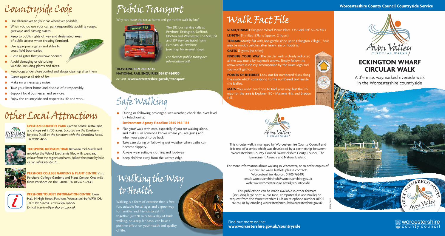
ECKINGTON WHARF CIRCULAR WALK
A 31/2 mile, waymarked riverside walkin the Worcestershire countryside
This circular walk is managed by Worcestershire County Council and it is one of a series which was developed by a partnership between Worcestershire County Council, Warwickshire Couty Council, The
Enviroment Agency and Natural England
For more information about walking in Worcester, or to order copies of our circular walks leaflets please contact:
Worcestershire Hub on: 01905 766493email: [email protected]
web: www.worcestershire.gov.uk/countryside
This publication can be made available in other formats (including large print, audio tape, computer disc and Braille) on
request from the Worcestershire Hub on telephone number 01905 765765 or by emailing [email protected]
5382
0 04
/10
• Use alternatives to your car whenever possible.
• When you do use your car, park responsibly avoiding verges, gateways and passing places.
• Keep to public rights of way and designated areasof public access when crossing farmland.
• Use appropriate gates and stiles to cross field boundaries.
• Close all gates that you have opened.
• Avoid damaging or disturbing wildlife, including plants and trees.
• Keep dogs under close control and always clean up after them.
• Guard against all risk of fire.
• Make no unnecessary noise.
• Take your litter home and dispose of it responsibly.
• Support local businesses and services.
• Enjoy the countryside and respect its life and work.
Find out more online:www.worcestershire.gov.uk/countryside
Worcestershire County Council Countryside Service
Eckington Wharf is a pleasant place to linger for a while, enjoying the view up river towards Bredon Hill, or watching elegant swans glide beneath the arches of the medieval bridge spanning the River Avon. The wharf is also the ideal starting point for a delightful and undemanding walk which takes you alongside the river to Strensham Lock before returning through Eckington village.
The River Avon rises near the English Civil War battlefield of Naseby
(1645) in Northamptonshire, and flows for 112 miles (179km) through Leicestershire,
Warwickshire and Worcestershire before joining the River Severn at Tewkesbury in
Gloucestershire. Its catchment is predominantly rural, but the Avon also
enhances a number of towns, including Stratford-upon-Avon, Evesham and Pershore.
Though the Avon starts life as a small stream, its many tributaries ensure that by the time it reaches Stratford-upon-Avon it is already a substantial river. Flooding is an obvious natural hazard and, for centuries, river flows have been managed to protect people and property from inundation. A large river such as the Avon has a floodplain, a natural mechanism for the storage of excess water, but in recent years floodplains have increasingly been under pressure from developers. It is essential that floodplains are kept as free from development as possible and the Environment Agency advises local planning authorities on this matter. The Agency also provides a flood warning service.
The Avon is navigable from Alveston, near Stratford-upon-Avon, to Tewkesbury. In 1639 it became one of the first English rivers to benefit from a system of locks and weirs to control water levels. Today, it’s a vital link in the Avon Ring, a popular cruising route which also incorporates parts of the River Severn and canals such as the Worcester and Birmingham, Grand Union and Stratford-upon-Avon.
The Avon supports other leisure activities too, such as canoeing, rowing, sailing, angling, birdwatching and walking. Riverside pubs and tea rooms draw visitors, while moorings and caravan sites occur at intervals along its banks. It also supplies water for drinking and irrigation, acts as a natural drainage system and plays a role in the dispersal of treated effluent.
Not only does the Avon have considerable landscape value, it also supports a huge variety of wildlife, including charismatic species such as otter and kingfisher. No fewer than 89 Sites of Special Scientific Interest are scattered across the river’s catchment. Though much of the associated wetland habitat has been destroyed, a project is currently underway to recreate lost habitat wherever possible.
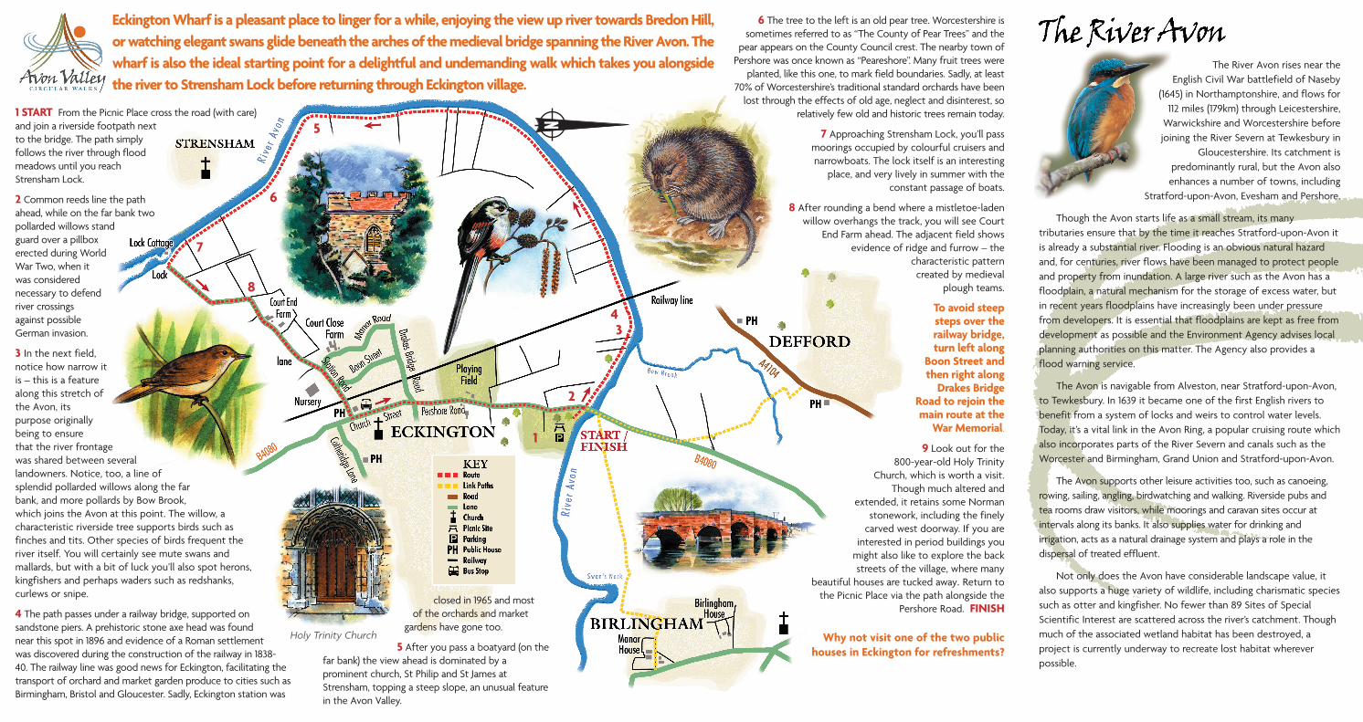
1 START From the Picnic Place cross the road (with care) and join a riverside footpath next to the bridge. The path simply follows the river through flood meadows until you reach Strensham Lock.
2 Common reeds line the path ahead, while on the far bank two pollarded willows stand guard over a pillbox erected during World War Two, when it was considered necessary to defend river crossings against possible German invasion.
3 In the next field, notice how narrow it is – this is a feature along this stretch of the Avon, its purpose originally being to ensure that the river frontage was shared between several landowners. Notice, too, a line of splendid pollarded willows along the far bank, and more pollards by Bow Brook, which joins the Avon at this point. The willow, a characteristic riverside tree supports birds such as finches and tits. Other species of birds frequent the river itself. You will certainly see mute swans and mallards, but with a bit of luck you’ll also spot herons, kingfishers and perhaps waders such as redshanks, curlews or snipe.
4 The path passes under a railway bridge, supported on sandstone piers. A prehistoric stone axe head was found near this spot in 1896 and evidence of a Roman settlement was discovered during the construction of the railway in 1838-40. The railway line was good news for Eckington, facilitating the transport of orchard and market garden produce to cities such as Birmingham, Bristol and Gloucester. Sadly, Eckington station was
6 The tree to the left is an old pear tree. Worcestershire is sometimes referred to as “The County of Pear Trees” and the
pear appears on the County Council crest. The nearby town of Pershore was once known as “Peareshore”. Many fruit trees were
planted, like this one, to mark field boundaries. Sadly, at least 70% of Worcestershire’s traditional standard orchards have been
lost through the effects of old age, neglect and disinterest, so relatively few old and historic trees remain today.
7 Approaching Strensham Lock, you’ll pass moorings occupied by colourful cruisers and narrowboats. The lock itself is an interesting
place, and very lively in summer with the constant passage of boats.
8 After rounding a bend where a mistletoe-laden willow overhangs the track, you will see Court
End Farm ahead. The adjacent field shows evidence of ridge and furrow – the
characteristic pattern created by medieval
plough teams.
To avoid steep steps over the railway bridge, turn left along
Boon Street and then right along
Drakes Bridge Road to rejoin the main route at the
War Memorial.
9 Look out for the 800-year-old Holy Trinity
Church, which is worth a visit. Though much altered and
extended, it retains some Norman stonework, including the finely
carved west doorway. If you are interested in period buildings you
might also like to explore the back streets of the village, where many
beautiful houses are tucked away. Return to the Picnic Place via the path alongside the
Pershore Road. FINISH
Why not visit one of the two public houses in Eckington for refreshments?
Holy Trinity Church
closed in 1965 and most of the orchards and market
gardens have gone too.
5 After you pass a boatyard (on the far bank) the view ahead is dominated by a prominent church, St Philip and St James at Strensham, topping a steep slope, an unusual feature in the Avon Valley.
1
2
34
5
6
7
8