standardization of undersea feature names - gebco.net · nombres de las formas del relieve...
TRANSCRIPT
INTERNATIONAL HYDROGRAPHIC
ORGANIZATION
ORGANIZACION HIDROGRAFICA
INTERNACIONAL
INTERGOVERNMENTAL OCEANOGRAPHIC
COMMISSION
COMISION OCEANOGRAFICA INTERGUBERNAMENTAL
STANDARDIZATION OF UNDERSEA
FEATURE NAMES
GUIDELINES PROPOSAL FORM TERMINOLOGY
English/Spanish Version 3rd Edition, April 2001
Bathymetric Publication No. 6
Published by the INTERNATIONAL HYDROGRAPHIC
BUREAU
NORMALIZACION DE LOS
NOMBRES DE LAS FORMAS DEL RELIEVE SUBMARINO
DIRECTRICES FORMULARIO DE PROPUESTA
TERMINOLOGIA
Versión Inglesa/Española 3a Edición, Abril del 2001
Publicación Batimétrica No. 6
Publicada por el BUREAU HIDROGRAFICO
INTERNACIONAL
MONACO
B-6
INTERNATIONAL HYDROGRAPHIC
ORGANIZATION
ORGANIZACION HIDROGRAFICA
INTERNACIONAL
INTERGOVERNMENTAL OCEANOGRAPHIC
COMMISSION
COMISION OCEANOGRAFICA INTERGUBERNAMENTAL
STANDARDIZATION OF UNDERSEA
FEATURE NAMES
GUIDELINES PROPOSAL FORM TERMINOLOGY
English/Spanish Version 3rd Edition, April 2001
Bathymetric Publication No. 6
Published by the INTERNATIONAL HYDROGRAPHIC
BUREAU
NORMALIZACION DE LOS
NOMBRES DE LAS FORMAS DEL RELIEVE SUBMARINO
DIRECTRICES FORMULARIO DE PROPUESTA
TERMINOLOGIA
Versión Inglesa/Española 3a Edición, Abril del 2001
Publicación Batimétrica No. 6
Publicada por el BUREAU HIDROGRAFICO
INTERNACIONAL
4, quai Antoine 1er BP 445
MC 98011, Monaco cedex Principauté de Monaco Fax: +377 93 10 81 40
E-mail: [email protected] Website-site: www.iho.shom.fr
MONACO
1-i
FOREWORD ________
The Guidelines, the Name Proposal Form and the List of Terms and Definitions contained in this publication have been worked out through collaboration between the "GEBCO Sub-Committee on Undersea Feature Names", appointed by the "Joint IOC/IHO Guiding Committee for GEBCO", and the Working Group on Maritime and Undersea Features of the "United Nations Group of Experts on Geographical Names (UNGEGN)", in accordance with provisions of appropriate resolutions of United Nations Conferences on Geographical Names. This third edition of the English/French version of B-6 supersedes the previous edition published by the IHB in 1993. Other versions of B-6 are also available in English/the following languages: French (2001 Edition); Russian (2002 Edition); Japanese (1991 Edition); and Chinese (1993 Edition). At the request of the "Joint IOC/IHO Guiding Committee for GEBCO", in order to obtain the largest distribution of these Guidelines and to bring the Geographical Names of Undersea Features to a better Standardization, the B-6 is available gratis from the IHB and IOC. (See page 2-6 for addresses).
________
PREFACIO ________ Las directrices, el Formulario de Propuesta de nombres y la Lista de Términos y Definiciones que figuran en esta publicación, han sido elaborados gracias a la colaboración del "Subcomité de la GEBCO sobre los Nombres de las Formas del Relieve Submarino", creado en 1974 por el "Comité Director Mixto COI/OHI de la GEBCO", y el Grupo de Trabajo sobre las Formas Marítimas y del Relieve Submarino del "Grupo de Expertos de las Naciones Unidas sobre los Nombres Geográficos (UNGEGN)", conforme a las disposiciones de las Resoluciones de las Conferencias de las Naciones Unidas sobre los Nombres Geográficos. Esta tercera edición de la versión inglesa/española de la B-6 anula la edición previa publicada por el BHI en 1993. Otras versiones de la B-6 están también disponibles en Inglés combinado con los siguientes idiomas : Francés (Edición 2001); Ruso (Edición 2002); Japonés (Edición 1991); y Chino (Edición 1993). A petición del "Comité Director Mixto COI/OHI de la GEBCO", y con el fin de asegurar la mayor difusión posible de estas directrices y de alcanzar una mejor uniformidad de los nombres geográficos de las formas del relieve submarino, la B-6 está disponible gratuitamente en la OHI y la COI (ver página 2-8 para las direcciones).
_______

1-ii
Page intentionally left blank
Página dejada intencionalmente en blanco
1-iii
CONTENTS ________
CONTENIDO ________
- Foreword Prefacio ..........................................................................................................................................1-i
- Notes on "Standardization of Undersea Feature Names" – Introduction. Notas sobre la "Normalización de los Nombres de las Formas del Relieve Submarino" – Introducción ............................................................................................... 1-v - Guidelines for the "Standardization of Undersea Feature Names" Directrices para la "Normalización de los Nombres de las Formas del Relieve Submarino" .................................................................................................... 2-1 - "Undersea Feature Name Proposal" Form - English version Formulario de "Propuesta de Nombre para una Forma de Relieve submarino" - Versión inglesa (*) ....................................................................................... 2-5 - "Undersea Feature Name Proposal" Form - Spanish version Formulario de "Propuesta de Nombre para una Forma de Relieve Submarino" - Versión española (*) .................................................................................. 2-7 - Names and addresses of national and international authorities to which the "Undersea Feature Name Proposal Form" should be sent for clearance, for any feature located in territorial waters. Nombres y direcciones de las autoridades nacionales e internacionales a las cuales se deberá enviar el "Formulario de Propuesta de Nombre para una Forma de Relieve Submarino" para su aprobación, para toda forma de relieve localizada en las aguas territoriales .................................................................. 2-9 - Terminology - Notes Terminología – Notas .................................................................................................................. 2-16 - Terms and Definitions Términos y Definiciones ........................................................................................................... 2-17 - Spanish aphabetical index of the Spanish terms shown in the list of "Terms and Definitions", with cross-references to the English terms Indice alfabético español de Términos españoles que figuran en la lista anterior de "Términos y Definiciones" y correspondencia con los términos Ingleses .................................................................................................................... 2-31 (*) The "Undersea Feature Name Proposal" Form is also available -- from the IHB -- in the French version. El formulario de "Propuesta de Nombre para una Forma de Relieve Submarino" está disponible
igualmente - en el BHI - en la versión francesa. __________

1-iv
Page intentionally left blank
Página dejada intencionalmente en blanco
1-v
STANDARDIZATION OF UNDERSEA FEATURE NAMES
________
NOTES 1. In recent years, considerable concern has been expressed at the indiscriminate and unregulated naming of undersea features which often get into print in articles submitted to professional journals, or on ocean maps and charts, without any close scrutiny being made concerning their suitability, or even whether the feature had already been discovered and named. In order to remedy this situation and to bring the geographical names of undersea features to a better standardization, the IHO, at its XIIIth I.H. Conference (May 1987) and the IOC, at its 14th Assembly (March 1987) adopted similar motions on this subject, the substance of which is recalled below. i) Marine scientists and other persons in their
country wishing to name undersea features, are strongly encouraged to check their proposals with published Gazetteers of Undersea Feature Names, taking into account the guidelines contained in the IHO-IOC publication B-6 "Standardization of Undersea Feature Names" (including the use of the "Undersea Feature Name Proposal Form" contained therein), and to submit all proposed new names for clearance, either to their appropriate national authority, or, where no such national authority exists, to the IHB or IOC, for consideration by the "GEBCO Sub-Committee on Undersea Feature Names", which may advise on any potentially confusing duplication of names.
ii) Publishers of ocean maps, and editors of
scientific journals, in their country, are invited to require compilers and authors to provide written evidence of such clearance before accepting for publication any maps or scientific articles containing new names for undersea features.
2. At the XIVth Session of the joint IHO-IOC Guiding Committee for GEBCO, in 1993, new Terms of Reference for the Sub-Committee on Undersea Feature Names (SCUFN) were adopted, including the following: i. It is the function of the Sub-Committee to
select those names appropriate for use on GEBCO graphical and digital products, on the IHO small-scale INTernational chart series, and on the IOC regional International Bathymetric Chart series.
NORMALIZACION DE LOS NOMBRES DE LAS FORMAS DEL RELIEVE SUBMARINO
____ NOTAS 1. Durante los últimos años, la designación incontrolada y anárquica de las formas del relieve submarino, que frecuentemente aparecen impresas en artículos publicados en revistas profesionales o en las cartas oceánicas, sin un estudio minucioso para conocer si el nombre es apropiado o si la forma haba sido ya descubierta y bautizada, ha dado lugar a serias preocupaciones. Con el fin de remediar a esta situación y de conseguir una mayor uniformidad de los nombres geográficos de las formas del relieve submarino, la OHI, en su XIIIª Conferencia H.I. (Mayo, 1987), y la COI, en su 14a Asamblea (Marzo, 1987), adoptaron, en este campo, mociones similares, cuya sustancia se recuerda a continuación . i) Se anima firmemente a los especialistas en
ciencias marinas de su país que deseen dar nombres a las formas del relieve submarino, a que comprueben sus propuestas con los Indices publicados de Formas de Relieve Submarino, teniendo en cuenta las directrices contenidas en la publicación de la OHI/COI B-6 "Normalización de los Nombres de las Formas del Relieve Submarino" (incluyendo el empleo del "Formulario de Propuesta de Nombre para una Forma del Relieve Submarino") y a enviar todos los nuevos nombres propuestos para su autorización, ya sea a la autoridad competente de su país o, en su defecto, al BHI o a la COI, para su consideración y estudio por el "Subcomité GEBCO sobre Nombres de las Formas de Relieve", que podrá aconsejar sobre cualquier posible duplicación de nombres confusa.
ii) Se invita a quienes publiquen cartas oceánicas,
así como a los editores de revistas científicas de sus países, a que soliciten a sus compiladores y autores una prueba escrita autorizada antes de aceptar para su publicación cualquier carta o artículo científico conteniendo nombres nuevos para las formas del relieve submarino."
2. En la XIVª Sesión del Comité Director Mixto OHI-COI para GEBCO, en 1993, se adoptaron nuevos Términos de Referencia para el Subcomité sobre Nombres de Formas del Relieve Submarino (SCUFN), incluyendo lo siguiente : i. Es función del Subcomité seleccionar aquellos
nombres que sean apropiados para su uso en productos GEBCO gráficos y digitales, en la serie de Cartas INTernacionales de la OHI a pequeña escala, y en la serie regional de Cartas Batimétricas Internacionales.
1-vi
ii. The Sub-Committee shall: • select undersea feature names on the
basis of: - undersea feature names provided by
national and international organizations concerned with nomenclature;
- names submitted to the Sub-Committee by individuals, agencies and organizations involved in marine research, hydrography, etc.;
- names appearing in scientific journals
or on appropriate charts and maps, with valid supporting evidence.
• define when appropriate the extent of
named features;
• provide advice to individuals and appropriate authorities on the selection of undersea feature names in international waters and, on request, in waters under national jurisdiction;
• encourage the establishment of national boards of geographical names and undersea features, and when such a board does not exist for a given coastal state, co-operate in the naming of seafloor features related to those national waters;
• prepare and maintain international gazetteers and supplements of undersea feature names;
• encourage the use of undersea feature names shown on GEBCO products, on other maps, charts, scientific publications, and documents by promulgating them widely;
• prepare and maintain internationally agreed guidelines for the standardization of undersea feature names and encourage their use;
• review and address the need for revised or additional terms and definitions for submarine topographic features.
• Maintain close liaison with the UN Group of Experts on Geographical Names and international or national authorities concerned with the naming of undersea features.
_________
ii. El Subcomité deberá : • Seleccionar nombres de formas del relieve
basándose en : - nombres de formas del relieve submarino
proporcionados por organizaciones nacionales e internacionales preocupadas por la nomenclatura ;
- nombres sometidos al Subcomité por
individuos, agencias y organizaciones implicadas en la investigación marina, la hidrografía, etc.. ;
- nombres que aparezcan en diarios científicos y en cartas y mapas apropiados, con una evidencia válida como complemento ;
• definir, cuando sea apropiado, la extensión de las formas del relieve nombradas;
• proporcionar asesoramiento a los individuos y las autoridades apropiadas, sobre la selección de nombres de formas del relieve submarino en aguas internacionales y, a la demanda, en aguas bajo jurisdicción nacional ;
• fomentar el establecimiento de comités nacionales de nombres geográficos y de formas del relieve submarino y, cuando un comité similar no exista para un estado costero determinado, cooperar en la atribución de nombres de formas del relieve del fondo marino relacionadas con esas aguas nacionales ;
• preparar y mantener diccionarios geográficos internacionales y suplementos de nombres de formas del relieve submarino ;
• fomentar el uso de nombres de formas del relieve submarino indicados en productos GEBCO, en otros mapas, cartas, publicaciones científicas y documentos, promulgándolos de forma extensa ;
• preparar y mantener directrices convenidas internacionalmente para la normalización de nombres de formas del relieve submarino y fomentar su uso ;
• revisar y tratar sobre la necesidad de términos y definiciones adicionales o revisados para formas del relieve topográfico submarino ;
• mantener una estrecha relación con el Grupo de Expertos de las NN.UU. sobre Nombres Geográficos y con las autoridades internacionales o nacionales implicadas en la atribución de nombres de formas del relieve submarino.
_________

1-vii
Page intentionally left blank
Página dejada intencionalmente en blanco
2-1
GUIDELINES FOR THE STANDARDIZATION OF UNDERSEA
FEATURE NAMES ________
I. GENERAL A. International concern for naming undersea
features is limited to those features entirely or mainly (more than 50%) outside waters under the jurisdiction of states, i.e. outside territorial waters, usually limited to 12 miles from the straight baseline, in agreement with the United Nations Convention on the Law of the Sea.
B. "Undersea feature" is a part of the ocean floor
or seabed that has measurable relief or is delimited by relief.
C. Names used for many years may be accepted
even through they do not conform to normal principles of nomenclature.
D. Names approved by national names authorities
in waters beyond national limits (i.e. international waters) should be accepted by other states if the names have been applied in conformance with internationally accepted principles. Names applied within the territorial limits of a state should be recognized by other states.
E. In the event of a conflict, the persons and
agencies involved should resolve the matter. Where two names have been applied to the same feature, the older name generally should be accepted. Where a single name has been applied to two different features, the feature named first generally should retain the name.
F. Names not in the writing system of the country
applying the names on maps or other documents should be transliterated according to the system adopted by the national authority applying the names.
G. In international programmes, it should be the
policy to use forms of names applied by national authorities having responsibility for the pertinent area.
DIRECTRICES PARA LA NORMALIZACION DE NOMBRES DE FORMAS DEL
RELIEVE SUBMARINO ________
I. GENERALIDADES A. El interés internacional por la denominación
de las formas del relieve submarino se limita a aquellas formas del relieve enteramente o principalmente (más del 50%) externas a las aguas que están bajo la jurisdicción de los estados, es decir fuera de las aguas territoriales, normalmente limitadas a 12 millas a partir de la línea de base recta, de acuerdo con la Convención de las Naciones Unidas sobre la Ley del Mar.
B. Una "forma del relieve submarino" es una
parte del fondo del océano o lecho oceánico que tiene un relieve mensurable o que está delimitada por un relieve.
C. Se pueden aceptar los nombres utilizados desde
hace muchos años, aunque no estén en conformidad con los principios habituales de la nomenclatura.
D. Los nombres aprobados por las autoridades
nacionales competentes en materia de nomenclatura en aguas fuera de los límites nacionales (es decir, en aguas internacionales) deberán ser aceptados por otros Estados, si los nombres se han aplicado en conformidad con los principios internacionalmente aceptados. Los nombres aplicados dentro de los límites territoriales de un Estado deberán ser reconocidos por los demás Estados.
E. En caso de litigio, deberán resolver la cuestión
las personas o entidades más directamente implicadas. Cuando se hayan utilizado dos nombres para la misma forma de relieve, deberá aceptarse generalmente el nombre más antiguo. Cuando se haya utilizado un solo nombre para designar dos formas de relieve distintas, deberá reservarse normalmente el nombre para la forma denominada inicialmente.
F. Los nombres procedentes de un idioma escrito
en caracteres distintos de los del país que va a utilizarlos en mapas u otros documentos deberán ajustarse a las normas de transliteración adoptadas por las autoridades nacionales competentes en materia de nomenclatura.
G. En los programas internacionales, deberá
seguirse la política de utilizar los nombres en la forma empleada por las autoridades nacionales que tengan la responsabilidad de la zona de que se trate.

2-2
H. States may utilize their preferred versions of exonyms.
II. PRINCIPLES FOR NAMING FEATURES A. Specific terms 1. Short and simple terms (or names) are
preferable. 2. The principal concern in naming is to provide
effective, conveniently usable, and appropriate reference; commemoration of persons or ships is a secondary consideration.
3. The first choice of a specific term, where
feasible, should be one associated with a geographical feature; e.g.: Aleutian Ridge, Aleutian Trench, Peru-Chile Trench, Barrow Canyon.
4. Specific terms for other features can be used to
commemorate ships or other vehicles, expeditions or scientific institutes involved in the discovering and/or delineation of the feature, or to honour the memory of famous persons. Where a ship name is used, it should be that of the discoverering ship, or if that has been previously used for a similar feature, it should be the name of the ship verifying the feature, e.g.: San Pablo Seamount, Atlantis II Seamounts.
5. If names of living persons are used (surnames
are preferable), they should be limited to those who have made an outstanding or fundamental contribution to ocean sciences.
6. Groups of like features may be named
collectively for specific categories of historical persons, mythical features, stars, constellations, fish, birds, animals, etc. Examples are as follows:
H. Los Estados podrán utilizar las versiones que prefieran de los nombres extranjeros.
II. PRINCIPIOS PARA LA DENOMINACION
DE LAS FORMAS DEL RELIEVE A. Términos específicos 1. Son preferibles los términos o nombres cortos y
sencillos. 2. El principal objetivo de dar un nombre es
facilitar una referencia eficaz, fácil de usar y adecuada. La conmemoración de personas o barcos debe quedar relegada a un segundo lugar.
3. En primer lugar, y si es posible, se deberá
asociar el término específico a un nombre geográfico de la región; por ejemplo: Cordillera submarina de las Aleutianas, Fosa de las Aleutianas, Fosa de Perú-Chile, Cañón submarino de Barrow.
4. Pueden escogerse términos específicos relativos
a otras formas del relieve para conmemorar barcos u otras naves, expediciones, o instituciones científicas que hayan contribuido al descubrimiento de la forma del relieve, o para honrar la memoria de personajes célebres. Si se utiliza un nombre de barco, deberá utilizarse el del barco descubridor, o si ese nombre se ha dado ya a una forma del relieve parecida, deberá utilizarse el nombre del barco que haya confirmado la forma del relieve en cuestión; por ejemplo: Monte submarino San Pablo, Montes submarinos Atlantis II.
5. Si se utilizan nombres de personas vivas
(preferentemente los apellidos), deberán limitarse a los nombres de personas que hayan aportado una contribución eminente o fundamental a las ciencias oceánicas.
6. A los grupos de formas del relieve parecidas, se
les puede dar un nombre colectivo que designe una categoría específica de personajes históricos, motivos de ficción, astros, constelaciones, peces, aves, animales, etc. He aquí varios ejemplos:
Musicians Seamounts (Montes submarinos de músicos) {
Bach Seamount (Monte submarino Bach) Brahms Seamount (Monte submarino Brahms) Schubert Seamount (Monte submarino Schubert)
Electricians Seamounts
(Montes submarinos de Físicos Electricistas) { Volta Seamount (Monte submarino Volta) Ampere Seamount (Monte submarino Ampère) Galvani Seamount (Monte submarino Galvani)
Ursa Minor Ridge and Trough Province (Provincia de la dorsal y de la depresión
de la Osa Menor) { Suhail Ridge (Dorsal Suhail) Kochab Ridge (Dorsal Kochab) Polaris Trough (Depresión Polaris)
2-3
7. Descriptive names are acceptable, particularly when they refer to distinguishing characteristics (i.e. Hook Ridge, Horseshoe Seamount). However, caution is prudent unless a characteristic shape has been established by definitive topographic exploration.
8. Names of well-known or large features that are
applied to other features should have the same spelling.
9. Specific elements of names should not be
translated from the language of the nation providing the accepted name.
B. Generic Terms 1. Generic terms should be selected from the
following list of definitions to reflect physiographic descriptions of features.
2. Generic terms applied to features appearing on
charts or other products should be in the language of the nation issuing the products. In those cases where terms have achieved international usage in a national form, that form should be retained.
3. It should be recognized that as ocean mapping
continues, features will be discovered for which existing terminology is not adequate. New terms required to describe those features should conform to these Guidelines.
III. PROCEDURES FOR NAMING
FEATURES A. Individuals and agencies applying names to
unnamed features in international waters should adhere to internationally accepted principles and procedures.
B. It is recommended that new proposals should
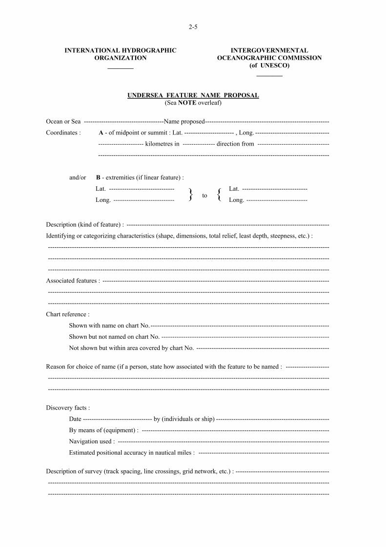
be submitted on an "Undersea Feature Name Proposal” as at pages 2-5/2-6 (English version) or in pages 2-7/2-8 (Spanish version). Proposal forms in French are currently available from the IHB. It is hoped to produce versions in other languages in due course.
C. Prior to the naming of a feature, its character,
extent, and position shall have been established sufficiently for identification. Positions should be given in terms of geographic co-ordinates. If
7. Los nombres descriptivos son aceptables, particularmente cuando se refieren a características distintivas (a saber Hook Ridge, Horseshoe Seamount). Sin embargo, hay que ser prudente a menos que haya sido establecida una forma característica por una exploración topográfica definitiva.
8. Los nombres de las formas del relieve bien
conocidas o de gran extensión que se apliquen a otras formas de relieve deben de tener la misma ortografía.
9. No deberán traducirse los elementos
específicos de nombres, del idioma del país que suministre el nombre aceptado.
B. Términos genéricos 1. Los términos genéricos deberán seleccionarse
de la lista de definiciones que se incluye a continuación para reflejar la descripción fisiográfica de las formas del relieve.
2. Los términos genéricos dados a las formas
del relieve que figuren en los mapas u otros documentos deberán ir en el idioma del país que los publica. En los casos en que hayan adquirido una utilización internacional en terminología nacional, deberá utilizarse esta terminología.
3. Hay que tener en cuenta además que, a
medida que vaya progresando la cartografía oceánica, se irán descubriendo formas del relieve para las cuales no bastará la terminología actual. Los nuevos términos necesarios para describir estas formas del relieve deberán ajustarse a estas directrices.
III. PROCEDIMIENTOS PARA LA DENOMINACION DE FORMAS DEL RELIEVE A. Las personas y los organismos que atribuyan
nombrse a las formas del relieve que carezcan de él, localizadas en aguas internacionales, deberán observar los principios y procedimientos internacionalmente aceptados.
B. Se recomienda que las nuevas propuestas sean
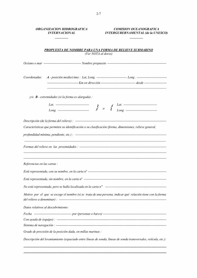
sometidas utilizando el Formulario de "Propuesta de Nombre para una Forma de Relieve Submarino" que figura en las páginas 2-5/2-6 (versión inglesa) o en las páginas 2-7/2-8 (versión española). Los formularios en Francés están actualmente disponibles en el BHI. Se espera producir versiones en otros idiomas, en su momento.
C. Antes de dar nombre a una forma de relieve, se
deberá precisar suficientemente su naturaleza, extensión y situación, para poder indentificarla. La situación deberá indicarse
2-4
it is necessary to refer to a feature before such identification has been established, it is suggested that the reference be by geographic co-ordinates and generic terms with the addition of (PA) -- position approximate -- after the co-ordinates if the position is not adequately established and (?) after the generic term if the nature of the feature is in some doubt.
D. Names and addresses of national authorities are
listed from page 2-9 to 2-15. Where no such authority exists, clearance
should be sought through either IHB or the IOC Secretariat, as indicated on the "Proposal Form".
E. If a national authority decides to change the
name of a feature it named originally, information explaining the reason for the change should be circulated to other authorities. If there is opposition to a name change, the involved authorities should communicate with each other to resolve the question.
F. National authorities approving names of
features should regularly publicize their decisions.
G. National authorities naming features within
their territorial jurisdiction should conform to the principles and procedures stated above.
________
en coordenadas geográficas. Si resultase necesario referirse a una forma del relieve antes de que se haya establecido su identificación, se sugiere que la referencia incluya las coordenadas geográficas, seguidas de la abreviación PA (posición aproximada) si la situación no se ha establecido con precisión, y el término genérico seguido de un signo de interrogación (?) si la naturaleza de la forma de relieve es dudosa.
D. Los nombres y direcciones de las autoridades
nacionales figuran en las páginas 2-9 a 2-15. Cuando no exista dicha autoridad, la
aprobación deberá ser obtenida a través del BHI o de la Secretaría de la COI, como se indica en el "Formulario de Propuesta".
E. Si la autoridad nacional estima necesario
cambiar el nombre de una forma de relieve, a la que hubiera dado denominación originariamente, deberá dar a conocer la razón del cambio a las demás autoridades. Si surgiera una oposición al cambio de nombre, las autoridades interesadas deberán ponerse en contacto para resolver el asunto.
F. Las autoridades nacionales que aprueben los
nombres de las formas del relieve, deberán difundir regularmente sus decisiones.
G. Las autoridades nacionales que den
denominación a las formas del relieve situadas en su jurisdicción territorial, deberán observar los principios y procedimientos anteriormente establecidos.
________
2-5
INTERNATIONAL HYDROGRAPHIC ORGANIZATION
________
INTERGOVERNMENTAL OCEANOGRAPHIC COMMISSION
(of UNESCO) ________
UNDERSEA FEATURE NAME PROPOSAL (Sea NOTE overleaf)
Ocean or Sea -------------------------------------Name proposed---------------------------------------------------------
Coordinates : A - of midpoint or summit : Lat. ----------------------- , Long. ----------------------------------
--------------------- kilometres in --------------- direction from ---------------------------------
----------------------------------------------------------------------------------------------------------
and/or B - extremities (if linear feature) :
Lat. ------------------------------
Long. ---------------------------- } to { Lat. ------------------------------
Long. ----------------------------
Description (kind of feature) : ---------------------------------------------------------------------------------------------
Identifying or categorizing characteristics (shape, dimensions, total relief, least depth, steepness, etc.) :
---------------------------------------------------------------------------------------------------------------------------------
---------------------------------------------------------------------------------------------------------------------------------
---------------------------------------------------------------------------------------------------------------------------------
Associated features : --------------------------------------------------------------------------------------------------------
---------------------------------------------------------------------------------------------------------------------------------
---------------------------------------------------------------------------------------------------------------------------------
Chart reference :
Shown with name on chart No.----------------------------------------------------------------------------------
Shown but not named on chart No. -----------------------------------------------------------------------------
Not shown but within area covered by chart No. -------------------------------------------------------------
Reason for choice of name (if a person, state how associated with the feature to be named : --------------------
---------------------------------------------------------------------------------------------------------------------------------
---------------------------------------------------------------------------------------------------------------------------------
Discovery facts :
Date -------------------------------- by (individuals or ship) ----------------------------------------------------
By means of (equipment) : --------------------------------------------------------------------------------------
Navigation used : -------------------------------------------------------------------------------------------------
Estimated positional accuracy in nautical miles : ------------------------------------------------------------
Description of survey (track spacing, line crossings, grid network, etc.) : -------------------------------------------
---------------------------------------------------------------------------------------------------------------------------------
---------------------------------------------------------------------------------------------------------------------------------
2-6
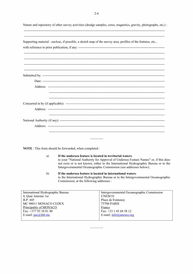
Nature and repository of other survey activities (dredge samples, cores, magnetics, gravity, photographs, etc;) :
---------------------------------------------------------------------------------------------------------------------------------
---------------------------------------------------------------------------------------------------------------------------------
Supporting material : enclose, if possible, a sketch map of the survey area, profiles of the features, etc.,
with reference to prior publication, if any: -------------------------------------------------------------------------------
---------------------------------------------------------------------------------------------------------------------------------
---------------------------------------------------------------------------------------------------------------------------------
---------------------------------------------------------------------------------------------------------------------------------
---------------------------------------------------------------------------------------------------------------------------------
Submitted by: ----------------------------------------------------------------------------------------------------------------
Date: ----------------------------------------------------------------------------------------------------------------
Address: -----------------------------------------------------------------------------------------------------------
----------------------------------------------------------------------------------------------------------
----------------------------------------------------------------------------------------------------------
Concurred in by (if applicable): -------------------------------------------------------------------------------------------
Address: -----------------------------------------------------------------------------------------------------------
----------------------------------------------------------------------------------------------------------
National Authority (if any): ------------------------------------------------------------------------------------------------
Address: -----------------------------------------------------------------------------------------------------------
----------------------------------------------------------------------------------------------------------
________
NOTE : This form should be forwarded, when completed :
a) If the undersea feature is located in territorial waters: to your "National Authority for Approval of Undersea Feature Names" or, if this does not exist or is not known, either to the International Hydrographic Bureau or to the Intergovernmental Oceanographic Commission (see addresses below);
b) If the undersea feature is located in international waters:
to the International Hydrographic Bureau or to the Intergovernmental Oceanographic Commission, at the following addresses :
International Hydrographic Bureau 4, Quai Antoine 1er B.P. 445 MC 98011 MONACO CEDEX Principality of MONACO Fax: +377 93 10 81 40 E-mail: [email protected]
Intergovernmental Oceanographic Commission UNESCO Place de Fontenoy 75700 PARIS France Fax: +33 1 45 68 58 12 E-mail: [email protected]
________
2-7
ORGANIZACION HIDROGRAFICA
INTERNACIONAL ________
COMISION OCEANOGRAFICA INTERGUBERNAMENTAL (de la UNESCO)
________
PROPUESTA DE NOMBRE PARA UNA FORMA DE RELIEVE SUBMARINO (Ver NOTA al dorso)
Océano o mar ----------------------------------- Nombre propuesto -------------------------------------------------------
Coordenadas: A - posición media/cima : Lat, Long. ---------------------------- Long . ----------------------------
----------------------------- Km en dirección -------------------------------- desde --------------------- ---------------------------------------------------------------------------------------------------------------
y/o B - extremidades (si la forma es alargada) : Lat. ------------------------------
Long. ---------------------------- } a { Lat. ------------------------------
Long. ----------------------------
Descripción (de la forma del relieve) : ------------------------------------------------------------------------------------- Características que permiten su identificación o su clasificación (forma, dimensiones, relieve general, profundidad mínima, pendiente, etc.) : ------------------------------------------------------------------------------------- -------------------------------------------------------------------------------------------------------------------------------
Formas del relieve en las proximidades : ---------------------------------------------------------------------------------
-------------------------------------------------------------------------------------------------------------------------------------
-------------------------------------------------------------------------------------------------------------------------------------
Referencias en las cartas : Está representada, con su nombre, en la carta n° ------------------------------------------------------------------------- Está representada, sin nombre, en la carta n° ----------------------------------------------------------------------------- No está representada, pero se halla localizada en la carta n° --------------------------------------------------------- Motivo por el que se escoge el nombre (si se trata de una persona, indicar qué relación tiene con la forma del relieve a denominar) : ---------------------------------------------------------------------------------------------------- Datos relativos al descubrimiento: Fecha ----------------------------------- por (personas o barco) -----------------------------------------------------------
Con ayuda de (equipo) : ------------------------------------------------------------------------------------------------------
Sistema de navegación : ------------------------------------------------------------------------------------------------------- Grado de precisión de la posición dada, en millas marinas : Descripción del levantamiento (espaciado entre líneas de sonda, líneas de sonda transversales, retícula, etc.): -------------------------------------------------------------------------------------------------------------------------------------
-------------------------------------------------------------------------------------------------------------------------------------
2-8
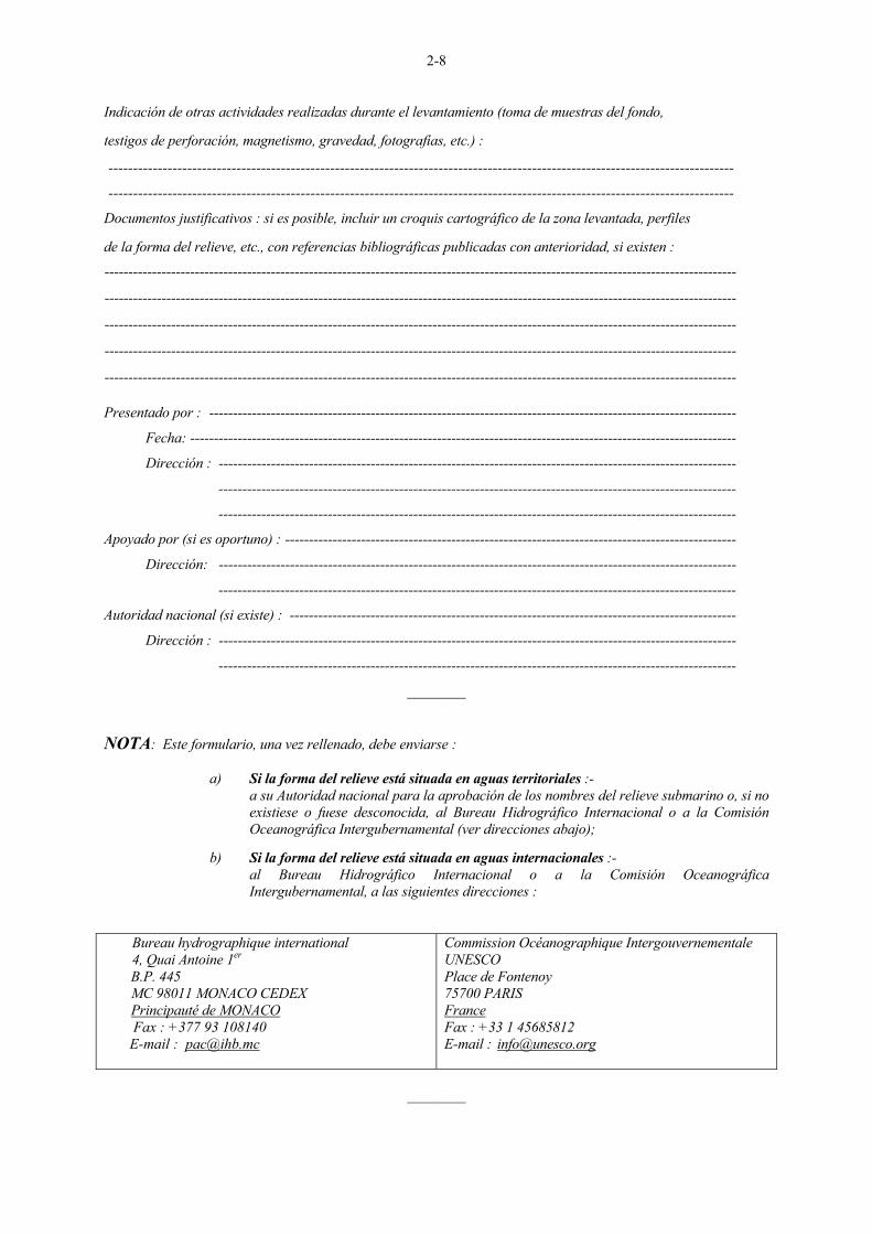
Indicación de otras actividades realizadas durante el levantamiento (toma de muestras del fondo, testigos de perforación, magnetismo, gravedad, fotografías, etc.) : -------------------------------------------------------------------------------------------------------------------------------
-------------------------------------------------------------------------------------------------------------------------------
Documentos justificativos : si es posible, incluir un croquis cartográfico de la zona levantada, perfiles de la forma del relieve, etc., con referencias bibliográficas publicadas con anterioridad, si existen :
-------------------------------------------------------------------------------------------------------------------------------------
-------------------------------------------------------------------------------------------------------------------------------------
-------------------------------------------------------------------------------------------------------------------------------------
-------------------------------------------------------------------------------------------------------------------------------------
------------------------------------------------------------------------------------------------------------------------------------- Presentado por : ---------------------------------------------------------------------------------------------------------------
Fecha: -------------------------------------------------------------------------------------------------------------------
Dirección : -------------------------------------------------------------------------------------------------------------
-------------------------------------------------------------------------------------------------------------
-------------------------------------------------------------------------------------------------------------
Apoyado por (si es oportuno) : -----------------------------------------------------------------------------------------------
Dirección: -------------------------------------------------------------------------------------------------------------
-------------------------------------------------------------------------------------------------------------
Autoridad nacional (si existe) : ----------------------------------------------------------------------------------------------
Dirección : -------------------------------------------------------------------------------------------------------------
-------------------------------------------------------------------------------------------------------------
________
NOTA: Este formulario, una vez rellenado, debe enviarse :
a) Si la forma del relieve está situada en aguas territoriales :- a su Autoridad nacional para la aprobación de los nombres del relieve submarino o, si no
existiese o fuese desconocida, al Bureau Hidrográfico Internacional o a la Comisión Oceanográfica Intergubernamental (ver direcciones abajo);
b) Si la forma del relieve está situada en aguas internacionales :-
al Bureau Hidrográfico Internacional o a la Comisión Oceanográfica Intergubernamental, a las siguientes direcciones :
Bureau hydrographique international 4, Quai Antoine 1er B.P. 445 MC 98011 MONACO CEDEX Principauté de MONACO Fax : +377 93 108140 E-mail : [email protected]
Commission Océanographique Intergouvernementale UNESCO Place de Fontenoy 75700 PARIS France Fax : +33 1 45685812 E-mail : [email protected]
________
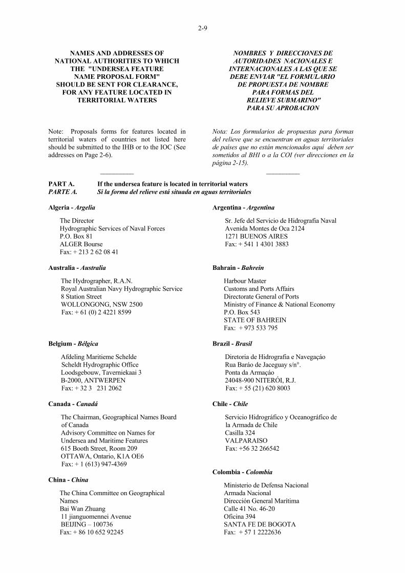
2-9
NAMES AND ADDRESSES OF NATIONAL AUTHORITIES TO WHICH
THE "UNDERSEA FEATURE NAME PROPOSAL FORM"
SHOULD BE SENT FOR CLEARANCE, FOR ANY FEATURE LOCATED IN
TERRITORIAL WATERS Note: Proposals forms for features located in territorial waters of countries not listed here should be submitted to the IHB or to the IOC (See addresses on Page 2-6).
__________
NOMBRES Y DIRECCIONES DE AUTORIDADES NACIONALES E
INTERNACIONALES A LAS QUE SE DEBE ENVIAR "EL FORMULARIO
DE PROPUESTA DE NOMBRE PARA FORMAS DEL
RELIEVE SUBMARINO" PARA SU APROBACION
Nota: Los formularios de propuestas para formas del relieve que se encuentran en aguas territoriales de países que no están mencionados aquí deben ser sometidos al BHI o a la COI (ver direcciones en la página 2-15).
__________
PART A. If the undersea feature is located in territorial waters PARTE A. Si la forma del relieve está situada en aguas territoriales
Algeria - Argelia The Director Hydrographic Services of Naval Forces P.O. Box 81 ALGER Bourse Fax: + 213 2 62 08 41 Australia - Australia The Hydrographer, R.A.N. Royal Australian Navy Hydrographic Service 8 Station Street WOLLONGONG, NSW 2500 Fax: + 61 (0) 2 4221 8599 Belgium - Bélgica Afdeling Maritieme Schelde Scheldt Hydrographic Office Loodsgebouw, Taverniekaai 3 B-2000, ANTWERPEN Fax: + 32 3 231 2062 Canada - Canadá The Chairman, Geographical Names Board of Canada Advisory Committee on Names for Undersea and Maritime Features 615 Booth Street, Room 209 OTTAWA, Ontario, K1A OE6 Fax: + 1 (613) 947-4369 China - China The China Committee on Geographical Names Bai Wan Zhuang 11 jianguomennei Avenue BEIJING – 100736 Fax: + 86 10 652 92245
Argentina - Argentina Sr. Jefe del Servicio de Hidrografia Naval Avenida Montes de Oca 2124 1271 BUENOS AIRES Fax: + 541 1 4301 3883 Bahrain - Bahrein Harbour Master Customs and Ports Affairs Directorate General of Ports Ministry of Finance & National Economy P.O. Box 543 STATE OF BAHREIN Fax: + 973 533 795 Brazil - Brasil Diretoria de Hidrografia e Navegaçáo Rua Baráo de Jaceguay s/n°. Ponta da Armaçáo 24048-900 NITERÓI, R.J. Fax: + 55 (21) 620 8003 Chile - Chile Servicio Hidrográfico y Oceanográfico de la Armada de Chile Casilla 324 VALPARAISO Fax: +56 32 266542 Colombia - Colombia Ministerio de Defensa Nacional Armada Nacional Dirección General Marítima Calle 41 No. 46-20 Oficina 394 SANTA FE DE BOGOTA Fax: + 57 1 2222636
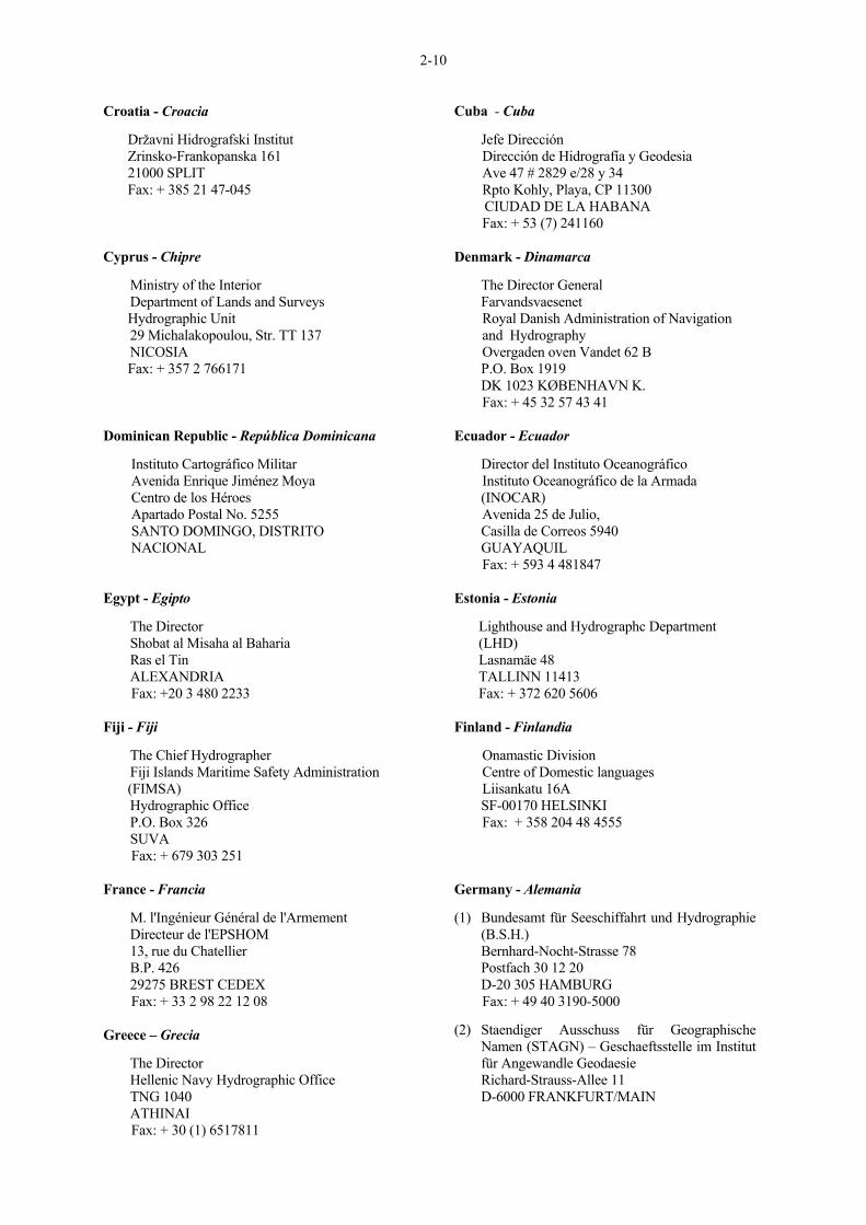
2-10
Croatia - Croacia Državni Hidrografski Institut Zrinsko-Frankopanska 161 21000 SPLIT Fax: + 385 21 47-045 Cyprus - Chipre Ministry of the Interior Department of Lands and Surveys Hydrographic Unit 29 Michalakopoulou, Str. TT 137 NICOSIA Fax: + 357 2 766171 Dominican Republic - República Dominicana Instituto Cartográfico Militar Avenida Enrique Jiménez Moya Centro de los Héroes Apartado Postal No. 5255 SANTO DOMINGO, DISTRITO NACIONAL Egypt - Egipto The Director Shobat al Misaha al Baharia Ras el Tin ALEXANDRIA Fax: +20 3 480 2233 Fiji - Fiji The Chief Hydrographer Fiji Islands Maritime Safety Administration (FIMSA) Hydrographic Office P.O. Box 326 SUVA Fax: + 679 303 251 France - Francia M. l'Ingénieur Général de l'Armement Directeur de l'EPSHOM 13, rue du Chatellier B.P. 426 29275 BREST CEDEX Fax: + 33 2 98 22 12 08 Greece – Grecia The Director Hellenic Navy Hydrographic Office TNG 1040 ATHINAI Fax: + 30 (1) 6517811
Cuba - Cuba Jefe Dirección Dirección de Hidrografía y Geodesia Ave 47 # 2829 e/28 y 34 Rpto Kohly, Playa, CP 11300 CIUDAD DE LA HABANA Fax: + 53 (7) 241160 Denmark - Dinamarca The Director General Farvandsvaesenet Royal Danish Administration of Navigation and Hydrography Overgaden oven Vandet 62 B P.O. Box 1919 DK 1023 KØBENHAVN K. Fax: + 45 32 57 43 41 Ecuador - Ecuador Director del Instituto Oceanográfico Instituto Oceanográfico de la Armada (INOCAR) Avenida 25 de Julio, Casilla de Correos 5940 GUAYAQUIL Fax: + 593 4 481847 Estonia - Estonia Lighthouse and Hydrographc Department (LHD) Lasnamäe 48 TALLINN 11413 Fax: + 372 620 5606 Finland - Finlandia Onamastic Division Centre of Domestic languages Liisankatu 16A SF-00170 HELSINKI Fax: + 358 204 48 4555 Germany - Alemania (1) Bundesamt für Seeschiffahrt und Hydrographie
(B.S.H.) Bernhard-Nocht-Strasse 78 Postfach 30 12 20 D-20 305 HAMBURG Fax: + 49 40 3190-5000 (2) Staendiger Ausschuss für Geographische
Namen (STAGN) – Geschaeftsstelle im Institut für Angewandle Geodaesie
Richard-Strauss-Allee 11 D-6000 FRANKFURT/MAIN
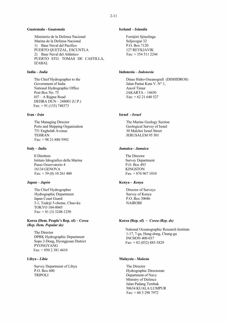
2-11
Guatemala - Guatemala Ministerio de la Defensa Nacional Marina de la Defensa Nacional
1) Base Naval del Pacífico PUERTO QUETZAL, ESCUNTLA 2) Base Naval del Atlántico PUERTO STO. TOMAS DE CASTILLA, IZABAL
India – India The Chief Hydrographer to the Government of India National Hydrographic Office Post Box No. 75 107 – A Rajpur Road DEHRA DUN – 248001 (U.P.) Fax: + 91 (135) 748373 Iran - Irán The Managing Director Ports and Shipping Organization 751 Enghelab Avenue TEHRAN Fax: + 98 21-880 5992 Italy – Italia Il Direttore Istituto Idrografico della Marina Passo Osservatorio 4 16134 GENOVA Fax: + 39 (0) 10 261 400 Japan – Japón The Chief Hydrographer Hydrographic Department Japan Coast Guard 3-1, Tsukiji 5-chome, Chuo-ku TOKYO 104-0045 Fax: + 81 (3) 3248-1250 Korea (Dem. People’s Rep. of) – Corea (Rep. Dem. Popular de) The Director DPRK Hydrographic Department Sopo 2-Dong, Hyongjesan District PYONGYANG Fax: + 850 2 381 4410 Libya - Libia Survey Department of Libya P.O. Box 600 TRIPOLI
Iceland – Islandia Forstjóri Sjóaelinga Seljavegur 32 P.O. Box 7120 127 REYKJAVIK Fax: + 354 511 2244 Indonesia – Indonesia Dinas Hidro-Oseanografi (DISHIDROS) Jalan Pantai Kuta V. N° 1, Ancol Timur JAKARTA – 14430 Fax: + 62 21 640 527 Israel - Israel The Marine Geology Section Geological Survey of Israel 30 Malchei Israel Street JERUSALEM 95 501 Jamaica - Jamaica The Director Survey Department P.O. Box 493 KINGSTON Fax: + 876 967 1010 Kenya - Kenya Director of Surveys Survey of Kenya P.O. Box 30046 NAIROBI Korea (Rep. of) – Corea (Rep. de) National Oceanographic Research Institute 1-17, 7-ga, Hang-dong, Chung-gu INCHON 400-037 Fax: + 82 (032) 885-3829 Malaysia - Malasia The Director Hydrographic Directorate Department of Navy Ministry of Defence Jalan Padang Tembak 50634 KUALA LUMPUR Fax: + 60 3 298 7972
2-12
Mexico – Méjico Sr. Director General de Geografía Instituto Nacional de Estadística, Geografía e Informática (INEGI) Av. Patriotismo No. 711, Torre A, 8° piso Col. San Juan Mixcoac C.P. 03910 MÉXICO, D.F. Fax: + 525 563 99 32 Morocco -Marruecos The Hydrographer Service Hydrographique et Océanographique de la Marine Royale (SDHOMAR) Etat Major de la Marine Royale 1, Rue D’Ifni B.P. 1977 RABAT PRINCIPAL Fax: + 212 7 70 46 07 Netherlands – Holanda Chef der Hydrografie Dienst der Hydrografie Koninklijke Marine 167 Badhuisweg 2597 JN-‘s GRAVENHAGE Fax: +31 70 316 2843 Nigeria – Nigeria The Hydrographer Nigerian Naval Hydrographic Office No. 5 Point Road Apapa LAGOS Fax: + 234 001 587 5715
Monaco (Principality of) - Mónaco (Principado de) Direction des Affaires Maritimes 6, quai Antoine 1er MC 98000 MONACO Fax: + 377 93 153715 Mozambique - Mozambique Instituto Nacional de Hidrografia e Navegaçao Av.Karl Marx No. 153 P.O. Box No. 2089 MAPUTO Fax: + 258 1 430 185 New Zealand –Nueva Zelanda The New Zealand Geographic Board Land Information New Zealand (LINZ) Lambton House 160 Lambton Quay Private Box 5501 WELLINGTON Fax: + 64 (4) 471 6894 Norway - Noruega Statens Kartverk Sjokartverket Norwegian Hydrographic Service P.O. Box 60 N-4001 STAVANGER Fax: + 47 51 85 87 01
Papua-New Guinea – Papua Nueva Guinea The Hydrographer Department of Transport Maritime Transport Division P.O. Box 1489 PORT MORESBY Fax: + 675 320 1205 Philippines - Filipinas Hydrographic and Geodetic Survey Department National Mapping and Resource Information Authority Coast and Geodetic Survey Department 421 Barraca Street, San Nicolas MANILA Fax: + 63 2 242 2090
Peru - Perú Sr. Director Dirección de Hidrografia y Navegación de la Marina Avda. Gamarra No. 500 CHUCUITO - CALLAO 1 Fax: + 51 14 465-2995 Poland - Polonia (1) Biuro Hydrograficzne
Marynarki Wojennej 81-912 GDYNIA Fax: + 48 58 626 36 80
(2) Urzad Rady Ministrow Komisja Ustalania Nazw Miejscowosci i Obiektow Fizjograficznych (Bureau of the Cabinet, Board for determining of the Names of Places and Physiographical Objects) Aleje Ujazdowskie 1/3 00-583 WARSZAWA
2-13
Portugal - Portugal Director-General Instituto Hidrografico Rua das Trinas, 49 1249-093 LISBOA Codex Fax: + 351 21 3914199 Saudi Arabia – Arabia Saudita Ministry of Petroleum and Mineral Resources Aerial Survey Department P.O. Box 247 RIYADH South Africa – Sudáfrica The Hydrographer of the Navy Maritime Headquarters Private Bag XI Tokai 7966 CAPE TOWN Fax: + 27 (021) 787 2228 Sri Lanka - Sri Lanka The Director National Hydrographic Office National Aquatic Resources Research and Development Agency Crow Island, Mattakkuliya COLOMBO 15 Fax: + 941 522 699 Sweden - Suecia (1) Sjökarteavdelningen
Swedish Maritime Administration SE-601 78 NORRKÖPING Fax: + 46 11 13 39 03
Syria - Siria General Directorate of Ports P.O.Box 505 LATTAKIA Fax: + 963 41 475 805 Tonga - Tonga Tonga Defence Services P.O.Box 72 NUKU'ALOFA Fax: + 676 23150
Russia (Federation of) - Rusia (Federación de) The Chief Head Department of Navigation and Oceanography 8, 11 liniya B-34 St. PETERSBURG 199034 Singapore – Singapur The Hydrographer Hydrographic Department Maritime and Port Authority of Singapore 7B, Keppel Road #13-07 Tanjong Pagar Complex SINGAPORE 089055 Fax: + 65 224 8454 Spain – España Sr. Director Instituto Hidrográfico de la Marina Calle Tolosa Latour N° 1 11007 CADIZ Fax: + 34 956 275358 Suriname - Suriname Ministry of Transport, Communication and Tourism Maritime Affairs Cornelis Jonbawstraat No. 2 P.O. Box 888 PARAMARIBO Fax: + 597 4 72940 Sweden - Suecia (2) The Swedish IOC Committee P.O. Box 6711 S-113 85 STOCKHOLM Thailand – Tailandia The Director Hydrographic Department Royal Thai Navy Aroon-amarin Road BANGKOK 10600 Fax: + 66 2 472 1286 Trinidad and Tobago – Trinidad y Tobago Hydrographic Unit Lands and Surveys Division 2B Richmond Street P.O.Box 1104 PORT OF SPAIN Fax: + 1868 625 3013
2-14
Tunisia - Túnez Service Hydrographique et Océanographique (SHO) Armée de Mer Base Navale principale de Bizerte 7011 La Pêcherie BIZERTE Fax: + 216 2 510 777 United Arab Emirates – Emiratos Arabes Unidos Ministry of Communications P.O. Box 900 ABU DHABI Fax: + 971 2 6651 691 United States of America – Estados Unidos de América Executive Secretary U.S. Board on Geographic Names National Imagery and Mapping Agency (NIMA) Department of Defense NIMA Bethesda, Mail Stop D-82. Code TED 4600 Sangamore Road BETHESDA, Maryland MD 20816-5003 Fax: + 1 (301) 227 7649 Venezuela - Venezuela Comandancia General de la Armada Dirección de Hidrografía y Navegación Observatorio "CAGICAL" Apartado Postal No. 6745 - Carmelitas CARACAS Fax: + 58 (2) 483 5878
Turkey – Turquía Seyir, Hidrografi ve Osinografi Dairesi Bakskanligi Çubuklu 81647 ISTANBUL Fax: + 90 (216) 331 05 25 United Kingdom – Reino Unido The Superintendent of Sailing Directions Hydrographic Department Ministry of Defence TAUNTON, Somerset TA1 2DN Fax: + 44 1823 284 077 Uruguay - Uruguay Servicio de Oceanografía, Hidrografía y Meteorología de la Armada Capurro 980 Casilla de Correos 1381 MONTEVIDEO Fax: + 598 4 (2) 39 92 20 Yugoslavia – Yugoslavia Hidrografski Institut Ratne Mornarice 85333 Lepetane TIVAT Fax: + 381 82 672 531
__________

2-15
Page intentionally left blank
Página dejada intencionalmente en blanco
2-16
TERMINOLOGY ________
NOTES (See "FOREWORD", page 1-i)
The List which follows is comprised of terms, that are defined as closely as possible to correspond to their usage in the cited references taken from literature of ocean science, hydrography and exploration. In developing the definitions, it was realized that modern investigations at sea have the advantage of using very advanced instrumentation and technology that enables a more precise description of certain features than was previously possible. There has also been an attempt to limit the usage of precise physical dimensions in the definition of features. In preference, words that indicate relative sizes such as extensive, large, limited and small have been used. The definitions are based almost exclusively on a geomorphological description of the features themselves: implications as to origin and composition have been avoided. They must not be construed as having any legal or political connotation whatsoever. Nor do they necessarily conform to the hydrographic/ navigation usage as appearing in the Hydrographic Dictionary (IHO Special Publication No. 32). It is realized that some named features, such as "cap", "deep" and "swell" have widely accepted longtime usage. No attempt has been made to define them since a suitable description of these particular features is found among the present definitions. The references cited in the following list, originating in the given language, employ usage as presented in these definitions.
________
TERMINOLOGIA ________ NOTAS (véase también el "PREFACIO", página 1-i) La lista que figura a continuación incluye los términos que han sido definidos para que correspondan con la mayor precisión posible a su empleo en las referencias citadas de la literatura científica oceanográfica, hidrográfica y de exploración. Al desarrollar estas definiciones, se ha puesto de manifiesto que las investigaciones marinas modernas presentan la ventaja de utilizar instrumentación y tecnología muy avanzada, permitiendo una descripción de ciertas formas, más precisa de lo que era posible en el pasado. También se ha intentado limitar el empleo de dimensiones físicas precisas en la definición de las formas. Preferentemente se han empleado palabras que indican dimensiones relativas, tales como extenso, grande, limitado y pequeño. Las definiciones se basan casi exclusivamente en una descripción geomorfológica de las proprias formas : se han evitado las implicaciones en cuanto al origen o la composición. No se debe deducir que tengan alguna connotación jurídica o política o de otro tipo. Las definiciones tampoco se ajustan necesariamente al uso hidrográfico o a la navegación, según se define en el Diccionario Hidrográfico (Publicación Especial de la OHI n° 32). Se ha observado que muchas formas del relieve que ya tienen denominación, tales como "cap", "deep" y "swell", tienen un uso que data desde hace mucho tiempo y es ampliamente aceptado. No se ha intentado definir esos términos, puesto que se ha encontrado la descripción de estas formas particulares del relieve en las presentes definiciones. Las "referencias" citadas en la siguiente lista, que se originan en el idioma dado, se emplean tal y como están presentadas en estas definiciones.
__________
2-17
UNDERSEA FEATURE TERMS AND DEFINITIONS
Note : Terms written in capitals in the definitions, are themselves defined elsewhere in the list.
________
ABYSSAL HILLS A tract of small elevations on the deep seafloor. Ref.: MENARD, H.W. 1964, Marine Geology of the
Pacific, McGraw-Hill, New York, 271 pp.
TERMINOS Y DEFINICIONES DE LAS FORMAS DEL RELIEVE SUBMARINO
Nota : Los términos escritos en mayúsculas en las definiciones, están definidos en alguna parte de la lista.
_________
COLINAS ABISALES Conjunto de pequeñas elevaciones de los fondos abisales. Ref.: Campañas Oceanográficas de Geología Marina
en el Estrecho de Gibraltar, 1983. Trab. Inst. Esp. Oceanogr. NE 43, 136 p.
CANALS, M. 1985. Referencia citada. LUGO HUBP, J. 1989. Diccionario Geomorfológico. Instituto de Geografía; UNAM, México, 337 p. LOPEZ RAMOS, E. 1981, Geología de México, t.II, 20 Ed., 446 p. (publicado por el autor).
ABYSSAL PLAIN An extensive, flat, gently sloping or nearly level region at abyssal depths. e.g.: Biscay Abyssal Plain Ref.: HEEZEN, B.C. and LAUGHTON, A.S., 1963,
"Abyssal Plains", in M.N. Hill (ed.), The Sea, Vol. 3, pp 312-364, John Wiley, New York.
LLANURA ABISAL Zona abisal llana, extensa, subhorizontal o de escasa pendiente. Ej. : Llanura abisal del Mar Mediterráneo. Ref.: REY, J. MEDIALDEA, T. 1989. Los sedimentos cuaternarios superficiales del margen continental español. Publ. Espec. Inst. Esp. Oceanogr. NE 3, 29p. FERRARIS, F. y ALDUNATE, R. 1979. Análisis morfoestructural de la zona del Paso Drake. Revista Geol. De Chile. NE 7, pp. 3-11. VALLE, G.V. y OVIEDO, D.A., 1976. Notas sobre procedimientos para identificarel origen de los cuerpos arenosos. Instituto Mejicano del Petróleo. Edición especial. Méjico.
APRON A gently dipping surface, underlain primarily by sediment, at the base of any steeper SLOPE. e.g.: West Aves Apron
FALDA Superficie de débil pendiente, de génesis esencialmente sedimentaria, en la base de una pendiente más pronunciada. Ref. : Campañas Oceanográficas de Geología Marina en el Estrecho de Gibraltar. Trab. Inst. Esp. Oceanogr. 1983. NE 43, 136 p.
ARCHIPELAGIC APRON A gentle SLOPE with a generally smooth surface of the sea floor, characteristically found around groups of islands or SEAMOUNTS.
FALDA ARCHIPELAGICA Pendiente suave del fondo marino con una superficie generalmente lisa que se encuentra en la parte baja o inferior de grupos de islas o montes submarinos.
2-18
e.g.: Marquesas Archipelagic Apron Ref.: MENARD, H.W. 1956. Archipelagic Aprons,
Bull. Amer. Assoc. petroleum Geol., V.40, pp 2195-2210.
BANK An elevation of the sea floor, over which the depth of water is relatively shallow, but sufficient for safe surface navigation. e.g.: Georges Bank Ref.: "... that but this blow Might be the be-all and end-all here, But here, upon this bank and shoal of time. We'd jump the life to come." Shakespeare, W., 1608, Macbeth, I, vii.
BANCO Elevación del fondo, de gran extensión, sobre la cual la profundidad es relativamente somera pero normalmente suficiente para una navegación segura en superfície. Ejem.: Banco de Majuan, Banco de Xauen. Ref.: Características y morfología geofísica de la parte centro-oriental del Estrecho de Gibraltar. 1988. Monog. Inst. Esp. Oceanogr. NE2, 47 p. SAMALEA, J.A., 1949. Exploración del Banco del Xauen. Bol. Inst. Esp. de Oceanogr. Madrid. NE 16, pp 1-7
BASIN A depression, in the sea floor, more or less equidimensional in plan and of variable extent. e.g.: Brazil Basin Ref.: MAURY, M.F. 1854. Bathymetrical Map of
theNorth Atlantic Basin, with contour lines drawn in at 1000, 2000, 3000 and 4000 fathoms.
CUENCA Una depresión, en el fondo marino, de extensión variable, más o menos equidimensional en planta. Ejem.: Cuenca de Chile; Cuenca Balear. Ref.: FUENZALIDA VILLEGAS, H. 1965. El mar y sus recursos. En: Geografía Económica de Chile. Texto Refundido. CORFO. Santiago, pp 268- 271. MPODOZIS, C., 1980. Islas Ildefonso. Tierra del Fuego : depósitos de ante arco del sistema Magallánico. Rev. Geol. de Chile. NE 11, pp 91- 99. ROA MORALES, P. y OTTMANN, F., 1961. Primer Estudio Topográfico y Geológico del Golfo de Cariaco. Bol. Inst. Oceanogr. Univ. Oriente. Venezuela. v.1, NE 1, pp 5-20. PALANQUES, A. y MALDONADO, A. 984. Sedimentología de las turbiditas de los sistemas deposicionales de la fosa de Valencia. I Congreso Español de Geología. T.I., pp 353-360.
BORDERLAND A region adjacent to a continent, normally occupied by or bordering a SHELF and sometimes emerging as islands, that is irregular or blocky in plan or profile, with depths well in excess of those typical of a SHELF. e.g.: California Borderland
BORDE CONTINENTAL Región adyacente a un continente, normalmente ocupada por o bordeando una plataforma continental, y que a veces emerge en forma de islas, que es irregular o un obstáculo en el plano o de perfil, con profundidades que exceden en mucho a las que son típicas de una plataforma continental.
2-19
Ref.: SHEPARD, F.P., and EMERY, K.O. 1941. Submarine Topography off the California Coast: Canyons and Tectonic Interpretations, Geol. Soc. America Spec. Paper 31, 171 pp.
Ref.: SANDOVAL, H., COMINGUEZ, A.H. y DEL CASTILLO, L., 1976-1977. Modelo geodinámico de la estructura del Golfo de Méjico. Anales del Institut de Geofísica. V.22-23, pp 153- 165.
CALDERA A collapsed or partially-collapsed SEAMOUNT, commonly of annular shape. e.g.: Albacora Caldera (off Portugal)
CALDERA MONTE SUBMARINO derrumbado, o parcialmente derrumbado, comúnmente de forma anular.
CANYON A relatively narrow, deep depression with steep sides, the bottom of which generally deepens continuously, developed characteristically on some continental SLOPES. e.g.: Hudson Canyon Ref.: SHEPARD, F.P. and DILL, R.F., 1966. Submarine Canyons and other Sea Valleys, Rand McNally and Co., Chicago, 381 pp.
CAÑON SUBMARINO Depresión profunda, relativamente angosta y de paredes abruptas, cuyo fondo generalmente es se hace más profundo de forma continua. Es característica de algunos TALUDES continentales. Ej.: Cañón de Blanes. Ref.: CANALS, M. 1985. Estructura sedimentaria y evolución morfológica del talud y el glacís continentales del Golfo de León : fenómenos de desestabilización de la cobertura sedimentaria pliocuaternaria. Tesis Doctoral. Universidad de Barcelona. Facultad de Geología. 618 p. GONZALES, S.A., 1978. Anomalías gravimétricas y magnéticas de la Bahía de Todos los Santos. Resúmenes del VI Cong. Nacional de Oceanografía. Ensenada; B.C.N., Méjico. MORDOJOVIC, C. 1976. La plataforma continental de Chile entre Constitución y Guafo. Primer Cong. Geol. Chileno Santiago. V.3, pp 13-22.
CONE (See FAN)
CONO (ver CONO DE DEYECCION, ABANICO)
CONTINENTAL MARGIN The zone, generally consisting of SHELF, SLOPE and CONTINENTAL RISE, separating the continent from the deep sea floor or ABYSSAL PLAIN. Occasionally a TRENCH may be present in place of a CONTINENTAL RISE. e.g.: MENARD, H.W., 1964, op. cit.
MARGEN CONTINENTAL Zona de separación, consistiendo generalmente en una PLATAFORMA, una PENDIENTE y una EMERSION CONTINENTAL, que separa el continente de la PLANICIE ABISAL o el fondo oceánico profundo. Ocasionalmente puede haber una FOSA OCEANICA en lugar de una EMERSION CONTINENTAL. Ej.: Margen continental de la Península Ibérica. Ref.: BAKER, P., 1971. Arcos de islas volcánicas, revista de Geofísica. V.30, pp 161-178.
2-20
CALDERON, R.G., COUCH, R.W. y NESS, G., 1978. Estudio geofísico del margen continental oeste de Méjico. Actividades de la Secretaría de la Marina en investigación oceanográfica. Méjico, pp 3-11. REY, J. y MEDIALDEA, T., 1989. Referencia citada. DIAZ DEL RIO, V. 1989. Morfología, formaciones superficiales y evolución reciente del margen continental en la región del cabo de Palos. (entre cabo Tiñoso y el cabo Cervera), SE, de la península Ibérica. Tesis Doctoral. Universidad Complutense. Facultad de Geología. Madrid, 358 p.
CONTINENTAL RISE A gentle slope rising from the oceanic depths towards the foot of a continental SLOPE. Ref.: HEEZEN, B.C., THARP, M. and EWING, M.
1959. The Floors of the Oceans, 1, The North Atlantic, Geol. Soc. Am. Spec., Paper 65, 113 pp.
FALDA CONTINENTAL Suave pendiente que asciende desde las profundidades oceánicas hasta la base de un talud continental. Ej.: Ascenso continental Catalán. Ref.: IGME. 1968-1969. Mapa geológico de la plataforma continental española y zonas adyacentes. Tortosa -Tarragona. 41-42. Centro de Publicaciones del Ministerio de Industria y Energía. Madrid. CANALS, M., 1985. Referencia citada. REY, J. y MEDIALDEA, T. 1989. Referencia citada. AGUAYO, C.J.E. “Origen y Distribución de sedimentos en el Golfo de California". Rev. Inst. Mex. del Petróleo. Vol. XIII, N1 3 . (1981).
CONTINENTAL SHELF (See SHELF)
PLATAFORMA CONTINENTAL (ver PLATAFORMA)
ESCARPMENT An elongated, characteristically linear, steep slope separating horizontal or gently sloping sectors of the sea floor in non-SHELF areas. Also abbreviated to SCARP. e.g.: Mendocino Escarpment Ref.: MENARD, H.W. and DIETZ, R.S., 1952.
Mendocino Submarine Escarpment Journ. Geol., V.60, pp 266-278.
ESCARPE Pendiente submarina, característicamente lineal, muy abrupta y alargada, que divide zonas llanas o suavemente pendientes del fondo marino en zonas que no son PLATAFORMAS. Se abrevia también como SCARP. Ej.: Escarpe de Falla, Escarpe Emile Baudot. Ref.: MORDOJOIC, C., 1976. Referencia citada. SANDOVAL, H. 1976-1977. Referencia citada. REY, J. y SANZ, J.L., 1982. Estudio Geológico Submarino del Litoral Cantábrico con Sonar de Barrido Lateral. Bol. Inst. Esp. Oceanogr., t.7, Parte 1, NE 338, pp 87-96.
2-21
IGME. 1979. Mapa geológico de la plataforma continental española y zonas adyacentes. Almería-Garrucha, Chella- Los Genoveses. Servicio de Publicaciones del Ministerio de Industria y Energía. Madrid. MALDONADO, A. y CANALS M., 1982. El margen continental sur-balear : un modelo deposicional reciente sobre un margen de tipo pasivo. Acta Geológica Hispánica. T.17, 4, pp 241-254.
FAN A relatively smooth, fan-like, depositional feature normally sloping away from the outer termination of a CANYON or canyon system. Also called CONE. e.g.: Delgada Fan Ref.: ERICSON, D.B., EWING, M., and HEEZEN,
B.C., 1951. "Deep Sea Sands and Submarine Canyons", Bull. Geol. Soc. Amer., Vol. 62, pp 961-966.
ABANICO SUBMARINO Cuerpo sedimentario en abanico, de contornos relativamente suaves, extendido en declive a partir de la desembocadura de un cañón submarino o sistema de cañones submarinos. Denominado también CONO. Ej.: Abanico submarino de Valencia. Ref.: PALANQUES, A., 1984. La fosa de Valencia un sistema deposicional profundo alimentado por aportes longitudinales y transversales. Tesis de licenciatura. Universidad de Barcelona. Facultad de Geología, 105 p. MPODOZIS, C., 1980. Referencia citada. VALLE, G.V. y OVIEDO, D.A., 1976. Referencia citada. MALDONADO, A., 1984. Influencia de los procesos geológicos de larga duración a catastróficos sobre la morfoestratigrafía del margen continental : ensayo genético. I. Congreso Español de Geología. T. V, pp 35-52.
FRACTURE ZONE An extensive linear zone of irregular topography, mountainous or faulted, characterized by steep-sided or asymmetrical RIDGES, clefts, TROUGHS or ESCARPMENTS. e.g.: Murray Fracture Zone Ref.: MENARD, H.W., 1964, op.cit
ZONA DE FRACTURA Vasta zona linear de topografía irregular, montañosa o con fallas, caracterizada por CRESTAS abruptas o asimétricas, grietas, DEPRESIONES o ESCARPES. Ej.: Zona de fractura, Shackleton. Ref.: PAYO SUBIZA, G., 1970. Formación y movimientos de la corteza océanica. Una nueva era, la de las Ciencias de la Tierra, Revista de Geofísica, V.29, pp 101-105. FERRARIS, F. y ALDUNATE, R., 1979. Referencia citada.
GAP (See PASSAGE)
BRECHA (Ver PASO)
2-22
GUYOT A SEAMOUNT having a comparatively smooth flat top. Also called TABLEMOUNT. See also SEAMOUNT. e.g.: Welker Guyot Ref.: HESS, H.H. (1946), Drowned ancient islands of
the Pacific Basin, Am. Jour. Sci., Vol. 244, pp 772-791.
HAMILTON, E.L. (1956), Sunken Islands of the Mid-Pacific Mountains, G.S.A., Memoir No. 64,
97 pp.
GUYOT MONTE SUBMARINO cuya cima es relativamente plana y de suave relieve. También denominada MESETA SUBMARINA. Ver también MONTE SUBMARINO. Ref.: DAÑOBEITIA, J.J., 1988. Reconocimiento geofísico de estructuras submarinas situadas al norte y sur del Archipiélago Canario. Rev. Soc. Geol. España. V.1 (1- 2), pp 143-155. RÜEGG, W., 1962. Referencia citada.
HILL(S) An isolated (or group of) elevation(s), smaller than a SEAMOUNT. See also ABYSSAL HILLS and KNOLL. e.g.: Nukak Hill (Caribbean Sea)
COLINA(S) Elevación o grupo de elevaciones aisladas, menores que un MONTE SUBMARINO. Ver también COLINAS ABISALES y COLINA. Ref.: MELNIK, V.I. y ZERMETSKI, B.F., 1969. Nuevos datos sobre la geología del Golfo de Méjico y el Mar Caribe. Acad. Ciencias Cuba. Serie Oceanológica, NE 5, pp 3-12. MALDONADO, A. y CANALS, M. 1982. Referencia citada. CANALS, M., 1985. Referencia citada.
HOLE A small local depression, often steep sided, in the sea floor. e.g.: Tenza Hole (Caribbean Sea)
HOYO Pequeña depresión local, a menudo escarpada en los lados, en el fondo marino. Ref.: GUEVARA, V., P.I.. Foraminíderos del Hoyo de Bonaire, Mar Caribe. Estación de Investigaciones Marinas de Margarita, Fundación La Salle de Ciencias Naturales. Venezuela. Contribución NE 85, pp 87-94.
KNOLL An elevation somewhat smaller than a SEAMOUNT and of rounded profile, characteristically isolated or as a cluster on the sea floor. See also HILL(S). e.g.: Cantabria Knoll.
Ref.: MENARD, H.W., 1964, op.cit
LOMA SUBMARINA Elevación algo menor que un MONTE SUBMARINO y de forma redondeada, característicamente aislada o como un grupo en el fondo marino. Ver también COLINA(S). Ref.: MALDONADO, A. y CANALS M., 1982. Referencia citada.
LEVEE A depositional natural embankment bordering a CANYON, VALLEY or SEACHANNEL on the ocean floor. Ref.: BUFFINGTON, E.C., 1952. Submarine "Natural
Levees". Journ. Geol. V.60, pp 473-479.
BORDO Terraplén deposicional que bordea un CAÑON, VALLE o CANAL SUBMARINO. Ref.: CANALS, 1985. Referencia citada.
2-23
MEDIAN VALLEY The axial depression of the MID-OCEANIC RIDGE system. Ref.: WISEMAN, J.D.H. and SEWELL R.B.S., 1937. The Floor of the Arabian Sea. The Geological
Magazine, V.74, pp 219-230.
VALLE AXIAL Depresión axial del sistema de DORSALES MEDIO-OCEÁNICAS. Ref.: PAYO SUBIA, G., 1970. Referencia citada.
MID-OCEANIC RIDGE (See RIDGE (c) and RISE (b))
DORSAL MEDIO-OCÉANICO (Ver DORSAL (c) y EMERSION (b))
MOAT An annular depression that may not be continuous, located at the base of many SEAMOUNTS, oceanic islands and other isolated elevations. e.g.: Hawaiian Moat. Ref.: VENING MEINESZ, F.A., 1948. Gravity Expeditions at Sea, V.4, Netherlands Geod. Comm., Delft.
FOSO Una depresión anular, que puede ser contínua o no, situada en la base de muchos MONTES SUBMARINOS, islas u otros promontorios aislados.
PASSAGE A narrow break in a RIDGE or a RISE. Also called GAP. e.g.: Theta Gap Ref.: HEEZEN, B.C., THARP, M., and EWING, M. 1959, op.cit.
PASO Grieta estrecha en un DORSAL o EMERSION. También denominado BRECHA.
PEAK A prominent elevation either pointed or of a very limited extent across the summit. e.g. Confederation Peak.
PICO Elevación notable terminada en punta o de cima muy estrecha. Ref.: RÜEGG, W., 1962. Rasgos morfológicos- geológicos intramarinos y sus contrapartes en el suelo continental Peruano, Bol. Soc. Geol. del Perú, v.38, pp 7-142. SERRA RAVENTOS, J., MALDONADO, A., y RIBA, O., 1982. Caracterización del margen continental de Calaluña y Baleares. Acta Geológica Hispánica. Homenaje a LLuis Solé i Sabaris. T.14, pp 491-504.
PINNACLE Any high tower or spire-shaped pillar of rock, or coral, alone or cresting a summit. e.g.: Gardner Pinnacles. Ref.: SHOR, GG., 1959, Reflection Studies in the eastern equatorial Pacific, Deep-sea Research, V.5, pp. 283-289
PINACULO Cualquier bloque de roca o de coral en forma de pilar o de punta, aislado o coronando una cima. Ref.: MALDONADO, A. y CANALS, M. 1982. Referencia citada.
2-24
PALOMO, C., ACOSTA, J., HERRANZ, P., SANZ, J.L. y SAN GIL, C., 1983. Características geomorfológicas en la parte occidental del Estrecho de Gibraltar. En Campañas Oceanográficas de Geología Marina en el Estrecho de Gibraltar. Trab. Inst. Esp. Oceanogr., NE 43, pp 51-73.
PLATEAU A flat or nearly flat elevation of considerable areal extent, dropping off abruptly on one or more sides. e.g.: Blake Plateau. Ref.: AGASSIZ, A., 1988. Three Cruises of the Blake.
Bull. Museum Comp. Zool., Harvard Univ., V.14 and 15. (Note however that Agassiz called what is now the "Blake Plateau" the "Pourtales Plateau").
MESETA SUBMARINA Zona llana o casi llana de extensión considerable, con una brusca ruptura de pendiente por uno o más lados. Ref.: REY, J. y MEDIALDEA, T., 1989. Referencia citada. SANZ, J.L. y PALOMO, C., 1983. Características morfológicas del umbral del Estrecho de Gibraltar. En campañas Oceanográficas de Geología Marina en el Estrecho de Gibraltar. Trab. Inst. Esp. Oceanogr., NE 43, pp 13-16.
PROMONTORY A major SPUR-like protrusion of the continental SLOPE extending to the deep seafloor. Characteristically, the crest deepens seaward. e.g.: Estremadura Promontory (off Portugal)
PROMONTORIO Una protuberancia en forma de ESPOLON de la PENDIENTE continental que se extiende hasta el fondo marino profundo. Característicamente, la cresta se hace más profunda en el lado del mar.
PROVINCE A region identifiable by a number of shared physiographic characteristics that are markedly in contrast with those in the surrounding areas. e.g.: Gulf of Alaska Seamount Province Ref.: HEEZEN, B.C., THARP, M., and EWING, M., 1959. -- op. cit.
PROVINCIA FISIOGRAFICA Región identificable por un conjunto de rasgos fisiográficos semejantes, cuyas características contrastan marcadamente con las de las zonas circundantes.
REEF A mass of rock or other indurated material lying at or near the sea surface that may constitute a hazard to surface navigation. e.g.: Great Barrier Reef Ref.: DARWIN, C., 1842. The Structure and
Distribution of Coral Reefs, Smith, Elder and Co., London, 214 pp.
ARRECIFE Rocas que emergen de la superficie del mar o que se encuentran a muy poca profundidad y que pueden constituir un peligro para la navegación de superficie. Ref.: CASAL, P.S., 1946. El litoral argentino y las islas. En : Geografía de la República Argentina, GAEA, t.III, Buenos Aires, pp. 199-356.
2-25
RIDGE (Several meanings) (a) An elongated narrow elevation of varying
complexity having steep sides. e.g.: Wyville- Thomson Ridge. Ref.: The term appears on the bathymetric maps by Sir John Murray which accompany the Challenger Report, Summary of results, Part I, published in 1895. (b) An elongated narrow elevation, often
separating ocean BASINS. e.g.: Walvis Ridge. Ref.: SCHOTT, G., 1942. Geographie des Atlantischen Ozeans, Hamburg, C. Boysen, 438 pp. (c) The linked major mid-oceanic mountain
systems of global extent. Also called MID-OCEANIC RIDGE.
e.g.: Mid-Atlantic Ridge.
CORDILLERA SUBMARINA DORSAL (Varios significados) a) Elevación larga y angosta de complejidad variable, con flancos escarpados. Ref.: MELNIK, V.I. y ZERNETSKI, B.F., 1969. Referencia citada. PAYO SUBIZA, G., 1970. Referencia citada. Campañas Oceanográficas de Geología Marina en el Estrecho de Gibraltar, 1983. Referencia citada. IGME. 1979. Referencia citada. b) Elevación larga y angosta que frecuentemente separa cuencas oceánicas. Ej.: Dorsal de Menorca; Dorsal Canaria.
Ref.: BRAVO CRUZ, M.C. y UDIAS, A., 1973 Referencia citada.. DAÑOBEITIA, J.J., 1988. Referencia citada. MALDONADO, A.y CANALS, M., 1982, Referencia citada. c) El principal sistema montañoso oceánico de
extensión mundial. (También llamada CORDILLERA CENTRO-OCEÁNICA).
Ej.: Cordillera submarina Meso-Atlántica. Ref.: LOPEZ-RAMOS, E., 1981. Referencia citada.
RISE (Several meanings) (a) A broad elevation that rises gently and
generally smoothly from the sea floor. e.g.: Argentine Rise. Ref.: MAURY (ibid) mapped the "Dolphin Rise", which
later was found by "Challenger" to be the Mid-Atlantic Ridge.
(b) The linked major mid-oceanic mountain
systems of global extent. Also called MID-OCEANIC RIDGES.
e.g.: East Pacific Rise. Ref.: MENARD, H.W., 1960, East Pacific Rise,
Science, Vol. 132, pp 1737-1746.
ELEVACION OCEANICA (Varios significados) a) Amplia elevación del fondo oceánico que se alza de forma regular y gradual en la mayoría de los casos. Ej. : Elevación del Pacífico Este o de la CORDILLERA CENTRO-OCEANICA b) Los principales sistemas montañosos centro- oceánicos de extensión mundial. Llamados también DORSALES CENTRO- OCEANICOS.
SADDLE A broad pass or col, resembling in shape a riding saddle, in a RIDGE or between contiguous elevations. e.g.: Montebello Saddle
SILLA Paso o collado ancho, que se parece en cuanto a la forma a una silla de montar, en un DORSAL o entre elevaciones contiguas.
SCARP (See ESCARPMENT)
ESCARPA
2-26
SEA VALLEY (See VALLEY)
VALLE SUBMARINO (ver VALLE)
SEACHANNEL A continuously sloping elongated discrete depression found in FANS or ABYSSAL PLAINS and customarily bordered by LEVEES on one or both sides. e.g.: Moresby Seachannel
CANAL SUBMARINO Depresión alargada de pendiente contínua, frecuente en abanicos y planicies abisales, generalmente flanqueadas por bordes en ambos o en uno de sus lados. Ej. : Canal Submarino de Valencia. Ref. : MALDONADO, A., RUIZ-ORTIZ, P., 1982. Modelos de sedimentación turbidítica antiguos y modernos: la formación Cerrajón (Cretácico Interior) ; las Cordilleras Béticas y los abanicos submarinos del Mediterráneo Noroccidental. Cuadernos de Geología Ibérica. V.8, pp. 499-525. IGME, 1989. Mapa Geológico de la Plataforma Continental Española y zonas adyacentes. Barcelona. Escala 1 :200.000. Servicio de Publicaciones del Ministerio de Industria y Energía. Madrid. CARABALLO, M.,L.F., 1973. Estudio fisiográfico, sedimentológico y geología histórica de la Ensenada Grande del Obispo (Estado Sucre, Venezuela), Bol. Inst. Oceanogr. Uni. Oriente, Venezuela, V.12, NE 2, pp. 29-77.
SEAMOUNT(S) A discrete (or group of) large isolated elevation(s), greater than 1,000 m in relief above the sea floor, characteristically of conical form. See also GUYOT. e.g.: New England Seamounts, Emperor Seamounts. Ref.: MURRAY, H.W., 1941. Submarine Mountains
in the Gulf of Alaska, Bull. Geol. Soc. Amer., V.52, pp 333-362.
MONTE SUBMARINO Elevación o grupo de elevaciones anchas aisladas, mayores de 1.000 m en relieve por encima del fondo marino, característicamente de forma cónica. Ver también GUYOT. Ej.: Monte submarino de los Genoveses. Ref. : CERDA D’AMICO, R., 1977. Exploratoria con espinelles en los montes submarines situados entre Valparaíso y el Archipiélago de Juan Fernández, Ciencia y Tecnología del Mar. CONA. V.3, pp. 3-8. EGME. 1979. Referencia citada.
2-27
SEAMOUNT CHAIN A linear or arcuate alignment of discrete SEAMOUNTS, with their bases clearly separated. See also SEAMOUNT(S). e.g. Kelvin Seamounts, Emperor Seamounts. Ref.: NORTHROP, J. and FROSCH, R.A., 1954.
Seamounts in the North American Basin, Deep Sea Research, Vol. 1, pp-252-257.$
DIETZ, R.S., 1954. Marine Geology of the Northwestern Pacific. Description of the Japanese Bathymetric Chart 6901. Bull. Geod. Soc. Amer., Vol. 65, pp 1199-1224.
CADENA DE MONTES SUBMARINOS Alineación lineal o arqueada de MONTES SUBMARINOS discretos, con sus bases claramente separadas. Ver también MONTE(S) SUBMARINO(S). Ej. Cadena de montes submarines de Juan Fernández. Ref . : VERGARA, H. y VALENZUELA, E., 1982 . Morfología submarina del Guyot O’Higgins, extremo oriental del Cordón Asísmico Juan Fernández. III Congr. Geol. Chileno. Concepción. Chile, pp. C132-145.
SHELF A zone adjacent to a continent (or around an island) and extending from the low water line to a depth at which there is usually a marked increase of slope towards oceanic depths. e.g.: Scotian Shelf. Ref.: MURRAY, Sir John and HJORT, J., 1912. The
Depths of the Ocean, Macmillan, London, 821 pp. Murray uses the term earlier than this, however. See MURRAY, Sir John, 1899. Present Condition of the Floor of the Ocean; Evolution of the Continental and Oceanic Areas, Rept. Of Brit. Assoc. Advancement of Sci., 1899, pp 789-802.
PLATAFORMA CONTINENTAL Zona adyacente a un continente (o rodeando una isla) que se extiende desde la línea de bajamar hasta una profuncidad en la que generalmente hay un incremento marcado de las pendientes hacia las profundidades oceánicas. Ej.: Plataforma Continental Mediterránea. Ref.: REY, J. y DIAZ DEL RIO, V., 1983. Aspectos geológicos, sobre la estructura poco profunda de la plataforma continental del Levante español. En Estudio Oceanográfico de la Plataforma Continental. Seminario científico. Cádiz. Ed. Josefina Castellví y Piulachs, pp 53-74. MORDOJOIC, C., 1976. Referencia citada. VALLE, G.V. y OVIEDO, D.A., 1976. Referencia citada. GROEBER, P., 1948. Las Plataformas submarinas : su edad. Ciencia e Investigación. Buenos Aires. NE 6, pp 224 - 231.
SHELF BREAK (See SHELF-EDGE)
ORLA CONTINENTAL (ver BORDE DE LA PLATAFORMA CONTINENTAL)
SHELF-EDGE The line along which there is marked increase of slope at the seaward margin of a CONTINENTAL (or island) SHELF. Also called SHELF BREAK. Ref.: MURRAY, Sir John and HJORT, J., 1912, op-cit.
BORDE DE LA PLATAFORMA CONTINENTAL Línea a lo largo de la cual hay un marcado aumento de la pendiente en el margen de mar afuera de una PLATAFORMA CONTINENTAL (o isla). También denominada ORLA CONTINENTAL. Ref.: FUENZALIDA VILLEGAS, H., 1965. Referencia citada. REY, J. y DIAZ DEL RIO, V., 1983. Referencia citada.
2-28
MPODOIS, C. y DAIDSON, J., 1980. Estructuras de origen gravitacionales en los Andes del Norte Chico de Chile. Revista Geológica de Chile. NE 10, pp 17-31. REY, J., ALONSO, M., BIANCHI, T., CAL, R.M., SANTIAGO, G., DIAZ DEL RIO, V., FERNANDEZ, M.A., GARCIA, C., GONZALEZ, M.G., LOPEZ-JAMAR, E., MIRANDA, A., RICE, D., 1989. Características y resultados preliminares de la campaña Breogan 485 en la plataforma continental de Galicia. Geología. Inf. Tec. Inst. Esp. Oceanogr. NE 71, 39 p.
SHOAL An offshore hazard to surface navigation with substantially less clearance than the surrounding area and composed of unconsolidated material. e.g.: Georges Shoal. Ref.: SHAKESPEARE, W., 1608, op.cit.
BAJO • ALTO FONDO
Accidente de la plataforma continental que representa un peligro para la navegación de superficie, con sustancialmente menos resguardo que la zona circundante y compuesto de material no consolidado. Ref. : CARABELLO, M. L.F., 1973. Referencia citada. IGME. 1979. Mapa Geológico de la Plataforma Continental. Referencia citada. REY, J. y MEDIALDEA, T., 1989. Referencia citada.
SILL A sea floor barrier of relatively shallow depth restricting water movement between BASINS. Ref.: SVERDRUP, H.U., JOHNSON, M.W. and
FLEMING, R.H., 1946. The Oceans, Prentice-hall, New York, 1087 pp.
UMBRAL Una barrera del fondo marino, de profundidad relativamente somera, que restringe el movimiento del agua entre las CUENCAS. Ej.: Umbral de Gibraltar. Ref.: HERRERA, L.E. y FEBRES-ORTEGA, G., 1975. Procesos de surgencia y de renovacíón de aguas en la Fosa de Cariaco. Mar Caribe. Bol. Inst. Oceanogr. Univ. Oriente. Venezuela. V.14, pp 31-44. MATEU, G., 1984. Nanoplancton calcáreo pliocuaternario del Mar Balear (Mediterráneo Occidental) : implicaciones crono estratigráficas y paleobiogeográficas. Revista Española de Micropaleontología. V. XVII, NE 2, pp 167- 200. Características Morfológicas y Geofísicas de la parte centro-oriental del Estrecho de Gibraltar. 1988. Referencia citada.
SLOPE The deepening sea floor out from the SHELF-EDGE to the upper limit of the CONTINENTAL
TALUD CONTINENTAL Declive hacia las grandes profundidades que se extiende desde el BORDE DE LA PLATAFORMA
2-29
RISE, or the point where there is a general decrease in steepness. Ref.: MURRAY, Sir John and HJORT, J., 1912, op. cit.
hasta el límite superior de la ELEVACION CONTINENTAL o hasta el punto donde hay una disminución general de la pendiente. Ref.: CARABELLO, M., L.F., 1973. Referencia citada. REY, J. y MEDIALDEA, T., 1793. Referencia citada. NAGERA, J.J., 1927. Mar Libre. Humanidades XIV. Buenos Aires, pp. 95 - 102.
SPUR A subordinate elevation or RIDGE protruding from a larger feature, such as a PLATEAU or island foundation.
ESPOLON Relieve secundario, o CRESTA que se extiende en forma saliente desde un rasgo morfológico mayor como MESETA o base insular. Ref.: CANALS, M. 1985. Referencia citada.
SUBMARINE VALLEY (See VALLEY)
VALLE SUBMARINO (Ver VALLE)
TABLEMOUNT (See GUYOT)
GUYOT
TERRACE A relatively flat horizontal or gently inclined surface, sometimes long and narrow, which is bounded by a steeper ascending slope on one side and by a steeper descending slope on the opposite side. e.g.: Meriadzek Terrace. Ref.: DAY, A.A., 1959. The Continental Margin
between Brittany and Ireland, Deep Sea Research, V.5, pp 249-265.
TERRAZA Zona relativamente plana, horizontal o ligeramente inclinada, a veces larga y angosta, limitada por una pendiente ascendente en un lado y por otra pendiente descendente más marcada en el lado opuesto. Ej.: Terrazas del Ebro. Ref.: DIAZ, J.I., ALONSO, B., FARRAN, M., GIRO, S., MALDONADO, A. y VAZQUEZ, A., 1984. Tipos Geomorfológicos en las plataformas continentales de los márgenes pasivos del Mediterráneo español. I Congreso Español de Geología. Tomo I, pp 313- 325. REY, J. y DIAZ DEL RIO, 1984. Algunos aspectos morfoestructurales del cuaternario submarino en la plataforma continental del Mediterráneo español. Thalassas. V.2 NE 1, pp 23-29. IGME. 1968-69. Referencia citada. IGME. 1989. Referencia citada.
2-30
TRENCH A long narrow, characteristically very deep and asymmetrical depression of the sea floor, with relatively steep sides. e.g.: Marianas Trench; Tonga Trench. Ref.: FISHER, R.L. and REVELLE, R., 1955. "Trenches
of the Pacific", Sci. Amer., Vol. 193, pp 36-41. FISHER, R.L., and HESS, H.H., 1963. "Trenches",
in M.N. Hill (ed.), The Sea, Vol. 3, pp 411-436, John Wiley, New York.
TRINCHERA FOSA Depresión del fondo marino, larga, angosta, característicamente muy profunda y asimétrica con flancos relativamente escarpados. Ej.: Fosa de Perú Chile; Fosa de Valencia. Ref.: PAYO SUBIZA, G., 1970. Referencia citada. LOPEZ-RAMOS, E., 1981. Referencia citada. SCHWEIGGER, E., 1947. La Fosa de Lima, Bol. Soc. Geol. del Perú. V.20, pp 35-50. ZUTA, S. y GUILLEN, O. 1970. Oceanografía de las aguas costeras del Perú. Callao. V.2, NE 5, pp 157-324. SERRA-RAVENTOS, J. y MALDONADO, A., 1982. Referencia citada. MALDONADO, A. y RUIZ-ORTIZ, P., 1982. Referencia citada.
TROUGH A long depression of the sea floor characteristically flat bottomed and steep sided and normally shallower than a TRENCH. e.g.: Rockall Trough, Langseth Trough.
ARTESA DEPRESION Depresión alargada del fondo marino caracterizada por su fondo plano y flancos empinados y generalmente menos profunda que una trinchera o fosa. Ref.: SANZ, J.L. y PALOMO, C., 1983. Referencia citada. MACHAIN-CASTILLO MA., L. y GIO- ANGAEZ R., Rev. Soc. Mex. Hist. Nat. 1990, V. 41, pp. 15-22.
VALLEY A relatively shallow, wide depression, the bottom of which usually has a continuous gradient. This term is generally not used for features that have CANYON-like characteristics for a significant portion of their extent. Also called SUBMARINE VALLEY or SEA VALLEY. e.g.: Natal Valley. Ref.: SHEPARD, F.P. and DILL, R.F., 1966. Submarine
Canyons and other Sea Valleys, Rand McNally, Chicago, 381 pp.
__________
VALLE SUBMARINO Depresión ancha y relativamente poco profunda cuyo fondo generalmente presenta un gradiente contínuo. Por lo general este término no se utiliza en aquellos rasgos que presenten las características de un cañón a lo largo de tramos significativos de su recorrido. También denominado VALLE SUBMARINO o VALLE MARINO. Ej.: Valle de Valencia. Ref.: MORDOJOVIC, C., 1976. Referencia citada. ALONSO, B. y MALDONADO, A., 1988. Sistemas distributarios profundos en el Mediterráneo Noroccidental : ensayo de clasificación genética. II Congreso Geológico de España. Granada. V.I., pp 427-429.
_________
2-31
SPANISH ALPHABETICAL INDEX of the Spanish terms shown in the foregoing list of "TERMS AND DEFINITIONS", with cross-references to the English terms. NOTE: Terms in "bold type" are defined and suggested for depiction on charts. Terms marked by an asterisk (*) are a number of synonymous and descriptive terms commonly used in literature.
INDICE ALFABETICO ESPAÑOL de los términos españoles que figuran en la lista anterior de las "TERMINOS Y DEFINICIONES", con referencias a los términos ingleses correspondientes. NOTA: Los términos en "negrita" se definen y sugieren para su uso en los mapas. Los términos marcados con un asterisco (*), son los términos sinónimos y descriptivos comúnmente utilizados en la literatura.
ABANICO SUBMARINO .............................................. FAN AGUJA................................................................................ PEAK;
PINNACLE * ALBARDON................................................................... LEVEE * ASCENSO CONTINENTAL......................................... CONTINENTAL RISE * ALTO FONDO................................................................ SHOAL ARRECIFE ....................................................................... REEF ARTESA ............................................................................ TROUGH BAJO.................................................................................. SHOAL BANCO.............................................................................. BANK BORDE CONTINENTAL .............................................. BORDERLAND BORDE DE PLATAFORMA......................................... SHELF-EDGE BORDO.............................................................................. LEVEE *CADENA DE MONTAÑAS .......................................... SEAMOUNTS CADENA DE MONTES SUBMARINOS.................... SEAMOUNT CHAIN; SEAMOUNTS * CANAL............................................................................ SEACHANNEL CANAL SUBMARINO ................................................... SEACHANNEL CAÑON SUBMARINO................................................... CANYON * CERROS ABISALES..................................................... ABYSSAL HILLS * CERRO SUBMARINO .................................................. HILL; KNOLL COLINA ............................................................................ HILL COLINAS ABISALES..................................................... ABYSSAL HILLS * COLLADO ...................................................................... SADDLE * CONO .............................................................................. FAN; CONE * CONO SUBMARINO .................................................... FAN; CONE CORDILLERA SUBMARINA...................................... RIDGE * CRESTA .......................................................................... RIDGE CUBETA............................................................................ TROUGH CUENCA ........................................................................... BASIN DEPRESION..................................................................... TROUGH * DEPRESION ................................................................... TROUGH * DOMO ............................................................................. KNOLL DORSAL............................................................................ RIDGE ELEVACION OCEANICA ............................................ RISE * EMINENCIA OCEANICA ............................................ RISE
2-32
ESCARPE.......................................................................... ESCARPMENT ESPOLON ......................................................................... SPUR FALDA............................................................................... APRON FALDA ARCHIPELAGICA.......................................... ARCHIPELAGIC APRON FALDA CONTINENTAL............................................... CONTINENTAL RISE FOSA.................................................................................. TRENCH FOSO.................................................................................. MOAT * GLACIS CONTINENTAL............................................. CONTINENTAL RISE * GRIETA........................................................................... MEDIAN VALLEY GUYOT.............................................................................. GUYOT HOYO ................................................................................ HOLE LLANURA ABISAL........................................................ ABYSSAL PLAIN LOMAS ABISALES ........................................................ ABYSSAL HILLS LOMA SUBMARINA ..................................................... KNOLL * LOMO.............................................................................. LEVEE; SPUR MARGEN CONTINENTAL.......................................... CONTINENTAL MARGIN * MESETA ......................................................................... PLATEAU MESETA SUBMARINA................................................. PLATEAU * MONTECILLO............................................................... KNOLL MONTE SUBMARINO .................................................. SEAMOUNT PASO.................................................................................. GAP * PENDIENTE CONTINENTAL..................................... CONTINENTAL RISE PICO................................................................................... PEAK PINACULO....................................................................... PINNACLE * PITON.............................................................................. PEAK * PLANICIE ....................................................................... ABYSSAL PLAIN * PLANICIE ABISAL ....................................................... ABYSSAL PLAIN * PLATAFORMA.............................................................. SHELF PLATAFORMA CONTINENTAL............................... SHELF * PLATAFORMA INSULAR........................................... SHELF * PORTILLO...................................................................... SADDLE PRECONTINENTE......................................................... CONTINENTAL MARGIN * PROMONTORIO............................................................ SPUR * PROMONTORIOS ABISALES ABYSSAL HILLS * PROVINCIA ................................................................... PROVINCE PROVINCIA FISIOGRAFICA ..................................... PROVINCE * REBORDE CONTINENTAL ........................................ SHELF-EDGE * REGION SUBMARINA ................................................ PROVINCE * RUPTURA DE PENDIENTE DE LA PLATAFORMA.................................................
SHELF-EDGE
* SENO ............................................................................... TROUGH SILLA................................................................................. SADDLE * TALUD............................................................................ SLOPE TALUD CONTINENTAL .............................................. SLOPE * TALUD INSULAR......................................................... SLOPE

2-33
TERRAZA......................................................................... TERRACE; BENCH * TERRAZA SUBMARINA............................................. TERRACE; BENCH TRINCHERA.................................................................... TRENCH UMBRAL........................................................................... SILL VALLE AXIAL ................................................................ MEDIAN VALLEY VALLE SUBMARINO.................................................... VALLEY; SUBMARINE VALLEY;
SEA VALLEY ZONA DE FRACTURA.................................................. FRACTURE ZONE
______________
______________