st. michaels station - merseyrail | train times & timetables, … michaels lam... ·...
TRANSCRIPT
Riverside Drive
Riverside Drive
Riverside Drive
Riv
ers
ide D
rive
Park
field
Ro
ad
Hargreaves R
oad
Livingston Drive
Livingston Drive South
Aig
bu
rth D
rive
Aigburth Road
Aigburth Road
Par
k Hill
Roa
d
Dingle M
ount
Park Road
Din
gle L
ane
Ulle
t Roa
d
e Street
Dav
id S
tree
t
Jaco
b Stree
t c Stree
t
Dav
id S
The Elms
lesley Road
id
ere
Road
Pee
l Stree
t
Baysdale C
lose
Mill
er C
lose
Stil
lington C
lose
Sou
th H
ill R
oad
South Grove
Dingle G
rove
Ked
dlest
on Stree
t
Gre
dingto
n Stree
t
San
dringham
Drive
Alexandra Drive
D
ingle
Lan
e
Sou
th H
ill R
oad
Ruby Street E
me
rald Street
kburn Street
Dingle Road
swood S
tree
t
Glendale
Close
Sh
ore
field
s V
illage
Promenade G
arden
s Prom
enade G
ard
en
s
Floral Wood
Gardenia Gr ove
Camelia Street
Cottonwood
Westward View
Eastw
ood
Priory Clo
se
Moel
Fam
au
Vie
w
Bem
pton Road
Barchester Drive
Westb
ury C
lose
Fulw
ood P
ark
Amherst Road
Am
pth
ill R
oad
Ash
bourn
e R
oad
Ash
bourn
e R
o
Anca
ster
Road
Fulw
ood R
oad
Lar
kfie
ld R
oad
Annesley Road
Fulwood R
oad
Fulwood Driv
e
Fulwood Drive
Bre
ntw
ood A
venue
Els
mer
e A
venue Nor
man
ton
Ave
nue
L
ivin
gst
on D
rive South
Langham Avenue
Aig
burth
Driv
e
Siddeley Street
Lucerne Street
Bickerton Street
Hadassah Grove
Pelham Grove
Livingston
Avenue
Linnet Lane
Lark
Lan
e
Lark
Lan
e
Ivan
hoe Road
Little
Park
field
Road
Mannering
Bertram
Road
Waverley R
oad
Marm
ion Road
StM
ichaels
Church R
oad
Tram
way
Road
Burd
ett S
tree
t
St M
ichae
ls R
oad
St Michaels Road
South
wood R
oad
Dal
men
y Str
eet
Chet
wyn
d S
tree
t
Bel
gra
ve R
oad
Alli
ngto
n S
tree
t
Alw
yn S
tree
t
Ross
lyn S
tree
t
Err
ol S
tree
t
San
dhurs
t Str
eet
Bly
thsw
ood S
tree
t
Alw
yn S
tree
t
Colb
rooke
Road
Co
lbro
oke R
oad
Bryanston Road A
lwyn
Str
eet
Ross
lyn S
tree
t
Err
ol S
tree
t
Longford Street
Monkswell Street
Dingle Vale
Buckland Street
Otterspool Promenade
F E
St. Finbar’s Catholic
Primary School
Matthew Arnold Primary School
Shorefields Technology College and City Learning Centre
St Michael-in the-Hamlet Community
Primary School
St Charles Catholic
Primary School
Livnigston Drive Health Centre
Liverpool Theatre School
and College
TA Training Centre
Toxteth Annexe
Conference Centre
Somerfield
Tesco Metro
Sefton Park
The Hamlets Preparatory School
Sefton Park Library
Britannia Inn
The Belgrave
The Parkfield Inn
The Albert
Dingle Mount Church
Auckland College Spiritualist
Church
St. Charles Borromeo Roman Catholic
Church
St Michaels Church
R
R
D C
B A
Festival Gardens(see inset map)
Main entrancefor Festival
Gardens
Riv
ers
ide
Drive
P
n DriveSouth
Aig
bu
rtrr hD
rive
Par
k Hill
Roa
d
Dingle M
ount
Park Road
let R
oad
e Street
Stree
Dav
id S
tree
t
Jaco
b Stree
t c Stree
t
Dav
id S
The Elms
he E
lesley Road
id
ere
Road
Pee
l Stree
t
Pe
Stre
Baysdale
Closoe
Milll
eerrC
lose
Stil
lington
Clo
see
Sou
th H
ill R
oad
South Grov
SouDingle G
ro
Ding
Sou
th H
ill R
oad
uth
H
Roa
d
Ruby St
Em
erar
kburn Street
kbu
StrStree
Din
swood S
tree
t
GGlel ndaallee
Cllo
Sh
oorreerrrr
field
sV
illa
P
ve
stb
urryyr
CCl
CCo
so
e
Fulw
ood P
ark
erst Road
Am
pth
ill R
oad
ad
Ash
bourn
e R
oad
Ash
bourn
e R
o
Anca
ster
Road
ad
sley Road oad
le
ingst
onDriv
e South
Aig
burth
Driv
e
HadassssahG
rove
PelhamG
rove
Livingston
Avenue
Linnet Lane
Lark
Lan
ene
Lark
vanhoe
Road
hoe Ro
L
MMannneerriing
Bertram
Road
Waverley R
oad
Marm
iSt. FiFinb
CathPrima
Somerfield
Sefton Park
The Hamlets Preparatory School
e The bertAlb
Riversr ide Drive
Park
field
Ro
ad
vingston Drive
Livingston D
A
Din
gle L
ane
Ulle
t
s
rove Grove
Ke
Ked
dlest
on Stree
t
lest
oG
rG
redin
gton S
tree
t
San
dringham
Drive
Alexandra
Drive
Din
gle
Lan
e
eet
yStreet t
aldl StSS reet
nggllee
Road
lloosse
aga e
Promenadee GGar
dens
Floral W
Cottonwooo do
Barrcchhesterr DDriv
Weesst
Amher
Amhe
Ash
bour
An
Fulw
ood R
oad
Lar
kfie
ld R
oad
Annesle
A
esle
Fulwood R
oad
ooodd
Driivv
ee
Bre
ntw
ood A
venue
Els
mer
e A
venue Nor
man
ton
Ave
nue
n Av
Liv
i
Langham Avenue
ghamAven
Siddeley Street
Lucerne Street
Bickerton Street
rton
Hadasssa
Lark
Lan
e
Lane
Ivan
Little
Park
field
Road
armion R
oad
Lon
Mo
ade ade
ar’s nbar’athola holic
mary School ary Sary School
Matthew Arnold Primary School
ToxtethAnnexe
ConferenceCentre
BritanniaInn
he Parkfield TheInn
Dingle Mount gle Mount ngle Mount Chururch urc
st
v
slele
Ash
bour
er
An
ad
n D
i
e
Riverside
Drive
Hargreaves R
oad
Liv
Aigburth Road
AigburthRoad
PPrroomm
eennade
Gard
enn
ss
Wood
Gardrr e
CCamelia S
Westward View
ard V
Eastw
ood
Bem
ppttoonRRooad
FuFF
lwwooo
Fulwood Drive
Fuwood
Els
N
way
Road
Str
eet
Str
Road
eet
Str
eet
Str
eet
slyn
Str
eet
Err
ol S
tree
t
urs
t Str
eet
urs
t
Bly
thsw
ood S
tree
t
wood
Alw
yn S
tree
t
yn S
Colb
rooke
Road
Co
lbro
Longford Street
Monkswell Street
Dingle Vale
Otterspool Promenade
Otterspool Promen
F E
Shorefields TechnologynologynologyCollege and City Learning Centre
s
ool
Livnigston Drivevnigston Dvnigston DLivHealth Centrealth Cenalth Cent
Liverpool Theatre School
and College
TA ATrainingCentreC
tre
Tesco Metro
Sefton Park Library
landAuucklalegeggCColleSpiritualist
Church
St. Charles Borromeo Roman Catholic
Church
R
R
D C
Festival (see inset
ade
ooo
Els
N
v
Riverside Drive
enia Gr or ve
Street
Moe
o
l Fammaa
aauu
Vie
w
StM
ichaels
Chuurrcch
RRooaad
Tram
wayBurd
ett S
tS
t
sR
oad
els
R
SStt MichaaeellssR
Dal
men
y Str
eet
Chet
wyn
d S
tre
Bel
gra
ve R
oad
Road
Alli
ngto
n S
tree
t
Str
eet
Alw
yn S
t
Ross
lE
San
dhu
hur
B
roo
ke R
oad
Bryanston Road A
lwyn
Str
eet
Ross
lyn S
tree
t
Err
ol S
tree
t
Bucklan St Michael-in iinthe-Hamlet CommunityComCom
Primary SchoPrimarPrimary Sc ool
St CharlesCatholic
Primary Scho
M
The Belgrave
St Michaels Church
B A
val Gardensset map)
Main entrantrancetranfor Festivall
Gardens
way
St
St
R
eet
s
o
M
t
n
eee
a
o
SSS
edd
AAA
o
ntntntrerere
o
sss
waaa
h
w
TowardsWavertree
TowardsGarston& Speke
TowardsLiverpool
St.Michaels
November 2012
Trains toHunts Cross
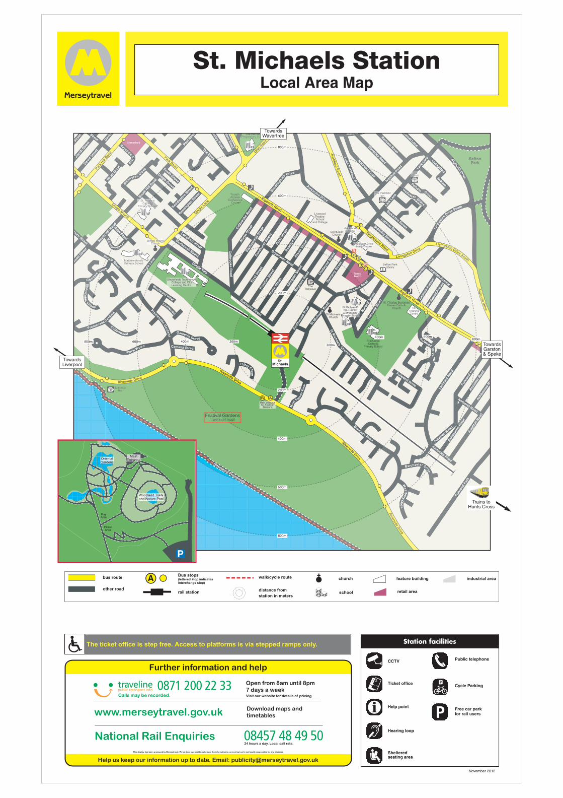
St. Michaels StationLocal Area Map
OrientalGardens
Woodland Trailsand Nature Pool
PlayArea
PicnicArea
MainEntrance
The ticket office is step free. Access to platforms is via stepped ramps only. Station facilities
Ticket office
CCTV
Sheltered seating area
Public telephone
Help point
Hearing loop
Cycle Parking
Free car park for rail users
Taxi
Taxi
Taxi
bus route
other road
Bus stops(lettered stop indicatesinterchange stop)
TaxiTaxi
Taxi
rail station
walk/cycle route
distance from
station in meters
Taxi
Taxi
Taxi
church
school
Taxi
Taxi
feature building
retail area
industrial area