southeastern minnesota freight rail capacity study€¦ · southeastern minnesota freight rail...
TRANSCRIPT
Kimley-Horn and Associates, Inc.
160519013
F E A S I B I L I T Y R E P O R T
Southeastern Minnesota
Freight Rail Capacity Study
Feasibility and Alternatives Analysis Study
Prepared for:
Prepared by:
April 2013
Southeastern Minnesota Freight Rail Capacity Study Feasibility Report
April 2013 i Revision 2
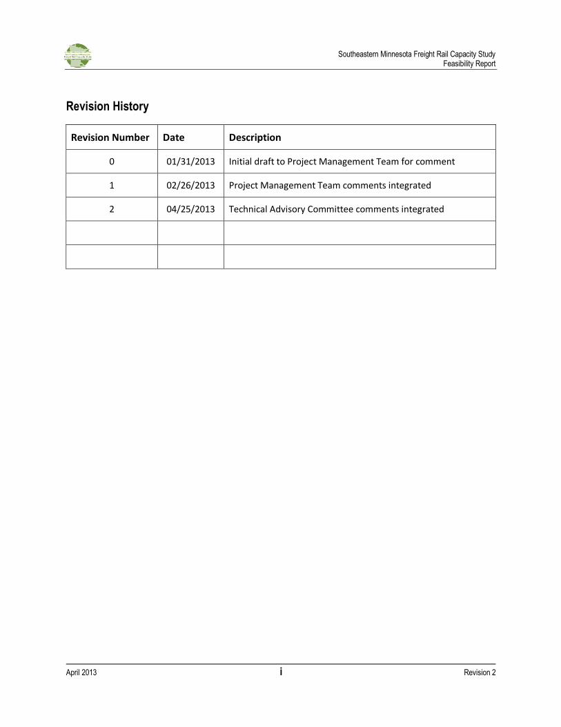
Revision History
Revision Number Date Description
0 01/31/2013 Initial draft to Project Management Team for comment
1 02/26/2013 Project Management Team comments integrated
2 04/25/2013 Technical Advisory Committee comments integrated
Southeastern Minnesota Freight Rail Capacity Study Feasibility Report
April 2013 ii Revision 2
List of Acronyms
AA Alternatives Analysis ABS Automatic Block Signals CP Canadian Pacific Railway CTC Centralized Traffic Control CNW Chicago and North Western CSAH County State Aid Highway CWR Continuous Welded Rail DM&E Dakota, Minnesota and Eastern Railroad EB Eastbound FAQ Frequently Asked Questions FEIS Final Environmental Impact Statement FRA Federal Railroad Administration GF Gannett Fleming MGT Million Gross Tons MnDOT Minnesota Department of Transportation MP Mile Post NEPA National Environmental Policy Act OCRRA Olmsted County Regional Railroad Authority PAC Project Advisory Committee PAS Power Assisted Switching PMP Project Management Plan PMT Project Management Team PRB Powder River Basin SDIC Systematic Development of Informed Consent SEIS Supplemental Environmental Impact Statement SRC Southern Rail Corridor STB Surface Transportation Board TAC Technical Advisory Committee TMS TranSystems Modeling Software WB Westbound WBAPS Web Based Accident Prediction System
Southeastern Minnesota Freight Rail Capacity Study Feasibility Report
April 2013 iii Revision 2
Table of Contents
Revision History ....................................................................................................................................... i
List of Acronyms ..................................................................................................................................... ii
Table of Contents ................................................................................................................................... iii
List of Tables ........................................................................................................................................... v
List of Figures .......................................................................................................................................... v
1. Introduction .................................................................................................................................. 1
1.1. Reason for the Study ................................................................................................................... 1
1.2. Changes During Study ................................................................................................................. 1
1.3. Context ....................................................................................................................................... 2
1.3.1. Project Area ..................................................................................................................... 2
1.3.2. Project History ................................................................................................................. 3
2. Existing Conditions ........................................................................................................................ 6
2.1. Physical Conditions ..................................................................................................................... 6
2.1.1. Right-of-Way .................................................................................................................... 6
2.1.2. Vertical design ................................................................................................................. 9
2.1.3. Track Classification ........................................................................................................... 9
2.1.4. Industry Service ............................................................................................................. 10
2.1.5. Physical Features ........................................................................................................... 11
2.2. Grade Crossings ........................................................................................................................ 13
2.3. Rail Operations ......................................................................................................................... 16
2.3.1. Safety ............................................................................................................................ 17
2.4. Modeling Methodology and Results .......................................................................................... 18
3. Future Conditions ........................................................................................................................ 20
3.1. Freight Growth and Modeling Scenarios ................................................................................... 20
3.2. Modeling Results ...................................................................................................................... 21
3.2.1. Existing Geometry .......................................................................................................... 21
3.2.2. Recommended Improvements ....................................................................................... 22
3.3. Probable Costs .......................................................................................................................... 26
Southeastern Minnesota Freight Rail Capacity Study Feasibility Report
April 2013 iv Revision 2
3.3.1. Rail Improvements ......................................................................................................... 26
3.3.2. Grade Separation Concepts ............................................................................................ 30
4. Conclusions ................................................................................................................................. 41
5. References................................................................................................................................... 42
6. Appendix ..................................................................................................................................... 43
Appendix A: Existing Conditions Maps .................................................................................................... 1
Appendix B: USDOT Crossing Inventory .................................................................................................. 2
Appendix C: FRA Annual WBAPS 2012 .................................................................................................... 3
Appendix D: Proposed Rail Improvements ............................................................................................. 4
Appendix E: Grade Separation Alternatives ............................................................................................ 5
Appendix F: Cost Estimates ..................................................................................................................... 6
Southeastern Minnesota Freight Rail Capacity Study Feasibility Report
April 2013 v Revision 2
List of Tables
Table 1 - At-Grade Crossings ................................................................................................................. 14
Table 2 - USDOT Technical Working Group Grade Separation Guidance ............................................... 16
Table 3 - Highway-Rail Incidents (2007 - 2011) ..................................................................................... 17
Table 4 - Predicted Collisions (WBAPS) ................................................................................................. 18
Table 5 - Proposed Rail Improvements (Cost Estimate) ........................................................................ 30
Table 6 - Grade Separation Design Criteria ........................................................................................... 31
Table 7 - Soft Cost Percentages ............................................................................................................. 33
Table 8 - Grade Separation Concepts (Cost Estimates).......................................................................... 40
Table 9 - Summary of Proposed Rail Improvements ............................................................................. 41
List of Figures
Figure 1 - Project Area Overview ............................................................................................................ 2
Figure 2 - Rochester Overview ................................................................................................................ 3
Figure 3 - Index of Sheets (Existing Conditions) ...................................................................................... 6
Figure 4 - Existing Rail Yard and Spur ...................................................................................................... 8
Figure 5 - Overview of Physical Conditions ........................................................................................... 10
Figure 6 - Industries Served along Existing Rail Corridor ....................................................................... 11
Figure 7 - Trails along Rail Corridor (MP 47.5 to 49.0) ........................................................................... 13
Figure 8 - Average Train Speed (Existing Conditions) ............................................................................ 19
Figure 9 - Average Congestion (High Growth Scenario without Improvements) ................................... 21
Figure 10 - Average Congestion (High Growth Scenario with Recommended Improvements) .............. 23
Figure 11 - Average Speed (High Growth Scenario with Recommended Improvements) ...................... 24
Figure 12 - Average Congestion (Low/Mid Growth Scenarios with Recommended Improvements) ..... 25
Figure 13 - Average Speed (Low/Mid Growth Scenarios with Recommended Improvements) ............. 25
Figure 14 - Existing Dodge Center Siding (Typical Section) .................................................................... 27
Figure 15 - Proposed East Rochester Siding (Typical Section) ............................................................... 28
Figure 16 - Proposed West Rochester Yard (Typical Section) ................................................................ 29
Figure 17 - Roadway Typical Sections ................................................................................................... 36
Figure 18 - Elevated Rail Concept (Plan and Profile) ............................................................................. 38
Figure 19 - Elevated Rail Concept (Typical Sections) ............................................................................. 39
Southeastern Minnesota Freight Rail Capacity Study Feasibility Report
April 2013 1 Revision 2
1. Introduction
1.1. Reason for the Study
On December 16, 2009, Congress directed funds under the Rail Line Relocation and Improvement program for the Southern Rail Corridor project, referred to herein as the Southeastern Minnesota Freight Rail Capacity Study (SEMNFRCS). The Southeastern Minnesota Freight Rail Capacity Study is a freight rail planning project proposed by Olmsted County Regional Railroad Authority (OCRRA) to evaluate the need and feasibility to mitigate and/or relocate the existing Dakota, Minnesota and Eastern Railroad (DM&E) freight rail line in Rochester to accommodate a potential increase in train traffic and address capacity, environmental, and safety concerns associated with the current route through the city’s downtown. The Minnesota Department of Transportation (MnDOT) has been designated as the grantee of these funds.
The project is intended to advance the study of reasonable and feasible alternatives, including improvements to existing infrastructure and consideration of a bypass around Rochester, through completion of an initial environmental analysis of all alternatives. In order to qualify for future federal and state funding, the study must be conducted in accordance with Federal Railroad Administration (FRA) guidelines. MnDOT, in coordination with OCRRA and FRA, will complete a series of technical reports and analyses that can be included in subsequent environmental documentation as part of the National Environmental Policy Act (NEPA) and Minnesota Environmental Policy Act (MEPA) compliant environmental review process, and will result in three primary milestones, as noted in the FRA approved Statement of Work:
Development of evaluation criteria that address: o The purpose and need for the action, including scenarios of varied
possible/potential rail traffic levels based on industry trends and passenger rail planning
o Engineering feasibility and conceptual costs o Preliminary environmental analysis
Comprehensive evaluation of all reasonable alternatives that avoid or minimize adverse effects on the environment, including:
o No Build alternative with and without increased rail traffic o Mitigation of current route through Rochester with and without increased rail traffic o Proposed Southern Rail Corridor (SRC) Alternative o All other reasonable alternative bypass routes
Preparation of a Feasibility Report and an Initial Alternatives Analysis Report that will result in the recommendation of further NEPA compliant review of the set of reasonable and feasible alternatives
1.2. Changes During Study
In December 2012, CP announced that it was writing down the PRB option. CP is indefinitely deferring plans for an extension into Wyoming, and therefore reducing the book value of the PRB extension accordingly. It also offered the railroad west of Tracy, MN up for sale to the highest bidder. This announcement by CP makes it unlikely that unit coal trains would travel through the study area. Despite
Southeastern Minnesota Freight Rail Capacity Study Feasibility Report
April 2013 2 Revision 2
these recent developments, the results of this study remain relevant to any increase in train traffic along the existing alignment.
1.3. Context
1.3.1. Project Area
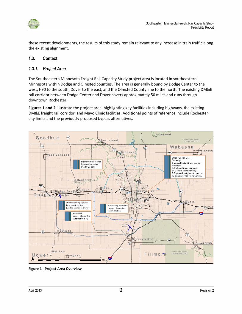
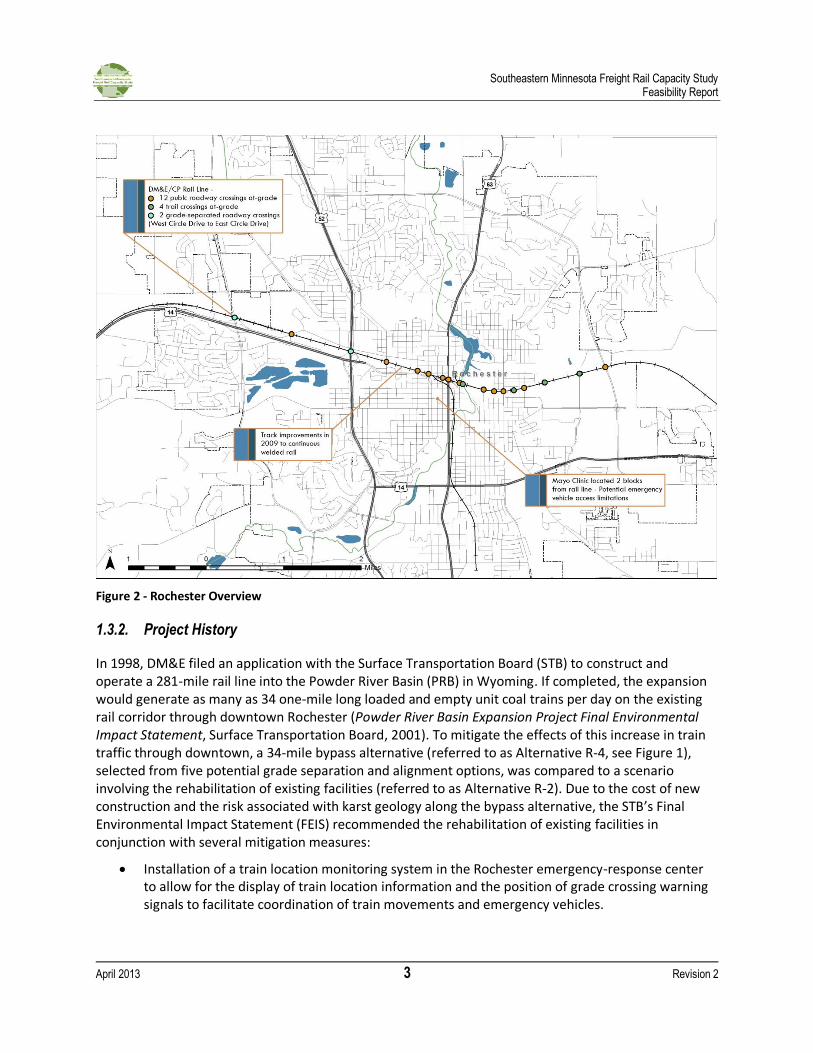
The Southeastern Minnesota Freight Rail Capacity Study project area is located in southeastern Minnesota within Dodge and Olmsted counties. The area is generally bound by Dodge Center to the west, I-90 to the south, Dover to the east, and the Olmsted County line to the north. The existing DM&E rail corridor between Dodge Center and Dover covers approximately 50 miles and runs through downtown Rochester.
Figures 1 and 2 illustrate the project area, highlighting key facilities including highways, the existing DM&E freight rail corridor, and Mayo Clinic facilities. Additional points of reference include Rochester city limits and the previously proposed bypass alternatives.
Figure 1 - Project Area Overview
Southeastern Minnesota Freight Rail Capacity Study Feasibility Report
April 2013 3 Revision 2
Figure 2 - Rochester Overview
1.3.2. Project History
In 1998, DM&E filed an application with the Surface Transportation Board (STB) to construct and operate a 281-mile rail line into the Powder River Basin (PRB) in Wyoming. If completed, the expansion would generate as many as 34 one-mile long loaded and empty unit coal trains per day on the existing rail corridor through downtown Rochester (Powder River Basin Expansion Project Final Environmental Impact Statement, Surface Transportation Board, 2001). To mitigate the effects of this increase in train traffic through downtown, a 34-mile bypass alternative (referred to as Alternative R-4, see Figure 1), selected from five potential grade separation and alignment options, was compared to a scenario involving the rehabilitation of existing facilities (referred to as Alternative R-2). Due to the cost of new construction and the risk associated with karst geology along the bypass alternative, the STB’s Final Environmental Impact Statement (FEIS) recommended the rehabilitation of existing facilities in conjunction with several mitigation measures:
Installation of a train location monitoring system in the Rochester emergency-response center to allow for the display of train location information and the position of grade crossing warning signals to facilitate coordination of train movements and emergency vehicles.
Southeastern Minnesota Freight Rail Capacity Study Feasibility Report
April 2013 4 Revision 2
Installation of two grade-separated crossings prior to transporting more than 50 million tons of coal annually through Rochester, including one grade-separated crossing prior to transporting more than 20 million tons of coal annually through Rochester, at two of the following grade crossings in Rochester or another mutually acceptable location:
o East Circle Drive/CR 22 o 2nd Avenue NE/West Silver Lake Drive o Broadway Avenue o 6th Avenue Northwest
Installation of additional grade crossing protection devices at Broadway Avenue prior to transporting 50 million tons of coal annually through Rochester.
Coordination with Mayo Clinic to determine how to best minimize project-related impacts on the Clinic.
During the EIS process, MnDOT conducted an analysis of the impacts of increased train traffic on all grade crossings within 10 southern Minnesota counties, including both Dodge and Olmsted. In addition to providing various recommendations on general guidelines for safety improvements at all remaining at-grade crossings, the study identified a total of seven grade separation candidates within the City of Rochester under a full build scenario. The final report recommended the installation of five additional grade-separated crossings within Rochester once train traffic levels reached 37 trains per day, likely selected from 11th Avenue Northeast, 11th Avenue Northwest, and the four crossings identified within the FEIS (Southern Minnesota Rail Corridor Safety Plan, MnDOT, Prepared by SEH, 2000). While the technical data from the MnDOT study were used in the EIS, the final recommendations were significantly modified.
Following a court challenge to the STB’s 2002 approval of the DM&E line (Mid States Coalition for Progress v. STB, 345 F.3d 52, 8TH circ. 2003), the STB issued a Supplemental Environmental Impact Statement (SEIS). The SEIS reimposed all 147 mitigation conditions documented in the FEIS over the entire DM&E line and included one additional recommendation that DM&E community liaisons provide assistance to communities interested in developing quiet zones. No additional mitigation conditions were recommended, and construction of the DM&E line was reapproved in 2006.
In 2009, Mayo Clinic released an independent evaluation of the potential impacts of increased train traffic through downtown in advance of the construction of the PRB line. Simulations conducted as part of this study indicated that in-town improvements, including a second mainline through the study area and new sidings, might not be sufficient to support 28 or more daily coal trains in addition to six other freight trains per day (DM&E Rail Alternative Analysis and Cost Study Task 3 Report, Mayo Clinic, Prepared by Gannett Fleming, 2009). The report noted that the present route through Rochester is very close to Mayo Clinic and its hospitals, which can house nearly 34,000 patients and staff at any given time. Because of this proximity, a derailment in this area involving hazardous materials may have devastating consequences due to the inability to evacuate such a large number of patients, the inability to close off buildings to outside air, and the reduced capacity to respond to the medical needs of the injured. The report presented a revised 48-mile bypass alternative to allow through freight traffic to avoid downtown Rochester, indicating that the associated geological and environmental concerns identified in the STB environmental analysis could be addressed.
Southeastern Minnesota Freight Rail Capacity Study Feasibility Report
April 2013 5 Revision 2
Concurrent with these studies, OCRRA and MnDOT have been actively studying a high-speed passenger rail connection between Rochester and the Twin Cities. Zip Rail, the name and brand adopted for a high-speed passenger rail corridor by the Southeast Minnesota Rail Alliance in 2011, is listed as a Tier I corridor in the Minnesota Comprehensive Statewide Freight and Passenger Rail Plan. Access to downtown Rochester is conceptually planned using the existing DM&E freight corridor, joining at a yet to be determined point west of downtown. Zip Rail will be the subject of a separate and independent study.
At present, the PRB line in Wyoming has not entered construction despite STB approval. DM&E, now a wholly owned subsidiary of Canadian Pacific (CP) Railway, has recently implemented several improvements within the project area, including the installation of a defect detection system, bridge improvements at the Zumbro River crossing, as well as track upgrades to continuous welded rail through downtown Rochester.
As noted earlier, CP announced in December 2012 that it was writing down the PRB option and indefinitely deferring plans for an extension into Wyoming. It also offered the railroad west of Tracy, MN up for sale to the highest bidder.
Southeastern Minnesota Freight Rail Capacity Study Feasibility Report
April 2013 6 Revision 2
2. Existing Conditions
2.1. Physical Conditions
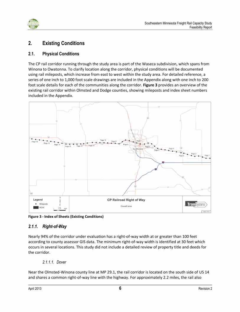
The CP rail corridor running through the study area is part of the Waseca subdivision, which spans from Winona to Owatonna. To clarify location along the corridor, physical conditions will be documented using rail mileposts, which increase from east to west within the study area. For detailed reference, a series of one inch to 1,000 foot scale drawings are included in the Appendix along with one inch to 200 foot scale details for each of the communities along the corridor. Figure 3 provides an overview of the existing rail corridor within Olmsted and Dodge counties, showing mileposts and index sheet numbers included in the Appendix.
Figure 3 - Index of Sheets (Existing Conditions)
2.1.1. Right-of-Way
Nearly 94% of the corridor under evaluation has a right-of-way width at or greater than 100 feet according to county assessor GIS data. The minimum right-of-way width is identified at 30 feet which occurs in several locations. This study did not include a detailed review of property title and deeds for the corridor.
2.1.1.1. Dover
Near the Olmsted-Winona county line at MP 29.1, the rail corridor is located on the south side of US 14 and shares a common right-of-way line with the highway. For approximately 2.2 miles, the rail also
Southeastern Minnesota Freight Rail Capacity Study Feasibility Report
April 2013 7 Revision 2
parallels the north side of CR 142 SE. The total width of this transportation corridor (meaning highway-rail-roadway) is approximately 400 feet wide. The rail is a single track within a 100-foot right-of-way, while US 14 is a two-lane rural highway with shoulders within an approximate 100-foot right-of-way.
Dover is located just southeast of the junction of US 14 and CR 10 (MP 32.2), approximately three miles west of the Olmsted County line. CR 10 is the only at-grade crossing within Dover. Within the city, US 14 shifts away from the rail corridor and is located 0.2 miles north of the rail corridor. Within Dover city limits, the rail right-of-way reduces to 75 feet in width. Although industry is adjacent to the rail, existing rail service does not currently serve this industry.
2.1.1.2. Eyota
On the approach to Eyota near MP 33.4, the rail and US 14 converge to a 200-foot wide combined transportation corridor. Prior to reaching the eastern boundary of Eyota, the railroad crosses a branch of the Whitewater River multiple times, after which the river follows closely along the south side of the rail corridor. Near Center Ave/CR 7 SE (MP 36.8) within the town of Eyota, an industry service track is located on the north side of the rail corridor (approximately 1,800 feet long) and the south side of the rail corridor (approximately 2,040 feet long). On the west end of Eyota (MP 37.9), a municipal airport is on the south side of the rail corridor, and the Plainview Spur is on the north side. Immediately west of Eyota and just south of the rail corridor, a former railroad wye—a triangular shaped junction of rail tracks with a switch corner that provides a connection to a track traveling in a different direction—is listed as CP right-of-way.
2.1.1.3. Chester
The town of Chester is located approximately six miles west of Eyota. Halfway between Eyota and Chester, US 14 swings southerly and goes beneath the railroad near MP 40.0. After this point, US 14 is on the south side of the railroad. At Chester Avenue SE (MP 42.7) within the town of Chester, US 14 is separated from the railroad by 0.13 miles.
2.1.1.4. Rochester
US 14 and the rail corridor come together approximately one mile west of Chester Avenue SE, but soon diverge as the rail goes north when entering into the City of Rochester through the East Side Pioneers neighborhood. This rail section is characterized by residential properties, several large parks, and Oakwood Cemetery. The railroad then crosses the Zumbro River and arrives at the downtown area of Rochester. Within downtown, commercial and former industrial land uses—including electrical substations— abut the rail corridor. An existing yard consisting of two 1,000-foot siding tracks to the north of the mainline is located between Cascade Creek and 11th Avenue NW.
Just east of 4th Avenue NW, an industrial spur joins the mainline from the south, the spur crosses Civic Center Drive and parallels to 1st Avenue before crossing the Zumbro River approximately a half-mile south of the mainline. The rail bridge crosses the river at an acute angle, and is nearly 330 feet long. It also crosses over a trail along both banks of the river. North of 16th Street there is a service track on the west side of the spur. As the rail approaches 20th Street, another service track is added on the west side and the rail splits to serve two warehousing facilities. There are two railroad tracks crossing 20th Street near Meadow Park.
Southeastern Minnesota Freight Rail Capacity Study Feasibility Report
April 2013 8 Revision 2
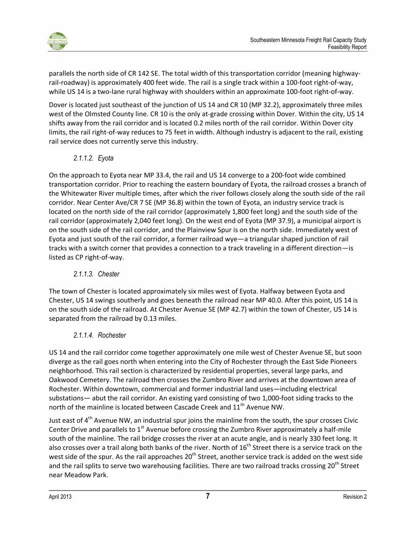
Figure 4 illustrates the yard and nearby spur, which is also used to store rail cars.
Figure 4 - Existing Rail Yard and Spur
2.1.1.5. Byron
At US 52, US 14 splits from US 52 and runs adjacent to the rail corridor. Just east of the CR 104 crossing at MP 54.2 (approximately three miles west of US 52), the rail is again immediately adjacent to US 14. At this point, the combined transportation corridor is approximately 300 feet wide. The rail corridor parallels US 14 for another 5.3 miles west, approaching Byron. At CR 5 NW (MP 58.7), the rail and road diverge. Within Byron, there is a 1,480 foot-long industry track on the north side of the railroad. Within Byron, the right-of-way narrows for a 400-foot stretch between 1st and 2nd Avenues.
2.1.1.6. Kasson
Kasson is located approximately 5 miles west of Byron. Within town, the rail right-of-way narrows to 50 feet. A 2,000-foot industry track is located on the north side of the mainline west of downtown.
2.1.1.7. Dodge Center
Approximately 3,000 feet west of the industry track (MP 65.1), the rail and US 14 return to a parallel alignment for three miles to the edge of Dodge Center. The combined transportation corridor is 300 feet wide. Between MP 66.8 and 68.8 on the east side of Dodge Center, there is a 10,100-foot long siding on the south side of the mainline track as well an industrial spur to the south at MP 68.6. Within Dodge Center, the right-of-way varies in width, increasing to more than 100 feet in some areas and narrowing to 30 feet between Central and 1st Avenue for a distance of approximately 400 feet.
West of Dodge Center at MP 71.4, US 14 crosses over the rail at a grade-separated crossing. The rail then crosses over Dodge Center Creek at MP 71.1, between Dodge Center and Claremont.

Southeastern Minnesota Freight Rail Capacity Study Feasibility Report
April 2013 9 Revision 2
2.1.1.8. Claremont
Claremont is located approximately 7 miles west of Dodge Center and 2.5 miles east of the Steele-Dodge County line. Right-of-way within Claremont is approximately 65 feet wide. Near Elm St, two industrial tracks (2,200 feet and 1,800 feet) are located on the north side of the rail, serving an ethanol plant at MP 77.3.
2.1.2. Vertical design
The topographic elevations along the existing rail corridor range from a low of approximately 990 feet at the Zumbro River in Rochester to a high of approximately 1,300 feet at two locations: one west of Eyota in Olmsted County and the other west of Kasson in Dodge County. The maximum grade in the eight-mile long segment from MP 30 to MP 38 is 0.8 percent near milepost 34. On the 11-mile segment from milepost 38 to MP 49 at the Zumbro River, the maximum grade is 1.1 percent near MP 40.5. The maximum grade in the 10-mile segment from MP 49 to MP 59 is 1.1 percent near MP 56.5. From MP 59 to MP 80, the grade is relatively flat. The maximum grade in this 21-mile long segment is 1.0 percent near MP 79.7, west of the Dodge-Steele County line (MP 78.8). The source of this data is from the rail track charts included in the Appendix.
2.1.3. Track Classification
The FRA’s Track Safety Standards establish track structure and track geometry requirements for nine separate classes of track (Sec. 213.9 and Sec. 213.307) with maximum speeds designated for each class. There are different allowable train speeds for every section of track, including maximum speed through cities, towns, and crossings. The speed at which trains can safely operate is determined by many factors, including the condition of the railbed and track structure. Railroad companies report the class for each track. Once the designation is made, the railroad companies are held responsible for maintaining each track to specified tolerances for its designated class.
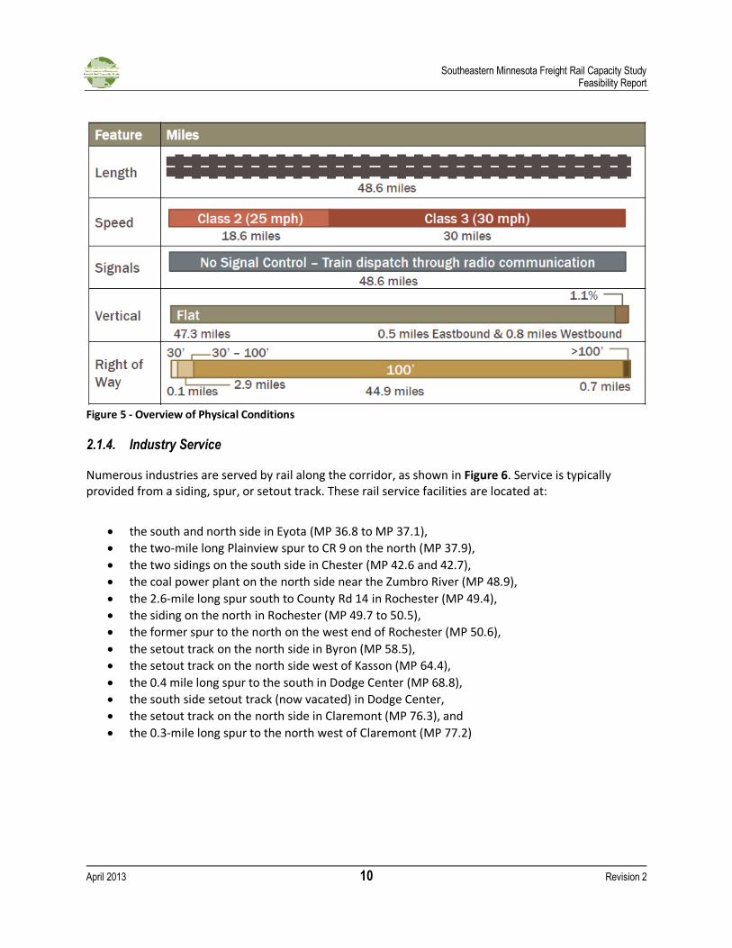
Figure 5 provides a summary of the rail characteristics along the study corridor.
Southeastern Minnesota Freight Rail Capacity Study Feasibility Report
April 2013 10 Revision 2
Figure 5 - Overview of Physical Conditions
2.1.4. Industry Service
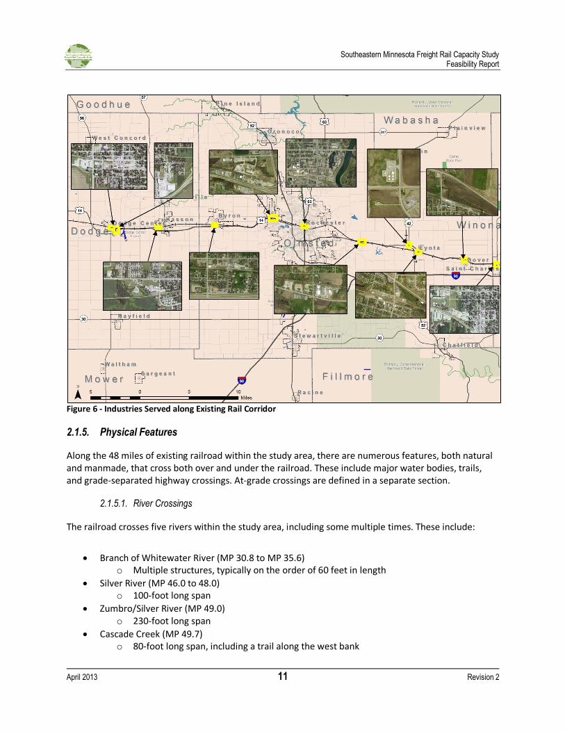
Numerous industries are served by rail along the corridor, as shown in Figure 6. Service is typically provided from a siding, spur, or setout track. These rail service facilities are located at:
the south and north side in Eyota (MP 36.8 to MP 37.1),
the two-mile long Plainview spur to CR 9 on the north (MP 37.9),
the two sidings on the south side in Chester (MP 42.6 and 42.7),
the coal power plant on the north side near the Zumbro River (MP 48.9),
the 2.6-mile long spur south to County Rd 14 in Rochester (MP 49.4),
the siding on the north in Rochester (MP 49.7 to 50.5),
the former spur to the north on the west end of Rochester (MP 50.6),
the setout track on the north side in Byron (MP 58.5),
the setout track on the north side west of Kasson (MP 64.4),
the 0.4 mile long spur to the south in Dodge Center (MP 68.8),
the south side setout track (now vacated) in Dodge Center,
the setout track on the north side in Claremont (MP 76.3), and
the 0.3-mile long spur to the north west of Claremont (MP 77.2)
Southeastern Minnesota Freight Rail Capacity Study Feasibility Report
April 2013 11 Revision 2
Figure 6 - Industries Served along Existing Rail Corridor
2.1.5. Physical Features
Along the 48 miles of existing railroad within the study area, there are numerous features, both natural and manmade, that cross both over and under the railroad. These include major water bodies, trails, and grade-separated highway crossings. At-grade crossings are defined in a separate section.
2.1.5.1. River Crossings
The railroad crosses five rivers within the study area, including some multiple times. These include:
Branch of Whitewater River (MP 30.8 to MP 35.6) o Multiple structures, typically on the order of 60 feet in length
Silver River (MP 46.0 to 48.0) o 100-foot long span
Zumbro/Silver River (MP 49.0) o 230-foot long span
Cascade Creek (MP 49.7) o 80-foot long span, including a trail along the west bank
Southeastern Minnesota Freight Rail Capacity Study Feasibility Report
April 2013 12 Revision 2
Dodge Center Creek (MP 71.10) o 128-foot long span
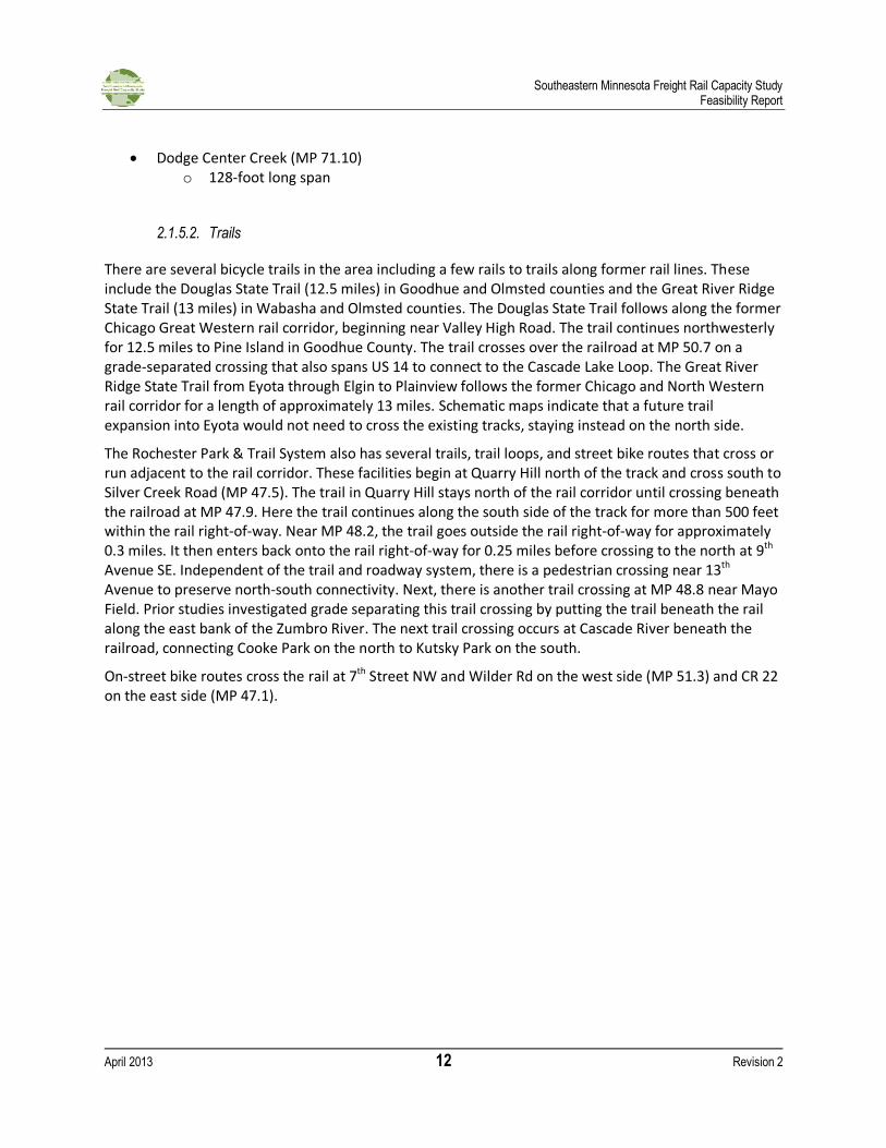
2.1.5.2. Trails
There are several bicycle trails in the area including a few rails to trails along former rail lines. These include the Douglas State Trail (12.5 miles) in Goodhue and Olmsted counties and the Great River Ridge State Trail (13 miles) in Wabasha and Olmsted counties. The Douglas State Trail follows along the former Chicago Great Western rail corridor, beginning near Valley High Road. The trail continues northwesterly for 12.5 miles to Pine Island in Goodhue County. The trail crosses over the railroad at MP 50.7 on a grade-separated crossing that also spans US 14 to connect to the Cascade Lake Loop. The Great River Ridge State Trail from Eyota through Elgin to Plainview follows the former Chicago and North Western rail corridor for a length of approximately 13 miles. Schematic maps indicate that a future trail expansion into Eyota would not need to cross the existing tracks, staying instead on the north side.
The Rochester Park & Trail System also has several trails, trail loops, and street bike routes that cross or run adjacent to the rail corridor. These facilities begin at Quarry Hill north of the track and cross south to Silver Creek Road (MP 47.5). The trail in Quarry Hill stays north of the rail corridor until crossing beneath the railroad at MP 47.9. Here the trail continues along the south side of the track for more than 500 feet within the rail right-of-way. Near MP 48.2, the trail goes outside the rail right-of-way for approximately 0.3 miles. It then enters back onto the rail right-of-way for 0.25 miles before crossing to the north at 9th Avenue SE. Independent of the trail and roadway system, there is a pedestrian crossing near 13th Avenue to preserve north-south connectivity. Next, there is another trail crossing at MP 48.8 near Mayo Field. Prior studies investigated grade separating this trail crossing by putting the trail beneath the rail along the east bank of the Zumbro River. The next trail crossing occurs at Cascade River beneath the railroad, connecting Cooke Park on the north to Kutsky Park on the south.
On-street bike routes cross the rail at 7th Street NW and Wilder Rd on the west side (MP 51.3) and CR 22 on the east side (MP 47.1).
Southeastern Minnesota Freight Rail Capacity Study Feasibility Report
April 2013 13 Revision 2
Figure 7 - Trails along Rail Corridor (MP 47.5 to 49.0)
2.1.5.3. Grade-Separated Highway Crossings
There are a total of four grade-separated highway crossings in the study area. Three of the grade separations are classified as principal arterials (US 14 at MP 71.5 in Dodge County, US 52 at MP 50.5 in Rochester, and West Circle Drive at MP 52.0 in Rochester), while the fourth grade separation (US 14 at MP 40.9 in Olmsted County) is classified as a minor arterial.
2.2. Grade Crossings
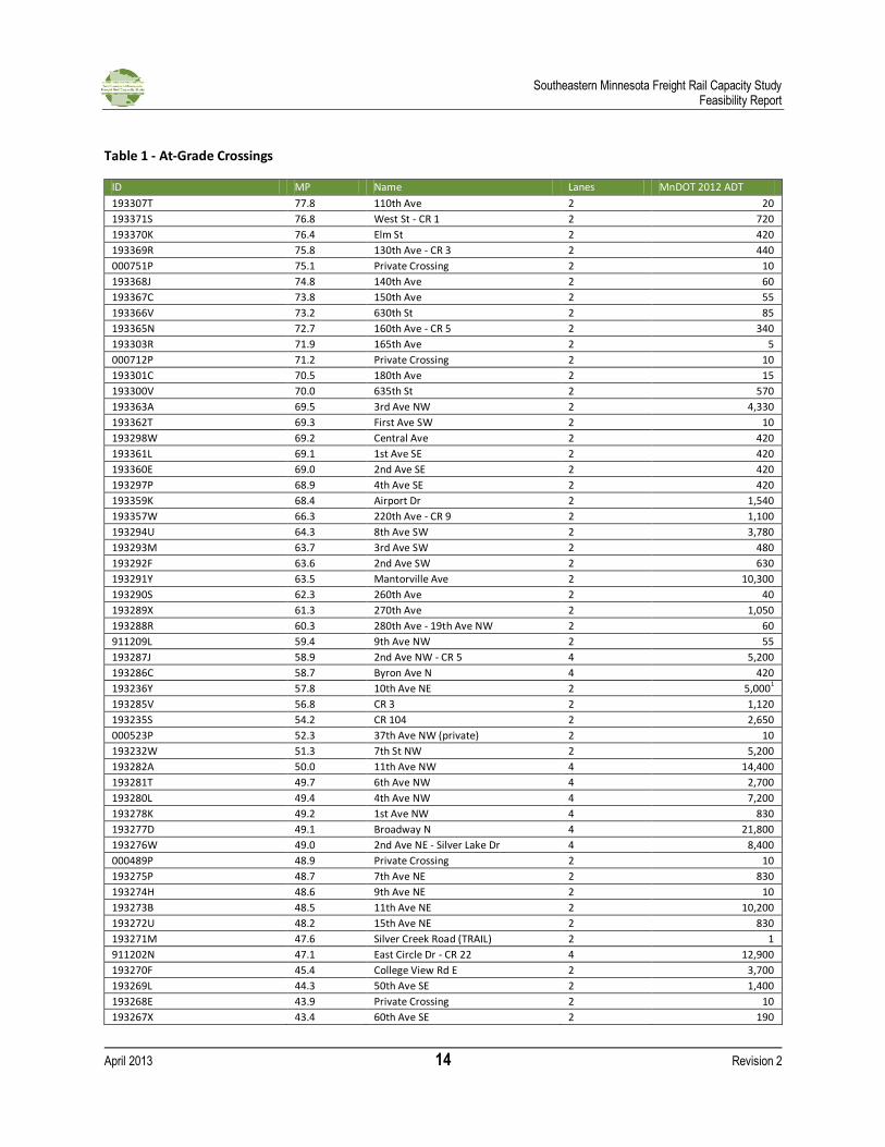
There are more than 70 public and private grade crossings along the rail corridor in the Olmsted and Dodge counties. While most crossings are local streets or private roadways, 20 existing grade crossings are classified as either collectors or arterials. CR 22/East Circle Drive and North Broadway (US 63) in Rochester are both principal arterials. The remaining classified crossings include nine minor arterials, eight rural major collectors, and one urban collector. Traffic volumes at these crossings range from a high of 18,700 vehicles per day to a low of 440 vehicles per day. In rural areas, the classified roads are typically three to five miles apart. In the Rochester area, the classified roadways average one-mile spacing on the fringe and less than a half-mile in the urban core. Table 1 presents the at-grade crossings. An inventory of the grade crossings from the FRA database is provided in the Appendix.
Southeastern Minnesota Freight Rail Capacity Study Feasibility Report
April 2013 14 Revision 2
Table 1 - At-Grade Crossings
ID MP Name Lanes MnDOT 2012 ADT
193307T 77.8 110th Ave 2 20
193371S 76.8 West St - CR 1 2 720
193370K 76.4 Elm St 2 420
193369R 75.8 130th Ave - CR 3 2 440
000751P 75.1 Private Crossing 2 10
193368J 74.8 140th Ave 2 60
193367C 73.8 150th Ave 2 55
193366V 73.2 630th St 2 85
193365N 72.7 160th Ave - CR 5 2 340
193303R 71.9 165th Ave 2 5
000712P 71.2 Private Crossing 2 10
193301C 70.5 180th Ave 2 15
193300V 70.0 635th St 2 570
193363A 69.5 3rd Ave NW 2 4,330
193362T 69.3 First Ave SW 2 10
193298W 69.2 Central Ave 2 420
193361L 69.1 1st Ave SE 2 420
193360E 69.0 2nd Ave SE 2 420
193297P 68.9 4th Ave SE 2 420
193359K 68.4 Airport Dr 2 1,540
193357W 66.3 220th Ave - CR 9 2 1,100
193294U 64.3 8th Ave SW 2 3,780
193293M 63.7 3rd Ave SW 2 480
193292F 63.6 2nd Ave SW 2 630
193291Y 63.5 Mantorville Ave 2 10,300
193290S 62.3 260th Ave 2 40
193289X 61.3 270th Ave 2 1,050
193288R 60.3 280th Ave - 19th Ave NW 2 60
911209L 59.4 9th Ave NW 2 55
193287J 58.9 2nd Ave NW - CR 5 4 5,200
193286C 58.7 Byron Ave N 4 420
193236Y 57.8 10th Ave NE 2 5,0001
193285V 56.8 CR 3 2 1,120
193235S 54.2 CR 104 2 2,650
000523P 52.3 37th Ave NW (private) 2 10
193232W 51.3 7th St NW 2 5,200
193282A 50.0 11th Ave NW 4 14,400
193281T 49.7 6th Ave NW 4 2,700
193280L 49.4 4th Ave NW 4 7,200
193278K 49.2 1st Ave NW 4 830
193277D 49.1 Broadway N 4 21,800
193276W 49.0 2nd Ave NE - Silver Lake Dr 4 8,400
000489P 48.9 Private Crossing 2 10
193275P 48.7 7th Ave NE 2 830
193274H 48.6 9th Ave NE 2 10
193273B 48.5 11th Ave NE 2 10,200
193272U 48.2 15th Ave NE 2 830
193271M 47.6 Silver Creek Road (TRAIL) 2 1
911202N 47.1 East Circle Dr - CR 22 4 12,900
193270F 45.4 College View Rd E 2 3,700
193269L 44.3 50th Ave SE 2 1,400
193268E 43.9 Private Crossing 2 10
193267X 43.4 60th Ave SE 2 190
Southeastern Minnesota Freight Rail Capacity Study Feasibility Report
April 2013 15 Revision 2
ID MP Name Lanes MnDOT 2012 ADT
193266R 42.7 Chester Ave SE 2 780
193220C 40.3 CR 102 2 70
193219H 39.4 100th Ave SE 2 50
193216M 38.6 110th Ave SE 2 130
193264C 37.4 TH 42 2 4,250
193263V 36.8 Center Ave 4 1,900
193262N 35.3 140th Ave SE 2 30
193261G 34.2 CR 32 2 230
193260A 32.2 Chatfield Street - CR 10 2 1,650
193259F 30.4 19th Ave SE 2 20
1Based on p.m. peak hour counts conducted November 27, 2012 for adjacent ICE report, using a K factor of 0.10
The USDOT Railroad-Highway Grade Crossing Handbook (August 2007) provides guidance for determining when at-grade crossings should be studied in detail for potential safety improvements, including grade separation. One indicator is exposure, or the product of the number of trains per day and average annual daily traffic (AADT). If the exposure exceeds 1,000,000 in urban areas or 250,000 in rural areas then grade separation may be justified after further investigation. Other indicators make adjustments for highway speeds, passenger trains, and expected accident frequency, as shown in Table 2.
Under current conditions, no crossings within the study area meet or exceed these exposure indicators. However, several locations have very low vehicular traffic volumes and should be considered candidates for potential closure. The majority of these locations are in rural areas and are often grouped closely together.
While exposure provides a method for comparing train and vehicle volumes over many crossings, it does not provide information on many other factors important to users of the highway network. Other indicators such as average vehicle delay, maximum queue lengths, emergency mobility, high speed crossings (posted speeds of 55 mph and greater), and the proximity of the nearest grade-separated crossing are all important factors that should be considered.
Southeastern Minnesota Freight Rail Capacity Study Feasibility Report
April 2013 16 Revision 2
Table 2 - USDOT Technical Working Group Grade Separation Guidance
# Condition
1 The highway is a part of the designated Interstate Highway System
2 The highway is otherwise designed to have full controlled access
3 The posted highway speed equals or exceeds 113 km/h (70 mph)
4 AADT exceeds 100,000 in urban areas or 50,000 in rural areas
5 Maximum authorized train speed exceeds 177 km/h (110 mph)
6 An average of 150 or more trains per day or 300 Million Gross Tons (MGT) per year
7 An average of 75 or more passenger trains per day in urban areas or 30 or more passenger trains per day in rural areas
8 Crossing exposure (the product of the number of trains per day and AADT) exceeds 1,000,000 in urban areas or 250,000 in rural areas
9 Passenger train crossing exposure (the product of the number of passenger trains per day and AADT) exceeds 800,000 in urban areas or 200,000 in rural areas
10 The expected accident frequency (EAF) for active devices with gates, as calculated by the USDOT Accident Prediction Formula including 5-year accident history, exceeds 0.5
11 Vehicle delay exceeds 40 vehicle hours per day
2.3. Rail Operations
While the number of trains per day along the corridor varies, CP indicates that there are about four trains per day on average. These include three “through” trains and the local switch engine. The switch engine serves local industry and typically makes a run to the east in the morning and a run to the west in the afternoon. The switch engine delivers cars to industry and receives train cars for pickup. Train cars are stored at the yard in Rochester. A transfer train will typically deliver and pick up cars at the yard. Other manifest (or mixed freight) trains operate through the two counties during the day without stopping. The corridor is currently controlled by radio dispatch.
The mixed freight cars typically include agricultural products. No unit coal trains are currently transported along this line, however some coal is currently delivered to the Rochester Public Utilities Silver Lake coal-fired power plant. The Rochester Public Utility’s Board voted in August 2012 to decommission the plant, effective in 2015. Some hazardous cargo is transported on placarded cars, and may consist of fertilizer, fuel, or other cargoes1. The transport of hazardous material is strictly governed by FRA regulations.
CP Railway indicates that 5.1 million gross tons (MGT) per year are transported along the rail corridor. MGT is a railroad industry measure that indicates both volume and potential value along a corridor. A corridor typically achieves financial importance when annual tonnage exceeds 30 MGT. The Minnesota Comprehensive Statewide Freight and Passenger Rail Plan (February 2010) indicated that the corridor actually carried less than 5 MGT in 2007, and forecast this value to remain below 5 MGT by 2030.
1 CP did not provide the total quantity or timetable for hazardous cargo.
Southeastern Minnesota Freight Rail Capacity Study Feasibility Report
April 2013 17 Revision 2
2.3.1. Safety
Following the 2008 acquisition of DM&E Railroad, CP has invested in several safety and capacity improvements in Olmsted and Dodge counties, including the installation of a defect detection system, bridge improvements at the Zumbro River crossing, as well as track upgrades to continuous welded rail through downtown Rochester. Since 2009 (through 2012), there have been no reported derailments or other non-highway-related rail incidents within the study area. A total of six highway-rail crossing incidents were reported in Olmsted and Dodge Counties along the corridor between 2007 and 2011, as reported in the FRA Crossing Inventory and Database. Table 3 lists the location, date, severity, and cause of each incident. All six involved a vehicle that either did not stop or was stopped on the tracks. Only one injury was reported of the six incidents. Police issued citations to two of the drivers. Neither the passenger vehicles nor the trains involved were transporting hazardous material. Table 3 - Highway-Rail Incidents (2007 - 2011)
LOCATION INCIDENT TRAIN DESCRIPTION
ID # MP Street Date Time Loco-
motives Cars
Speed (mph)
Driver Injuries Property Damage
911202N 47.1 East
Circle Dr - CR 22
12/19/2011 11:00 AM 4 116 23 Did not stop injured $ 7,000
193367C 73.8 150th Ave
8/19/2011 9:38 AM 1 0 29 Did not stop uninjured $ 10,000
193289X 61.3 270th Ave
3/23/2011 9:42 AM 3 81 27 Did not stop uninjured $ 3,000
193294U 64.3 8th Ave
SW 2/10/2010 3:50 PM 1 19 27
Stopped and then proceeded
uninjured $ -
193280L 49.4 4th Ave
NW 11/18/2008 12:40 PM 3 46 10
Stopped on crossing
uninjured $ 2,000
193266R 42.7 Chester
Ave 2/18/2008 7:25 AM 3 15 26 Did not stop uninjured $ 250
The FRA’s Web Based Accident Prediction System (WBAPS) provides one method for comparing multiple at-grade crossings based on available data. It serves as one potential tool to help agencies identify where scarce highway-rail grade crossing resources can best be directed. The model utilizes physical conditions, operating characteristics, and the five-year accident history of each crossing to calculate an accident prediction value that can be used to compare multiple crossings. It should be noted that many relevant factors are not included within the model, including sight-distance, highway congestion, bus or hazardous material traffic, and local topography. As such, it should be treated as one factor among many when assessing where to direct safety improvement funding. The accident prediction value is typically very low; A value of 0.01 would indicate than one (1) accident could be expected every 100 years. The USDOT Railroad-Highway Grade Crossing Handbook suggests evaluating improvements at locations with a predicted collision rate greater than 0.02. Under current conditions, 14 highway-rail-grade crossings exceed this threshold, as shown in Table 4. The crossings that have experienced an accident in the last five years are typically ranked near the top. Four of these crossings are currently controlled by stop signs or crossbucks. Modifications to the type of crossing
Southeastern Minnesota Freight Rail Capacity Study Feasibility Report
April 2013 18 Revision 2
control could reduce the predicted collision rate to a value less than 0.2. Similarly, incremental improvements at other crossings, such as the installation of gates, would likely reduce the predicted collision rate. Table 4 - Predicted Collisions (WBAPS)
Predicted collisions Road Crossing City Number of Collisions
(last five years) Warning Device
0.083480 East Circle Dr - CR 22 Rochester 1 Flashing Lights
0.054831 4th Avenue NW Rochester 1 Gates
0.052690 8th Avenue SW Kasson 1 Stop Sign
0.047604 270th Avenue Byron 1 Stop Sign
0.044948 Chester Avenue SE Eyota 1 Stop Sign
0.026455 11th Avenue NW Rochester 0 Gates
0.026213 Broadway N Rochester 0 Gates
0.025228 150th
Ave Claremont 1 Crossbucks
0.023373 2nd Avenue NW Byron 0 Flashing Lights
0.022860 2nd Avenue NE Rochester 0 Gates
0.022584 11th Avenue NE Rochester 0 Flashing Lights
0.022333 12th
Street SE Rochester 0 Flashing Lights
0.020456 6th Avenue NW Rochester 0 Gates
0.020299 Byron Ave N Byron 0 Flashing Lights
Within the study area, five locations with a predicted collision rate greater than 0.02 are currently controlled by gates. These crossings are closely grouped together, with all five crossings between MP 49.0 and MP 50.0. As train volumes increase, additional study may be needed to determine potential mitigation options, including four-quadrant gates or complete grade separation.
2.4. Modeling Methodology and Results
The TranSystems Modeling Studio (TMS) was used to assess railroad operations. The model includes characteristics such as train volumes, operating parameters, and track conditions. Acceptable operations are reflected in measures such as levels of network congestion and operating speeds by type of train.
The purpose of modeling operations is to determine what, if any, improvements are needed to adequately accommodate increased levels of train traffic. A baseline, or existing conditions scenario, was used to evaluate current conditions and validate model parameters. Using the same methodology, future growth scenarios were then developed and analyzed, as discussed in the following chapter.
The existing conditions scenario represents the current day network with current day rail traffic: one eastbound and one westbound through train per day, five night trains per week, and accompanying local moves. The model area encompasses two counties: Olmsted and Dodge counties. A variety of
Southeastern Minnesota Freight Rail Capacity Study Feasibility Report
April 2013 19 Revision 2
physical track conditions were input into the model, as well as the two types of railroad track along the 48-mile long corridor: Class II and Class III, which are limited to speeds of 25 and 30 mph, respectively. Trains within the corridor are currently dispatched by radio, and the track is not signalized.
A key element of the existing conditions scenario was to develop an applicable train schedule. Informal discussions with crew operators and on-site observations guided the development of a schedule that includes an eastbound manifest train through Rochester during the mid-afternoon and a westbound manifest train through Rochester in the early evening. A transfer train in either direction occurs at night. The local switch engine typically operates weekdays between 7 AM and 5 PM.
Under existing conditions, there are no “unplanned” delays along the corridor, and congestion is consequently zero. Average operating speeds, as shown in Figure 8, are effectively limited by the condition of the track and are not a reflection of any congestion.
The local switching operations currently restrict the use of the mainline during the day. This is due to the short length of the storage tracks and their location between two grade crossings. If additional trains were scheduled to run during daytime operations, it would be necessary to restrict or relocate the switching operations.
Overall, the existing rail corridor operates at acceptable levels under current train volumes (Figure 8), and recent safety history does not indicate any significant concerns. Over the last ten years, train traffic along the corridor has declined or remained stable.
Figure 8 - Average Train Speed (Existing Conditions)
0
5
10
15
20
25
30
35
40
All Trains Manifest Local
mp
h
Average Speed (mph)
Southeastern Minnesota Freight Rail Capacity Study Feasibility Report
April 2013 20 Revision 2
3. Future Conditions
3.1. Freight Growth and Modeling Scenarios
According to a forecast completed for the Minnesota Comprehensive Statewide Freight and Passenger Rail Plan (February 2010), statewide rail tonnage is expected to grow by 25 percent or less through 2030. This modest growth is driven by flattening demand by Minnesota’s most rail dependent industries, as well as the cessation of growth in the handling of coal from Wyoming and Montana’s Powder River Basin. The Rail Plan indicated less than 5 MGT in 2007 on the CP route through the study area and forecast the rail line to carry less than 5 MGT in 2030.
Despite these modest growth projections, there are many factors that could lead to higher growth within the study area. Initially this included rail expansion into the Powder River Basin with subsequent increases in coal traffic, but with CP’s recent announcement the likelihood of unit coal traffic along this route is essentially zero. However, the modeling was completed before CP’s announcement and the results are generally applicable regardless of the type of commodity. Consistent with previous studies, several growth scenarios were developed assuming incremental increases in coal traffic along with low levels of background growth in mixed commodities and ethanol:
12 Trains per Day o 4 Mixed Freight o 8 Coal (20 MGT)
23 Trains per Day o 7 Mixed Freight o 16 Coal (50 MGT)
39 Train per Day o 7 Mixed Freight o 32 Coal (100 MGT)
The primary objective of the analysis is to test the carrying capacity of the existing alignment with various improvements in place. Because the analysis focuses on a sensitivity analysis of various train volumes, the results will remain relevant regardless of the primary driver of growth.
Although all freight traffic identified within these scenarios is assumed to travel through the entire study area, it is anticipated that passenger rail trains will eventually serve downtown Rochester, entering the corridor near the US 52 overpass. For the purposes of this study, all passenger rail traffic will be assumed to use a new track on the north side of the corridor. However, these trains will be an important consideration in the calculation of delay and exposure at the four grade crossings west of Broadway in downtown Rochester.
Southeastern Minnesota Freight Rail Capacity Study Feasibility Report
April 2013 21 Revision 2
3.2. Modeling Results
3.2.1. Existing Geometry
In order to determine the feasibility of accommodating up to 39 trains per day within the existing rail corridor, the initial operational analysis focused on the high growth scenario. An initial assessment was conducted using existing track configurations and characteristics.
3.2.1.1. Evaluation Methodology
From the perspective of the railroad operator, delays would be considered unacceptable when train crews are unable to reach the next crew change point within a single crew shift. Based upon the crew change locations along the existing alignment, the model area can only tolerate up to a maximum of 2.25 hours of delay. Otherwise, assuming similar conditions outside of the model area2, the train would not reach its crew change point in time and the entire line would fail.
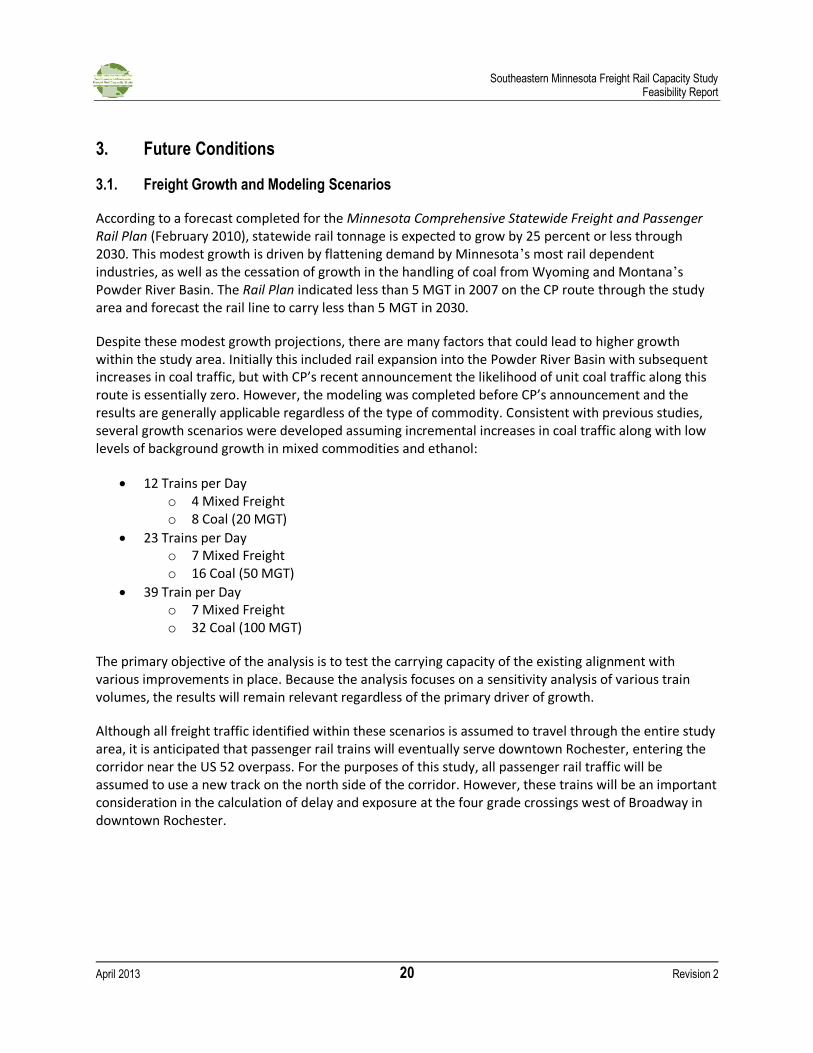
3.2.1.2. Results
Under the high growth scenario, assuming existing geometry with unsignalized track control, delays would far exceed 2.25 hours within the study area and average speeds would drop significantly. Average daily congestion by train type for the high growth scenario on the existing corridor with no improvements is shown in Figure 9.
Figure 9 - Average Congestion (High Growth Scenario without Improvements)
2 The crew change points along the existing corridor are outside of Dodge and Olmsted counties.
0:000:301:001:302:002:303:003:304:004:305:005:306:006:307:007:308:008:309:00
All Trains EB Coal WB Coal Transfer Manifest Local
Ho
urs
of
Co
nge
stio
n (h
ou
r:m
in)
Average Congestion by Train Type
Southeastern Minnesota Freight Rail Capacity Study Feasibility Report
April 2013 22 Revision 2
3.2.2. Recommended Improvements
3.2.2.1. High Growth Scenario (39 Trains)
The high growth scenario represents a significant change in both the volume of trains on the corridor as well as ability to schedule trains. To effectively handle this increase in train volume, physical as well as operational improvements will be necessary:
Track Upgrade (Class IV)
Centralized Traffic Control (CTC)
Siding Improvements with Power Assisted Switching (PAS)
Yard Relocation
Track upgrades would allow for an overall increase in train speeds. However, the speed of a loaded coal train is typically operated under 40 mph in an effort to minimize wear and tear on the track, ballast, and switches.
Central Traffic Control (CTC) represents an improvement over radio dispatch, and allows trains to safely move through the corridor while more effectively utilizing the available mainline.
In addition to track and signal improvements, it is expected that sidings along the corridor under evaluation will be necessary in order to allow eastbound loaded trains to be given priority while empty cars are shuttled westerly along a series of sidings (based on a scenario assuming coal traffic). It is important to note that this study is limited to a two county study area, and these improvements assume that adequate improvements are provided outside the study area in order to allow trains to operate in a similar manner.
The scheduling of trains can be accomplished through a variety of methods, though these can be complicated by the scheduling of crews and yard operations. Crew changes occur well outside the study limits, yet the criteria for overall delay associated with maintaining crew changes within mandated time periods remains valid. Relocating the yard in downtown Rochester would improve operations by removing the switching train from the mainline, adding flexibility to the scheduling of trains.
The scheduling of trains is based on an assumption of continuous loading operations west of the study area. The 16 loaded trains from the west are assumed to depart on a regularly scheduled basis: one train every hour and a half throughout the day. The time the train takes to traverse the study area is effectively 1 hour and 12 minutes. Utilizing the existing Dodge Center siding and adding a new siding east of Rochester will allow an empty train to be shuttled westbound between sidings as the next eastbound loaded train passes unimpeded through the system. The existing Dodge Center siding is located within the railroad’s existing 100-foot wide right-of-way. The proposed east Rochester siding could also be located in an area with 100-foot right-of-way, eliminating the need to obtain additional right-of-way.
Under the high growth scenario, the eastbound trains would be considered the primary movement for scheduling purposes, with the highest priority given to eastbound loaded trains. Empty westbound trains are the lowest priority. A mid-level priority is assigned to other mixed freight shipments as well as sand and ethanol trains. In an attempt to provide balance and flexibility in maintaining schedules of the existing and potential background freight growth, the proposed yard would include a siding for trains other than the empty eastbound trains.
Southeastern Minnesota Freight Rail Capacity Study Feasibility Report
April 2013 23 Revision 2
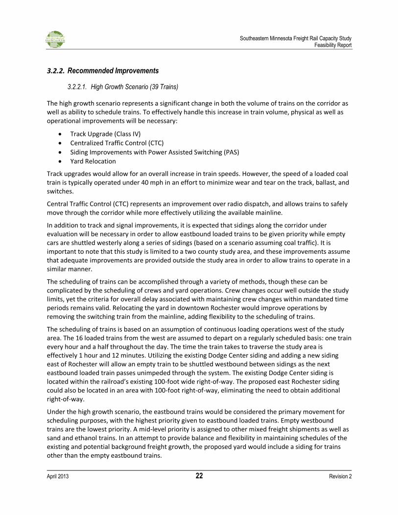
These improvements, including increases in track operating speeds associated with Class IV track, installation of signals, the addition of sidings, and the relocation of the Rochester yard were tested with the high growth scenario. The results indicate that with the priority scheduling for loaded eastbound trains, the railroad operations would be considered acceptable by industry standards. The delay for all trains within the study area is near one hour, or less than the 2.25 hour performance criteria for acceptable operations. With the change from unsignalized to signalized operations, unplanned congestion can now occur. As such, some small levels of congestion would be expected, particularly for manifest trains that wait for the higher priority eastbound loaded trains. However, these levels of congestion are relatively minor and within acceptable limits. In fact, with all improvements in place, the average operating speed for all trains would increase over existing conditions due to the tracks improvements and installation of signals.
In order to more closely model real world operation, the model includes some degree of stochasticity, allowing a variance of plus or minus 45 minutes in scheduling trains. The results from the randomization run indicate an increase in congestion for the eastbound loaded while creating a slight reduction in overall congestion. In fact, the randomization appears to balance congestion more efficiently across the train types. The average daily congestion by train type as well as average speed by train type for the high growth scenario on the existing rail corridor with track and signal improvements are shown in Figures 10 and 11.
Figure 10 - Average Congestion (High Growth Scenario with Recommended Improvements)
0:00
0:30
1:00
1:30
2:00
2:30
3:00
3:30
4:00
All Trains EB Coal WB Coal Transfer Manifest Local
Ho
urs
of
Co
nge
stio
n (h
ou
r:m
in)
Average Congestion by Train Type
EB Coal Optimized Randomized Coal Traffic
Southeastern Minnesota Freight Rail Capacity Study Feasibility Report
April 2013 24 Revision 2
Figure 11 - Average Speed (High Growth Scenario with Recommended Improvements)
3.2.2.2. Low-level Growth Scenario (12 Trains)
After determining the feasibility of accommodating the high growth scenario on the existing alignment, mid-level growth scenarios were assessed. These scenarios effectively represent an exercise in determining the most cost-effective means to meet the system-level crew change requirements.
The low-level growth scenario (12 daily trains) adds eight trains per day to the existing four trains per day. At this level of train traffic, the most important improvement to the existing network will be the relocation of the Rochester yard in order to allow the switch engine to operate without blocking the mainline track. Power assisted switching (PAS) would also be recommended as a method of increasing speeds along the continuous welded rail (CWR) track portions. The existing jointed rail would be assumed to remain as is and thereby limits speeds to 25 mph.
With the recommended improvements in place, congestion would reduce to less than 17 minutes per day for all trains, or well within acceptable limits. While the east siding would not be operationally necessary, it would add flexibility to the network. Without this siding, a similar improvement outside the study area would likely be required, and it is therefore considered a recommended improvement under the low-level growth scenario.
3.2.2.1. Mid-Level Growth Scenario (23Trains)
With the mid-level growth scenario (23 daily trains) it is assumed that all improvements from the low-level growth scenario are already in place. With 23 daily trains, additional improvements would be needed in order to balance the levels of delay across the varying types of train traffic. These include upgrading all remaining jointed rail within the study area to CWR with PAS, as well as increasing the
0
5
10
15
20
25
30
35
40
All Trains EB Coal WB Coal Transfer Manifest Local
mp
h
Average Speed by Train Type
EB Coal Optimized Randomized Coal Traffic
Southeastern Minnesota Freight Rail Capacity Study Feasibility Report
April 2013 25 Revision 2
siding length at the new Rochester yard. These improvements allow for acceptable congestion levels for all trains.
Average daily congestion by train type and average speed by train type for the low and mid growth scenarios with recommended improvements are shown in Figures 12 and 13.
Figure 12 - Average Congestion (Low/Mid Growth Scenarios with Recommended Improvements)
Figure 13 - Average Speed (Low/Mid Growth Scenarios with Recommended Improvements)
0:00
0:30
1:00
1:30
2:00
2:30
3:00
3:30
4:00
All Trains EB Loaded Coal Manifest WB Empty Coal Transfer Local
Ho
urs
of
Co
nge
stio
n (h
ou
r:m
in)
Average Congestion by Train Type
12 Trains 23 Trains
0
5
10
15
20
25
30
35
40
All Trains EB Loaded Coal Manifest WB Empty Coal Transfer Local
mp
h
Average Speed by Train Type
12 Trains 23 Trains
Southeastern Minnesota Freight Rail Capacity Study Feasibility Report
April 2013 26 Revision 2
3.3. Probable Costs
3.3.1. Rail Improvements
The purpose of this section is to develop conceptual plans associated with achieving acceptable train operations and to estimate probable construction costs. The opinion of probable costs is summarized here by major work items including site preparation, track work, structures, and signals. Costs associated with grade separations are discussed in Section 3.3.2. Quantities and unit prices for various pertinent elements by line item are provided in the Appendix. All costs are in 2012 dollars. Because the total represents a conceptual cost estimate, several elements are calculated as percentages of the base construction subtotal including miscellaneous items not quantified, contingencies, mobilization, and fees.
Right-of-way costs are also included, but it should be noted that these costs are subject to wide variations. Right-of-way costs are highly dependent upon specific design components not yet known at the conceptual stage. Additionally, negotiations with individual property owners regarding appropriate compensation and potential relocation assistance influence right-of-way costs. In rural areas, right-of-way costs are estimated at $10,000 per acre, while in urban areas right-of-way is estimated on a square-foot basis dependent upon land use. Right-of-way costs may vary from $2 per square foot for unimproved land to $10 per square foot for commercially developed land. For the yard relocation cost estimate, it is assumed that a willing seller can be found, eliminating the need for a taking. It is important to note that the costs associated with all proposed rail improvements are assumed to be borne entirely by CP Railway.
Implementation costs may include survey, geotechnical, permitting, design, construction inspection, and administrative oversight, among other costs. Construction costs are cited for the various improvements and then summarized for the existing rail corridor.
A common concern with railroad improvements along an existing corridor is the expectation of private property right-of-way impacts. A series of existing conditions sheets (shown in the Appendix) were prepared along the corridor showing the existing right-of-way. Other than a few short segments where the right-of-way narrows, the vast majority of the corridor’s right-of-way is equal to or greater than 100 feet in width.
The improvements can be grouped into four primary categories:
Construction of sidings with power assisted switching
Yard relocation
Track improvements to continuous welded rail
Signal system installation
Each of these categories is described in detail in the following sections and is supported with corresponding figures. Potential right-of-way and construction impacts are then discussed, with probable construction costs in 2012 dollars.
Southeastern Minnesota Freight Rail Capacity Study Feasibility Report
April 2013 27 Revision 2
3.3.1.1. Sidings
A rail siding is a low-speed track section separate from the mainline. Sidings typically have lower speeds and less heavy traffic. Sidings may store stationary rolling stock and are often used for loading and unloading. Sidings may also hold maintenance of way equipment or other equipment allowing trains to pass. The length of a siding is an important consideration, as it must be able to accommodate all train cars in order to prevent blockage of the mainline. The critical design length for this corridor is assumed the length of a coal train. For operational purposes, it is assumed that the westbound empty coal train will utilize the sidings in order to minimize the wear upon the track switches; loaded coal trains would quickly wear out a switch. The typical length of the coal train is 135 cars, and the minimum design length of any new siding is assumed to be 9,000 feet in order to accommodate each 8,500 foot train.
An existing 10,100 foot siding is located on the east side of Dodge Center between MP 66.8 and 68.8. The siding is accommodated within the existing 100-foot right-of-way and is located on the south side of the mainline track, which essentially runs along the centerline of the right-of-way. The siding is located parallel to the existing track, offset by 15 feet to the centerline of the track siding, as illustrated in Figure 14. It is important to note that this siding crosses one at-grade public road, Airport Drive. Under increased train traffic scenarios, the crossing would likely be blocked for a significant amount of time.
Figure 14 - Existing Dodge Center Siding (Typical Section)
Similar design parameters are proposed for the East Rochester siding. This siding is conceptually conceived in the area east of Rochester approximately 20 miles east of Dodge Center. The placement of this siding coincides with operational movements to provide sufficient distance for the empty westbound coal trains to shuttle from one siding to another while allowing the higher priority eastbound loaded coal train to travel easterly. This operational scenario assumes similarly distributed sidings of similar length outside the study area to accommodate the shuttling of empty westbound coal trains.
A review of the existing rail corridor east of Rochester reveals a segment length of approximately 1.7 miles between East Circle Drive and College View Road with no public grade crossings. The 100-foot right-of-way along this segment should easily accommodate the construction of the proposed siding.
Southeastern Minnesota Freight Rail Capacity Study Feasibility Report
April 2013 28 Revision 2
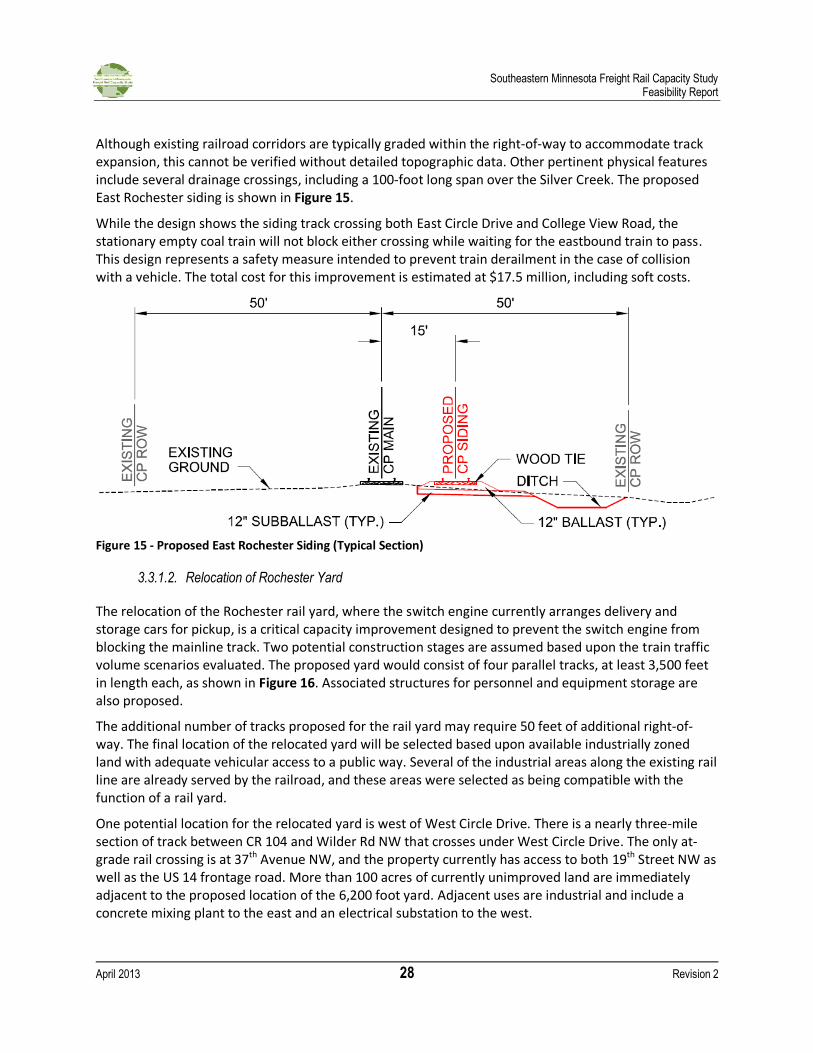
Although existing railroad corridors are typically graded within the right-of-way to accommodate track expansion, this cannot be verified without detailed topographic data. Other pertinent physical features include several drainage crossings, including a 100-foot long span over the Silver Creek. The proposed East Rochester siding is shown in Figure 15.
While the design shows the siding track crossing both East Circle Drive and College View Road, the stationary empty coal train will not block either crossing while waiting for the eastbound train to pass. This design represents a safety measure intended to prevent train derailment in the case of collision with a vehicle. The total cost for this improvement is estimated at $17.5 million, including soft costs.
Figure 15 - Proposed East Rochester Siding (Typical Section)
3.3.1.2. Relocation of Rochester Yard
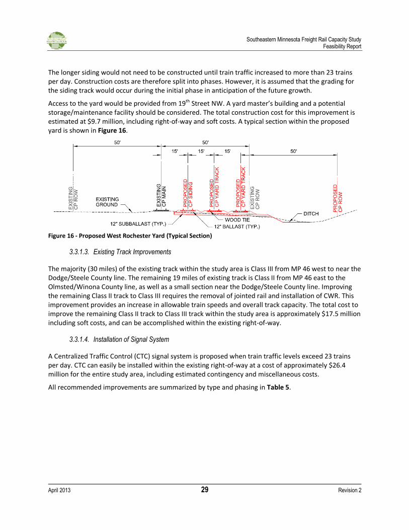
The relocation of the Rochester rail yard, where the switch engine currently arranges delivery and storage cars for pickup, is a critical capacity improvement designed to prevent the switch engine from blocking the mainline track. Two potential construction stages are assumed based upon the train traffic volume scenarios evaluated. The proposed yard would consist of four parallel tracks, at least 3,500 feet in length each, as shown in Figure 16. Associated structures for personnel and equipment storage are also proposed.
The additional number of tracks proposed for the rail yard may require 50 feet of additional right-of-way. The final location of the relocated yard will be selected based upon available industrially zoned land with adequate vehicular access to a public way. Several of the industrial areas along the existing rail line are already served by the railroad, and these areas were selected as being compatible with the function of a rail yard.
One potential location for the relocated yard is west of West Circle Drive. There is a nearly three-mile section of track between CR 104 and Wilder Rd NW that crosses under West Circle Drive. The only at-grade rail crossing is at 37th Avenue NW, and the property currently has access to both 19th Street NW as well as the US 14 frontage road. More than 100 acres of currently unimproved land are immediately adjacent to the proposed location of the 6,200 foot yard. Adjacent uses are industrial and include a concrete mixing plant to the east and an electrical substation to the west.
Southeastern Minnesota Freight Rail Capacity Study Feasibility Report
April 2013 29 Revision 2
The longer siding would not need to be constructed until train traffic increased to more than 23 trains per day. Construction costs are therefore split into phases. However, it is assumed that the grading for the siding track would occur during the initial phase in anticipation of the future growth.
Access to the yard would be provided from 19th Street NW. A yard master’s building and a potential storage/maintenance facility should be considered. The total construction cost for this improvement is estimated at $9.7 million, including right-of-way and soft costs. A typical section within the proposed yard is shown in Figure 16.
Figure 16 - Proposed West Rochester Yard (Typical Section)
3.3.1.3. Existing Track Improvements
The majority (30 miles) of the existing track within the study area is Class III from MP 46 west to near the Dodge/Steele County line. The remaining 19 miles of existing track is Class II from MP 46 east to the Olmsted/Winona County line, as well as a small section near the Dodge/Steele County line. Improving the remaining Class II track to Class III requires the removal of jointed rail and installation of CWR. This improvement provides an increase in allowable train speeds and overall track capacity. The total cost to improve the remaining Class II track to Class III track within the study area is approximately $17.5 million including soft costs, and can be accomplished within the existing right-of-way.
3.3.1.4. Installation of Signal System
A Centralized Traffic Control (CTC) signal system is proposed when train traffic levels exceed 23 trains per day. CTC can easily be installed within the existing right-of-way at a cost of approximately $26.4 million for the entire study area, including estimated contingency and miscellaneous costs.
All recommended improvements are summarized by type and phasing in Table 5.
Southeastern Minnesota Freight Rail Capacity Study Feasibility Report
April 2013 30 Revision 2
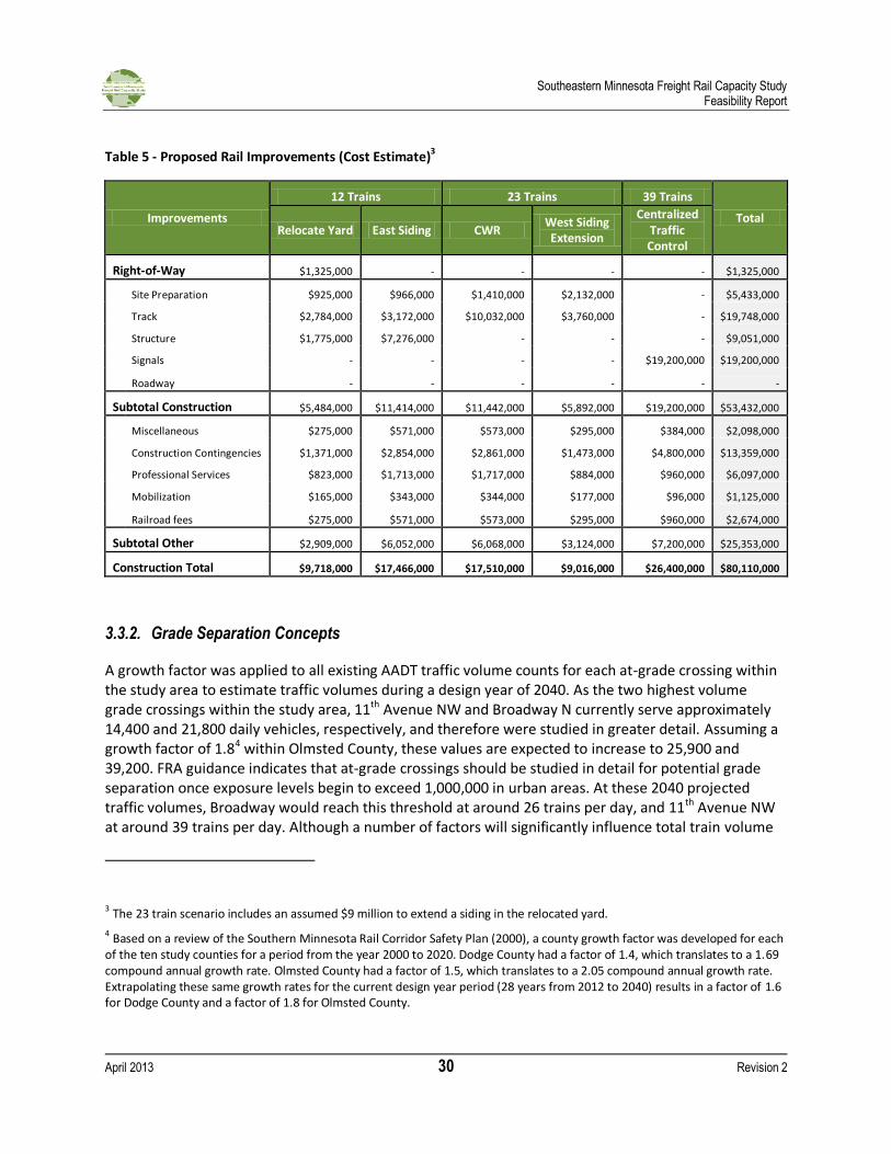
Table 5 - Proposed Rail Improvements (Cost Estimate)3
Improvements
12 Trains 23 Trains 39 Trains
Total Relocate Yard East Siding CWR
West Siding Extension
Centralized Traffic Control
Right-of-Way $1,325,000 - - - - $1,325,000
Site Preparation $925,000 $966,000 $1,410,000 $2,132,000 - $5,433,000
Track $2,784,000 $3,172,000 $10,032,000 $3,760,000 - $19,748,000
Structure $1,775,000 $7,276,000 - - - $9,051,000
Signals - - - - $19,200,000 $19,200,000
Roadway - - - - - -
Subtotal Construction $5,484,000 $11,414,000 $11,442,000 $5,892,000 $19,200,000 $53,432,000
Miscellaneous $275,000 $571,000 $573,000 $295,000 $384,000 $2,098,000
Construction Contingencies $1,371,000 $2,854,000 $2,861,000 $1,473,000 $4,800,000 $13,359,000
Professional Services $823,000 $1,713,000 $1,717,000 $884,000 $960,000 $6,097,000
Mobilization $165,000 $343,000 $344,000 $177,000 $96,000 $1,125,000
Railroad fees $275,000 $571,000 $573,000 $295,000 $960,000 $2,674,000
Subtotal Other $2,909,000 $6,052,000 $6,068,000 $3,124,000 $7,200,000 $25,353,000
Construction Total $9,718,000 $17,466,000 $17,510,000 $9,016,000 $26,400,000 $80,110,000
3.3.2. Grade Separation Concepts
A growth factor was applied to all existing AADT traffic volume counts for each at-grade crossing within the study area to estimate traffic volumes during a design year of 2040. As the two highest volume grade crossings within the study area, 11th Avenue NW and Broadway N currently serve approximately 14,400 and 21,800 daily vehicles, respectively, and therefore were studied in greater detail. Assuming a growth factor of 1.84 within Olmsted County, these values are expected to increase to 25,900 and 39,200. FRA guidance indicates that at-grade crossings should be studied in detail for potential grade separation once exposure levels begin to exceed 1,000,000 in urban areas. At these 2040 projected traffic volumes, Broadway would reach this threshold at around 26 trains per day, and 11th Avenue NW at around 39 trains per day. Although a number of factors will significantly influence total train volume
3 The 23 train scenario includes an assumed $9 million to extend a siding in the relocated yard.
4 Based on a review of the Southern Minnesota Rail Corridor Safety Plan (2000), a county growth factor was developed for each of the ten study counties for a period from the year 2000 to 2020. Dodge County had a factor of 1.4, which translates to a 1.69 compound annual growth rate. Olmsted County had a factor of 1.5, which translates to a 2.05 compound annual growth rate. Extrapolating these same growth rates for the current design year period (28 years from 2012 to 2040) results in a factor of 1.6 for Dodge County and a factor of 1.8 for Olmsted County.
Southeastern Minnesota Freight Rail Capacity Study Feasibility Report
April 2013 31 Revision 2
at each of these crossings, including the potential for up to 20 passenger trains per day at the 11th Avenue NW crossing associated with Zip Rail, these two crossings will likely emerge as two of the strongest candidates for grade separation based on projected traffic volumes alone.
Upon selection of these two critical crossings, a review of potential ways to address grade separation was undertaken. General grade separation concepts include elevating the roadway over the railroad or excavating a roadway trench under the railroad. Each concept has associated roadway and railroad design criteria, as shown in Table 6. A brief description of each concept along with plan and profile exhibits as well as probable costs is provided. One final option, elevating the railroad over multiple roadways in downtown Rochester, is also presented.
Table 6 - Grade Separation Design Criteria
Design Element Road over Rail Rail over Road
Depth of Structure (ft) 6.0' 8.0'
Minimum Vertical Clearance (ft) 23.5' 16.3'
Profile Grade (%)
Arterial Roadway (Max.) 8.0% -
Arterial Roadway (Desired) 6.0% -
Railroad (Freight) - 1.2%
Railroad (Passenger) - 1.6%
The capital cost estimates were developed to include the one-time expenditure required to build the grade separations and included costs associated with construction of the aerial structure, retaining walls, roadway, and frontage roads. “Soft costs” for items such as engineering, construction services, project management, surveys, testing, insurance, legal, permits and owner’s costs are included as part of the overall capital cost.
Due to the conceptual nature of the project, a contingency of 20 percent was applied to the construction cost to account for uncertainty in both the estimating process and the scope of the project. A contingency of 100 percent was applied to anticipated right-of-way costs. As the level of design detail increases, more and more items are specifically costed, leading to lower contingency costs in the estimate.
At this early study stage, there is not sufficient definition or detail to prepare true construction cost estimates for the grade separations under consideration. Rather, the capital cost estimates were developed using representative typical unit costs or allowances on a per unit basis that is consistent with the conceptual nature of the project. Unit costs were collected using historical MnDOT cost information and previous project experience. Capital cost estimates will need to be refined if the grade separations are chosen to move forward into preliminary and final design.
Capital costs developed for the grade separations are shown to be 2013 dollars and were not inflated to the mid-point of construction, which is unknown at this time.
Southeastern Minnesota Freight Rail Capacity Study Feasibility Report
April 2013 32 Revision 2
The following provides a summary of the costs that were included within each of the grade separation cost estimates.
General Conditions
General condition costs are estimated to be 10 percent of the construction cost and include mobilization, temporary traffic control, and railroad protection for the project.
Civil Work
Civil costs were based on quantity take-offs that were determined from the conceptual plan/profile exhibits dated January 8, 2013. Where specific quantities were not available, allowances were developed to account for potential costs that may be realized as the design progresses.
The following items were included within the cost estimate:
Removals
Street Lighting
Traffic Signal (Civic Center Drive)
Common Excavation
Roadway Construction (Pavement, subgrade preparation, curb and gutter)
Traffic Control
Turf Establishment
Sidewalk
Utility Relocation
Stormwater Pumps (Broadway Underpass Only)
Environmental Mitigation
Costs to relocate private utilities, such as the power lines adjacent to 11th Avenue NW and the CP Railroad are not included within the cost estimate.
Structures
Structure costs include the bridge structures that would be required for the railroad and roadway, as well as costs for retaining walls that are required to support the elevated or depressed roadway profile. Bridge structure costs assume that a precast concrete girder bridge would be used for highway bridges structures and steel thru girder bridges would be used for the railroad bridge structures. Concrete retaining walls were assumed as the preferred retaining wall type.
Soft Costs
“Soft costs” include the indirect project costs such as professional/technical fees, design, and construction management costs, insurance, legal and permitting costs, surveys, testing, investigation, and inspection costs. These costs are generated by applying assumed rates to different categories of the estimate. Table 7 identifies the percentages that were used to develop these costs:
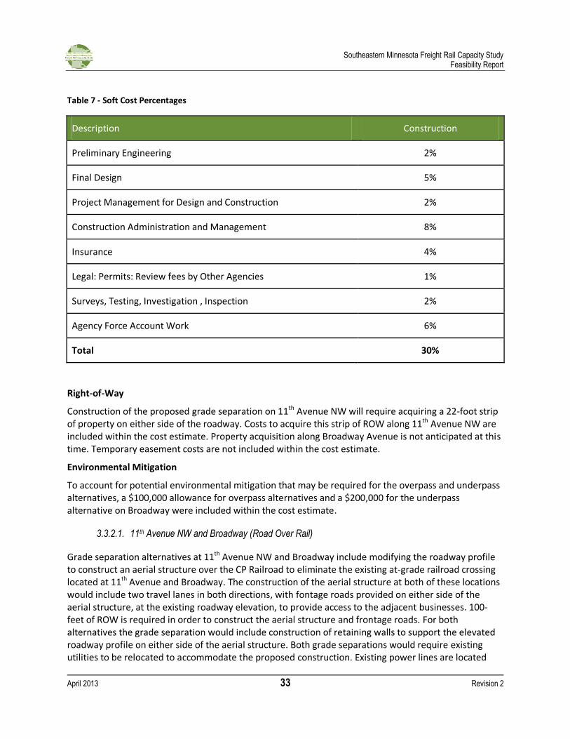
Southeastern Minnesota Freight Rail Capacity Study Feasibility Report
April 2013 33 Revision 2
Table 7 - Soft Cost Percentages
Description Construction
Preliminary Engineering 2%
Final Design 5%
Project Management for Design and Construction 2%
Construction Administration and Management 8%
Insurance 4%
Legal: Permits: Review fees by Other Agencies 1%
Surveys, Testing, Investigation , Inspection 2%
Agency Force Account Work 6%
Total 30%
Right-of-Way
Construction of the proposed grade separation on 11th Avenue NW will require acquiring a 22-foot strip of property on either side of the roadway. Costs to acquire this strip of ROW along 11th Avenue NW are included within the cost estimate. Property acquisition along Broadway Avenue is not anticipated at this time. Temporary easement costs are not included within the cost estimate.
Environmental Mitigation
To account for potential environmental mitigation that may be required for the overpass and underpass alternatives, a $100,000 allowance for overpass alternatives and a $200,000 for the underpass alternative on Broadway were included within the cost estimate.
3.3.2.1. 11th Avenue NW and Broadway (Road Over Rail)
Grade separation alternatives at 11th Avenue NW and Broadway include modifying the roadway profile to construct an aerial structure over the CP Railroad to eliminate the existing at-grade railroad crossing located at 11th Avenue and Broadway. The construction of the aerial structure at both of these locations would include two travel lanes in both directions, with fontage roads provided on either side of the aerial structure, at the existing roadway elevation, to provide access to the adjacent businesses. 100-feet of ROW is required in order to construct the aerial structure and frontage roads. For both alternatives the grade separation would include construction of retaining walls to support the elevated roadway profile on either side of the aerial structure. Both grade separations would require existing utilities to be relocated to accommodate the proposed construction. Existing power lines are located
Southeastern Minnesota Freight Rail Capacity Study Feasibility Report
April 2013 34 Revision 2
parallel to 11th Avenue NW and the CP Railroad. These power lines may required adjustments or relocation in order to accommodate the proposed aerial structure.
On 11th Avenue NW, the roadway profile begins to climb at Civic Center Drive on the south side of the CP Railroad, crosses over the CP Railroad and 7th Street NW and is back down to the existing roadway elevation at 10th Street NW. Through access under the aerial structure is maintained at 7th Street NW, while access at 6th Street NW and 9th Street NW is modified to be right-in, right-out only. Additional ROW would need to be acquired south of 7th Street NW, 11th Avenue NW, which currently only has 66-feet of ROW available. 100-feet of ROW is available north of 7th Street NW. Construction of the aerial structure and frontage roads would likely require the acquisition of the existing Super America that is located at 6th Street NW and Broadway Avenue. Approximately 13 access points to existing properties would be affected with this grade separation.
On Broadway, the roadway profile begins to climb north of East Center Street on the south side of the CP Railroad, crosses over the existing spur line, Civic Center Drive and the CP Railroad and is back down to the existing roadway elevation prior to the 6th Street NW intersection. Through access and turning movements under the aerial structure are maintained at 2nd Street NW, 3rd Street NW and Civic Center Drive, while access at 1st Street NW and 5th Street NW is modified to be right-in, right-out only. The existing at-grade railroad crossing would be maintained to provide through access on the frontage roads that are currently proposed on Broadway Avenue. Broadway currently has 100-feet of ROW on both sides of the CP Railroad, which is sufficient for the aerial structure and frontage roads that are currently proposed. Approximately 7 access points to existing properties would be affected with this grade separation.
The total cost for the aerial structure grade separation alternative on 11th Avenue NW is estimated at $16.5 million, and the total cost for the aerial structure grade separation alternative on Broadway is estimated at $17.7 million.
3.3.2.2. Broadway (Road Under Rail)
A second grade separation alternative on Broadway includes the construction of an underpass that would eliminate the existing at-grade crossing at the CP Railroad.The underpass would include the construction of two travel lanes in both directions and retaining walls on either side of the roadway to support the adjacent infrastructure. Similar to the overpass alternatives, frontage roads would be provided on either side of the underpass to allow access to the businesse adjacent to Broadway and access to Civic Center Drive. Construction of the underpass would require relocations of the existing utilities that are located within the existing roadway to accommodate the proposed construction. Additional design measures would need to be taken into consideration for stormwater removal and potential water table concerns.
The Broadway roadway profile begins to drop north of East Center Street on the south of the CP Railroad, crosses under the existing spur line, Civic Center Drive, and the CP Railroad and then climbs back to the existing roadway elevation prior to the 6th Street NW intersection. Bridge structures for the existing spur line, Civic Center Drive at the CP Railroad would be constructed above the proposed underpass. Through access and turning movements would be maintained on the proposed Civic Center Drive bridge structure, while access at 1st Street NW, 2nd Street NW, 3rd Street NW, and 5th Street NW are modified to be right-in, right-out only. An at-grade crossing would be required to maintain through
Southeastern Minnesota Freight Rail Capacity Study Feasibility Report
April 2013 35 Revision 2
access on the frontage roads that are currently proposed on Broadway Avenue. Broadway currently has 100-feet of ROW on both sides of the CP Railroad, which is sufficient for the aerial structure and frontage roads that are currently proposed. Approximately 7 access points to existing properties would be affected with this grade separation.
The total cost for the underpass grade separation alternative on Broadway is estimated at $25.0 million. Typical sections are shown in Figure 17.
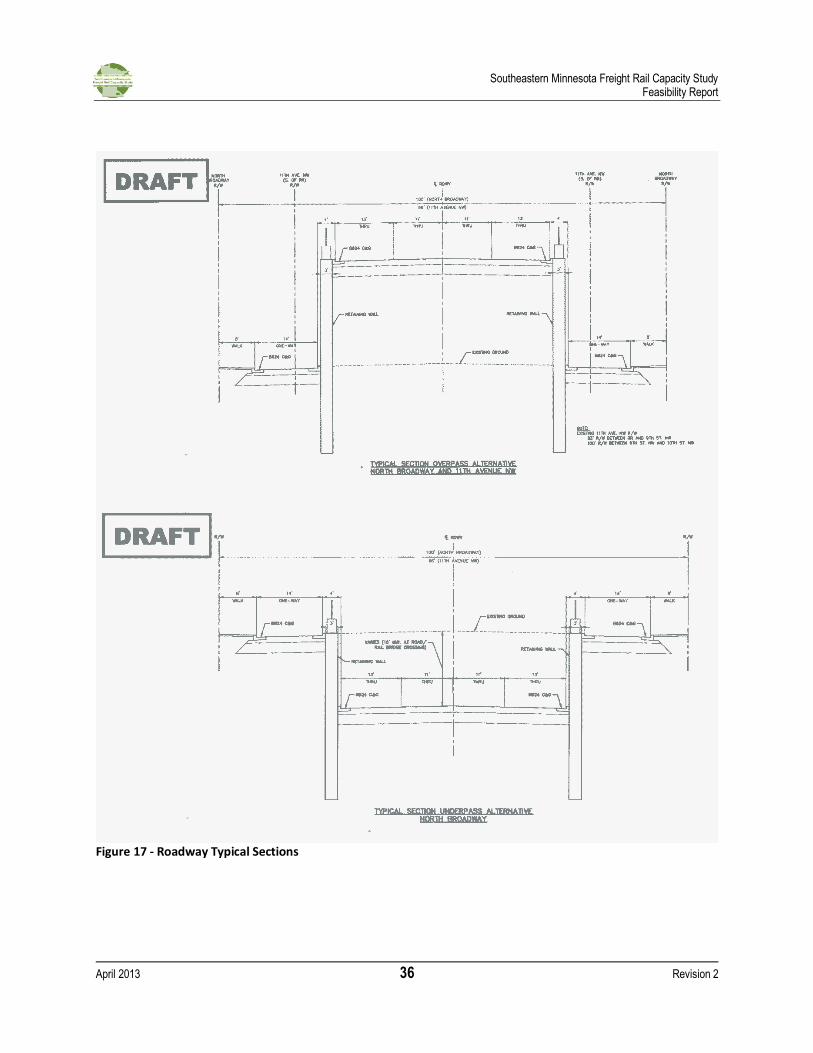
Southeastern Minnesota Freight Rail Capacity Study Feasibility Report
April 2013 36 Revision 2
Figure 17 - Roadway Typical Sections
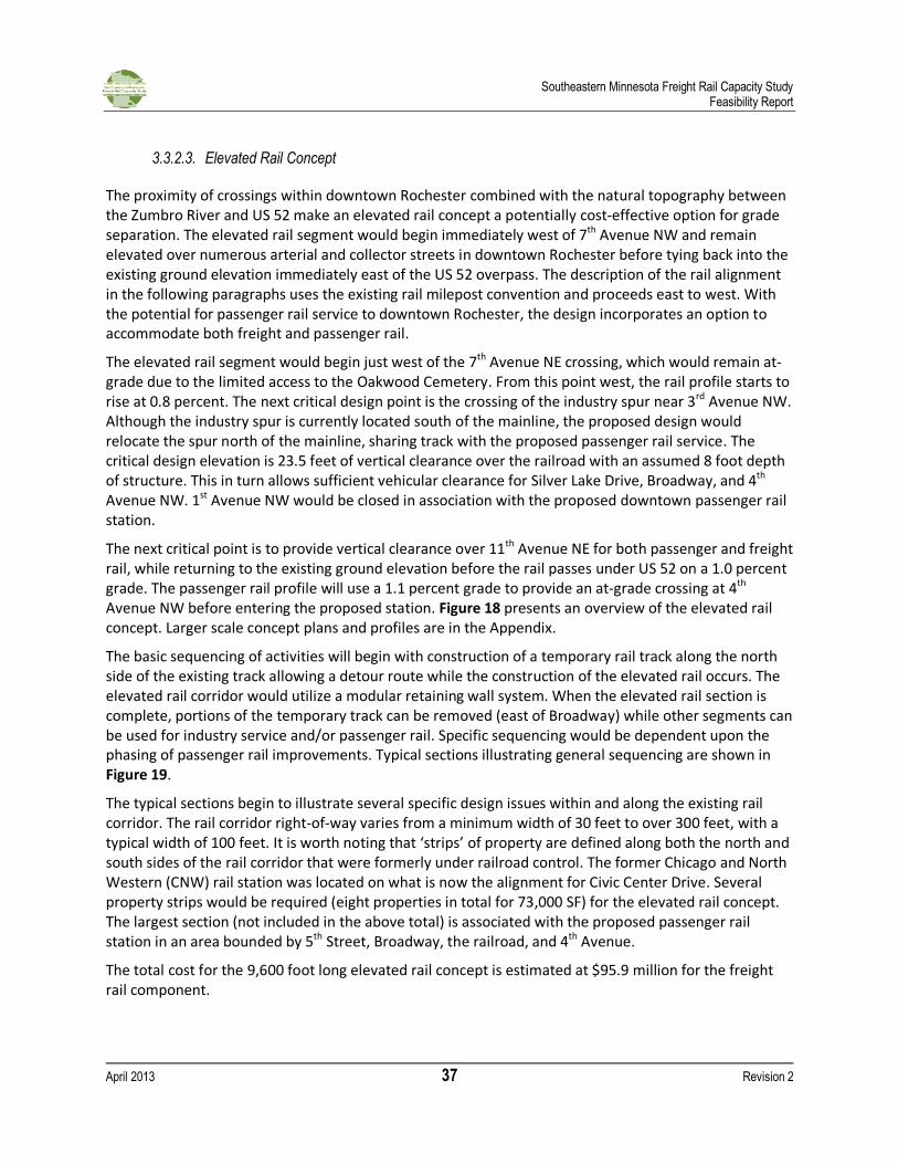
Southeastern Minnesota Freight Rail Capacity Study Feasibility Report
April 2013 37 Revision 2
3.3.2.3. Elevated Rail Concept
The proximity of crossings within downtown Rochester combined with the natural topography between the Zumbro River and US 52 make an elevated rail concept a potentially cost-effective option for grade separation. The elevated rail segment would begin immediately west of 7th Avenue NW and remain elevated over numerous arterial and collector streets in downtown Rochester before tying back into the existing ground elevation immediately east of the US 52 overpass. The description of the rail alignment in the following paragraphs uses the existing rail milepost convention and proceeds east to west. With the potential for passenger rail service to downtown Rochester, the design incorporates an option to accommodate both freight and passenger rail.
The elevated rail segment would begin just west of the 7th Avenue NE crossing, which would remain at-grade due to the limited access to the Oakwood Cemetery. From this point west, the rail profile starts to rise at 0.8 percent. The next critical design point is the crossing of the industry spur near 3rd Avenue NW. Although the industry spur is currently located south of the mainline, the proposed design would relocate the spur north of the mainline, sharing track with the proposed passenger rail service. The critical design elevation is 23.5 feet of vertical clearance over the railroad with an assumed 8 foot depth of structure. This in turn allows sufficient vehicular clearance for Silver Lake Drive, Broadway, and 4th Avenue NW. 1st Avenue NW would be closed in association with the proposed downtown passenger rail station.
The next critical point is to provide vertical clearance over 11th Avenue NE for both passenger and freight rail, while returning to the existing ground elevation before the rail passes under US 52 on a 1.0 percent grade. The passenger rail profile will use a 1.1 percent grade to provide an at-grade crossing at 4th Avenue NW before entering the proposed station. Figure 18 presents an overview of the elevated rail concept. Larger scale concept plans and profiles are in the Appendix.
The basic sequencing of activities will begin with construction of a temporary rail track along the north side of the existing track allowing a detour route while the construction of the elevated rail occurs. The elevated rail corridor would utilize a modular retaining wall system. When the elevated rail section is complete, portions of the temporary track can be removed (east of Broadway) while other segments can be used for industry service and/or passenger rail. Specific sequencing would be dependent upon the phasing of passenger rail improvements. Typical sections illustrating general sequencing are shown in Figure 19.
The typical sections begin to illustrate several specific design issues within and along the existing rail corridor. The rail corridor right-of-way varies from a minimum width of 30 feet to over 300 feet, with a typical width of 100 feet. It is worth noting that ‘strips’ of property are defined along both the north and south sides of the rail corridor that were formerly under railroad control. The former Chicago and North Western (CNW) rail station was located on what is now the alignment for Civic Center Drive. Several property strips would be required (eight properties in total for 73,000 SF) for the elevated rail concept. The largest section (not included in the above total) is associated with the proposed passenger rail station in an area bounded by 5th Street, Broadway, the railroad, and 4th Avenue.
The total cost for the 9,600 foot long elevated rail concept is estimated at $95.9 million for the freight rail component.

Southeastern Minnesota Freight Rail Capacity Study Feasibility Report
April 2013 38 Revision 2
Figure 18 - Elevated Rail Concept (Plan and Profile)
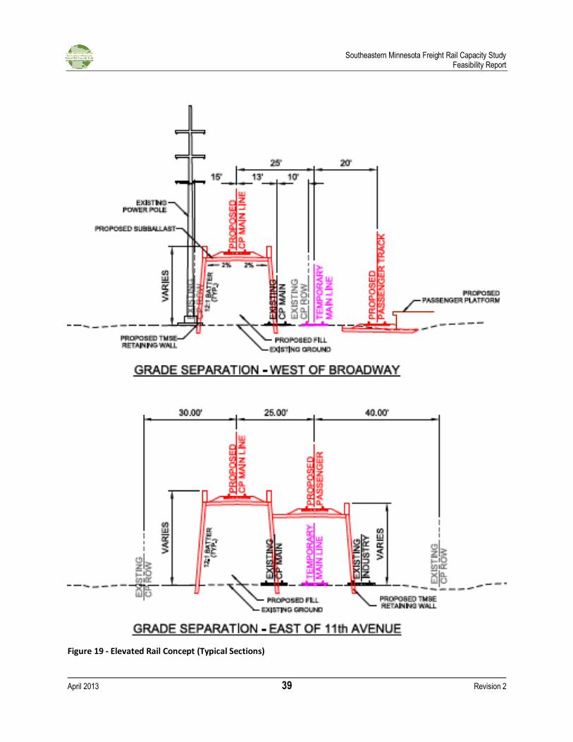
Southeastern Minnesota Freight Rail Capacity Study Feasibility Report
April 2013 39 Revision 2
Figure 19 - Elevated Rail Concept (Typical Sections)
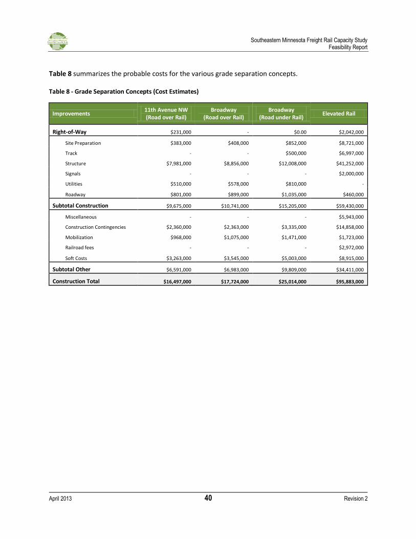
Southeastern Minnesota Freight Rail Capacity Study Feasibility Report
April 2013 40 Revision 2
Table 8 summarizes the probable costs for the various grade separation concepts. Table 8 - Grade Separation Concepts (Cost Estimates)
Improvements 11th Avenue NW (Road over Rail)
Broadway (Road over Rail)
Broadway (Road under Rail)
Elevated Rail
Right-of-Way $231,000 - $0.00 $2,042,000
Site Preparation $383,000 $408,000 $852,000 $8,721,000
Track - - $500,000 $6,997,000
Structure $7,981,000 $8,856,000 $12,008,000 $41,252,000
Signals - - - $2,000,000
Utilities $510,000 $578,000 $810,000 -
Roadway $801,000 $899,000 $1,035,000 $460,000
Subtotal Construction $9,675,000 $10,741,000 $15,205,000 $59,430,000
Miscellaneous - - - $5,943,000
Construction Contingencies $2,360,000 $2,363,000 $3,335,000 $14,858,000
Mobilization $968,000 $1,075,000 $1,471,000 $1,723,000
Railroad fees - - - $2,972,000
Soft Costs $3,263,000 $3,545,000 $5,003,000 $8,915,000
Subtotal Other $6,591,000 $6,983,000 $9,809,000 $34,411,000
Construction Total $16,497,000 $17,724,000 $25,014,000 $95,883,000
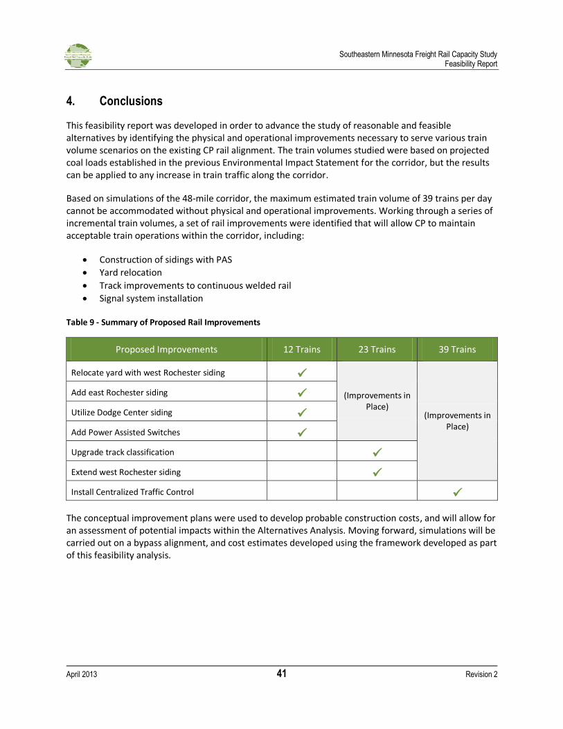
Southeastern Minnesota Freight Rail Capacity Study Feasibility Report
April 2013 41 Revision 2
4. Conclusions
This feasibility report was developed in order to advance the study of reasonable and feasible alternatives by identifying the physical and operational improvements necessary to serve various train volume scenarios on the existing CP rail alignment. The train volumes studied were based on projected coal loads established in the previous Environmental Impact Statement for the corridor, but the results can be applied to any increase in train traffic along the corridor.
Based on simulations of the 48-mile corridor, the maximum estimated train volume of 39 trains per day cannot be accommodated without physical and operational improvements. Working through a series of incremental train volumes, a set of rail improvements were identified that will allow CP to maintain acceptable train operations within the corridor, including:
Construction of sidings with PAS
Yard relocation
Track improvements to continuous welded rail
Signal system installation Table 9 - Summary of Proposed Rail Improvements
Proposed Improvements 12 Trains 23 Trains 39 Trains
Relocate yard with west Rochester siding
(Improvements in Place)
(Improvements in Place)
Add east Rochester siding
Utilize Dodge Center siding
Add Power Assisted Switches
Upgrade track classification
Extend west Rochester siding
Install Centralized Traffic Control
The conceptual improvement plans were used to develop probable construction costs, and will allow for an assessment of potential impacts within the Alternatives Analysis. Moving forward, simulations will be carried out on a bypass alignment, and cost estimates developed using the framework developed as part of this feasibility analysis.
Southeastern Minnesota Freight Rail Capacity Study Feasibility Report
April 2013 42 Revision 2
5. References
City of Rochester, Emergency Operations Plan, Rochester, MN, 2011.
Dodge County, Dodge County All-Hazard Mitigation Plan, Mantorville, MN, 2010.
Mayo Clinic, DM&E Rail Alternative Analysis and Cost Study Task 3 Report, 2009.
Minnesota Department of Public Safety, Emergency Operations Plan, State of Minnesota, St. Paul, 2011.
Minnesota Department of Transportation, Minnesota Comprehensive Statewide Freight and Passenger Rail Plan, State of Minnesota, St. Paul, MN, February 2010.
Minnesota Department of Transportation, Southern Minnesota Rail Corridor Safety Plan, 2000
Minnesota Division of Homeland Security and Emergency Management, Minnesota All-Hazard Mitigation Plan, State of Minnesota, St. Paul, MN, 2011.
Olmsted County, All Hazard Mitigation Plan, Rochester, MN, 2009.
Surface Transportation Board, Powder River Basin Expansion Project Final Environmental Impact Statement, 2001.
United States Department of Transportation, Railroad-Highway Grade Crossing Handbook, Washington, DC, August 2007.
Southeastern Minnesota Freight Rail Capacity Study Feasibility Report
April 2013 43 Revision 2
6. Appendix
A. Existing Conditions Maps
B. USDOT Crossing Inventory
C. FRA Annual WBAPS 2012
D. Proposed Rail Improvements
E. Grade Separation Alternatives
F. Cost Estimates