south sudan livelihood zones and descriptions august 2013...south sudan livelihood zones and...
TRANSCRIPT

FEWS NET Washington
www.fews.net
FEWS NET is a USAID-funded activity. The content of this report does not
necessarily reflect the view of the United States Agency for International
Development or the United States Government.
SOUTH SUDAN Livelihood Zones and Descriptions August 2013

FEWS NET Washington
www.fews.net
FEWS NET is a USAID-funded activity. The content of this report does not
necessarily reflect the view of the United States Agency for International
Development or the United States Government.
TABLE OF CONTENTS
Map of Livelihood Zones in South Sudan .................................................................................................................................................. 1
Acknowledgements ......................................................................................................................................................................................... 3
Acronyms and Abbreviations ....................................................................................................................................................................... 4
Livelihood Zoning and Description Methodology .................................................................................................................................. 5
Livelihoods in Rural South Sudan ................................................................................................................................................................ 6
Recent Events Affecting Food Security and Livelihood ......................................................................................................................... 8
Equatorial Maize and Cassava (Livelihood zone 1) ................................................................................................................................. 9
Iron Stone Plateu Agropastoral (Livelihood zone 2) ........................................................................................................................... 12
High land Forest and Sorghum (Livelihood zone 3) ............................................................................................................................. 15
Western Groundnuts, Sesame and Sorghum (Livelihood zone 4) ................................................................................................... 18
Eastern Semi Arid Pastoral (Livelihood zone 5) .................................................................................................................................... 21
Eastern Plain Sorghum and Cattle (Livelihood zone 6) ....................................................................................................................... 24
Greater Bahr el Ghazal Sorghum and Cattle (Livelihood zone 7) .................................................................................................... 27
Nile Basin Fishing and Agropastoral (Livelihood zone 8) .................................................................................................................... 30
Oil Resources, Cattle and Maize (Livelihood zone 9).......................................................................................................................... 33
North Eastern Cattle and Maize (Livelihood zone 10) ........................................................................................................................ 36
Northern Sorghum and Livestock (Livelihood zone 11) ..................................................................................................................... 39
Administrative Areas and Demographics ................................................................................................................................................ 42
List of Participants ......................................................................................................................................................................................... 45

Famine Early Warning Systems Network 2
SOUTH SUDAN Livelihood Zones and Descriptions August 2013
ACKNOWLEDGEMENTS
The Livelihood Zoning Workshop and this report were led by James Acidri of Evidence for Development, with technical support from John Vuga and Chan Lam Chuol of FEWS NET South Sudan, Nancy Mutunga of FEWS NET Nairobi Regional Office and Gary Sawdon of FEWS NET Head Office in Washington. This activity was conducted in collaboration with main partners the Government of South Sudan (GoSS), the National Ministry of Agriculture and Forestry (NMAF) and the National Bureau of Statistics (NBS). Special thanks are extended to the core national facilitator’s team, especially Mr. Manase Yanga, the coordinator of the Food Security Technical Secretariat (FSTS) within NBS, Angelo Longa, Planning Officer with NMAF, Evans Kenyi, Coordinator for Integrated Food Security Phase Classification (IPC), United Nations Food and Agricultural Organization (FAO), and Gummat Abdellatif, Senior Vulnerability Assessment and Mapping Assistant with the United Nations World Food Programme (WFP), without whose contributions this South Sudan Livelihood “Plus” report could not have been developed. This report will form part of the knowledge base for FEWS NET’s food security monitoring activities in South Sudan.

Famine Early Warning Systems Network 3
SOUTH SUDAN Livelihood Zones and Descriptions August 2013
ACRONYMS AND ABBREVIATIONS
CAR Central Africa Republic
EfD Evidence for Development
FAO Food and Agricultural Organization
FEWS NET Famine Early Warning Systems Network
FMA Federal Ministry of Agriculture
FSTS Food Security Technical Secretariat
G Gathering, usually for wild foods or products
GRSS Government of the Republic of South Sudan
HEA Household Economy Approach
IDP Internally Displaced People
IK Payment for services in kind
IPC Integrated Food Security Phase Classification
MARS Ministry of Agriculture and Rural Services
NBS National Bureau of Statistics
USAID United States Agency for International Development
USG United States Government
UN United Nations
VAM Vulnerability Analysis and Mapping
WFP World Food Programme
OP Own produced crops
MP Market-purchased food
NMAF National Ministry of Agriculture and Forestry
SMAF State Ministry of Agriculture and Forestry
SMARF State Ministry of Animal Resources and Fisheries

Famine Early Warning Systems Network 4
SOUTH SUDAN Livelihood Zones and Descriptions August 2013
LIVELIHOOD ZONING AND DESCRIPTION METHODOLOGY
The standard Household Economy Assessment (HEA) is a livelihood-based framework for analyzing the ways people access the things they need to survive and maintain their livelihood. It helps determine people’s food and non-food needs and identify appropriate means of assistance, whether short-term emergency assistance or longer term development programs or policy changes. It is important to note that the HEA is an analytical framework, not a specific method of information collection. It defines the information that needs to be collected and the way in which it should be analyzed in order to answer a particular set of questions. It is a framework for organizing a vast array of information – some of which is local knowledge, some of which is census data, some of which is crop production data, and so on. It functions as a powerful way to make practical use of both existing secondary sources of information and also primary information. HEA defines a livelihood zone as a geographic area in which households obtain their basic survival needs, notably food and cash income, in relatively similar ways. This means that they also typically have similar socio-economic groupings with similar asset bases, as well as relatively similar consumption patterns. These similarities apply to both good and bad years, in that coping strategies in response to shocks are also relatively similar within the same livelihood zone. The Livelihood Zoning “Plus” product is based on the Household Economy Approach (http://www.feg-consulting.com/resource/practitioners-guide-to-hea/practitioners-guide-to-hea/). It includes a traditional livelihoods zoning component (http://www.feg-consulting.com/resource/practitioners-guide-to-hea/2%20Livelihood%20Zoning.pdf). In addition, key characteristics of socioeconomic status are explored by setting those of relatively poorer households beside those of relatively better-off households. The Livelihood zoning Plus product also provides a brief description of the zone’s main geographical and climatic features, the main sources of food and cash income for each wealth group, and seasonal labor and food access calendars. Finally, the zones most vulnerable to food insecurity are identified. Livelihood zone maps and descriptions form part of the knowledge base for FEWS NET’s food security monitoring activities. These tools, however, are not designed as a comprehensive analysis of food security or as a complete monitoring tool, but rather to provide points of reference and indicate whether the conditions reported at a given time justify a more in-depth study. The results presented in this report describe how households may be affected by various shocks. They provide a geographic context for interpreting existing monitoring data on production, prices, and other indicators in order to identify potential problems. Rapid assessment teams may be able to use the zoning as a basis for sampling in their studies. The methodology for elaborating the livelihood zone maps and descriptions in this document consisted of the following steps:
1. FEWS NET researched available secondary information regarding geography, climatology, demographics, agriculture, livestock, markets, etc. WFP and FEWS NET’s previous food security reports in South Sudan were also used as a foundation for this work.
2. Approximately 10 representatives from each state came together in a regional-level workshop to divide the
country into livelihood zones. The five workshops included an initial national core facilitator’s workshop which took place from 20-23
rd March 2013. This was followed by regional workshops in Bor (26-28
th March); Malakal (6-
8th
June); Wau (11th
-13th
June) and the Juba workshop covering the Greater Equatoria States (17-19th
June).
3. Participants documented the key characteristics of livelihoods, produced seasonal calendars, and set out salient market characteristics for their respective zones, providing the basic information presented in the livelihood zone descriptions.
4. An initial version of the report was circulated to workshop participants between 17-30
th July
2013. This final
version incorporates their comments.

Famine Early Warning Systems Network 5
SOUTH SUDAN Livelihood Zones and Descriptions August 2013
For more information about Household Economy Approach principles and analysis, visit the livelihood pages at http://www.fews.net
1
LIVELIHOODS IN RURAL SOUTH SUDAN Despite abundant natural resources, i.e. arable and grazing land, water resources, oil, timber, South Sudan is among the poorest and least-developed countries in the world. There are few tarmac roads, limited electronic communications and over wide areas communications and trade rely on river transport on the White Nile, particularly between the ports of Juba, Bor, Malakal and with the Republic of Sudan). The national economy is overwhelming dependent on oil exports which account for 98% of the country’s total exports and
over 80% of gross domestic product although some livestock and timber are exported and there is informal trade
particularly in agricultural produce across the country's borders with CAR, DRC, Uganda, Ethiopia, Kenya and Sudan. Staple
foods, including food aid, accounts for the bulk of imports because of low production in some areas and because limited
internal transport does not allow food to be brought from surplus to deficit areas and to Juba and other urban areas within
South Sudan. The dangers of extreme overreliance on oil include lack of government revenue if and when oil exports are
disrupted by problems with neighboring Sudan.
The population, estimated (2008 census) at approximately 8 million, is overwhelmingly rural and primarily dependent on
subsistence farming or animal husbandry for their livelihoods and the risk of food insecurity varies markedly with rainfall,
soil types, topography, drainage and access to markets and to wild plant foods, hunting and fishing, timber, gum arabic and
other natural resources. Larger scale mechanized farming is limited to parts of Upper Nile, Unity and Northern Bahr el
Ghazal states.
South Sudan has a tropical climate with wet and dry seasons. Most of the country receives 750–1,000mm of rain annually although the south and west receives slightly more (1,000–1,500mm), areas of the north and southeastern regions less (500–750mm) falling to less than 500 mm in the extreme southeast. Six broad agro ecological zones are usually recognized. From northwest to southeast: (i) the Ironstone Plateau (most of Bahr
el Ghazal, west of the River Nile) with lateritic soils. (ii) The Central Hills, along the Nile to the north of the Green Belt. (iii)
The Green Belt, (southern parts of Eastern Equatoria, Central Equatoria and the western parts of Western Equatoria), which
has two rainy seasons and the most fertile arable land in South Sudan. (iv) The Imatong mountains along the Uganda
border. (v) The Flood Plains including the Sudd a vast area of swamp. (vi) The Nile–Sobat Corridor along the banks of the
River Sobat which flows from Ethiopia and receives numerous tributaries before draining into the Nile. (vii) A semi desert
area in the extreme southeast.
In general, the risk of food insecurity is greatest in those areas in which there is a high risk of production failure, the poorest households have limited opportunities to obtain income and the greatest difficulties in accessing markets. The following zones identified are considered to be at greatest risk of food insecurity Greater Bahr-el-Ghazal Sorghum and Cattle (SSD7). This is a predominantly agro pastoral economy occupying a flood plain.
Continuous leaching and loss of soil nutrients lead to reduced crop yields, flooding to poor crop performance and to an
increased risk of livestock losses from disease, and there is overgrazing and high levels of cattle rustling. This is exacerbated
by over exploitation of the natural resources, especially fish, wild foods and bush products, communal conflicts over water
and grazing, and the presence of Internally Displaced People (IDP) due to political conflicts along the border with Sudan.
Rural to urban migration has also deprived households of productive labor.
1 http://v4.fews.net/docs/Publications/Guidance_Application%20of%20Livelihood%20Zone%20Maps%20and%20Profiles_final_en.pdf

Famine Early Warning Systems Network 6
SOUTH SUDAN Livelihood Zones and Descriptions August 2013
Eastern Semi-Arid Pastoral (SSD5): Mainly a semi-arid livestock rearing area, with limited crop production, this zone is prone to prolonged drought, livestock losses from diseases and raiding, resource and political conflict. Multiple and frequent hazards combined with low household resilience, a heavy reliance on markets for food and difficulty with market access expose inhabitants to a high risk of food insecurity. Eastern Plain Sorghum and Cattle (SSD6): This zone is a predominantly agropastoral area, with some seasonal fishing and is
highly prone to floods, livestock and human diseases, crop pests, cattle raiding and conflict which combined with low
resilience due to recurring losses of crops and livestock and limited market access exposes inhabitants to higher levels of
risk of food insecurity.
Northern Sorghum and Livestock (SSD11): Livelihoods in this zone depend chiefly on sorghum production and rearing
goats. Rainfall in the area is among the lowest and most unreliable within the country and frequent drought and crop
failure, cattle raiding, political instability and insecurity, and changes in market conditions due to its location along the
border with Sudan, expose inhabitants to food insecurity.
Nile River Fishing and Agropastoral (SSD8): This zone is predominantly agropastoral farming and fishing zone, along the Nile River. It is the least food insecure area among the five main zones. However, it is prone to flooding, particularly in low lying areas. This can result in limited access to wild foods (fish and water lilies), crop destruction, particularly the short-term variety of sorghum which is known for its low resistance to flood water, and increases in other crop pests and livestock diseases, especially among goats and sheep.

Famine Early Warning Systems Network 7
SOUTH SUDAN Livelihood Zones and Descriptions August 2013
RECENT EVENTS AFFECTING FOOD SECURITY AND LIVELIHOODS
2012/13 Widespread communal conflicts caused human and livestock displacement and disruption of crop production activities. The situation was exacerbated by delayed onset of rains around May 2012 and compounded by quelea birds, which destroyed cereal crops. The most significant impact was a near-total crop failure in parts of Jonglei, Unity, Upper Nile and Northern Bahr el Ghazal states, particularly of the long-term sorghum variety and reduced availability of food in regional markets. Other external factors which affected national food security included cross-border political conflicts and disputes with Sudan, which led to a trade embargo and an abrupt pullout of traders from Sudan. The subsequent effects included a shortfall of oil revenue and scarcity of staple foods and other basic commodities, triggering an increase in fuel prices and exceptionally high staple food prices in the country. The GRSS responded with stringent austerity measures which culminated in a lack of basic social services such as healthcare among the rural population.
2011/12 Widespread communal conflicts caused displacement of people and livestock and disruption of crop production activities. Large-scale riverine and localized flooding – especially in areas where soil types and topography lend themselves to accumulation of water (such as Upper Nile State) – affected food production, while also limiting physical access to markets. Other factors which exacerbated floods included poor road construction and narrow culverts, blocking flood waters in areas such as Lake and Unity States. The aftermath of the floods was characterized by disease outbreaks such as East Coast fever & anthrax, which killed large herds of cattle. This led to a lack of livestock sales, loss of income and reduced household ability to buy food. The overall food security situation worsened due to political insurgency and relatively moderate drought conditions within other parts of the country.
2010/11 Widespread inter-communal conflicts caused displacement of people and disruption of crop production activities. There were also cases of crop pests and livestock diseases across the country. This caused reductions of crop harvests and the overall availability of food, mainly in crop-producing areas. The frequent cattle raids also reduced livestock sales and households’ ability to buy food within pastoral and agropastoral areas of the country.
2009/10 Widespread inter-communal conflicts caused displacement of people and disruption of crop production activities. The overall food security situation was exacerbated by long dry spells which caused crop failure and poor livestock conditions in the 2009/2010 marketing year. The early onset of dry spells around July 2009 at a critical stage of flowering for staple cereals (sorghum and bulrush millet) led to near total crop failure in four states. The most affected states were Eastern Equatoria and Jonglei. This exacerbated household food insecurity. Environmental pollution caused by oil companies’ also negatively affected fishing, livestock and crop production activities, particularly in Upper Nile and Unity states.
2008/09 Widespread inter-communal conflicts caused displacement of people and disruption of crop production activities. Household food security was also at risk due to localized floods across South Sudan which reduced crop harvests and physical access to key regional markets in most states. Other external drivers of food insecurity included an increase in global fuel prices, which – coupled with political instability in neighboring Kenya – disrupted cross-border market and trade flows and had the immediate impact of increasing prices of basic commodities and essential agricultural inputs.

Famine Early Warning Systems Network 8
SOUTH SUDAN Livelihood Zones and Descriptions August 2013
EQUATORIAL MAIZE AND CASSAVA (Livelihood zone 1)
This livelihood zone borders Uganda, the
Democratic Republic of Congo and Central Africa
Republic. It is characterized by plains, highlands
and mountains with equatorial rain forest
concentrated particularly on the highlands.
This is the only part of South Sudan with a bimodal
rainfall pattern and two reliable seasons.
Precipitation is about 1,100-1,500 mm per annum
in both rainy seasons. Rains normally commence
in March-June with a break in late June and restart
in July-November. Average temperatures range
between 27-30° Celsius in January to February and
30-35° Celsius from December to March. Soils are
mainly a mixture of loamy clay and sandy soils.
The soils are fertile and provide the most suitable
conditions for crop farming in South Sudan. Most
cultivation is by hand and the land cultivated is
small averaging 0.8 hectares, although better off
households who can employ labor and hire
tractors have larger landholdings. Compared to
the rest of South Sudan, the zone is a high
potential area for crop production due to good
soils and higher rainfall amounts.
The livestock kept include cattle goats and poultry
(chickens and duck) are kept for consumption and
sale; wild foods consumed and sold include yams,
palms, shea butter and termites, wild honey and
wild game including dik-diks, gazelles and
monkeys and by fishing using nets and lines.
The primary local determinants of wealth are size of land cultivated per household and types of crops grown in both seasons and the level of access to productive assets, plus other gainful economic activities.
Poorer households subsist from their own crop
and livestock production supplemented by food
obtained from hunting and fishing and wild foods,
and food purchased with income from agricultural
and casual labor. The better off are largely self-
sufficient in food with saleable surpluses in years
of good rainfall and do not purchase staples from
the market.
Food security risk
Reliable rainfall and two consistent growing seasons guarantees sufficient access to food
Main productive assets
Poor Better-off
Land cultivated–fewer hectares Bicycles Hand tools Chickens
Land cultivated–more hectares Motor cycles Hand tools Goats
Main foods consumed and sources
Poor Better-off
Maize (OP/MP) Sorghum (OP/MP) Groundnuts (OP/MP) Soya beans (OP) Cassava and sweet potatoes(OP) Vegetables (OP) Wild foods (G)
Maize (OP) Sorghum (OP) Groundnuts (OP) Soya beans(OP) Cassava and sweet potatoes (OP) Rice (OP/MP) Vegetables (OP)
Main income sources
Poor Better-off
Sale of natural products, i.e. charcoal, firewood, poles, bamboo and ropes etc. Sale of labor. Sale of local brew. Sale of livestock.
Sale of food crops such as maize, sorghum, cassava, groundnuts and sesame. Sale of coffee, sugarcane, tobacco, fruits and teak trees Retail trade.
Main markets
Main external markets both for sale and purchase of commodities include Nabiapai and Bazi along the border with Democratic Republic of Congo (DRC), Kenya and Uganda. Internal and local markets include Yambio, Yei, Ikotos, Nimule, Namaku and Koliko.
Main hazards and approximate frequency
Prolonged dry spells from May to July, generally every two years. Crop pests and diseases during rainy season on annual basis. Seasonal flooding of rivers and streams from August to October generally every four years. Sporadic political insurgency due to presence of Lord’s Resistance Army (LRA)
Main coping strategies
Increased consumption of wild foods. Increased reliance on sale of natural products including charcoal and firewood. Increased labor migration. Increased reliance on cash remittances. Increased sale of livestock. Increased reliance on self-employment.

Famine Early Warning Systems Network 9
SOUTH SUDAN Livelihood Zones and Descriptions August 2013
Crop sales constitute the main source of income among poor and better-off group. In addition to staple crop sales, sale of
labor, poultry, honey and fruit (including mangoes, oranges, pineapples and lemons) provide additional sources of income
among the poor group.
Trade is conducted at border markets, e.g. Nabiapai and Bazi, with urban areas e.g. Yambio, Yei, Ikotos, and Nimule and
rural trading centers e.g. Namaku, Koliko. In recent years surplus maize production in this zone has also been purchased by
the World Food Program (WFP), through the purchase for progress (P4P) initiative.
Vital trade links with neighboring countries of Uganda, Central Africa Republic (CRA) and Democratic Republic of Congo
(DRC) provide the much needed strategic access to external markets outside the zone. The main constraints to market
access include long distances, poor road conditions, seasonal flooding and insecurity.
The main hazards are prolonged dry spells, crop pest, livestock diseases and localized seasonal floods and because of poor
market access a limited ability to compensate for this by trade. Cassava is cultivated mainly as an insurance against the risk
of crop failure and is left in the ground until this is required.
SEASONAL CALENDAR, ZONE 1
The two rainy seasons of this zone last from April to mid-December and are normally adequate for crop production. The main crops grown in both seasons include maize, sorghum, cassava, groundnut and sweet potatoes. Agricultural activities start with land preparation from February to March, followed by sowing and planting in April to June, weeding in July to August and harvesting of cereals through the months of September to December. There is all year round harvesting of cassava, the main root tuber in this zone. First season consumption of green crops such as maize normally starts in late June and allows local inhabitants manage the end of the lean season.
Seasons
Rainy season
Dry season
Lean season
Cropping
maize
sorghum w
cassava
groundnut
Livestock
lambing/kidding/calving
fish farming
Other
Hazards
prolonged dry spells
overflow of streams/rivers
pests and diseases outbreak
Legend p p land preparation s s sowing w w weeding h h harvest
Sept Oct Nov DecJan Feb JulyMar Apr May Jun Aug

Famine Early Warning Systems Network 10
SOUTH SUDAN Livelihood Zones and Descriptions August 2013
The better-off group normally sells surplus stock in June towards the end of the lean season to take advantage of relatively high market prices and to empty food stores for the next harvest.
CONSUMPTION CALENDAR FOR POOR HOUSEHOLDS, ZONE 1
The poor group, purchase bulk of maize grain during lean months (April to June). The main sources of cash income during the lean season are sale of natural products, agricultural and non-farm labor employment such as construction. Most cash income is used to purchase staple foods. The main expenditures include health care services and school fees payment in the months of February and June.
Staple foods
maize
sorghum
groundnuts
cassava
Income
sale of charcoal/firewood
labor
sale of poles/bamboos/ropes
Expenditures
health care
education
Legend p p own production m m market purchase k k in-kind c c gathering
Jan Feb Mar Apr May Nov DecJun July Aug Sept Oct

Famine Early Warning Systems Network 11
SOUTH SUDAN Livelihood Zones and Descriptions August 2013
IRON STONE PLATEAU AGROPASTORAL (Livelihood zone 2)
This livelihood zone is concentrated within the
great Iron Stone plateau, and covers parts of Bahr
el Ghazal, Lakes and Western and Central
Equatoria States. It lies at an altitude of 800 to
1,000 metres (2,600 to 3,300 ft) above sea level,
with mountains in southern part of the zone and a
cover of acacia forest and scrub and deciduous
broad-leaved woodlands.
Shea butternut “lulu”, mahogany and bamboo are
the main source of natural products available to
local inhabitants.
The zone has sandy clay soils, which are
moderately fertile and tend to be shallower
towards the north of the zone, with low water
retention capacity; however they do support a
wide variety of crops. Average rainfall is about
1,100-1,300mm per annum, in a single season
from March to November. The maximum
temperature reaches 40° Celsius in March falling
to about 19° Celsius in July.
This area is sparsely settled with a population of
approximately 5 people per square kilometer.
Shifting cultivation is practiced which maintains
soil fertility. Poorer households cultivate by hand,
while better off use animal traction, the average
area of land cultivated per household is
approximately 1.8 hectares.
The most important food crops are sorghum,
millet, cow peas, green gram, groundnut, sweet
potatoes, and vegetables such as okra. Maize,
cassava and other crops such as pumpkins are
grown on a small scale in specific areas. Cattle,
goats, and a few sheep are the main livestock
reared in this zone. Some poultry is also kept, but
in very small numbers, for household
consumption.
Despite being an agricultural zone, the key determinants of wealth are land size cultivated and livestock owned per household. Livelihoods depend chiefly on cultivation with
livestock production being of lesser importance.
Food security risk
Likely risk to food insecurity, during years of crisis.
Main productive assets
Poor Better-off
Land cultivated–fewer hectares Goats and sheep Bicycles Bee hives Hand tools
Land cultivated–more hectares Cattle Goats and sheep Motor vehicles/ cycles Bee hives Power driven saws
Main foods consumed and sources
Poor Better-off
Sorghum (OP/MP) Millet (OP/MP) Maize(OP/MP) Groundnut (OP) Sesame(OP) Vegetables(OP) Cassava (OP) Sweet potatoes (OP) Dried fish (OP) Wild foods (G)
Sorghum (OP) Millet (OP) Maize (OP/MP) Groundnut (OP) Sesame(OP) Vegetables(OP) Cassava (OP) Sweet potatoes (OP) Dried fish (OP) Wild foods (G)
Main income sources
Poor Better-off
Sale of natural products, i.e. fire wood, charcoal, grass, mats, poles, shear butternut oil etc. Sale of wild foods Sale of labor
Sale of sorghum Sale of millet Sale of vegetables Sale of tobacco Sale of cattle Sale of honey
Main markets
Main external markets where local commodities from this LZ are sold and non-local household items are purchased include Rumbek, Yirol, Cueibet, Wulu and Juba.
Main hazards and approximate frequency
Drought conditions normally occur after every twelve years Crop pest and diseases occur on annual basis during the rainy season Livestock diseases occur on annual basis in both the dry and rainy/wet seasons Inter communal conflicts and cattle raiding occur on annual basis during dry season Floods occur on annual basis between September and October
Main coping strategies
Increased goat and sheep sales Increased consumption of wild foods Increased labor migration Increased sale of natural products
Increased sale of cattle. Increased reliance on natural products such as bamboo and honey

Famine Early Warning Systems Network 12
SOUTH SUDAN Livelihood Zones and Descriptions August 2013
The livestock sector, especially cattle has been severely undermined by tsetse fly infestations and trypanosomiasis.
Cultivation occurs on the plateau in the wet season with transhumant movement of livestock in the dry season to the
wetter areas of the Greater Bahr el Ghazal region, particularly the Bahr el-Jebel areas of Lake Nyubor and the Toch River.
Supplementary food sources include fishing along seasonal rivers using nets, lines and spears.
For the most part, crops are grown for consumption, although the better-off group have saleable surplus (sorghum, millet
and vegetables). Additional food sources among poor group include kin-ship support from better-off and loans from traders
especially during the lean season.
Poor households obtain most of their income from the sale of natural products (fire wood, charcoal, grass, mats, poles,
shea butternut oil) and from agricultural and casual labor within and outside the zone.
The main markets are Rumbek, Yirol, Cueibet, Wulu and Juba. However in recent years rainfall and production have been
poor and improvements in the road network since the comprehensive peace agreement, particularly to the Rumbek, Juba
and Uganda high way have made it possible for people to travel long distances to the regional markets of Yambio and into
Uganda to purchase grain.
Household incomes especially from the sale of surplus crops and natural products are heavily dependent on access to
external markets.
SEASONAL CALENDAR, ZONE 2
The rainy season starts in April and ends in late October and is mostly adequate for crop production. The lean season is normally from June to July, before the main green crops are ready for consumption. The main crops grown are sorghum, millet and groundnuts with all food crops cultivated during the same months. Sorghum is the staple cereal, supplemented with millet and groundnut. Agricultural work starts with land preparation in January to March, followed by sowing or planting in April and May. Weeding starts in June to mid-August. Annual crop harvest starts with green consumption from mid-August with most of the dry grain harvest in December. The harvest season ends with threshing of grain and sesame in early January.
Seasons
Rainy season
Dry season
Lean season
Cropping
sorghum
millet
groundnuts
Livestock
lambing/kidding/calving
milking
Other
seasonal livestock movement Lowland Highlands Highlands
Hazards
livestock diseases
crop pests and diseases
Legend p p land preparation s s sowing w w weeding h h harvest
Sept Oct Nov DecJan Feb JulyMar Apr May Jun Aug

Famine Early Warning Systems Network 13
SOUTH SUDAN Livelihood Zones and Descriptions August 2013
Lambing, kidding and calving mainly occur in dry season from November to February. Milk production peaks during the rainy season from June to early December. Seasonal livestock movement into the lowlands in search of pasture and water is during the dry season, returning to the highlands when the rain season starts.
CONSUMPTION CALENDAR FOR POOR HOUSEHOLDS, ZONE 2
The poor group mostly purchases sorghum during the lean months (April to July) and millet from June to July. The main sources of income during lean period include are sale of natural products, i.e. firewood, charcoal and thatching grass. The main expenditures are for health care at the peak of the rain season June to August. There is also a lump sum school fees payment in March and April.
Staple foods
sorghum
millet
groundnuts
Income
sale of firewood
sale of charcoal
sale of honey
Expenditures
health care
education
Legend p p own production m m market purchase k k in-kind c c gathering
Jan Feb Mar Apr May Nov DecJun July Aug Sept Oct

Famine Early Warning Systems Network 14
SOUTH SUDAN Livelihood Zones and Descriptions August 2013
HIGH LAND FOREST AND SORGHUM (Livelihood zone 3)
This zone is located along the mountain ranges of
the Greater Equatorial region and the border with
Ethiopia. Its topography is characterized by
highlands and foothills with a mixture of forest,
bush shrubs and grasslands.
The zone has a unimodal rainfall pattern with
average precipitation of about 900-1,100mm per
annum. There are two distinct seasons; a rainy
season from April to November and a short dry
season from December to March. Average
temperatures in this area reach a maximum of
about 42° Celsius in February and minimum of 30°
Celsius in December to January.
Soils vary in type including sandy soils, clays and
loam, and are relatively fertile compared with
neighboring zones especially the Eastern Semi-
Arid Pastoral zone.
The area is endowed with some natural resources
such as wild honey and shea butternut trees.
The population density in this zone can be described as medium. The average land cultivated per household is about 1.25 hectares. The local inhabitants are mainly of the Murle and Kachipo tribe, with the former categorized mainly as cultivators and pastoralists, especially the hill Murle living in parts of the highlands. It is the latter, who have strong economic relationship with cattle keeper Murle’s along the vast plains of Eastern Semi-Arid Pastoral zone including areas such as Pibor, Ikotos and Pochalla.
The zone is also home to Badingilo National Park,
although elephants and other animal populations
were severely depleted during the civil war.
Reliable rainfall and fertile soils favor rain fed crop farming and livelihood depends on sedentary cultivation with less reliance on livestock. The main food crops are maize, grown mainly in the eastern parts of the zone, short and long-term varieties of sorghum, millet, sesame, cow peas/green grass. Other crops grown on a smaller scale include sweet potatoes and cassava and
Food security risk
Relatively food secure areas of Greater Equatoria region and Jonglei state.
Main productive assets
Poor Better-off
Land cultivated-fewer hectares Goats and sheep Hand tools
Land cultivated- more hectares Cattle Goats and sheep Ox ploughs Hand tools
Main foods consumed and sources
Poor Better-off
Maize (OP/MP) Sorghum (OP/MP) Millet(OP/MP) Groundnuts(OP/MP) Cow peas (OP) Sweet potatoes (OP) Vegetables (OP/MP) Fish (MP) Wild foods (G)
Maize (OP) Sorghum (OP) Millet (OP/MP) Maize (OP/MP) Cow peas (OP) Sweet potatoes (OP) Vegetables (OP/MP) Fish and meat (MP) Wild foods (G)
Main income sources
Poor Better-off
Sale of natural products, i.e. charcoal, bamboo, grass, wild game, honey, shear butter nut oil etc. Gold extraction. Sale of agricultural labor. Sale of local brew.
Sale of maize, sorghum, and millet. Sale of timber. Retail trade.
Main markets
The main markets accessed for the sale and purchase of commodities as well as providing a labor market include Pochalla, Boma and Pibor in the eastern part of the country Central parts of the zone normally access Juba and Torit markets in the center and south respectively.
Main hazards and approximate frequency
Crop pests and diseases occur annually during rainy season. Floods occur at least once every two years during the rainy season (April to November). Conflict and insecurity can occur at any time of the year Mining accidents occur mainly during the rainy season from April to November.
Main coping strategies
Use of scarecrows for protection against birds Sale of goats. Increased migration to urban areas for work. Increased consumption of wild foods.
Sale of cattle Increased gold extraction Increased reliance on trade.

Famine Early Warning Systems Network 15
SOUTH SUDAN Livelihood Zones and Descriptions August 2013
groundnut. The livestock kept are mainly goats, a few sheep and poultry with relatively few cattle mainly owned by the better-off group.
In a typical year, all wealth groups depend chiefly on their own crop production supplemented by wild foods and dry fish
and for the poor by market purchases. The better-off hire labor and can cultivate more land and have surplus production
for sale.
A wide variety of wild food plants are available in the hills and mountains including roots, fruits, berries and leafy
vegetables gathered by both wealth groups to supplement household food needs.
For the better-off group chief source of income is from the sale of Maize, followed by sorghum and millet. Some income is
also obtained from retail sales and the sale of timber outside the zone. The poor group mainly depends for cash income on
labor and natural products such as charcoal and bamboo. Complementary sources of livelihood include hunting and
seasonal fishing along Oboth, Pibor and Gilo rivers, some of the major tributaries of Sobat River along the Ethiopian border.
There is also some gold mining although at a low level because of the lack of tools.
Due to favorable climatic conditions, this zone usually has good harvest, but lacks access to markets and good trade
linkages with neighboring zones. The main markets for the sale of local products, including labor include Pochalla, Boma
and Pibor in the eastern part of the country; people in the central parts of the zone can access the main regional markets at
Juba and Torit. In the eastern part of the zone there is some trade with Ethiopia. The long distant trade with Ethiopia
expands during the dry season.
Household incomes are constrained by a lack of roads, hilly and mountainous terrain and poor road conditions, which limits
access to markets.
The main hazards in this zone are dry spells, mudslides and floods causing crop failure.
SEASONAL CALENDAR, ZONE 3
Seasons
Rainy season
Dry season
Lean season
Cropping
sorghum
maize
Livestock
lambing/kidding/calving
milking
Other
Hazards
floods
conflict
accidents-gold extraction
Legend p p land preparation s s sowing w w weeding h h harvest
Sept Oct Nov DecJan Feb JulyMar Apr May Jun Aug

Famine Early Warning Systems Network 16
SOUTH SUDAN Livelihood Zones and Descriptions August 2013
The rainy season starts in April and ends in November. Rains are normally adequate for crop production. The main staples grown are sorghum and maize with maize predominating in the eastern part of the zone. The lean season is normally from June to August, when green crops are still not ready for consumption. Agricultural work starts with land preparation from January to March, followed by sowing or planting in the months of April to mid-June. Weeding starts at the peak of the rainy season in June to July. Harvesting of all crops, inclusive of green consumption starts in August and continues until December when the long maturing sorghum is harvested.
Lambing, kidding and calving take place in the dry season from November to February the following year. The peak milk
production is during rainy season. There is no seasonal livestock movement in this highland zone.
CONSUMPTION CALENDAR FOR POOR HOUSEHOLDS, ZONE 3
The poor group mainly purchase staple sorghum grain during the lean months (April to August). Sorghum and maize are
purchased from March and April until August, when the new harvest is available. In the lean season the main sources of
income are from the sale of agricultural labor, gold extraction and livestock sales especially goats and sheep. The main
expenditures include health care services during the rainy season. There is also a lump sum annual school fees payment
between March and April.
Staple foods
sorghum
maize
Income
agricultural labor
mining
livestock sales
Expenditures
health care
education
Legend p p own production m m market purchase k k in-kind c c gathering
Nov DecJun July Aug Sept OctJan Feb Mar Apr May

Famine Early Warning Systems Network 17
SOUTH SUDAN Livelihood Zones and Descriptions August 2013
WESTERN GROUNDNUTS, SESAME AND SORGHUM (Livelihood zone 4)
This zone is mainly located in Western Bahr el Ghazal and some parts of Western Equatoria State and is characterized by highlands, foothills and parts of the Ironstone plateau. Vegetation in the area is a mixture of forest and grasslands with mahogany and bamboo trees. The zone has a unimodal rainfall pattern, with average precipitation of about 1,100-1,300mm. There are two main seasons; the rainy season, which starts in April to October, and the dry season from November to March. Temperatures in this zone are a maximum of 30-40° Celsius in March and a minimum of 22-30° Celsius around August. Population density is low, approximately 3 persons per square kilometer. Soils are mainly relatively fertile sandy clays. The average land cultivated is approximately 0.6 hectares per household. The poor cultivate by hand tilling. Animal traction is mainly used by the better-off group. Livelihoods in this zone are chiefly based on agriculture, supplemented by seasonal fishing in shallow rivers using spears and traps and livestock products. The main food crops cultivated include sorghum, cassava, groundnut, cow peas, sweet potatoes and vegetables. Cash crops include sesame and groundnuts, mainly grown along the Lol River, and marketed in Aweil, cow peas, sweet potatoes and vegetables which are also grown for sale and tobacco which is grown by some households. Small numbers of livestock mainly goats and poultry are mainly kept for household consumption. The better-off are self-sufficient in food from crop
production, livestock products (milk and meat)
and fish. The poor depend chiefly on their own
crop production and fish for food, but depend on
the purchase of staples for part of the year and
practice hunting with some in-kind payment of
labor to maximize access to food.
Income sources within the zone are limited. Crop sales are mainly dominated by better-off group, who have surplus production and supplemented by the sale of high value
Food security risk
Highly productive crop farming zone, with less risk to food insecurity.
Main productive assets
Poor Better-off
Land cultivated – fewer hectares Hand tools
Land cultivated- more hectares. Ox ploughs Goats and sheep Bicycles
Main foods consumed and sources
Poor Better-off
Sorghum ( OP/MP) Maize (OP/MP) Cassava (OP) Groundnut (OP) Cowpeas (OP) Pumpkins (OP) Vegetables (OP) Fish (G/MP) Sorghum (In-kind payment)
Sorghum (OP) Maize (OP) Cassava (OP) Groundnut (OP) Cowpeas(OP) Pumpkins (OP) Vegetables (OP) Meat (MP/OP) Fish (G/MP)
Main income sources
Poor Better-off
Sale of groundnut Sale of natural products, i.e. Charcoal, grass and bamboo poles among others. Sale of honey and shea butter nut oil.
Sale of groundnut Sale of sesame Sale of cassava Sale of sorghum Sale of tobacco Sale of bamboo Sale of timber
Main markets
The main local markets accessible for sale and purchase of commodities are Wau, Raja, Aroyo, Mapel, Bar Mayen and Aweil town. External markets include western Equatoria and South Darfur.
Main hazards and approximate frequency
Cross border conflict, due to presence of the LRA. Price spikes due to lack of market access particularly in crisis periods Endemic HIV and AIDS Crop pests and diseases, an annual problem from June-December. Annual dry spells, particularly in June.
Main coping strategies
Increased reliance on cash remittances. Increased consumption of wild foods. Increased sale of natural products including charcoal, wild foods and thatch. Labor migration.
Increased sale of goats. Increased reliance on remittances. Increased reliance on sale of natural resources such as timber

Famine Early Warning Systems Network 18
SOUTH SUDAN Livelihood Zones and Descriptions August 2013
natural products including timber and bamboo. The poor mainly rely on agricultural labor and particularly during the dry season on lower value natural products such as charcoal, thatching grass, wild honey and shea butternuts for income. They are also unable to engage in timber and other high value production because they lack the resources to purchase power saws.
In years of poor rainfall, the poor group increase consumption of wild foods and sale some natural products such as
charcoal to maximize food access.
As in other areas of south Sudan access to markets is seasonal and limited by poor roads and insecurity. Access to markets is on foot or by bicycle. Surplus food and cash crops produced in the zone are sold in permanent rural markets (Namatina, Duma and Nagero). The main commodity flows are with Wau in Western Equatoria and South Darfur in the Republic of Sudan. In years of poor crop production staple foods may not be available in markets. Access to markets is sometimes constrained by insecurity due to the presence of the Lord’s Resistance Army (LRA) in neighboring CAR. The main hazards include drought and crop pests and diseases. In years of poor rainfall local inhabitants cope by bartering natural products with grain in places like Aguok and Paliet, Wau. Although this zone is regarded a food sufficient area, the reliance on rain fed crop production, the low level of income
diversification and restricted access to reliable markets means that there is a risk of food insecurity in years of low
production.
SEASONAL CALENDAR, ZONE 4
The rainy season starts in April and ends in October. These rains are normally adequate for crop production. The main crops grown are groundnuts and sesame for cash income and sorghum mainly for household consumption. Agricultural work starts with land preparation in February to April, followed by sowing or planting in the month of May until mid-June and
Seasons
Rainy season
Dry season
Lean season
Cropping
groundnuts p p p h h
sorghum
sesame threshing
Livestock
lambing/kidding
Other
seasonal fishing
wild foods-shear butter nut,
honey, wild game etc
Hazards
price spikes
crop pests and diseases
Legend p p land preparation s s sowing w w weeding h h harvest
Sept Oct Nov DecJan Feb JulyMar Apr May Jun Aug

Famine Early Warning Systems Network 19
SOUTH SUDAN Livelihood Zones and Descriptions August 2013
weeding in mid-June to July. Harvesting of all crops starts with green consumption in September and the main crop of long term maturity sorghum and sesame is harvested in March the following year. Lambing and kidding takes place in the dry season from November to February. Milk production is not typical in this area, due to extremely low number of cattle among local inhabitants in this zone. Wild foods such as wild game meat, mangoes, shea butter nut and honey provide a critical source of food during the dry season. They are also part of coping strategies employed to preserve staple foods for consumption during the lean period. Shea butter nut oil production is mainly available in the month of May.
CONSUMPTION CALENDAR FOR POOR HOUSEHOLDS, ZONE 4
The poor group mainly purchase staple sorghum grain during the lean months (June to August). There are no major sources of income during the lean months. This poses a great challenge for the poor group. The main cushion is normally the availability of the cassava crop throughout the year, in-kind agricultural labor payments and wild foods. Priority expenditures include health care services, especially during the rainy/wet season when malaria is prevalent. Secondly the one off payment of school fees, normally at the beginning of a new school year within the months of March and April.
Staple foods
sorghum P P P
cassava
groundnuts
Income
sale of groundnuts
sale of charcoal, firewood etc
sale of share butter nut
sale of honey
Expenditures
primary education
health care
Legend p p own production m m market purchase k k in-kind c c gathering
Nov DecJun July Aug Sept OctJan Feb Mar Apr May

Famine Early Warning Systems Network 20
SOUTH SUDAN Livelihood Zones and Descriptions August 2013
EASTERN SEMI ARID PASTORAL (Livelihood zone 5)
This livelihood zone is mainly located within
Eastern Equatoria and parts of Jonglei State. It is a
vast plain which stretches towards the foothills of
the mountainous ranges near the Ethiopian
border. The vegetation is characterized by dense
thickets, bush shrubs and savanna grasslands,
which are more suitable for rearing livestock than
growing crops.
The zone is also home to Boma National Park, one
of the main tourist attractions of this area.
This zone has a unimodal rainfall pattern, with
average precipitation of about 500-600mm per
annum. There are two seasons, namely the rainy
season which lasts from around May to November
and the dry season from December to April.
Average temperatures are about 38-40° Celsius,
with a minimum of 32° Celsius in December-
January and maximum of 42° Celsius in March.
Soils in this area are mainly black cotton clay.
Though suitable for crop farming, the semi-arid
conditions limit crop production. Average land
cultivated per household is only about 0.4
hectares.
This zone is generally sparsely populated area
mainly occupied by the Toposa Didinga and Murle
tribe.
The dominant production system of this zone is
pastoralism, with very limited crop production.
The main food crops produced are sorghum and
on a small scale okra and other vegetables. The
livestock kept include cattle, camels, goats, and
sheep and to a lesser extent poultry, mainly for
household consumption. In the dry season the
inhabitants normally move in search of water and
pasture into Ethiopia and Kenya.
The primary determinant of wealth in the zone is number and type of livestock owned per household.
The poor group produces approximately two months of their staple foods from their own crop production, the better-off
group slightly more and all households depend for food on market purchases of staple foods, supplemented by milk, meat
and animal blood especially during the rainy season. Milk consumption is normally throughout the year, although the
quantities consumed are higher during the rainy season.
Food security risk
High food security risk area, due to semi-arid conditions and re-current shocks.
Main productive assets
Poor Better-off
Small herds of cattle Fewer goats Fewer sheep Hand tools
Large herds of cattle More goats More sheep Camels and donkeys Hand tools
Main foods consumed and sources
Poor Better-off
Sorghum (MP/OP) Milk meal (OP) Animal blood meal (OP) Meat (OP/MP) Vegetables (OP/MP) Wild foods (G)
Sorghum (MP/OP) Milk meal (OP) Meat (OP) Animal blood meal (OP) Vegetables (OP/MP) Wild foods (G)
Main income sources
Poor Better-off
Sale of goats Sale of sheep Herding Domestic work Sale of gold Sale of natural products including charcoal and wild foods.
Sale of cattle Sale of goats Sale of sheep Gold extraction,/sale of gold Sale of milk, ghee and yoghurt
Main markets
The main markets in this zone include Nadapal, Kapoeta and Pibor within and Juba outside the zone
Main hazards and approximate frequency
Inter communal conflict and cattle raiding occur mainly during dry the season, from November to February. Floods occur in the months of July to October. Livestock diseases are endemic across the zone.
Main coping strategies
Increased consumption of wild foods Increased labor migration. Increased reliance on in-kind remittances
Increased bartering of livestock for grain. Increased sale of cattle, goats and sheep. Increased reliance on cash remittances.

Famine Early Warning Systems Network 21
SOUTH SUDAN Livelihood Zones and Descriptions August 2013
However most of the livestock products consumed by poor group are obtained through in-kind labor payment (herding
livestock) of the better-off group. There is also some hunting of small animals, and wild foods and honey are also collected,
although these do not contribute much to the annual diet.
Livestock sales are the most important source of cash income for the poor and better-off group. The better off group also
obtain income from sale of milk and milk products and gold mining. Much of the milk is sold during seasonal movements in
search of water and pasture. The poor group obtains income from the sale of livestock, and is also engaged in charcoal
making, firewood sales, and wild food sales as a supplementary source of income. The two wealth groups both engage in
gold extraction to complement annual income.
Trade is conducted chiefly at the markets of Torit, Kapoeta and Juba although market access is limited, by poor road
conditions both within and outside the zone, cattle raiding and poor relations with neighbour zones, civil insecurity and the
unreliability of markets. External traders also travel to sell maize grain and vegetables locally and in turn trade livestock to
Ethiopia and Uganda. Households also exchange livestock for grain and other household items with Murle cultivators in
zone 3(Highland Forest and Sorghum) with whom they have strong economic links.
Hazards include drought, livestock diseases and periodic conflicts with other pastoral groups. The heavy dependence of livelihoods on livestock and trade for staple foods makes these vulnerable to interruptions in market access particularly during seasonal livestock movement, when there is less milk and animal blood for consumption for people who do not move with the animals and in drought years to falling livestock prices. The zone experiences frequent food shortages.
SEASONAL CALENDAR, ZONE 5
The rainy season starts in June and ends in October. Although this area is mainly suitable for rearing of livestock, small quantities of the sorghum and some vegetables are grown. The crop is harvested in. Cultivation starts with land preparation in April to May. This is followed by wet sowing in June and weeding in July. Crops are harvested green for consumption from September and the main harvest is in September and October. Seasonal livestock movement takes place from November to December, with livestock returning around the end of April to May. Lambing, kidding and calving takes place from March to June. Peak milk production is during the rainy season.
Seasons
Rainy season
Dry season
Lean season
Cropping
sorghum w
Livestock
calving/lambing/kidding
milking
Other
seasonal livestock movement
Hazards
dry spells
cattle raiding
Legend p p land preparation s s sowing w w weeding h h harvest
Sept Oct Nov DecJan Feb JulyMar Apr May Jun Aug

Famine Early Warning Systems Network 22
SOUTH SUDAN Livelihood Zones and Descriptions August 2013
CONSUMPTION CALENDAR FOR POOR HOUSEHOLDS, ZONE 5
The poor group purchases sorghum for most of the year from October until July the following year. The purchases also cover the lean months (January to April) during which period the only source of income available is sale of charcoal. This poses a great challenge to the poor group. This is the only cash income used to purchase sorghum grain during the lean months. Other priority expenditures include health care services (especially during the rainy season, due to mosquitoes) and school fees, paid at the beginning of a new school year between the months of March to April.
Staple foods
Sorghum
Blood for consumption
Milk consumption
Income
herding, gold
extraction/domestic work
charcoal sales
milk sales
Expenditures
livestock drugs
health care
Legend p p own production m m market purchase k k in-kind c c gathering
Jan Feb Mar Apr May Nov DecJun July Aug Sept Oct

Famine Early Warning Systems Network 23
SOUTH SUDAN Livelihood Zones and Descriptions August 2013
EASTERN PLAIN SORGHUM AND CATTLE (Livelihood zone 6)
This livelihood zone is located in central parts of
Jonglei state and covers the vast eastern flood
plains.
The area has a unimodal rainfall pattern, with
precipitation of about 800-900mm per annum.
There are two distinct seasons, the rainy season
from May to November and the dry season from
December to April. During wet years most
agropastoralists remain along the main water
courses which intersect their territory, but in dry
years lack of water makes inland pastures
unusable within this vast zone.
The area is characterized by sandy clay soils, which
are relatively more fertile than those in
neighboring areas like the eastern semi-arid
pastoral zone.
The zone is mainly occupied by the sparsely-
settled Dinka and Nuer tribes, with approximately
one person per 12 sq. km. The economy is agro-
pastoral. Crop farming and livestock rearing are
both important sources of livelihood. However,
frequent floods and other hazards make crop
cultivation a precarious activity.
The average land area cultivated is about 0.7
hectares per household. The main crops grown by
both poor and better-off group are sorghum,
millet, groundnut, sesame, pumpkins and some
vegetables. The livestock reared in this zone are
cattle, goats, sheep and to a lesser extent poultry,
especially chicken mainly for household
consumption. The Nuer have rather more cattle
than the Dinka.
Cattle are mainly kept within the grass and
woodlands and cultivated areas during the wet
and early dry season. In the dry season cattle
(particularly Nuer) migrate towards the south-east
bank of the Sobat River. The Jonglei canal
although now dysfunctional continues to restrict
the seasonal movement of livestock. Sheep and
goats are kept closer to homes. Goats far
outnumber sheep in this area, are mainly kept within homesteads and are vitally important to household food security.
Food security risk
Relatively at less risk, seasonal food insecurity, mainly due to recurring floods.
Main productive assets
Poor Better-off
Goats Land cultivated- fewer hectares Hand tools
Land cultivated- more hectares Cattle Goats Hand tools
Main foods consumed and sources
Poor Better-off
Sorghum (OP/MP) Millet (OP/ MP) Groundnut (OP) Sesame (OP) Pumpkins (OP) Wild foods (G) Milk (OP/ MP) Meat (OP/MP) Gifts Food Assistance
Sorghum (OP) Millet (OP/ MP) Groundnut (OP) Sesame (OP) Pumpkins (OP) Wild foods (G) Milk (OP/ MP) Meat (OP/MP)
Main income sources
Poor Better-off
Sale of goats Sale of local brew Sale of natural products, i.e. firewood, charcoal and poles etc.
Sale of sorghum Sale of millet Sale of cattle Sale of milk
Main markets
The main markets for the sale and purchase of local commodities include Bor Marol which is well linked to Juba and to external markets across the border with Uganda and Kenya.
Main hazards and approximate frequency
Inter communal conflicts and cattle rustling occur during both the wet and dry seasons. Flooding occurs on an annual basis from July to October. Livestock diseases occur annually from May to November. Crop pests and diseases occur annually from June to September. Drought conditions generally occur once in every three years. Health problems among the population are greatest from August to November.
Main coping strategies
Migration for work Building of dykes Increased collection of wild foods.
Increased reliance on the market for food
purchases.

Famine Early Warning Systems Network 24
SOUTH SUDAN Livelihood Zones and Descriptions August 2013
Local determinants of local wealth in this zone are type and number of livestock owned and area cultivated per household
as well as access to productive assets such as canoes and fishing equipment.
The poor and better-off group chiefly depend on own crop and livestock products for food although the poor group who
own fewer livestock, and have limited access to milk, ghee and meat relies more heavily on the purchase of staples. The
poor increase their access to livestock products from in-kind payment for herding livestock for the better-off.
All households supplement their food supply with wild foods such as desert date, water lily, tamarind, and other wild fruits,
roots and leaves.
The main income sources of the poor group are from the sale of firewood, charcoal, construction poles, goats and brewing.
The better-off group depends on sale of surplus crop harvest, cattle and milk. The poor groups have more irregular and
unpredictable income, due to reliance on natural products, for which there is a limited market in the zone.
Market access in this zone is relatively good due to improvements in road communication with Bor and Juba. The main markets include Bor Marol Panyagor, Akobo and Langkien. Akobo and Langkien are mainly supplied from Malakal, although Akobo also has seasonal trade with Ethiopia through the Sobat/Pibor River. However, Bor which supplies Panyagor is well linked to Juba and other external markets along the Uganda and Kenya border. These markets enable local traders to sell livestock and purchase commodities such as grain and household items. The
constraints to market access in the zone are insecurity, livestock diseases and a lack of feeder roads in the most rural parts
of the zone.
Hazards in the zone are from conflict, floods, livestock diseases, pests and drought which reduce crop and livestock
production and chiefly affect the poor who are least resilient. In years of poor rainfall and production, the poor group
obtains gifts from the better-off group and external food assistance.
SEASONAL CALENDAR, ZONE 6
Seasons
Rainy season
Dry season
Lean season
Cropping
sorghum
other crops
Livestock
lambing/kidding/calving
milking
Other
seasonal livestock movement
Hazards
intercommunal conflicts
floods
Legend p p land preparation s s sowing w w weeding h h harvest
Sept Oct Nov DecJan Feb JulyMar Apr May Jun Aug
Famine Early Warning Systems Network 25
SOUTH SUDAN Livelihood Zones and Descriptions August 2013
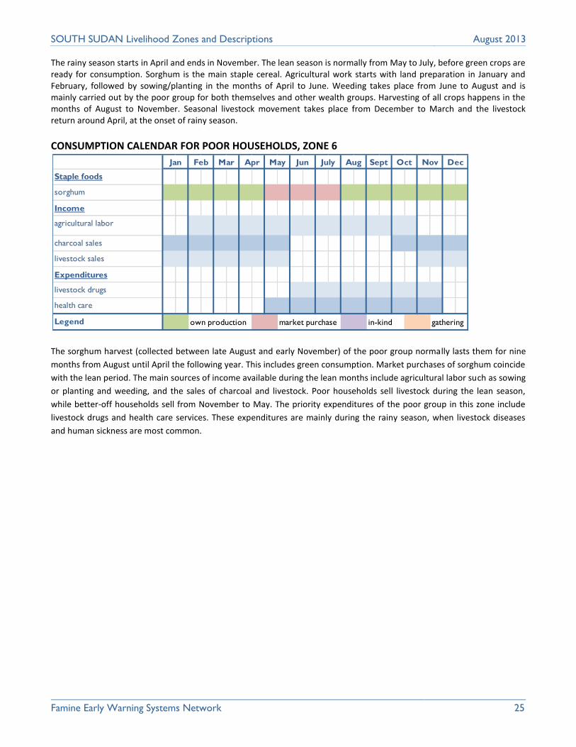
The rainy season starts in April and ends in November. The lean season is normally from May to July, before green crops are ready for consumption. Sorghum is the main staple cereal. Agricultural work starts with land preparation in January and February, followed by sowing/planting in the months of April to June. Weeding takes place from June to August and is mainly carried out by the poor group for both themselves and other wealth groups. Harvesting of all crops happens in the months of August to November. Seasonal livestock movement takes place from December to March and the livestock return around April, at the onset of rainy season.
CONSUMPTION CALENDAR FOR POOR HOUSEHOLDS, ZONE 6
The sorghum harvest (collected between late August and early November) of the poor group normally lasts them for nine
months from August until April the following year. This includes green consumption. Market purchases of sorghum coincide
with the lean period. The main sources of income available during the lean months include agricultural labor such as sowing
or planting and weeding, and the sales of charcoal and livestock. Poor households sell livestock during the lean season,
while better-off households sell from November to May. The priority expenditures of the poor group in this zone include
livestock drugs and health care services. These expenditures are mainly during the rainy season, when livestock diseases
and human sickness are most common.
Staple foods
sorghum
Income
agricultural labor
charcoal sales
livestock sales
Expenditures
livestock drugs
health care
Legend p p own production m m market purchase k k in-kind c c gathering
Nov DecJun July Aug Sept OctJan Feb Mar Apr May

Famine Early Warning Systems Network 26
SOUTH SUDAN Livelihood Zones and Descriptions August 2013
GREATER BAHR EL GHAZAL SORGHUM AND CATTLE (Livelihood zone 7)
This livelihood zone is located in the lowlands of
the Greater Bahr el Ghazal region, stretching
across the vast western flood plains towards the
northern border of the Iron Stone Plateau. It is
characterized by grassland and swampy areas with
papyrus reeds and pockets of forest cover. Trees
include acacia species such as gum Arabic. The
main rivers draining the zone include Lol, Jurand
Kuom, Kueng; lakes include Yany-Yom, Ban-Nyon,
Ban-Luony and Ban-Dhikdhik.
The zone has a unimodal rainfall pattern, with a
dry period from November to April and rainy
season from May to October. Average
precipitation is about 800-1,100mm per annum,
with average temperatures ranging from 20-27°
minimum and a maximum of 30 to 35° Celsius in
the dry season.
Population density is relatively high with average
land cultivation of about 1 hectare per household.
Crop production is mainly rain fed. Soil types vary,
with sandy soils in the northern parts bordering
Sudan and clay soils mainly in the swamps and
dark alluvial loams along the western border of
the flood plains. The sandy soils are the most
fertile. Animal traction used only by the better off.
However, a shortage of suitable agricultural land
means that average household production is low
even in good years and in bad years there are high
levels of food insecurity characterized by near
famine situations and starvation.
Although this is a mixed, agro-pastoral area, with
all wealth groups cultivating some crops, livestock
rearing is the most important source of income.
The main food crops grown include maize,
sorghum, rice, groundnuts, sesame, cow peas and
vegetables such as okra and pumpkins. Livestock
include cattle, goats, sheep and poultry.
Sorghum is by far the most important staple food.
However, unfavorable conditions (water logging
and flooding) means that food produced from household cultivation is rarely expected to last until the next harvest, despite
increased crop production in recent years, with the poor households relying on food aid for approximately 6 months of the
Food security risk
Greater risk food insecurity area caused by recurring hazards, shocks and diminishing natural resources.
Main productive assets
Poor Better-off
Land cultivated- fewer hectares Goats and sheep Bicycles. Hand tools
Land cultivated- fewer hectares Cattle Hand tools Bicycles Motor cycles and vehicles
Main foods consumed and sources
Poor Better-off
Sorghum (OP/MP) Maize (OP/MP) Ground nuts (OP/MP) Rice (OP/MP) Milk (OP/MP) Wild foods (C)
Sorghum (OP/MP) Maize (OP) Ground nuts (OP) Rice (OP/MP) Milk (OP) Fish (OP/MP) Meat (OP/MP)
Main income sources
Poor Better-off
Sale of goats and sheep Sale of natural products, i.e. grass, firewood, charcoal. Sale of labor Sale of wild foods/fish Sale of local brew
Sale of cattle Sale of sorghum, maize Sale of timber Sale of fish Retail trade
Main markets
The main markets for sale and purchase of commodities include Wau/Rumbek, Cueibet Yirol West, Wau and Tonj.
Main hazards and approximate frequency
Floods occur annually during the wet season Livestock diseases occur annually during the dry season. Dry spells occur every two-three years at the middle of the wet season. Inter communal conflicts and cattle rustling occur annually during dry season. Human diseases are at their height every year during the wet season.
Main coping strategies
Increased search for work in neighboring zones /urban areas. Increased consumption of wild foods. Increased sale of natural products such as charcoal.
Increased sale of cattle Increased barter trade especially grain for livestock. Purchase of livestock drugs placing livestock in quarantine to control disease. Migration to urban centers.
Famine Early Warning Systems Network 27
SOUTH SUDAN Livelihood Zones and Descriptions August 2013
year. However livestock owners in this zone normally cultivate a second crop in flood retreat areas. River fish (both fresh
and dried), wild foods and bush products are an important part of the local diet and form a supplementary livelihood
source. Traps, hooks, and nets are used for fishing.
Seasonal transhumance takes place around the Jur and Lol rivers, where livestock are moved in the dry season. Sufficient
wet season grazing is generally available around the permanent settlements of the flood region and along the edge of Iron
Stone Plateau. However in crisis years, livestock are moved towards the Nile River.
The poor group subsist on their own crops and external food assistance, supplemented with milk and wild foods mainly
collected in swampy areas of the flood plain. The better-off largely depend on their own production and livestock products.
However all wealth groups must purchase staple grain especially during the lean months of the year to make up their
requirement.
The poor group obtains significant levels of income from labor migration across into Sudan, and supplement this with goat
and sheep sales, local brew and the sale of wild foods and charcoal. The distant employment opportunities is mainly inform
of agricultural labor such as land preparation, wedding and harvest with paek season in the months of January and February
The better-off group relies on their cattle for income with additional income from the sale of surplus crops and timber and
retail trade.
Physical access to the markets of Wau, Rumbek, Cueibet Yirol West, Wau and Tonj is fairly good although sometimes
limited by floods and inter communal conflicts and by livestock quarantines due to disease. Hazards include cattle rustling,
flood, drought and livestock diseases. During years of poor production the poor survive by collecting wild foods, cutting fire
wood for sale and migrating to find work in towns and neighboring zones.
Overall, food insecurity in this zone is mainly due to low crop production, over exploitation of fish, wild foods and bush products compounded by loss of livestock due to natural hazards such as seasonal flooding in the months of July and August.

Famine Early Warning Systems Network 28
SOUTH SUDAN Livelihood Zones and Descriptions August 2013
SEASONAL CALENDAR, ZONE 7
The rainy season starts in May and ends in October. The lean season is normally from June to August, before green crops
are ready for consumption. The main food crops are all cultivated during the same months. Agricultural work starts with
land preparation in February to March, followed by sowing or planting in the month of May and weeding from May to
August. Harvesting of all crops including green consumption starts in September and ends in December with threshing of
the long term maturity sorghum.
Lambing, kidding and calving takes place within the dry season. The peak of milk production is during the rainy/wet season
from May to September. Internal seasonal livestock movement within the zone is from November to April the following
year.
Seasons
Rainy season
Dry season
Lean season
Cropping
sorghum
maize
groundnut
sesame
Livestock
lambing/kidding/calving
milking
Other
seasonal livestock movement
Hazards
cattle rustling
floods
animal diseases
human diseases
Legend p p land preparation s s sowing w w weeding h h harvest
Sept Oct Nov DecJan Feb JulyMar Apr May Jun Aug

Famine Early Warning Systems Network 29
SOUTH SUDAN Livelihood Zones and Descriptions August 2013
CONSUMPTION CALENDAR FOR POOR HOUSEHOLDS, ZONE 7
The sorghum harvest of the poor group in this zone including green consumption in September normally lasts for five
months from October to January the following year. The green consumption is also supplemented by in-kind payments for
labor by wealthier groups. Market purchases normally commence in February and extend to August. The poor group
purchases most of their food in the lean months (June to August). Food access especially among the poor group is
increasingly dependent on money and the market, due to accelerated rural urban migration. Agricultural and non-farm
labor and sale of natural products, provide the income required for purchase of staple foods, during the lean period. Other
priority expenditures include purchase of staple foods, health care services and a lump sum payment of school fees in
March and April.
Staple foods
sorghum
maize
groundnuts
Income
sale of grass
sale of firewood/charcoal
agricultural/other labor
fishing
sale of wild foods
Expenditures
food
health care
education
Legend p p own production m m market purchase k k in-kind c c gathering
Jan Feb Mar Apr May Nov DecJun July Aug Sept Oct

Famine Early Warning Systems Network 30
SOUTH SUDAN Livelihood Zones and Descriptions August 2013
NILE BASIN FISHING AND AGRO PASTORAL (Livelihood zone 8)
This livelihood zone is located along the Nile River
extending into parts of the eastern and western
flood plains. The zone is characterized by swampy
vegetation of papyrus, reeds, Napier grass and
bush scrub. Other water resources within the zone
include lakes Namm and Nang.
The zone has a unimodal rainfall pattern with
average precipitation ranging from 800-1,100mm
per annum. Temperatures range from a maximum
of 30° to 36° Celsius in March-April and fall to 18
to 25° Celsius from June-December.
Soils are mainly clay along the banks of the Nile with relatively fertile sandy loams in the outer boundaries of the River bank. Population density is fairly low (approximately 500
people per square kilometer) and average land
cultivation is about 0.6 hectares per household.
The small size of cultivated land can be attributed
to limited draft power with animal traction only
accessible by better-off group.
This zone is predominantly occupied by
agropastoralists. Crop production is rain fed. The
main crops grown in the area include sorghum,
maize, groundnut and cow peas. Sesame and
vegetable crops such as okra, tomatoes and
pumpkins are grown on a smaller scale.
The main livestock kept are cattle, goats and
sheep. Livestock are moved towards the River Nile
from February to April and return to homesteads
from May- June. Fishing using nets, lines, spears
and hooks takes place throughout the year and is
a source of both food and cash income for all
wealth groups. Wild foods are abundant and
include fish, laloub nuts, dolieb palm nuts, water
lilly, and “leau” a very bitter nut growing in sandy
places. However access to these natural products
is normally constrained by excessive flood water.
Local determinants of wealth in this zone are type and number of livestock owned, land size cultivated and access to fishing
equipment such as canoes and nets.
Food security risk
Food secure zone with surplus maize production, sold in external markets.
Main productive assets
Poor Better-off
Land cultivated- fewer hectares Goats Sheep Hand tools
Land cultivated- more hectares Cattle Goats Sheep Ox ploughs
Main foods consumed and sources
Poor Better-off
Maize (OP/MP) Sorghum (OP) Cow peas (OP) Pumpkins (OP) Okra (OP) Milk (MP/IK) Fish (G/MP) Wild foods (G)
Maize (OP) Sorghum (OP) Cow peas (OP) Pumpkins (OP) Okra (OP) Milk (OP) Fish (G/MP) Wild foods (G)
Main income sources
Poor Better-off
Sale of goats Sale of sheep Sale of vegetables Sale of natural resource products including grass, charcoal, firewood Domestic work
Sale of cattle Sale of maize Sale of sorghum Retail trade Formal employment
Main markets
The main markets for selling and buying of commodities are Bentui and Mayom.
Main hazards and approximate frequency
Inter communal conflicts/ cattle raiding occur annually during the dry season. Floods occurs annually during the rainy season A livestock disease occurs annually during rainy season. Crop pests and diseases occur annually during rainy season
Main coping strategies
Increased migration in search of labor. Increased consumption of wild foods
Increased sale of livestock Increased reliance on formal employment.

Famine Early Warning Systems Network 31
SOUTH SUDAN Livelihood Zones and Descriptions August 2013
The primary source of food for consumption for poorer households is from fishing, their own crop production milk and the
collection of wild foods. Fishing is more important than agriculture among this group. Poorer households rely on purchased
staples for about five to six months of the year. In years of low rainfall the group intensifies their fishing activities. Better-off
households mainly rely on own production and livestock products with market purchases of mainly staple foods.
The main sources of income for the poor group include the sale of fish, goats, charcoal, papyrus mats, local brew and wild
foods, supplemented by the sale of labor especially during years of low rainfall. The better-off group sell livestock products
(mostly milk, ghee and yogurt) as their main source of income but may sell cattle to purchase food in years of low
production. In addition, the better-off group engage in retail trade, sale of fish, timber, vegetables and a small number of
people are in formal employment.
This zone has limited physical access to markets due to poor road conditions especially during the rainy season particularly
in August and September when excessive flooding takes place. This is despite its strategic location on the main road linking
the four states of Upper Nile, Unity, Jonglei and Lake. Because of its close proximity to the border with Sudan market access
is also constrained by insecurity. However this zone also enjoys exclusive access to five major ports along the Nile River on
the western side bordering Unity State which provide the opportunity for better-off group to sell livestock and milk, ghee
and other livestock products and fish to traders from Juba and a wider area who travel along the main highway linking Bor,
Malakal and Rumbek with Juba.
The main hazards are floods which tend to limit fishing activities, reduce crop and livestock and wild foods production
(particularly water lilies) and cause a loss of income for the better off and put the poor group at greater risk of food
insecurity.
SEASONAL CALENDAR, ZONE 8
Seasons
Rainy season
Dry season
Lean season
Cropping
maize
sorghum
vegetables
Livestock
lambing/kidding/calving
milking
Other
fishing
Hazards
floods
inter communal conflict/cattle
raiding
Legend p p land preparation s s sowing w w weeding h h harvest
Sept Oct Nov DecJan Feb JulyMar Apr May Jun Aug

Famine Early Warning Systems Network 32
SOUTH SUDAN Livelihood Zones and Descriptions August 2013
Although river fishing in this zone takes place throughout the year, it is less important during the period of peak seasonal
rainfall and flooding (June to September). During this period fishing activity is concentrated in the flood plains and swamps.
Agricultural work starts with land preparation from February to April, followed by sowing or planting in the months of May and June. Weeding takes place from June to August. Harvesting of cereal crops starting with green consumption begins in September and continues into November. Vegetable production is mainly carried out in the dry season, from November-April.
Livestock prices tend to peak from February to March. This is due to seasonal migration of herds away from homesteads
and social events, i.e. payment of dowry and weddings. Prices fall in the lean months of June and July, when livestock are
sold off in exchange for grain, thus depressing prices. Milk, cheese and ghee production is greatest during the rainy season,
when livestock are in good condition and have returned to homesteads.
CONSUMPTION CALENDAR FOR POOR HOUSEHOLDS, ZONE 8
The food production (sorghum) of the poor normally lasts six and a half months from mid-August to February the following year. Market purchase of sorghum and maize starts in March and January, respectively. The main sources of income during the lean season are from sale of firewood, papyrus mats, local brew and in some cases a few goats. The poor group normally derives more income from fish sales from January to April and August to November. The main expenditures include the purchase of staple foods, health care services and school fees, normally paid in three installments over the course of the year (April, July and October)
Staple foods
sorghum
maize
wild food collection
Income
sale of firewood
sale of papyrus mats
sale of fish
sale of goats
sale of local brew
sale of wild foods
Expenditures
health care
education
Legend p p own production m m market purchase k k in-kind c c gathering
Nov DecJun July Aug Sept OctJan Feb Mar Apr May

Famine Early Warning Systems Network 33
SOUTH SUDAN Livelihood Zones and Descriptions August 2013
OIL RESOURCES, CATTLE AND MAIZE (Livelihood zone 9)
This livelihood zone lies in the western flood plain
of the Nile, bounded by permanent swamps which
link rivers and lakes, including the river Naam and
Lakes Pooltocha and Rubkona. Vegetation is
characterized by a combination of forest, bush
scrub and grasslands. The area also has natural
resources including oil, timber, gum Arabic, fish in
Lake Rubkona and special grasses suitable for
thatching in some parts of Koch. The main oil wells
are in Higlig and Adok, and zinc sulphate is found
in Mayom.
Seasonal water courses run south from Bentiu to
the Nyuong Nuer branching off from Leer to Adok
Bahr. To the east are permanent swamps and
seasonally flooded grasslands; to the west are
mainly open grasslands with some permanent
villages. During the rainy season, the extensive
swamps in the south normally cut off other areas
from lower parts of the zone, especially areas such
as Leer County with total isolation of western
Nuer ethnic group.
This area has a unimodal rainfall pattern with
average precipitation of about 800-900mm per
annum. The rainy season generally lasts from May
to November. Temperatures with a minimum of
20 to 25° Celsius from May to November and
maximum of 25 to 30° Celsius from February to
April. Soils vary from clay near the rivers, swamps
and water courses to sandy ridges and outcrops
across the grasslands where permanent villages
are sited.
Compared with its neighbors, this zone is fairly
densely populated, with approximately 45 people
per square km. The areas of highest population
include Rubkona, Mayom and Koch counties.
The main crops grown are maize, and long (‘dura’),
and short (‘der)’ maturing sorghum varieties. The “der” sorghum is grown as a stop gap during the lean season and is
usually harvested in early August, along with maize. Cowpeas, pumpkin and okra are planted in the second season in flood
recess areas, and harvested in January. In years of excessive floods a third crop of maize and “der may also be harvested.
Transhumance is practiced along the Naam River and Pooltocha Lake, with migration to these water sources taking place
from January to April.
Food security risk
Food secure zone with surplus maize production, sold in external markets.
Main productive assets
Poor Better-off
Land cultivated- fewer hectares Goats Sheep Hand tools
Land cultivated- more hectares Cattle Goats Sheep Ox ploughs
Main foods consumed and sources
Poor Better-off
Maize (OP/MP) Sorghum (OP) Cow peas (OP) Pumpkins (OP) Okra (OP) Milk (MP/IK) Fish (G/MP) Wild foods (G)
Maize (OP) Sorghum (OP) Cow peas (OP) Pumpkins (OP) Okra (OP) Milk (OP) Fish (G/MP) Wild foods (G)
Main income sources
Poor Better-off
Sale of goats Sale of sheep Sale of vegetables Sale of natural resource products including grass, charcoal, firewood Domestic work
Sale of cattle Sale of maize Sale of sorghum Retail trade Formal employment
Main markets
The main markets for selling and buying of commodities are Bentui and Mayom.
Main hazards and approximate frequency
Inter communal conflicts/ cattle raiding occur annually during the dry season. Floods occurs annually during the rainy season A livestock disease occurs annually during rainy season. Crop pests and diseases occur annually during rainy season
Main coping strategies
Increased migration in search of labor. Increased consumption of wild foods
Increased sale of livestock Increased reliance on formal employment.

Famine Early Warning Systems Network 34
SOUTH SUDAN Livelihood Zones and Descriptions August 2013
Own crops, milk and fish are the main food sources in this zone. Fishing in rivers, swamps and water courses is an important
dry season activity using spears and traps in shallow waters, with nets and hooks mainly used in deep waters. Household
diets in this zone are supplemented with wild foods such as fish, laloub nuts, dolieb palm nuts, water lilly, and “leau” a very
bitter nut growing in sandy places.
To obtain income both the poor and better-off groups sell livestock (especially goats, sheep and cattle) every year
increasing the quantities sold in bad years. In addition the poor group sells charcoal, firewood, grass and does some
domestic work to supplement their income. The better-off sell surplus maize, engage in retail trade and some are engaged
in formal employment. The poor group purchase about five and half months of their staple cereals from the market.
Market access to Bentiu, Juba and Malakal is, as in other zones, limited by poor roads, flooding and insecurity.
The main hazards include reduced crop and livestock production from flood, drought, bird attack, plant and animal diseases
(particularly when livestock are confined due to delayed receding of flood waters), conflict and livestock raiding and low
livestock and high food prices. Poor households cope through increased reliance on wild foods, migratory labor in Bentiu
and in some cases external food assistance. The better-off group normally increases livestock sales.
SEASONAL CALENDAR, ZONE 9
The rainy season starts in May and ends in October. The lean season is generally from June to July, before green crops are ready for consumption. Sorghum is the staple cereal. Agricultural work starts with land preparation from February to April. This is followed by sowing or planting in the month of May to mid-June and weeding from the end of June until August. Harvesting of all crops including green consumption starts in September and continues until the end of October. Lambing, kidding and calving takes place in the dry season months of November to February.
The peak milk production period is the rainy season from June to October and falls from the start of the dry season in
November to December. There is no major external seasonal livestock movement outside this zone.
Seasons
Rainy season
Dry season
Lean season
Cropping
maize
vegetables
Livestock
lambing/kidding/calving
milking
Other
employment by oil companies
Hazards
livestock diseases
conflict/cattle raiding
Legend p p land preparation s s sowing w w weeding h h harvest
Sept Oct Nov DecJan Feb JulyMar Apr May Jun Aug

Famine Early Warning Systems Network 35
SOUTH SUDAN Livelihood Zones and Descriptions August 2013
CONSUMPTION CALENDAR FOR POOR HOUSEHOLDS, ZONE 9
The maize harvest of the poor group normally lasts from mid-August to February the following year. Market purchases especially of maize and vegetables start in March and continue until the end of September. These purchases also cover the lean months of June to July. The main sources of income available during the lean season include sale of firewood, elephant grass and domestic work. The main expenditures include purchase of staple foods, health care services (with higher demands during the rainy season due to malaria) and three installments of school fees.
Staple foods
maize
vegetables
wild food consumption
Income
sale of firewood
sale of elephant grass
domestic work
Expenditures
health care
education
Legend p p own production m m market purchase k k in-kind c c gathering
Nov DecJun July Aug Sept OctJan Feb Mar Apr May

Famine Early Warning Systems Network 36
SOUTH SUDAN Livelihood Zones and Descriptions August 2013
NORTH EASTERN CATTLE AND MAIZE (Livelihood zone 10)
This livelihood zone is located in Upper Nile State, along the Nile’s eastern flood plain, covering Nasir County and extending southwards along the River Sobat and its tributaries and northwest from Nasir to Melut. The zone is characterized by grasslands, forests and swamp. Normal flooding of the river Sobat provides
excellent pasture during the dry season above
Nasir County.
This zone has a unimodal rainfall pattern with
average precipitation of 500-700mm per annum.
Average temperatures range from 18 to 25°
Celsius in March and 30 to 40 Celsius from July to
August. There are two seasons, a dry season
lasting from November to April and a rainy
season from May-October.
Population density is low, with 12 people per
square km. land holdings average approximately
2 hectares per household.
Natural resources include oil, with the nascent oil
industry already providing some employment,
gum Arabic, fish and wild game.
Livelihood patterns in this area are largely
determined by the annual distribution of rainfall
and water courses, including the River Sobat and
tributaries running from Ethiopia into South
Sudan.
The soils in this low lying flood plain are mainly
grey and black cotton. Cleared areas are used for
rain fed cultivation, including flood recess
cropping from September to October with crop
harvests in March.
This is an agro-pastoral area, with a majority of
households practicing agriculture, livestock and
fishing.
In a typically good year, the main food crops
grown include maize, sorghum, cow peas,
pumpkins and green vegetables such as okra. (Maize is a hard corn type of red, violet and yellow color.) The main livestock
reared are cattle, and goats with smaller numbers of chicken primarily for domestic consumption.
Food security risk
Low risk food insecurity zone, the area has very diversified sources of livelihood.
Main productive assets
Poor Better-off
Land cultivated- fewer hectares Goats Sheep Pigs Fishing gears i.e. nets and hooks.
Land cultivated- more hectares Cattle Goats Sheep Pigs Fishing gears, i.e. canoes, nets and hooks.
Main foods consumed and sources
Poor Better-off
Maize (OP/MP) Sorghum (MP) Cow peas (OP) Vegetables (OP) Pumpkins (OP) Fish (OP) Milk (OP) Wild foods(C)
Maize (OP) Sorghum (OP) Cow peas (OP) Vegetables (OP/MP) Pumpkins (OP) Fish ( OP/MP) Milk(OP) Meat (OP/MP)
Main income sources
Poor Better-off
Sale of goats Sale of labor Sale of natural products, including charcoal, firewood, grass Sale of fish.
Sale of cattle Sale of goats Sale of fish Sale of maize. Formal employment. Retail trade.
Main markets
The main markets both for selling and buying of commodities are Malakal, Nasir and Juba with external markets mainly in Ethiopia and Sudan.
Main hazards and approximate frequency
Floods generally occur once in every three years during the rainy season. Quiilea birds feed on crops annually at the end of the rainy season. Drought generally occurs once in every five years. Inter communal conflicts occur annually mainly during the dry season.
Main coping strategies
Increased sale of goats and sheep. Increased migration in search of labor Increased collection of wild foods
Increased sale of livestock and other assets. Increased reliance on self-employment. Increased reliance on savings

Famine Early Warning Systems Network 37
SOUTH SUDAN Livelihood Zones and Descriptions August 2013
The fish consumed in the zone is seasonal and mainly from the Sobat River, its tributaries and ponds. Fishing is mainly
carried out using hooks and nets.
The better-off are mostly self-sufficient in food and in years of good rainfall produce a surplus of maize for sale and
purchase only non-staples such as dry fish, meat and vegetables. The poor are self-sufficient only for about 6 months of the
year and rely on staple purchase for the remainder.
Better-off households derive much of their cash income from the sale of cattle, goats and maize, supplemented with retail
trade and for a few households formal employment The main sources of income among the poor group include the sale of
goats, charcoal, firewood, grass, labor and in good years fish from the Sobat River.
In years of poor rainfall, the poor group maximizes their access to food, through increased wild food collection, migratory
labor and the sale of some goats and sheep.
Trade in this zone is mainly within South Sudan, in the markets at Nasir, Malakal and Juba in Central Equatoria. Local grain
and livestock are all traded in Upper Nile State and Akobo County in Jonglei state as well as Juba. The good physical access
to Ethiopia also allows this zone to trade surplus maize and livestock (especially cattle) with Gambella. Trade volumes
normally increase during the dry season (January to April).
As in other areas of South Sudan the major hazards are from floods, drought, bird and pest damage to crops and inter
communal conflict. In parts of the Sobat Valley the economic impact of heavy rainfall on grazing milk and crop production is
exacerbated by swings between floods and dry spells and drought conditions, when the river level falls. Although a low food
security risk area, excessive and recurring floods can negatively affect crop production and livestock rearing, the main
sources of livelihood of the inhabitants of this zone.
SEASONAL CALENDAR, ZONE 10
Seasons
Rainy season
Dry season
Lean season
Cropping
maize
vegetables
flood recess-maize cropping
Livestock
lambing/kidding/calving
milking
Other
employment by oil companies
Hazards
livestock diseases
conflict/cattle raiding
Legend p p land preparation s s sowing w w weeding h h harvest
Sept Oct Nov DecJan Feb JulyMar Apr May Jun Aug
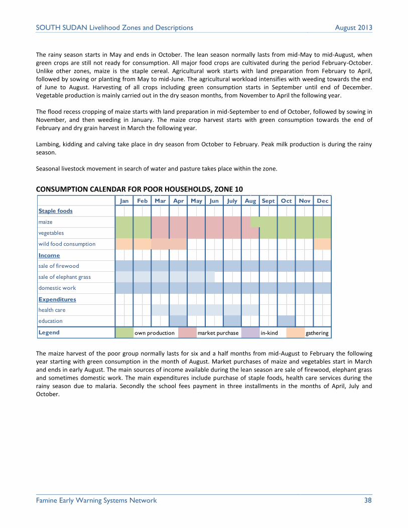
Famine Early Warning Systems Network 38
SOUTH SUDAN Livelihood Zones and Descriptions August 2013
The rainy season starts in May and ends in October. The lean season normally lasts from mid-May to mid-August, when green crops are still not ready for consumption. All major food crops are cultivated during the period February-October. Unlike other zones, maize is the staple cereal. Agricultural work starts with land preparation from February to April, followed by sowing or planting from May to mid-June. The agricultural workload intensifies with weeding towards the end of June to August. Harvesting of all crops including green consumption starts in September until end of December. Vegetable production is mainly carried out in the dry season months, from November to April the following year. The flood recess cropping of maize starts with land preparation in mid-September to end of October, followed by sowing in November, and then weeding in January. The maize crop harvest starts with green consumption towards the end of February and dry grain harvest in March the following year. Lambing, kidding and calving take place in dry season from October to February. Peak milk production is during the rainy season. Seasonal livestock movement in search of water and pasture takes place within the zone.
CONSUMPTION CALENDAR FOR POOR HOUSEHOLDS, ZONE 10
The maize harvest of the poor group normally lasts for six and a half months from mid-August to February the following year starting with green consumption in the month of August. Market purchases of maize and vegetables start in March and ends in early August. The main sources of income available during the lean season are sale of firewood, elephant grass and sometimes domestic work. The main expenditures include purchase of staple foods, health care services during the rainy season due to malaria. Secondly the school fees payment in three installments in the months of April, July and October.
Staple foods
maize
vegetables
wild food consumption
Income
sale of firewood
sale of elephant grass
domestic work
Expenditures
health care
education
Legend p p own production m m market purchase k k in-kind c c gathering
Jan Feb Mar Apr May Nov DecJun July Aug Sept Oct

Famine Early Warning Systems Network 39
SOUTH SUDAN Livelihood Zones and Descriptions August 2013
NORTHERN SORGHUM AND LIVESTOCK (Livelihood zone 11)
This livelihood zone is located along the border
with Sudan in Upper Nile and Unity States. It is
dominated by flat plains with low lying areas,
which aid the flow of rivers Namm and Nang
towards the south into the Sobat River. The zone
is covered with grasslands, scanty shrubs, thorns,
Balanites, bushes and other hardy plants and
patches of forest.
The rainfall pattern is unimodal, with average
precipitation of approximately 500mm per annum.
Temperatures range from a minimum of 30 to 32°
Celsius from June to December to a maximum of
35 to 37° Celsius from February to May. There are
two agricultural seasons a rainy season, from May
to October and a dry season from November to
April.
The zone has relatively fertile sandy and loamy
soils with rocky surfaces in some areas. These are
somewhat less fertile than neighboring zones in
Upper Nile and Unity States and are distinguished
from these by relatively low rainfall, which
restricts crops mainly to drought resistant
sorghum and some gum arabic production.
The population density is moderate, with around
400 people per square kilometer. Average land
cultivation is about 1 hectare per household. Hand
tilling is the main means of ploughing, although
mechanized and irrigated crop production is also
carried out in some areas by a few commercial
farmers and the Government of the Republic of
South Sudan.
The inhabitants of this zone are agro-pastoralists.
The main rain fed food crops grown include
sorghum, cowpeas, pumpkins and okra and other
vegetables. The main livestock reared are goats
and to lesser extent sheep and cattle. There are
seasonal livestock movements to Greater Bahr El
Ghazal, with frequent inter marriages and other
exchanges between communities in these areas.
These seasonal movements are the source of frequent conflict over pastures, waters and cattle raiding.
Food security risk
High risk food insecurity zone, due to semi-arid conditions and natural hazards.
Main productive assets
Poor Better-off
Land cultivated- fewer hectares Goats Sheep
Land cultivated- more hectares Cattle Goats Sheep
Main foods consumed and sources
Poor Better-off
Sorghum ( OP/MP) Cow peas(OP) Pumpkins (OP) Fish (OP/MP) Vegetables (OP) Wild foods (C ) Milk (OP/MP)
Sorghum (OP) Cow peas (OP) Pumpkins (OP) Fish ( OP/MP) Meat (OP/MP) Vegetables (OP/MP) Milk (OP/MP)
Main income sources
Poor Better-off
Sale of natural products, including thatching grass and rope. Sale of goats Sale of labor Sale of local brew Sale of wild foods
Sale of goats. Sale of sheep. Sale of cattle. Retail trade Formal employment.
Main markets
The main markets for selling and buying of commodities are Malakal, Renk, Juba, Parieng cattle market. There is also access to external markets across the border in Sudan.
Main hazards and approximate frequency
Inter communal conflicts including annual cattle raiding leading to insecurity in the dry season. Floods occur annually during the wet season. Livestock diseases occur on annual basis throughout the year. Crop pests and diseases occur on an annual basis during the rainy season. Dry spells generally occur every two years
Main coping strategies
Increased migration in search of labor Increased consumption of wild foods Increased sale of natural products such as grass
Increased sale of livestock. Increased reliance on formal employment. Increased reliance on cash remittances.

Famine Early Warning Systems Network 40
SOUTH SUDAN Livelihood Zones and Descriptions August 2013
The poor and better-off group in this zone subsist on their own crops, fish, wild foods and some milk both from own stock.
The poor group depend on market purchase for about half of their food needs.
Better-off households obtain income from the sale of livestock, supplemented by retail trade and for some household’s
formal employment. Income opportunities for the poor group are very limited and include chiefly the, agricultural and
other casual labor, brewing and the sale of goats, thatching grass, wild foods and other natural products. Most of the labor
employment is within the zone, except during periods of crisis, when poor group migrate to neighboring zones in search of
employment.
In years of poor rainfall, the poor maximize food access through migratory labor and increased consumption of wild foods.
They also sometimes receive external food assistance.
Compared to other areas, this zone has exceptional access to markets within South Sudan and with Sudan. The main goods
traded include cattle, goats and grain. During the dry season, cattle are generally taken from Leer to Rupnyagai, where they
command higher prices. Commodities such as household items (soap, salt and tea among others) are brought in to
Rupnyagai from Southern Kordofan. The local traders use cash from livestock sales to purchase these items for sale in Leer
market.
Floods and crop pests and diseases normally compound the problem of low crop harvests in this zone and increasing
reliance particularly by the poor group on the market for food.
SEASONAL CALENDAR, ZONE 11
The rainy season starts in May and ends in October. The lean season is normally from June to July, before green crops are s ready for consumption. Sorghum is the staple cereal. Agricultural work starts with land preparation from February to April, followed by sowing or planting in the months of May to mid-June. The season picks up with weeding from mid-June to
Seasons
Rainy season
Dry season
Lean season
Cropping
sorghum
vegetables
Livestock
lambing/kidding/calving
milking
Other
employment by oil companies
Hazards
livestock diseases
conflict/cattle raiding
Legend p p land preparation s s sowing w w weeding h h harvest
Sept Oct Nov DecJan Feb JulyMar Apr May Jun Aug

Famine Early Warning Systems Network 41
SOUTH SUDAN Livelihood Zones and Descriptions August 2013
August. Harvesting of staple food crops, including green consumption takes place from September to December. Vegetable production is mainly carried out during the dry season, from November to April. Lambing, kidding and calving takes place from November to February during the dry season. Milk production peaks during
the rainy season from June to December.
Lambing, calving and kidding are mainly during the dry season from November to February.
CONSUMPTION CALENDAR FOR POOR HOUSEHOLDS, ZONE 11
As in neighboring zones, the sorghum harvest of the poor group normally lasts for six and a half months from mid-August to February the following year, starting with green consumption in August. Market purchases of sorghum start in March until mid-August and include the lean months of June to July. The main sources of income available during the lean season include the sale of firewood, elephant grass and some domestic work. The main expenditures include the purchase of staple foods, health care services during the rainy season due to the high prevalence of malaria. Secondly school fees payment in three installments in the months of April, July and October.
Staple foods
sorghum
market purchase
wild food collection
Income
sale of firewood
sale of elephant grass
domestic work
Expenditures
health care
education
Legend p p own production m m market purchase k k in-kind c c gathering
Jan Feb Mar Apr May Nov DecJun July Aug Sept Oct

Famine Early Warning Systems Network 42
SOUTH SUDAN Livelihood Zones and Descriptions August 2013
ADMINISTRATIVE AREAS AND DEMOGRAPHICS Livelihood zone name States Counties 2008 population estimates
EQUATORIAL MAIZE AND CASSAVA (SSD 1)
Western Equatoria Tambura 41,447
Nzara 65,712
Ezo 80,861
Yambio 148,099
Ibba 41,869
Maridi 82,461
Mundri West 33,975
Central Equatoria Lainya 89,315
Yei 201,443
Morobo 103,603
Kajo Keji 196,422
Torit 99,740
Eastern Equatoria Ikotos 27,415
Magwi 169,826
IRONSTONE PLATEAU AGROPASTORAL (SSD 2)
Lakes Cuebit 64,869
Rumbek North 43,410
Rumbek Centre 153,550
Wulu 40,550
Rumbek East 122,832
Yirol West 103,190
Yirol East 67,402
Awerial 26,621
Western Equatoria Mundri East 43,318
Mvolo 48,134
Central Equatoria Terekeka 111,830
HIGHLAND FOREST AND SORGHUM (SSD 3)
Central Equatoria Juba 365,891
Eastern Equatoria Lopa/Lafon 106,161
Budi 99,199
Ikotos 57,234
Jonglei Akobo 4,146
Pochala 66,201
Pibor 6,151
WESTERN GROUNDNUTS, SIMSIM AND SORGHUM (SSD 4)
Warrap Tonj South 86,592
Western Bahr-el- Ghazal Raga 54,340
Jur River 12,382
Wau 151,320
Northern Bahr-el-Ghazal Awiel Centre 41,827
Lakes Cuebit
Western Equatoria Tambura 13,918
Nagero 10,077
EASTERN SEMI ARID PASTORAL (SSD 5)
Eastern Equatoria Kapoeta North 103, 084
Kapoeta East 163,997
Kapoeta South 79,470
Jonglei Pibor 143,324

Famine Early Warning Systems Network 43
SOUTH SUDAN Livelihood Zones and Descriptions August 2013
EASTERN PLAIN CATTLE AND SORGHUM (SSD 6)
Jonglei Old Pangak 14,529
Khorflus 92,460
Ayod 21,001
Duk 45,387
Uror 178,519
Nyirol 108,674
Akobo 132,054
Bor South 136,884
GREATER BAHR EL GHAZAL SORGHUM AND CATTLE (SSD 7)
Northern Bahr-el-Ghazal Awiel North 129,127
Awiel East 309,921
Awiel South 73,806
Awiel West 166,217
Western Bahr-el-Ghazal Jur River 115,389
Warrap Abyei 52,883
Twic 204,905
Gogrial West 243,921
Gogrial East 103,283
Tonj North 165,222
Tonj East 116,122
Lakes Cueibet 52,886
NILE RIVER FISHING AND AGROPASTORAL (SSD 8)
Jonglei Old Pangak 95,601
Khorflus 6,608
Ayod 117,553
Duk 20,201
Twic East 85,349
Bor South 73,222
Unity Guit 33,004
Leer 55,022
Paynijar 50,723
Lakes Awerial 20,420
Central Equatoria Terekeka 20,770
Juba 6,522
OIL RESOURCES, CATTLE AND MAIZE (SSD 9)
Unity Rubkona 100,236
Koch 74,863
Mayendit 53,783
NORTHEASTERN CATTLE AND MAIZE (SSD 10)
Upper Nile Maban 33,829
Maiwut 79,462
Nasir 210,002
Longochuk 63,166
Ulang 85,044
Baliet 48,010
Malakal 126,483
Panykang 89,385
NORTHERN SORGHUM AND Upper Nile Renk 137,751
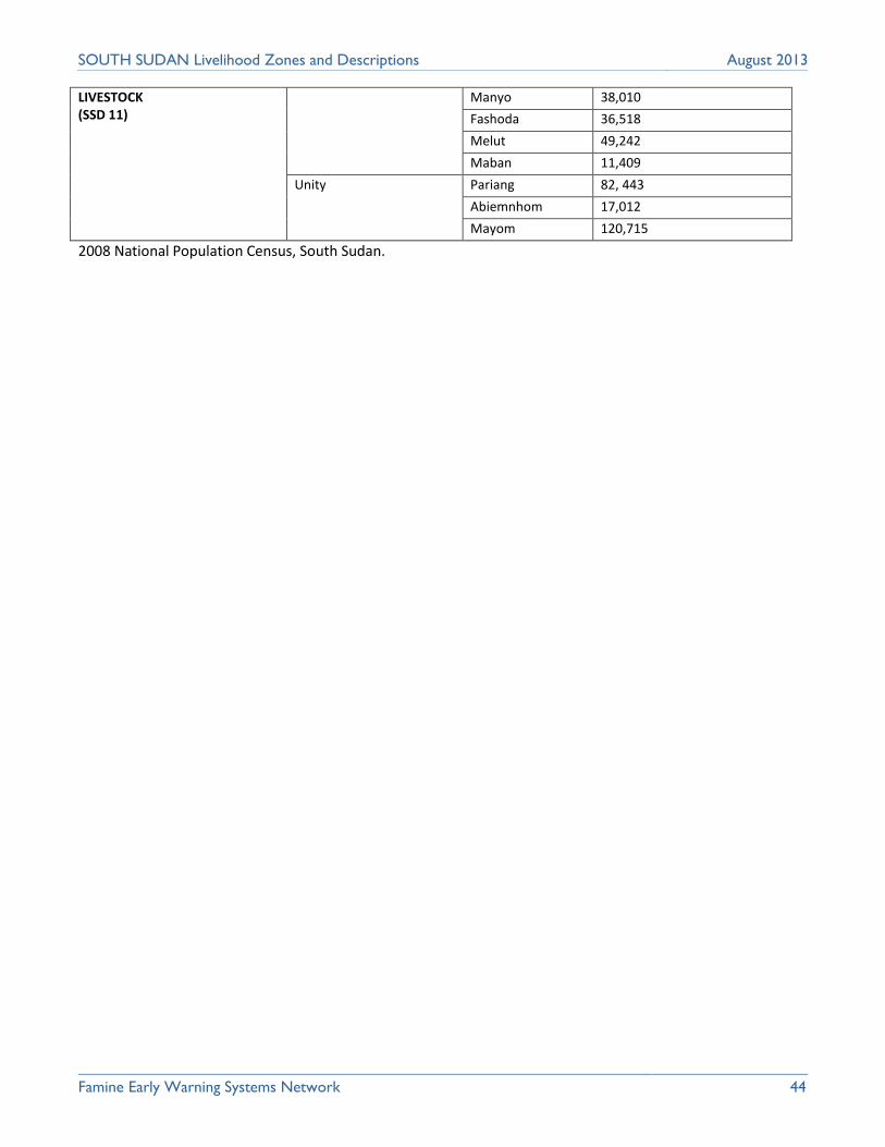
Famine Early Warning Systems Network 44
SOUTH SUDAN Livelihood Zones and Descriptions August 2013
LIVESTOCK (SSD 11)
Manyo 38,010
Fashoda 36,518
Melut 49,242
Maban 11,409
Unity Pariang 82, 443
Abiemnhom 17,012
Mayom 120,715
2008 National Population Census, South Sudan.

Famine Early Warning Systems Network 45
SOUTH SUDAN Livelihood Zones and Descriptions August 2013
LIST OF PARTICIPANTS
National Core Facilitators Workshop, Juba
Names Function/Post Institution
1. John Vuga National Technical Manager Famine Early Warning Systems Net Work
2. Chan Chuol Lam Deputy National Technical Manager Famine Early Warning Systems Network
3. Nancy Mutunga Regional Food Security Specialist Famine Early Warning Systems Network
4. Manase Yanga National Co-ordinator FSTS/National Bureau of Statistics
5. Gummat Abdellatif Senior Vulnerability Assessment/
Mapping Assistant.
World Food Program
6. Evans Kenyi Coordinator- IPC Food Agricultural Organization
7. Angelo Longa Planning Officer Ministry of Agriculture/Fisheries
8. Buzz Sharp Senior Livelihood Consultant Evidence for Development/FEWS NET
9. James Acidri Livelihood Consultant Evidence for Development/FEWS NET
Malakal Regional Workshop (Upper Nile and Unity States)
Names Function/Post Institution
1. Chan Nyikang Nyiker Veterinary Officer SMARF - Upper Nile State
2. William Arop Jak Agricultural Officer Head Quarters SMAF - Upper Nile State
3. Kur Nyidhok Gwang Agricultural Officer SMAF - Fashoda County, Upper Nile State
4. James GatluakLiah Director of Agriculture MAFCRD - Unity State
5. John Otor Ayong Director of Agriculture SMARF
6. William Kuer Yang Acting Director of Forestry MAFCRD - Unity State
7. George GatluakHoth Director of Agriculture & Forestry SMAF - Guit County-Unity State
8. Mananeh Yanga Co-ordinator SSNBS - Juba, South Sudan State
9. Peter Gony Ngok Director of Fisheries SMARF - Upper Nile State
10. Regina Otor Ayik Fisheries Officer SMARF - Upper Nile State
11. Yor Ajak Deng Assistant inspector of Agriculture SMAF - Upper Nile State
12. Peter Okach Aney Director Animal Production SMARF - Upper Nile State
13. Dr. Stephen Opyeny Director of Veterinary Services SMARF- Upper Nile State
14. Joseph Nyajuok Youth Co-ordinator Fashoda Youth Forum
15. Emmanuel Joseph Wadjok Extension Officer SMAF - Upper Nile State
16. Ruon Ruach Tut Director of Agriculture SMAF -Nasir County
17. James Akwuch Deng Director of Plant Protection SMAF - Renk County
18. Yoannis Amuch Abar Inspector of Agriculture SMAF
19. Denis Tipo Arop Director of Extension SMAF
20. Sarah Nyanger Managing Director Nile Lilly International Limited

Famine Early Warning Systems Network 46
SOUTH SUDAN Livelihood Zones and Descriptions August 2013
21. James Acidri Consultant EfD/FEWS NET
22. Chan Chuol Lam Deputy Technical Manager Famine Early Warning Systems Network
23. Saferino John Thabo Agricultural Officer SMAF - Malakal County-Upper Nile State
24. Francis Amum Achwany Inspector of Agriculture SMAF - Upper Nile State
25. Samuel Alex Latio Livelihoods Officer OXFAM - Great Britain (GB)
Bor Regional Workshop (Jonglei State)
Names Function/Post Institution
1. Makuach Munken Director Ministry of Finance
2. Solomon Kuol Deng Director Fisheries State Ministry of Agriculture/Fisheries
3. James Majok Maper Deputy Director Agriculture MLF/JSB
4. Jilo Gilu Nasir Deputy Director Agriculture MLF/JSB
5. Adol Apollo Director- Taxation MLF/JSB
6. Alith Apeec Alith Deputy Director Commerce Ministry of Finance
7. Kuol Monykuc Atem Inspector of Agriculture Ministry of Finance
8. Johnson Achuk Bol Inspector of Agriculture Ministry of Agriculture
9. John Majok M Director of Supplies Ministry of Finance
10. Richard Opuot Food Security Officer World Vision International
11. Machar Awuol Deng Director of Administration & Finance Ministry of Agriculture and Forestry
12. Abraham Mading Project Officer Norwegian People’s Aid
13. Riek Machar Dieu Inspector Ministry of Agriculture and Forestry
14. Robert K Flaminio Agriculture Officer Food and Agricultural Organization
15. Buzz Sharp Senior Livelihoods Consultant Evidence for Development/FEWS NET
16. Manase Yanga Co-ordinator FSTS/National Bureau of Statistics
17. Angelo Longa Planning/Officer MAFCRD
18. Gabriel Matiop Field Monitor World Food Program
19. James Ochang Joil Extension Coordinator Borlang/JG-MUST
20. Juma Rufas Field Monitor/VAM World Food Program
21. Abot Abraham Director MoFIPTAS
22. Bul John Kuol Agricultural Officer Catholic Relief Services
23. Atera Mathew Garang Agricultural Extension Officer Ministry of Finance
24. Evans Kenyi Coordinator- IPC Food Agricultural Organization
25. Martha Nyangum Deputy Information Coordinator JSWA
26. Esther Morris Konyi Deputy Chairperson JSWA
27. Cde Ayuil deChut Deng Ex Director WNDF

Famine Early Warning Systems Network 47
SOUTH SUDAN Livelihood Zones and Descriptions August 2013
28. John Vuga National Technical Manager Famine Early Warning Systems Network
29. William Arop Field Coordinator ADRA - Relief Agency
30. Ruben Kuol Director Ministry of Finance
31. Gummat Abdellatif Senior Vulnerability Assessment/
Mapping Assistant.
World Food Program
32. Ronald Sami Field Director CHF
33. James Acidri Livelihoods Consultant Evidence for Development/FEWS NET
Wau Regional Workshop (Western Bahr-El Ghazal, Northern Bahr- El Ghazal, Warrap and Lake States)
Names Function/Post Institution
1. Manase Yanga Laki Co-ordinator FSTS/National Bureau of Statistics
2. Chan Kuac Agricultural Officer State Ministry of Agriculture/Fisheries
3. Benjamin Adrea Agricultural Extension Officer State Ministry of Agriculture/Fisheries
4. Michael Marual Veterinary Officer State Ministry of Agriculture/Fisheries
5. Deng Deng Bol Agricultural Extension Officer State Ministry of Agriculture/Fisheries
6. Kerubino Dut John Director of Forestry State Ministry of Agriculture/Fisheries
7. James Mapuor Agricultural Extension Officer State Ministry of Agriculture/Fisheries
8. Amina Ratic Hassen Agricultural Officer State Ministry of Agriculture/Fisheries
9. John Adaing Atem Agricultural Extension Officer State Ministry of Agriculture/Fisheries
10. Najib Fotrain Veterinary Officer State Ministry of Agriculture/Fisheries
11. Samuel Maker Agor Agricultural Extension Officer State Ministry of Agriculture/Fisheries
12. Deng Deng Jor Fisheries Officer State Ministry of Agriculture/Fisheries
13. Nyarakajo Joseph Agricultural Extension Officer FEWS NET South Sudan
14. Angelo Wol Atak Director of Forestry SMAF/NBG state
15. Ezekiel Magok Director of Agriculture SMAF/Lakes state
16. Abraham Meen Fisheries Officer SMAF/Lakes state
17. Dominic Mangong Agricultural Extension Officer SMAF/Warrap state
18. Chirilo Chier Paduol Director SMAF/Warrap state
19. Chan Chuol Lam Deputy National Technical Manager Famine Early Warning Systems Network
20. Martin Athian Finance Director SMARF/ Warrap state
21. Gaitano Guido Director SMAF/WBG state
22. Rizik Peter Agricultural extension officer SMAF/WBG state
23. Paul Andrea Agricultural officer SMARF/WBG state
24. Sarah Nyanger Managing Director Nile Lilly International Limited
25. James Acidri Livelihoods Consultant Evidence for Development/FEWS NET

Famine Early Warning Systems Network 48
SOUTH SUDAN Livelihood Zones and Descriptions August 2013
Juba Regional Workshop (Western Equatoria, Central Equatoria and Eastern Equatoria States) Names Function/Post Institution
1. Manase Yanga Co-ordinator Food Security Technical
Secretariat/National Bureau of Statistics
2. Richard Jada Inspector Planning State Ministry of Agriculture/Fisheries
3. Tito Aroru Deputy Director of Agriculture State Ministry of Agriculture
4. Phillip Lajo Veterinary Officer State Ministry of Agriculture
5. James Gelasio Veterinary Officer State Ministry of Agriculture
6. Kumuko Stephen Fisheries Officer State Ministry of Agriculture/Fisheries
7. Andria Dario Assistant Inspector State Ministry of Agriculture
8. Alison Paida Senior Extension Worker State Ministry of Agriculture
9. Patrick Lomica Deputy Director State Ministry of Agriculture/Fisheries
10. John Tito Assistant Inspector State Ministry of Agriculture/Fisheries
11. Awelo Obaale Deputy Director State Ministry of Agriculture/Fisheries
12. John Vuga National Technical Manager Famine Early Warning Systems Network
13. James Logale Deputy Director State Ministry of Agriculture/Fisheries
14. James Acidri Livelihood Consultant Evidence for Development/FEWS NET