south mountain freeway (loop 202), interstate 10 (papago
TRANSCRIPT

4
4-80 Chapter 4 • Affected Environment, Environmental Consequences, and Mitigation South Mountain Freeway (Loop 202) DEIS and Section 4(f) Evaluation
What is noise?
Noise is unwanted or excessive sound. In many ways, under this definition, noise is undesirable but it is, by fact, a real by-product of today’s way of life. Noise can be intrusive and annoying. It can interfere with sleep, work, or recreation. Noise, in today’s society, comes from many sources; a vacuum cleaner, for example, can be disruptive to a family member who is trying to read a book. But it is recognized that transportation noise is perhaps the most pervasive and difficult source to avoid in society today. Noise from airplanes f lying overhead, from trains passing by, from motorized boats on a lake, and from cars and trucks traveling on the nation’s roads and highways has become a daily part of our lives. And of these, highway traffic noise is admittedly a major contributor to overall transportation noise.Therefore, the construction and operation of a freeway of the magnitude of a project like the proposed action would introduce a major noise source into locations where such noise may not have existed in the past. Therefore, a project like the proposed freeway could cause great concern to those who live and work near such a project. It could pass by residences, schools, parks, churches, and myriad land uses that would be particularly sensitive to the noise generated by such a project. The project team, using federal and State guidance, analyzed how a project like the proposed action would increase noise levels to adjacent areas and, for those areas that would warrant protection from the expected noise, proposed ways for ADOT and FHWA to reduce the noise to acceptable levels.Noise mitigation strategies typically consist of placing a noise barrier, such as a concrete or masonry wall or an earth berm (or a combination of the two), along the main line or at the R/W line of a transportation corridor. Noise barriers are usually the most feasible and cost-effective strategy for mitigating highway transportation noise impacts.
NOISE
NOISE CRITERIAThe basic unit of measurement for noise is the decibel, which is a logarithmic unit that expresses the ratio of the sound pressure level being measured to a standard reference level. Environmental noise is typically frequency-weighted using the A-scale (dBA) to approximate the frequency response of the human ear. Noise analyses for transportation projects use the hourly equivalent sound level (LAeq1h, or simply Leq), which is a logarithmic energy average over a 1-hour period.
Under 23 C.F.R. § 772, FHWA is required to identify noise-sensitive land uses near its projects, to evaluate the noise impacts on those land uses, and to consider noise abatement options (see Activity Category B, in Table 4-38). To further clarify the process of noise analysis and the evaluation of noise abatement, ADOT adopted a Noise Abatement Policy (NAP), last updated in 2007. This policy was formally approved by FHWA.
Federal regulations specify noise abatement criteria (NAC) for various types of land use activity categories, summarized in Table 4-38, and state that noise abatement must be considered when the predicted future peak-hour traffic noise from a project would approach or exceed the NAC. The NAP defines “approach” to mean being within 3 dBA, thereby requiring noise abatement considerations when the predicted future peak-hour traffic noise at Category B (residential) land uses is 64 Leq (i.e., within 3 dBA of 67 Leq). Additionally, mitigation must be considered for residential properties if predicted traffic noise levels substantially exceed existing levels. “Substantially exceed” is defined in the NAP as 15 dBA.
Part of the noise abatement consideration process specifies that the abatement must be reasonable and feasible. Feasibility evaluations consist of various constructibility issues and assessments of whether the proposed noise abatement could provide substantial noise reduction. Reasonability criteria consist of cost-benefit considerations, maximum barrier heights, and other barrier design issues.
The NAP defines specific exceptions to conditions where the NAC would suggest that noise mitigation is warranted. These exceptions include, among others, isolated receivers and the cost of abatement per residence. These exceptions are defined in the ADOT noise policy as:
➤ Isolated receivers – “An isolated receiver is defined as one or two sensitive affected receivers (e.g., residences) set apart from other receivers in the project area. It generally would not be considered reasonable to provide abatement for isolated receivers.” (ADOT 2005b)
➤ Cost of abatement – “The maximum recommended cost of abatement is $46,000 per benefited developed property. Benefited residential properties include all single-family dwelling residences (i.e., manufactured homes, condominiums, detached homes) whether occupied by the owner or a renter, that receive a dBA noise reduction from proposed mitigation measures. For benefited developed properties such as parks, schools, hospitals, and churches, noise abatement will be considered on a case by case basis, as specified in ADOT’s noise guidelines.” (ADOT 2007d)
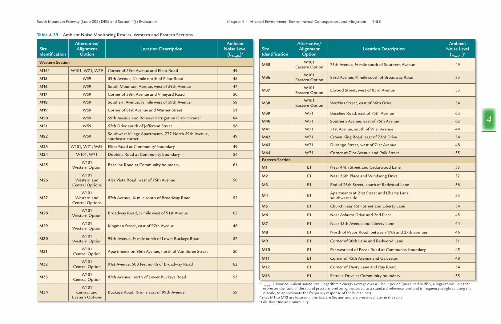
EXISTING NOISE LEVELSAmbient or existing noise level readings were taken at 44 locations in the Study Area. The monitoring sites, described below, were located at approximately 1-mile spacings along the corridor. Receiver locations are shown on Figures 4-29 through 4-32.
The existing noise levels were recorded at the monitoring sites with Larson Davis Model 812 and Model 820 Type I integrating sound level meters. The readings were taken on numerous occasions from September 2003 to July 2004 during nonpeak traffic conditions.
Weather conditions during the readings ranged from clear skies to mostly cloudy skies, 58° to 103° Fahrenheit and 8 to 35 percent relative humidity, with breezes averaging 0 miles per hour (mph) to 5.9 mph from variable directions. Such weather conditions are within the parameters established by FHWA in Measurement of Highway-Related Noise (FHWA 1996) and have little effect on the transmission of sound energy for the receivers in the Study Area.
ActivityCategory LAeq1h
a DescriptionofActivityCategory
A 57 (exterior)Land on which serenity and quiet are of extraordinary significance and serve an important public need and where the preservation of those qualities is essential if the area is to continue to serve its intended purpose
B 67 (exterior) Picnic areas, recreation areas, playgrounds, active sports areas, parks, residences, motels, hotels, schools, churches, libraries, and hospitals
C 72 (exterior) Developed land, properties, or activities not included in Categories A or B above
D —b Undeveloped land
E 52 (interior) Residences, motels, hotels, public meeting rooms, schools, churches, libraries, hospitals, and auditoriums
Table4-38 Federal Highway Administration Noise Abatement Criteria
Source: 23 Code of Federal Regulations § 772a LAeq1h, 1-hour equivalent sound level; logarithmic energy average over a 1-hour period (measured in dBA, a logarithmic unit that
expresses the ratio of the sound pressure level being measured to a standard reference level and is frequency-weighted using the A-scale, to approximate the frequency response of the human ear)
b not applicable (or no standard exists)
South Mountain Freeway (Loop 202) DEIS and Section 4(f) Evaluation Chapter 4 • Affected Environment, Environmental Consequences, and Mitigation 4-81
4
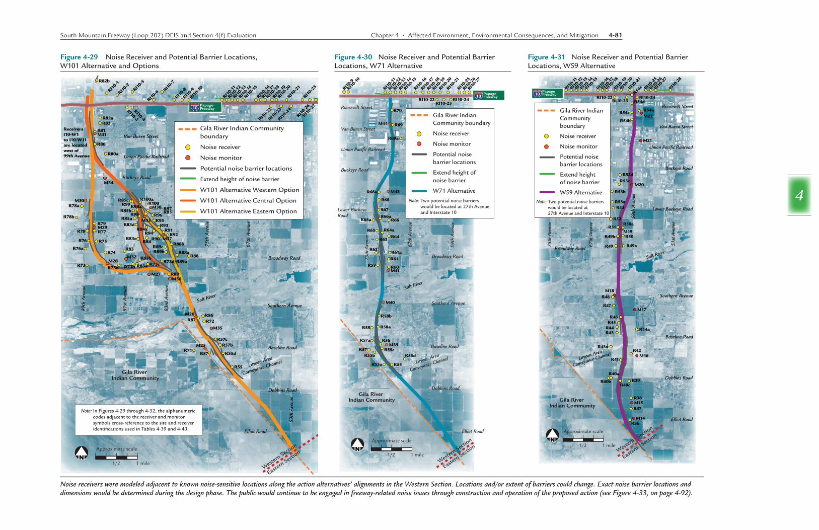
Figure4-29 Noise Receiver and Potential Barrier Locations, W101 Alternative and Options
Noise receivers were modeled adjacent to known noise-sensitive locations along the action alternatives’ alignments in the Western Section. Locations and/or extent of barriers could change. Exact noise barrier locations and dimensions would be determined during the design phase. The public would continue to be engaged in freeway-related noise issues through construction and operation of the proposed action (see Figure 4-33, on page 4-92).
Figure4-30 Noise Receiver and Potential Barrier Locations, W71 Alternative
Figure4-31 Noise Receiver and Potential Barrier Locations, W59 Alternative
Gila River Indian Community
Union Pacific Railroad
Van Buren Street
Buckeye Road
Broadway Road
59th
Ave
nue
91st
Ave
nue
99th
Ave
nue
83rd
Ave
nue
75th
Ave
nue
67th
Ave
nue
Southern Avenue
Baseline Road
Laveen Area
Conveyance Channel
Salt River
Elliot Road
Dobbins Road
R82a
R82b
R82
R81M31
R80
R80a
M34
R85c
R85b
R85aR83d
R84aR94
R84
R83b
R73b R73c R73d/R89aR88
R88a
R88b
R92R91
R93R95
R96R97R85
M38
R89bR89c
R83a
R90R83c
R83
M32
R99R98a
R98
R100aR100M30
R78a
R78bR79
R78
R76
R76a
M29R77
R75
R74
M28
M27
M37
M33
R89M36
M26R87
R71R57
R57cR57b
R55d
R55
R86R72
M35
M25
R73 R73a
RI10-1
RI10-2
RI10-5
RI10-6
RI10-3
RI10-4
RI10-7
RI10-8
RI10-9
RI10-1
0
RI10-11
RI10-1
2
RI10-1
3
RI10-1
4
RI10-1
5
RI10-1
6
RI10-1
7
RI10-1
8
RI10-1
9
RI10-2
0
RI10-2
1
RI10-2
5
RI10-2
3
RI10-2
4
RI10-2
2
RI10-2
6
RI10-2
7
Approximate scale
1 mile1/2
Gila River Indian Community boundary
Noise receiver
Noise monitor
Potential noise barrier locations
Extend height of noise barrier
W101 Alternative Western Option
W101 Alternative Central Option
W101 Alternative Eastern Option
Western
Section
Eastern Sect
ion
PapagoFreeway10
Receivers I10-W1 to I10-W11 are located west of 99th Avenue
Note: In Figures 4-29 through 4-32, the alphanumeric codes adjacent to the receiver and monitor symbols cross-reference to the site and receiver identifications used in Tables 4-39 and 4-40.
Gila River Indian Community
Roosevelt Street
Van Buren Street
Union Pacific Railroad
Buckeye Road
Lower Buckeye Road
Broadway Road
59th
Ave
nue
67th
Ave
nue
75th
Ave
nue
Southern Avenue
Baseline Road
Laveen Area
Conveyance Channel
Salt River
Elliot Road
Dobbins Road
R70
M44 R69
R69a
M43R68a
R68
R67R66a
R64aR64
R65
R63
R62R61aR61
R60R59M41
M40
R58b
R58aR58
R57a R56M39
R55cR57R55b
R55
R55d
R55a
R65a R66
RI10-9
RI10-1
0
RI10-11
RI10-1
2
RI10-1
3
RI10-1
4
RI10-1
5
RI10-1
6
RI10-1
7
RI10-1
8
RI10-1
9
RI10-2
0
RI10-2
1
RI10-24 RI10-23
RI10-22
RI10-2
5
RI10-2
6
RI10-2
7
PapagoFreeway10
Western
Section
Eastern Sect
ion
Gila River Indian Community boundary
Noise receiver
Noise monitor
Potential noise barrier locations
Extend height ofnoise barrier
W71 Alternative
Approximate scale
1 mile1/2
Note: Two potential noise barriers would be located at 27th Avenue and Interstate 10
Van Buren Street
Roosevelt Street
Union Pacific Railroad
Buckeye Road
Lower Buckeye Road
Broadway Road
51st
Ave
nue
67th
Ave
nue
75th
Ave
nue
Southern Avenue
Baseline Road
Laveen Area
Conveyance Channel
Salt River
Elliot Road
Dobbins Road
Western
Sect
ion
Eastern S
ection
59th
Ave
nue
Gila River Indian Community
PapagoFreeway10
Approximate scale
1 mile1/2
Gila River Indian Community boundary
Noise receiver
Noise monitor
Potential noise barrier locations
Extend heightof noise barrier
W59 Alternative Note: Two potential noise barriers
would be located at 27th Avenue and Interstate 10
M21
M20
R53dR53c
R53b
R53aR53
R52
R51R50a
M19R49b R50
R49aR49
M18R48
R47M17
R46R45
R44 R44a
R43aR42
M16R41
R40a
R40cR40b R39
R38M15R37
M14R36
R43
M22R54b
R54d
R54a
R54e
R54c
RI10-11
RI10-1
2
RI10-1
3
RI10-1
4
RI10-1
5
RI10-1
6
RI10-1
7
RI10-1
8
RI10-1
9
RI10-2
0
RI10-2
1
RI10-2
5
RI10-2
6
RI10-2
7
RI10-2
8
RI10-22RI10-23
RI10-24

4-82 Chapter 4 • Affected Environment, Environmental Consequences, and Mitigation South Mountain Freeway (Loop 202) DEIS and Section 4(f) Evaluation
4
Figure4-32 Noise Receiver and Potential Barrier Locations, Eastern Section
Noise receivers were modeled adjacent to known noise-sensitive locations along the E1 Alternative in the Eastern Section. Locations and/or extent of barriers could change. Exact noise barrier locations and dimensions would be determined during the design phase. The public would be encouraged to continue to be engaged in freeway-related noise issues through con-struction and operation of the proposed action (see Figure 4-33, on page 4-92).
Each monitoring period consisted of a 15- to 30-minute sound level recording using an integrating sound level meter. Most readings were conducted for a period of 15 minutes. Based on FHWA guidance, the longer monitoring periods were used at locations with little traffic noise and greater short-term variabilities in ambient noise. The duration of each reading was sufficient to record the existing noise characteristics at the monitoring location. At all locations, the meter was placed approximately 5 feet above the ground. Results of the ambient noise monitoring are shown in Table 4-39.
ENVIRONMENTAL CONSEQUENCESFor the three Western Section action alternatives and options and the Eastern Section action alternative, over 220 sensitive receivers were evaluated from a traffic noise perspective. All of the receivers represent noise-sensitive Activity Category B land uses, as described
in Table 4-40, with the exception of the casino (R30), which is a commercial land use (Category C). Receiver locations for the Western Section of the Study Area are indicated on Figures 4-29 through 4-31. Receiver locations for the Eastern Section of the Study Area are indicated on Figure 4-32. The impacts from each of the action alternatives and options and those of the No-Action Alternative are discussed in more detail later in this section.
In areas where the Western Section action alternatives are located close together, nearby receivers were evaluated for both action alternatives and are listed in Table 4-40 under both alternatives. Also, several new residential subdivisions have been developed since the initial noise evaluations began in 2003. To include these new receiver locations without altering the sequential numbering system, additional receivers were assigned an identification beginning with the nearest receiver number, followed by a letter to distinguish the new receiver. For
instance, if the nearest existing receiver was numbered 26, the additional nearby receiver was numbered 26a.
Results of the noise analysis for each receiver are summarized in Table 4-40. The first column of Table 4-40 lists a consecutive number assigned to identify each receiver. The second column in the table identifies the approximate distance and direction from the given action alternative’s centerline to the receiver. The third column identifies the receiver, such as school or park, neighborhood, subdivision, or the area where the receiver is located. The fourth column displays the projected future noise level (in dBA Leq) without noise mitigation, based on Traffic Noise Model 2.5 modeling (traffic noise model endorsed by FHWA—see the technical report on traffic noise) and the 2035 design year. Noise mitigation was then added to the model, resulting in the mitigated future noise levels shown in the fifth column. For some of the receivers, noise from nearby arterial street traffic limited the amount of noise reduction that could be achieved for the proposed action alternatives. Mitigation is discussed in further detail in the next section.
Action Alternatives, Western SectionThe evaluation of impacts on noise-sensitive receivers included modeling noise level impacts from the W59 Alternative, W71 Alternative, and W101 Alternative and Options along I-10 (Papago Freeway) near and including where the new system traffic interchange would connect I-10 and the proposed action. The receivers for this analysis can be found in Table 4-40 and are denoted by the prefix “I-10” in the first column. Because the W101 Alternative and its Options would result in the same impacts along I-10, the results are presented only for the Western Option.
W59(Preferred)AlternativeProjected peak-hour noise levels along the W59 Alternative and I-10 (Papago Freeway) would range from 60 to 78 dBA Leq at the 84 receivers. The projected noise levels at 65 of the 84 receivers would approach or exceed the ADOT mitigation criterion. The 65 affected receivers along this action alternative and I-10 would be eligible for noise abatement consideration.
Are the noise barriers shown in the DEIS the exact locations?
The noise analysis was based on preliminary design and traffic information. Numerous “state-of-the-practice” assumptions were made to complete the noise analysis. As the design of the proposed action further develops, additional noise analyses would be conducted. The results of this analysis and the mitigation recommendations should not be considered final and would need to be verified and refined as the design would progress.
R35a
R35
R33
M12
R31
R29
R28
R27
R26a
R26R25
R24R23
R22
R22aR21
R19R20R18 M
6R17 R16
R15R14 R13 R12 R11 R10 R9
R8R7 R6 R5 R4
R3 R2
R1
R1a
M8M
9
R30
M11
M10
M7
M5 M
4
M3
M2 M
1R1cR1b
R21a
R34
R32
M13
Elliot Road
Pecos Road
51st
Ave
nue
17th
Ave
nue
Des
ert F
ooth
ills
Park
way
24th
Str
eet
32nd
Str
eet
40th
Str
eet 56
th S
tree
t
Elliot Road
Ray Road
Ahwatukee FoothillsVillage
Gila River Indian Community
Phoenix SouthMountain Park/Preserve
MaricopaFreeway10
SantanFreeway202
LOOP
Existing freewayGila River Indian Community boundaryMaricopa County lineNoise receiverNoise monitorPotential noise barrier locationsE1 Alternative
Approximate scale
1 mile1/2
South Mountain Freeway (Loop 202) DEIS and Section 4(f) Evaluation Chapter 4 • Affected Environment, Environmental Consequences, and Mitigation 4-83
4
SiteIdentification
Alternative/AlignmentOption
LocationDescriptionAmbient
NoiseLevel(LAeq1h)
a
WesternSection
M14b W101, W71, W59 Corner of 59th Avenue and Elliot Road 49
M15 W59 59th Avenue, 3/8 mile north of Elliot Road 45
M16 W59 South Mountain Avenue, west of 59th Avenue 47
M17 W59 Corner of 59th Avenue and Vineyard Road 50
M18 W59 Southern Avenue, ½ mile west of 59th Avenue 58
M19 W59 Corner of 61st Avenue and Warner Street 51
M20 W59 59th Avenue and Roosevelt Irrigation District canal 64
M21 W59 57th Drive south of Jefferson Street 58
M22 W59 Southwest Village Apartments, 777 North 59th Avenue, southeast corner 49
M23 W101, W71, W59 Elliot Road at Communityc boundary 49
M24 W101, W71 Dobbins Road at Community boundary 54
M25 W101 Western Option Baseline Road at Community boundary 61
M26W101
Western and Central Options
Alta Vista Road, west of 75th Avenue 50
M27W101
Western and Central Options
87th Avenue, ¼ mile south of Broadway Road 52
M28 W101 Western Option Broadway Road, ½ mile west of 91st Avenue 62
M29 W101 Western Option Kingman Street, east of 97th Avenue 48
M30 W101 Western Option 99th Avenue, ½ mile north of Lower Buckeye Road 57
M31 W101 Central Option Apartments on 96th Avenue, north of Van Buren Street 50
M32 W101 Central Option 91st Avenue, 500 feet north of Broadway Road 62
M33 W101 Central Option 87th Avenue, north of Lower Buckeye Road 53
M34W101
Central and Eastern Options
Buckeye Road, ½ mile east of 99th Avenue 59
SiteIdentification
Alternative/AlignmentOption
LocationDescriptionAmbient
NoiseLevel(LAeq1h)
a
M35 W101 Eastern Option 75th Avenue, ½ mile south of Southern Avenue 49
M36 W101 Eastern Option 83rd Avenue, ¾ mile south of Broadway Road 53
M37 W101 Eastern Option Elwood Street, west of 83rd Avenue 53
M38 W101 Eastern Option Watkins Street, east of 86th Drive 54
M39 W71 Baseline Road, east of 75th Avenue 63
M40 W71 Southern Avenue, east of 75th Avenue 62
M41 W71 71st Avenue, south of Wier Avenue 44
M42 W71 Crown King Road, east of 73rd Drive 54
M43 W71 Durango Street, west of 71st Avenue 48
M44 W71 Corner of 71st Avenue and Polk Street 55
EasternSection
M1 E1 Near 44th Street and Cedarwood Lane 55
M2 E1 Near 36th Place and Windsong Drive 52
M3 E1 End of 26th Street, south of Redwood Lane 56
M4 E1 Apartments at 21st Street and Liberty Lane, southwest side 53
M5 E1 Church near 15th Street and Liberty Lane 54
M6 E1 Near Ashurst Drive and 2nd Place 45
M7 E1 Near 15th Avenue and Liberty Lane 44
M8 E1 North of Pecos Road, between 17th and 27th avenues 46
M9 E1 Corner of 30th Lane and Redwood Lane 51
M10 E1 Far west end of Pecos Road at Community boundary 45
M11 E1 Corner of 45th Avenue and Galveston 48
M12 E1 Corner of Dusty Lane and Ray Road 54
M13 E1 Estrella Drive at Community boundary 55
Table4-39 Ambient Noise Monitoring Results, Western and Eastern Sections
a LAeq1h, 1-hour equivalent sound level; logarithmic energy average over a 1-hour period (measured in dBA, a logarithmic unit that expresses the ratio of the sound pressure level being measured to a standard reference level and is frequency-weighted using the A-scale, to approximate the frequency response of the human ear)
b Sites M1 to M13 are located in the Eastern Section and are presented later in the table.c Gila River Indian Community

4-84 Chapter 4 • Affected Environment, Environmental Consequences, and Mitigation South Mountain Freeway (Loop 202) DEIS and Section 4(f) Evaluation
4
Table4-40 Noise Analysis Results, Western and Eastern Sections
(continued on next page)Note: Footnotes are at the end of the table, page 4-88.
ReceiverID
DistanceandDirectionfromCenterline
NeighborhoodorArea
UnmitigatedAction
AlternativeNoiseLevela
MitigatedNoiseLevela
Western Section
W59 Alternative (Preferred Alternative)
36b 580 feet east 59th Avenue and Elliot Road 69 63
37 1,170 feet east 59th Avenue north of Elliot Road 66 60
38 1,500 feet east 59th Avenue and Olney Avenue 64 58
39 1,225 feet east 59th Avenue and Dobbins Road 65 58
40a 925 feet west 63rd Avenue and Dobbins Road 65 60
40b 1,220 feet west 63rd Avenue and Dobbins Road 65 59
40c 250 feet west 61st Avenue and Dobbins Road 72 63
41 385 feet west 61st Avenue and South Mountain Avenue 74 63
42 790 feet east 59th Avenue and South Mountain Avenue 69 62
43 920 feet west Rancho Grande 67 61
43ad 1,750 feet west Avalon Village 63 58
44 835 feet west Rancho Grande 67 61
44a 1,590 feet east Cottonwood Golf Course 63 61
45 530 feet west Rancho Grande 71 63
46 145 feet west Rancho Grande 78 63
47 895 feet west Rancho Grande 68 61
48 840 feet west Rancho Grande 67 62
49 485 feet west Rio Del Rey Unit 1 71 63
49a 470 feet east Rio Del Rey Unit 2 70 63
49b 270 feet west Rio Del Rey Unit 1 74 62
50 375 feet east Rio Del Rey Unit 2 73 61
50a 345 feet east Rio Del Rey Unit 2 74 63
51 250 feet west Rio Del Rey Unit 1 76 63
52 1,245 feet west Estrella Manor 65 58
53 1,285 feet west Meadows 64 59
53a 1,825 feet west Park at Terralea 62 58
53b 2,350 feet west Park at Terralea 61 58
53c 1,520 feet west Western Valley Elementary School 64 60c
53d 1,405 feet west 61st Avenue and Buckeye Road 65 60
54b 355 feet west 59th Avenue north of Van Buren Street 72 67e
54c 430 feet west Centura West 72 69e
ReceiverID
DistanceandDirectionfromCenterline
NeighborhoodorArea
UnmitigatedAction
AlternativeNoiseLevela
MitigatedNoiseLevela
54d 700 feet west Centura West 71 70e
54e 900 feet west Patio Homes West 73 71e
Interstate 10 with W59 Alternative (Preferred Alternative)
I-10-1 1,350 feet north Sheely Farms Parcel 3 62 62
I-10-2 1,180 feet north Apartments – McDowell Road and 93rd Avenue 61 61
I-10-3 510 feet south Tolsun Farms 67 61
I-10-4 520 feet south Tolsun Farms 68 62
I-10-5 1,440 feet north Westpoint 60 60
I-10-6 470 feet north EconoLodge 70 —f
I-10-7 1,440 feet north Amberlea Cottages 60 60
I-10-8 460 feet north Legacy Suites Apartments 63 58
I-10-9 410 feet north Daravante 63 56
I-10-10 380 feet north Daravante 67 56
I-10-11 440 feet north Hampton Square Apartments 62 61
I-10-12 420 feet north Hampton Square Apartments 62 58
I-10-13 390 feet north Sunpointe Apartments 63 59
I-10-14 420 feet north Las Gardenias Apartments 64 59
I-10-15 460 feet north Las Gardenias Apartments 63 61
I-10-16 490 feet north Westover Parc Condominiums 62 59
I-10-17 440 feet north Apartments – McDowell Road and 85th Avenue 62 58
I-10-18 420 feet north Apartments – McDowell Road and 84th Avenue 61 59
I-10-19 410 feet north Apartments – McDowell Road and 83rd Avenue 61 58
I-10-20 400 feet north Avanti Apartments 64 58
I-10-21 500 feet north Avanti Apartments 63 59
I-10-22 340 feet south La Terraza 64 60
I-10-23 280 feet south Patio Homes West 70 62
I-10-24 350 feet south Patio Homes West 66 63
I-10-25 430 feet north Apartments – McDowell Road and 57th Avenue 67 62
I-10-26 390 feet north Apartments – McDowell Road and 56th Avenue 68 60
I-10-27 360 feet north Hallcraft Villas West Condominiums 71 59
I-10-28 380 feet north Hallcraft Villas West Condominiums 72 62
I-10-29 320 feet north Winona Park 1 68 60
I-10-30 250 feet north Winona Park 6A 67 61

South Mountain Freeway (Loop 202) DEIS and Section 4(f) Evaluation Chapter 4 • Affected Environment, Environmental Consequences, and Mitigation 4-85
4
Table4-40 Noise Analysis Results, Western and Eastern Sections (continued)
(continued on next page)
ReceiverID
DistanceandDirectionfromCenterline
NeighborhoodorArea
UnmitigatedAction
AlternativeNoiseLevela
MitigatedNoiseLevela
I-10-31 250 feet north Winona Park 6A 67 61
I-10-32 310 feet south Winona Park 2 68 61
I-10-33 270 feet south Deluxe Mobile Home Park 66 61
I-10-34 280 feet south Deluxe Mobile Home Park 66 61
I-10-35 300 feet north Franmar Manor 67 60
I-10-36 300 feet north West View Manor 72 61
I-10-37 310 feet north West View Manor 71 61
I-10-38 270 feet south West Phoenix No. 4 67 61
I-10-39 220 feet south West Phoenix No. 4 72 62
I-10-40 370 feet south West Phoenix No. 4 69 62
I-10-41 340 feet north Westcroft Place 71 60
I-10-42 250 feet north Isaac Infill 71 61
I-10-43 360 feet north Westcroft Place Plat 2 64 59
I-10-44 260 feet north El Retiro Block 1 and 2 69 61
I-10-45 240 feet north Sharon Gardens 72 62
I-10-46 370 feet south Westcroft Place Plat 2 67 61
I-10-47 220 feet south Westcroft Place Plat 2 69 61
I-10-48 330 feet south El Retiro Block 1 and 2 66 62
I-10-49 280 feet south North Willow Square 70 62
I-10-50 370 feet south North Willow Square 70 62
I-10-51 370 feet south North Willow Square Plat 2 65 59
W71 Alternative
55 415 feet east Laveen Meadows 72 65c
55a 305 feet west Laveen Meadows Parcel 3 74 67c
55b 450 feet west Laveen Meadows Parcel 2 71 60
55c 590 feet east Laveen Meadows Parcel 15 71 63
55d 2,000 feet east Laveen Meadows Elementary School 64 59
56 590 feet east Rancho Grande 70 63
57 1,040 feet west 75th Avenue and Baseline Road 66 63
57a 400 feet west Laveen Ranch 72 63
58 410 feet west 75th Avenue and Vineyard Road 74 63
58a 410 feet east Laveen Farms Phase 1 74 63
58b 425 feet east Laveen Farms Phase 1 74 63
ReceiverID
DistanceandDirectionfromCenterline
NeighborhoodorArea
UnmitigatedAction
AlternativeNoiseLevela
MitigatedNoiseLevela
59 435 feet west Western Heritage Estates 72 62
60 890 feet east Western Heritage Estates 2 68 61
61 930 feet east Western Heritage Estates 2 67 62
61a 1,150 feet east Sienna Vista 66 61
62 495 feet west Sienna Vista 72 63
63 290 feet west Marbella 74 61
64 1,160 feet east 71st Avenue and Elwood Street 66 59
64a 345 feet east Sienna Vista 74 63
65 260 feet west Suncrest at Estrella Village 76 63
65a 410 feet west Travertine at Estrella Village 72 61
66 1,440 feet east Santa Marie Townsite 64 59
66a 445 feet east Sienna Vista 70 61
67 535 feet east Santa Maria Elementary School 71 65c
68 600 feet east Valle Eldorado 71 61
68a 385 feet east Valle Eldorado 74 63
69 460 feet east Westridge Park 4 70 65c
69a 1,135 feet east Western Acres 65 60
70 400 feet east Westridge Park 2 69 62
Interstate 10 with W71 Alternative
I-10-1 1,350 feet north Sheely Farms Parcel 3 62 62
I-10-2 1,180 feet north Apartments – McDowell Road and 93rd Avenue 61 61
I-10-3 510 feet south Tolsun Farms 66 61
I-10-4 520 feet south Tolsun Farms 68 62
I-10-5 1,440 feet north Westpoint 60 60
I-10-6 470 feet north EconoLodge 70 —f
I-10-7 1,440 feet north Amberlea Cottages 60 60
I-10-8 460 feet north Legacy Suites Apartments 63 58
I-10-9 410 feet north Daravante 63 56
I-10-10 380 feet north Daravante 67 57
I-10-11 440 feet north Hampton Square Apartments 69 62
I-10-12 420 feet north Hampton Square Apartments 67 59
I-10-13 390 feet north Sunpointe Apartments 66 61
I-10-14 420 feet north Las Gardenias Apartments 63 63

4-86 Chapter 4 • Affected Environment, Environmental Consequences, and Mitigation South Mountain Freeway (Loop 202) DEIS and Section 4(f) Evaluation
4
Table4-40 Noise Analysis Results, Western and Eastern Sections (continued)
(continued on next page)
ReceiverID
DistanceandDirectionfromCenterline
NeighborhoodorArea
UnmitigatedAction
AlternativeNoiseLevela
MitigatedNoiseLevela
I-10-15 460 feet north Las Gardenias Apartments 63 63
I-10-16 490 feet north Westover Parc Condominiums 63 59
I-10-17 440 feet north Apartments – McDowell Road and 85th Avenue 62 58
I-10-18 420 feet north Apartments – McDowell Road and 84th Avenue 61 58
I-10-19 410 feet north Apartments – McDowell Road and 83rd Avenue 61 57
I-10-20 400 feet north Avanti Apartments 63 57
I-10-21 500 feet north Avanti Apartments 62 58
I-10-22 340 feet south La Terraza 60 60
I-10-23 280 feet south Patio Homes West 69 61
I-10-24 350 feet south Patio Homes West 63 61
I-10-25 430 feet north Apartments – McDowell Road and 57th Avenue 61 61
I-10-26 390 feet north Apartments – McDowell Road and 56th Avenue 68 59
I-10-27 360 feet north Hallcraft Villas West Condominiums 72 59
I-10-28 380 feet north Hallcraft Villas West Condominiums 72 60
I-10-29 320 feet north Winona Park 1 68 59
I-10-30 250 feet north Winona Park 6A 66 60
I-10-31 250 feet north Winona Park 6A 67 61
I-10-32 310 feet south Winona Park 2 68 60
I-10-33 270 feet south Deluxe Mobile Home Park 66 60
I-10-34 280 feet south Deluxe Mobile Home Park 66 60
I-10-35 300 feet north Franmar Manor 67 60
I-10-36 300 feet north West View Manor 72 61
I-10-37 310 feet north West View Manor 70 60
I-10-38 270 feet south West Phoenix No. 4 67 60
I-10-39 220 feet south West Phoenix No. 4 72 62
I-10-40 370 feet south West Phoenix No. 4 69 62
I-10-41 340 feet north Westcroft Place 71 60
I-10-42 250 feet north Isaac Infill 71 61
I-10-43 360 feet north Westcroft Place Plat 2 64 59
I-10-44 260 feet north El Retiro Block 1 and 2 69 61
I-10-45 240 feet north Sharon Gardens 72 61
I-10-46 370 feet south Westcroft Place Plat 2 67 61
I-10-47 220 feet south Westcroft Place Plat 2 69 61
I-10-48 330 feet south El Retiro Block 1 and 2 66 61
I-10-49 280 feet south North Willow Square 70 62
ReceiverID
DistanceandDirectionfromCenterline
NeighborhoodorArea
UnmitigatedAction
AlternativeNoiseLevela
MitigatedNoiseLevela
I-10-50 370 feet south North Willow Square 70 61
I-10-51 370 feet south North Willow Square Plat 2 65 58
W101 Alternative Western Option
55 410 feet east Laveen Meadows 73 63
55d 545 feet east Laveen Meadows Parcel 15 71 63
57 820 feet west 75th Avenue and Baseline Road 69 63
57b 800 feet east Laveen Ranch 69 63
57c 670 feet east Laveen Ranch 70 60
71 2,270 feet west Communityg, 78th Avenue and Baseline Road 62 61
72 945 feet east 75th Avenue and Southern Avenue 69 61
73 1,750 feet west 95th Avenue and Broadway Road 63 62
73a 535 feet east 93rd Avenue and Broadway Road 71 66c
73b 745 feet east 89th Avenue and Broadway Road 70 63
73c 450 feet east 87th Avenue and Broadway Road 74 63
73d 950 feet east 84th Avenue and Broadway Road 69 61
74 1,040 feet east Tivoli 68 62
75 615 feet east Country Place Parcel 26 72 63
76 275 feet west Country Place Parcel 25 76 63
76a 925 feet west 99th Avenue and Illini Street 69 63
77 485 feet east Country Place Parcel 22 72 63
78 350 feet west Country Place Parcel 21 73 61
78a 1,080 feet west Country Place Phase 4 67 62
78b 1,705 feet west Country Place Phase 4 64 59
79 485 feet east Country Place Parcel 23 73 67c
80 445 feet east Tolleson High School 72 63
80a 1,730 feet east Tolleson-Goetz Tract, Block 100 64 59
81 475 feet east Concord Sundancer Apartments 73 65c
82 1,090 feet east Villa de Tolleson 1 66 61
82a 1,060 feet east Parkview Casitas 64 59
82b 380 feet east Sheely Farms Parcel 5 70 62
86 1,060 feet east 75th and Southern avenues 68 61
87 400 feet east 75th and Southern avenues 75 63
Interstate 10 with W101 Alternative (Western, Central, and Eastern Options)h
I-10-1 1,350 feet north Sheely Farms Parcel 3 62 62
I-10-2 1,180 feet north Apartments – McDowell Road and 93rd Avenue 61 61

South Mountain Freeway (Loop 202) DEIS and Section 4(f) Evaluation Chapter 4 • Affected Environment, Environmental Consequences, and Mitigation 4-87
4
Table4-40 Noise Analysis Results, Western and Eastern Sections (continued)
(continued on next page)
ReceiverID
DistanceandDirectionfromCenterline
NeighborhoodorArea
UnmitigatedAction
AlternativeNoiseLevela
MitigatedNoiseLevela
I-10-3 510 feet south Tolsun Farms 61 61
I-10-4 520 feet south Tolsun Farms 62 62
I-10-5 1,440 feet north Westpoint 60 60
I-10-6 470 feet north EconoLodge 70 —f
I-10-7 1,440 feet north Amberlea Cottages 60 60
I-10-8 460 feet north Legacy Suites Apartments 58 58
I-10-9 410 feet north Daravante 55 55
I-10-10 380 feet north Daravante 56 56
I-10-11 440 feet north Hampton Square Apartments 60 60
I-10-12 420 feet north Hampton Square Apartments 58 58
I-10-13 390 feet north Sunpointe Apartments 58 58
I-10-14 420 feet north Las Gardenias Apartments 58 58
I-10-15 460 feet north Las Gardenias Apartments 60 60
I-10-16 490 feet north Westover Parc Condominiums 58 58
I-10-17 440 feet north Apartments – McDowell Road and 85th Avenue 57 57
I-10-18 420 feet north Apartments – McDowell Road and 84th Avenue 58 58
I-10-19 410 feet north Apartments – McDowell Road and 83rd Avenue 56 56
I-10-20 400 feet north Avanti Apartments 56 56
I-10-21 500 feet north Avanti Apartments 57 57
I-10-22 340 feet south La Terraza 59 59
I-10-23 280 feet south Patio Homes West 60 60
I-10-24 350 feet south Patio Homes West 60 60
I-10-W1 1,280 feet north Apartments – McDowell Road and 103rd Avenue 63 63
I-10-W2 1,270 feet north Crystal Gardens Parcel 2A 63 63
I-10-W3 1,400 feet north Crystal Point 62 62
I-10-W4 670 feet south Hotel 66 —f
I-10-W5 960 feet north Crystal Springs Apartments 58 58
I-10-W6 980 feet north Mobile Home Park – McDowell Road and 119th Avenue 63 63
I-10-W7 810 feet south Isolated homes – east of El Mirage Road 66 66i
I-10-W8 1,040 feet north Avondale Friendship Park 63 63
I-10-W9 1,240 feet north Avondale Friendship Park 62 62
I-10-W10 1,070 feet north Rio Santa Fe Apartments 59 59
I-10-W11 350 feet south Desert Sage Apartments 63 63
W101 Alternative Central Option
83 2,375 feet west Union Elementary School 71 63
ReceiverID
DistanceandDirectionfromCenterline
NeighborhoodorArea
UnmitigatedAction
AlternativeNoiseLevela
MitigatedNoiseLevela
83a 1,750 feet west 89th Avenue and Broadway Road 64 59
83b 1,200 feet west 89th Avenue and Broadway Road 61 56
83c 330 feet west Hurley Ranch Parcel 3 63 59
83d 445 feet west Hurley Ranch Parcels 1 and 2 66 61
84 765 feet east Volterra 77 65
84a 750 feet east Volterra 72 63
85 835 feet east Ryland at Heritage Point 71 63
85a 595 feet west Farmington Park 69 63
85b 550 feet west Farmington Park 68 63
85c 295 feet west Farmington Park 71 66e
89a 580 feet east 84th Avenue and Broadway Road 71 63
89b 1,805 feet east 83rd Avenue north of Broadway Road 75 63
100 1,240 feet east Ryland at Heritage Point 66 61
W101 Alternative Eastern Option
72 930 feet east 75th and Southern avenues 70 62
80 490 feet east Tolleson High School 72 63
80a 1,395 feet east Tolleson-Goetz Tract Block 100 66 61
84a 650 feet west Volterra 70 60
86 1,060 feet east 75th and Southern avenues 69 62
87 400 feet east 75th and Southern avenues 73 63
88 1,920 feet east Estrella Village Manor 63 60
88a 625 feet east Tuscano Phase 2 Parcel C 71 63
88b 410 feet east Tuscano Phase 2 Parcel A 72 61
89 1,205 feet west 83rd Avenue and Mobile Street 67 61
89a 1,460 feet west 84th Avenue and Broadway Road 65 62e
89b 550 feet west 83rd Avenue north of Broadway Road 72 63
89c 400 feet west 83rd Avenue north of Broadway Road 72 62
90 300 feet west Volterra 73 63
91 370 feet east Volterra 72 63
92 520 feet east Tuscano Phase 1 70 61
93 400 feet east Volterra 73 63
94 325 feet west Volterra 73 62
95 580 feet east Volterra 71 62
96 840 feet east Ryland at Heritage Point 69 63
97 690 feet east Ryland at Heritage Point 70 61

4-88 Chapter 4 • Affected Environment, Environmental Consequences, and Mitigation South Mountain Freeway (Loop 202) DEIS and Section 4(f) Evaluation
4
a in decibels (dBA), which are logarithmic units that express the ratio of the sound pressure level being measured to a standard reference level and is frequency-weighted using the A-scale, to approximate the frequency response of the human ear
b Sites 1 to 35 are located in the Eastern Section and are presented later in the table.c Further mitigation would require a noise barrier taller than 20 feet, which would not meet the Arizona Department of
Transportation Noise Abatement Policy. d Numerous new receivers were added to represent new development since the initial analysis began in 2003. These receivers are
designated with a letter following the receiver number to maintain the sequential numbering system.e Traffic noise from nearby cross street prevented further noise reduction at this receiver.
Table4-40 Noise Analysis Results, Western and Eastern Sections (continued)
f mitigation typically not recommended for hotels, motels, and casinos g Gila River Indian Communityh The noise analysis results along Interstate 10 are the same for all of the W101 Alternative Options. i not eligible for mitigation based on land use category
ReceiverID
DistanceandDirectionfromCenterline
NeighborhoodorArea
UnmitigatedAction
AlternativeNoiseLevela
MitigatedNoiseLevela
98 520 feet west Farmington Park 72 62
98a 330 feet west Farmington Park 74 63
99 305 feet west Farmington Park 75 65c
100 950 feet east Ryland at Heritage Point 68 61
100a 450 feet east School at 87th Avenue and Durango Street 73 63
Eastern Section
E1 Alternative
1 250 feet north Foothills Paseo 2 78 64c
1a 460 feet south Pecos Park 74 62
1b 320 feet south Pecos Park 77 63
1c 440 feet south Pecos Park 74 61
2 260 feet north Foothills Paseo 2 77 63
3 335 feet north Foothills Paseo 2 73 62
4 785 feet north Wilton Commons 69 63
5 235 feet north Kyrene de los Lagos Elementary School 76 63
6 220 feet north Lakewood Parcel 20 74 64c
7 215 feet north Lakepoint 21 at Lakewood 76 63
8 380 feet north Kyrene Akimel Middle School 75 62
9 390 feet north Foothills Mountain Ranch 2 71 63
10 280 feet north Foothills Apartments 72 63
11 320 feet north Foothills Parcel 5B 75 63
12 325 feet north Foothills Parcel 5A 75 63
13 305 feet north Foothills Parcel 5C 76 63
14 290 feet north Parcel 6A at the Foothills 75 63
15 370 feet north Parcel 6A at the Foothills 74 68c
ReceiverID
DistanceandDirectionfromCenterline
NeighborhoodorArea
UnmitigatedAction
AlternativeNoiseLevela
MitigatedNoiseLevela
16 400 feet north Foothills Parcels 12A, B, C 74 70e
17 690 feet north Foothills Parcels 12A, B, C 70 63
18 405 feet north Fairway Hills at Club West 74 63
19 455 feet north Fairway Hills at Club West 72 62
20 460 feet north Parcel 9G at Foothills Club West 73 62
21 350 feet north Parcels 18A, 19D, 19E, 26B at Foothills Club West 75 63
21a 395 feet north Parcels 18A, 19D, 19E, 26B at Foothills Club West 74 61
22 1,175 feet north Parcel 26 at Foothills Club West 66 61
22a 470 feet north Foothills Club West Parcels 20 and 25 Amended 71 64c
23 1,370 feet north Parcel 23 at Foothills Club West 65 60
24 210 feet north Foothills Reserve Parcel D 78 63
24a 865 feet north Foothills Reserve 67 59
24b 1,400 feet north Foothills Reserve 68 60
25 195 feet north Foothills Reserve Parcel D 76 63
26 240 feet north Foothills Reserve Parcel C 76 63
26a 350 feet north Foothills 80 76 63
27 470 feet east Dusty Lane area 73 62
28 490 feet east Dusty Lane area 72 62
29 335 feet east Dusty Lane area 74 63
30 760 feet west Community Casino 68 —f
31 580 feet east Dusty Lane area 70 61
32 1,540 feet west Community, 51st Avenue area 64 59
33 420 feet east Dusty Lane area 75 69c
34 760 feet west Community, 51st Avenue area 68 63
35 670 feet east 53rd Avenue and Estrella Drive 68 63
35a 770 feet east Tierra Montana Phase 1 70 63

South Mountain Freeway (Loop 202) DEIS and Section 4(f) Evaluation Chapter 4 • Affected Environment, Environmental Consequences, and Mitigation 4-89
4
W71AlternativeProjected peak-hour noise levels along the W71 Alternative and I-10 (Papago Freeway) would range from 60 to 76 dBA Leq at the 80 receivers. The projected noise levels at 63 of the 80 receivers would approach or exceed the ADOT mitigation criterion. The 63 affected receivers along this action alternative and I-10 would be eligible for noise abatement consideration.
W101AlternativeandOptions
➤ Projected peak-hour noise levels along the W101 Alternative Western Option would range from 62 to 76 dBA Leq at the 29 receivers. The projected noise levels at 27 of the 29 receivers would approach or exceed the ADOT mitigation criterion.
Short-term noise impacts may be experienced during construction along any of the various action alternatives. Quantification of such impacts is difficult without data on the proposed freeway’s construction schedule and equipment to be used. Therefore, several assumptions were made to project the approximate noise level at R/W boundaries. These projections are based on the use of the noisiest equipment expected during each construction stage of a typical roadway project. Data on construction equipment noise are available from FHWA Highway Construction Noise Handbook (FHWA 2006b).
Measurements were taken during a freeway construction project in Arizona that assessed the collective impact of construction noise. The maximum noise levels (Lmax) were calculated at the R/W line. The distance between the R/W and the construction activity was estimated based on the type of work being performed.
Results of the preliminary estimates, shown below, indicate that sensitive receivers could be adversely affected by construction noise if the receivers were immediately adjacent to the proposed R/W. The highest noise levels would occur during the grading/earthwork phase of the construction project.
Construction Equipment Noise
Phase Equipment Equipment(Lmax)a FeettoR/Wb LmaxatR/W
Site clearing Dozer/Backhoe 82/78 50 83
Grading/Earthwork Scraper/Grader 84/85 75 85
Foundation Backhoe/Loader 78/79 100 78
Base preparation Compactor/Dozer 83/82 100 82a maximum noise level, measured in dBA (a logarithmic unit that expresses the ratio of the sound pressure level being measured to a
standard reference level and is frequency-weighted using the A-scale, to approximate the frequency response of the human ear)b right-of-way
Construction Noise
The 27 affected receivers along this option would be eligible for noise abatement consideration.
➤ Projected peak-hour noise levels along the W101 Alternative Central Option would range from 61 to 77 dBA Leq at the 14 receivers. The projected noise levels at 12 of the 14 receivers would approach or exceed the ADOT mitigation criterion. The 12 affected receivers along this option would be eligible for noise abatement consideration.
➤ Projected peak-hour noise levels along the W101 Alternative Eastern Option would range from 63 to 75 dBA Leq at the 26 receivers. The projected noise levels at 25 of the 26 receivers would approach or exceed the ADOT mitigation criterion. The 25 affected receivers along this option would be eligible for noise abatement consideration.
➤ Projected peak-hour noise levels along I-10 (Papago Freeway) for the W101 Alternative would range from 55 to 70 dBA Leq at the 35 receivers. The projected noise levels at 3 of the 35 receivers would approach or exceed the ADOT mitigation criterion. The 3 affected receivers along I-10 (Papago Freeway) would not be eligible for noise abatement considerations. Two of the receivers are hotels; hotel owners typically consider noise walls to be undesirable because they reduce the hotel’s visibility. The third affected receiver represents an area of isolated homes, which would not be considered eligible for mitigation according to the ADOT NAP.
Action Alternative, Eastern SectionE1 (Preferred)AlternativeMost of the 44 receivers are located along the existing Pecos Road; the remainder of the receivers are located between 43rd and 55th avenues.
Projected peak-hour noise levels along the E1 Alternative would range from 64 to 78 dBA Leq at the 44 receivers. The projected noise level at 43 of the 44 receivers would exceed the ADOT mitigation criterion. Receiver 30 represents the casino near 51st Avenue, and because it is not considered a noise-sensitive land use, would not be eligible for noise abatement consideration. The 43 affected receivers along this action alternative, including one on Community land (Receiver 34), would be eligible for noise abatement consideration.
No-Action AlternativeNoise impacts from the No-Action Alternative would be caused by vehicle traffic along arterial and other area surface streets. Based on projected growth throughout the region, traffic congestion would increase under this alternative, which would reduce travel speeds and thereby reduce traffic noise levels. As such, the No-Action Alternative would generally result in lower noise levels at the selected receivers than would any of the action alternatives, but would result in higher noise levels at other locations, such as along arterial streets. Noise from this alternative would be generated by traffic
4-90 Chapter 4 • Affected Environment, Environmental Consequences, and Mitigation South Mountain Freeway (Loop 202) DEIS and Section 4(f) Evaluation
4
on neighborhood and arterial streets, as well as by nontraffic noise sources and other general neighborhood activity. Therefore, it is difficult to quantify the projected noise levels from the No-Action Alternative.
MITIGATIONADOT Environmental Planning Group and Design ResponsibilitiesProjected noise levels would approach or exceed the Activity Category B NAC at 196 of the receiver locations. Noise mitigation was evaluated for these receivers. Noise mitigation, in the form of noise walls or earth berms, is discussed for each of the action alternatives and options. Noise walls and earth berms are the most common type of noise mitigation used along ADOT freeways. General locations of noise barriers for the Western and Eastern Sections are shown in Figures 4-29 through 4-32. Other noise mitigation strategies that could be applied in addition to or instead of standard noise walls or earth berms are discussed later in this section.
Where the main line would be elevated, each of the noise barriers would be placed on the freeway embankment, near the edge of the shoulder, to take advantage of the elevated profile. (Placing a noise barrier on an elevated section of freeway results in a lower wall height to achieve the same noise reduction.) Where feasible (but not likely in the areas where the main line would be elevated), noise barriers would be constructed as early as possible in the construction phasing to shield adjacent properties from construction-related noise impacts.
In addition, the ADOT NAP specifies that noise abatement should provide at least 5 dBA in noise reduction and result in a noise level below the 64 dBA criterion. Also, the ADOT NAP specifies that the maximum reasonable barrier height is 20 feet.
For some of the receivers along the action alternatives, a barrier as high as 20 feet would provide more than 5 dBA of noise reduction, but a noise level below 64 dBA could not be achieved. According to ADOT policy, barriers generally will not be constructed higher than 20 feet because of cost, aesthetics, and
Noise policy as it applies to the proposed action
According to ADOT policy, noise mitigation should achieve a reduction of 5 dBA and result in a noise level of less than 64 dBA (ADOT 2005b). Some of the receivers along the proposed action alternatives would be affected by noise from adjacent surface streets in addition to that from the proposed freeway. For some of these receivers, the proposed noise barriers would achieve a 5 dBA reduction, but the mitigated noise level would remain above the 64 dBA NAC approach level. For many of these receivers, however, the proposed noise barriers would achieve only a 3 to 4 dBA reduction, because the dominant noise source at the receiver would be the local arterial street rather than the proposed freeway. It would not be feasible to achieve additional noise reduction because of the impact from the local streets. Noise barriers would need to be constructed outside of the proposed R/W of the action alternatives to effectively reduce noise levels from local streets at these receivers. It would not be feasible to construct noise barriers outside of the proposed R/W. Each of these receivers would achieve the ADOT NAP criterion when modeled without the local street traffic.
constructibility. Therefore, no further noise reduction would be provided.
Action Alternatives, Western SectionW59(Preferred)AlternativeNineteen new barriers and one raised barrier would be needed to reduce noise levels in accordance with the ADOT NAP along the W59 Alternative and I-10 (Papago Freeway). The barriers would range in height from 10 to 20 feet and would reduce noise levels at the 84 receivers to between 56 and 71 dBA Leq. The noise levels at 1 of the receivers (R53c), even with a 20-foot-high noise barrier, would not be reduced to by at least 5 dBA, ADOT’s goal for reducing traffic noise on new roadway projects. This receiver, however, would achieve a 4 dBA reduction in the projected noise levels and would be reduced to less than the approach threshold of 64 dBA. Additionally, the noise level at 4 of the receivers (R54b, R54c, R54d, and R54e) would not be reduced in full accordance with the ADOT NAP because of noise impacts from adjacent arterial streets. These receivers would achieve noise reductions of 1 to 5 dBA, but would still be higher than 64 dBA. Three of the receivers (R37, R38, and R42) would be affected because of a “substantial increase” and would all be mitigated with a 5 to 7 dBA reduction. The barriers would total approximately 745,500 square feet in area. Using the standard $33 per square foot of barrier recommended by ADOT, the cost of noise mitigation for the W59 Alternative would be approximately $24.6 million. The ADOT-recommended cost per square foot is subject to future increase.
W71AlternativeEighteen new barriers and one raised barrier would be needed to reduce noise levels in accordance with the ADOT NAP along the W71 Alternative and I-10 (Papago Freeway). The barriers would range in height from 10 to 20 feet and would reduce noise levels at the 80 receivers to between 56 and 67 dBA Leq. The noise level at 4 of the receivers (R55, R55a, R67, and R69), even with a 20-foot-high noise barrier, would not be reduced to less than the approach threshold of 64 dBA, which is
ADOT’s goal for reducing traffic noise on new roadway projects. These receivers, however, would experience at least a 5 dBA reduction in the projected noise level. The barriers would total approximately 1,036,100 square feet in area. Using the standard $33 per square foot recommended by ADOT, the cost of noise mitigation for the W71 Alternative would be approximately $34.2 million.
W101AlternativesandOptions
➤ Seventeen barriers would be needed to reduce noise levels in accordance with the ADOT NAP along the W101 Alternative Western Option. The barriers would range in height from 10 to 20 feet and would reduce noise levels at the 29 receivers to between 59 and 67 dBA Leq. The noise level at 3 of the receivers (R73a, R79, and R81) would not be reduced in full accordance with the ADOT NAP. These receivers would achieve a noise reduction of at least 5 dBA. The barriers would total approximately 835,100 square feet in area. Using the standard $33 per square foot recommended by ADOT, the cost of noise mitigation for the W101 Alternative Western Option would be approximately $27.6 million.
➤ Twenty barriers would be needed to reduce noise levels in accordance with the ADOT NAP along the W101 Alternative Central Option. The barriers would range in height from 10 to 20 feet and would reduce noise levels at the 14 receivers to between 56 and 66 dBA Leq. The noise level at one of the receivers (R85a) would not be reduced in full accordance with the ADOT NAP because of noise impacts from adjacent arterial streets. This receiver would achieve a noise reduction of 5 dBA. The barriers would total approximately 825,500 square feet in area. Using the standard $33 per square foot recommended by ADOT, the cost of noise mitigation for the W101 Alternative Central Option would be approximately $27.2 million.
➤ Sixteen barriers would be needed to reduce noise levels in accordance with the ADOT NAP along the W101 Alternative Eastern Option. The barriers would range in height from 10 to 20 feet and would

South Mountain Freeway (Loop 202) DEIS and Section 4(f) Evaluation Chapter 4 • Affected Environment, Environmental Consequences, and Mitigation 4-91
4
reduce noise levels at the 26 receivers to between 60 and 65 dBA Leq. The noise level at one of the receivers (R89a) would not be reduced in full accordance with the ADOT NAP because of noise impacts from adjacent arterial streets. Noise levels at this receiver would be reduced to a sound level below 64 dBA, but would achieve a noise reduction of only 3 dBA. The noise level at one of the receivers (R99), even with a 20-foot-high noise barrier, would not be reduced to less than the approach threshold of 64 dBA. This receiver, however, would experience a noise reduction of 5 dBA. The barriers would total approximately 859,400 square feet in area. Using the standard $33 per square foot recommended by ADOT, the cost of the noise mitigation for the W101 Alternative Eastern Option would be approximately $28.4 million.
➤ For the W101 Alternative and Options along I-10 (Papago Freeway), no barriers would be needed to reduce noise levels in accordance with the ADOT NAP.
Action Alternative, Eastern SectionE1 (Preferred)AlternativeTwenty barriers would be needed to reduce noise levels in accordance with the ADOT NAP along the E1 Alternative. The barriers would range in height from 8 to 20 feet and would reduce noise levels at the 44 receivers to between 59 and 70 dBA Leq. One receiver (R30), the Vee Quiva Casino near 51st Avenue, is not considered noise-sensitive and is not eligible for noise mitigation. The noise levels at five of the receivers (R1, R6, R15, R22a, and R33) would not be reduced in full accordance with the ADOT NAP even with a 20-foot-high noise barrier. Each of these receivers, however, would achieve at least a 5 dBA reduction in projected noise levels. Additionally, the noise level at one of the receivers (R16) would not be reduced in full accordance with the ADOT NAP because of noise impacts from adjacent arterial streets. This receiver would achieve a noise reduction of 4 dBA. The barriers would total approximately 1,356,200 square feet in area. Using the
standard $33 per square foot recommended by ADOT, the cost of the noise mitigation for the E1 Alternative would be approximately $44.8 million.
No-Action AlternativeThe No-Action Alternative assumes that the proposed action would not be selected. Consequently, under the No-Action Alternative, noise mitigation would not be provided for any of the receivers.
OTHER POSSIBLE MITIGATION STRATEGIESA number of mitigation strategies are available that could be used instead of, or in addition to, noise barriers. These involve elements of the action alternatives’ alignments, design features, and restrictions.
➤ Depressing the freeway – For most alignments of each of the action alternatives, the proposed freeway would be elevated above the natural grade of the surrounding land. This elevated profile would allow noise to carry farther, creating noise impacts at greater distances from the freeway. Depressing the profile of the freeway below grade (see Depressed Freeway Options, on page 3-15) may result in reduced traffic noise levels adjacent to depressed sections (FHWA 1980). However, it would be necessary to also construct at-grade noise barriers to achieve noise reduction goals at receiver locations adjacent to depressed freeway sections. This strategy would also reduce the visual impacts associated with high noise walls on elevated freeways (FHWA 1994). A major disadvantage of this strategy, however, would be the added substantial construction cost of depressing the freeway, including possible acquisition of R/W and provision of drainage (pumping systems and retention basins).
➤ Rubberized asphalt pavement surface – Until recently, new freeways constructed by ADOT were composed of concrete pavement. ADOT has embarked on a multiyear pilot program in cooperation with FHWA to overlay the metropolitan Phoenix freeway system with a rubberized asphalt
pavement surface. The rubberized asphalt paving program seeks to reduce freeway traffic noise levels by at least 4 dBA. At this point in the pilot study, such results appear to be achievable.
ADOT would overlay the proposed action’s concrete pavement with rubberized asphalt, but is not making any predictions at this time regarding expected noise reductions. Noise modeling during the final design phase would reflect the most current FHWA modeling criteria, which may include rubberized asphalt.
➤ Truck traffic restrictions or reduced posted speed limits – Discussions regarding reduction of transportation noise impacts have at times focused on restricting truck traffic entirely or during certain hours of the day and on reducing the posted speed limit of a transportation facility. Reducing weight limits is another potential noise reduction strategy. In theory, all of these strategies would reduce the noise impacts on adjacent properties because trucks produce higher noise levels than automobiles and higher speeds generate more noise than lower speeds (FHWA 1976). None of these strategies would, however, be consistent with the purpose and need for the proposed action and, therefore, are not feasible for the proposed freeway.
CONCLUSIONSImplementation of the proposed action would introduce traffic noise where it currently does not exist or at higher levels than now experienced. There are sensitive receivers [e.g., residences, Section 4(f) resources, schools, parks, churches] where freeway noise might be perceived adversely by users of such facilities. Depending on which action alternatives might be implemented (Western Section combined with the Eastern Section), between 55 and 108 affected receivers would be eligible for noise abatement consideration. The combinations of the W59/E1 (Preferred) Alternative and W71/E1 Alternative would have the most affected eligible receivers, followed by the W101/E1 Alternative. These numbers are expected for a project of this magnitude located in a rapidly growing region. With the placement of noise
Evening traff ic noise
The loudest traffic noise near an urban freeway is thought to occur during the morning and afternoon peaks associated with commuting cycles. Traffic noise analysis, therefore, has evolved to focus on these time periods. However, based on past experiences, ADOT also monitors noise levels during off-peak hours. Noise levels could be distinctly higher in the evening because vehicles cause substantially more noise at higher speeds. With fewer vehicles on freeways in the evening, vehicles are able to travel at higher speeds than in the peak periods. Higher speeds were found to cause high late-evening traffic noise. If this condition were to be experienced along the proposed freeway ADOT would first investigate the occurrence and, if warranted, seek to reduce the noise to levels that would meet ADOT policy and FHWA regulations. It is ADOT policy to monitor a new freeway for 3 years.

4-92 Chapter 4 • Affected Environment, Environmental Consequences, and Mitigation South Mountain Freeway (Loop 202) DEIS and Section 4(f) Evaluation
4
barriers in selected locations along whatever action alternatives might be implemented—if any—freeway noise would be reduced to levels that would meet ADOT policy and FHWA regulations for abatement. Under the No-Action Alternative, travel speeds would generally be reduced (along with noise levels) because of increased congestion near modeled receivers, but noise levels would increase in other areas, such as along arterial streets.
ADOT would continue to encourage the public’s involvement in freeway-related noise issues through final design, construction, and operation of the proposed action (see Figure 4-33).
Figure4-33 Noise Barrier Process
The determination of the location, length, and height of noise barriers requires multiple stages of modeling analysis and offers the public a number of opportunities to gather information and provide comments.
Level of design
Publicinformation
Planningstage
Analysis
Mitigation(if needed)
OperationConstruction100% Design30% DesignPlanning Level
Confirm location,length,
and height specifics
Confirmationof publicdesire for
noisemitigation
ThroughEISa
process
Freewaytrafficnoise
concerns expressed
Construction-relatednoise
concernsaddressed
Planning
Noise monitoring and modeling
Generalbarrier location
identified
Preliminaryengineering
Conceptual barrier design (locations
and heights) completed
Finalengineering
Barrier specifics finalized
Complete
Complete
Barriersconstructed
Complete
Fieldmonitoring
Barrieradjustments
made if needed
Additional modeling
Rubberized asphalt pavement pilot program
In 2003, ADOT and FHWA started a pilot program to study the noise reduction potential of rubberized asphalt pavement overlays. The goal of the rubberized asphalt overlay program is to reduce traffic noise levels from freeways by 4 dBA. Initial noise measurements completed for the pilot study indicate the traffic noise reduction goal of 4 dBA for rubberized asphalt pavement is realistic; however, mitigation credit cannot be taken for potential noise reductions.
a environmental impact statement