south mountain freeway (loop 202), interstate 10 … · 28 environmental planning, hazardous...
TRANSCRIPT

PREPARERS
The following list identifies major contributors in the preparation of the DEIS.
Name Contribution Title Highest Education/Degree Years/Experience
Federal Highway AdministrationKenneth Davis* Senior oversight Senior Engineering Manager BS Civil Engineering 44 highway and transportation projects
Tom Deitering, PE Senior oversight Area Engineer BS Civil Engineering 14 highway and transportation projects
Mary Frye Senior oversight Environmental Protection Specialist MA American History 22 cultural resource compliance, National Park Service park planning, highway and transportation projects
Alan Hansen, PE Senior oversight Major Projects Manager BS Civil Engineering 25 highway and transportation projects
Robert Hollis* Senior oversight Arizona Division Administrator
Meesa Otani Senior oversight Environmental Coordinator BS Civil Engineering 3 highway and transportation projects
Karla S. Petty Senior oversight Arizona Division Administrator BS Civil Engineering 24 highway and transportation projects
Rebecca Swiecki Senior oversight Environmental Coordinator JD Environmental Law 11 NEPA compliance, environmental planning
Steve Thomas* Senior oversight Environmental Protection Specialist AA Mechanical/Civil Engineering 33 highway and transportation projects
Bill Vachon* Senior oversight Senior Transportation Engineer BS Civil Engineering 32 highway and transportation projects
Arizona Department of TransportationThor Anderson Strategic oversight Planning and Environmental Linkages Program Manager 28 environmental planning, hazardous materials
Oliver Antony, PE* Roadway design Design Review Engineer MS Civil Engineering 53 freeway design
Brock Barnhart Agency and community oversight Assistant Communications Director BA Business 9 communication, community relations, public involvement
Emily Blinkhorn* Reviewer Environmental Planner II, Noise Specialist BA Fine Arts 12 NEPA compliance for highway and transportation projects
Misty Dayzie Cultural sensitivity Tribal Planner and Coordinator BS Business 7 transportation projects, tribal planning and coordination
Dee Bowling Reviewer Enhancement Project Manager BS Wildlife Biology 22 NEPA compliance for highway and transportation projects
Michael Bruder, PE* Project manager Transportation Manager, Valley Project Management BS Mining Engineering 27 highway and transportation projects
Matt Burdick Agency and community oversight Communications Director MS Mass Communications 15 communication in community relations, media relations
Brent Cain, PE Senior oversight Deputy State Engineer BS Civil Engineering 24 transportation planning, travel demand modeling, and traffic engineering
Dennis Crandall Roadway drainage reviewer Senior Drainage Engineer BS Civil Engineering 31 drainage design, highway projects
Linda Davis Cultural resources Historic Preservation Specialist III/Archaeologist BA Anthropology 9 cultural resources
Mike Dennis* Air/Noise Air and Noise Specialist III BS Engineering Geology 23 hazardous materials, environmental planning, air quality, noise
Darlene Dyer* Reviewer Environmental Planner III, Biologist BS Ecology and Systematic Biology 17 NEPA compliance, biology
Eddie Edison Affirmative action Civil Rights Executive Consultant BA Business Administration 24 civil rights enforcement
Ralph Ellis NEPA Project Manager Planning Section Manager MBA Business 17 Transportation NEPA compliance
Pete Eno Right-of-way Right-of-Way Coordinator Surveying (no degree) 49 right-of-way
Tammy Flaitz Senior oversight Transportation Enhancement Program Manager MS Geography 25 land use planning, transportation planning
Preparers PRE-1
* no longer with organization
PRE

Fred Garcia* Air/Noise Air and Noise Specialist III AA Engineering 34 highway development, 18 years of experience in air quality and noise
Rados Gluscevic Traffic Transportation Engineering Specialist BS Traffic and Transportation 11 transportation planning, traffic engineering Engineering
Ed Green Hazardous materials Hazardous Materials Coordinator AA Business 22 hazardous materials
Ruth Greenspan, PhD Cultural resources Historical Preservation Specialist, PhD Anthropology – 30+ cultural resources management in private, tribal, and state government Technical Environmental Section Manager North American Archaeology sectors
John Halikowski Senior oversight Director BA Communications 20 senior oversight and policy
Chaun Hill, PE Project manager Assistant State Engineer, Valley Project Management BS Civil Engineering 31 highway, roadway, and transportation project management
Mark Hollowell* Reviewer Environmental Planner III BS Business Administration 6 NEPA compliance for highway and transportation projects
Stephanie Huang, PE Reviewer Transportation Engineer I MS Environmental Engineering 10 transportation and roadway projects
Dan Lance, PE* Senior oversight Deputy State Engineer BS Civil Engineering 41 highway and transportation projects
Larry Langer, PE* Senior oversight Assistant State Engineer, Valley Project Management BS Civil Engineering 38 highway and transportation projects
Melissa Maiefski* Reviewer Technical Environmental Section Manager BS Wildlife and Fisheries Sciences 15 environmental activities related to transportation, including ground work and NEPA compliance
Mike Manthey, PE* Traffic design State Traffic Engineer BS Civil Engineering 31 traffic engineering
Merrisa Marin Right-of-way Right-of-way Coordinator
Velvet Mathew, PE Reviewer Transportation Manager MS Structural Engineering 11 transportation and highway projects
Victor Mendez* Senior oversight Director BS/ Civil Engineering 22 senior oversight and policy MBA
Paul O’Brien, PE Strategic oversight Manager, Environmental Planning Group BS Civil Engineering 23
Reggie Rector Right-of-way Right-of-way Coordinator
Barney Remington* Air/Noise Air and Noise Specialist BA Anthropology 5 cultural resources management, environmental compliance, noise and air quality
Angela Roach, PhD* Reviewer Hazardous Materials Specialist PhD Geology 5 hazardous materials
Floyd Roehrich, Jr. Senior oversight Deputy Director for Policy BS Civil Engineering 27 highway project development
Robert Samour Senior oversight Senior Deputy State Engineer MPA Technology 18 construction
Shannon Scutari* Strategic oversight Director of Rail and Sustainability Services JD/ Law 7 communications, community partnerships MBA
Timothy Tait Community oversight Community Relations Manager MS Leadership/Crisis Management 13 community, media and government relations and public involvement EdD Organizational Leadership
Tom Tortice, PE Traffic Transportation Engineer I BS Civil Engineering 11 traffic engineering
Jennifer Toth, PE Senior oversight State Engineer
Justin White Biology Roadside Resources Program Manager BS Wildlife Biology 17 NEPA compliance, biology
Nan Wilcox* Right-of-way Right-of-way Coordinator AA Engineering/ 27 right-of-way Administration of Justice
Pe-Shen Yang, PE Bridge design Assistant State Bridge Engineer PhD Structural Engineering 26 bridge design, management
Name Contribution Title Highest Education/Degree Years/Experience
PRE-2 Preparers
* no longer with organization
PRE

U.S. Army Corps of EngineersSallie McGuire Cooperating agency oversight Chief, Arizona Branch BS Biology 15 natural resource management
Dana Owsiany, PE* Cooperating agency oversight Traffic Engineer MS Civil Engineering 18 civil and traffic engineering
Kathleen Tucker Cooperating agency oversight ADOT Liaison MS Biological Sciences and 16 landscape architecture, natural resource management Environmental Resources
U.S. Bureau of Indian AffairsStacey Begay Cooperating agency oversight Highway Engineer right-of-way
Bryan Bowker Cooperating agency oversight Regional Director senior oversight
Matt Crain Cooperating agency oversight Deputy Regional Director senior oversight
Tamera Dawes Cooperating agency oversight Realty Specialist right-of-way
Beau J. Goldstein Cooperating agency oversight Acting Environmental Coordinator environmental protection
Amy Heuslein Cooperating agency oversight Branch Chief, Environmental Quality Services environmental protection, NEPA compliance
Chip Lewis Cooperating agency oversight Environmental Protection Specialist environmental protection
Cecelia Martinez Cooperating agency oversight Superintendent, Pima Agency senior oversight
Bob Maxwell Cooperating agency oversight Transportation Planner transportation planning
Rodney McVey Cooperating agency oversight Deputy Regional Director senior oversight
Peter B. Overton Cooperating agency oversight Agency Environmental Protection Specialist BS Agriculture 34 agricultural conservation, environmental protection
David R. Smith Cooperating agency oversight Regional Roads Engineer highway and transportation projects
Jonah Walker Cooperating agency oversight Pima Agency, Real Estate Services right-of-way
Stan Webb Cooperating agency oversight Realty Officer right-of-way
Western Area Power AdministrationMary Barger* Cooperating agency oversight Environmental Planner cultural resources
Matthew Bilsbarrow Cooperating agency oversight Archaeologist cultural resources
Carla Christelli Cooperating agency oversight Realty Officer right-of-way
John Holt Cooperating agency oversight Environmental Technical Manager environmental protection, NEPA compliance
Linda Hughes Cooperating agency oversight Environmental Division Manager environmental protection, NEPA compliance
Maricopa Association of GovernmentsEric Anderson MPO planning Transportation Director MS Economics 32 transportation, policy projects
Cathy Arthur Air Quality MAG Associate MA Urban Studies 20 transportation and air quality planning and modeling
Lindy Bauer Air Quality Environmental Director MA Urban Studies 20 environmental planning
Dean Giles Air Quality Air Quality Planning Program Specialist BA Geography 22 transportation and air quality planning
Name Contribution Title Highest Education/Degree Years/Experience
Preparers PRE-3
* no longer with organization
PRE

Robert Hazlett, PE MPO planning Senior Engineer BS Civil Engineering 29 transportation, highway projects
Vladimir Livshits MPO planning System Analysis Program Manager PhD Transportation Planning 29 transportation demand modeling, planning and Economics
Matt Poppen Air Quality Senior Air Quality Policy Manager MUEP Masters of Urban 13 years of experience in air quality planning and Environmental Planning
Nathan Pryor MPO planning Government Relations Manager MPA Public Administration 13 government relations and as public policy analyst
Roger Roy Traffic volume projections Decision Support Analyst III BS Physics 17 air quality, transportation demand modeling
Mark Schappi, PE* Traffic analyst System Analysis Program Manager MS Civil Engineering 35 transportation planning, travel demand modeling, highway and transit analysis, truck travel, air quality evaluations
Kelly Taft, APR MPO planning Communications Manager BA Broadcast Journalism 30 Accredited in public relations with experience in journalism, (telecommunications) communications, public involvement, community relations
Consultant Team
HDR Engineering, Inc.Angie Barton, EIT* Noise impacts Noise Specialist MS Civil Engineering 9 transportation planning, noise analysis
Mark Brodbeck, RPA Technical lead, cultural resources Cultural Resources Coordinator, Professional Associate MA Anthropology 24 cultural resources management
Patricia Brown, PE* Roadway Project Manager BS Civil Engineering 19 roadway design
Dorothy Bungert Lead, document design and production Senior Graphic Designer BFA Graphic and Computer Design 31 graphic design management
Praveen Chanda, PE Traffic Transportation Planner MS Civil Engineering 8 transportation planning
Faisal Chowdhury, PE Traffic Transportation Planner MS Civil Engineering 8 transportation planning
Jeremy Cook Socioeconomics Economist MA Economics 10 economics
Elisa Cote, PE* Drainage Water Resources Engineer BS Civil Engineering 12 drainage
Amelia Edwards, PE* EIS author Civil Engineer, Senior Professional Associate MS Civil Engineering 22 roadway design, NEPA compliance for highway projects
Terry Gruver Public involvement Senior Public Involvement Specialist BS Business Administration 25 communications and communications strategy
Greta Halle* Mitigation measures Senior Environmental Planner BA/BS Life Sciences/Psychology 12 NEPA planning
Joel P. Hennings* Hazardous materials Hazardous Material Specialist, Environmental Planner BS Environmental Science 10 evaluation and management of hazardous materials
Eric Herman Biology Environmental Planner MS Environmental Planning 6 biology, GIS review of technical reports, photography
Kelly W. Kading Hazardous materials Regional Hazardous Materials Services Manager, BS Geology 25 hazardous waste assessment and management Professional Associate
Michael LaBianca, AICP Technical lead, social conditions Planner MEP Environmental Planning 26 land use planning, environmental, and public outreach projects
Nicholas LaFronz, PE Technical lead, geotechnical Senior Geotechnical Program Manager MSE Civil Engineering 28 geotechnical engineering
Scott Mars, PE* Technical lead, water resources, Project Manager MS Water Resources 22 water resources planning, hydrology, water quality, water rights, waters of the United States, f loodplains, wetland ecology, soil erosion prime and unique farmlands
Gregg Mitchell, RG Geotechnical, geology Geotechnical/Environmental Planner BS Environmental Resources 23 engineering, geology, environmental geology, hazardous waste assessment and management
Renee Mullholland Waters of the United States Environmental Planner ME- Earth and Environmental 8 environmental permitting compliance, NEPA compliance ERM Resources Management
Name Contribution Title Highest Education/Degree Years/Experience
PRE-4 Preparers
* no longer with organization
PRE

Laura Paty, RLA Social conditions, document production Landscape Architect BS Design Science in Landscape 27 landscape architectural design, site planning, master planning, Architecture and Planning design guidelines, landscape character analysis
Carl Petrich Lead editor, visual resources Senior Environmental Planner, Professional Associate MLA/ Landscape Architecture/ 36 landscape architecture, environmental and energy planning, MBA Business Administration business research, technical editing
Susanna Schippers Editor Technical Editor BA Creative Writing 14 journalism, technical editing, public involvement
Ben Spargo, PE Engineering lead Transportation Engineer MS Civil Engineering 10 transportation planning and engineering
Scott Stapp Senior oversight Environmental Section Manager MS Biology 34 air quality, hazardous materials, noise, land use, prime and unique farmland, secondary and cumulative impacts, cultural resources, socioeconomics/Title VI/environmental justice
Audrey Unger Section 4(f) evaluation Environmental Planner and Biologist MS Environmental Planning 6 NEPA compliance, Section 4(f) analysis
Dustin D. Watson Technical lead, noise impacts Environmental Planner/Noise and Air Quality Specialist MS Environmental Planning 22 environmental planning
Kurt Watzek Biological resources Senior Environmental Planner MLA Landscape Architecture 27 environmental planning, NEPA compliance, environmental permitting compliance
Karen Wigglesworth, GISP* Technical lead, GIS analysis GIS Manager/SW Regional GIS Coordinator, BS Anthropology 26 database management, spatial analysis, Professional Associate oversight of cartographic products
Mark Wollschlager, Attorney Senior reviewer Technical Director – Environmental Review and Permitting JD Law 32 environmental review, environmental permitting, NEPA compliance
AMEC Earth & EnvironmentalRichard Bansberg, PG Geotechnical and hazardous materials Senior Geologist BA Earth Sciences 28 environmental assessments, environmental compliance audits, hydrogeologic site characterization studies
Kenneth C. Fergason, PG Geotechnical and hazardous materials Staff Geologist MS Geology 9 geotechnical investigations for buildings, characterization of subsidence and subsidence-related phenomena
Lawrence A. Hansen, PhD, PE Technical lead, geotechnical and hazardous Senior Vice President PhD Geotechnical Engineering 28 evaluation of geotechnical conditions; experience materials in investigation, design, construction, and performance monitoring
Marcie Martin Geotechnical and hazardous materials Environmental Planner MS Environmental Management 13 environmental regulatory compliance and Industrial Hygiene biological reviews, Clean Water Act permitting
Shandra Wagner Geotechnical and hazardous materials Environmental Scientist BS Geological Engineering 7 soil and groundwater remediation sites
Ralph E. Weeks, PG Geotechnical and hazardous materials Senior Geologist BS Geology 38 evaluation of geologic hazards; site selection; hydrogeologic, environmental, environmental, and geotechnical characterization; design development; construction
AMEC InfrastructureNatalya Hyland, PE Utilities Transportation Group Manager BS Civil Engineering 27 highway design, transportation projects
Digital Mapping Associates Sam Lowe Mapping and aerial photography Associate of Photogeometric Applications AA Civil Engineering 43 mapping and surveying in the transportation industry
Gila River Cultural Resource Management ProgramChris Loendorf, PhD Cultural resources Project Manager/Archaeologist PhD Anthropology 31 cultural resources management
Kyle Woodson, PhD Cultural resources Director (Acting) PhD Anthropology 20 cultural resources management
Name Contribution Title Highest Education/Degree Years/Experience
Preparers PRE-5
* no longer with organization
PRE

PRE-6 Preparers
Gunn Communications Theresa E. Gunn Public involvement Public Involvement Coordinator MA Organizational Management 20 designing and implementing public involvement and outreach programs
Jacobs Engineering, Inc.Jack Allen Senior oversight, EIS author EIS Author, NEPA Strategist BA Natural Resource Management 26 NEPA compliance for highway and transportation projects
Heather L. Honsberger Public involvement, document production Senior Public Involvement Specialist BA/BA Environmental Studies/ 14 communication of technical information Politics, Philosophy, Law
Logan Simpson Design Inc. Diane Simpson-Colebank, RLA Technical lead, visual resources Senior Landscape Architect MLA Master Landscape Architect 32 environmental issues, planning, assessments, public involvement, documentation, design
Patrick Higgins, RLA* Noise, air, social conditions Senior Landscape Architect MPA Public Administration 41 noise level and air quality assessments, visual assessment, NEPA compliance for highway and transportation projects
Mark Meyer, RLA* Visual resources Senior Environmental Planner MS Natural Sciences 28 design and environmental planning including visual resource analysis, natural resource planning, NEPA documentation
Southwest Heritage ResearchJ. Andrew Darling, PhD Cultural resources Principal Investigator PhD Anthropology 25 cultural resources management
Traffic Research & Analysis, Inc.Robert Medland Traffic Vice President BS Education 23 traffic data collection
VSI Environmental David Pekara Technical lead, air quality Project Manager MBA Business Administration 22 air quality monitoring and modeling
Dennis Haase Air quality Senior Air Quality Specialist BS Meteorology 35 air quality assessment
Wilbur Smith & Associates Janis Burall Socioeconomics Regional Coordinator of GIS Services BFA Advertising Art 22 data collection, data conversion, geographic analysis, mapping
Gary Mitchell, AICP Technical lead, socioeconomics Director of Urban Planning Services MA Urban Planning 22 regional, county, and community planning
Naina Magon, AICP Socioeconomics Senior Planner MA Urban and Regional Planning 12 comprehensive and land use planning, population and employment forecasting, socioeconomic analyses, transportation planning, parks planning, GIS applications
Name Contribution Title Highest Education/Degree Years/Experience
* no longer with organization
PRE
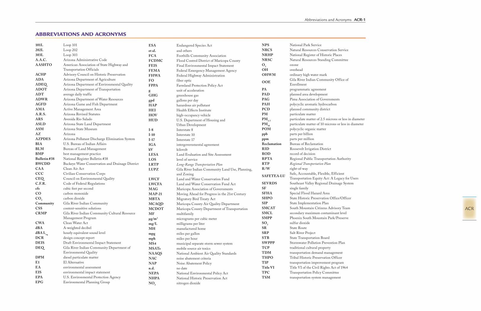
101L Loop 101202L Loop 202303L Loop 303A.A.C. Arizona Administrative CodeAASHTO American Association of State Highway and
Transportation OfficialsACHP Advisory Council on Historic PreservationADA Arizona Department of AgricultureADEQ Arizona Department of Environmental QualityADOT Arizona Department of TransportationADT average daily trafficADWR Arizona Department of Water ResourcesAGFD Arizona Game and Fish DepartmentAMA Active Management AreaA.R.S. Arizona Revised Statutes ARS Avenida Rio SaladoASLD Arizona State Land DepartmentASM Arizona State MuseumAZ ArizonaAZPDES Arizona Pollutant Discharge Elimination SystemBIA U.S. Bureau of Indian AffairsBLM Bureau of Land ManagementBMP best management practiceBulletin #38 National Register Bulletin #38BWCDD Buckeye Water Conservation and Drainage DistrictCAA Clean Air ActCCC Civilian Conservation CorpsCEQ Council on Environmental QualityC.F.R. Code of Federal Regulationscfs cubic feet per secondCO carbon monoxideCO2 carbon dioxideCommunity Gila River Indian CommunityCSS context-sensitive solutionsCRMP Gila River Indian Community Cultural Resource
Management ProgramCWA Clean Water ActdBA A-weighted decibeldBA Leq hourly equivalent sound levelDCR design concept reportDEIS Draft Environmental Impact StatementDEQ Gila River Indian Community Department of
Environmental QualityDPM diesel particulate matterE1 El AlternativeEA environmental assessmentEIS environmental impact statementEPA U.S. Environmental Protection AgencyEPG Environmental Planning Group
ESA Endangered Species Actet al. and othersFCA Foothills Community AssociationFCDMC Flood Control District of Maricopa CountyFEIS Final Environmental Impact StatementFEMA Federal Emergency Management AgencyFHWA Federal Highway AdministrationFO fiber opticFPPA Farmland Protection Policy Actg unit of accelerationGHG greenhouse gasgpd gallons per dayHAP hazardous air pollutantHEI Health Effects InstituteHOV high-occupancy vehicleHUD U.S. Department of Housing and
Urban DevelopmentI-8 Interstate 8I-10 Interstate 10I-17 Interstate 17IGA intergovernmental agreementkV kilovolt LESA Land Evaluation and Site AssessmentLOS level of serviceLRTP Long-Range Transportation PlanLUPZ Gila River Indian Community Land Use, Planning,
and ZoningLWCF Land and Water Conservation FundLWCFA Land and Water Conservation Fund ActMAG Maricopa Association of GovernmentsMAP-21 Moving Ahead for Progress in the 21st CenturyMBTA Migratory Bird Treaty ActMCAQD Maricopa County Air Quality DepartmentMCDOT Maricopa County Department of TransportationMF multifamilyµg/m3 micrograms per cubic metermg/L milligrams per literMH manufactured homempg miles per gallonmph miles per hourMS4 municipal separate storm sewer systemMSATs mobile source air toxicsNAAQS National Ambient Air Quality StandardsNAC noise abatement criteriaNAP Noise Abatement Policyn.d. no dateNEPA National Environmental Policy ActNHPA National Historic Preservation ActNO2 nitrogen dioxide
ABBREVIATIONS AND ACRONYMS
NPS National Park ServiceNRCS Natural Resources Conservation ServiceNRHP National Register of Historic PlacesNRSC Natural Resources Standing CommitteeO3 ozoneOH overheadOHWM ordinary high water mark
OOE Gila River Indian Community Office of Enrollment
PA programmatic agreementPAD planned area development PAG Pima Association of GovernmentsPAH polycyclic aromatic hydrocarbonPCD planned community districtPM particulate matter PM2.5 particulate matter of 2.5 microns or less in diameterPM10 particulate matter of 10 microns or less in diameterPOM polycyclic organic matterppb parts per billionppm parts per millionReclamation Bureau of ReclamationRID Roosevelt Irrigation DistrictROD record of decision RPTA Regional Public Transportation AuthorityRTP Regional Transportation PlanR/W right-of-way
SAFETEA-LU Safe, Accountable, Flexible, Efficient Transportation Equity Act: A Legacy for Users
SEVRDS Southeast Valley Regional Drainage SystemSF single familySFHA Special Flood Hazard AreaSHPO State Historic Preservation Office/OfficerSIP State Implementation PlanSMCAT South Mountain Citizens Advisory TeamSMCL secondary maximum contaminant levelSMPP Phoenix South Mountain Park/PreserveSO2 sulfur dioxideSR State RouteSRP Salt River ProjectSTB State Transportation BoardSWPPP Stormwater Pollution Prevention Plan TCP traditional cultural propertyTDM transportation demand managementTHPO Tribal Historic Preservation OfficerTIP transportation improvement programTitle VI Title VI of the Civil Rights Act of 1964TPC Transportation Policy CommitteeTSM transportation system management
Abbreviations and Acronyms ACR-1
ACR

TTT Gila River Indian Community Transportation Technical Team
UG undergroundUPRR Union Pacific RailroadU.S. United StatesUS 60 U.S. Route 60USACE U.S. Army Corps of Engineers
U.S.C. U.S. CodeUSDOT U.S. Department of TransportationUSFWS U.S. Fish and Wildlife ServiceUSGS U.S. Geological SurveyVAU Visual Assessment UnitVMT vehicle miles traveledVOC volatile organic compound
vpd vehicles per dayW101 W101 AlternativeW55 W55 AlternativeW59 W59 AlternativeW71 W71 AlternativeWestern Western Area Power AdministrationWQARF Water Quality Assurance Revolving FundWWTP wastewater treatment plant
ACR-2 Abbreviations and Acronyms
ACR

GLOSSARY
accessible Capable of being reached.acrolein One of the seven priority mobile source air toxics designated by the
U.S. Environmental Protection Agency. Acrolein can be formed from the breakdown of certain pollutants found in outdoor air, from burning tobacco, or from burning gasoline. Acrolein is highly reactive and remains in the atmosphere for only a brief period of time.
affected environment Natural resources within the project area that may be changed by the proposed alternatives. These changes might be positive, neutral, or negative in nature to the natural environment.
allottees The General Allotment Act of 1887 established land trusts for the Gila River Indian Community and individual tribal members. Under the Act, each Tribal member was allotted two 10-acre tracts of land, one for irrigable farm use and one for a home site or grazing purposes. The Act required that the allotted lands be held in trust, established the Bureau of Indian Affairs in the U.S. Department of the Interior, and designated BIA as the Trustee for allotted lands.
alluvial Pertaining to or composed of unconsolidated sediments deposited by a stream or running water.
alluvial fan An outspreading, gently sloping mass of alluvium deposited by a stream, especially in an arid or semiarid region where a stream issues from a narrow canyon onto a plain or valley f loor.
alluvium A general term for deposits made by streams on riverbeds, f loodplains, and alluvial fans.
American Indian or Alaska Native
A person having origins in any of the original peoples of North America and who maintains cultural identification through tribal affiliation or community recognition.
aquatic Growing or living in or on water.aquifer A body of rock or alluvium that is sufficiently permeable to conduct
groundwater and yield significant quantities of water to wells and/or springs.
Arizona Department of Environmental Quality (ADEQ )
The State agency responsible for ensuring that the quality of Arizona’s air, land, and water resources meets healthful, regulatory standards.
Arizona Department of Transportation (ADOT)
The State agency responsible, among other things, for state roads and highways.
arterial A through-road or street.asbestos-containing material A material or product that contains more than 1 percent asbestos.A-scale A measurement of sound approximating the sensitivity of the human
ear to variations in frequencies, used to note the intensity or annoyance level of sounds.
Asian American A person having origins in any of the original peoples of the Far East, Southeast Asia, the Indian subcontinent, or the Pacific Islands.
assessment viewpoint General location within a Visual Assessment Unit from which the unit was photographed and evaluated.
at-grade roadway A roadway element that is approximately level with the immediate surrounding terrain.
automobiles All vehicles, typically passenger cars, with two axles and four wheels—designed primarily for passenger transportation. Generally, the gross vehicle weight is less than 10,000 pounds.
auxiliary lane An additional lane on a freeway to connect an on-ramp and an off-ramp.average travel time The average time spent by vehicles traveling a highway segment,
including control delay, in seconds per vehicle or minutes per vehicle.background The landscape distance zone that extends beyond 3 miles from the
observer; surfaces and landforms will lose detail distinction. Silhouettes and ridges are conspicuous when skyline is the strongest line.
barrier A solid wall or earth berm located on a direct line between the roadway and noise receiver location that reduces the noise level at the receiver. Some material that blocks or is intended to block passage, or a natural formation or structure that prevents or hinders movement or action.
bedrock The solid rock that underlies gravel, soil, or other surficial material, or that is exposed in mountain highlands.
benzene One of the seven priority mobile source air toxics designated by the U.S. Environmental Protection Agency. It is an important industrial solvent and precursor in the production of drugs, plastics, synthetic rubber, and dyes. Benzene is a natural constituent of crude oil, but it is usually synthesized from other compounds present in petroleum.
bioaccumulation The accumulation of a substance, such as a toxic chemical, in various tissues of a living organism: for example, the bioaccumulation of mercury in fish.
biotic community A major regional community of plants and animals over large natural areas. Natural communities are characterized by a distinctive vegetation structure.
Black/African American A person having origins in any of the black racial groups of Africa.blasting The controlled use of explosives to excavate or remove rock.bosque A dense thicket of trees; a wooded area or forest.buffer An area designed to separate.1,3-butadiene One of the seven priority mobile source air toxics designated by the
U.S. Environmental Protection Agency. Most butadiene is polymerized to produce synthetic rubber, most commonly used for the production of tires. Small amounts of butadiene are also found in plastics and fuel.
capacity The maximum number of vehicles that a given section of road or traffic lane can accommodate.
carbon monoxide (CO) An odorless, colorless gas that is a product of the combustion of hydrocarbons; it interferes with the body’s organs and tissues.
census block Census blocks are areas bounded on all sides by visible features such as roads, streams, and railroad tracks and by invisible boundaries such as city, town, township, and county limits; property lines; and short, imaginary extensions of roads. Generally, census blocks are small in area—for example, a block bounded by city streets. However, census blocks in remote areas may be large and irregular and may contain many square miles.
characteristic A distinguishing trait, quality, or property.chromium A metal commonly used in plating facilities.citizens advisory team A group of volunteers that meets regularly and acts as a sounding board
to help the project team understand issues and concerns of their respective communities and to help find a consensus solution for the project.
colluvium A loose deposit of rock debris accumulated through the action of gravity at the base of a slope.
color An object’s relative ref lectiveness (for example: light, dark) and its hue (for example: red, green).
common point The break in the Study Area between the Western and Eastern Sections. It is a line perpendicular to the Gila River Indian Community boundary through a point located near Elliot Road and 59th Avenue. All action alternatives share this common point in their alignments.
community A unified body of individuals; people with common interests living in a particular area. An interacting population of various kinds of individuals (as species) in a common location, or a group of people with a common characteristic or interest living together within a larger area.
Community Throughout this document, the Gila River Indian Community is referred to as the Community.
Glossary G-1
G

community character A set of parameters that creates a “sense of place” within a community. Factors contributing to community character are physical size, compatible land uses within the community, internal circulation, distinct but common architecture, and cultural activities.
community cohesion The dynamic within a community that promotes internal neighborhood circulation to and from residences and community facilities, quasi-public facilities, and regularly required activities such as food shopping at local grocery stores.
congestion Traffic volume on a road at sufficient densities to become detrimental to its performance; undesirable traffic conditions that exist when traffic on a freeway or street is moving at an average speed of 45 mph or less, and/or the traffic f low is often stop and go.
constructive use A type of use in which a transportation project’s proximity impacts (as opposed to its direct impacts) are so severe that the protected activities, features, or attributes that qualify a resource for protection under Section 4(f) of the Department of Transportation Act of 1966, as amended, are substantially impaired. Examples include a substantial increase in noise level, impaired aesthetic features or attributes, restriction on access that substantially diminishes the utility of the resource, and other indirect impacts on the resource’s environment or utility.
cooperating agency Another agency—federal, state, or local—that has jurisdiction by law or special expertise over portions of the project area and that must make a decision on the proposed project.
Criterion A of the National Register of Historic Places
Cultural resources associated with events that have made a significant contribution to the broad patterns of our history.
Criterion B of the National Register of Historic Places
Cultural resources associated with the lives of persons significant in our past.
Criterion C of the National Register of Historic Places
Cultural resources embodying the distinctive characteristics of a type, period, or method of construction, or that represents the work of a master, or that possess high artistic values, or that represent a significant and distinguishable entity whose components may lack individual distinction.
Criterion D of the National Register of Historic Places
Cultural resources that have yielded, or may be likely to yield, information important in prehistory or history. Generally, cultural resources eligible for the National Register of Historic Places under Criterion D are not eligible for protection under Section 4(f).
critical habitat Critical habitat is defined in Section 3(5)(A) of the Endangered Species Act; critical habitat is a specific geographic area(s) essential for the conservation of a threatened or endangered species and that may require special management and protection.
cumulative impact The impact on the environment that results from the incremental impact of the action when added to the other past, present, and reasonably foreseeable future actions regardless of what agency (federal or nonfederal) or person undertakes such other actions. Cumulative impacts can result from individually minor but collectively significant actions taking place over a period.
decibel (dB) A logarithmic unit indicating the amount of sound energy. The approximate threshold of hearing is 0 dBA (A-weighted decibel), while the approximate threshold of pain is 140 dBA. Most suburban areas have daytime noise levels ranging from 50 dBA to 70 dBA.
delay per vehicle The additional travel time experienced by a vehicle with reference to a base travel time (i.e., the free-f low travel time).
demographic Relating to the vital and social statistics of a population, as in births, deaths, racial or ethnic composition, and related socioeconomic factors.
density Number per unit of area.design concept report A study intended to guide future decisions regarding the ultimate
improvements to a transportation facility, such as a highway, to meet the capacity, operational, and safety needs of the motoring public.
design year The future year used to determine the probable traffic volume for which a highway and noise abatement are designed.
diesel particulate matter (DPM)
One of the seven priority mobile source air toxics designated by the U.S. Environmental Protection Agency. Diesel particulate matter is part of a complex mixture that makes up diesel exhaust. Diesel exhaust is composed of two phases. The gaseous phase is composed of hazardous air pollutants, such as acrolein; benzene; 1,3-butadiene; formaldehyde; naphthalene; and polycyclic aromatic hydrocarbons. The particle phase also has many different types of particles that can be classified by size or composition. Diesel exhaust is emitted from a broad range of diesel engines: the on-road diesel engines of trucks, buses, and cars and the off-road diesel engines that include locomotives, marine vessels, and heavy-duty equipment.
direct impact A change in the physical, social, or economic environment that would be caused by the proposed action and would occur at the same time and same place as the action.
distinctiveness/vividness A criterion for measuring visual quality. Distinctiveness is defined by the memorability of the visual impression received from the contrasting landscape elements as they combine to form a striking and distinctive visual pattern. Vividness is assessed according to spatial definition, landmarks, water forms/riparian features, presence of human-made features, topographic relief, skyline character, vegetation, and adjacent landforms and features.
diversity The variety of species in a community; this also includes the relative abundance of each species. The number, variety, and intermixing of visual pattern elements.
dry well An underground structure with stones or gravel inside that is used to collect stormwater runoff to avoid soil erosion. The collected water is dissipated into the ground, where it merges with the local groundwater.
Eastern Section The portion of the Study Area located east of the common point.elderly Those persons age 65 and older; a demographic statistic tracked by the
U.S. Census Bureau.elevated roadway A roadway constructed above the immediate surrounding terrain, either
on an embankment or a structure.eligible Refers to properties that meet the National Park Service’s criteria for
inclusion in the National Register of Historic Places.emission A substance discharged into the air, especially by an internal
combustion engine.environmental assessment (EA)
A federally mandated report that includes brief discussions of a project need, alternatives, environmental impacts associated with the alternatives, and a listing of individuals and agencies consulted. An EA is completed to see whether an environmental impact statement is needed.
environmental impact statement (EIS)
The project documentation prepared in accordance with the National Environmental Policy Act when a project is anticipated to have a significant impact on the environment.
ephemeral Lasting only a short time; present only during a portion of the year; in this document generally refers to watercourses.
existing noise levels The noise resulting from natural and mechanical sources and from other human activity usually present in a particular area; also known as ambient noise level.
family A group of two or more people who reside together and who are related by birth, marriage, or adoption.
fault A fracture or fracture zone in the earth along which there has been movement of the sides relative to one another.
fauna The animal population of a particular area.Federal Highway Administration (FHWA)
The branch of the U.S. Department of Transportation responsible for administering the Federal-aid Highway Program and the Federal Lands Highway Program. The programs provide financial resources and technical assistance for constructing, preserving, and improving the National Highway System along with other urban and rural roads.
G-2 Glossary
G

fill Earth used to create embankments or to raise low-lying areas to bring them to grade.
f loodplain The portion of a stream valley, adjacent to the channel, that is built of sediments deposited during the present regime of the stream and is covered with water when the stream overf lows its banks at f lood stage.
f loodplain encroachment An action within the limits of the 100-year f loodplain.f loodway That portion of the floodplain in which construction would raise the
water level during a 100-year flood by more than 30 centimeters (1 foot).More generally, 1) a part of the f loodplain, otherwise leveed, reserved for emergency diversion of water during f loods. A part of the f loodplain which, to facilitate the passage of f loodwater, is kept clear of encumbrances; 2) the channel of a river or stream and those parts of the f loodplains adjoining the channel that are reasonably required to carry and discharge the f loodwater or f lood f low of any river or stream.
f lora The plant population of a particular area.foreground The landscape distance zone that extends up to 0.25 mile from the
observer; details can be perceived.form The visual mass, bulk, or shape of an object.formaldehyde One of the seven priority mobile source air toxics designated by the
U.S. Environmental Protection Agency. Formaldehyde is an important chemical used widely by industry to manufacture building materials and numerous household products, such as adding permanent-press qualities to clothing and draperies; as a component of glues and adhesives; and as a preservative in some paints and coating products. Formaldehyde also results from the incomplete combustion of carbon-containing materials such as in forest fires, in automobile exhaust, and in tobacco smoke. It may be present both indoors and outdoors. In the atmosphere, formaldehyde is produced by the action of sunlight and oxygen on atmospheric methane and other hydrocarbons. Small amounts of formaldehyde are produced as a metabolic byproduct in most organisms, including humans.
fracture A crack, joint, or other break in rock.fully directional interchange All traffic movement in the traffic interchange has a dedicated ramp,
ensuring free traffic f low in every direction.geotechnical Referring to the use of scientific methods and engineering principles to
acquire, interpret, and apply knowledge of earth materials for solving engineering problems.
granite An intrusive igneous rock that is predominantly composed of quartz and feldspar.
granitic Pertaining to, or composed of, granite.groundwater The part of the subsurface water that is in the zone of saturation.habitat Place where an animal or plant normally lives, often characterized by a
dominant plant form or physical characteristic.Hispanic/Latino Of Mexican, Puerto Rican, Cuban, Central or South American, or
other Spanish culture or origin, regardless of race.Holocene An epoch of the Quaternary period from the end of the Pleistocene,
approximately 10,000 years ago, to present time.household A social unit consisting of those living together in the same dwelling. impact A direct or indirect consequence of the construction or operation of
a proposed alternative, including the No-Action Alternative, on the environment in the Study Area; can be negative, positive, or neutral.
income Total amount of all and any wages, bonuses, and/or tips an individual receives in a given year.
independent utility The ability of the proposed action to function as proposed, independent of other planned transportation-related projects in the region.
indirect impact Changes that are caused by the action and are later in time or farther removed in distance, but are still reasonably foreseeable. Indirect impacts may include growth-inducing effects and other effects related to induced changes in the pattern of land use, population density, or growth rate, and related effects on air, water, and other natural systems, including ecosystems.
intactness A criterion for measuring visual quality. The integrity of visual order in the natural and human-made environment and the extent to which the landscape is free from visual encroachment of human-made elements.
intermittent A stream that f lows at only certain times of the year (not continuously) because of the balance between water losses from evaporation and seepage and actual streamflow.
jurisdiction Refers to the territory over which authority is exercised.Land and Water Conservation Fund Act (LWCFA) and Section 6(f)
Passed by Congress in 1965, the Act established the Land and Water Conservation Fund, a matching assistance program providing grants paying half the acquisition and development cost of outdoor recreation sites and facilities. Section 6(f) of the Act prohibits the conversion of property acquired or developed with these grants to a nonrecreational purpose without the approval of the U.S. Department of the Interior’s National Park Service. A condition of conversion is that replacement lands of equal value, location, and usefulness are provided. This means that where conversions of Section 6(f) lands are proposed for highway projects, replacement lands are required.
last resort housing On most projects, an adequate supply of housing would be available for sale or rent, and the benefits provided would be sufficient to enable relocation to comparable housing. However, there may be projects in certain locations where the supply of available housing is insufficient to provide the necessary housing for those persons being displaced. When a housing shortage occurs, the Arizona Department of Transportation would solve the problem by the administrative process called Housing of Last Resort (see Appendix 4-1 for more information).
lateral A type of irrigation feature branching from a canal. Can be a lined or unlined ditch or pipe.
Leq The equivalent steady-state, A-weighted sound level which, in a stated period, would contain the same acoustical energy as the time-varying sound levels during the same period. The average noise level over a period.
Leq1h The Leq for 1 hour.leukemogen A substance tending to induce the development of leukemia.level of service (LOS) The operating performance of an intersection or roadway segment
can be described using the term level of service. Level of service is a qualitative description of operation based on the degree of delay and maneuverability.
light trucks All vehicles with two axles and four wheels, designed primarily for transportation of passengers and cargo. Generally, the gross vehicle weight is equal to or less than 6,000 pounds.
line The edge of an object or a part of an object—the linear transitional demarcation between objects and between colors and textures.
listed species Any species of fish, wildlife, or plant that has been determined to be endangered or threatened under Section 4 of the Endangered Species Act.
logical termini Rational end points for a transportation project and for a review of environmental impacts.
long-term impact Change that will be significant beyond 2035, which is the design year for the proposed South Mountain Freeway project.
low-income Populations in households with an income at or below the U.S. Department of Health and Human Services poverty guidelines.
Glossary G-3
G

major viewpoint A location from which the landscape is viewed where the view of distinct landforms/landmarks attracts attention away from the foreground area.
metamorphic rock Any rock derived from preexisting rocks by mineralogical, chemical, and/or structural change in response to marked changes in temperature, pressure, shearing stress, and chemical environment.
methodology A particular procedure or set of procedures.micron A metric unit of length equal to one millionth of a meter.migration To move from one country, place, or locality to another.minority populations People who identify themselves as Hispanic or Latino, Black or African
American, American Indian or Alaska Native, Asian, Native Hawaiian or other Pacific Islander, some other race, or more than one race.
mitigation An action taken to reduce or eliminate an adverse impact stemming from construction, operation, or maintenance of a proposed action alternative. Mitigation could reduce the magnitude and extent of an impact from a level of significance to a level of insignificance. Mitigation includes:Avoiding the impact altogether by not taking a certain action or parts of an action.Minimizing impacts by limiting the degree of magnitude of the action and its implementation.Rectifying the impact by repairing, rehabilitating, or restoring the affected environment.Reducing or eliminating the impact over time by preservation and maintenance operations during the life of the action.Compensating for the impact by replacing or providing substitute resources or environments.
mobile source air toxics (MSATs)
The seven priority mobile source air toxics—acrolein; benzene; 1,3-butadiene; formaldehyde; naphthalene; polycyclic organic matter; and diesel particulate matter.
multidisciplinary process A method using numerous professions or experts working together to solve a problem.
naphthalene One of the seven priority mobile source air toxics designated by the U.S. Environmental Protection Agency. Naphthalene is a white, crystalline, volatile solid that converts directly to a gas without an intermediate liquid phase at room temperature so that it exists as a gas in the atmosphere. Naphthalene is produced from petroleum refining and coal tar distillation. Naphthalene is released to the air from the burning of coal and oil and from mothballs. Naphthalene is a component of tobacco smoke and vehicle exhaust. Its vapors are highly irritating to the eyes.
National Ambient Air Quality Standards (NAAQS)
Standards set by the U.S. Environmental Protection Agency to protect public health and welfare. These standards are set for pollutant concentrations that states, cities, and towns must meet by specified deadlines.
National Environmental Policy Act (NEPA)
The federal law, enacted in 1970, that established a national policy for the environment and requires federal agencies to become aware of the environmental ramifications of their proposed actions, to fully disclose to the public proposed federal actions, to provide a mechanism for public input to federal decision making, and to prepare environmental impact statements for every major action that would significantly affect the quality of the human environment.
National Historic Preservation Act (NHPA)
The primary federal law pertaining to the protection of cultural resources.
National Park Service (NPS) An agency within the U.S. Department of the Interior, the NPS preserves the natural and cultural resources and values of the national park system for the enjoyment, education, and inspiration of current and future generations. The NPS is responsible for the administration of the National Register of Historic Places. Under Section 6(f) of the Land and Water Conservation Fund Act, the NPS reviews land conversions for transportation projects that require replacement land.
National Register of Historic Places (NRHP)
The nation’s official list of cultural resources worthy of preservation. Authorized under the National Historic Preservation Act of 1966, the National Register of Historic Places is part of a program to coordinate and support public and private efforts to identify, evaluate, and protect historic and archaeological resources. Properties listed in the National Register of Historic Places include districts, sites, buildings, structures, and objects that are significant in American history, architecture, archaeology, engineering, and culture.
National Trail The backbone of the Phoenix South Mountain Park/Preserve trail system, stretching from the Pima Canyon Trailhead in the east to the San Juan Lookout in the west. Nearly every other trail in the park joins the National Trail at some point.
native An indigenous plant or animal.Native Hawaiian/Other Pacific Islander
A person having origins in any of the original peoples of Hawaii, Guam, Samoa, or other Pacific Islands.
nonattainment areas Areas that have failed to meet the National Ambient Air Quality Standards.
nonpoint source Pertains to the discharge of pollutants into waters or air where the pollutant sources come from an area rather than a single source that can be pinpointed.
occupancy Housing unit inhabited as of April 1, 2000 (when the 2000 Census was taken).
off-road Nonroad vehicles: aircraft, trains, boats, farm equipment, recreation, and construction equipment.
on-road Cars, motorcycles, buses, light-duty trucks, and heavy-duty trucks.overpass A grade separation where the freeway passes over the cross street or rail
line.ozone (O3) A form of oxygen and a criteria pollutant that can develop when oxides
of nitrogen, volatile organic compounds, and sunlight interact in the lower atmosphere. Ozone is a powerful oxidizing agent, and is thus biologically corrosive
peak hour The single morning or evening hour during which the maximum traffic volume occurs.
pediment A broad, gently sloping erosion surface or plain of low relief, typically developed by running water, found in arid or semiarid regions at the base of abrupt and receding mountain fronts; it is underlain by bedrock that may be at the surface but is more often mantled with a thin veneer of alluvium derived from upland regions.
perched groundwater Unconfined groundwater separated from the underlying main body of groundwater by unsaturated rock or alluvium.
perennial Present throughout the year.physiographic province A region of which all parts are similar in geologic structure and climate,
and which has had a unified geomorphic history; its relief features differ significantly from those of adjacent regions.
piedmont Lying or formed at the base of a mountain or mountain range.PM2.5 Particulate matter of 2.5 microns or less in diameter.PM10 Particulate matter of 10 microns or less in diameter.point source Stationary source of emissions, such as manufacturing facilities,
factories, petroleum refineries, and dry cleaners.polycyclic organic matter (POM)
One of the seven priority mobile source air toxics designated by the U.S. Environmental Protection Agency. POM is a broad class of over 100 organic compounds existing as either gases or particles in the atmosphere, depending on chemical structure, temperature, and pressure. POM is produced by incomplete combustion of fossil fuels and vegetable matter and is generally present in the atmosphere in particulate form. Vehicle exhaust is one of many sources of POM.
population All the organisms living in a given area; a group of individuals.
G-4 Glossary
G

precursors Pollutants that contribute to the formation of other pollutants.prime farmland Land that has the best combination of physical and chemical
characteristics for producing food, feed, fiber, forage, oilseed, and other agricultural crops with minimum inputs of fuel, fertilizer, pesticides, and labor, and without intolerable soil erosion.
prior rights As used in this document, prior rights refer to a situation involving a utility company that has facilities located on private easements that are later acquired or encompassed by the State’s right-of-way. In this situation, the utility is given a choice of relocating its conflicting facilities onto a public right-of-way or of acquiring a new easement and relocating onto it. Either would be at the Arizona Department of Transportation’s expense.
project sponsor An individual, agency, or group who lends support to the project by advocacy and/or financial means.
proximity impacts Indirect impacts so severe that the protected activities, features, or attributes that qualify a resource for protection under Section 4(f) are substantially impaired. Proximity impacts are in regard to noise, air, and water pollution; wildlife and habitat; aesthetic values; and/or other relevant impacts.
prudent and feasible This concept is essential to the Section 4(f) process. It refers to how practical an alternative is in its attempt to avoid the use of a Section 4(f) resource. The term feasible refers to whether a project can be built using current construction methods, technologies, and practices. The term prudent refers to how reasonable and responsible the alternative is. The Arizona Department of Transportation is obligated to choose an avoidance alternative only if it is prudent and feasible.
public use Public use entails access for more than a select group of the public at any time during normal hours of operation.
publicly owned Property that is owned and/or operated by a public entity. If a governmental body has a proprietary interest in the land (such as fee ownership or drainage easements), it can still be considered publicly owned.
Quaternary The second period of the Cenozoic era, following the Tertiary period. It began 2 or 3 million years ago and extends to the present.
reasonable alternatives Feasible recourses for a proposed action.receiver The location at which noise levels are measured, modeled, and
analyzed. Receivers of interest are typically residences, schools, parks, or other noise-sensitive land uses.
receiving water Watercourse or water body that would receive discharges from a source(s).recharge The process involved in the addition of water to the zone of saturation;
also, the amount of water added.return period A return period, or recurrence interval, is an estimate of the interval of
time between events such as an earthquake, f lood, or river discharge of a certain intensity or size. It is a statistical measurement denoting the average recurrence interval over an extended period, and is usually required for risk analysis.
right-of-way (R/W) Publicly owned land used or intended to be used for transportation and other purposes.
riparian An aquatic or terrestrial ecosystem associated with bodies of water, such as streams, lakes, or wetlands, or dependent on the existence of perennial, intermittent, or ephemeral surface or subsurface water drainage. Riparian areas are usually characterized by dense vegetation and abundance and diversity of wildlife.
rolling profile A roadway that follows the land contour and is not f lat. Slight crests and sags in roadway help avoid concentrated stormwater drainage and assist in making travel interesting for drivers, thus improving safety. Such a road profile helps to cost-effectively balance the import and export of fill material and minimize the amount of land that must be acquired.
scale The apparent size relationship between a landscape component and its surroundings.
secondary impact See indirect impact.Section 106 of the National Historic Preservation Act
Under Section 106 of the National Historic Preservation Act of 1966, federal agencies are required to identify and evaluate cultural resources and consider the impact of undertakings they fund, license, permit, or assist on historic properties eligible for inclusion in the National Register of Historic Places. The federal agencies must allow the State Historic Preservation Office and the Advisory Council on Historic Preservation the opportunity to comment on these undertakings.
Section 4(f) A later amendment to the U.S. Department of Transportation Act of 1966 stipulating that the Federal Highway Administration and other departments of transportation using federal funds cannot approve the use of land from a significant publicly owned public park, recreation area, wildlife or waterfowl refuge, or any significant cultural resource unless there is no prudent and feasible alternative to the use of that land and unless the action includes all possible planning to minimize harm to the property resulting from its use.
sediment A solid, fragmental material transported by wind, water, or ice; chemically precipitated from solution or secreted by organisms; and that forms in layers in loose, unconsolidated form.
service traffic interchange A traffic interchange connecting a freeway facility and a cross street—it typically features traffic signals to regulate traffic f low.
setting The time, place, and circumstances in which something occurs or develops.shielding Any construction or natural barrier that, when located between the
roadway and the receiver, will provide an excess reduction in road noise.short-term impact Change that will not be significant beyond the planning horizon of the
design year (2035).single-family residence Single-family, detached house.
socioeconomic Of, relating to, or involving a combination of social and economic factors.
solvent A chemical product used to dissolve or disperse other substances.sound level (or noise level) Sound-pressure level measured, for use in transportation noise analysis,
through use of A-weighted frequency.speed The rate of movement of vehicular traffic measured in miles per hour
(mph).State Historic Preservation Office/Officer (SHPO)
The State Historic Preservation Officer is appointed by the governor to head the State Historic Preservation Office. The agency provides project review and oversees compliance with Section 106 of the National Historic Preservation Act. The U.S. Department of Transportation generally uses the Section 106 process as a method for determining National Register of Historic Places eligibility and by which a cultural resource’s significance is determined for a federal undertaking under Section 4(f).
State Implementation Plan (SIP)
The document prepared by the Arizona Department of Environmental Quality detailing for the U.S. Environmental Protection Agency the actions the State of Arizona will take to attain compliance with the National Ambient Air Quality Standards.
Study Area Boundary of area being evaluated for the South Mountain Freeway Environmental Impact Statement/Section 4(f) Evaluation.
subsidence Sinking or downward settling of the earth’s surface, not restricted in rate, magnitude, or area involved. Subsidence may be caused by natural geologic processes, such as solution, compaction, or withdrawal of fluid lava from beneath a solid crust; or by human activity, such as subsurface mining or the pumping of oil or groundwater.
suitable habitat For any given species, defined as habitat that contains the components (i.e., food, cover, and nesting/breeding sites) required for the survival and reproduction of a species.
Glossary G-5
G

system linkage Improving access to various points throughout the region by connecting or “linking” two or more transportation facilities.
system traffic interchange A traffic interchange connecting two or more freeway facilities and allowing for uninterrupted traffic f low as motorists move from one facility to another.
tetrachloroethene A solvent commonly used in dry cleaning; can become a groundwater contaminant.
texture An object’s apparent surface coarseness or roughness.threatened species Any species that is likely to become an endangered species within the
foreseeable future throughout all or a significant portion of its range.transportation demand management (TDM)
A general term for strategies that encourage more efficient use of existing transportation resources.
transportation system management (TSM)
Fundamental traffic engineering actions taken to improve the operation of the highway system to help reduce congestion.
trichloroethene A solvent primarily used in metal degreasing and cleaning operations; can become a groundwater contaminant.
ultimate configuration The ultimate lane configuration of the proposed action includes three general purpose lanes and one high-occupancy vehicle lane in each direction, for an eight-lane, divided, access-controlled freeway.
unique farmland Land other than prime farmland that is used for the production of specific high-value food and fiber crops, such as citrus, tree nuts, olives, cranberries, fruits, and vegetables.
unity A criterion for measuring visual quality. The degree to which visual resources join together to form a single, coherent, harmonious visual pattern. It refers to compositional harmony—intercompatibility between the landscape elements, or an organized balance. Unity can be measured by two factors: the degree of contrast between human-made elements and their setting in the landscape and the unity of the overall landscape. The rating for the degree of contrast between human-made elements and their setting in the landscape is based on a rating of the visual compatibility, scale contrast, and spatial dominance of the elements.
upland Ground elevated above drainage features, wetlands, and rivers that could be banks, hills, and slopes. Land that is generally dry.
U.S. Census Bureau Part of the U.S. Department of Commerce, the government department responsible for collecting statistics about the nation, its people, and its economy.
U.S. Department of Transportation (USDOT)
The agency responsible for transportation issues in the federal government. It consists of many agencies providing transportation services to the public, including the Federal Highway Administration and the Federal Aviation Administration.
use A “use” of a Section 4(f) resource, as defined in 23 Code of Federal Regulations 771.135(p), occurs 1) when land is permanently incorporated into a transportation facility, 2) when there is a temporary occupancy of land that is adverse in terms of the statute’s preservationist purpose, or 3) when there is a constructive use of land. A constructive use of a Section 4(f) resource occurs when the transportation project does not incorporate land from the Section 4(f) resource, but the project’s proximity impacts are so severe that the protected activities, features, or attributes that qualify a resource for protection under Section 4(f) are substantially impaired.
utility An entity that transmits or distributes communication, cable television, electricity, light, heat, gas, petroleum products, water, sewer, waste, or any other similar commodity that directly or indirectly serves the public. For this document, a railroad is considered a utility.
veneer A thin layer of a deposit covering another layer.Visual Assessment Units Subdivisions of the landscape defined in terms of landform, vegetation,
land use, length, and special features in the foreground, middleground, and background. In particular, such units are defined by observable changes in the primary biotic community as marked by vegetation, changes in land use and visual character, and changes in viewpoint (on- or off-corridor), as well as the presence of special features in the landscape.
visual character The order and composition of the elements of form, line, color, and texture that form the visual landscape.
visual impact The degree of change in visual resources and viewer response to those changes.
visual quality The measure of the visual elements of distinctiveness, intactness, and unity as it relates to the formation of a distinct landscape.
visual/viewer sensitivity The relative measure of viewer response to changes in the visual landscape.
Water Quality Assurance Revolving Fund (WQARF)
Created under the Environmental Quality Act of 1986 to support hazardous substance cleanup efforts in the state of Arizona. The program is administered by the Arizona Department of Environmental Quality. It has a federal counterpart, the Comprehensive Environmental Response Compensation and Liability Act (CERCLA).
watershed That part of a landform from which stormwater runoff f lows to a single point.
Western Section The portion of the Study Area located west of the common point.wetlands The U.S. Army Corps of Engineers defines wetlands as areas that
are inundated or saturated by surface water or groundwater at a frequency and duration sufficient to support, under normal conditions, a prevalence of vegetation typically adapted for life in saturated soil conditions. Wetlands generally include swamps, marshes, and similar areas, and are subject to protection under Executive Order 11990 and Section 404 of the Clean Water Act, as amended.
White A person having origins in any of the original peoples of Europe, the Middle East, or North Africa.
wildlife of special concern in Arizona
Species whose occurrence in Arizona is or may be in jeopardy, or with known or perceived threats on population declines, as described by the Arizona Game and Fish Department’s listing of wildlife of special concern in Arizona.
xeroriparian Dense areas of vegetation that border dry desert washes.
Symbols
° Degree.> Greater than.≥ Greater than or equal to.< Less than.≤ Less than or equal to.% Percent.µ Micro.± Plus or minus (approximate value).§ Section (in legal references). Plural is denoted by §§.
<xxxx> Brackets set off Web site addresses or e-mail addresses from the surrounding text.
G-6 Glossary
G

BIBLIOGRAPHY AND REFERENCES
Adams, E. D. 1974. Soil Survey, Eastern Maricopa and Northern Pinal Counties Area, Arizona. Prepared for U.S. Department of Agriculture, Soil Conservation Service.
Agency for Toxic Substances and Disease Registry. 2005. Toxicological Profile for Benzene. <www.atsdr.cdc.gov/toxprofiles/tp3.html> (accessed January 8, 2010).
Bibliography and References REF-1
Technical reports and predecisional reports and memos are available for review by appointment at ADOT Environmental Planning Group, 1611 W. Jackson St., Phoenix, AZ 85007.
Technical ReportsAir Quality AssessmentBiological Resources ReportCost Estimate ReportEconomic Impacts ReportEnergy ReportFloodplains ReportGeotechnical ReportInitial Site AssessmentJurisdictional Waters ReportLand Use ReportNoise ReportPrime and Unique Farmland ReportSecondary and Cumulative Impacts ReportSection 4(f) and Section 6(f) ReportSocial Conditions ReportTitle VI and Environmental Justice ReportTraffic ReportUtilities ReportVisual Resources ReportWater Resources Report
Predecisional Reports and MemosSouth Mountain Transportation Corridor Study, Purpose and
Need Technical Memorandum Traffic Analysis (2001)Alternatives Development and Screening Process Memorandum
(2002)Scoping Summary Report (2002) South Mountain Corridor Study Issues Assessment (2002)South Mountain Transportation Corridor – Purpose and Need
Technical Memorandum (2002)Alternatives Screening Report (2003)SR 202L/SR 101L Direct Connection Alternatives Screening
Report (2003)SR 202L/SR 101L Direct Connection Alternatives along
99th Avenue and ¼ Mile East Memorandum (2004) Tunnel Concept Preliminary Estimate of Costs Memorandum.
March 2005 (2009)Renaming of Alternatives for the Draft EIS Memorandum
(2006)W101 Options Screening Memorandum (2006)Business Issues Relating to Access Change Memorandum (2006)W101 Alternative, Partial Reconstruction or Full
Reconstruction of the Existing System Interchange Memorandum (2006)
System Interchange Ramp Capacity Memo (2006)System Interchange Mainline Through Capacity Memorandum
(2006)Phoenix South Mountain Park/Preserve and Traditional
Cultural Property Avoidance, Ridge Bridge – Tunnel Analysis Memorandum (2009)
E1 Alternative – Profile Variations along Pecos Road Memorandum (2009)
W59 Alternative Environmental and Engineering Overview (2010)
ADOT Technical Reports and Predecisional Reports and Memorandums
American Association of State Highway and Transportation Officials (AASHTO). 2003. Recommendations for Bridge and Tunnel Security. Blue Ribbon Panel on Bridge and Tunnel Security. Transportation Security Task Force. September.
———. 2004. A Policy on Geometric Design of Highways and Streets, Fifth Edition. Washington, D.C.
———. 2006. Roadside Design Guide, Third Edition. Washington, D.C.
Arizona Department of Agriculture (ADA). 2009. Protected Arizona Native Plants. <www.azda.gov/esd/nativeplants.htm> (accessed November 12, 2009).
Arizona Department of Commerce. 2004. Transportation/Logistics Research Project: Trade Flow Study. Prepared by Cambridge Systematics, Inc. Phoenix.
———. 2008. Population Estimates for Arizona’s Counties, Incorporated Places, and Balance of County Areas. Prepared by Population Statistics Unit. Phoenix.
———. 2010. July 1, 2009 Population Estimates for Arizona’s Counties, Incorporated Places and Balance of County. Prepared by the Population Statistics Unit. Phoenix.
Arizona Department of Economic Security. 2000. 2000 Census Data. <www.de.state.az.us/links/economic/webpage/page2.html> (As of August 17, 2006, Web page not functional.)
Arizona Department of Environmental Quality (ADEQ ). 2006. West Van Buren Water Quality Assurance Revolving Fund Site - Fact Sheet, February 2006. Prepared by Water Quality Division.
———. 2008. Arizona Pollutant Discharge Elimination System General Permit for Discharge from Construction Activities to Waters of the United States. Prepared by Water Quality Division. February 28, 2008. Permit No. AZG2008-001.
———. 2010. 2009 Air Quality Annual Report. ———. 2011. 2010 Status of Ambient Surface Water Quality
in Arizona. Arizona’s Integrated 305(b) Water Quality Assessment and 303(d) Listing Report. <www.azdeq.gov/environ/water/assessment/assess.html#integrated> (accessed May 24, 2012).
Arizona Department of Mines and Mineral Resources. 2001. Arizona Mineral Industry Location System (AzMILS) Database. January.
Arizona Department of Transportation (ADOT). 1988a. Southwest Loop Highway (SR 218) Final Environmental Assessment. Phoenix.
———. 1988b. Southwest Loop Highway (SR 218) Design Concept Report. Phoenix.
———. 1989. Red Mountain Freeway, Dobson Road to Lindsay Road, Environmental Assessment. Phoenix.
———. 1993. Highway Drainage Design Manual – Hydrology. Phoenix.
———. 1996. Interim Auxiliary Lane Design Guidelines. Phoenix.———. 1998. Santan Channel Project Southwest Valley Regional
Drainage System. Prepared by HDR Engineering, Inc. Phoenix.
REF

———. 2001. Regional Freeway System (Map) July 2001 Certification. Phoenix.
———. 2005a. Aerial Imagery. From helicopter f lyover video of Study Area in October.
———. 2005b. Noise Abatement Policy. Phoenix.———. 2005c. Erosion and Pollution Control Manual for
Highway Design and Construction. Prepared by Wheat Scharf Associates for the Intermodal Transportation Division. Phoenix.
———. 2007a. Roadway Design Guidelines. With revisions and amendments. Prepared by the Roadway Engineering Group. January. Phoenix.
———. 2007b. Camera Images. <www.az511.com/CameraImages/>.
———. 2007c. Technical Memorandum #1: Analysis of Arizona’s Freight Dependent Industries. Arizona Multimodal Freight Analysis Study. Prepared by Wilbur Smith Associates, Inc., for the Arizona Department of Transportation. Phoenix.
———. 2007d. Noise Abatement Policy, Addendum, August 2007. Phoenix.
———. 2008. Standard Specifications for Road and Bridge Construction. Phoenix.
———. 2009a. Right-of-Way Procedures Manual. Prepared by the Project Management Section. June. Phoenix.
———. 2009b. Post-Construction Best Management Practices Manual for Highway Design and Construction.
———. 2010a. Camera Images. <www.az511.com/CameraImages/index.php> (accessed May 3, 2010).
———. 2010b. 2010 Statewide Transportation Planning Framework. Final Report. bqAZ. Phoenix.
———. 2010c. Issued Vehicle Registrations. <www.azdot.gov/mvd/statistics/documents/IssuedVehRegSummary.pdf> (accessed August 23, 2010). Phoenix.
———. 2012. Arizona Supplement to the 2009 Manual on Uniform Traffic Control Devices. January. Phoenix.
Arizona Department of Water Resources (ADWR). 1999. Third Management Plan, 2000–2010, Phoenix Active Management Area. Phoenix.
———. 2002. Arizona Well Registry Distribution Database.———. 2006. Well Spacing Requirements, Replacement Wells in
Approximately the Same Location, Article 13.———. 2008. ADWR Water Resource Data. Groundwater
Site Inventory. <arcims.azwater.gov/gwsi/waterresourcedata.aspx> (accessed October 21, 2009).
———. 2009. Maps of Land Subsidence Areas in Arizona. <www.azwater.gov/azdwr/Hydrology/Geophysics/LandSubsidenceMaps.htm> (accessed October 21, 2009).
———. 2010. Groundwater Well Database.———. 2011. Assessment of Active Management Areas.
<www.azwater.gov/AzDWR/WaterManagement/AMAs/default.htm> (accessed January 11, 2011).
Arizona Floodplain Management Association. 2000. Where are Waters of the United States in Arizona? <www.azfma.org>.
Arizona Game and Fish Department (AGFD). 2001a. Glaucidium brasilianum cactorum. Unpublished abstract compiled and edited by the Heritage Data Management System. June. Phoenix.
———. 2001b. Macrotus californicus. Unpublished abstract compiled and edited by the Heritage Data Management System. October. Phoenix.
———. 2001c. Thamnophis eques megalops. Unpublished abstract compiled and edited by the Heritage Data Management System. May. Phoenix.
———. 2001d. Catostomus sp. 3. Unpublished abstract compiled and edited by the Heritage Data Management System. October. Phoenix.
———. 2002a. Falco peregrinus anatum. Unpublished abstract compiled and edited by the Heritage Data Management System. December. Phoenix.
———. 2002b. Haliaeetus leucocephalus. Draft unpublished abstract compiled and edited by the Heritage Data Management System. November. Phoenix.
———. 2002c. Dendrocygna autumnalis. Draft unpublished abstract compiled and edited by the Heritage Data Management System. November. Phoenix.
———. 2002d. Ardea alba. Draft unpublished abstract compiled and edited by the Heritage Data Management System. November. Phoenix.
———. 2002e. Pandion haliaetus. Draft unpublished abstract compiled and edited by the Heritage Data Management System. November. Phoenix.
———. 2002f. Egretta thula. Draft unpublished abstract compiled and edited by the Heritage Data Management System. November. Phoenix.
———. 2002g. Charadrius alexandrines nivosus. Draft unpublished abstract compiled and edited by the Heritage Data Management System. November. Phoenix.
———. 2002h. Coccyzus americanus occidentalis. Unpublished abstract prepared by the Heritage Data Management System. Phoenix.
———. 2003a. Ictinia mississippiensis. Draft unpublished abstract compiled and edited by the Heritage Data Management System. March. Phoenix.
———. 2003b. Gastrophryne olivacea. Unpublished abstract compiled and edited by the Heritage Data Management System. April. Phoenix.
———. 2003c. Pternohyla fodiens. Unpublished abstract compiled and edited by the Heritage Data Management System. April. Phoenix.
———. 2003d. Lasiurus blossevillii. Unpublished abstract compiled and edited by the Heritage Data Management System. January. Phoenix.
———. 2003e. Lasiurus xanthinus. Unpublished abstract compiled and edited by the Heritage Data Management System. January. Phoenix.
———. 2003f. Eumeces gilberti arizonensis. Draft unpublished abstract compiled and edited by the Heritage Data Management System. March. Phoenix.
———. 2004. Ixobrychus exilis. Draft unpublished abstract compiled and edited by the Heritage Data Management System. January. Phoenix.
———. 2005. Buteogallus anthracinus. Draft unpublished abstract compiled and edited by the Heritage Data Management System. March. Phoenix.
———. 2006a. Rana yavapaiensis. Unpublished abstract compiled and edited by the Heritage Data Management System. October. Phoenix.
———. 2006b. Rallus longirostris yumanensis. Unpublished abstract prepared by the Heritage Data Management System. Phoenix.
———. 2007. Megaceryle alcyon. Draft unpublished abstract compiled and edited by the Heritage Data Management System. August. Phoenix.
———. 2010. Anthus spragueii. Draft unpublished abstract compiled and edited by the Heritage Data Management System. Phoenix.
———. 2011a. Arizona’s On‐line Environmental Review Tool. Search identification numbers: 20110803015763, 20110803015765, 20110803015766, 20110803015767, 20110803015768, 20110803015769, <www.azgfd.gov/hgis/> (accessed August 3, 2011).
———. 2011b. Gopherus agassizii. Draft unpublished abstract compiled and edited by the Heritage Data Management System. Phoenix.
———. 2011c. Echinomastus erectocentrus var. acunensis. Unpublished abstract compiled and edited by the Heritage Data Management System. Phoenix.
———. 2012. The Maricopa County Wildlife Connectivity Assessment: Report on Stakeholder Input. Phoenix.
Arizona Land Resource Information System. 1996. Arizona Actual Vegetation, 1993 (revised). Developed by the National Biological Survey’s Arizona GAP Analysis Program and revised by the Advanced Resource Technology Lab, University of Arizona, Tucson.
REF-2 Bibliography and References
REF

———. 2009. Vector Digital Data. Published by Arizona State Land Department. Phoenix.
Arizona State Highway Commission. 1960. A Major Street and Highway Plan, Phoenix Urban Area, Maricopa County. Prepared by Wilbur Smith and Associates for the Arizona State Highway Commission, Maricopa County, and the City of Phoenix.
Arizona State University. 2009. Repeat Sales Index Report October 2009. Prepared by W. P. Carey School of Business, Center for Real Estate Theory and Practice. Tempe.
Arizona Transportation Group and South Mountain Community Highway Association. 1997. Alignment Recommendation, South Mountain Corridor Loop 202.
Association of State Floodplain Managers. 2003. Certified Floodplain Manager Program, National Flood Insurance Program.
Bondello, M. C., and B. H. Brattstrom. 1979. The Experimental Effects of Offroad Vehicle Sounds on Three Species of Desert Invertebrates. Prepared for the U.S. Department of the Interior Bureau of Land Management.
Brodbeck, M. 2006a. A Second Addendum Cultural Resources Report for the 202L, South Mountain Freeway EIS & L/DCR Project, Maricopa County, Arizona. HDR Cultural Resources Report 05-02. Prepared by HDR Engineering, Inc., for the Arizona Department of Transportation. Phoenix.
———. 2006b. An Evaluation of Traditional Cultural Properties for the 202L, South Mountain Transportation Corridor EIS & L/DCR Project, Maricopa County, Arizona. HDR Cultural Resources Report 06-01. Prepared by HDR Engineering, Inc., for the Arizona Department of Transportation. Phoenix.
Brodbeck, M., and D. Pratt. 2005. An Addendum Cultural Resources Report for the 202L, South Mountain Freeway EIS & L/DCR Project, Maricopa County, Arizona. HDR Cultural Resources Report 05-02. Prepared by HDR Engineering, Inc., for the Arizona Department of Transportation. Phoenix.
Brodbeck, M., and J. Touchin. 2005. An Addendum Class I Overview for the 202L, South Mountain Freeway, EIS & L/DCR Project, the I-10 and Loop 101 Corridors, Maricopa County, Arizona. HDR Cultural Resources Report 05-01. Prepared by HDR Engineering, Inc., for the Arizona Department of Transportation. Phoenix.
Burden, D. 2002. A Class I Overview of the South Mountain Freeway Corridor Study Area, Maricopa County, Arizona. CRMP Technical Report No. 2002-09. Prepared by the Cultural Resource Management Program, Gila River Indian Community. Sacaton.
Chronic, H. 1998. Roadside Geology of Arizona. Missoula, Mont.: Mountain Press Publishing Company.
City of Avondale. 2002. Avondale General Plan.———. 2009. The City of Avondale Budget, Fiscal Year 2008–
2009. <www.ci.avondale.az.us/index.aspx?NID=176> (accessed December 2, 2009).
———. 2012. Avondale General Plan 2030.City of Chandler. 2008. Build-Out and Beyond: City of Chandler
General Plan 2008.City of Glendale. 2002. General Plan 2025: The Next Step.City of Goodyear. 2003. Goodyear General Plan 2003–2013. City of Phoenix. 1980. Annexation Implications in the Area South
of South Mountain Park.———. 1985. General Plan.———. 1989. South Mountain Park Master Plan.———. 1997. Salt-Gila River Baseline Ecological Characterization,
Report Number 131457.01. Prepared by CH2M Hill.———. 1998. Southwest Growth Study/Laveen: A Guide for
Development.———. 1999. Estrella Village Plan.———. 2000. Water Resources Master Plan Update, Final Report. ———. 2001. Phoenix General Plan.———. 2004a. Southwestern Loop 202: Fiscal, Economic, and
Social Impacts to the City of Phoenix, Arizona. Prepared by Crystal and Company.
———. 2004b. Laveen Village. Prepared by the Planning Department. July. <phoenix.gov/planning/vpbrolv.pdf> (accessed June 22, 2011).
———. 2005a. Parks and Recreation Department. <phoenix.gov/ parks/parks.html>.
———. 2005b. City of Phoenix General Plan. <phoenix.gov/planning/gpindex.html>.
———. 2009a. Community Trends and Profile. <phoenix.gov/ CITYGOV/stats.html> (updated September 1, 2009, accessed December 1, 2009).
———. 2009b. Phoenix Detail Budget 2009–10. <phoenix.gov/BUDGET/bud09detail.html> (updated August 18, 2009, accessed December 2, 2009).
———. 2009c. South Mountain Park Reservable Areas. <phoenix.gov/PARKS/southmnt.html> (updated November 9, 2009; accessed May 6, 2010).
City of Tolleson. 2005. Tolleson General Plan.———. 2009. Statement of Revenues, Expenditures, and Changes
in Fund Balances.Council on Environmental Quality (CEQ ). 1997. Considering
Cumulative Effects under the National Environmental Policy Act. January.
———. 2005. Guidance on the Consideration of Past Activities in Cumulative Effects Analysis. Memorandum from James L. Connaughton, Chairman, to Heads of Federal Agencies. June.
Darling, J. 2005. A Class III Cultural Resource Survey of Five Alternative Alignments in the South Mountain Freeway Corridor Study Area, Maricopa County, Arizona.
Demsey, K. A. 1989. Geologic Map of Quaternary and Upper Tertiary Alluvium in the Phoenix South 30' × 60' Quadrangle, Arizona.
Dorigo, G. 2006. Technical Memorandum for the Loop 202 South Mountain Freeway, 57th Ave. and Van Buren St. Project. Eligibility Assessment for Two Residential Properties. EcoPlan Technical Memorandum 06-982.
Energy Information Administration. 2009. Monthly Energy Review. October.
Environment Canada. 1993. Priority Substances List Assessment Report Benzene. C930994930.
Epple, A. O. 1995. A Field Guide to the Plants of Arizona. Helena, Mont.: Falcon Publishing, Inc.
Euge, K. M., B. A. Schell, and I. P. Lam. 1992. Development of Seismic Acceleration Contour Maps for Arizona, Final Report No. FHWA-AZ92-344. Phoenix.
Fackler, S. G., M. Brodbeck, and D. Lundin. 2009. A Third Addendum Cultural Resources Report for the 202L, South Mountain Transportation Corridor EIS & L/DCR Project, Maricopa County, Arizona. HDR Cultural Resources Report 09-03. Prepared by HDR Engineering, Inc., for the Arizona Department of Transportation. Phoenix.
Federal Highway Administration (FHWA). 1976. The Audible Landscape: A Manual for Highway Noise and Land Use. Prepared by the Office of Research and Development. Washington, D.C.
———. 1980. Fundamentals and Abatement of Highway Traffic Noise: Textbook and Training Course. Washington, D.C.
———. 1987. Technical Advisory T 6640.8A: Guidance for Preparing and Processing Environmental and Section 4(f) Documents. Washington, D.C.
———. 1988. Visual Impact Assessment for Highway Projects. Prepared for the Office of Environmental Policy, FHWA-HI-88-054. Washington, D.C.
———. 1992. Position Paper: Secondary and Cumulative Impact Assessment in the Highway Project Development Process. Prepared by Project Development Branch, HEP-32. Washington, D.C.
———. 1994. A Guide to Visual Quality in Noise Barrier Design, FHWA-HI-94-039. Washington, D.C.
———. 1996. Measurement of Highway-Related Noise, FHWA-PD-96-046. Washington, D.C.
Bibliography and References REF-3
REF

———. 2000. Critter Crossings, Linking Habitats and Reducing Roadkill. Prepared by the Office of Natural Environment. Washington, D.C.
———. 2001a. Guidance for Qualitative Project-level Hot-spot Analysis in PM10 Nonattainment and Maintenance Areas. September 12.
———. 2001b. Urban Drainage Design Manual. Publication No. FHWA-NHI-01-021. HEC-22. Washington, D.C.
———. 2001c. Migratory Bird Treaty Act and Executive Order 13186. <www.fhwa.dot.gov/environment/migbird.htm> (accessed November 12, 2009).
———. 2003. Interim Guidance: Questions and Answers Regarding Indirect and Cumulative Impact Considerations in the NEPA Process, Memorandum. <www.environment.fhwa.dot.gov/guidebook/qaimpactmemo.asp> (accessed December 4, 2009).
———. 2004. Freight Facts and Figures 2004. Washington, D.C.———. 2006a. Interim Guidance on Air Toxics Analysis in NEPA
Documents. Washington, D.C. ———. 2006b. FHWA Highway Construction Noise Handbook.
FHWA-HEP-06-015. Prepared for the Office of Natural and Human Environment by U.S. Department of Transportation, Research and Innovative Technology Administration, John A. Volpe National Transportation Systems Center, Environmental Measurement and Modeling Division, Acoustics Facility (Cambridge, MA). Washington, D.C.
———. 2006c. Mobile Source Air Toxics. <www.fhwa.dot.gov/environment/aqfactbk/page12.htm> (accessed April 12, 2013).
———. 2007. What is CSS? <www.fhwa.dot.gov/context/ what.cfm> (updated February 5, 2007, accessed November 23, 2009).
———. 2009a. Manual on Uniform Traffic Control Devices for Streets and Highways, 2003 Edition. Washington, D.C.
———. 2009b. Vehicle Miles Traveled (VMT) October and Novembe 2008 and 2007, USA,. <http://finder.geocommons.com/overlays/9759>; accessed May 27, 2009.
———. 2012. Interim Guidance Update on Mobile Source Air Toxic Analysis in NEPA. Office of Natural Environment. December 6.
Flood Control District of Maricopa County (FCDMC). 2003. Drainage Design Manual for Maricopa County, Arizona: Hydraulics. Phoenix.
———. 2009. Drainage Design Manual for Maricopa County, Arizona: Hydrology. Phoenix.
———. 2010. NovaStar ALERT System Statistical Data Display 24-hour Water-level Gage Report: January 22, 2010.
Foothills Community Association (FCA). 1996. Foothills Lake System Study. Prepared by Coo & Van Loo Consultants, Inc. Phoenix.
Gila River Indian Community (Community). 2010a. The Official Website of the Gila River Indian Community. <www.gilariver.org> (accessed March 10, 2010).
———. 2010b. Macha Hi/Him Ha Vehejid Hefth Hamachkam – (We Are) Moving Forward for the People. State of the Community Address by Governor William R. Rhodes, presented to the Gila River Indian Community, Second Regular Community Council Meeting. January 20.
Hartman, G. W. 1977. Soil Survey of Maricopa County, Arizona, Central Part. Prepared for U.S. Department of Agriculture, Soil Conservation Service.
Holmstead, J. 2005. Thirty Years of Clean Air Progress. eJournal USA: Global Issues.
Hughes, K., M. E. Meek, M. Walker, and R. Beauchamp. 2001. 1,3-Butadiene: Human Health Aspects. World Health Organization International Programme on Chemical Safety. <www.inchem.org/documents/cicads/cicads/cicad30.htm> (accessed December 15, 2009).
International Code Council, Inc. 2006. International Building Code. Country Club Hills, Ill.
Johnson, W. W., P. D. Camp, and J. D. Preston. 1986. Soil Survey of Gila Indian Reservation, Arizona, Parts of Maricopa and Pinal Counties. U.S. Department of Agriculture, Natural Resources Conservation Service; and U.S. Department of the Interior, Bureau of Indian Affairs; in cooperation with the Arizona Agricultural Experiment Station and the Gila River Indian Tribe.
Joint Air Toxics Assessment Project. 2004. Joint Air Toxics Assessment Project Report. November.
Kamilli, R. J., and S. M. Richard, eds. 1998. Geologic Highway Map of Arizona. Tucson: Arizona Geologic Society and Arizona Geologic Survey.
Konig, R. 2004. Valley Home Values. Arizona Republic. <www.azcentral.com/class/marketplace/homevaluesfall04/vhv-numbers.html> (accessed January 4, 2005).
Laney, R. L., R. H. Raymond, and C. C. Winikka. 1978. Maps Showing Water Declines, Land Subsidence, and Earth Fissures in SouthCentral Arizona. U.S. Geological Survey Water Resources Investigations Open File Report 7883.
Laney, R. L., and M. E. Hahn. 1986. Hydrogeology of the Eastern Part of the Salt River Valley Area: Maricopa and Pinal Counties, Arizona. U.S. Geological Survey Water Resources Investigations Report 864147.
Margenta, M., C. Ford, and M. A. Dipo. 2009. U.S. Freight on the Move: Highlights from the 2007 Commodity Flow Survey Preliminary Data. Research and Innovative
Technology Administration, Bureau of Transportation Statistics, U.S. Department of Transportation, SR 018. <www.bts.gov/publications/special_reports_and_issue_briefs/special_report/2009_09_30/pdf/entire.pdf> (accessed August 18, 2010).
Maricopa Association of Governments (MAG). 1985a. Regional Transportation Plan. Phoenix.
———. 1985b. Long-Range Transportation Plan. Phoenix.———. 1985c. Central Area Transportation Study. Prepared by
JHK and Associates. Phoenix.———. 1995. Long-Range Transportation Plan Summary,
1995 Update. Phoenix.———. 1999. Long-Range Transportation Plan. Phoenix.———. 2000. Long-Range Transportation Plan Summary,
2000 Update. Phoenix.———. 2001a. Long-Range Transportation Plan, 2001 Update.
Phoenix.———. 2001b. Phoenix External Travel Summary. Phoenix.———. 2003. Regional Transportation Plan. Phoenix.———. 2004. Regional Freight Assessment. Phoenix.———. 2005a. Regional Transportation Plan 2004. Phoenix.———. 2005b. Regional Transportation Plan Draft 2005 Update.
Phoenix.———. 2006a. Regional Transportation Plan - 2006 Update.
Phoenix.———. 2006b. FY 2007-2011 Transportation Improvement
Program. Phoenix.———. 2007a. Socioeconomic Projections of Population, Housing,
and Employment by Municipal Planning Area and Regional Analysis Zone. Phoenix.
———. 2007b. Regional Transportation Plan, 2007 Update. July. Phoenix.
———. 2007c. MAG 2007 Five Percent Plan for PM-10. <www.azmag.gov/Projects/Project.asp?CMSID2=1120> (accessed June 20, 2011).
———. 2008a. Population Growth in Maricopa County, 1912–2030. <www.mag.maricopa.gov/pdf/cms.resource/POPTAC_2008_Population-Growth-in-Maricopa-County_1912-2030.pdf> (accessed July 21, 2008).
———. 2008b. Interstate 10/Hassayampa Valley Roadway Framework Study.
———. 2009a. Tentative Scenario for the MAG Regional Freeway and Highway Program. Phoenix.
———. 2009b. Extension of MAG 2007 Socioeconomic Projections to 2035 for Population, Housing and Employment by Municipal Planning Area and Regional Analysis Zone. January. Phoenix.
———. 2009c. MAG and PAG External Travel Study. Phoenix.
REF-4 Bibliography and References
REF

———. 2009d. 2009 Annual Report on the Status of the Implementation of Proposition 400. August. Phoenix.
———. 2009e. Interstates 8 and 10/Hidden Valley Transportation Framework Study.
———. 2009f. MAG Eight-Hour Ozone Redesignation Request and Maintenance Plan for the Maricopa Nonattainment Area. February. Phoenix.
———. 2010a. Regional Transportation Plan 2010 Update. Phoenix.———. 2010b. Regional Travel Demand Model Output
(TransCAD). Phoenix.———. 2010c. Executive Director’s Report: Regional Council
Meeting Report for Wednesday, April 28, 2010. <www.mag.maricopa.gov/detail.cms?item=12095> (accessed August 18, 2010). Phoenix.
———. 2010d. FY 2011–FY2015 Transportation Improvement Program. Phoenix.
———. 2012. Final MAG 2012 Five Percent Plan for PM-10 for the Maricopa County Nonattainment Area. <www.azmag.gov/Documents/EP_2012-06-06_FINAL-MAG-2012-Five-Percent-Plan-for-PM10-for-the-Maricopa-County-Nonattainment-Area.pdf> (accessed October 22, 2012).
Maricopa County. 1997. Eye to the Future – Maricopa County Comprehensive Plan. Phoenix.
———. 2004a. Maricopa County Official Canvas.———. 2004b. Arizona’s Native Plant Law. Maricopa
County Cooperative Extension Home Horticulture: Environmentally Responsible Gardening & Landscaping in the Low Desert. <ag.arizona.edu/maricopa/garden/html/plants/native.htm> (updated December 13, 2004; accessed November 12, 2009).
———. 2004c. Maricopa County Regional Trails System Plan.Maricopa County Air Quality Department (MCAQD). 2010.
2009 Air Quality Monitoring Network Review.Maricopa County Department of Emergency Management.
2005. <www.maricopa.gov/emerg_mgt/Dams.aspx> (accessed September 7, 2005). (As of November 3, 2009, Web page not functional.)
McCarthy, M., et al. 2004. Data Analyses for Air Toxics Collected at JATAP Sites from 2001 to 2004: Task 2 Results. Sonoma Technology, Inc., Petaluma, California. Final Report STI9037722620.
Monson, G., and A. R. Phillips. 1981. Annotated Checklist of the Birds of Arizona, Second Edition. Tucson: University of Arizona Press.
National Park Service (NPS). 1990. How to Apply the National Register Criteria for Evaluation. National Register Bulletin 15. Washington, D.C.
———. 1997. How to Complete the National Register Registration Form. National Register Bulletin 16A. Prepared by L. F. McClelland. Washington, D.C.
Natural Resources Conservation Service (NRCS). 2007. Arizona Prime and Unique Farmland List.
Noise Pollution Clearinghouse. 2004. Noise Effects on Wildlife. <www.nonoise.org/library/fctsheet/wildlife.htm>.
Oak Ridge National Laboratory. 2002. Transportation Energy Book, Edition 22. Oak Ridge, Tenn.
Parker, P. L., and T. F. King. 1990. Guidelines for Evaluating and Documenting Traditional Cultural Properties. National Register Bulletin 38. Prepared for the U.S. Department of the Interior, National Park Service. Washington, D.C.
Reynolds, S. J. 1985. Geology of the South Mountains. Arizona Bureau of Geology and Mineral Technology, Geological Survey Branch, Central Arizona, Bulletin 195.
Reynolds, S. J., and S. J. Skotnicki. 1993. Geologic Map of the Phoenix South 30' × 60' Quadrangle, Central Arizona. Bulletin 195, U.S. Geological Survey Open-File Report 93-18.
Rosgen, D. 1996. Applied River Morphology, Second Edition.Schumann, H. H. 1974. Land Subsidence and Earth Fissures in
Alluvial Deposits in the Phoenix Area. U.S. Geological Survey, Miscellaneous Investigations Series, Map I845H.
———. 1992. Land Subsidence and Earth Fissure Hazards near Luke Air Force Base, Arizona. U.S. Geological Survey Open File Report 94532.
Sergent, Hauskins, & Beckwith. 1987a. Preliminary Geotechnical Investigation Report, Southwest Loop Highway – SR 218, I-10 & 59th Avenue to I-10 & Pecos Road. SHB Job No. E865.
———. 1987b. Geotechnical Investigation Report, Southwest Loop Highway – SR 218, I-10 & 59th Avenue to I-10 & Pecos Road. SHB Job No. E8718.
Shipman, T. C. 2007. Maricopa County Earth Fissures Planning Map, Arizona. Arizona Geological Survey Open File Report 0701, v.7, Sheet 2, scale 1:250,000.
Solliday, S., and B. Macnider. 2012. South Mountain Transportation Corridor Study: Evaluation of Four Historic Buildings and Districts, Maricopa County, Arizona. Prepared by AZTEC Engineering, Inc., for the Arizona Department of Transportation. April 3.
Standard and Poor’s and Fiserv. 2009. Press Release: Home Prices on an Upswing in the Second Quarter of 2009 According to the S&P/Case-Shiller Home Price Indices.
Sullivan, D. C., et al. 2004. An Emission Inventory of Toxic Air Pollutants for South Phoenix and Recommendations for Further Inventory Development. Sonoma Technology, Inc., Petaluma Calif. Final Report STI9037732670FR.
Texas Transportation Institute. 2007. 2007 Urban Mobility Report. College Station, Texas.
Transportation Research Board. 2000. Highway Capacity Manual.
Turner, R. M., and D. E. Brown. 1994. “Tropical-Subtropical Desertlands.” In Biotic Communities: Southwestern United States and Northwestern Mexico, David E. Brown (ed.), 180–221. Salt Lake City: University of Utah Press.
U.S. Army Corps of Engineers (USACE). 1987. USACE Wetland Delineation Manual. Prepared by the Environmental Laboratory.
———. 2000. Tres Rios Arizona Feasibility Report. April. Prepared by the Los Angeles District.
———. 2001. Final Summary Report: Guidelines for Jurisdictional Determinations for Waters of the United States in the Arid Southwest.
———. 2005. Operating Agreement: The Integration Process Relative to the National Environmental Policy Act and Section 404 of the Clean Water Act.
———. 2008a. Regulatory Guidance Letter (No. 08-02) for Jurisdictional Delineations. June 26.
———. 2008b. A Field Guide to the Identification of the Ordinary High Water Mark (OHWM) in the Arid West Region of the Western United States. Prepared by R. W. Lichvar and S. M. McColley. August.
U.S. Census Bureau. 2000a. 1950–2000 Census Counts. Washington, D.C.
———. 2000b. 2000 Census Data. <www.census.gov>. ———. 2000c. Summary File 3, 2000 Census of Population and
Housing Technical Documentation. Washington, D.C.———. 2007. Arizona’s Maricopa Leads Counties in Population
Growth since Census 2000. Washington, D.C.———. 2009. Small Area Income and Poverty Estimates.
Washington, D.C.———. 2010a. Housing Vacancies and Homeownership.
<www.census.gov/hhes/www/housing/hvs/rates/index.html> (accessed February 4, 2010).
———. 2010b. Census Data. <www.census.gov>.———. 2010c. American Community Survey. <www.census.gov>.———. 2011. The 2012 Statistical Abstract: The National Data
Book. <www.census.gov/compendia/statab/cats/population.html>.
U.S. Department of Agriculture, National Agricultural Statistics Service. 2009. S2007 Census of Agriculture, Volumne 1, U.S. Summary and State Reports. Washington, D.C.
U.S. Department of Agriculture, Soil Conservation Service. 1977. Soil Survey of Maricopa County, Arizona, Central Part.
Bibliography and References REF-5
REF

U.S. Department of Housing and Urban Development (HUD). 2000. Section 8 Assistance for Public Housing Relocation/Replacement. <www.hud.gov/progdesc/phrr123.cfm> (updated December 5, 2000, accessed December 3, 2009).
———. 2009. Fair Market Rents. <www.huduser.org/datasets/fmr.html> (accessed November 23, 2009).
U.S. Department of Transportation (USDOT). 1983. Energy Use in Ground Transportation. Prepared by Booz Allen Hamilton, Inc.
———. 1997. Departmental Guidance for the Valuation of Travel Time in Economic Analysis. <ostpxweb.dot.gov/policy/Data/VOT97guid.pdf> (accessed December 2, 2009).
U.S. Department of Transportation (USDOT), Bureau of Transportation Statistics. 2006. Freight in America. Washington, D.C.
———. 2009. State Transportation Statistics. Washington, D.C.U.S. Environmental Protection Agency (EPA). 2002. Health
Assessment Document for Diesel Engine Exhaust. Publication No. EPA/600/890/057F. Washington, D.C.
———. 2003. Toxicological Review of Acrolein (CAS No. 107028): In Support of Summary Information on the Integrated Risk Information System (IRIS). <www.epa.gov/iris/toxreviews/0364tr.pdf>.
———. 2004. Phoenix Indicators, <http://www.epa.gove/urban/phx/indicators.htm>.
———. 2005. Guidelines for Carcinogen Risk Assessment. Document No. EPA/630/P03/001F. March. Washington, D.C.
———. 2006. Air Emissions Summary Through 2004. <www.epa.gov/airtrends/2006/emissions_summary_2005.html>.
———. 2009. 2002 National-Scale Air Toxics Assessment. June. U.S. Environmental Protection Agency (EPA) and U.S. Army
Corps of Engineers (USACE). 2008. Clean Water Act Jurisdiction Memorandum and Guidance to EPA Regions and USACE Districts regarding the Supreme Court Decision in the Consolidation Cases Rapanos v. United States and Carabell v. United States. December 2, 2008.
U.S. Fish and Wildlife Service (USFWS). 1988. Endangered Species Act of 1973, as Amended through the 100th Congress. U.S. Department of the Interior, Washington, D.C.
———. 1998. Gila Topminnow, Poeciliopsis occidentalis occidentalis – Revised Recovery Plan. Prepared by D. A. Weedman for Region 2, U.S. Fish and Wildlife Service. Albuquerque.
———. 2013. Maricopa County Species List. <www.fws.gov/southwest/es/arizona/Documents/CountyLists/Maricopa.pdf> (accessed April 9, 2013).
U.S. Geological Survey (USGS). 1989. Floods of October 1983 in Southwestern Arizona.
———. 2002. National Seismic Hazard Mapping Project, Hazard Map Analysis Tool. <gldims.cr.usgs.gov/nshmp2008/viewer.htm> (updated May 13, 2008, accessed November 4, 2009).
———. 2006. Quaternary Fault and Fold Database of the United States. <earthquakes.usgs.gov/regional/qfaults/> (accessed October 21, 2009).
———. 2009. USGS Groundwater Data for Arizona. <waterdata.usgs.gov/az/nwis/gw>. (accessed December 4, 2009).
Waters, M. 2001. Surficial Geologic Map of the Gila River Indian Community, Arizona. PMIP Technical Report No. 9601.
Waters, M., and J. C. Ravesloot. 2000. Later Quaternary Geology of the Middle Gila River, Gila River Indian Reservation, Arizona. Quaternary Research, No. 54(1).
Weisbrod, G., D. Vary, and G. Trevz. 2001. Economic Implications of Congestion. NCHRP Report 463. Washington, D.C.: Academy Press.
Mobile Source Air Toxics: Selected Epidemiological Bibliography
Ballester, F., et al. 2002. The EMECAM Project: A Multicentre Study on Air Pollution and Mortality in Spain: Combined Results for Particulates and for Sulfur Dioxide. Occupational Environmental Medicine 59: 300–308.
Brauer, M., et al. 2002. Air Pollution for Traffic and the Development of Respiratory Infections and Asthmatic and Allergic Symptoms in Children. American Journal of Respiratory and Critical Care Medicine 166 (8): 1092–98.
———. 2002. Review of the Health Risks Associated with Nitrogen Dioxide and Sulfur Dioxide in Indoor Air. Prepared for Health Canada.
Brauer, M., and S. Henderson. 2003. Diesel Exhaust Particles and Related Air Pollution from Traffic Sources in the Lower Mainland. The University of British Columbia School of Occupational and Environmental Hygiene, Vancouver, British Columbia. Prepared for Health Canada, Environment and Sustainability Program Western Region Health Protection Branch, Burnaby, British Columbia.
———. 2003. Measurement and Modeling of Traffic-Related Air Pollution in the British Columbia Lower Mainland for Use in Health Risk Assessment and Epidemiological Analysis, Interim Report. The University of British Columbia School of Occupational and Environmental Hygiene, Vancouver, British Columbia.
Broadbent, J., et al. 2000. Multiple Air Toxics Exposure Study (MATES-II). South Coast Air Quality Management District. <www.aqmd.gov/matesiidf/es.pdf>.
Brunekreef, B., et al. 1997. Air Pollution from Truck Traffic and Lung Function in Children Living near Motorways. Epidemiology 8(3): 298–303. Abstract.
Buckeridge, D. L., et al. 2002. Effect of Motor Vehicle Emissions on Respiratory Health in an Urban Area. Environmental Health Perspectives 110(3): 293–300.
Burr, M. L., et al. 2004. Effects on Respiratory Health of a Reduction in Air Pollution from Vehicle Exhaust Emissions. Occupational Environmental Medicine 61: 212–18.
Calderon-Garciduenas, L., et al. 2004. Inflammation and Alzheimer’s-like Damage Caused by Severe Air Pollution. Toxicologic Pathology 32(6): 650–58. Abstract.
California Environmental Protection Agency Air Resources Board. 2000. Risk Reduction Plan to Reduce Particulate Matter Emissions from Diesel-Fueled Engines and Vehicles. California Environmental Protection Agency Air Resources Board Stationary Source Division Mobile Source Control Division.
———. 2003. Staff Report: Initial Statement of Reasons for Proposed Rule Making. Airborne Toxic Control Measure for In-Use Diesel-fueled Transport Refrigeration Units (TRU) and TRU Generator Sets, and Facilities where TRUs Operate. Prepared for the California Environmental Protection Agency Air Resource Board, Sacramento, Calif.
Carman, N. J., and W. J. Hamilton. 1996. Children’s Health Threatened by Air Toxics. Galveston-Houston Association for Smog Prevention. <www.ghasp.org/publications/ toxics_report/chtat.htm>.
Chaix, B., et al. 2006. Children’s Exposure to Nitrogen Dioxide in Sweden: Investigating Environmental Injustice in an Egalitarian Country. Journal of Epidemiology and Community Health 60(3): 234–41. Abstract.
Chauhan, A. J., et al. 2003. Personal Exposure to Nitrogen Dioxide (NO2) and the Severity of Virus-Induced Asthma in Children. The Lancet 361(9373): 1939–44. Abstract.
Ciccone, G., et al. 1998. Road Traffic and Adverse Respiratory Effects in Children. SIDRIA Collaborative Group. Occupational and Environmental Medicine 55(11): 771–78.
Cordier, S., et al. 2004. Parental Exposure to Polycyclic Aromatic Hydrocarbons and the Risk of Childhood Brain Tumors. American Journal of Epidemiology 159(12): 1109–16.
Crosignani, P., et al. 2004. Childhood Leukemia and Road Traffic: A Population-Based Case-control Study.” International Journal of Cancer 108(4): 596–99. Abstract.
De Marco, R., et al. 2002. The Impact of Climate and Traffic-Related NO2 on the Prevalence of Asthma and Allergic Rhinitis in Italy. Clinical & Experimental Allergy 32(10): 1405–12. Abstract.
Delfino, R. J. 2002. Epidemiologic Evidence for Asthma and Exposure to Air Toxics: Linkages between
REF-6 Bibliography and References
REF

Occupational, Indoor, and Community Air Pollution Research. Environmental Health Perspectives Supplements 110(S4): 573–89.
Delfino, R. J., et al. 2003. Asthma Symptoms in Hispanic Children and Daily Ambient Exposures to Toxic and Criteria Air Pollutants. Environmental Health Perspectives 111(4): 647–56.
———. 2003. Respiratory Symptoms and Peak Expiratory Flow in Children with Asthma in Relation to Volatile Organic Compounds in Exhaled Breath and Ambient Air. Journal of Exposure Analysis and Environmental Epidemiology 13(5): 348–63. Abstract.
De Rosa, M., et al. 2003. Traffic Pollutants Affect Fertility in Men. Human Reproduction 18(5): 1055–61.
Derlet, R. W. n.d. The Effects of Diesel Exhaust Emissions on Cyclists. Sacramento Area Bicycle Advocates. <www.sacbike.org/sacbiking/Diesel.htm>.
Dockery, D. W., et al. 1993. An Association between Air Pollution and Mortality in Six U.S. Cities. The New England Journal of Medicine 329(24): 1753–59.
Duarte-Davidson, R., et al. 2001. Benzene in the Environment: An Assessment of the Potential Risks to the Health of the Population. Occupational and Environmental Medicine 58: 2–13.
Duhme, H., et al. 1996. The Association between Self-Reported Symptoms of Asthma and Allergic Rhinitis and Self-Reported Traffic Density on Street of Residence in Adolescents. Epidemiology 7(6): 578–82. Abstract.
Edwards, J., et al. 1994. Hospital Admissions for Asthma in Preschool Children: Relationship to Major Roads in Birmingham, United Kingdom. Archives of Environmental Health 49(4): 223–27.
English, P., et al. 1999. Examining Associations between Childhood Asthma and Traffic Flow using a Geographic Information System. Environmental Health Perspectives 107(9): 761–67.
Environmental Defense. n.d. Motor Vehicle Air Pollution and Public Health: Selected Cancers. <www.environmentaldefense.org/documents/2656_MotorAirPollutionCancer.pdf#search=’.%20Motor%20Vehicle%20Air%20Pollution%20and%20Public%20Health%3A%20Selected%20Cancers’>.
Figdor, E. 2002. Dangers of Diesel: How Diesel Soot and Other Air Toxics Increase Americans’ Risk of Cancer. Public Interest Research Group Education Fund, Washington, D.C. <www.pennenvironment.org/reports/dangersofdieselreport2002.pdf>.
Figdor, E., and L. Chausow. 2004. Danger in the Air: Unhealthy Levels of Air Pollution in 2003. PennEnvironment Research
& Policy Center, Philadelphia, Pennsylvania. <www.pennenvironment.org/reports/ Danger%20in%20the%20Air%20Final%20PA1.pdf>.
Finkelstein, M. M., et al. 2004. Traffic Air Pollution and Mortality Rate Advancement Periods. American Journal of Epidemiology 160(2): 173–77.
Friedman, M. S., et al. 2001. Impact of Changes in Transportation and Commuting Behaviors during 1996 Summer Olympic Games in Atlanta on Air Quality and Childhood Asthma. Journal of the American Medical Association 285(7): 897–905.
Garshick, E., et al. 2003. Residence near a Major Road and Respiratory Symptoms in US Veterans. Epidemiology 14(6): 728–36. Abstract.
Gauderman, W. J., et al. 2004. The Effect of Air Pollution on Lung Development from 10 to 18 Years of Age. The New England Journal of Medicine 351(11): 1057–67.
———. 2005. Childhood Asthma and Exposure to Traffic and Nitrogen Dioxide. Epidemiology 16(6): 737–43. Abstract.
Gehring, U., et al. 2002. Traffic-Related Air Pollution and Respiratory Health during the First 2 Years of Life. European Respiratory Journal 19: 690–98.
Gent, J. F. et al. 2003. Association of Low-Level Ozone and Fine Particles with Respiratory Symptoms in Children with Asthma. Journal of the American Medical Association 290(14): 1859–67. Abstract.
Harrison, R. M., et al. 1999. Analysis of Incidence of Childhood Cancer in the West Midlands of the United Kingdom in Relation to Proximity to Main Roads and Petrol Stations. Occupational and Environmental Medicine 56: 774–80. Abstract.
Heinrich, J., et al. 2005. Exposure to Traffic-Related Air Pollutants: Self-Reported Traffic Intensity Versus GIS Modeled Exposure. Occupational and Environmental Medicine 62: 517–23.
Henderson, S., and M. Brauer. 2005. Measurement and Modeling of Traffic-Related Air Pollution in the British Columbia Lower Mainland for Use in Health Risk Assessment and Epidemiological Analysis. Final Report. The University of British Columbia School of Occupational and Environmental Hygiene and Center for Health and Environment Research, Vancouver, British Columbia.
Hirsch, T., et al. 1999. Inner City Air Pollution and Respiratory Health and Atopy in Children. European Respiratory Journal 14: 669–77.
Hoek, G., et al. 2002. Association between Mortality and Indicators of Traffic-Related Air Pollution in the Netherlands: a Cohort Study. The Lancet 360: 1203–09.
Hricko, A. M. 2004. Road to an Unhealthy Future for Southern California’s Children. University of Southern California Policy Urban Initiative. Southern California Particle Center. <www.scpcs.ucla.edu/news/CHSPolicyBrief.pdf>.
Janssen, N. A., et al. The Relationship between Air Pollution from Heavy Traffic and Allergic Sensitization, Bronchial Hyperresponsiveness, and Respiratory Symptoms in Dutch Schoolchildren. Environmental Health Perspectives 111(12): 1512–18.
Jermann, G., et al. 1989. Exposure of Children to Benzene and Other Motor Vehicle Emissions. Zentralblatt für Hygiene und Umweltmedizin 189(1): 50–61. Abstract.
Kagawa, J. 1994. Atmospheric Pollution Due to Mobile Sources and Effects on Human Health in Japan. Environmental Health Perspectives 102(S4): 93–99.
Kilburn, K. H. 2000. Effects of Diesel Exhaust on Neurobehavioral and Pulmonary Functions. Archives of Environmental Health.
Kim, J. J., et al. 2004. Traffic-related Air Pollution near Busy Roads: the East Bay Children’s Respiratory Health Study. American Journal of Respiratory Critical Care Medicine 170: 520–26.
Knox, E. G. 2005. Childhood Cancers and Atmospheric Carcinogens. Journal of Epidemiological Community Health 59: 101–105.
Knox, E. G., and E. A. Gilman. 1997. Hazard Proximities of Childhood Cancers in Great Britain from 1953–80. Journal of Epidemiology and Community Health 51: 151–59. Abstract.
Kwon, H., et al. 2001. Effects of Ambient Air Pollution on Daily Mortality in a Cohort of Patients with Congestive Heart Failure. Epidemiology 12(4): 413–19. Abstract.
Laden, F., et al. 2000. Association of Fine Particulate Matter from Different Sources with Daily Mortality in Six U.S. Cities. Environmental Health Perspectives 108(10): 941–47.
Langholz, B., et al. 2002. Traffic Density and the Risk of Childhood Leukemia in a Los Angeles Case-Control Study. Annals of Epidemiology 12(7): 482–87. Abstract.
Leikauf, G. D., et al. 1995. Evaluation of a Possible Association of Urban Air Toxics and Asthma. Environmental Health Perspectives 103(S6): 253–71.
Lewis-Mitchl, E. L. et al. 1996. Breast Cancer Risk and Residence near Industry or Traffic in Nassau and Suffolk Counties, Long Island, NY. Archives of Environmental Health.
Lin, S., et al. 2002. Increased Childhood Asthma Hospital Visits Linked to Proximity of Traffic. Environmental Research 88(2): 73–81. Abstract.
Bibliography and References REF-7
REF

Livingstone, A. E., et al. 1996. Do People Living near Inner City Main Roads have More Asthma Needing Treatment? Case-control Study. British Medical Journal 312: 676–77.
Lwebuga-Mukasa, J. S., et al. 2003. Traffic Volumes and Respiratory Health are Utilization among Residents in Close Proximity to the Peace Bridge Before and After September 11, 2001. Journal of Asthma 40(8): 855–64. Abstract.
Madsen, T., and N. Willcox. 2006. Air Pollution and Public Health in Pennsylvania. PennEnvironment Research and Policy Center, Philadelphia, Pennsylvania.
Maheswaran, R., and P. Elliott. 2003. Stroke Mortality Associated with Living near Main Roads in England and Wales: A Geographical Study. Stroke 34: 2776–80.
Mar, T. F. et al. 2000. Associations between Air Pollution and Mortality in Phoenix, 1995–1997. Environmental Health Perspectives 108(4): 347–53.
McConnell, R., et al. 2002. Asthma in Exercising Children Exposed to Ozone: A Cohort Study. The Lancet 359: 386–91.
———. 2006. Traffic, Susceptibility, and Childhood Asthma. Environmental Health Perspectives 114: 766–72.
Miguel, A. G., et al. 1996. Latex Allergens in Tire Dust and Airborne Particles. Environmental Health Perspectives 104: 1180–86. Abstract.
Morawska, L., et al. 2004. Health Impacts of Ultrafine Particles – Desktop Literature Review and Analysis. Prepared for the Australian Department of the Environment and Heritage, Canberra, Australian Capital Territory.
Morris, S. E., et al. 2000. Hospital Admissions for Asthma and Chronic Obstructive Airways Disease in East London Hospitals and Proximity of Residence to Main Roads. Journal of Epidemiology and Community Health 54: 75–76.
Nafstad, P., et al. 2003. Lung Cancer and Air Pollution: A 27-Year Follow Up of 16,209 Norwegian Men. Thorax 58(12): 1071–76.
Natural Resources Defense Council. 2005. Five Dangerous Pollutants in the Air You Breathe.” <www.nrdc.org/health/effects/fairpoll.asp>.
Nauss, K. 1997. Diesel Exhaust: A Critical Analysis of Emissions, Exposure, and Health Effects. DieselNet. <www.dieselnet.com/papers/9710nauss.html>.
Nazemi, M. A. n.d. Multiple Air Toxics Exposure Study (MATES-II) in the South Coast Air Basin. South Coast Air Quality Management District. <www.epa.gov/osp/presentations/airtox/nazemi.pdf#search=’multiple%20air%20toxic%20exposure%20study%20II’>.
Nicolai, T., et al. 2003. Urban Traffic and Pollutant Exposure Related to Respiratory Outcomes and Atopy in a Large Sample of Children. European Respiratory Journal 21: 956–63.
Nitta, H., et al. 1993. Results of Cross-Sectional Studies in 1979, 1982, and 1983 – Respiratory Health Associated with Exposure to Automobile Exhaust, Part 1. Archives of Environmental Health Jan–Feb.
Nyberg, F., et al. 2000. Urban Air Pollution and Lung Cancer in Stockholm. Epidemiology 11(5): 487–95.
Pacific Institute. 2003. Clearing the Air, Reducing Diesel Pollution in West Oakland. <pacinst.org/reports/diesel/clearing_the_air_final.pdf>.
Pandya, R. L., et al. 2002. Diesel Exhaust and Asthma: Hypotheses and Molecular Mechanisms of Action. Environmental Health Perspectives 110(S1): 103–12.
Pearson, R. L., et al. 2000. Distance-Weighted Traffic Density in Proximity to a Home is a Risk Factor for Leukemia & Other Childhood Cancers. Journal of the Air & Waste Management Association 50(2): 175–80. Abstract.
Penfold, B. M., et al. n.d. Predicting Areas of High Diesel Particulate Matter Emissions in Phoenix, Arizona, Using Spatial Analysis Techniques. Sonoma Technology, Inc., Petaluma, California. Prepared for the Arizona Department of Environmental Quality, Phoenix.
Penn Environment Research and Policy Center. 2003. Dangers in the Air: Unhealthy Levels of Smog in 2002. <www.pennenvironment.org/reports/dangerintheair2003.pdf>.
Penttinen, P., et al. 2001. Number Concentration and Size of Particles in Urban Air: Effects on Spirometric Lung Function in Adult Asthmatic Subjects. Environmental Health Perspectives 109(4): 319–23.
Pereira, L. A., et al. 1998. Association between Air Pollution and Intrauterine Mortality in São Paulo, Brazil. Environmental Health Perspectives 106(6): 325–29.
Peters, A., et al. 2004. Exposure to Traffic and the Onset of Myocardial Infarction. The New England Journal of Medicine 351(17): 1721–30.
Peters, J. M., et al. 1999. A Study of Twelve Southern California Communities with Differing Levels and Types of Air Pollution. American Journal of Respiratory and Critical Care Medicine 159: 768–75.
Pope, C. A., et al. 1995. Particulate Air Pollution as a Predictor of Mortality in a Prospective Study of U.S. Adults. American Journal of Respiratory and Critical Care Medicine 151(3): 669–74. Abstract.
———. 2002. Lung Cancer, Cardiopulmonary Mortality, and Long-Term Exposure to Fine Particulate Air Pollution. Journal of the American Medical Association 287(9): 1132–41.
———. 2004. Cardiovascular Mortality and Long-Term Exposure to Particulate Air Pollution. Circulation 13: 71–77.
Raaschou-Nielsen, O., et al. 2001. Air Pollution from Traffic at the Residence of Children with Cancer. American Journal of Epidemiology 153(5): 433–43.
Ray, S. 2006. Plagued by Pollution: Unsafe Levels of Soot Pollution in 2004. PennEnvironment Research and Policy Center. <www.pennenvironment.org/reports/plaugedbypollution.pdf>.
Reynolds, P., et al. 2003. Childhood Cancer Incidence Rates and Hazardous Air Pollutants in California: An Exploratory Analysis. Environmental Health Perspectives 111(4): 663–68.
———. 2004. Epidemiologic Evidence for Air Pollution and Childhood Cancer. International Scientific Conference on Childhood Leukaemia. <www.leukaemiaconference.org/programme/speakers/day4reynolds.pdf>.
———. 2004. Residential Exposure to Traffic in California and Childhood Cancer. Epidemiology 15: 6–12. Abstract.
Riediker, M., et al. 2004. Cardiovascular Effects in Patrol Officers are Associated with Fine Particulate Matter from Brake Wear and Engine Emissions. Particle and Fibre Toxicology 1(2).
———. 2004. Particulate Matter Exposure in Cars is Associated with Cardiovascular Effects in Healthy, Young Men. American Journal of Respiratory and Critical Care Medicine 169: 934–40.
Rijnders, E., et al. 2001. Personal and Outdoor Nitrogen Dioxide Concentrations in Relation to Degree of Urbanization and Traffic Density. Environmental Health Perspectives 109(S3): 411–17.
Ritz, B., et al. 2000. Effect of Air Pollution on Preterm Birth among Children Born in Southern California between 1989 and 1993. Epidemiology 11(5): 502–11.
———. 2002. Ambient Air Pollution and Risk of Birth Defects in Southern California. American Journal of Epidemiology 155(1): 17–25.
Ritz, B., and F. Yu. 1999. The Effect of Ambient Carbon Monoxide on Low Birth Weight among Children Born in Southern California between 1989 and 1993. Environmental Health Perspectives 107(1): 17–25.
Roorda-Knape, M. C., et al. Traffic Related Air Pollution in City Districts near Motorways. The Science of the Total Environment 235: 339–41. Abstract.
Salam, M. T., et al. 2004. Early-Life Environmental Risk Factors for Asthma: Findings from the Children’s Health Study. Environmental Health Perspectives 112(6): 760–65.
Sandstrom, T., et al. 2005. Health Effects of Coarse Particles in Ambient Air: Messages for Research and Decision-Making. European Respiratory Journal 26(2): 187–88.
Sapkota, A., and T. J. Buckley. The Mobile Source Effect on Curbside 1,3 Butadiene, Benzene and Particle-Bound
REF-8 Bibliography and References
REF

Studnicka, M., et al. 1997. Traffic-Related NO2 and the Prevalence of Asthma and Respiratory Symptoms in Seven-Year Olds. European Respiratory Journal 10: 2275–78.
Svartengren, M., et al. 2000. Short-Term Exposure to Air Pollution in a Road Tunnel Enhances the Asthmatic Response to Allergen. European Respiratory Journal 15: 716–24.
Szagun, B., and H. Seidel. 2000. Mortality Due to Road Traffic in Baden-Wurttemberg—Air Pollution, Accidents, Noise. Gesundheitswesen 62(4): 225–33. Abstract.
Ulvestad, B., et al. 2000. Increased Risk of Obstructive Pulmonary Disease in Tunnel Workers. Thorax 55: 277–82.
University of Minnesota Environmental and Occupational Health. n.d. Health Effects of Diesel Exhaust. <www1.umn.edu/eoh/hazards/hazardssite/dieselexhaust/dieselhealtheffects.html>.
U.S. Environmental Protection Agency. 2000. Technology Transfer Network Website Benzene. <www.epa.gov/ttn/atw/hlthef/benzene.html>.
———. 2002. Health Assessment Document for Diesel Engine Exhaust. Prepared by the National Center for Environmental Assessment, Washington, D.C. Prepared for the Office of Transportation and Air Quality. EPA/600/890/057F.
Venn, A., et al. 2000. Local Road Traffic Activity and the Prevalence, Severity, and Persistence of Wheeze in School Children: Combined Cross Sectional and Longitudinal Study. Occupational Environmental Medicine 57: 152–58.
———. 2001. Living Near a Main Road and the Risk of Wheezing Illness in Children. American Journal of Respiratory and Critical Care Medicine 164: 2177–88.
Vliet, P. V., et al. 1997. Motor Vehicle Exhaust and Chronic Respiratory Symptoms in Children Living near Freeways. Environmental Research 74: 122–32. Abstract.
Waldron, G., et al. 1997. Asthma and the Motorways—One District’s Experience. Journal of Public Health 17(1): 85–89. Abstract.
Watt, M., et al. 1995. Individual Exposure to Particulate Air Pollution and Its Relevance to Thresholds for Health Effects: A Study of Traffic Wardens. Occupational and Environmental Medicine 52(12): 790–92. Abstract.
Weiland, S. K., et al. 1994. Self-Reported Wheezing and Allergic Rhinitis in Children and Traffic Density on Street of Residence. Annals of Epidemiology 4(3): 243–47. Abstract.
Whyatt, R. M., et al. 1998. Relationship between Ambient Air Pollution and DNA Damage in Polish Mothers and Newborns. Environmental Health Perspectives 106(S3): 821–26.
Wilhelm, M., and B. Ritz. 2003. Residential Proximity to Traffic and Adverse Birth Outcomes in Los Angeles County, California. Environmental Health Perspectives 111(2): 207–16.
Wilkinson, P., et al. 1999. Case-Control Study of Hospital Admission with Asthma in Children Aged 5–14 Years: Relation with Road Traffic in North West London.” Thorax 54: 1070–74.
Wyler, C., et al. 2000. Exposure to Motor Vehicle Traffic and Allergic Sensitization. The Swiss Study on Air Pollution and Lung Diseases in Adults (SAPALDIA) Team. Epidemiology 11(4): 450–56. Abstract.
Yueliang, L. G., et al. 1999. Climate, Traffic-Related Air Pollutants, and Asthma Prevalence in Middle School Children in Taiwan. Environmental Health Perspectives 107(12): 1001–06.
Zhu, Y., et al. 2002. Concentration and Size Distribution of Ultrafine Particles Near a Major Highway. Journal of the Air & Waste Management Association 52: 1032–42. Abstract.
———. Study of Ultrafine Particles Near a Major Highway with Heavy-Duty Diesel Traffic. Atmospheric Environment 36: 4323–35. Abstract.
Zmirou, D., et al. 2004. Traffic Related Air Pollution and Incidence of Childhood Asthma: Results of the Vesta Case-Control Study. Journal of Epidemiology and Community Health 58: 18–23.
Polycyclic Aromatic Hydrocarbons Assessed at a Tollbooth. Journal of the Air & Waste Management Association 53: 740–48.
Schwartz, J., et al. 2002. The Concentration-Response Relation between PM2.5 and Daily Deaths. Environmental Health Perspectives 10(10): 1025–29.
Sekine, K., et al. 2004. Long Term Effects of Exposure to Automobile Exhaust on the Pulmonary Function of Female Adults in Tokyo, Japan. Occupational and Environmental Medicine 61: 350–57.
Shima, M., and M. Adachi. 2000. Effect of Outdoor and Indoor Nitrogen Dioxide on Respiratory Symptoms in Schoolchildren. International Journal of Epidemiology 29: 862–70.
Sierra Club. 2004. Highway Health Hazards. <www.sierraclub.org/ sprawl/report04U/highwayhealth/>.
Solomon, G. M., et al. 2001. No Breathing in the Aisles: Diesel Exhaust Inside School Buses. Natural Resources Defense Council and Coalition for Clean Air. NRDC Publications Department, New York, New York.
South Coast Air Quality Management District. 2003. Health Risk Assessment Guidance for Analyzing Cancer Risks from Mobil Source Diesel Idling Emissions for CEQA Air Quality Analysis. Prepared for the South Coast Air Quality Management District, Diamond Bar, California.
Southern California Particle Center. 2004. SCPCS Fact Sheet: Should I Buy a Home near the Freeway? <www.scpcs.ucla.edu/news/Freeway.pdf>.
Speizer, F. E., and B. G. Ferris. 1973. Exposure to Automobile Exhaust. I. Prevalence of Respiratory Symptoms and Disease. Archives of Environmental Health 26(6): 313–18. Abstract.
Steffan, C., et al. 2004. Acute Childhood Leukemia and Environmental Exposure to Potential Sources of Benzene and Other Hydrocarbons; a Case-Control Study. Occupational and Environmental Medicine 61: 773–78.
Stenfors, N., et al. 2004. Different Airway Inflammatory Responses in Asthmatic and Healthy Humans Exposed to Diesel. European Respiratory Journal 23: 82–86.
Bibliography and References REF-9
REF

This page intentionally left blank.

Index IND-1
INDEX
Bureau of Land Management (BLM) S-18, S-34, S-37, S-41, 3-58, 3-67, 4-7, 4-14, 4-18, 4-19, 4-130, 4-125, 4-133, 4-134, 4-136, 4-137, 4-139, 4-142 4-144
bus 1-5, 1-8, 1-10, 3-27, 3-28, 3-40, 3-52, 4-21businesse(s) S-10, S-12, S-13, S-16, S-17, S-18, S-19, S-25,
S-43, 1-7, 1-9, 1-10, 1-11, 3-1, 3-4, 3-5, 3-6, 3-15, 3-24, 3-52, 4-15, 4-16, 4-21, 4-24, 4-26, 4-39, 4-40, 4-41, 4-42, 4-43, 4-44, 4-45, 4-47, 4-56, 4-57, 4-62, 4-116, 4-162, 4-173, 4-176, 4-178, 6-3, 6-6, 6-8, 6-14, 6-15, 6-16, 6-17, 6-18, 6-19, 6-20, 6-21
CChandler S-6, 1-12, 3-12, 3-36, 3-52, 4-3, 4-4, 4-7, 4-9, 4-18,
4-27, 4-30, 4-40, 4-72, 4-73, 4-94, 4-113, 4-133, 4-135, 4-137, 4-139, 4-142, 4-143 4-147, 5-13, 6-4, 6-5, 6-6, 6-8, 6-12, 6-15,
Clean Air Act (CAA) 4-58, 4-59, 4-61, 4-62, 4-68, 4-76, 4-77, 4-79
Clean Water Act (CWA) S-1, S-21, S-22, S-23, S-25, S-34, S-41, 1-1, 3-9, 3-27, 4-93, 4-98, 4-99, 4-100, 4-101, 4-108, 4-110, 4-111, 4-112, 4-119, 6-1, 6-26, 6-27 6-28
climate change 4-77, 4-79commercial S-11, S-12, 1-7, 1-11, 1-14, 1-22, 3-6, 3-9, 3-11,
3-12, 3-25, 3-26, 3-36, 3-37, 3-64, 4-3, 4-5, 4-7, 4-9, 4-14, 4-15, 4-16, 4-17, 4-18, 4-19, 4-21, 4-26, 4-27, 4-28, 4-39, 4-47, 4-49, 4-54, 4-59, 4-67, 4-80, 4-82, 4-93, 4-108, 4-117, 4-118, 4-149, 4-150, 4-151, 4-152, 4-169, 4-171, 5-29, 5-30, 6-11, 6-20
Community S-1, S-2, S-6, S-7, S-9, S-12, S-21, S-27, S-31, S-33, S-34, S-35, S-38, S-39, S-40, S-41, S-43, 1-8, 1-12, 1-15, 2-1, 2-2, 2-3, 2-4, 2-5, 2-6, 2-7, 2-8, 2-9, 2-10, 2-11, 3-2, 3-3, 3-6, 3-8, 3-9, 3-18, 3-24, 3-25, 3-26, 3-27, 3-38, 3-40, 3-41, 3-48, 3-51, 3-58, 3-60, 3-65, 3-69, 4-1, 4-3, 4-5, 4-12, 4-16, 4-17, 4-26, 4-27, 4-32, 4-39, 4-44, 4-56, 4-72, 4-76, 4-81, 4-83, 4-86, 4-87, 4-88, 4-89, 4-93, 4-94, 4-98, 4-100, 4-101, 4-102, 4-103, 4-104, 4-109, 4-112, 5-23, 5-25, 5-26, 4-118, 4-120, 4-125, 4-127, 4-128, 4-129, 4-130, 4-131, 4-132, 4-133, 4-134, 4-135, 4-136, 4-137, 4-138, 4-139, 4-140, 4-141, 4-142, 4-143, 4-144, 4-145, 4-147, 4-148, 4-150, 4-155, 4-157, 4-178, 5-2, 5-4, 5-9, 5-16, 5-18, 5-24, 5-25, 5-26, 5-27, 5-28, 5-29, 5-30, 5-31, 6-1, 6-2, 6-3, 6-4, 6-5, 6-6, 6-8, S-9, 6-9, 6-10, 6-11, 6-12, 6-13, 6-14, 6-15, 6-16, 6-17, 6-18, 6-19, 6-20, 6-21, 6-23, 3-25
community cohesion 4-15conformity S-14, 1-5, 3-27, 4-67, 4-68construction impacts S-16, S-17, S-24, S-30, S-31, 4-44, 4-111,
4-115, 4-176
consultation S-27, S-31, S-34, 1-1, 2-7, 4-128, 4-130, 4-131, 4-132, 4-140, 4-141, 4-142, 4-147, 4-148, 5-6, 5-26, 5-27, 5-27, 5-28, 4-142, 6-26, 6-27
cooperating agency(ies) S-44, 2-9, 6-2, 6-3cost S-7, S-8, S-19, S-31, S-33, 1-3, 1-5, 1-9, 1-10, 1-22, 2-3,
3-3, 3-7, 3-9, 3-11, 3-12, 3-14, 3-19, 3-20, 3-24, 3-25, 3-26, 3-27, 3-40, 3-48, 3-51, 3-58, 3-59, 4-1, 4-18, 4-43, 4-45, 4-78, 4-80, 4-90, 4-91, 4-119, 4-178, 4-179, 5-1, 5-16, 5-18, 5-20, 5-25, 6-16, 6-17, 6-18, 6-22
criteria pollutants 4-58, 4-59, 4-62, 4-68, 6-4critical habitat S-15, 4-122, 4-124, 4-127cultural resources S-16, S-17, S-23, S-27, S-39, 2-6, 2-7, 2-9,
2-10, 3-2, 3-24, 4-2, 4-15, 4-111, 4-128, 4-129, 4-131, 4-132, 4-134, 4-137, 4-138, 4-140, 4-141, 4-146, 4-147, 4-148, 4-161, 4-169, 4-178, 4-179, 5-1, 5-25, 5-26, 5-31,
cumulative impacts 4-178, 4-179
Ddemographic 1-1, 4-20, 4-58desert tortoise S-15, 4-121design features S-33, S-34, 3-2, 3-40, 4-1, 4-89, 4-91, 4-98,
5-25, 5-27, 6-6, 6-24, 6-25, design year S-8, 3-40, 4-65, 4-79, 4-82displace S-12, S-13, 1-21, 3-23, 4-24, 4-25, 4-39, 4-42, 4-43,
4-45, 4-178displacements S-10, S-12, S-13, 3-9, 3-11, 3-12, 3-18, 3-24,
3-69, 4-9, 4-20, 4-24, 4-25, 4-26, 4-36, 4-38, 4-39, 4-40, 4-41, 4-43, 4-45, 4-178, 4-179, 4-176, 6-23,
Draft Environmental Impact Statement (DEIS) S-1, S-2, S-3, S-5, S-6, S-7, S-8, S-10, S-18, S-35, S-36, S-38, S-40, S-43, S-44, 1-1, 1-4, 2-1, 2-6, 2-7, 2-10, 2-11, 3-1, 3-2, 3-3, 3-8, 3-9, 3-10, 3-11, 3-13, 3-19, 3-20, 3-26, 3-27, 3-40, 3-41, 3-51, 3-52, 3-59, 3-60, 3-62, 3-65, 3-68, 3-70, 4-82, 4-104, 4-131, 5-14, 5-22, 5-23, 6-2, 6-3, 6-5, 6-6, 6-10, 6-23, 6-24, 6-25, 6-26, 6-27,6-28,
drainage S-9, S-10, S-21, S-22, S-25, 2-8, 2-10, 3-13, 3-14, 3-15, 3-17, 3-18, 3-23, 3-24, 3-25, 3-41, 3-42, 3-43, 3-44, 3-45, 3-46, 3-47, 3-48, 3-58, 3-59, 3-60, 4-91, 4-93, 4-94, 4-97, 4-98, 4-99, 4-100, 4-101, 4-103, 4-105, 4-106, 4-108, 4-109, 4-110, 4-112, 4-114, 4-123, 4-125, 4-126, 4-154, 4-164, 4-169, 4-173, 4-178, 6-5, 4-176
Eearth fissures 4-114, 4-116economics 4-15, 4-24emergency S-18, S-28, 1-8, 3-12, 3-52, 3-56, 3-57, 4-16, 4-21,
4-23, 4-28, 4-55, 4-106, 4-153, 4-154, 6-5
Aaccess S-1, S-4, S-8, S-9, S-15, S-17, S-18, S-19, S-25, S-27,
S-31, S-32, S-33, S-34, S-36, S-41, 1-5, 1-7, 1-8, 2-3, 2-7, 2-8, 2-9, 2-10, 2-11, 3-8, 3-9, 3-12, 3-13, 3-15, 3-16, 3-17, 3-19, 3-35, 3-38, 3-40, 3-47, 3-48, 3-49, 3-50, 3-51, 3-52, 3-53, 3-54, 3-55, 3-59, 3-65, 3-68, 3-69, 4-15, 4-16, 4-17, 4-18, 4-21, 4-22, 4-23, 4-26, 4-27, 4-40, 4-42, 4-43, 4-44, 4-45, 4-98, 4-148, 4-56, 4-57, 4-74, 4-77, 4-97, 4-101, 4-105, 4-106, 4-116, 4-132, 4-147, 4-148, 4-149, 4-150, 4-156, 4-161, 4-162, 4-168, 4-169, 4-171, 4-176, 5-11, 5-12, 5-13, 5-14, 5-18, 5-20, 5-22, 5-24, 5-25, 5-26, 5-27, 5-28, 6-5, 6-7, 6-8, 6-18, 6-19, 6-20, 6-21, 6-22,
acquisition S-18, S-19, S-25, S-27, S-28, S-32, S-42, 3-3, 3-11, 3-18, 3-19, 3-20, 3-23, 3-41, 3-52, 3-53, 3-59, 3-60, 4-1, 4-13, 4-28, 4-40, 4-43, 4-44, 4-45, 4-48, 4-54, 4-90, 4-91, 4-100, 4-116, 4-149, 4-150, 5-1, 5-23, 5-24, 6-2, 6-14, 6-16, 6-19, 6-20, 6-21, 6-22
Advisory Council on Historic Preservation (ACHP) 4-128, 4-134, 4-136, 4-140, 4-147
agency coordination S-41, 6-1, 6-29agriculture 4-16, 4-95, 4-15, 4-62, 4-64, 4-94, 4-105, 4-117,
4-118, 4-155Ahwatukee Foothills Village S-7, S-41, 3-12, 3-13, 3-15, 3-18,
3-34, 3-48, 4-93, 4-3, 4-6, 4-7, 4-9, 4-17, 4-18, 4-19, 4-20, 4-22, 4-27, 4-28, 4-39, 4-40, 4-94, 4-97, 4-113, 4-157, 4-173, 4-178, 5-16, 6-4, 6-5, 6-7, 6-8, 6-11, 6-12, 6-13, 6-14, 6-15, 6-17, 6-18, 6-19, 6-20, 6-23
air quality S-10, S-16, S-17, 1-5, 2-6, 2-10, 3-15, 3-24, 3-27, 4-9, 4-15, 4-16, 4-24, 4-58, 4-59, 4-60, 4-65, 4-68, 4-76, 4-77, 4-78, 4-79, 4-161, 4-173, 4-174, 4-175, 4-178, 4-179, 4-180, 6-2, 6-4, 6-10, 6-11, 6-14, 6-16, 6-17, 6-18, 6-19, 6-20
alignment alternative(s) S-40, 3-6, 3-7, 3-8, 3-9, 3-11, 3-13, 3-26, 3-27, 6-4, 6-5
archaeological S-15, S-16, 2-3, 4-128, 4-129, 4-130, 4-131, 4-132, 4-144, 4-145, 4-146, 4-148, 5-27, 5-28, 6-4
Avondale S-2, S-12, S-13, 1-4, 3-8, 3-11, 3-14, 3-34, 3-36, 3-37, 3-69, 4-3, 4-4, 4-5, 4-7, 4-9, 4-11, 4-17, 4-18, 4-30, 4-46, 4-47, 4-48, 4-49, 4-50, 4-51, 4-53, 4-54, 4-55, 4-57, 4-85, 4-87, 4-135, 4-137, 4-139, 4-147, 4-173, 4-178, 5-9, 5-13, 6-6, 6-7, 6-8, 6-12, 6-13, 6-14, 6-15, 6-16, 4-142
Bbald eagle 4-124bicycle 1-5, 3-6, 3-60, 4-20, 4-21biological resources 4-77, 4-126, 4-127, 4-161, 4-178blasting S-14, S-15, S-25, S-42, 4-115, 4-125, 5-20Bureau of Indian Affairs (BIA) S-27, S-34, 1-1, 2-1, 2-2, 2-3,
2-4, 2-5, 2-7, 2-8, 2-9, 4-133, 4-134, 4-141, 4-142, 4-147, 5-26, 5-27, 6-2, 6-3, 6-6
IND

IND-2 Index
employment S-5, S-6, 1-2, 1-7, 1-9, 1-11, 1-12, 1-14, 1-21, 1-22, 2-6, 3-1, 3-5, 3-36, 3-37, 3-64, 4-3, 4-10, 4-17, 4-18, 4-20, 4-21, 6-26, 4-43, 4-178, 6-25
energy S-16, S-17, 4-78, 4-80, 4-83, 4-98, 4-99, 4-160, 4-166, 4-173, 4-178
environmental assessment (EA) S-40, 1-8, 1-21, 4-2, 4-12, 6-2, 6-1
environmental impact statement (EIS) S-2, S-3, S-4, S-8, S-35, S-36, S-38, S-40, S-41, S-42, S-43, S-44, 1-1, 1-2, 1-6, 1-11, 2-1, 2-4, 2-7, 2-8, 2-9, 2-11, 3-1, 3-2, 3-8, 3-10, 3-25, 3-26, 3-27, 3-59, 3-60, 3-65, 3-68, 3-70, 4-2, 4-13, 4-18, 4-32, 4-92, 4-141, 4-174, 4-179, 4-180, 5-2, 5-3, 5-4, 5-28, 5-29, 5-30, 5-31, 6-1, 6-2, 6-3, 6-4, 6-5, 6-6, 6-8, 6-16, 6-17, 6-18, 6-19, 6-22, 6-25, 6-26, 6-27, 6-28, 6-29
environmental justice 2-11, 4-20, 4-32, 4-38, 4-178Environmental Protection Agency (EPA) S-13, S-14, S-17,
S-41, S-42, S-43, 1-5, 3-27, 4-58, 4-59, 4-60, 4-61, 4-62, 4-63, 4-64, 4-65, 4-67, 4-68, 4-77, 4-78, 4-93, 4-96, 4-97, -108, 4-110, 4-152, 4-175, 4-179, 4-174, 4-175, 4-179, 4-180, 6-2, 6-3, 6-26, 6-28
erosion S-20, S-21, S-22, S-24, S-25, 4-97, 4-98, 4-99, 4-100, 4-101, 4-106, 4-107, 4-111, 4-116, 4-149, 4-162, 4-176, 5-28,
Estrella Village S-12, 3-36, 4-5, 4-7, 4-24, 4-25, 4-26, 4-85, 4-87, 6-5, 6-8, 6-11, 6-12, 6-15, 6-17, 6-21, 6-23
Ffarmland S-15, S-16, 4-5, 4-149, 4-150, 4-151, 4-165, 6-3, 6-11,
6-18Final Environmental Impact Statement (FEIS) S-3, S-9, S-10,
S-18, 3-59, 4-1, 4-108, 4-110, 6-1, 6-10, 6-23fire S-28, 3-16, 4-3, 4-21, 4-153, 4-154fiscal S-3, S-5, 3-15, S-35, 3-18, 3-19, 3-65, 3-68, 4-55, 6-2flood control S-21, 4-14, 4-101, 4-103, 4-104, 4-105, 4-125Flood Control District of Maricopa County (FCDMC) S-36,
3-58, 3-69, 4-93, 4-94, 4-104, 4-105, 4-136, 4-139, 4-137, 4-142, 4-147, 6-4, 6-6
floodplain S-14, S-15, 4-46, 4-98, 4-102, 4-103, 4-104, 4-105, 4-106, 4-107, 4-111, 4-115, 4-121, 4-125
floodway 4-102, 4-105, 4-106fragmentation 4-18, 4-38, 4-125, 4-126, 4-171, 4-176
Ggeology S-14, S-15, 3-17, 4-102, 4-113, 4-173, 4-178Gila River S-1, S-2, S-6, S-9, S-21, S-24, S-27, S-31, S-33, S-34,
S-35, S-38, S-40, S-43, 1-12, 1-15, 2-1, 2-2, 2-3, 2-4, 2-5, 2-6, 2-7, 2-8, 2-9, 2-10, 3-2, 3-3, 3-8, 3-17, 3-25, 3-38, 3-41, 3-48, 3-51, 3-65, 4-83, 4-88, 4-3, 4-96, 4-5, 4-12, 4-22, 4-27, 4-81, 4-86, 4-93, 4-94, 4-95, 4-98, 4-102, 4-103, 4-104, 4-109, 4-112, 4-113, 4-115, 54-122, 4-123, 4-126, 4-127, 4-133, 4-134, 4-137, 4-138, 4-139, 4-140, 4-141, 4-142,
4-143, 4-144, 4-147, 5-2, 5-9, 5-16, 5-18, 5-26, 5-27, 5-28, 5-29, 5-30, 5-31, 6-1, 6-3, 6-4, 6-6, 6-9, 6-11, 6-12, 6-13, 6-14, 6-16, 6-17, 6-18, 6-23, 3-25, 4-134, 4-135, 4-143
Gila River Indian Community (See Community)Gilbert S-6, 1-12, 4-3, 4-40, 6-5, 6-20Goodyear S-36, 3-38, 3-69, 4-3, 4-4, 4-7, 4-9, 4-18, 4-30, 5-13,
6-6, 6-15, 6-16greenhouse gas (GHG) 4-77, 4-78, 4-79, 4-179, 4-180groundwater S-13, S-14, S-15, S-28, 3-15, 3-42, 3-43, 3-44,
3-45, 3-46, 4-93, 4-95, 4-96, 4-97, 4-98, 4-100, 4-101, 4-105, 4-108, 4-113, 4-114, 4-115, 4-116, 4-152, 4-153, 4-169
Hhabitat connectivity S-15, S-16, S-33, S-34, 4-125, 4-126, 5-16,
5-25, 5-26, 5-27, 6-3hazardous materials S-15, S-16, S-28, 3-16, 5-20, 4-152, 4-153,
4-154, 4-178, 5-18, 5-22health and safety plan S-28, 4-153historic S-5, S-6, S-15, S-16, S-27, S-32, S-39, 3-25, 3-26, 4-49,
4-128, 4-129, 4-130, 4-131, 4-132, 4-133, 4-134, 4-141, 4-142, 4-146, 4-147, 4-148, 4-157, 4-168, 4-169, 4-171, 5-1, 5-5, 5-26,5-29, 5-30, 5-31, 6-4, 6-11, 6-21, 6-22, 6-23, 6-24, 6-25, 6-26, 6-27,
historical S-1, S-5, S-6, 1-2, 1-5, 1-11, 2-2, 2-10, 3-37, 3-70, 4-100, 4-102, 4-114, 4-128, 4-129, 4-130, 4-131, 4-132, 4-146, 4-173, 4-178, 5-1, 5-26, 5-27, 6-24, 6-25
housing S-5, S-19, 1-2, 11-7, -9, 1-11, 1-21, 1-22, 3-1, 3-36, 3-37, 4-3, 4-9, 4-10, 4-17, 4-18, 4-20, 4-21, 4-24, 4-39, 4-40, 4-45, 4-178, 6-4
Iimpacts S-1, S-2, S-3, S-7, S-8, S-10, S-12, S-13, S-14, S-15,
S-16, S-17, S-18, S-19, S-20, S-22, S-24, S-25, S-26, S-29, S-30, S-31, S-32, S-33, S-34, S-35, S-36, S-37, S-38, S-40, S-41, S-42, 1-1, 1-4, 1-19, 1-22, 2-1, 2-3, 2-4, 2-7, 2-8, 2-9, 2-10, 3-2, 3-3, 3-6, 3-7, 3-9, 3-11, 3-12, 3-13, 3-14, 3-15, 3-16, 3-17, 3-18, 3-19, 3-20, 3-23, 3-24, 3-25, 3-26, 3-27, 3-31, 3-40, 3-42, 3-43, 3-44, 3-45, 3-46, 3-50, 3-51, 3-52, 3-59, 3-65, 3-67, 3-68, 3-69, 3-70, 4-1, 4-2, 4-3, 4-7, 4-9, 4-11, 4-15, 4-16, 4-17, 4-18, 4-19, 4-20, 4-21, 4-23, 4-24, 4-28, 4-32, 4-38, 4-39, 4-40, 4-42, 4-43, 4-44, 4-45, 4-46, 4-47, 4-48, 4-49, 4-50, 4-51, 4-52, 4-53, 4-54, 4-55, 4-65, 4-77, 4-78, 4-79, 4-80, 4-82, 4-87, 4-88, 4-89, 4-90, 4-91, 4-93, 4-94, 4-97, 4-98, 4-100, 4-101, 4-104, 4-105, 4-106, 4-107, 4-109, 4-110, 4-111, 4-112, 4-115, 5-24, 4-116, 4-124, 4-125, 4-126, 4-127, 4-128, 4-129, 4-130, 4-131, 4-132, 4-147, 4-148, 4-149, 4-151, 4-153, 4-154, 4-155, 4-156, 4-157, 4-158, 4-163, 4-166, 4-167, 4-171, 4-173, 4-174, 4-176, 4-178, 4-179, 4-180, 5-2, 5-3, 5-4, 5-5, 5-7, 5-9, 6-10, 5-11, 5-12,
5-13, 5-14, 5-16, S-17, 5-18, 5-19, 5-20, 5-21, 5-22, 5-23, 5-24, 5-25, 6-26, 5-26, 5-27, 5-28, 5-30, 5-31, 6-3, 6-4, 6-20, 6-21, 6-22, 6-23, 6-25, 6-29,
income S-12, 4-20, 4-32, 4-43, 4-56industrial S-11, S-12, 2-2, 3-9, 3-64, 4-95, 4-3, 4-5, 4-6, 4-7,
4-9, 4-14, 4-15, 4-16, 4-17, 4-18, 4-19, 4-21, 4-24, 4-25, 4-26, 4-42, 4-46, 4-49, 4-54, 4-62, 4-63, 4-64, 4-67, 4-94, 4-108, 4-114, 4-118, 4-149, 4-150, 4-151, 4-152, 4-155, 4-156, 4-157, 4-169, 4-171
Jjurisdictional waters S-14, S-15, 3-27, 4-108, 4-109, 4-110,
4-112, 4-173, 4-178
Kkey issues S-1, 4-179, 6-2, 6-7, 6-8, 6-29
LLand and Water Conservation Fund Act (LWCFA) 5-1, 5-2Land Evaluation and Site Assessment (LESA) 4-149, 4-150land use S-8, S-10, S-11, S-12, S-36, S-41, 1-1, 1-5, 1-8, 1-14,
2-1, 2-3, 2-6, 3-1, 3-6, 3-36, 3-37, 3-52, 3-68, 3-69, 4-3, 4-5, 4-6, 4-7, 4-9, 4-10, 4-11, 4-15, 4-16, 4-17, 4-18, 4-19, 4-21, 4-24, 4-27, 4-28, 4-40, 4-47, 4-48, 4-49, 4-55, 4-78, 4-80, 4-82, 4-86, 4-87, 4-88, 4-89, 4-108, 4-149, 4-155, 4-156, 4-157, 6-5, 6-20, 6-22
Laveen Village 3-25, 3-26, 4-5, 4-6, 4-14, 4-17, 4-22, 4-24, 4-97, 4-113, 4-131, 6-4, 6-5, 6-7, 6-8, 6-11, 6-12, 6-13, 6-14, 6-15, 6-18, 6-20, 6-21, 6-23
level of service (LOS) S-6, S-9, 1-1, 1-13, 1-14, 1-16, 1-17, 1-18, 1-19, 1-20, 3-20, 3-21, 3-22, 3-23, 3-27, 3-28, 3-31, 3-32, 3-33, 3-34, 3-35, 3-37, 3-38, 3-62, 3-63, 3-65, 3-66, 4-65, 4-66
light rail 1-5, 1-10, 3-1, 3-4, 3-6, 3-27, 3-28, 6-11, 6-13, 6-16, 6-17, 6-18, 6-19, 6-20, 6-22
Long-Range Transportation Plan (LRTP) S-5, 1-8, 1-9, 4-12, 4-13, 6-1, 6-2
low-income S-12, 4-32
MMaricopa County Department of Transportation (MCDOT)
2-4, 4-136, 4-14, 4-137, 4-139, 4-143, 4-147, 6-4, 6-6Migratory Bird Treaty Act (MBTA) S-26, S-34, 4-124, 4-127minority S-12mitigate S-1, S-3, S-8, S-9, S-10, S-18, S-33, S-35, 1-1, 2-4,
2-8, 3-11, 3-13, 3-27, 3-68, 4-1, 4-11, 4-16, 4-45, 4-101, 4-105, 4-106, 5-24, 5-25, 5-27, 5-28, 4-146, 4-147, 4-154, 4-174, 4-179, 5-3, 5-14, 5-23, 5-24, 5-26, 5-27
mitigation S-3, S-10, S-13, S-14, S-18, S-19, S-20, S-22, S-24, S-25, S-26, S-27, S-28, S-30, S-32, S-33, 3-17, 3-18, 3-24,
IND
Index IND-3
3-27, 3-60, 4-1, 4-2, 4-16, 4-23, 4-28, 4-57, 4-77, 4-80, 4-82, 4-88, 4-89, 4-90, 4-91, 4-92, 4-105, 4-107, 4-108, 4-110, 4-115, 4-116, 4-126, 4-127, 4-131, 4-132, 4-141, 4-142, 4-146, 4-147, 4-148, 4-150, 4-153, 4-161, 4-162, 4-163, 4-173, 4-178, 5-3, 5-11, 5-13, 5-14, 5-16, 5-23, 5-24, 5-25, 6-26, 5-27, 5-29, 5-30, 5-31, 6-6, 6-7, 6-25, 6-28, 6-29,
mobile source air toxics (MSATs) S-13, S-14, S-17, S-42, S-43, 4-62, 4-64, 4-68, 4-69, 4-70, 4-71, 4-72, 4-73, 4-74, 4-76, 4-78, 4-79, 6-10
NNational Ambient Air Quality Standards (NAAQS) S-14, S-17,
4-58, 4-59, 4-60, 4-61, 4-62, 4-65, 4-67, 4-68, 4-76, 4-79 4-174 , 4-179,
National Environmental Policy Act (NEPA) S-1, S-2, S-5, S-8, S-38, S-43, 1-1, 2-9, 3-3, 3-4, 3-17, 3-39, 3-40, 4-1, 4-76, 4-78, 4-110, 6-25, 6-26, 6-27, 6-28, 6-29
National Highway System S-1, 1-8National Historic Preservation Act (NHPA) 4-128, 4-130,
4-133, 4-146, 4-147, 5-1, 5-6, 5-25, 5-26National Park Service (NPS) 4-146, 5-1National Pollutant Discharge Elimination System (NPDES)
4-93National Register of Historic Places (NRHP) S-16, S-17, S-26,
S-27, S-32, S-34, S-39, 4-22, 4-128, 4-129, 4-130, 4-131, 4-132, 4-140, 4-141, 4-142, 4-146, 4-147, 4-148, 5-1, 5-2, 5-3, 5-4, 5-5, 5-6, 5-7, 5-25, 5-26, 5-27, 5-28, 5-29, 5-30, 5-31
Natural Resources Conservation Service (NRCS) S-27, S-34, 3-58, 4-149, 4-150, 6-3
neighborhood S-18, S-43, 1-7, 4-15, 4-16, 4-18, 4-21, 4-24, 4-26, 4-82, 4-90, 4-174, 4-179, 6-6, 6-7, 6-9, 6-10, 6-11, 6-12, 6-13, 6-14, 6-15, 6-17, 6-18, 6-19, 6-20
noise S-10, S-11, S-12, S-13, S-14, S-16, S-17, S-30, S-33, S-34, 2-4, 2-8, 2-10, 3-15, 3-17, 3-18, 3-19, 3-24, 3-58, 4-9, 4-15, 4-16, 4-21, 4-23, 4-24, 4-27, 4-28, 4-38, 4-43, 4-44, 4-80, 4-81, 4-82, 4-88, 4-89, 4-90, 4-91, 4-92, 4-125, 4-126, 4-127, 4-157, 4-158, 4-159, 4-161, 4-171, 4-173, 4-178, 5-1, 5-3, 5-9, 5-11, 5-12, 5-13, 5-19, 5-20, 5-21, 5-22, 5-23, 5-24, 5-25, 5-28, 6-2, 6-5, 6-10, 6-11, 6-12, 6-14, 6-16, 6-17, 6-18, 6-19, 6-20, 6-21, 6-22, 6-23
noise abatement criteria (NAC) 4-80, 4-90Noise Abatement Policy (NAP) 4-80, 4-88, 4-89, 4-90, 4-91noise barriers S-18, S-20, S-29, S-33, S-34, 3-19, 4-16, 4-23,
4-82, 4-90, 4-91, 4-92, 4-157, 4-158, 4-159, 5-23, 5-24, 5-25, 5-27, 6-21
Notice of Intent S-21, 4-12, 4-101, 6-2
Ppark S-19, S-33, S-39, 2-7, 3-5, 3-6, 3-17, 3-26, 3-40, 3-60,
4-16, 4-24, 4-26, 4-27, 4-28, 4-45, 4-82, 4-129, 4-130, 4-157, 5-1, 5-2, 5-13, 5-14, 5-16, 5-22, 5-23, 5-24, 5-25, 5-26, 6-5, 6-11, 6-13
Phoenix S-1, S-2, S-5, S-9, S-13, S-14, S-16, S-32, S-33, S-34, S-36, S-38, S-39, S-40, S-41, S-42, 1-1, 1-3, 1-4, 1-5, 1-7, 1-8, 1-9, 1-11, 1-12, 1-14, 1-16, 1-17, 1-18, 1-19, 1-20, 1-21, 1-22, 2-2, 2-4, 2-5, 2-6, 3-2, 3-4, 3-5, 3-6, 3-9, 3-12, 3-13, 3-14, 3-15, 3-16, 3-17, 3-18, 3-23, 3-24, 3-25, 3-26, 3-31, 3-34, 3-35, 3-36, 3-37, 3-38, 3-48, 3-58, 3-60, 3-64, 3-65, 3-68, 3-69, 4-1, 4-2, 4-3, 4-4, 4-5, 4-7, 4-8, 4-9, 4-10, 4-11, 4-12, 4-13, 4-14, 4-15, 4-16, 4-17, 4-18, 4-19, 4-20, 4-21, 4-22, 4-23, 4-30, 4-31, 4-32, 4-33, 4-34, 4-35, 4-39, 4-40, 4-42, 4-43, 4-45, 4-46, 4-47, 4-48, 4-49, 4-50, 4-51, 4-52, 4-53, 4-54, 4-55, 4-56, 4-57, 4-58, 4-59, 4-60, 4-61, 4-62, 4-64, 4-65, 4-66, 4-67, 4-68, 4-76, 4-78, 4-83, 4-84, 4-85, 4-86, 4-90, 4-91, 4-93, 4-94, 4-95, 4-96, 4-97, 4-98, 4-100, 4-103, 4-104, 4-106, 4-110, 4-113, 4-117, 4-123, 4-125, 4-130, 4-131, 4-132, 4-133, 4-134, 4-136, 4-137, 4-139, 4-140, 4-141, 4-142, 4-144, 4-146, 4-147, 4-148, 4-150, 4-152, 4-154, 4-156, 4-157, 4-158, 4-159, 4-160, 4-163, 4-165, 4-166, 4-173, 4-175, 4-178, 4-180, 5-3, 5-7, 5-9, 5-11, 5-12, 5-13, 5-14, 5-15, 5-16, 5-20, 5-22, 5-23, 5-24, 5-25, 5-26, 5-27, 5-28, 5-29, 5-29, 5-30, 6-2, 6-3, 6-4, 6-5, 6-6, 6-8, 6-11, 6-12, 6-13, 6-14, 6-15, 6-17, 6-18, 6-19, 6-20, 6-21, 6-22, 6-28, 6-29,
Phoenix Mountain Preserve Act (PMPA) 4-10, 5-14Phoenix South Mountain Park/Preserve (SMPP) S-15, S-16,
S-25, S-32, S-33, S-34, S-39, S-40, 3-6, 3-9, 3-26, 3-36, 3-48, 4-3, 4-5, 4-7, 4-9, 4-11, 4-15, 4-16, 4-17, 4-28, 4-31, 4-32, 4-33, 4-34, 4-35, 4-117, 4-118, 4-119, 4-120, 4-122, 4-123, 4-124, 4-125, 4-126, 4-127, 4-129, 4-130, 4-131, 4-132, 4-138, 4-155, 4-156, 4-157, 4-174, 4-179, 5-3, 5-9, 5-12, 5-13, 5-14, 5-15, 5-16, 5-22, 5-23, 5-24, 5-25, 5-26, 5-27, 5-28, 5-29, 6-2, 6-5, 6-11, 6-13, 6-14, 6-16, 6-17, 6-19, 6-23
police 4-3, 4-21pollutant S-20, S-30, 4-58, 4-60, 4-63, 4-65, 4-76, 4-77, 4-93,
4-97, 4-98, 4-101, 4-161pollutants S-20, S-21, S-24, S-42, 4-58, 4-59, 4-60, 4-62, 4-63,
4-64, 4-65, 4-68, 4-77, 4-79, 4-93, 4-94, 4-97, 4-98, 4-104, 4-112
population S-5, S-6, S-15, S-17, 1-2, 1-4, 1-5, 1-6, 1-7, 1-8, 1-9, 1-11, 1-12, 1-21, 1-22, 2-2, 2-6, 2-7, 2-11, 3-1, 3-27, 3-36, 3-37, 4-3, 4-5, 4-10, 4-14, 4-20, 4-21, 4-33, 4-38, 4-40, 4-59, 4-95, 4-169, 4-178, 6-26, 6-27,
Preferred Alternative S-1, S-3, S-35, S-36, S-37, S-38, 3-2, 3-15, 3-35, 3-40, 3-48, 3-49, 3-52, 3-56, 3-57, 3-65, 3-67,
3-68, 3-69, 3-70, 4-57, 4-77, 4-78, 4-79, 4-84, 4-82, 4-101, 4-110, 4-112, 4-174, 4-175, 4-179, 4-180, 6-7, 6-10
prehistoric S-16, S-26, 2-2, 4-128, 4-129, 4-130, 4-131, 4-134, 4-146, 4-147, 4-148, 4-169, S-27, 5-28
proposed action S-1, S-2, S-3, S-4, S-5, S-6, S-7, S-8, S-9, S-10, S-11, S-12, S-13, S-14, S-15, S-16, S-17, S-18, S-19, S-20, S-21, S-22, S-27, S-29, S-32, S-33, S-34, S-35, S-36, S-38, S-40, S-42, S-43, S-44, 1-1, 1-2, 1-3, 1-4, 1-5, 1-9, 1-10, 1-11, 1-12, 1-13, 1-15, 1-16, 1-17, 1-20, 1-21, 1-22, 2-1, 2-3, 2-4, 2-8, 2-9, 2-10, 2-11, 3-1, 3-2, 3-3, 3-4, 3-6, 3-7, 3-8, 3-9, 3-13, 3-16, 3-17, 3-18, 3-20, 3-25, 3-26, 3-27, 3-28, 3-30, 3-31, 3-32, 3-34, 3-35, 3-36, 3-37, 3-40, 3-41, 3-48, 3-49, 3-50, 3-51, 3-52, 3-54, 3-58, 3-59, 3-64, 3-65, 3-68, 3-70, 4-1, 4-2, 4-3, 4-7, 4-101, 4-9, 4-10, 4-11, 4-12, 4-13, 4-14, 4-15, 4-16, 4-17, 4-18. 4-19, 4-23, 4-65, 4-67, 4-68, 4-72, 4-74, 4-75, 4-76, 4-77, 4-78, 4-79, 4-80, 4-81, 4-82, 4-88, 4-89, 4-90, 4-91, 4-92, 4-93, 4-97, 4-100, 4-101, 4-102, 4-104, 4-105, 4-106, 4-107, 4-110, 4-115, 4-116, 4-118, 4-120, 4-124, 4-125, 4-126, 4-128, 4-129, 4-130, 4-131, 4-132, 4-146, 4-147, 4-148, 4-149, 4-150, 4-151, 4-153, 4-154, 4-155, 4-157, 4-158, 4-160, 4-161, 4-163, 4-165, 4-178, 5-1, 5-5, 5-14, 5-16, 5-18, 5-20, 5-22, 5-23, 5-24, 5-25, 6-1, 6-2, 6-3, 6-4, 6-5, 6-6, 6-7, 6-8, 6-10, 6-25, 6-26, 6-27, 6-28, 6-29, 6-30, 6-31
proposed freeway S-1, S-3, S-4, S-5, S-9, S-10, S-18, S-19, S-20, S-25, S-27, S-29, S-36, S-38, S-39, S-40, S-41, S-42, S-43, 2-4, 3-2, 4-98, 3-6, 3-9, 3-12, 3-14, 3-15, 3-16, 3-17, 3-18, 3-19, 3-20, 3-21, 3-22, 3-23, 3-24, 3-25, 3-27, 3-28, 3-29, 3-30, 3-31, 3-32, 3-33, 3-34, 3-35, 3-36, 3-37, 3-38, 3-48, 3-51, 3-56, 3-57, 3-60, 3-62, 4-12, 4-17, 4-18, 4-27, 4-28, 4-41, 4-44, 4-45, 4-55, 4-56, 4-64, 4-65, 4-78, 4-80, 4-87, 4-89, 4-90, 4-91, 4-100, 4-101, 4-115, 4-116, 4-125, 4-126, 4-127, 4-130, 4-132, 4-147, 4-148, 4-152, 4-154, 4-156, 4-157, 4-178, 5-28, 6-12, 6-14, 6-16, 6-17, 6-18, 6-19, 6-20, 6-21, 6-22, 6-23
public coordination 6-6public meetings S-35, S-42, S-43, 2-9, 3-68, 4-32, 4-154, 6-6,
6-7, 6-8, 6-9, 6-10, 6-11, 6-12, 6-13, 6-14, 6-15purpose and need S-6, S-7, S-38, S-39, S-40, 1-1, 1-2, 1-3, 1-11,
3-1, 3-2, 3-3, 3-4, 3-5, 3-6, 3-9, 3-19, 3-20, 3-23, 3-24, 3-25, 3-26, 3-27, 3-35, 3-37, 3-40, 3-70, 4-90, 4-91, 5-3, 5-18, 6-3, 6-5, 6-8, 6-9, 6-10, 6-11, 6-14, 6-27, 6-28
RRecommended Alternative S-10record of decision (ROD) S-2, S-3, S-18, S-19, S-34, S-41,
3-70, 4-1, 4-2, 4-9, 4-45, 4-116, 6-23, 6-25, 6-26, 6-27, 6-28recreation S-38, S-39, 1-21, 4-80, 4-78, 4-80, 4-105, 4-125,
4-130, 4-157, 5-1, 5-28, 5-29recreational trails 5-3, 5-5, 5-9, 5-29, 5-31
IND

IND-4 Index
Regional Public Transportation Authority (RPTA) S-19, S-34, 1-9, 1-10, 3-60, 4-45
Regional Transportation Plan (RTP) S-5, S-6, S-8, S-9, S-13, S-14, S-17, S-36, S-40, S-42, 1-2, 1-4, 1-5, 1-9, 1-10, 1-11, 1-13, 1-15, 1-16, 1-17, 1-18, 1-19, 1-20, 1-21, 2-1, 2-9, 3-1, 3-4, 3-5, 3-6, 3-8, 3-9, 3-19, 3-21, 3-22, 3-27, 3-28, 3-29, 3-31, 3-32, 3-33, 3-35, 3-36, 3-37, 3-38, 3-40, 3-50, 3-59, 3-60, 3-68, 4-12, 4-72, 4-74, 4-76, 4-77, 4-79, 4-160, 4-178, 6-2, 6-10, 6-20, 6-27, 6-28,
relocation S-18, S-19, S-25, S-28, S-31, S-36, S-40, S-41, S-42, 3-15, 3-19, 3-59, 3-60, 3-68, 4-1, 4-13, 4-28, 4-39, 4-40, 4-42, 4-43, 4-44, 4-45, 4-116, 4-152, 4-154, 4-162, 4-173, 4-178, 6-14, 6-16, 6-21, 6-22
residential S-10, S-11, S-12, S-16, S-17, S-33, 1-22, 2-10, 3-5, 3-9, 3-11, 3-12, 3-15, 3-18, 3-19, 3-24, 3-25, 3-26, 3-36, 3-37, 3-58, 3-59, 3-69, 4-3, 4-5, 4-6, 4-7, 4-8, 4-9, 4-10, 4-14, 4-15, 4-16, 4-17, 4-18, 4-19, 4-20, 4-21, 4-22, 4-24, 4-25, 4-26, 4-27, 4-36, 4-39, 4-40, 4-45, 4-49, 4-59, 4-67, 4-78, 4-80, 4-82, 4-152, 4-156, 4-157, 4-158, 4-159, 4-162, 4-165, 4-168, 4-169, 4-171, 4-173, 4-174, 4-178, 4-179, 5-24, 5-25, 6-10, 6-14, 6-16, 6-17, 6-20, 6-21, 6-22, 6-23
residents S-18, S-19, S-39, S-40, S-42, S-43, 1-10, 2-3, 2-4, 2-10, 3-13, 3-15, 3-24, 4-9, 4-16, 4-20, 4-21, 4-24, 4-25, 4-27, 4-28, 4-39, 4-40, 4-45, 4-100, 4-116, 4-156, 4-158, 4-165, 4-166, 6-3, 6-5, 6-7, 6-8, 6-10, 6-11, 6-15, 6-16, 6-17, 6-18, 6-19
right-of-way (R/W) S-8, S-9, S-18, S-19, S-22, S-25, S-27, S-29, S-33, S-34, S-36, S-37, S-38, S-42, 1-22, 3-6, 3-9, 3-14, 3-15, 3-18, 3-19, 3-20, 3-23, 3-24, 3-37, 3-38, 3-42, 3-43, 3-44, 3-45, 3-46, 3-47, 3-51, 3-52, 3-53, 3-58, 3-59, 3-60, 3-67, 3-69, 4-1, 4-7, 4-9, 4-10, 4-11, 4-12, 4-13, 4-14, 4-15, 4-16, 4-23, 4-24, 4-39, 4-40, 4-43, 4-44, 4-45, 4-46, 4-48, 4-49, 4-66, 4-67, 4-80, 4-87, 4-89, 4-90, 4-91, 4-97, 4-98, 4-101, 4-100, 4-105, 4-107, 4-110, 4-111, 4-114, 5-23, 4-116, 4-124, 4-131, 4-148, 4-150, 4-165, 4-176 5-22, 5-23, 5-25, 5-26, 5-27, 5-28, 6-5, 6-13, 6-14, 6-17, 6-18, 6-19, 6-20, 6-22, 6-23
runoff S-20, S-21, S-22, 3-15, 4-93, 4-97, 4-98, 4-99, 4-100, 4-101, 4-104, 4-105, 4-110, 4-112, 4-125, 4-176, 4-178
Ssafety S-9, S-10, S-25, S-28, 1-1, 1-5, 1-10, 2-4, 2-10, 3-5, 3-12,
3-14, 3-15, 3-16, 3-17, 3-18, 3-52, 3-58, 4-43, 4-97, 4-98, 4-116, 4-153, 4-154, 4-163, 4-165, 5-9, 5-20, 5-22, 5-29, 6-24, 6-25, 6-26, 6-27
Salt River S-14, S-15, S-25, 1-19, 3-6, 3-7, 3-9, 3-30, 3-40, 3-41, 3-42, 3-43, 3-44, 3-45, 3-46, 3-48, 3-69, 4-5, 4-14, 4-15, 4-18, 4-22, 4-24, 4-25, 4-26, 4-46, 4-93, 4-94, 4-96, 4-97, 4-98, 4-102, 4-103, 4-104, 4-105, 4-106, 4-107, 4-108, 4-109, 4-110, 4-111, 4-112, 4-113, 4-115, 4-116, 4-117,
4-119, 4-120, 4-122, 4-123, 4-124, 4-125, 4-126, 4-132, 4-133, 4-134, 4-135, 4-136, 4-137, 4-138, 4-139, 4-140, 4-142, 4-143, 4-144, 4-147, 4-154, 4-163, 5-25, 5-26, 5-27, 5-28, 5-30, 6-5
Salt River Pima-Maricopa Indian Community 5-26, 4-129, 4-133, 4-135, 4-136, 4-138, 4-140, 4-147, 4-143
Salt River Project (SRP) 4-15, 4-93, 4-96, 4-97, 4-98, 4-103, 4-104, 4-133, 4-134, 4-136, 4-138, 4-139, 4-142, 4-143, 4-144, 4-147, 4-163, 5-7, 5-9, 5-30, 6-4, 6-5, 6-11
school 1-21, 1-22, 2-10, 4-21, 4-27, 4-82, 5-3, 5-5, 5-10, 5-11, 5-30, 5-31
scoping S-43, 2-6, 2-8, 3-1, 4-32, 6-2, 6-3, 6-9, 6-10, 6-11, 6-12, 6-26, 6-27
secondary impacts S-17, 4-16Section 4(f) S-1, S-2, S-17, S-18, S-32, S-33, S-34, S-38, S-39,
S-40, S-41, 2-1, 2-10, 3-9, 3-25, 3-26, 4-7, 4-27, 4-28, 4-90, 4-91, 4-127, 4-157, 4-163, 4-174, 4-179, 5-1, 5-3, 5-8, 5-9, 5-10, 5-12, 5-16, 5-20, 5-21, 5-22, 5-23, 5-24, 5-25, 5-26, 5-27, 5-28, 5-29, 5-30, 5-31, 6-14, 6-16, 6-17, 6-19, 6-21
Section 6(f) S-2, 5-1Section 401 S-22, S-23, S-41Section 402 S-21, S-41Section 404 S-1, S-22, S-24, S-41, 3-27, 4-112Selected Alternative S-3, S-8, S-18, S-21, S-22, S-23, S-30,
S-36, S-38, S-41, 3-8, 3-35, 3-40, 3-51, 3-59, 3-65, 3-68, 4-2, 4-9, 4-97, 4-98, 4-111, 4-119, 4-150, 4-161, 4-162, 6-23
socioeconomic S-2, S-5, S-6, 1-1, 1-5, 1-11, 1-16, 2-6, 3-1, 3-24, 4-20, 4-174, 4-179
South Mountain Citizens Advisory Team (SMCAT) S-35, S-38, S-43, 2-2, 2-9, 3-65, 3-68, 3-69, 4-21, 4-32, 6-7, 6-8, 6-9, 6-10, 6-26, 6-27, 6-28
South Mountain Freeway S-1, S-4, S-5, S-38, S-42, 1-1, 1-4, 1-5, 1-6, 1-8, 1-9, 1-21, 2-4, 2-8, 2-9, 3-8, 3-20, 3-24, 3-25, 3-36, 3-37, 4-12, 4-13, 4-18, 4-21, 4-24, 4-61, 4-65, 4-72, 4-76, 4-125, 4-131, 4-157, 5-14, 5-22, 5-23, 6-1, 6-2, 6-8, 6-14, 6-19
South Mountain Village 3-12, 6-8, 6-11, 6-12, 6-15, 6-17State Historic Preservation Office (SHPO) S-26, S-34, 4-128,
4-130, 4-131, 4-133, 4-134, 4-136, 4-137, 4-139, 4-140, 4-141, 4-142, 4-143, 4-144, 4-145, 4-146, 4-147, 4-148, 5-7, 5-27, 5-28, 5-29, 5-29, 5-30,
State Implementation Plan (SIP) 4-60, 4-65, 4-76State Transportation Board (STB) S-4, 1-8, 1-21, 3-23, 3-36,
4-12 ,5-14stormwater S-22, 3-15, 4-93, 4-94, 4-100, 4-101, 4-104, 4-110,
4-125Stormwater Pollution Prevention Plan (SWPPP) S-21, S-34,
4-98, 4-100, 4-101, 4-176surface water S-10, S-22, S-23, 3-23, 4-93, 4-96, 4-98, 4-101,
4-108, 4-111, 4-126
Ttax revenues S-10, S-13, 1-10, 4-46, 4-48, 4-49, 4-54, 4-55,
4-57threatened and endangered species S-14, S-15, 4-121, 4-122,
4-123, 4-124, 4-127Title VI S-17, S-19, 2-11, 4-2, 4-30Tolleson S-12, S-13, 3-11, 3-14, 3-15, 3-36, 3-37, 3-68, 3-69,
4-3, 4-4, 4-5, 4-6, 4-7, 4-9, 4-11, 4-17, 4-18, 4-19, 4-20, 4-22, 4-26, 4-30, 4-42, 4-46, 4-47, 4-48, 4-49, 4-50, 4-51, 4-52, 4-53, 4-54, 4-55, 4-57, 4-84, 4-85, 4-178, 4-86, 4-87, 4-133, 4-135, 4-137, 4-139, 4-142 4-147, 4-173, 5-11, 5-13, 5-24, 6-4, 6-5, 6-6, 6-7, 6-8, 6-10, 6-11, 6-12, 6-13, 6-15
topography S-15, 4-113, 4-117, 4-174, 4-178, 4-179traditional cultural property (TCP) S-15, S-16, S-17, S-27,
S-34, S-39, 3-17, 4-128, 4-129, 4-130, 4-131, 4-132, 4-134, 4-137, 4-138, 4-139, 4-140, 4-141, 4-142, 4-144, 4-146, 4-147, 4-148, 5-25, 5-26, 5-27, 5-28, 5-29, 5-31, 4-134
traffic analysis 1-14traffic control S-20, S-29, S-31, 3-16, 3-58, 3-60, 4-77, 4-161,
4-162traffic modeling 4-56transportation demand management (TDM) S-9, 1-10, 3-1, 3-3,
3-4, 3-5, 3-26, 3-37, 3-38, 3-58transportation improvement program (TIP) S-14, 4-76transportation system management (TSM) S-9, 1-10, 3-1, 3-3,
3-4, 3-5, 3-26, 3-28, 3-31, 3-37, 3-58travel demand S-5, S-9, 1-5, 1-10, 1-12, 1-13, 1-15, 1-16, 1-20,
3-5, 3-9, 3-12, 3-19, 3-27, 3-28, 3-30, 3-33, 3-35, 3-38, 3-65, 4-55, 4-160
Tribal Historic Preservation Officer (THPO) 2-6, 2-7, 4-128, 4-131, 4-132, 4-141, 4-142, 5-26
tunnel 3-12, 3-13, 3-14, 3-16, 3-17, 4-154, 5-19, 5-20
UU.S. Army Corps of Engineers (USACE) S-1, S-22, S-23,
S-24, S-25, S-34, S-36, S-41, 1-1, 2-9, 3-27, 3-69, 4-14, 4-103, 4-104, 4-108, 4-110, 4-111, 4-112, 4-125, 4-137, 4-138, 4-139, 4-143, 4-180, 6-2, 6-3, 6-6
U.S. Fish and Wildlife Service (USFWS) S-25, S-26, S-34, 4-122, 4-123, 4-124, 4-126, 4-127, 6-2
underground storage tank (UST) S-28, S-34, 4-152utilities S-10, S-16, S-17, S-19, S-31, 3-25, 3-68, 4-15, 4-22,
4-28, 4-45, 4-161, 4-162, 4-166, 5-13, 6-21
Vvegetation S-26, 4-108, 4-109, 4-117, 4-118, 4-119, 4-121,
4-122, 4-123, 4-125, 4-127, 4-130, 4-155, 4-156, 4-158, 4-169, 4-176, 6-19
Visual Assessment Units (VAU) 4-155, 4-156, 4-157IND

Index IND-5
visual character 4-155, 4-156, 4-158visual quality S-16, S-40, 3-18, 4-38, 4-43, 4-155, 4-156, 4-157,
4-158visual sensitivity S-16, 4-156, 4-157
Wwater quality S-21, S-22, S-23, 4-93, 4-97, 4-98, 4-100, 4-101,
4-105, 4-108, 4-110, 4-111, 4-112, 4-125, 4-162
water resources S-14, S-16, S-17, 4-93, 4-95, 4-97, 4-98, 4-161, 4-166, 4-178
Western Area Power Administration S-1, S-34, 1-1, 4-141, 4-143, 4-144, 4-163, 6-5
wildlife corridors 2-8, 2-10, 3-24, 4-127wildlife crossings 3-27, 3-47, 4-125, 4-176wildlife of special concern S-15, 4-120, 4-121
Yyellow-billed cuckoo 4-122, 4-124, 4-126Yuma clapper rail 4-121, 4-122, 4-123, 4-124, 4-126
Zzoning S-41, 2-3, 2-10, 3-26, 3-36, 4-3, 4-7, 4-9, 4-13, 4-14,
4-16, 4-17, 4-18, 4-55, 4-131, 4-176, 5-29, 5-30, 6-5, 6-22
IND

This page intentionally left blank.