soil survey of du page county, illinois - home | nrcs · soil survey of du page county, illinois in...
TRANSCRIPT
United StatesDepartment ofAgriculture
NaturalResourcesConservationService
Soil Survey ofDu Page County,Illinois
In cooperation with theDu Page County Boardand the Illinois AgriculturalExperiment Station

The Natural Resources Conservation Service (NRCS) is committed to making itsinformation accessible to all of its customers and employees. If you are experiencingaccessibility issues and need assistance, please contact our Helpdesk by phone at1-800-457-3642 or by e-mail at [email protected]. For assistancewith publications that include maps, graphs, or similar forms of information, you mayalso wish to contact our State or local office. You can locate the correct office andphone number at http://offices.sc.egov.usda.gov/locator/app.
NRCS Accessibility Statement
This survey is divided into three parts. Part I includes general information about the survey area, descriptions ofthe detailed soil map units and soil series in the area, and a description of how the soils formed. Part IIdescribes the use and management of the soils and the major soil properties.This part may be updated asfurther information about soil management becomes available. Part III includes the maps.
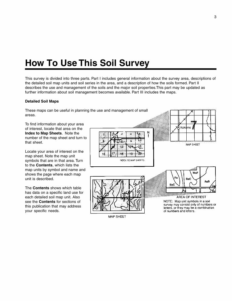
Detailed Soil Maps
These maps can be useful in planning the use and management of smallareas.
To find information about your areaof interest, locate that area on theIndex to Map Sheets. Note thenumber of the map sheet and turn tothat sheet.
Locate your area of interest on themap sheet. Note the map unitsymbols that are in that area. Turnto the Contents, which lists themap units by symbol and name andshows the page where each mapunit is described.
The Contents shows which tablehas data on a specific land use foreach detailed soil map unit. Alsosee the Contents for sections ofthis publication that may addressyour specific needs.
3
How To Use This Soil Survey
4
Additional information about the Nation’s natural resources is available on theNatural Resources Conservation Service home page on the World Wide Web. Theaddress is http://www.nrcs.usda.gov (click on “Technical Resources”).
This soil survey is a publication of the National Cooperative Soil Survey, a joint effortof the United States Department of Agriculture and other Federal agencies, Stateagencies including the Agricultural Experiment Stations, and local agencies. TheNatural Resources Conservation Service (formerly the Soil Conservation Service) hasleadership for the Federal part of the National Cooperative Soil Survey.
Major fieldwork for this soil survey was completed in 1997. Soil names anddescriptions were approved in 1997. Unless otherwise indicated, statements in thispublication refer to conditions in the survey area in 1997. This survey was madecooperatively by the Natural Resources Conservation Service and the IllinoisAgricultural Experiment Station. It is part of the technical assistance furnished to theKane-Du Page County Soil and Water Conservation District. Additional funding wasprovided by the Du Page County Board and the Illinois Department of Agriculture.
Soil maps in this survey may be copied without permission. Enlargement of thesemaps, however, could cause misunderstanding of the detail of mapping. If enlarged,maps do not show the small areas of contrasting soils that could have been shown at alarger scale.
The United States Department of Agriculture (USDA) prohibits discrimination in all ofits programs on the basis of race, color, national origin, gender, religion, age, disability,political beliefs, sexual orientation, and marital or family status. (Not all prohibited basesapply to all programs.) Persons with disabilities who require alternative means forcommunication of program information (Braille, large print, audiotape, etc.) shouldcontact the USDA’s TARGET Center at 202-720-2600 (voice or TDD).
To file a complaint of discrimination, write USDA, Director, Office of Civil Rights,Room 326W, Whitten Building, 14th and Independence Avenue SW, Washington, DC20250-9410, or call 202-720-5964 (voice or TDD). USDA is an equal opportunityprovider and employer.
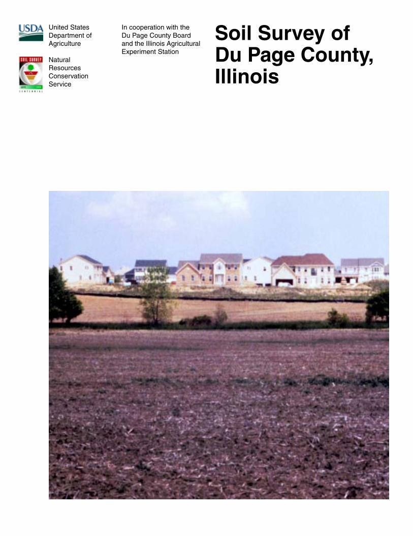
Cover: During the past several decades, the major land use in Du Page County has shifted fromagriculture to urban development.
5
Contents
Cover ....................................................................... 1How to Use This Soil Survey ................................. 3Contents .................................................................. 5Foreword ................................................................. 9
Part I
General Nature of the Survey Area ....................... 11How This Survey Was Made .................................. 15Formation and Classification of the Soils ......... 17Soil Series and Detailed Soil Map Units ............ 21
Ashkum Series .................................................. 22232A—Ashkum silty clay loam, 0 to 2 percent
slopes .......................................................... 23854B—Markham-Ashkum-Beecher complex,
1 to 6 percent slopes ................................... 23Barrington Series ............................................... 24443B—Barrington silt loam, 2 to 4 percent
slopes .......................................................... 25848B—Drummer-Barrington-Mundelein
complex, 1 to 6 percent slopes ................... 25Beecher Series .................................................. 26298A—Beecher silt loam, 0 to 2 percent
slopes .......................................................... 27298B—Beecher silt loam, 2 to 4 percent
slopes .......................................................... 27854B—Markham-Ashkum-Beecher complex,
1 to 6 percent slopes ................................... 28Blount Series ..................................................... 2823A—Blount silt loam, 0 to 2 percent slopes ..... 2923B—Blount silt loam, 2 to 4 percent slopes ..... 30Bowes Series ..................................................... 30792B—Bowes silt loam, 2 to 4 percent
slopes .......................................................... 31Casco Series ..................................................... 31323C2—Casco loam, 4 to 6 percent slopes,
eroded ......................................................... 32323D2—Casco loam, 6 to 12 percent slopes,
eroded ......................................................... 33969F—Casco-Rodman complex, 20 to 30
percent slopes ............................................. 33Chenoa Series ................................................... 34614A—Chenoa silty clay loam, 0 to 2 percent
slopes .......................................................... 35Del Rey Series ................................................... 35
192A—Del Rey silt loam, 0 to 2 percentslopes .......................................................... 36
Drummer Series ................................................ 36152A—Drummer silty clay loam, 0 to 2
percent slopes ............................................. 37848B—Drummer-Barrington-Mundelein
complex, 1 to 6 percent slopes ................... 381152A—Drummer silty clay loam, undrained,
0 to 2 percent slopes ................................... 38Dunham Series .................................................. 39523A—Dunham silty clay loam, 0 to 2
percent slopes ............................................. 401523A—Dunham silty clay loam, undrained,
0 to 2 percent slopes ................................... 40Elliott Series ...................................................... 41146A—Elliott silt loam, 0 to 2 percent slopes .... 42146B—Elliott silt loam, 2 to 4 percent slopes .... 42Faxon Series ...................................................... 431516A—Faxon silty clay loam, undrained, 0
to 2 percent slopes, frequently flooded ....... 43Fox Series .......................................................... 44327B—Fox silt loam, 2 to 4 percent slopes ....... 44327C2—Fox silt loam, 4 to 6 percent slopes,
eroded ......................................................... 45Graymont Series ................................................ 45541B—Graymont silt loam, 2 to 5 percent
slopes .......................................................... 46Grays Series ...................................................... 47698B—Grays silt loam, 2 to 4 percent slopes ... 48Grundelein Series .............................................. 48526A—Grundelein silt loam, 0 to 2 percent
slopes .......................................................... 50Harpster Series ................................................. 5067A—Harpster silty clay loam, 0 to 2 percent
slopes .......................................................... 51Houghton Series ................................................ 51903A—Muskego and Houghton mucks, 0 to 2
percent slopes ............................................. 521903A—Muskego and Houghton mucks,
undrained, 0 to 2 percent slopes ................. 52Kankakee Series ................................................ 53494B—Kankakee fine sandy loam, 2 to 4 percent
slopes .......................................................... 54830—Landfills .................................................... 54
6
Lorenzo Series ................................................... 54318C2—Lorenzo loam, 4 to 6 percent slopes,
eroded ......................................................... 55318D2—Lorenzo loam, 6 to 12 percent
slopes, eroded ............................................. 56Markham Series ................................................ 56531B—Markham silt loam, 2 to 4 percent
slopes .......................................................... 57531C2—Markham silt loam, 4 to 6 percent
slopes, eroded ............................................. 57854B—Markham-Ashkum-Beecher complex,
1 to 6 percent slopes ................................... 58Martinton Series ................................................ 58189A—Martinton silt loam, 0 to 2 percent
slopes .......................................................... 59849A—Milford-Martinton complex, 0 to 2
percent slopes ............................................. 60Milford Series ..................................................... 6069A—Milford silty clay loam, 0 to 2 percent
slopes .......................................................... 61849A—Milford-Martinton complex, 0 to 2
percent slopes ............................................. 61Millstream Series ............................................... 62557A—Millstream silt loam, 0 to 2 percent
slopes .......................................................... 63Mundelein Series ............................................... 64442A—Mundelein silt loam, 0 to 2 percent
slopes .......................................................... 65848B—Drummer-Barrington-Mundelein
complex, 1 to 6 percent slopes ................... 65Muskego Series ................................................. 66903A—Muskego and Houghton mucks, 0 to 2
percent slopes ............................................. 661903A—Muskego and Houghton mucks,
undrained, 0 to 2 percent slopes ................. 674904A—Muskego and Peotone soils, ponded,
0 to 2 percent slopes ................................... 67535B—Orthents, stony, undulating .................... 68802B—Orthents, loamy, undulating ................... 68802D—Orthents, loamy, rolling .......................... 68805B—Orthents, clayey, undulating .................. 69Ozaukee Series ................................................. 69530B—Ozaukee silt loam, 2 to 4 percent
slopes .......................................................... 71
530C2—Ozaukee silt loam, 4 to 6 percentslopes, eroded ............................................. 71
530D2—Ozaukee silt loam, 6 to 12 percentslopes, eroded ............................................. 72
530D3—Ozaukee silty clay loam, 6 to 12percent slopes, severely eroded ................. 72
530E—Ozaukee silt loam, 12 to 20 percentslopes .......................................................... 73
530F—Ozaukee silt loam, 20 to 30 percentslopes .......................................................... 73
Peotone Series ................................................... 73330A—Peotone silty clay loam, 0 to 2 percent
slopes .......................................................... 741330A—Peotone silty clay loam, undrained,
0 to 2 percent slopes ................................... 754904A—Muskego and Peotone soils, ponded,
0 to 2 percent slopes ................................... 75864—Pits, quarry ............................................... 75865—Pits, gravel ............................................... 76Rockton Series .................................................. 76503B—Rockton silt loam, 2 to 6 percent
slopes .......................................................... 76Rodman Series .................................................. 77969F—Casco-Rodman complex, 20 to 30
percent slopes ............................................. 77Romeo Series .................................................... 783316A—Romeo silt loam, 0 to 2 percent
slopes, frequently flooded ........................... 78Rush Series ....................................................... 79791B—Rush silt loam, 2 to 4 percent slopes .... 80Sawmill Series ................................................... 801107A—Sawmill silty clay loam, undrained,
0 to 2 percent slopes, frequently flooded .... 813107A—Sawmill silty clay loam, 0 to 2
percent slopes, frequently flooded .............. 81Selma Series ..................................................... 82125A—Selma loam, 0 to 2 percent slopes ........ 83Swygert Series .................................................. 8391A—Swygert silty clay loam, 0 to 2 percent
slopes .......................................................... 84Thorp Series ...................................................... 85206A—Thorp silt loam, 0 to 2 percent
slopes .......................................................... 86Varna Series ...................................................... 86
7
223B—Varna silt loam, 2 to 4 percentslopes .......................................................... 87
223C2—Varna silt loam, 4 to 6 percentslopes, eroded ............................................. 87
Warsaw Series ................................................... 88290C2—Warsaw silt loam, 4 to 6 percent
slopes, eroded ............................................. 89Wauconda Series ............................................... 89697A—Wauconda silt loam, 0 to 2 percent
slopes .......................................................... 90Waupecan Series ............................................... 91369B—Waupecan silt loam, 2 to 4 percent
slopes .......................................................... 92Zurich Series ..................................................... 92696B—Zurich silt loam, 2 to 4 percent
slopes .......................................................... 93696C2—Zurich silt loam, 4 to 6 percent
slopes, eroded ............................................. 94
Part II
Agronomy .............................................................. 97Cropland Management Considerations .............. 98Crop Yield Estimates ......................................... 99Land Capability Classification ......................... 101Prime Farmland................................................ 101Erosion Factors ................................................ 102Windbreaks and Environmental Plantings ....... 103
Forestland ........................................................... 105Recreation ........................................................... 107Wildlife Habitat ................................................... 109Hydric Soils ........................................................ 113Engineering ......................................................... 115
Building Site Development ............................... 115Sanitary Facilities ............................................ 117Construction Materials ..................................... 118Water Management .......................................... 119
Soil Properties .................................................... 121Engineering Index Properties ........................... 121Physical and Chemical Properties ................... 122Water Features ................................................ 124Soil Features .................................................... 125
References .......................................................... 127Glossary .............................................................. 129Tables .................................................................. 141
Table 1.—Temperature and Precipitation ......... 142Table 2.—Freeze Dates in Spring and Fall ....... 143Table 3.—Growing Season .............................. 143Table 4.—Classification of the Soils ................ 144Table 5.—Acreage and Proportionate Extent
of the Soils ................................................ 145Table 6.—Main Cropland Limitations and
Hazards ..................................................... 147Table 7.—Land Capability and Yields per
Acre of Crops and Pasture ........................ 151Table 8.—Main Pasture Limitations and
Hazards ..................................................... 155Table 9.—Prime Farmland ............................... 158Table 10.—Windbreaks and Environmental
Plantings .................................................... 159Table 11.—Forestland Management and
Productivity ............................................... 172Table 12.—Recreational Development ............. 177Table 13.—Wildlife Habitat ............................... 183Table 14.—Building Site Development ............. 188Table 15.—Sanitary Facilities .......................... 195Table 16.—Construction Materials ................... 202Table 17.—Water Management ........................ 208Table 18.—Engineering Index Properties ......... 216Table 19.—Physical and Chemical
Properties of the Soils ............................... 228Table 20.—Water Features .............................. 238Table 21.—Soil Features .................................. 243
Issued 1999

9
This soil survey contains information that affects land use planning in this surveyarea. It contains predictions of soil behavior for selected land uses. The survey alsohighlights soil limitations, improvements needed to overcome the limitations, and theimpact of selected land uses on the environment.
This soil survey is designed for many different users. Farmers, foresters, andagronomists can use it to evaluate the potential of the soil and the management neededfor maximum food and fiber production. Planners, community officials, engineers,developers, builders, and home buyers can use the survey to plan land use, select sitesfor construction, and identify special practices needed to ensure proper performance.Conservationists, teachers, students, and specialists in recreation, wildlifemanagement, waste disposal, and pollution control can use the survey to help themunderstand, protect, and enhance the environment.
Various land use regulations of Federal, State, and local governments may imposespecial restrictions on land use or land treatment. The information in this report isintended to identify soil properties that are used in making various land use or landtreatment decisions. Statements made in this report are intended to help the land usersidentify and reduce the effects of soil limitations on various land uses. The landowner oruser is responsible for identifying and complying with existing laws and regulations.
Great differences in soil properties can occur within short distances. Some soils areseasonally wet or subject to flooding. Some are shallow to bedrock. Some are toounstable to be used as a foundation for buildings or roads. Clayey or wet soils arepoorly suited to use as septic tank absorption fields. A high water table makes a soilpoorly suited to basements or underground installations.
These and many other soil properties that affect land use are described in this soilsurvey. The location of each soil is shown on the detailed soil maps. Each soil in thesurvey area is described. Information on specific uses is given for each soil. Help inusing this publication and additional information are available at the local office of theNatural Resources Conservation Service or the Cooperative Extension Service.
William J. GradleState ConservationistNatural Resources Conservation Service
Foreword

11
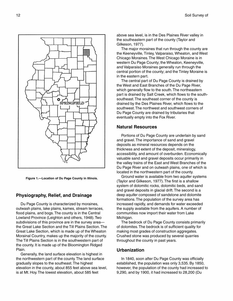
DU PAGE COUNTY is in northeastern Illinois (fig. 1). Ithas an area of 215,455 acres, or 337 square miles. In1990, the population of the county was 781,666 (U.S.Department of Commerce, 1990). Wheaton is thecounty seat. Naperville, Wheaton, Downers Grove,and Elmhurst are the largest cities. The county isbordered by Cook County on the north and east, byWill County on the south, and by Kane County on thewest.
This soil survey is a subset of MLRA (major landresource area) 110, the Northern Illinois and IndianaHeavy Till Plain (USDA, 1981). It is an update of theDu Page County part of the survey of Du Page Countyand part of Cook County, Illinois, published in 1979(Mapes, 1979). It provides additional information andhas larger maps, which show the soils in greaterdetail.
General Nature of the Survey AreaThis section provides general information about Du
Page County. It describes history; physiography, relief,and drainage; natural resources; urbanization;
agriculture; transportation facilities; industry; andclimate.
History
When Marquette and Joliet first explored the surveyarea in 1673, the Potawatomi Indians were the maininhabitants. Smaller groups of Illinois and OttawaIndians were also in the area. The county was firstsettled in 1830 by Bailey Hobson, who laterestablished a mill. He took up residence near whatwas to become Naperville, the oldest town in thecounty. Naperville was first settled by John andJoseph Naper in 1831.
Du Page County took its name from the Du PageRiver, which was named after a French fur trader,DuPazhe. He built a trading post and home at the forkof the east and west branches of the river in 1800.
Du Page County was established by the IllinoisLegislature on February 28, 1839. It was originally partof Cook County. Naperville served as the county seatuntil 1867. The county seat was then moved toWheaton because of that community’s central locationwithin the county.
Soil Survey of
Du Page County, Illinois—Part IBy Dale E. Calsyn, Natural Resources Conservation Service
Original fieldwork by J.L. Alexander, T.M. Goddard, D.R. Mapes, J.E. Paschke,D.L. Smith, B.G. Stewart, and R.D. Windhorn, Soil Conservation Service
Update fieldwork by Dale E. Calsyn, LeAnn S. Colburn, Jeffrey A. Deniger, andKarla D. Hanson, Natural Resources Conservation Service
Map compilation by Dale E. Calsyn, LeAnn S. Colburn, Jeffrey A. Deniger,Karla D. Hanson, Ellen M. Starr, and Michael B. Walker, Natural ResourcesConservation Service
United States Department of Agriculture, Natural Resources Conservation Service,in cooperation withthe Du Page County Board and the Illinois Agricultural Experiment Station
12 Soil Survey of
Physiography, Relief, and Drainage
Du Page County is characterized by moraines,outwash plains, lake plains, kames, stream terraces,flood plains, and bogs. The county is in the CentralLowland Province (Leighton and others, 1948). Twosubdivisions of this province are in the survey area—the Great Lake Section and the Till Plains Section. TheGreat Lake Section, which is made up of the WheatonMorainal Country, makes up the majority of the county.The Till Plains Section is in the southwestern part ofthe county. It is made up of the Bloomington RidgedPlain.
Generally, the land surface elevation is highest inthe northwestern part of the county. The land surfacegradually slopes to the southeast. The highestelevation in the county, about 855 feet above sea level,is at Mt. Hoy. The lowest elevation, about 585 feet
above sea level, is in the Des Plaines River valley inthe southeastern part of the county (Taylor andGilkeson, 1977).
The major moraines that run through the county arethe Keeneyville, Tinley, Valparaiso, Wheaton, and WestChicago Moraines. The West Chicago Moraine is inwestern Du Page County; the Wheaton, Keeneyville,and Valparaiso Moraines generally run through thecentral portion of the county; and the Tinley Moraine isin the eastern part.
The central part of Du Page County is drained bythe West and East Branches of the Du Page River,which generally flow to the south. The northeasternpart is drained by Salt Creek, which flows to the south-southeast. The southeast corner of the county isdrained by the Des Plaines River, which flows to thesouthwest. The northwest and southwest corners ofDu Page County are drained by tributaries thateventually empty into the Fox River.
Natural Resources
Portions of Du Page County are underlain by sandand gravel. The importance of sand and graveldeposits as mineral resources depends on thethickness and extent of the deposit, mineralogy,accessibility, and amount of overburden. Economicallyvaluable sand and gravel deposits occur primarily inthe valley trains of the East and West Branches of theDu Page River and on outwash plains, one of which islocated in the northwestern part of the county.
Ground water is available from two aquifer systems(Taylor and Gilkeson, 1977). The first is a shallowsystem of dolomitic rocks, dolomitic beds, and sandand gravel deposits in glacial drift. The second is adeep aquifer composed of sandstone and dolomiteformations. The population of the survey area hasincreased rapidly, and demands for water exceededthe supply available from the aquifers. A number ofcommunities now import their water from LakeMichigan.
The bedrock of Du Page County consists primarilyof dolomites. The bedrock is of sufficient quality formaking most grades of construction aggregates.Crushed stone was produced by several quarriesthroughout the county in past years.
Urbanization
In 1840, soon after Du Page County was officiallyestablished, the population was only 3,535. By 1850,however, the population of the county had increased to9,290, and by 1900, it had increased to 28,200 (Du
Figure 1.—Location of Du Page County in Illinois.
Du Page County, Illinois—Part I 13
Page County Development Department, 1996). Thepopulation increased by 66 percent during that timeperiod.
As Chicago continued to grow and with the adventof industry and technology, the population of thesurvey area increased dramatically. By 1980, it hadrisen to 650,000. The 1990 census reported 781,666residents in Du Page County, which represents a 20percent increase over the 1980 figure (U.S.Department of Commerce, 1990). Du Page County isone of the fastest growing counties in Illinois and is the53rd most populous county in the United States.
Although agriculture was the primary livelihood in1955, when agriculture made up 58 percent of thetotal land use, only 8.6 percent of the land was stillused for agricultural purposes in 1992 (Du PageCounty Development Department, 1996). Over thepast several decades, people migrating to the suburbsfrom the city have greatly impacted land usage. Themajority of the county has been developed forresidential use. The eastern half of the county hasmany commercial and industrial establishments.Despite the intense development of Du Page County,there are numerous city parks and many forestpreserves. These areas provide a balance in land useand help to preserve environmental and naturalresources.
Agriculture
The rapid growth in population and the subsequenturbanization of Du Page County have resulted in atremendous change in land use patterns. The numberof farms in Du Page County declined from 207 in 1982to 95 in 1992 (U.S. Department of Commerce, 1992).The average farm size has increased from 157 to 192acres, but the total acreage in farms decreased from123,860 acres in 1955 to 18,206 acres in 1992.
Agriculture in Du Page County consists primarily ofcommodity crop production and some livestockproduction and specialty crops, such as vegetables,turf, and landscape materials. The largest agriculturalland use is the production of corn, soybeans, and hay.About 49 percent of the cropland acreage is used forcorn, 37 percent for soybeans, and 4 percent for hay.
Transportation Facilities
Du Page County’s transportation system providespassenger and freight access to the Chicago, De Kalb,and Joliet areas. The road network includes the East-West Tollway (I-88) (fig. 2), the North-South Tollway(I-355), the Eisenhower Expressway (I-290), a smallportion of the Tri-State Tollway (I-294), and the
Stevenson Expressway (I-55); U.S. Highways 20 and34; and State Highways 19, 38, 53, 56, 59, 64, and 83.Du Page County itself has a well developed roadsystem that provides easy access among its manycommunities.
Commuter rail is an important public transportationsource in Du Page County. In 1995, more than 34,000passengers boarded commuter rail lines eachweekday (Du Page County Development Department,1996). These rail lines run from east to west throughthe county and provide direct access to Chicago.Freight is also shipped through the county by rail.
Du Page County is serviced by one general aviationairport, Du Page Airport, which is outside WestChicago. In addition, one of the world’s busiestairports, Chicago O’Hare International, extends intothe northeastern part of the county.
Industry
In addition to increases in population during thepast decade, economic opportunities have alsoexpanded in Du Page County. Not only hasemployment increased about 6 percent over the pastseveral years, but the number of businessestablishments also has increased substantially. From1989 to 1993, 2,374 new firms were established. Thisnumber represents a 9.5 percent increase (Du PageCounty Development Department, 1996).
Du Page County has more than 25,000 businessestablishments. Major industries are manufacturing,wholesale and retail trade, construction, transportationand public utilities, and a variety of service agencies,including education, health, and hotel and lodging. DuPage County is also home to Argonne and FermiNational Laboratories.
Climate
Table 1 provides data on temperature andprecipitation for the survey area as recorded atWheaton in the period 1961 to 1990. Table 2 showsprobable dates of the first freeze in fall and the lastfreeze in spring. Table 3 provides data on length of thegrowing season.
In winter, the average temperature is 24.7 degreesF and the average daily minimum temperature is 18.9degrees. The lowest temperature on record, whichoccurred at Wheaton on January 20, 1985, is -26degrees. In summer, the average temperature is 72degrees F and the average daily maximumtemperature is 84.3 degrees. The highest recordedtemperature, which occurred at Wheaton on July 14,1995, is 105 degrees.
14 Soil Survey of
Growing degree days are shown in table 1. Theyare equivalent to “heat units.” During the month,growing degree days accumulate by the amount thatthe average temperature each day exceeds a basetemperature (50 degrees F). The normal monthlyaccumulation is used to schedule single or successiveplantings of a crop between the last freeze in springand the first freeze in fall.
The total annual precipitation is 36.62 inches. Ofthis, 19.6 inches, or about 54 percent, usually falls inApril through September. The growing season for mostcrops falls within this period. In 2 years out of 10, therainfall in April through September is less than 13.89inches. The heaviest 1-day rainfall on record was 9.24inches at Wheaton on July 18, 1996. Thunderstormsoccur on about 38 days each year, and most occurfrom June to August.
The average seasonal snowfall is 36 inches. Thegreatest snow depth at any one time during the period
of record was 29 inches on January 25, 1979. Theheaviest 1-day snowfall on record was 11.9 incheson January 14, 1979. On the average, 42 days peryear have at least 1 inch of snow on the ground. Thenumber of such days varies greatly from year toyear.
The average relative humidity in midafternoon isabout 60 percent. Humidity is higher at night, and theaverage at dawn is about 80 percent. The sun shines67 percent of the time possible in summer and 47percent in winter. The prevailing wind is from thesouthwest. The average windspeed is highest,between 11 and 12 miles per hour, from November toApril.
Tornadoes and severe thunderstorms strikeoccasionally. They are of local extent and of shortduration and cause only sparse damage in narrowareas. Hailstorms sometimes occur during the warmerperiods.
Figure 2.—The East-West Tollway provides easy access from Du Page County to Chicago and other metropolitan areas.
Du Page County, Illinois—Part I 15
How This Survey Was MadeSoil surveys are updated as part of maintenance
projects that are conducted for a major land resourcearea or other region. Maintaining and coordinating soilsurvey information within a broad area result inuniformly delineated and joined soil maps and incoordinated interpretations and map unit descriptionsfor areas that have similar physiography, climate, andland use.
Updated soil survey information is coordinatedwithin the major land resource area or other regionand meets the standards established and defined inthe memorandum of understanding. Soil surveys thatare consistent and uniform within a broad area enablethe coordination of soil managementrecommendations and a uniform program applicationof soil information.
This survey was made to provide updatedinformation about the soils and miscellaneous areas inthe survey area, which is a subset of MLRA 110. Theinformation includes a description of the soils andmiscellaneous areas and their location and adiscussion of their suitability, limitations, andmanagement for specified uses. Soil scientistsobserved the steepness, length, and shape of slopes;the degree of erosion; the general pattern of drainage;the kinds of crops and native plants; and the kinds ofbedrock. To study the soil profile, which is thesequence of natural layers or horizons in a soil, soilscientists examine the soil with the aid of a soil probeor spade. The profile extends from the surface downinto the unconsolidated material in which the soilformed. The unconsolidated material is devoid of rootsand other living organisms and has not been changedby other biological activity.
The soils and miscellaneous areas in the surveyarea are in an orderly pattern that is related to thegeology, landforms, relief, climate, and naturalvegetation of the area. Each kind of soil andmiscellaneous area is associated with a particular kindof landscape or segment of the landscape. Byobserving the soils and miscellaneous areas in thesurvey area and relating their position to specificsegments of the landscape, soil scientists develop aconcept, or model, of how the soils were formed. Thus,during mapping, this model enables the soil scientiststo predict with a considerable degree of accuracy thekind of soil or miscellaneous area at a specific locationon the landscape.
Individual soils on the landscape commonly mergeinto one another as their characteristics graduallychange. To construct an accurate map, however, soilscientists must determine the boundaries between the
soils. They can observe only a limited number of soilprofiles. Nevertheless, these observations,supplemented by an understanding of the soil-vegetation-landscape relationship, are sufficient toverify predictions of the kinds of soil in an area and todetermine the boundaries.
Fieldwork in Du Page County consisted primarily ofsoil transects conducted by soil scientists. Soiltransects are a systematic way of sampling a specificsoil type. Soil borings were taken at regular intervals.Soil scientists recorded the characteristics of the soilprofiles that they studied. They noted soil color,texture, size and shape of soil aggregates, kind andamount of rock fragments, distribution of plant roots,soil reaction, and other features that enable them toidentify soils. After describing the soils in the surveyarea and determining their properties, the soilscientists assigned the soils to taxonomic classes(units). Taxonomic classes are concepts. Eachtaxonomic class has a set of soil characteristics withprecisely defined limits. The classes are used as abasis for comparison to classify soils systematically.Soil taxonomy, the system of taxonomic classificationused in the United States, is based mainly on the kindand character of soil properties and the arrangementof horizons within the profile. After the soil scientistsclassified and named the soils in the survey area, theycompared the individual soils with similar soils in thesame taxonomic class in other areas so that theycould confirm data and assemble additional databased on experience and research.
While a soil survey is in progress, samples of someof the soils in the area generally are collected forlaboratory analyses and for engineering tests. Soilscientists interpret the data from these analyses andtests as well as the field-observed characteristics andthe soil properties to determine the expected behaviorof the soils under different uses. Interpretations for allof the soils are field tested through observation of thesoils in different uses and under different levels ofmanagement. Some interpretations are modified to fitlocal conditions, and some new interpretations aredeveloped to meet local needs. Data are assembledfrom other sources, such as research information,production records, and field experience of specialists.For example, data on crop yields under defined levelsof management are assembled from farm records andfrom field or plot experiments on the same kinds ofsoil.
Predictions about soil behavior are based not onlyon soil properties but also on such variables asclimate and biological activity. Soil conditions arepredictable over long periods of time, but they are notpredictable from year to year. For example, soil

16
scientists can predict with a fairly high degree ofaccuracy that a given soil will have a high water tablewithin certain depths in most years, but they cannotpredict that a high water table will always be at aspecific level in the soil on a specific date.
Aerial photographs used in this survey were takenin 1993. Soil scientists also studied U.S. Geological
Survey topographic maps and ortho-photographs torelate land and image features. Specific soilboundaries were drawn on the ortho-photographs.Adjustments of soil boundary lines were made tocoincide with the U.S. Geological Survey topographicmap contour lines and tonal patterns on aerialphotographs.
17
This section relates the soils in the survey area tothe major factors of soil formation and describes thesystem of soil classification.
Formation of the Soils
Soil forms through processes that act on depositedgeologic material. The main factors of soil formationare the physical and mineralogical composition of theparent material; the climate under which the soilformed; the plant and animal life on and in the soil;relief; and the length of time the processes of soilformation have acted on the parent material (Jenny,1941).
Climate and plant and animal life are the dominantactive factors of soil formation. They act directly on theparent material, either in place or after it has beenmoved by water, wind, or glaciers, and slowly changeit into a natural body that has genetically relatedhorizons. Relief modifies soil formation and can inhibitsoil formation on the steeper, eroded slopes and inwet depressional or nearly level areas by controllingthe moisture status of soils. Finally, time is needed forchanging the parent material into a soil that hasdifferentiated horizons.
The factors of soil formation are so closelyinterrelated and conditioned by each other that fewgeneralizations can be made regarding the effects ofany one factor unless the effects of the other factorsare understood.
Parent Material
Parent material consists of the unconsolidatedgeologic formations in which a soil forms. The soils ofDu Page County were derived from parent materialsthat were directly or indirectly impacted by theWisconsin glaciation. The parent materials in Du PageCounty include glacial till, glacial outwash, loess (orsilty material), lacustrine sediments, organic deposits,alluvium, and bedrock.
Glacial till is nonstratified drift transported anddeposited directly by glacial ice. It is made up of acompact mixture of gravel, sand, silt, and clay. Theglaciers deposited an extensive morainic system in thesurvey area. The major moraines, from west to east,
include the West Chicago, Wheaton, Keeneyville,Valparaiso, and Tinley Moraines. The two principalparent materials in Du Page County include theWadsworth Formation and the Lemont Formation,which contains the Yorkville till member (Hansel andJohnson, 1996). Soils that formed in material derivedfrom these formations include the poorly drainedAshkum soils and the moderately well drainedOzaukee and Varna soils.
Glacial outwash was deposited by runningmeltwater from glaciers. The particle size of thematerial that was deposited depends on the speed ofthe stream or river. As the water velocity slowed, thelarger particles were deposited first; with furtherreduction in velocity, the smaller particles weredeposited. The finer particles were carried a greaterdistance by slower moving water. Outwash deposits inDu Page County range from loamy sediments to amixture of coarse sand and gravel. Fox and Warsawsoils formed in loamy outwash over sandy and gravellydeposits. Significant outwash plains are principallyalong the East and West Branches of the Du PageRiver, the Des Plaines River, and some of the smallertributaries.
Sometime after the glaciers retreated, conditionsbecame drier and the winds increased. A thin,discontinuous layer of silty material, or loess, wasdeposited over the county directly by the winds. Theprimary sources of the loess were the flood plainsalong major rivers. Some of the silty material in thecounty may be of local origin since it contains moresand than is typical for loess. Depth of the loess orsilty material generally ranges from 1.0 to 3.5 feet.
In areas where drainage was blocked, shallow lakeswere formed. Lacustrine sediments were depositedfrom the still or ponded glacial meltwater. After thecoarser particles were deposited by moving water, thefiner particles, such as very fine sand, silt, and clay,settled in still water. Martinton and Milford soils formedin lacustrine deposits.
Organic deposits consist of decomposed plantremnants. After the glaciers receded, water was leftstanding in depressional areas. As a result, theseareas were very wet during soil formation, and thedecaying plant material accumulated more quickly
Formation and Classification of the Soils
18 Soil Survey of
than it decomposed. Most of these plant remains areso decomposed that they are unrecognizable. Theseorganic deposits are called sapric material. Examplesof soils that formed in these deposits are Muskegoand Houghton soils.
Alluvium is material and sediments recentlydeposited by streams and rivers on their flood plains.The texture of alluvium varies, depending on thevelocity of the water source. Sawmill soils formed insilty alluvium.
Underlying the unconsolidated deposits in Du PageCounty is layered Silurian dolomitic bedrock. Depth tothe bedrock ranges from 0 to 200 feet in the county(Taylor and Gilkeson, 1977). Romeo soils are veryshallow to bedrock, and Faxon and Rockton soils aremoderately deep.
Climate
Du Page County has a temperate, humidcontinental climate. The general climate has had animportant overall influence on the characteristics of thesoils. It is essentially uniform throughout the county,however, and has not caused any major differencesamong the soils.
Climate has very important effects on weathering,vegetation, and erosion. The weathering of minerals inthe soil increases as temperature and rainfall increase.As water moves downward, clay is moved from thesurface soil to the subsoil, where it accumulates. Thewater also dissolves soluble salts and leaches themdownward. Climate also influences the kind and extentof plant and animal life. The climate in Du Page Countyhas favored prairie grass and hardwood forests. Heavyrains can harm exposed areas of soil that are farmedor are in the process of being developed. Spring rainsand wind can cause extensive erosion when cropresidue, trees, or other vegetative cover is removedfrom the surface. More soil will be lost through erosioneach year than is formed by natural processes.
Living Organisms
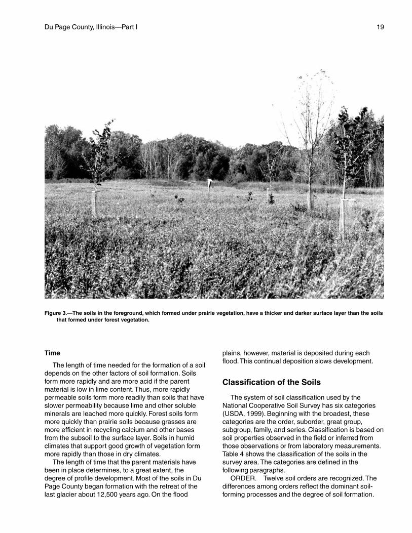
Soils are affected by the vegetation under whichthey formed. The main contribution of the vegetationand biological processes is the addition of organicmatter and nitrogen to the soil. The amount of organicmaterial in the soil depends on the kind of nativeplants that grew on the soil. Grasses have many fine,fibrous roots that add large amounts of organic matterto the soil when they die and decay. Soils that formedunder prairie vegetation, therefore, have a thick, blackor dark brown surface layer. Barrington, Elliott, andMundelein soils formed under prairie vegetation. Incontrast, the soils whose native vegetation was
deciduous trees have a thin, light-colored surface layerbecause less organic matter is added to the soil.Blount, Ozaukee, and Zurich soils formed under forestvegetation (fig. 3).
Bacteria, fungi, and other micro-organisms help tobreak down the organic matter and thus providenutrients for plants and other soil organisms. Thestability of soil aggregates (structure units made up ofsand, silt, and clay) is affected by microbial activitybecause cellular excretions from these organisms helpto bind soil particles together. Stable aggregates helpto maintain soil porosity and promote favorablerelationships among soil, water, and air. Moreover,earthworms, crayfish, insects, and burrowing animalstend to incorporate organic matter into the soil andhelp to keep the soils open and porous.
Human activities are also important factors in DuPage County. Urban and industrial expansion hasresulted in a significant amount of land being drained,cleared, and excavated and filled. These practiceshave had a pronounced effect on past soil formationand on present and future soil development.
Relief
Relief, which includes elevation, topography, andwater table levels, largely determines the naturaldrainage of soils. In Du Page County, the slopes rangefrom 0 to 30 percent. Natural soil drainage classes inthe county range from excessively drained on the sideslopes and ridges to very poorly drained indepressions.
Relief affects the depth to a seasonal high watertable or the natural drainage of the soil by influencinginfiltration and runoff rates. The poorly drainedAshkum and Drummer soils are in low-lying, nearlylevel areas and have a water table close to the surfacefor most of the year. The soil pores contain water,which restricts the circulation of air in the soil. Underthese conditions, iron and manganese compounds arechemically reduced. As a result, the subsoil is dull grayand mottled. In areas of the more sloping, well drainedFox and Warsaw soils, the water table is at a lowerdepth and some of the rainfall runs off the surface. Thesoil pores contain less water and more air. The ironand manganese compounds are well oxidized. As aresult, the subsoil is brown.
Local relief also influences the severity of erosion.Even though some erosion occurs on almost allsloping soils, the hazard of erosion generally is moresevere as the slope increases. Runoff and the removalof soil material on these slopes result in the formationof soils that have a thinner solum than soils in lesssloping areas.
Du Page County, Illinois—Part I 19
Time
The length of time needed for the formation of a soildepends on the other factors of soil formation. Soilsform more rapidly and are more acid if the parentmaterial is low in lime content. Thus, more rapidlypermeable soils form more readily than soils that haveslower permeability because lime and other solubleminerals are leached more quickly. Forest soils formmore quickly than prairie soils because grasses aremore efficient in recycling calcium and other basesfrom the subsoil to the surface layer. Soils in humidclimates that support good growth of vegetation formmore rapidly than those in dry climates.
The length of time that the parent materials havebeen in place determines, to a great extent, thedegree of profile development. Most of the soils in DuPage County began formation with the retreat of thelast glacier about 12,500 years ago. On the flood
plains, however, material is deposited during eachflood. This continual deposition slows development.
Classification of the Soils
The system of soil classification used by theNational Cooperative Soil Survey has six categories(USDA, 1999). Beginning with the broadest, thesecategories are the order, suborder, great group,subgroup, family, and series. Classification is based onsoil properties observed in the field or inferred fromthose observations or from laboratory measurements.Table 4 shows the classification of the soils in thesurvey area. The categories are defined in thefollowing paragraphs.
ORDER. Twelve soil orders are recognized. Thedifferences among orders reflect the dominant soil-forming processes and the degree of soil formation.
Figure 3.—The soils in the foreground, which formed under prairie vegetation, have a thicker and darker surface layer than the soilsthat formed under forest vegetation.
20
Each order is identified by a word ending in sol. Anexample is Mollisol.
SUBORDER. Each order is divided into subordersprimarily on the basis of properties that influence soilgenesis and are important to plant growth orproperties that reflect the most important variableswithin the orders. The last syllable in the name of asuborder indicates the order. An example is Aquoll(Aqu, meaning water, plus oll, from Mollisol).
GREAT GROUP. Each suborder is divided intogreat groups on the basis of close similarities in kind,arrangement, and degree of development ofpedogenic horizons; soil moisture and temperatureregimes; and base status. Each great group isidentified by the name of a suborder and by a prefixthat indicates a property of the soil. An example isEndoaquolls (Endo, meaning within, plus aquoll, thesuborder of the Mollisols that has an aquic moistureregime).
SUBGROUP. Each great group has a typicsubgroup. Other subgroups are intergrades orextragrades. The typic is the central concept of thegreat group; it is not necessarily the most extensive.Intergrades are transitions to other orders, suborders,or great groups. Extragrades have some propertiesthat are not representative of the great group but do
not indicate transitions to any other known kind of soil.Each subgroup is identified by one or more adjectivespreceding the name of the great group. The adjectiveTypic identifies the subgroup that typifies the greatgroup. An example is Typic Endoaquolls.
FAMILY. Families are established within asubgroup on the basis of physical and chemicalproperties and other characteristics that affectmanagement. Generally, the properties are those ofhorizons below plow depth where there is muchbiological activity. Among the properties andcharacteristics considered are particle-size class,mineral content, cation-exchange activity class,temperature regime, thickness of the root zone,consistence, moisture equivalent, slope, andpermanent cracks. A family name consists of thename of a subgroup preceded by terms that indicatesoil properties. An example is fine, mixed, superactive,mesic Typic Endoaquolls.
SERIES. The series consists of soils that havesimilar horizons in their profile. The horizons aresimilar in color, texture, structure, reaction,consistence, mineral and chemical composition, andarrangement in the profile. The texture of the surfacelayer or of the substratum can differ within a series. Anexample is the Ashkum series.
21
In this section, arranged in alphabetical order, eachsoil series recognized in the survey area is described.Each series description is followed by descriptions ofthe associated detailed soil map units.
Characteristics of the soil and the material in whichit formed are identified for each soil series. A pedon, asmall three-dimensional area of soil, that is typical ofthe series in the survey area is described. The detaileddescription of each soil horizon follows standards inthe “Soil Survey Manual” (USDA, 1993). Many of thetechnical terms used in the descriptions are defined in“Soil Taxonomy” (USDA, 1999). Unless otherwisestated, colors in the descriptions are for moist soil.Following the pedon description is the range ofimportant characteristics of the soils in the series.
The map units on the detailed soil maps in thissurvey represent the soils or miscellaneous areas inthe survey area. The map unit descriptions in thissection, along with the maps, can be used todetermine the suitability and potential of a unit forspecific uses. They also can be used to plan themanagement needed for those uses. More informationabout each map unit is given in Part II of this survey.
A map unit delineation on the detailed soil mapsrepresents an area on the landscape and consists ofone or more soils or miscellaneous areas. A map unitis identified and named according to the taxonomicclassification of the dominant soils. Within a taxonomicclass there are precisely defined limits for theproperties of the soils. On the landscape, however, thesoils and miscellaneous areas are naturalphenomena, and they have the characteristicvariability of all natural phenomena. Thus, the range ofsome observed properties may extend beyond thelimits defined for a taxonomic class. Areas of soils of asingle taxonomic class rarely, if ever, can be mappedwithout including areas of other taxonomic classes.Consequently, every map unit is made up of the soilsor miscellaneous areas for which it is named andsome “included” areas that belong to other taxonomicclasses.
Most included soils have properties similar to thoseof the dominant soil or soils in the map unit, and thusthey do not affect use and management. These arecalled noncontrasting, or similar, inclusions. They may
or may not be mentioned in the map unit description.Other included soils and miscellaneous areas,however, have properties and behavioralcharacteristics divergent enough to affect use or torequire different management. These are calledcontrasting, or dissimilar, inclusions. They generallyare in small areas and could not be mappedseparately because of the scale used. Some smallareas of strongly contrasting soils or miscellaneousareas are identified by a special symbol on the maps.The included areas of contrasting soils ormiscellaneous areas are mentioned in the map unitdescriptions. A few included areas may not have beenobserved, and consequently they are not mentioned inthe descriptions, especially where the pattern was socomplex that it was impractical to make enoughobservations to identify all the soils and miscellaneousareas on the landscape.
The presence of included areas in a map unit in noway diminishes the usefulness or accuracy of the data.The objective of mapping is not to delineate puretaxonomic classes but rather to separate thelandscape into segments that have similar use andmanagement requirements. The delineation of suchlandscape segments on the map provides sufficientinformation for the development of resource plans, butif intensive use of small areas is planned, onsiteinvestigation is needed to define and locate the soilsand miscellaneous areas.
An identifying symbol precedes the map unit namein the map unit descriptions. Each description includesgeneral facts about the unit. The principal hazards andlimitations to be considered in planning for specificuses are described in Part II of this survey.
Soils that have profiles that are almost alike makeup a soil series. Except for differences in texture of thesurface layer or of the underlying layers, all the soils ofa series have major horizons that are similar incomposition, thickness, and arrangement.
Soils of one series can differ in texture of thesurface layer or of the underlying layers. They also candiffer in slope, stoniness, salinity, wetness, degree oferosion, and other characteristics that affect their use.On the basis of such differences, a soil series isdivided into soil phases. Most of the areas shown on
Soil Series and Detailed Soil Map Units
22 Soil Survey of
the detailed soil maps are phases of soil series. Thename of a soil phase commonly indicates a featurethat affects use or management. For example,Ozaukee silt loam, 4 to 6 percent slopes, eroded, is aphase of the Ozaukee series.
Some map units are made up of two or more majorsoils or miscellaneous areas. These map units arecomplexes or undifferentiated groups.
A complex consists of two or more soils ormiscellaneous areas in such an intricate pattern or insuch small areas that they cannot be shownseparately on the maps. The pattern and proportion ofthe soils or miscellaneous areas are somewhat similarin all areas. Casco-Rodman complex, 20 to 30 percentslopes, is an example.
An undifferentiated group is made up of two ormore soils or miscellaneous areas that could bemapped individually but are mapped as one unitbecause similar interpretations can be made for useand management. The pattern and proportion of thesoils or miscellaneous areas in a mapped area are notuniform. An area can be made up of only one of themajor soils or miscellaneous areas, or it can be madeup of all of them. Muskego and Houghton mucks, 0 to2 percent slopes, is an undifferentiated group in thissurvey area.
This survey includes miscellaneous areas. Suchareas have little or no soil material and support little orno vegetation. The map unit Pits, gravel, is anexample.
Table 5 gives the acreage and proportionate extentof each map unit. Other tables (see Contents) giveproperties of the soils and the limitations, capabilities,and potentials for many uses. The Glossary definesmany of the terms used in describing the soils ormiscellaneous areas.
Ashkum Series
Drainage class: Poorly drainedPermeability: Moderately slowLandform: Moraines and till plainsParent material: Silty colluvium and the underlying silty
clay loam tillSlope range: 0 to 2 percent
Taxonomic classification: Fine, mixed, superactive,mesic Typic Endoaquolls
Typical Pedon for MLRA 110
Typical pedon of Ashkum silty clay loam, 0 to 2percent slopes, at an elevation of 705 feet, 96 feetsouth and 2,030 feet east of the northwest corner ofsec. 22, T. 34 N., R. 11 E., in Will County; USGS
Prairie Center topographic quadrangle; lat. 41 degrees25 minutes 28 seconds N. and long. 87 degrees 57minutes 24 seconds W., NAD 27:
Ap—0 to 7 inches; black (10YR 2/1) silty clay loam,dark gray (10YR 4/1) dry; moderate fine granularstructure; friable; many very fine roots; neutral;clear smooth boundary.
A—7 to 12 inches; black (10YR 2/1) silty clay loam,dark gray (10YR 4/1) dry; moderate fine andmedium granular structure; friable; common veryfine roots; neutral; clear smooth boundary.
BAg—12 to 18 inches; dark gray (2.5Y 4/1) silty clayloam; moderate very fine and fine subangularblocky structure; firm; common very fine roots;many distinct black (10YR 2/1) organic coatingson faces of peds; common fine very dark gray(7.5YR 3/1) very weakly cemented iron andmanganese oxide concretions throughout; neutral;clear smooth boundary.
Bg1—18 to 29 inches; grayish brown (2.5Y 5/2) siltyclay; moderate medium prismatic structure partingto moderate medium angular blocky; firm;common very fine roots; few distinct very darkgray (10YR 3/1) organic coatings on faces ofpeds; common fine very dark gray (7.5YR 3/1)very weakly cemented iron and manganese oxideconcretions throughout; common fine prominentyellowish brown (10YR 5/6) masses of ironaccumulation in the matrix; common fine faint gray(2.5Y 5/1) iron depletions in the matrix; neutral;clear wavy boundary.
2Bg2—29 to 49 inches; grayish brown (2.5Y 5/2) siltyclay loam; weak medium prismatic structureparting to moderate medium angular blocky; firm;few very fine roots; few distinct very dark gray(10YR 3/1) organic coatings on faces of peds;common fine very dark gray (7.5YR 3/1) veryweakly cemented iron and manganese oxideconcretions throughout; common fine and mediumprominent yellowish brown (10YR 5/8) andcommon fine and medium distinct brown (10YR5/3) masses of iron accumulation in the matrix;common fine and medium distinct gray (5Y 5/1)iron depletions in the matrix; 8 percent gravel;neutral; gradual wavy boundary.
2BCg—49 to 54 inches; grayish brown (2.5Y 5/2) siltyclay loam; weak medium prismatic structureparting to weak coarse angular blocky; firm; fewvery fine roots; common fine very dark gray (10YR3/1) very weakly cemented iron and manganeseoxide concretions throughout; common fine andmedium prominent yellowish brown (10YR 5/6)and distinct brown (10YR 5/3) masses of ironaccumulation in the matrix; common fine and
Du Page County, Illinois—Part I 23
medium faint gray (2.5Y 5/1) iron depletions in thematrix; 8 percent gravel; slightly effervescent;slightly alkaline; gradual wavy boundary.
2Cg—54 to 60 inches; grayish brown (2.5Y 5/2) siltyclay loam; massive; firm; common fine prominentyellowish brown (10YR 5/6) and common fine andmedium distinct brown (10YR 5/3) masses of ironaccumulation in the matrix; common fine faint gray(2.5Y 5/1) iron depletions in the matrix; 8 percentgravel; strongly effervescent; slightly alkaline.
MLRA Series Range in Characteristics
Thickness of the mollic epipedon: 10 to 24 inchesThickness of the silty colluvium: 15 to 40 inchesDepth to carbonates: 22 to 50 inchesThickness of the solum: 30 to 55 inches
Ap or A horizon:Hue—10YR, 2.5Y, or neutralValue—2 or 3Chroma—0 or 1Texture—silty clay loam, silt loam, or silty clay
Bg horizon:Hue—2.5Y, 5Y, or neutralValue—3 to 6Chroma—0 to 2Texture—silty clay loam or silty clay
2Bg horizon:Hue—2.5Y, 5Y, 5GY, or neutralValue—4 to 6Chroma—0 to 2Texture—silty clay loam or silty clay
2Cg horizon:Hue—2.5Y, 5Y, 5GY, or neutralValue—5 or 6Chroma—0 to 2Texture—silty clay loam
232A—Ashkum silty clay loam, 0 to 2percent slopes
Setting
Landform: Moraines and till plainsPosition on the landform: Toeslopes and depressions
Soil Properties and Qualities
Drainage class: Poorly drainedParent material: Silty colluvium and the underlying silty
clay loam till
A typical soil series description with range incharacteristics is included, in alphabetical order, in thissection. Additional information specific to this map unit,
such as horizon depth and textures, is available in the“Soil Properties” section in Part II of this publication.
Composition
Ashkum and similar soils: 90 percentDissimilar soils: 10 percent
Similar soils:• Soils that have no subsurface layer• Soils that contain less clay in the subsoil• Soils that are overlain by recent, light-coloreddeposition
Dissimilar soils:• The somewhat poorly drained Beecher, Blount, andElliott soils in the slightly higher positions on thelandform• Clayey Orthents in positions on the landform similarto those of the Ashkum soil
Management
For general and detailed information aboutmanaging this map unit, see the following sections inPart II of this publication:
• “Agronomy” section• “Wildlife Habitat” section• “Engineering” section• “Soil Properties” section
854B—Markham-Ashkum-Beechercomplex, 1 to 6 percent slopes
Setting
Landform: Moraines and till plainsPosition on the landform:
Markham—summits, shoulders, and backslopesAshkum—toeslopes and depressionsBeecher—summits, backslopes, and footslopes
Soil Properties and Qualities
Drainage class:Markham—moderately well drainedAshkum—poorly drainedBeecher—somewhat poorly drained
Parent material:Markham—thin mantle of silty material and the
underlying silty clay loam tillAshkum—silty colluvium and the underlying silty
clay loam tillBeecher—thin mantle of silty material and the
underlying silty clay loam till
A typical soil series description with range incharacteristics is included, in alphabetical order, in this
24 Soil Survey of
section. Additional information specific to this map unit,such as horizon depth and textures, is available in the“Soil Properties” section in Part II of this publication.
Composition
Markham and similar soils: 35 percentAshkum and similar soils: 30 percentBeecher and similar soils: 30 percentDissimilar soils: 5 percent
Similar soils:• Soils that have a thicker surface layer• Soils that contain more sand and less clay in theupper one-half of the profile• Soils that have a lighter colored surface layer• Soils that contain less clay in the subsoil
Dissimilar soils:• The very poorly drained Houghton, Muskego, andPeotone soils in depressions and drainageways• Clayey Orthents in positions on the landform similarto those of the major soils
Management
For general and detailed information aboutmanaging this map unit, see the following sections inPart II of this publication:
• “Wildlife Habitat” section• “Engineering” section• “Soil Properties” section
Barrington Series
Drainage class: Moderately well drainedPermeability: ModerateLandform: Outwash plains and stream terracesParent material: Silty material and the underlying
loamy outwashSlope range: 2 to 4 percent
Taxonomic classification: Fine-silty, mixed,superactive, mesic Oxyaquic Argiudolls
Typical Pedon for MLRA 110
Typical pedon of Barrington silt loam, 2 to 4 percentslopes, at an elevation of 627 feet, 400 feet north and190 feet west of the center of sec. 16, T. 30 N., R. 3 E.,in Livingston County; USGS Long Point topographicquadrangle; lat. 41 degrees 4 minutes 3 seconds N.and long. 88 degrees 52 minutes 52 seconds W., NAD27:
Ap—0 to 11 inches; very dark grayish brown (10YR3/2) silt loam, grayish brown (10YR 5/2) dry;
moderate fine granular structure; friable; few veryfine roots; slightly acid; abrupt smooth boundary.
BA—11 to 16 inches; brown (10YR 4/3) silty clay loam;weak fine subangular blocky structure parting tomoderate fine granular; friable; few very fine roots;common faint very dark grayish brown (10YR 3/2)organic coatings on faces of peds; slightly acid;clear smooth boundary.
Bt1—16 to 21 inches; dark yellowish brown (10YR 4/4)silty clay loam; weak fine prismatic structureparting to moderate fine angular blocky; friable;few very fine roots; few distinct very dark grayishbrown (10YR 3/2) organic coatings on faces ofpeds; common distinct brown (10YR 4/3) clayfilms on faces of peds; slightly acid; clear smoothboundary.
Bt2—21 to 26 inches; yellowish brown (10YR 5/4) siltyclay loam; weak fine prismatic structure parting tomoderate fine angular blocky; friable; few distinctbrown (10YR 4/3) clay films on faces of peds;neutral; clear smooth boundary.
Bt3—26 to 32 inches; yellowish brown (10YR 5/4) siltyclay loam; weak fine prismatic structure parting tomoderate medium angular blocky; friable; fewdistinct brown (10YR 4/3) clay films on faces ofpeds; few fine distinct light brownish gray (10YR6/2) iron depletions in the matrix; neutral; clearsmooth boundary.
2Bt4—32 to 37 inches; yellowish brown (10YR 5/4) siltloam; weak fine prismatic structure parting toweak medium angular blocky; friable; very fewdistinct brown (10YR 4/3) clay films on faces ofpeds; common fine distinct light brownish gray(10YR 6/2) iron depletions in the matrix; veryslightly effervescent; slightly alkaline; clear smoothboundary.
2BC—37 to 42 inches; yellowish brown (10YR 5/4) siltloam with thin strata of fine sandy loam; weak fineprismatic structure; friable; few fine distinctyellowish brown (10YR 5/6) masses of ironaccumulation in the matrix; common fine distinctlight brownish gray (10YR 6/2) iron depletions inthe matrix; slightly effervescent; slightly alkaline;clear smooth boundary.
2C—42 to 60 inches; yellowish brown (10YR 5/4),stratified silt loam and fine sandy loam; massive;friable; few fine distinct yellowish brown (10YR5/6) masses of iron accumulation in the matrix;common fine distinct light brownish gray (10YR6/2) iron depletions in the matrix; stronglyeffervescent; slightly alkaline.
MLRA Series Range in Characteristics
Thickness of the mollic epipedon: 10 to 18 inches
Du Page County, Illinois—Part I 25
Thickness of the silty material: 22 to 40 inchesDepth to carbonates: 20 to 40 inchesThickness of the solum: 25 to 45 inches
Ap or A horizon:Hue—10YRValue—2 or 3Chroma—1 to 3Texture—silt loam
Bt horizon:Hue—10YRValue—4 to 6Chroma—3 to 6Texture—silty clay loam or silt loam
2Bt horizon:Hue—7.5YR, 10YR, or 2.5YValue—4 to 6Chroma—3 to 6Texture—loam, silt loam, sandy loam, very fine
sandy loam, or clay loam
2C horizon:Hue—10YR or 2.5YValue—4 to 6Chroma—2 to 6Texture—stratified silt loam, loam, sandy loam,
fine sandy loam, loamy fine sand, very finesand, or the gravelly analogs of these textures
443B—Barrington silt loam, 2 to 4 percentslopes
Setting
Landform: Outwash plains and stream terracesPosition on the landform: Summits, shoulders, and
backslopes
Soil Properties and Qualities
Drainage class: Moderately well drainedParent material: Silty material and the underlying
loamy outwash
A typical soil series description with range incharacteristics is included, in alphabetical order, in thissection. Additional information specific to this map unit,such as horizon depth and textures, is available in the“Soil Properties” section in Part II of this publication.
Composition
Barrington and similar soils: 85 percentDissimilar soils: 15 percent
Similar soils:• Soils that have a thinner surface layer
• Soils that contain sandy and gravelly deposits in thelower part of the profile• Soils that have carbonates at a depth of more than40 inches• Soils that contain till in the lower part of the profile• Soils that contain loamy outwash at a depth of morethan 40 inches• Soils that have a seasonal high water table at adepth of more than 3.5 feet or less than 2.0 feet
Dissimilar soils:• The poorly drained Drummer and Thorp soils indepressions and drainageways• Loamy Orthents in positions on the landform similarto those of the Barrington soil
Management
For general and detailed information aboutmanaging this map unit, see the following sections inPart II of this publication:
• “Agronomy” section• “Wildlife Habitat” section• “Engineering” section• “Soil Properties” section
848B—Drummer-Barrington-Mundeleincomplex, 1 to 6 percent slopes
Setting
Landform: Outwash plains and stream terracesPosition on the landform:
Drummer—toeslopes and depressionsBarrington—summits, shoulders, and backslopesMundelein—footslopes
Soil Properties and Qualities
Drainage class:Drummer—poorly drainedBarrington—moderately well drainedMundelein—somewhat poorly drained
Parent material: Silty material and the underlyingloamy outwash
A typical soil series description with range incharacteristics is included, in alphabetical order, in thissection. Additional information specific to this map unit,such as horizon depth and textures, is available in the“Soil Properties” section in Part II of this publication.
Composition
Drummer and similar soils: 35 percentBarrington and similar soils: 30 percentMundelein and similar soils: 30 percentDissimilar soils: 5 percent
26 Soil Survey of
Similar soils:• Soils that contain sandy and gravelly deposits in thelower part of the profile• Soils that contain till in the lower part of the profile• Soils that have a thinner surface layer
Dissimilar soils:• Loamy Orthents in positions on the landform similarto those of the major soils• The very poorly drained Houghton, Muskego, andPeotone soils in depressions and drainageways
Management
For general and detailed information aboutmanaging this map unit, see the following sections inPart II of this publication:
• “Wildlife Habitat” section• “Engineering” section• “Soil Properties” section
Beecher Series
Drainage class: Somewhat poorly drainedPermeability: SlowLandform: Moraines and till plainsParent material: Thin mantle of silty material and the
underlying silty clay loam tillSlope range: 0 to 4 percent
Taxonomic classification: Fine, illitic, mesic UdollicEpiaqualfs
Typical Pedon for MLRA 110
Typical pedon of Beecher silt loam, 0 to 2 percentslopes, at an elevation of 655 feet, 340 feet south and65 feet west of the northeast corner of sec. 14, T. 31N., R. 12 E., in Kankakee County; USGS Bradleytopographic quadrangle; lat. 41 degrees 10 minutes 39seconds N. and long. 87 degrees 47 minutes 52seconds W., NAD 27:
Ap—0 to 9 inches; very dark gray (10YR 3/1) silt loam,dark grayish brown (10YR 4/2) dry; weak very finegranular structure; friable; neutral; abrupt smoothboundary.
BE—9 to 13 inches; dark grayish brown (10YR 4/2)silty clay loam; moderate very fine granularstructure; friable; common distinct very dark gray(10YR 3/1) organic coatings on faces of peds; fewfine faint brown (10YR 5/3) masses of ironaccumulation in the matrix; slightly acid; clearsmooth boundary.
2Bt1—13 to 16 inches; brown (10YR 5/3) silty clayloam; moderate very fine subangular blocky
structure; firm; few distinct very dark gray (10YR3/1) organo-clay films on faces of peds; commondistinct dark grayish brown (10YR 4/2) clay filmson faces of peds; few fine black (10YR 2/1) ironand manganese oxide concretions throughout;many fine distinct yellowish brown (10YR 5/6)masses of iron accumulation in the matrix; 1percent gravel; moderately acid; clear smoothboundary.
2Bt2—16 to 21 inches; grayish brown (10YR 5/2) siltyclay loam; moderate very fine and fine subangularblocky structure; firm; few distinct very dark gray(10YR 3/1) organo-clay films on faces of peds;common distinct dark gray (10YR 4/1) clay filmson faces of peds; many fine prominent yellowishbrown (10YR 5/6) masses of iron accumulation inthe matrix; 2 percent gravel; moderately acid; clearsmooth boundary.
2Bt3—21 to 27 inches; grayish brown (10YR 5/2) siltyclay loam; moderate medium prismatic structureparting to moderate fine subangular blocky; firm;few distinct very dark gray (10YR 3/1) organo-clayfilms on faces of peds; common distinct dark gray(10YR 4/1) clay films on faces of peds; few finedark brown (7.5YR 3/3) and black (10YR 2/1) ironand manganese oxide concretions throughout; fewfine prominent yellowish brown (10YR 5/6 and 5/8)masses of iron accumulation in the matrix; 2percent gravel; slightly alkaline; clear smoothboundary.
2Bt4—27 to 32 inches; yellowish brown (10YR 5/4)silty clay loam; moderate medium prismaticstructure parting to moderate fine and mediumsubangular blocky; firm; few distinct very dark gray(10YR 3/1) organo-clay films on faces of peds;common distinct grayish brown (10YR 5/2) clayfilms on faces of peds; few fine black (10YR 2/1)iron and manganese oxide concretionsthroughout; common fine prominent yellowishbrown (10YR 5/8) and distinct yellowish brown(10YR 5/6) masses of iron accumulation in thematrix; many medium prominent gray (5Y 5/1) irondepletions in the matrix; 2 percent gravel; slightlyalkaline; clear smooth boundary.
2BCt—32 to 37 inches; yellowish brown (10YR 5/6)silty clay loam; weak coarse prismatic structureparting to moderate medium subangular blocky;firm; few distinct very dark gray (10YR 3/1)organo-clay films on faces of peds; few fine black(10YR 2/1) iron and manganese oxide concretionsthroughout; many coarse prominent gray (5Y 5/1)iron depletions in the matrix; 2 percent gravel;slightly effervescent; moderately alkaline; clearsmooth boundary.
Du Page County, Illinois—Part I 27
2Cd—37 to 60 inches; yellowish brown (10YR 5/4)silty clay loam; massive; very firm; few fine black(10YR 2/1) iron and manganese oxide concretionsthroughout; common fine prominent yellowishbrown (10YR 5/8) and distinct yellowish brown(10YR 5/6) masses of iron accumulation in thematrix; common fine prominent greenish gray(5GY 5/1) iron depletions in the matrix; commonmedium prominent greenish gray (5G 6/1) irondepletions on cleavage planes; 5 percent gravel;strongly effervescent; moderately alkaline.
MLRA Series Range in Characteristics
Thickness of the silty material: Less than 18 inchesDepth to carbonates: 20 to 40 inchesThickness of the solum: 24 to 45 inches
Ap or A horizon:Hue—10YRValue—2 or 3Chroma—1 or 2Texture—silt loam
E horizon (if it occurs):Hue—10YRValue—4 or 5Chroma—2Texture—silt loam
2Bt or 2BCt horizon:Hue—10YR or 2.5YValue—4 to 6Chroma—2 to 4Texture—silty clay loam or silty clay
2Cd horizon:Hue—10YR or 2.5YValue—4 to 6Chroma—2 to 6Texture—silty clay loam
298A—Beecher silt loam, 0 to 2 percentslopes
Setting
Landform: Moraines and till plainsPosition on the landform: Footslopes
Soil Properties and Qualities
Drainage class: Somewhat poorly drainedParent material: Thin mantle of silty material and the
underlying silty clay loam till
A typical soil series description with range incharacteristics is included, in alphabetical order, in thissection. Additional information specific to this map unit,
such as horizon depth and textures, is available in the“Soil Properties” section in Part II of this publication.
Composition
Beecher and similar soils: 85 percentDissimilar soils: 15 percent
Similar soils:• Soils that have a lighter colored surface layer• Soils that have a thicker surface layer• Soils that contain more sand in the upper one-half ofthe profile• Soils that have a seasonal high water table at adepth of more than 2 feet• Soils that have slopes of more than 2 percent
Dissimilar soils:• The poorly drained Ashkum and very poorly drainedPeotone soils in depressions and drainageways• Clayey Orthents in positions on the landform similarto those of the Beecher soil
Management
For general and detailed information aboutmanaging this map unit, see the following sections inPart II of this publication:
• “Agronomy” section• “Forestland” section• “Wildlife Habitat” section• “Engineering” section• “Soil Properties” section
298B—Beecher silt loam, 2 to 4 percentslopes
Setting
Landform: Moraines and till plainsPosition on the landform: Summits, backslopes, and
footslopes
Soil Properties and Qualities
Drainage class: Somewhat poorly drainedParent material: Thin mantle of silty material and the
underlying silty clay loam till
A typical soil series description with range incharacteristics is included, in alphabetical order, in thissection. Additional information specific to this map unit,such as horizon depth and textures, is available in the“Soil Properties” section in Part II of this publication.
Composition
Beecher and similar soils: 85 percentDissimilar soils: 15 percent
28 Soil Survey of
Similar soils:• Soils that have a lighter colored surface layer• Soils that have a thicker surface layer• Soils that are moderately eroded• Soils that have a seasonal high water table at adepth of more than 2 feet• Soils that have slopes of less than 2 percent or morethan 4 percent• Soils that contain more sand in the upper one-half ofthe profile
Dissimilar soils:• The poorly drained Ashkum and very poorly drainedPeotone soils in depressions and drainageways• Clayey Orthents in positions on the landform similarto those of the Beecher soil
Management
For general and detailed information aboutmanaging this map unit, see the following sections inPart II of this publication:
• “Agronomy” section• “Forestland” section• “Wildlife Habitat” section• “Engineering” section• “Soil Properties” section
854B—Markham-Ashkum-Beechercomplex, 1 to 6 percent slopes
Setting
Landform: Moraines and till plainsPosition on the landform:
Markham—summits, shoulders, and backslopesAshkum—toeslopes and depressionsBeecher—summits, backslopes, and footslopes
Soil Properties and Qualities
Drainage class:Markham—moderately well drainedAshkum—poorly drainedBeecher—somewhat poorly drained
Parent material:Markham—thin mantle of silty material and the
underlying silty clay loam tillAshkum—silty colluvium and the underlying silty
clay loam tillBeecher—thin mantle of silty material and the
underlying silty clay loam till
A typical soil series description with range incharacteristics is included, in alphabetical order, in thissection. Additional information specific to this map unit,
such as horizon depth and textures, is available in the“Soil Properties” section in Part II of this publication.
Composition
Markham and similar soils: 35 percentAshkum and similar soils: 30 percentBeecher and similar soils: 30 percentDissimilar soils: 5 percent
Similar soils:• Soils that have a thicker surface layer• Soils that contain more sand and less clay in theupper one-half of the profile• Soils that have a lighter colored surface layer• Soils that contain less clay in the subsoil
Dissimilar soils:• The very poorly drained Houghton, Muskego, andPeotone soils in depressions and drainageways• Clayey Orthents in positions on the landform similarto those of the major soils
Management
For general and detailed information aboutmanaging this map unit, see the following sections inPart II of this publication:
• “Wildlife Habitat” section• “Engineering” section• “Soil Properties” section
Blount Series
Drainage class: Somewhat poorly drainedPermeability: SlowLandform: Moraines and till plainsParent material: Thin mantle of silty material and the
underlying silty clay loam tillSlope range: 0 to 4 percent
Taxonomic classification: Fine, illitic, mesic AericEpiaqualfs
Typical Pedon for MLRA 110
Typical pedon of Blount silt loam, 0 to 2 percentslopes, at an elevation of 705 feet, 2,480 feet southand 1,203 feet west of the northeast corner of sec. 29,T. 26 N., R. 6 E., in Livingston County; USGS Fairburytopographic quadrangle; lat. 40 degrees 41 minutes 39seconds N. and long. 88 degrees 32 minutes 59seconds W., NAD 27:
Ap—0 to 7 inches; brown (10YR 4/3) silt loam, lightbrownish gray (10YR 6/2) dry; moderate finegranular structure; friable; few fine roots;moderately acid; abrupt smooth boundary.
Du Page County, Illinois—Part I 29
E—7 to 13 inches; grayish brown (10YR 5/2) silt loam,light gray (10YR 7/2) dry; moderate thin platystructure; friable; few fine roots; few fine prominentyellowish brown (10YR 5/6) masses of ironaccumulation in the matrix; strongly acid; abruptsmooth boundary.
2Bt1—13 to 17 inches; brown (10YR 5/3) silty clayloam; weak fine prismatic structure parting tomoderate fine angular blocky; friable; few fineroots; common distinct dark grayish brown (2.5Y4/2) clay films on faces of peds; common mediumdistinct yellowish brown (10YR 5/6) masses of ironaccumulation in the matrix; common fine faintgrayish brown (10YR 5/2) iron depletions in thematrix; 3 percent gravel; moderately acid; clearsmooth boundary.
2Bt2—17 to 26 inches; grayish brown (10YR 5/2) siltyclay; weak medium prismatic structure parting tomoderate medium angular blocky; firm; few veryfine roots; common distinct dark grayish brown(2.5Y 4/2) clay films on faces of peds; commonmedium black (10YR 2/1) very weakly cementediron and manganese oxide concretionsthroughout; 3 percent gravel; slightly acid; clearsmooth boundary.
2Bt3—26 to 32 inches; light olive brown (2.5Y 5/4) siltyclay loam; moderate medium prismatic structureparting to weak medium angular blocky; firm; fewvery fine roots; common distinct gray (5Y 5/1) clayfilms on faces of peds; many medium prominentgray (5Y 6/1) iron depletions in the matrix; 3percent gravel; slightly effervescent; slightlyalkaline; clear smooth boundary.
2Cd—32 to 60 inches; 60 percent light olive brown(2.5Y 5/4) and 40 percent gray (5Y 6/1) silty clayloam; massive; very firm; common mediumprominent white (10YR 8/1) calcium carbonateconcretions throughout; 5 percent gravel; stronglyeffervescent; slightly alkaline.
MLRA Series Range in Characteristics
Thickness of the silty material: Less than 18 inchesDepth to carbonates: 19 to 40 inchesThickness of the solum: 20 to 48 inches
Ap or A horizon:Hue—10YRValue—3 or 4Chroma—1 to 3Texture—silt loam
E horizon:Hue—10YR or 2.5YValue—4 or 5
Chroma—1 or 2Texture—silt loam
Bt or 2Bt horizon:Hue—10YR or 2.5YValue—4 to 6Chroma—1 to 4Texture—silty clay loam or silty clay
2Cd horizon:Hue—10YR or 2.5YValue—4 to 6Chroma—1 to 6Texture—silty clay loam or clay loam
23A—Blount silt loam, 0 to 2 percentslopes
Setting
Landform: Moraines and till plainsPosition on the landform: Footslopes
Soil Properties and Qualities
Drainage class: Somewhat poorly drainedParent material: Thin mantle of silty material and the
underlying silty clay loam till
A typical soil series description with range incharacteristics is included, in alphabetical order, in thissection. Additional information specific to this map unit,such as horizon depth and textures, is available in the“Soil Properties” section in Part II of this publication.
Composition
Blount and similar soils: 85 percentDissimilar soils: 15 percent
Similar soils:• Soils that have a darker surface layer• Soils that contain more sand in the upper one-half ofthe profile• Soils that have a seasonal high water table at adepth of more than 2 feet• Soils that have slopes of more than 2 percent
Dissimilar soils:• The poorly drained Ashkum and very poorly drainedPeotone soils in depressions and drainageways• Clayey Orthents in positions on the landform similarto those of the Blount soil
Management
For general and detailed information aboutmanaging this map unit, see the following sections inPart II of this publication:
30 Soil Survey of
• “Agronomy” section• “Forestland” section• “Wildlife Habitat” section• “Engineering” section• “Soil Properties” section
23B—Blount silt loam, 2 to 4 percentslopes
Setting
Landform: Moraines and till plainsPosition on the landform: Summits, backslopes, and
footslopes
Soil Properties and Qualities
Drainage class: Somewhat poorly drainedParent material: Thin mantle of silty material and the
underlying silty clay loam till
A typical soil series description with range incharacteristics is included, in alphabetical order, in thissection. Additional information specific to this map unit,such as horizon depth and textures, is available in the“Soil Properties” section in Part II of this publication.
Composition
Blount and similar soils: 85 percentDissimilar soils: 15 percent
Similar soils:• Soils that have a darker surface layer• Soils that contain more sand in the upper one-half ofthe profile• Soils that are moderately eroded• Soils that have a seasonal high water table at adepth of more than 2 feet• Soils that have slopes of less than 2 percent or morethan 4 percent
Dissimilar soils:• The poorly drained Ashkum and very poorly drainedPeotone soils in depressions and drainageways• Clayey Orthents in positions on the landform similarto those of the Blount soil
Management
For general and detailed information aboutmanaging this map unit, see the following sections inPart II of this publication:
• “Agronomy” section• “Forestland” section• “Wildlife Habitat” section• “Engineering” section• “Soil Properties” section
Bowes Series
Drainage class: Well drainedPermeability: Moderate in the upper part; very rapid in
the lower partLandform: Outwash plains, stream terraces, and
kamesParent material: Silty material and the underlying
loamy and gravelly outwashSlope range: 2 to 4 percent
Taxonomic classification: Fine-silty, mixed,superactive, mesic Mollic Hapludalfs
Typical Pedon for MLRA 110
Typical pedon of Bowes silt loam, 2 to 4 percentslopes, at an elevation of 760 feet, 1,500 feet southand 2,635 feet east of the northwest corner of sec. 8,T. 40 N., R. 9 E., in Du Page County; USGS WestChicago topographic quadrangle; lat. 41 degrees 58minutes 8 seconds N. and long. 88 degrees 13minutes 58 seconds W., NAD 27:
Ap—0 to 8 inches; black (10YR 2/1) silt loam, darkgray (10YR 4/1) dry; moderate medium granularstructure; friable; many very fine roots; moderatelyacid; abrupt smooth boundary.
E—8 to 12 inches; brown (10YR 4/3) silt loam, palebrown (10YR 6/3) dry; moderate thin platystructure; friable; common very fine roots;moderately acid; clear smooth boundary.
Bt1—12 to 17 inches; dark yellowish brown (10YR 4/4)silty clay loam; moderate fine subangular blockystructure; friable; common very fine roots; fewdistinct dark brown (10YR 3/3) clay films on facesof peds and in pores; slightly acid; clear wavyboundary.
Bt2—17 to 27 inches; dark yellowish brown (10YR 4/4)silty clay loam; moderate fine and mediumprismatic structure parting to moderate fine andmedium subangular blocky; friable; common veryfine roots; common distinct brown (10YR 4/3) clayfilms on faces of peds and in pores; slightly acid;gradual wavy boundary.
Bt3—27 to 37 inches; dark yellowish brown (10YR 4/4)silt loam; moderate medium and coarse prismaticstructure parting to moderate medium subangularblocky; friable; common very fine roots; few distinctbrown (10YR 4/3) clay films on faces of peds andin pores; slightly acid; gradual wavy boundary.
2Bt4—37 to 43 inches; dark yellowish brown (10YR4/4) gravelly clay loam; weak medium and coarseprismatic structure parting to moderate mediumsubangular blocky; friable; few very fine roots; fewdistinct very dark grayish brown (10YR 3/2)
Du Page County, Illinois—Part I 31
organo-clay films and brown (10YR 4/3) clay filmson faces of peds and in pores; 15 percent gravel;slightly effervescent; slightly alkaline; clear wavyboundary.
2C—43 to 70 inches; yellowish brown (10YR 5/4) verygravelly loamy sand; single grain; loose; 35percent gravel and 5 percent cobbles; stronglyeffervescent; moderately alkaline.
MLRA Series Range in Characteristics
Thickness of the silty material: 28 to 60 inchesDepth to sandy and gravelly deposits: 40 to 60 inchesDepth to carbonates: 40 to 60 inchesThickness of the solum: 42 to 65 inches
Ap or A horizon:Hue—10YRValue—2 or 3Chroma—1 to 3Texture—silt loam
E horizon:Hue—7.5YR or 10YRValue—4 to 6Chroma—3 or 4Texture—silt loam
Bt horizon:Hue—7.5YR or 10YRValue—4 or 5Chroma—3 to 6Texture—silty clay loam or silt loam
2Bt horizon:Hue—7.5YR or 10YRValue—3 to 5Chroma—2 to 6Texture—the gravelly or very gravelly analogs of
clay loam, sandy clay loam, loam, sandy loam,or loamy sand
Content of gravel—15 to 60 percent
2C horizon:Hue—7.5YR or 10YRValue—4 to 6Chroma—3 to 6Texture—gravelly loamy sand to extremely
gravelly coarse sandContent of gravel—15 to 75 percentContent of cobbles—5 to 35 percent
792B—Bowes silt loam, 2 to 4 percentslopes
Setting
Landform: Outwash plains, stream terraces, and kames
Position on the landform: Summits, shoulders, andbackslopes
Soil Properties and Qualities
Drainage class: Well drainedParent material: Silty material and the underlying
loamy and gravelly outwash
A typical soil series description with range incharacteristics is included, in alphabetical order, in thissection. Additional information specific to this map unit,such as horizon depth and textures, is available in the“Soil Properties” section in Part II of this publication.
Composition
Bowes and similar soils: 85 percentDissimilar soils: 15 percent
Similar soils:• Soils that have a darker subsurface layer• Soils that contain sandy and gravelly deposits at adepth of less than 40 inches or more than 60 inches• Soils that have slopes of less than 2 percent or morethan 4 percent• Soils that contain more sand in the upper and middleparts of the subsoil• Soils that have a lighter colored surface layer
Dissimilar soils:• The poorly drained Dunham soils in depressionsand drainageways• The somewhat poorly drained Grundelein andMillstream soils in the lower positions on the landform• The loamy Fox soils in positions on the landformsimilar to those of the Bowes soil• Loamy Orthents in positions on the landform similarto those of the Bowes soil
Management
For general and detailed information aboutmanaging this map unit, see the following sections inPart II of this publication:
• “Agronomy” section• “Forestland” section• “Wildlife Habitat” section• “Engineering” section• “Soil Properties” section
Casco Series
Drainage class: Somewhat excessively drainedPermeability: Moderate in the upper part; very rapid in
the lower partLandform: Stream terraces, kames, outwash plains,
and moraines
32 Soil Survey of
Parent material: Loamy drift over sandy and gravellydeposits
Slope range: 4 to 30 percent
Taxonomic classification: Fine-loamy over sandy orsandy-skeletal, superactive, mixed, mesic IncepticHapludalfs
Typical Pedon for MLRA 110
Typical pedon of Casco loam, 6 to 12 percent slopes,eroded, at an elevation of 707 feet, 1,470 feet southand 300 feet west of the northeast corner of sec. 15, T.39 N., R. 9 E., in Du Page County; USGS Napervilletopographic quadrangle; lat. 41 degrees 52 minutes 3seconds N. and long. 88 degrees 11 minutes 11seconds W., NAD 27:
Ap—0 to 8 inches; dark grayish brown (10YR 4/2)loam, pale brown (10YR 6/3) dry; weak finegranular structure; friable; many very fine tomedium roots; neutral; abrupt smooth boundary.
Bt1—8 to 11 inches; dark yellowish brown (10YR 4/4)clay loam; moderate fine and medium subangularblocky structure; friable; common very fine roots;common distinct brown (10YR 4/3) clay films onfaces of peds; 2 percent gravel; neutral; clearsmooth boundary.
Bt2—11 to 14 inches; dark yellowish brown (10YR 4/4)clay loam; weak medium angular blocky structure;friable; common very fine roots; many distinctbrown (10YR 4/3) clay films on faces of peds; 6percent gravel; very slightly effervescent; slightlyalkaline; clear smooth boundary.
2Bt3—14 to 18 inches; brown (7.5YR 4/4) gravelly clayloam; weak coarse angular blocky structure;friable; common fine roots; few distinct very darkgrayish brown (10YR 3/2) organo-clay films andbrown (10YR 4/3) clay films on faces of peds; 20percent gravel; strongly effervescent; slightlyalkaline; clear wavy boundary.
2C—18 to 60 inches; brown (7.5YR 4/4) very gravellysand; single grain; loose; 50 percent gravel;strongly effervescent; moderately alkaline.
MLRA Series Range in Characteristics
Depth to sandy and gravelly deposits: 10 to 20 inchesDepth to carbonates: 10 to 20 inchesThickness of the solum: 10 to 20 inches
Ap or A horizon:Hue—7.5YR or 10YRValue—3 or 4Chroma—2 or 3Texture—loam or silt loam
Bt or 2Bt horizon:Hue—7.5YR or 10YRValue—4 or 5Chroma—3 or 4Texture—sandy clay loam, loam, clay loam, or the
gravelly analogs of these texturesContent of gravel—0 to 35 percent
2C horizon:Hue—7.5YR or 10YRValue—4 to 6Chroma—3 or 4Texture—sand, coarse sand, or the gravelly, very
gravelly, or extremely gravelly analogs of thesetextures
Content of gravel—10 to 70 percent
323C2—Casco loam, 4 to 6 percentslopes, eroded
Setting
Landform: Stream terraces, kames, outwash plains,and moraines
Position on the landform: Backslopes and shoulders
Soil Properties and Qualities
Drainage class: Somewhat excessively drainedParent material: Loamy drift over sandy and gravelly
deposits
A typical soil series description with range incharacteristics is included, in alphabetical order, in thissection. Additional information specific to this map unit,such as horizon depth and textures, is available in the“Soil Properties” section in Part II of this publication.
Composition
Casco and similar soils: 85 percentDissimilar soils: 15 percent
Similar soils:• Soils that are severely eroded• Soils that contain sandy and gravelly deposits at adepth of more than 20 inches• Soils that contain till in the lower part of the profile• Soils that have slopes of less than 4 percent or morethan 6 percent• Soils that have a darker surface layer
Dissimilar soils:• The somewhat poorly drained Grundelein andMillstream soils in the lower positions on the landform• The excessively drained Rodman soils in positionson the landform similar to those of the Casco soil
Du Page County, Illinois—Part I 33
• The poorly drained Dunham soils in depressionsand drainageways• Loamy Orthents in positions on the landform similarto those of the Casco soil
Management
For general and detailed information aboutmanaging this map unit, see the following sections inPart II of this publication:
• “Agronomy” section• “Forestland” section• “Wildlife Habitat” section• “Engineering” section• “Soil Properties” section
323D2—Casco loam, 6 to 12 percentslopes, eroded
Setting
Landform: Stream terraces, kames, outwash plains,and moraines
Position on the landform: Backslopes
Soil Properties and Qualities
Drainage class: Somewhat excessively drainedParent material: Loamy drift over sandy and gravelly
deposits
A typical soil series description with range incharacteristics is included, in alphabetical order, in thissection. Additional information specific to this map unit,such as horizon depth and textures, is available in the“Soil Properties” section in Part II of this publication.
Composition
Casco and similar soils: 85 percentDissimilar soils: 15 percent
Similar soils:• Soils that are severely eroded• Soils that contain sandy and gravelly deposits at adepth of more than 20 inches• Soils that have slopes of less than 6 percent or morethan 12 percent• Soils that contain till in the lower part of the profile
Dissimilar soils:• The somewhat poorly drained Grundelein andMillstream soils in the lower positions on the landform• The excessively drained Rodman soils in positionson the landform similar to those of the Casco soil• The poorly drained Dunham soils in depressionsand drainageways• Loamy Orthents in positions on the landform similarto those of the Casco soil
Management
For general and detailed information aboutmanaging this map unit, see the following sections inPart II of this publication:
• “Agronomy” section• “Forestland” section• “Wildlife Habitat” section• “Engineering” section• “Soil Properties” section
969F—Casco-Rodman complex, 20 to 30percent slopes
Setting
Landform: Stream terraces, kames, outwash plains,and moraines
Position on the landform: Backslopes
Soil Properties and Qualities
Drainage class:Casco—somewhat excessively drainedRodman—excessively drained
Parent material:Casco—loamy drift over sandy and gravelly
depositsRodman—gravelly drift
A typical soil series description with range incharacteristics is included, in alphabetical order, in thissection. Additional information specific to this map unit,such as horizon depth and textures, is available in the“Soil Properties” section in Part II of this publication.
Composition
Casco and similar soils: 45 percentRodman and similar soils: 40 percentDissimilar soils: 15 percent
Similar soils:• Soils that have carbonates at or near the surface• Soils that contain sandy and gravelly deposits at adepth of more than 20 inches• Soils that have slopes of less than 20 percent ormore than 30 percent• Soils that are moderately eroded• Soils that contain till in the lower part of the profile
Dissimilar soils:• The somewhat poorly drained Grundelein andMillstream soils in the lower positions on the landform• The poorly drained Dunham soils in depressionsand drainageways• Loamy Orthents in positions on the landform similarto those of the major soils
34 Soil Survey of
Management
For general and detailed information aboutmanaging this map unit, see the following sections inPart II of this publication:
• “Forestland” section• “Wildlife Habitat” section• “Engineering” section• “Soil Properties” section
Chenoa Series
Drainage class: Somewhat poorly drainedPermeability: Moderate in the upper part; slow in the
lower partLandform: Moraines and till plainsParent material: Silty material and the underlying silty
clay loam tillSlope range: 0 to 2 percent
Taxonomic classification: Fine, illitic, mesic AquicArgiudolls
Typical Pedon for MLRA 110
Typical pedon of Chenoa silty clay loam, 0 to 2 percentslopes, at an elevation of 692 feet, 100 feet south and825 feet west of the northeast corner of sec. 2, T. 27N., R. 3 E., in Livingston County; USGS FlanaganSouth topographic quadrangle; lat. 40 degrees 47minutes 19 seconds N. and long. 88 degrees 50minutes 14 seconds W., NAD 27:
Ap—0 to 12 inches; black (10YR 2/1) silty clay loam,dark gray (10YR 4/1) dry; moderate fine granularstructure; friable; few fine roots; neutral; abruptsmooth boundary.
BA—12 to 16 inches; brown (10YR 4/3) silty clay loam;weak fine prismatic structure parting to moderatefine angular blocky; friable; few very fine roots;many distinct black (10YR 2/1) organic coatingson faces of peds; few fine faint dark grayish brown(10YR 4/2) iron depletions in the matrix; neutral;clear smooth boundary.
Bt1—16 to 21 inches; brown (10YR 4/3) silty clayloam; moderate fine prismatic structure parting tomoderate fine angular blocky; friable; few very fineroots; few distinct very dark grayish brown (10YR3/2) organic coatings on faces of peds; commondistinct dark grayish brown (10YR 4/2) clay filmson faces of peds; few fine distinct gray (10YR 5/1)iron depletions in the matrix; neutral; clear smoothboundary.
Bt2—21 to 26 inches; grayish brown (10YR 5/2) siltyclay loam; moderate fine prismatic structureparting to moderate fine angular blocky; friable;
few very fine roots; many distinct dark grayishbrown (10YR 4/2) clay films on vertical faces ofpeds; common medium black (10YR 2/1) veryweakly cemented iron and manganese oxideconcretions throughout; common mediumprominent yellowish brown (10YR 5/6) masses ofiron accumulation in the matrix; common fine faintgray (10YR 5/1) iron depletions in the matrix;neutral; clear smooth boundary.
Bt3—26 to 32 inches; grayish brown (10YR 5/2) siltyclay loam; moderate medium prismatic structureparting to moderate medium angular blocky;friable; few very fine roots; common distinct darkgrayish brown (10YR 4/2) clay films on verticalfaces of peds; common medium black (10YR 2/1)very weakly cemented iron and manganese oxideconcretions throughout; common mediumprominent yellowish brown (10YR 5/6) masses ofiron accumulation in the matrix; common mediumfaint gray (10YR 5/1) iron depletions in the matrix;neutral; clear smooth boundary.
2Bt4—32 to 36 inches; light olive brown (2.5Y 5/4) siltyclay loam; weak medium prismatic structureparting to weak medium angular blocky; firm; fewvery fine roots; few distinct grayish brown (2.5Y5/2) clay films on faces of peds; common mediumdistinct gray (2.5Y 6/1) iron depletions in thematrix; 3 percent gravel; slightly alkaline; clearsmooth boundary.
2C—36 to 60 inches; light olive brown (2.5Y 5/4) siltyclay loam; massive; firm; few prominent lightbrownish gray (10YR 6/2) coatings on verticalcleavage planes; common medium distinct gray(2.5Y 6/1) iron depletions in the matrix; 3 percentgravel; strongly effervescent; moderately alkaline.
MLRA Series Range in Characteristics
Thickness of the mollic epipedon: 10 to 18 inchesThickness of the silty material: 20 to 40 inchesDepth to carbonates: 25 to 45 inchesThickness of the solum: 25 to 50 inches
Ap or A horizon:Hue—10YRValue—2 or 3Chroma—1 or 2Texture—silty clay loam or silt loam
Bt or BA horizon:Hue—10YR or 2.5YValue—4 to 6Chroma—2 to 6Texture—silty clay loam or silty clay
2Bt horizon:Hue—10YR or 2.5Y
Du Page County, Illinois—Part I 35
Value—4 to 6Chroma—2 to 6Texture—silty clay loam or silt loam
2C horizon:Hue—10YR, 2.5Y, or 5YValue—4 to 6Chroma—1 to 6Texture—silty clay loam or silt loam
614A—Chenoa silty clay loam, 0 to 2percent slopes
Setting
Landform: Moraines and till plainsPosition on the landform: Footslopes
Soil Properties and Qualities
Drainage class: Somewhat poorly drainedParent material: Silty material and the underlying silty
clay loam till
A typical soil series description with range incharacteristics is included, in alphabetical order, in thissection. Additional information specific to this map unit,such as horizon depth and textures, is available in the“Soil Properties” section in Part II of this publication.
Composition
Chenoa and similar soils: 85 percentDissimilar soils: 15 percent
Similar soils:• Soils that have a thinner surface layer• Soils that contain silty clay loam till at a depth of lessthan 20 inches or more than 40 inches• Soils that contain more silt and less clay in thesubsoil• Soils that contain more sand in the upper one-half ofthe profile• Soils that have carbonates at a depth of more than45 inches• Soils that have a seasonal high water table at adepth of more than 2 feet
Dissimilar soils:• The poorly drained Ashkum and very poorly drainedPeotone soils in depressions and drainageways• Clayey Orthents in positions on the landform similarto those of the Chenoa soil
Management
For general and detailed information aboutmanaging this map unit, see the following sections inPart II of this publication:
• “Agronomy” section• “Wildlife Habitat” section• “Engineering” section• “Soil Properties” section
Del Rey Series
Drainage class: Somewhat poorly drainedPermeability: SlowLandform: Lake plainsParent material: Lacustrine depositsSlope range: 0 to 2 percent
Taxonomic classification: Fine, illitic, mesic AericEpiaqualfs
Typical Pedon for MLRA 110
Typical pedon of Del Rey silt loam, 0 to 2 percentslopes, at an elevation of 662 feet, 155 feet south and1,200 feet west of the northeast corner of sec. 1, T. 25N., R. 11 E., in Iroquois County; USGS Onarga Westtopographic quadrangle; lat. 40 degrees 40 minutes 43seconds N. and long. 88 degrees 0 minutes 12seconds W., NAD 27:
A—0 to 4 inches; dark grayish brown (10YR 4/2) siltloam, light brownish gray (10YR 6/2) dry;moderate fine and medium granular structure;friable; many fine roots; neutral; abrupt smoothboundary.
E—4 to 9 inches; light brownish gray (10YR 6/2) siltloam, light gray (10YR 7/2) dry; moderate thin andmedium platy structure; friable; many fine roots;moderately acid; abrupt smooth boundary.
Bt—9 to 12 inches; brown (10YR 5/3) silty clay loam;strong fine subangular blocky structure; firm;common fine roots; many distinct pale brown(10YR 6/3 dry) clay depletions and grayish brown(10YR 5/2) clay films on faces of peds; verystrongly acid; clear smooth boundary.
Btg1—12 to 25 inches; light brownish gray (2.5Y 6/2)silty clay; strong fine and medium subangularblocky structure; firm; common fine roots; manydistinct grayish brown (10YR 5/2) clay films onfaces of peds; few fine prominent yellowish brown(10YR 5/8) masses of iron accumulation in thematrix; very strongly acid; clear smooth boundary.
Btg2—25 to 33 inches; 50 percent light brownish gray(2.5Y 6/2), 30 percent light olive brown (2.5Y 5/4),and 20 percent gray (10YR 6/1) silty clay;moderate fine and medium angular andsubangular blocky structure; firm; common fineroots; many distinct grayish brown (2.5Y 5/2) clayfilms on faces of peds; strongly acid; gradualsmooth boundary.
36 Soil Survey of
BCtg—33 to 41 inches; 35 percent light brownish gray(2.5Y 6/2), 35 percent gray (10YR 6/1), and 30percent light olive brown (2.5Y 5/4) silty clay loam;weak coarse angular and subangular blockystructure; firm; few fine roots; common distinctgrayish brown (2.5Y 5/2) clay films on verticalfaces of peds; slightly alkaline; gradual smoothboundary.
Cg—41 to 60 inches; 55 percent grayish brown (10YR5/2) and 45 percent yellowish brown (10YR 5/6and 5/8) silty clay loam; massive; friable; fewdistinct light gray (10YR 7/1 dry) clay depletionson bedding planes; strongly effervescent;moderately alkaline.
MLRA Series Range in Characteristics
Depth to carbonates: 30 to 48 inchesThickness of the solum: 24 to 48 inches
Ap or A horizon:Hue—10YRValue—3 or 4Chroma—1 to 3Texture—silt loam or silty clay loam
E horizon:Hue—10YRValue—4 to 6Chroma—1 or 2Texture—silt loam
Bt, Btg, or BCtg horizon:Hue—10YR, 2.5Y, or 5YValue—4 to 6Chroma—1 to 6Texture—silty clay loam or silty clay
C or Cg horizon:Hue—10YR, 2.5Y, or 5YValue—4 to 6Chroma—1 to 8Texture—silt loam or silty clay loam
192A—Del Rey silt loam, 0 to 2 percentslopes
Setting
Landform: Lake plainsPosition on the landform: Footslopes
Soil Properties and Qualities
Drainage class: Somewhat poorly drainedParent material: Lacustrine deposits
A typical soil series description with range in
characteristics is included, in alphabetical order, in thissection. Additional information specific to this map unit,such as horizon depth and textures, is available in the“Soil Properties” section in Part II of this publication.
Composition
Del Rey and similar soils: 90 percentDissimilar soils: 10 percent
Similar soils:• Soils that contain less clay in the subsoil• Soils that contain more gravel in the profile• Soils that have a thicker and darker surface layer• Soils that have a seasonal high water table at adepth of more than 2 feet
Dissimilar soils:• The poorly drained Milford soils in depressions anddrainageways• Clayey Orthents in positions on the landform similarto those of the Del Rey soil
Management
For general and detailed information aboutmanaging this map unit, see the following sections inPart II of this publication:
• “Agronomy” section• “Forestland” section• “Wildlife Habitat” section• “Engineering” section• “Soil Properties” section
Drummer Series
Drainage class: Poorly drainedPermeability: ModerateLandform: Outwash plains, stream terraces, and till
plainsParent material: Silty material and the underlying
loamy outwashSlope range: 0 to 2 percent
Taxonomic classification: Fine-silty, mixed,superactive, mesic Typic Endoaquolls
Typical Pedon for MLRA 110
Typical pedon of Drummer silty clay loam, 0 to 2percent slopes, at an elevation of 735 feet, 1,400 feetsouth and 200 feet east of the northwest corner of sec.2, T. 25 N., R. 6 E., in Livingston County; USGSForrest South topographic quadrangle; lat. 40 degrees40 minutes 4 seconds N. and long. 88 degrees 29minutes 47 seconds W., NAD 27:
Ap—0 to 10 inches; black (10YR 2/1) silty clay loam,
Du Page County, Illinois—Part I 37
dark gray (10YR 4/1) dry; moderate fine granularstructure; friable; few very fine roots; neutral;abrupt smooth boundary.
A—10 to 14 inches; black (10YR 2/1) silty clay loam,dark gray (10YR 4/1) dry; moderate fine granularstructure; friable; few very fine roots; neutral; clearsmooth boundary.
BAg—14 to 18 inches; dark gray (10YR 4/1) silty clayloam; moderate fine subangular blocky structure;friable; few very fine roots; many distinct black(10YR 2/1) organic coatings on faces of peds; fewfine faint grayish brown (10YR 5/2) iron depletionsin the matrix; neutral; clear smooth boundary.
Bg—18 to 24 inches; dark grayish brown (2.5Y 4/2)silty clay loam; moderate fine subangular blockystructure; friable; few very fine roots; commondistinct very dark gray (10YR 3/1) organiccoatings on faces of peds; few fine black (10YR2/1) very weakly cemented iron and manganeseoxide concretions throughout; few fine prominentyellowish brown (10YR 5/6) masses of ironaccumulation in the matrix; few fine distinct lightgrayish brown (2.5Y 6/2) iron depletions in thematrix; neutral; clear smooth boundary.
Btg1—24 to 30 inches; grayish brown (2.5Y 5/2) siltyclay loam; moderate fine prismatic structureparting to moderate medium angular blocky;friable; few very fine roots; few distinct darkgrayish brown (2.5Y 4/2) clay films on faces ofpeds; few fine black (10YR 2/1) very weaklycemented iron and manganese oxide concretionsthroughout; few fine prominent yellowish brown(10YR 5/6) masses of iron accumulation in thematrix; few fine faint light brownish gray (2.5Y 6/2)iron depletions in the matrix; neutral; clear smoothboundary.
Btg2—30 to 42 inches; grayish brown (2.5Y 5/2) siltloam; moderate medium prismatic structureparting to moderate medium angular blocky;friable; few very fine roots; few distinct darkgrayish brown (2.5Y 4/2) clay films on faces ofpeds; few fine black (10YR 2/1) very weaklycemented iron and manganese oxide concretionsthroughout; common medium prominent yellowishbrown (10YR 5/6) masses of iron accumulation inthe matrix; many medium faint light brownish gray(2.5Y 6/2) iron depletions in the matrix; neutral;clear smooth boundary.
2Btg3—42 to 50 inches; grayish brown (2.5Y 5/2),stratified silt loam and loam; weak coarseprismatic structure; friable; few very fine roots; fewdistinct dark grayish brown (2.5Y 4/2) clay films onfaces of peds; few fine black (10YR 2/1) veryweakly cemented iron and manganese oxide
concretions throughout; many medium prominentyellowish brown (10YR 5/6) masses of ironaccumulation in the matrix; many medium faintlight brownish gray (2.5Y 6/2) iron depletions inthe matrix; 2 percent gravel; neutral; clear smoothboundary.
2Cg—50 to 60 inches; light brownish gray (2.5Y 6/2),stratified silt loam and loam; massive; friable; fewfine black (10YR 2/1) very weakly cemented ironand manganese oxide concretions throughout;many coarse prominent yellowish brown (10YR5/6) masses of iron accumulation in the matrix;common medium faint grayish brown (2.5Y 5/2)iron depletions in the matrix; very slightlyeffervescent; slightly alkaline.
MLRA Series Range in Characteristics
Thickness of the mollic epipedon: 10 to 20 inchesThickness of the silty material: 40 to 60 inchesDepth to carbonates: 40 to 60 inchesThickness of the solum: 42 to 60 inches
Ap or A horizon:Hue—10YR, 2.5Y, or neutralValue—2 or 3Chroma—0 to 2Texture—silty clay loam or silt loam
Bg, Btg, or BAg horizon:Hue—10YR, 2.5Y, or 5YValue—4 or 5Chroma—1 or 2Texture—silty clay loam or silt loam
2Btg horizon:Hue—10YR, 2.5Y, or 5YValue—4 to 6Chroma—1 or 2Texture—loam, silt loam, sandy loam, sandy clay
loam, or clay loam
2Cg horizon:Hue—10YR, 2.5Y, or 5YValue—4 to 6Chroma—1 to 6Texture—loam, silt loam, sandy loam, or loamy
sand
152A—Drummer silty clay loam, 0 to 2percent slopes
Setting
Landform: Outwash plains, stream terraces, and tillplains
Position on the landform: Toeslopes and depressions
38 Soil Survey of
Soil Properties and Qualities
Drainage class: Poorly drainedParent material: Silty material and the underlying
loamy outwash
A typical soil series description with range incharacteristics is included, in alphabetical order, in thissection. Additional information specific to this map unit,such as horizon depth and textures, is available in the“Soil Properties” section in Part II of this publication.
Composition
Drummer and similar soils: 85 percentDissimilar soils: 15 percent
Similar soils:• Soils that have no subsurface layer• Soils that contain more sand in the middle part ofthe subsoil• Soils that have carbonates at a depth of less than 40inches• Soils that contain sandy and gravelly deposits in thelower part of the profile
Dissimilar soils:• The moderately well drained Barrington andsomewhat poorly drained Mundelein soils in the higherpositions on the landform• The very poorly drained Houghton and Muskegosoils in depressions• Loamy Orthents in positions on the landform similarto those of the Drummer soil
Management
For general and detailed information aboutmanaging this map unit, see the following sections inPart II of this publication:
• “Agronomy” section• “Wildlife Habitat” section• “Engineering” section• “Soil Properties” section
848B—Drummer-Barrington-Mundeleincomplex, 1 to 6 percent slopes
Setting
Landform: Outwash plains and stream terracesPosition on the landform:
Drummer—toeslopes and depressionsBarrington—summits, shoulders, and backslopesMundelein—footslopes
Soil Properties and Qualities
Drainage class:Drummer—poorly drainedBarrington—moderately well drainedMundelein—somewhat poorly drained
Parent material: Silty material and the underlyingloamy outwash
A typical soil series description with range incharacteristics is included, in alphabetical order, in thissection. Additional information specific to this map unit,such as horizon depth and textures, is available in the“Soil Properties” section in Part II of this publication.
Composition
Drummer and similar soils: 35 percentBarrington and similar soils: 30 percentMundelein and similar soils: 30 percentDissimilar soils: 5 percent
Similar soils:• Soils that contain sandy and gravelly deposits in thelower part of the profile• Soils that contain till in the lower part of the profile• Soils that have a thinner surface layer
Dissimilar soils:• Loamy Orthents in positions on the landform similarto those of the major soils• The very poorly drained Houghton, Muskego, andPeotone soils in depressions and drainageways
Management
For general and detailed information aboutmanaging this map unit, see the following sections inPart II of this publication:
• “Wildlife Habitat” section• “Engineering” section• “Soil Properties” section
1152A—Drummer silty clay loam,undrained, 0 to 2 percent slopes
Setting
Landform: Outwash plains, stream terraces, and tillplains
Position on the landform: Toeslopes and depressions
Soil Properties and Qualities
Drainage class: Poorly drainedParent material: Silty material and the underlying
loamy outwash
Du Page County, Illinois—Part I 39
A typical soil series description with range incharacteristics is included, in alphabetical order, in thissection. Additional information specific to this map unit,such as horizon depth and textures, is available in the“Soil Properties” section in Part II of this publication.
Composition
Drummer and similar soils: 85 percentDissimilar soils: 15 percent
Similar soils:• Soils that have no subsurface layer• Soils that contain more sand in the middle part ofthe subsoil• Soils that have carbonates at a depth of less than 40inches• Soils that contain sandy and gravelly deposits in thelower part of the profile
Dissimilar soils:• The somewhat poorly drained Mundelein soils in theslightly higher positions on the landform• The very poorly drained Houghton and Muskegosoils in depressions
Management
For general and detailed information aboutmanaging this map unit, see the following sections inPart II of this publication:
• “Wildlife Habitat” section• “Engineering” section• “Soil Properties” section
Dunham Series
Drainage class: Poorly drainedPermeability: Moderate in the upper part; very rapid in
the lower partLandform: Outwash plains and stream terracesParent material: Silty material and the underlying
loamy outwash over sandy and gravelly depositsSlope range: 0 to 2 percent
Taxonomic classification: Fine-silty, mixed,superactive, mesic Typic Endoaquolls
Typical Pedon for MLRA 110
Typical pedon of Dunham silty clay loam, 0 to 2percent slopes, at an elevation of 690 feet, 1,060 feetsouth and 2,360 feet east of the northwest corner ofsec. 11, T. 38 N., R. 9 E., in Du Page County; USGSNaperville topographic quadrangle; lat. 41 degrees 47minutes 49 seconds N. and long. 88 degrees 10minutes 40 seconds W., NAD 27:
Ap—0 to 7 inches; black (10YR 2/1) silty clay loam,dark gray (10YR 4/1) dry; moderate fine andmedium granular structure; friable; many very fineroots; neutral; clear smooth boundary.
A—7 to 11 inches; very dark gray (10YR 3/1) silty clayloam, gray (10YR 5/1) dry; weak mediumsubangular blocky structure parting to moderatefine and medium granular; friable; common veryfine roots; common fine distinct brown (10YR 4/3)masses of iron accumulation in the matrix; neutral;clear smooth boundary.
Btg1—11 to 15 inches; dark grayish brown (2.5Y 4/2)silty clay loam; moderate fine and mediumsubangular blocky structure; friable; common veryfine roots; many distinct very dark gray (10YR 3/1)organo-clay films on faces of peds; common fineprominent brown (10YR 5/3) masses of ironaccumulation in the matrix; neutral; clear smoothboundary.
Btg2—15 to 24 inches; dark grayish brown (2.5Y 4/2)silty clay loam; weak medium prismatic structureparting to moderate fine and medium angularblocky; friable; few very fine roots; few distinct verydark gray (10YR 3/1) organo-clay films on faces ofpeds; common black (2.5Y 2.5/1) krotovinas;many fine prominent yellowish brown (10YR 5/8)masses of iron accumulation in the matrix;common fine faint gray (2.5Y 5/1) iron depletionsin the matrix; neutral; clear smooth boundary.
Bg1—24 to 31 inches; gray (2.5Y 5/1) silty clay loam;weak medium prismatic structure parting to weakmedium angular blocky; friable; few very fine roots;common very dark gray (2.5Y 3/1) krotovinas;common fine and medium prominent yellowishbrown (10YR 5/6) masses of iron accumulation inthe matrix; common fine distinct gray (5Y 6/1) irondepletions in the matrix; neutral; clear wavyboundary.
2Bg2—31 to 35 inches; gray (2.5Y 5/1) clay loam;weak medium subangular blocky structure; friable;few very fine roots; common very dark gray (2.5Y3/1) krotovinas; common fine distinct light olivebrown (2.5Y 5/3) masses of iron accumulation inthe matrix; common fine distinct gray (5Y 6/1) irondepletions in the matrix; 12 percent gravel; slightlyeffervescent; slightly alkaline; clear smoothboundary.
2BCg—35 to 42 inches; grayish brown (2.5Y 5/2),stratified gravelly loam and gravelly sandy loam;weak coarse subangular blocky structure; friable;common fine prominent yellowish brown (10YR5/8) masses of iron accumulation in the matrix; 18percent gravel; slightly effervescent; slightlyalkaline; clear smooth boundary.
40 Soil Survey of
3C—42 to 60 inches; brown (10YR 5/3) very gravellyloamy sand; massive; very friable; common fineprominent yellowish brown (10YR 5/8) masses ofiron accumulation in the matrix; 50 percent gravel;slightly effervescent; slightly alkaline.
MLRA Series Range in Characteristics
Thickness of the mollic epipedon: 10 to 20 inchesThickness of the silty material: 24 to 50 inchesDepth to sandy and gravelly deposits: 32 to 55 inchesDepth to carbonates: 30 to 50 inchesThickness of the solum: 36 to 55 inches
Ap or A horizon:Hue—10YR, 2.5Y, or neutralValue—2 or 3Chroma—0 to 2Texture—silty clay loam or silt loam
Btg or Bg horizon:Hue—10YR, 2.5Y, 5Y, or neutralValue—4 to 6Chroma—0 to 2Texture—silty clay loam or silt loam
2Bg or 2BCg horizon:Hue—10YR, 2.5Y, 5Y, or neutralValue—5 or 6Chroma—0 to 2Texture—loam, clay loam, silt loam, sandy loam,
or the gravelly analogs of these texturesContent of gravel—0 to 20 percent
3C horizon:Hue—7.5YR, 10YR, 2.5Y, 5Y, or neutralValue—4 to 6Chroma—0 to 8Texture—gravelly sandy loam to extremely
gravelly coarse sandContent of gravel—15 to 70 percent
523A—Dunham silty clay loam, 0 to 2percent slopes
Setting
Landform: Outwash plains and stream terracesPosition on the landform: Toeslopes and depressions
Soil Properties and Qualities
Drainage class: Poorly drainedParent material: Silty material and the underlying
loamy outwash over sandy and gravelly deposits
A typical soil series description with range incharacteristics is included, in alphabetical order, in this
section. Additional information specific to this map unit,such as horizon depth and textures, is available in the“Soil Properties” section in Part II of this publication.
Composition
Dunham and similar soils: 85 percentDissimilar soils: 15 percent
Similar soils:• Soils that contain less sand and more clay in lowerpart of the profile• Soils that have no subsurface layer• Soils that contain more sand in the upper one-half ofthe subsoil• Soils that contain sandy and gravelly deposits at adepth of less than 32 inches or more than 55 inches• Soils that have carbonates at a depth of more than50 inches
Dissimilar soils:• The somewhat poorly drained Grundelein andMillstream soils in the higher positions on the landform• The very poorly drained Houghton and Muskegosoils in depressions and drainageways• Loamy Orthents in positions on the landform similarto those of the Dunham soil
Management
For general and detailed information aboutmanaging this map unit, see the following sections inPart II of this publication:
• “Agronomy” section• “Wildlife Habitat” section• “Engineering” section• “Soil Properties” section
1523A—Dunham silty clay loam,undrained, 0 to 2 percent slopes
Setting
Landform: Outwash plains and stream terracesPosition on the landform: Toeslopes and depressions
Soil Properties and Qualities
Drainage class: Poorly drainedParent material: Silty material and the underlying
loamy outwash over sandy and gravelly deposits
A typical soil series description with range incharacteristics is included, in alphabetical order, in thissection. Additional information specific to this map unit,such as horizon depth and textures, is available in the“Soil Properties” section in Part II of this publication.
Du Page County, Illinois—Part I 41
Composition
Dunham and similar soils: 85 percentDissimilar soils: 15 percent
Similar soils:• Soils that contain less sand and more clay in thelower part of the profile• Soils that have no subsurface layer• Soils that contain more sand in the upper one-half ofthe subsoil• Soils that contain sandy and gravelly deposits at adepth of less than 32 inches or more than 55 inches• Soils that have carbonates at a depth of more than50 inches
Dissimilar soils:• The somewhat poorly drained Grundelein andMillstream soils in the higher positions on the landform• The very poorly drained Houghton and Muskegosoils in depressions
Management
For general and detailed information aboutmanaging this map unit, see the following sections inPart II of this publication:
• “Wildlife Habitat” section• “Engineering” section• “Soil Properties” section
Elliott Series
Drainage class: Somewhat poorly drainedPermeability: SlowLandform: Moraines and till plainsParent material: Thin mantle of silty material and the
underlying silty clay loam tillSlope range: 0 to 4 percent
Taxonomic classification: Fine, illitic, mesic AquicArgiudolls
Typical Pedon for MLRA 110
Typical pedon of Elliott silt loam, 0 to 2 percent slopes,at an elevation of 704 feet, 690 feet south and 2,436feet west of the center of sec. 21, T. 29 N., R. 8 E., inLivingston County; USGS Cullom topographicquadrangle; lat. 40 degrees 58 minutes 11 seconds N.and long. 88 degrees 19 minutes 58 seconds W., NAD27:
Ap—0 to 6 inches; black (10YR 2/1) silt loam, darkgray (10YR 4/1) dry; moderate fine granularstructure; friable; common fine roots; moderatelyacid; abrupt smooth boundary.
A—6 to 11 inches; black (10YR 2/1) silty clay loam,dark gray (10YR 4/1) dry; moderate fine granularstructure; friable; common fine roots; slightly acid;clear smooth boundary.
Bt1—11 to 16 inches; light olive brown (2.5Y 5/4) siltyclay; moderate fine subangular blocky structure;friable; common fine roots; few distinct black(10YR 2/1) organic coatings on faces of peds;many distinct dark grayish brown (2.5Y 4/2) clayfilms on faces of peds; neutral; clear smoothboundary.
2Bt2—16 to 23 inches; light olive brown (2.5Y 5/4) siltyclay loam; moderate fine prismatic structureparting to moderate fine angular blocky; friable;few fine roots; common distinct dark grayish brown(2.5Y 4/2) clay films on faces of peds; few fineprominent yellowish brown (10YR 5/6) masses ofiron accumulation in the matrix; few fine distinctgrayish brown (2.5Y 5/2) iron depletions in thematrix; 1 percent gravel; neutral; clear smoothboundary.
2Bt3—23 to 28 inches; grayish brown (2.5Y 5/2) siltyclay loam; moderate fine prismatic structureparting to moderate fine angular blocky; friable;few fine roots; common distinct dark grayish brown(2.5Y 4/2) clay films on faces of peds; commonfine prominent yellowish brown (10YR 5/6)masses of iron accumulation in the matrix; 1percent gravel; neutral; clear smooth boundary.
2Bt4—28 to 35 inches; olive brown (2.5Y 4/4) silty clayloam; moderate fine prismatic structure parting tomoderate fine angular blocky; firm; few fine roots;many distinct dark grayish brown (2.5Y 4/2) clayfilms on faces of peds; few fine black (10YR 2/1)very weakly cemented iron and manganese oxideconcretions throughout; few fine prominentyellowish brown (10YR 5/6) masses of ironaccumulation in the matrix; few medium white(10YR 8/1) calcium carbonate concretionsthroughout; 1 percent gravel; slightly effervescent;slightly alkaline; clear smooth boundary.
2Bt5—35 to 41 inches; olive brown (2.5Y 4/4) silty clayloam; weak fine prismatic structure parting tomoderate medium angular blocky; firm; few fineroots; common distinct gray (5Y 6/1) clay films onfaces of peds; few fine prominent yellowish brown(10YR 5/6) masses of iron accumulation in thematrix; 2 percent gravel; strongly effervescent;slightly alkaline; clear smooth boundary.
2Cd—41 to 60 inches; olive brown (2.5Y 4/4) silty clayloam; massive; very firm; common fine prominentgray (5Y 5/1) iron depletions in the matrix; 3percent gravel; strongly effervescent; moderatelyalkaline.
42 Soil Survey of
MLRA Series Range in Characteristics
Thickness of the mollic epipedon: 10 to 18 inchesThickness of the silty material: Less than 20 inchesDepth to carbonates: 17 to 40 inchesThickness of the solum: 20 to 45 inches
Ap or A horizon:Hue—10YRValue—2 or 3Chroma—1 or 2Texture—silt loam or silty clay loam
Bt or 2Bt horizon:Hue—10YR or 2.5YValue—4 to 6Chroma—2 to 4Texture—silty clay loam or silty clay
2Cd horizon:Hue—10YR, 2.5Y, or 5YValue—4 to 6Chroma—1 to 4Texture—silty clay loam
146A—Elliott silt loam, 0 to 2 percentslopes
Setting
Landform: Moraines and till plainsPosition on the landform: Footslopes
Soil Properties and Qualities
Drainage class: Somewhat poorly drainedParent material: Thin mantle of silty material and the
underlying silty clay loam till
A typical soil series description with range incharacteristics is included, in alphabetical order, in thissection. Additional information specific to this map unit,such as horizon depth and textures, is available in the“Soil Properties” section in Part II of this publication.
Composition
Elliott and similar soils: 85 percentDissimilar soils: 15 percent
Similar soils:• Soils that have a seasonal high water table at adepth of more than 2 feet• Soils that have a thinner subsurface layer• Soils that contain more sand in the upper one-half ofthe profile• Soils that contain less clay and more silt in the upperone-half of the profile• Soils that have slopes of more than 2 percent
Dissimilar soils:• The poorly drained Ashkum and very poorly drainedPeotone soils in depressions and drainageways• Clayey Orthents in positions on the landform similarto those of the Elliott soil
Management
For general and detailed information aboutmanaging this map unit, see the following sections inPart II of this publication:
• “Agronomy” section• “Wildlife Habitat” section• “Engineering” section• “Soil Properties” section
146B—Elliott silt loam, 2 to 4 percentslopes
Setting
Landform: Moraines and till plainsPosition on the landform: Summits, backslopes, and
footslopes
Soil Properties and Qualities
Drainage class: Somewhat poorly drainedParent material: Thin mantle of silty material and the
underlying silty clay loam till
A typical soil series description with range incharacteristics is included, in alphabetical order, in thissection. Additional information specific to this map unit,such as horizon depth and textures, is available in the“Soil Properties” section in Part II of this publication.
Composition
Elliott and similar soils: 85 percentDissimilar soils: 15 percent
Similar soils:• Soils that have a seasonal high water table at adepth of more than 2 feet• Soils that contain more sand in the upper one-half ofthe profile• Soils that have a thinner subsurface layer• Soils that are moderately eroded• Soils that have slopes of less than 2 percent or morethan 4 percent• Soils that contain less clay and more silt in the upperone-half of the profile
Dissimilar soils:• The poorly drained Ashkum and very poorly drainedPeotone soils in depressions and drainageways
Du Page County, Illinois—Part I 43
• Clayey Orthents in positions on the landform similarto those of the Elliott soil
Management
For general and detailed information aboutmanaging this map unit, see the following sections inPart II of this publication:
• “Agronomy” section• “Wildlife Habitat” section• “Engineering” section• “Soil Properties” section
Faxon Series
Drainage class: Poorly drainedPermeability: ModerateLandform: TerracesParent material: Glacial drift over bedrockSlope range: 0 to 2 percent
Taxonomic classification: Fine-loamy, mixed,superactive, mesic Typic Endoaquolls
Typical Pedon for MLRA 110
Typical pedon of Faxon silty clay loam, undrained, 0 to2 percent slopes, frequently flooded, at an elevation of519 feet, 30 feet north and 1,320 feet east of thecenter of sec. 35, T. 34 N., R. 8 E., in Grundy County;USGS Minooka topographic quadrangle; lat. 41degrees 23 minutes 3 seconds N. and long. 88degrees 16 minutes 24 seconds W., NAD 27:
Ap—0 to 9 inches; black (N 2.5/0) silty clay loam, darkgray (N 4/0) dry; moderate medium granularstructure; friable; common very fine roots; slightlyalkaline; clear smooth boundary.
A—9 to 19 inches; black (N 2.5/0) silty clay loam, gray(N 5/0) dry; weak coarse subangular blockystructure; firm; common very fine roots; slightlyalkaline; gradual smooth boundary.
2Bg1—19 to 27 inches; dark gray (5Y 4/1) clay loam;weak coarse prismatic structure; firm; few veryfine roots; many distinct very dark gray (10YR 3/1)organic coatings on faces of peds; common fineprominent light olive brown (2.5Y 5/4) masses ofiron accumulation in the matrix; slightly alkaline;clear smooth boundary.
2Bg2—27 to 34 inches; gray (5Y 5/1) clay loam;moderate medium prismatic structure; firm; fewvery fine roots; common fine prominent oliveyellow (2.5Y 6/6) masses of iron accumulation inthe matrix; 12 percent gravel; slightly effervescent;slightly alkaline; clear smooth boundary.
3R—34 inches; limestone bedrock.
MLRA Series Range in Characteristics
Thickness of the mollic epipedon: 10 to 24 inchesDepth to carbonates: More than 12 inchesDepth to bedrock: 20 to 40 inchesThickness of the solum: 20 to 40 inches
Ap or A horizon:Hue—10YR, 2.5Y, 5Y, or neutralValue—2 or 3Chroma—0 or 1Texture—loam, silt loam, clay loam, or silty clay
loam
2Bg horizon:Hue—10YR, 2.5Y, 5Y, or 5GYValue—4 or 5Chroma—1 to 4Texture—clay loam, silty clay loam, loam, silt
loam, or sandy loam
1516A—Faxon silty clay loam, undrained,0 to 2 percent slopes, frequentlyflooded
Setting
Landform: Flood plainsPosition on the landform: Footslopes and toeslopes
Soil Properties and Qualities
Drainage class: Poorly drainedParent material: Glacial drift over bedrock
A typical soil series description with range incharacteristics is included, in alphabetical order, in thissection. Additional information specific to this map unit,such as horizon depth and textures, is available in the“Soil Properties” section in Part II of this publication.
Composition
Faxon and similar soils: 85 percentDissimilar soils: 15 percent
Similar soils:• Soils that are overlain by recent, light-coloreddeposition• Soils that have no subsurface layer• Soils that contain bedrock at a depth of less than 20inches or more than 40 inches
Dissimilar soils:• The very deep Sawmill and very shallow Romeosoils in positions on the landform similar to those ofthe Faxon soil• Loamy Orthents in positions on the landform similarto those of the Faxon soil
44 Soil Survey of
Management
For general and detailed information aboutmanaging this map unit, see the following sections inPart II of this publication:
• “Wildlife Habitat” section• “Engineering” section• “Soil Properties” section
Fox Series
Drainage class: Well drainedPermeability: Moderate in the upper part; very rapid in
the lower partLandform: Stream terraces, kames, outwash plains,
and morainesParent material: Loamy drift over sandy and gravelly
depositsSlope range: 2 to 6 percent
Taxonomic classification: Fine-loamy over sandy orsandy-skeletal, mixed, superactive, mesic TypicHapludalfs
Typical Pedon for MLRA 110
Typical pedon of Fox silt loam, 2 to 4 percent slopes,at an elevation of 709 feet, 960 feet north and 2,740feet west of the southeast corner of sec. 22, T. 39 N.,R. 9 E., in Du Page County; USGS Napervilletopographic quadrangle; lat. 41 degrees 50 minutes 41seconds N. and long. 88 degrees 11 minutes 46seconds W., NAD 27:
Ap—0 to 7 inches; dark grayish brown (10YR 4/2) siltloam, light brownish gray (10YR 6/2) dry;moderate very fine and fine granular structure;friable; many very fine roots; neutral; abruptsmooth boundary.
BE—7 to 10 inches; brown (10YR 5/3) loam; weakmedium platy structure parting to moderate finegranular; friable; common very fine roots; fewdistinct dark grayish brown (10YR 4/2) coatings onfaces of peds; 8 percent gravel; neutral; clearsmooth boundary.
Bt1—10 to 16 inches; brown (7.5YR 4/4) clay loam;moderate fine subangular blocky structure; friable;common very fine roots; common distinct brown(7.5YR 4/3) clay films on faces of peds; 10 percentgravel; slightly acid; gradual smooth boundary.
Bt2—16 to 26 inches; brown (7.5YR 4/4) clay loam;weak medium prismatic structure parting tomoderate medium subangular blocky; friable;common very fine roots; many distinct brown(7.5YR 4/3) clay films on faces of peds; commonfine strong brown (7.5YR 5/8) very weakly
cemented iron oxide concretions throughout; 12percent gravel; neutral; abrupt smooth boundary.
2BC—26 to 32 inches; dark yellowish brown (10YR4/4) very gravelly sandy clay loam; weak mediumsubangular blocky structure; very friable; few veryfine roots; 40 percent gravel; slightly effervescent;slightly alkaline; clear smooth boundary.
2C—32 to 80 inches; yellowish brown (10YR 5/4)extremely gravelly coarse sand; single grain; loose;few very fine roots; 60 percent gravel and 5 percentcobbles; slightly effervescent; slightly alkaline.
MLRA Series Range in Characteristics
Depth to sandy and gravelly deposits: 20 to 40 inchesDepth to carbonates: 20 to 40 inchesThickness of the solum: 24 to 40 inches
Ap or A horizon:Hue—10YRValue—3 or 4Chroma—2 or 3Texture—silt loam or loam
Bt or 2BC horizon:Hue—7.5YR or 10YRValue—3 or 4Chroma—3 or 4Texture—clay loam, silty clay loam, loam, sandy
clay loam, sandy loam, or the gravelly or verygravelly analogs of these textures
Content of gravel—0 to 45 percent
2C horizon:Hue—7.5YR or 10YRValue—4 to 6Chroma—3 or 4Texture—the gravelly, very gravelly, or extremely
gravelly analogs of sand or coarse sandContent of gravel—15 to 70 percent
327B—Fox silt loam, 2 to 4 percent slopes
Setting
Landform: Stream terraces, kames, outwash plains,and moraines
Position on the landform: Summits, shoulders, andbackslopes
Soil Properties and Qualities
Drainage class: Well drainedParent material: Loamy drift over sandy and gravelly
deposits
A typical soil series description with range incharacteristics is included, in alphabetical order, in this
Du Page County, Illinois—Part I 45
section. Additional information specific to this map unit,such as horizon depth and textures, is available in the“Soil Properties” section in Part II of this publication.
Composition
Fox and similar soils: 85 percentDissimilar soils: 15 percent
Similar soils:• Soils that have a darker surface layer• Soils that contain sandy and gravelly deposits at adepth of more than 40 inches or less than 20 inches• Soils that contain less sand and more silt in thelower one-half of the profile• Soils that contain till in the lower part of the profile• Soils that have slopes of less than 2 percent or morethan 4 percent
Dissimilar soils:• The somewhat poorly drained Grundelein andMillstream soils in the lower positions on the landform• The poorly drained Dunham soils in depressionsand drainageways• The excessively drained Rodman soils in the slightlyhigher positions on the landform• Loamy Orthents in positions on the landform similarto those of the Fox soil
Management
For general and detailed information aboutmanaging this map unit, see the following sections inPart II of this publication:
• “Agronomy” section• “Forestland” section• “Wildlife Habitat” section• “Engineering” section• “Soil Properties” section
327C2—Fox silt loam, 4 to 6 percentslopes, eroded
Setting
Landform: Stream terraces, kames, outwash plains,and moraines
Position on the landform: Backslopes and shoulders
Soil Properties and Qualities
Drainage class: Well drainedParent material: Loamy drift over sandy and gravelly
deposits
A typical soil series description with range incharacteristics is included, in alphabetical order, in thissection. Additional information specific to this map unit,
such as horizon depth and textures, is available in the“Soil Properties” section in Part II of this publication.
Composition
Fox and similar soils: 85 percentDissimilar soils: 15 percent
Similar soils:• Soils that have a darker surface layer• Soils that contain less sand and more silt in thelower one-half of the profile• Soils that contain till in the lower part of the profile• Soils that have slopes of less than 4 percent or morethan 6 percent
Dissimilar soils:• The somewhat poorly drained Grundelein andMillstream soils in the lower positions on the landform• The poorly drained Dunham soils in depressionsand drainageways• The excessively drained Rodman soils in the slightlyhigher positions on the landform• Loamy Orthents in positions on the landform similarto those of the Fox soil
Management
For general and detailed information aboutmanaging this map unit, see the following sections inPart II of this publication:
• “Agronomy” section• “Forestland” section• “Wildlife Habitat” section• “Engineering” section• “Soil Properties” section
Graymont Series
Drainage class: Moderately well drainedPermeability: Moderate in the upper part; slow in the
lower partLandform: Moraines and till plainsParent material: Silty material and the underlying silty
clay loam tillSlope range: 2 to 5 percent
Taxonomic classification: Fine-silty, mixed,superactive, mesic Oxyaquic Argiudolls
Typical Pedon for MLRA 110
Typical pedon of Graymont silt loam, 2 to 5 percentslopes, at an elevation of 704 feet, 2,100 feet northand 100 feet east of the southwest corner of sec. 28, T.28 N., R. 3 E., in Livingston County; USGS FlanaganSouthwest topographic quadrangle; lat. 40 degrees 51
46 Soil Survey of
minutes 40 seconds N. and long. 88 degrees 53minutes 30 seconds W., NAD 27:
Ap—0 to 7 inches; black (10YR 2/1) silt loam, darkgray (10YR 4/1) dry; moderate fine granularstructure; friable; few very fine roots; slightly acid;abrupt smooth boundary.
AB—7 to 12 inches; very dark brown (10YR 2/2) siltloam, dark gray (10YR 4/1) dry; weak finesubangular blocky structure parting to moderatefine angular blocky; friable; few very fine roots;slightly acid; clear smooth boundary.
Bt1—12 to 19 inches; dark yellowish brown (10YR 4/4)silty clay loam; moderate fine angular blockystructure; friable; few very fine roots; commondistinct very dark grayish brown (10YR 3/2)organic coatings on faces of peds; few distinctbrown (10YR 4/3) clay films on faces of peds;slightly acid; clear smooth boundary.
Bt2—19 to 24 inches; yellowish brown (10YR 5/4 and5/6) silty clay loam; moderate fine prismaticstructure parting to moderate fine angular blocky;friable; few very fine roots; common distinct brown(10YR 4/3) clay films on faces of peds; slightlyacid; clear smooth boundary.
Bt3—24 to 28 inches; yellowish brown (10YR 5/4 and10YR 5/6) silty clay loam; moderate fine prismaticstructure parting to moderate fine angular blocky;friable; few very fine roots; few distinct darkgrayish brown (10YR 4/2) clay films on faces ofpeds; few fine black (7.5YR 2.5/1) very weaklycemented iron and manganese oxide concretionsthroughout; common fine distinct grayish brown(10YR 5/2) iron depletions in the matrix; slightlyacid; clear smooth boundary.
Bt4—28 to 33 inches; brown (10YR 5/3) silt loam;weak fine prismatic structure parting to moderatefine angular blocky; friable; few very fine roots; fewdistinct grayish brown (10YR 5/2) clay films onfaces of peds; few fine black (7.5YR 2.5/1) veryweakly cemented iron and manganese oxideconcretions throughout; common fine distinctyellowish brown (10YR 5/6) masses of ironaccumulation in the matrix; common fine faint lightbrownish gray (10YR 6/2) iron depletions in thematrix; neutral; clear smooth boundary.
2Btg—33 to 38 inches; grayish brown (2.5Y 5/2) siltyclay loam; weak fine prismatic structure; firm; fewvery fine roots; few distinct dark grayish brown(2.5Y 4/2) clay films on faces of peds; few fineblack (7.5YR 2.5/1) very weakly cemented ironand manganese oxide concretions throughout;common fine distinct light olive brown (2.5Y 5/4)masses of iron accumulation in the matrix; 3percent gravel; neutral; clear smooth boundary.
2Cg—38 to 60 inches; grayish brown (2.5Y 5/2) siltyclay loam; massive; firm; few fine black (7.5YR2.5/1) very weakly cemented iron and manganeseoxide concretions throughout; few fine prominentlight olive brown (2.5Y 5/6) masses of ironaccumulation in the matrix; few fine faint lightbrownish gray (2.5Y 6/2) iron depletions in thematrix; few fine white (10YR 8/1) calciumcarbonate concretions throughout; 3 percentgravel; strongly effervescent; moderately alkaline.
MLRA Series Range in Characteristics
Thickness of the mollic epipedon: 10 to 20 inchesThickness of the silty material: 20 to 40 inchesDepth to carbonates: 24 to 40 inchesThickness of the solum: 24 to 45 inches
Ap or AB horizon:Hue—10YRValue—2 or 3Chroma—1 to 3Texture—silt loam or silty clay loam
Bt horizon:Hue—10YR or 2.5YValue—4 to 6Chroma—3 or 4Texture—silty clay loam, silt loam, or silty clay
2Btg horizon:Hue—10YR or 2.5YValue—4 to 6Chroma—1 to 6Texture—silty clay loam, silt loam, or silty clay
2Cg horizon:Hue—10YR, 2.5Y, or 5YValue—4 to 6Chroma—1 to 6Texture—silty clay loam or silt loam
541B—Graymont silt loam, 2 to 5 percentslopes
Setting
Landform: Moraines and till plainsPosition on the landform: Summits, shoulders, and
backslopes
Soil Properties and Qualities
Drainage class: Moderately well drainedParent material: Silty material and the underlying silty
clay loam till
A typical soil series description with range incharacteristics is included, in alphabetical order, in this
Du Page County, Illinois—Part I 47
section. Additional information specific to this map unit,such as horizon depth and textures, is available in the“Soil Properties” section in Part II of this publication.
Composition
Graymont and similar soils: 85 percentDissimilar soils: 15 percent
Similar soils:• Soils that have no subsurface layer• Soils that contain silty clay loam till at a depth of lessthan 20 inches or more than 40 inches• Soils that contain more sand in the upper one-half ofthe profile• Soils that have a seasonal high water table at adepth of less than 2.0 feet or more than 3.5 feet• Soils that have slopes of less than 2 percent or morethan 5 percent
Dissimilar soils:• The poorly drained Ashkum and very poorly drainedPeotone soils in depressions and drainageways• Clayey Orthents in positions on the landform similarto those of the Graymont soil
Management
For general and detailed information aboutmanaging this map unit, see the following sections inPart II of this publication:
• “Agronomy” section• “Wildlife Habitat” section• “Engineering” section• “Soil Properties” section
Grays Series
Drainage class: Moderately well drainedPermeability: ModerateLandform: Outwash plains and stream terracesParent material: Silty material and the underlying
loamy outwashSlope range: 2 to 4 percent
Taxonomic classification: Fine-silty, mixed,superactive, mesic Oxyaquic Hapludalfs
Typical Pedon for MLRA 110
Typical pedon of Grays silt loam, 2 to 4 percent slopes,at an elevation of 790 feet, 575 feet north and 1,645feet east of the southwest corner of sec. 14, T. 45 N.,R. 10 E., in Lake County; USGS Grayslaketopographic quadrangle; lat. 42 degrees 22 minutes 23seconds N. and long. 88 degrees 22 minutes 14seconds W., NAD 27:
Ap—0 to 8 inches; very dark gray (10YR 3/1) silt loam,gray (10YR 5/1) dry; weak fine granular structure;friable; common very fine roots; slightly acid;gradual wavy boundary.
BE—8 to 11 inches; 70 percent dark yellowish brown(10YR 4/4) and 30 percent brown (10YR 4/3) siltloam; weak very fine and fine subangular blockystructure; friable; common very fine and fine roots;common distinct very dark grayish brown (10YR3/2) and few distinct very dark gray (10YR 3/1)organic coatings on faces of peds; neutral; gradualsmooth boundary.
Bt1—11 to 18 inches; dark yellowish brown (10YR 4/4)silty clay loam; moderate fine and mediumsubangular blocky structure; friable; common veryfine roots; few distinct very dark gray (10YR 3/1)organic coatings on faces of peds; commondistinct dark brown (10YR 3/3) clay films on facesof peds; neutral; gradual wavy boundary.
Bt2—18 to 24 inches; dark yellowish brown (10YR 4/4)silty clay loam; moderate medium prismaticstructure parting to moderate fine and mediumsubangular blocky; friable; common very fineroots; few distinct very dark gray (10YR 3/1)organic coatings on faces of peds and in pores;many distinct brown (10YR 4/3) clay films on facesof peds; neutral; gradual wavy boundary.
Bt3—24 to 34 inches; dark yellowish brown (10YR 4/4)silty clay loam; moderate medium prismaticstructure parting to moderate medium subangularblocky; friable; common very fine roots; few distinctvery dark grayish brown (10YR 3/2) organiccoatings on faces of peds and in pores; commondistinct brown (10YR 4/3) clay films on faces ofpeds; common fine black (10YR 2/1) iron andmanganese oxide concretions throughout;common fine distinct grayish brown (10YR 5/2)iron depletions in the matrix; slightly alkaline; clearwavy boundary.
2Bt4—34 to 42 inches; yellowish brown (10YR 5/4)loam; weak medium subangular blocky structure;friable; common very fine roots; few distinct brown(10YR 5/3) clay films on faces of peds; commonmedium distinct yellowish brown (10YR 5/6)masses of iron accumulation in the matrix;common fine and medium distinct grayish brown(10YR 5/2) iron depletions in the matrix; 2 percentgravel; slightly effervescent; slightly alkaline;gradual wavy boundary.
2C1—42 to 50 inches; yellowish brown (10YR 5/4)loam; massive; friable; common mediumprominent strong brown (7.5YR 4/6) and commonmedium faint light yellowish brown (10YR 6/4)masses of iron accumulation in the matrix;
48 Soil Survey of
common medium and coarse distinct grayishbrown (10YR 5/2) and light brownish gray (10YR6/2) iron depletions in the matrix; 4 percent gravel;strongly effervescent; moderately alkaline; gradualwavy boundary.
2C2—50 to 60 inches; yellowish brown (10YR 5/4),stratified loam and sandy loam; massive; veryfriable; common medium prominent strong brown(7.5YR 4/6) masses of iron accumulation in thematrix; 6 percent gravel; strongly effervescent;moderately alkaline.
MLRA Series Range in Characteristics
Thickness of the silty material: 22 to 40 inchesDepth to carbonates: 20 to 40 inchesThickness of the solum: 24 to 45 inches
Ap horizon:Hue—10YRValue—2 or 3Chroma—1 to 3Texture—silt loam
Bt or BE horizon:Hue—7.5YR, 10YR, or 2.5YValue—4 or 5Chroma—3 to 6Texture—silty clay loam or silt loam
2Bt horizon:Hue—7.5YR, 10YR, or 2.5YValue—4 to 6Chroma—2 to 6Texture—stratified silt loam, loam, sandy loam, or
loamy fine sandContent of gravel—0 to 10 percent
2C horizon:Hue—7.5YR, 10YR, or 2.5YValue—4 to 6Chroma—2 to 8Texture—stratified silt loam to very fine sandContent of gravel—0 to 15 percent
698B—Grays silt loam, 2 to 4 percentslopes
Setting
Landform: Outwash plains and stream terracesPosition on the landform: Summits, shoulders, and
backslopes
Soil Properties and Qualities
Drainage class: Moderately well drainedParent material: Silty material and the underlying
loamy outwash
A typical soil series description with range incharacteristics is included, in alphabetical order, in thissection. Additional information specific to this map unit,such as horizon depth and textures, is available in the“Soil Properties” section in Part II of this publication.
Composition
Grays and similar soils: 85 percentDissimilar soils: 15 percent
Similar soils:• Soils that have a thicker surface layer• Soils that have carbonates at a depth of less than 20inches or more than 40 inches• Soils that contain till in the lower part of the profile• Soils that have a lighter colored surface layer• Soils that contain loamy outwash at a depth of morethan 40 inches• Soils that have a seasonal high water table at adepth of less than 2.0 feet or more than 3.5 feet
Dissimilar soils:• The poorly drained Drummer and Thorp soils indepressions and drainageways• Loamy Orthents in positions on the landform similarto those of the Grays soil
Management
For general and detailed information aboutmanaging this map unit, see the following sections inPart II of this publication:
• “Agronomy” section• “Forestland” section• “Wildlife Habitat” section• “Engineering” section• “Soil Properties” section
Grundelein Series
Drainage class: Somewhat poorly drainedPermeability: Moderate in the upper part; very rapid in
the lower partLandform: Outwash plains and stream terracesParent material: Silty material and the underlying
loamy outwash over sandy and gravelly depositsSlope range: 0 to 2 percent
Taxonomic classification: Fine-silty, mixed,superactive, mesic Aquic Argiudolls
Typical Pedon for MLRA 110
Typical pedon of Grundelein silt loam, 0 to 2 percentslopes, at an elevation of 765 feet, 340 feet south and2,200 feet east of the northwest corner of sec. 20, T.40 N., R. 9 E., in Du Page County; USGS West
Du Page County, Illinois—Part I 49
Chicago topographic quadrangle; lat. 41 degrees 56minutes 12 seconds N. and long. 88 degrees 14minutes 2 seconds W., NAD 27:
Ap—0 to 8 inches; black (10YR 2/1) silt loam, darkgray (10YR 4/1) dry; moderate fine granularstructure; friable; common very fine roots; slightlyacid; clear smooth boundary.
A—8 to 13 inches; black (10YR 2/1) silt loam, darkgray (10YR 4/1) dry; weak medium subangularblocky structure parting to moderate fine granular;friable; common very fine roots; neutral; abruptsmooth boundary.
Bt1—13 to 18 inches; dark grayish brown (10YR 4/2)silty clay loam; moderate fine subangular blockystructure; friable; common very fine roots;common distinct very dark gray (10YR 3/1)organic coatings and very dark grayish brown(10YR 3/2) organo-clay films on faces of peds;common fine prominent yellowish brown (10YR5/6) masses of iron accumulation in the matrix;neutral; clear smooth boundary.
Bt2—18 to 25 inches; olive brown (2.5Y 4/3) silty clayloam; weak fine prismatic structure parting tomoderate fine subangular blocky; friable; commonvery fine roots; few distinct very dark grayishbrown (2.5Y 3/2) organo-clay films on faces ofpeds; many distinct dark grayish brown (10YR 4/2)clay films on faces of peds; common fine black(10YR 2/1) very weakly cemented iron andmanganese oxide concretions throughout; manyfine prominent yellowish brown (10YR 5/6)masses of iron accumulation in the matrix;common fine prominent gray (10YR 5/1) irondepletions in the matrix; neutral; clear smoothboundary.
Bt3—25 to 29 inches; light olive brown (2.5Y 5/3) siltyclay loam; moderate fine and medium subangularblocky structure; friable; few very fine roots;common distinct grayish brown (2.5Y 5/2) clayfilms on faces of peds; common fine black (10YR2/1) very weakly cemented iron and manganeseoxide concretions throughout; many fine prominentyellowish brown (10YR 5/6) masses of ironaccumulation in the matrix; slightly alkaline; clearsmooth boundary.
2Bt4—29 to 35 inches; light olive brown (2.5Y 5/3) siltloam; moderate medium subangular blockystructure; friable; few distinct grayish brown (2.5Y5/2) clay films on faces of peds; common fineblack (10YR 2/1) very weakly cemented iron andmanganese oxide concretions throughout;common fine prominent yellowish brown (10YR
5/6) masses of iron accumulation in the matrix;many fine faint light brownish gray (2.5Y 6/2) irondepletions in the matrix; 2 percent gravel; slightlyeffervescent; slightly alkaline; clear smoothboundary.
2BC—35 to 43 inches; light olive brown (2.5Y 5/3)sandy loam; weak medium and coarse subangularblocky structure; very friable; common fine black(10YR 2/1) very weakly cemented iron andmanganese oxide concretions throughout;common fine prominent yellowish brown (10YR5/6) masses of iron accumulation in the matrix;common fine faint light brownish gray (2.5Y 6/2)iron depletions in the matrix; 4 percent gravel;strongly effervescent; moderately alkaline; abruptwavy boundary.
3C—43 to 80 inches; brown (10YR 4/3) very gravellyloamy sand; single grain; loose; 55 percent gravel;violently effervescent; moderately alkaline.
MLRA Series Range in Characteristics
Thickness of the mollic epipedon: 10 to 20 inchesThickness of the silty material: 24 to 45 inchesDepth to sandy and gravelly deposits: 32 to 50 inchesDepth to carbonates: 27 to 50 inchesThickness of the solum: 36 to 50 inches
Ap or A horizon:Hue—10YRValue—2 or 3Chroma—1 to 3Texture—silt loam
Bt horizon:Hue—10YR or 2.5YValue—4 to 6Chroma—2 to 4Texture—silty clay loam or silt loam
2Bt or 2BC horizon:Hue—10YR or 2.5YValue—4 to 6Chroma—2 to 6Texture—loam, clay loam, silt loam, sandy loam,
or the gravelly analogs of these texturesContent of gravel—0 to 20 percent
3C horizon:Hue—7.5YR, 10YR, or 2.5YValue—4 to 6Chroma—1 to 8Texture—gravelly sandy loam to extremely
gravelly coarse sandContent of gravel—15 to 70 percent
50 Soil Survey of
526A—Grundelein silt loam, 0 to 2percent slopes
Setting
Landform: Outwash plains and stream terracesPosition on the landform: Footslopes
Soil Properties and Qualities
Drainage class: Somewhat poorly drainedParent material: Silty material and the underlying
loamy outwash over sandy and gravelly deposits
A typical soil series description with range incharacteristics is included, in alphabetical order, in thissection. Additional information specific to this map unit,such as horizon depth and textures, is available in the“Soil Properties” section in Part II of this publication.
Composition
Grundelein and similar soils: 85 percentDissimilar soils: 15 percent
Similar soils:• Soils that have no subsurface layer• Soils that contain more sand in the upper one-half ofthe subsoil• Soils that contain sandy and gravelly deposits at adepth of less than 32 inches or more than 50 inches• Soils that have carbonates at a depth of more than50 inches• Soils that contain less sand and more clay in thelower part of the profile
Dissimilar soils:• The poorly drained Dunham soils and the verypoorly drained Houghton and Muskego soils indepressions and drainageways• The well drained Bowes and Waupecan soils in thehigher positions on the landform• Loamy Orthents in positions on the landform similarto those of the Grundelein soil
Management
For general and detailed information aboutmanaging this map unit, see the following sections inPart II of this publication:
• “Agronomy” section• “Wildlife Habitat” section• “Engineering” section• “Soil Properties” section
Harpster Series
Drainage class: Poorly drainedPermeability: ModerateLandform: Till plains and outwash plainsParent material: Calcareous driftSlope range: 0 to 2 percent
Taxonomic classification: Fine-silty, mixed,superactive, mesic Typic Calciaquolls
Typical Pedon for MLRA 110
Typical pedon of Harpster silt clay loam, 0 to 2 percentslopes, at an elevation of 722 feet, 855 feet south and70 feet west of the northeast corner of sec. 20, T. 23N., R. 7 E., in Ford County; USGS Gibson City Westtopographic quadrangle; lat. 40 degrees 26 minutes 24seconds N. and long. 88 degrees 25 minutes 23seconds W., NAD 27:
Apk—0 to 9 inches; black (10YR 2/1) silty clay loam,dark gray (10YR 4/1) dry; weak fine granularstructure; friable; common very fine roots; manysnail shells; strongly effervescent (20 percentcalcium carbonate); moderately alkaline; abruptsmooth boundary.
Ak—9 to 18 inches; very dark gray (10YR 3/1) siltyclay loam, gray (10YR 5/1) dry; weak fine andmedium granular structure; firm; common very fineroots; many snail shells; strongly effervescent (18percent calcium carbonate); moderately alkaline;clear smooth boundary.
Bg1—18 to 25 inches; dark grayish brown (2.5Y 4/2)silty clay loam; weak fine and medium angularblocky structure; firm; common very fine roots;many distinct very dark gray (10YR 3/1) organiccoatings on faces of peds; few snail shells;common fine distinct light olive brown (2.5Y 5/4)masses of iron accumulation in the matrix; slightlyeffervescent (7 percent calcium carbonate);moderately alkaline; gradual smooth boundary.
Bg2—25 to 31 inches; dark gray (5Y 4/1) silty clayloam; moderate medium prismatic structureparting to moderate fine and medium angularblocky; firm; few very fine roots; many distinct verydark gray (10YR 3/1) organic coatings on faces ofpeds; few snail shells; few fine prominent darkyellowish brown (10YR 4/4) and few fine distinctolive (5Y 4/4) masses of iron accumulation in thematrix; slightly effervescent (5 percent calciumcarbonate); slightly alkaline; gradual smoothboundary.
Du Page County, Illinois—Part I 51
Bg3—31 to 36 inches; dark gray (5Y 4/1) silty clayloam; weak coarse prismatic structure parting toweak medium angular blocky; firm; few very fineroots; common distinct very dark gray (10YR 3/1)organic coatings on faces of peds; commonmedium distinct olive (5Y 4/4) and few fineprominent yellowish brown (10YR 5/6) masses ofiron accumulation in the matrix; 2 percent gravel;slightly effervescent (2 percent calciumcarbonate); slightly alkaline; gradual smoothboundary.
Bg4—36 to 41 inches; 40 percent olive brown (2.5Y4/4), 35 percent olive yellow (2.5Y 6/6), and 25percent gray (5Y 5/1) silty clay loam; weak coarseangular blocky structure; firm; few very fine roots;2 percent gravel; slightly effervescent (2 percentcalcium carbonate); slightly alkaline; gradualsmooth boundary.
Cg1—41 to 56 inches; 55 percent gray (5Y 5/1), 40percent light olive brown (2.5Y 5/6), and 5 percentdark yellowish brown (10YR 4/4) silt loam;massive; firm; 1 percent gravel; stronglyeffervescent (16 percent calcium carbonate);moderately alkaline; clear smooth boundary.
Cg2—56 to 60 inches; gray (10YR 5/1) loam; massive;friable; 5 percent gravel; strongly effervescent;moderately alkaline.
MLRA Series Range in Characteristics
Thickness of the mollic epipedon: 10 to 22 inchesThickness of the silty material: 30 to 60 inchesDepth to carbonates: Less than 10 inchesThickness of the solum: 22 to 46 inches
Apk or Ak horizon:Hue—10YR, 2.5Y, or neutralValue—2 or 3Chroma—0 or 1Texture—silty clay loam or silt loam
Bg horizon:Hue—10YR, 2.5Y, 5Y, or neutralValue—4 to 6Chroma—0 to 2Texture—silty clay loam, silt loam, loam, or clay
loam
Cg horizon:Hue—10YR, 2.5Y, or 5YValue—4 to 6Chroma—1 to 4Texture—silt loam, loam, sandy loam, or clay
loam
67A—Harpster silty clay loam, 0 to 2percent slopes
Setting
Landform: Outwash plains and till plainsPosition on the landform: Toeslopes and depressions
Soil Properties and Qualities
Drainage class: Poorly drainedParent material: Calcareous drift
A typical soil series description with range incharacteristics is included, in alphabetical order, in thissection. Additional information specific to this map unit,such as horizon depth and textures, is available in the“Soil Properties” section in Part II of this publication.
Composition
Harpster and similar soils: 90 percentDissimilar soils: 10 percent
Similar soils:• Soils that contain more sand in the subsoil• Soils that contain more gravel in the lower part of theprofile• Soils that are darker in the upper part of the subsoil• Soils that do not have carbonates at or near thesurface
Dissimilar soils:• The very poorly drained Houghton and Muskegosoils in depressions• The somewhat poorly drained Mundelein andWauconda soils in the higher positions on thelandform• Loamy Orthents in positions on the landform similarto those of the Harpster soil
Management
For general and detailed information aboutmanaging this map unit, see the following sections inPart II of this publication:
• “Agronomy” section• “Wildlife Habitat” section• “Engineering” section• “Soil Properties” section
Houghton Series
Drainage class: Very poorly drainedPermeability: ModerateLandform: Till plains, outwash plains, and lake plains
52 Soil Survey of
Parent material: Herbaceous organic materialSlope range: 0 to 2 percent
Taxonomic classification: Euic, mesic TypicHaplosaprists
Typical Pedon for MLRA 110
Typical pedon of Houghton muck, ponded, 0 to 2percent slopes, at an elevation of 706 feet, 525 feetnorth and 1,620 feet east of the southwest corner ofsec. 32, T. 26 N., R. 8 E., in Livingston County; USGSChatsworth South topographic quadrangle; lat. 40degrees 30 minutes 0 seconds N. and long. 88degrees 19 minutes 36 seconds W., NAD 27:
Oa1—0 to 10 inches; muck (sapric material), black (N2.5/0) broken face and rubbed, dark gray (10YR4/1) dry; about 15 percent fiber, 5 percent rubbed;weak fine subangular blocky structure; veryfriable; few very fine roots; neutral; clear smoothboundary.
Oa2—10 to 19 inches; muck (sapric material), black(N 2.5/0) broken face and rubbed; about 15percent fiber, 5 percent rubbed; weak fineprismatic structure; very friable; few very fineroots; neutral; clear smooth boundary.
Oa3—19 to 27 inches; muck (sapric material), black(N 2.5/0) broken face and rubbed; about 15percent fiber, 5 percent rubbed; weak fineprismatic structure; very friable; many fine roots;slightly acid; clear smooth boundary.
Oa4—27 to 36 inches; muck (sapric material), black(N 2.5/0) broken face and rubbed; about 15percent fiber, 5 percent rubbed; massive; veryfriable; few very fine roots; slightly acid; clearsmooth boundary.
Oa5—36 to 60 inches; muck (sapric material), black(N 2.5/0) broken face and rubbed; about 15percent fiber, 5 percent rubbed; massive; veryfriable; few very fine roots; slightly alkaline.
MLRA Series Range in Characteristics
Thickness of the organic deposits: More than 51inches
Surface tier:Hue—7.5YR, 10YR, or neutralValue—2 or 3Chroma—0 or 1
Subsurface tier:Hue—7.5YR, 10YR, or neutralValue—2 or 3Chroma—0 to 2
903A—Muskego and Houghton mucks, 0to 2 percent slopes
Setting
Landform: Till plains, outwash plains, and lake plainsPosition on the landform: Depressions
Soil Properties and Qualities
Drainage class: Very poorly drainedParent material:
Muskego—herbaceous organic material overcoprogenous deposits
Houghton—herbaceous organic material
A typical soil series description with range incharacteristics is included, in alphabetical order, in thissection. Additional information specific to this map unit,such as horizon depth and textures, is available in the“Soil Properties” section in Part II of this publication.
Composition
Muskego and similar soils: 50 percentHoughton and similar soils: 40 percentDissimilar soils: 10 percent
Similar soils:• Soils that have organic deposits less than 51 inches thick• Soils that have carbonates at or near the surface• Soils that have less organic matter in the surface layer• Soils that are lighter colored in the lower one-half ofthe profile
Dissimilar soils:• The poorly drained Drummer, Dunham, and Milfordsoils in the slightly higher positions on the landform• Loamy Orthents in positions on the landform similarto those of the major soils
Management
For general and detailed information aboutmanaging this map unit, see the following sections inPart II of this publication:
• “Agronomy” section• “Forestland” section• “Wildlife Habitat” section• “Engineering” section• “Soil Properties” section
1903A—Muskego and Houghton mucks,undrained, 0 to 2 percent slopes
Setting
Landform: Till plains, outwash plains, and lake plainsPosition on the landform: Depressions
Du Page County, Illinois—Part I 53
Soil Properties and Qualities
Drainage class: Very poorly drainedParent material:
Muskego—herbaceous organic material overcoprogenous deposits
Houghton—herbaceous organic material
A typical soil series description with range incharacteristics is included, in alphabetical order, in thissection. Additional information specific to this map unit,such as horizon depth and textures, is available in the“Soil Properties” section in Part II of this publication.
Composition
Muskego and similar soils: 50 percentHoughton and similar soils: 40 percentDissimilar soils: 10 percent
Similar soils:• Soils that have organic deposits less than 51 inchesthick• Soils that have less organic matter in the surfacelayer• Soils that have carbonates at or near the surface• Soils that are lighter colored in the lower one-half ofthe profile
Dissimilar soils:• The poorly drained Drummer, Dunham, and Milfordsoils in the slightly higher positions on the landform
Management
For general and detailed information aboutmanaging this map unit, see the following sections inPart II of this publication:
• “Forestland” section• “Wildlife Habitat” section• “Engineering” section• “Soil Properties” section
Kankakee Series
Drainage class: Well drainedPermeability: Moderate in the upper part; moderately
rapid in the lower partLandform: Outwash plains and stream terracesParent material: Loamy outwash and the underlying
cobbly depositsSlope range: 2 to 4 percent
Taxonomic classification: Loamy-skeletal, mixed,superactive, mesic Typic Hapludolls
Typical Pedon for MLRA 110
Typical pedon of Kankakee fine sandy loam, 0 to 2
percent slopes, at an elevation of 635 feet, 1,660 feetnorth and 216 feet east of the southwest corner of sec.36, T. 31 N., R. 10 E., in Kankakee County; USGSHerscher topographic quadrangle; lat. 41 degrees 7minutes 21 seconds N. and long. 88 degrees 1 minute44 seconds W., NAD 27:
Ap—0 to 7 inches; very dark grayish brown (10YR 3/2)fine sandy loam, grayish brown (10YR 5/2) dry;weak fine granular structure; friable; many veryfine roots; neutral; abrupt smooth boundary.
A—7 to 10 inches; very dark grayish brown (10YR 3/2)fine sandy loam, grayish brown (10YR 5/2) dry;weak fine granular structure; friable; many veryfine roots; moderately acid; clear smoothboundary.
AB—10 to 14 inches; dark brown (10YR 3/3) finesandy loam, brown (10YR 5/3) dry; moderate fineand medium subangular blocky structure; friable;many very fine and fine roots; many distinct verydark grayish brown (10YR 3/2) organic coatingson faces of peds; slightly acid; clear smoothboundary.
Bt1—14 to 22 inches; yellowish brown (10YR 5/4)sandy clay loam; moderate fine and mediumsubangular blocky structure; friable; common veryfine roots; common distinct dark brown (10YR 3/3)organic coatings on faces of peds; many distinctbrown (10YR 4/3) clay films on faces of peds; 3percent gravel; slightly acid; gradual wavyboundary.
2Bt2—22 to 27 inches; dark yellowish brown (10YR4/4) very cobbly loam; weak fine subangularblocky structure; friable; common very fine roots;common distinct brown (10YR 4/3) clay films onfaces of peds; 25 percent cobbles and 15 percentgravel; neutral; gradual wavy boundary.
2C—27 to 80 inches; dark yellowish brown (10YR 4/4)very cobbly loam; massive; friable; common veryfine and fine roots; common fine prominent strongbrown (7.5YR 5/6) masses of iron accumulation inthe matrix; 40 percent cobbles and 20 percentgravel; strongly effervescent; slightly alkaline.
MLRA Series Range in Characteristics
Thickness of the mollic epipedon: 7 to 18 inchesDepth to cobbles: 10 to 30 inchesDepth to carbonates: 12 to 30 inchesThickness of the solum: 20 to 45 inches
Ap or A horizon:Hue—10YRValue—2 or 3Chroma—1 to 3Texture—fine sandy loam, sandy loam, or loam

54 Soil Survey of
Bt or 2Bt horizon:Hue—10YRValue—4 to 6Chroma—3 to 8Texture—loam, sandy loam, clay loam, sandy clay
loam, or the cobbly or very cobbly analogs ofthese textures
Content of cobbles—0 to 60 percent
2C horizon:Hue—7.5YR or 10YRValue—4 or 5Chroma—3 to 6Texture—the cobbly, very cobbly, or extremely
cobbly analogs of sandy loam or loamContent of cobbles—20 to 70 percent
494B—Kankakee fine sandy loam, 2 to 4percent slopes
Setting
Landform: Outwash plains and stream terracesPosition on the landform: Summits, shoulders, and
backslopes
Soil Properties and Qualities
Drainage class: Well drainedParent material: Loamy outwash and the underlying
cobbly deposits
A typical soil series description with range incharacteristics is included, in alphabetical order, in thissection. Additional information specific to this map unit,such as horizon depth and textures, is available in the“Soil Properties” section in Part II of this publication.
Composition
Kankakee and similar soils: 85 percentDissimilar soils: 15 percent
Similar soils:• Soils that have no subsurface layer• Soils that have carbonates at a depth of more than30 inches• Soils that contain fewer cobbles in the lower part ofthe profile• Soils that contain less clay and more sand in thelower one-half of the profile
Dissimilar soils:• The somewhat poorly drained Grundelein soils in thelower positions on the landform• The poorly drained Dunham soils in depressionsand drainageways
• Loamy and stony Orthents in positions on thelandform similar to those of the Kankakee soil• Rockton soils, which are moderately deep tobedrock; in positions on the landform similar to thoseof the Kankakee soil
Management
For general and detailed information aboutmanaging this map unit, see the following sections inPart II of this publication:
• “Agronomy” section• “Wildlife Habitat” section• “Engineering” section• “Soil Properties” section
830—Landfills
Description
This unit consists of garbage and other refuse andrubble from the demolition of buildings and pavement.These materials are typically covered by a layer ofcompacted earth. Slopes are highly variable. Some ofthe landfills are active, but some have beenabandoned.
Management
Some inactive landfills are being developed asrecreational areas.
Lorenzo Series
Drainage class: Well drainedPermeability: Moderate in the upper part; very rapid in
the lower partLandform: Stream terraces, kames, outwash plains,
and morainesParent material: Loamy drift over sandy and gravelly
depositsSlope range: 4 to 12 percent
Taxonomic classification: Fine-loamy over sandy orsandy-skeletal, active, mixed, mesic Typic Argiudolls
Typical Pedon for MLRA 110
Typical pedon of Lorenzo loam, 2 to 4 percent slopes,at an elevation of 510 feet, 320 feet south and 1,720feet west of the northeast corner of sec. 35, T. 33 N.,R. 5 E., in La Salle County; USGS Seneca topographicquadrangle; lat. 41 degrees 17 minutes 47 seconds N.and long. 88 degrees 37 minutes 3 seconds W., NAD27:
Du Page County, Illinois—Part I 55
Ap—0 to 6 inches; very dark brown (10YR 2/2) loam,dark grayish brown (10YR 4/2) dry; moderatefine and medium granular structure; friable;neutral; common very fine roots; clear smoothboundary.
AB—6 to 9 inches; dark brown (7.5YR 3/2) loam,brown (7.5YR 5/2) dry; weak medium angularblocky structure; friable; neutral; clear smoothboundary.
Bt1—9 to 16 inches; brown (7.5YR 4/4) clay loam;weak medium and coarse angular blockystructure; firm; common distinct dark brown(7.5YR 3/2) organo-clay films on faces of peds; 3percent gravel; slightly acid; abrupt smoothboundary.
2Bt2—16 to 18 inches; brown (7.5YR 4/4) gravellyloam; very weak coarse subangular blockystructure; very friable; few distinct dark brown(7.5YR 3/2) organo-clay films on faces of peds; 20percent gravel; slightly alkaline; abrupt smoothboundary.
2C—18 to 60 inches; yellowish brown (10YR 5/4)extremely gravelly sand; single grain; loose; 70percent gravel; strongly effervescent; moderatelyalkaline.
MLRA Series Range in Characteristics
Thickness of the mollic epipedon: 6 to 15 inchesDepth to sandy and gravelly deposits: 12 to 24 inchesDepth to carbonates: 12 to 24 inchesThickness of the solum: 12 to 24 inches
Ap or AB horizon:Hue—7.5YR or 10YRValue—2 or 3Chroma—1 or 2Texture—loam, silt loam, or sandy loam
Bt or 2Bt horizon:Hue—7.5YR or 10YRValue—4 or 5Chroma—3 or 4Texture—clay loam, loam, sandy clay loam, or the
gravelly analogs of these texturesContent of gravel—2 to 35 percent
2C horizon:Hue—7.5YR or 10YRValue—4 or 5Chroma—3 to 6Texture—the gravelly, very gravelly, or extremely
gravelly analogs of sand, loamy sand, coarsesand, or loamy coarse sand
Content of gravel—20 to 75 percent
318C2—Lorenzo loam, 4 to 6 percentslopes, eroded
Setting
Landform: Stream terraces, kames, outwash plains,and moraines
Position on the landform: Backslopes and shoulders
Soil Properties and Qualities
Drainage class: Well drainedParent material: Loamy drift over sandy and gravelly
deposits
A typical soil series description with range incharacteristics is included, in alphabetical order, inthis section. Additional information specific to thismap unit, such as horizon depth and textures, isavailable in the “Soil Properties” section in Part II ofthis publication.
Composition
Lorenzo and similar soils: 85 percentDissimilar soils: 15 percent
Similar soils:• Soils that have a lighter colored subsurface layer• Soils that contain sandy and gravelly deposits at adepth of more than 24 inches• Soils that have slopes of less than 4 percent or morethan 6 percent• Soils that contain till in the lower part of the profile
Dissimilar soils:• The excessively drained Rodman soils in the higherpositions on the landform• The poorly drained Dunham soils in depressionsand drainageways• The somewhat poorly drained Grundelein soils in thelower positions on the landform• Loamy Orthents in positions on the landform similarto those of the Lorenzo soil
Management
For general and detailed information aboutmanaging this map unit, see the following sections inPart II of this publication:
• “Agronomy” section• “Wildlife Habitat” section• “Engineering” section• “Soil Properties” section
56 Soil Survey of
318D2—Lorenzo loam, 6 to 12 percentslopes, eroded
Setting
Landform: Stream terraces, kames, outwash plains,and moraines
Position on the landform: Backslopes
Soil Properties and Qualities
Drainage class: Well drainedParent material: Loamy drift over sandy and gravelly
deposits
A typical soil series description with range incharacteristics is included, in alphabetical order, in thissection. Additional information specific to this map unit,such as horizon depth and textures, is available in the“Soil Properties” section in Part II of this publication.
Composition
Lorenzo and similar soils: 85 percentDissimilar soils: 15 percent
Similar soils:• Soils that are severely eroded• Soils that contain sandy and gravelly deposits at adepth of more than 24 inches• Soils that have slopes of less than 6 percent or morethan 12 percent• Soils that contain till in the lower part of the profile
Dissimilar soils:• The excessively drained Rodman soils in the slightlyhigher positions on the landform• The poorly drained Dunham soils in depressionsand drainageways• The somewhat poorly drained Grundelein soils in thelower positions on the landform• Loamy Orthents in positions on the landform similarto those of the Lorenzo soil
Management
For general and detailed information aboutmanaging this map unit, see the following sections inPart II of this publication:
• “Agronomy” section• “Wildlife Habitat” section• “Engineering” section• “Soil Properties” section
Markham Series
Drainage class: Moderately well drainedPermeability: Slow
Landform: Moraines and till plainsParent material: Thin mantle of silty material and the
underlying silty clay loam tillSlope range: 2 to 6 percent
Taxonomic classification: Fine, illitic, mesicOxyaquic Hapludalfs
Typical Pedon for MLRA 110
Typical pedon of Markham silt loam, 2 to 4 percentslopes, at an elevation of 775 feet, 2,125 feet southand 1,375 feet east of the northwest corner of sec. 16,T. 40 N., R. 9 E., in Du Page County; USGS WestChicago topographic quadrangle; lat. 41 degrees 57seconds 11 minutes N. and long. 88 degrees 13minutes 8 seconds W., NAD 27:
Ap—0 to 5 inches; very dark grayish brown (10YR 3/2)silt loam, grayish brown (10YR 5/2) dry; moderatefine granular structure; friable; common very fineroots; moderately acid; clear smooth boundary.
A—5 to 8 inches; very dark grayish brown (10YR 3/2)silt loam, grayish brown (10YR 5/2) dry; moderatefine subangular blocky structure parting to weakfine granular; friable; common very fine roots;moderately acid; abrupt smooth boundary.
BA—8 to 12 inches; brown (10YR 4/3) silty clay loam;moderate fine subangular blocky structure; friable;common very fine roots; common distinct verydark grayish brown (10YR 3/2) organic coatingson faces of peds; moderately acid; clear wavyboundary.
2Bt1—12 to 21 inches; dark yellowish brown (10YR4/4) silty clay loam; moderate fine and mediumprismatic structure parting to moderate finesubangular blocky; friable; common very fine andfine roots; few distinct very dark grayish brown(10YR 3/2) organic coatings on faces of peds;common distinct brown (10YR 4/3) clay films onfaces of peds; common fine strong brown (7.5YR4/6) very weakly cemented iron oxide concretionsthroughout; 2 percent gravel; slightly acid; clearwavy boundary.
2Bt2—21 to 26 inches; yellowish brown (10YR 5/4)silty clay loam; weak medium subangular blockystructure; friable; common very fine and fine roots;few distinct brown (10YR 4/3) clay films on facesof peds and in pores; common fine yellowish red(5YR 4/6) very weakly cemented iron oxideconcretions throughout; common fine distinctgrayish brown (10YR 5/2) iron depletions in thematrix; 7 percent gravel; slightly effervescent;slightly alkaline; gradual wavy boundary.
2BC—26 to 32 inches; yellowish brown (10YR 5/4)silty clay loam; weak medium and coarse angular
Du Page County, Illinois—Part I 57
blocky structure; firm; common very fine roots;common fine yellowish red (5YR 5/6) very weaklycemented iron oxide concretions throughout;common fine distinct grayish brown (10YR 5/2)iron depletions in the matrix; 6 percent gravel;strongly effervescent; slightly alkaline; gradualwavy boundary.
2Cd1—32 to 39 inches; yellowish brown (10YR 5/4)silty clay loam; massive; very firm; few very fineroots; common fine yellowish red (5YR 5/6) veryweakly cemented iron oxide concretionsthroughout; 6 percent gravel; violentlyeffervescent; moderately alkaline; gradual wavyboundary.
2Cd2—39 to 60 inches; brown (10YR 5/3) silty clayloam; massive; very firm; common fine yellowishred (5YR 5/6) very weakly cemented iron oxideconcretions throughout; 7 percent gravel; violentlyeffervescent; moderately alkaline.
MLRA Series Range in Characteristics
Thickness of the silty material: Less than 18 inchesDepth to carbonates: 18 to 42 inchesThickness of the solum: 20 to 50 inches
Ap or A horizon:Hue—10YRValue—2 or 3Chroma—1 or 2Texture—silt loam or silty clay loam
Bt, 2Bt, or 2BC horizon:Hue—10YR or 2.5YValue—4 or 5Chroma—2 to 8Texture—silty clay loam or silty clay
2Cd horizon:Hue—10YR or 2.5YValue—4 to 6Chroma—2 to 6Texture—silty clay loam
531B—Markham silt loam, 2 to 4 percentslopes
Setting
Landform: Moraines and till plainsPosition on the landform: Summits, shoulders, and
backslopes
Soil Properties and Qualities
Drainage class: Moderately well drainedParent material: Thin mantle of silty material and the
underlying silty clay loam till
A typical soil series description with range incharacteristics is included, in alphabetical order, in thissection. Additional information specific to this map unit,such as horizon depth and textures, is available in the“Soil Properties” section in Part II of this publication.
Composition
Markham and similar soils: 85 percentDissimilar soils: 15 percent
Similar soils:• Soils that have a thicker surface layer• Soils that have slopes of less than 2 percent or morethan 4 percent• Soils that contain more sand and less clay in theupper one-half of the profile• Soils that have a lighter colored surface layer• Soils that have a seasonal high water table at adepth of less than 2.0 feet or more than 3.5 feet
Dissimilar soils:• The poorly drained Ashkum soils in depressions anddrainageways• Clayey Orthents in positions on the landform similarto those of the Markham soil
Management
For general and detailed information aboutmanaging this map unit, see the following sections inPart II of this publication:
• “Agronomy” section• “Forestland” section• “Wildlife Habitat” section• “Engineering” section• “Soil Properties” section
531C2—Markham silt loam, 4 to 6 percentslopes, eroded
Setting
Landform: Moraines and till plainsPosition on the landform: Summits, shoulders, and
backslopes
Soil Properties and Qualities
Drainage class: Moderately well drainedParent material: Thin mantle of silty material and the
underlying silty clay loam till
A typical soil series description with range incharacteristics is included, in alphabetical order, in thissection. Additional information specific to this map unit,such as horizon depth and textures, is available in the“Soil Properties” section in Part II of this publication.
58 Soil Survey of
Composition
Markham and similar soils: 85 percentDissimilar soils: 15 percent
Similar soils:• Soils that have slopes of less than 4 percent or morethan 6 percent• Soils that have a thicker surface layer• Soils that contain more sand and less clay in theupper one-half of the profile• Soils that have a lighter colored surface layer• Soils that have a seasonal high water table at adepth of less than 2.0 feet or more than 3.5 feet
Dissimilar soils:• The poorly drained Ashkum soils in depressions anddrainageways• Clayey Orthents in positions on the landform similarto those of the Markham soil
Management
For general and detailed information aboutmanaging this map unit, see the following sections inPart II of this publication:
• “Agronomy” section• “Forestland” section• “Wildlife Habitat” section• “Engineering” section• “Soil Properties” section
854B—Markham-Ashkum-Beechercomplex, 1 to 6 percent slopes
Setting
Landform: Moraines and till plainsPosition on the landform:
Markham—summits, shoulders, and backslopesAshkum—toeslopes and depressionsBeecher—summits, backslopes, and footslopes
Soil Properties and Qualities
Drainage class:Markham—moderately well drainedAshkum—poorly drainedBeecher—somewhat poorly drained
Parent material:Markham—thin mantle of silty material and the
underlying silty clay loam tillAshkum—silty colluvium and the underlying silty
clay loam tillBeecher—thin mantle of silty material and the
underlying silty clay loam till
A typical soil series description with range in
characteristics is included, in alphabetical order, in thissection. Additional information specific to this map unit,such as horizon depth and textures, is available in the“Soil Properties” section in Part II of this publication.
Composition
Markham and similar soils: 35 percentAshkum and similar soils: 30 percentBeecher and similar soils: 30 percentDissimilar soils: 5 percent
Similar soils:• Soils that have a thicker surface layer• Soils that contain more sand and less clay in theupper one-half of the profile• Soils that have a lighter colored surface layer• Soils that contain less clay in the subsoil
Dissimilar soils:• The very poorly drained Houghton, Muskego, andPeotone soils in depressions and drainageways• Clayey Orthents in positions on the landform similarto those of the major soils
Management
For general and detailed information aboutmanaging this map unit, see the following sections inPart II of this publication:
• “Wildlife Habitat” section• “Engineering” section• “Soil Properties” section
Martinton Series
Drainage class: Somewhat poorly drainedPermeability: Moderately slowLandform: Lake plainsParent material: Lacustrine depositsSlope range: 0 to 2 percent
Taxonomic classification: Fine, illitic, mesic AquicArgiudolls
Typical Pedon for MLRA 110
Typical pedon of Martinton silt loam, 0 to 2 percentslopes, at an elevation of 650 feet, 425 feet north and160 feet west of the southeast corner of sec. 5, T. 27N., R. 7 E., in Livingston County; USGS Forrest Northtopographic quadrangle; lat. 40 degrees 50 minutes 1second N. and long. 88 degrees 26 minutes 3 secondsW., NAD 27:
Ap—0 to 7 inches; very dark gray (10YR 3/1) silt loam,grayish brown (10YR 5/2) dry; moderate finegranular structure; friable; few very fine roots; few
Du Page County, Illinois—Part I 59
faint very dark gray (10YR 3/1) organic coatingson faces of peds; slightly acid; abrupt smoothboundary.
A—7 to 12 inches; very dark grayish brown (10YR 3/2)silt loam, grayish brown (10YR 5/2) dry; moderatefine granular structure; friable; few very fine roots;few faint very dark gray (10YR 3/1) organiccoatings on faces of peds; slightly acid; abruptsmooth boundary.
BA—12 to 19 inches; brown (10YR 4/3) silty clayloam; moderate fine angular blocky structure;friable; few very fine roots; many faint very darkgrayish brown (10YR 3/2) organic coatings onfaces of peds; few fine faint grayish brown (10YR5/2) iron depletions in the matrix; slightly acid;clear smooth boundary.
Btg1—19 to 27 inches; dark grayish brown (10YR 4/2)silty clay; moderate fine prismatic structureparting to moderate fine angular blocky; firm; fewvery fine roots; common distinct very dark grayishbrown (2.5Y 3/2) organo-clay films on faces ofpeds; few fine black (7.5YR 2.5/1) iron andmanganese oxide concretions throughout; fewfine prominent yellowish brown (10YR 5/6)masses of iron accumulation in the matrix;common fine faint grayish brown (10YR 5/2) irondepletions in the matrix; slightly acid; clearsmooth boundary.
Btg2—27 to 39 inches; grayish brown (2.5Y 5/2) siltyclay loam; moderate medium prismatic structureparting to moderate fine angular blocky; firm; fewvery fine roots; common faint very dark grayishbrown (2.5Y 3/2) organo-clay films on faces ofpeds; few black (7.5YR 2.5/1) iron and manganeseoxide concretions throughout; many mediumdistinct light olive brown (2.5Y 5/4) and few fineprominent yellowish brown (10YR 5/6) masses ofiron accumulation in the matrix; neutral; clearsmooth boundary.
BCtg—39 to 46 inches; grayish brown (2.5Y 5/2) siltloam; weak medium prismatic structure; friable;few faint dark grayish brown (2.5Y 4/2) clay filmson faces of peds; few fine black (7.5YR 2.5/1) ironand manganese oxide concretions throughout;common medium prominent yellowish brown(10YR 5/6) masses of iron accumulation in thematrix; very slightly effervescent; slightly alkaline;clear smooth boundary.
Cg—46 to 60 inches; 60 percent grayish brown (2.5Y5/2) and 40 percent yellowish brown (10YR 5/6),stratified silty clay loam and sandy loam; massive;friable; few fine black (7.5YR 2.5/1) iron andmanganese oxide concretions throughout; slightlyeffervescent; slightly alkaline.
MLRA Series Range in Characteristics
Thickness of the mollic epipedon: 10 to 18 inchesDepth to carbonates: 24 to 50 inchesThickness of the solum: 30 to 52 inches
Ap or A horizon:Hue—10YRValue—2 or 3Chroma—1 or 2Texture—silt loam or silty clay loam
Btg horizon:Hue—10YR or 2.5YValue—4 or 5Chroma—2 or 3Texture—silty clay loam or silty clay
Cg horizon:Hue—10YR or 2.5YValue—4 to 6Chroma—1 to 6Texture—silt loam, silty clay loam, clay loam,
loam, or sandy loam
189A—Martinton silt loam, 0 to 2 percentslopes
Setting
Landform: Lake plainsPosition on the landform: Footslopes
Soil Properties and Qualities
Drainage class: Somewhat poorly drainedParent material: Lacustrine deposits
A typical soil series description with range incharacteristics is included, in alphabetical order, in thissection. Additional information specific to this map unit,such as horizon depth and textures, is available in the“Soil Properties” section in Part II of this publication.
Composition
Martinton and similar soils: 90 percentDissimilar soils: 10 percent
Similar soils:• Soils that have no subsurface layer• Soils that contain less clay and more silt in thesubsoil• Soils that contain more gravel in the profile
Dissimilar soils:• The poorly drained Milford soils in depressions anddrainageways• Clayey Orthents in positions on the landform similarto those of the Martinton soil
60 Soil Survey of
Management
For general and detailed information aboutmanaging this map unit, see the following sections inPart II of this publication:
• “Agronomy” section• “Wildlife Habitat” section• “Engineering” section• “Soil Properties” section
849A—Milford-Martinton complex, 0 to 2percent slopes
Setting
Landform: Lake plainsPosition on the landform:
Milford—toeslopes and depressionsMartinton—footslopes
Soil Properties and Qualities
Drainage class:Milford—poorly drainedMartinton—somewhat poorly drained
Parent material: Lacustrine deposits
A typical soil series description with range incharacteristics is included, in alphabetical order, in thissection. Additional information specific to this map unit,such as horizon depth and textures, is available in the“Soil Properties” section in Part II of this publication.
Composition
Milford and similar soils: 50 percentMartinton and similar soils: 40 percentDissimilar soils: 10 percent
Similar soils:• Soils that contain less clay and more silt in thesubsoil• Soils that have no subsurface layer• Soils that contain more gravel in the profile
Dissimilar soils:• The somewhat poorly drained Del Rey soils in theslightly higher positions on the landform• Clayey Orthents in positions on the landform similarto those of the major soils
Management
For general and detailed information aboutmanaging this map unit, see the following sections inPart II of this publication:
• “Agronomy” section• “Wildlife Habitat” section
• “Engineering” section• “Soil Properties” section
Milford Series
Drainage class: Poorly drainedPermeability: Moderately slowLandform: Lake plainsParent material: Lacustrine depositsSlope range: 0 to 2 percent
Taxonomic classification: Fine, mixed, superactive,mesic Typic Endoaquolls
Typical Pedon for MLRA 110
Typical pedon of Milford silty clay loam, 0 to 2 percentslopes, at an elevation of 643 feet, 1,450 feet northand 70 feet east of the southwest corner of sec. 4, T.26 N., R. 14 W., in Iroquois County; USGS Gilmantopographic quadrangle; lat. 40 degrees 45 minutes 24seconds N. and long. 87 degrees 57 minutes 29seconds W., NAD 27:
Ap—0 to 9 inches; black (10YR 2/1) silty clay loam,dark gray (10YR 4/1) dry; moderate very fine andfine subangular and angular blocky structure; firm;many fine roots; slightly acid; abrupt smoothboundary.
A—9 to 18 inches; black (10YR 2/1) silty clay, darkgray (10YR 4/1) dry; moderate and strong veryfine subangular blocky structure; firm; commonfine roots; slightly acid; clear smooth boundary.
BA—18 to 22 inches; very dark gray (10YR 3/1) siltyclay, gray (10YR 5/1) dry; moderate fine andmedium angular blocky structure; very firm;common fine roots; many distinct black (10YR 2/1)organic coatings on faces of peds; commonmedium prominent olive brown (2.5Y 4/4) massesof iron accumulation in the matrix; commonmedium distinct dark grayish brown (2.5Y 4/2) irondepletions in the matrix; neutral; clear smoothboundary.
Bg1—22 to 31 inches; gray (5Y 5/1) silty clay loam;moderate medium and coarse prismatic structureparting to moderate medium and coarse angularand subangular blocky; very firm; common fineroots; many distinct dark gray (5Y 4/1) pressurefaces; few fine black (N 2.5/0) iron andmanganese oxide concretions throughout; manymedium prominent dark yellowish brown (10YR4/4) masses of iron accumulation in the matrix;many medium distinct grayish brown (2.5Y 5/2)iron depletions in the matrix; neutral; clear smoothboundary.
Du Page County, Illinois—Part I 61
Bg2—31 to 42 inches; gray (5Y 5/1) clay loam;moderate coarse prismatic structure parting tomoderate medium and coarse angular blocky;very firm; few fine roots; common mediumprominent dark yellowish brown (10YR 4/4) andyellowish brown (10YR 5/6) masses of ironaccumulation in the matrix; neutral; clear smoothboundary.
Bg3—42 to 50 inches; dark gray (5Y 4/1) silty clayloam stratified with thin bands of clay loam;moderate coarse prismatic structure parting tomoderate coarse subangular and angular blocky;firm; few fine roots; many medium prominentyellowish brown (10YR 5/6) masses of ironaccumulation in the matrix; neutral; clear wavyboundary.
Cg—50 to 60 inches; gray (5Y 5/1) clay loam stratifiedwith bands of fine sandy loam, silty clay loam, andsilty clay; massive; firm; few fine roots; many coarseprominent yellowish brown (10YR 5/4 and 5/8)masses of iron accumulation in the matrix; neutral.
MLRA Series Range in Characteristics
Thickness of the mollic epipedon: 12 to 24 inchesDepth to carbonates: More than 40 inchesThickness of the solum: 36 to 60 inches
Ap or A horizon:Hue—10YR, 2.5Y, 5Y, or neutralValue—2 or 3Chroma—0 to 2Texture—silty clay loam or silty clay
Bg horizon:Hue—10YR, 2.5Y, 5Y, or neutralValue—4 to 6Chroma—0 to 2Texture—silty clay loam, silty clay, or clay loam
Cg horizon:Hue—10YR, 2.5Y, 5Y, or neutralValue—4 to 6Chroma—0 to 2Texture—silty clay loam, clay loam, silt loam,
loam, or sandy loam
69A—Milford silty clay loam, 0 to 2percent slopes
Setting
Landform: Lake plainsPosition on the landform: Toeslopes and depressions
Soil Properties and Qualities
Drainage class: Poorly drained
Parent material: Lacustrine deposits
A typical soil series description with range incharacteristics is included, in alphabetical order, in thissection. Additional information specific to this map unit,such as horizon depth and textures, is available in the“Soil Properties” section in Part II of this publication.
Composition
Milford and similar soils: 90 percentDissimilar soils: 10 percent
Similar soils:• Soils that contain less clay and more silt in thesubsoil• Soils that have no subsurface layer and are lightercolored in the upper part of the subsoil• Soils that contain more gravel in the profile
Dissimilar soils:• The somewhat poorly drained Del Rey andMartinton soils in the higher positions on the landform• Clayey Orthents in positions on the landform similarto those of the Milford soil
Management
For general and detailed information aboutmanaging this map unit, see the following sections inPart II of this publication:
• “Agronomy” section• “Wildlife Habitat” section• “Engineering” section• “Soil Properties” section
849A—Milford-Martinton complex, 0 to 2percent slopes
Setting
Landform: Lake plainsPosition on the landform:
Milford—toeslopes and depressionsMartinton—footslopes
Soil Properties and Qualities
Drainage class:Milford—poorly drainedMartinton—somewhat poorly drained
Parent material: Lacustrine deposits
A typical soil series description with range incharacteristics is included, in alphabetical order, in thissection. Additional information specific to this map unit,such as horizon depth and textures, is available in the“Soil Properties” section in Part II of this publication.
62 Soil Survey of
Composition
Milford and similar soils: 50 percentMartinton and similar soils: 40 percentDissimilar soils: 10 percent
Similar soils:• Soils that contain less clay and more silt in thesubsoil• Soils that have no subsurface layer• Soils that contain more gravel in the profile
Dissimilar soils:• The somewhat poorly drained Del Rey soils in theslightly higher positions on the landform• Clayey Orthents in positions on the landform similarto those of the major soils
Management
For general and detailed information aboutmanaging this map unit, see the following sections inPart II of this publication:
• “Wildlife Habitat” section• “Engineering” section• “Soil Properties” section
Millstream Series
Drainage class: Somewhat poorly drainedPermeability: Moderate in the upper part; very rapid in
the lower partLandform: Outwash plains and stream terracesParent material: Silty material and the underlying
loamy outwash over sandy and gravelly depositsSlope range: 0 to 2 percent
Taxonomic classification: Fine-silty, mixed,superactive, mesic Aquollic Hapludalfs
Typical Pedon for MLRA 110
Typical pedon of Millstream silt loam, 0 to 2 percentslopes, at an elevation of 750 feet, 1,000 feet southand 2,000 feet west of the northeast corner of sec. 29,T. 40 N., R. 9 E., in Du Page County; USGS WestChicago topographic quadrangle; lat. 41 degrees 55minutes 34 seconds N. and long. 88 degrees 13minutes 50 seconds W., NAD 27:
Ap—0 to 8 inches; very dark gray (10YR 3/1) silt loam,grayish brown (10YR 5/2) dry; weak fine granularstructure; friable; common very fine roots;moderately acid; clear smooth boundary.
E—8 to 13 inches; dark grayish brown (10YR 4/2) siltloam, light brownish gray (10YR 6/2) dry; weakmedium platy structure; friable; common very fine
roots; common fine yellowish brown (10YR 5/6)very weakly cemented iron oxide concretionsthroughout; moderately acid; clear wavy boundary.
Bt1—13 to 17 inches; olive brown (2.5Y 4/3) silty clayloam; moderate medium subangular blockystructure; friable; common very fine roots;common distinct very dark grayish brown (10YR3/2) organo-clay films on faces of peds and inpores; common fine and medium yellowish brown(10YR 5/6) very weakly cemented iron oxideconcretions throughout; common medium distinctdark grayish brown (10YR 4/2) iron depletions inthe matrix; moderately acid; clear wavy boundary.
Bt2—17 to 24 inches; olive brown (2.5Y 4/3) silty clayloam; moderate medium prismatic structureparting to moderate medium subangular andangular blocky; friable; common very fine roots;few distinct very dark grayish brown (10YR 3/2)organo-clay films and dark grayish brown (2.5Y4/2) clay films on faces of peds and in pores;common fine and medium yellowish brown (10YR5/6) very weakly cemented iron oxide concretionsthroughout; many medium faint grayish brown(2.5Y 5/2) iron depletions in the matrix; neutral;clear wavy boundary.
Bt3—24 to 30 inches; light olive brown (2.5Y 5/3) siltyclay loam; moderate medium angular blockystructure; friable; common very fine roots; fewdistinct dark grayish brown (2.5Y 4/2) clay films onfaces of peds and in pores; common fine black(10YR 2/1) very weakly cemented iron andmanganese oxide concretions throughout; manymedium and coarse prominent yellowish brown(10YR 5/6) masses of iron accumulation in thematrix; many medium faint grayish brown (2.5Y5/2) iron depletions in the matrix; common verydark gray (N 3/0) krotovinas; neutral; gradual wavyboundary.
2Bt4—30 to 34 inches; light olive brown (2.5Y 5/3) siltyclay loam; weak medium angular blocky structure;friable; few very fine roots; few distinct darkgrayish brown (2.5Y 4/2) clay films on faces ofpeds and in pores; common medium and coarseblack (10YR 2/1) very weakly cemented iron andmanganese oxide concretions throughout; manymedium and coarse prominent yellowish brown(10YR 5/6) masses of iron accumulation in thematrix; many medium faint grayish brown (2.5Y5/2) iron depletions in the matrix; commonmedium white (2.5Y 8/1) soft masses of carbonatethroughout; 5 percent gravel; common very darkgray (N 3/0) krotovinas; slightly effervescent;slightly alkaline; gradual wavy boundary.
2Bt5—34 to 37 inches; grayish brown (2.5Y 5/2) clay
Du Page County, Illinois—Part I 63
loam; weak medium angular blocky structure;friable; few distinct dark grayish brown (2.5Y 4/2)clay films on faces of peds; common fine black(10YR 2/1) very weakly cemented iron andmanganese oxide concretions throughout;common medium and coarse prominent yellowishbrown (10YR 5/6) masses of iron accumulation inthe matrix; many medium faint light brownish gray(2.5Y 6/2) iron depletions in the matrix; commonmedium white (2.5Y 8/1) soft masses of carbonatethroughout; 14 percent gravel; common very darkgray (N 3/0) krotovinas; strongly effervescent;moderately alkaline; gradual wavy boundary.
2BC—37 to 46 inches; light olive brown (2.5Y 5/4)gravelly loam; weak medium subangular blockystructure; friable; common medium and coarseprominent olive yellow (2.5Y 6/8) and yellowishbrown (10YR 5/6) masses of iron accumulation inthe matrix; many medium distinct light brownishgray (2.5Y 6/2) and brown (10YR 5/3) irondepletions in the matrix; common medium white(2.5Y 8/1) soft masses of carbonate throughout;20 percent gravel; common very dark gray (N 3/0)krotovinas; strongly effervescent; moderatelyalkaline; gradual wavy boundary.
3C—46 to 65 inches; light olive brown (2.5Y 5/4)gravelly loamy sand; single grain; loose; commonmedium and coarse prominent yellowish brown(10YR 5/6) and olive yellow (2.5Y 6/8) masses ofiron accumulation in the matrix; many mediumdistinct light brownish gray (2.5Y 6/2) irondepletions in the matrix; many medium white (2.5Y8/1) soft masses of carbonate throughout; 25percent gravel; common very dark gray (N 3/0)krotovinas; strongly effervescent; moderatelyalkaline.
MLRA Series Range in Characteristics
Thickness of the silty material: 24 to 45 inchesDepth to sandy and gravelly deposits: 32 to 50 inchesDepth to carbonates: 30 to 50 inchesThickness of the solum: 36 to 50 inches
Ap horizon:Hue—10YRValue—2 or 3Chroma—1 to 3Texture—silt loam
E horizon:Hue—10YRValue—4 to 6Chroma—2 or 3Texture—silt loam
Bt horizon:Hue—10YR or 2.5YValue—4 to 6Chroma—2 to 6Texture—silty clay loam or silt loam
2Bt or 2BC horizon:Hue—10YR or 2.5YValue—4 to 6Chroma—2 to 6Texture—clay loam, silt loam, loam, sandy clay
loam, sandy loam, loamy sand, or the gravellyanalogs of these textures
Content of gravel—0 to 20 percent
3C horizon:Hue—7.5YR, 10YR, or 2.5YValue—4 to 6Chroma—2 to 6Texture—gravelly loamy sand to extremely
gravelly coarse sandContent of gravel—15 to 70 percent
557A—Millstream silt loam, 0 to 2 percentslopes
Setting
Landform: Outwash plains and stream terracesPosition on the landform: Footslopes
Soil Properties and Qualities
Drainage class: Somewhat poorly drainedParent material: Silty material and the underlying
loamy outwash over sandy and gravelly deposits
A typical soil series description with range incharacteristics is included, in alphabetical order, in thissection. Additional information specific to this map unit,such as horizon depth and textures, is available in the“Soil Properties” section in Part II of this publication.
Composition
Millstream and similar soils: 85 percentDissimilar soils: 15 percent
Similar soils:• Soils that have a darker subsurface layer• Soils that have a lighter colored surface layer• Soils that contain more sand in the upper one-half ofthe profile• Soils that contain less sand and more clay in thelower part of the profile• Soils that contain sandy and gravelly deposits at adepth of less than 32 inches or more than 50 inches
64 Soil Survey of
Dissimilar soils:• The poorly drained Dunham soils and the verypoorly drained Houghton and Muskego soils indepressions and drainageways• The well drained Bowes and Waupecan soils in thehigher positions on the landform• Loamy Orthents in positions on the landform similarto those of the Millstream soil
Management
For general and detailed information aboutmanaging this map unit, see the following sections inPart II of this publication:
• “Agronomy” section• “Forestland” section• “Wildlife Habitat” section• “Engineering” section• “Soil Properties” section
Mundelein Series
Drainage class: Somewhat poorly drainedPermeability: ModerateLandform: Outwash plains and stream terracesParent material: Silty material and the underlying
loamy outwashSlope range: 0 to 2 percent
Taxonomic classification: Fine-silty, mixed,superactive, mesic Aquic Argiudolls
Typical Pedon for MLRA 110
Typical pedon of Mundelein silt loam, 0 to 2 percentslopes, at an elevation of 792 feet, 780 feet north and1,560 feet east of the southwest corner of sec. 14, T.45 N., R. 10 E., in Lake County; USGS Grayslaketopographic quadrangle; lat. 42 degrees 22 minutes 24seconds N. and long. 88 degrees 2 minutes 17seconds W., NAD 27:
Ap—0 to 7 inches; black (10YR 2/1) silt loam, darkgray (10YR 4/1) dry; weak medium subangularblocky structure parting to weak fine granular;friable; common very fine roots; slightly acid; clearsmooth boundary.
A—7 to 13 inches; black (N 2.5/0) silt loam, dark gray(10YR 4/1) dry; weak fine subangular blockystructure parting to weak fine granular; friable;common very fine roots; neutral; clear smoothboundary.
AB—13 to 17 inches; very dark brown (10YR 2/2) siltloam, dark grayish brown (10YR 4/2) dry; weakvery fine and fine subangular blocky structureparting to weak fine granular; friable; few very fine
roots; many distinct black (10YR 2/1) organiccoatings on faces of peds; neutral; clear smoothboundary.
Bt1—17 to 21 inches; brown (10YR 4/3) silty clayloam; moderate very fine and fine subangularblocky structure; friable; few distinct black (10YR2/1) organic coatings on faces of peds; fewdistinct very dark grayish brown (10YR 3/2)organo-clay films and dark grayish brown (10YR4/2) clay films on faces of peds; common finedistinct yellowish brown (10YR 5/6) masses of ironaccumulation in the matrix; neutral; clear smoothboundary.
Bt2—21 to 26 inches; dark yellowish brown (10YR 4/4)silty clay loam; moderate fine subangular blockystructure; friable; few distinct dark grayish brown(10YR 4/2) and brown (10YR 4/3) clay films onfaces of peds; common fine distinct yellowishbrown (10YR 5/6) masses of iron accumulation inthe matrix; 2 percent gravel; neutral; clear smoothboundary.
Bt3—26 to 31 inches; light olive brown (2.5Y 5/4) siltloam; weak medium subangular blocky structure;friable; few distinct grayish brown (2.5Y 5/2) clayfilms on faces of peds; common fine prominentyellowish brown (10YR 5/6) masses of ironaccumulation in the matrix; common fineprominent light brownish gray (10YR 6/2) irondepletions in the matrix; 4 percent gravel; slightlyeffervescent; slightly alkaline; clear smoothboundary.
2BC—31 to 42 inches; 65 percent yellowish brown(10YR 5/4 and 5/6) and 35 percent light brownishgray (2.5Y 6/2), stratified silt loam and loam; weakmedium prismatic structure parting to weakmedium subangular blocky; friable; common fineblack (10YR 2/1) very weakly cemented iron andmanganese oxide concretions throughout; 8percent gravel; strongly effervescent; moderatelyalkaline; gradual smooth boundary.
2C—42 to 60 inches; 35 percent light brown (7.5YR6/3), 35 percent yellowish brown (10YR 5/6), and30 percent light brownish gray (2.5Y 6/2), stratifiedloam and silt loam; massive; friable; common fineblack (10YR 2/1) very weakly cemented iron andmanganese oxide concretions throughout; 6percent gravel; strongly effervescent; moderatelyalkaline.
MLRA Series Range in Characteristics
Thickness of the mollic epipedon: 10 to 20 inchesThickness of the silty material: 20 to 40 inchesDepth to carbonates: 20 to 40 inchesThickness of the solum: 24 to 50 inches
Du Page County, Illinois—Part I 65
Ap, A, or AB horizon:Hue—10YR or neutralValue—2 or 3Chroma—0 to 2Texture—silt loam
Bt horizon:Hue—10YR or 2.5YValue—4 or 5Chroma—2 to 4Texture—silty clay loam or silt loam
2BC horizon:Hue—7.5YR, 10YR, or 2.5YValue—4 to 6Chroma—1 to 6Texture—silt loam, loam, clay loam, sandy clay
loam, or sandy loam
2C horizon:Hue—7.5YR, 10YR, 2.5Y, or 5YValue—5 or 6Chroma—1 to 8Texture—stratified silt loam to very fine sand
442A—Mundelein silt loam, 0 to 2 percentslopes
Setting
Landform: Outwash plains and stream terracesPosition on the landform: Footslopes
Soil Properties and Qualities
Drainage class: Somewhat poorly drainedParent material: Silty material and the underlying
loamy outwash
A typical soil series description with range incharacteristics is included, in alphabetical order, in thissection. Additional information specific to this map unit,such as horizon depth and textures, is available in the“Soil Properties” section in Part II of this publication.
Composition
Mundelein and similar soils: 85 percentDissimilar soils: 15 percent
Similar soils:• Soils that contain loamy outwash at a depth of lessthan 20 inches or more than 40 inches• Soils that contain till in the lower part of the profile• Soils that have no subsurface layer• Soils that contain sandy and gravelly deposits in thelower part of the profile
• Soils that have carbonates at a depth of more than40 inches• Soils that have a seasonal high water table at adepth of more than 2 feet
Dissimilar soils:• The poorly drained Drummer and Thorp soils indepressions and drainageways• Loamy Orthents in positions on the landform similarto those of the Mundelein soil
Management
For general and detailed information aboutmanaging this map unit, see the following sections inPart II of this publication:
• “Agronomy” section• “Wildlife Habitat” section• “Engineering” section• “Soil Properties” section
848B—Drummer-Barrington-Mundeleincomplex, 1 to 6 percent slopes
Setting
Landform: Outwash plains and stream terracesPosition on the landform:
Drummer—toeslopes and depressionsBarrington—summits, shoulders, and backslopesMundelein—footslopes
Soil Properties and Qualities
Drainage class:Drummer—poorly drainedBarrington—moderately well drainedMundelein—somewhat poorly drained
Parent material: Silty material and the underlyingloamy outwash
A typical soil series description with range incharacteristics is included, in alphabetical order, in thissection. Additional information specific to this map unit,such as horizon depth and textures, is available in the“Soil Properties” section in Part II of this publication.
Composition
Drummer and similar soils: 35 percentBarrington and similar soils: 30 percentMundelein and similar soils: 30 percentDissimilar soils: 5 percent
Similar soils:• Soils that contain sandy and gravelly deposits in thelower part of the profile
66 Soil Survey of
• Soils that contain till in the lower part of the profile• Soils that have a thinner surface layer
Dissimilar soils:• Loamy Orthents in positions on the landform similarto those of the major soils• The very poorly drained Houghton, Muskego, andPeotone soils in depressions and drainageways
Management
For general and detailed information aboutmanaging this map unit, see the following sections inPart II of this publication:
• “Wildlife Habitat” section• “Engineering” section• “Soil Properties” section
Muskego Series
Drainage class: Very poorly drainedPermeability: Moderate in the upper part; slow in the
lower partLandform: Till plains, outwash plains, and lake plainsParent material: Herbaceous organic material over
coprogenous depositsSlope range: 0 to 2 percent
Taxonomic classification: Coprogenous, euic, mesicLimnic Haplosaprists
Typical Pedon for MLRA 110
Typical pedon of Muskego muck, in an area ofMuskego and Houghton mucks, 0 to 2 percent slopes,at an elevation of 745 feet, 255 feet west and 1,950feet north of the southeast corner of sec. 15, T. 39 N.,R. 10 E., in Du Page County; USGS Wheatontopographic quadrangle; lat. 41 degrees 51 minutes 49seconds N. and long. 88 degrees 4 minutes 23seconds W., NAD 27:
Oa1—0 to 5 inches; muck (sapric material), black (N2.5/0) broken face and rubbed, dark gray (N 4/0)dry; less than 5 percent fiber rubbed; weak finegranular structure; friable; many very fine roots;slightly acid; clear smooth boundary.
Oa2—5 to 11 inches; muck (sapric material), black (N2.5/0) broken face and rubbed; less than 5 percentfiber rubbed; moderate fine subangular blockystructure; friable; common very fine and fine roots;neutral; clear smooth boundary.
Oa3—11 to 22 inches; muck (sapric material), black(N 2.5/0) broken face and rubbed; less than 5percent fiber rubbed; moderate fine and mediumsubangular blocky structure; friable; common very
fine and fine roots; slightly acid; clear wavyboundary.
Oa4—22 to 36 inches; muck (sapric material), 60percent black (N 2.5/0) and 40 percent dark brown(7.5YR 3/3) broken face and rubbed; 10 percentfiber rubbed; weak thick platy structure; friable;common very fine roots; slightly acid; clear wavyboundary.
Lco1—36 to 47 inches; 90 percent very dark gray (5Y3/1) and 10 percent dark brown (7.5YR 3/4)coprogenous earth; 5 percent fiber rubbed; veryfriable; massive; common very fine roots; neutral;gradual wavy boundary.
Lco2—47 to 60 inches; very dark gray (5Y 3/1)coprogenous earth; 5 percent fiber rubbed; veryfriable; massive; common very fine roots; 4percent snail shells; neutral.
MLRA Series Range in Characteristics
Depth to coprogenous deposits: 16 to 51 inches
Surface tier:Hue—10YR, 2.5Y, or neutralValue—2 or 3Chroma—0 or 1
Subsurface tier:Hue—7.5YR, 10YR, or neutralValue—2 or 3Chroma—0 to 3
Lco horizon:Hue—10YR, 2.5Y, or 5YValue—2 to 4Chroma—1 to 3
903A—Muskego and Houghton mucks, 0to 2 percent slopes
Setting
Landform: Till plains, outwash plains, and lake plainsPosition on the landform: Depressions
Soil Properties and Qualities
Drainage class: Very poorly drainedParent material:
Muskego—herbaceous organic material overcoprogenous deposits
Houghton—herbaceous organic material
A typical soil series description with range incharacteristics is included, in alphabetical order, in thissection. Additional information specific to this map unit,such as horizon depth and textures, is available in the“Soil Properties” section in Part II of this publication.
Du Page County, Illinois—Part I 67
Composition
Muskego and similar soils: 50 percentHoughton and similar soils: 40 percentDissimilar soils: 10 percent
Similar soils:• Soils that have organic deposits less than 51 inchesthick• Soils that have carbonates at or near the surface• Soils that have less organic matter in the surfacelayer• Soils that are lighter colored in the lower one-half ofthe profile
Dissimilar soils:• The poorly drained Drummer, Dunham, and Milfordsoils in the slightly higher positions on the landform• Loamy Orthents in positions on the landform similarto those of the major soils
Management
For general and detailed information aboutmanaging this map unit, see the following sections inPart II of this publication:
• “Agronomy” section• “Forestland” section• “Wildlife Habitat” section• “Engineering” section• “Soil Properties” section
1903A—Muskego and Houghton mucks,undrained, 0 to 2 percent slopes
Setting
Landform: Till plains, outwash plains, and lake plainsPosition on the landform: Depressions
Soil Properties and Qualities
Drainage class: Very poorly drainedParent material:
Muskego—herbaceous organic material overcoprogenous deposits
Houghton—herbaceous organic material
A typical soil series description with range incharacteristics is included, in alphabetical order, in thissection. Additional information specific to this map unit,such as horizon depth and textures, is available in the“Soil Properties” section in Part II of this publication.
Composition
Muskego and similar soils: 50 percentHoughton and similar soils: 40 percentDissimilar soils: 10 percent
Similar soils:• Soils that have organic deposits less than 51 inchesthick• Soils that have less organic matter in the surfacelayer• Soils that have carbonates at or near the surface• Soils that are lighter colored in the lower one-half ofthe profile
Dissimilar soils:• The poorly drained Drummer, Dunham, and Milfordsoils in the slightly higher positions on the landform
Management
For general and detailed information aboutmanaging this map unit, see the following sections inPart II of this publication:
• “Forestland” section• “Wildlife Habitat” section• “Engineering” section• “Soil Properties” section
4904A—Muskego and Peotone soils,ponded, 0 to 2 percent slopes
Setting
Landform: Outwash plains and till plainsPosition on the landform: Depressions
Soil Properties and Qualities
Drainage class: Very poorly drainedParent material:
Muskego—herbaceous organic material overcoprogenous deposits
Peotone—silty colluvium and the underlying drift
A typical soil series description with range incharacteristics is included, in alphabetical order, in thissection. Additional information specific to this map unit,such as horizon depth and textures, is available in the“Soil Properties” section in Part II of this publication.
Composition
Muskego and similar soils: 50 percentPeotone and similar soils: 40 percentDissimilar soils: 10 percent
Similar soils:• Soils that have carbonates at or near the surface• Soils that have less organic matter in the surface layer• Soils that are lighter colored in the upper part of thesubsoil• Soils that contain less clay in the subsurface layerand subsoil
68 Soil Survey of
• Soils that are overlain by recent, light-coloreddeposition
Dissimilar soils:• The somewhat poorly drained Mundelein and Elliottsoils in the higher positions on the landform
Management
For general and detailed information aboutmanaging this map unit, see the following sections inPart II of this publication:
• “Forestland” section• “Wildlife Habitat” section• “Engineering” section• “Soil Properties” section
535B—Orthents, stony, undulatingSetting
Landform: Flood plainsSlope: 1 to 6 percent
Soil Properties and Qualities
Drainage class: Well drained
Description
This unit consists of disturbed, calcareous soilmaterial, stones, and boulders from spoil banks thatwere formed during dredging operations. The surfacelayer is very dark grayish brown, friable stony loamabout 6 inches thick. The underlying material to adepth of 60 inches or more is brown, dark yellowishbrown, and yellowish brown, friable and firm stony clayloam and stony loam.
Composition
Orthents and similar soils: 90 percentDissimilar soils: 10 percent
Similar soils:• Soils that contain less than 15 percent stones in the profile• Soils that have carbonates at a depth of more than10 inches• Soils that have a seasonal high water table at adepth of less than 4 feet
Dissimilar soils:• The poorly drained Faxon and Sawmill soils and thevery poorly drained Houghton and Muskego soils indepressions and drainageways
Management
For general and detailed information aboutmanaging this map unit, see the following sections inPart II of this publication:
• “Agronomy” section• “Wildlife Habitat” section• “Engineering” section• “Soil Properties” section
802B—Orthents, loamy, undulating
Setting
Landform: Moraines, outwash plains, and stream terracesSlope: 1 to 6 percent
Soil Properties and Qualities
Drainage class: Well drained
Description
This unit consists of disturbed soil material. Thesurface layer is very dark grayish brown, friable loamabout 6 inches thick. The underlying material extendsto a depth of 60 inches or more. It is brown and darkyellowish brown, firm clay loam and silty clay loam inthe upper part and mottled yellowish brown andbrown, firm loam in the lower part.
Composition
Orthents and similar soils: 90 percentDissimilar soils: 10 percent
Similar soils:• Soils that contain more silt and less sand in the profile• Soils that contain more than 15 percent gravel in thelower one-half of the profile• Soils that have a seasonal high water table at adepth of less than 4 feet
Dissimilar soils:• The poorly drained Drummer soils and the verypoorly drained Houghton and Muskego soils indepressions and drainageways• Soils that have carbonates at or near the surface
Management
For general and detailed information aboutmanaging this map unit, see the following sections inPart II of this publication:
• “Agronomy” section• “Wildlife Habitat” section• “Engineering” section• “Soil Properties” section
802D—Orthents, loamy, rollingSetting
Landform: Moraines, outwash plains, and stream terracesSlope: 6 to 12 percent
Du Page County, Illinois—Part I 69
Soil Properties and Qualities
Drainage class: Well drained
Description
This unit consists of disturbed soil material. Thesurface layer is very dark grayish brown, friable loamabout 6 inches thick. The underlying material extendsto a depth of 60 inches or more. It is brown and darkyellowish brown, firm clay loam and silty clay loam inthe upper part and mottled yellowish brown andbrown, firm loam in the lower part.
Composition
Orthents and similar soils: 90 percentDissimilar soils: 10 percent
Similar soils:• Soils that contain more silt and less sand in theprofile• Soils that contain more than 15 percent gravel in thelower one-half of the profile• Soils that have a seasonal high water table at adepth of less than 4 feet• Soils that have slopes of less than 6 percent
Dissimilar soils:• The poorly drained Drummer soils and the verypoorly drained Houghton and Muskego soils indepressions and drainageways• Soils that have carbonates at or near the surface
Management
For general and detailed information aboutmanaging this map unit, see the following sections inPart II of this publication:
• “Agronomy” section• “Wildlife Habitat” section• “Engineering” section• “Soil Properties” section
805B—Orthents, clayey, undulating
Setting
Landform: Lake plains and morainesSlope: 1 to 6 percent
Soil Properties and Qualities
Drainage class: Moderately well drained
Description
This unit consists of disturbed soil material. Thesurface layer is very dark gray, firm silty clay 6 inchesthick. The underlying material extends to a depth of 60
inches or more. It is brown and yellowish brown, firmsilty clay in the upper part and mottled olive brown,light olive brown, and grayish brown, firm silty clay andsilty clay loam in the lower part.
Composition
Orthents and similar soils: 90 percentDissimilar soils: 10 percent
Similar soils:• Soils that contain more silt and less clay in theprofile• Soils that contain more sand and less clay in theprofile• Soils that have a seasonal high water table at adepth of more than 4 feet
Dissimilar soils:• The poorly drained Ashkum soils and very poorlydrained Houghton, Muskego, and Peotone soils indepressions and drainageways• Soils that have carbonates at or near the surface
Management
For general and detailed information aboutmanaging this map unit, see the following sections inPart II of this publication:
• “Agronomy” section• “Wildlife Habitat” section• “Engineering” section• “Soil Properties” section
Ozaukee Series
Drainage class: Moderately well drainedPermeability: SlowLandform: Moraines and till plainsParent material: Thin mantle of silty material and the
underlying silty clay loam tillSlope range: 2 to 30 percent
Taxonomic classification: Fine, illitic, mesicOxyaquic Hapludalfs
Typical Pedon for MLRA 110
Typical pedon of Ozaukee silt loam, 2 to 4 percentslopes, at an elevation of 780 feet, 2,540 feet northand 2,200 feet east of the southwest corner of sec. 31,T. 39 N., R. 10 E., in Du Page County; USGSNaperville topographic quadrangle; lat. 41 degrees 49minutes 13 seconds N. and long. 88 degrees 8minutes 29 seconds W., NAD 27:
Ap—0 to 4 inches; dark grayish brown (10YR 4/2) siltloam, yellowish brown (10YR 5/4) dry; moderate
70 Soil Survey of
very fine and fine granular structure; friable; manyvery fine and fine roots; neutral; clear smoothboundary.
BE—4 to 10 inches; brown (10YR 4/3) silt loam; weakmedium platy structure parting to moderate finesubangular blocky; friable; many very fine roots;few distinct dark grayish brown (10YR 4/2)coatings on faces of peds; moderately acid; clearsmooth boundary.
2Bt1—10 to 16 inches; dark yellowish brown (10YR4/4) silty clay loam; weak fine prismatic structureparting to moderate fine subangular blocky; friable;common very fine roots; few distinct very darkgrayish brown (10YR 3/2) organo-clay films onfaces of peds; many distinct brown (10YR 4/3)clay films on faces of peds; 1 percent gravel;slightly acid; abrupt smooth boundary.
2Bt2—16 to 21 inches; dark yellowish brown (10YR4/4) silty clay loam; moderate medium prismaticstructure parting to moderate medium subangularblocky; friable; common very fine roots; commondistinct very dark grayish brown (10YR 3/2)organo-clay films and brown (10YR 4/3) clay filmson faces of peds; common fine strong brown(7.5YR 5/8) very weakly cemented iron oxideconcretions throughout; common fine distinctyellowish brown (10YR 5/6) masses of ironaccumulation in the matrix; 5 percent gravel;neutral; clear smooth boundary.
2Bt3—21 to 27 inches; light olive brown (2.5Y 5/3) siltyclay loam; weak fine prismatic structure parting tomoderate medium subangular blocky; firm;common very fine roots; few distinct very darkgrayish brown (10YR 3/2) organo-clay films onfaces of peds; common distinct grayish brown(2.5Y 5/2) clay films on faces of peds; commonfine strong brown (7.5YR 5/8) very weaklycemented iron oxide concretions throughout;common fine black (10YR 2/1) very weaklycemented iron and manganese oxide concretionsthroughout; common fine prominent yellowishbrown (10YR 5/6) masses of iron accumulation inthe matrix; 8 percent gravel; slightly effervescent;slightly alkaline; clear smooth boundary.
2Bt4—27 to 33 inches; light olive brown (2.5Y 5/3) siltyclay loam; weak fine prismatic structure parting tomoderate medium subangular blocky; firm;common very fine roots; few distinct very darkgrayish brown (10YR 3/2) organo-clay films onfaces of peds; common distinct grayish brown(2.5Y 5/2) clay films on faces of peds; commonfine strong brown (7.5YR 5/8) very weaklycemented iron oxide concretions throughout;common fine black (10YR 2/1) very weakly
cemented iron and manganese oxideconcentrations throughout; common fineprominent yellowish brown (10YR 5/6) masses ofiron accumulation in the matrix; common fine faintlight brownish gray (2.5Y 6/2) iron depletions inthe matrix; 8 percent gravel; strongly effervescent;moderately alkaline; clear smooth boundary.
2BCt—33 to 39 inches; light olive brown (2.5Y 5/3)silty clay loam; weak fine and medium subangularblocky structure; firm; common very fine roots; fewdistinct grayish brown (2.5Y 5/2) clay films onfaces of peds; common fine strong brown (7.5YR5/8) very weakly cemented iron oxide concretionsthroughout; common fine black (10YR 2/1) veryweakly cemented iron and manganese oxideconcentrations throughout; common fineprominent yellowish brown (10YR 5/6) masses ofiron accumulation in the matrix; common fine faintlight brownish gray (2.5Y 6/2) iron depletions inthe matrix; 6 percent gravel; strongly effervescent;moderately alkaline; abrupt smooth boundary.
2Cd—39 to 60 inches; grayish brown (2.5Y 5/2) siltyclay loam; massive; very firm; few very fine roots;common fine black (10YR 2/1) very weaklycemented iron and manganese oxide concretionsthroughout; many medium prominent yellowishbrown (10YR 5/6) masses of iron accumulation inthe matrix; common fine faint light brownish gray(2.5Y 6/2) iron depletions in the matrix; manymedium white (10YR 8/1) carbonate concretionsthroughout; 6 percent gravel; violentlyeffervescent; moderately alkaline.
MLRA Series Range in Characteristics
Thickness of the silty material: Less than 18 inchesDepth to carbonates: 15 to 40 inchesThickness of the solum: 20 to 40 inches
Ap or A horizon:Hue—10YRValue—3 or 4Chroma—1 to 3Texture—silt loam or silty clay loam
E horizon (if it occurs):Hue—10YRValue—4 or 5Chroma—2 or 3Texture—silt loam
2Bt horizon:Hue—10YR or 2.5YValue—4 or 5Chroma—3 or 4Texture—silty clay loam or silty clay
Du Page County, Illinois—Part I 71
2Cd horizon:Hue—10YR or 2.5YValue—5 or 6Chroma—2 to 4Texture—silty clay loam or clay loam
530B—Ozaukee silt loam, 2 to 4 percentslopes
Setting
Landform: Moraines and till plainsPosition on the landform: Summits, shoulders, and
backslopes
Soil Properties and Qualities
Drainage class: Moderately well drainedParent material: Thin mantle of silty material and the
underlying silty clay loam till
A typical soil series description with range incharacteristics is included, in alphabetical order, in thissection. Additional information specific to this map unit,such as horizon depth and textures, is available in the“Soil Properties” section in Part II of this publication.
Composition
Ozaukee and similar soils: 85 percentDissimilar soils: 15 percent
Similar soils:• Soils that are moderately eroded• Soils that contain more sand and less clay in theupper one-half of the profile• Soils that contain more sand and less silt in thelower part of the profile• Soils that have a thicker, darker surface layer• Soils that have a seasonal high water table at adepth of less than 2.0 feet or more than 3.5 feet
Dissimilar soils:• The poorly drained Ashkum soils in depressions anddrainageways• Clayey Orthents in positions on the landform similarto those of the Ozaukee soil
Management
For general and detailed information aboutmanaging this map unit, see the following sections inPart II of this publication:
• “Agronomy” section• “Forestland” section• “Wildlife Habitat” section• “Engineering” section• “Soil Properties” section
530C2—Ozaukee silt loam, 4 to 6 percentslopes, eroded
Setting
Landform: Moraines and till plainsPosition on the landform: Summits, shoulders, and
backslopes
Soil Properties and Qualities
Drainage class: Moderately well drainedParent material: Thin mantle of silty material and the
underlying silty clay loam till
A typical soil series description with range incharacteristics is included, in alphabetical order, in thissection. Additional information specific to this map unit,such as horizon depth and textures, is available in the“Soil Properties” section in Part II of this publication.
Composition
Ozaukee and similar soils: 85 percentDissimilar soils: 15 percent
Similar soils:• Soils that have a thicker, darker surface layer• Soils that contain more sand and less clay in theupper one-half of the profile• Soils that are severely eroded• Soils that have slopes of less than 4 percent or morethan 6 percent• Soils that have a seasonal high water table at adepth of less than 2.0 feet or more than 3.5 feet• Soils that contain more sand and less silt in thelower part of the profile
Dissimilar soils:• The poorly drained Ashkum soils in depressions anddrainageways• Calcareous soils in positions on the landform similarto those of the Ozaukee soil• Clayey Orthents in positions on the landform similarto those of the Ozaukee soil
Management
For general and detailed information aboutmanaging this map unit, see the following sections inPart II of this publication:
• “Agronomy” section• “Forestland” section• “Wildlife Habitat” section• “Engineering” section• “Soil Properties” section
72 Soil Survey of
530D2—Ozaukee silt loam, 6 to 12 percentslopes, eroded
Setting
Landform: MorainesPosition on the landform: Shoulders and backslopes
Soil Properties and Qualities
Drainage class: Moderately well drainedParent material: Thin mantle of silty material and the
underlying silty clay loam till
A typical soil series description with range incharacteristics is included, in alphabetical order, in thissection. Additional information specific to this map unit,such as horizon depth and textures, is available in the“Soil Properties” section in Part II of this publication.
Composition
Ozaukee and similar soils: 85 percentDissimilar soils: 15 percent
Similar soils:• Soils that have a seasonal high water table at adepth of less than 2.0 feet or more than 3.5 feet• Soils that contain more sand and less clay in theupper one-half of the profile• Soils that are severely eroded• Soils that have slopes of less than 6 percent or morethan 12 percent• Soils that contain more sand and less silt in thelower part of the profile
Dissimilar soils:• The poorly drained Ashkum soils in depressions anddrainageways• Calcareous soils in positions on the landform similarto those of the Ozaukee soil• Clayey Orthents in positions on the landform similarto those of the Ozaukee soil
Management
For general and detailed information aboutmanaging this map unit, see the following sections inPart II of this publication:
• “Agronomy” section• “Forestland” section• “Wildlife Habitat” section• “Engineering” section• “Soil Properties” section
530D3—Ozaukee silty clay loam, 6 to 12percent slopes, severely eroded
Setting
Landform: MorainesPosition on the landform: Backslopes
Soil Properties and Qualities
Drainage class: Moderately well drainedParent material: Thin mantle of silty material and the
underlying silty clay loam till
A typical soil series description with range incharacteristics is included, in alphabetical order, in thissection. Additional information specific to this map unit,such as horizon depth and textures, is available in the“Soil Properties” section in Part II of this publication.
Composition
Ozaukee and similar soils: 85 percentDissimilar soils: 15 percent
Similar soils:• Soils that are moderately eroded• Soils that contain more sand and less clay in theupper one-half of the profile• Soils that have slopes of less than 6 percent or morethan 12 percent• Soils that contain more sand and less silt in thelower part of the profile• Soils that have a seasonal high water table at adepth of less than 2.0 feet or more than 3.5 feet
Dissimilar soils:• The poorly drained Ashkum soils in depressions anddrainageways• Calcareous soils in positions on the landform similarto those of the Ozaukee soil• Clayey Orthents in positions on the landform similarto those of the Ozaukee soil
Management
For general and detailed information aboutmanaging this map unit, see the following sections inPart II of this publication:
• “Agronomy” section• “Forestland” section• “Wildlife Habitat” section• “Engineering” section• “Soil Properties” section
Du Page County, Illinois—Part I 73
530E—Ozaukee silt loam, 12 to 20 percentslopes
Setting
Landform: MorainesPosition on the landform: Backslopes
Soil Properties and Qualities
Drainage class: Moderately well drainedParent material: Thin mantle of silty material and the
underlying silty clay loam till
A typical soil series description with range incharacteristics is included, in alphabetical order, inthis section. Additional information specific to thismap unit, such as horizon depth and textures, isavailable in the “Soil Properties” section in Part II ofthis publication.
Composition
Ozaukee and similar soils: 85 percentDissimilar soils: 15 percent
Similar soils:• Soils that are moderately eroded• Soils that contain more sand and less clay in theupper one-half of the profile• Soils that have slopes of less than 12 percent ormore than 20 percent• Soils that contain more sand and less silt in thelower part of the profile• Soils that have a seasonal high water table at adepth of less than 2.0 feet or more than 3.5 feet
Dissimilar soils:• The poorly drained Ashkum soils in depressions anddrainageways• Calcareous soils in positions on the landform similarto those of the Ozaukee soil• Clayey Orthents in positions on the landform similarto those of the Ozaukee soil
Management
For general and detailed information aboutmanaging this map unit, see the following sections inPart II of this publication:
• “Agronomy” section• “Forestland” section• “Wildlife Habitat” section• “Engineering” section• “Soil Properties” section
530F—Ozaukee silt loam, 20 to 30 percentslopes
Setting
Landform: MorainesPosition on the landform: Backslopes
Soil Properties and Qualities
Drainage class: Moderately well drainedParent material: Thin mantle of silty material and the
underlying silty clay loam till
A typical soil series description with range incharacteristics is included, in alphabetical order, in thissection. Additional information specific to this map unit,such as horizon depth and textures, is available in the“Soil Properties” section in Part II of this publication.
Composition
Ozaukee and similar soils: 85 percentDissimilar soils: 15 percent
Similar soils:• Soils that are moderately eroded• Soils that contain more sand and less clay in theupper one-half of the profile• Soils that have slopes of less than 20 percent ormore than 30 percent• Soils that contain more sand and less silt in thelower part of the profile• Soils that have a seasonal high water table at adepth of less than 2.0 feet or more than 3.5 feet
Dissimilar soils:• The poorly drained Ashkum soils in depressions anddrainageways• Calcareous soils in positions on the landform similarto those of the Ozaukee soil• Clayey Orthents in positions on the landform similarto those of the Ozaukee soil
Management
For general and detailed information aboutmanaging this map unit, see the following sections inPart II of this publication:
• “Forestland” section• “Wildlife Habitat” section• “Engineering” section• “Soil Properties” section
Peotone Series
Drainage class: Very poorly drainedPermeability: Moderately slow
74 Soil Survey of
Landform: Moraines, till plains, and outwash plainsParent material: Silty colluvium and the underlying driftSlope range: 0 to 2 percent
Taxonomic classification: Fine, smectitic, mesicCumulic Vertic Endoaquolls
Typical Pedon for MLRA 110
Typical pedon of Peotone silty clay loam, 0 to 2percent slopes, at an elevation of 707 feet, 315 feetsouth and 2,233 feet east of the northwest corner ofsec. 21, T. 29 N., R. 9 E., in Ford County; USGSCabery topographic quadrangle; lat. 40 degrees 48minutes 58 seconds N. and long. 88 degrees 12minutes 2 seconds W., NAD 27:
Ap—0 to 7 inches; black (N 2.5/0) silty clay loam, darkgray (10YR 4/1) dry; weak fine granular structure;friable; common very fine roots; neutral; clearsmooth boundary.
A—7 to 13 inches; black (N 2.5/0) silty clay loam, darkgray (10YR 4/1) dry; weak fine granular structure;friable; common very fine roots; neutral; clearsmooth boundary.
Bg1—13 to 27 inches; black (N 2.5/0) silty clay loam,dark gray (10YR 4/1) dry; moderate mediumangular blocky structure; friable; common very fineroots; neutral; clear smooth boundary.
Bg2—27 to 41 inches; dark gray (10YR 4/1) silty clay;moderate fine prismatic structure; firm; commonvery fine roots; common fine faint dark grayishbrown (10YR 4/2) iron depletions in the matrix; fewfine prominent yellowish brown (10YR 5/6)masses of iron accumulation in the matrix; slightlyalkaline; clear smooth boundary.
Bg3—41 to 50 inches; dark gray (10YR 4/1) silty clay;moderate medium prismatic structure; firm; fewvery fine roots; common medium faint dark grayishbrown (10YR 4/2) iron depletions in the matrix;common fine prominent yellowish brown (10YR5/6) masses of iron accumulation in the matrix;slightly alkaline; clear smooth boundary.
Cg—50 to 60 inches; dark gray (10YR 4/1) silty clayloam; massive; firm; few fine faint dark grayishbrown (10YR 4/2) iron depletions in the matrix; fewfine prominent yellowish brown (10YR 5/6)masses of iron accumulation in the matrix; slightlyeffervescent; slightly alkaline.
MLRA Series Range in Characteristics
Thickness of the mollic epipedon: 24 to 36 inchesDepth to carbonates: More than 24 inchesThickness of the solum: 38 to 60 inches
Ap or A horizon:Hue—10YR, 2.5Y, or neutral
Value—2 or 3Chroma—0 or 1Texture—silty clay loam
Bg horizon:Hue—10YR, 2.5Y, 5Y, or neutralValue—2 to 6Chroma—0 to 2Texture—silty clay loam or silty clay
Cg horizon:Hue—10YR, 2.5Y, 5Y, or neutralValue—4 to 6Chroma—0 to 2Texture—silty clay loam or silt loam
330A—Peotone silty clay loam, 0 to 2percent slopes
Setting
Landform: Moraines, till plains, and outwash plainsPosition on the landform: Toeslopes and depressions
Soil Properties and Qualities
Drainage class: Very poorly drainedParent material: Silty colluvium and the underlying drift
A typical soil series description with range incharacteristics is included, in alphabetical order, in thissection. Additional information specific to this map unit,such as horizon depth and textures, is available in the“Soil Properties” section in Part II of this publication.
Composition
Peotone and similar soils: 90 percentDissimilar soils: 10 percent
Similar soils:• Soils that contain less clay in the subsurface layerand subsoil• Soils that are overlain by recent, light-coloreddeposition• Soils that are lighter colored in the upper part of thesubsoil
Dissimilar soils:• The mucky Houghton and Muskego soils in positionson the landform similar to those of the Peotone soil• The somewhat poorly drained Mundelein and Elliottsoils in the higher positions on the landform• Clayey Orthents in positions on the landform similarto those of the Peotone soil
Management
For general and detailed information about
Du Page County, Illinois—Part I 75
managing this map unit, see the following sections inPart II of this publication:
• “Agronomy” section• “Wildlife Habitat” section• “Engineering” section• “Soil Properties” section
1330A—Peotone silty clay loam,undrained, 0 to 2 percent slopes
Setting
Landform: Moraines, till plains, and outwash plainsPosition on the landform: Toeslopes and depressions
Soil Properties and Qualities
Drainage class: Very poorly drainedParent material: Silty colluvium and the underlying
drift
A typical soil series description with range incharacteristics is included, in alphabetical order, in thissection. Additional information specific to this map unit,such as horizon depth and textures, is available in the“Soil Properties” section in Part II of this publication.
Composition
Peotone and similar soils: 90 percentDissimilar soils: 10 percent
Similar soils:• Soils that are lighter colored in the upper part of thesubsoil• Soils that contain less clay in the subsurface layerand subsoil• Soils that are overlain by recent, light-coloreddeposition
Dissimilar soils:• The somewhat poorly drained Mundelein and Elliottsoils in the higher positions on the landform• The mucky Houghton and Muskego soils inpositions on the landform similar to those of thePeotone soil
Management
For general and detailed information aboutmanaging this map unit, see the following sections inPart II of this publication:
• “Wildlife Habitat” section• “Engineering” section• “Soil Properties” section
4904A—Muskego and Peotone soils,ponded, 0 to 2 percent slopes
Setting
Landform: Outwash plains and till plainsPosition on the landform: Depressions
Soil Properties and Qualities
Drainage class: Very poorly drainedParent material:
Muskego—herbaceous organic material overcoprogenous deposits
Peotone—silty colluvium and the underlying drift
A typical soil series description with range incharacteristics is included, in alphabetical order, in thissection. Additional information specific to this map unit,such as horizon depth and textures, is available in the“Soil Properties” section in Part II of this publication.
Composition
Muskego and similar soils: 50 percentPeotone and similar soils: 40 percentDissimilar soils: 10 percent
Similar soils:• Soils that have carbonates at or near the surface• Soils that have less organic matter in the surface layer• Soils that are lighter colored in the upper part of thesubsoil• Soils that contain less clay in the subsurface layerand subsoil• Soils that are overlain by recent, light-coloreddeposition
Dissimilar soils:• The somewhat poorly drained Mundelein and Elliottsoils in the higher positions on the landform
Management
For general and detailed information aboutmanaging this map unit, see the following sections inPart II of this publication:
• “Forestland” section• “Wildlife Habitat” section• “Engineering” section• “Soil Properties” section
864—Pits, quarryDescription
This unit consists of nearly level and gently slopingareas from which limestone has been extracted. The
76 Soil Survey of
pits have nearly vertical sidewalls. Some pits areactive, but others have been abandoned. Somecontain water.
Management
Some of the abandoned, larger pits are used asrecreational areas.
865—Pits, gravel
Description
This unit consists of nearly level and gently slopingareas from which gravel has been extracted. The pitshave nearly vertical sidewalls. Some pits are active,but others have been abandoned. Some contain water.
Management
Some of the abandoned, larger pits are used asrecreational areas.
Rockton Series
Drainage class: Well drainedPermeability: ModerateLandform: KnollsParent material: Glacial drift over bedrockSlope range: 2 to 6 percent
Taxonomic classification: Fine-loamy, mixed,superactive, mesic Typic Argiudolls
Typical Pedon for MLRA 110
Typical pedon of Rockton silt loam, 0 to 2 percentslopes, at an elevation of 676 feet, 550 feet north and2,600 feet east of the southwest corner of sec. 19, T.27 N., R. 6 E., in Livingston County; USGS SoutheastPontiac topographic quadrangle; lat. 40 degrees 47minutes 19 seconds N. and long. 88 degrees 34minutes 28 seconds W., NAD 27:
Ap—0 to 11 inches; very dark gray (10YR 3/1) siltloam, grayish brown (10YR 5/2) dry; moderate finegranular structure; friable; few very fine roots;slightly acid; abrupt smooth boundary.
BA—11 to 16 inches; brown (10YR 4/3) silt loam;moderate fine granular structure; friable; few veryfine roots; common distinct very dark grayishbrown (10YR 3/2) organic coatings on faces ofpeds; slightly acid; clear smooth boundary.
Bt1—16 to 22 inches; dark yellowish brown (10YR 4/4)clay loam; moderate medium prismatic structureparting to moderate fine angular blocky; friable;few very fine roots; common distinct brown (10YR
4/3) clay films on faces of peds; slightly acid; clearsmooth boundary.
Bt2—22 to 28 inches; brown (7.5YR 4/4) clay loam;moderate medium prismatic structure parting tomoderate fine angular blocky; friable; few very fineroots; common distinct dark brown (7.5YR 3/2)clay films on faces of peds; 2 percent gravel;slightly acid; clear smooth boundary.
Bt3—28 to 35 inches; brown (7.5YR 4/4) clay loam;moderate medium subangular blocky structure;friable; few very fine roots; many distinct darkbrown (7.5YR 3/2) clay films on faces of peds; 5percent gravel; slightly acid; abrupt smoothboundary.
2R—35 inches; limestone bedrock.
MLRA Series Range in Characteristics
Thickness of the mollic epipedon: 10 to 18 inchesDepth to bedrock: 20 to 40 inchesThickness of the solum: 20 to 40 inches
Ap horizon:Hue—10YRValue—2 or 3Chroma—1 or 2Texture—silt loam or loam
Bt horizon:Hue—7.5YR or 10YRValue—4 or 5Chroma—3 or 4Texture—clay loam, loam, or sandy clay loam
503B—Rockton silt loam, 2 to 6 percentslopes
Setting
Landform: KnollsPosition on the landform: Summits, shoulders, and
backslopes
Soil Properties and Qualities
Drainage class: Well drainedParent material: Glacial drift over bedrock
A typical soil series description with range incharacteristics is included, in alphabetical order, in thissection. Additional information specific to this map unit,such as horizon depth and textures, is available in the“Soil Properties” section in Part II of this publication.
Composition
Rockton and similar soils: 90 percentDissimilar soils: 10 percent
Du Page County, Illinois—Part I 77
Similar soils:• Soils that are moderately eroded• Soils that contain less sand in the upper one-half ofthe subsoil• Soils that have slopes of less than 2 percent or morethan 6 percent• Soils that have bedrock at a depth of less than 20inches or more than 40 inches• Soils that have a thinner surface layer
Dissimilar soils:• The poorly drained Faxon soils in depressions anddrainageways• Loamy Orthents in positions on the landform similarto those of the Rockton soil
Management
For general and detailed information aboutmanaging this map unit, see the following sections inPart II of this publication:
• “Agronomy” section• “Wildlife Habitat” section• “Engineering” section• “Soil Properties” section
Rodman Series
Drainage class: Excessively drainedPermeability: Very rapidLandform: Stream terraces, kames, outwash plains,
and morainesParent material: Gravelly driftSlope range: 20 to 30 percent
Taxonomic classification: Sandy-skeletal, mixed,mesic Typic Hapludolls
Typical Pedon for MLRA 110
Typical pedon of Rodman gravelly loam, 6 to 12percent slopes, at an elevation of 530 feet, 2,120 feetsouth and 740 feet west of the northeast corner of sec.9, T. 33 N., R. 9 E., in Will County; USGS Wilmingtontopographic quadrangle; lat. 41 degrees 21 minutes 25seconds N. and long. 88 degrees 11 minutes 43seconds W., NAD 27:
A—0 to 8 inches; very dark grayish brown (10YR 3/2)gravelly loam, grayish brown (10YR 5/2) dry; weakfine granular structure; very friable; many very fineand common fine roots; 15 percent gravel; neutral;clear smooth boundary.
Bw—8 to 12 inches; dark brown (10YR 3/3) gravellyloam; weak fine subangular blocky structureparting to weak fine granular; very friable;common very fine roots; few faint very dark
grayish brown (10YR 3/2) organic coatings onfaces of peds; 15 percent gravel; slightly alkaline;abrupt smooth boundary.
C1—12 to 18 inches; brown (10YR 4/3) very gravellyloamy sand; single grain; loose; common very fineroots; few distinct very dark grayish brown (10YR3/2) organic coatings on sand and gravel; 40percent gravel; slightly effervescent; slightlyalkaline; clear wavy boundary.
C2—18 to 60 inches; dark yellowish brown (10YR 4/4)very gravelly sand; single grain; loose; few veryfine roots; 45 percent gravel and 15 percentcobbles; slightly effervescent; slightly alkaline.
MLRA Series Range in Characteristics
Thickness of the mollic epipedon: 6 to 15 inchesDepth to carbonates: 10 to 15 inchesThickness of the solum: 10 to 15 inches
A horizon:Hue—7.5YR or 10YRValue—2 or 3Chroma—1 or 2Texture—loam, sandy loam, or the gravelly
analogs of these texturesContent of gravel—10 to 25 percent
Bw horizon:Hue—7.5YR or 10YRValue—3 or 4Chroma—2 or 3Texture—loam, sandy loam, or the gravelly
analogs of these texturesContent of gravel—10 to 35 percent
C horizon:Hue—10YRValue—3 to 5Chroma—1 to 4Texture—the very gravelly or extremely gravelly
analogs of loamy sand, sand, loamy coarsesand, or coarse sand
Content of gravel—35 to 70 percent
969F—Casco-Rodman complex, 20 to 30percent slopes
Setting
Landform: Stream terraces, kames, outwash plains,and moraines
Position on the landform: Backslopes
Soil Properties and Qualities
Drainage class:Casco—somewhat excessively drainedRodman—excessively drained

78 Soil Survey of
Parent material:Casco—loamy drift over sandy and gravelly
depositsRodman—gravelly drift
A typical soil series description with range incharacteristics is included, in alphabetical order, in thissection. Additional information specific to this map unit,such as horizon depth and textures, is available in the“Soil Properties” section in Part II of this publication.
Composition
Casco and similar soils: 45 percentRodman and similar soils: 40 percentDissimilar soils: 15 percent
Similar soils:• Soils that have carbonates at or near the surface• Soils that contain sandy and gravelly deposits at adepth of more than 20 inches• Soils that have slopes of less than 20 percent ormore than 30 percent• Soils that are moderately eroded• Soils that contain till in the lower part of the profile
Dissimilar soils:• The somewhat poorly drained Grundelein andMillstream soils in the lower positions on the landform• The poorly drained Dunham soils in depressionsand drainageways• Loamy Orthents in positions on the landform similarto those of the major soils
Management
For general and detailed information aboutmanaging this map unit, see the following sections inPart II of this publication:
• “Forestland” section• “Wildlife Habitat” section• “Engineering” section• “Soil Properties” section
Romeo Series
Drainage class: Poorly drainedPermeability: ModerateLandform: Flood plainsParent material: Thin mantle of loamy deposits over
limestone bedrockSlope range: 0 to 2 percent
Taxonomic classification: Loamy, mixed,superactive, mesic Lithic Endoaquolls
Typical Pedon for MLRA 110
Typical pedon of Romeo silt loam, 0 to 2 percent
slopes, frequently flooded, at an elevation of 585 feet,150 feet south and 1,280 feet east of the northwestcorner of sec. 25, T. 37 N., R. 10 E., in Will County;USGS Romeoville topographic quadrangle; lat. 41degrees 40 minutes 13 seconds N. and long. 88degrees 2 minutes 27 seconds W., NAD 27:
A—0 to 8 inches; black (10YR 2/1) silt loam, dark gray(10YR 4/1) dry; moderate medium granularstructure; friable; many very fine to coarse roots; 3percent gravel; neutral; abrupt smooth boundary.
2R—8 inches; unweathered limestone bedrock.
MLRA Series Range in Characteristics
Thickness of the mollic epipedon: 2 to 10 inchesDepth to bedrock: Less than 10 inchesThickness of the solum: 2 to 10 inches
A horizon:Hue—10YR or 2.5YValue—2 or 3Chroma—1 or 2Texture—silt loam, silty clay loam, loam, or clay
loam
3316A—Romeo silt loam, 0 to 2 percentslopes, frequently flooded
Setting
Landform: Flood plainsPosition on the landform: Toeslopes and depressions
Soil Properties and Qualities
Drainage class: Poorly drainedParent material: Thin mantle of loamy deposits over
limestone bedrock
A typical soil series description with range incharacteristics is included, in alphabetical order, in thissection. Additional information specific to this map unit,such as horizon depth and textures, is available in the“Soil Properties” section in Part II of this publication.
Composition
Romeo and similar soils: 85 percentDissimilar soils: 15 percent
Similar soils:• Soils that have bedrock at a depth of more than 10inches• Soils that contain more than 15 percent coarsefragments in the surface layer
Dissimilar soils:• The moderately deep Faxon and very deep Sawmill
Du Page County, Illinois—Part I 79
soils in positions on the landform similar to those ofthe Romeo soil
Management
For general and detailed information aboutmanaging this map unit, see the following sections inPart II of this publication:
• “Wildlife Habitat” section• “Engineering” section• “Soil Properties” section
Rush Series
Drainage class: Well drainedPermeability: Moderate in the upper part; very rapid in
the lower partLandform: Outwash plains, stream terraces, and
kamesParent material: Silty material and the underlying
loamy and gravelly outwashSlope range: 2 to 4 percent
Taxonomic classification: Fine-silty, mixed,superactive, mesic Typic Hapludalfs
Typical Pedon for MLRA 110
Typical pedon of Rush silt loam, 0 to 2 percent slopes,at an elevation of 712 feet, 175 feet south and 470 feetwest of the northeast corner of sec. 15, T. 39 N., R. 8E., in Kane County; USGS Aurora North topographicquadrangle; lat. 41 degrees 52 minutes 9 seconds N.and long. 88 degrees 18 minutes 8 seconds W., NAD27:
A—0 to 4 inches; very dark gray (10YR 3/1) silt loam,brown (10YR 5/3) dry; weak very fine granularstructure; friable; common very fine roots; slightlyacid; abrupt smooth boundary.
E—4 to 11 inches; 60 percent dark grayish brown(10YR 4/2) and 40 percent brown (10YR 4/3) siltloam, light brownish gray (10YR 6/2) dry; weakthick platy structure; friable; common very fineroots; strongly acid; abrupt smooth boundary.
Bt1—11 to 18 inches; 55 percent brown (10YR 4/3)and 45 percent dark yellowish brown (10YR 4/4)silty clay loam; weak very fine subangular blockystructure; friable; common very fine roots; stronglyacid; clear smooth boundary.
Bt2—18 to 24 inches; dark yellowish brown (10YR4/4) silty clay loam; moderate fine subangularblocky structure; firm; common very fine roots;common distinct brown (10YR 4/3) clay films onfaces of peds; moderately acid; clear smoothboundary.
Bt3—24 to 32 inches; dark yellowish brown (10YR 4/4)silty clay loam; moderate medium subangularblocky structure; firm; few very fine roots; commondistinct brown (10YR 4/3) clay films on faces ofpeds; slightly acid; clear smooth boundary.
Bt4—32 to 38 inches; dark yellowish brown (10YR 4/4)silty clay loam; weak coarse subangular blockystructure; firm; few very fine roots; few distinctbrown (10YR 4/3) and dark brown (10YR 3/3) clayfilms on faces of peds; slightly acid; abrupt smoothboundary.
2Bt5—38 to 45 inches; dark yellowish brown (10YR4/4) clay loam; weak coarse subangular blockystructure; firm; few very fine roots; commondistinct dark brown (10YR 3/3) clay films on facesof peds; 12 percent gravel; slightly acid; abruptsmooth boundary.
3C—45 to 60 inches; yellowish brown (10YR 5/4)gravelly sand; single grain; loose; 25 percentgravel; strongly effervescent; moderately alkaline.
MLRA Series Range in Characteristics
Thickness of the silty material: 24 to 40 inchesDepth to sandy and gravelly deposits: 40 to 60 inchesDepth to carbonates: 40 to 60 inchesThickness of the solum: 40 to 70 inches
Ap or A horizon:Hue—10YRValue—3 or 4Chroma—1 to 3Texture—silt loam
E horizon (if it occurs):Hue—10YRValue—4 or 5Chroma—2 to 4Texture—silt loam
Bt horizon:Hue—7.5YR or 10YRValue—4 or 5Chroma—3 to 6Texture—silty clay loam or silt loam
2Bt horizon:Hue—7.5YR or 10YRValue—4 or 5Chroma—3 to 6Texture—clay loam, loam, sandy clay loam, sandy
loam, or the gravelly analogs of these texturesContent of gravel—0 to 35 percent
3C horizon:Hue—10YRValue—5 or 6

80 Soil Survey of
Chroma—2 to 4Texture—the gravelly, very gravelly, or extremely
gravelly analogs of sand, loamy sand, coarsesand, or loamy coarse sand
Content of gravel—20 to 70 percent
791B—Rush silt loam, 2 to 4 percentslopes
Setting
Landform: Outwash plains, stream terraces, andkames
Position on the landform: Summits, shoulders, andbackslopes
Soil Properties and Qualities
Drainage class: Well drainedParent material: Silty material and the underlying
loamy and gravelly outwash
A typical soil series description with range incharacteristics is included, in alphabetical order, in thissection. Additional information specific to this map unit,such as horizon depth and textures, is available in the“Soil Properties” section in Part II of this publication.
Composition
Rush and similar soils: 85 percentDissimilar soils: 15 percent
Similar soils:• Soils that have a seasonal high water table at adepth of less than 6 feet• Soils that have a darker subsurface layer• Soils that contain sandy and gravelly deposits at adepth of less than 40 inches or more than 60 inches• Soils that contain more sand in the upper and middleparts of the subsoil• Soils that have slopes of less than 2 percent or morethan 4 percent
Dissimilar soils:• The poorly drained Dunham soils in depressionsand drainageways• The somewhat poorly drained Grundelein andMillstream soils in the lower positions on the landform• The loamy Fox soils in the higher positions on thelandform• Loamy Orthents in positions on the landform similarto those of the Rush soil
Management
For general and detailed information aboutmanaging this map unit, see the following sections inPart II of this publication:
• “Agronomy” section• “Forestland” section• “Wildlife Habitat” section• “Engineering” section• “Soil Properties” section
Sawmill Series
Drainage class: Poorly drainedPermeability: ModerateLandform: Flood plainsParent material: AlluviumSlope range: 0 to 2 percent
Taxonomic classification: Fine-silty, mixed,superactive, mesic Cumulic Endoaquolls
Typical Pedon for MLRA 110
Typical pedon of Sawmill silty clay loam, 0 to 2 percentslopes, frequently flooded, at an elevation of 636 feet,1,350 feet south and 140 feet west of the northeastcorner of sec. 31, T. 30 N., R. 3 E., in LivingstonCounty; USGS Long Point topographic quadrangle; lat.41 degrees 30 minutes 37 seconds N. and long. 88degrees 54 minutes 42 seconds W., NAD 27:
Ap—0 to 9 inches; very dark gray (10YR 3/1) silty clayloam, gray (10YR 5/1) dry; moderate mediumgranular structure; friable; few very fine roots;slightly acid; abrupt smooth boundary.
A1—9 to 17 inches; very dark gray (10YR 3/1) siltyclay loam, gray (10YR 5/1) dry; moderate mediumgranular structure; friable; few very fine roots;slightly acid; clear smooth boundary.
A2—17 to 24 inches; black (10YR 2/1) silty clay loam,dark gray (10YR 4/1) dry; weak fine subangularblocky structure parting to moderate mediumgranular; friable; few very fine roots; 1 percentgravel; neutral; clear smooth boundary.
A3—24 to 29 inches; very dark gray (10YR 3/1) siltyclay loam, gray (10YR 5/1) dry; weak mediumprismatic structure parting to moderate fineangular blocky; friable; few very fine roots; 1percent gravel; neutral; clear smooth boundary.
Bg1—29 to 36 inches; dark gray (5Y 4/1) silty clayloam; weak medium prismatic structure; firm; fewvery fine roots; common distinct very dark gray(10YR 3/1) organic coatings on faces of peds; fewfine prominent dark grayish brown (10YR 4/2) irondepletions in the matrix; 1 percent gravel; neutral;clear smooth boundary.
Bg2—36 to 41 inches; dark gray (5Y 4/1) silty clayloam; weak medium prismatic structure; friable;few very fine roots; common distinct very darkgray (10YR 3/1) organic coatings on faces of
Du Page County, Illinois—Part I 81
peds; few fine black (10YR 2/1) very weaklycemented iron and manganese oxide concretionsthroughout; common medium prominent yellowishbrown (10YR 5/6) masses of iron accumulation inthe matrix; few fine prominent dark grayish brown(10YR 4/2) iron depletions in the matrix; 1 percentgravel; neutral; clear smooth boundary.
BCg—41 to 48 inches; dark gray (5Y 4/1) silty clayloam; very weak medium prismatic structure; firm;few very fine roots; few fine black (10YR 2/1) veryweakly cemented iron and manganese oxideconcretions throughout; few fine prominentyellowish brown (10YR 5/4) masses of ironaccumulation in the matrix; common fineprominent dark grayish brown (10YR 4/2) irondepletions in the matrix; 1 percent gravel; neutral;abrupt smooth boundary.
Cg—48 to 60 inches; 60 percent gray (10YR 5/1) and40 percent brownish yellow (10YR 6/6) silt loam;massive; firm; few fine black (10YR 2/1) veryweakly cemented iron and manganese oxideconcretions throughout; 1 percent gravel; slightlyalkaline.
MLRA Series Range in Characteristics
Thickness of the mollic epipedon: 24 to 36 inchesDepth to carbonates: More than 48 inchesThickness of the solum: 36 to 60 inches
Ap or A horizon:Hue—10YR, 2.5Y, 5Y, or neutralValue—2 or 3Chroma—0 to 2Texture—silty clay loam
Bg or BCg horizon:Hue—10YR, 2.5Y, or 5YValue—3 to 6Chroma—1 or 2Texture—silty clay loam, clay loam, or loam
Cg horizon:Hue—10YR, 2.5Y, or 5YValue—4 to 6Chroma—1 or 2Texture—silty clay loam or clay loam with strata of
loam, silt loam, or sandy loam
1107A—Sawmill silty clay loam,undrained, 0 to 2 percent slopes,frequently flooded
Setting
Landform: Flood plainsPosition on the landform: Toeslopes
Soil Properties and Qualities
Drainage class: Poorly drainedParent material: Alluvium
A typical soil series description with range incharacteristics is included, in alphabetical order, in thissection. Additional information specific to this map unit,such as horizon depth and textures, is available in the“Soil Properties” section in Part II of this publication.
Composition
Sawmill and similar soils: 85 percentDissimilar soils: 15 percent
Similar soils:• Soils that contain less clay in the profile• Soils that are overlain by recent, light-coloreddeposition• Soils that have a thinner subsurface layer• Soils that contain sandy and gravelly deposits in thelower part of the profile
Dissimilar soils:• The somewhat poorly drained Grundelein andMillstream soils on the higher adjacent landforms• The very poorly drained Muskego and Houghtonsoils in depressions
Management
For general and detailed information aboutmanaging this map unit, see the following sections inPart II of this publication:
• “Wildlife Habitat” section• “Engineering” section• “Soil Properties” section
3107A—Sawmill silty clay loam, 0 to 2percent slopes, frequently flooded
Setting
Landform: Flood plainsPosition on the landform: Toeslopes
Soil Properties and Qualities
Drainage class: Poorly drainedParent material: Alluvium
A typical soil series description with range incharacteristics is included, in alphabetical order, in thissection. Additional information specific to this map unit,such as horizon depth and textures, is available in the“Soil Properties” section in Part II of this publication.
82 Soil Survey of
Composition
Sawmill and similar soils: 85 percentDissimilar soils: 15 percent
Similar soils:• Soils that are overlain by recent, light-coloreddeposition• Soils that have a thinner subsurface layer• Soils that contain sandy and gravelly deposits in thelower part of the profile• Soils that contain less clay in the profile
Dissimilar soils:• The somewhat poorly drained Grundelein andMundelein soils on the higher adjacent landforms• The very poorly drained Muskego and Houghtonsoils in depressions
Management
For general and detailed information aboutmanaging this map unit, see the following sections inPart II of this publication:
• “Agronomy” section• “Wildlife Habitat” section• “Engineering” section• “Soil Properties” section
Selma Series
Drainage class: Poorly drainedPermeability: ModerateLandform: Outwash plains and stream terracesParent material: Loamy outwashSlope range: 0 to 2 percent
Taxonomic classification: Fine-loamy, mixed,superactive, mesic Typic Endoaquolls
Typical Pedon for MLRA 110
Typical pedon of Selma loam, 0 to 2 percent slopes, atan elevation of 607 feet, 2,784 feet north and 72 feeteast of the southwest corner of sec. 20, T. 32 N., R. 7E., in Grundy County; USGS Mazon topographicquadrangle; lat. 41 degrees 14 minutes 0 seconds N.and long. 88 degrees 27 minutes 24 seconds W., NAD27:
Ap—0 to 8 inches; black (10YR 2/1) loam, dark gray(10YR 4/1) dry; weak medium granular structure;friable; neutral; abrupt smooth boundary.
A—8 to 16 inches; very dark gray (10YR 3/1) loam,gray (10YR 5/1) dry; weak fine granular structure;friable; neutral; clear smooth boundary.
Bg1—16 to 20 inches; dark gray (5Y 4/1) loam;moderate fine subangular blocky structure; firm;
common fine prominent grayish brown (10YR 5/2)iron depletions in the matrix; slightly alkaline; clearsmooth boundary.
Bg2—20 to 30 inches; gray (5Y 6/1) loam; moderatefine subangular blocky structure; firm; commonprominent very dark gray (10YR 3/1) organiccoatings in root channels and on faces of peds;few fine brown (10YR 4/3) iron oxide concretionsthroughout; few fine prominent brownish yellow(10YR 6/6) masses of iron accumulation in thematrix; slightly alkaline; clear smooth boundary.
Bg3—30 to 38 inches; gray (5Y 6/1) clay loam; weakmedium prismatic structure; firm; few fine brown(10YR 4/3) iron oxide concretions throughout;common fine prominent yellowish brown (10YR5/6) masses of iron accumulation in the matrix;slightly alkaline; gradual smooth boundary.
BCg—38 to 45 inches; gray (10YR 6/1) loam; weakmedium prismatic structure; firm; few fine brown(10YR 4/3) iron oxide concretions throughout;common fine prominent yellowish brown (10YR5/6) masses of iron accumulation in the matrix;slightly effervescent; moderately alkaline; clearsmooth boundary.
Cg—45 to 54 inches; gray (10YR 6/1) loamy sand;single grain; loose; few fine prominent brownishyellow (10YR 6/6) masses of iron accumulation inthe matrix; slightly effervescent; moderatelyalkaline; gradual smooth boundary.
C—54 to 60 inches; yellowish brown (10YR 5/6) sandwith thin strata of loam and silt loam; single grain;loose; common fine prominent light gray (10YR6/1) iron depletions in the matrix; stronglyeffervescent; moderately alkaline.
MLRA Series Range in Characteristics
Thickness of the mollic epipedon: 10 to 24 inchesDepth to carbonates: More than 30 inchesThickness of the solum: 35 to 55 inches
Ap or A horizon:Hue—10YRValue—2 or 3Chroma—1 or 2Texture—loam, clay loam, or silt loam
Bg or BCg horizon:Hue—10YR, 2.5Y, 5Y, or neutralValue—4 to 6Chroma—0 to 2Texture—loam, clay loam, silt loam, silty clay
loam, or sandy loam
Cg or C horizon:Hue—10YR, 2.5Y, or 5YValue—5 or 6
Du Page County, Illinois—Part I 83
Chroma—1 to 6Texture—sandy loam, loam, silt loam, loamy sand,
or sand
125A—Selma loam, 0 to 2 percent slopes
Setting
Landform: Outwash plains and stream terracesPosition on the landform: Toeslopes and depressions
Soil Properties and Qualities
Drainage class: Poorly drainedParent material: Loamy outwash
A typical soil series description with range incharacteristics is included, in alphabetical order, in thissection. Additional information specific to this map unit,such as horizon depth and textures, is available in the“Soil Properties” section in Part II of this publication.
Composition
Selma and similar soils: 90 percentDissimilar soils: 10 percent
Similar soils:• Soils that contain less sand and more silt in theupper two-thirds of the profile• Soils that have no subsurface layer• Soils that contain less clay in the subsoil
Dissimilar soils:• The very poorly drained Houghton and Muskegosoils in depressions• Loamy Orthents in positions on the landform similarto those of the Selma soil
Management
For general and detailed information aboutmanaging this map unit, see the following sections inPart II of this publication:
• “Agronomy” section• “Wildlife Habitat” section• “Engineering” section• “Soil Properties” section
Swygert Series
Drainage class: Somewhat poorly drainedPermeability: Very slowLandform: Moraines and till plainsParent material: Thin mantle of silty material and the
underlying lacustrine deposits and clayey tillSlope range: 0 to 2 percent
Taxonomic classification: Fine, mixed, superactive,mesic Aquertic Argiudolls
Typical Pedon for MLRA 110
Typical pedon of Swygert silty clay loam, 0 to 2percent slopes, at an elevation of 675 feet, 339 feetsouth and 66 feet east of the northwest corner of sec.7, T. 25 N., R. 13 W., in Iroquois County; USGSOnarga East topographic quadrangle; lat. 40 degrees38 minutes 36 seconds N. and long. 87 degrees 53minutes 2 seconds W., NAD 27:
Ap—0 to 7 inches; black (10YR 2/1) silty clay loam,dark gray (10YR 4/1) dry; moderate very finegranular structure; friable; many fine roots; slightlyacid; abrupt wavy boundary.
A—7 to 12 inches; black (10YR 2/1) silty clay loam,dark gray (10YR 4/1) dry; weak medium angularblocky structure parting to weak fine subangularblocky; friable; many fine roots; common black (N2.5/0) krotovinas; slightly acid; abrupt smoothboundary.
Bt1—12 to 18 inches; very dark grayish brown (10YR3/2) silty clay, gray (10YR 5/1) dry; moderate finesubangular blocky structure; friable; many fineroots; many distinct black (10YR 2/1) and verydark gray (10YR 3/1) organo-clay films on faces ofpeds; common fine black (10YR 2/1) iron andmanganese oxide concretions throughout;common fine distinct yellowish brown (10YR 5/4)masses of iron accumulation in the matrix; slightlyacid; clear wavy boundary.
Bt2—18 to 26 inches; brown (10YR 4/3) silty clay;weak medium prismatic structure parting tomoderate medium subangular blocky; friable;common fine roots; many distinct very darkgrayish brown (10YR 3/2) organo-clay films anddark grayish brown (10YR 4/2) clay films on facesof peds; common fine prominent strong brown(7.5YR 5/6) masses of iron accumulation in thematrix; common fine prominent olive gray (5Y 5/2)iron depletions in the matrix; neutral; clear smoothboundary.
Bt3—26 to 31 inches; yellowish brown (10YR 5/4) siltyclay; moderate medium prismatic structure partingto weak medium and fine angular blocky; firm;common fine roots; common distinct very darkgray (10YR 3/1) organo-clay films in rootchannels; common distinct dark gray (10YR 4/1)and gray (10YR 5/1) clay films on faces of peds;common medium distinct yellowish brown (10YR5/6) masses of iron accumulation in the matrix;common fine prominent gray (5Y 5/1) irondepletions in the matrix; common very dark gray
84 Soil Survey of
(10YR 3/1) krotovinas; slightly effervescent (7percent calcium carbonate equivalent); moderatelyalkaline; gradual smooth boundary.
2Bt4—31 to 41 inches; light olive brown (2.5Y 5/4) siltyclay; moderate medium prismatic structure partingto weak coarse angular blocky; very firm; few fineroots; common prominent very dark gray (10YR3/1) organo-clay films and gray (5Y 5/1) clay filmson faces of peds; common medium prominentgray (5Y 5/1) iron depletions in the matrix; slightlyeffervescent (16 percent calcium carbonateequivalent); moderately alkaline; gradual smoothboundary.
2BCt—41 to 51 inches; light olive brown (2.5Y 5/4)silty clay; weak coarse prismatic structure; veryfirm; few fine roots; common distinct very darkgray (5Y 3/1) organo-clay films in root channels;many distinct dark gray (5Y 4/1) clay films onfaces of peds; common fine black (10YR 2/1) ironand manganese oxide concretions throughout; fewfine prominent olive (5Y 5/6) and strong brown(7.5YR 5/6) masses of iron accumulation in thematrix; common fine prominent gray (5Y 5/1) irondepletions in the matrix; strongly effervescent (18percent calcium carbonate equivalent); moderatelyalkaline; gradual smooth boundary.
2Cd—51 to 60 inches; brown (10YR 5/3) silty clay;massive; very firm; many gray (5Y 6/1) pressurefaces; common fine black (10YR 2/1) iron andmanganese oxide concretions throughout; fewcoarse prominent strong brown (7.5YR 5/6 and5/8) masses of iron accumulation in the matrix;strongly effervescent (19 percent calciumcarbonate equivalent); moderately alkaline.
MLRA Series Range in Characteristics
Thickness of the mollic epipedon: 10 to 20 inchesThickness of the silty material: Less than 20 inchesDepth to carbonates: 20 to 45 inchesThickness of the solum: 35 to 50 inches
Ap or A horizon:Hue—10YRValue—2 or 3Chroma—1 or 2Texture—silty clay loam or silt loam
Bt horizon:Hue—10YR or 2.5YValue—3 to 5Chroma—1 to 4Texture—silty clay loam or silty clay
2Bt horizon:Hue—10YR, 2.5Y, or 5Y
Value—4 or 5Chroma—2 to 6Texture—silty clay or clay
2BCt or 2Cd horizon:Hue—10YR, 2.5Y, or 5YValue—4 to 6Chroma—1 to 6Texture—silty clay, clay, or silty clay loam
91A—Swygert silty clay loam, 0 to 2percent slopes
Setting
Landform: Moraines and till plainsPosition on the landform: Footslopes
Soil Properties and Qualities
Drainage class: Somewhat poorly drainedParent material: Thin mantle of silty material and the
underlying lacustrine deposits and clayey till
A typical soil series description with range incharacteristics is included, in alphabetical order, in thissection. Additional information specific to this map unit,such as horizon depth and textures, is available in the“Soil Properties” section in Part II of this publication.
Composition
Swygert and similar soils: 90 percentDissimilar soils: 10 percent
Similar soils:• Soils that have no subsurface layer and are lightercolored in the upper part of the subsoil• Soils that contain more silt and less clay in thesubsoil• Soils that have a seasonal high water table at adepth of more than 2 feet
Dissimilar soils:• The poorly drained Ashkum and very poorly drainedPeotone soils in depressions and drainageways• Clayey Orthents in positions on the landform similarto those of the Swygert soil
Management
For general and detailed information aboutmanaging this map unit, see the following sections inPart II of this publication:
• “Agronomy” section• “Wildlife Habitat” section• “Engineering” section• “Soil Properties” section
Du Page County, Illinois—Part I 85
Thorp Series
Drainage class: Poorly drainedPermeability: SlowLandform: Outwash plains, stream terraces, and till
plainsParent material: Silty material and the underlying
loamy outwashSlope range: 0 to 2 percent
Taxonomic classification: Fine-silty, mixed,superactive, mesic Argiaquic Argialbolls
Typical Pedon for MLRA 110
Typical pedon of Thorp silt loam, 0 to 2 percent slopes,at an elevation of 615 feet, 750 feet south and 1,935feet east of the northwest corner of sec. 30, T. 30 N.,R. 4 E., in Livingston County; USGS Streator Southtopographic quadrangle; lat. 41 degrees 2 minutes 47seconds N. and long. 88 degrees 48 minutes 25seconds W., NAD 27:
Ap—0 to 11 inches; very dark gray (10YR 3/1) siltloam, gray (10YR 5/1) dry; moderate mediumgranular structure; friable; few very fine roots;moderately acid; abrupt smooth boundary.
Eg—11 to 15 inches; gray (10YR 6/1) silt loam, lightbrownish gray (10YR 6/2) dry; weak thin platystructure; friable; few very fine roots; few fine black(7.5YR 2.5/1) iron and manganese oxideconcretions throughout; common fine prominentyellowish brown (10YR 5/6) masses of ironaccumulation in the matrix; moderately acid; clearsmooth boundary.
Btg1—15 to 22 inches; gray (10YR 5/1) silty clay loam;weak fine prismatic structure parting to moderatefine angular blocky; friable; few very fine roots;common faint dark grayish brown (10YR 4/2) clayfilms on faces of peds; common fine prominentyellowish brown (10YR 5/6) masses of ironaccumulation in the matrix; moderately acid; clearsmooth boundary.
Btg2—22 to 30 inches; gray (10YR 5/1) silty clay loam;moderate fine prismatic structure parting tomoderate fine angular blocky; friable; few very fineroots; common faint dark grayish brown (10YR4/2) clay films on faces of peds; common fineprominent yellowish brown (10YR 5/6) masses ofiron accumulation in the matrix; moderately acid;clear smooth boundary.
Btg3—30 to 36 inches; gray (10YR 6/1) silty clay loam;weak medium prismatic structure parting tomoderate medium angular blocky; friable; few veryfine roots; few distinct dark grayish brown (10YR4/2) clay films on faces of peds; few fine black
(7.5YR 2.5/1) very weakly cemented iron andmanganese oxide concretions throughout;common fine prominent yellowish brown (10YR5/6) masses of iron accumulation in the matrix; 2percent gravel; moderately acid; clear smoothboundary.
Btg4—36 to 41 inches; gray (10YR 6/1) silty clay loam;weak medium prismatic structure parting tomoderate medium angular blocky; friable; few veryfine roots; few faint light brownish gray (10YR 6/2)clay films on faces of peds; few fine black (7.5YR2.5/1) very weakly cemented iron and manganeseoxide concretions throughout; common fineprominent yellowish brown (10YR 5/6) masses ofiron accumulation in the matrix; 2 percent gravel;moderately acid; gradual smooth boundary.
2Btg5—41 to 49 inches; gray (10YR 6/1) sandy clayloam; weak fine prismatic structure; friable; fewvery fine roots; common faint dark grayish brown(10YR 4/2) clay films on faces of peds; commonmedium prominent yellowish brown (10YR 5/6)masses of iron accumulation in the matrix; 2percent gravel; moderately acid; clear smoothboundary.
2Cg—49 to 60 inches; gray (10YR 6/1), stratifiedsandy loam and silty clay loam; massive; friable;common medium prominent yellowish brown(10YR 5/6) masses of iron accumulation in thematrix; 2 percent gravel; neutral.
MLRA Series Range in Characteristics
Thickness of the mollic epipedon: 10 to 14 inchesThickness of the silty material: 30 to 54 inchesDepth to carbonates: More than 40 inchesThickness of the solum: 40 to 65 inches
Ap or A horizon:Hue—10YRValue—2 or 3Chroma—1 or 2Texture—silt loam
Eg horizon:Hue—10YR or 2.5YValue—4 to 6Chroma—1 or 2Texture—silt loam
Btg horizon:Hue—10YR, 2.5Y, or 5YValue—4 to 6Chroma—1 or 2Texture—silty clay loam or silt loam
2Btg horizon:Hue—10YR, 2.5Y, or 5Y
86 Soil Survey of
Value—4 to 6Chroma—1 to 6Texture—clay loam, loam, silt loam, sandy loam,
or sandy clay loam
2Cg horizon:Hue—10YR, 2.5Y, or 5YValue—4 to 6Chroma—1 to 8Texture—loam, silt loam, sandy loam, sandy clay
loam, or clay loam
206A—Thorp silt loam, 0 to 2 percentslopes
Setting
Landform: Outwash plains, stream terraces, and tillplains
Position on the landform: Toeslopes and depressions
Soil Properties and Qualities
Drainage class: Poorly drainedParent material: Silty material and the underlying
loamy outwash
A typical soil series description with range incharacteristics is included, in alphabetical order, in thissection. Additional information specific to this map unit,such as horizon depth and textures, is available in the“Soil Properties” section in Part II of this publication.
Composition
Thorp and similar soils: 85 percentDissimilar soils: 15 percent
Similar soils:• Soils that have a thinner surface layer• Soils that have no subsurface layer• Soils that contain till in the lower part of the subsoil• Soils that contain sandy and gravelly deposits in thelower part of the profile
Dissimilar soils:• The somewhat poorly drained Grundelein,Mundelein, Millstream, and Wauconda soils in thehigher positions on the landform• Loamy Orthents in positions on the landform similarto those of the Thorp soil
Management
For general and detailed information aboutmanaging this map unit, see the following sections inPart II of this publication:
• “Agronomy” section• “Wildlife Habitat” section
• “Engineering” section• “Soil Properties” section
Varna Series
Drainage class: Moderately well drainedPermeability: SlowLandform: Moraines and till plainsParent material: Thin mantle of silty material and the
underlying silty clay loam tillSlope range: 2 to 6 percent
Taxonomic classification: Fine, illitic, mesicOxyaquic Argiudolls
Taxadjunct features: The Varna soil in map unit223C2 (Varna silt loam, 4 to 6 percent slopes, eroded)has a mollic epipedon less than 10 inches thick. Thissoil is classified as a fine, illitic, mesic OxyaquicHapludalf.
Typical Pedon for MLRA 110
Typical pedon of Varna silt loam, 2 to 4 percent slopes,at an elevation of 722 feet, 35 feet north and 3,525 feetwest of the southeast corner of sec. 6, T. 29 N., R. 11E., in Kankakee County; USGS West Kankakeetopographic quadrangle; lat. 41 degrees 0 minutes 57seconds N. and long. 88 degrees 59 minutes 12seconds W., NAD 27:
Ap—0 to 8 inches; very dark gray (10YR 3/1) silt loam,gray (10YR 5/1) dry; moderate fine granularstructure; friable; neutral; abrupt smooth boundary.
A—8 to 12 inches; very dark grayish brown (10YR 3/2)silt loam, grayish brown (10YR 5/2) dry; moderatefine granular structure; friable; slightly acid; clearsmooth boundary.
2Bt1—12 to 18 inches; brown (10YR 4/3) silty clayloam; moderate very fine subangular blockystructure; firm; many distinct very dark gray (10YR3/1) organo-clay films on faces of peds; 5 percentfine gravel; moderately acid; clear smoothboundary.
2Bt2—18 to 24 inches; dark yellowish brown (10YR4/4) silty clay; weak fine prismatic structure partingto moderate very fine and fine subangular blocky;firm; many distinct very dark grayish brown (10YR3/2) organo-clay films on faces of peds; 5 percentfine gravel; moderately acid; clear smoothboundary.
2Bt3—24 to 30 inches; light olive brown (2.5Y 5/4) siltyclay; weak fine prismatic structure parting tomoderate fine angular and subangular blocky; firm;common distinct dark grayish brown (10YR 4/2)clay films on faces of peds; many fine prominent
Du Page County, Illinois—Part I 87
yellowish brown (10YR 5/6) masses of ironaccumulation in the matrix; 5 percent fine gravel;neutral; clear wavy boundary.
2Bt4—30 to 42 inches; 60 percent yellowish brown(10YR 5/6) and 40 percent grayish brown (2.5Y5/2) silty clay loam; moderate medium prismaticstructure parting to moderate fine and mediumangular and subangular blocky; firm; few distinctdark grayish brown (10YR 4/2) clay films onvertical faces of peds; 5 percent fine gravel;slightly effervescent; slightly alkaline; gradualsmooth boundary.
2BCt—42 to 48 inches; 50 percent yellowish brown(10YR 5/6) and 50 percent gray (5Y 5/1) silty clayloam; weak medium prismatic structure parting toweak medium subangular and angular blocky;firm; few distinct dark grayish brown (10YR 4/2)clay films on vertical faces of peds; 2 percent finegravel; slightly effervescent; moderately alkaline;gradual wavy boundary.
2Cd—48 to 60 inches; 90 percent yellowish brown(10YR 5/4 and 5/6) and 10 percent gray (5Y 5/1)silty clay loam; massive; very firm; 5 percent finegravel; strongly effervescent; moderately alkaline.
MLRA Series Range in Characteristics
Thickness of the mollic epipedon: 10 to 16 inchesThickness of the silty material: Less than 18 inchesDepth to carbonates: 24 to 40 inchesThickness of the solum: 24 to 50 inches
Ap or A horizon:Hue—10YRValue—2 or 3Chroma—1 or 2Texture—silt loam or silty clay loam
2Bt horizon:Hue—10YR or 2.5YValue—4 to 6Chroma—2 to 4Texture—silty clay loam or silty clay
2Cd horizon:Hue—10YR, 2.5Y, or 5YValue—4 to 6Chroma—1 to 6Texture—silty clay loam, silty clay, or clay loam
223B—Varna silt loam, 2 to 4 percentslopes
Setting
Landform: Moraines and till plains
Position on the landform: Summits, shoulders, andbackslopes
Soil Properties and Qualities
Drainage class: Moderately well drainedParent material: Thin mantle of silty material and the
underlying silty clay loam till
A typical soil series description with range incharacteristics is included, in alphabetical order, in thissection. Additional information specific to this map unit,such as horizon depth and textures, is available in the“Soil Properties” section in Part II of this publication.
Composition
Varna and similar soils: 85 percentDissimilar soils: 15 percent
Similar soils:• Soils that are moderately eroded• Soils that contain more sand in the upper one-half ofthe profile• Soils that contain less clay in the subsoil• Soils that have a seasonal high water table at adepth of more than 3.5 feet or less than 2.0 feet• Soils that have slopes of more than 4 percent
Dissimilar soils:• The poorly drained Ashkum soils and very poorlydrained Peotone soils in depressions anddrainageways• Clayey Orthents in positions on the landform similarto those of the Varna soil
Management
For general and detailed information aboutmanaging this map unit, see the following sections inPart II of this publication:
• “Agronomy” section• “Wildlife Habitat” section• “Engineering” section• “Soil Properties” section
223C2—Varna silt loam, 4 to 6 percentslopes, eroded
Setting
Landform: Moraines and till plainsPosition on the landform: Summits, shoulders, and
backslopes
Soil Properties and Qualities
Drainage class: Moderately well drained
88 Soil Survey of
Parent material: Thin mantle of silty material and theunderlying silty clay loam till
A typical soil series description with range incharacteristics is included, in alphabetical order, in thissection. Additional information specific to this map unit,such as horizon depth and textures, is available in the“Soil Properties” section in Part II of this publication.
Composition
Varna and similar soils: 85 percentDissimilar soils: 15 percent
Similar soils:• Soils that are severely eroded• Soils that contain more sand in the upper one-half ofthe profile• Soils that have a seasonal high water table at adepth of more than 3.5 feet or less than 2.0 feet• Soils that have slopes of less than 4 percent or morethan 6 percent• Soils that contain less clay in the subsoil
Dissimilar soils:• The poorly drained Ashkum and very poorly drainedPeotone soils in depressions and drainageways• Calcareous soils in positions on the landform similarto those of the Varna soil• Clayey Orthents in positions on the landform similarto those of the Varna soil
Management
For general and detailed information aboutmanaging this map unit, see the following sections inPart II of this publication:
• “Agronomy” section• “Wildlife Habitat” section• “Engineering” section• “Soil Properties” section
Warsaw Series
Drainage class: Well drainedPermeability: Moderate in the upper part; very rapid in
the lower partLandform: Outwash plains, stream terraces, and
kamesParent material: Loamy drift over sandy and gravelly
depositsSlope range: 4 to 6 percent
Taxonomic classification: Fine-loamy over sandy orsandy-skeletal, mixed, superactive, mesic TypicArgiudolls
Taxadjunct features: The Warsaw soils in this survey
area have a mollic epipedon less than 10 inches thick.They are classified as fine-loamy over sandy or sandy-skeletal, mixed, superactive, mesic Mollic Hapludalfs.
Typical Pedon for MLRA 110
Typical pedon of Warsaw silt loam, 0 to 2 percentslopes, at an elevation of 535 feet, 1,800 feet southand 620 feet west of the northeast corner of sec. 9, T.33 N., R. 9 E., in Will County; USGS Wilmingtontopographic quadrangle; lat. 41 degrees 21 minutes 25seconds N. and long. 88 degrees 11 minutes 42seconds W., NAD 27:
Ap—0 to 7 inches; very dark grayish brown (10YR 3/2)silt loam, grayish brown (10YR 5/2) dry; moderatefine granular structure; friable; many very fineroots; 2 percent gravel; slightly acid; clear smoothboundary.
A—7 to 11 inches; very dark grayish brown (10YR 3/2)silt loam, grayish brown (10YR 5/2) dry; moderatefine and medium granular structure; friable; manyvery fine roots; common distinct black (10YR 2/1)organic coatings on faces of peds; 2 percentgravel; slightly acid; clear smooth boundary.
2BA—11 to 17 inches; brown (10YR 4/3) loam;moderate fine subangular blocky structure; friable;many very fine roots; many distinct very darkgrayish brown (10YR 3/2) organic coatings onfaces of peds; 5 percent gravel; moderately acid;clear smooth boundary.
2Bt1—17 to 28 inches; dark yellowish brown (10YR4/4) clay loam; moderate fine and mediumsubangular blocky structure; friable; common veryfine roots; many distinct brown (10YR 4/3) clayfilms on faces of peds; common fine black (10YR2/1) very weakly cemented iron and manganeseoxide concretions throughout; 5 percent gravel;moderately acid; clear wavy boundary.
3Bt2—28 to 32 inches; dark yellowish brown (10YR4/4) gravelly sandy clay loam; weak fine andmedium subangular blocky structure; friable;common very fine roots; few distinct brown (10YR4/3) clay films on faces of peds; common fineblack (10YR 2/1) very weakly cemented iron andmanganese oxide concretions throughout; 20percent gravel; neutral; clear wavy boundary.
3C1—32 to 44 inches; yellowish brown (10YR 5/4)gravelly loamy sand; massive; very friable; fewvery fine roots; 20 percent gravel; slightlyeffervescent; slightly alkaline; gradual wavyboundary.
3C2—44 to 80 inches; light yellowish brown (10YR6/4) very gravelly sand; single grain; loose; 40percent gravel; strongly effervescent; slightlyalkaline.
Du Page County, Illinois—Part I 89
MLRA Series Range in Characteristics
Depth to sandy and gravelly deposits: 24 to 40 inchesDepth to carbonates: 24 to 40 inchesThickness of the solum: 24 to 40 inches
Ap or A horizon:Hue—10YRValue—2 or 3Chroma—1 or 2Texture—silt loam or loam
2Bt or 3Bt horizon:Hue—7.5YR or 10YRValue—4 or 5Chroma—3 or 4Texture—clay loam, loam, sandy clay loam, or the
gravelly analogs of these texturesContent of gravel—0 to 35 percent
3C horizon:Hue—7.5YR or 10YRValue—5 or 6Chroma—3 to 6Texture—the gravelly, very gravelly, or extremely
gravelly analogs of sand, loamy sand, coarsesand, or loamy coarse sand
Content of gravel—15 to 70 percent
290C2—Warsaw silt loam, 4 to 6 percentslopes, eroded
Setting
Landform: Outwash plains, stream terraces, andkames
Position on the landform: Shoulders and backslopes
Soil Properties and Qualities
Drainage class: Well drainedParent material: Loamy drift over sandy and gravelly
deposits
A typical soil series description with range incharacteristics is included, in alphabetical order, in thissection. Additional information specific to this map unit,such as horizon depth and textures, is available in the“Soil Properties” section in Part II of this publication.
Composition
Warsaw and similar soils: 85 percentDissimilar soils: 15 percent
Similar soils:• Soils that have slopes of less than 4 percent• Soils that contain sandy and gravelly deposits at adepth of more than 40 inches or less than 24 inches
• Soils that contain less sand and more silt in theupper one-half of the profile• Soils that contain till in the lower part of the profile
Dissimilar soils:• The somewhat poorly drained Grundelein soils in thelower positions on the landform• The poorly drained Dunham soils in depressionsand drainageways• Loamy Orthents in positions on the landform similarto those of the Warsaw soil
Management
For general and detailed information aboutmanaging this map unit, see the following sections inPart II of this publication:
• “Agronomy” section• “Wildlife Habitat” section• “Engineering” section• “Soil Properties” section
Wauconda Series
Drainage class: Somewhat poorly drainedPermeability: ModerateLandform: Outwash plains and stream terracesParent material: Silty material and the underlying
stratified loamy outwashSlope range: 0 to 2 percent
Taxonomic classification: Fine-silty, mixed,superactive, mesic Udollic Endoaqualfs
Typical Pedon for MLRA 110
Typical pedon of Wauconda silt loam, 0 to 2 percentslopes, at an elevation of 778 feet, 1,780 feet northand 2,640 feet west of the southeast corner of sec. 13,T. 45 N., R. 10 E., in Lake County; USGS Antiochtopographic quadrangle; lat. 42 degrees 22 minutes 34seconds N. and long. 88 degrees 0 minutes 55seconds W., NAD 27:
Ap—0 to 9 inches; black (10YR 2/1) silt loam, darkgray (10YR 4/1) dry; weak medium subangularblocky structure parting to weak medium granular;friable; common very fine roots; neutral; clearsmooth boundary.
E—9 to 14 inches; dark gray (2.5Y 4/1) silt loam; weakfine and medium subangular blocky structureparting to moderate fine and medium granular;friable; common very fine roots; few distinct black(10YR 2/1) organic coatings on faces of peds;neutral; clear smooth boundary.
Bt1—14 to 23 inches; brown (10YR 4/3) silty clayloam; weak medium prismatic structure parting to
90 Soil Survey of
moderate fine and medium subangular blocky;friable; common very fine roots; common distinctvery dark gray (10YR 3/1) organo-clay films anddark grayish brown (2.5Y 4/2) clay films on facesof peds; common fine and medium distinct olivebrown (2.5Y 4/4) and few fine prominent yellowishbrown (10YR 5/8) masses of iron accumulation inthe matrix; neutral; clear smooth boundary.
Bt2—23 to 30 inches; light olive brown (2.5Y 5/4) siltloam; weak medium prismatic structure parting tomoderate medium subangular blocky; friable; fewvery fine roots; few distinct olive brown (2.5Y 4/3)clay films on faces of peds; common fine black(2.5Y 2.5/1) very weakly cemented iron andmanganese oxide concretions throughout;common fine prominent yellowish brown (10YR5/8) masses of iron accumulation in the matrix;common fine and medium distinct light brownishgray (2.5Y 6/2) iron depletions in the matrix;slightly effervescent; slightly alkaline; clear smoothboundary.
2BC—30 to 38 inches; light olive brown (2.5Y 5/3),stratified sandy loam and silt loam; weak mediumsubangular blocky structure; very friable; commonfine black (2.5Y 2.5/1) very weakly cemented ironand manganese oxide concretions throughout;common fine faint light brownish gray (2.5Y 6/2)iron depletions in the matrix; 10 percent gravel;slightly effervescent; slightly alkaline; clear smoothboundary.
2C1—38 to 41 inches; light olive brown (2.5Y 5/4)loamy coarse sand; single grain; loose; 13 percentgravel; strongly effervescent; moderately alkaline;abrupt smooth boundary.
2C2—41 to 60 inches; brown (10YR 5/3), stratified siltloam and sandy loam; firm; common mediumprominent yellowish brown (10YR 5/8) masses ofiron accumulation in the matrix; common mediumfaint grayish brown (10YR 5/2) iron depletions inthe matrix; 2 percent gravel; strongly effervescent;moderately alkaline.
MLRA Series Range in Characteristics
Thickness of the silty material: 20 to 40 inchesDepth to carbonates: 20 to 40 inchesThickness of the solum: 24 to 45 inches
Ap horizon:Hue—10YRValue—2 or 3Chroma—1 or 2Texture—silt loam
E horizon:Hue—10YR or 2.5Y
Value—4 to 6Chroma—1 or 2Texture—silt loam
Bt horizon:Hue—10YR or 2.5YValue—4 or 5Chroma—2 to 4Texture—silty clay loam or silt loam
2BC horizon:Hue—10YR or 2.5YValue—4 to 6Chroma—1 to 4Texture—silt loam, loam, sandy loam, or fine
sandy loam
2C horizon:Hue—10YR or 2.5YValue—4 to 6Chroma—1 to 6Texture—stratified silt loam to very fine sand
697A—Wauconda silt loam, 0 to 2 percentslopes
Setting
Landform: Outwash plains and stream terracesPosition on the landform: Footslopes
Soil Properties and Qualities
Drainage class: Somewhat poorly drainedParent material: Silty material and the underlying
loamy outwash
A typical soil series description with range incharacteristics is included, in alphabetical order, in thissection. Additional information specific to this map unit,such as horizon depth and textures, is available in the“Soil Properties” section in Part II of this publication.
Composition
Wauconda and similar soils: 85 percentDissimilar soils: 15 percent
Similar soils:• Soils that contain loamy outwash at a depth of morethan 40 inches• Soils that have carbonates at a depth of less than 20inches or more than 40 inches• Soils that contain till in the lower part of the profile• Soils that have a darker subsurface layer• Soils that have a lighter colored surface layer• Soils that have a seasonal high water table at adepth of more than 2 feet
Du Page County, Illinois—Part I 91
Dissimilar soils:• The poorly drained Drummer and Thorp soils indepressions and drainageways• Loamy Orthents in positions on the landform similarto those of the Wauconda soil
Management
For general and detailed information aboutmanaging this map unit, see the following sections inPart II of this publication:
• “Agronomy” section• “Forestland” section• “Wildlife Habitat” section• “Engineering” section• “Soil Properties” section
Waupecan Series
Drainage class: Well drainedPermeability: Moderate in the upper part; very rapid in
the lower partLandform: Outwash plains, stream terraces, and
kamesParent material: Silty material and the underlying
loamy and gravelly outwashSlope range: 2 to 4 percent
Taxonomic classification: Fine-silty, mixed,superactive, mesic Typic Argiudolls
Typical Pedon for MLRA 110
Typical pedon of Waupecan silt loam, 2 to 4 percentslopes, at an elevation of 775 feet, 2,120 feet southand 720 feet west of the northeast corner of sec. 20, T.40 N., R. 9 E., in Du Page County; USGS WestChicago topographic quadrangle; lat. 41 degrees 56minutes 16 seconds N. and long. 88 degrees 13minutes 38 seconds W., NAD 27:
Ap—0 to 7 inches; very dark grayish brown (10YR 3/2)silt loam, grayish brown (10YR 5/2) dry; moderatevery fine and fine granular structure; friable;common very fine roots; slightly acid; clear smoothboundary.
A—7 to 11 inches; very dark grayish brown (10YR 3/2)silt loam, grayish brown (10YR 5/2) dry; weakmedium subangular blocky structure parting tomoderate very fine and fine granular; friable;common very fine roots; many distinct very darkgray (10YR 3/1) organic coatings on faces ofpeds; slightly acid; clear smooth boundary.
Bt1—11 to 14 inches; dark yellowish brown (10YR 4/4)silty clay loam; moderate fine and mediumsubangular blocky structure; friable; common very
fine roots; common distinct very dark grayishbrown (10YR 3/2) organic coatings on faces ofpeds; common distinct brown (10YR 4/3) clayfilms on faces of peds; slightly acid; clear smoothboundary.
Bt2—14 to 24 inches; dark yellowish brown (10YR 4/4)silty clay loam; weak medium prismatic structureparting to moderate medium subangular blocky;friable; common very fine roots; common distinctdark brown (10YR 3/3) organo-clay films andmany distinct brown (10YR 4/3) clay films on facesof peds; slightly acid; gradual smooth boundary.
Bt3—24 to 35 inches; dark yellowish brown (10YR 4/4)silty clay loam; moderate medium prismaticstructure parting to moderate medium subangularblocky; friable; common very fine roots; commondistinct dark brown (10YR 3/3) organo-clay filmsand brown (10YR 4/3) clay films on faces of peds;slightly acid; clear smooth boundary.
Bt4—35 to 39 inches; dark yellowish brown (10YR 4/4)silty clay loam; moderate medium subangularblocky structure; friable; common very fine andfine roots; many distinct very dark grayish brown(10YR 3/2) organo-clay films and few distinctbrown (10YR 4/3) clay films on faces of peds; 2percent gravel; neutral; clear wavy boundary.
2BCt—39 to 45 inches; brown (10YR 4/3) gravellyloam; weak medium subangular blocky structure;friable; few distinct dark brown (10YR 3/3) organo-clay films on faces of peds; 25 percent gravel and5 percent cobbles; slightly effervescent; slightlyalkaline; gradual wavy boundary.
3C—45 to 60 inches; dark yellowish brown (10YR 4/4)very gravelly loamy sand; single grain; loose; 45percent gravel and 10 percent cobbles; stronglyeffervescent; moderately alkaline.
MLRA Series Range in Characteristics
Thickness of the mollic epipedon: 10 to 20 inchesThickness of the silty material: 24 to 48 inchesDepth to sandy and gravelly deposits: 40 to 60 inchesDepth to carbonates: 24 to 48 inchesThickness of the solum: 40 to 72 inches
Ap or A horizon:Hue—10YRValue—2 or 3Chroma—1 or 2Texture—silt loam
Bt horizon:Hue—10YRValue—4 or 5Chroma—3 to 6Texture—silty clay loam or silt loam
92 Soil Survey of
2BCt horizon:Hue—7.5YR or 10YRValue—3 to 5Chroma—3 to 6Texture—clay loam, sandy clay loam, loam, sandy
loam, loamy sand, or the gravelly analogs ofthese textures
Content of gravel—0 to 35 percent
3C horizon:Hue—7.5YR or 10YRValue—3 to 6Chroma—3 to 6Texture—gravelly loamy sand to extremely
gravelly coarse sandContent of gravel—15 to 70 percentContent of cobbles—5 to 35 percent
369B—Waupecan silt loam, 2 to 4 percentslopes
Setting
Landform: Outwash plains, stream terraces, andkames
Position on the landform: Summits, shoulders, andbackslopes
Soil Properties and Qualities
Drainage class: Well drainedParent material: Silty material and the underlying
loamy and gravelly outwash
A typical soil series description with range incharacteristics is included, in alphabetical order, in thissection. Additional information specific to this map unit,such as horizon depth and textures, is available in the“Soil Properties” section in Part II of this publication.
Composition
Waupecan and similar soils: 85 percentDissimilar soils: 15 percent
Similar soils:• Soils that contain sandy and gravelly deposits at adepth of less than 40 inches or more than 60 inches• Soils that have no subsurface layer• Soils that have slopes of less than 2 percent or morethan 4 percent
Dissimilar soils:• The somewhat poorly drained Grundelein andMillstream soils in the lower positions on the landform• The poorly drained Dunham soils in depressionsand drainageways
• Loamy Orthents in positions on the landform similarto those of the Waupecan soil
Management
For general and detailed information aboutmanaging this map unit, see the following sections inPart II of this publication:
• “Agronomy” section• “Wildlife Habitat” section• “Engineering” section• “Soil Properties” section
Zurich Series
Drainage class: Moderately well drainedPermeability: ModerateLandform: Outwash plains and stream terracesParent material: Silty material and the underlying
loamy outwashSlope range: 2 to 6 percent
Taxonomic classification: Fine-silty, mixed,superactive, mesic Oxyaquic Hapludalfs
Typical Pedon for MLRA 110
Typical pedon of Zurich silt loam, 2 to 4 percentslopes, at an elevation of 640 feet, 300 feet north and2,260 feet east of the southwest corner of sec. 23, T.43 N., R. 11 E., in Lake County; USGS Wheelingtopographic quadrangle; lat. 42 degrees 10 minutes 58seconds N. and long. 87 degrees 55 minutes 1 secondW., NAD 27:
Ap—0 to 5 inches; very dark grayish brown (10YR 3/2)silt loam, grayish brown (10YR 5/2) dry; moderatefine granular structure; friable; few very fine andfine roots; neutral; clear smooth boundary.
E—5 to 9 inches; 60 percent dark grayish brown(10YR 4/2) and 40 percent brown (10YR 4/3) siltloam, light brownish gray (10YR 6/2) dry; weakmedium platy structure parting to weak finesubangular blocky; friable; few very fine and fineroots; common distinct very dark grayish brown(10YR 3/2) organic coatings on faces of peds;slightly acid; clear smooth boundary.
BE—9 to 16 inches; dark yellowish brown (10YR 4/4)silt loam; weak fine subangular blocky structure;friable; few very fine and fine roots; few distinctlight brownish gray (10YR 6/2 dry) silt coatings onfaces of peds; few distinct brown (10YR 4/3) clayfilms on faces of peds; moderately acid; clearsmooth boundary.
Bt1—16 to 23 inches; brown (7.5YR 4/4) silty clay
Du Page County, Illinois—Part I 93
loam; moderate fine and medium subangularblocky structure; friable; few very fine roots; fewdistinct light brownish gray (10YR 6/2 dry) siltcoatings on faces of peds; many distinct brown(7.5YR 4/3) clay films on faces of peds; slightlyacid; clear smooth boundary.
Bt2—23 to 28 inches; brown (7.5YR 4/4) silt loam;weak medium prismatic structure parting tomoderate medium subangular blocky; friable; fewvery fine roots; common distinct brown (7.5YR4/3) clay films on faces of peds; neutral; clearsmooth boundary.
2Bt3—28 to 31 inches; brown (7.5YR 4/3) loam;moderate medium subangular blocky structure;friable; few very fine roots; common distinct brown(7.5YR 4/2) clay films on faces of peds; commonmedium distinct grayish brown (10YR 5/2) andlight brownish gray (10YR 6/2) iron depletions inthe matrix; very slightly effervescent; slightlyalkaline; clear smooth boundary.
2BC—31 to 38 inches; yellowish brown (10YR 5/4)loam; moderate medium subangular blockystructure; friable; few very fine roots; common fineblack (10YR 2/1) very weakly cemented iron andmanganese oxide concretions throughout;common medium distinct yellowish brown (10YR5/6) and brown (7.5YR 4/4) masses of ironaccumulation in the matrix; many medium coarsedistinct light brownish gray (10YR 6/2) irondepletions in the matrix; slightly effervescent;moderately alkaline; gradual smooth boundary.
2C—38 to 64 inches; 70 percent yellowish brown(10YR 5/4 and 5/6) and 30 percent light brownishgray (10YR 6/2), stratified silt loam and very finesandy loam; massive; friable; common fine black(10YR 2/1) very weakly cemented iron andmanganese oxide concretions throughout; few fineand medium white (10YR 8/1) carbonateconcretions throughout; strongly effervescent;moderately alkaline.
MLRA Series Range in Characteristics
Thickness of the silty material: 20 to 40 inchesDepth to carbonates: 20 to 40 inchesThickness of the solum: 24 to 45 inches
Ap or A horizon:Hue—10YRValue—3 or 4Chroma—1 to 3Texture—silt loam
E horizon:Hue—10YRValue—4 or 5
Chroma—2 or 3Texture—silt loam
Bt or BE horizon:Hue—10YR or 7.5YRValue—4 or 5Chroma—3 or 4Texture—silty clay loam or silt loam
2Bt or 2BC horizon:Hue—7.5YR, 10YR, or 2.5YValue—4 to 6Chroma—2 to 6Texture—silt loam, loam, sandy loam, or fine
sandy loam
2C horizon:Hue—10YR or 2.5YValue—4 to 6Chroma—2 to 8Texture—stratified silt loam to very fine sand
696B—Zurich silt loam, 2 to 4 percentslopes
Setting
Landform: Outwash plains and stream terracesPosition on the landform: Summits, shoulders, and
backslopes
Soil Properties and Qualities
Drainage class: Moderately well drainedParent material: Silty material and the underlying
loamy outwash
A typical soil series description with range incharacteristics is included, in alphabetical order, in thissection. Additional information specific to this map unit,such as horizon depth and textures, is available in the“Soil Properties” section in Part II of this publication.
Composition
Zurich and similar soils: 85 percentDissimilar soils: 15 percent
Similar soils:• Soils that contain loamy outwash at a depth of morethan 40 inches• Soils that have carbonates at a depth of less than 20inches or more than 40 inches• Soils that contain till in the lower part of the profile• Soils that have a thicker surface layer• Soils that have slopes of less than 2 percent or morethan 4 percent• Soils that have a seasonal high water table at adepth of less than 2.0 feet or more than 3.5 feet
94
Dissimilar soils:• The poorly drained Drummer and Thorp soils indepressions and drainageways• Loamy Orthents in positions on the landform similarto those of the Zurich soil
Management
For general and detailed information aboutmanaging this map unit, see the following sections inPart II of this publication:
• “Agronomy” section• “Forestland” section• “Wildlife Habitat” section• “Engineering” section• “Soil Properties” section
696C2—Zurich silt loam, 4 to 6 percentslopes, eroded
Setting
Landform: Outwash plains and stream terracesPosition on the landform: Shoulders and backslopes
Soil Properties and Qualities
Drainage class: Moderately well drainedParent material: Silty material and the underlying
loamy outwash
A typical soil series description with range incharacteristics is included, in alphabetical order, inthis section. Additional information specific to this mapunit, such as horizon depth and textures, is available in
the “Soil Properties” section in Part II of thispublication.
Composition
Zurich and similar soils: 85 percentDissimilar soils: 15 percent
Similar soils:• Soils that are severely eroded• Soils that contain loamy outwash at a depth of morethan 40 inches• Soils that contain till in the lower part of the profile• Soils that have slopes of less than 4 percent or morethan 6 percent• Soils that have carbonates at a depth of less than 20inches or more than 40 inches• Soils that have a seasonal high water table at adepth of less than 2.0 feet or more than 3.5 feet
Dissimilar soils:• The poorly drained Drummer and Thorp soils indepressions and drainageways• Loamy Orthents in positions on the landform similarto those of the Zurich soil
Management
For general and detailed information aboutmanaging this map unit, see the following sections inPart II of this publication:
• “Agronomy” section• “Forestland” section• “Wildlife Habitat” section• “Engineering” section• “Soil Properties” section
95
This soil survey is an inventory and evaluation ofthe soils in the survey area. It can be used to adjustland uses to the limitations and potentials of naturalresources and the environment. Also, it can help toprevent soil-related failures in land uses.
In preparing a soil survey, soil scientists,conservationists, engineers, and others collectextensive field data about the nature and behavioralcharacteristics of the soils. They collect data onerosion, droughtiness, flooding, and other factors thataffect various soil uses and management. Fieldexperience and collected data on soil properties andperformance are used as a basis in predicting soilbehavior.
Information in this section can be used to plan theuse and management of soils for crops and pasture;as forestland; as sites for buildings, sanitary facilities,highways and other transportation systems, and parksand other recreational facilities; and for wildlife habitat.It can be used to identify the potentials and limitationsof each soil for specific land uses and to help preventconstruction failures caused by unfavorable soilproperties.
Interpretive ratings help engineers, planners, andothers understand how soil properties influenceimportant nonagricultural uses, such as building site
development and construction materials. The ratingsindicate the most restrictive soil features affecting thesuitability of the soils for these uses.
Soils are rated in their natural state. No unusualmodification of the soil site or material is made otherthan that which is considered normal practice for therated use. Even though soils may have limitations, it isimportant to remember that engineers and others canmodify soil features or can design or adjust the plansfor a structure to compensate for most of thelimitations. Most of these practices, however, arecostly. The final decision in selecting a site for aparticular use generally involves weighing the costs ofsite preparation and maintenance.
Planners and others using soil survey informationcan evaluate the effect of specific land uses onproductivity and on the environment in all or part of thesurvey area. The survey can help planners to maintainor create a land use pattern in harmony with thenatural soil.
Contractors can use this survey to locate sourcesof sand and gravel, roadfill, and topsoil. They can useit to identify areas where bedrock, wetness, or veryfirm soil layers can cause difficulty in excavation.
Health officials, highway officials, engineers, andothers may also find this survey useful. The survey
Soil Survey of
Du Page County, Illinois—Part IIBy Dale E. Calsyn, Natural Resources Conservation Service
Original fieldwork by J.L. Alexander, T.M. Goddard, D.R. Mapes, J.E. Paschke,D.L. Smith, B.G. Stewart, and R.D. Windhorn, Soil Conservation Service
Update fieldwork by Dale E. Calsyn, LeAnn S. Colburn, Jeffrey A. Deniger, andKarla D. Hanson, Natural Resources Conservation Service
Map compilation by Dale E. Calsyn, LeAnn S. Colburn, Jeffrey A. Deniger,Karla D. Hanson, Ellen M. Starr, and Michael B. Walker, Natural ResourcesConservation Service
United States Department of Agriculture, Natural Resources Conservation Service,in cooperation withthe Du Page County Board and the Illinois Agricultural Experiment Station

96
can help them plan the safe disposal of wastes andlocate sites for pavements, sidewalks, campgrounds,playgrounds, lawns, and trees and shrubs.
Climate information for the survey area is provided
in tables 1, 2, and 3 at the back of Part II. Theclassification and extent of the soils in the survey areaare shown in tables 4 and 5.
97
General management needed for crops and for hayand pasture is suggested in this section. The systemof land capability classification used by the NaturalResources Conservation Service is explained, and theestimated yields of the main crops and hay andpasture plants are listed for each soil.
Planners of management systems for individualfields or farms should consider obtaining specificinformation from the local office of the NaturalResources Conservation Service or the CooperativeExtension Service.
The demand for food and fiber has increased inrecent years along with the number of residentialtracts. In 1992, Du Page County had only about15,984 acres of cropland (U.S. Department ofCommerce, 1992). Agriculture is still an important landuse in the county. The major row crops are corn andsoybeans. Some vegetables, sod, and nursery cropsalso are grown. Alfalfa is the major forage crop.
The soils in Du Page County have good potential forcontinued crop production, especially if the latest cropproduction technology is applied. This soil survey canbe used as a guide for applying the latest cropproduction technologies.
The major management concerns affectingcropland in the county are water erosion, restrictedpermeability, wetness, ponding, surface crusting, poortilth, and excessive permeability.
Erosion is a potential problem on approximately 55percent of the cropland in the county. Erosion can be aproblem on soils that have slopes of more than 2percent, such as Barrington, Markham, andWaupecan soils.
Loss of the surface layer is damaging for severalreasons. Soil productivity is reduced as the surfacesoil is removed and part of the subsoil is incorporatedinto the plow layer. The subsoil is generally lower inplant nutrients, lower in organic matter, and higher inclay content compared to the surface soil. As thecontent of organic matter in the plow layer is reducedand the content of clay is increased, soil tilthdeteriorates. As a result, the surface is subject tocrusting and the rate of water infiltration is reduced.Erosion results in the sedimentation of streams, rivers,road ditches, and lakes. This sedimentation has a
negative impact on the quality of water for agricultural,municipal, and recreational uses and for fish andwildlife. Removing the sediment generally is expensive.Erosion control helps to minimize this pollution andimproves water quality.
Erosion-control measures include both cultural andstructural practices. The most widely used practices inthe county are conservation tillage systems, such asmulch tillage and zero tillage. These systems canleave from 30 to 90 percent of the surface coveredwith crop residue. Another cultural practice is a croprotation that includes one or more years of close-growing grasses or legumes. In areas where slopesare smooth and uniform, terraces and contour farmingare also effective in controlling erosion.
Structural practices are needed in drainagewayswhere concentrated runoff flows overland. Erosion canbe controlled by establishing grassed waterways orerosion-control structures.
Further information about erosion-control measuressuitable for each kind of soil is provided in the FieldOffice Technical Guide, which is available in localoffices of the Natural Resources ConservationService.
Restricted permeability can increase thesusceptibility to erosion. As water movement slowswithin a soil, the rate of runoff increases. The slowlypermeable Ozaukee soils have a higher erodibilitypotential than the moderately permeable Zurich soils.The effect of restricted permeability on the hazard oferosion can be controlled by using a cropping systemthat leaves crop residue on the surface after planting,incorporating green manure crops or crop residue intothe soil, and using conservation cropping systems.
Restricted permeability can also limit theeffectiveness of drainage systems. In areas of theslowly permeable Thorp soils, a narrower tile spacingis needed to lower the water table than in areas of themoderately permeable Drummer soils.
Drainage systems have been installed in mostareas of poorly drained and somewhat poorly drainedsoils used as cropland in the county. As a result, thesesoils are adequately drained for the commonly growncrops. Measures that maintain the drainage systemare needed. Poorly drained soils, such as Ashkum,
Agronomy
98 Soil Survey of
Drummer, and Dunham soils, have subsurfacedrainage. Also, in some areas of poorly drained soils,surface tile inlets or shallow surface ditches areneeded to remove excess water. Unless artificialdrainage is provided, some areas of somewhat poorlydrained soils are wet for long enough periods in someyears that productivity is hampered. Somewhat poorlydrained soils, such as Elliott, Martinton, and Mundeleinsoils, have subsurface drainage.
Soil tilth is an important factor influencing thegermination of seeds, the amount of runoff, and therate of water infiltration. Soils that have good tilth aregranular and porous and have a high content oforganic matter.
Surface crusting can be a problem in areas ofBlount and Ozaukee soils, which have a surface layerof silt loam that is low in organic matter. Generally, thestructure of these soils is weak, and a crust forms onthe surface during periods of intense rainfall. This crustis hard when dry. It inhibits seedling emergence,reduces the infiltration rate, and increases the runoffrate and the hazard of erosion. Regular additions ofcrop residue, manure, and other organic materialimprove soil structure and minimize crusting.
Poor tilth is also a problem on soils that have asurface layer of silty clay loam, such as Drummer andMilford soils. If these poorly drained soils are plowedwhen wet, the surface layer can become cloddy. Thiscloddiness hinders the preparation of a good seedbed.Tilling in the fall and leaving the soil surface rough andcovered with a moderate amount of crop residuegenerally result in good tilth in the spring. A system ofstrip or ridge tillage may also work well on these soils.
Soils that are excessively permeable, such as Foxand Waupecan soils, are subject to ground-watercontamination. These soils contain sandy and gravellydeposits within a depth of 60 inches and are veryrapidly permeable in the lower part of the profile.
Several measures can be used to limit the deepleaching of nutrients and pesticides. Applications offertilizer should be based on the results of soil tests.The local office of the Cooperative Extension Servicecan help in determining the kinds and proper amountsof nutrients needed. Chemicals should be selectedbased on their solubility in water, their ability to bindwith the soil, and the rate at which they break down inthe soil. Splitting chemical applications, particularlyapplications of nitrogen, is beneficial. This practicereduces the chance for excessive leaching from aone-time application. Planting legumes in a croprotation or as a cover crop adds nitrogen to the soil,thereby reducing the amount of nitrogen needed inchemical applications. A system of crop rotation is also
effective in controlling weeds and insects and thusreduces the amount of herbicides and insecticidesneeded per application. Finally, the use of small graincover crops following fertilized corn crops can beeffective in taking up some residual nitrogen from thesoil.
Proper management is needed on hayland toprolong the life of desirable forage species, to maintainor improve the quality and quantity of forage, and tocontrol erosion and reduce the runoff rate. Hay cropscan remain vigorous for 4 to 5 years, depending onmanagement and on the varieties seeded. Suitablehay plants include several legumes and cool-seasongrasses. Alfalfa is the most common legume grown forhay. It is often used in mixtures with smoothbromegrass and orchardgrass. Alfalfa is best suited tomoderately well drained and well drained soils, suchas Grays and Rush soils. Red clover is also grown forhay. Measures that maintain or improve fertility areneeded. The amount of lime and fertilizer to be addedshould be based on the results of soil tests, the needsof the plants, and the expected level of yields. Seedvarieties should be selected in accordance with thesoil properties and the drainage conditions of the tractof land.
Cropland ManagementConsiderations
The management concerns affecting the use of thedetailed soil map units in the survey area for crops areshown in table 6. The main concerns in managingcropland are controlling water erosion, soil wetness,and ponding; limiting the effects of restricted orexcessive permeability; minimizing surface crusting;and improving poor tilth.
Generally, a combination of several practices isneeded to control water erosion. Conservation tillage,stripcropping, contour farming, conservation croppingsystems, crop residue management, diversions, andgrassed waterways help to prevent excessive soil loss.
Wetness is a limitation in some areas of cropland,and ponding is a hazard. Drainage systems consist ofsubsurface tile drains, surface inlet tile, open drainageditches, or a combination of these. Measures thatmaintain the drainage system are needed.
Restricted permeability can be overcome byincorporating green manure crops, manure, or cropresidue into the soil; applying a system ofconservation tillage; and using conservation croppingsystems.
Excessive permeability can cause deep leaching of
Du Page County, Illinois—Part II 99
nutrients and pesticides. Selecting appropriatechemicals and using split application methods reducethe hazard of ground-water contamination.
Practices that reduce surface crusting and improvepoor tilth include incorporating green manure crops,manure, or crop residue into the soil and using asystem of conservation tillage. Surface cloddiness canbe controlled by avoiding tillage when the soil is toowet.
Some of the considerations shown in the tablecannot be easily overcome. These are depth tobedrock, flooding, and subsidence.
The considerations included in the table are asfollows:
Depth to bedrock.—Rooting depth and availablemoisture may be limited by bedrock within a depth of30 inches.
Excessive lime.—This limitation can be overcomeby incorporating green manure crops, manure, or cropresidue into the soil; applying a system ofconservation tillage; and using conservation croppingsystems. Also, crops may respond well to additions ofphosphate fertilizer in areas where the soils have ahigh content of lime.
Flooding.—Winter small grain crops can bedamaged. Tilling and planting should be delayed in thespring until flooding is no longer a hazard.
Low available water capacity.—This limitation canbe minimized by reducing the evaporation and runoffrates and increasing the rate of water infiltration.Applying conservation tillage and conservationcropping systems, farming on the contour,stripcropping, establishing field windbreaks, andleaving crop residue on the surface conservemoisture.
Stony.—Stones on or near the surface can hindernormal tillage unless they are removed.
Subsidence.—Subsidence occurs as a result ofshrinkage from drying, consolidation because of theloss of ground water, compaction from tillage, winderosion, burning, and biochemical oxidation. Limitingthe amount of drainage, avoiding excessive tillage,deferring tillage when the soil is wet, and using asystem of conservation tillage that leaves crop residueon the surface after planting help to controlsubsidence.
Wind erosion.—Using a system of conservationtillage that leaves crop residue on the surface afterplanting and keeping the surface rough help to controlwind erosion.
The criteria used to determine the limitations orhazards are as follows:
Crusting.—The organic matter content is less than
2.5 percent, and the clay content is more than 20percent.
Depth to bedrock.—The depth to bedrock is lessthan 30 inches.
Excessive lime.—The calcium carbonate equivalentis 15 percent or more and meets the calcic horizonclassification criteria.
Excessive permeability.—Permeability is 6 inchesper hour or more within the soil profile.
Flooding.—The soil is subject to occasional orfrequent flooding.
Gravelly.—The content of gravel in the surface layeris more than 15 percent.
Low available water capacity.—The weightedaverage of the available water capacity between thesurface and a depth of 40 inches is 0.1 inch or less.
Low pH.—Soil reaction (pH) is less than 4.5.Ponding.—The water table is above the surface.Poor tilth.—The soil has more than 27 percent clay
in the surface layer.Restricted permeability.—Permeability is less than
0.2 inch per hour between the surface and a depth of40 inches.
Stony.—The content of stones in the surface layeris more than 15 percent.
Subsidence.—The decrease in surface elevation ismore than 0 inches.
Water erosion.—The K factor in the surface layermultiplied by the slope is 0.8 or more, and the slope is3 percent or more.
Wetness.—The soil has a water table within a depthof 1.5 feet.
Wind erosion.—The wind erodibility group (WEG) is1 or 2.
Crop Yield EstimatesThe average yields per acre that can be expected
of the principal crops under a high level ofmanagement are shown in table 7. In any given year,yields may be higher or lower than those indicated inthe table because of variations in rainfall and otherclimatic factors. The land capability classification ofmap units in the survey area also is shown in thetable.
The yields are based mainly on the experience andrecords of farmers, conservationists, and extensionagents (Fehrenbacher and others, 1978). Availableyield data from nearby counties and results of fieldtrials and demonstrations also are considered.
The management needed to obtain the indicatedyields of the various crops depends on the kind of soiland the crop. Management can include drainage,
100 Soil Survey of
erosion control, and protection from flooding; theproper planting and seeding rates; suitable high-yielding crop varieties; appropriate and timely tillage;control of weeds, plant diseases, and harmful insects;favorable soil reaction and optimum levels of nitrogen,phosphorus, potassium, and trace elements for eachcrop; effective use of crop residue, barnyard manure,and green manure crops; and harvesting that ensuresthe smallest possible loss.
The estimated yields reflect the productive capacityof each soil for each of the principal crops. Yields arelikely to increase as new production technology isdeveloped. The productivity of a given soil comparedwith that of other soils, however, is not likely tochange.
Crops other than those shown in the table aregrown in the survey area, but estimated yields are notlisted because the acreage of such crops is small. Thelocal office of the Natural Resources ConservationService or of the Cooperative Extension Service canprovide information about the management andproductivity of the soils for those crops.
Pasture and Hayland Interpretations
Under good management, proper grazing isessential for the production of high-quality forage,stand survival, and erosion control. Proper grazinghelps plants to maintain sufficient and generallyvigorous top growth during the growing season. Brushcontrol is essential in many areas, and weed controlgenerally is needed. Rotation grazing and renovationalso are important management practices.
Yield estimates are often provided in animal unitmonths (AUM), or the amount of forage or feedrequired to feed one animal unit (one cow, one horse,one mule, five sheep, or five goats) for 30 days.
The local office of the Natural ResourcesConservation Service or of the Cooperative ExtensionService can provide information about forage yieldsother than those shown in table 7.
Pasture Limitations and Hazards
Growing legumes, cool-season grasses, and warm-season grasses that are suited to the soils and theclimate of the area helps to maintain a productivestand of pasture.
The management concerns affecting the use of thesoils in the survey area for pasture are shown in table8. The major management concerns affecting pastureare water erosion, soil fertility, low available watercapacity, low pH, and equipment limitations.
Pastureland soils that are susceptible to watererosion meet the following criteria: The K factormultiplied by the slope is greater than 0.8, and theslope is 3 percent or more. Water erosion reduces theproductivity of pastureland. It also results in onsite andoffsite sedimentation, causes water pollution, andincreases the runoff of livestock manure and otheradded nutrients.
Measures that are effective in controlling watererosion include establishing or renovating stands oflegumes and grasses. Controlling erosion duringseedbed preparation is a major concern. If the soil istilled for the reseeding of pasture or hay crops,planting winter cover crops, establishing grassedwaterways, farming on the contour, and using asystem of conservation tillage that leaves a protectivecover of crop residue on the surface can help tominimize erosion.
Wetness is a limitation in some pastured areas.Drainage systems consist of subsurface tile drains,surface inlet tile, open drainage ditches, or acombination of these. Measures that maintain thedrainage system are needed.
Overgrazing or grazing when the soil is wet reducesthe extent of plant cover and results in surfacecompaction and poor tilth. These conditions canincrease the hazard of erosion. Proper stocking rates,rotation grazing, and timely deferment of grazing,especially during wet periods, help to keep the pasturein good condition. The proper location of livestockwatering facilities helps to prevent surface compactionor the formation of ruts by making it unnecessary forcattle to travel long distances up and down the steepslopes.
Soils that have low fertility meet the followingcriteria: The average content of organic matter in thesurface layer is less than 1 percent, and the cation-exchange capacity is equal to or less than 7milliequivalents per 100 grams of soil. Low fertilitylevels affect the health and vigor of the plants and thushave a direct impact on the quantity and quality oflivestock produced. Additions of fertilizers and otherorganic material should be based on the results of soiltests, on the needs of specific plant species, and onthe desired level of production.
Soils that have low pH, or low reaction, have a pHvalue equal to or less than 5.5 in the surface layer.Low soil reaction inhibits the uptake of certainnutrients by the plants or accelerates the absorption ofcertain other elements to the level of toxicconcentrations. Either of these conditions affects thehealth and vigor of plants. Applications of lime shouldbe based on the results of soil tests. The goal is to
Du Page County, Illinois—Part II 101
achieve the optimum pH level for the uptake of themajor nutrients by the specific grass, legume, orcombination of grasses and legumes.
Available water capacity is low when it is a weightedaverage of less than 0.10 inch of water per inch of soilwithin a depth of 40 inches or when it is a weightedaverage of less than 3 inches in the root zone if theroot zone is less than 40 inches thick. Available watercapacity refers to the capacity of soils to hold wateravailable for use by most plants. The quality andquantity of pasture plants may be reduced if theavailable water is inadequate for the maintenance of ahealthy community of desired pasture species and,thus, the desired number of livestock. A poor qualitypasture may increase the hazard of erosion andincrease the runoff of pollutants. Planting drought-resistant species of grasses and legumes helps toestablish a cover of vegetation. Irrigation may beneeded.
In areas where slopes are 10 percent or more, theuse of farm equipment may be restricted.
In areas where the soils have more than 15 percentgravel in the surface layer, seedbed preparation andrenovation practices may be hindered. The cobblesand stones can be removed or piled in a corner of thefield.
Land Capability ClassificationLand capability classification shows, in a general
way, the suitability of soils for most kinds of field crops.Crops that require special management are excluded.The soils are grouped according to their limitations forfield crops, the risk of damage if they are used forcrops, and the way they respond to management. Thecriteria used in grouping the soils do not take intoaccount major and generally expensive landshapingthat would change slope, depth, or othercharacteristics of the soils, nor do they includepossible but unlikely major reclamation projects.Capability classification is not a substitute forinterpretations designed to show suitability andlimitations of groups of soils for woodland or forengineering purposes.
In the capability system, soils generally are groupedat three levels—capability class, subclass, and unit(USDA, 1961). These categories indicate the degreeand kinds of limitations affecting mechanized farmingsystems that produce the more commonly grown fieldcrops, such as corn, small grain, cotton, hay, and field-grown vegetables. Only class and subclass are usedin this survey.
Capability classes, the broadest groups, aredesignated by the numbers 1 through 8. The numbers
indicate progressively greater limitations and narrowerchoices for practical use.
If properly managed, soils in classes 1, 2, 3, and 4are suitable for the mechanized production ofcommonly grown field crops and for pasture andwoodland. The degree of the soil limitations affectingthe production of cultivated crops increasesprogressively from class 1 to class 4. The limitationscan affect levels of production and the risk ofpermanent soil deterioration caused by erosion andother factors.
Soils in classes 5, 6, and 7 are generally not suitedto the mechanized production of commonly grown fieldcrops without special management, but they aresuitable for plants that provide a permanent cover,such as grasses and trees. The severity of the soillimitations affecting crops increases progressivelyfrom class 5 to class 7.
Areas in class 8 are generally not suitable for crops,pasture, or woodland without a level of managementthat is impractical. These areas may have potential forother uses, such as recreational facilities and wildlifehabitat.
Capability subclasses identify the dominant kind oflimitation in the class. They are designated by adding asmall letter, e, w, s, or c, to the class numeral, forexample, 2e. The letter e shows that the main hazardis the risk of erosion unless a close-growing plantcover is maintained; w shows that water in or on thesoil interferes with plant growth or cultivation (in somesoils the wetness can be partly corrected by artificialdrainage); s shows that the soil is limited mainlybecause it is shallow, droughty, or stony; and c, usedin only some parts of the United States, shows that thechief limitation is climate that is very cold or very dry.
There are no subclasses in class 1 because thesoils of this class have few limitations. Class 5contains only the subclasses indicated by w, s, or cbecause the soils in class 5 are subject to little or noerosion. They have other limitations that restrict theiruse mainly to pasture, rangeland, woodland, wildlifehabitat, or recreation.
The capability classification of the map units in thesurvey area is given in table 7.
Prime FarmlandPrime farmland is of major importance in meeting
the Nation’s short- and long-range needs for food andfiber. The acreage of high-quality farmland is limited,and the U.S. Department of Agriculture recognizesthat government at local, State, and Federal levels, aswell as individuals, must encourage and facilitate thewise use of our Nation’s prime farmland.
102 Soil Survey of
Prime farmland soils, as defined by the U.S.Department of Agriculture, are soils that are bestsuited to food, feed, forage, fiber, and oilseed crops.Such soils have properties that favor the economicproduction of sustained high yields of crops. The soilsneed only to be treated and managed by acceptablefarming methods. An adequate moisture supply and asufficiently long growing season are required. Primefarmland soils produce the highest yields with minimalexpenditure of energy and economic resources, andfarming these soils results in the least damage to theenvironment.
Prime farmland soils may presently be used ascropland, pasture, or woodland or for other purposes.They either are used for food and fiber or are availablefor these uses. Urban or built-up land, public land, andwater areas cannot be considered prime farmland.Urban or built-up land is any contiguous unit of land 10acres or more in size that is used for such purposesas housing, industrial, and commercial sites, sites forinstitutions or public buildings, small parks, golfcourses, cemeteries, railroad yards, airports, sanitarylandfills, sewage treatment plants, and water-controlstructures. Public land is land not available for farmingin National forests, National parks, militaryreservations, and State parks.
Prime farmland soils commonly receive anadequate and dependable supply of moisture fromprecipitation or irrigation. The temperature and growingseason are favorable, and the level of acidity oralkalinity and the content of salts and sodium areacceptable. The soils have few, if any, rocks and arepermeable to water and air. They are not excessivelyerodible or saturated with water for long periods, andthey are not frequently flooded during the growingseason or are protected from flooding. Slopes rangemainly from 0 to 6 percent.
Soils that have a high water table or are subject toflooding may qualify as prime farmland where theselimitations are overcome by drainage measures orflood control. Onsite evaluation is necessary todetermine the effectiveness of corrective measures.More information about the criteria for prime farmlandcan be obtained at the local office of the NaturalResources Conservation Service.
In the past two decades, there has been a rapidconversion of prime farmland in Du Page County tourban and industrial uses. The loss of prime farmlandto other uses puts pressure on lands that are lessproductive than prime farmland.
The map units in the survey area that meet therequirements for prime farmland are listed in table 9.This list does not constitute a recommendation for aparticular land use. On some soils included in the
table, measures that overcome limitations are needed.The need for these measures is indicated inparentheses after the map unit name. The location ofeach map unit is shown on the detailed soil maps. Thesoil qualities that affect use and management aredescribed in the section “Soil Series and Detailed SoilMap Units” in Part I of this publication.
Erosion FactorsSoil erodibility (K) and soil-loss tolerance (T) factors
are used in an equation that predicts the amount ofsoil lost through water erosion in areas of cropland.The procedure for predicting soil loss is useful inguiding the selection of soil and water conservationpractices. The erosion factors for the soils in thesurvey area are listed in table 19.
Soil Erodibility (K) Factor
The soil erodibility (K) factor indicates thesusceptibility of a soil to sheet and rill erosion bywater. The soil properties that influence erodibility arethose that affect the infiltration rate, the movement ofwater through the soil, and the water storage capacityof the soil and those that allow the soil to resistdispersion, splashing, abrasion, and the transportingforces of rainfall and runoff. The most important soilproperties are the content of silt plus very fine sand,the content of sand coarser than very fine sand, thecontent of organic matter, soil structure, andpermeability.
Fragment-Free Soil Erodibility (Kf) Factor
This is one of the factors used in the RevisedUniversal Soil Loss Equation. It shows the erodibility ofthe fine-earth fraction, or the material less than 2millimeters in size.
Soil-Loss Tolerance (T) Factor
The soil-loss tolerance (T) factor is an estimate ofthe maximum annual rate of soil erosion that canoccur over a sustained period without affecting cropproductivity. The rate is expressed in tons of soil lossper acre per year. Ratings of 1 to 5 are used,depending on soil properties and prior erosion. Thecriteria used in assigning a T factor to a soil includemaintenance of an adequate rooting depth for cropproduction, potential reduction of crop yields,maintenance of water-control structures affected bysedimentation, prevention of gullying, and the value ofnutrients lost through erosion.
Du Page County, Illinois—Part II 103
Wind Erodibility Groups
Wind erodibility is directly related to the percentageof dry, nonerodible surface soil aggregates larger than0.84 millimeter in diameter. From this percentage, thewind erodibility index (I) factor is determined. Thisfactor is an expression of the stability of the soilaggregates, or the extent to which they are brokendown by tillage and the abrasion caused by windblownsoil particles. Soils are assigned to wind erodibilitygroups (WEG) having similar percentages of dry soilaggregates larger than 0.84 millimeter. The winderodibility groups and wind erodibility index numbersare listed in table 19.
Additional information about wind erodibility groupsand K, Kf, T, and I factors can be obtained from localoffices of the Natural Resources Conservation Serviceor the Cooperative Extension Service.
Windbreaks and EnvironmentalPlantings
Windbreaks protect livestock, buildings, and yardsfrom wind and snow. They also protect fruit trees andgardens, and they furnish habitat for wildlife. Severalrows of low-and high-growing broadleaf and coniferoustrees and shrubs provide the most protection.
Field windbreaks are narrow plantings made at rightangles to the prevailing wind and at specific intervalsacross the field. The interval depends on the erodibilityof the soil. Field windbreaks protect cropland andcrops from wind, help to keep snow on the fields, andprovide food and cover for wildlife.
Environmental plantings help to beautify and screenhouses and other buildings and to abate noise. Theplants, mostly evergreen shrubs and trees, are closelyspaced. To ensure plant survival, a healthy plantingstock of suitable species should be planted properlyon a well prepared site and maintained in goodcondition.
Windbreaks are often planted on land that did notoriginally support trees. Knowledge of how treesperform on such land can be gained only by observingand recording the performance of trees that have beenplanted and have survived. Many popular windbreakspecies are not indigenous to the areas in which theyare planted.
Each tree or shrub species has certain climatic andphysiographic limits. Within these parameters, a treeor shrub may grow well or grow poorly, depending onthe characteristics of the soil. Each tree or shrub hasdefinable potential heights in a given physiographicarea and under a given climate. Accurate definitions ofpotential heights are necessary when a windbreak isplanned and designed.
Table 10 shows the height that locally grown treesand shrubs are expected to reach in 20 years onvarious soils. The estimates in this table are based onmeasurements and observation of establishedplantings that have been given adequate care. Theycan be used as a guide in planning windbreaks andscreens. Additional information on planningwindbreaks and screens and planting and caring fortrees and shrubs can be obtained from local offices ofthe Natural Resources Conservation Service or theCooperative Extension Service or from a nursery.

105
Wayne A. Lampa and Daniel R. Ludwig, Ph.D., of the ForestPreserve District of Du Page County, helped prepare this section.
Before it was settled, forest covered nearly 29,000acres in Du Page County. At the time of settlement, theupland oak and maple groves of the county were veryrestricted in distribution and very open in nature. Thefirst settlers to enter the area in the 1830’s reportedthat trees were so scattered and the woody understoryso sparse that a wagon could easily be driven throughthe woods. This condition was attributed to naturallyoccurring fires and fires set annually by NativeAmericans to maintain the open character of theseecosystems. Within a generation after these fires werestopped, the forests had filled with brush and smalltrees. The need for building materials, firewood, androad planks in the mid 1800’s decimated the forests ofthe county. The end products of this process aredeclining, even-aged, nearly monotypic stands ofmature oaks with a dense understory of brush andsmall trees.
Along with settlement of the county, there was amarked shift in the composition of forests. The oaks,hickories, and ashes that made up the majority oftrees in the past are now being replaced by othernative and non-native trees.
Prior to settlement, Du Page County also had27,000 acres of savanna. These wooded prairiegroves have since been fragmented into woodlots andsmall woodlands by farming and urban development.As a result, much of the seed source has beenisolated and the potential for natural restoration hasbeen reduced.
Most of the forestland in the county could be greatlyimproved with proper management measures. Aforester or natural resource specialist can help in theestablishment, improvement, or management ofwoodland sites. The forests in Du Page County are notonly aesthetically pleasing, but they also protect andenhance watershed quality, recreation, and wildlifehabitat.
Table 11 can be used by forest managers inplanning the use of soils for wood crops. Only thosesoils suitable for wood crops are listed. The table liststhe ordination symbol for each soil. Soils assigned the
same ordination symbol require the same generalmanagement and have about the same potentialproductivity.
The first part of the ordination symbol, a number,indicates the potential productivity of the soils for anindicator tree species. The number indicates thevolume, in cubic meters per hectare per year, whichthe indicator species can produce in a pure standunder natural conditions. The number 1 indicates lowpotential productivity; 2 or 3, moderate; 4 or 5,moderately high; 6 to 8, high; 9 to 11, very high; and12 to 39, extremely high. The second part of thesymbol, a letter, indicates the major kind of soillimitation. The letter R indicates steep slopes; X,stoniness or rockiness; W, excess water in or on thesoil; T, toxic substances in the soil; D, restricted rootingdepth; C, clay in the upper part of the soil; S, sandytexture; F, a high content of rock fragments in the soil;L, low strength; and N, snowpack. The letter Aindicates that limitations or restrictions areinsignificant. If a soil has more than one limitation, thepriority is as follows: R, X, W, T, D, C, S, F, L, and N.
In the table, slight, moderate, and severe indicatethe degree of the major soil limitations to beconsidered in management.
Erosion hazard is the probability that damage willoccur as a result of site preparation and cutting wherethe soil is exposed along roads, skid trails, and firelanes and in log-handling areas. Forests that havebeen burned or overgrazed also are subject to erosion.Ratings of the erosion hazard are based on thepercent of the slope. A rating of slight indicates that noparticular prevention measures are needed underordinary conditions. A rating of moderate indicates thaterosion-control measures are needed in certainsilvicultural activities. A rating of severe indicates thatspecial precautions are needed to control erosion inmost silvicultural activities.
Equipment limitation reflects the characteristics andconditions of the soil that restrict use of the equipmentgenerally needed in woodland management orharvesting. The chief characteristics and conditionsconsidered in the ratings are slope, stones on thesurface, rock outcrops, soil wetness, and texture of thesurface layer. A rating of slight indicates that under
Forestland
106
normal conditions the kind of equipment and seasonof use are not significantly restricted by soil factors.Soil wetness can restrict equipment use, but the wetperiod does not exceed 1 month. A rating of moderateindicates that equipment use is moderately restrictedbecause of one or more soil factors. If the soil is wet,the wetness restricts equipment use for a period of 1to 3 months. A rating of severe indicates thatequipment use is severely restricted either as to thekind of equipment that can be used or the season ofuse. If the soil is wet, the wetness restricts equipmentuse for more than 3 months.
Seedling mortality refers to the death of naturallyoccurring or planted tree seedlings, as influenced bythe kinds of soil, soil wetness, or topographicconditions. The factors used in rating the soils forseedling mortality are texture of the surface layer,depth to a seasonal high water table and the length ofthe period when the water table is high, rockfragments in the surface layer, effective rooting depth,and slope aspect. A rating of slight indicates thatseedling mortality is not likely to be a problem undernormal conditions. Expected mortality is less than 25percent. A rating of moderate indicates that someproblems from seedling mortality can be expected.Extra precautions are advisable. Expected mortality is25 to 50 percent. A rating of severe indicates thatseedling mortality is a serious problem. Extraprecautions are important. Replanting may benecessary. Expected mortality is more than 50percent.
Windthrow hazard is the likelihood that trees will beuprooted by the wind because the soil is not deepenough for adequate root anchorage. The mainrestrictions that affect rooting are a seasonal highwater table and the depth to bedrock, a fragipan, orother limiting layers. A rating of slight indicates thatunder normal conditions no trees are blown down bythe wind. Strong winds may damage trees, but they donot uproot them. A rating of moderate indicates thatsome trees can be blown down during periods when
the soil is wet and winds are moderate or strong. Arating of severe indicates that many trees can beblown down during these periods.
Plant competition ratings indicate the degree towhich undesirable species are expected to invade andgrow when openings are made in the tree canopy. Themain factors that affect plant competition are depth tothe water table and the available water capacity. Arating of slight indicates that competition fromundesirable plants is not likely to prevent naturalregeneration or suppress the more desirable species.Planted seedlings can become established withoutundue competition. A rating of moderate indicates thatcompetition may delay the establishment of desirablespecies. Competition may hamper stand development,but it will not prevent the eventual development of fullystocked stands. A rating of severe indicates thatcompetition can be expected to prevent regenerationunless precautionary measures are applied.
The potential productivity of merchantable orcommon trees on a soil is expressed as a site indexand as a volume number. The site index is the averageheight, in feet, that dominant and codominant trees ofa given species attain in a specified number of years.The site index applies to fully stocked, even-aged,unmanaged stands. Commonly grown trees are thosethat woodland managers generally favor inintermediate or improvement cuttings. They areselected on the basis of growth rate, quality, value,and marketability.
The volume, a number, is the yield likely to beproduced by the most important trees. This number,expressed as cubic feet per acre per year, indicatesthe amount of fiber produced in a fully stocked, even-aged, unmanaged stand.
The first species listed under common trees for asoil is the indicator species for that soil. It generally isthe most common species on the soil and is the onethat determines the ordination class.
Suggested trees to plant are those that are suitablefor commercial wood production.
107
Du Page County offers a wide variety ofrecreational facilities. As a result of a major landacquisition program during the 1970’s and 1980’s, theForest Preserve District of Du Page County now ownsand manages numerous tracts of land throughout thecounty (fig. 4).Various outdoor activities are availableto the public, including boating, fishing, hiking, biking,horseback riding, camping, picnicking, flying modelaircraft, cross-country skiing, ice skating, ice fishing,and snow tubing. The Fermi National Laboratory offerssimilar recreational opportunities on its property. Also,most municipalities offer a variety of recreationalfacilities and activities, such as playgrounds,swimming pools, and golf courses.
Du Page County has a network of bicycle trails.The Illinois Prairie Path and Great Western Trail aretwo of the more extensive trails crossing thecounty.
The soils of the survey area are rated in table 12according to limitations that affect their suitability forrecreation. The ratings are based on restrictive soilfeatures, such as wetness, slope, and texture of thesurface layer. Susceptibility to flooding is considered.Not considered in the ratings, but important inevaluating a site, are the location and accessibility ofthe area, the size and shape of the area and its scenicquality, the ability of the soil to support vegetation,access to water, potential water impoundment sites,and either access to public sewer lines or the capacityof the soil to absorb septic tank effluent. Soils subjectto flooding are limited in varying degrees forrecreational uses by the duration of flooding and theseason when it occurs. Onsite assessment of theheight, duration, intensity, and frequency of flooding isessential in planning recreational facilities.
Camp areas are tracts of land used intensively assites for tents, trailers, and campers and for outdooractivities that accompany such sites. These areasrequire site preparation, such as shaping and levelingthe tent and parking areas, stabilizing roads andintensively used areas, and installing sanitary facilitiesand utility lines. Camp areas are subject to heavy foottraffic and some vehicular traffic. The soils are rated on
the basis of soil properties that influence the ease ofdeveloping camp areas and performance of the areasafter development. Also considered are the soilproperties that influence trafficability and promote thegrowth of vegetation after heavy use.
Picnic areas are natural or landscaped tracts ofland that are subject to heavy foot traffic. Mostvehicular traffic is confined to access roads andparking areas. The soils are rated on the basis of soilproperties that influence the cost of shaping the site,trafficability, and the growth of vegetation afterdevelopment. The surface of picnic areas shouldabsorb rainfall readily, remain firm under heavy foottraffic, and not be dusty when dry.
Playgrounds are areas used intensively forbaseball, football, or similar activities. These areasrequire a nearly level soil that is free of stones and thatcan withstand heavy foot traffic and maintain anadequate cover of vegetation. The soils are rated onthe basis of soil properties that influence the cost ofshaping the site, trafficability, and the growth ofvegetation. Slope and stoniness are the mainconcerns in developing playgrounds. The surface ofthe playgrounds should absorb rainfall readily, remainfirm under heavy foot traffic, and not be dusty whendry.
Paths and trails are areas used for hiking andhorseback riding. The areas should require little or nocutting and filling during site preparation. The soils arerated on the basis of soil properties that influencetrafficability and erodibility. Paths and trails shouldremain firm under foot traffic and not be dusty whendry.
Golf fairways are subject to heavy foot traffic andsome light vehicular traffic. Cutting or filling may berequired. The best soils for use as golf fairways arefirm when wet, are not dusty when dry, and are notsubject to prolonged flooding during the period of use.They have moderate slopes and no stones or boulderson the surface. The suitability of the soil for tees orgreens is not considered in rating the soils.
The interpretive ratings in this table help engineers,planners, and others to understand how soil properties
Recreation
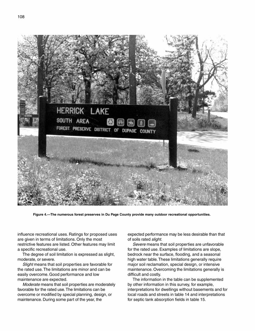
108
influence recreational uses. Ratings for proposed usesare given in terms of limitations. Only the mostrestrictive features are listed. Other features may limita specific recreational use.
The degree of soil limitation is expressed as slight,moderate, or severe.
Slight means that soil properties are favorable forthe rated use. The limitations are minor and can beeasily overcome. Good performance and lowmaintenance are expected.
Moderate means that soil properties are moderatelyfavorable for the rated use. The limitations can beovercome or modified by special planning, design, ormaintenance. During some part of the year, the
expected performance may be less desirable than thatof soils rated slight.
Severe means that soil properties are unfavorablefor the rated use. Examples of limitations are slope,bedrock near the surface, flooding, and a seasonalhigh water table. These limitations generally requiremajor soil reclamation, special design, or intensivemaintenance. Overcoming the limitations generally isdifficult and costly.
The information in the table can be supplementedby other information in this survey, for example,interpretations for dwellings without basements and forlocal roads and streets in table 14 and interpretationsfor septic tank absorption fields in table 15.
Figure 4.—The numerous forest preserves in Du Page County provide many outdoor recreational opportunities.
109
Wayne A. Lampa and Daniel R. Ludwig, Ph.D., of the ForestPreserve District of Du Page County, helped prepare this section.
In presettlement times, the survey area hadapproximately 28,800 acres of forest, 156,100 acres ofprairie, and 26,900 acres of savanna. Approximately128,000 acres consisted of wetlands. The plantcommunities that developed over the past 10,000years provided habitats for very diverse flora andfauna.
Since the 1830’s, human use of the land expandedand intensified to the extent that less than 4 percent ofthe historic landscape remains. Today, 90 percent ofthe remnants of the presettlement landscape arefound in the county’s forest preserves.
Despite increasing degradation and loss of habitat,wildlife persists in forest preserves, cropland, andother open spaces. Non-native and native plantcommunities provide habitat and necessary resourcesfor 225 vertebrate animals (44 fish, 8 amphibians, 15reptiles, 119 breeding birds, and 39 mammals).Canada goose, beaver, coyote, raccoon, and white-tailed deer are among the most commonly observedspecies in Du Page County. These species haveadapted as their habitats have been changed byhuman development. Native aquatic plants, fish, andinvertebrates are still found in several county lakesand ponds and in larger streams. These species arevery vulnerable to destruction, however, as a result ofeven simple alteration of their water regime orchemistry and encroachment by surrounding landuses.
The continued existence of many of the county’splants and animals depends on the habitats to whichthey are adapted. Active management is necessary,even in an urban environment, to sustain ecosystemsand the wildlife populations that rely on them forhabitat.
In general, most of the remaining openland in thecounty is not managed primarily for wildlife. Good landmanagement practices, however, can also improve anarea’s value for wildlife. For example, farming practicesthat leave crop residue on the fields during the fall andwinter months not only help to control erosion but alsoprovide winter cover and food for some wildlife
species. Allowing grassed waterways, road ditches,fencelines, set-aside fields, and vacant properties toremain unmowed until early August provides much-needed habitat for ground-nesting wildlife, such asrabbits, pheasants, and many species of songbirds.
Development and cultivation of temporarily andseasonally flooded wetlands should be avoided. Bufferstrips surrounding wetland areas provide food andnesting cover for many wildlife species and protectthese areas from filling in with eroded sediment.Wetlands, streambanks, and woodlots should befenced so that foot and vehicular traffic is prevented.Fencing can protect and maintain the native plantcommunities that support wildlife species. It can alsohelp to control erosion and improve water quality instreams and rivers.
Knowledge of the soils in the area is importantwhen efforts to restore or manage an area for wildlifeare undertaken. For example, because poorly drainedand very poorly drained soils have a seasonal highwater table, they are most likely to support vegetationtolerant of wet conditions and thus provide habitat forwetland wildlife species. In some areas, poorly drainedand very poorly drained soils have been drained bysubsurface tile drains or drainage ditches. Such areasoffer opportunities for wetland habitat restoration aslong as negative impacts are avoided on neighboringproperties.
Upland soils, once dominated by prairies and oaksavannas, can also be managed in ways that promotethe native plant species. This management mayinclude planting native species, controlling oreliminating competing exotic vegetation, or usingcontrolled fire.
Assistance with wildlife habitat projects can beobtained from various local, State, and Federalagencies, including the Illinois Department ofConservation, the U.S. Fish and Wildlife Service, theNatural Resources Conservation Service, and thelocal Soil and Water Conservation District.
Soils affect the kind and amount of vegetation thatis available to wildlife as food and cover. They alsoaffect the construction of water impoundments. Thekind and abundance of wildlife depend largely on theamount and distribution of food, cover, and water.
Wildlife Habitat
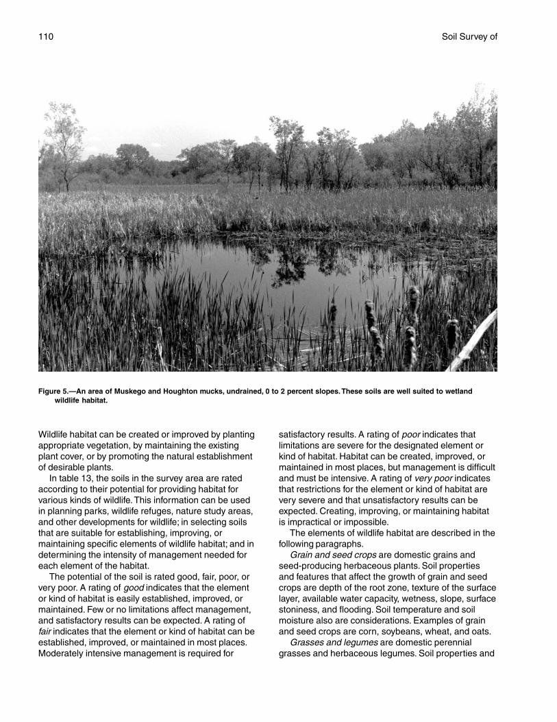
110 Soil Survey of
Wildlife habitat can be created or improved by plantingappropriate vegetation, by maintaining the existingplant cover, or by promoting the natural establishmentof desirable plants.
In table 13, the soils in the survey area are ratedaccording to their potential for providing habitat forvarious kinds of wildlife. This information can be usedin planning parks, wildlife refuges, nature study areas,and other developments for wildlife; in selecting soilsthat are suitable for establishing, improving, ormaintaining specific elements of wildlife habitat; and indetermining the intensity of management needed foreach element of the habitat.
The potential of the soil is rated good, fair, poor, orvery poor. A rating of good indicates that the elementor kind of habitat is easily established, improved, ormaintained. Few or no limitations affect management,and satisfactory results can be expected. A rating offair indicates that the element or kind of habitat can beestablished, improved, or maintained in most places.Moderately intensive management is required for
satisfactory results. A rating of poor indicates thatlimitations are severe for the designated element orkind of habitat. Habitat can be created, improved, ormaintained in most places, but management is difficultand must be intensive. A rating of very poor indicatesthat restrictions for the element or kind of habitat arevery severe and that unsatisfactory results can beexpected. Creating, improving, or maintaining habitatis impractical or impossible.
The elements of wildlife habitat are described in thefollowing paragraphs.
Grain and seed crops are domestic grains andseed-producing herbaceous plants. Soil propertiesand features that affect the growth of grain and seedcrops are depth of the root zone, texture of the surfacelayer, available water capacity, wetness, slope, surfacestoniness, and flooding. Soil temperature and soilmoisture also are considerations. Examples of grainand seed crops are corn, soybeans, wheat, and oats.
Grasses and legumes are domestic perennialgrasses and herbaceous legumes. Soil properties and
Figure 5.—An area of Muskego and Houghton mucks, undrained, 0 to 2 percent slopes.These soils are well suited to wetlandwildlife habitat.
Du Page County, Illinois—Part II 111
features that affect the growth of grasses and legumesare depth of the root zone, texture of the surface layer,available water capacity, wetness, surface stoniness,flooding, and slope. Soil temperature and soil moisturealso are considerations. Examples of grasses andlegumes are bromegrass, timothy, orchardgrass,clover, alfalfa, and birdsfoot trefoil.
Wild herbaceous plants are native or naturallyestablished grasses and forbs, including weeds. Soilproperties and features that affect the growth of theseplants are depth of the root zone, texture of thesurface layer, available water capacity, wetness,surface stoniness, and flooding. Soil temperature andsoil moisture also are considerations. Examples of wildherbaceous plants are bluestems, indiangrass,sideoats grama, goldenrod, lambsquarter, dandelions,partridge pea, coneflower, sunflowers, butterflyweed,and milkvetch.
Hardwood trees and woody understory producenuts or other fruit, buds, catkins, twigs, bark, andfoliage. Soil properties and features that affect thegrowth of hardwood trees and shrubs are depth of theroot zone, available water capacity, and wetness.Examples of these plants are oak, sycamore, beech,maple, hickory, green ash, crabapple, American plum,and eastern redbud. Examples of fruit-producingshrubs that are suitable for planting on soils ratedgood are redosier dogwood, elderberry, winterberry,spicebush, and serviceberry.
Coniferous plants furnish browse and seeds. Soilproperties and features that affect the growth ofconiferous trees, shrubs, and ground cover are depthof the root zone, available water capacity, andwetness. Examples of coniferous plants are pine,spruce, cedar, and juniper.
Wetland plants are annual and perennial wildherbaceous plants that grow on moist or wet sites.
Submerged or floating aquatic plants are excluded.Soil properties and features affecting wetland plantsare texture of the surface layer, wetness, reaction,salinity, slope, and surface stoniness. Examples ofwetland plants are smartweed, wildrye, switchgrass,prairie cordgrass, rushes, sedges, waterplantain,beggartick, aster, and willows.
Shallow water areas have an average depth of lessthan 5 feet. Some are naturally wet areas. Others arecreated by dams, levees, or other water-controlstructures. Soil properties and features affectingshallow water areas are depth to bedrock, wetness,surface stoniness, slope, and permeability. Examplesof shallow water areas are marshes, waterfowl feedingareas, wildlife watering developments, beaver ponds,and other ponds.
The habitat for various kinds of wildlife is describedin the following paragraphs.
Habitat for openland wildlife consists of cropland,pasture, meadows, and areas that are overgrown withgrasses, herbs, shrubs, and vines. These areasproduce grain and seed crops, grasses and legumes,and wild herbaceous plants. Wildlife attracted to theseareas include ring-necked pheasant, bobwhite quail,meadowlark, field sparrow, killdeer, cottontail rabbit,and red fox.
Habitat for woodland wildlife consists of areas ofdeciduous and/or coniferous plants and associatedgrasses, legumes, and wild herbaceous plants. Wildlifeattracted to these areas include thrushes,woodpeckers, owls, tree squirrels, raccoon, and white-tailed deer.
Habitat for wetland wildlife consists of open, marshyor swampy shallow water areas, bogs, or flood plainsthat support water-tolerant plants (fig. 5).The wildlifeattracted to this habitat include ducks, geese, herons,muskrat, beaver, frogs, and turtles.

113
In this section, hydric soils are defined anddescribed and the hydric soils in the survey area arelisted.
The three essential characteristics of wetlands arehydrophytic vegetation, hydric soils, and wetlandhydrology (Cowardin and others, 1979; U.S. ArmyCorps of Engineers, 1987; National Research Council,1995; Tiner, 1985). Criteria for each of thecharacteristics must be met for areas to be identifiedas wetlands. Undrained hydric soils that have naturalvegetation should support a dominant population ofecological wetland plant species. Hydric soils thathave been converted to other uses should be capableof being restored to wetlands.
Hydric soils are defined by the National TechnicalCommittee for Hydric Soils (NTCHS) as soils thatformed under conditions of saturation, flooding, orponding long enough during the growing season todevelop anaerobic conditions in the upper part(Federal Register, 1994). These soils are eithersaturated or inundated long enough during thegrowing season to support the growth andreproduction of hydrophytic vegetation.
The NTCHS definition identifies general soilproperties that are associated with wetness. In orderto determine whether a specific soil is a hydric soil ornonhydric soil, however, more specific information,such as information about the depth and duration ofthe water table, is needed. Thus, criteria that identifythose estimated soil properties unique to hydric soilshave been established (Federal Register, 1995). Thesecriteria are used to identify a phase of a soil seriesthat normally is associated with wetlands. The criteriaused are selected estimated soil properties that aredescribed in “Soil Taxonomy” (USDA, 1999) and “Keysto Soil Taxonomy” (USDA, 1998) and in the “SoilSurvey Manual” (USDA, 1993).
If soils are wet enough for a long enough period tobe considered hydric, they should exhibit certainproperties that can be easily observed in the field.These visible properties are indicators of hydric soils.The indicators used to make onsite determinations ofhydric soils in this survey area are specified in “Field
Hydric Soils
Indicators of Hydric Soils in the United States” (USDA,1996).
Hydric soils are identified by examining anddescribing the soil to a depth of about 20 inches. Thisdepth may be greater if determination of anappropriate indicator so requires. It is alwaysrecommended that soils be excavated and describedto the depth necessary for an understanding of theredoximorphic processes. Then, using the completedsoil descriptions, soil scientists can compare the soilfeatures required by each indicator and specify whichindicators have been matched with the conditionsobserved in the soil. The soil can be identified as ahydric soil if at least one of the approved indicators ispresent.
The following map units meet the definition of hydricsoils and, in addition, have at least one of the hydricsoil indicators. This list can help in planning land uses;however, onsite investigation is recommended todetermine the hydric soils on a specific site (NationalResearch Council, 1995; USDA, 1996).
67A—Harpster silty clay loam, 0 to 2 percent slopes69A—Milford silty clay loam, 0 to 2 percent slopes125A—Selma loam, 0 to 2 percent slopes152A—Drummer silty clay loam, 0 to 2 percent slopes206A—Thorp silt loam, 0 to 2 percent slopes232A—Ashkum silty clay loam, 0 to 2 percent slopes330A—Peotone silty clay loam, 0 to 2 percent slopes523A—Dunham silty clay loam, 0 to 2 percent
slopes848B—Drummer-Barrington-Mundelein complex, 1 to
6 percent slopes849A—Milford-Martinton complex, 0 to 2 percent
slopes854B—Markham-Ashkum-Beecher complex, 1 to 6
percent slopes903A—Muskego and Houghton mucks, 0 to 2 percent
slopes1107A—Sawmill silty clay loam, undrained, 0 to 2
percent slopes, frequently flooded1152A—Drummer silty clay loam, undrained, 0 to 2
percent slopes
114
1330A—Peotone silty clay loam, undrained, 0 to 2percent slopes
1516A—Faxon silty clay loam, undrained, 0 to 2percent slopes, frequently flooded
1523A—Dunham silty clay loam, undrained, 0 to 2percent slopes
1903A—Muskego and Houghton mucks, undrained, 0to 2 percent slopes
3107A—Sawmill silty clay loam, 0 to 2 percent slopes,frequently flooded
3316A—Romeo silt loam, 0 to 2 percent slopes,frequently flooded
4904A—Muskego and Peotone soils, ponded, 0 to 2percent slopes
Map units that are made up of hydric soils mayhave small areas, or inclusions, of nonhydric soils inthe higher positions on the landform, and map unitsmade up of nonhydric soils may have inclusions ofhydric soils in the lower positions on the landform.
115
This section provides information for planning landuses related to urban development and to watermanagement. Soils are rated for various uses, and themost limiting features are identified. Ratings are givenfor building site development, sanitary facilities,construction materials, and water management. Theratings are based on observed performance of thesoils and on the estimated data and test data in the“Soil Properties” section.
Information in this section is intended for land useplanning, for evaluating land use alternatives, and forplanning site investigations prior to design andconstruction.The information, however, has limitations.For example, estimates and other data generally applyonly to that part of the soil within a depth of 5 or 6 feet.Because of the map scale, small areas of differentsoils may be included within the mapped areas of aspecific soil.
The information is not site specific and does noteliminate the need for onsite investigation of the soilsor for testing and analysis by personnel experienced inthe design and construction of engineering works.
Government ordinances and regulations thatrestrict certain land uses or impose specific designcriteria were not considered in preparing theinformation in this section. Local ordinances andregulations should be considered in planning, in siteselection, and in design.
Soil properties, site features, and observedperformance were considered in determining theratings in this section. During the fieldwork for this soilsurvey, determinations were made about grain-sizedistribution, liquid limit, plasticity index, soil reaction,depth to bedrock, hardness of bedrock within 5 or 6feet of the surface, soil wetness, depth to a seasonalhigh water table, slope, likelihood of flooding, naturalsoil structure aggregation, and soil density. Data werecollected about kinds of clay minerals, mineralogy ofthe sand and silt fractions, and the kinds of adsorbedcations. Estimates were made for erodibility,permeability, corrosivity, shrink-swell potential,available water capacity, and other behavioralcharacteristics affecting engineering uses.
This information can be used to evaluate the
potential of areas for residential, commercial,industrial, and recreational uses; make preliminaryestimates of construction conditions; evaluatealternative routes for roads, streets, highways,pipelines, and underground cables; evaluatealternative sites for sanitary landfills, septic tankabsorption fields, and sewage lagoons; plan detailedonsite investigations of soils and geology; locatepotential sources of gravel, sand, earthfill, and topsoil;plan drainage systems, irrigation systems, ponds,terraces, and other structures for soil and waterconservation; and predict performance of proposedsmall structures and pavements by comparing theperformance of existing similar structures on the sameor similar soils.
The information in the tables, along with the soilmaps, the soil descriptions, and other data provided inthis survey, can be used to make additionalinterpretations.
Some of the terms used in this soil survey have aspecial meaning in soil science and are defined in theGlossary.
Building Site Development
Over the last two decades, Du Page County hasexperienced a significant increase in population. Thisincrease has had an important impact on land use inthe county.
Urban erosion can be a major factor affecting waterquality. It is estimated that the rate of urban erosionand the resulting sediment may be as much as 300 to400 times the erosion rate in agricultural areas. Urbanland under development is commonly stripped forseveral years without adequate erosion control (fig. 6).Soil compaction and massive earth moving are morelikely to increase the hazard of erosion than seedbedpreparation for crop production.
Urban erosion-control practices utilize essentiallythe same concepts as those applied in agriculturalareas. The surface of the soil should be protected fromthe impact of raindrops, and the runoff fromaccumulated rainwater must be controlled. Effectivecontrol of erosion and sediment involves three major
Engineering
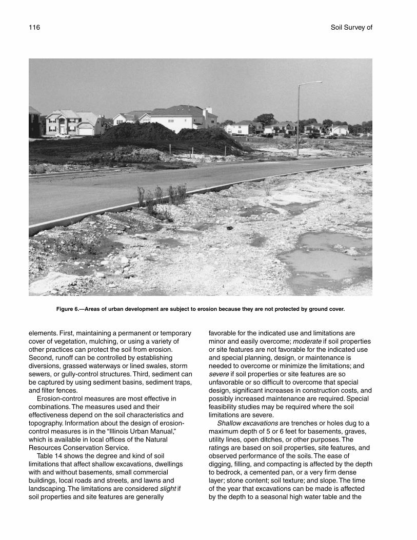
116 Soil Survey of
elements. First, maintaining a permanent or temporarycover of vegetation, mulching, or using a variety ofother practices can protect the soil from erosion.Second, runoff can be controlled by establishingdiversions, grassed waterways or lined swales, stormsewers, or gully-control structures. Third, sediment canbe captured by using sediment basins, sediment traps,and filter fences.
Erosion-control measures are most effective incombinations. The measures used and theireffectiveness depend on the soil characteristics andtopography. Information about the design of erosion-control measures is in the “Illinois Urban Manual,”which is available in local offices of the NaturalResources Conservation Service.
Table 14 shows the degree and kind of soillimitations that affect shallow excavations, dwellingswith and without basements, small commercialbuildings, local roads and streets, and lawns andlandscaping. The limitations are considered slight ifsoil properties and site features are generally
favorable for the indicated use and limitations areminor and easily overcome; moderate if soil propertiesor site features are not favorable for the indicated useand special planning, design, or maintenance isneeded to overcome or minimize the limitations; andsevere if soil properties or site features are sounfavorable or so difficult to overcome that specialdesign, significant increases in construction costs, andpossibly increased maintenance are required. Specialfeasibility studies may be required where the soillimitations are severe.
Shallow excavations are trenches or holes dug to amaximum depth of 5 or 6 feet for basements, graves,utility lines, open ditches, or other purposes. Theratings are based on soil properties, site features, andobserved performance of the soils. The ease ofdigging, filling, and compacting is affected by the depthto bedrock, a cemented pan, or a very firm denselayer; stone content; soil texture; and slope. The timeof the year that excavations can be made is affectedby the depth to a seasonal high water table and the
Figure 6.—Areas of urban development are subject to erosion because they are not protected by ground cover.
Du Page County, Illinois—Part II 117
susceptibility of the soil to flooding. The resistance ofthe excavation walls or banks to sloughing or caving isaffected by soil texture and depth to the water table.
Dwellings and small commercial buildings arestructures built on shallow foundations on undisturbedsoil. The load limit is the same as that for single-familydwellings no higher than three stories. Ratings aremade for small commercial buildings withoutbasements, for dwellings with basements, and fordwellings without basements. The ratings are basedon soil properties, site features, and observedperformance of the soils. A high water table, flooding,shrinking and swelling, and organic layers can causethe movement of footings. A high water table, depth tobedrock or to a cemented pan, large stones, slope,and flooding affect the ease of excavation andconstruction. Landscaping and grading that requirecuts and fills of more than 5 or 6 feet are notconsidered.
Local roads and streets have an all-weather surfaceand carry automobile and light truck traffic all year.They have a subgrade of cut or fill soil material; a baseof gravel, crushed rock, or stabilized soil material; anda flexible or rigid surface. Cuts and fills are generallylimited to less than 6 feet. The ratings are based onsoil properties, site features, and observedperformance of the soils. Depth to bedrock or to acemented pan, a high water table, flooding, largestones, and slope affect the ease of excavating andgrading. Soil strength (as inferred from the engineeringclassification of the soil), shrink-swell potential, frostaction potential, and depth to a high water table affectthe traffic-supporting capacity.
Lawns and landscaping require soils on which turfand ornamental trees and shrubs can be establishedand maintained. The ratings are based on soilproperties, site features, and observed performanceof the soils. Soil reaction, a high water table, depth tobedrock or to a cemented pan, the available watercapacity in the upper 40 inches, and the content ofsalts, sodium, and sulfidic materials affect plantgrowth. Flooding, wetness, slope, stoniness, andthe amount of sand, clay, or organic matter in thesurface layer affect trafficability after vegetation isestablished.
Sanitary Facilities
Table 15 shows the degree and kind of soillimitations that affect septic tank absorption fields,sewage lagoons, and sanitary landfills. The limitationsare considered slight if soil properties and site featuresare generally favorable for the indicated use andlimitations are minor and easily overcome; moderate if
soil properties or site features are not favorable for theindicated use and special planning, design, ormaintenance is needed to overcome or minimize thelimitations; and severe if soil properties or site featuresare so unfavorable or so difficult to overcome thatspecial design, significant increases in constructioncosts, and possibly increased maintenance arerequired.
The table also shows the suitability of the soils foruse as daily cover for landfill. A rating of goodindicates that soil properties and site features arefavorable for the use and good performance and lowmaintenance can be expected; fair indicates that soilproperties and site features are moderately favorablefor the use and one or more soil properties or sitefeatures make the soil less desirable than the soilsrated good; and poor indicates that one or more soilproperties or site features are unfavorable for the useand overcoming the unfavorable properties requiresspecial design, extra maintenance, or costly alteration.
Septic tank absorption fields are areas in whicheffluent from a septic tank is distributed into the soilthrough subsurface tiles or perforated pipe. Only thatpart of the soil between depths of 24 and 72 inches isevaluated. The ratings are based on soil properties,site features, and observed performance of the soils.Permeability, a high water table, depth to bedrock or toa cemented pan, and flooding affect absorption of theeffluent. Large stones and bedrock or a cemented paninterfere with installation.
Unsatisfactory performance of septic tankabsorption fields, including excessively slowabsorption of effluent, surfacing of effluent, and hillsideseepage, can affect public health. Ground water canbe polluted if highly permeable sand and gravel orfractured bedrock is less than 4 feet below the base ofthe absorption field, if slope is excessive, or if thewater table is near the surface. There must beunsaturated soil material beneath the absorption fieldto filter the effluent effectively. Many local ordinancesrequire that this material be of a certain thickness.
Sewage lagoons are shallow ponds constructed tohold sewage while aerobic bacteria decompose thesolid and liquid wastes. Lagoons should have a nearlylevel floor surrounded by cut slopes or embankmentsof compacted soil. Lagoons generally are designed tohold the sewage within a depth of 2 to 5 feet. Nearlyimpervious soil material for the lagoon floor and sidesis required to minimize seepage and contamination ofground water.
The table gives ratings for the natural soil thatmakes up the lagoon floor. The surface layer and,generally, 1 or 2 feet of soil material below the surfacelayer are excavated to provide material for the
118 Soil Survey of
embankments. The ratings are based on soilproperties, site features, and observed performance ofthe soils. Considered in the ratings are slope,permeability, a high water table, depth to bedrock or toa cemented pan, flooding, large stones, and content oforganic matter.
Excessive seepage resulting from rapidpermeability in the soil or a water table that is highenough to raise the level of sewage in the lagooncauses a lagoon to function unsatisfactorily. Pollutionresults if seepage is excessive or if floodwaterovertops the lagoon. A high content of organic matteris detrimental to proper functioning of the lagoonbecause it inhibits aerobic activity. Slope, bedrock, andcemented pans can cause construction problems, andlarge stones can hinder compaction of the lagoonfloor.
Sanitary landfills are areas where solid waste isdisposed of by burying it in soil. There are two types oflandfill—trench and area. In a trench landfill, the wasteis placed in a trench. It is spread, compacted, andcovered daily with a thin layer of soil excavated at thesite. In an area landfill, the waste is placed insuccessive layers on the surface of the soil. The wasteis spread, compacted, and covered daily with a thinlayer of soil from a source away from the site.
Both types of landfill must be able to bear heavyvehicular traffic. Both types involve a risk of ground-water pollution. Ease of excavation and revegetationshould be considered.
The ratings in the table are based on soilproperties, site features, and observed performance ofthe soils. Permeability, depth to bedrock or to acemented pan, a high water table, slope, and floodingaffect both types of landfill. Texture, stones andboulders, highly organic layers, soil reaction, andcontent of salts and sodium affect trench landfills.Unless otherwise stated, the ratings apply only to thatpart of the soil within a depth of about 6 feet. Fordeeper trenches, a limitation rated slight or moderatemay not be valid. Onsite investigation is needed.
Daily cover for landfill is the soil material that isused to cover compacted solid waste in an areasanitary landfill. The soil material is obtained offsite,transported to the landfill, and spread over the waste.
Soil texture, wetness, coarse fragments, and slopeaffect the ease of removing and spreading the materialduring wet and dry periods. Loamy or silty soils thatare free of large stones or excess gravel are the bestcover for a landfill. Clayey soils are sticky or cloddyand are difficult to spread; sandy soils are subject towind erosion.
After soil material has been removed, the soilmaterial remaining in the borrow area must be thick
enough over bedrock, a cemented pan, or the watertable to permit revegetation. The soil material used asthe final cover for a landfill should be suitable forplants. The surface layer generally has the bestworkability, more organic matter, and the best potentialfor plants. Material from the surface layer should bestockpiled for use as the final cover.
Construction Materials
Table 16 gives information about the soils as asource of roadfill, sand, gravel, and topsoil. The soilsare rated good, fair, or poor as a source of roadfill andtopsoil. They are rated as a probable or improbablesource of sand and gravel. The ratings are based onsoil properties and site features that affect the removalof the soil and its use as construction material. Normalcompaction, minor processing, and other standardconstruction practices are assumed. Each soil isevaluated to a depth of 5 or 6 feet.
Roadfill is soil material that is excavated in oneplace and used in road embankments in anotherplace. In this table, the soils are rated as a source ofroadfill for low embankments, generally less than 6feet high and less exacting in design than higherembankments.
The ratings are for the soil material below thesurface layer to a depth of 5 or 6 feet. It is assumedthat soil layers will be mixed during excavating andspreading. Many soils have layers of contrastingsuitability within their profile. The table showingengineering index properties provides detailedinformation about each soil layer. This information canhelp to determine the suitability of each layer for useas roadfill. The performance of soil after it is stabilizedwith lime or cement is not considered in the ratings.
The ratings are based on soil properties, sitefeatures, and observed performance of the soils. Thethickness of suitable material is a major consideration.The ease of excavation is affected by large stones, ahigh water table, and slope. How well the soil performsin place after it has been compacted and drained isdetermined by its strength (as inferred from theengineering classification of the soil) and shrink-swellpotential.
Soils rated good contain significant amounts ofsand or gravel or both. They have at least 5 feet ofsuitable material, a low shrink-swell potential, fewcobbles and stones, and slopes of 15 percent or less.Depth to the water table is more than 3 feet. Soilsrated fair are more than 35 percent silt- and clay-sizedparticles and have a plasticity index of less than 10.They have a moderate shrink-swell potential, slopes of15 to 25 percent, or many stones. Depth to the water
Du Page County, Illinois—Part II 119
table is 1 to 3 feet. Soils rated poor have a plasticityindex of more than 10, a high shrink-swell potential,many stones, or slopes of more than 25 percent. Theyare wet and have a water table at a depth of less than1 foot. They may have layers of suitable material, butthe material is less than 3 feet thick.
Sand and gravel are natural aggregates suitable forcommercial use with a minimum of processing. Theyare used in many kinds of construction. Specificationsfor each use vary widely. In table 16, only theprobability of finding material in suitable quantity isevaluated. The suitability of the material for specificpurposes is not evaluated, nor are factors that affectexcavation of the material.
The properties used to evaluate the soil as a sourceof sand or gravel are gradation of grain sizes (asindicated by the engineering classification of the soil),the thickness of suitable material, and the content ofrock fragments. Kinds of rock, acidity, and stratificationare given in the soil series descriptions. Gradation ofgrain sizes is given in the table on engineering indexproperties.
A soil rated as a probable source has a layer ofclean sand or gravel or a layer of sand or gravel that isup to 12 percent silty fines. This material must be atleast 3 feet thick and less than 50 percent, by weight,large stones. All other soils are rated as an improbablesource. Coarse fragments of soft bedrock, such asshale and siltstone, are not considered to be sand andgravel.
Topsoil is used to cover an area so that vegetationcan be established and maintained. The upper 40inches of a soil is evaluated for use as topsoil. Alsoevaluated is the reclamation potential of the borrowarea.
Plant growth is affected by toxic material and bysuch properties as soil reaction, available watercapacity, and fertility. The ease of excavating, loading,and spreading is affected by rock fragments, slope, awater table, soil texture, and thickness of suitablematerial. Reclamation of the borrow area is affected byslope, a water table, rock fragments, bedrock, andtoxic material.
Soils rated good have friable, loamy material to adepth of at least 40 inches. They are free of stonesand cobbles, have little or no gravel, and have slopesof less than 8 percent. They are low in content ofsoluble salts, are naturally fertile or respond well tofertilizer, and are not so wet that excavation is difficult.
Soils rated fair are sandy soils, loamy soils thathave a relatively high content of clay, soils that haveonly 20 to 40 inches of suitable material, soils thathave an appreciable amount of gravel, stones, orsoluble salts, or soils that have slopes of 8 to 15
percent. The soils are not so wet that excavation isdifficult.
Soils rated poor are very sandy or clayey, have lessthan 20 inches of suitable material, have a largeamount of gravel, stones, or soluble salts, have slopesof more than 15 percent, or have a seasonal highwater table at or near the surface.
The surface layer of most soils is generallypreferred for topsoil because of its organic mattercontent. Organic matter greatly increases theabsorption and retention of moisture and nutrients forplant growth.
Water Management
Table 17 gives information on the soil propertiesand site features that affect water management. Thedegree and kind of soil limitations are given for pondreservoir areas; embankments, dikes, and levees; andaquifer-fed excavated ponds. The limitations areconsidered slight if soil properties and site features aregenerally favorable for the indicated use andlimitations are minor and are easily overcome;moderate if soil properties or site features are notfavorable for the indicated use and special planning,design, or maintenance is needed to overcome orminimize the limitations; and severe if soil properties orsite features are so unfavorable or so difficult toovercome that special design, significant increase inconstruction costs, and possibly increasedmaintenance are required.
This table also gives for each soil the restrictivefeatures that affect drainage, irrigation, terraces anddiversions, and grassed waterways.
Pond reservoir areas hold water behind a dam orembankment. Soils best suited to this use have lowseepage potential in the upper 60 inches. Theseepage potential is determined by the permeability ofthe soil and the depth to fractured bedrock or otherpermeable material. Excessive slope can affect thestorage capacity of the reservoir area.
Embankments, dikes, and levees are raisedstructures of soil material, generally less than 20 feethigh, constructed to impound water or to protect landagainst overflow. In this table, the soils are rated as asource of material for embankment fill. The ratingsapply to the soil material below the surface layer to adepth of about 5 feet. It is assumed that soil layers willbe uniformly mixed and compacted duringconstruction.
The ratings do not indicate the ability of the naturalsoil to support an embankment. Soil properties to adepth even greater than the height of the embankmentcan affect performance and safety of the embankment.
120
Generally, deeper onsite investigation is needed todetermine these properties.
Soil material in embankments must be resistant toseepage, piping, and erosion and have favorablecompaction characteristics. Unfavorable featuresinclude less than 5 feet of suitable material and a highcontent of stones or boulders, organic matter, or saltsor sodium. A high water table affects the amount ofusable material. It also affects trafficability.
Aquifer-fed excavated ponds are pits or dugoutsthat extend to a ground-water aquifer or to a depthbelow a permanent water table. Excluded are pondsthat are fed only by surface runoff and embankmentponds that impound water 3 feet or more above theoriginal surface. Excavated ponds are affected bydepth to a permanent water table, permeability of theaquifer, and quality of the water as inferred from thesalinity of the soil. Depth to bedrock and the content oflarge stones affect the ease of excavation.
Drainage is the removal of excess surface andsubsurface water from the soil. How easily andeffectively the soil is drained depends on the depth tobedrock, to a cemented pan, or to other layers thataffect the rate of water movement; permeability; depthto a high water table or depth of standing water if thesoil is subject to ponding; slope; susceptibility toflooding; subsidence of organic layers; and thepotential for frost action. Excavating and grading andthe stability of ditchbanks are affected by depth tobedrock or to a cemented pan, large stones, slope,and the hazard of cutbanks caving. The productivity ofthe soil after drainage is adversely affected by extremeacidity or by toxic substances in the root zone, such as
salts, sodium, and sulfur. Availability of drainageoutlets is not considered in the ratings.
Irrigation is the controlled application of water tosupplement rainfall and support plant growth. Thedesign and management of an irrigation system areaffected by depth to the water table, the need fordrainage, flooding, available water capacity, intakerate, permeability, erosion hazard, and slope. Theconstruction of a system is affected by large stonesand depth to bedrock or to a cemented pan. Theperformance of a system is affected by the depth ofthe root zone, the amount of salts or sodium, and soilreaction.
Terraces and diversions are embankments or acombination of channels and ridges constructedacross a slope to control erosion and conservemoisture by intercepting runoff. Slope, wetness, largestones, and depth to bedrock or to a cemented panaffect the construction of terraces and diversions. Arestricted rooting depth, a severe hazard of winderosion or water erosion, an excessively coarsetexture, and restricted permeability adversely affectmaintenance.
Grassed waterways are natural or constructedchannels, generally broad and shallow, that conductsurface water to outlets at a nonerosive velocity. Largestones, wetness, slope, and depth to bedrock or to acemented pan affect the construction of grassedwaterways. A hazard of wind erosion, low availablewater capacity, restricted rooting depth, toxicsubstances such as salts and sodium, and restrictedpermeability adversely affect the growth andmaintenance of the grass after construction.
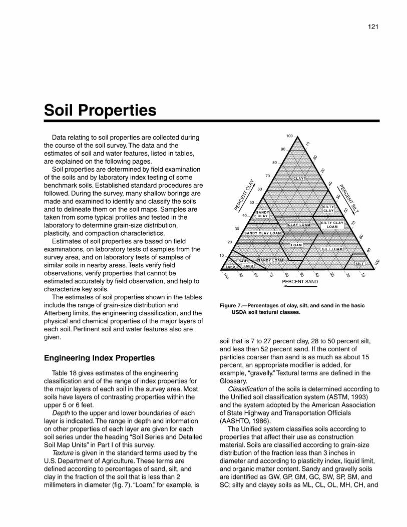
121
Data relating to soil properties are collected duringthe course of the soil survey. The data and theestimates of soil and water features, listed in tables,are explained on the following pages.
Soil properties are determined by field examinationof the soils and by laboratory index testing of somebenchmark soils. Established standard procedures arefollowed. During the survey, many shallow borings aremade and examined to identify and classify the soilsand to delineate them on the soil maps. Samples aretaken from some typical profiles and tested in thelaboratory to determine grain-size distribution,plasticity, and compaction characteristics.
Estimates of soil properties are based on fieldexaminations, on laboratory tests of samples from thesurvey area, and on laboratory tests of samples ofsimilar soils in nearby areas. Tests verify fieldobservations, verify properties that cannot beestimated accurately by field observation, and help tocharacterize key soils.
The estimates of soil properties shown in the tablesinclude the range of grain-size distribution andAtterberg limits, the engineering classification, and thephysical and chemical properties of the major layers ofeach soil. Pertinent soil and water features also aregiven.
Engineering Index Properties
Table 18 gives estimates of the engineeringclassification and of the range of index properties forthe major layers of each soil in the survey area. Mostsoils have layers of contrasting properties within theupper 5 or 6 feet.
Depth to the upper and lower boundaries of eachlayer is indicated. The range in depth and informationon other properties of each layer are given for eachsoil series under the heading “Soil Series and DetailedSoil Map Units” in Part I of this survey.
Texture is given in the standard terms used by theU.S. Department of Agriculture. These terms aredefined according to percentages of sand, silt, andclay in the fraction of the soil that is less than 2millimeters in diameter (fig. 7). “Loam,” for example, is
soil that is 7 to 27 percent clay, 28 to 50 percent silt,and less than 52 percent sand. If the content ofparticles coarser than sand is as much as about 15percent, an appropriate modifier is added, forexample, “gravelly.” Textural terms are defined in theGlossary.
Classification of the soils is determined according tothe Unified soil classification system (ASTM, 1993)and the system adopted by the American Associationof State Highway and Transportation Officials(AASHTO, 1986).
The Unified system classifies soils according toproperties that affect their use as constructionmaterial. Soils are classified according to grain-sizedistribution of the fraction less than 3 inches indiameter and according to plasticity index, liquid limit,and organic matter content. Sandy and gravelly soilsare identified as GW, GP, GM, GC, SW, SP, SM, andSC; silty and clayey soils as ML, CL, OL, MH, CH, and
Soil Properties
Figure 7.—Percentages of clay, silt, and sand in the basicUSDA soil textural classes.
122 Soil Survey of
OH; and highly organic soils as PT. Soils exhibitingengineering properties of two groups can have a dualclassification, for example, CL-ML.
The AASHTO system classifies soils according tothose properties that affect roadway construction andmaintenance. In this system, the fraction of a mineralsoil that is less than 3 inches in diameter is classifiedin one of seven groups from A-1 through A-7 on thebasis of grain-size distribution, liquid limit, andplasticity index. Soils in group A-1 are coarse grainedand low in content of fines (silt and clay). At the otherextreme, soils in group A-7 are fine grained. Highlyorganic soils are classified in group A-8 on the basis ofvisual inspection.
If laboratory data are available, the A-1, A-2, and A-7 groups are further classified as A-1-a, A-1-b, A-2-4,A-2-5, A-2-6, A-2-7, A-7-5, or A-7-6. As an additionalrefinement, the suitability of a soil as subgradematerial can be indicated by a group index number.Group index numbers range from 0 for the bestsubgrade material to 20 or higher for the poorest.
Rock fragments larger than 10 inches in diameterand 3 to 10 inches in diameter are indicated as apercentage of the total soil on a dry-weight basis. Thepercentages are estimates determined mainly byconverting volume percentage in the field to weightpercentage.
Percentage (of soil particles) passing designatedsieves is the percentage of the soil fraction less than 3inches in diameter based on an ovendry weight. Thesieves, numbers 4, 10, 40, and 200 (USA StandardSeries), have openings of 4.76, 2.00, 0.420, and 0.074millimeters, respectively. Estimates are based onlaboratory tests of soils sampled in the survey areaand in nearby areas and on estimates made in thefield.
Liquid limit and plasticity index (Atterberg limits)indicate the plasticity characteristics of a soil. Theestimates are based on test data from the survey areaor from nearby areas and on field examination.
The estimates of grain-size distribution, liquid limit,and plasticity index are generally rounded to thenearest 5 percent. Thus, if the ranges of gradation andAtterberg limits extend a marginal amount (1 or 2percentage points) across classification boundaries,the classification in the marginal zone is omitted in thetable.
Physical and Chemical Properties
Table 19 shows estimates of some characteristicsand features that affect soil behavior. These estimatesare given for the major layers of each soil in the survey
area. The estimates are based on field observationsand on test data for these and similar soils.
Clay as a soil separate consists of mineral soilparticles that are less than 0.002 millimeter indiameter. In the table, the estimated clay content ofeach major soil layer is given as a percentage, byweight, of the soil material that is less than 2millimeters in diameter.
The amount and kind of clay greatly affect thefertility and physical condition of the soil. Theydetermine the ability of the soil to adsorb cations andto retain moisture. They influence shrink-swellpotential, permeability, plasticity, the ease of soildispersion, and other soil properties. The amount andkind of clay in a soil also affect tillage and earthmovingoperations.
Moist bulk density is the weight of soil (ovendry) perunit volume. Volume is measured when the soil is atfield moisture capacity, that is, the moisture content at1/3-bar moisture tension. Weight is determined after thesoil is dried at 105 degrees C. In the table, theestimated moist bulk density of each major soilhorizon is expressed in grams per cubic centimeter ofsoil material that is less than 2 millimeters in diameter.Bulk density data are used to compute shrink-swellpotential, available water capacity, total pore space,and other soil properties. The moist bulk density of asoil indicates the pore space available for water androots. A bulk density of more than 1.6 can restrictwater storage and root penetration. Moist bulk densityis influenced by texture, kind of clay, content of organicmatter, and soil structure.
Permeability (Ksat ) refers to the ability of a soil totransmit water or air. The term “permeability” hastraditionally been used in soil surveys to indicatesaturated hydraulic conductivity (K
sat). The estimates
in the table indicate the rate of movement of waterwhen the soil is saturated. They are based on soilcharacteristics observed in the field, particularlystructure, porosity, and texture. Permeability isconsidered in the design of soil drainage systems andseptic tank absorption fields.
Available water capacity refers to the quantity ofwater that the soil is capable of storing for use byplants. The capacity for water storage is given ininches of water per inch of soil for each major soillayer. The capacity varies, depending on soilproperties that affect retention of water and depth ofthe root zone. The most important properties are thecontent of organic matter, soil texture, bulk density,and soil structure. Available water capacity is animportant factor in the choice of plants or crops to begrown and in the design and management of irrigation
Du Page County, Illinois—Part II 123
systems. Available water capacity is not an estimate ofthe quantity of water actually available to plants at anygiven time.
Linear extensibility refers to the change in length ofan unconfined clod as moisture content is decreasedfrom a moist to a dry state. It is an expression of thevolume change between the water content of the clodat 1/3- or 1/10-bar tension (33kPa or 10kPa tension) andoven dryness. The volume change is reported in thetable as percent change for the whole soil. Volumechange is influenced by the amount and type of clayminerals in the soil.
Linear extensibility is used to determine the shrink-swell potential of soils. The shrink-swell potential is lowif the soil has a linear extensibility of less than 3percent; moderate if 3 to 6 percent; high if 6 to 9percent; and very high if more than 9 percent. If theshrink-swell potential is rated moderate to very high,shrinking and swelling can cause damage to buildings,roads, and other structures and to plant roots. Specialdesign commonly is needed.
Organic matter is the plant and animal residue inthe soil at various stages of decomposition. In table19, the estimated content of organic matter isexpressed as a percentage, by weight, of the soilmaterial that is less than 2 millimeters in diameter.
The content of organic matter in a soil can bemaintained or increased by returning crop residue tothe soil. Organic matter affects the available watercapacity, infiltration rate, and tilth. It is a source ofnitrogen and other nutrients for crops.
Erosion factors are shown in table 19 as the Kfactor (Kw and Kf) and the T factor. Erosion factor Kindicates the susceptibility of a soil to sheet and rillerosion by water. Factor K is one of six factors used inthe Revised Universal Soil Loss Equation (RUSLE) topredict the average annual rate of soil loss by sheetand rill erosion in tons per acre per year. Theestimates are based primarily on percentage of silt,sand, and organic matter (as much as 4 percent) andon soil structure and permeability. Values of K rangefrom 0.02 to 0.69. Other factors being equal, thehigher the value, the more susceptible the soil is tosheet and rill erosion by water.
Erosion factor Kw indicates the erodibility of thewhole soil. The estimates are modified by thepresence of rock fragments.
Erosion factor Kf indicates the erodibility of the fine-earth fraction, or the material less than 2 millimeters insize.
Erosion factor T is an estimate of the maximumaverage annual rate of soil erosion by wind or waterthat can occur without affecting crop productivity over
a sustained period. The rate is in tons per acre peryear.
Wind erodibility groups are made up of soils thathave similar properties affecting their resistance towind erosion in cultivated areas. The groups indicatethe susceptibility of soil to wind erosion. The soilsassigned to group 1 are the most susceptible to winderosion, and those assigned to group 8 are the leastsusceptible. The groups are as follows:
1. Coarse sands, sands, fine sands, and very finesands.
2. Loamy coarse sands, loamy sands, loamy finesands, loamy very fine sands, ash material, and sapricsoil material.
3. Coarse sandy loams, sandy loams, fine sandyloams, and very fine sandy loams.
4L. Calcareous loams, silt loams, clay loams, andsilty clay loams.
4. Clays, silty clays, noncalcareous clay loams,and silty clay loams that are more than 35 percentclay.
5. Noncalcareous loams and silt loams that areless than 20 percent clay and sandy clay loams, sandyclays, and hemic soil material.
6. Noncalcareous loams and silt loams that aremore than 20 percent clay and noncalcareous clayloams that are less than 35 percent clay.
7. Silts, noncalcareous silty clay loams that areless than 35 percent clay, and fibric soil material.
8. Soils that are not subject to wind erosionbecause of coarse fragments on the surface orbecause of surface wetness.
Wind erodibility index is a numerical value indicatingthe susceptibility of soil to wind erosion, or the tonsper acre per year that can be expected to be lost towind erosion. There is a close correlation betweenwind erosion and the texture of the surface layer, thesize and durability of surface clods, rock fragments,organic matter, and a calcareous reaction. Soilmoisture and frozen soil layers also influence winderosion.
Soil reaction is a measure of acidity or alkalinity andis expressed as a range in pH values. The range in pHof each major horizon is based on many field tests. Formany soils, values have been verified by laboratoryanalyses. Soil reaction is important in selecting cropsand other plants, in evaluating soil amendments forfertility and stabilization, and in determining the risk ofcorrosion.
Cation-exchange capacity is the total amount ofextractable bases that can be held by the soil,expressed in terms of milliequivalents per 100 gramsof soil at neutrality (pH 7.0) or at some other stated pH
124 Soil Survey of
value. Soils having a low cation-exchange capacityhold fewer cations and may require more frequentapplications of fertilizer than soils having a high cation-exchange capacity. Soils having a high cation-exchange capacity can retain cations. The ability toretain cations helps to prevent the pollution of groundwater.
Calcium carbonate equivalent is the percent ofcarbonates, by weight, in the fraction of the soil lessthan 2 millimeters in size. The availability of plantnutrients is influenced by the amount of carbonates inthe soil. Incorporating nitrogen fertilizer into calcareoussoils helps to prevent nitrite accumulation andammonium-N volatilization.
Water Features
Table 20 gives estimates of various water features.The estimates are used in land use planning thatinvolves engineering considerations.
Hydrologic soil groups are based on estimates ofrunoff potential. Soils are assigned to one of fourgroups according to the rate of water infiltration whenthe soils are not protected by vegetation, arethoroughly wet, and receive precipitation from long-duration storms.
The four hydrologic soil groups are:Group A. Soils having a high infiltration rate (low
runoff potential) when thoroughly wet. These consistmainly of deep, well drained to excessively drainedsands or gravelly sands. These soils have a high rateof water transmission.
Group B. Soils having a moderate infiltration ratewhen thoroughly wet. These consist chiefly ofmoderately deep or deep, moderately well drained orwell drained soils that have moderately fine texture tomoderately coarse texture. These soils have amoderate rate of water transmission.
Group C. Soils having a slow infiltration rate whenthoroughly wet. These consist chiefly of soils having alayer that impedes the downward movement of wateror soils of moderately fine texture or fine texture.These soils have a slow rate of water transmission.
Group D. Soils having a very slow infiltration rate(high runoff potential) when thoroughly wet. Theseconsist chiefly of clays that have a high shrink-swellpotential, soils that have a high water table, soils thathave a claypan or clay layer at or near the surface,and soils that are shallow over nearly imperviousmaterial. These soils have a very slow rate of watertransmission.
The months in the table indicate the portion of theyear in which the feature is most likely to be aconcern.
Water table refers to a saturated zone in the soil.Table 20 indicates, by month, depth to the top (upperlimit) and base (lower limit) of the saturated zone inmost years. Estimates of the upper and lower limitsare based mainly on observations of the water table atselected sites and on evidence of a saturated zone,namely grayish colors or mottles (redoximorphicfeatures) in the soil. A saturated zone that lasts forless than a month is not considered a water table.
Ponding is standing water in a closed depression.Unless a drainage system is installed, the water isremoved only by percolation, transpiration, orevaporation. Table 20 indicates surface water depthand the duration and frequency of ponding. Duration isexpressed as very brief if less than 2 days, brief if 2 to7 days, long if 7 to 30 days, and very long if more than30 days. Frequency is expressed as none, rare,occasional, and frequent. None means that ponding isnot probable; rare that it is unlikely but possible underunusual weather conditions (the chance of ponding isnearly 0 percent to 5 percent in any year); occasionalthat it occurs, on the average, once or less in 2 years(the chance of ponding is 5 to 50 percent in any year);and frequent that it occurs, on the average, more thanonce in 2 years (the chance of ponding is more than50 percent in any year).
Flooding, the temporary inundation of an area, iscaused by overflowing streams, by runoff fromadjacent slopes, or by tides. Water standing for shortperiods after rainfall or snowmelt is not consideredflooding, and water standing in swamps and marshesis considered ponding rather than flooding.
Duration and frequency are estimated. Duration isexpressed as extremely brief if 0.1 hour to 4 hours,very brief if 4 hours to 2 days, brief if 2 to 7 days, longif 7 to 30 days, and very long if more than 30 days.Frequency is expressed as none, very rare, rare,occasional, frequent, and very frequent. None meansthat flooding is not probable; very rare that it is veryunlikely but possible under extremely unusual weatherconditions (the chance of flooding is less than 1percent in any year); rare that it is unlikely but possibleunder unusual weather conditions (the chance offlooding is 1 to 5 percent in any year); occasional thatit occurs infrequently under normal weather conditions(the chance of flooding is 5 to 50 percent in any year);frequent that it is likely to occur often under normalweather conditions (the chance of flooding is morethan 50 percent in any year but is less than 50 percentin all months in any year); and very frequent that it islikely to occur very often under normal weatherconditions (the chance of flooding is more than 50percent in all months of any year).
The information is based on evidence in the soil
Du Page County, Illinois—Part II 125
profile, namely thin strata of gravel, sand, silt, or claydeposited by floodwater; irregular decrease in organicmatter content with increasing depth; and little or nohorizon development.
Also considered are local information about theextent and levels of flooding and the relation of eachsoil on the landscape to historic floods. Information onthe extent of flooding based on soil data is lessspecific than that provided by detailed engineeringsurveys that delineate flood-prone areas at specificflood frequency levels.
Soil Features
Table 21 gives estimates of various soil features.The estimates are used in land use planning thatinvolves engineering considerations.
A restrictive layer is a nearly continuous layer thathas one or more physical, chemical, or thermalproperties that significantly impede the movement ofwater and air through the soil or that otherwise providean unfavorable root environment. Examples arebedrock, cemented layers, dense layers, and frozenlayers. The table indicates the hardness and thicknessof the restrictive layer, both of which significantly affectthe ease of excavation. Depth to top is the verticaldistance from the soil surface to the upper boundary ofthe restrictive layer.
Subsidence is the settlement of organic soils or ofsaturated mineral soils of very low density. Subsidencegenerally results from either desiccation andshrinkage or oxidation of organic material, or both,following drainage. Subsidence takes place gradually,usually over a period of several years. The table showsthe expected initial subsidence, which usually is aresult of drainage, and total subsidence, which resultsfrom a combination of factors.
Potential for frost action is the likelihood of upwardor lateral expansion of the soil caused by the formation
of segregated ice lenses (frost heave) and thesubsequent collapse of the soil and loss of strength onthawing. Frost action occurs when moisture movesinto the freezing zone of the soil. Temperature, texture,density, permeability, content of organic matter, anddepth to the water table are the most important factorsconsidered in evaluating the potential for frost action. Itis assumed that the soil is not insulated by vegetationor snow and is not artificially drained. Silty and highlystructured, clayey soils that have a high water table inwinter are the most susceptible to frost action. Welldrained, very gravelly, or very sandy soils are the leastsusceptible. Frost heave and low soil strength duringthawing cause damage mainly to pavements and otherrigid structures.
Risk of corrosion pertains to potential soil-inducedelectrochemical or chemical action that dissolves orweakens uncoated steel or concrete. The rate ofcorrosion of uncoated steel is related to such factorsas soil moisture, particle-size distribution, acidity, andelectrical conductivity of the soil. The rate of corrosionof concrete is based mainly on the sulfate and sodiumcontent, texture, moisture content, and acidity of thesoil. Special site examination and design may beneeded if the combination of factors results in a severehazard of corrosion. The steel in installations thatintersect soil boundaries or soil layers is moresusceptible to corrosion than steel in installations thatare entirely within one kind of soil or within one soillayer.
For uncoated steel, the risk of corrosion, expressedas low, moderate, or high, is based on soil drainageclass, total acidity, electrical resistivity near fieldcapacity, and electrical conductivity of the saturationextract.
For concrete, the risk of corrosion also is expressedas low, moderate, or high. It is based on soil texture,acidity, and amount of sulfates in the saturationextract.

127
American Association of State Highway and Transportation Officials (AASHTO). 1986.Standard specifications for highway materials and methods of sampling and testing.14th edition, 2 volumes.
American Society for Testing and Materials (ASTM). 1993. Standard classification ofsoils for engineering purposes. ASTM Standard D 2487.
Cowardin, L.M., V. Carter, F.C. Golet, and E.T. LaRoe. 1979. Classification of wetlandsand deep-water habitats of the United States. U.S. Fish and Wildlife Service. FWS/OBS-79/31.
Du Page County Development Department, Planning Division. 1996. Profile: Du PageCounty statistical handbook.
Federal Register. July 13, 1994. Changes in hydric soils of the United States.
Federal Register. February 24, 1995. Hydric soils of the United States.
Fehrenbacher, J.B., R.A. Pope, I.J. Jansen, J.D. Alexander, and B.W. Ray. 1978. Soilproductivity in Illinois. University of Illinois, College of Agriculture, CooperativeExtension Service Circular 1156.
Hansel, A.K., and W.H. Johnson. 1996. Wedron and Mason Groups: Lithostratigraphicreclassification of deposits of the Wisconsin Episode, Lake Michigan Lobe area. IllinoisState Geological Survey Bulletin 104.
Jenny, Hans. 1941. Factors of soil formation.
Leighton, M.M., G.E. Ekblaw, and L. Horberg. 1948. Physiographic divisions of Illinois.Illinois State Geological Survey Report of Investigations 129.
Mapes, D.R. 1979. Soil survey of Du Page and Part of Cook Counties, Illinois. Universityof Illinois Agricultural Experiment Station Soil Report 108.
National Research Council. 1995. Wetlands: Characteristics and boundaries.
Taylor, S.M., and R.H. Gilkeson. 1977. Geology for planning in Du Page County. IllinoisState Geological Survey, Open File Series 1977-1.
Tiner, R.W., Jr. 1985. Wetlands of Delaware. U.S. Fish and Wildlife Service andDelaware Department of Natural Resources and Environmental Control, WetlandsSection.
References
128
United States Army Corps of Engineers, Environmental Laboratory. 1987. Corps ofEngineers wetlands delineation manual. U.S. Army Corps of Engineers WaterwaysExperiment Station, Technical Report Y-87-1.
United States Department of Agriculture. 1961. Land capability classification. U.S.Department of Agriculture Handbook 210.
United States Department of Agriculture. 1981. Land resource regions and major landresource areas of the United States. U.S. Department of Agriculture Handbook 296.
United States Department of Agriculture. 1993. Soil survey manual. Soil ConservationService, Soil Survey Division Staff. U.S. Department of Agriculture Handbook 18.
United States Department of Agriculture. 1996. Field indicators of hydric soils in theUnited States. U.S. Department of Agriculture, Natural Resources ConservationService.
United States Department of Agriculture. 1998. Keys to soil taxonomy, 8th edition.Natural Resources Conservation Service, Soil Survey Staff.
United States Department of Agriculture. 1999. Soil taxonomy: A basic system of soilclassification for making and interpreting soil surveys, 2nd edition. Natural ResourcesConservation Service, Soil Survey Staff, U.S. Department of Agriculture Handbook 436.
United States Department of Commerce, Bureau of the Census. 1990. 1990 census ofpopulation and housing.
United States Department of Commerce, Bureau of the Census. 1992. 1992 census ofagriculture.
129
Ablation till. Loose, permeable till deposited duringthe final downwasting of glacial ice. Lenses ofcrudely sorted sand and gravel are common.
Aeration, soil. The exchange of air in soil with air fromthe atmosphere. The air in a well aerated soil issimilar to that in the atmosphere; the air in apoorly aerated soil is considerably higher incarbon dioxide and lower in oxygen.
Aggregate, soil. Many fine particles held in a singlemass or cluster. Natural soil aggregates, such asgranules, blocks, or prisms, are called peds. Clodsare aggregates produced by tillage or logging.
Alluvium. Material, such as sand, silt, or clay,deposited on land by streams.
Alpha,alpha-dipyridyl. A dye that when dissolved in1N ammonium acetate is used to detect thepresence of reduced iron (Fe II) in the soil. Apositive reaction indicates a type of redoximorphicfeature.
Animal unit month (AUM). The amount of foragerequired by one mature cow of approximately1,000 pounds weight, with or without a calf, for 1month.
Aquic conditions. Current soil wetness characterizedby saturation, reduction, and redoximorphicfeatures.
Area reclaim (in tables). An area difficult to reclaimafter the removal of soil for construction and otheruses. Revegetation and erosion control areextremely difficult.
Argillic horizon. A subsoil horizon characterized byan accumulation of illuvial clay.
Aspect. The direction in which a slope faces.Association, soil. A group of soils or miscellaneous
areas geographically associated in a characteristicrepeating pattern and defined and delineated as asingle map unit.
Available water capacity (available moisturecapacity). The capacity of soils to hold wateravailable for use by most plants. It is commonlydefined as the difference between the amount ofsoil water at field moisture capacity and theamount at wilting point. It is commonly expressed
as inches of water per inch of soil. The capacity, ininches, in a 60-inch profile or to a limiting layer isexpressed as:
Very low ............................................................ 0 to 3
Low ................................................................... 3 to 6
Moderate .......................................................... 6 to 9
High ................................................................ 9 to 12
Very high .............................................. more than 12
Backslope. The position that forms the steepest andgenerally linear, middle portion of a hillslope. Inprofile, backslopes are commonly bounded by aconvex shoulder above and a concave footslopebelow.
Basal till. Compact glacial till deposited beneath theice.
Base saturation. The degree to which material havingcation-exchange properties is saturated withexchangeable bases (sum of Ca, Mg, Na, and K),expressed as a percentage of the total cation-exchange capacity.
Bedding planes. Fine strata, less than 5 millimetersthick, in unconsolidated alluvial, eolian, lacustrine,or marine sediment.
Bedrock. The solid rock that underlies the soil andother unconsolidated material or that is exposed atthe surface.
Bench terrace. A raised, level or nearly level strip ofearth constructed on or nearly on a contour,supported by a barrier of rocks or similar material,and designed to make the soil suitable for tillageand to prevent accelerated erosion.
Calcareous soil. A soil containing enough calciumcarbonate (commonly combined with magnesiumcarbonate) to effervesce visibly when treated withcold, dilute hydrochloric acid.
Canopy. The leafy crown of trees or shrubs. (SeeCrown.)
Capillary water. Water held as a film around soilparticles and in tiny spaces between particles.Surface tension is the adhesive force that holdscapillary water in the soil.
Catena. A sequence, or “chain,” of soils on a
Glossary
130 Soil Survey of
landscape that formed in similar kinds of parentmaterial but have different characteristics as aresult of differences in relief and drainage.
Cation. An ion carrying a positive charge of electricity.The common soil cations are calcium, potassium,magnesium, sodium, and hydrogen.
Cation-exchange capacity. The total amount ofexchangeable cations that can be held by the soil,expressed in terms of milliequivalents per 100grams of soil at neutrality (pH 7.0) or at someother stated pH value. The term, as applied tosoils, is synonymous with base-exchange capacitybut is more precise in meaning.
Channery soil material. Soil material that has, byvolume, 15 to 35 percent thin, flat fragments ofsandstone, shale, slate, limestone, or schist asmuch as 6 inches (15 centimeters) along thelongest axis. A single piece is called a channer.
Chemical treatment. Control of unwanted vegetationthrough the use of chemicals.
Chiseling. Tillage with an implement having one ormore soil-penetrating points that shatter or loosenhard, compacted layers to a depth below normalplow depth.
Clay. As a soil separate, the mineral soil particles lessthan 0.002 millimeter in diameter. As a soil texturalclass, soil material that is 40 percent or more clay,less than 45 percent sand, and less than 40percent silt.
Clay depletions. Low-chroma zones having a lowcontent of iron, manganese, and clay because ofthe chemical reduction of iron and manganeseand the removal of iron, manganese, and clay. Atype of redoximorphic depletion.
Clayey soil. Silty clay, sandy clay, or clay. Generally, asoil that has an average clay content of more than35 percent.
Clay film. A thin coating of oriented clay on thesurface of a soil aggregate or lining pores or rootchannels. Synonyms: clay coating, clay skin.
Closed depression. A low area completelysurrounded by higher ground and having nonatural outlet.
Coarse textured soil. Sand or loamy sand.Cobble (or cobblestone). A rounded or partly
rounded fragment of rock 3 to 10 inches (7.6 to 25centimeters) in diameter.
Cobbly soil material. Material that has 15 to 35percent, by volume, rounded or partially roundedrock fragments 3 to 10 inches (7.6 to 25centimeters) in diameter. Very cobbly soil materialhas 35 to 60 percent of these rock fragments, andextremely cobbly soil material has more than 60percent.
Colluvium. Soil material or rock fragments, or both,moved by creep, slide, or local wash anddeposited at the base of steep slopes.
Complex slope. Irregular or variable slope. Planningor establishing terraces, diversions, and otherwater-control structures on a complex slope isdifficult.
Complex, soil. A map unit of two or more kinds of soilor miscellaneous areas in such an intricate patternor so small in area that it is not practical to mapthem separately at the selected scale of mapping.The pattern and proportion of the soils ormiscellaneous areas are somewhat similar in allareas.
Concretions. Cemented bodies with crude internalsymmetry organized around a point, a line, or aplane. They typically take the form of concentriclayers visible to the naked eye. Calcium carbonate,iron oxide, and manganese oxide are commoncompounds making up concretions. If formed inplace, concretions of iron oxide or manganeseoxide are generally considered a type ofredoximorphic concentration.
Conservation cropping system. Growing crops incombination with needed cultural andmanagement practices. In a good conservationcropping system, the soil-improving crops andpractices more than offset the effects of the soil-depleting crops and practices. Cropping systemsare needed on all tilled soils. Soil-improvingpractices in a conservation cropping systeminclude the use of rotations that contain grassesand legumes and the return of crop residue to thesoil. Other practices include the use of greenmanure crops of grasses and legumes, propertillage, adequate fertilization, and weed and pestcontrol.
Conservation tillage. A tillage system that does notinvert the soil and that leaves a protective amountof crop residue on the surface throughout the year.
Consistence, soil. Refers to the degree of cohesionand adhesion of soil material and its resistance todeformation when ruptured. Consistence includesresistance of soil material to rupture and topenetration; plasticity, toughness, and stickiness ofpuddled soil material; and the manner in which thesoil material behaves when subject tocompression. Terms describing consistence aredefined in the “Soil Survey Manual.”
Contour stripcropping. Growing crops in strips thatfollow the contour. Strips of grass or close-growingcrops are alternated with strips of clean-tilledcrops or summer fallow.
Control section. The part of the soil on which
Du Page County, Illinois—Part II 131
classification is based. The thickness variesamong different kinds of soil, but for many it is thatpart of the soil profile between depths of 10 inchesand 40 or 80 inches.
Coprogenous earth (sedimentary peat). Fecalmaterial deposited in water by aquatic organisms.
Corrosion. Soil-induced electrochemical or chemicalaction that dissolves or weakens concrete oruncoated steel.
Cover crop. A close-growing crop grown primarily toimprove and protect the soil between periods ofregular crop production, or a crop grown betweentrees and vines in orchards and vineyards.
Cropping system. Growing crops according to aplanned system of rotation and managementpractices.
Crop residue management. Returning crop residueto the soil, which helps to maintain soil structure,organic matter content, and fertility and helps tocontrol erosion.
Crown. The upper part of a tree or shrub, including theliving branches and their foliage.
Cutbanks cave (in tables). The walls of excavationstend to cave in or slough.
Deferred grazing. Postponing grazing or restinggrazing land for a prescribed period.
Dense layer (in tables). A very firm, massive layer thathas a bulk density of more than 1.8 grams percubic centimeter. Such a layer affects the ease ofdigging and can affect filling and compacting.
Depth, soil. Generally, the thickness of the soil overbedrock. Very deep soils are more than 60 inchesdeep over bedrock; deep soils, 40 to 60 inches;moderately deep, 20 to 40 inches; shallow, 10 to20 inches; and very shallow, less than 10 inches.
Depth to rock (in tables). Bedrock is too near thesurface for the specified use.
Diversion (or diversion terrace). A ridge of earth,generally a terrace, built to protect downslopeareas by diverting runoff from its natural course.
Drainage class (natural). Refers to the frequency andduration of wet periods under conditions similar tothose under which the soil formed. Alterations ofthe water regime by human activities, eitherthrough drainage or irrigation, are not aconsideration unless they have significantlychanged the morphology of the soil. Sevenclasses of natural soil drainage are recognized—excessively drained, somewhat excessivelydrained, well drained, moderately well drained,somewhat poorly drained, poorly drained, andvery poorly drained. These classes are defined inthe “Soil Survey Manual.”
Drainage, surface. Runoff, or surface flow of water,from an area.
Eluviation. The movement of material in true solutionor colloidal suspension from one place to anotherwithin the soil. Soil horizons that have lost materialthrough eluviation are eluvial; those that havereceived material are illuvial.
Endosaturation. A type of saturation of the soil inwhich all horizons between the upper boundary ofsaturation and a depth of 2 meters are saturated.
Eolian deposits. Earthy parent material accumulatedthrough wind action; commonly refers to sandymaterial in dunes or to loess in blankets on thesurface.
Ephemeral stream. A stream, or reach of a stream,that flows only in direct response to precipitation. Itreceives no long-continued supply from meltingsnow or other source, and its channel is above thewater table at all times.
Episaturation. A type of saturation indicating aperched water table in a soil in which saturatedlayers are underlain by one or more unsaturatedlayers within 2 meters of the surface.
Erosion. The wearing away of the land surface bywater, wind, ice, or other geologic agents and bysuch processes as gravitational creep.Erosion (geologic). Erosion caused by geologicprocesses acting over long geologic periods andresulting in the wearing away of mountains andthe building up of such landscape features asflood plains and coastal plains. Synonym: naturalerosion.Erosion (accelerated). Erosion much more rapidthan geologic erosion, mainly as a result of humanor animal activities or of a catastrophe in nature,such as a fire, that exposes the surface.
Escarpment. A relatively continuous and steep slopeor cliff breaking the general continuity of moregently sloping land surfaces and resulting fromerosion or faulting. Synonym: scarp.
Esker. A narrow, winding ridge of stratified gravellyand sandy drift deposited by a stream flowing in atunnel beneath a glacier.
Excess fines (in tables). Excess silt and clay in thesoil. The soil does not provide a source of gravelor sand for construction purposes.
Fertility, soil. The quality that enables a soil to provideplant nutrients, in adequate amounts and in properbalance, for the growth of specified plants whenlight, moisture, temperature, tilth, and other growthfactors are favorable.
Fibric soil material (peat). The least decomposed ofall organic soil material. Peat contains a large
132 Soil Survey of
amount of well preserved fiber that is readilyidentifiable according to botanical origin. Peat hasthe lowest bulk density and the highest watercontent at saturation of all organic soil material.
Field moisture capacity. The moisture content of asoil, expressed as a percentage of the ovendryweight, after the gravitational, or free, water hasdrained away; the field moisture content 2 or 3days after a soaking rain; also called normal fieldcapacity, normal moisture capacity, or capillarycapacity.
Fine textured soil. Sandy clay, silty clay, or clay.First bottom. The normal flood plain of a stream,
subject to frequent or occasional flooding.Flaggy soil material. Material that has, by volume, 15
to 35 percent flagstones. Very flaggy soil materialhas 35 to 60 percent flagstones, and extremelyflaggy soil material has more than 60 percentflagstones.
Flagstone. A thin fragment of sandstone, limestone,slate, shale, or (rarely) schist 6 to 15 inches (15 to38 centimeters) long.
Flood plain. A nearly level alluvial plain that borders astream and is subject to flooding unless protectedartificially.
Footslope. The position that forms the inner, gentlyinclined surface at the base of a hillslope. Inprofile, footslopes are commonly concave. Afootslope is a transition zone between upslopesites of erosion and transport (shoulders andbackslopes) and downslope sites of deposition(toeslopes).
Forb. Any herbaceous plant not a grass or a sedge.Forest cover. All trees and other woody plants
(underbrush) covering the ground in a forest.Forest type. A stand of trees similar in composition
and development because of given physical andbiological factors by which it may be differentiatedfrom other stands.
Frost action (in tables). Freezing and thawing of soilmoisture. Frost action can damage roads,buildings and other structures, and plant roots.
Genesis, soil. The mode of origin of the soil. Refersespecially to the processes or soil-forming factorsresponsible for the formation of the solum, or truesoil, from the unconsolidated parent material.
Geomorphology. The science that treats the generalconfiguration of the earth’s surface; specifically,the study of the classification, description, nature,origin, and development of landforms and theirrelationships to underlying structures, and thehistory of geologic changes as recorded by thesesurface features. The term is especially applied tothe genetic interpretation of landforms.
Glacial drift. Pulverized and other rock materialtransported by glacial ice and then deposited.Also, the sorted and unsorted material depositedby streams flowing from glaciers.
Glacial outwash. Gravel, sand, and silt, commonlystratified, deposited by glacial meltwater.
Glacial till. Unsorted, nonstratified glacial driftconsisting of clay, silt, sand, and boulderstransported and deposited by glacial ice.
Glaciofluvial deposits. Material moved by glaciersand subsequently sorted and deposited bystreams flowing from the melting ice. The depositsare stratified and occur as kames, eskers, deltas,and outwash plains.
Glaciolacustrine deposits. Material ranging from fineclay to sand derived from glaciers and depositedin glacial lakes mainly by glacial meltwater. Manydeposits are interbedded or laminated.
Gleyed soil. Soil that formed under poor drainage,resulting in the reduction of iron and otherelements in the profile and in gray colors.
Grassed waterway. A natural or constructedwaterway, typically broad and shallow, seeded tograss as protection against erosion. Conductssurface water away from cropland.
Gravel. Rounded or angular fragments of rock asmuch as 3 inches (2 millimeters to 7.6centimeters) in diameter. An individual piece is apebble.
Gravelly soil material. Material that has 15 to 35percent, by volume, rounded or angular rockfragments, not prominently flattened, as much as3 inches (7.6 centimeters) in diameter.
Green manure crop (agronomy). A soil-improvingcrop grown to be plowed under in an early stageof maturity or soon after maturity.
Ground water. Water filling all the unblocked pores ofthe material below the water table.
Gully. A miniature valley with steep sides cut byrunning water and through which water ordinarilyruns only after rainfall. The distinction between agully and a rill is one of depth. A gully generally isan obstacle to farm machinery and is too deep tobe obliterated by ordinary tillage; a rill is of lesserdepth and can be smoothed over by ordinarytillage.
Hard bedrock. Bedrock that cannot be excavatedexcept by blasting or by the use of specialequipment that is not commonly used inconstruction.
Hemic soil material (mucky peat). Organic soilmaterial intermediate in degree of decompositionbetween the less decomposed fibric material andthe more decomposed sapric material.
Du Page County, Illinois—Part II 133
High-chroma zones. Zones having chroma of 3 ormore. Typical color in areas of iron concentrations.
High-residue crops. Such crops as small grain andcorn used for grain. If properly managed, residuefrom these crops can be used to control erosionuntil the next crop in the rotation is established.These crops return large amounts of organicmatter to the soil.
Horizon, soil. A layer of soil, approximately parallel tothe surface, having distinct characteristicsproduced by soil-forming processes. In theidentification of soil horizons, an uppercase letterrepresents the major horizons. Numbers orlowercase letters that follow representsubdivisions of the major horizons. An explanationof the subdivisions is given in the “Soil SurveyManual.” The major horizons of mineral soil are asfollows:O horizon.—An organic layer of fresh anddecaying plant residue.A horizon.—The mineral horizon at or near thesurface in which an accumulation of humifiedorganic matter is mixed with the mineral material.Also, a plowed surface horizon, most of which wasoriginally part of a B horizon.E horizon.—The mineral horizon in which the mainfeature is loss of silicate clay, iron, aluminum, orsome combination of these.B horizon.—The mineral horizon below an Ahorizon. The B horizon is in part a layer oftransition from the overlying A to the underlying Chorizon. The B horizon also has distinctivecharacteristics, such as (1) accumulation of clay,sesquioxides, humus, or a combination of these;(2) prismatic or blocky structure; (3) redder orbrowner colors than those in the A horizon; or (4)a combination of these.C horizon.—The mineral horizon or layer,excluding indurated bedrock, that is little affectedby soil-forming processes and does not have theproperties typical of the overlying soil material.The material of a C horizon may be either like orunlike that in which the solum formed. If thematerial is known to differ from that in the solum,an Arabic numeral, commonly a 2, precedes theletter C.Cr horizon.—Soft, consolidated bedrock beneaththe soil.R layer.—Consolidated bedrock beneath the soil.The bedrock commonly underlies a C horizon, butit can be directly below an A or a B horizon.
Humus. The well decomposed, more or less stablepart of the organic matter in mineral soils.
Hydrologic soil groups. Refers to soils grouped
according to their runoff potential. The soilproperties that influence this potential are thosethat affect the minimum rate of water infiltration ona bare soil during periods after prolonged wettingwhen the soil is not frozen. These properties aredepth to a seasonal high water table, theinfiltration rate and permeability after prolongedwetting, and depth to a very slowly permeablelayer. The slope and the kind of plant cover are notconsidered but are separate factors in predictingrunoff.
Illuviation. The movement of soil material from onehorizon to another in the soil profile. Generally,material is removed from an upper horizon anddeposited in a lower horizon.
Impervious soil. A soil through which water, air, orroots penetrate slowly or not at all. No soil isabsolutely impervious to air and water all the time.
Infiltration. The downward entry of water into theimmediate surface of soil or other material, ascontrasted with percolation, which is movement ofwater through soil layers or material.
Infiltration capacity. The maximum rate at whichwater can infiltrate into a soil under a given set ofconditions.
Infiltration rate. The rate at which water penetratesthe surface of the soil at any given instant, usuallyexpressed in inches per hour. The rate can belimited by the infiltration capacity of the soil or therate at which water is applied at the surface.
Intake rate. The average rate of water entering thesoil under irrigation. Most soils have a fast initialrate; the rate decreases with application time.Therefore, intake rate for design purposes is not aconstant but is a variable depending on the netirrigation application. The rate of water intake, ininches per hour, is expressed as follows:
Less than 0.2 ............................................... very low
0.2 to 0.4 .............................................................. low
0.4 to 0.75 ......................................... moderately low
0.75 to 1.25 ................................................ moderate
1.25 to 1.75 ..................................... moderately high
1.75 to 2.5 .......................................................... high
More than 2.5 ............................................. very high
Interfluve. An elevated area between twodrainageways that sheds water to thosedrainageways.
Intermittent stream. A stream, or reach of a stream,that flows for prolonged periods only when itreceives ground-water discharge or long,continued contributions from melting snow or othersurface and shallow subsurface sources.
Iron concentrations. High-chroma zones having a
134 Soil Survey of
high content of iron and manganese oxidebecause of chemical oxidation and accumulation,but having a clay content similar to that of theadjacent matrix. A type of redoximorphicconcentration.
Iron depletions. Low-chroma zones having a lowcontent of iron and manganese oxide because ofchemical reduction and removal, but having a claycontent similar to that of the adjacent matrix. Atype of redoximorphic depletion.
Irrigation. Application of water to soils to assist inproduction of crops. Methods of irrigation are:Basin.—Water is applied rapidly to nearly levelplains surrounded by levees or dikes.Border.—Water is applied at the upper end of astrip in which the lateral flow of water is controlledby small earth ridges called border dikes, orborders.Controlled flooding.—Water is released atintervals from closely spaced field ditches anddistributed uniformly over the field.Corrugation.—Water is applied to small, closelyspaced furrows or ditches in fields of close-growing crops or in orchards so that it flows in onlyone direction.Drip (or trickle).—Water is applied slowly andunder low pressure to the surface of the soil orinto the soil through such applicators as emitters,porous tubing, or perforated pipe.Furrow.—Water is applied in small ditches madeby cultivation implements. Furrows are used fortree and row crops.Sprinkler.—Water is sprayed over the soil surfacethrough pipes or nozzles from a pressure system.Subirrigation.—Water is applied in open ditches ortile lines until the water table is raised enough towet the soil.Wild flooding.—Water, released at high points, isallowed to flow onto an area without controlleddistribution.
Kame. An irregular, short ridge or hill of stratifiedglacial drift.
Kame moraine. An end moraine that containsnumerous kames. A group of kames along thefront of a stagnant glacier, commonly consisting ofthe slumped remnants of a formerly continuousoutwash plain built up over the foot of rapidlywasting or stagnant ice.
Lacustrine deposit. Material deposited in lake waterand exposed when the water level is lowered orthe elevation of the land is raised.
Lake plain. A nearly level surface marking the floor ofan extinct lake filled by well sorted, generally finetextured, stratified deposits.
Large stones (in tables). Rock fragments 3 inches(7.6 centimeters) or more across. Large stonesadversely affect the specified use of the soil.
Leaching. The removal of soluble material from soil orother material by percolating water.
Liquid limit. The moisture content at which the soilpasses from a plastic to a liquid state.
Loam. Soil material that is 7 to 27 percent clayparticles, 28 to 50 percent silt particles, and lessthan 52 percent sand particles.
Loamy soil. Coarse sandy loam, sandy loam, finesandy loam, very fine sandy loam, loam, silt loam,silt, clay loam, sandy clay loam, or silty clay loam.
Loess. Fine grained material, dominantly of silt-sizedparticles, deposited by wind.
Low-chroma zones. Zones having chroma of 2 orless. Typical color in areas of iron depletions.
Low-residue crops. Such crops as corn used forsilage, peas, beans, and potatoes. Residue fromthese crops is not adequate to control erosionuntil the next crop in the rotation is established.These crops return little organic matter to thesoil.
Low strength. The soil is not strong enough tosupport loads.
Masses. Concentrations of substances in the soilmatrix that do not have a clearly defined boundarywith the surrounding soil material and cannot beremoved as a discrete unit. Common compoundsmaking up masses are calcium carbonate,gypsum or other soluble salts, iron oxide, andmanganese oxide. Masses consisting of iron oxideor manganese oxide generally are considered atype of redoximorphic concentration.
Mechanical treatment. Use of mechanical equipmentfor seeding, brush management, and othermanagement practices.
Medium textured soil. Very fine sandy loam, loam,silt loam, or silt.
Metamorphic rock. Rock of any origin altered inmineralogical composition, chemical composition,or structure by heat, pressure, and movement.Nearly all such rocks are crystalline.
Mineral soil. Soil that is mainly mineral material andlow in organic material. Its bulk density is morethan that of organic soil.
Minimum tillage. Only the tillage essential to cropproduction and prevention of soil damage.
Miscellaneous area. An area that has little or nonatural soil and supports little or no vegetation.
MLRA (major land resource area). A geographicarea characterized by a particular pattern of landuses, elevation and topography, soils, climate,water resources, and potential natural vegetation.
Du Page County, Illinois—Part II 135
Moderately coarse textured soil. Coarse sandyloam, sandy loam, or fine sandy loam.
Moderately fine textured soil. Clay loam, sandy clayloam, or silty clay loam.
Mollic epipedon. A thick, dark, humus-rich surfacehorizon (or horizons) that has high base saturationand pedogenic soil structure. It may include theupper part of the subsoil.
Moraine. An accumulation of earth, stones, and otherdebris deposited by a glacier. Some types areterminal, lateral, medial, and ground.
Morphology, soil. The physical makeup of the soil,including the texture, structure, porosity,consistence, color, and other physical, mineral,and biological properties of the various horizons,and the thickness and arrangement of thosehorizons in the soil profile.
Mottling, soil. Irregular spots of different colors thatvary in number and size. Descriptive terms are asfollows: abundance—few, common, and many;size—fine, medium, and coarse; and contrast—faint, distinct, and prominent. The sizemeasurements are of the diameter along thegreatest dimension. Fine indicates less than 5millimeters (about 0.2 inch); medium, from 5 to 15millimeters (about 0.2 to 0.6 inch); and coarse,more than 15 millimeters (about 0.6 inch).
Muck. Dark, finely divided, well decomposed organicsoil material. (See Sapric soil material.)
Munsell notation. A designation of color by degreesof three simple variables—hue, value, andchroma. For example, a notation of 10YR 6/4 is acolor with hue of 10YR, value of 6, and chroma of4.
Neutral soil. A soil having a pH value of 6.6 to 7.3.(See Reaction, soil.)
Nodules. Cemented bodies lacking visible internalstructure. Calcium carbonate, iron oxide, andmanganese oxide are common compoundsmaking up nodules. If formed in place, nodules ofiron oxide or manganese oxide are consideredtypes of redoximorphic concentrations.
Nose slope. A geomorphic component of hillsconsisting of the projecting end (laterally convexarea) of a hillside. The overland waterflow ispredominantly divergent.
Nutrient, plant. Any element taken in by a plantessential to its growth. Plant nutrients are mainlynitrogen, phosphorus, potassium, calcium,magnesium, sulfur, iron, manganese, copper,boron, and zinc obtained from the soil and carbon,hydrogen, and oxygen obtained from the air andwater.
Organic matter. Plant and animal residue in the soil in
various stages of decomposition. The content oforganic matter in the surface layer is described asfollows:
Very low ................................... less than 0.5 percent
Low ................................................ 0.5 to 1.0 percent
Moderately low .............................. 1.0 to 2.0 percent
Moderate ....................................... 2.0 to 4.0 percent
High ............................................... 4.0 to 8.0 percent
Very high ............................... more than 8.0 percent
Outwash plain. A landform of mainly sandy or coarsetextured material of glaciofluvial origin. Anoutwash plain is commonly smooth; where pitted,it generally is low in relief.
Parent material. The unconsolidated organic andmineral material in which soil forms.
Peat. Unconsolidated material, largely undecomposedorganic matter, that has accumulated underexcess moisture. (See Fibric soil material.)
Ped. An individual natural soil aggregate, such as agranule, a prism, or a block.
Pedon. The smallest volume that can be called “a soil.”A pedon is three dimensional and large enough topermit study of all horizons. Its area ranges fromabout 10 to 100 square feet (1 square meter to 10square meters), depending on the variability of thesoil.
Percolation. The movement of water through the soil.Percs slowly (in tables). The slow movement of water
through the soil adversely affects the specifieduse.
Permeability. The quality of the soil that enables wateror air to move downward through the profile. Therate at which a saturated soil transmits water isaccepted as a measure of this quality. In soilphysics, the rate is referred to as “saturatedhydraulic conductivity,” which is defined in the “SoilSurvey Manual.” In line with conventional usage inthe engineering profession and with traditionalusage in published soil surveys, this rate of flowcontinues to be expressed as “permeability.” Termsdescribing permeability, measured in inches perhour, are as follows:
Extremely slow ................................. 0.0 to 0.01 inch
Very slow ........................................ 0.01 to 0.06 inch
Slow .................................................. 0.06 to 0.2 inch
Moderately slow ................................. 0.2 to 0.6 inch
Moderate ................................ 0.6 inch to 2.0 inches
Moderately rapid ............................ 2.0 to 6.0 inches
Rapid ............................................... 6.0 to 20 inches
Very rapid ................................. more than 20 inches
Phase, soil. A subdivision of a soil series based on
136 Soil Survey of
features that affect its use and management, suchas slope, stoniness, and flooding.
pH value. A numerical designation of acidity andalkalinity in soil. (See Reaction, soil.)
Piping (in tables). Formation of subsurface tunnels orpipelike cavities by water moving through the soil.
Plasticity index. The numerical difference betweenthe liquid limit and the plastic limit; the range ofmoisture content within which the soil remainsplastic.
Plastic limit. The moisture content at which a soilchanges from semisolid to plastic.
Plowpan. A compacted layer formed in the soildirectly below the plowed layer.
Ponding. Standing water on soils in closeddepressions. Unless the soils are artificiallydrained, the water can be removed only bypercolation or evapotranspiration.
Poor filter (in tables). Because of rapid or very rapidpermeability, the soil may not adequately filtereffluent from a waste disposal system.
Poorly graded. Refers to a coarse grained soil or soilmaterial consisting mainly of particles of nearlythe same size. Because there is little difference insize of the particles, density can be increased onlyslightly by compaction.
Prescribed burning. Deliberately burning an area forspecific management purposes, under theappropriate conditions of weather and soilmoisture and at the proper time of day.
Productivity, soil. The capability of a soil forproducing a specified plant or sequence of plantsunder specific management.
Profile, soil. A vertical section of the soil extendingthrough all its horizons and into the parentmaterial.
Reaction, soil. A measure of acidity or alkalinity of asoil, expressed in pH values. A soil that tests to pH7.0 is described as precisely neutral in reactionbecause it is neither acid nor alkaline. Thedegrees of acidity or alkalinity, expressed as pHvalues, are:
Ultra acid .............................................. less than 3.5
Extremely acid ........................................... 3.5 to 4.4
Very strongly acid ...................................... 4.5 to 5.0
Strongly acid .............................................. 5.1 to 5.5
Moderately acid .......................................... 5.6 to 6.0
Slightly acid ................................................ 6.1 to 6.5
Neutral ........................................................ 6.6 to 7.3
Slightly alkaline .......................................... 7.4 to 7.8
Moderately alkaline .................................... 7.9 to 8.4
Strongly alkaline ........................................ 8.5 to 9.0
Very strongly alkaline ......................... 9.1 and higher
Redoximorphic concentrations. Nodules,concretions, soft masses, pore linings, and otherfeatures resulting from the accumulation of iron ormanganese oxide. An indication of chemicalreduction and oxidation resulting from saturation.
Redoximorphic depletions. Low-chroma zones fromwhich iron and manganese oxide or a combinationof iron and manganese oxide and clay has beenremoved. These zones are indications of thechemical reduction of iron resulting fromsaturation.
Redoximorphic features. Redoximorphicconcentrations, redoximorphic depletions, reducedmatrices, a positive reaction to alpha,alpha-dipyridyl, and other features indicating thechemical reduction and oxidation of iron andmanganese compounds resulting from saturation.
Reduced matrix. A soil matrix that has low chroma insitu because of chemically reduced iron (Fe II).The chemical reduction results from nearlycontinuous wetness. The matrix undergoes achange in hue or chroma within 30 minutes afterexposure to air as the iron is oxidized (Fe III). Atype of redoximorphic feature.
Regolith. The unconsolidated mantle of weatheredrock and soil material on the earth’s surface; theloose earth material above the solid rock.
Relief. The elevations or inequalities of a land surface,considered collectively.
Residuum (residual soil material). Unconsolidated,weathered or partly weathered mineral materialthat accumulated as consolidated rockdisintegrated in place.
Rill. A steep-sided channel resulting from acceleratederosion. A rill generally is a few inches deep andnot wide enough to be an obstacle to farmmachinery.
Rock fragments. Rock or mineral fragments having adiameter of 2 millimeters or more; for example,pebbles, cobbles, stones, and boulders.
Rooting depth (in tables). Shallow root zone. The soilis shallow over a layer that greatly restricts roots.
Root zone. The part of the soil that can be penetratedby plant roots.
Runoff. The precipitation discharged into streamchannels from an area. The water that flows off thesurface of the land without sinking into the soil iscalled surface runoff. Water that enters the soilbefore reaching surface streams is called ground-water runoff or seepage flow from ground water.
Sand. As a soil separate, individual rock or mineralfragments from 0.05 millimeter to 2.0 millimetersin diameter. Most sand grains consist of quartz.As a soil textural class, a soil that is 85 percent
Du Page County, Illinois—Part II 137
or more sand and not more than 10 percentclay.
Sandstone. Sedimentary rock containing dominantlysand-sized particles.
Sapric soil material (muck). The most highlydecomposed of all organic soil material. Muck hasthe least amount of plant fiber, the highest bulkdensity, and the lowest water content at saturationof all organic soil material.
Saturation. Wetness characterized by zero or positivepressure of the soil water. Under conditions ofsaturation, the water will flow from the soil matrixinto an unlined auger hole.
Second bottom. The first terrace above the normalflood plain (or first bottom) of a river.
Sedimentary rock. Rock made up of particlesdeposited from suspension in water. The chiefkinds of sedimentary rock are conglomerate,formed from gravel; sandstone, formed from sand;shale, formed from clay; and limestone, formedfrom soft masses of calcium carbonate. There aremany intermediate types. Some wind-depositedsand is consolidated into sandstone.
Seepage (in tables). The movement of water throughthe soil. Seepage adversely affects the specifieduse.
Sequum. A sequence consisting of an illuvial horizonand the overlying eluvial horizon. (See Eluviation.)
Series, soil. A group of soils that have profiles that arealmost alike, except for differences in texture ofthe surface layer. All the soils of a series havehorizons that are similar in composition, thickness,and arrangement.
Shale. Sedimentary rock formed by the hardening of aclay deposit.
Sheet erosion. The removal of a fairly uniform layer ofsoil material from the land surface by the action ofrainfall and surface runoff.
Shoulder. The position that forms the uppermostinclined surface near the top of a hillslope. It is atransition from backslope to summit. The surfaceis dominantly convex in profile and erosional inorigin.
Shrink-swell (in tables). The shrinking of soil whendry and the swelling when wet. Shrinking andswelling can damage roads, dams, buildingfoundations, and other structures. It can alsodamage plant roots.
Side slope. A geomorphic component of hillsconsisting of a laterally planar area of a hillside.The overland waterflow is predominantly parallel.
Silica. A combination of silicon and oxygen. Themineral form is called quartz.
Silt. As a soil separate, individual mineral particlesthat range in diameter from the upper limit of clay(0.002 millimeter) to the lower limit of very finesand (0.05 millimeter). As a soil textural class, soilthat is 80 percent or more silt and less than 12percent clay.
Siltstone. Sedimentary rock made up of dominantlysilt-sized particles.
Similar soils. Soils that share limits of diagnosticcriteria, behave and perform in a similar manner,and have similar conservation needs ormanagement requirements for the major land usesin the survey area.
Site index. A designation of the quality of a forest sitebased on the height of the dominant stand at anarbitrarily chosen age. For example, if the averageheight attained by dominant and codominant treesin a fully stocked stand at the age of 50 years is75 feet, the site index is 75.
Slope. The inclination of the land surface from thehorizontal. Percentage of slope is the verticaldistance divided by horizontal distance, thenmultiplied by 100. Thus, a slope of 20 percent is adrop of 20 feet in 100 feet of horizontal distance.
Slope (in tables). Slope is great enough that specialpractices are required to ensure satisfactoryperformance of the soil for a specific use.
Slow intake (in tables). The slow movement of waterinto the soil.
Slow refill (in tables). The slow filling of ponds,resulting from restricted permeability in the soil.
Small stones (in tables). Rock fragments less than 3inches (7.6 centimeters) in diameter. Small stonesadversely affect the specified use of the soil.
Soft bedrock. Bedrock that can be excavated withtrenching machines, backhoes, small rippers, andother equipment commonly used in construction.
Soil. A natural, three-dimensional body at the earth’ssurface. It is capable of supporting plants and hasproperties resulting from the integrated effect ofclimate and living matter acting on earthy parentmaterial, as conditioned by relief over periods oftime.
Soil quality. The fitness of a specific kind of soil tofunction within its surroundings, support plant andanimal productivity, maintain or enhance thequality of water and air, and support human healthand habitation.
Soil separates. Mineral particles less than 2millimeters in equivalent diameter and rangingbetween specified size limits. The names andsizes, in millimeters, of separates recognized inthe United States are as follows:
138 Soil Survey of
Very coarse sand ....................................... 2.0 to 1.0
Coarse sand ............................................... 1.0 to 0.5
Medium sand ........................................... 0.5 to 0.25
Fine sand ............................................... 0.25 to 0.10
Very fine sand ........................................ 0.10 to 0.05
Silt ........................................................ 0.05 to 0.002
Clay .................................................. less than 0.002
Solum. The upper part of a soil profile, above the Chorizon, in which the processes of soil formationare active. The solum in soil consists of the A, E,and B horizons. Generally, the characteristics ofthe material in these horizons are unlike those ofthe material below the solum. The living roots andplant and animal activities are largely confined tothe solum.
Stones. Rock fragments 10 to 24 inches (25 to 60centimeters) in diameter if rounded or 15 to 24inches (38 to 60 centimeters) in length if flat.
Stony. Refers to a soil containing stones in numbersthat interfere with or prevent tillage.
Stream channel. The hollow bed where a naturalstream or surface water flows or may flow; thedeepest or central part of the bed, formed by themain current and covered more or lesscontinuously by water.
Stream terrace. One of a series of platforms in astream valley, flanking and more or less parallel tothe stream channel. It originally formed near thelevel of the stream and is the dissected remnantsof an abandoned flood plain, streambed, or valleyfloor produced during a former stage of erosion ordeposition.
Stripcropping. Growing crops in a systematicarrangement of strips or bands that providevegetative barriers to wind erosion and watererosion.
Structure, soil. The arrangement of primary soilparticles into compound particles or aggregates.The principal forms of soil structure are—platy(laminated), prismatic (vertical axis of aggregateslonger than horizontal), columnar (prisms withrounded tops), blocky (angular or subangular),and granular. Structureless soils are either singlegrained (each grain by itself, as in dune sand) ormassive (the particles adhering without anyregular cleavage, as in many hardpans).
Stubble mulch. Stubble or other crop residue left onthe soil or partly worked into the soil. It protectsthe soil from wind erosion and water erosion afterharvest, during preparation of a seedbed for thenext crop, and during the early growing period ofthe new crop.
Subsoil. Technically, the B horizon; roughly, the part ofthe solum below plow depth.
Subsoiling. Tilling a soil below normal plow depth,ordinarily to shatter a hardpan or claypan.
Substratum. The part of the soil below the solum.Subsurface layer. Any surface soil horizon (A, E, AB,
or EB) below the surface layer.Summit. The topographically highest position of a
hillslope. It has a nearly level (planar or onlyslightly convex) surface.
Surface layer. The soil ordinarily moved in tillage, orits equivalent in uncultivated soil, ranging in depthfrom 4 to 10 inches (10 to 25 centimeters).Frequently designated as the “plow layer,” or the“Ap horizon.”
Surface soil. The A, E, AB, and EB horizons,considered collectively. It includes all subdivisionsof these horizons.
Taxadjuncts. Soils that cannot be classified in aseries recognized in the classification system.Such soils are named for a series they stronglyresemble and are designated as taxadjuncts tothat series because they differ in ways too small tobe of consequence in interpreting their use andbehavior. Soils are recognized as taxadjuncts onlywhen one or more of their characteristics areslightly outside the range defined for the family ofthe series for which the soils are named.
Terminal moraine. A belt of thick glacial drift thatgenerally marks the termination of importantglacial advances.
Terrace. An embankment, or ridge, constructedacross sloping soils on the contour or at a slightangle to the contour. The terrace interceptssurface runoff so that water soaks into the soil orflows slowly to a prepared outlet. A terrace in afield generally is built so that the field can befarmed. A terrace intended mainly for drainagehas a deep channel that is maintained inpermanent sod.
Terrace (geologic). An old alluvial plain, ordinarily flator undulating, bordering a river, a lake, or the sea.
Texture, soil. The relative proportions of sand, silt,and clay particles in a mass of soil. The basictextural classes, in order of increasing proportionof fine particles, are sand, loamy sand, sandyloam, loam, silt loam, silt, sandy clay loam, clayloam, silty clay loam, sandy clay, silty clay, andclay. The sand, loamy sand, and sandy loamclasses may be further divided by specifying“coarse,” “fine,” or “very fine.”
Thin layer (in tables). Otherwise suitable soil materialthat is too thin for the specified use.
Du Page County, Illinois—Part II 139
Till plain. An extensive area of nearly level toundulating soils underlain by glacial till.
Tilth, soil. The physical condition of the soil asrelated to tillage, seedbed preparation, seedlingemergence, and root penetration.
Toeslope. The position that forms the gently inclinedsurface at the base of a hillslope. Toeslopes inprofile are commonly gentle and linear and areconstructional surfaces forming the lower part of ahillslope continuum that grades to valley or closed-depression floors.
Topsoil. The upper part of the soil, which is themost favorable material for plant growth. It isordinarily rich in organic matter and is used totopdress roadbanks, lawns, and land affected bymining.
Trace elements. Chemical elements, for example,zinc, cobalt, manganese, copper, and iron, in soilsin extremely small amounts. They are essential toplant growth.
Understory. Any plants in a forest community thatgrow to a height of less than 5 feet.
Upland. Land at a higher elevation, in general, than
the alluvial plain or stream terrace; land above thelowlands along streams.
Variegation. Refers to patterns of contrasting colorsassumed to be inherited from the parent materialrather than to be the result of poor drainage.
Weathering. All physical and chemical changesproduced in rocks or other deposits at or near theearth’s surface by atmospheric agents. Thesechanges result in disintegration anddecomposition of the material.
Well graded. Refers to soil material consisting ofcoarse grained particles that are well distributedover a wide range in size or diameter. Such soilnormally can be easily increased in density andbearing properties by compaction. Contrasts withpoorly graded soil.
Wilting point (or permanent wilting point). Themoisture content of soil, on an ovendry basis, atwhich a plant (specifically a sunflower) wilts somuch that it does not recover when placed in ahumid, dark chamber.
Windthrow. The uprooting and tipping over of trees bythe wind.


141
Tables
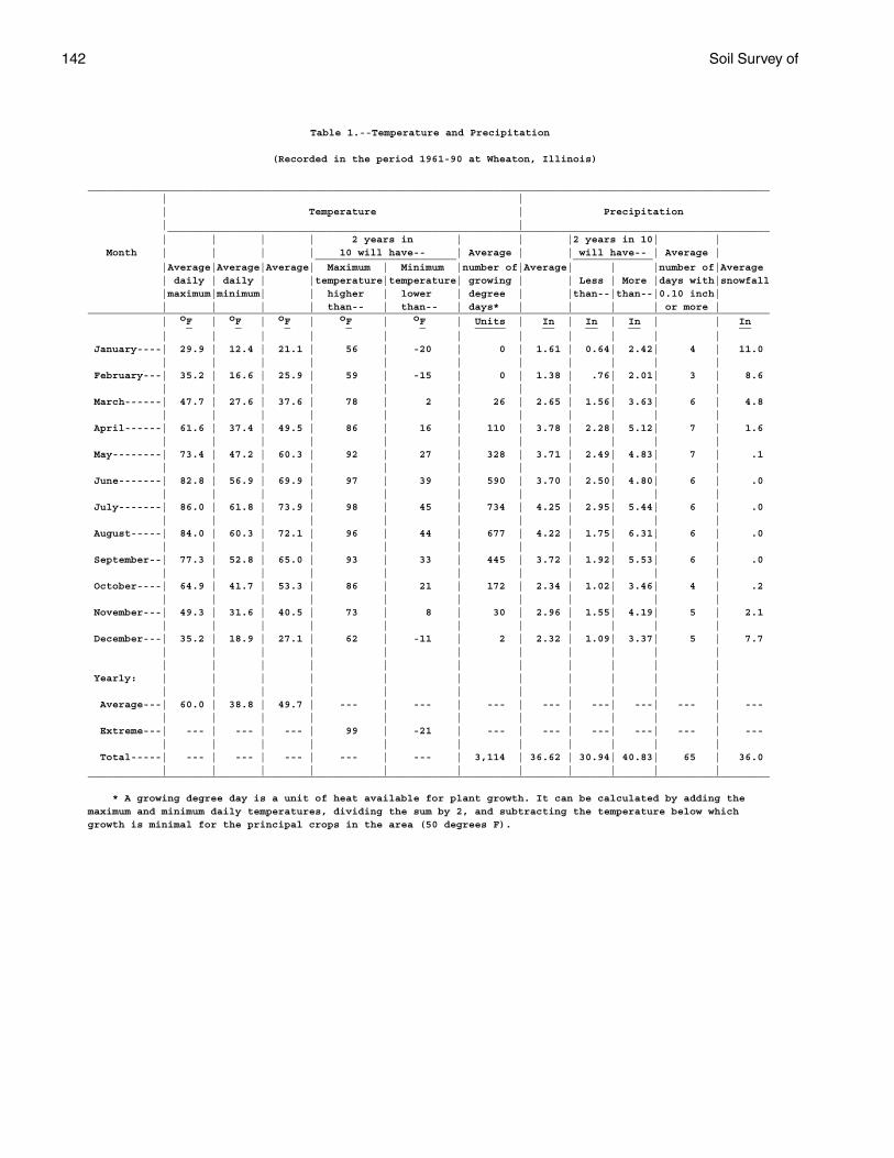
142 Soil Survey of
Table 1.--Temperature and Precipitation
(Recorded in the period 1961-90 at Wheaton, Illinois)
_______________________________________________________________________________________________________________ | | | Temperature | Precipitation | | __________________________________________________________________________________________________ | | | | 2 years in | | |2 years in 10| | Month | | | | 10 will have-- | Average | | will have-- | Average | _______________________ _____________ |Average|Average|Average| Maximum | Minimum |number of|Average| | |number of|Average | daily | daily | |temperature|temperature| growing | | Less | More |days with|snowfall |maximum|minimum| | higher | lower | degree | |than--|than--|0.10 inch| | | | | than-- | than-- | days* | | | | or more |_______________________________________________________________________________________________________________ | oF | oF | oF | oF | oF | Units | In | In | In | | In _ _ _ _ _ _____ __ __ __ __ | | | | | | | | | | | January----| 29.9 | 12.4 | 21.1 | 56 | -20 | 0 | 1.61 | 0.64| 2.42| 4 | 11.0 | | | | | | | | | | | February---| 35.2 | 16.6 | 25.9 | 59 | -15 | 0 | 1.38 | .76| 2.01| 3 | 8.6 | | | | | | | | | | | March------| 47.7 | 27.6 | 37.6 | 78 | 2 | 26 | 2.65 | 1.56| 3.63| 6 | 4.8 | | | | | | | | | | | April------| 61.6 | 37.4 | 49.5 | 86 | 16 | 110 | 3.78 | 2.28| 5.12| 7 | 1.6 | | | | | | | | | | | May--------| 73.4 | 47.2 | 60.3 | 92 | 27 | 328 | 3.71 | 2.49| 4.83| 7 | .1 | | | | | | | | | | | June-------| 82.8 | 56.9 | 69.9 | 97 | 39 | 590 | 3.70 | 2.50| 4.80| 6 | .0 | | | | | | | | | | | July-------| 86.0 | 61.8 | 73.9 | 98 | 45 | 734 | 4.25 | 2.95| 5.44| 6 | .0 | | | | | | | | | | | August-----| 84.0 | 60.3 | 72.1 | 96 | 44 | 677 | 4.22 | 1.75| 6.31| 6 | .0 | | | | | | | | | | | September--| 77.3 | 52.8 | 65.0 | 93 | 33 | 445 | 3.72 | 1.92| 5.53| 6 | .0 | | | | | | | | | | | October----| 64.9 | 41.7 | 53.3 | 86 | 21 | 172 | 2.34 | 1.02| 3.46| 4 | .2 | | | | | | | | | | | November---| 49.3 | 31.6 | 40.5 | 73 | 8 | 30 | 2.96 | 1.55| 4.19| 5 | 2.1 | | | | | | | | | | | December---| 35.2 | 18.9 | 27.1 | 62 | -11 | 2 | 2.32 | 1.09| 3.37| 5 | 7.7 | | | | | | | | | | | | | | | | | | | | | | Yearly: | | | | | | | | | | | | | | | | | | | | | | Average---| 60.0 | 38.8 | 49.7 | --- | --- | --- | --- | ---| ---| --- | --- | | | | | | | | | | | Extreme---| --- | --- | --- | 99 | -21 | --- | --- | ---| ---| --- | --- | | | | | | | | | | | Total-----| --- | --- | --- | --- | --- | 3,114 | 36.62 | 30.94| 40.83| 65 | 36.0 | | | | | | | | | | |_______________________________________________________________________________________________________________
* A growing degree day is a unit of heat available for plant growth. It can be calculated by adding themaximum and minimum daily temperatures, dividing the sum by 2, and subtracting the temperature below whichgrowth is minimal for the principal crops in the area (50 degrees F).
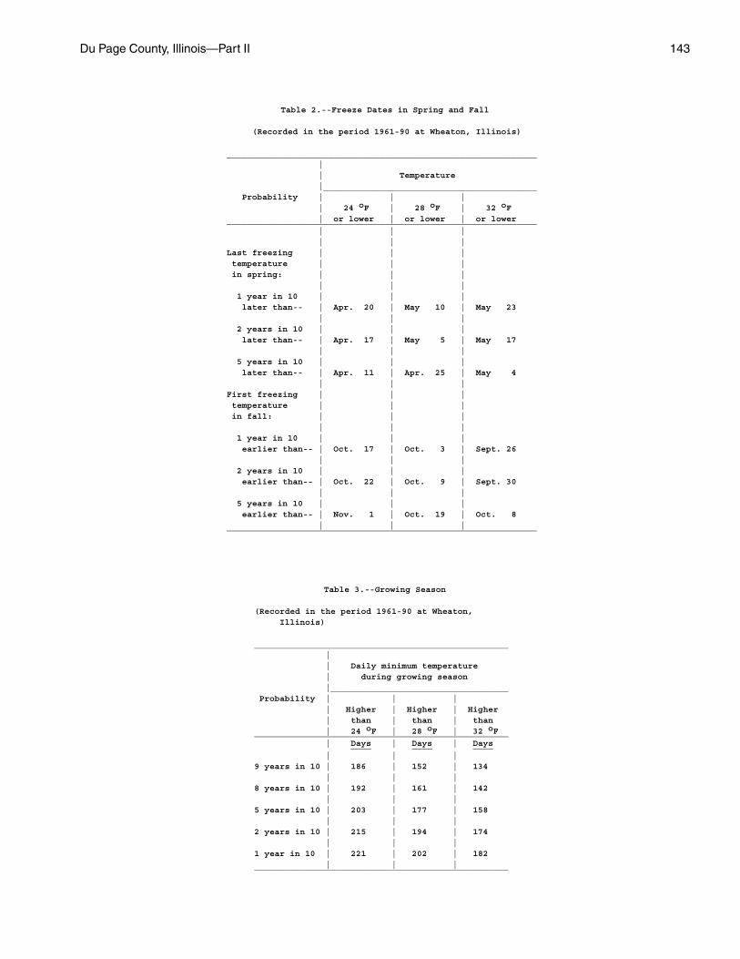
Du Page County, Illinois—Part II 143
Table 2.--Freeze Dates in Spring and Fall
(Recorded in the period 1961-90 at Wheaton, Illinois)
_____________________________________________________________ | | Temperature |__________________________________________ Probability | | | | 24 oF | 28 oF | 32 oF | or lower | or lower | or lower _____________________________________________________________ | | | | | | Last freezing | | | temperature | | | in spring: | | | | | | 1 year in 10 | | | later than-- | Apr. 20 | May 10 | May 23 | | | 2 years in 10 | | | later than-- | Apr. 17 | May 5 | May 17 | | | 5 years in 10 | | | later than-- | Apr. 11 | Apr. 25 | May 4 | | | First freezing | | | temperature | | | in fall: | | | | | | 1 year in 10 | | | earlier than-- | Oct. 17 | Oct. 3 | Sept. 26 | | | 2 years in 10 | | | earlier than-- | Oct. 22 | Oct. 9 | Sept. 30 | | | 5 years in 10 | | | earlier than-- | Nov. 1 | Oct. 19 | Oct. 8 | | | _____________________________________________________________
Table 3.--Growing Season
(Recorded in the period 1961-90 at Wheaton, Illinois)
__________________________________________________ | | Daily minimum temperature | during growing season |___________________________________ Probability | | | | Higher | Higher | Higher | than | than | than | 24 oF | 28 oF | 32 oF__________________________________________________ | Days | Days | Days ____ ____ ____ | | |9 years in 10 | 186 | 152 | 134 | | |8 years in 10 | 192 | 161 | 142 | | |5 years in 10 | 203 | 177 | 158 | | |2 years in 10 | 215 | 194 | 174 | | |1 year in 10 | 221 | 202 | 182 | | |__________________________________________________
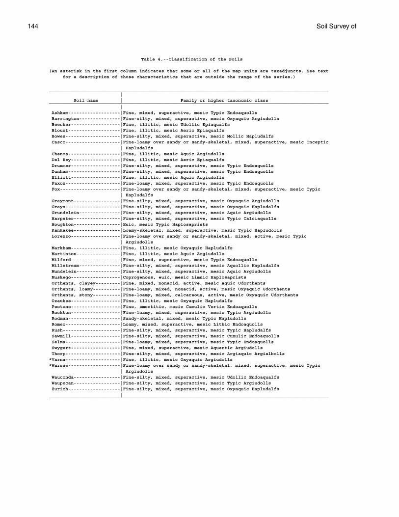
144 Soil Survey of
Table 4.--Classification of the Soils
(An asterisk in the first column indicates that some or all of the map units are taxadjuncts. See text for a description of those characteristics that are outside the range of the series.)
______________________________________________________________________________________________________ | Soil name | Family or higher taxonomic class______________________________________________________________________________________________________ | Ashkum-------------------|Fine, mixed, superactive, mesic Typic Endoaquolls Barrington---------------|Fine-silty, mixed, superactive, mesic Oxyaquic Argiudolls Beecher------------------|Fine, illitic, mesic Udollic Epiaqualfs Blount-------------------|Fine, illitic, mesic Aeric Epiaqualfs Bowes--------------------|Fine-silty, mixed, superactive, mesic Mollic Hapludalfs Casco--------------------|Fine-loamy over sandy or sandy-skeletal, mixed, superactive, mesic Inceptic | Hapludalfs Chenoa-------------------|Fine, illitic, mesic Aquic Argiudolls Del Rey------------------|Fine, illitic, mesic Aeric Epiaqualfs Drummer------------------|Fine-silty, mixed, superactive, mesic Typic Endoaquolls Dunham-------------------|Fine-silty, mixed, superactive, mesic Typic Endoaquolls Elliott------------------|Fine, illitic, mesic Aquic Argiudolls Faxon--------------------|Fine-loamy, mixed, superactive, mesic Typic Endoaquolls Fox----------------------|Fine-loamy over sandy or sandy-skeletal, mixed, superactive, mesic Typic | Hapludalfs Graymont-----------------|Fine-silty, mixed, superactive, mesic Oxyaquic Argiudolls Grays--------------------|Fine-silty, mixed, superactive, mesic Oxyaquic Hapludalfs Grundelein---------------|Fine-silty, mixed, superactive, mesic Aquic Argiudolls Harpster-----------------|Fine-silty, mixed, superactive, mesic Typic Calciaquolls Houghton-----------------|Euic, mesic Typic Haplosaprists Kankakee-----------------|Loamy-skeletal, mixed, superactive, mesic Typic Hapludolls Lorenzo------------------|Fine-loamy over sandy or sandy-skeletal, mixed, active, mesic Typic | Argiudolls Markham------------------|Fine, illitic, mesic Oxyaquic Hapludalfs Martinton----------------|Fine, illitic, mesic Aquic Argiudolls Milford------------------|Fine, mixed, superactive, mesic Typic Endoaquolls Millstream---------------|Fine-silty, mixed, superactive, mesic Aquollic Hapludalfs Mundelein----------------|Fine-silty, mixed, superactive, mesic Aquic Argiudolls Muskego------------------|Coprogenous, euic, mesic Limnic Haplosaprists Orthents, clayey---------|Fine, mixed, nonacid, active, mesic Aquic Udorthents Orthents, loamy----------|Fine-loamy, mixed, nonacid, active, mesic Oxyaquic Udorthents Orthents, stony----------|Fine-loamy, mixed, calcareous, active, mesic Oxyaquic Udorthents Ozaukee------------------|Fine, illitic, mesic Oxyaquic Hapludalfs Peotone------------------|Fine, smectitic, mesic Cumulic Vertic Endoaquolls Rockton------------------|Fine-loamy, mixed, superactive, mesic Typic Argiudolls Rodman-------------------|Sandy-skeletal, mixed, mesic Typic Hapludolls Romeo--------------------|Loamy, mixed, superactive, mesic Lithic Endoaquolls Rush---------------------|Fine-silty, mixed, superactive, mesic Typic Hapludalfs Sawmill------------------|Fine-silty, mixed, superactive, mesic Cumulic Endoaquolls Selma--------------------|Fine-loamy, mixed, superactive, mesic Typic Endoaquolls Swygert------------------|Fine, mixed, superactive, mesic Aquertic Argiudolls Thorp--------------------|Fine-silty, mixed, superactive, mesic Argiaquic Argialbolls*Varna--------------------|Fine, illitic, mesic Oxyaquic Argiudolls*Warsaw-------------------|Fine-loamy over sandy or sandy-skeletal, mixed, superactive, mesic Typic | Argiudolls Wauconda-----------------|Fine-silty, mixed, superactive, mesic Udollic Endoaqualfs Waupecan-----------------|Fine-silty, mixed, superactive, mesic Typic Argiudolls Zurich-------------------|Fine-silty, mixed, superactive, mesic Oxyaquic Hapludalfs |______________________________________________________________________________________________________
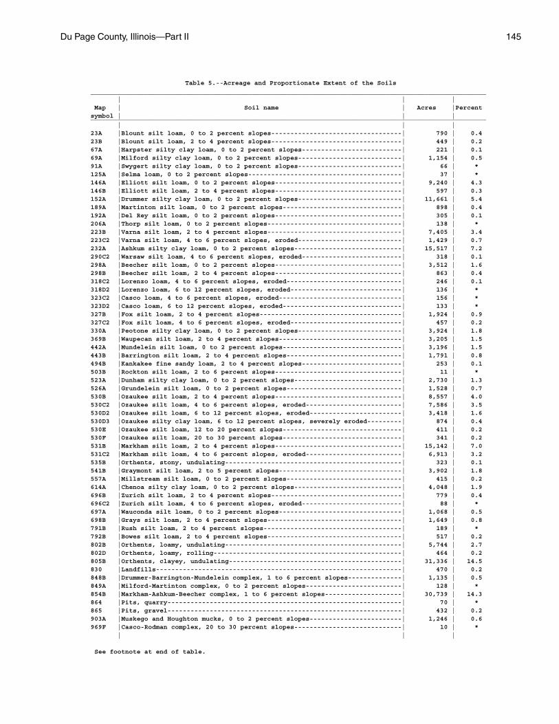
Du Page County, Illinois—Part II 145
Table 5.--Acreage and Proportionate Extent of the Soils_______________________________________________________________________________________________________ | | | Map | Soil name | Acres |Percentsymbol | | |_______________________________________________________________________________________________________ | | |23A |Blount silt loam, 0 to 2 percent slopes----------------------------------| 790 | 0.423B |Blount silt loam, 2 to 4 percent slopes----------------------------------| 449 | 0.267A |Harpster silty clay loam, 0 to 2 percent slopes--------------------------| 221 | 0.169A |Milford silty clay loam, 0 to 2 percent slopes---------------------------| 1,154 | 0.591A |Swygert silty clay loam, 0 to 2 percent slopes---------------------------| 66 | *125A |Selma loam, 0 to 2 percent slopes----------------------------------------| 37 | *146A |Elliott silt loam, 0 to 2 percent slopes---------------------------------| 9,240 | 4.3146B |Elliott silt loam, 2 to 4 percent slopes---------------------------------| 597 | 0.3152A |Drummer silty clay loam, 0 to 2 percent slopes---------------------------| 11,661 | 5.4189A |Martinton silt loam, 0 to 2 percent slopes-------------------------------| 898 | 0.4192A |Del Rey silt loam, 0 to 2 percent slopes---------------------------------| 305 | 0.1206A |Thorp silt loam, 0 to 2 percent slopes-----------------------------------| 138 | *223B |Varna silt loam, 2 to 4 percent slopes-----------------------------------| 7,405 | 3.4223C2 |Varna silt loam, 4 to 6 percent slopes, eroded---------------------------| 1,429 | 0.7232A |Ashkum silty clay loam, 0 to 2 percent slopes----------------------------| 15,517 | 7.2290C2 |Warsaw silt loam, 4 to 6 percent slopes, eroded--------------------------| 318 | 0.1298A |Beecher silt loam, 0 to 2 percent slopes---------------------------------| 3,512 | 1.6298B |Beecher silt loam, 2 to 4 percent slopes---------------------------------| 863 | 0.4318C2 |Lorenzo loam, 4 to 6 percent slopes, eroded------------------------------| 246 | 0.1318D2 |Lorenzo loam, 6 to 12 percent slopes, eroded-----------------------------| 136 | *323C2 |Casco loam, 4 to 6 percent slopes, eroded--------------------------------| 156 | *323D2 |Casco loam, 6 to 12 percent slopes, eroded-------------------------------| 133 | *327B |Fox silt loam, 2 to 4 percent slopes-------------------------------------| 1,924 | 0.9327C2 |Fox silt loam, 4 to 6 percent slopes, eroded-----------------------------| 457 | 0.2330A |Peotone silty clay loam, 0 to 2 percent slopes---------------------------| 3,924 | 1.8369B |Waupecan silt loam, 2 to 4 percent slopes--------------------------------| 3,205 | 1.5442A |Mundelein silt loam, 0 to 2 percent slopes-------------------------------| 3,196 | 1.5443B |Barrington silt loam, 2 to 4 percent slopes------------------------------| 1,791 | 0.8494B |Kankakee fine sandy loam, 2 to 4 percent slopes--------------------------| 253 | 0.1503B |Rockton silt loam, 2 to 6 percent slopes---------------------------------| 11 | *523A |Dunham silty clay loam, 0 to 2 percent slopes----------------------------| 2,730 | 1.3526A |Grundelein silt loam, 0 to 2 percent slopes------------------------------| 1,528 | 0.7530B |Ozaukee silt loam, 2 to 4 percent slopes---------------------------------| 8,557 | 4.0530C2 |Ozaukee silt loam, 4 to 6 percent slopes, eroded-------------------------| 7,586 | 3.5530D2 |Ozaukee silt loam, 6 to 12 percent slopes, eroded------------------------| 3,418 | 1.6530D3 |Ozaukee silty clay loam, 6 to 12 percent slopes, severely eroded---------| 874 | 0.4530E |Ozaukee silt loam, 12 to 20 percent slopes-------------------------------| 411 | 0.2530F |Ozaukee silt loam, 20 to 30 percent slopes-------------------------------| 341 | 0.2531B |Markham silt loam, 2 to 4 percent slopes---------------------------------| 15,142 | 7.0531C2 |Markham silt loam, 4 to 6 percent slopes, eroded-------------------------| 6,913 | 3.2535B |Orthents, stony, undulating----------------------------------------------| 323 | 0.1541B |Graymont silt loam, 2 to 5 percent slopes--------------------------------| 3,902 | 1.8557A |Millstream silt loam, 0 to 2 percent slopes------------------------------| 415 | 0.2614A |Chenoa silty clay loam, 0 to 2 percent slopes----------------------------| 4,048 | 1.9696B |Zurich silt loam, 2 to 4 percent slopes----------------------------------| 779 | 0.4696C2 |Zurich silt loam, 4 to 6 percent slopes, eroded--------------------------| 88 | *697A |Wauconda silt loam, 0 to 2 percent slopes--------------------------------| 1,068 | 0.5698B |Grays silt loam, 2 to 4 percent slopes-----------------------------------| 1,649 | 0.8791B |Rush silt loam, 2 to 4 percent slopes------------------------------------| 189 | *792B |Bowes silt loam, 2 to 4 percent slopes-----------------------------------| 517 | 0.2802B |Orthents, loamy, undulating----------------------------------------------| 5,744 | 2.7802D |Orthents, loamy, rolling-------------------------------------------------| 464 | 0.2805B |Orthents, clayey, undulating---------------------------------------------| 31,336 | 14.5830 |Landfills----------------------------------------------------------------| 470 | 0.2848B |Drummer-Barrington-Mundelein complex, 1 to 6 percent slopes--------------| 1,135 | 0.5849A |Milford-Martinton complex, 0 to 2 percent slopes-------------------------| 128 | *854B |Markham-Ashkum-Beecher complex, 1 to 6 percent slopes--------------------| 30,739 | 14.3864 |Pits, quarry-------------------------------------------------------------| 70 | *865 |Pits, gravel-------------------------------------------------------------| 432 | 0.2903A |Muskego and Houghton mucks, 0 to 2 percent slopes------------------------| 1,246 | 0.6969F |Casco-Rodman complex, 20 to 30 percent slopes----------------------------| 10 | * | | |
See footnote at end of table.
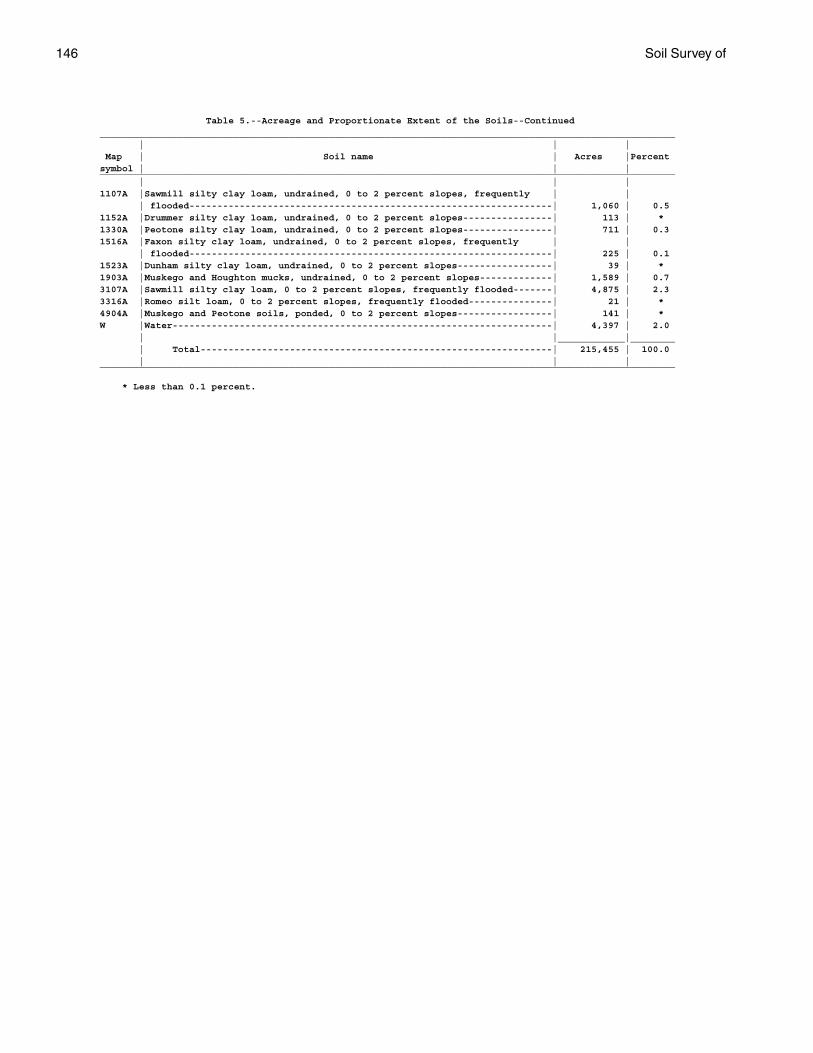
146 Soil Survey of
Table 5.--Acreage and Proportionate Extent of the Soils--Continued_______________________________________________________________________________________________________ | | | Map | Soil name | Acres |Percentsymbol | | |_______________________________________________________________________________________________________ | | |1107A |Sawmill silty clay loam, undrained, 0 to 2 percent slopes, frequently | | | flooded-----------------------------------------------------------------| 1,060 | 0.51152A |Drummer silty clay loam, undrained, 0 to 2 percent slopes----------------| 113 | *1330A |Peotone silty clay loam, undrained, 0 to 2 percent slopes----------------| 711 | 0.31516A |Faxon silty clay loam, undrained, 0 to 2 percent slopes, frequently | | | flooded-----------------------------------------------------------------| 225 | 0.11523A |Dunham silty clay loam, undrained, 0 to 2 percent slopes-----------------| 39 | *1903A |Muskego and Houghton mucks, undrained, 0 to 2 percent slopes-------------| 1,589 | 0.73107A |Sawmill silty clay loam, 0 to 2 percent slopes, frequently flooded-------| 4,875 | 2.33316A |Romeo silt loam, 0 to 2 percent slopes, frequently flooded---------------| 21 | *4904A |Muskego and Peotone soils, ponded, 0 to 2 percent slopes-----------------| 141 | *W |Water--------------------------------------------------------------------| 4,397 | 2.0 | |____________|________ | Total---------------------------------------------------------------| 215,455 | 100.0 | | |_______________________________________________________________________________________________________
* Less than 0.1 percent.
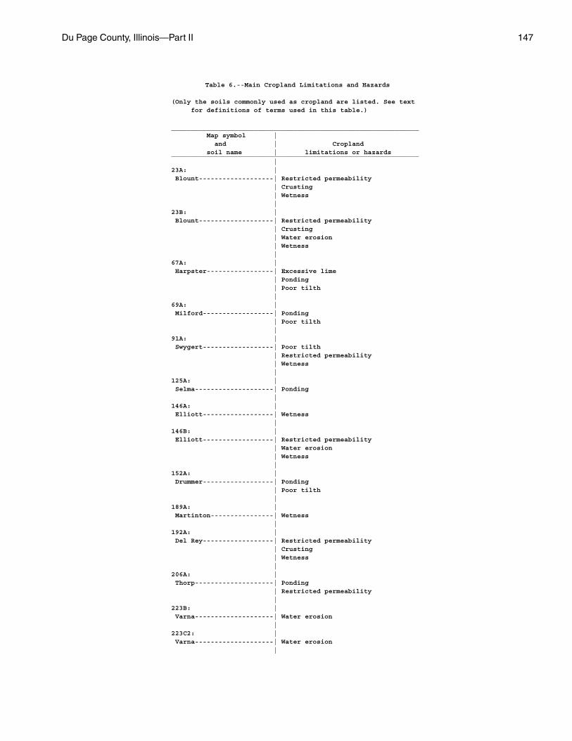
Du Page County, Illinois—Part II 147
Table 6.--Main Cropland Limitations and Hazards
(Only the soils commonly used as cropland are listed. See text for definitions of terms used in this table.)
_______________________________________________________________ Map symbol | and | Cropland soil name | limitations or hazards_______________________________________________________________ |23A: | Blount-------------------| Restricted permeability | Crusting | Wetness |23B: | Blount-------------------| Restricted permeability | Crusting | Water erosion | Wetness |67A: | Harpster-----------------| Excessive lime | Ponding | Poor tilth |69A: | Milford------------------| Ponding | Poor tilth |91A: | Swygert------------------| Poor tilth | Restricted permeability | Wetness |125A: | Selma--------------------| Ponding |146A: | Elliott------------------| Wetness |146B: | Elliott------------------| Restricted permeability | Water erosion | Wetness |152A: | Drummer------------------| Ponding | Poor tilth |189A: | Martinton----------------| Wetness |192A: | Del Rey------------------| Restricted permeability | Crusting | Wetness |206A: | Thorp--------------------| Ponding | Restricted permeability |223B: | Varna--------------------| Water erosion |223C2: | Varna--------------------| Water erosion |
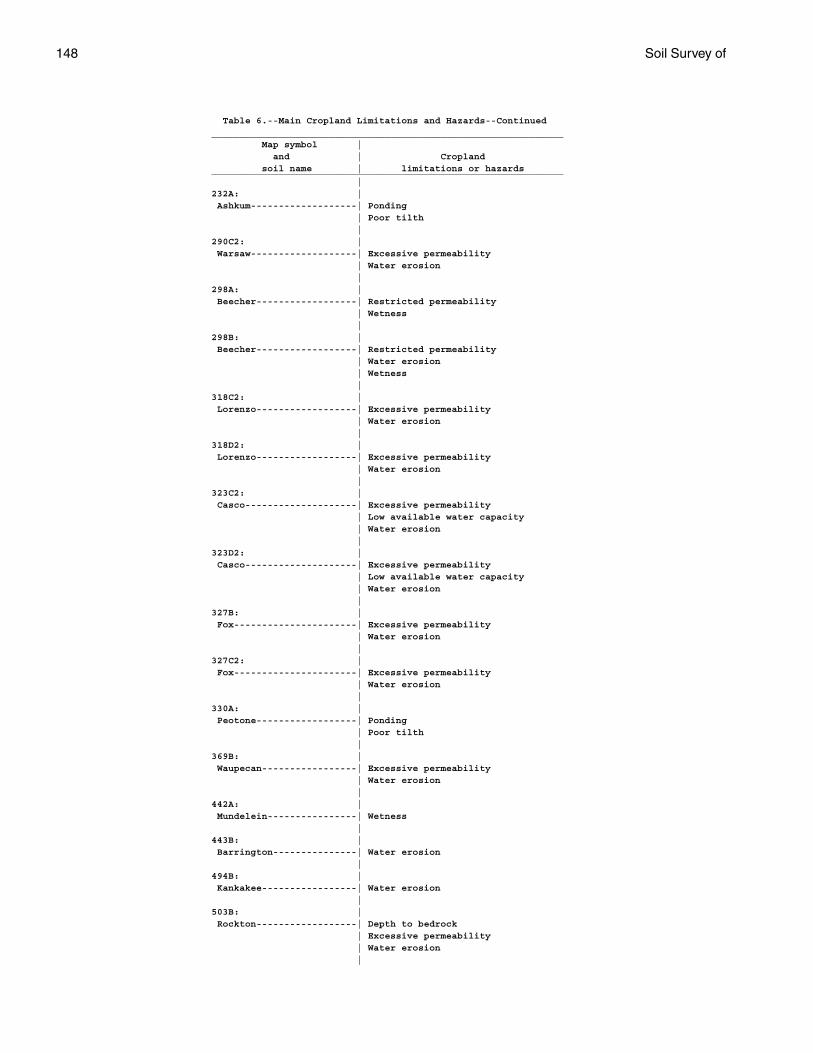
148 Soil Survey of
Table 6.--Main Cropland Limitations and Hazards--Continued_______________________________________________________________ Map symbol | and | Cropland soil name | limitations or hazards_______________________________________________________________ |232A: | Ashkum-------------------| Ponding | Poor tilth |290C2: | Warsaw-------------------| Excessive permeability | Water erosion |298A: | Beecher------------------| Restricted permeability | Wetness |298B: | Beecher------------------| Restricted permeability | Water erosion | Wetness |318C2: | Lorenzo------------------| Excessive permeability | Water erosion |318D2: | Lorenzo------------------| Excessive permeability | Water erosion |323C2: | Casco--------------------| Excessive permeability | Low available water capacity | Water erosion |323D2: | Casco--------------------| Excessive permeability | Low available water capacity | Water erosion |327B: | Fox----------------------| Excessive permeability | Water erosion |327C2: | Fox----------------------| Excessive permeability | Water erosion |330A: | Peotone------------------| Ponding | Poor tilth |369B: | Waupecan-----------------| Excessive permeability | Water erosion |442A: | Mundelein----------------| Wetness |443B: | Barrington---------------| Water erosion |494B: | Kankakee-----------------| Water erosion |503B: | Rockton------------------| Depth to bedrock | Excessive permeability | Water erosion |
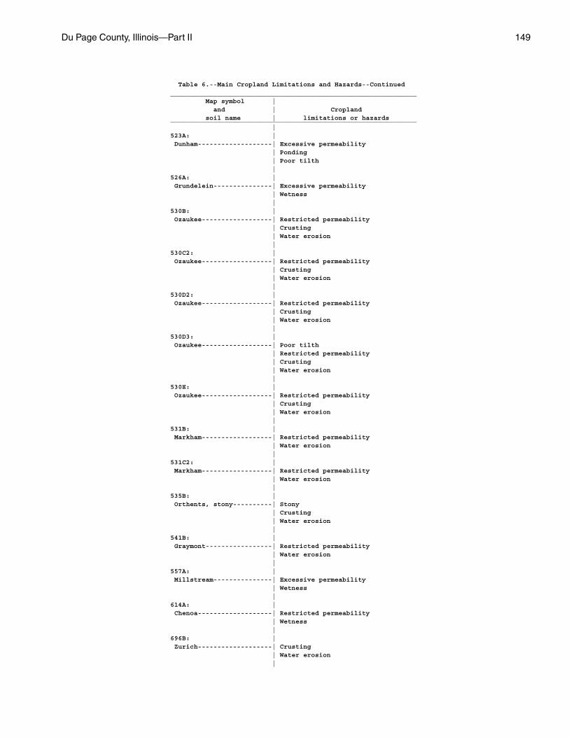
Du Page County, Illinois—Part II 149
Table 6.--Main Cropland Limitations and Hazards--Continued_______________________________________________________________ Map symbol | and | Cropland soil name | limitations or hazards_______________________________________________________________ |523A: | Dunham-------------------| Excessive permeability | Ponding | Poor tilth |526A: | Grundelein---------------| Excessive permeability | Wetness |530B: | Ozaukee------------------| Restricted permeability | Crusting | Water erosion |530C2: | Ozaukee------------------| Restricted permeability | Crusting | Water erosion |530D2: | Ozaukee------------------| Restricted permeability | Crusting | Water erosion |530D3: | Ozaukee------------------| Poor tilth | Restricted permeability | Crusting | Water erosion |530E: | Ozaukee------------------| Restricted permeability | Crusting | Water erosion |531B: | Markham------------------| Restricted permeability | Water erosion |531C2: | Markham------------------| Restricted permeability | Water erosion |535B: | Orthents, stony----------| Stony | Crusting | Water erosion |541B: | Graymont-----------------| Restricted permeability | Water erosion |557A: | Millstream---------------| Excessive permeability | Wetness |614A: | Chenoa-------------------| Restricted permeability | Wetness |696B: | Zurich-------------------| Crusting | Water erosion |
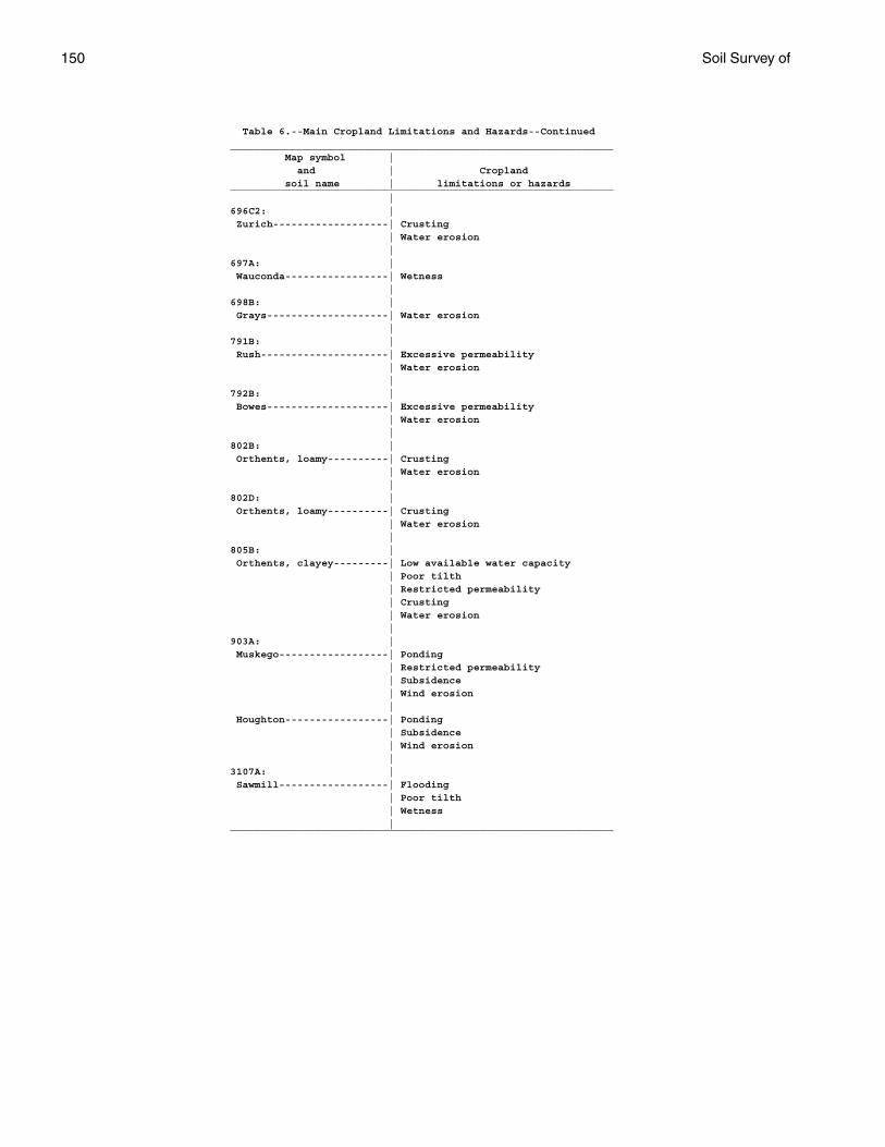
150 Soil Survey of
Table 6.--Main Cropland Limitations and Hazards--Continued_______________________________________________________________ Map symbol | and | Cropland soil name | limitations or hazards_______________________________________________________________ |696C2: | Zurich-------------------| Crusting | Water erosion |697A: | Wauconda-----------------| Wetness |698B: | Grays--------------------| Water erosion |791B: | Rush---------------------| Excessive permeability | Water erosion |792B: | Bowes--------------------| Excessive permeability | Water erosion |802B: | Orthents, loamy----------| Crusting | Water erosion |802D: | Orthents, loamy----------| Crusting | Water erosion |805B: | Orthents, clayey---------| Low available water capacity | Poor tilth | Restricted permeability | Crusting | Water erosion |903A: | Muskego------------------| Ponding | Restricted permeability | Subsidence | Wind erosion | Houghton-----------------| Ponding | Subsidence | Wind erosion |3107A: | Sawmill------------------| Flooding | Poor tilth | Wetness |_______________________________________________________________
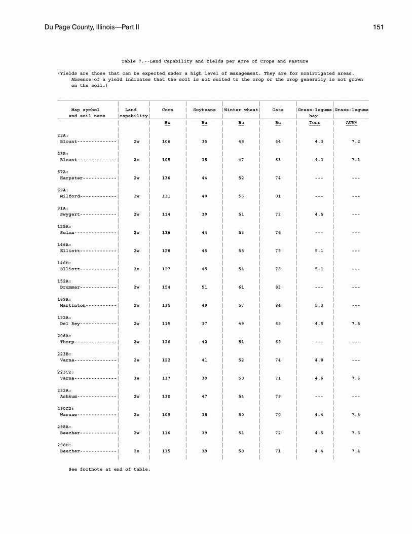
Du Page County, Illinois—Part II 151
Table 7.--Land Capability and Yields per Acre of Crops and Pasture
(Yields are those that can be expected under a high level of management. They are for nonirrigated areas. Absence of a yield indicates that the soil is not suited to the crop or the crop generally is not grown on the soil.)
______________________________________________________________________________________________________________ | | | | | | | Map symbol | Land | Corn | Soybeans |Winter wheat| Oats |Grass-legume|Grass-legume and soil name |capability| | | | | hay |______________________________________________________________________________________________________________ | | Bu | Bu | Bu | Bu | Tons | AUM* __ __ __ __ ____ ____ | | | | | | |23A: | | | | | | | Blount--------------| 2w | 106 | 35 | 48 | 64 | 4.3 | 7.2 | | | | | | |23B: | | | | | | | Blount--------------| 2e | 105 | 35 | 47 | 63 | 4.3 | 7.1 | | | | | | |67A: | | | | | | | Harpster------------| 2w | 136 | 44 | 52 | 74 | --- | --- | | | | | | |69A: | | | | | | | Milford-------------| 2w | 131 | 48 | 56 | 81 | --- | --- | | | | | | |91A: | | | | | | | Swygert-------------| 2w | 114 | 39 | 51 | 73 | 4.5 | --- | | | | | | |125A: | | | | | | | Selma---------------| 2w | 136 | 44 | 53 | 76 | --- | --- | | | | | | |146A: | | | | | | | Elliott-------------| 2w | 128 | 45 | 55 | 79 | 5.1 | --- | | | | | | |146B: | | | | | | | Elliott-------------| 2e | 127 | 45 | 54 | 78 | 5.1 | --- | | | | | | |152A: | | | | | | | Drummer-------------| 2w | 154 | 51 | 61 | 83 | --- | --- | | | | | | |189A: | | | | | | | Martinton-----------| 2w | 135 | 49 | 57 | 84 | 5.3 | --- | | | | | | |192A: | | | | | | | Del Rey-------------| 2w | 115 | 37 | 49 | 69 | 4.5 | 7.5 | | | | | | |206A: | | | | | | | Thorp---------------| 2w | 126 | 42 | 51 | 69 | --- | --- | | | | | | |223B: | | | | | | | Varna---------------| 2e | 122 | 41 | 52 | 74 | 4.8 | --- | | | | | | |223C2: | | | | | | | Varna---------------| 3e | 117 | 39 | 50 | 71 | 4.6 | 7.6 | | | | | | |232A: | | | | | | | Ashkum--------------| 2w | 130 | 47 | 54 | 79 | --- | --- | | | | | | |290C2: | | | | | | | Warsaw--------------| 2e | 109 | 38 | 50 | 70 | 4.4 | 7.3 | | | | | | |298A: | | | | | | | Beecher-------------| 2w | 116 | 39 | 51 | 72 | 4.5 | 7.5 | | | | | | |298B: | | | | | | | Beecher-------------| 2e | 115 | 39 | 50 | 71 | 4.4 | 7.4 | | | | | | |
See footnote at end of table.
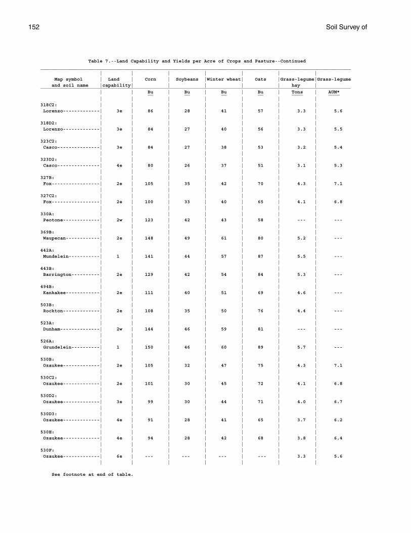
152 Soil Survey of
Table 7.--Land Capability and Yields per Acre of Crops and Pasture--Continued______________________________________________________________________________________________________________ | | | | | | | Map symbol | Land | Corn | Soybeans |Winter wheat| Oats |Grass-legume|Grass-legume and soil name |capability| | | | | hay |______________________________________________________________________________________________________________ | | Bu | Bu | Bu | Bu | Tons | AUM* __ __ __ __ ____ ____ | | | | | | |318C2: | | | | | | | Lorenzo-------------| 3e | 86 | 28 | 41 | 57 | 3.3 | 5.6 | | | | | | |318D2: | | | | | | | Lorenzo-------------| 3e | 84 | 27 | 40 | 56 | 3.3 | 5.5 | | | | | | |323C2: | | | | | | | Casco---------------| 3e | 84 | 27 | 38 | 53 | 3.2 | 5.4 | | | | | | |323D2: | | | | | | | Casco---------------| 4e | 80 | 26 | 37 | 51 | 3.1 | 5.3 | | | | | | |327B: | | | | | | | Fox-----------------| 2e | 105 | 35 | 42 | 70 | 4.3 | 7.1 | | | | | | |327C2: | | | | | | | Fox-----------------| 2e | 100 | 33 | 40 | 65 | 4.1 | 6.8 | | | | | | |330A: | | | | | | | Peotone-------------| 2w | 123 | 42 | 43 | 58 | --- | --- | | | | | | |369B: | | | | | | | Waupecan------------| 2e | 148 | 49 | 61 | 80 | 5.2 | --- | | | | | | |442A: | | | | | | | Mundelein-----------| 1 | 141 | 44 | 57 | 87 | 5.5 | --- | | | | | | |443B: | | | | | | | Barrington----------| 2e | 129 | 42 | 54 | 84 | 5.3 | --- | | | | | | |494B: | | | | | | | Kankakee------------| 2e | 111 | 40 | 51 | 69 | 4.6 | --- | | | | | | |503B: | | | | | | | Rockton-------------| 2e | 108 | 35 | 50 | 76 | 4.4 | --- | | | | | | |523A: | | | | | | | Dunham--------------| 2w | 144 | 46 | 59 | 81 | --- | --- | | | | | | |526A: | | | | | | | Grundelein----------| 1 | 150 | 46 | 60 | 89 | 5.7 | --- | | | | | | |530B: | | | | | | | Ozaukee-------------| 2e | 105 | 32 | 47 | 75 | 4.3 | 7.1 | | | | | | |530C2: | | | | | | | Ozaukee-------------| 2e | 101 | 30 | 45 | 72 | 4.1 | 6.8 | | | | | | |530D2: | | | | | | | Ozaukee-------------| 3e | 99 | 30 | 44 | 71 | 4.0 | 6.7 | | | | | | |530D3: | | | | | | | Ozaukee-------------| 4e | 91 | 28 | 41 | 65 | 3.7 | 6.2 | | | | | | |530E: | | | | | | | Ozaukee-------------| 4e | 94 | 28 | 42 | 68 | 3.8 | 6.4 | | | | | | |530F: | | | | | | | Ozaukee-------------| 6e | --- | --- | --- | --- | 3.3 | 5.6 | | | | | | |
See footnote at end of table.

Du Page County, Illinois—Part II 153
Table 7.--Land Capability and Yields per Acre of Crops and Pasture--Continued______________________________________________________________________________________________________________ | | | | | | | Map symbol | Land | Corn | Soybeans |Winter wheat| Oats |Grass-legume|Grass-legume and soil name |capability| | | | | hay |______________________________________________________________________________________________________________ | | Bu | Bu | Bu | Bu | Tons | AUM* __ __ __ __ ____ ____ | | | | | | |531B: | | | | | | | Markham-------------| 2e | 111 | 37 | 49 | 68 | 4.4 | 7.2 | | | | | | |531C2: | | | | | | | Markham-------------| 3e | 101 | 33 | 44 | 62 | 4.0 | 6.6 | | | | | | |535B: | | | | | | | Orthents, stony-----| 2e | 80 | 25 | 28 | 48 | 3.5 | 6.0 | | | | | | |541B: | | | | | | | Graymont------------| 2e | 138 | 46 | 59 | 83 | 5.5 | --- | | | | | | |557A: | | | | | | | Millstream----------| 1 | 135 | 42 | 57 | 79 | 5.2 | 8.7 | | | | | | |614A: | | | | | | | Chenoa--------------| 2w | 135 | 45 | 61 | 85 | 5.6 | --- | | | | | | |696B: | | | | | | | Zurich--------------| 2e | 116 | 37 | 49 | 68 | 4.7 | 7.7 | | | | | | |696C2: | | | | | | | Zurich--------------| 3e | 110 | 35 | 46 | 65 | 4.4 | 7.3 | | | | | | |697A: | | | | | | | Wauconda------------| 1 | 129 | 41 | 54 | 80 | 5.2 | 8.7 | | | | | | |698B: | | | | | | | Grays---------------| 2e | 123 | 40 | 51 | 76 | 4.9 | 8.2 | | | | | | |791B: | | | | | | | Rush----------------| 2e | 125 | 44 | 50 | 76 | 4.8 | 8.2 | | | | | | |792B: | | | | | | | Bowes---------------| 2e | 140 | 46 | 59 | 78 | 5.2 | 8.7 | | | | | | |802B: | | | | | | | Orthents, loamy-----| 2e | 85 | 27 | 30 | 50 | 3.7 | 6.2 | | | | | | |802D: | | | | | | | Orthents, loamy-----| 3e | 80 | 25 | 28 | 48 | 3.4 | 5.7 | | | | | | |805B: | | | | | | | Orthents, clayey----| 3e | 77 | 24 | 26 | 46 | 3.3 | 5.6 | | | | | | |830: | | | | | | | Landfills. | | | | | | | | | | | | | |848B-----------------| | --- | --- | --- | --- | --- | --- Drummer-------------| 2w | | | | | | | | | | | | | Barrington----------| 2e | | | | | | | | | | | | | Mundelein-----------| 1 | | | | | | | | | | | | |849A-----------------| 2w | --- | --- | --- | --- | --- | --- Milford-Martinton | | | | | | | | | | | | | |
See footnote at end of table.
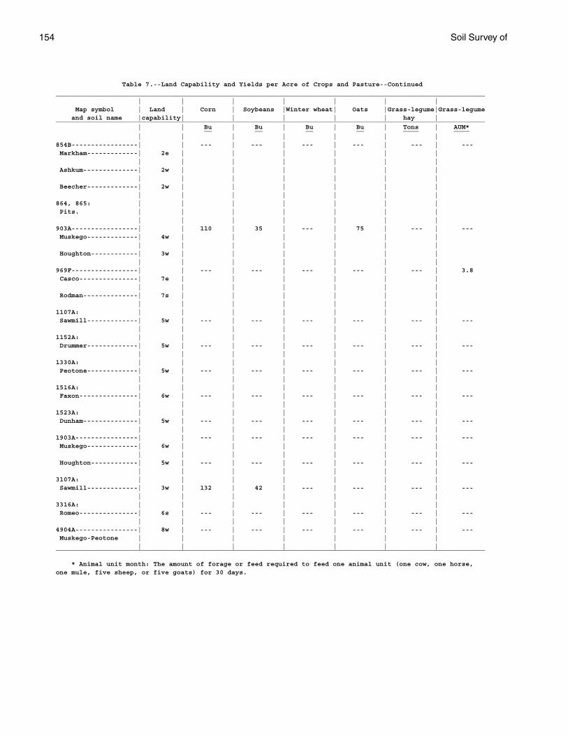
154 Soil Survey of
Table 7.--Land Capability and Yields per Acre of Crops and Pasture--Continued______________________________________________________________________________________________________________ | | | | | | | Map symbol | Land | Corn | Soybeans |Winter wheat| Oats |Grass-legume|Grass-legume and soil name |capability| | | | | hay |______________________________________________________________________________________________________________ | | Bu | Bu | Bu | Bu | Tons | AUM* __ __ __ __ ____ ____ | | | | | | |854B-----------------| | --- | --- | --- | --- | --- | --- Markham-------------| 2e | | | | | | | | | | | | | Ashkum--------------| 2w | | | | | | | | | | | | | Beecher-------------| 2w | | | | | | | | | | | | |864, 865: | | | | | | | Pits. | | | | | | | | | | | | | |903A-----------------| | 110 | 35 | --- | 75 | --- | --- Muskego-------------| 4w | | | | | | | | | | | | | Houghton------------| 3w | | | | | | | | | | | | |969F-----------------| | --- | --- | --- | --- | --- | 3.8 Casco---------------| 7e | | | | | | | | | | | | | Rodman--------------| 7s | | | | | | | | | | | | |1107A: | | | | | | | Sawmill-------------| 5w | --- | --- | --- | --- | --- | --- | | | | | | |1152A: | | | | | | | Drummer-------------| 5w | --- | --- | --- | --- | --- | --- | | | | | | |1330A: | | | | | | | Peotone-------------| 5w | --- | --- | --- | --- | --- | --- | | | | | | |1516A: | | | | | | | Faxon---------------| 6w | --- | --- | --- | --- | --- | --- | | | | | | |1523A: | | | | | | | Dunham--------------| 5w | --- | --- | --- | --- | --- | --- | | | | | | |1903A----------------| | --- | --- | --- | --- | --- | --- Muskego-------------| 6w | | | | | | | | | | | | | Houghton------------| 5w | --- | --- | --- | --- | --- | --- | | | | | | |3107A: | | | | | | | Sawmill-------------| 3w | 132 | 42 | --- | --- | --- | --- | | | | | | |3316A: | | | | | | | Romeo---------------| 6s | --- | --- | --- | --- | --- | --- | | | | | | |4904A----------------| 8w | --- | --- | --- | --- | --- | --- Muskego-Peotone | | | | | | | | | | | | | |______________________________________________________________________________________________________________
* Animal unit month: The amount of forage or feed required to feed one animal unit (one cow, one horse,one mule, five sheep, or five goats) for 30 days.
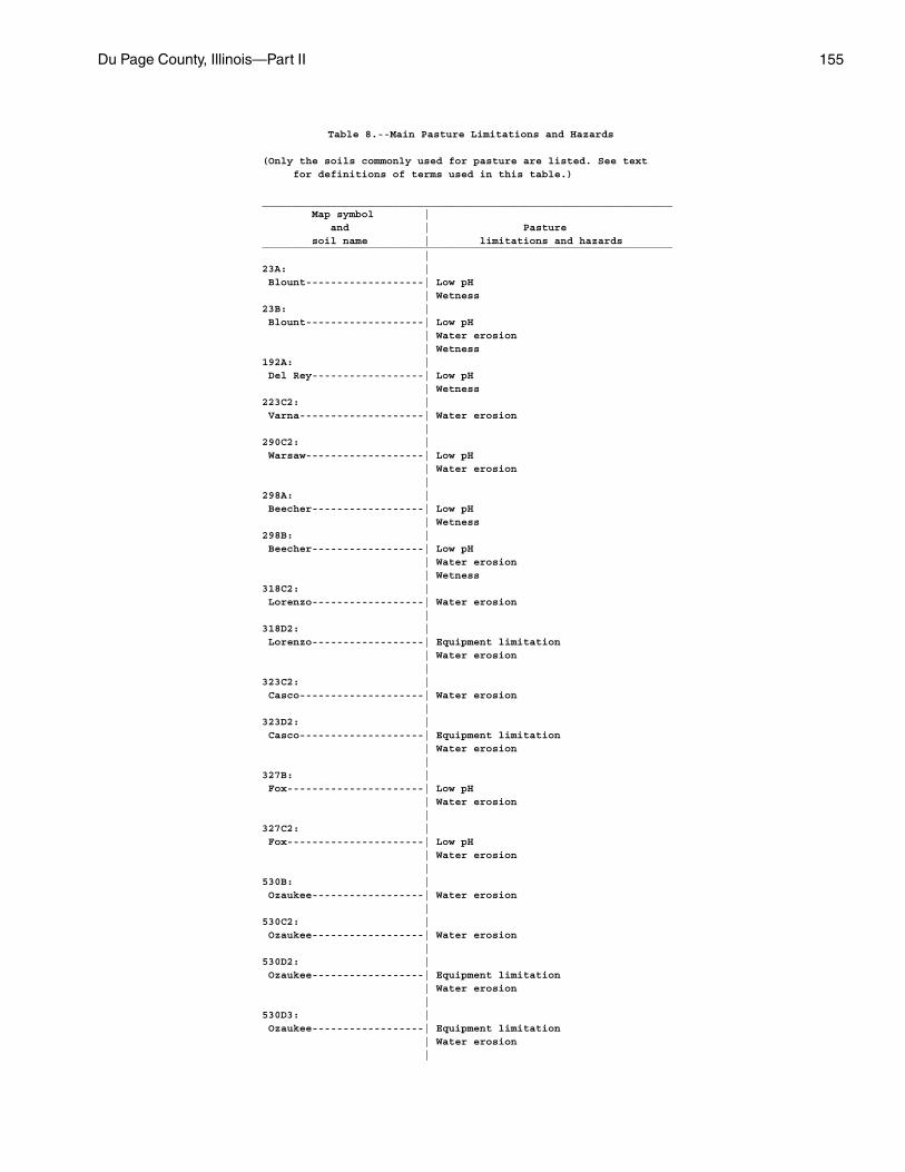
Du Page County, Illinois—Part II 155
Table 8.--Main Pasture Limitations and Hazards
(Only the soils commonly used for pasture are listed. See text for definitions of terms used in this table.)
__________________________________________________________________ Map symbol | and | Pasture soil name | limitations and hazards__________________________________________________________________ |23A: | Blount-------------------| Low pH | Wetness23B: | Blount-------------------| Low pH | Water erosion | Wetness192A: | Del Rey------------------| Low pH | Wetness223C2: | Varna--------------------| Water erosion |290C2: | Warsaw-------------------| Low pH | Water erosion |298A: | Beecher------------------| Low pH | Wetness298B: | Beecher------------------| Low pH | Water erosion | Wetness318C2: | Lorenzo------------------| Water erosion |318D2: | Lorenzo------------------| Equipment limitation | Water erosion |323C2: | Casco--------------------| Water erosion |323D2: | Casco--------------------| Equipment limitation | Water erosion |327B: | Fox----------------------| Low pH | Water erosion |327C2: | Fox----------------------| Low pH | Water erosion |530B: | Ozaukee------------------| Water erosion |530C2: | Ozaukee------------------| Water erosion |530D2: | Ozaukee------------------| Equipment limitation | Water erosion |530D3: | Ozaukee------------------| Equipment limitation | Water erosion |
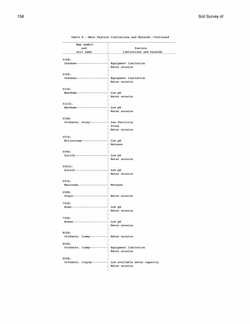
156 Soil Survey of
Table 8.--Main Pasture Limitations and Hazards--Continued__________________________________________________________________ Map symbol | and | Pasture soil name | limitations and hazards__________________________________________________________________ |530E: | Ozaukee------------------| Equipment limitation | Water erosion |530F: | Ozaukee------------------| Equipment limitation | Water erosion |531B: | Markham------------------| Low pH | Water erosion |531C2: | Markham------------------| Low pH | Water erosion |535B: | Orthents, stony----------| Low fertility | Stony | Water erosion |557A: | Millstream---------------| Low pH | Wetness |696B: | Zurich-------------------| Low pH | Water erosion |696C2: | Zurich-------------------| Low pH | Water erosion |697A: | Wauconda-----------------| Wetness |698B: | Grays--------------------| Water erosion |791B: | Rush---------------------| Low pH | Water erosion |792B: | Bowes--------------------| Low pH | Water erosion |802B: | Orthents, loamy----------| Water erosion |802D: | Orthents, loamy----------| Equipment limitation | Water erosion |805B: | Orthents, clayey---------| Low available water capacity | Water erosion |
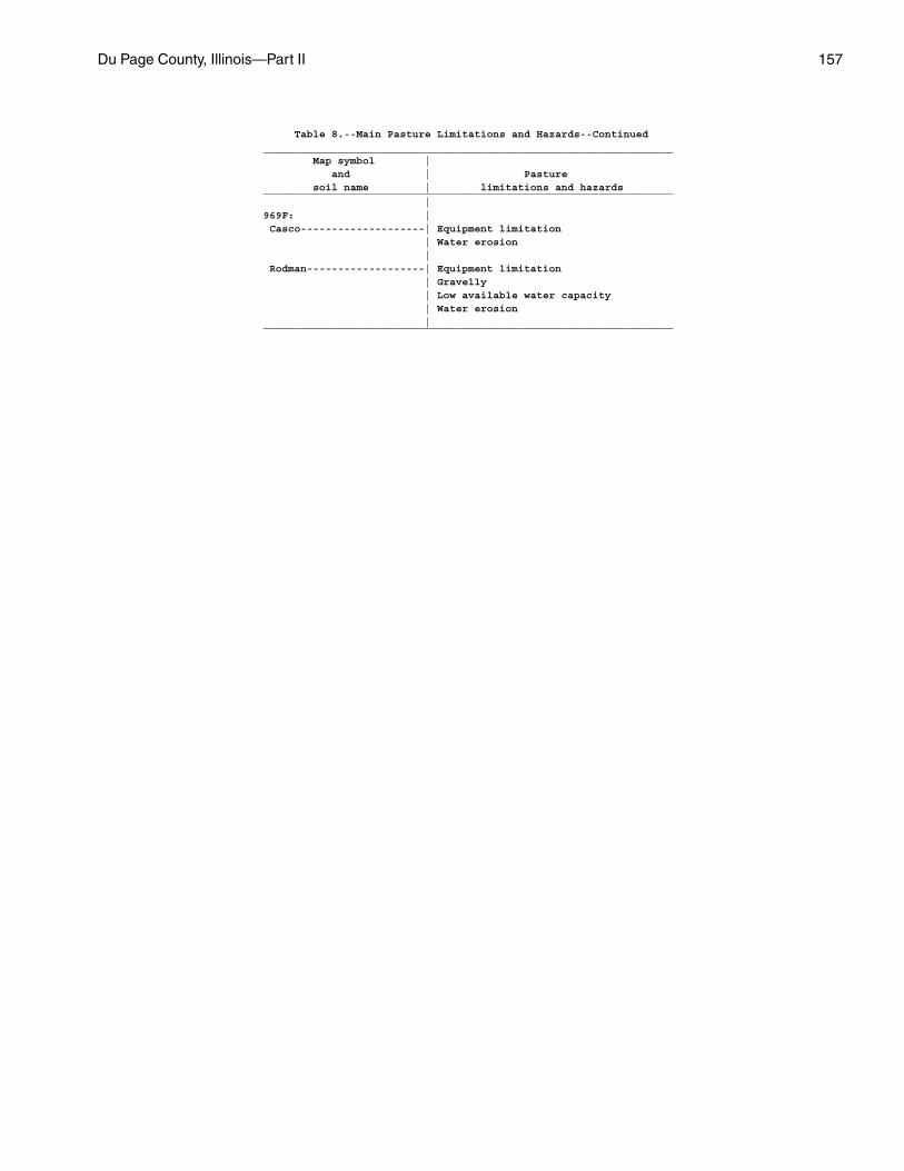
Du Page County, Illinois—Part II 157
Table 8.--Main Pasture Limitations and Hazards--Continued__________________________________________________________________ Map symbol | and | Pasture soil name | limitations and hazards__________________________________________________________________ |969F: | Casco--------------------| Equipment limitation | Water erosion | Rodman-------------------| Equipment limitation | Gravelly | Low available water capacity | Water erosion |__________________________________________________________________
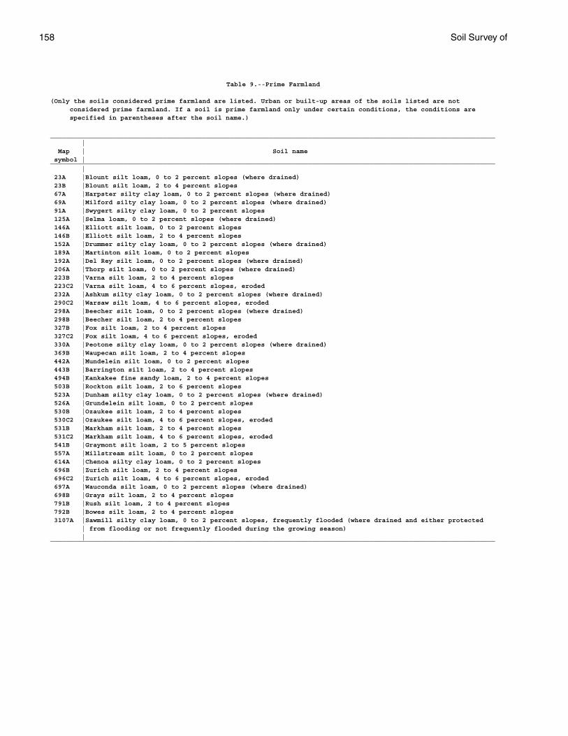
158 Soil Survey of
Table 9.--Prime Farmland
(Only the soils considered prime farmland are listed. Urban or built-up areas of the soils listed are not considered prime farmland. If a soil is prime farmland only under certain conditions, the conditions are specified in parentheses after the soil name.)
__________________________________________________________________________________________________________________ | Map | Soil name symbol |__________________________________________________________________________________________________________________ | 23A |Blount silt loam, 0 to 2 percent slopes (where drained) 23B |Blount silt loam, 2 to 4 percent slopes 67A |Harpster silty clay loam, 0 to 2 percent slopes (where drained) 69A |Milford silty clay loam, 0 to 2 percent slopes (where drained) 91A |Swygert silty clay loam, 0 to 2 percent slopes 125A |Selma loam, 0 to 2 percent slopes (where drained) 146A |Elliott silt loam, 0 to 2 percent slopes 146B |Elliott silt loam, 2 to 4 percent slopes 152A |Drummer silty clay loam, 0 to 2 percent slopes (where drained) 189A |Martinton silt loam, 0 to 2 percent slopes 192A |Del Rey silt loam, 0 to 2 percent slopes (where drained) 206A |Thorp silt loam, 0 to 2 percent slopes (where drained) 223B |Varna silt loam, 2 to 4 percent slopes 223C2 |Varna silt loam, 4 to 6 percent slopes, eroded 232A |Ashkum silty clay loam, 0 to 2 percent slopes (where drained) 290C2 |Warsaw silt loam, 4 to 6 percent slopes, eroded 298A |Beecher silt loam, 0 to 2 percent slopes (where drained) 298B |Beecher silt loam, 2 to 4 percent slopes 327B |Fox silt loam, 2 to 4 percent slopes 327C2 |Fox silt loam, 4 to 6 percent slopes, eroded 330A |Peotone silty clay loam, 0 to 2 percent slopes (where drained) 369B |Waupecan silt loam, 2 to 4 percent slopes 442A |Mundelein silt loam, 0 to 2 percent slopes 443B |Barrington silt loam, 2 to 4 percent slopes 494B |Kankakee fine sandy loam, 2 to 4 percent slopes 503B |Rockton silt loam, 2 to 6 percent slopes 523A |Dunham silty clay loam, 0 to 2 percent slopes (where drained) 526A |Grundelein silt loam, 0 to 2 percent slopes 530B |Ozaukee silt loam, 2 to 4 percent slopes 530C2 |Ozaukee silt loam, 4 to 6 percent slopes, eroded 531B |Markham silt loam, 2 to 4 percent slopes 531C2 |Markham silt loam, 4 to 6 percent slopes, eroded 541B |Graymont silt loam, 2 to 5 percent slopes 557A |Millstream silt loam, 0 to 2 percent slopes 614A |Chenoa silty clay loam, 0 to 2 percent slopes 696B |Zurich silt loam, 2 to 4 percent slopes 696C2 |Zurich silt loam, 4 to 6 percent slopes, eroded 697A |Wauconda silt loam, 0 to 2 percent slopes (where drained) 698B |Grays silt loam, 2 to 4 percent slopes 791B |Rush silt loam, 2 to 4 percent slopes 792B |Bowes silt loam, 2 to 4 percent slopes 3107A |Sawmill silty clay loam, 0 to 2 percent slopes, frequently flooded (where drained and either protected | from flooding or not frequently flooded during the growing season) |__________________________________________________________________________________________________________________
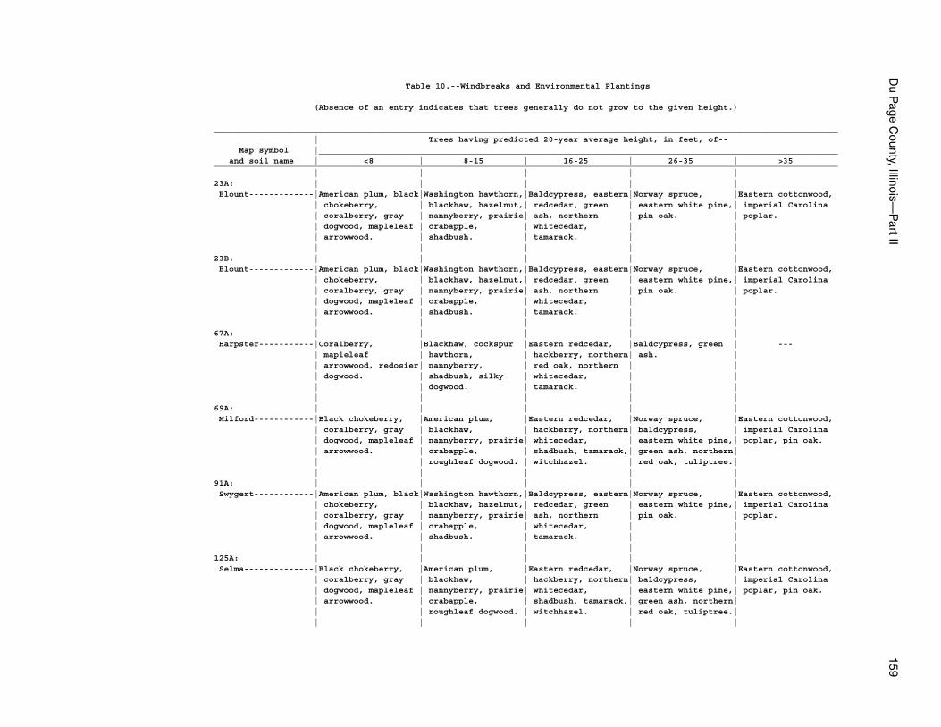
Du P
age County, Illinois—
Part II
159
Table 10.--Windbreaks and Environmental Plantings
(Absence of an entry indicates that trees generally do not grow to the given height.)
_____________________________________________________________________________________________________________________________ | Trees having predicted 20-year average height, in feet, of-- Map symbol |________________________________________________________________________________________________________ and soil name | <8 | 8-15 | 16-25 | 26-35 | >35_____________________________________________________________________________________________________________________________ | | | | |23A: | | | | | Blount-------------|American plum, black|Washington hawthorn,|Baldcypress, eastern|Norway spruce, |Eastern cottonwood, | chokeberry, | blackhaw, hazelnut,| redcedar, green | eastern white pine,| imperial Carolina | coralberry, gray | nannyberry, prairie| ash, northern | pin oak. | poplar. | dogwood, mapleleaf | crabapple, | whitecedar, | | | arrowwood. | shadbush. | tamarack. | | | | | | |23B: | | | | | Blount-------------|American plum, black|Washington hawthorn,|Baldcypress, eastern|Norway spruce, |Eastern cottonwood, | chokeberry, | blackhaw, hazelnut,| redcedar, green | eastern white pine,| imperial Carolina | coralberry, gray | nannyberry, prairie| ash, northern | pin oak. | poplar. | dogwood, mapleleaf | crabapple, | whitecedar, | | | arrowwood. | shadbush. | tamarack. | | | | | | |67A: | | | | | Harpster-----------|Coralberry, |Blackhaw, cockspur |Eastern redcedar, |Baldcypress, green | --- | mapleleaf | hawthorn, | hackberry, northern| ash. | | arrowwood, redosier| nannyberry, | red oak, northern | | | dogwood. | shadbush, silky | whitecedar, | | | | dogwood. | tamarack. | | | | | | |69A: | | | | | Milford------------|Black chokeberry, |American plum, |Eastern redcedar, |Norway spruce, |Eastern cottonwood, | coralberry, gray | blackhaw, | hackberry, northern| baldcypress, | imperial Carolina | dogwood, mapleleaf | nannyberry, prairie| whitecedar, | eastern white pine,| poplar, pin oak. | arrowwood. | crabapple, | shadbush, tamarack,| green ash, northern| | | roughleaf dogwood. | witchhazel. | red oak, tuliptree.| | | | | |91A: | | | | | Swygert------------|American plum, black|Washington hawthorn,|Baldcypress, eastern|Norway spruce, |Eastern cottonwood, | chokeberry, | blackhaw, hazelnut,| redcedar, green | eastern white pine,| imperial Carolina | coralberry, gray | nannyberry, prairie| ash, northern | pin oak. | poplar. | dogwood, mapleleaf | crabapple, | whitecedar, | | | arrowwood. | shadbush. | tamarack. | | | | | | |125A: | | | | | Selma--------------|Black chokeberry, |American plum, |Eastern redcedar, |Norway spruce, |Eastern cottonwood, | coralberry, gray | blackhaw, | hackberry, northern| baldcypress, | imperial Carolina | dogwood, mapleleaf | nannyberry, prairie| whitecedar, | eastern white pine,| poplar, pin oak. | arrowwood. | crabapple, | shadbush, tamarack,| green ash, northern| | | roughleaf dogwood. | witchhazel. | red oak, tuliptree.| | | | | |
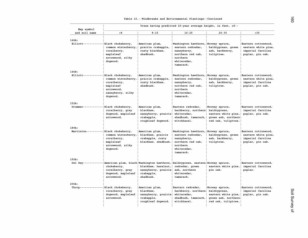
160S
oil Survey of
Table 10.--Windbreaks and Environmental Plantings--Continued_____________________________________________________________________________________________________________________________ | Trees having predicted 20-year average height, in feet, of-- Map symbol |________________________________________________________________________________________________________ and soil name | <8 | 8-15 | 16-25 | 26-35 | >35_____________________________________________________________________________________________________________________________ | | | | |146A: | | | | | Elliott------------|Black chokeberry, |American plum, |Washington hawthorn,|Norway spruce, |Eastern cottonwood, | common winterberry,| prairie crabapple, | eastern redcedar, | baldcypress, green | eastern white pine, | coralberry, | rusty blackhaw, | nannyberry, | ash, hackberry, | imperial Carolina | mapleleaf | shadbush. | northern red oak, | tuliptree. | poplar, pin oak. | arrowwood, silky | | northern | | | dogwood. | | whitecedar, | | | | | tamarack. | | | | | | |146B: | | | | | Elliott------------|Black chokeberry, |American plum, |Washington hawthorn,|Norway spruce, |Eastern cottonwood, | common winterberry,| prairie crabapple, | eastern redcedar, | baldcypress, green | eastern white pine, | coralberry, | rusty blackhaw, | nannyberry, | ash, hackberry, | imperial Carolina | mapleleaf | shadbush. | northern red oak, | tuliptree. | poplar, pin oak. | arrowwood, | | northern | | | nannyberry, silky | | whitecedar, | | | dogwood. | | tamarack. | | | | | | |152A: | | | | | Drummer------------|Black chokeberry, |American plum, |Eastern redcedar, |Norway spruce, |Eastern cottonwood, | coralberry, gray | blackhaw, | hackberry, northern| baldcypress, | imperial Carolina | dogwood, mapleleaf | nannyberry, prairie| whitecedar, | eastern white pine,| poplar, pin oak. | arrowwood. | crabapple, | shadbush, tamarack,| green ash, northern| | | roughleaf dogwood. | witchhazel. | red oak, tuliptree.| | | | | |189A: | | | | | Martinton----------|Black chokeberry, |American plum, |Washington hawthorn,|Norway spruce, |Eastern cottonwood, | common winterberry,| blackhaw, prairie | eastern redcedar, | baldcypress, green | eastern white pine, | coralberry, | crabapple, rusty | nannyberry, | ash, hackberry, | imperial Carolina | mapleleaf | blackhaw, shadbush.| northern red oak, | tuliptree. | poplar, pin oak. | arrowwood, silky | | northern | | | dogwood. | | whitecedar, | | | | | tamarack. | | | | | | |192A: | | | | | Del Rey------------|American plum, black|Washington hawthorn,|Baldcypress, eastern|Norway spruce, |Eastern cottonwood, | chokeberry, | blackhaw, hazelnut,| redcedar, green | eastern white pine,| imperial Carolina | coralberry, gray | nannyberry, prairie| ash, northern | pin oak. | poplar. | dogwood, mapleleaf | crabapple, | whitecedar, | | | arrowwood. | shadbush. | tamarack. | | | | | | |206A: | | | | | Thorp--------------|Black chokeberry, |American plum, |Eastern redcedar, |Norway spruce, |Eastern cottonwood, | coralberry, gray | blackhaw, | hackberry, northern| baldcypress, | imperial Carolina | dogwood, mapleleaf | nannyberry, prairie| whitecedar, | eastern white pine,| poplar, pin oak. | arrowwood. | crabapple, | shadbush, tamarack,| green ash, northern| | | roughleaf dogwood. | witchhazel. | red oak, tuliptree.| | | | | |
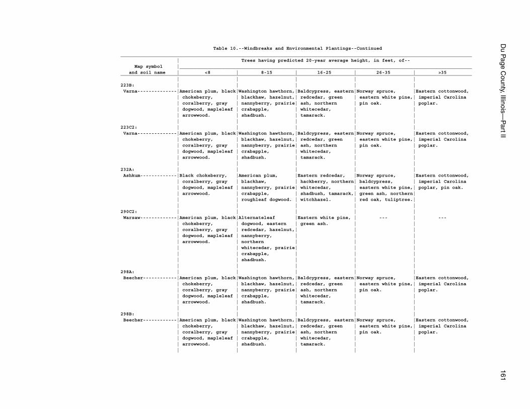
Du P
age County, Illinois—
Part II
161
Table 10.--Windbreaks and Environmental Plantings--Continued_____________________________________________________________________________________________________________________________ | Trees having predicted 20-year average height, in feet, of-- Map symbol |________________________________________________________________________________________________________ and soil name | <8 | 8-15 | 16-25 | 26-35 | >35_____________________________________________________________________________________________________________________________ | | | | |223B: | | | | | Varna--------------|American plum, black|Washington hawthorn,|Baldcypress, eastern|Norway spruce, |Eastern cottonwood, | chokeberry, | blackhaw, hazelnut,| redcedar, green | eastern white pine,| imperial Carolina | coralberry, gray | nannyberry, prairie| ash, northern | pin oak. | poplar. | dogwood, mapleleaf | crabapple, | whitecedar, | | | arrowwood. | shadbush. | tamarack. | | | | | | |223C2: | | | | | Varna--------------|American plum, black|Washington hawthorn,|Baldcypress, eastern|Norway spruce, |Eastern cottonwood, | chokeberry, | blackhaw, hazelnut,| redcedar, green | eastern white pine,| imperial Carolina | coralberry, gray | nannyberry, prairie| ash, northern | pin oak. | poplar. | dogwood, mapleleaf | crabapple, | whitecedar, | | | arrowwood. | shadbush. | tamarack. | | | | | | |232A: | | | | | Ashkum-------------|Black chokeberry, |American plum, |Eastern redcedar, |Norway spruce, |Eastern cottonwood, | coralberry, gray | blackhaw, | hackberry, northern| baldcypress, | imperial Carolina | dogwood, mapleleaf | nannyberry, prairie| whitecedar, | eastern white pine,| poplar, pin oak. | arrowwood. | crabapple, | shadbush, tamarack,| green ash, northern| | | roughleaf dogwood. | witchhazel. | red oak, tuliptree.| | | | | |290C2: | | | | | Warsaw-------------|American plum, black|Alternateleaf |Eastern white pine, | --- | --- | chokeberry, | dogwood, eastern | green ash. | | | coralberry, gray | redcedar, hazelnut,| | | | dogwood, mapleleaf | nannyberry, | | | | arrowwood. | northern | | | | | whitecedar, prairie| | | | | crabapple, | | | | | shadbush. | | | | | | | |298A: | | | | | Beecher------------|American plum, black|Washington hawthorn,|Baldcypress, eastern|Norway spruce, |Eastern cottonwood, | chokeberry, | blackhaw, hazelnut,| redcedar, green | eastern white pine,| imperial Carolina | coralberry, gray | nannyberry, prairie| ash, northern | pin oak. | poplar. | dogwood, mapleleaf | crabapple, | whitecedar, | | | arrowwood. | shadbush. | tamarack. | | | | | | |298B: | | | | | Beecher------------|American plum, black|Washington hawthorn,|Baldcypress, eastern|Norway spruce, |Eastern cottonwood, | chokeberry, | blackhaw, hazelnut,| redcedar, green | eastern white pine,| imperial Carolina | coralberry, gray | nannyberry, prairie| ash, northern | pin oak. | poplar. | dogwood, mapleleaf | crabapple, | whitecedar, | | | arrowwood. | shadbush. | tamarack. | | | | | | |
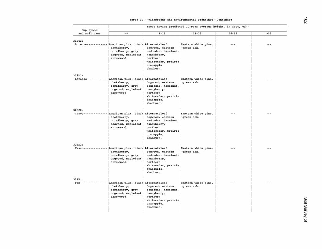
162S
oil Survey of
Table 10.--Windbreaks and Environmental Plantings--Continued_____________________________________________________________________________________________________________________________ | Trees having predicted 20-year average height, in feet, of-- Map symbol |________________________________________________________________________________________________________ and soil name | <8 | 8-15 | 16-25 | 26-35 | >35_____________________________________________________________________________________________________________________________ | | | | |318C2: | | | | | Lorenzo------------|American plum, black|Alternateleaf |Eastern white pine, | --- | --- | chokeberry, | dogwood, eastern | green ash. | | | coralberry, gray | redcedar, hazelnut,| | | | dogwood, mapleleaf | nannyberry, | | | | arrowwood. | northern | | | | | whitecedar, prairie| | | | | crabapple, | | | | | shadbush. | | | | | | | |318D2: | | | | | Lorenzo------------|American plum, black|Alternateleaf |Eastern white pine, | --- | --- | chokeberry, | dogwood, eastern | green ash. | | | coralberry, gray | redcedar, hazelnut,| | | | dogwood, mapleleaf | nannyberry, | | | | arrowwood. | northern | | | | | whitecedar, prairie| | | | | crabapple, | | | | | shadbush. | | | | | | | |323C2: | | | | | Casco--------------|American plum, black|Alternateleaf |Eastern white pine, | --- | --- | chokeberry, | dogwood, eastern | green ash. | | | coralberry, gray | redcedar, hazelnut,| | | | dogwood, mapleleaf | nannyberry, | | | | arrowwood. | northern | | | | | whitecedar, prairie| | | | | crabapple, | | | | | shadbush. | | | | | | | |323D2: | | | | | Casco--------------|American plum, black|Alternateleaf |Eastern white pine, | --- | --- | chokeberry, | dogwood, eastern | green ash. | | | coralberry, gray | redcedar, hazelnut,| | | | dogwood, mapleleaf | nannyberry, | | | | arrowwood. | northern | | | | | whitecedar, prairie| | | | | crabapple, | | | | | shadbush. | | | | | | | |327B: | | | | | Fox----------------|American plum, black|Alternateleaf |Eastern white pine, | --- | --- | chokeberry, | dogwood, eastern | green ash. | | | coralberry, gray | redcedar, hazelnut,| | | | dogwood, mapleleaf | nannyberry, | | | | arrowwood. | northern | | | | | whitecedar, prairie| | | | | crabapple, | | | | | shadbush. | | | | | | | |
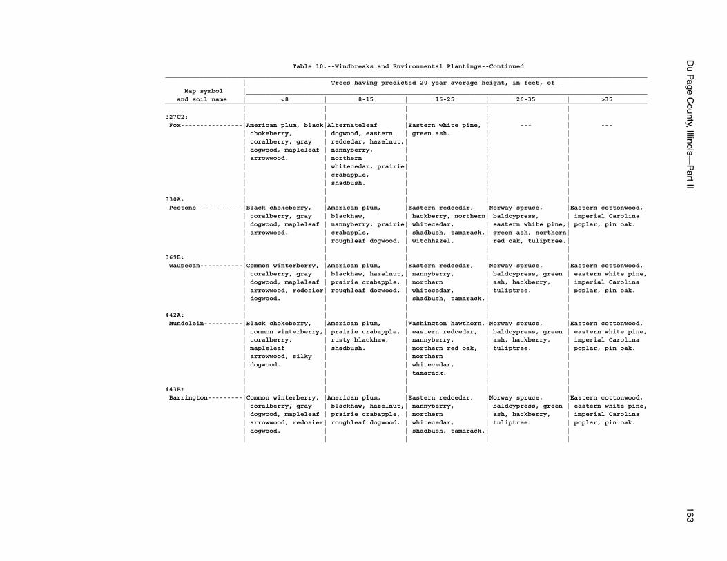
Du P
age County, Illinois—
Part II
163
Table 10.--Windbreaks and Environmental Plantings--Continued_____________________________________________________________________________________________________________________________ | Trees having predicted 20-year average height, in feet, of-- Map symbol |________________________________________________________________________________________________________ and soil name | <8 | 8-15 | 16-25 | 26-35 | >35_____________________________________________________________________________________________________________________________ | | | | |327C2: | | | | | Fox----------------|American plum, black|Alternateleaf |Eastern white pine, | --- | --- | chokeberry, | dogwood, eastern | green ash. | | | coralberry, gray | redcedar, hazelnut,| | | | dogwood, mapleleaf | nannyberry, | | | | arrowwood. | northern | | | | | whitecedar, prairie| | | | | crabapple, | | | | | shadbush. | | | | | | | |330A: | | | | | Peotone------------|Black chokeberry, |American plum, |Eastern redcedar, |Norway spruce, |Eastern cottonwood, | coralberry, gray | blackhaw, | hackberry, northern| baldcypress, | imperial Carolina | dogwood, mapleleaf | nannyberry, prairie| whitecedar, | eastern white pine,| poplar, pin oak. | arrowwood. | crabapple, | shadbush, tamarack,| green ash, northern| | | roughleaf dogwood. | witchhazel. | red oak, tuliptree.| | | | | |369B: | | | | | Waupecan-----------|Common winterberry, |American plum, |Eastern redcedar, |Norway spruce, |Eastern cottonwood, | coralberry, gray | blackhaw, hazelnut,| nannyberry, | baldcypress, green | eastern white pine, | dogwood, mapleleaf | prairie crabapple, | northern | ash, hackberry, | imperial Carolina | arrowwood, redosier| roughleaf dogwood. | whitecedar, | tuliptree. | poplar, pin oak. | dogwood. | | shadbush, tamarack.| | | | | | |442A: | | | | | Mundelein----------|Black chokeberry, |American plum, |Washington hawthorn,|Norway spruce, |Eastern cottonwood, | common winterberry,| prairie crabapple, | eastern redcedar, | baldcypress, green | eastern white pine, | coralberry, | rusty blackhaw, | nannyberry, | ash, hackberry, | imperial Carolina | mapleleaf | shadbush. | northern red oak, | tuliptree. | poplar, pin oak. | arrowwood, silky | | northern | | | dogwood. | | whitecedar, | | | | | tamarack. | | | | | | |443B: | | | | | Barrington---------|Common winterberry, |American plum, |Eastern redcedar, |Norway spruce, |Eastern cottonwood, | coralberry, gray | blackhaw, hazelnut,| nannyberry, | baldcypress, green | eastern white pine, | dogwood, mapleleaf | prairie crabapple, | northern | ash, hackberry, | imperial Carolina | arrowwood, redosier| roughleaf dogwood. | whitecedar, | tuliptree. | poplar, pin oak. | dogwood. | | shadbush, tamarack.| | | | | | |
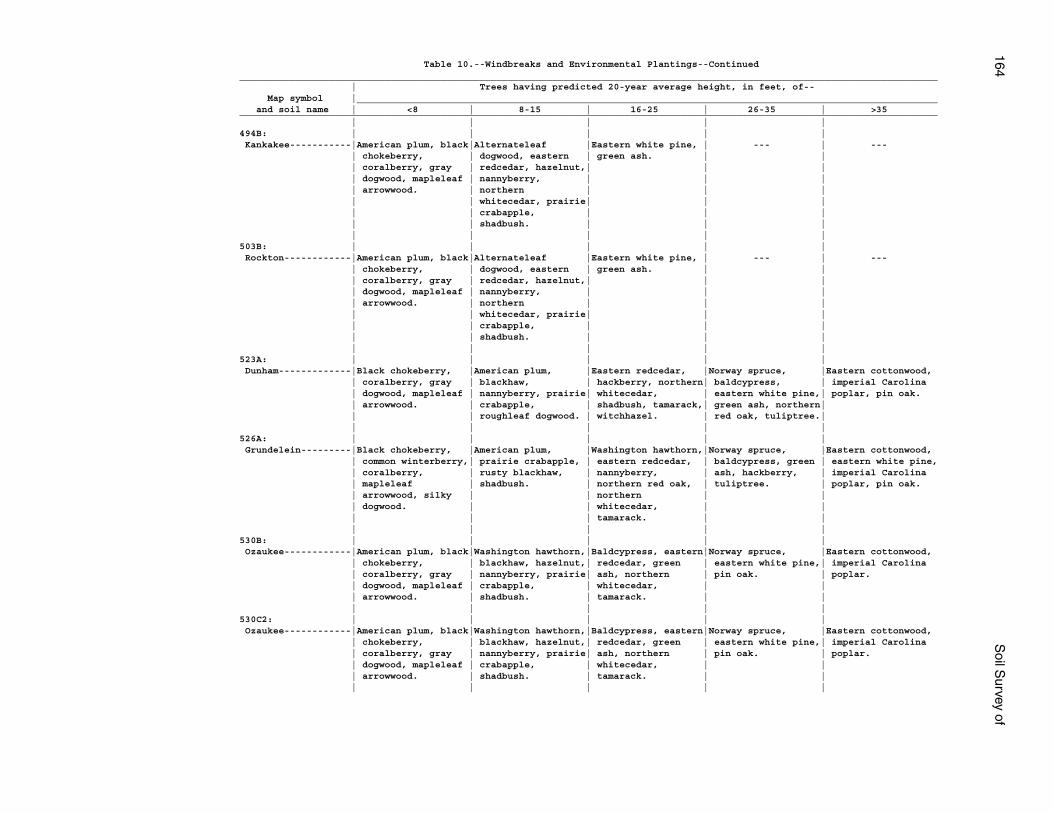
164S
oil Survey of
Table 10.--Windbreaks and Environmental Plantings--Continued_____________________________________________________________________________________________________________________________ | Trees having predicted 20-year average height, in feet, of-- Map symbol |________________________________________________________________________________________________________ and soil name | <8 | 8-15 | 16-25 | 26-35 | >35_____________________________________________________________________________________________________________________________ | | | | |494B: | | | | | Kankakee-----------|American plum, black|Alternateleaf |Eastern white pine, | --- | --- | chokeberry, | dogwood, eastern | green ash. | | | coralberry, gray | redcedar, hazelnut,| | | | dogwood, mapleleaf | nannyberry, | | | | arrowwood. | northern | | | | | whitecedar, prairie| | | | | crabapple, | | | | | shadbush. | | | | | | | |503B: | | | | | Rockton------------|American plum, black|Alternateleaf |Eastern white pine, | --- | --- | chokeberry, | dogwood, eastern | green ash. | | | coralberry, gray | redcedar, hazelnut,| | | | dogwood, mapleleaf | nannyberry, | | | | arrowwood. | northern | | | | | whitecedar, prairie| | | | | crabapple, | | | | | shadbush. | | | | | | | |523A: | | | | | Dunham-------------|Black chokeberry, |American plum, |Eastern redcedar, |Norway spruce, |Eastern cottonwood, | coralberry, gray | blackhaw, | hackberry, northern| baldcypress, | imperial Carolina | dogwood, mapleleaf | nannyberry, prairie| whitecedar, | eastern white pine,| poplar, pin oak. | arrowwood. | crabapple, | shadbush, tamarack,| green ash, northern| | | roughleaf dogwood. | witchhazel. | red oak, tuliptree.| | | | | |526A: | | | | | Grundelein---------|Black chokeberry, |American plum, |Washington hawthorn,|Norway spruce, |Eastern cottonwood, | common winterberry,| prairie crabapple, | eastern redcedar, | baldcypress, green | eastern white pine, | coralberry, | rusty blackhaw, | nannyberry, | ash, hackberry, | imperial Carolina | mapleleaf | shadbush. | northern red oak, | tuliptree. | poplar, pin oak. | arrowwood, silky | | northern | | | dogwood. | | whitecedar, | | | | | tamarack. | | | | | | |530B: | | | | | Ozaukee------------|American plum, black|Washington hawthorn,|Baldcypress, eastern|Norway spruce, |Eastern cottonwood, | chokeberry, | blackhaw, hazelnut,| redcedar, green | eastern white pine,| imperial Carolina | coralberry, gray | nannyberry, prairie| ash, northern | pin oak. | poplar. | dogwood, mapleleaf | crabapple, | whitecedar, | | | arrowwood. | shadbush. | tamarack. | | | | | | |530C2: | | | | | Ozaukee------------|American plum, black|Washington hawthorn,|Baldcypress, eastern|Norway spruce, |Eastern cottonwood, | chokeberry, | blackhaw, hazelnut,| redcedar, green | eastern white pine,| imperial Carolina | coralberry, gray | nannyberry, prairie| ash, northern | pin oak. | poplar. | dogwood, mapleleaf | crabapple, | whitecedar, | | | arrowwood. | shadbush. | tamarack. | | | | | | |
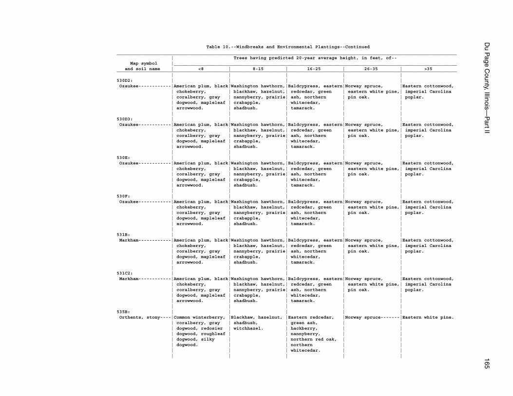
Du P
age County, Illinois—
Part II
165
Table 10.--Windbreaks and Environmental Plantings--Continued_____________________________________________________________________________________________________________________________ | Trees having predicted 20-year average height, in feet, of-- Map symbol |________________________________________________________________________________________________________ and soil name | <8 | 8-15 | 16-25 | 26-35 | >35_____________________________________________________________________________________________________________________________ | | | | |530D2: | | | | | Ozaukee------------|American plum, black|Washington hawthorn,|Baldcypress, eastern|Norway spruce, |Eastern cottonwood, | chokeberry, | blackhaw, hazelnut,| redcedar, green | eastern white pine,| imperial Carolina | coralberry, gray | nannyberry, prairie| ash, northern | pin oak. | poplar. | dogwood, mapleleaf | crabapple, | whitecedar, | | | arrowwood. | shadbush. | tamarack. | | | | | | |530D3: | | | | | Ozaukee------------|American plum, black|Washington hawthorn,|Baldcypress, eastern|Norway spruce, |Eastern cottonwood, | chokeberry, | blackhaw, hazelnut,| redcedar, green | eastern white pine,| imperial Carolina | coralberry, gray | nannyberry, prairie| ash, northern | pin oak. | poplar. | dogwood, mapleleaf | crabapple, | whitecedar, | | | arrowwood. | shadbush. | tamarack. | | | | | | |530E: | | | | | Ozaukee------------|American plum, black|Washington hawthorn,|Baldcypress, eastern|Norway spruce, |Eastern cottonwood, | chokeberry, | blackhaw, hazelnut,| redcedar, green | eastern white pine,| imperial Carolina | coralberry, gray | nannyberry, prairie| ash, northern | pin oak. | poplar. | dogwood, mapleleaf | crabapple, | whitecedar, | | | arrowwood. | shadbush. | tamarack. | | | | | | |530F: | | | | | Ozaukee------------|American plum, black|Washington hawthorn,|Baldcypress, eastern|Norway spruce, |Eastern cottonwood, | chokeberry, | blackhaw, hazelnut,| redcedar, green | eastern white pine,| imperial Carolina | coralberry, gray | nannyberry, prairie| ash, northern | pin oak. | poplar. | dogwood, mapleleaf | crabapple, | whitecedar, | | | arrowwood. | shadbush. | tamarack. | | | | | | |531B: | | | | | Markham------------|American plum, black|Washington hawthorn,|Baldcypress, eastern|Norway spruce, |Eastern cottonwood, | chokeberry, | blackhaw, hazelnut,| redcedar, green | eastern white pine,| imperial Carolina | coralberry, gray | nannyberry, prairie| ash, northern | pin oak. | poplar. | dogwood, mapleleaf | crabapple, | whitecedar, | | | arrowwood. | shadbush. | tamarack. | | | | | | |531C2: | | | | | Markham------------|American plum, black|Washington hawthorn,|Baldcypress, eastern|Norway spruce, |Eastern cottonwood, | chokeberry, | blackhaw, hazelnut,| redcedar, green | eastern white pine,| imperial Carolina | coralberry, gray | nannyberry, prairie| ash, northern | pin oak. | poplar. | dogwood, mapleleaf | crabapple, | whitecedar, | | | arrowwood. | shadbush. | tamarack. | | | | | | |535B: | | | | | Orthents, stony----|Common winterberry, |Blackhaw, hazelnut, |Eastern redcedar, |Norway spruce-------|Eastern white pine. | coralberry, gray | shadbush, | green ash, | | | dogwood, redosier | witchhazel. | hackberry, | | | dogwood, roughleaf | | nannyberry, | | | dogwood, silky | | northern red oak, | | | dogwood. | | northern | | | | | whitecedar. | | | | | | |
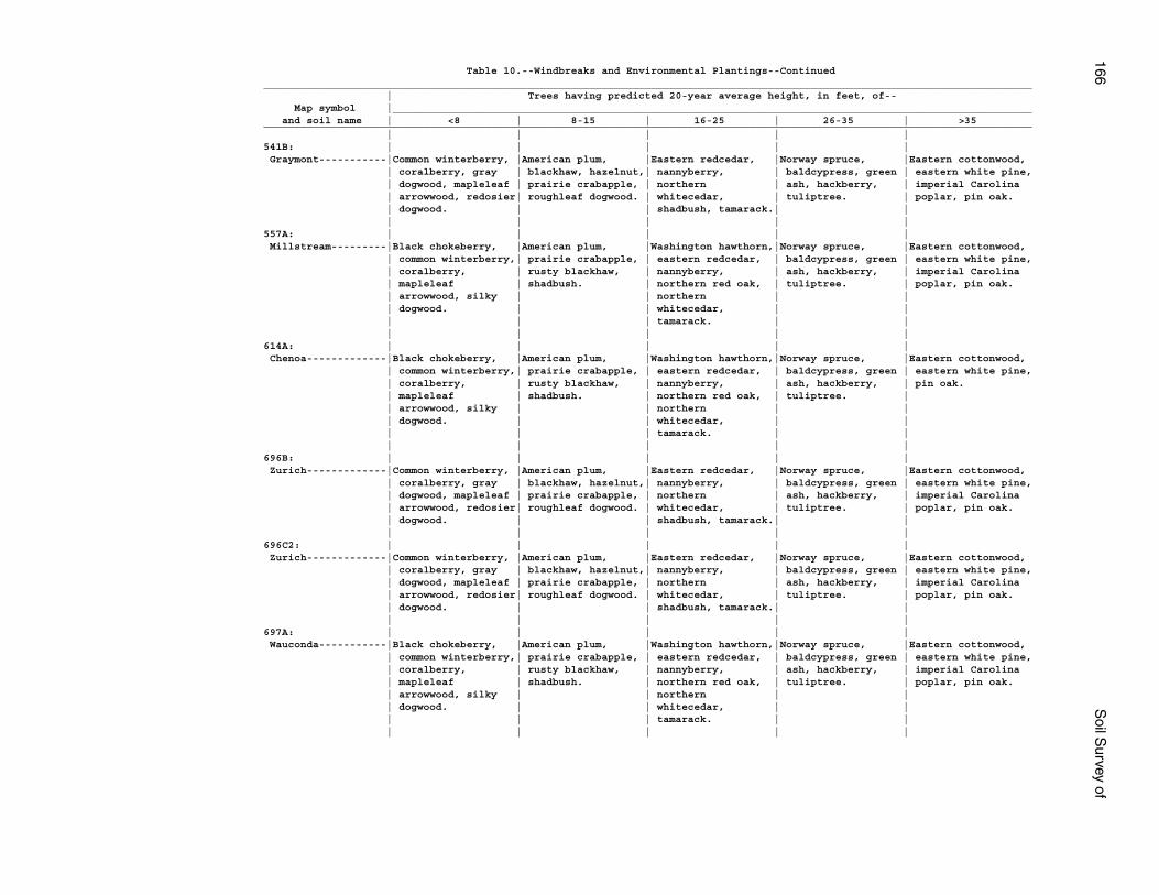
166S
oil Survey of
Table 10.--Windbreaks and Environmental Plantings--Continued_____________________________________________________________________________________________________________________________ | Trees having predicted 20-year average height, in feet, of-- Map symbol |________________________________________________________________________________________________________ and soil name | <8 | 8-15 | 16-25 | 26-35 | >35_____________________________________________________________________________________________________________________________ | | | | |541B: | | | | | Graymont-----------|Common winterberry, |American plum, |Eastern redcedar, |Norway spruce, |Eastern cottonwood, | coralberry, gray | blackhaw, hazelnut,| nannyberry, | baldcypress, green | eastern white pine, | dogwood, mapleleaf | prairie crabapple, | northern | ash, hackberry, | imperial Carolina | arrowwood, redosier| roughleaf dogwood. | whitecedar, | tuliptree. | poplar, pin oak. | dogwood. | | shadbush, tamarack.| | | | | | |557A: | | | | | Millstream---------|Black chokeberry, |American plum, |Washington hawthorn,|Norway spruce, |Eastern cottonwood, | common winterberry,| prairie crabapple, | eastern redcedar, | baldcypress, green | eastern white pine, | coralberry, | rusty blackhaw, | nannyberry, | ash, hackberry, | imperial Carolina | mapleleaf | shadbush. | northern red oak, | tuliptree. | poplar, pin oak. | arrowwood, silky | | northern | | | dogwood. | | whitecedar, | | | | | tamarack. | | | | | | |614A: | | | | | Chenoa-------------|Black chokeberry, |American plum, |Washington hawthorn,|Norway spruce, |Eastern cottonwood, | common winterberry,| prairie crabapple, | eastern redcedar, | baldcypress, green | eastern white pine, | coralberry, | rusty blackhaw, | nannyberry, | ash, hackberry, | pin oak. | mapleleaf | shadbush. | northern red oak, | tuliptree. | | arrowwood, silky | | northern | | | dogwood. | | whitecedar, | | | | | tamarack. | | | | | | |696B: | | | | | Zurich-------------|Common winterberry, |American plum, |Eastern redcedar, |Norway spruce, |Eastern cottonwood, | coralberry, gray | blackhaw, hazelnut,| nannyberry, | baldcypress, green | eastern white pine, | dogwood, mapleleaf | prairie crabapple, | northern | ash, hackberry, | imperial Carolina | arrowwood, redosier| roughleaf dogwood. | whitecedar, | tuliptree. | poplar, pin oak. | dogwood. | | shadbush, tamarack.| | | | | | |696C2: | | | | | Zurich-------------|Common winterberry, |American plum, |Eastern redcedar, |Norway spruce, |Eastern cottonwood, | coralberry, gray | blackhaw, hazelnut,| nannyberry, | baldcypress, green | eastern white pine, | dogwood, mapleleaf | prairie crabapple, | northern | ash, hackberry, | imperial Carolina | arrowwood, redosier| roughleaf dogwood. | whitecedar, | tuliptree. | poplar, pin oak. | dogwood. | | shadbush, tamarack.| | | | | | |697A: | | | | | Wauconda-----------|Black chokeberry, |American plum, |Washington hawthorn,|Norway spruce, |Eastern cottonwood, | common winterberry,| prairie crabapple, | eastern redcedar, | baldcypress, green | eastern white pine, | coralberry, | rusty blackhaw, | nannyberry, | ash, hackberry, | imperial Carolina | mapleleaf | shadbush. | northern red oak, | tuliptree. | poplar, pin oak. | arrowwood, silky | | northern | | | dogwood. | | whitecedar, | | | | | tamarack. | | | | | | |
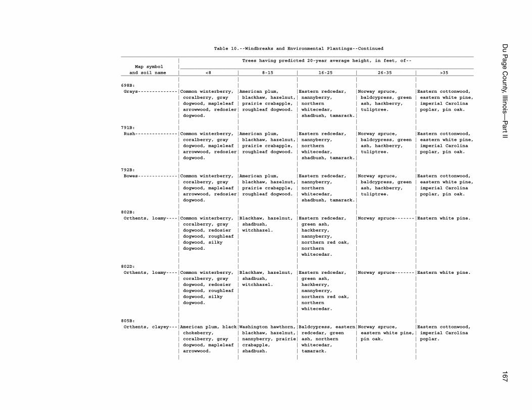
Du P
age County, Illinois—
Part II
167
Table 10.--Windbreaks and Environmental Plantings--Continued_____________________________________________________________________________________________________________________________ | Trees having predicted 20-year average height, in feet, of-- Map symbol |________________________________________________________________________________________________________ and soil name | <8 | 8-15 | 16-25 | 26-35 | >35_____________________________________________________________________________________________________________________________ | | | | |698B: | | | | | Grays--------------|Common winterberry, |American plum, |Eastern redcedar, |Norway spruce, |Eastern cottonwood, | coralberry, gray | blackhaw, hazelnut,| nannyberry, | baldcypress, green | eastern white pine, | dogwood, mapleleaf | prairie crabapple, | northern | ash, hackberry, | imperial Carolina | arrowwood, redosier| roughleaf dogwood. | whitecedar, | tuliptree. | poplar, pin oak. | dogwood. | | shadbush, tamarack.| | | | | | |791B: | | | | | Rush---------------|Common winterberry, |American plum, |Eastern redcedar, |Norway spruce, |Eastern cottonwood, | coralberry, gray | blackhaw, hazelnut,| nannyberry, | baldcypress, green | eastern white pine, | dogwood, mapleleaf | prairie crabapple, | northern | ash, hackberry, | imperial Carolina | arrowwood, redosier| roughleaf dogwood. | whitecedar, | tuliptree. | poplar, pin oak. | dogwood. | | shadbush, tamarack.| | | | | | |792B: | | | | | Bowes--------------|Common winterberry, |American plum, |Eastern redcedar, |Norway spruce, |Eastern cottonwood, | coralberry, gray | blackhaw, hazelnut,| nannyberry, | baldcypress, green | eastern white pine, | dogwood, mapleleaf | prairie crabapple, | northern | ash, hackberry, | imperial Carolina | arrowwood, redosier| roughleaf dogwood. | whitecedar, | tuliptree. | poplar, pin oak. | dogwood. | | shadbush, tamarack.| | | | | | |802B: | | | | | Orthents, loamy----|Common winterberry, |Blackhaw, hazelnut, |Eastern redcedar, |Norway spruce-------|Eastern white pine. | coralberry, gray | shadbush, | green ash, | | | dogwood, redosier | witchhazel. | hackberry, | | | dogwood, roughleaf | | nannyberry, | | | dogwood, silky | | northern red oak, | | | dogwood. | | northern | | | | | whitecedar. | | | | | | |802D: | | | | | Orthents, loamy----|Common winterberry, |Blackhaw, hazelnut, |Eastern redcedar, |Norway spruce-------|Eastern white pine. | coralberry, gray | shadbush, | green ash, | | | dogwood, redosier | witchhazel. | hackberry, | | | dogwood, roughleaf | | nannyberry, | | | dogwood, silky | | northern red oak, | | | dogwood. | | northern | | | | | whitecedar. | | | | | | |805B: | | | | | Orthents, clayey---|American plum, black|Washington hawthorn,|Baldcypress, eastern|Norway spruce, |Eastern cottonwood, | chokeberry, | blackhaw, hazelnut,| redcedar, green | eastern white pine,| imperial Carolina | coralberry, gray | nannyberry, prairie| ash, northern | pin oak. | poplar. | dogwood, mapleleaf | crabapple, | whitecedar, | | | arrowwood. | shadbush. | tamarack. | | | | | | |
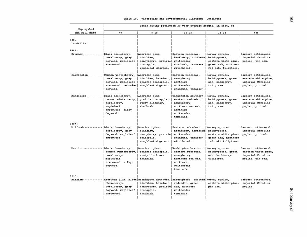
168S
oil Survey of
Table 10.--Windbreaks and Environmental Plantings--Continued_____________________________________________________________________________________________________________________________ | Trees having predicted 20-year average height, in feet, of-- Map symbol |________________________________________________________________________________________________________ and soil name | <8 | 8-15 | 16-25 | 26-35 | >35_____________________________________________________________________________________________________________________________ | | | | |830: | | | | | Landfills. | | | | | | | | | |848B: | | | | | Drummer------------|Black chokeberry, |American plum, |Eastern redcedar, |Norway spruce, |Eastern cottonwood, | coralberry, gray | blackhaw, | hackberry, northern| baldcypress, | imperial Carolina | dogwood, mapleleaf | nannyberry, prairie| whitecedar, | eastern white pine,| poplar, pin oak. | arrowwood. | crabapple, | shadbush, tamarack,| green ash, northern| | | roughleaf dogwood. | witchhazel. | red oak, tuliptree.| | | | | | Barrington---------|Common winterberry, |American plum, |Eastern redcedar, |Norway spruce, |Eastern cottonwood, | coralberry, gray | blackhaw, hazelnut,| nannyberry, | baldcypress, green | eastern white pine, | dogwood, mapleleaf | prairie crabapple, | northern | ash, hackberry, | imperial Carolina | arrowwood, redosier| roughleaf dogwood. | whitecedar, | tuliptree. | poplar, pin oak. | dogwood. | | shadbush, tamarack.| | | | | | | Mundelein----------|Black chokeberry, |American plum, |Washington hawthorn,|Norway spruce, |Eastern cottonwood, | common winterberry,| prairie crabapple, | eastern redcedar, | baldcypress, green | eastern white pine, | coralberry, | rusty blackhaw, | nannyberry, | ash, hackberry, | imperial Carolina | mapleleaf | shadbush. | northern red oak, | tuliptree. | poplar, pin oak. | arrowwood, silky | | northern | | | dogwood. | | whitecedar, | | | | | tamarack. | | | | | | |849A: | | | | | Milford------------|Black chokeberry, |American plum, |Eastern redcedar, |Norway spruce, |Eastern cottonwood, | coralberry, gray | blackhaw, | hackberry, northern| baldcypress, | imperial Carolina | dogwood, mapleleaf | nannyberry, prairie| whitecedar, | eastern white pine,| poplar, pin oak. | arrowwood. | crabapple, | shadbush, tamarack,| green ash, northern| | | roughleaf dogwood. | witchhazel. | red oak, tuliptree.| | | | | | Martinton----------|Black chokeberry, |American plum, |Washington hawthorn,|Norway spruce, |Eastern cottonwood, | common winterberry,| prairie crabapple, | eastern redcedar, | baldcypress, green | eastern white pine, | coralberry, | rusty blackhaw, | nannyberry, | ash, hackberry, | imperial Carolina | mapleleaf | shadbush. | northern red oak, | tuliptree. | poplar, pin oak. | arrowwood, silky | | northern | | | dogwood. | | whitecedar, | | | | | tamarack. | | | | | | |854B: | | | | | Markham------------|American plum, black|Washington hawthorn,|Baldcypress, eastern|Norway spruce, |Eastern cottonwood, | chokeberry, | blackhaw, hazelnut,| redcedar, green | eastern white pine,| imperial Carolina | coralberry, gray | nannyberry, prairie| ash, northern | pin oak. | poplar. | dogwood, mapleleaf | crabapple, | whitecedar, | | | arrowwood. | shadbush. | tamarack. | | | | | | |
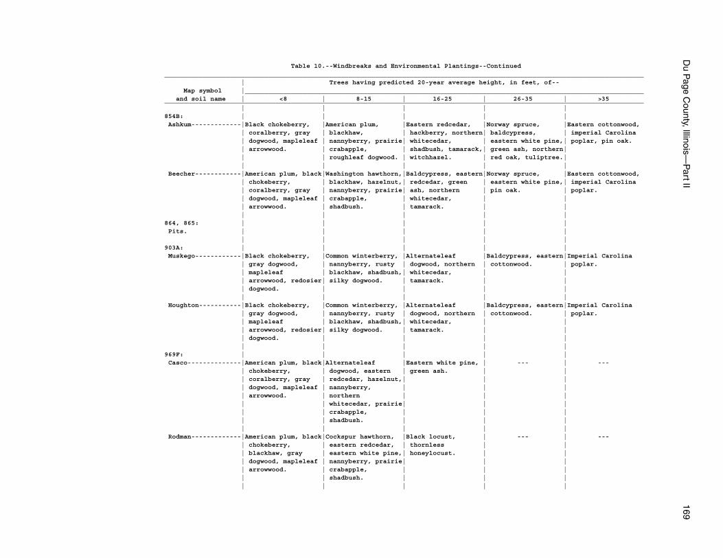
Du P
age County, Illinois—
Part II
169
Table 10.--Windbreaks and Environmental Plantings--Continued_____________________________________________________________________________________________________________________________ | Trees having predicted 20-year average height, in feet, of-- Map symbol |________________________________________________________________________________________________________ and soil name | <8 | 8-15 | 16-25 | 26-35 | >35_____________________________________________________________________________________________________________________________ | | | | |854B: | | | | | Ashkum-------------|Black chokeberry, |American plum, |Eastern redcedar, |Norway spruce, |Eastern cottonwood, | coralberry, gray | blackhaw, | hackberry, northern| baldcypress, | imperial Carolina | dogwood, mapleleaf | nannyberry, prairie| whitecedar, | eastern white pine,| poplar, pin oak. | arrowwood. | crabapple, | shadbush, tamarack,| green ash, northern| | | roughleaf dogwood. | witchhazel. | red oak, tuliptree.| | | | | | Beecher------------|American plum, black|Washington hawthorn,|Baldcypress, eastern|Norway spruce, |Eastern cottonwood, | chokeberry, | blackhaw, hazelnut,| redcedar, green | eastern white pine,| imperial Carolina | coralberry, gray | nannyberry, prairie| ash, northern | pin oak. | poplar. | dogwood, mapleleaf | crabapple, | whitecedar, | | | arrowwood. | shadbush. | tamarack. | | | | | | |864, 865: | | | | | Pits. | | | | | | | | | |903A: | | | | | Muskego------------|Black chokeberry, |Common winterberry, |Alternateleaf |Baldcypress, eastern|Imperial Carolina | gray dogwood, | nannyberry, rusty | dogwood, northern | cottonwood. | poplar. | mapleleaf | blackhaw, shadbush,| whitecedar, | | | arrowwood, redosier| silky dogwood. | tamarack. | | | dogwood. | | | | | | | | | Houghton-----------|Black chokeberry, |Common winterberry, |Alternateleaf |Baldcypress, eastern|Imperial Carolina | gray dogwood, | nannyberry, rusty | dogwood, northern | cottonwood. | poplar. | mapleleaf | blackhaw, shadbush,| whitecedar, | | | arrowwood, redosier| silky dogwood. | tamarack. | | | dogwood. | | | | | | | | |969F: | | | | | Casco--------------|American plum, black|Alternateleaf |Eastern white pine, | --- | --- | chokeberry, | dogwood, eastern | green ash. | | | coralberry, gray | redcedar, hazelnut,| | | | dogwood, mapleleaf | nannyberry, | | | | arrowwood. | northern | | | | | whitecedar, prairie| | | | | crabapple, | | | | | shadbush. | | | | | | | | Rodman-------------|American plum, black|Cockspur hawthorn, |Black locust, | --- | --- | chokeberry, | eastern redcedar, | thornless | | | blackhaw, gray | eastern white pine,| honeylocust. | | | dogwood, mapleleaf | nannyberry, prairie| | | | arrowwood. | crabapple, | | | | | shadbush. | | | | | | | |
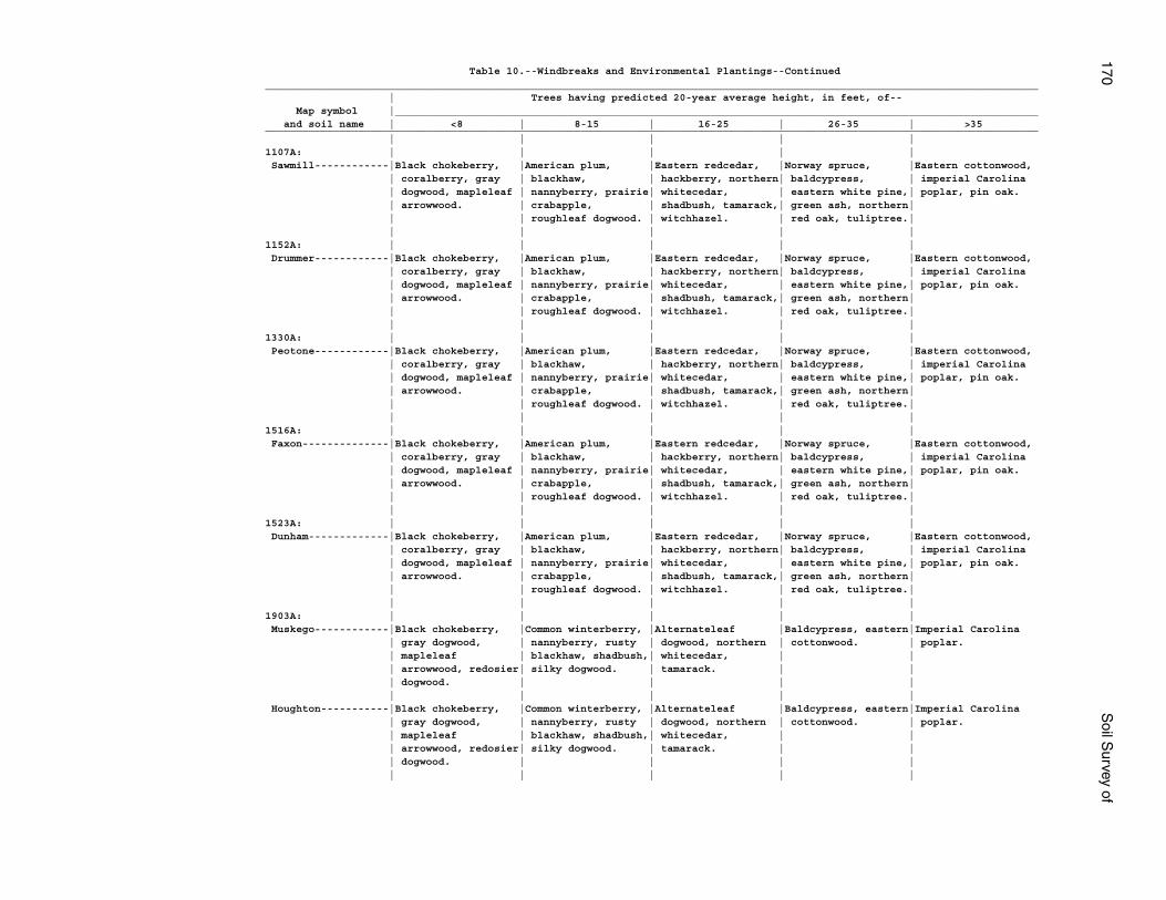
170S
oil Survey of
Table 10.--Windbreaks and Environmental Plantings--Continued_____________________________________________________________________________________________________________________________ | Trees having predicted 20-year average height, in feet, of-- Map symbol |________________________________________________________________________________________________________ and soil name | <8 | 8-15 | 16-25 | 26-35 | >35_____________________________________________________________________________________________________________________________ | | | | |1107A: | | | | | Sawmill------------|Black chokeberry, |American plum, |Eastern redcedar, |Norway spruce, |Eastern cottonwood, | coralberry, gray | blackhaw, | hackberry, northern| baldcypress, | imperial Carolina | dogwood, mapleleaf | nannyberry, prairie| whitecedar, | eastern white pine,| poplar, pin oak. | arrowwood. | crabapple, | shadbush, tamarack,| green ash, northern| | | roughleaf dogwood. | witchhazel. | red oak, tuliptree.| | | | | |1152A: | | | | | Drummer------------|Black chokeberry, |American plum, |Eastern redcedar, |Norway spruce, |Eastern cottonwood, | coralberry, gray | blackhaw, | hackberry, northern| baldcypress, | imperial Carolina | dogwood, mapleleaf | nannyberry, prairie| whitecedar, | eastern white pine,| poplar, pin oak. | arrowwood. | crabapple, | shadbush, tamarack,| green ash, northern| | | roughleaf dogwood. | witchhazel. | red oak, tuliptree.| | | | | |1330A: | | | | | Peotone------------|Black chokeberry, |American plum, |Eastern redcedar, |Norway spruce, |Eastern cottonwood, | coralberry, gray | blackhaw, | hackberry, northern| baldcypress, | imperial Carolina | dogwood, mapleleaf | nannyberry, prairie| whitecedar, | eastern white pine,| poplar, pin oak. | arrowwood. | crabapple, | shadbush, tamarack,| green ash, northern| | | roughleaf dogwood. | witchhazel. | red oak, tuliptree.| | | | | |1516A: | | | | | Faxon--------------|Black chokeberry, |American plum, |Eastern redcedar, |Norway spruce, |Eastern cottonwood, | coralberry, gray | blackhaw, | hackberry, northern| baldcypress, | imperial Carolina | dogwood, mapleleaf | nannyberry, prairie| whitecedar, | eastern white pine,| poplar, pin oak. | arrowwood. | crabapple, | shadbush, tamarack,| green ash, northern| | | roughleaf dogwood. | witchhazel. | red oak, tuliptree.| | | | | |1523A: | | | | | Dunham-------------|Black chokeberry, |American plum, |Eastern redcedar, |Norway spruce, |Eastern cottonwood, | coralberry, gray | blackhaw, | hackberry, northern| baldcypress, | imperial Carolina | dogwood, mapleleaf | nannyberry, prairie| whitecedar, | eastern white pine,| poplar, pin oak. | arrowwood. | crabapple, | shadbush, tamarack,| green ash, northern| | | roughleaf dogwood. | witchhazel. | red oak, tuliptree.| | | | | |1903A: | | | | | Muskego------------|Black chokeberry, |Common winterberry, |Alternateleaf |Baldcypress, eastern|Imperial Carolina | gray dogwood, | nannyberry, rusty | dogwood, northern | cottonwood. | poplar. | mapleleaf | blackhaw, shadbush,| whitecedar, | | | arrowwood, redosier| silky dogwood. | tamarack. | | | dogwood. | | | | | | | | | Houghton-----------|Black chokeberry, |Common winterberry, |Alternateleaf |Baldcypress, eastern|Imperial Carolina | gray dogwood, | nannyberry, rusty | dogwood, northern | cottonwood. | poplar. | mapleleaf | blackhaw, shadbush,| whitecedar, | | | arrowwood, redosier| silky dogwood. | tamarack. | | | dogwood. | | | | | | | | |
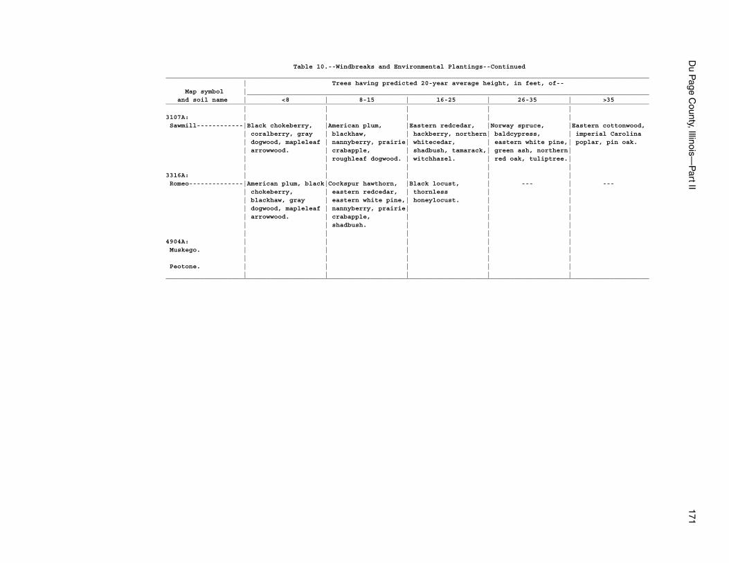
Du P
age County, Illinois—
Part II
171
Table 10.--Windbreaks and Environmental Plantings--Continued_____________________________________________________________________________________________________________________________ | Trees having predicted 20-year average height, in feet, of-- Map symbol |________________________________________________________________________________________________________ and soil name | <8 | 8-15 | 16-25 | 26-35 | >35_____________________________________________________________________________________________________________________________ | | | | |3107A: | | | | | Sawmill------------|Black chokeberry, |American plum, |Eastern redcedar, |Norway spruce, |Eastern cottonwood, | coralberry, gray | blackhaw, | hackberry, northern| baldcypress, | imperial Carolina | dogwood, mapleleaf | nannyberry, prairie| whitecedar, | eastern white pine,| poplar, pin oak. | arrowwood. | crabapple, | shadbush, tamarack,| green ash, northern| | | roughleaf dogwood. | witchhazel. | red oak, tuliptree.| | | | | |3316A: | | | | | Romeo--------------|American plum, black|Cockspur hawthorn, |Black locust, | --- | --- | chokeberry, | eastern redcedar, | thornless | | | blackhaw, gray | eastern white pine,| honeylocust. | | | dogwood, mapleleaf | nannyberry, prairie| | | | arrowwood. | crabapple, | | | | | shadbush. | | | | | | | |4904A: | | | | | Muskego. | | | | | | | | | | Peotone. | | | | | | | | | |_____________________________________________________________________________________________________________________________
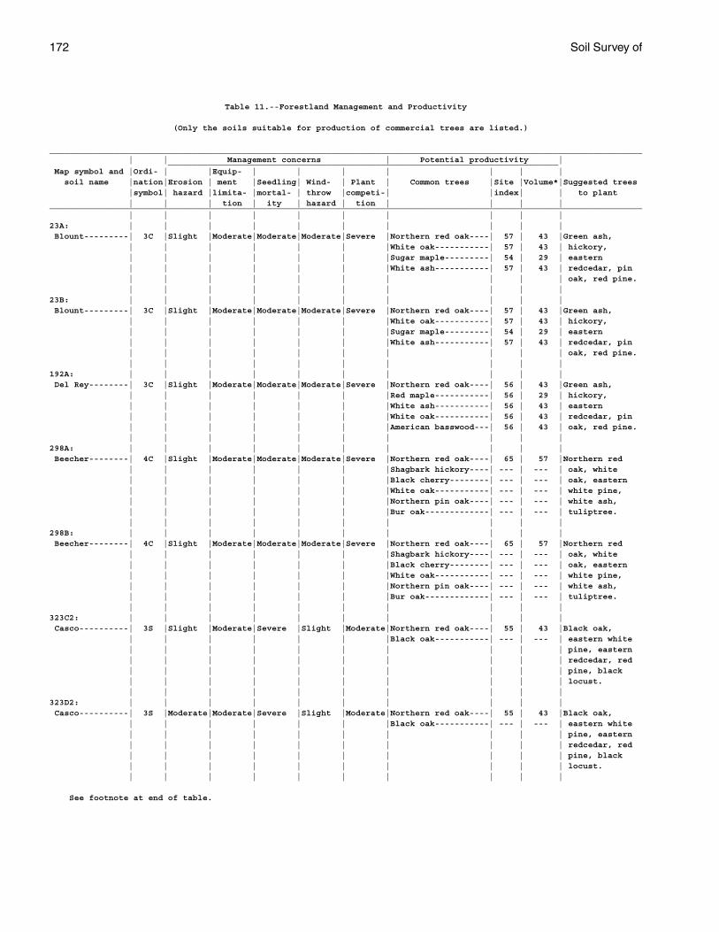
172 Soil Survey of
Table 11.--Forestland Management and Productivity
(Only the soils suitable for production of commercial trees are listed.)
________________________________________________________________________________________________________________________ | | Management concerns | Potential productivity | _______________________________________________________________________________ Map symbol and |Ordi- | |Equip- | | | | | | | soil name |nation|Erosion | ment |Seedling| Wind- | Plant | Common trees |Site |Volume*|Suggested trees |symbol| hazard |limita- |mortal- | throw |competi-| |index| | to plant | | | tion | ity | hazard | tion | | | |________________________________________________________________________________________________________________________ | | | | | | | | | |23A: | | | | | | | | | | Blount---------| 3C |Slight |Moderate|Moderate|Moderate|Severe |Northern red oak----| 57 | 43 |Green ash, | | | | | | |White oak-----------| 57 | 43 | hickory, | | | | | | |Sugar maple---------| 54 | 29 | eastern | | | | | | |White ash-----------| 57 | 43 | redcedar, pin | | | | | | | | | | oak, red pine. | | | | | | | | | |23B: | | | | | | | | | | Blount---------| 3C |Slight |Moderate|Moderate|Moderate|Severe |Northern red oak----| 57 | 43 |Green ash, | | | | | | |White oak-----------| 57 | 43 | hickory, | | | | | | |Sugar maple---------| 54 | 29 | eastern | | | | | | |White ash-----------| 57 | 43 | redcedar, pin | | | | | | | | | | oak, red pine. | | | | | | | | | |192A: | | | | | | | | | | Del Rey--------| 3C |Slight |Moderate|Moderate|Moderate|Severe |Northern red oak----| 56 | 43 |Green ash, | | | | | | |Red maple-----------| 56 | 29 | hickory, | | | | | | |White ash-----------| 56 | 43 | eastern | | | | | | |White oak-----------| 56 | 43 | redcedar, pin | | | | | | |American basswood---| 56 | 43 | oak, red pine. | | | | | | | | | |298A: | | | | | | | | | | Beecher--------| 4C |Slight |Moderate|Moderate|Moderate|Severe |Northern red oak----| 65 | 57 |Northern red | | | | | | |Shagbark hickory----| --- | --- | oak, white | | | | | | |Black cherry--------| --- | --- | oak, eastern | | | | | | |White oak-----------| --- | --- | white pine, | | | | | | |Northern pin oak----| --- | --- | white ash, | | | | | | |Bur oak-------------| --- | --- | tuliptree. | | | | | | | | | |298B: | | | | | | | | | | Beecher--------| 4C |Slight |Moderate|Moderate|Moderate|Severe |Northern red oak----| 65 | 57 |Northern red | | | | | | |Shagbark hickory----| --- | --- | oak, white | | | | | | |Black cherry--------| --- | --- | oak, eastern | | | | | | |White oak-----------| --- | --- | white pine, | | | | | | |Northern pin oak----| --- | --- | white ash, | | | | | | |Bur oak-------------| --- | --- | tuliptree. | | | | | | | | | |323C2: | | | | | | | | | | Casco----------| 3S |Slight |Moderate|Severe |Slight |Moderate|Northern red oak----| 55 | 43 |Black oak, | | | | | | |Black oak-----------| --- | --- | eastern white | | | | | | | | | | pine, eastern | | | | | | | | | | redcedar, red | | | | | | | | | | pine, black | | | | | | | | | | locust. | | | | | | | | | |323D2: | | | | | | | | | | Casco----------| 3S |Moderate|Moderate|Severe |Slight |Moderate|Northern red oak----| 55 | 43 |Black oak, | | | | | | |Black oak-----------| --- | --- | eastern white | | | | | | | | | | pine, eastern | | | | | | | | | | redcedar, red | | | | | | | | | | pine, black | | | | | | | | | | locust. | | | | | | | | | |
See footnote at end of table.
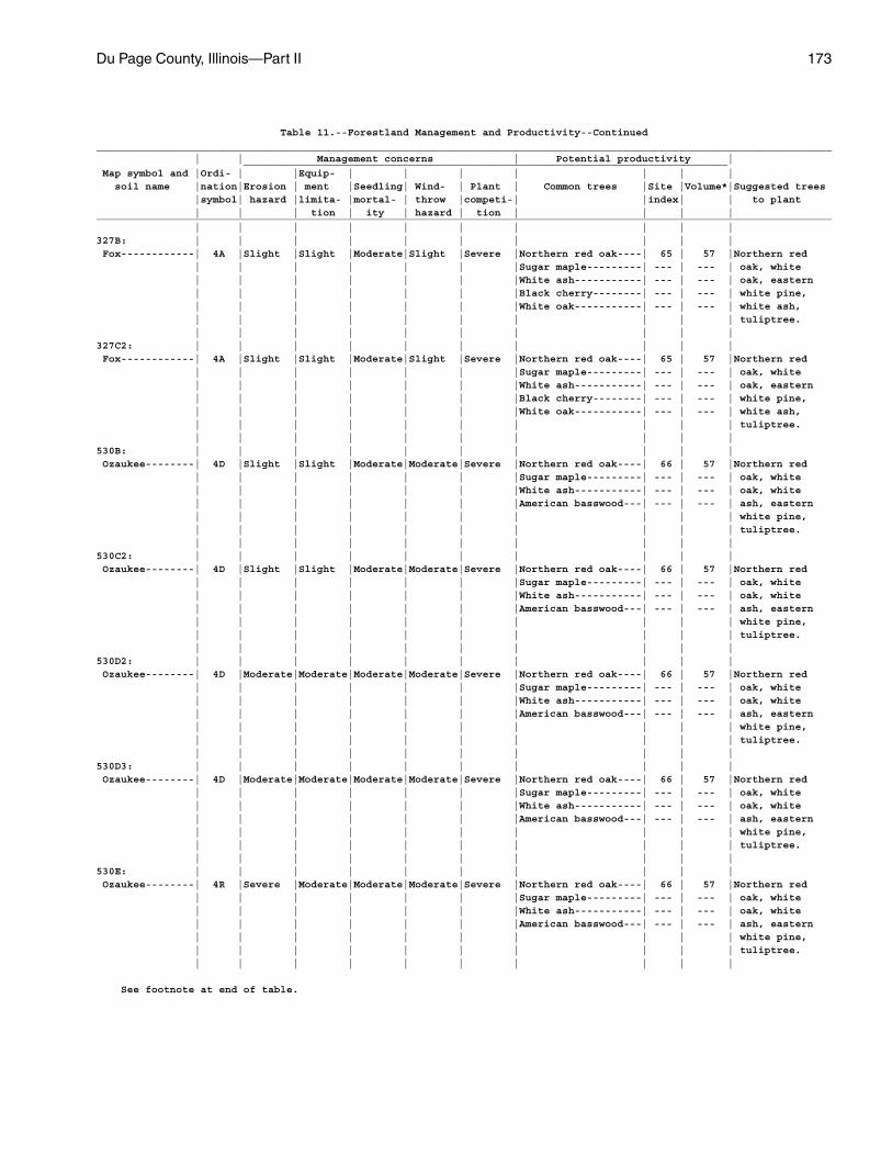
Du Page County, Illinois—Part II 173
Table 11.--Forestland Management and Productivity--Continued________________________________________________________________________________________________________________________ | | Management concerns | Potential productivity | _______________________________________________________________________________ Map symbol and |Ordi- | |Equip- | | | | | | | soil name |nation|Erosion | ment |Seedling| Wind- | Plant | Common trees |Site |Volume*|Suggested trees |symbol| hazard |limita- |mortal- | throw |competi-| |index| | to plant | | | tion | ity | hazard | tion | | | |________________________________________________________________________________________________________________________ | | | | | | | | | |327B: | | | | | | | | | | Fox------------| 4A |Slight |Slight |Moderate|Slight |Severe |Northern red oak----| 65 | 57 |Northern red | | | | | | |Sugar maple---------| --- | --- | oak, white | | | | | | |White ash-----------| --- | --- | oak, eastern | | | | | | |Black cherry--------| --- | --- | white pine, | | | | | | |White oak-----------| --- | --- | white ash, | | | | | | | | | | tuliptree. | | | | | | | | | |327C2: | | | | | | | | | | Fox------------| 4A |Slight |Slight |Moderate|Slight |Severe |Northern red oak----| 65 | 57 |Northern red | | | | | | |Sugar maple---------| --- | --- | oak, white | | | | | | |White ash-----------| --- | --- | oak, eastern | | | | | | |Black cherry--------| --- | --- | white pine, | | | | | | |White oak-----------| --- | --- | white ash, | | | | | | | | | | tuliptree. | | | | | | | | | |530B: | | | | | | | | | | Ozaukee--------| 4D |Slight |Slight |Moderate|Moderate|Severe |Northern red oak----| 66 | 57 |Northern red | | | | | | |Sugar maple---------| --- | --- | oak, white | | | | | | |White ash-----------| --- | --- | oak, white | | | | | | |American basswood---| --- | --- | ash, eastern | | | | | | | | | | white pine, | | | | | | | | | | tuliptree. | | | | | | | | | |530C2: | | | | | | | | | | Ozaukee--------| 4D |Slight |Slight |Moderate|Moderate|Severe |Northern red oak----| 66 | 57 |Northern red | | | | | | |Sugar maple---------| --- | --- | oak, white | | | | | | |White ash-----------| --- | --- | oak, white | | | | | | |American basswood---| --- | --- | ash, eastern | | | | | | | | | | white pine, | | | | | | | | | | tuliptree. | | | | | | | | | |530D2: | | | | | | | | | | Ozaukee--------| 4D |Moderate|Moderate|Moderate|Moderate|Severe |Northern red oak----| 66 | 57 |Northern red | | | | | | |Sugar maple---------| --- | --- | oak, white | | | | | | |White ash-----------| --- | --- | oak, white | | | | | | |American basswood---| --- | --- | ash, eastern | | | | | | | | | | white pine, | | | | | | | | | | tuliptree. | | | | | | | | | |530D3: | | | | | | | | | | Ozaukee--------| 4D |Moderate|Moderate|Moderate|Moderate|Severe |Northern red oak----| 66 | 57 |Northern red | | | | | | |Sugar maple---------| --- | --- | oak, white | | | | | | |White ash-----------| --- | --- | oak, white | | | | | | |American basswood---| --- | --- | ash, eastern | | | | | | | | | | white pine, | | | | | | | | | | tuliptree. | | | | | | | | | |530E: | | | | | | | | | | Ozaukee--------| 4R |Severe |Moderate|Moderate|Moderate|Severe |Northern red oak----| 66 | 57 |Northern red | | | | | | |Sugar maple---------| --- | --- | oak, white | | | | | | |White ash-----------| --- | --- | oak, white | | | | | | |American basswood---| --- | --- | ash, eastern | | | | | | | | | | white pine, | | | | | | | | | | tuliptree. | | | | | | | | | |
See footnote at end of table.
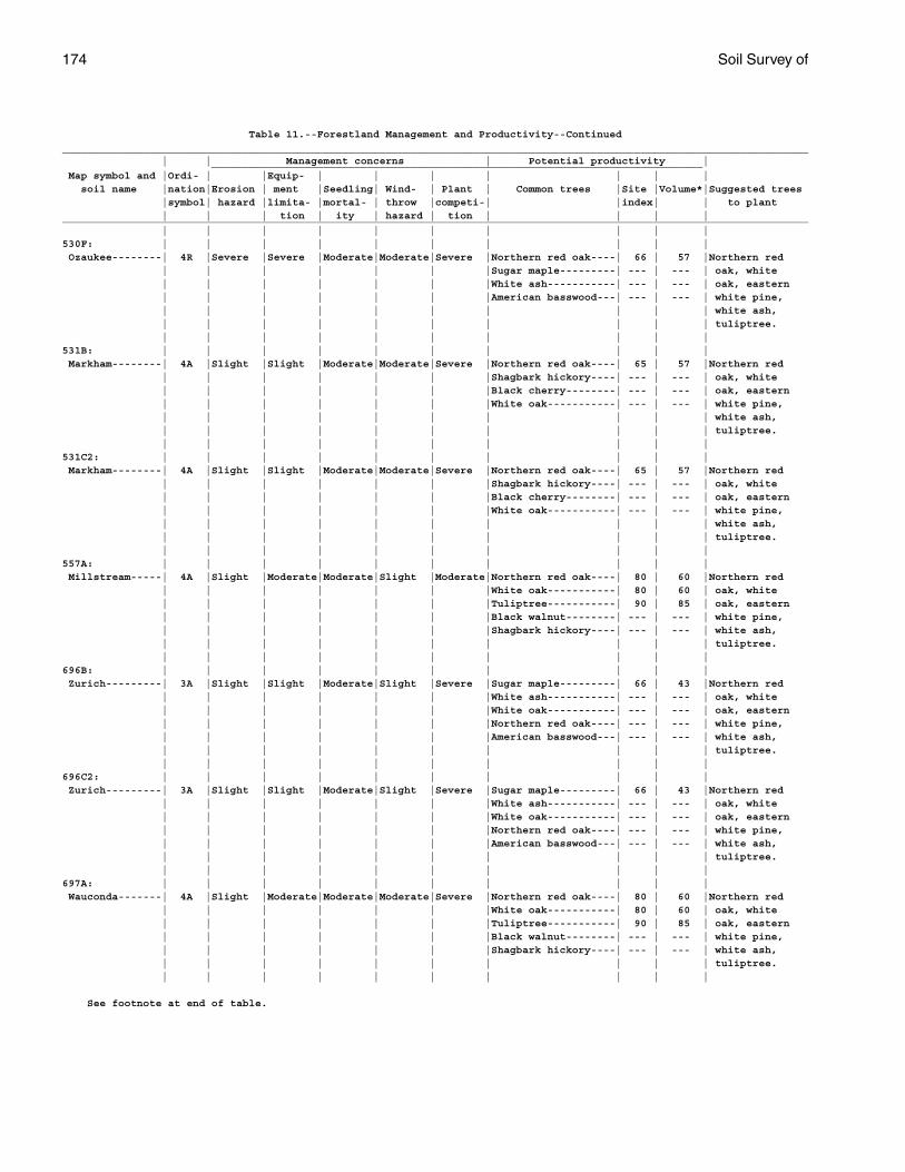
174 Soil Survey of
Table 11.--Forestland Management and Productivity--Continued________________________________________________________________________________________________________________________ | | Management concerns | Potential productivity | _______________________________________________________________________________ Map symbol and |Ordi- | |Equip- | | | | | | | soil name |nation|Erosion | ment |Seedling| Wind- | Plant | Common trees |Site |Volume*|Suggested trees |symbol| hazard |limita- |mortal- | throw |competi-| |index| | to plant | | | tion | ity | hazard | tion | | | |________________________________________________________________________________________________________________________ | | | | | | | | | |530F: | | | | | | | | | | Ozaukee--------| 4R |Severe |Severe |Moderate|Moderate|Severe |Northern red oak----| 66 | 57 |Northern red | | | | | | |Sugar maple---------| --- | --- | oak, white | | | | | | |White ash-----------| --- | --- | oak, eastern | | | | | | |American basswood---| --- | --- | white pine, | | | | | | | | | | white ash, | | | | | | | | | | tuliptree. | | | | | | | | | |531B: | | | | | | | | | | Markham--------| 4A |Slight |Slight |Moderate|Moderate|Severe |Northern red oak----| 65 | 57 |Northern red | | | | | | |Shagbark hickory----| --- | --- | oak, white | | | | | | |Black cherry--------| --- | --- | oak, eastern | | | | | | |White oak-----------| --- | --- | white pine, | | | | | | | | | | white ash, | | | | | | | | | | tuliptree. | | | | | | | | | |531C2: | | | | | | | | | | Markham--------| 4A |Slight |Slight |Moderate|Moderate|Severe |Northern red oak----| 65 | 57 |Northern red | | | | | | |Shagbark hickory----| --- | --- | oak, white | | | | | | |Black cherry--------| --- | --- | oak, eastern | | | | | | |White oak-----------| --- | --- | white pine, | | | | | | | | | | white ash, | | | | | | | | | | tuliptree. | | | | | | | | | |557A: | | | | | | | | | | Millstream-----| 4A |Slight |Moderate|Moderate|Slight |Moderate|Northern red oak----| 80 | 60 |Northern red | | | | | | |White oak-----------| 80 | 60 | oak, white | | | | | | |Tuliptree-----------| 90 | 85 | oak, eastern | | | | | | |Black walnut--------| --- | --- | white pine, | | | | | | |Shagbark hickory----| --- | --- | white ash, | | | | | | | | | | tuliptree. | | | | | | | | | |696B: | | | | | | | | | | Zurich---------| 3A |Slight |Slight |Moderate|Slight |Severe |Sugar maple---------| 66 | 43 |Northern red | | | | | | |White ash-----------| --- | --- | oak, white | | | | | | |White oak-----------| --- | --- | oak, eastern | | | | | | |Northern red oak----| --- | --- | white pine, | | | | | | |American basswood---| --- | --- | white ash, | | | | | | | | | | tuliptree. | | | | | | | | | |696C2: | | | | | | | | | | Zurich---------| 3A |Slight |Slight |Moderate|Slight |Severe |Sugar maple---------| 66 | 43 |Northern red | | | | | | |White ash-----------| --- | --- | oak, white | | | | | | |White oak-----------| --- | --- | oak, eastern | | | | | | |Northern red oak----| --- | --- | white pine, | | | | | | |American basswood---| --- | --- | white ash, | | | | | | | | | | tuliptree. | | | | | | | | | |697A: | | | | | | | | | | Wauconda-------| 4A |Slight |Moderate|Moderate|Moderate|Severe |Northern red oak----| 80 | 60 |Northern red | | | | | | |White oak-----------| 80 | 60 | oak, white | | | | | | |Tuliptree-----------| 90 | 85 | oak, eastern | | | | | | |Black walnut--------| --- | --- | white pine, | | | | | | |Shagbark hickory----| --- | --- | white ash, | | | | | | | | | | tuliptree. | | | | | | | | | |
See footnote at end of table.
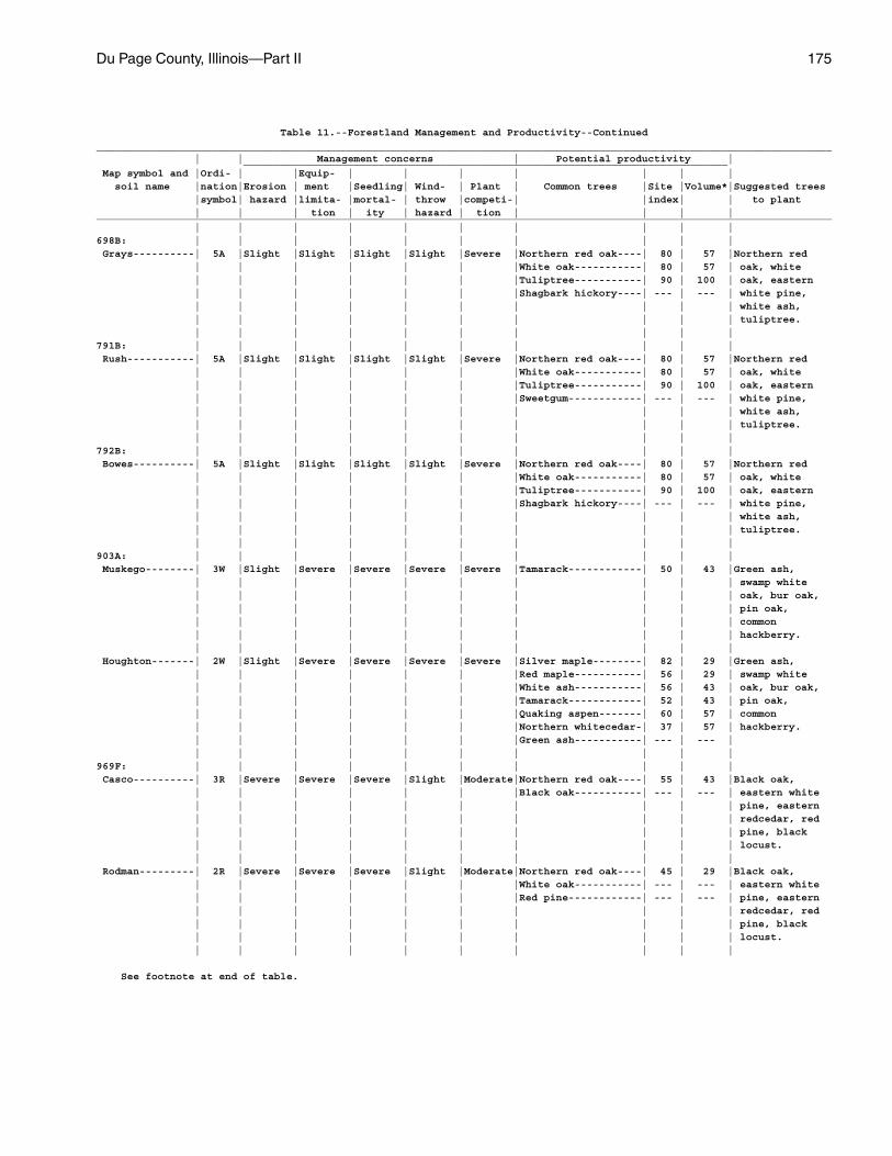
Du Page County, Illinois—Part II 175
Table 11.--Forestland Management and Productivity--Continued________________________________________________________________________________________________________________________ | | Management concerns | Potential productivity | _______________________________________________________________________________ Map symbol and |Ordi- | |Equip- | | | | | | | soil name |nation|Erosion | ment |Seedling| Wind- | Plant | Common trees |Site |Volume*|Suggested trees |symbol| hazard |limita- |mortal- | throw |competi-| |index| | to plant | | | tion | ity | hazard | tion | | | |________________________________________________________________________________________________________________________ | | | | | | | | | |698B: | | | | | | | | | | Grays----------| 5A |Slight |Slight |Slight |Slight |Severe |Northern red oak----| 80 | 57 |Northern red | | | | | | |White oak-----------| 80 | 57 | oak, white | | | | | | |Tuliptree-----------| 90 | 100 | oak, eastern | | | | | | |Shagbark hickory----| --- | --- | white pine, | | | | | | | | | | white ash, | | | | | | | | | | tuliptree. | | | | | | | | | |791B: | | | | | | | | | | Rush-----------| 5A |Slight |Slight |Slight |Slight |Severe |Northern red oak----| 80 | 57 |Northern red | | | | | | |White oak-----------| 80 | 57 | oak, white | | | | | | |Tuliptree-----------| 90 | 100 | oak, eastern | | | | | | |Sweetgum------------| --- | --- | white pine, | | | | | | | | | | white ash, | | | | | | | | | | tuliptree. | | | | | | | | | |792B: | | | | | | | | | | Bowes----------| 5A |Slight |Slight |Slight |Slight |Severe |Northern red oak----| 80 | 57 |Northern red | | | | | | |White oak-----------| 80 | 57 | oak, white | | | | | | |Tuliptree-----------| 90 | 100 | oak, eastern | | | | | | |Shagbark hickory----| --- | --- | white pine, | | | | | | | | | | white ash, | | | | | | | | | | tuliptree. | | | | | | | | | |903A: | | | | | | | | | | Muskego--------| 3W |Slight |Severe |Severe |Severe |Severe |Tamarack------------| 50 | 43 |Green ash, | | | | | | | | | | swamp white | | | | | | | | | | oak, bur oak, | | | | | | | | | | pin oak, | | | | | | | | | | common | | | | | | | | | | hackberry. | | | | | | | | | | Houghton-------| 2W |Slight |Severe |Severe |Severe |Severe |Silver maple--------| 82 | 29 |Green ash, | | | | | | |Red maple-----------| 56 | 29 | swamp white | | | | | | |White ash-----------| 56 | 43 | oak, bur oak, | | | | | | |Tamarack------------| 52 | 43 | pin oak, | | | | | | |Quaking aspen-------| 60 | 57 | common | | | | | | |Northern whitecedar-| 37 | 57 | hackberry. | | | | | | |Green ash-----------| --- | --- | | | | | | | | | | |969F: | | | | | | | | | | Casco----------| 3R |Severe |Severe |Severe |Slight |Moderate|Northern red oak----| 55 | 43 |Black oak, | | | | | | |Black oak-----------| --- | --- | eastern white | | | | | | | | | | pine, eastern | | | | | | | | | | redcedar, red | | | | | | | | | | pine, black | | | | | | | | | | locust. | | | | | | | | | | Rodman---------| 2R |Severe |Severe |Severe |Slight |Moderate|Northern red oak----| 45 | 29 |Black oak, | | | | | | |White oak-----------| --- | --- | eastern white | | | | | | |Red pine------------| --- | --- | pine, eastern | | | | | | | | | | redcedar, red | | | | | | | | | | pine, black | | | | | | | | | | locust. | | | | | | | | | |
See footnote at end of table.
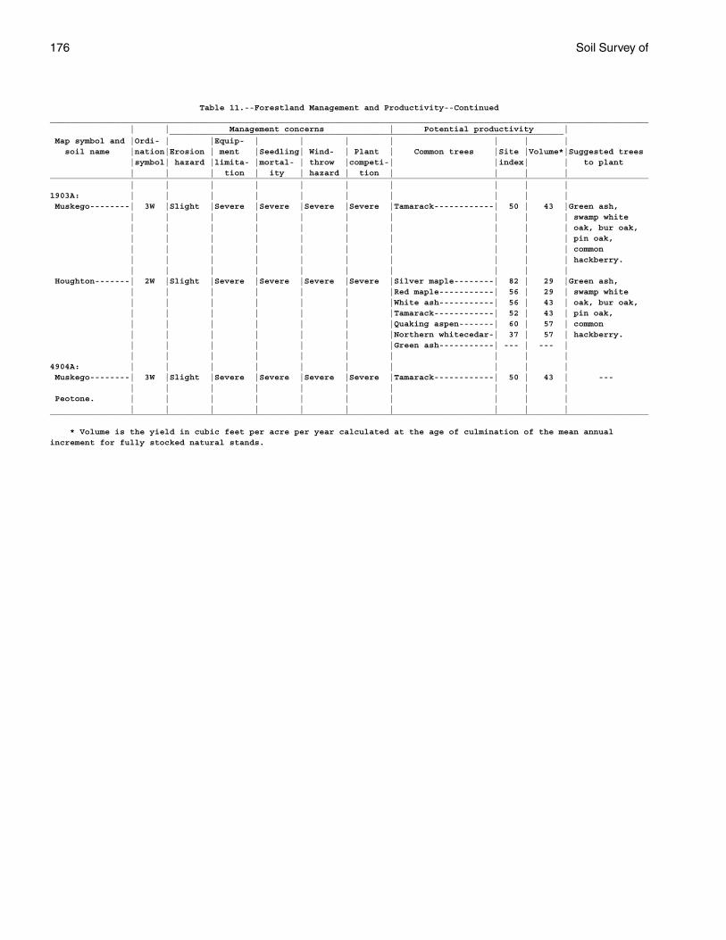
176 Soil Survey of
Table 11.--Forestland Management and Productivity--Continued________________________________________________________________________________________________________________________ | | Management concerns | Potential productivity | _______________________________________________________________________________ Map symbol and |Ordi- | |Equip- | | | | | | | soil name |nation|Erosion | ment |Seedling| Wind- | Plant | Common trees |Site |Volume*|Suggested trees |symbol| hazard |limita- |mortal- | throw |competi-| |index| | to plant | | | tion | ity | hazard | tion | | | |________________________________________________________________________________________________________________________ | | | | | | | | | |1903A: | | | | | | | | | | Muskego--------| 3W |Slight |Severe |Severe |Severe |Severe |Tamarack------------| 50 | 43 |Green ash, | | | | | | | | | | swamp white | | | | | | | | | | oak, bur oak, | | | | | | | | | | pin oak, | | | | | | | | | | common | | | | | | | | | | hackberry. | | | | | | | | | | Houghton-------| 2W |Slight |Severe |Severe |Severe |Severe |Silver maple--------| 82 | 29 |Green ash, | | | | | | |Red maple-----------| 56 | 29 | swamp white | | | | | | |White ash-----------| 56 | 43 | oak, bur oak, | | | | | | |Tamarack------------| 52 | 43 | pin oak, | | | | | | |Quaking aspen-------| 60 | 57 | common | | | | | | |Northern whitecedar-| 37 | 57 | hackberry. | | | | | | |Green ash-----------| --- | --- | | | | | | | | | | |4904A: | | | | | | | | | | Muskego--------| 3W |Slight |Severe |Severe |Severe |Severe |Tamarack------------| 50 | 43 | --- | | | | | | | | | | Peotone. | | | | | | | | | | | | | | | | | | | |________________________________________________________________________________________________________________________
* Volume is the yield in cubic feet per acre per year calculated at the age of culmination of the mean annualincrement for fully stocked natural stands.
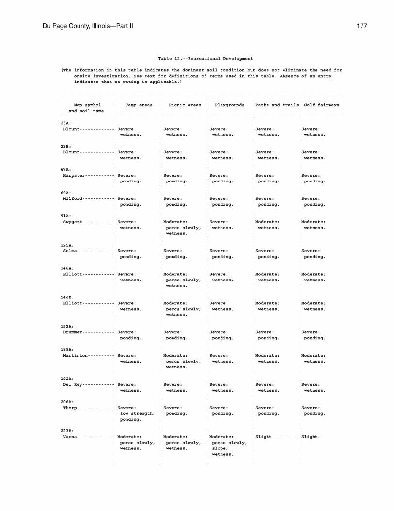
Du Page County, Illinois—Part II 177
Table 12.--Recreational Development
(The information in this table indicates the dominant soil condition but does not eliminate the need for onsite investigation. See text for definitions of terms used in this table. Absence of an entry indicates that no rating is applicable.)
_________________________________________________________________________________________________________ | | | | | Map symbol | Camp areas | Picnic areas | Playgrounds |Paths and trails| Golf fairways and soil name | | | | |_________________________________________________________________________________________________________ | | | | |23A: | | | | | Blount-------------|Severe: |Severe: |Severe: |Severe: |Severe: | wetness. | wetness. | wetness. | wetness. | wetness. | | | | |23B: | | | | | Blount-------------|Severe: |Severe: |Severe: |Severe: |Severe: | wetness. | wetness. | wetness. | wetness. | wetness. | | | | |67A: | | | | | Harpster-----------|Severe: |Severe: |Severe: |Severe: |Severe: | ponding. | ponding. | ponding. | ponding. | ponding. | | | | |69A: | | | | | Milford------------|Severe: |Severe: |Severe: |Severe: |Severe: | ponding. | ponding. | ponding. | ponding. | ponding. | | | | |91A: | | | | | Swygert------------|Severe: |Moderate: |Severe: |Moderate: |Moderate: | wetness. | percs slowly, | wetness. | wetness. | wetness. | | wetness. | | | | | | | |125A: | | | | | Selma--------------|Severe: |Severe: |Severe: |Severe: |Severe: | ponding. | ponding. | ponding. | ponding. | ponding. | | | | |146A: | | | | | Elliott------------|Severe: |Moderate: |Severe: |Moderate: |Moderate: | wetness. | percs slowly, | wetness. | wetness. | wetness. | | wetness. | | | | | | | |146B: | | | | | Elliott------------|Severe: |Moderate: |Severe: |Moderate: |Moderate: | wetness. | percs slowly, | wetness. | wetness. | wetness. | | wetness. | | | | | | | |152A: | | | | | Drummer------------|Severe: |Severe: |Severe: |Severe: |Severe: | ponding. | ponding. | ponding. | ponding. | ponding. | | | | |189A: | | | | | Martinton----------|Severe: |Moderate: |Severe: |Moderate: |Moderate: | wetness. | percs slowly, | wetness. | wetness. | wetness. | | wetness. | | | | | | | |192A: | | | | | Del Rey------------|Severe: |Severe: |Severe: |Severe: |Severe: | wetness. | wetness. | wetness. | wetness. | wetness. | | | | |206A: | | | | | Thorp--------------|Severe: |Severe: |Severe: |Severe: |Severe: | low strength, | ponding. | ponding. | ponding. | ponding. | ponding. | | | | | | | | |223B: | | | | | Varna--------------|Moderate: |Moderate: |Moderate: |Slight----------|Slight. | percs slowly, | percs slowly, | percs slowly, | | | wetness. | wetness. | slope, | | | | | wetness. | | | | | | |
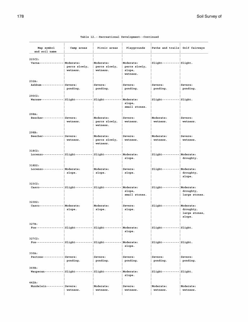
178 Soil Survey of
Table 12.--Recreational Development--Continued_________________________________________________________________________________________________________ | | | | | Map symbol | Camp areas | Picnic areas | Playgrounds |Paths and trails| Golf fairways and soil name | | | | |_________________________________________________________________________________________________________ | | | | |223C2: | | | | | Varna--------------|Moderate: |Moderate: |Moderate: |Slight----------|Slight. | percs slowly, | percs slowly, | percs slowly, | | | wetness. | wetness. | slope, | | | | | wetness. | | | | | | |232A: | | | | | Ashkum-------------|Severe: |Severe: |Severe: |Severe: |Severe: | ponding. | ponding. | ponding. | ponding. | ponding. | | | | |290C2: | | | | | Warsaw-------------|Slight----------|Slight----------|Moderate: |Slight----------|Slight. | | | slope, | | | | | small stones. | | | | | | |298A: | | | | | Beecher------------|Severe: |Moderate: |Severe: |Moderate: |Severe: | wetness. | percs slowly, | wetness. | wetness. | wetness. | | wetness. | | | | | | | |298B: | | | | | Beecher------------|Severe: |Moderate: |Severe: |Moderate: |Severe: | wetness. | percs slowly, | wetness. | wetness. | wetness. | | wetness. | | | | | | | |318C2: | | | | | Lorenzo------------|Slight----------|Slight----------|Moderate: |Slight----------|Moderate: | | | slope. | | droughty. | | | | |318D2: | | | | | Lorenzo------------|Moderate: |Moderate: |Severe: |Slight----------|Moderate: | slope. | slope. | slope. | | droughty, | | | | | slope. | | | | |323C2: | | | | | Casco--------------|Slight----------|Slight----------|Moderate: |Slight----------|Moderate: | | | slope, | | droughty, | | | small stones. | | large stones. | | | | |323D2: | | | | | Casco--------------|Moderate: |Moderate: |Severe: |Slight----------|Moderate: | slope. | slope. | slope. | | droughty, | | | | | large stones, | | | | | slope. | | | | |327B: | | | | | Fox----------------|Slight----------|Slight----------|Moderate: |Slight----------|Slight. | | | slope. | | | | | | |327C2: | | | | | Fox----------------|Slight----------|Slight----------|Moderate: |Slight----------|Slight. | | | slope. | | | | | | |330A: | | | | | Peotone------------|Severe: |Severe: |Severe: |Severe: |Severe: | ponding. | ponding. | ponding. | ponding. | ponding. | | | | |369B: | | | | | Waupecan-----------|Slight----------|Slight----------|Moderate: |Slight----------|Slight. | | | slope. | | | | | | |442A: | | | | | Mundelein----------|Severe: |Moderate: |Severe: |Moderate: |Moderate: | wetness. | wetness. | wetness. | wetness. | wetness. | | | | |
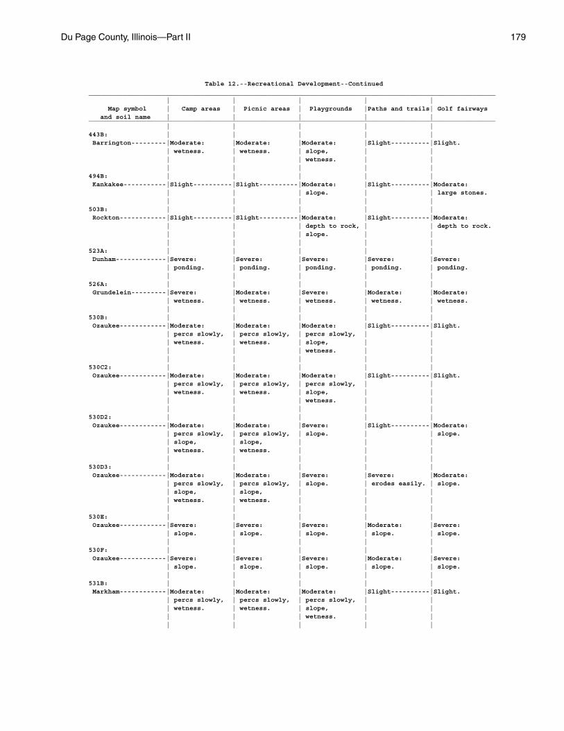
Du Page County, Illinois—Part II 179
Table 12.--Recreational Development--Continued_________________________________________________________________________________________________________ | | | | | Map symbol | Camp areas | Picnic areas | Playgrounds |Paths and trails| Golf fairways and soil name | | | | |_________________________________________________________________________________________________________ | | | | |443B: | | | | | Barrington---------|Moderate: |Moderate: |Moderate: |Slight----------|Slight. | wetness. | wetness. | slope, | | | | | wetness. | | | | | | |494B: | | | | | Kankakee-----------|Slight----------|Slight----------|Moderate: |Slight----------|Moderate: | | | slope. | | large stones. | | | | |503B: | | | | | Rockton------------|Slight----------|Slight----------|Moderate: |Slight----------|Moderate: | | | depth to rock, | | depth to rock. | | | slope. | | | | | | |523A: | | | | | Dunham-------------|Severe: |Severe: |Severe: |Severe: |Severe: | ponding. | ponding. | ponding. | ponding. | ponding. | | | | |526A: | | | | | Grundelein---------|Severe: |Moderate: |Severe: |Moderate: |Moderate: | wetness. | wetness. | wetness. | wetness. | wetness. | | | | |530B: | | | | | Ozaukee------------|Moderate: |Moderate: |Moderate: |Slight----------|Slight. | percs slowly, | percs slowly, | percs slowly, | | | wetness. | wetness. | slope, | | | | | wetness. | | | | | | |530C2: | | | | | Ozaukee------------|Moderate: |Moderate: |Moderate: |Slight----------|Slight. | percs slowly, | percs slowly, | percs slowly, | | | wetness. | wetness. | slope, | | | | | wetness. | | | | | | |530D2: | | | | | Ozaukee------------|Moderate: |Moderate: |Severe: |Slight----------|Moderate: | percs slowly, | percs slowly, | slope. | | slope. | slope, | slope, | | | | wetness. | wetness. | | | | | | | |530D3: | | | | | Ozaukee------------|Moderate: |Moderate: |Severe: |Severe: |Moderate: | percs slowly, | percs slowly, | slope. | erodes easily. | slope. | slope, | slope, | | | | wetness. | wetness. | | | | | | | |530E: | | | | | Ozaukee------------|Severe: |Severe: |Severe: |Moderate: |Severe: | slope. | slope. | slope. | slope. | slope. | | | | |530F: | | | | | Ozaukee------------|Severe: |Severe: |Severe: |Moderate: |Severe: | slope. | slope. | slope. | slope. | slope. | | | | |531B: | | | | | Markham------------|Moderate: |Moderate: |Moderate: |Slight----------|Slight. | percs slowly, | percs slowly, | percs slowly, | | | wetness. | wetness. | slope, | | | | | wetness. | | | | | | |
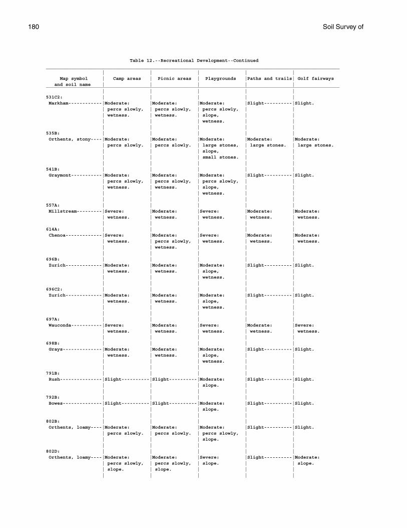
180 Soil Survey of
Table 12.--Recreational Development--Continued_________________________________________________________________________________________________________ | | | | | Map symbol | Camp areas | Picnic areas | Playgrounds |Paths and trails| Golf fairways and soil name | | | | |_________________________________________________________________________________________________________ | | | | |531C2: | | | | | Markham------------|Moderate: |Moderate: |Moderate: |Slight----------|Slight. | percs slowly, | percs slowly, | percs slowly, | | | wetness. | wetness. | slope, | | | | | wetness. | | | | | | |535B: | | | | | Orthents, stony----|Moderate: |Moderate: |Moderate: |Moderate: |Moderate: | percs slowly. | percs slowly. | large stones, | large stones. | large stones. | | | slope, | | | | | small stones. | | | | | | |541B: | | | | | Graymont-----------|Moderate: |Moderate: |Moderate: |Slight----------|Slight. | percs slowly, | percs slowly, | percs slowly, | | | wetness. | wetness. | slope, | | | | | wetness. | | | | | | |557A: | | | | | Millstream---------|Severe: |Moderate: |Severe: |Moderate: |Moderate: | wetness. | wetness. | wetness. | wetness. | wetness. | | | | |614A: | | | | | Chenoa-------------|Severe: |Moderate: |Severe: |Moderate: |Moderate: | wetness. | percs slowly, | wetness. | wetness. | wetness. | | wetness. | | | | | | | |696B: | | | | | Zurich-------------|Moderate: |Moderate: |Moderate: |Slight----------|Slight. | wetness. | wetness. | slope, | | | | | wetness. | | | | | | |696C2: | | | | | Zurich-------------|Moderate: |Moderate: |Moderate: |Slight----------|Slight. | wetness. | wetness. | slope, | | | | | wetness. | | | | | | |697A: | | | | | Wauconda-----------|Severe: |Moderate: |Severe: |Moderate: |Severe: | wetness. | wetness. | wetness. | wetness. | wetness. | | | | |698B: | | | | | Grays--------------|Moderate: |Moderate: |Moderate: |Slight----------|Slight. | wetness. | wetness. | slope, | | | | | wetness. | | | | | | |791B: | | | | | Rush---------------|Slight----------|Slight----------|Moderate: |Slight----------|Slight. | | | slope. | | | | | | |792B: | | | | | Bowes--------------|Slight----------|Slight----------|Moderate: |Slight----------|Slight. | | | slope. | | | | | | |802B: | | | | | Orthents, loamy----|Moderate: |Moderate: |Moderate: |Slight----------|Slight. | percs slowly. | percs slowly. | percs slowly, | | | | | slope. | | | | | | |802D: | | | | | Orthents, loamy----|Moderate: |Moderate: |Severe: |Slight----------|Moderate: | percs slowly, | percs slowly, | slope. | | slope. | slope. | slope. | | | | | | | |
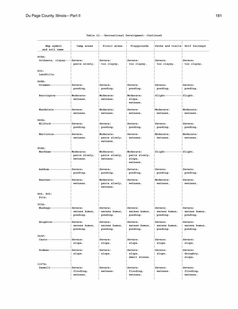
Du Page County, Illinois—Part II 181
Table 12.--Recreational Development--Continued_________________________________________________________________________________________________________ | | | | | Map symbol | Camp areas | Picnic areas | Playgrounds |Paths and trails| Golf fairways and soil name | | | | |_________________________________________________________________________________________________________ | | | | |805B: | | | | | Orthents, clayey---|Severe: |Severe: |Severe: |Severe: |Severe: | percs slowly. | too clayey. | too clayey. | too clayey. | too clayey. | | | | |830: | | | | | Landfills. | | | | | | | | | |848B: | | | | | Drummer------------|Severe: |Severe: |Severe: |Severe: |Severe: | ponding. | ponding. | ponding. | ponding. | ponding. | | | | | Barrington---------|Moderate: |Moderate: |Moderate: |Slight----------|Slight. | wetness. | wetness. | slope, | | | | | wetness. | | | | | | | Mundelein----------|Severe: |Moderate: |Severe: |Moderate: |Moderate: | wetness. | wetness. | wetness. | wetness. | wetness. | | | | |849A: | | | | | Milford------------|Severe: |Severe: |Severe: |Severe: |Severe: | ponding. | ponding. | ponding. | ponding. | ponding. | | | | | Martinton----------|Severe: |Moderate: |Severe: |Moderate: |Moderate: | wetness. | percs slowly, | wetness. | wetness. | wetness. | | wetness. | | | | | | | |854B: | | | | | Markham------------|Moderate: |Moderate: |Moderate: |Slight----------|Slight. | percs slowly, | percs slowly, | percs slowly, | | | wetness. | wetness. | slope, | | | | | wetness. | | | | | | | Ashkum-------------|Severe: |Severe: |Severe: |Severe: |Severe: | ponding. | ponding. | ponding. | ponding. | ponding. | | | | | Beecher------------|Severe: |Moderate: |Severe: |Moderate: |Severe: | wetness. | percs slowly, | wetness. | wetness. | wetness. | | wetness. | | | | | | | |864, 865: | | | | | Pits. | | | | | | | | | |903A: | | | | | Muskego------------|Severe: |Severe: |Severe: |Severe: |Severe: | excess humus, | excess humus, | excess humus, | excess humus, | excess humus, | ponding. | ponding. | ponding. | ponding. | ponding. | | | | | Houghton-----------|Severe: |Severe: |Severe: |Severe: |Severe: | excess humus, | excess humus, | excess humus, | excess humus, | excess humus, | ponding. | ponding. | ponding. | ponding. | ponding. | | | | |969F: | | | | | Casco--------------|Severe: |Severe: |Severe: |Severe: |Severe: | slope. | slope. | slope. | slope. | slope. | | | | | Rodman-------------|Severe: |Severe: |Severe: |Severe: |Severe: | slope. | slope. | slope, | slope. | droughty, | | | small stones. | | slope. | | | | |1107A: | | | | | Sawmill------------|Severe: |Severe: |Severe: |Severe: |Severe: | flooding, | wetness. | flooding, | wetness. | flooding, | wetness. | | wetness. | | wetness. | | | | |
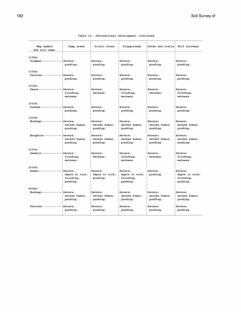
182 Soil Survey of
Table 12.--Recreational Development--Continued_________________________________________________________________________________________________________ | | | | | Map symbol | Camp areas | Picnic areas | Playgrounds |Paths and trails| Golf fairways and soil name | | | | |_________________________________________________________________________________________________________ | | | | |1152A: | | | | | Drummer------------|Severe: |Severe: |Severe: |Severe: |Severe: | ponding. | ponding. | ponding. | ponding. | ponding. | | | | |1330A: | | | | | Peotone------------|Severe: |Severe: |Severe: |Severe: |Severe: | ponding. | ponding. | ponding. | ponding. | ponding. | | | | |1516A: | | | | | Faxon--------------|Severe: |Severe: |Severe: |Severe: |Severe: | flooding, | wetness. | flooding, | wetness. | flooding, | wetness. | | wetness. | | wetness. | | | | |1523A: | | | | | Dunham-------------|Severe: |Severe: |Severe: |Severe: |Severe: | ponding. | ponding. | ponding. | ponding. | ponding. | | | | |1903A: | | | | | Muskego------------|Severe: |Severe: |Severe: |Severe: |Severe: | excess humus, | excess humus, | excess humus, | excess humus, | excess humus, | ponding. | ponding. | ponding. | ponding. | ponding. | | | | | Houghton-----------|Severe: |Severe: |Severe: |Severe: |Severe: | excess humus, | excess humus, | excess humus, | excess humus, | excess humus, | ponding. | ponding. | ponding. | ponding. | ponding. | | | | |3107A: | | | | | Sawmill------------|Severe: |Severe: |Severe: |Severe: |Severe: | flooding, | wetness. | flooding, | wetness. | flooding, | wetness. | | wetness. | | wetness. | | | | |3316A: | | | | | Romeo--------------|Severe: |Severe: |Severe: |Severe: |Severe: | depth to rock, | depth to rock, | depth to rock, | ponding. | depth to rock, | flooding, | ponding. | flooding, | | flooding, | ponding. | | ponding. | | ponding. | | | | |4904A: | | | | | Muskego------------|Severe: |Severe: |Severe: |Severe: |Severe: | excess humus, | excess humus, | excess humus, | excess humus, | excess humus, | ponding. | ponding. | ponding. | ponding. | ponding. | | | | | Peotone------------|Severe: |Severe: |Severe: |Severe: |Severe: | ponding. | ponding. | ponding. | ponding. | ponding. | | | | |_________________________________________________________________________________________________________
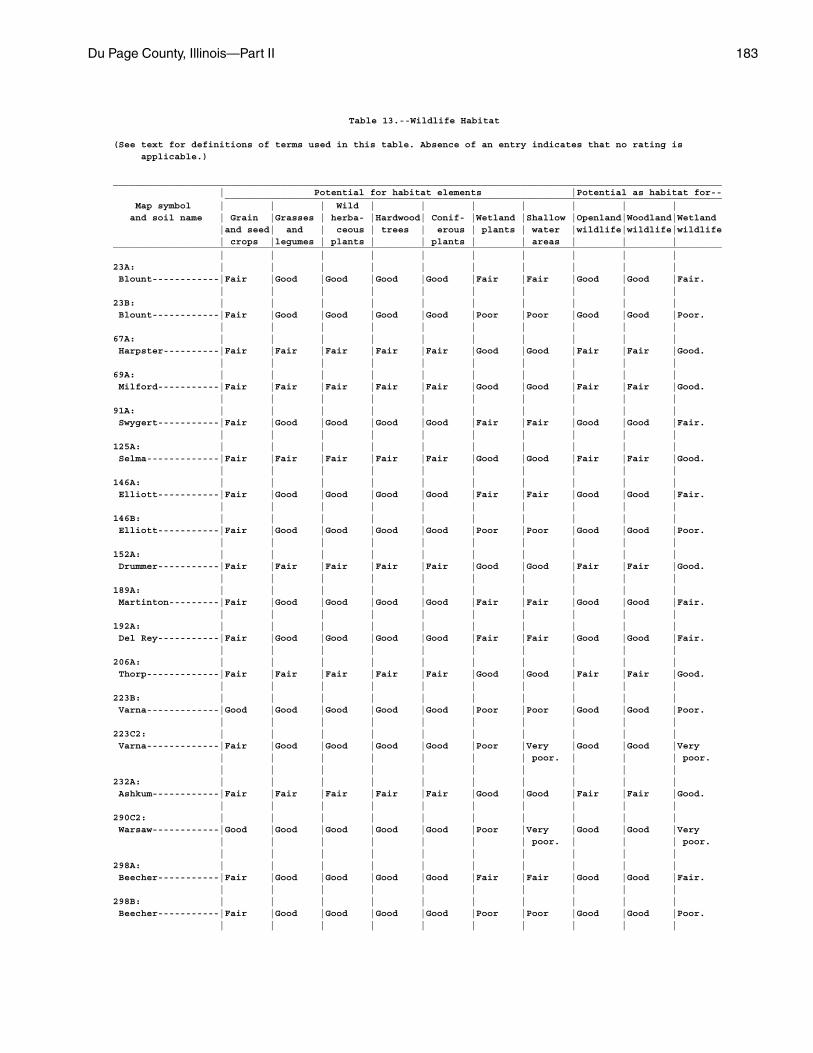
Du Page County, Illinois—Part II 183
Table 13.--Wildlife Habitat
(See text for definitions of terms used in this table. Absence of an entry indicates that no rating is applicable.)
_____________________________________________________________________________________________________________ | Potential for habitat elements |Potential as habitat for-- _________________________________________________________________________________________ Map symbol | | | Wild | | | | | | | and soil name | Grain |Grasses | herba- |Hardwood| Conif- |Wetland |Shallow |Openland|Woodland|Wetland |and seed| and | ceous | trees | erous | plants | water |wildlife|wildlife|wildlife | crops |legumes | plants | | plants | | areas | | |_____________________________________________________________________________________________________________ | | | | | | | | | |23A: | | | | | | | | | | Blount------------|Fair |Good |Good |Good |Good |Fair |Fair |Good |Good |Fair. | | | | | | | | | |23B: | | | | | | | | | | Blount------------|Fair |Good |Good |Good |Good |Poor |Poor |Good |Good |Poor. | | | | | | | | | |67A: | | | | | | | | | | Harpster----------|Fair |Fair |Fair |Fair |Fair |Good |Good |Fair |Fair |Good. | | | | | | | | | |69A: | | | | | | | | | | Milford-----------|Fair |Fair |Fair |Fair |Fair |Good |Good |Fair |Fair |Good. | | | | | | | | | |91A: | | | | | | | | | | Swygert-----------|Fair |Good |Good |Good |Good |Fair |Fair |Good |Good |Fair. | | | | | | | | | |125A: | | | | | | | | | | Selma-------------|Fair |Fair |Fair |Fair |Fair |Good |Good |Fair |Fair |Good. | | | | | | | | | |146A: | | | | | | | | | | Elliott-----------|Fair |Good |Good |Good |Good |Fair |Fair |Good |Good |Fair. | | | | | | | | | |146B: | | | | | | | | | | Elliott-----------|Fair |Good |Good |Good |Good |Poor |Poor |Good |Good |Poor. | | | | | | | | | |152A: | | | | | | | | | | Drummer-----------|Fair |Fair |Fair |Fair |Fair |Good |Good |Fair |Fair |Good. | | | | | | | | | |189A: | | | | | | | | | | Martinton---------|Fair |Good |Good |Good |Good |Fair |Fair |Good |Good |Fair. | | | | | | | | | |192A: | | | | | | | | | | Del Rey-----------|Fair |Good |Good |Good |Good |Fair |Fair |Good |Good |Fair. | | | | | | | | | |206A: | | | | | | | | | | Thorp-------------|Fair |Fair |Fair |Fair |Fair |Good |Good |Fair |Fair |Good. | | | | | | | | | |223B: | | | | | | | | | | Varna-------------|Good |Good |Good |Good |Good |Poor |Poor |Good |Good |Poor. | | | | | | | | | |223C2: | | | | | | | | | | Varna-------------|Fair |Good |Good |Good |Good |Poor |Very |Good |Good |Very | | | | | | | poor. | | | poor. | | | | | | | | | |232A: | | | | | | | | | | Ashkum------------|Fair |Fair |Fair |Fair |Fair |Good |Good |Fair |Fair |Good. | | | | | | | | | |290C2: | | | | | | | | | | Warsaw------------|Good |Good |Good |Good |Good |Poor |Very |Good |Good |Very | | | | | | | poor. | | | poor. | | | | | | | | | |298A: | | | | | | | | | | Beecher-----------|Fair |Good |Good |Good |Good |Fair |Fair |Good |Good |Fair. | | | | | | | | | |298B: | | | | | | | | | | Beecher-----------|Fair |Good |Good |Good |Good |Poor |Poor |Good |Good |Poor. | | | | | | | | | |
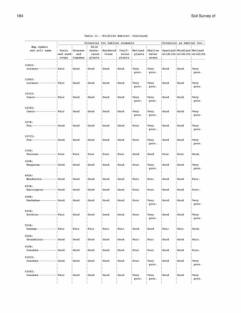
184 Soil Survey of
Table 13.--Wildlife Habitat--Continued_____________________________________________________________________________________________________________ | Potential for habitat elements |Potential as habitat for-- _________________________________________________________________________________________ Map symbol | | | Wild | | | | | | | and soil name | Grain |Grasses | herba- |Hardwood| Conif- |Wetland |Shallow |Openland|Woodland|Wetland |and seed| and | ceous | trees | erous | plants | water |wildlife|wildlife|wildlife | crops |legumes | plants | | plants | | areas | | |_____________________________________________________________________________________________________________ | | | | | | | | | |318C2: | | | | | | | | | | Lorenzo-----------|Fair |Good |Good |Good |Good |Very |Very |Good |Good |Very | | | | | | poor. | poor. | | | poor. | | | | | | | | | |318D2: | | | | | | | | | | Lorenzo-----------|Fair |Good |Good |Good |Good |Very |Very |Good |Good |Very | | | | | | poor. | poor. | | | poor. | | | | | | | | | |323C2: | | | | | | | | | | Casco-------------|Fair |Good |Good |Good |Good |Very |Very |Good |Good |Very | | | | | | poor. | poor. | | | poor. | | | | | | | | | |323D2: | | | | | | | | | | Casco-------------|Fair |Good |Good |Good |Good |Very |Very |Good |Good |Very | | | | | | poor. | poor. | | | poor. | | | | | | | | | |327B: | | | | | | | | | | Fox---------------|Good |Good |Good |Good |Good |Poor |Very |Good |Good |Very | | | | | | | poor. | | | poor. | | | | | | | | | |327C2: | | | | | | | | | | Fox---------------|Good |Good |Good |Good |Good |Poor |Very |Good |Good |Very | | | | | | | poor. | | | poor. | | | | | | | | | |330A: | | | | | | | | | | Peotone-----------|Poor |Poor |Poor |Poor |Poor |Good |Good |Poor |Poor |Good. | | | | | | | | | |369B: | | | | | | | | | | Waupecan----------|Good |Good |Good |Good |Good |Poor |Very |Good |Good |Very | | | | | | | poor. | | | poor. | | | | | | | | | |442A: | | | | | | | | | | Mundelein---------|Good |Good |Good |Good |Good |Fair |Fair |Good |Good |Fair. | | | | | | | | | |443B: | | | | | | | | | | Barrington--------|Good |Good |Good |Good |Good |Poor |Poor |Good |Good |Poor. | | | | | | | | | |494B: | | | | | | | | | | Kankakee----------|Good |Good |Good |Good |Good |Poor |Very |Good |Good |Very | | | | | | | poor. | | | poor. | | | | | | | | | |503B: | | | | | | | | | | Rockton-----------|Fair |Good |Good |Good |Good |Poor |Very |Good |Good |Very | | | | | | | poor. | | | poor. | | | | | | | | | |523A: | | | | | | | | | | Dunham------------|Fair |Fair |Fair |Fair |Fair |Good |Good |Fair |Fair |Good. | | | | | | | | | |526A: | | | | | | | | | | Grundelein--------|Good |Good |Good |Good |Good |Fair |Fair |Good |Good |Fair. | | | | | | | | | |530B: | | | | | | | | | | Ozaukee-----------|Good |Good |Good |Good |Good |Poor |Poor |Good |Good |Poor. | | | | | | | | | |530C2: | | | | | | | | | | Ozaukee-----------|Good |Good |Good |Good |Good |Poor |Very |Good |Good |Very | | | | | | | poor. | | | poor. | | | | | | | | | |530D2: | | | | | | | | | | Ozaukee-----------|Fair |Good |Good |Good |Good |Very |Very |Good |Good |Very | | | | | | poor. | poor. | | | poor. | | | | | | | | | |
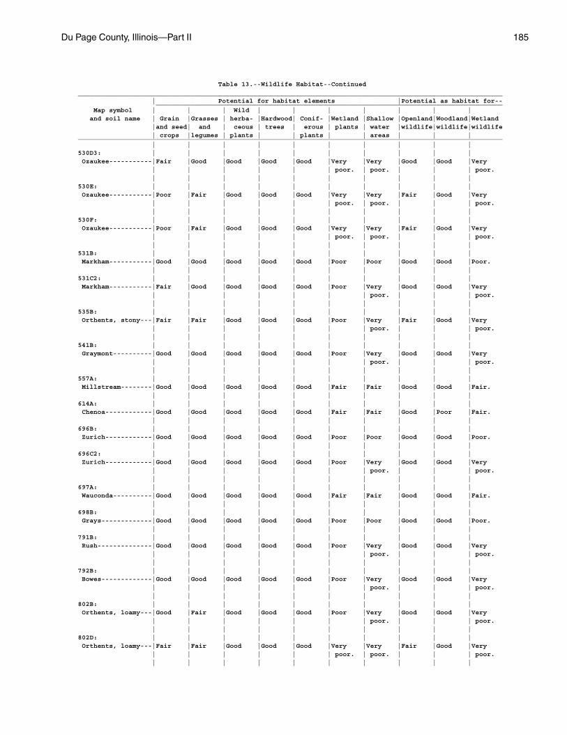
Du Page County, Illinois—Part II 185
Table 13.--Wildlife Habitat--Continued_____________________________________________________________________________________________________________ | Potential for habitat elements |Potential as habitat for-- _________________________________________________________________________________________ Map symbol | | | Wild | | | | | | | and soil name | Grain |Grasses | herba- |Hardwood| Conif- |Wetland |Shallow |Openland|Woodland|Wetland |and seed| and | ceous | trees | erous | plants | water |wildlife|wildlife|wildlife | crops |legumes | plants | | plants | | areas | | |_____________________________________________________________________________________________________________ | | | | | | | | | |530D3: | | | | | | | | | | Ozaukee-----------|Fair |Good |Good |Good |Good |Very |Very |Good |Good |Very | | | | | | poor. | poor. | | | poor. | | | | | | | | | |530E: | | | | | | | | | | Ozaukee-----------|Poor |Fair |Good |Good |Good |Very |Very |Fair |Good |Very | | | | | | poor. | poor. | | | poor. | | | | | | | | | |530F: | | | | | | | | | | Ozaukee-----------|Poor |Fair |Good |Good |Good |Very |Very |Fair |Good |Very | | | | | | poor. | poor. | | | poor. | | | | | | | | | |531B: | | | | | | | | | | Markham-----------|Good |Good |Good |Good |Good |Poor |Poor |Good |Good |Poor. | | | | | | | | | |531C2: | | | | | | | | | | Markham-----------|Fair |Good |Good |Good |Good |Poor |Very |Good |Good |Very | | | | | | | poor. | | | poor. | | | | | | | | | |535B: | | | | | | | | | | Orthents, stony---|Fair |Fair |Good |Good |Good |Poor |Very |Fair |Good |Very | | | | | | | poor. | | | poor. | | | | | | | | | |541B: | | | | | | | | | | Graymont----------|Good |Good |Good |Good |Good |Poor |Very |Good |Good |Very | | | | | | | poor. | | | poor. | | | | | | | | | |557A: | | | | | | | | | | Millstream--------|Good |Good |Good |Good |Good |Fair |Fair |Good |Good |Fair. | | | | | | | | | |614A: | | | | | | | | | | Chenoa------------|Good |Good |Good |Good |Good |Fair |Fair |Good |Poor |Fair. | | | | | | | | | |696B: | | | | | | | | | | Zurich------------|Good |Good |Good |Good |Good |Poor |Poor |Good |Good |Poor. | | | | | | | | | |696C2: | | | | | | | | | | Zurich------------|Good |Good |Good |Good |Good |Poor |Very |Good |Good |Very | | | | | | | poor. | | | poor. | | | | | | | | | |697A: | | | | | | | | | | Wauconda----------|Good |Good |Good |Good |Good |Fair |Fair |Good |Good |Fair. | | | | | | | | | |698B: | | | | | | | | | | Grays-------------|Good |Good |Good |Good |Good |Poor |Poor |Good |Good |Poor. | | | | | | | | | |791B: | | | | | | | | | | Rush--------------|Good |Good |Good |Good |Good |Poor |Very |Good |Good |Very | | | | | | | poor. | | | poor. | | | | | | | | | |792B: | | | | | | | | | | Bowes-------------|Good |Good |Good |Good |Good |Poor |Very |Good |Good |Very | | | | | | | poor. | | | poor. | | | | | | | | | |802B: | | | | | | | | | | Orthents, loamy---|Good |Fair |Good |Good |Good |Poor |Very |Good |Good |Very | | | | | | | poor. | | | poor. | | | | | | | | | |802D: | | | | | | | | | | Orthents, loamy---|Fair |Fair |Good |Good |Good |Very |Very |Fair |Good |Very | | | | | | poor. | poor. | | | poor. | | | | | | | | | |
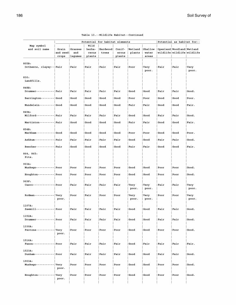
186 Soil Survey of
Table 13.--Wildlife Habitat--Continued_____________________________________________________________________________________________________________ | Potential for habitat elements |Potential as habitat for-- _________________________________________________________________________________________ Map symbol | | | Wild | | | | | | | and soil name | Grain |Grasses | herba- |Hardwood| Conif- |Wetland |Shallow |Openland|Woodland|Wetland |and seed| and | ceous | trees | erous | plants | water |wildlife|wildlife|wildlife | crops |legumes | plants | | plants | | areas | | |_____________________________________________________________________________________________________________ | | | | | | | | | |805B: | | | | | | | | | | Orthents, clayey--|Fair |Fair |Fair |Fair |Fair |Poor |Very |Fair |Fair |Very | | | | | | | poor. | | | poor. | | | | | | | | | |830: | | | | | | | | | | Landfills. | | | | | | | | | | | | | | | | | | | |848B: | | | | | | | | | | Drummer-----------|Fair |Fair |Fair |Fair |Fair |Good |Good |Fair |Fair |Good. | | | | | | | | | | Barrington--------|Good |Good |Good |Good |Good |Poor |Poor |Good |Good |Poor. | | | | | | | | | | Mundelein---------|Good |Good |Good |Good |Good |Fair |Fair |Good |Good |Fair. | | | | | | | | | |849A: | | | | | | | | | | Milford-----------|Fair |Fair |Fair |Fair |Fair |Good |Good |Fair |Fair |Good. | | | | | | | | | | Martinton---------|Fair |Good |Good |Good |Good |Fair |Fair |Good |Good |Fair. | | | | | | | | | |854B: | | | | | | | | | | Markham-----------|Good |Good |Good |Good |Good |Poor |Poor |Good |Good |Poor. | | | | | | | | | | Ashkum------------|Fair |Fair |Fair |Fair |Fair |Good |Good |Fair |Fair |Good. | | | | | | | | | | Beecher-----------|Fair |Good |Good |Good |Good |Fair |Fair |Good |Good |Fair. | | | | | | | | | |864, 865: | | | | | | | | | | Pits. | | | | | | | | | | | | | | | | | | | |903A: | | | | | | | | | | Muskego-----------|Poor |Poor |Poor |Poor |Poor |Good |Good |Poor |Poor |Good. | | | | | | | | | | Houghton----------|Poor |Poor |Poor |Poor |Poor |Good |Good |Poor |Poor |Good. | | | | | | | | | |969F: | | | | | | | | | | Casco-------------|Poor |Fair |Fair |Fair |Fair |Very |Very |Fair |Fair |Very | | | | | | poor. | poor. | | | poor. | | | | | | | | | | Rodman------------|Very |Poor |Fair |Poor |Poor |Very |Very |Poor |Poor |Very | poor. | | | | | poor. | poor. | | | poor. | | | | | | | | | |1107A: | | | | | | | | | | Sawmill-----------|Poor |Fair |Fair |Fair |Fair |Good |Good |Fair |Fair |Good. | | | | | | | | | |1152A: | | | | | | | | | | Drummer-----------|Poor |Fair |Fair |Fair |Fair |Good |Good |Fair |Fair |Good. | | | | | | | | | |1330A: | | | | | | | | | | Peotone-----------|Very |Poor |Poor |Poor |Poor |Good |Good |Poor |Poor |Good. | poor. | | | | | | | | | | | | | | | | | | |1516A: | | | | | | | | | | Faxon-------------|Poor |Fair |Fair |Fair |Fair |Good |Fair |Fair |Fair |Fair. | | | | | | | | | |1523A: | | | | | | | | | | Dunham------------|Poor |Fair |Fair |Fair |Fair |Good |Good |Fair |Fair |Good. | | | | | | | | | |1903A: | | | | | | | | | | Muskego-----------|Very |Poor |Poor |Poor |Poor |Good |Good |Poor |Poor |Good. | poor. | | | | | | | | | | | | | | | | | | | Houghton----------|Very |Poor |Poor |Poor |Poor |Good |Good |Poor |Poor |Good. | poor. | | | | | | | | | | | | | | | | | | |
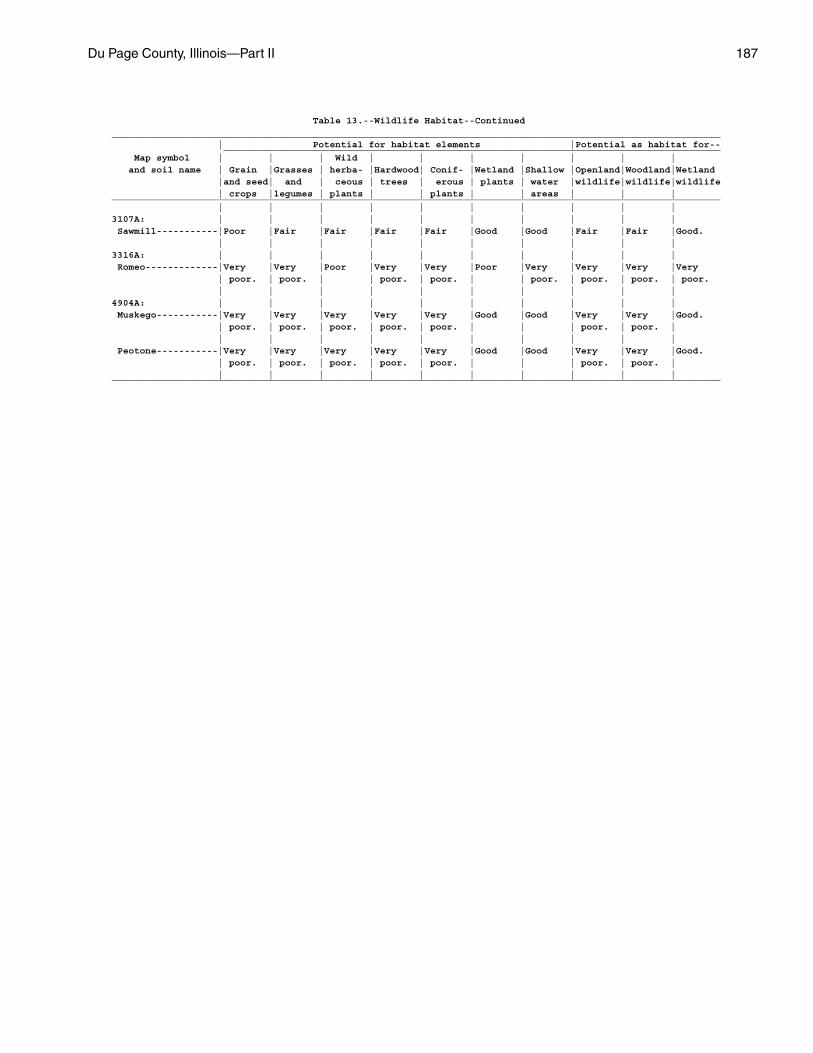
Du Page County, Illinois—Part II 187
Table 13.--Wildlife Habitat--Continued_____________________________________________________________________________________________________________ | Potential for habitat elements |Potential as habitat for-- _________________________________________________________________________________________ Map symbol | | | Wild | | | | | | | and soil name | Grain |Grasses | herba- |Hardwood| Conif- |Wetland |Shallow |Openland|Woodland|Wetland |and seed| and | ceous | trees | erous | plants | water |wildlife|wildlife|wildlife | crops |legumes | plants | | plants | | areas | | |_____________________________________________________________________________________________________________ | | | | | | | | | |3107A: | | | | | | | | | | Sawmill-----------|Poor |Fair |Fair |Fair |Fair |Good |Good |Fair |Fair |Good. | | | | | | | | | |3316A: | | | | | | | | | | Romeo-------------|Very |Very |Poor |Very |Very |Poor |Very |Very |Very |Very | poor. | poor. | | poor. | poor. | | poor. | poor. | poor. | poor. | | | | | | | | | |4904A: | | | | | | | | | | Muskego-----------|Very |Very |Very |Very |Very |Good |Good |Very |Very |Good. | poor. | poor. | poor. | poor. | poor. | | | poor. | poor. | | | | | | | | | | | Peotone-----------|Very |Very |Very |Very |Very |Good |Good |Very |Very |Good. | poor. | poor. | poor. | poor. | poor. | | | poor. | poor. | | | | | | | | | | |_____________________________________________________________________________________________________________
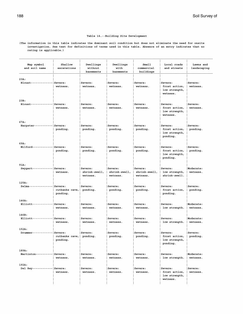
188 Soil Survey of
Table 14.--Building Site Development
(The information in this table indicates the dominant soil condition but does not eliminate the need for onsite investigation. See text for definitions of terms used in this table. Absence of an entry indicates that no rating is applicable.)
____________________________________________________________________________________________________________________ | | | | | | Map symbol | Shallow | Dwellings | Dwellings | Small | Local roads | Lawns and and soil name | excavations | without | with | commercial | and streets | landscaping | | basements | basements | buildings | |____________________________________________________________________________________________________________________ | | | | | |23A: | | | | | | Blount-------------|Severe: |Severe: |Severe: |Severe: |Severe: |Severe: | wetness. | wetness. | wetness. | wetness. | frost action, | wetness. | | | | | low strength, | | | | | | wetness. | | | | | | |23B: | | | | | | Blount-------------|Severe: |Severe: |Severe: |Severe: |Severe: |Severe: | wetness. | wetness. | wetness. | wetness. | frost action, | wetness. | | | | | low strength, | | | | | | wetness. | | | | | | |67A: | | | | | | Harpster-----------|Severe: |Severe: |Severe: |Severe: |Severe: |Severe: | ponding. | ponding. | ponding. | ponding. | frost action, | ponding. | | | | | low strength, | | | | | | ponding. | | | | | | |69A: | | | | | | Milford------------|Severe: |Severe: |Severe: |Severe: |Severe: |Severe: | ponding. | ponding. | ponding. | ponding. | frost action, | ponding. | | | | | low strength, | | | | | | ponding. | | | | | | |91A: | | | | | | Swygert------------|Severe: |Severe: |Severe: |Severe: |Severe: |Moderate: | wetness. | shrink-swell, | shrink-swell, | shrink-swell, | low strength, | wetness. | | wetness. | wetness. | wetness. | shrink-swell. | | | | | | |125A: | | | | | | Selma--------------|Severe: |Severe: |Severe: |Severe: |Severe: |Severe: | cutbanks cave,| ponding. | ponding. | ponding. | frost action, | ponding. | ponding. | | | | ponding. | | | | | | |146A: | | | | | | Elliott------------|Severe: |Severe: |Severe: |Severe: |Severe: |Moderate: | wetness. | wetness. | wetness. | wetness. | low strength. | wetness. | | | | | |146B: | | | | | | Elliott------------|Severe: |Severe: |Severe: |Severe: |Severe: |Moderate: | wetness. | wetness. | wetness. | wetness. | low strength. | wetness. | | | | | |152A: | | | | | | Drummer------------|Severe: |Severe: |Severe: |Severe: |Severe: |Severe: | cutbanks cave,| ponding. | ponding. | ponding. | frost action, | ponding. | ponding. | | | | low strength, | | | | | | ponding. | | | | | | |189A: | | | | | | Martinton----------|Severe: |Severe: |Severe: |Severe: |Severe: |Moderate: | wetness. | wetness. | wetness. | wetness. | low strength. | wetness. | | | | | |192A: | | | | | | Del Rey------------|Severe: |Severe: |Severe: |Severe: |Severe: |Severe: | wetness. | wetness. | wetness. | wetness. | frost action, | wetness. | | | | | low strength, | | | | | | wetness. | | | | | | |
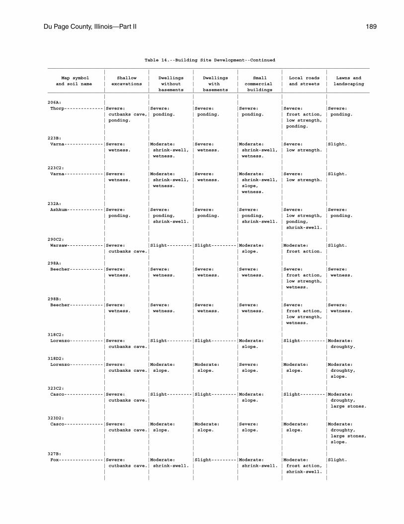
Du Page County, Illinois—Part II 189
Table 14.--Building Site Development--Continued____________________________________________________________________________________________________________________ | | | | | | Map symbol | Shallow | Dwellings | Dwellings | Small | Local roads | Lawns and and soil name | excavations | without | with | commercial | and streets | landscaping | | basements | basements | buildings | |____________________________________________________________________________________________________________________ | | | | | |206A: | | | | | | Thorp--------------|Severe: |Severe: |Severe: |Severe: |Severe: |Severe: | cutbanks cave,| ponding. | ponding. | ponding. | frost action, | ponding. | ponding. | | | | low strength, | | | | | | ponding. | | | | | | |223B: | | | | | | Varna--------------|Severe: |Moderate: |Severe: |Moderate: |Severe: |Slight. | wetness. | shrink-swell, | wetness. | shrink-swell, | low strength. | | | wetness. | | wetness. | | | | | | | |223C2: | | | | | | Varna--------------|Severe: |Moderate: |Severe: |Moderate: |Severe: |Slight. | wetness. | shrink-swell, | wetness. | shrink-swell, | low strength. | | | wetness. | | slope, | | | | | | wetness. | | | | | | | |232A: | | | | | | Ashkum-------------|Severe: |Severe: |Severe: |Severe: |Severe: |Severe: | ponding. | ponding, | ponding. | ponding, | low strength, | ponding. | | shrink-swell. | | shrink-swell. | ponding, | | | | | | shrink-swell. | | | | | | |290C2: | | | | | | Warsaw-------------|Severe: |Slight---------|Slight---------|Moderate: |Moderate: |Slight. | cutbanks cave.| | | slope. | frost action. | | | | | | |298A: | | | | | | Beecher------------|Severe: |Severe: |Severe: |Severe: |Severe: |Severe: | wetness. | wetness. | wetness. | wetness. | frost action, | wetness. | | | | | low strength, | | | | | | wetness. | | | | | | |298B: | | | | | | Beecher------------|Severe: |Severe: |Severe: |Severe: |Severe: |Severe: | wetness. | wetness. | wetness. | wetness. | frost action, | wetness. | | | | | low strength, | | | | | | wetness. | | | | | | |318C2: | | | | | | Lorenzo------------|Severe: |Slight---------|Slight---------|Moderate: |Slight---------|Moderate: | cutbanks cave.| | | slope. | | droughty. | | | | | |318D2: | | | | | | Lorenzo------------|Severe: |Moderate: |Moderate: |Severe: |Moderate: |Moderate: | cutbanks cave.| slope. | slope. | slope. | slope. | droughty, | | | | | | slope. | | | | | |323C2: | | | | | | Casco--------------|Severe: |Slight---------|Slight---------|Moderate: |Slight---------|Moderate: | cutbanks cave.| | | slope. | | droughty, | | | | | | large stones. | | | | | |323D2: | | | | | | Casco--------------|Severe: |Moderate: |Moderate: |Severe: |Moderate: |Moderate: | cutbanks cave.| slope. | slope. | slope. | slope. | droughty, | | | | | | large stones, | | | | | | slope. | | | | | |327B: | | | | | | Fox----------------|Severe: |Moderate: |Slight---------|Moderate: |Moderate: |Slight. | cutbanks cave.| shrink-swell. | | shrink-swell. | frost action, | | | | | | shrink-swell. | | | | | | |
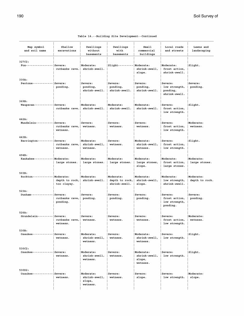
190 Soil Survey of
Table 14.--Building Site Development--Continued____________________________________________________________________________________________________________________ | | | | | | Map symbol | Shallow | Dwellings | Dwellings | Small | Local roads | Lawns and and soil name | excavations | without | with | commercial | and streets | landscaping | | basements | basements | buildings | |____________________________________________________________________________________________________________________ | | | | | |327C2: | | | | | | Fox----------------|Severe: |Moderate: |Slight---------|Moderate: |Moderate: |Slight. | cutbanks cave.| shrink-swell. | | shrink-swell, | frost action, | | | | | slope. | shrink-swell. | | | | | | |330A: | | | | | | Peotone------------|Severe: |Severe: |Severe: |Severe: |Severe: |Severe: | ponding. | ponding, | ponding, | ponding, | low strength, | ponding. | | shrink-swell. | shrink-swell. | shrink-swell. | ponding, | | | | | | shrink-swell. | | | | | | |369B: | | | | | | Waupecan-----------|Severe: |Moderate: |Moderate: |Moderate: |Severe: |Slight. | cutbanks cave.| shrink-swell. | shrink-swell. | shrink-swell. | frost action, | | | | | | low strength. | | | | | | |442A: | | | | | | Mundelein----------|Severe: |Severe: |Severe: |Severe: |Severe: |Moderate: | cutbanks cave,| wetness. | wetness. | wetness. | frost action, | wetness. | wetness. | | | | low strength. | | | | | | |443B: | | | | | | Barrington---------|Severe: |Moderate: |Severe: |Moderate: |Severe: |Slight. | cutbanks cave,| shrink-swell, | wetness. | shrink-swell, | frost action, | | wetness. | wetness. | | wetness. | low strength. | | | | | | |494B: | | | | | | Kankakee-----------|Moderate: |Moderate: |Moderate: |Moderate: |Moderate: |Moderate: | large stones. | large stones. | large stones. | large stones, | frost action, | large stones. | | | | slope. | large stones. | | | | | | |503B: | | | | | | Rockton------------|Moderate: |Moderate: |Moderate: |Moderate: |Moderate: |Moderate: | depth to rock,| shrink-swell. | depth to rock,| shrink-swell, | low strength, | depth to rock. | too clayey. | | shrink-swell. | slope. | shrink-swell. | | | | | | |523A: | | | | | | Dunham-------------|Severe: |Severe: |Severe: |Severe: |Severe: |Severe: | cutbanks cave,| ponding. | ponding. | ponding. | frost action, | ponding. | ponding. | | | | low strength, | | | | | | ponding. | | | | | | |526A: | | | | | | Grundelein---------|Severe: |Severe: |Severe: |Severe: |Severe: |Moderate: | cutbanks cave,| wetness. | wetness. | wetness. | frost action, | wetness. | wetness. | | | | low strength. | | | | | | |530B: | | | | | | Ozaukee------------|Severe: |Moderate: |Severe: |Moderate: |Severe: |Slight. | wetness. | shrink-swell, | wetness. | shrink-swell, | low strength. | | | wetness. | | wetness. | | | | | | | |530C2: | | | | | | Ozaukee------------|Severe: |Moderate: |Severe: |Moderate: |Severe: |Slight. | wetness. | shrink-swell, | wetness. | shrink-swell, | low strength. | | | wetness. | | slope, | | | | | | wetness. | | | | | | | |530D2: | | | | | | Ozaukee------------|Severe: |Moderate: |Severe: |Severe: |Severe: |Moderate: | wetness. | shrink-swell, | wetness. | slope. | low strength. | slope. | | slope, | | | | | | wetness. | | | | | | | | | |
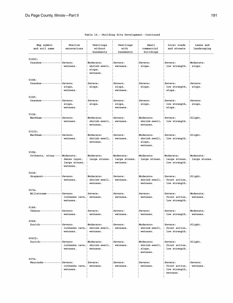
Du Page County, Illinois—Part II 191
Table 14.--Building Site Development--Continued____________________________________________________________________________________________________________________ | | | | | | Map symbol | Shallow | Dwellings | Dwellings | Small | Local roads | Lawns and and soil name | excavations | without | with | commercial | and streets | landscaping | | basements | basements | buildings | |____________________________________________________________________________________________________________________ | | | | | |530D3: | | | | | | Ozaukee------------|Severe: |Moderate: |Severe: |Severe: |Severe: |Moderate: | wetness. | shrink-swell, | wetness. | slope. | low strength. | slope. | | slope, | | | | | | wetness. | | | | | | | | | |530E: | | | | | | Ozaukee------------|Severe: |Severe: |Severe: |Severe: |Severe: |Severe: | slope, | slope. | slope, | slope. | low strength, | slope. | wetness. | | wetness. | | slope. | | | | | | |530F: | | | | | | Ozaukee------------|Severe: |Severe: |Severe: |Severe: |Severe: |Severe: | slope, | slope. | slope, | slope. | low strength, | slope. | wetness. | | wetness. | | slope. | | | | | | |531B: | | | | | | Markham------------|Severe: |Moderate: |Severe: |Moderate: |Severe: |Slight. | wetness. | shrink-swell, | wetness. | shrink-swell, | low strength. | | | wetness. | | wetness. | | | | | | | |531C2: | | | | | | Markham------------|Severe: |Moderate: |Severe: |Moderate: |Severe: |Slight. | wetness. | shrink-swell, | wetness. | shrink-swell, | low strength. | | | wetness. | | slope, | | | | | | wetness. | | | | | | | |535B: | | | | | | Orthents, stony----|Moderate: |Moderate: |Moderate: |Moderate: |Moderate: |Moderate: | dense layer, | large stones. | large stones, | large stones. | large stones, | large stones. | large stones, | | wetness. | | low strength. | | wetness. | | | | | | | | | | |541B: | | | | | | Graymont-----------|Severe: |Moderate: |Severe: |Moderate: |Severe: |Slight. | wetness. | shrink-swell, | wetness. | shrink-swell, | frost action, | | | wetness. | | wetness. | low strength. | | | | | | |557A: | | | | | | Millstream---------|Severe: |Severe: |Severe: |Severe: |Severe: |Moderate: | cutbanks cave,| wetness. | wetness. | wetness. | frost action, | wetness. | wetness. | | | | low strength. | | | | | | |614A: | | | | | | Chenoa-------------|Severe: |Severe: |Severe: |Severe: |Severe: |Moderate: | wetness. | wetness. | wetness. | wetness. | low strength. | wetness. | | | | | |696B: | | | | | | Zurich-------------|Severe: |Moderate: |Severe: |Moderate: |Severe: |Slight. | cutbanks cave,| shrink-swell, | wetness. | shrink-swell, | frost action, | | wetness. | wetness. | | wetness. | low strength. | | | | | | |696C2: | | | | | | Zurich-------------|Severe: |Moderate: |Severe: |Moderate: |Severe: |Slight. | cutbanks cave,| shrink-swell, | wetness. | shrink-swell, | frost action, | | wetness. | wetness. | | slope, | low strength. | | | | | wetness. | | | | | | | |697A: | | | | | | Wauconda-----------|Severe: |Severe: |Severe: |Severe: |Severe: |Severe: | cutbanks cave,| wetness. | wetness. | wetness. | frost action, | wetness. | wetness. | | | | low strength, | | | | | | wetness. | | | | | | |
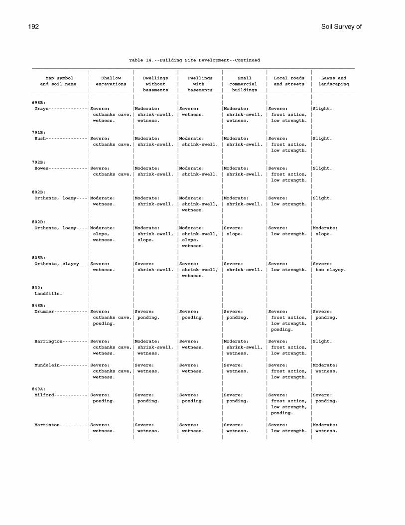
192 Soil Survey of
Table 14.--Building Site Development--Continued____________________________________________________________________________________________________________________ | | | | | | Map symbol | Shallow | Dwellings | Dwellings | Small | Local roads | Lawns and and soil name | excavations | without | with | commercial | and streets | landscaping | | basements | basements | buildings | |____________________________________________________________________________________________________________________ | | | | | |698B: | | | | | | Grays--------------|Severe: |Moderate: |Severe: |Moderate: |Severe: |Slight. | cutbanks cave,| shrink-swell, | wetness. | shrink-swell, | frost action, | | wetness. | wetness. | | wetness. | low strength. | | | | | | |791B: | | | | | | Rush---------------|Severe: |Moderate: |Moderate: |Moderate: |Severe: |Slight. | cutbanks cave.| shrink-swell. | shrink-swell. | shrink-swell. | frost action, | | | | | | low strength. | | | | | | |792B: | | | | | | Bowes--------------|Severe: |Moderate: |Moderate: |Moderate: |Severe: |Slight. | cutbanks cave.| shrink-swell. | shrink-swell. | shrink-swell. | frost action, | | | | | | low strength. | | | | | | |802B: | | | | | | Orthents, loamy----|Moderate: |Moderate: |Moderate: |Moderate: |Severe: |Slight. | wetness. | shrink-swell. | shrink-swell, | shrink-swell. | low strength. | | | | wetness. | | | | | | | | |802D: | | | | | | Orthents, loamy----|Moderate: |Moderate: |Moderate: |Severe: |Severe: |Moderate: | slope, | shrink-swell, | shrink-swell, | slope. | low strength. | slope. | wetness. | slope. | slope, | | | | | | wetness. | | | | | | | | |805B: | | | | | | Orthents, clayey---|Severe: |Severe: |Severe: |Severe: |Severe: |Severe: | wetness. | shrink-swell. | shrink-swell, | shrink-swell. | low strength. | too clayey. | | | wetness. | | | | | | | | |830: | | | | | | Landfills. | | | | | | | | | | | |848B: | | | | | | Drummer------------|Severe: |Severe: |Severe: |Severe: |Severe: |Severe: | cutbanks cave,| ponding. | ponding. | ponding. | frost action, | ponding. | ponding. | | | | low strength, | | | | | | ponding. | | | | | | | Barrington---------|Severe: |Moderate: |Severe: |Moderate: |Severe: |Slight. | cutbanks cave,| shrink-swell, | wetness. | shrink-swell, | frost action, | | wetness. | wetness. | | wetness. | low strength. | | | | | | | Mundelein----------|Severe: |Severe: |Severe: |Severe: |Severe: |Moderate: | cutbanks cave,| wetness. | wetness. | wetness. | frost action, | wetness. | wetness. | | | | low strength. | | | | | | |849A: | | | | | | Milford------------|Severe: |Severe: |Severe: |Severe: |Severe: |Severe: | ponding. | ponding. | ponding. | ponding. | frost action, | ponding. | | | | | low strength, | | | | | | ponding. | | | | | | | Martinton----------|Severe: |Severe: |Severe: |Severe: |Severe: |Moderate: | wetness. | wetness. | wetness. | wetness. | low strength. | wetness. | | | | | |
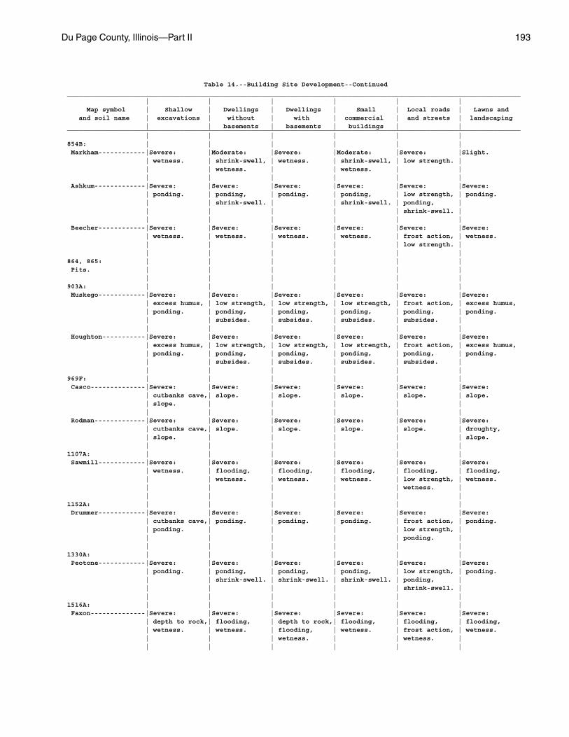
Du Page County, Illinois—Part II 193
Table 14.--Building Site Development--Continued____________________________________________________________________________________________________________________ | | | | | | Map symbol | Shallow | Dwellings | Dwellings | Small | Local roads | Lawns and and soil name | excavations | without | with | commercial | and streets | landscaping | | basements | basements | buildings | |____________________________________________________________________________________________________________________ | | | | | |854B: | | | | | | Markham------------|Severe: |Moderate: |Severe: |Moderate: |Severe: |Slight. | wetness. | shrink-swell, | wetness. | shrink-swell, | low strength. | | | wetness. | | wetness. | | | | | | | | Ashkum-------------|Severe: |Severe: |Severe: |Severe: |Severe: |Severe: | ponding. | ponding, | ponding. | ponding, | low strength, | ponding. | | shrink-swell. | | shrink-swell. | ponding, | | | | | | shrink-swell. | | | | | | | Beecher------------|Severe: |Severe: |Severe: |Severe: |Severe: |Severe: | wetness. | wetness. | wetness. | wetness. | frost action, | wetness. | | | | | low strength. | | | | | | |864, 865: | | | | | | Pits. | | | | | | | | | | | |903A: | | | | | | Muskego------------|Severe: |Severe: |Severe: |Severe: |Severe: |Severe: | excess humus, | low strength, | low strength, | low strength, | frost action, | excess humus, | ponding. | ponding, | ponding, | ponding, | ponding, | ponding. | | subsides. | subsides. | subsides. | subsides. | | | | | | | Houghton-----------|Severe: |Severe: |Severe: |Severe: |Severe: |Severe: | excess humus, | low strength, | low strength, | low strength, | frost action, | excess humus, | ponding. | ponding, | ponding, | ponding, | ponding, | ponding. | | subsides. | subsides. | subsides. | subsides. | | | | | | |969F: | | | | | | Casco--------------|Severe: |Severe: |Severe: |Severe: |Severe: |Severe: | cutbanks cave,| slope. | slope. | slope. | slope. | slope. | slope. | | | | | | | | | | | Rodman-------------|Severe: |Severe: |Severe: |Severe: |Severe: |Severe: | cutbanks cave,| slope. | slope. | slope. | slope. | droughty, | slope. | | | | | slope. | | | | | |1107A: | | | | | | Sawmill------------|Severe: |Severe: |Severe: |Severe: |Severe: |Severe: | wetness. | flooding, | flooding, | flooding, | flooding, | flooding, | | wetness. | wetness. | wetness. | low strength, | wetness. | | | | | wetness. | | | | | | |1152A: | | | | | | Drummer------------|Severe: |Severe: |Severe: |Severe: |Severe: |Severe: | cutbanks cave,| ponding. | ponding. | ponding. | frost action, | ponding. | ponding. | | | | low strength, | | | | | | ponding. | | | | | | |1330A: | | | | | | Peotone------------|Severe: |Severe: |Severe: |Severe: |Severe: |Severe: | ponding. | ponding, | ponding, | ponding, | low strength, | ponding. | | shrink-swell. | shrink-swell. | shrink-swell. | ponding, | | | | | | shrink-swell. | | | | | | |1516A: | | | | | | Faxon--------------|Severe: |Severe: |Severe: |Severe: |Severe: |Severe: | depth to rock,| flooding, | depth to rock,| flooding, | flooding, | flooding, | wetness. | wetness. | flooding, | wetness. | frost action, | wetness. | | | wetness. | | wetness. | | | | | | |
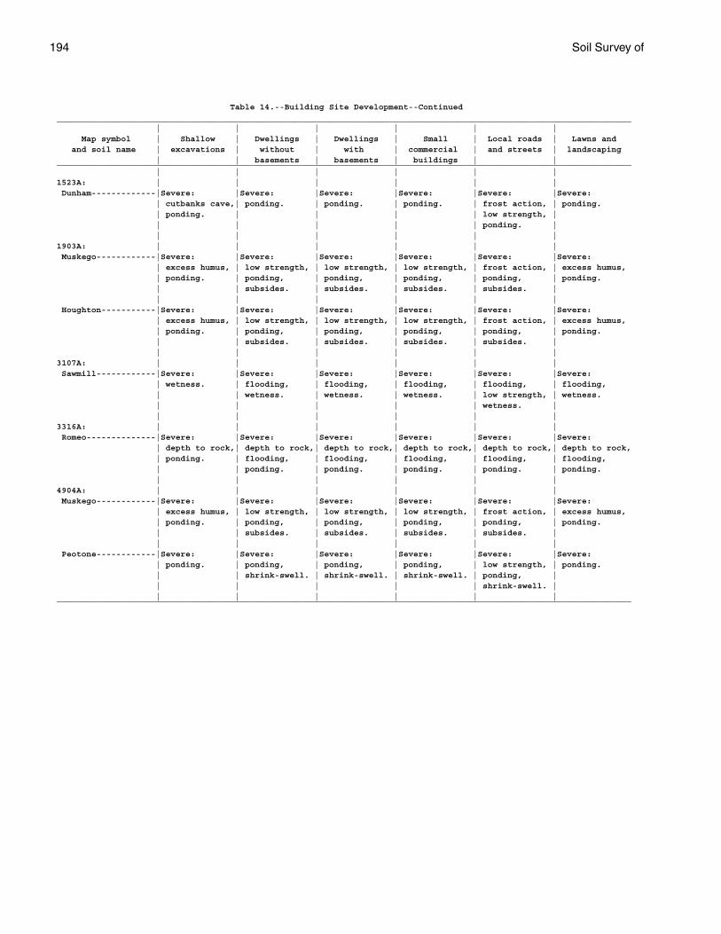
194 Soil Survey of
Table 14.--Building Site Development--Continued____________________________________________________________________________________________________________________ | | | | | | Map symbol | Shallow | Dwellings | Dwellings | Small | Local roads | Lawns and and soil name | excavations | without | with | commercial | and streets | landscaping | | basements | basements | buildings | |____________________________________________________________________________________________________________________ | | | | | |1523A: | | | | | | Dunham-------------|Severe: |Severe: |Severe: |Severe: |Severe: |Severe: | cutbanks cave,| ponding. | ponding. | ponding. | frost action, | ponding. | ponding. | | | | low strength, | | | | | | ponding. | | | | | | |1903A: | | | | | | Muskego------------|Severe: |Severe: |Severe: |Severe: |Severe: |Severe: | excess humus, | low strength, | low strength, | low strength, | frost action, | excess humus, | ponding. | ponding, | ponding, | ponding, | ponding, | ponding. | | subsides. | subsides. | subsides. | subsides. | | | | | | | Houghton-----------|Severe: |Severe: |Severe: |Severe: |Severe: |Severe: | excess humus, | low strength, | low strength, | low strength, | frost action, | excess humus, | ponding. | ponding, | ponding, | ponding, | ponding, | ponding. | | subsides. | subsides. | subsides. | subsides. | | | | | | |3107A: | | | | | | Sawmill------------|Severe: |Severe: |Severe: |Severe: |Severe: |Severe: | wetness. | flooding, | flooding, | flooding, | flooding, | flooding, | | wetness. | wetness. | wetness. | low strength, | wetness. | | | | | wetness. | | | | | | |3316A: | | | | | | Romeo--------------|Severe: |Severe: |Severe: |Severe: |Severe: |Severe: | depth to rock,| depth to rock,| depth to rock,| depth to rock,| depth to rock,| depth to rock, | ponding. | flooding, | flooding, | flooding, | flooding, | flooding, | | ponding. | ponding. | ponding. | ponding. | ponding. | | | | | |4904A: | | | | | | Muskego------------|Severe: |Severe: |Severe: |Severe: |Severe: |Severe: | excess humus, | low strength, | low strength, | low strength, | frost action, | excess humus, | ponding. | ponding, | ponding, | ponding, | ponding, | ponding. | | subsides. | subsides. | subsides. | subsides. | | | | | | | Peotone------------|Severe: |Severe: |Severe: |Severe: |Severe: |Severe: | ponding. | ponding, | ponding, | ponding, | low strength, | ponding. | | shrink-swell. | shrink-swell. | shrink-swell. | ponding, | | | | | | shrink-swell. | | | | | | |____________________________________________________________________________________________________________________
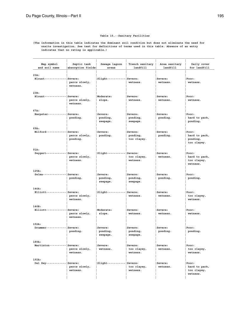
Du Page County, Illinois—Part II 195
Table 15.--Sanitary Facilities
(The information in this table indicates the dominant soil condition but does not eliminate the need for onsite investigation. See text for definitions of terms used in this table. Absence of an entry indicates that no rating is applicable.)
______________________________________________________________________________________________________________ | | | | | Map symbol | Septic tank | Sewage lagoon | Trench sanitary | Area sanitary | Daily cover and soil name |absorption fields| areas | landfill | landfill | for landfill______________________________________________________________________________________________________________ | | | | |23A: | | | | | Blount-------------|Severe: |Slight-----------|Severe: |Severe: |Poor: | percs slowly, | | wetness. | wetness. | wetness. | wetness. | | | | | | | | |23B: | | | | | Blount-------------|Severe: |Moderate: |Severe: |Severe: |Poor: | percs slowly, | slope. | wetness. | wetness. | wetness. | wetness. | | | | | | | | |67A: | | | | | Harpster-----------|Severe: |Severe: |Severe: |Severe: |Poor: | ponding. | ponding, | ponding, | ponding. | hard to pack, | | seepage. | seepage. | | ponding. | | | | |69A: | | | | | Milford------------|Severe: |Severe: |Severe: |Severe: |Poor: | percs slowly, | ponding. | ponding, | ponding. | hard to pack, | ponding. | | too clayey. | | ponding, | | | | | too clayey. | | | | |91A: | | | | | Swygert------------|Severe: |Slight-----------|Severe: |Severe: |Poor: | percs slowly, | | too clayey, | wetness. | hard to pack, | wetness. | | wetness. | | too clayey, | | | | | wetness. | | | | |125A: | | | | | Selma--------------|Severe: |Severe: |Severe: |Severe: |Poor: | ponding. | ponding, | ponding, | ponding. | ponding. | | seepage. | seepage. | | | | | | |146A: | | | | | Elliott------------|Severe: |Slight-----------|Severe: |Severe: |Poor: | percs slowly, | | wetness. | wetness. | too clayey, | wetness. | | | | wetness. | | | | |146B: | | | | | Elliott------------|Severe: |Moderate: |Severe: |Severe: |Poor: | percs slowly, | slope. | wetness. | wetness. | wetness. | wetness. | | | | | | | | |152A: | | | | | Drummer------------|Severe: |Severe: |Severe: |Severe: |Poor: | ponding. | ponding, | ponding, | ponding. | ponding. | | seepage. | seepage. | | | | | | |189A: | | | | | Martinton----------|Severe: |Severe: |Severe: |Severe: |Poor: | percs slowly, | wetness. | too clayey, | wetness. | too clayey, | wetness. | | wetness. | | wetness. | | | | |192A: | | | | | Del Rey------------|Severe: |Slight-----------|Severe: |Severe: |Poor: | percs slowly, | | too clayey, | wetness. | hard to pack, | wetness. | | wetness. | | too clayey, | | | | | wetness. | | | | |
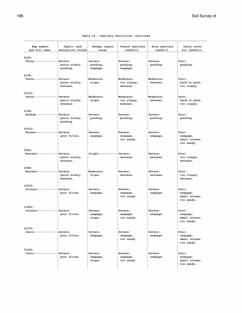
196 Soil Survey of
Table 15.--Sanitary Facilities--Continued______________________________________________________________________________________________________________ | | | | | Map symbol | Septic tank | Sewage lagoon | Trench sanitary | Area sanitary | Daily cover and soil name |absorption fields| areas | landfill | landfill | for landfill______________________________________________________________________________________________________________ | | | | |206A: | | | | | Thorp--------------|Severe: |Severe: |Severe: |Severe: |Poor: | percs slowly, | ponding, | ponding, | ponding. | ponding. | ponding. | seepage. | seepage. | | | | | | |223B: | | | | | Varna--------------|Severe: |Moderate: |Moderate: |Moderate: |Poor: | percs slowly, | slope. | too clayey, | wetness. | hard to pack, | wetness. | | wetness. | | too clayey. | | | | |223C2: | | | | | Varna--------------|Severe: |Moderate: |Moderate: |Moderate: |Poor: | percs slowly, | slope. | too clayey, | wetness. | hard to pack, | wetness. | | wetness. | | too clayey. | | | | |232A: | | | | | Ashkum-------------|Severe: |Severe: |Severe: |Severe: |Poor: | percs slowly, | ponding. | ponding. | ponding. | ponding. | ponding. | | | | | | | | |290C2: | | | | | Warsaw-------------|Severe: |Severe: |Severe: |Severe: |Poor: | poor filter. | seepage. | seepage, | seepage. | seepage, | | | too sandy. | | small stones, | | | | | too sandy. | | | | |298A: | | | | | Beecher------------|Severe: |Slight-----------|Severe: |Severe: |Poor: | percs slowly, | | wetness. | wetness. | too clayey, | wetness. | | | | wetness. | | | | |298B: | | | | | Beecher------------|Severe: |Moderate: |Severe: |Severe: |Poor: | percs slowly, | slope. | wetness. | wetness. | too clayey, | wetness. | | | | wetness. | | | | |318C2: | | | | | Lorenzo------------|Severe: |Severe: |Severe: |Severe: |Poor: | poor filter. | seepage. | seepage, | seepage. | seepage, | | | too sandy. | | small stones, | | | | | too sandy. | | | | |318D2: | | | | | Lorenzo------------|Severe: |Severe: |Severe: |Severe: |Poor: | poor filter. | seepage, | seepage, | seepage. | seepage, | | slope. | too sandy. | | small stones, | | | | | too sandy. | | | | |323C2: | | | | | Casco--------------|Severe: |Severe: |Severe: |Severe: |Poor: | poor filter. | seepage. | seepage, | seepage. | seepage, | | | too sandy. | | small stones, | | | | | too sandy. | | | | |323D2: | | | | | Casco--------------|Severe: |Severe: |Severe: |Severe: |Poor: | poor filter. | seepage, | seepage, | seepage. | seepage, | | slope. | too sandy. | | small stones, | | | | | too sandy. | | | | |
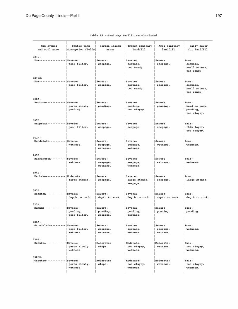
Du Page County, Illinois—Part II 197
Table 15.--Sanitary Facilities--Continued______________________________________________________________________________________________________________ | | | | | Map symbol | Septic tank | Sewage lagoon | Trench sanitary | Area sanitary | Daily cover and soil name |absorption fields| areas | landfill | landfill | for landfill______________________________________________________________________________________________________________ | | | | |327B: | | | | | Fox----------------|Severe: |Severe: |Severe: |Severe: |Poor: | poor filter. | seepage. | seepage, | seepage. | seepage, | | | too sandy. | | small stones, | | | | | too sandy. | | | | |327C2: | | | | | Fox----------------|Severe: |Severe: |Severe: |Severe: |Poor: | poor filter. | seepage. | seepage, | seepage. | seepage, | | | too sandy. | | small stones, | | | | | too sandy. | | | | |330A: | | | | | Peotone------------|Severe: |Severe: |Severe: |Severe: |Poor: | percs slowly, | ponding. | ponding, | ponding. | hard to pack, | ponding. | | too clayey. | | ponding, | | | | | too clayey. | | | | |369B: | | | | | Waupecan-----------|Severe: |Severe: |Severe: |Severe: |Fair: | poor filter. | seepage. | seepage. | seepage. | thin layer, | | | | | too clayey. | | | | |442A: | | | | | Mundelein----------|Severe: |Severe: |Severe: |Severe: |Poor: | wetness. | seepage, | seepage, | wetness. | wetness. | | wetness. | wetness. | | | | | | |443B: | | | | | Barrington---------|Severe: |Severe: |Severe: |Severe: |Fair: | wetness. | seepage, | seepage, | wetness. | wetness. | | wetness. | wetness. | | | | | | |494B: | | | | | Kankakee-----------|Moderate: |Severe: |Severe: |Severe: |Poor: | large stones. | seepage. | large stones, | seepage. | large stones. | | | seepage. | | | | | | |503B: | | | | | Rockton------------|Severe: |Severe: |Severe: |Severe: |Poor: | depth to rock. | depth to rock. | depth to rock. | depth to rock. | depth to rock. | | | | |523A: | | | | | Dunham-------------|Severe: |Severe: |Severe: |Severe: |Poor: | ponding, | ponding, | ponding, | ponding. | ponding. | poor filter. | seepage. | seepage. | | | | | | |526A: | | | | | Grundelein---------|Severe: |Severe: |Severe: |Severe: |Poor: | poor filter, | seepage, | seepage, | seepage, | wetness. | wetness. | wetness. | wetness. | wetness. | | | | | |530B: | | | | | Ozaukee------------|Severe: |Moderate: |Moderate: |Moderate: |Fair: | percs slowly, | slope. | too clayey, | wetness. | too clayey, | wetness. | | wetness. | | wetness. | | | | |530C2: | | | | | Ozaukee------------|Severe: |Moderate: |Moderate: |Moderate: |Fair: | percs slowly, | slope. | too clayey, | wetness. | too clayey, | wetness. | | wetness. | | wetness. | | | | |
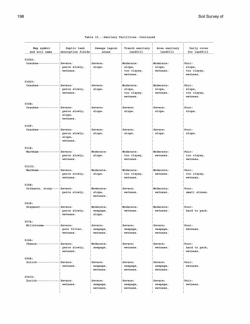
198 Soil Survey of
Table 15.--Sanitary Facilities--Continued______________________________________________________________________________________________________________ | | | | | Map symbol | Septic tank | Sewage lagoon | Trench sanitary | Area sanitary | Daily cover and soil name |absorption fields| areas | landfill | landfill | for landfill______________________________________________________________________________________________________________ | | | | |530D2: | | | | | Ozaukee------------|Severe: |Severe: |Moderate: |Moderate: |Fair: | percs slowly, | slope. | slope, | slope, | slope, | wetness. | | too clayey, | wetness. | too clayey, | | | wetness. | | wetness. | | | | |530D3: | | | | | Ozaukee------------|Severe: |Severe: |Moderate: |Moderate: |Fair: | percs slowly, | slope. | slope, | slope, | slope, | wetness. | | too clayey, | wetness. | too clayey, | | | wetness. | | wetness. | | | | |530E: | | | | | Ozaukee------------|Severe: |Severe: |Severe: |Severe: |Poor: | percs slowly, | slope. | slope. | slope. | slope. | slope, | | | | | wetness. | | | | | | | | |530F: | | | | | Ozaukee------------|Severe: |Severe: |Severe: |Severe: |Poor: | percs slowly, | slope. | slope. | slope. | slope. | slope, | | | | | wetness. | | | | | | | | |531B: | | | | | Markham------------|Severe: |Moderate: |Moderate: |Moderate: |Fair: | percs slowly, | slope. | too clayey, | wetness. | too clayey, | wetness. | | wetness. | | wetness. | | | | |531C2: | | | | | Markham------------|Severe: |Moderate: |Moderate: |Moderate: |Fair: | percs slowly, | slope. | too clayey, | wetness. | too clayey, | wetness. | | wetness. | | wetness. | | | | |535B: | | | | | Orthents, stony----|Severe: |Moderate: |Severe: |Moderate: |Poor: | percs slowly. | slope, | wetness. | wetness. | small stones. | | wetness. | | | | | | | |541B: | | | | | Graymont-----------|Severe: |Moderate: |Moderate: |Moderate: |Poor: | percs slowly, | seepage, | wetness. | wetness. | hard to pack. | wetness. | slope. | | | | | | | |557A: | | | | | Millstream---------|Severe: |Severe: |Severe: |Severe: |Poor: | poor filter, | seepage, | seepage, | seepage, | wetness. | wetness. | wetness. | wetness. | wetness. | | | | | |614A: | | | | | Chenoa-------------|Severe: |Moderate: |Severe: |Severe: |Poor: | percs slowly, | seepage. | wetness. | wetness. | hard to pack, | wetness. | | | | wetness. | | | | |696B: | | | | | Zurich-------------|Severe: |Severe: |Severe: |Severe: |Fair: | wetness. | seepage, | seepage, | seepage, | wetness. | | wetness. | wetness. | wetness. | | | | | |696C2: | | | | | Zurich-------------|Severe: |Severe: |Severe: |Severe: |Fair: | wetness. | seepage, | seepage, | seepage, | wetness. | | wetness. | wetness. | wetness. | | | | | |
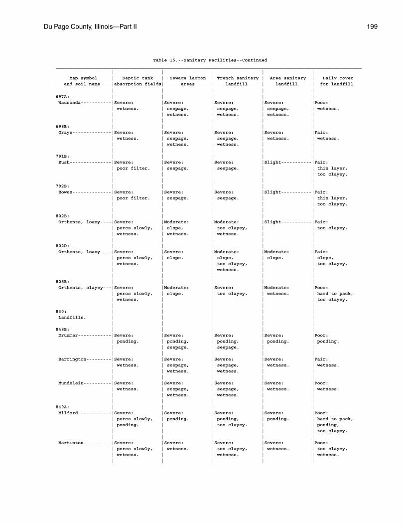
Du Page County, Illinois—Part II 199
Table 15.--Sanitary Facilities--Continued______________________________________________________________________________________________________________ | | | | | Map symbol | Septic tank | Sewage lagoon | Trench sanitary | Area sanitary | Daily cover and soil name |absorption fields| areas | landfill | landfill | for landfill______________________________________________________________________________________________________________ | | | | |697A: | | | | | Wauconda-----------|Severe: |Severe: |Severe: |Severe: |Poor: | wetness. | seepage, | seepage, | seepage, | wetness. | | wetness. | wetness. | wetness. | | | | | |698B: | | | | | Grays--------------|Severe: |Severe: |Severe: |Severe: |Fair: | wetness. | seepage, | seepage, | wetness. | wetness. | | wetness. | wetness. | | | | | | |791B: | | | | | Rush---------------|Severe: |Severe: |Severe: |Slight-----------|Fair: | poor filter. | seepage. | seepage. | | thin layer, | | | | | too clayey. | | | | |792B: | | | | | Bowes--------------|Severe: |Severe: |Severe: |Slight-----------|Fair: | poor filter. | seepage. | seepage. | | thin layer, | | | | | too clayey. | | | | |802B: | | | | | Orthents, loamy----|Severe: |Moderate: |Moderate: |Slight-----------|Fair: | percs slowly, | slope, | too clayey, | | too clayey. | wetness. | wetness. | wetness. | | | | | | |802D: | | | | | Orthents, loamy----|Severe: |Severe: |Moderate: |Moderate: |Fair: | percs slowly, | slope. | slope, | slope. | slope, | wetness. | | too clayey, | | too clayey. | | | wetness. | | | | | | |805B: | | | | | Orthents, clayey---|Severe: |Moderate: |Severe: |Moderate: |Poor: | percs slowly, | slope. | too clayey. | wetness. | hard to pack, | wetness. | | | | too clayey. | | | | |830: | | | | | Landfills. | | | | | | | | | |848B: | | | | | Drummer------------|Severe: |Severe: |Severe: |Severe: |Poor: | ponding. | ponding, | ponding, | ponding. | ponding. | | seepage. | seepage. | | | | | | | Barrington---------|Severe: |Severe: |Severe: |Severe: |Fair: | wetness. | seepage, | seepage, | wetness. | wetness. | | wetness. | wetness. | | | | | | | Mundelein----------|Severe: |Severe: |Severe: |Severe: |Poor: | wetness. | seepage, | seepage, | wetness. | wetness. | | wetness. | wetness. | | | | | | |849A: | | | | | Milford------------|Severe: |Severe: |Severe: |Severe: |Poor: | percs slowly, | ponding. | ponding, | ponding. | hard to pack, | ponding. | | too clayey. | | ponding, | | | | | too clayey. | | | | | Martinton----------|Severe: |Severe: |Severe: |Severe: |Poor: | percs slowly, | wetness. | too clayey, | wetness. | too clayey, | wetness. | | wetness. | | wetness. | | | | |
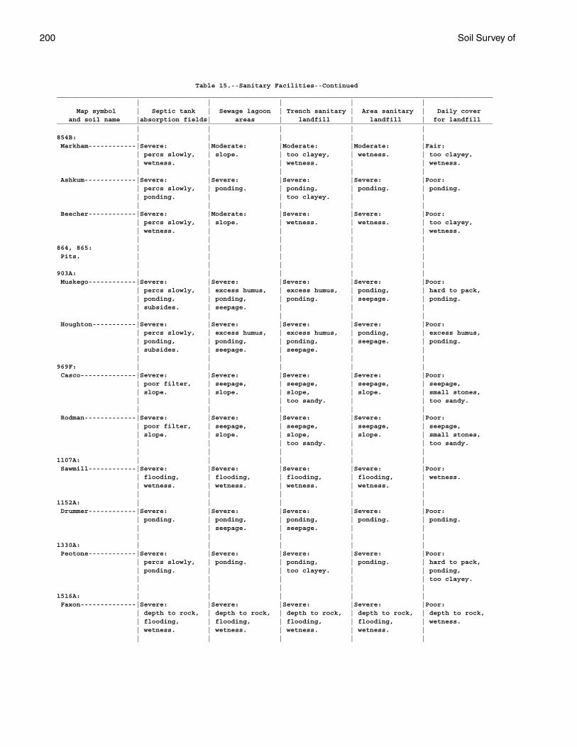
200 Soil Survey of
Table 15.--Sanitary Facilities--Continued______________________________________________________________________________________________________________ | | | | | Map symbol | Septic tank | Sewage lagoon | Trench sanitary | Area sanitary | Daily cover and soil name |absorption fields| areas | landfill | landfill | for landfill______________________________________________________________________________________________________________ | | | | |854B: | | | | | Markham------------|Severe: |Moderate: |Moderate: |Moderate: |Fair: | percs slowly, | slope. | too clayey, | wetness. | too clayey, | wetness. | | wetness. | | wetness. | | | | | Ashkum-------------|Severe: |Severe: |Severe: |Severe: |Poor: | percs slowly, | ponding. | ponding, | ponding. | ponding. | ponding. | | too clayey. | | | | | | | Beecher------------|Severe: |Moderate: |Severe: |Severe: |Poor: | percs slowly, | slope. | wetness. | wetness. | too clayey, | wetness. | | | | wetness. | | | | |864, 865: | | | | | Pits. | | | | | | | | | |903A: | | | | | Muskego------------|Severe: |Severe: |Severe: |Severe: |Poor: | percs slowly, | excess humus, | excess humus, | ponding, | hard to pack, | ponding, | ponding, | ponding. | seepage. | ponding. | subsides. | seepage. | | | | | | | | Houghton-----------|Severe: |Severe: |Severe: |Severe: |Poor: | percs slowly, | excess humus, | excess humus, | ponding, | excess humus, | ponding, | ponding, | ponding, | seepage. | ponding. | subsides. | seepage. | seepage. | | | | | | |969F: | | | | | Casco--------------|Severe: |Severe: |Severe: |Severe: |Poor: | poor filter, | seepage, | seepage, | seepage, | seepage, | slope. | slope. | slope, | slope. | small stones, | | | too sandy. | | too sandy. | | | | | Rodman-------------|Severe: |Severe: |Severe: |Severe: |Poor: | poor filter, | seepage, | seepage, | seepage, | seepage, | slope. | slope. | slope, | slope. | small stones, | | | too sandy. | | too sandy. | | | | |1107A: | | | | | Sawmill------------|Severe: |Severe: |Severe: |Severe: |Poor: | flooding, | flooding, | flooding, | flooding, | wetness. | wetness. | wetness. | wetness. | wetness. | | | | | |1152A: | | | | | Drummer------------|Severe: |Severe: |Severe: |Severe: |Poor: | ponding. | ponding, | ponding, | ponding. | ponding. | | seepage. | seepage. | | | | | | |1330A: | | | | | Peotone------------|Severe: |Severe: |Severe: |Severe: |Poor: | percs slowly, | ponding. | ponding, | ponding. | hard to pack, | ponding. | | too clayey. | | ponding, | | | | | too clayey. | | | | |1516A: | | | | | Faxon--------------|Severe: |Severe: |Severe: |Severe: |Poor: | depth to rock, | depth to rock, | depth to rock, | depth to rock, | depth to rock, | flooding, | flooding, | flooding, | flooding, | wetness. | wetness. | wetness. | wetness. | wetness. | | | | | |
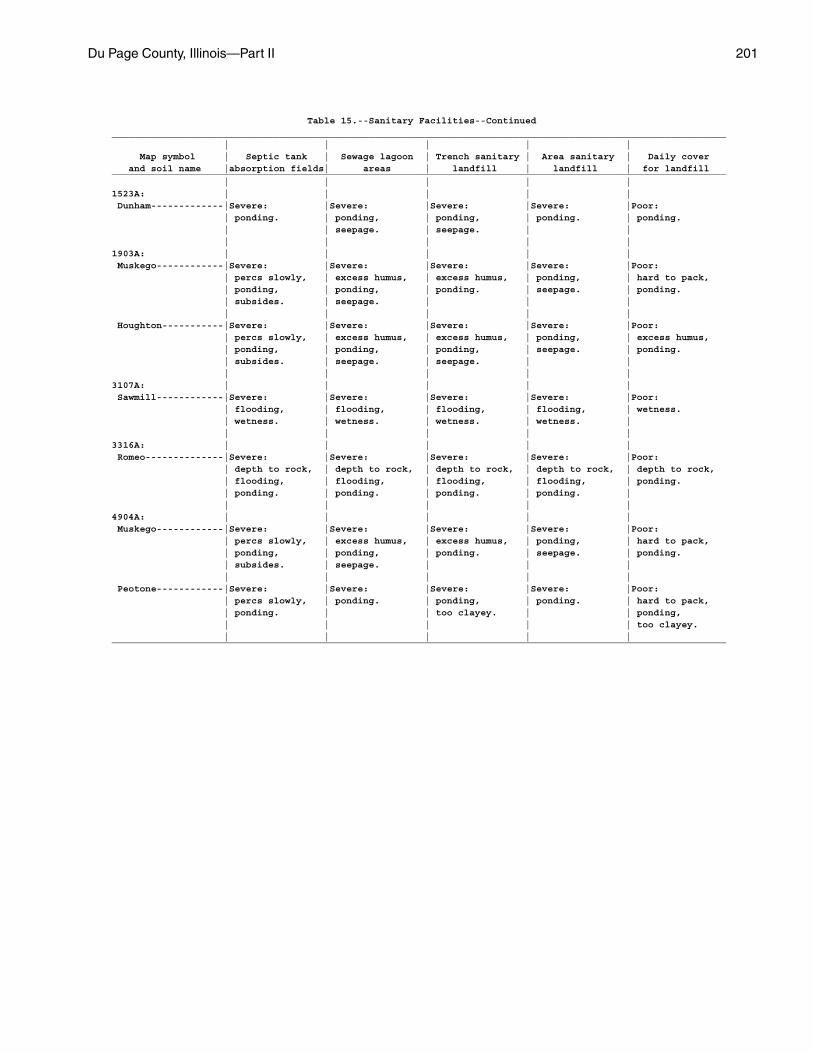
Du Page County, Illinois—Part II 201
Table 15.--Sanitary Facilities--Continued______________________________________________________________________________________________________________ | | | | | Map symbol | Septic tank | Sewage lagoon | Trench sanitary | Area sanitary | Daily cover and soil name |absorption fields| areas | landfill | landfill | for landfill______________________________________________________________________________________________________________ | | | | |1523A: | | | | | Dunham-------------|Severe: |Severe: |Severe: |Severe: |Poor: | ponding. | ponding, | ponding, | ponding. | ponding. | | seepage. | seepage. | | | | | | |1903A: | | | | | Muskego------------|Severe: |Severe: |Severe: |Severe: |Poor: | percs slowly, | excess humus, | excess humus, | ponding, | hard to pack, | ponding, | ponding, | ponding. | seepage. | ponding. | subsides. | seepage. | | | | | | | | Houghton-----------|Severe: |Severe: |Severe: |Severe: |Poor: | percs slowly, | excess humus, | excess humus, | ponding, | excess humus, | ponding, | ponding, | ponding, | seepage. | ponding. | subsides. | seepage. | seepage. | | | | | | |3107A: | | | | | Sawmill------------|Severe: |Severe: |Severe: |Severe: |Poor: | flooding, | flooding, | flooding, | flooding, | wetness. | wetness. | wetness. | wetness. | wetness. | | | | | |3316A: | | | | | Romeo--------------|Severe: |Severe: |Severe: |Severe: |Poor: | depth to rock, | depth to rock, | depth to rock, | depth to rock, | depth to rock, | flooding, | flooding, | flooding, | flooding, | ponding. | ponding. | ponding. | ponding. | ponding. | | | | | |4904A: | | | | | Muskego------------|Severe: |Severe: |Severe: |Severe: |Poor: | percs slowly, | excess humus, | excess humus, | ponding, | hard to pack, | ponding, | ponding, | ponding. | seepage. | ponding. | subsides. | seepage. | | | | | | | | Peotone------------|Severe: |Severe: |Severe: |Severe: |Poor: | percs slowly, | ponding. | ponding, | ponding. | hard to pack, | ponding. | | too clayey. | | ponding, | | | | | too clayey. | | | | |______________________________________________________________________________________________________________
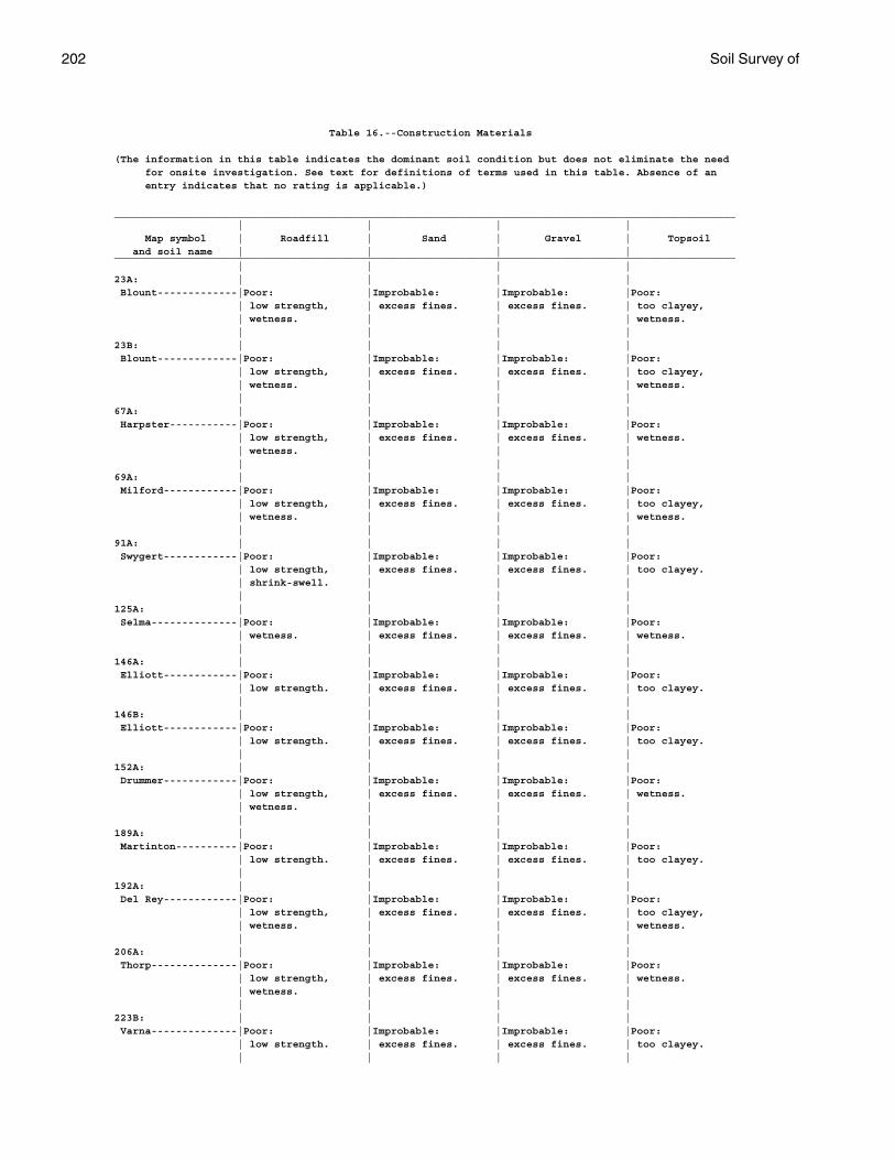
202 Soil Survey of
Table 16.--Construction Materials
(The information in this table indicates the dominant soil condition but does not eliminate the need for onsite investigation. See text for definitions of terms used in this table. Absence of an entry indicates that no rating is applicable.)
_____________________________________________________________________________________________________ | | | | Map symbol | Roadfill | Sand | Gravel | Topsoil and soil name | | | |_____________________________________________________________________________________________________ | | | |23A: | | | | Blount-------------|Poor: |Improbable: |Improbable: |Poor: | low strength, | excess fines. | excess fines. | too clayey, | wetness. | | | wetness. | | | |23B: | | | | Blount-------------|Poor: |Improbable: |Improbable: |Poor: | low strength, | excess fines. | excess fines. | too clayey, | wetness. | | | wetness. | | | |67A: | | | | Harpster-----------|Poor: |Improbable: |Improbable: |Poor: | low strength, | excess fines. | excess fines. | wetness. | wetness. | | | | | | |69A: | | | | Milford------------|Poor: |Improbable: |Improbable: |Poor: | low strength, | excess fines. | excess fines. | too clayey, | wetness. | | | wetness. | | | |91A: | | | | Swygert------------|Poor: |Improbable: |Improbable: |Poor: | low strength, | excess fines. | excess fines. | too clayey. | shrink-swell. | | | | | | |125A: | | | | Selma--------------|Poor: |Improbable: |Improbable: |Poor: | wetness. | excess fines. | excess fines. | wetness. | | | |146A: | | | | Elliott------------|Poor: |Improbable: |Improbable: |Poor: | low strength. | excess fines. | excess fines. | too clayey. | | | |146B: | | | | Elliott------------|Poor: |Improbable: |Improbable: |Poor: | low strength. | excess fines. | excess fines. | too clayey. | | | |152A: | | | | Drummer------------|Poor: |Improbable: |Improbable: |Poor: | low strength, | excess fines. | excess fines. | wetness. | wetness. | | | | | | |189A: | | | | Martinton----------|Poor: |Improbable: |Improbable: |Poor: | low strength. | excess fines. | excess fines. | too clayey. | | | |192A: | | | | Del Rey------------|Poor: |Improbable: |Improbable: |Poor: | low strength, | excess fines. | excess fines. | too clayey, | wetness. | | | wetness. | | | |206A: | | | | Thorp--------------|Poor: |Improbable: |Improbable: |Poor: | low strength, | excess fines. | excess fines. | wetness. | wetness. | | | | | | |223B: | | | | Varna--------------|Poor: |Improbable: |Improbable: |Poor: | low strength. | excess fines. | excess fines. | too clayey. | | | |
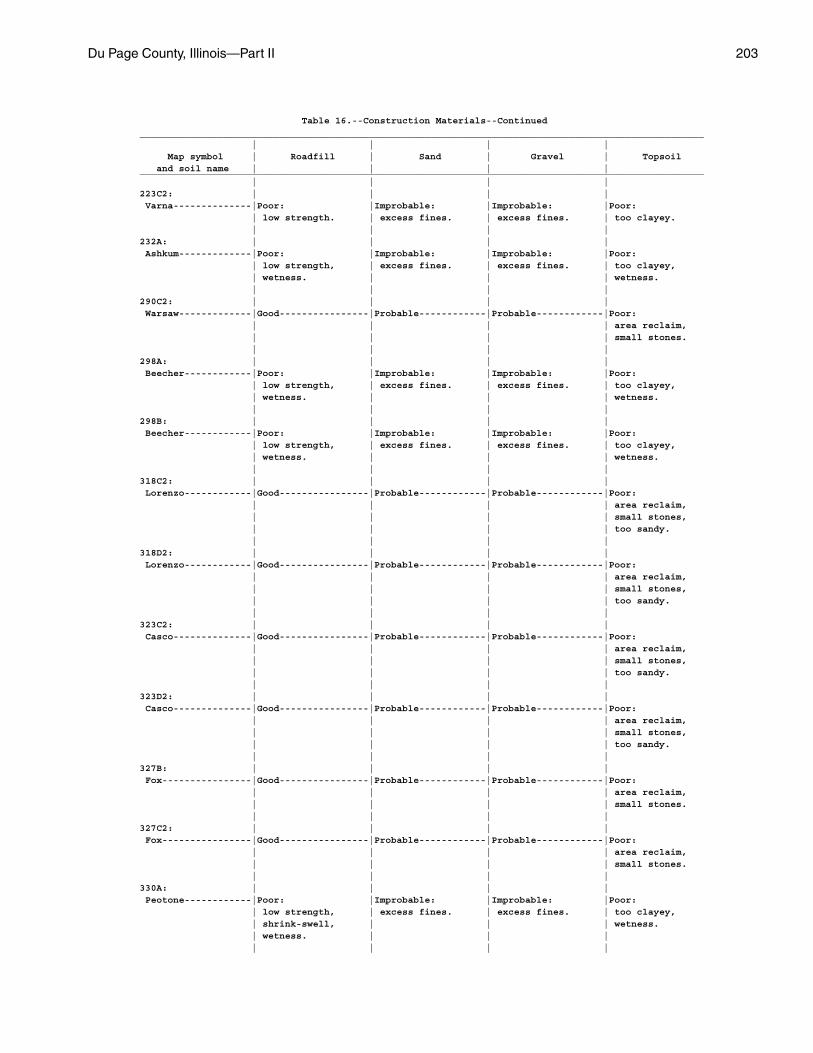
Du Page County, Illinois—Part II 203
Table 16.--Construction Materials--Continued_____________________________________________________________________________________________________ | | | | Map symbol | Roadfill | Sand | Gravel | Topsoil and soil name | | | |_____________________________________________________________________________________________________ | | | |223C2: | | | | Varna--------------|Poor: |Improbable: |Improbable: |Poor: | low strength. | excess fines. | excess fines. | too clayey. | | | |232A: | | | | Ashkum-------------|Poor: |Improbable: |Improbable: |Poor: | low strength, | excess fines. | excess fines. | too clayey, | wetness. | | | wetness. | | | |290C2: | | | | Warsaw-------------|Good----------------|Probable------------|Probable------------|Poor: | | | | area reclaim, | | | | small stones. | | | |298A: | | | | Beecher------------|Poor: |Improbable: |Improbable: |Poor: | low strength, | excess fines. | excess fines. | too clayey, | wetness. | | | wetness. | | | |298B: | | | | Beecher------------|Poor: |Improbable: |Improbable: |Poor: | low strength, | excess fines. | excess fines. | too clayey, | wetness. | | | wetness. | | | |318C2: | | | | Lorenzo------------|Good----------------|Probable------------|Probable------------|Poor: | | | | area reclaim, | | | | small stones, | | | | too sandy. | | | |318D2: | | | | Lorenzo------------|Good----------------|Probable------------|Probable------------|Poor: | | | | area reclaim, | | | | small stones, | | | | too sandy. | | | |323C2: | | | | Casco--------------|Good----------------|Probable------------|Probable------------|Poor: | | | | area reclaim, | | | | small stones, | | | | too sandy. | | | |323D2: | | | | Casco--------------|Good----------------|Probable------------|Probable------------|Poor: | | | | area reclaim, | | | | small stones, | | | | too sandy. | | | |327B: | | | | Fox----------------|Good----------------|Probable------------|Probable------------|Poor: | | | | area reclaim, | | | | small stones. | | | |327C2: | | | | Fox----------------|Good----------------|Probable------------|Probable------------|Poor: | | | | area reclaim, | | | | small stones. | | | |330A: | | | | Peotone------------|Poor: |Improbable: |Improbable: |Poor: | low strength, | excess fines. | excess fines. | too clayey, | shrink-swell, | | | wetness. | wetness. | | | | | | |
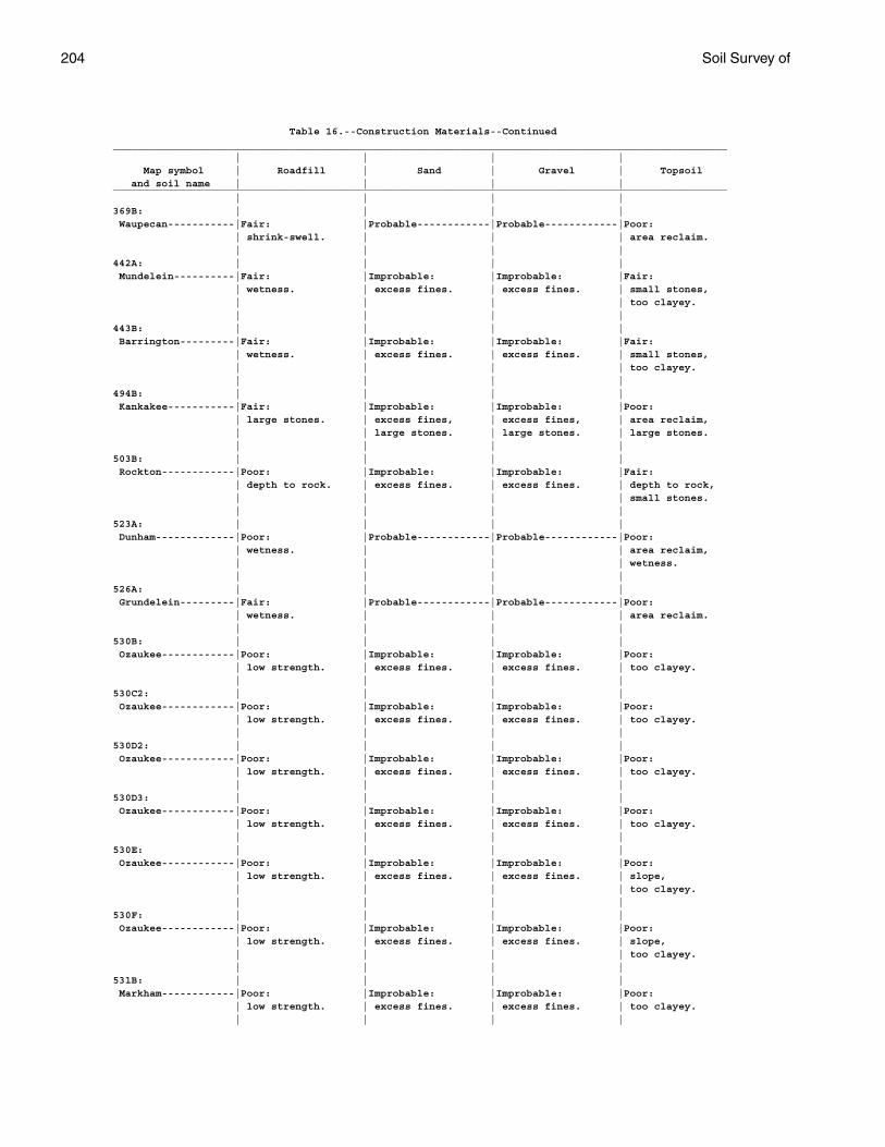
204 Soil Survey of
Table 16.--Construction Materials--Continued_____________________________________________________________________________________________________ | | | | Map symbol | Roadfill | Sand | Gravel | Topsoil and soil name | | | |_____________________________________________________________________________________________________ | | | |369B: | | | | Waupecan-----------|Fair: |Probable------------|Probable------------|Poor: | shrink-swell. | | | area reclaim. | | | |442A: | | | | Mundelein----------|Fair: |Improbable: |Improbable: |Fair: | wetness. | excess fines. | excess fines. | small stones, | | | | too clayey. | | | |443B: | | | | Barrington---------|Fair: |Improbable: |Improbable: |Fair: | wetness. | excess fines. | excess fines. | small stones, | | | | too clayey. | | | |494B: | | | | Kankakee-----------|Fair: |Improbable: |Improbable: |Poor: | large stones. | excess fines, | excess fines, | area reclaim, | | large stones. | large stones. | large stones. | | | |503B: | | | | Rockton------------|Poor: |Improbable: |Improbable: |Fair: | depth to rock. | excess fines. | excess fines. | depth to rock, | | | | small stones. | | | |523A: | | | | Dunham-------------|Poor: |Probable------------|Probable------------|Poor: | wetness. | | | area reclaim, | | | | wetness. | | | |526A: | | | | Grundelein---------|Fair: |Probable------------|Probable------------|Poor: | wetness. | | | area reclaim. | | | |530B: | | | | Ozaukee------------|Poor: |Improbable: |Improbable: |Poor: | low strength. | excess fines. | excess fines. | too clayey. | | | |530C2: | | | | Ozaukee------------|Poor: |Improbable: |Improbable: |Poor: | low strength. | excess fines. | excess fines. | too clayey. | | | |530D2: | | | | Ozaukee------------|Poor: |Improbable: |Improbable: |Poor: | low strength. | excess fines. | excess fines. | too clayey. | | | |530D3: | | | | Ozaukee------------|Poor: |Improbable: |Improbable: |Poor: | low strength. | excess fines. | excess fines. | too clayey. | | | |530E: | | | | Ozaukee------------|Poor: |Improbable: |Improbable: |Poor: | low strength. | excess fines. | excess fines. | slope, | | | | too clayey. | | | |530F: | | | | Ozaukee------------|Poor: |Improbable: |Improbable: |Poor: | low strength. | excess fines. | excess fines. | slope, | | | | too clayey. | | | |531B: | | | | Markham------------|Poor: |Improbable: |Improbable: |Poor: | low strength. | excess fines. | excess fines. | too clayey. | | | |
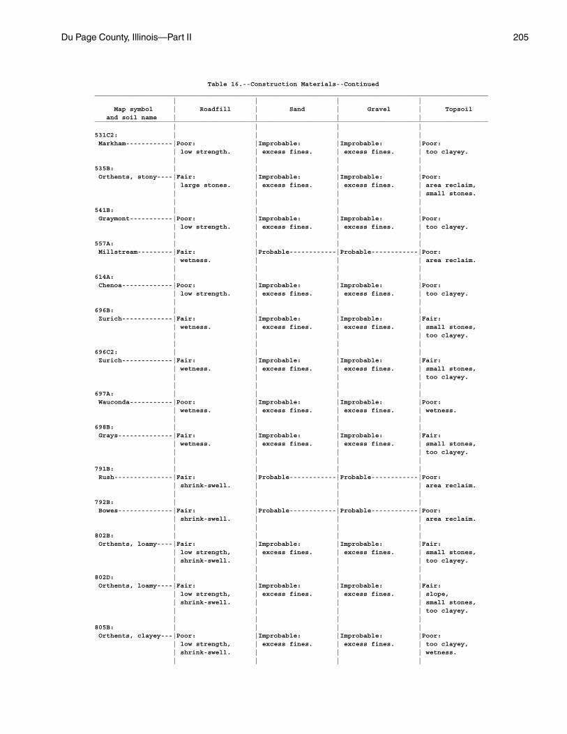
Du Page County, Illinois—Part II 205
Table 16.--Construction Materials--Continued_____________________________________________________________________________________________________ | | | | Map symbol | Roadfill | Sand | Gravel | Topsoil and soil name | | | |_____________________________________________________________________________________________________ | | | |531C2: | | | | Markham------------|Poor: |Improbable: |Improbable: |Poor: | low strength. | excess fines. | excess fines. | too clayey. | | | |535B: | | | | Orthents, stony----|Fair: |Improbable: |Improbable: |Poor: | large stones. | excess fines. | excess fines. | area reclaim, | | | | small stones. | | | |541B: | | | | Graymont-----------|Poor: |Improbable: |Improbable: |Poor: | low strength. | excess fines. | excess fines. | too clayey. | | | |557A: | | | | Millstream---------|Fair: |Probable------------|Probable------------|Poor: | wetness. | | | area reclaim. | | | |614A: | | | | Chenoa-------------|Poor: |Improbable: |Improbable: |Poor: | low strength. | excess fines. | excess fines. | too clayey. | | | |696B: | | | | Zurich-------------|Fair: |Improbable: |Improbable: |Fair: | wetness. | excess fines. | excess fines. | small stones, | | | | too clayey. | | | |696C2: | | | | Zurich-------------|Fair: |Improbable: |Improbable: |Fair: | wetness. | excess fines. | excess fines. | small stones, | | | | too clayey. | | | |697A: | | | | Wauconda-----------|Poor: |Improbable: |Improbable: |Poor: | wetness. | excess fines. | excess fines. | wetness. | | | |698B: | | | | Grays--------------|Fair: |Improbable: |Improbable: |Fair: | wetness. | excess fines. | excess fines. | small stones, | | | | too clayey. | | | |791B: | | | | Rush---------------|Fair: |Probable------------|Probable------------|Poor: | shrink-swell. | | | area reclaim. | | | |792B: | | | | Bowes--------------|Fair: |Probable------------|Probable------------|Poor: | shrink-swell. | | | area reclaim. | | | |802B: | | | | Orthents, loamy----|Fair: |Improbable: |Improbable: |Fair: | low strength, | excess fines. | excess fines. | small stones, | shrink-swell. | | | too clayey. | | | |802D: | | | | Orthents, loamy----|Fair: |Improbable: |Improbable: |Fair: | low strength, | excess fines. | excess fines. | slope, | shrink-swell. | | | small stones, | | | | too clayey. | | | |805B: | | | | Orthents, clayey---|Poor: |Improbable: |Improbable: |Poor: | low strength, | excess fines. | excess fines. | too clayey, | shrink-swell. | | | wetness. | | | |
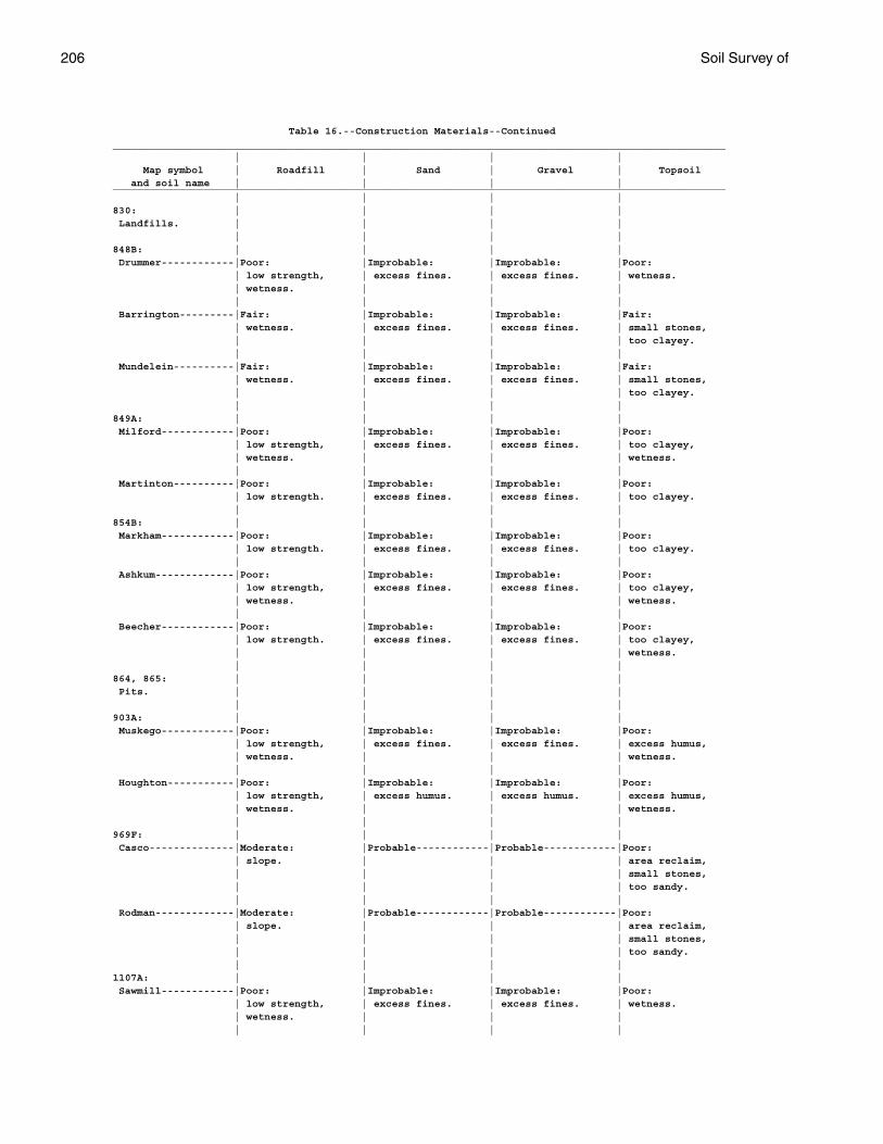
206 Soil Survey of
Table 16.--Construction Materials--Continued_____________________________________________________________________________________________________ | | | | Map symbol | Roadfill | Sand | Gravel | Topsoil and soil name | | | |_____________________________________________________________________________________________________ | | | |830: | | | | Landfills. | | | | | | | |848B: | | | | Drummer------------|Poor: |Improbable: |Improbable: |Poor: | low strength, | excess fines. | excess fines. | wetness. | wetness. | | | | | | | Barrington---------|Fair: |Improbable: |Improbable: |Fair: | wetness. | excess fines. | excess fines. | small stones, | | | | too clayey. | | | | Mundelein----------|Fair: |Improbable: |Improbable: |Fair: | wetness. | excess fines. | excess fines. | small stones, | | | | too clayey. | | | |849A: | | | | Milford------------|Poor: |Improbable: |Improbable: |Poor: | low strength, | excess fines. | excess fines. | too clayey, | wetness. | | | wetness. | | | | Martinton----------|Poor: |Improbable: |Improbable: |Poor: | low strength. | excess fines. | excess fines. | too clayey. | | | |854B: | | | | Markham------------|Poor: |Improbable: |Improbable: |Poor: | low strength. | excess fines. | excess fines. | too clayey. | | | | Ashkum-------------|Poor: |Improbable: |Improbable: |Poor: | low strength, | excess fines. | excess fines. | too clayey, | wetness. | | | wetness. | | | | Beecher------------|Poor: |Improbable: |Improbable: |Poor: | low strength. | excess fines. | excess fines. | too clayey, | | | | wetness. | | | |864, 865: | | | | Pits. | | | | | | | |903A: | | | | Muskego------------|Poor: |Improbable: |Improbable: |Poor: | low strength, | excess fines. | excess fines. | excess humus, | wetness. | | | wetness. | | | | Houghton-----------|Poor: |Improbable: |Improbable: |Poor: | low strength, | excess humus. | excess humus. | excess humus, | wetness. | | | wetness. | | | |969F: | | | | Casco--------------|Moderate: |Probable------------|Probable------------|Poor: | slope. | | | area reclaim, | | | | small stones, | | | | too sandy. | | | | Rodman-------------|Moderate: |Probable------------|Probable------------|Poor: | slope. | | | area reclaim, | | | | small stones, | | | | too sandy. | | | |1107A: | | | | Sawmill------------|Poor: |Improbable: |Improbable: |Poor: | low strength, | excess fines. | excess fines. | wetness. | wetness. | | | | | | |
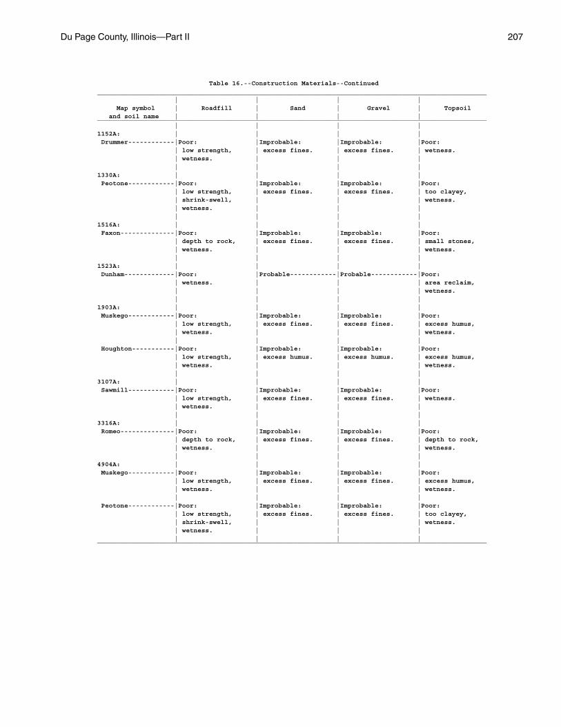
Du Page County, Illinois—Part II 207
Table 16.--Construction Materials--Continued_____________________________________________________________________________________________________ | | | | Map symbol | Roadfill | Sand | Gravel | Topsoil and soil name | | | |_____________________________________________________________________________________________________ | | | |1152A: | | | | Drummer------------|Poor: |Improbable: |Improbable: |Poor: | low strength, | excess fines. | excess fines. | wetness. | wetness. | | | | | | |1330A: | | | | Peotone------------|Poor: |Improbable: |Improbable: |Poor: | low strength, | excess fines. | excess fines. | too clayey, | shrink-swell, | | | wetness. | wetness. | | | | | | |1516A: | | | | Faxon--------------|Poor: |Improbable: |Improbable: |Poor: | depth to rock, | excess fines. | excess fines. | small stones, | wetness. | | | wetness. | | | |1523A: | | | | Dunham-------------|Poor: |Probable------------|Probable------------|Poor: | wetness. | | | area reclaim, | | | | wetness. | | | |1903A: | | | | Muskego------------|Poor: |Improbable: |Improbable: |Poor: | low strength, | excess fines. | excess fines. | excess humus, | wetness. | | | wetness. | | | | Houghton-----------|Poor: |Improbable: |Improbable: |Poor: | low strength, | excess humus. | excess humus. | excess humus, | wetness. | | | wetness. | | | |3107A: | | | | Sawmill------------|Poor: |Improbable: |Improbable: |Poor: | low strength, | excess fines. | excess fines. | wetness. | wetness. | | | | | | |3316A: | | | | Romeo--------------|Poor: |Improbable: |Improbable: |Poor: | depth to rock, | excess fines. | excess fines. | depth to rock, | wetness. | | | wetness. | | | |4904A: | | | | Muskego------------|Poor: |Improbable: |Improbable: |Poor: | low strength, | excess fines. | excess fines. | excess humus, | wetness. | | | wetness. | | | | Peotone------------|Poor: |Improbable: |Improbable: |Poor: | low strength, | excess fines. | excess fines. | too clayey, | shrink-swell, | | | wetness. | wetness. | | | | | | |_____________________________________________________________________________________________________
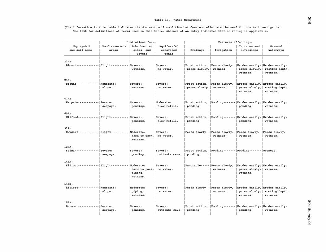
208S
oil Survey of
Table 17.--Water Management
(The information in this table indicates the dominant soil condition but does not eliminate the need for onsite investigation. See text for definitions of terms used in this table. Absence of an entry indicates that no rating is applicable.)
__________________________________________________________________________________________________________________________________ | Limitations for-- | Features affecting-- _____________________________________________________________________________________________________________ Map symbol | Pond reservoir | Embankments, | Aquifer-fed | | | Terraces and | Grassed and soil name | areas | dikes, and | excavated | Drainage | Irrigation | diversions | waterways | | levees | ponds | | | |__________________________________________________________________________________________________________________________________ | | | | | | |23A: | | | | | | | Blount-------------|Slight----------|Severe: |Severe: |Frost action, |Percs slowly, |Erodes easily,|Erodes easily, | | wetness. | no water. | percs slowly.| wetness. | percs slowly,| rooting depth, | | | | | | wetness. | wetness. | | | | | | |23B: | | | | | | | Blount-------------|Moderate: |Severe: |Severe: |Frost action, |Percs slowly, |Erodes easily,|Erodes easily, | slope. | wetness. | no water. | percs slowly.| wetness. | percs slowly,| rooting depth, | | | | | | wetness. | wetness. | | | | | | |67A: | | | | | | | Harpster-----------|Severe: |Severe: |Moderate: |Frost action, |Ponding-------|Erodes easily,|Erodes easily, | seepage. | ponding. | slow refill. | ponding. | | ponding. | wetness. | | | | | | |69A: | | | | | | | Milford------------|Slight----------|Severe: |Severe: |Frost action, |Ponding-------|Erodes easily,|Erodes easily, | | ponding. | slow refill. | ponding. | | ponding. | wetness. | | | | | | |91A: | | | | | | | Swygert------------|Slight----------|Moderate: |Severe: |Percs slowly |Percs slowly, |Percs slowly, |Percs slowly, | | hard to pack,| no water. | | wetness. | wetness. | wetness. | | wetness. | | | | | | | | | | | |125A: | | | | | | | Selma--------------|Severe: |Severe: |Severe: |Frost action, |Ponding-------|Ponding-------|Wetness. | seepage. | ponding. | cutbanks cave. | ponding. | | | | | | | | | |146A: | | | | | | | Elliott------------|Slight----------|Moderate: |Severe: |Favorable-----|Percs slowly, |Erodes easily,|Erodes easily, | | hard to pack,| no water. | | wetness. | percs slowly,| wetness. | | piping, | | | | wetness. | | | wetness. | | | | | | | | | | | |146B: | | | | | | | Elliott------------|Moderate: |Moderate: |Severe: |Percs slowly |Percs slowly, |Erodes easily,|Erodes easily, | slope. | piping, | no water. | | wetness. | percs slowly,| rooting depth, | | wetness. | | | | wetness. | wetness. | | | | | | |152A: | | | | | | | Drummer------------|Severe: |Severe: |Severe: |Frost action, |Ponding-------|Erodes easily,|Erodes easily, | seepage. | ponding. | cutbanks cave. | ponding. | | ponding. | wetness. | | | | | | |
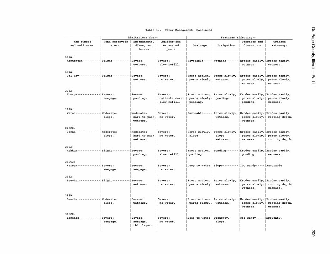
Du P
age County, Illinois—
Part II
209
Table 17.--Water Management--Continued__________________________________________________________________________________________________________________________________ | Limitations for-- | Features affecting-- _____________________________________________________________________________________________________________ Map symbol | Pond reservoir | Embankments, | Aquifer-fed | | | Terraces and | Grassed and soil name | areas | dikes, and | excavated | Drainage | Irrigation | diversions | waterways | | levees | ponds | | | |__________________________________________________________________________________________________________________________________ | | | | | | |189A: | | | | | | | Martinton----------|Slight----------|Severe: |Severe: |Favorable-----|Wetness-------|Erodes easily,|Erodes easily, | | wetness. | slow refill. | | | wetness. | wetness. | | | | | | |192A: | | | | | | | Del Rey------------|Slight----------|Severe: |Severe: |Frost action, |Percs slowly, |Erodes easily,|Erodes easily, | | wetness. | no water. | percs slowly.| wetness. | percs slowly,| percs slowly, | | | | | | wetness. | wetness. | | | | | | |206A: | | | | | | | Thorp--------------|Severe: |Severe: |Severe: |Frost action, |Percs slowly, |Erodes easily,|Erodes easily, | seepage. | ponding. | cutbanks cave, | percs slowly,| ponding. | percs slowly,| percs slowly, | | | slow refill. | ponding. | | ponding. | wetness. | | | | | | |223B: | | | | | | | Varna--------------|Moderate: |Moderate: |Severe: |Favorable-----|Percs slowly, |Erodes easily,|Erodes easily, | slope. | hard to pack,| no water. | | wetness. | percs slowly,| rooting depth. | | wetness. | | | | wetness. | | | | | | | |223C2: | | | | | | | Varna--------------|Moderate: |Moderate: |Severe: |Percs slowly, |Percs slowly, |Erodes easily,|Erodes easily, | slope. | hard to pack,| no water. | slope. | slope, | percs slowly,| percs slowly, | | wetness. | | | wetness. | wetness. | rooting depth. | | | | | | |232A: | | | | | | | Ashkum-------------|Slight----------|Severe: |Severe: |Frost action, |Ponding-------|Erodes easily,|Erodes easily, | | ponding. | slow refill. | ponding. | | ponding. | wetness. | | | | | | |290C2: | | | | | | | Warsaw-------------|Severe: |Severe: |Severe: |Deep to water |Slope---------|Too sandy-----|Favorable. | seepage. | seepage. | no water. | | | | | | | | | | |298A: | | | | | | | Beecher------------|Slight----------|Severe: |Severe: |Frost action, |Percs slowly, |Erodes easily,|Erodes easily, | | wetness. | no water. | percs slowly.| wetness. | percs slowly,| rooting depth, | | | | | | wetness. | wetness. | | | | | | |298B: | | | | | | | Beecher------------|Moderate: |Severe: |Severe: |Frost action, |Percs slowly, |Erodes easily,|Erodes easily, | slope. | wetness. | no water. | percs slowly.| wetness. | percs slowly,| rooting depth, | | | | | | wetness. | wetness. | | | | | | |318C2: | | | | | | | Lorenzo------------|Severe: |Severe: |Severe: |Deep to water |Droughty, |Too sandy-----|Droughty. | seepage. | seepage, | no water. | | slope. | | | | thin layer. | | | | | | | | | | | |
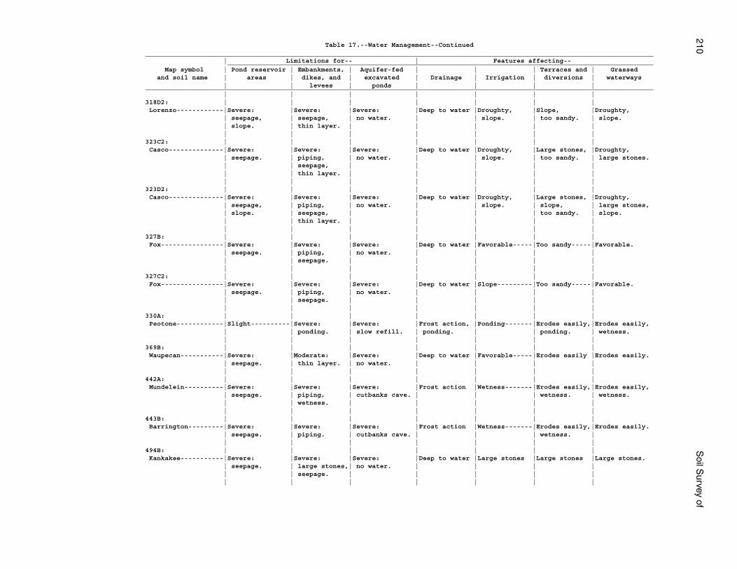
210S
oil Survey of
Table 17.--Water Management--Continued__________________________________________________________________________________________________________________________________ | Limitations for-- | Features affecting-- _____________________________________________________________________________________________________________ Map symbol | Pond reservoir | Embankments, | Aquifer-fed | | | Terraces and | Grassed and soil name | areas | dikes, and | excavated | Drainage | Irrigation | diversions | waterways | | levees | ponds | | | |__________________________________________________________________________________________________________________________________ | | | | | | |318D2: | | | | | | | Lorenzo------------|Severe: |Severe: |Severe: |Deep to water |Droughty, |Slope, |Droughty, | seepage, | seepage, | no water. | | slope. | too sandy. | slope. | slope. | thin layer. | | | | | | | | | | | |323C2: | | | | | | | Casco--------------|Severe: |Severe: |Severe: |Deep to water |Droughty, |Large stones, |Droughty, | seepage. | piping, | no water. | | slope. | too sandy. | large stones. | | seepage, | | | | | | | thin layer. | | | | | | | | | | | |323D2: | | | | | | | Casco--------------|Severe: |Severe: |Severe: |Deep to water |Droughty, |Large stones, |Droughty, | seepage, | piping, | no water. | | slope. | slope, | large stones, | slope. | seepage, | | | | too sandy. | slope. | | thin layer. | | | | | | | | | | | |327B: | | | | | | | Fox----------------|Severe: |Severe: |Severe: |Deep to water |Favorable-----|Too sandy-----|Favorable. | seepage. | piping, | no water. | | | | | | seepage. | | | | | | | | | | | |327C2: | | | | | | | Fox----------------|Severe: |Severe: |Severe: |Deep to water |Slope---------|Too sandy-----|Favorable. | seepage. | piping, | no water. | | | | | | seepage. | | | | | | | | | | | |330A: | | | | | | | Peotone------------|Slight----------|Severe: |Severe: |Frost action, |Ponding-------|Erodes easily,|Erodes easily, | | ponding. | slow refill. | ponding. | | ponding. | wetness. | | | | | | |369B: | | | | | | | Waupecan-----------|Severe: |Moderate: |Severe: |Deep to water |Favorable-----|Erodes easily |Erodes easily. | seepage. | thin layer. | no water. | | | | | | | | | | |442A: | | | | | | | Mundelein----------|Severe: |Severe: |Severe: |Frost action |Wetness-------|Erodes easily,|Erodes easily, | seepage. | piping, | cutbanks cave. | | | wetness. | wetness. | | wetness. | | | | | | | | | | | |443B: | | | | | | | Barrington---------|Severe: |Severe: |Severe: |Frost action |Wetness-------|Erodes easily,|Erodes easily. | seepage. | piping. | cutbanks cave. | | | wetness. | | | | | | | |494B: | | | | | | | Kankakee-----------|Severe: |Severe: |Severe: |Deep to water |Large stones |Large stones |Large stones. | seepage. | large stones,| no water. | | | | | | seepage. | | | | | | | | | | | |
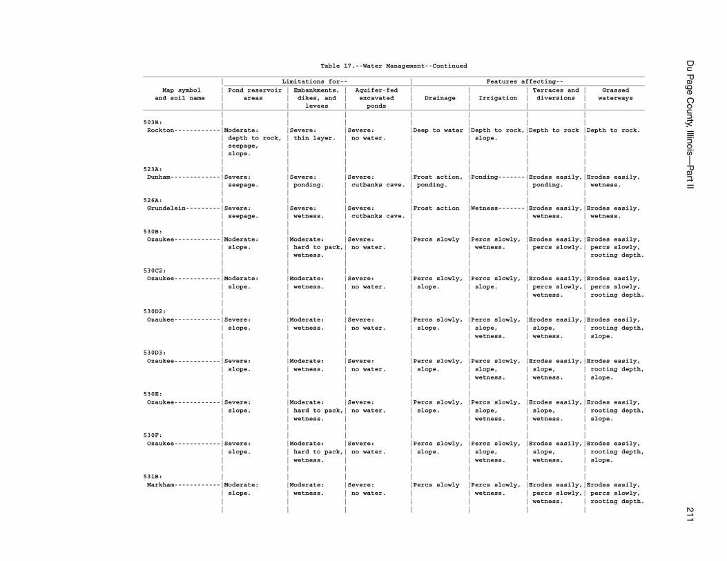
Du P
age County, Illinois—
Part II
211
Table 17.--Water Management--Continued__________________________________________________________________________________________________________________________________ | Limitations for-- | Features affecting-- _____________________________________________________________________________________________________________ Map symbol | Pond reservoir | Embankments, | Aquifer-fed | | | Terraces and | Grassed and soil name | areas | dikes, and | excavated | Drainage | Irrigation | diversions | waterways | | levees | ponds | | | |__________________________________________________________________________________________________________________________________ | | | | | | |503B: | | | | | | | Rockton------------|Moderate: |Severe: |Severe: |Deep to water |Depth to rock,|Depth to rock |Depth to rock. | depth to rock, | thin layer. | no water. | | slope. | | | seepage, | | | | | | | slope. | | | | | | | | | | | | |523A: | | | | | | | Dunham-------------|Severe: |Severe: |Severe: |Frost action, |Ponding-------|Erodes easily,|Erodes easily, | seepage. | ponding. | cutbanks cave. | ponding. | | ponding. | wetness. | | | | | | |526A: | | | | | | | Grundelein---------|Severe: |Severe: |Severe: |Frost action |Wetness-------|Erodes easily,|Erodes easily, | seepage. | wetness. | cutbanks cave. | | | wetness. | wetness. | | | | | | |530B: | | | | | | | Ozaukee------------|Moderate: |Moderate: |Severe: |Percs slowly |Percs slowly, |Erodes easily,|Erodes easily, | slope. | hard to pack,| no water. | | wetness. | percs slowly.| percs slowly, | | wetness. | | | | | rooting depth. | | | | | | |530C2: | | | | | | | Ozaukee------------|Moderate: |Moderate: |Severe: |Percs slowly, |Percs slowly, |Erodes easily,|Erodes easily, | slope. | wetness. | no water. | slope. | slope. | percs slowly,| percs slowly, | | | | | | wetness. | rooting depth. | | | | | | |530D2: | | | | | | | Ozaukee------------|Severe: |Moderate: |Severe: |Percs slowly, |Percs slowly, |Erodes easily,|Erodes easily, | slope. | wetness. | no water. | slope. | slope, | slope, | rooting depth, | | | | | wetness. | wetness. | slope. | | | | | | |530D3: | | | | | | | Ozaukee------------|Severe: |Moderate: |Severe: |Percs slowly, |Percs slowly, |Erodes easily,|Erodes easily, | slope. | wetness. | no water. | slope. | slope, | slope, | rooting depth, | | | | | wetness. | wetness. | slope. | | | | | | |530E: | | | | | | | Ozaukee------------|Severe: |Moderate: |Severe: |Percs slowly, |Percs slowly, |Erodes easily,|Erodes easily, | slope. | hard to pack,| no water. | slope. | slope, | slope, | rooting depth, | | wetness. | | | wetness. | wetness. | slope. | | | | | | |530F: | | | | | | | Ozaukee------------|Severe: |Moderate: |Severe: |Percs slowly, |Percs slowly, |Erodes easily,|Erodes easily, | slope. | hard to pack,| no water. | slope. | slope, | slope, | rooting depth, | | wetness. | | | wetness. | wetness. | slope. | | | | | | |531B: | | | | | | | Markham------------|Moderate: |Moderate: |Severe: |Percs slowly |Percs slowly, |Erodes easily,|Erodes easily, | slope. | wetness. | no water. | | wetness. | percs slowly,| percs slowly, | | | | | | wetness. | rooting depth. | | | | | | |
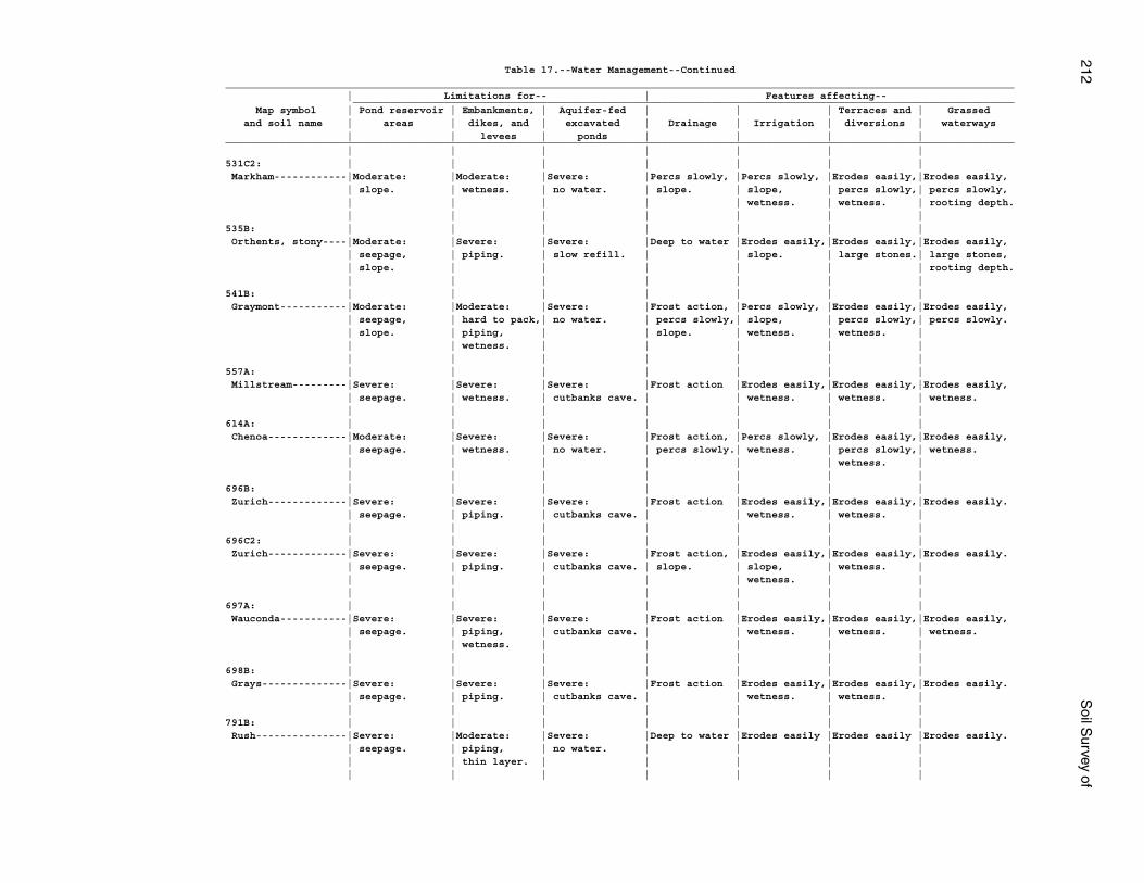
212S
oil Survey of
Table 17.--Water Management--Continued__________________________________________________________________________________________________________________________________ | Limitations for-- | Features affecting-- _____________________________________________________________________________________________________________ Map symbol | Pond reservoir | Embankments, | Aquifer-fed | | | Terraces and | Grassed and soil name | areas | dikes, and | excavated | Drainage | Irrigation | diversions | waterways | | levees | ponds | | | |__________________________________________________________________________________________________________________________________ | | | | | | |531C2: | | | | | | | Markham------------|Moderate: |Moderate: |Severe: |Percs slowly, |Percs slowly, |Erodes easily,|Erodes easily, | slope. | wetness. | no water. | slope. | slope, | percs slowly,| percs slowly, | | | | | wetness. | wetness. | rooting depth. | | | | | | |535B: | | | | | | | Orthents, stony----|Moderate: |Severe: |Severe: |Deep to water |Erodes easily,|Erodes easily,|Erodes easily, | seepage, | piping. | slow refill. | | slope. | large stones.| large stones, | slope. | | | | | | rooting depth. | | | | | | |541B: | | | | | | | Graymont-----------|Moderate: |Moderate: |Severe: |Frost action, |Percs slowly, |Erodes easily,|Erodes easily, | seepage, | hard to pack,| no water. | percs slowly,| slope, | percs slowly,| percs slowly. | slope. | piping, | | slope. | wetness. | wetness. | | | wetness. | | | | | | | | | | | |557A: | | | | | | | Millstream---------|Severe: |Severe: |Severe: |Frost action |Erodes easily,|Erodes easily,|Erodes easily, | seepage. | wetness. | cutbanks cave. | | wetness. | wetness. | wetness. | | | | | | |614A: | | | | | | | Chenoa-------------|Moderate: |Severe: |Severe: |Frost action, |Percs slowly, |Erodes easily,|Erodes easily, | seepage. | wetness. | no water. | percs slowly.| wetness. | percs slowly,| wetness. | | | | | | wetness. | | | | | | | |696B: | | | | | | | Zurich-------------|Severe: |Severe: |Severe: |Frost action |Erodes easily,|Erodes easily,|Erodes easily. | seepage. | piping. | cutbanks cave. | | wetness. | wetness. | | | | | | | |696C2: | | | | | | | Zurich-------------|Severe: |Severe: |Severe: |Frost action, |Erodes easily,|Erodes easily,|Erodes easily. | seepage. | piping. | cutbanks cave. | slope. | slope, | wetness. | | | | | | wetness. | | | | | | | | |697A: | | | | | | | Wauconda-----------|Severe: |Severe: |Severe: |Frost action |Erodes easily,|Erodes easily,|Erodes easily, | seepage. | piping, | cutbanks cave. | | wetness. | wetness. | wetness. | | wetness. | | | | | | | | | | | |698B: | | | | | | | Grays--------------|Severe: |Severe: |Severe: |Frost action |Erodes easily,|Erodes easily,|Erodes easily. | seepage. | piping. | cutbanks cave. | | wetness. | wetness. | | | | | | | |791B: | | | | | | | Rush---------------|Severe: |Moderate: |Severe: |Deep to water |Erodes easily |Erodes easily |Erodes easily. | seepage. | piping, | no water. | | | | | | thin layer. | | | | | | | | | | | |
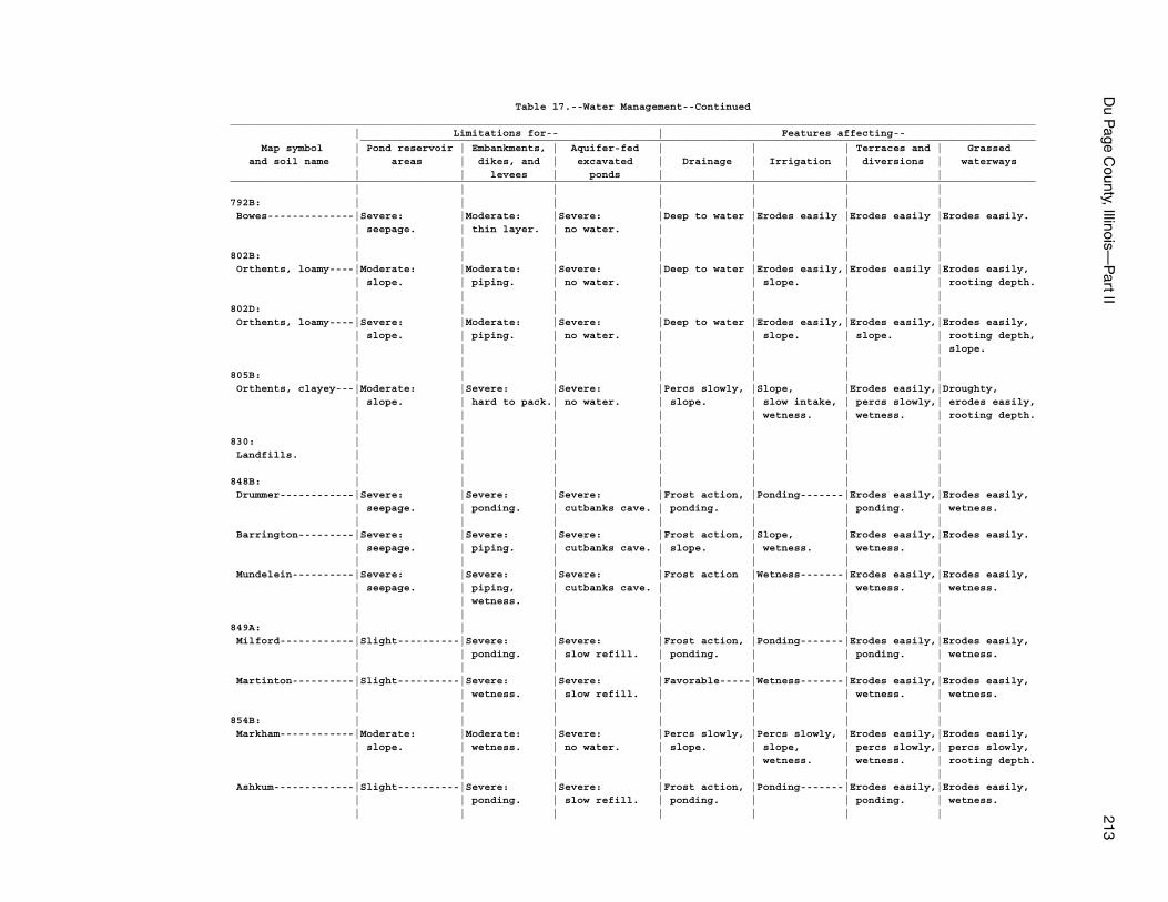
Du P
age County, Illinois—
Part II
213
Table 17.--Water Management--Continued__________________________________________________________________________________________________________________________________ | Limitations for-- | Features affecting-- _____________________________________________________________________________________________________________ Map symbol | Pond reservoir | Embankments, | Aquifer-fed | | | Terraces and | Grassed and soil name | areas | dikes, and | excavated | Drainage | Irrigation | diversions | waterways | | levees | ponds | | | |__________________________________________________________________________________________________________________________________ | | | | | | |792B: | | | | | | | Bowes--------------|Severe: |Moderate: |Severe: |Deep to water |Erodes easily |Erodes easily |Erodes easily. | seepage. | thin layer. | no water. | | | | | | | | | | |802B: | | | | | | | Orthents, loamy----|Moderate: |Moderate: |Severe: |Deep to water |Erodes easily,|Erodes easily |Erodes easily, | slope. | piping. | no water. | | slope. | | rooting depth. | | | | | | |802D: | | | | | | | Orthents, loamy----|Severe: |Moderate: |Severe: |Deep to water |Erodes easily,|Erodes easily,|Erodes easily, | slope. | piping. | no water. | | slope. | slope. | rooting depth, | | | | | | | slope. | | | | | | |805B: | | | | | | | Orthents, clayey---|Moderate: |Severe: |Severe: |Percs slowly, |Slope, |Erodes easily,|Droughty, | slope. | hard to pack.| no water. | slope. | slow intake, | percs slowly,| erodes easily, | | | | | wetness. | wetness. | rooting depth. | | | | | | |830: | | | | | | | Landfills. | | | | | | | | | | | | | |848B: | | | | | | | Drummer------------|Severe: |Severe: |Severe: |Frost action, |Ponding-------|Erodes easily,|Erodes easily, | seepage. | ponding. | cutbanks cave. | ponding. | | ponding. | wetness. | | | | | | | Barrington---------|Severe: |Severe: |Severe: |Frost action, |Slope, |Erodes easily,|Erodes easily. | seepage. | piping. | cutbanks cave. | slope. | wetness. | wetness. | | | | | | | | Mundelein----------|Severe: |Severe: |Severe: |Frost action |Wetness-------|Erodes easily,|Erodes easily, | seepage. | piping, | cutbanks cave. | | | wetness. | wetness. | | wetness. | | | | | | | | | | | |849A: | | | | | | | Milford------------|Slight----------|Severe: |Severe: |Frost action, |Ponding-------|Erodes easily,|Erodes easily, | | ponding. | slow refill. | ponding. | | ponding. | wetness. | | | | | | | Martinton----------|Slight----------|Severe: |Severe: |Favorable-----|Wetness-------|Erodes easily,|Erodes easily, | | wetness. | slow refill. | | | wetness. | wetness. | | | | | | |854B: | | | | | | | Markham------------|Moderate: |Moderate: |Severe: |Percs slowly, |Percs slowly, |Erodes easily,|Erodes easily, | slope. | wetness. | no water. | slope. | slope, | percs slowly,| percs slowly, | | | | | wetness. | wetness. | rooting depth. | | | | | | | Ashkum-------------|Slight----------|Severe: |Severe: |Frost action, |Ponding-------|Erodes easily,|Erodes easily, | | ponding. | slow refill. | ponding. | | ponding. | wetness. | | | | | | |
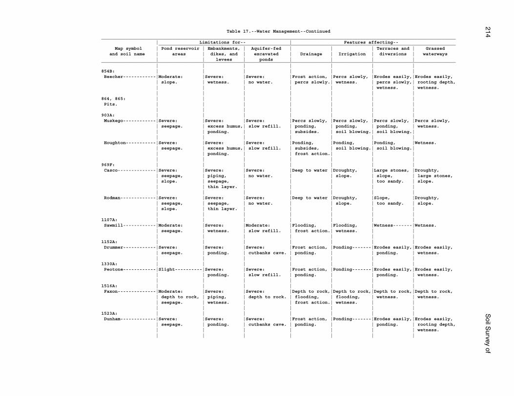
214S
oil Survey of
Table 17.--Water Management--Continued__________________________________________________________________________________________________________________________________ | Limitations for-- | Features affecting-- _____________________________________________________________________________________________________________ Map symbol | Pond reservoir | Embankments, | Aquifer-fed | | | Terraces and | Grassed and soil name | areas | dikes, and | excavated | Drainage | Irrigation | diversions | waterways | | levees | ponds | | | |__________________________________________________________________________________________________________________________________ | | | | | | |854B: | | | | | | | Beecher------------|Moderate: |Severe: |Severe: |Frost action, |Percs slowly, |Erodes easily,|Erodes easily, | slope. | wetness. | no water. | percs slowly.| wetness. | percs slowly,| rooting depth, | | | | | | wetness. | wetness. | | | | | | |864, 865: | | | | | | | Pits. | | | | | | | | | | | | | |903A: | | | | | | | Muskego------------|Severe: |Severe: |Severe: |Percs slowly, |Percs slowly, |Percs slowly, |Percs slowly, | seepage. | excess humus,| slow refill. | ponding, | ponding, | ponding, | wetness. | | ponding. | | subsides. | soil blowing.| soil blowing.| | | | | | | | Houghton-----------|Severe: |Severe: |Severe: |Ponding, |Ponding, |Ponding, |Wetness. | seepage. | excess humus,| slow refill. | subsides, | soil blowing.| soil blowing.| | | ponding. | | frost action.| | | | | | | | | |969F: | | | | | | | Casco--------------|Severe: |Severe: |Severe: |Deep to water |Droughty, |Large stones, |Droughty, | seepage, | piping, | no water. | | slope. | slope, | large stones, | slope. | seepage, | | | | too sandy. | slope. | | thin layer. | | | | | | | | | | | | Rodman-------------|Severe: |Severe: |Severe: |Deep to water |Droughty, |Slope, |Droughty, | seepage, | seepage, | no water. | | slope. | too sandy. | slope. | slope. | thin layer. | | | | | | | | | | | |1107A: | | | | | | | Sawmill------------|Moderate: |Severe: |Moderate: |Flooding, |Flooding, |Wetness-------|Wetness. | seepage. | wetness. | slow refill. | frost action.| wetness. | | | | | | | | |1152A: | | | | | | | Drummer------------|Severe: |Severe: |Severe: |Frost action, |Ponding-------|Erodes easily,|Erodes easily, | seepage. | ponding. | cutbanks cave. | ponding. | | ponding. | wetness. | | | | | | |1330A: | | | | | | | Peotone------------|Slight----------|Severe: |Severe: |Frost action, |Ponding-------|Erodes easily,|Erodes easily, | | ponding. | slow refill. | ponding. | | ponding. | wetness. | | | | | | |1516A: | | | | | | | Faxon--------------|Moderate: |Severe: |Severe: |Depth to rock,|Depth to rock,|Depth to rock,|Depth to rock, | depth to rock, | piping, | depth to rock. | flooding, | flooding, | wetness. | wetness. | seepage. | wetness. | | frost action.| wetness. | | | | | | | | |1523A: | | | | | | | Dunham-------------|Severe: |Severe: |Severe: |Frost action, |Ponding-------|Erodes easily,|Erodes easily, | seepage. | ponding. | cutbanks cave. | ponding. | | ponding. | rooting depth, | | | | | | | wetness. | | | | | | |
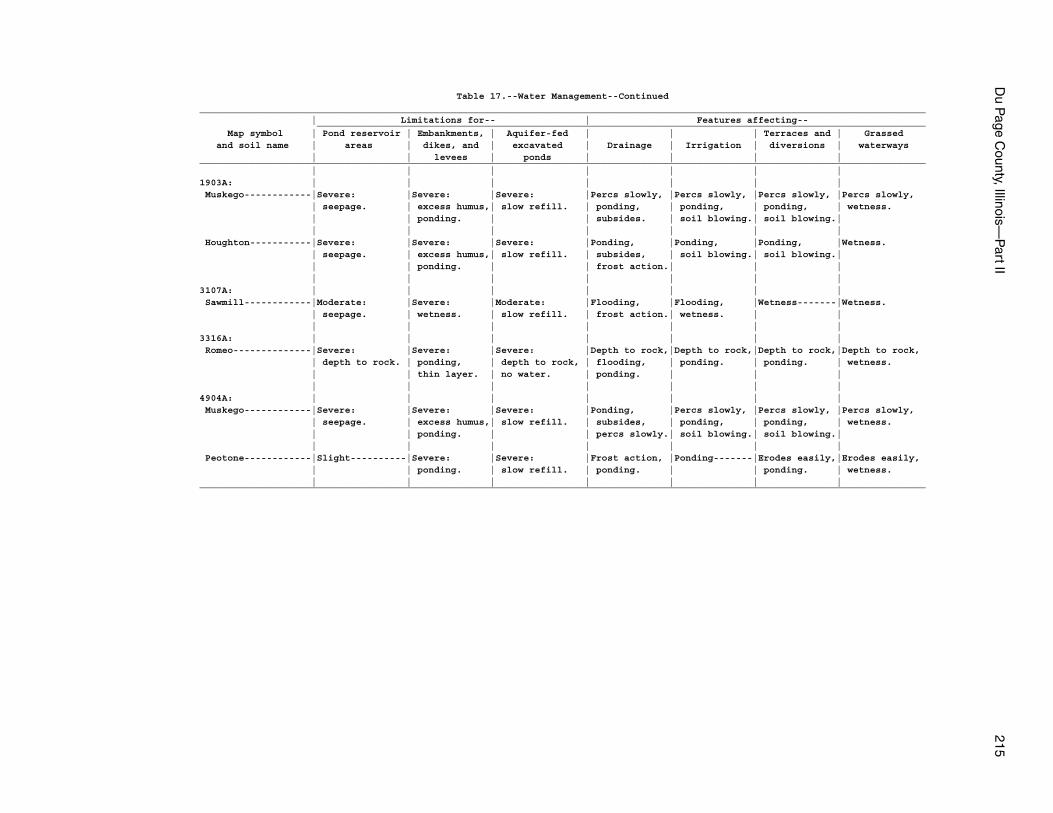
Du P
age County, Illinois—
Part II
215
Table 17.--Water Management--Continued__________________________________________________________________________________________________________________________________ | Limitations for-- | Features affecting-- _____________________________________________________________________________________________________________ Map symbol | Pond reservoir | Embankments, | Aquifer-fed | | | Terraces and | Grassed and soil name | areas | dikes, and | excavated | Drainage | Irrigation | diversions | waterways | | levees | ponds | | | |__________________________________________________________________________________________________________________________________ | | | | | | |1903A: | | | | | | | Muskego------------|Severe: |Severe: |Severe: |Percs slowly, |Percs slowly, |Percs slowly, |Percs slowly, | seepage. | excess humus,| slow refill. | ponding, | ponding, | ponding, | wetness. | | ponding. | | subsides. | soil blowing.| soil blowing.| | | | | | | | Houghton-----------|Severe: |Severe: |Severe: |Ponding, |Ponding, |Ponding, |Wetness. | seepage. | excess humus,| slow refill. | subsides, | soil blowing.| soil blowing.| | | ponding. | | frost action.| | | | | | | | | |3107A: | | | | | | | Sawmill------------|Moderate: |Severe: |Moderate: |Flooding, |Flooding, |Wetness-------|Wetness. | seepage. | wetness. | slow refill. | frost action.| wetness. | | | | | | | | |3316A: | | | | | | | Romeo--------------|Severe: |Severe: |Severe: |Depth to rock,|Depth to rock,|Depth to rock,|Depth to rock, | depth to rock. | ponding, | depth to rock, | flooding, | ponding. | ponding. | wetness. | | thin layer. | no water. | ponding. | | | | | | | | | |4904A: | | | | | | | Muskego------------|Severe: |Severe: |Severe: |Ponding, |Percs slowly, |Percs slowly, |Percs slowly, | seepage. | excess humus,| slow refill. | subsides, | ponding, | ponding, | wetness. | | ponding. | | percs slowly.| soil blowing.| soil blowing.| | | | | | | | Peotone------------|Slight----------|Severe: |Severe: |Frost action, |Ponding-------|Erodes easily,|Erodes easily, | | ponding. | slow refill. | ponding. | | ponding. | wetness. | | | | | | |__________________________________________________________________________________________________________________________________
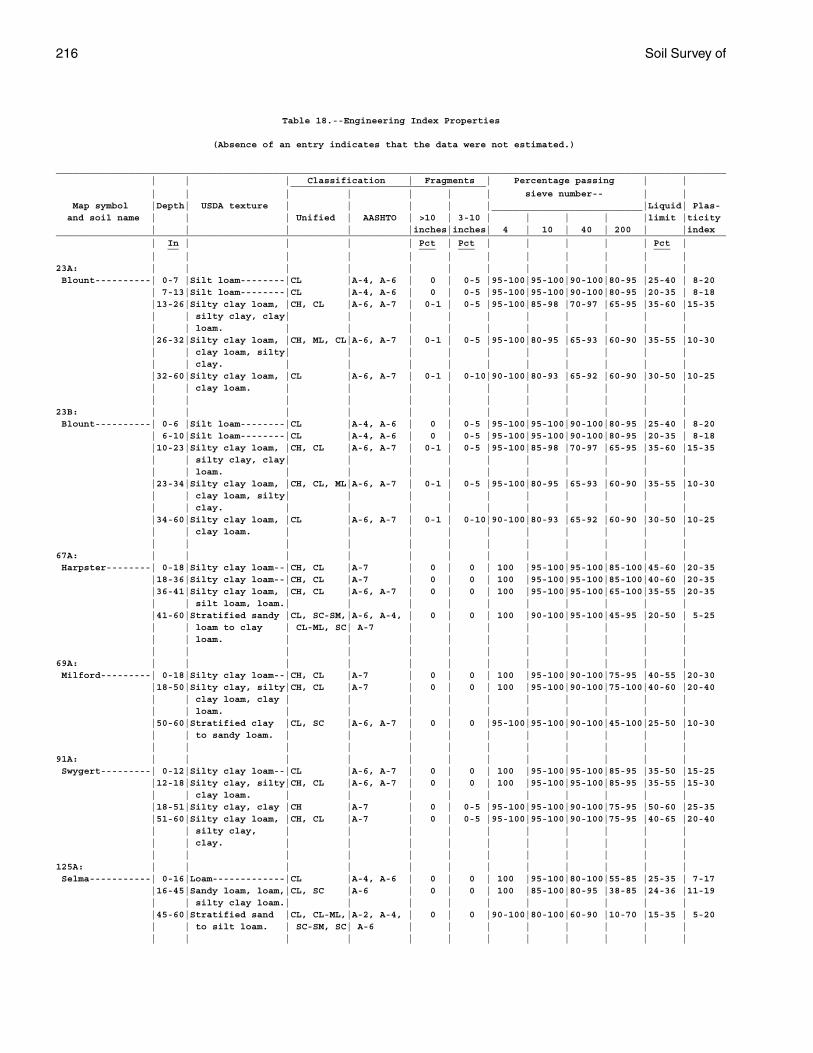
216 Soil Survey of
Table 18.--Engineering Index Properties
(Absence of an entry indicates that the data were not estimated.)
________________________________________________________________________________________________________________________ | | | Classification | Fragments | Percentage passing | | ___________________________________ | | | | | | | sieve number-- | | Map symbol |Depth| USDA texture | | | | |___________________________|Liquid| Plas- and soil name | | | Unified | AASHTO | >10 | 3-10 | | | | |limit |ticity | | | | |inches|inches| 4 | 10 | 40 | 200 | |index________________________________________________________________________________________________________________________ | In | | | | Pct | Pct | | | | | Pct | __ ___ ___ ___ | | | | | | | | | | | |23A: | | | | | | | | | | | | Blount----------| 0-7 |Silt loam--------|CL |A-4, A-6 | 0 | 0-5 |95-100|95-100|90-100|80-95 |25-40 | 8-20 | 7-13|Silt loam--------|CL |A-4, A-6 | 0 | 0-5 |95-100|95-100|90-100|80-95 |20-35 | 8-18 |13-26|Silty clay loam, |CH, CL |A-6, A-7 | 0-1 | 0-5 |95-100|85-98 |70-97 |65-95 |35-60 |15-35 | | silty clay, clay| | | | | | | | | | | | loam. | | | | | | | | | | |26-32|Silty clay loam, |CH, ML, CL|A-6, A-7 | 0-1 | 0-5 |95-100|80-95 |65-93 |60-90 |35-55 |10-30 | | clay loam, silty| | | | | | | | | | | | clay. | | | | | | | | | | |32-60|Silty clay loam, |CL |A-6, A-7 | 0-1 | 0-10|90-100|80-93 |65-92 |60-90 |30-50 |10-25 | | clay loam. | | | | | | | | | | | | | | | | | | | | | |23B: | | | | | | | | | | | | Blount----------| 0-6 |Silt loam--------|CL |A-4, A-6 | 0 | 0-5 |95-100|95-100|90-100|80-95 |25-40 | 8-20 | 6-10|Silt loam--------|CL |A-4, A-6 | 0 | 0-5 |95-100|95-100|90-100|80-95 |20-35 | 8-18 |10-23|Silty clay loam, |CH, CL |A-6, A-7 | 0-1 | 0-5 |95-100|85-98 |70-97 |65-95 |35-60 |15-35 | | silty clay, clay| | | | | | | | | | | | loam. | | | | | | | | | | |23-34|Silty clay loam, |CH, CL, ML|A-6, A-7 | 0-1 | 0-5 |95-100|80-95 |65-93 |60-90 |35-55 |10-30 | | clay loam, silty| | | | | | | | | | | | clay. | | | | | | | | | | |34-60|Silty clay loam, |CL |A-6, A-7 | 0-1 | 0-10|90-100|80-93 |65-92 |60-90 |30-50 |10-25 | | clay loam. | | | | | | | | | | | | | | | | | | | | | |67A: | | | | | | | | | | | | Harpster--------| 0-18|Silty clay loam--|CH, CL |A-7 | 0 | 0 | 100 |95-100|95-100|85-100|45-60 |20-35 |18-36|Silty clay loam--|CH, CL |A-7 | 0 | 0 | 100 |95-100|95-100|85-100|40-60 |20-35 |36-41|Silty clay loam, |CH, CL |A-6, A-7 | 0 | 0 | 100 |95-100|95-100|65-100|35-55 |20-35 | | silt loam, loam.| | | | | | | | | | |41-60|Stratified sandy |CL, SC-SM,|A-6, A-4, | 0 | 0 | 100 |90-100|95-100|45-95 |20-50 | 5-25 | | loam to clay | CL-ML, SC| A-7 | | | | | | | | | | loam. | | | | | | | | | | | | | | | | | | | | | |69A: | | | | | | | | | | | | Milford---------| 0-18|Silty clay loam--|CH, CL |A-7 | 0 | 0 | 100 |95-100|90-100|75-95 |40-55 |20-30 |18-50|Silty clay, silty|CH, CL |A-7 | 0 | 0 | 100 |95-100|90-100|75-100|40-60 |20-40 | | clay loam, clay | | | | | | | | | | | | loam. | | | | | | | | | | |50-60|Stratified clay |CL, SC |A-6, A-7 | 0 | 0 |95-100|95-100|90-100|45-100|25-50 |10-30 | | to sandy loam. | | | | | | | | | | | | | | | | | | | | | |91A: | | | | | | | | | | | | Swygert---------| 0-12|Silty clay loam--|CL |A-6, A-7 | 0 | 0 | 100 |95-100|95-100|85-95 |35-50 |15-25 |12-18|Silty clay, silty|CH, CL |A-6, A-7 | 0 | 0 | 100 |95-100|95-100|85-95 |35-55 |15-30 | | clay loam. | | | | | | | | | | |18-51|Silty clay, clay |CH |A-7 | 0 | 0-5 |95-100|95-100|90-100|75-95 |50-60 |25-35 |51-60|Silty clay loam, |CH, CL |A-7 | 0 | 0-5 |95-100|95-100|90-100|75-95 |40-65 |20-40 | | silty clay, | | | | | | | | | | | | clay. | | | | | | | | | | | | | | | | | | | | | |125A: | | | | | | | | | | | | Selma-----------| 0-16|Loam-------------|CL |A-4, A-6 | 0 | 0 | 100 |95-100|80-100|55-85 |25-35 | 7-17 |16-45|Sandy loam, loam,|CL, SC |A-6 | 0 | 0 | 100 |85-100|80-95 |38-85 |24-36 |11-19 | | silty clay loam.| | | | | | | | | | |45-60|Stratified sand |CL, CL-ML,|A-2, A-4, | 0 | 0 |90-100|80-100|60-90 |10-70 |15-35 | 5-20 | | to silt loam. | SC-SM, SC| A-6 | | | | | | | | | | | | | | | | | | | |
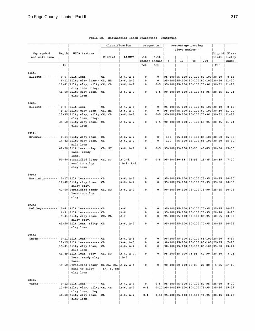
Du Page County, Illinois—Part II 217
Table 18.--Engineering Index Properties--Continued________________________________________________________________________________________________________________________ | | | Classification | Fragments | Percentage passing | | ___________________________________ | | | | | | | sieve number-- | | Map symbol |Depth| USDA texture | | | | |___________________________|Liquid| Plas- and soil name | | | Unified | AASHTO | >10 | 3-10 | | | | |limit |ticity | | | | |inches|inches| 4 | 10 | 40 | 200 | |index________________________________________________________________________________________________________________________ | In | | | | Pct | Pct | | | | | Pct | __ ___ ___ ___ | | | | | | | | | | | |146A: | | | | | | | | | | | | Elliott---------| 0-6 |Silt loam--------|CL |A-4, A-6 | 0 | 0 |95-100|95-100|90-100|80-100|30-40 | 8-18 | 6-11|Silty clay loam--|CL, ML |A-6, A-7 | 0 | 0 |95-100|95-100|90-100|80-100|30-50 |11-20 |11-41|Silty clay, silty|CH, CL |A-6, A-7 | 0 | 0-5 |95-100|85-100|80-100|70-96 |30-52 |11-26 | | clay loam, clay.| | | | | | | | | | |41-60|Silty clay loam, |CL |A-6, A-7 | 0 | 0-5 |90-100|80-100|75-100|65-95 |28-45 |11-24 | | clay loam. | | | | | | | | | | | | | | | | | | | | | |146B: | | | | | | | | | | | | Elliott---------| 0-9 |Silt loam--------|CL |A-4, A-6 | 0 | 0 |95-100|95-100|90-100|80-100|30-40 | 8-18 | 9-13|Silty clay loam--|CL, ML |A-6, A-7 | 0 | 0 |95-100|95-100|90-100|80-100|30-50 |11-20 |13-35|Silty clay, silty|CH, CL |A-6, A-7 | 0 | 0-5 |95-100|85-100|80-100|70-96 |30-52 |11-26 | | clay loam, clay.| | | | | | | | | | |35-60|Silty clay loam, |CL |A-6, A-7 | 0 | 0-5 |90-100|80-100|75-100|65-95 |28-45 |11-24 | | clay loam. | | | | | | | | | | | | | | | | | | | | | |152A: | | | | | | | | | | | | Drummer---------| 0-14|Silty clay loam--|CL |A-6, A-7 | 0 | 0 | 100 |95-100|95-100|85-100|30-50 |15-30 |14-42|Silty clay loam, |CL |A-6, A-7 | 0 | 0 | 100 |95-100|95-100|85-100|30-50 |15-30 | | silt loam. | | | | | | | | | | |42-50|Silt loam, clay |CL, SC |A-6, A-7 | 0 | 0-5 |95-100|93-100|75-95 |40-85 |30-50 |15-30 | | loam, sandy | | | | | | | | | | | | loam. | | | | | | | | | | |50-60|Stratified loamy |CL, SC |A-2-4, | 0 | 0-5 |95-100|80-98 |75-95 |15-85 |20-35 | 7-20 | | sand to silty | | A-4, A-6 | | | | | | | | | | clay loam. | | | | | | | | | | | | | | | | | | | | | |189A: | | | | | | | | | | | | Martinton-------| 0-17|Silt loam--------|CL |A-6, A-7 | 0 | 0 |95-100|95-100|90-100|75-95 |30-45 |10-20 |17-42|Silty clay loam, |CL |A-6, A-7 | 0 | 0 |95-100|95-100|90-100|70-95 |35-50 |20-30 | | silty clay. | | | | | | | | | | |42-60|Stratified sandy |CL, SC |A-6, A-7 | 0 | 0 |90-100|80-100|75-100|35-90 |25-45 |10-25 | | loam to silty | | | | | | | | | | | | clay. | | | | | | | | | | | | | | | | | | | | | |192A: | | | | | | | | | | | | Del Rey---------| 0-4 |Silt loam--------|CL |A-6 | 0 | 0 |95-100|95-100|90-100|70-95 |25-45 |10-25 | 4-9 |Silt loam--------|CL |A-6 | 0 | 0 |95-100|95-100|90-100|70-95 |20-40 | 8-20 | 9-41|Silty clay loam, |CH, CL |A-7 | 0 | 0 |95-100|95-100|90-100|85-95 |40-55 |20-30 | | silty clay. | | | | | | | | | | |41-60|Silt loam, silty |CL |A-6, A-7 | 0 | 0 |95-100|95-100|90-100|70-95 |30-45 |10-25 | | clay loam. | | | | | | | | | | | | | | | | | | | | | |206A: | | | | | | | | | | | | Thorp-----------| 0-11|Silt loam--------|CL |A-4, A-6 | 0 | 0 |98-100|95-100|90-100|85-100|20-40 | 8-19 |11-15|Silt loam--------|CL |A-4, A-6 | 0 | 0 |98-100|95-100|90-100|85-100|25-35 | 7-15 |15-41|Silty clay loam, |CL |A-6, A-7 | 0 | 0 |98-100|95-100|90-100|85-100|35-50 |13-27 | | silt loam. | | | | | | | | | | |41-49|Silt loam, clay |CL, SC |A-4, A-7, | 0 | 0 |95-100|85-100|75-95 |40-90 |20-50 | 8-26 | | loam, sandy clay| | A-6 | | | | | | | | | | loam. | | | | | | | | | | |49-60|Stratified loamy |CL-ML, ML,|A-2, A-4 | 0 | 0 |90-100|80-100|65-85 |20-80 | 5-25 |NP-15 | | sand to silty | SM, SC-SM| | | | | | | | | | | clay loam. | | | | | | | | | | | | | | | | | | | | | |223B: | | | | | | | | | | | | Varna-----------| 0-12|Silt loam--------|CL |A-4, A-6 | 0 | 0-5 |95-100|95-100|90-100|80-95 |25-40 | 8-20 |12-48|Silty clay, silty|CH, CL |A-6, A-7 | 0-1 | 0-10|95-100|85-100|80-100|75-95 |35-56 |15-29 | | clay loam, clay.| | | | | | | | | | |48-60|Silty clay loam, |CL |A-6, A-7 | 0-1 | 0-10|95-100|85-100|80-100|70-95 |30-45 |13-26 | | clay loam. | | | | | | | | | | | | | | | | | | | | | |
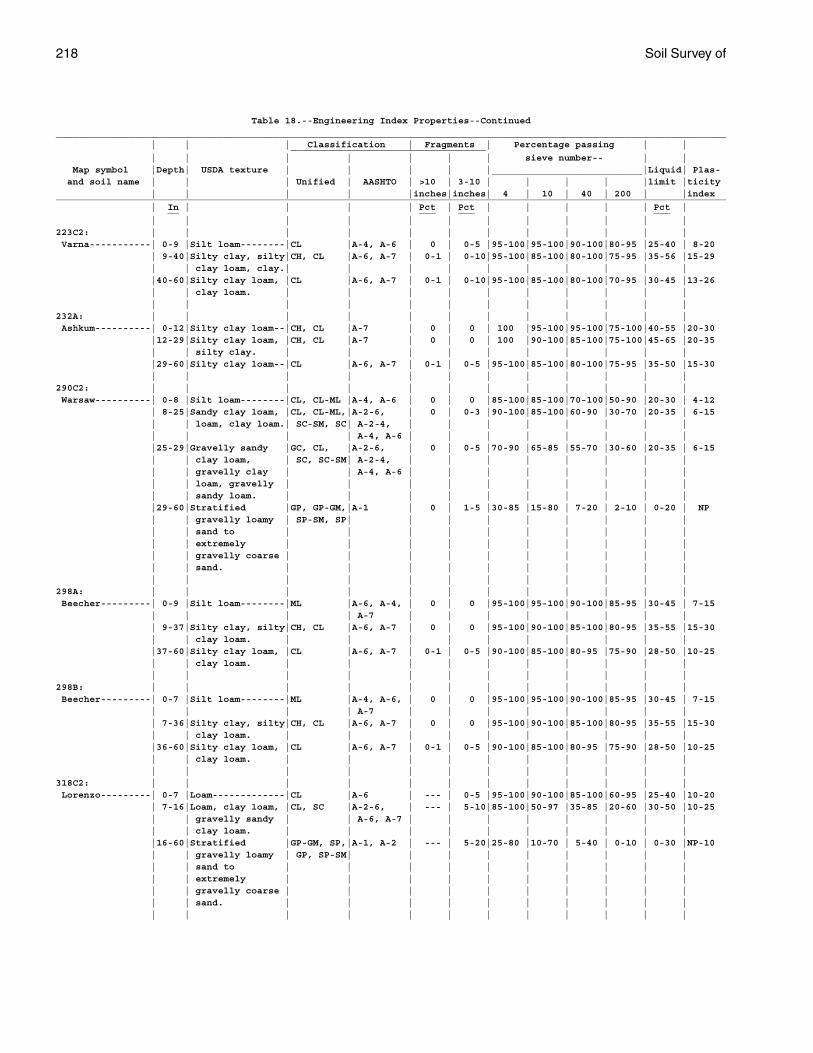
218 Soil Survey of
Table 18.--Engineering Index Properties--Continued________________________________________________________________________________________________________________________ | | | Classification | Fragments | Percentage passing | | ___________________________________ | | | | | | | sieve number-- | | Map symbol |Depth| USDA texture | | | | |___________________________|Liquid| Plas- and soil name | | | Unified | AASHTO | >10 | 3-10 | | | | |limit |ticity | | | | |inches|inches| 4 | 10 | 40 | 200 | |index________________________________________________________________________________________________________________________ | In | | | | Pct | Pct | | | | | Pct | __ ___ ___ ___ | | | | | | | | | | | |223C2: | | | | | | | | | | | | Varna-----------| 0-9 |Silt loam--------|CL |A-4, A-6 | 0 | 0-5 |95-100|95-100|90-100|80-95 |25-40 | 8-20 | 9-40|Silty clay, silty|CH, CL |A-6, A-7 | 0-1 | 0-10|95-100|85-100|80-100|75-95 |35-56 |15-29 | | clay loam, clay.| | | | | | | | | | |40-60|Silty clay loam, |CL |A-6, A-7 | 0-1 | 0-10|95-100|85-100|80-100|70-95 |30-45 |13-26 | | clay loam. | | | | | | | | | | | | | | | | | | | | | |232A: | | | | | | | | | | | | Ashkum----------| 0-12|Silty clay loam--|CH, CL |A-7 | 0 | 0 | 100 |95-100|95-100|75-100|40-55 |20-30 |12-29|Silty clay loam, |CH, CL |A-7 | 0 | 0 | 100 |90-100|85-100|75-100|45-65 |20-35 | | silty clay. | | | | | | | | | | |29-60|Silty clay loam--|CL |A-6, A-7 | 0-1 | 0-5 |95-100|85-100|80-100|75-95 |35-50 |15-30 | | | | | | | | | | | |290C2: | | | | | | | | | | | | Warsaw----------| 0-8 |Silt loam--------|CL, CL-ML |A-4, A-6 | 0 | 0 |85-100|85-100|70-100|50-90 |20-30 | 4-12 | 8-25|Sandy clay loam, |CL, CL-ML,|A-2-6, | 0 | 0-3 |90-100|85-100|60-90 |30-70 |20-35 | 6-15 | | loam, clay loam.| SC-SM, SC| A-2-4, | | | | | | | | | | | | A-4, A-6 | | | | | | | | |25-29|Gravelly sandy |GC, CL, |A-2-6, | 0 | 0-5 |70-90 |65-85 |55-70 |30-60 |20-35 | 6-15 | | clay loam, | SC, SC-SM| A-2-4, | | | | | | | | | | gravelly clay | | A-4, A-6 | | | | | | | | | | loam, gravelly | | | | | | | | | | | | sandy loam. | | | | | | | | | | |29-60|Stratified |GP, GP-GM,|A-1 | 0 | 1-5 |30-85 |15-80 | 7-20 | 2-10 | 0-20 | NP | | gravelly loamy | SP-SM, SP| | | | | | | | | | | sand to | | | | | | | | | | | | extremely | | | | | | | | | | | | gravelly coarse | | | | | | | | | | | | sand. | | | | | | | | | | | | | | | | | | | | | |298A: | | | | | | | | | | | | Beecher---------| 0-9 |Silt loam--------|ML |A-6, A-4, | 0 | 0 |95-100|95-100|90-100|85-95 |30-45 | 7-15 | | | | A-7 | | | | | | | | | 9-37|Silty clay, silty|CH, CL |A-6, A-7 | 0 | 0 |95-100|90-100|85-100|80-95 |35-55 |15-30 | | clay loam. | | | | | | | | | | |37-60|Silty clay loam, |CL |A-6, A-7 | 0-1 | 0-5 |90-100|85-100|80-95 |75-90 |28-50 |10-25 | | clay loam. | | | | | | | | | | | | | | | | | | | | | |298B: | | | | | | | | | | | | Beecher---------| 0-7 |Silt loam--------|ML |A-4, A-6, | 0 | 0 |95-100|95-100|90-100|85-95 |30-45 | 7-15 | | | | A-7 | | | | | | | | | 7-36|Silty clay, silty|CH, CL |A-6, A-7 | 0 | 0 |95-100|90-100|85-100|80-95 |35-55 |15-30 | | clay loam. | | | | | | | | | | |36-60|Silty clay loam, |CL |A-6, A-7 | 0-1 | 0-5 |90-100|85-100|80-95 |75-90 |28-50 |10-25 | | clay loam. | | | | | | | | | | | | | | | | | | | | | |318C2: | | | | | | | | | | | | Lorenzo---------| 0-7 |Loam-------------|CL |A-6 | --- | 0-5 |95-100|90-100|85-100|60-95 |25-40 |10-20 | 7-16|Loam, clay loam, |CL, SC |A-2-6, | --- | 5-10|85-100|50-97 |35-85 |20-60 |30-50 |10-25 | | gravelly sandy | | A-6, A-7 | | | | | | | | | | clay loam. | | | | | | | | | | |16-60|Stratified |GP-GM, SP,|A-1, A-2 | --- | 5-20|25-80 |10-70 | 5-40 | 0-10 | 0-30 |NP-10 | | gravelly loamy | GP, SP-SM| | | | | | | | | | | sand to | | | | | | | | | | | | extremely | | | | | | | | | | | | gravelly coarse | | | | | | | | | | | | sand. | | | | | | | | | | | | | | | | | | | | | |
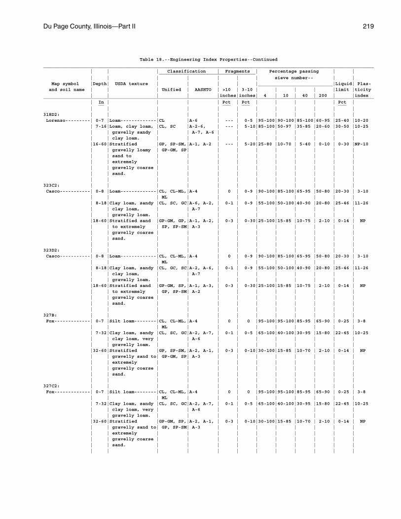
Du Page County, Illinois—Part II 219
Table 18.--Engineering Index Properties--Continued________________________________________________________________________________________________________________________ | | | Classification | Fragments | Percentage passing | | ___________________________________ | | | | | | | sieve number-- | | Map symbol |Depth| USDA texture | | | | |___________________________|Liquid| Plas- and soil name | | | Unified | AASHTO | >10 | 3-10 | | | | |limit |ticity | | | | |inches|inches| 4 | 10 | 40 | 200 | |index________________________________________________________________________________________________________________________ | In | | | | Pct | Pct | | | | | Pct | __ ___ ___ ___ | | | | | | | | | | | |318D2: | | | | | | | | | | | | Lorenzo---------| 0-7 |Loam-------------|CL |A-6 | --- | 0-5 |95-100|90-100|85-100|60-95 |25-40 |10-20 | 7-16|Loam, clay loam, |CL, SC |A-2-6, | --- | 5-10|85-100|50-97 |35-85 |20-60 |30-50 |10-25 | | gravelly sandy | | A-7, A-6 | | | | | | | | | | clay loam. | | | | | | | | | | |16-60|Stratified |GP, SP-SM,|A-1, A-2 | --- | 5-20|25-80 |10-70 | 5-40 | 0-10 | 0-30 |NP-10 | | gravelly loamy | GP-GM, SP| | | | | | | | | | | sand to | | | | | | | | | | | | extremely | | | | | | | | | | | | gravelly coarse | | | | | | | | | | | | sand. | | | | | | | | | | | | | | | | | | | | | |323C2: | | | | | | | | | | | | Casco-----------| 0-8 |Loam-------------|CL, CL-ML,|A-4 | 0 | 0-9 |90-100|85-100|65-95 |50-80 |20-30 | 3-10 | | | ML | | | | | | | | | | 8-18|Clay loam, sandy |CL, SC, GC|A-6, A-2, | 0-1 | 0-9 |55-100|50-100|40-90 |20-80 |25-46 |11-26 | | clay loam, | | A-7 | | | | | | | | | | gravelly loam. | | | | | | | | | | |18-60|Stratified sand |GP-GM, GP,|A-1, A-2, | 0-3 | 0-30|25-100|15-85 |10-75 | 2-10 | 0-14 | NP | | to extremely | SP, SP-SM| A-3 | | | | | | | | | | gravelly coarse | | | | | | | | | | | | sand. | | | | | | | | | | | | | | | | | | | | | |323D2: | | | | | | | | | | | | Casco-----------| 0-8 |Loam-------------|CL, CL-ML,|A-4 | 0 | 0-9 |90-100|85-100|65-95 |50-80 |20-30 | 3-10 | | | ML | | | | | | | | | | 8-18|Clay loam, sandy |CL, GC, SC|A-2, A-6, | 0-1 | 0-9 |55-100|50-100|40-90 |20-80 |25-46 |11-26 | | clay loam, | | A-7 | | | | | | | | | | gravelly loam. | | | | | | | | | | |18-60|Stratified sand |GP-GM, SP,|A-1, A-3, | 0-3 | 0-30|25-100|15-85 |10-75 | 2-10 | 0-14 | NP | | to extremely | GP, SP-SM| A-2 | | | | | | | | | | gravelly coarse | | | | | | | | | | | | sand. | | | | | | | | | | | | | | | | | | | | | |327B: | | | | | | | | | | | | Fox-------------| 0-7 |Silt loam--------|CL, CL-ML,|A-4 | 0 | 0 |95-100|95-100|85-95 |65-90 | 0-25 | 3-8 | | | ML | | | | | | | | | | 7-32|Clay loam, sandy |CL, SC, GC|A-2, A-7, | 0-1 | 0-5 |65-100|40-100|30-95 |15-80 |22-45 |10-25 | | clay loam, very | | A-6 | | | | | | | | | | gravelly loam. | | | | | | | | | | |32-60|Stratified |GP, SP-SM,|A-2, A-1, | 0-3 | 0-10|30-100|15-85 |10-70 | 2-10 | 0-14 | NP | | gravelly sand to| GP-GM, SP| A-3 | | | | | | | | | | extremely | | | | | | | | | | | | gravelly coarse | | | | | | | | | | | | sand. | | | | | | | | | | | | | | | | | | | | | |327C2: | | | | | | | | | | | | Fox-------------| 0-7 |Silt loam--------|CL, CL-ML,|A-4 | 0 | 0 |95-100|95-100|85-95 |65-90 | 0-25 | 3-8 | | | ML | | | | | | | | | | 7-32|Clay loam, sandy |CL, SC, GC|A-2, A-7, | 0-1 | 0-5 |65-100|40-100|30-95 |15-80 |22-45 |10-25 | | clay loam, very | | A-6 | | | | | | | | | | gravelly loam. | | | | | | | | | | |32-60|Stratified |GP-GM, SP,|A-2, A-1, | 0-3 | 0-10|30-100|15-85 |10-70 | 2-10 | 0-14 | NP | | gravelly sand to| GP, SP-SM| A-3 | | | | | | | | | | extremely | | | | | | | | | | | | gravelly coarse | | | | | | | | | | | | sand. | | | | | | | | | | | | | | | | | | | | | |
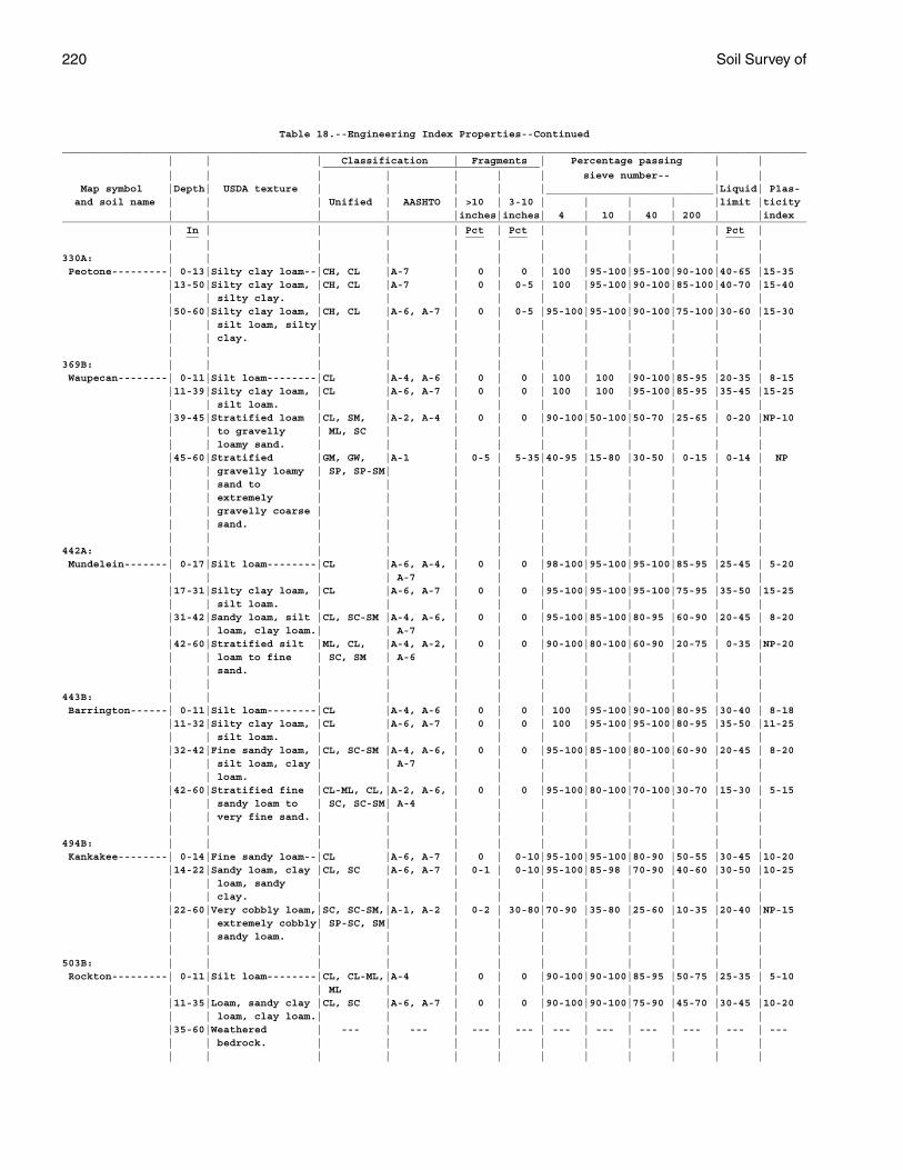
220 Soil Survey of
Table 18.--Engineering Index Properties--Continued________________________________________________________________________________________________________________________ | | | Classification | Fragments | Percentage passing | | ___________________________________ | | | | | | | sieve number-- | | Map symbol |Depth| USDA texture | | | | |___________________________|Liquid| Plas- and soil name | | | Unified | AASHTO | >10 | 3-10 | | | | |limit |ticity | | | | |inches|inches| 4 | 10 | 40 | 200 | |index________________________________________________________________________________________________________________________ | In | | | | Pct | Pct | | | | | Pct | __ ___ ___ ___ | | | | | | | | | | | |330A: | | | | | | | | | | | | Peotone---------| 0-13|Silty clay loam--|CH, CL |A-7 | 0 | 0 | 100 |95-100|95-100|90-100|40-65 |15-35 |13-50|Silty clay loam, |CH, CL |A-7 | 0 | 0-5 | 100 |95-100|90-100|85-100|40-70 |15-40 | | silty clay. | | | | | | | | | | |50-60|Silty clay loam, |CH, CL |A-6, A-7 | 0 | 0-5 |95-100|95-100|90-100|75-100|30-60 |15-30 | | silt loam, silty| | | | | | | | | | | | clay. | | | | | | | | | | | | | | | | | | | | | |369B: | | | | | | | | | | | | Waupecan--------| 0-11|Silt loam--------|CL |A-4, A-6 | 0 | 0 | 100 | 100 |90-100|85-95 |20-35 | 8-15 |11-39|Silty clay loam, |CL |A-6, A-7 | 0 | 0 | 100 | 100 |95-100|85-95 |35-45 |15-25 | | silt loam. | | | | | | | | | | |39-45|Stratified loam |CL, SM, |A-2, A-4 | 0 | 0 |90-100|50-100|50-70 |25-65 | 0-20 |NP-10 | | to gravelly | ML, SC | | | | | | | | | | | loamy sand. | | | | | | | | | | |45-60|Stratified |GM, GW, |A-1 | 0-5 | 5-35|40-95 |15-80 |30-50 | 0-15 | 0-14 | NP | | gravelly loamy | SP, SP-SM| | | | | | | | | | | sand to | | | | | | | | | | | | extremely | | | | | | | | | | | | gravelly coarse | | | | | | | | | | | | sand. | | | | | | | | | | | | | | | | | | | | | |442A: | | | | | | | | | | | | Mundelein-------| 0-17|Silt loam--------|CL |A-6, A-4, | 0 | 0 |98-100|95-100|95-100|85-95 |25-45 | 5-20 | | | | A-7 | | | | | | | | |17-31|Silty clay loam, |CL |A-6, A-7 | 0 | 0 |95-100|95-100|95-100|75-95 |35-50 |15-25 | | silt loam. | | | | | | | | | | |31-42|Sandy loam, silt |CL, SC-SM |A-4, A-6, | 0 | 0 |95-100|85-100|80-95 |60-90 |20-45 | 8-20 | | loam, clay loam.| | A-7 | | | | | | | | |42-60|Stratified silt |ML, CL, |A-4, A-2, | 0 | 0 |90-100|80-100|60-90 |20-75 | 0-35 |NP-20 | | loam to fine | SC, SM | A-6 | | | | | | | | | | sand. | | | | | | | | | | | | | | | | | | | | | |443B: | | | | | | | | | | | | Barrington------| 0-11|Silt loam--------|CL |A-4, A-6 | 0 | 0 | 100 |95-100|90-100|80-95 |30-40 | 8-18 |11-32|Silty clay loam, |CL |A-6, A-7 | 0 | 0 | 100 |95-100|95-100|80-95 |35-50 |11-25 | | silt loam. | | | | | | | | | | |32-42|Fine sandy loam, |CL, SC-SM |A-4, A-6, | 0 | 0 |95-100|85-100|80-100|60-90 |20-45 | 8-20 | | silt loam, clay | | A-7 | | | | | | | | | | loam. | | | | | | | | | | |42-60|Stratified fine |CL-ML, CL,|A-2, A-6, | 0 | 0 |95-100|80-100|70-100|30-70 |15-30 | 5-15 | | sandy loam to | SC, SC-SM| A-4 | | | | | | | | | | very fine sand. | | | | | | | | | | | | | | | | | | | | | |494B: | | | | | | | | | | | | Kankakee--------| 0-14|Fine sandy loam--|CL |A-6, A-7 | 0 | 0-10|95-100|95-100|80-90 |50-55 |30-45 |10-20 |14-22|Sandy loam, clay |CL, SC |A-6, A-7 | 0-1 | 0-10|95-100|85-98 |70-90 |40-60 |30-50 |10-25 | | loam, sandy | | | | | | | | | | | | clay. | | | | | | | | | | |22-60|Very cobbly loam,|SC, SC-SM,|A-1, A-2 | 0-2 | 30-80|70-90 |35-80 |25-60 |10-35 |20-40 |NP-15 | | extremely cobbly| SP-SC, SM| | | | | | | | | | | sandy loam. | | | | | | | | | | | | | | | | | | | | | |503B: | | | | | | | | | | | | Rockton---------| 0-11|Silt loam--------|CL, CL-ML,|A-4 | 0 | 0 |90-100|90-100|85-95 |50-75 |25-35 | 5-10 | | | ML | | | | | | | | | |11-35|Loam, sandy clay |CL, SC |A-6, A-7 | 0 | 0 |90-100|90-100|75-90 |45-70 |30-45 |10-20 | | loam, clay loam.| | | | | | | | | | |35-60|Weathered | --- | --- | --- | --- | --- | --- | --- | --- | --- | --- | | bedrock. | | | | | | | | | | | | | | | | | | | | | |
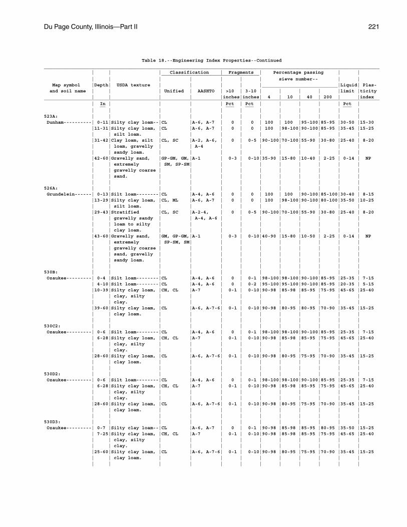
Du Page County, Illinois—Part II 221
Table 18.--Engineering Index Properties--Continued________________________________________________________________________________________________________________________ | | | Classification | Fragments | Percentage passing | | ___________________________________ | | | | | | | sieve number-- | | Map symbol |Depth| USDA texture | | | | |___________________________|Liquid| Plas- and soil name | | | Unified | AASHTO | >10 | 3-10 | | | | |limit |ticity | | | | |inches|inches| 4 | 10 | 40 | 200 | |index________________________________________________________________________________________________________________________ | In | | | | Pct | Pct | | | | | Pct | __ ___ ___ ___ | | | | | | | | | | | |523A: | | | | | | | | | | | | Dunham----------| 0-11|Silty clay loam--|CL |A-6, A-7 | 0 | 0 | 100 | 100 |95-100|85-95 |30-50 |15-30 |11-31|Silty clay loam, |CL |A-6, A-7 | 0 | 0 | 100 |98-100|90-100|85-95 |35-45 |15-25 | | silt loam. | | | | | | | | | | |31-42|Clay loam, silt |CL, SC |A-2, A-6, | 0 | 0-5 |90-100|70-100|55-90 |30-80 |25-40 | 8-20 | | loam, gravelly | | A-4 | | | | | | | | | | sandy loam. | | | | | | | | | | |42-60|Gravelly sand, |GP-GM, GM,|A-1 | 0-3 | 0-10|35-90 |15-80 |10-40 | 2-25 | 0-14 | NP | | extremely | SM, SP-SM| | | | | | | | | | | gravelly coarse | | | | | | | | | | | | sand. | | | | | | | | | | | | | | | | | | | | | |526A: | | | | | | | | | | | | Grundelein------| 0-13|Silt loam--------|CL |A-4, A-6 | 0 | 0 | 100 | 100 |90-100|85-100|30-40 | 8-15 |13-29|Silty clay loam, |CL, ML |A-6, A-7 | 0 | 0 | 100 |98-100|90-100|80-100|35-50 |10-25 | | silt loam. | | | | | | | | | | |29-43|Stratified |CL, SC |A-2-4, | 0 | 0-5 |90-100|70-100|55-90 |30-80 |25-40 | 8-20 | | gravelly sandy | | A-4, A-6 | | | | | | | | | | loam to silty | | | | | | | | | | | | clay loam. | | | | | | | | | | |43-60|Gravelly sand, |GM, GP-GM,|A-1 | 0-3 | 0-10|40-90 |15-80 |10-50 | 2-25 | 0-14 | NP | | extremely | SP-SM, SM| | | | | | | | | | | gravelly coarse | | | | | | | | | | | | sand, gravelly | | | | | | | | | | | | sandy loam. | | | | | | | | | | | | | | | | | | | | | |530B: | | | | | | | | | | | | Ozaukee---------| 0-4 |Silt loam--------|CL |A-4, A-6 | 0 | 0-1 |98-100|98-100|90-100|85-95 |25-35 | 7-15 | 4-10|Silt loam--------|CL |A-4, A-6 | 0 | 0-2 |95-100|95-100|90-100|85-95 |20-35 | 5-15 |10-39|Silty clay loam, |CH, CL |A-7 | 0-1 | 0-10|90-98 |85-98 |85-95 |75-95 |45-65 |25-40 | | clay, silty | | | | | | | | | | | | clay. | | | | | | | | | | |39-60|Silty clay loam, |CL |A-6, A-7-6| 0-1 | 0-10|90-98 |80-95 |80-95 |70-90 |35-45 |15-25 | | clay loam. | | | | | | | | | | | | | | | | | | | | | |530C2: | | | | | | | | | | | | Ozaukee---------| 0-6 |Silt loam--------|CL |A-4, A-6 | 0 | 0-1 |98-100|98-100|90-100|85-95 |25-35 | 7-15 | 6-28|Silty clay loam, |CH, CL |A-7 | 0-1 | 0-10|90-98 |85-98 |85-95 |75-95 |45-65 |25-40 | | clay, silty | | | | | | | | | | | | clay. | | | | | | | | | | |28-60|Silty clay loam, |CL |A-6, A-7-6| 0-1 | 0-10|90-98 |80-95 |75-95 |70-90 |35-45 |15-25 | | clay loam. | | | | | | | | | | | | | | | | | | | | | |530D2: | | | | | | | | | | | | Ozaukee---------| 0-6 |Silt loam--------|CL |A-4, A-6 | 0 | 0-1 |98-100|98-100|90-100|85-95 |25-35 | 7-15 | 6-28|Silty clay loam, |CH, CL |A-7 | 0-1 | 0-10|90-98 |85-98 |85-95 |75-95 |45-65 |25-40 | | clay, silty | | | | | | | | | | | | clay. | | | | | | | | | | |28-60|Silty clay loam, |CL |A-6, A-7-6| 0-1 | 0-10|90-98 |80-95 |75-95 |70-90 |35-45 |15-25 | | clay loam. | | | | | | | | | | | | | | | | | | | | | |530D3: | | | | | | | | | | | | Ozaukee---------| 0-7 |Silty clay loam--|CL |A-6, A-7 | 0 | 0-1 |90-98 |85-98 |85-95 |80-95 |35-50 |15-25 | 7-25|Silty clay loam, |CH, CL |A-7 | 0-1 | 0-10|90-98 |85-98 |85-95 |75-95 |45-65 |25-40 | | clay, silty | | | | | | | | | | | | clay. | | | | | | | | | | |25-60|Silty clay loam, |CL |A-6, A-7-6| 0-1 | 0-10|90-98 |80-95 |75-95 |70-90 |35-45 |15-25 | | clay loam. | | | | | | | | | | | | | | | | | | | | | |
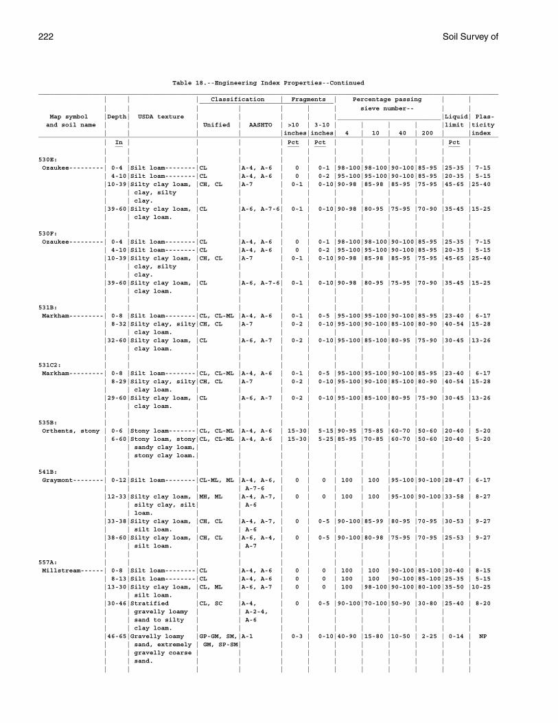
222 Soil Survey of
Table 18.--Engineering Index Properties--Continued________________________________________________________________________________________________________________________ | | | Classification | Fragments | Percentage passing | | ___________________________________ | | | | | | | sieve number-- | | Map symbol |Depth| USDA texture | | | | |___________________________|Liquid| Plas- and soil name | | | Unified | AASHTO | >10 | 3-10 | | | | |limit |ticity | | | | |inches|inches| 4 | 10 | 40 | 200 | |index________________________________________________________________________________________________________________________ | In | | | | Pct | Pct | | | | | Pct | __ ___ ___ ___ | | | | | | | | | | | |530E: | | | | | | | | | | | | Ozaukee---------| 0-4 |Silt loam--------|CL |A-4, A-6 | 0 | 0-1 |98-100|98-100|90-100|85-95 |25-35 | 7-15 | 4-10|Silt loam--------|CL |A-4, A-6 | 0 | 0-2 |95-100|95-100|90-100|85-95 |20-35 | 5-15 |10-39|Silty clay loam, |CH, CL |A-7 | 0-1 | 0-10|90-98 |85-98 |85-95 |75-95 |45-65 |25-40 | | clay, silty | | | | | | | | | | | | clay. | | | | | | | | | | |39-60|Silty clay loam, |CL |A-6, A-7-6| 0-1 | 0-10|90-98 |80-95 |75-95 |70-90 |35-45 |15-25 | | clay loam. | | | | | | | | | | | | | | | | | | | | | |530F: | | | | | | | | | | | | Ozaukee---------| 0-4 |Silt loam--------|CL |A-4, A-6 | 0 | 0-1 |98-100|98-100|90-100|85-95 |25-35 | 7-15 | 4-10|Silt loam--------|CL |A-4, A-6 | 0 | 0-2 |95-100|95-100|90-100|85-95 |20-35 | 5-15 |10-39|Silty clay loam, |CH, CL |A-7 | 0-1 | 0-10|90-98 |85-98 |85-95 |75-95 |45-65 |25-40 | | clay, silty | | | | | | | | | | | | clay. | | | | | | | | | | |39-60|Silty clay loam, |CL |A-6, A-7-6| 0-1 | 0-10|90-98 |80-95 |75-95 |70-90 |35-45 |15-25 | | clay loam. | | | | | | | | | | | | | | | | | | | | | |531B: | | | | | | | | | | | | Markham---------| 0-8 |Silt loam--------|CL, CL-ML |A-4, A-6 | 0-1 | 0-5 |95-100|95-100|90-100|85-95 |23-40 | 6-17 | 8-32|Silty clay, silty|CH, CL |A-7 | 0-2 | 0-10|95-100|90-100|85-100|80-90 |40-54 |15-28 | | clay loam. | | | | | | | | | | |32-60|Silty clay loam, |CL |A-6, A-7 | 0-2 | 0-10|95-100|85-100|80-95 |75-90 |30-45 |13-26 | | clay loam. | | | | | | | | | | | | | | | | | | | | | |531C2: | | | | | | | | | | | | Markham---------| 0-8 |Silt loam--------|CL, CL-ML |A-4, A-6 | 0-1 | 0-5 |95-100|95-100|90-100|85-95 |23-40 | 6-17 | 8-29|Silty clay, silty|CH, CL |A-7 | 0-2 | 0-10|95-100|90-100|85-100|80-90 |40-54 |15-28 | | clay loam. | | | | | | | | | | |29-60|Silty clay loam, |CL |A-6, A-7 | 0-2 | 0-10|95-100|85-100|80-95 |75-90 |30-45 |13-26 | | clay loam. | | | | | | | | | | | | | | | | | | | | | |535B: | | | | | | | | | | | | Orthents, stony | 0-6 |Stony loam-------|CL, CL-ML |A-4, A-6 | 15-30| 5-15|90-95 |75-85 |60-70 |50-60 |20-40 | 5-20 | 6-60|Stony loam, stony|CL, CL-ML |A-4, A-6 | 15-30| 5-25|85-95 |70-85 |60-70 |50-60 |20-40 | 5-20 | | sandy clay loam,| | | | | | | | | | | | stony clay loam.| | | | | | | | | | | | | | | | | | | | | |541B: | | | | | | | | | | | | Graymont--------| 0-12|Silt loam--------|CL-ML, ML |A-4, A-6, | 0 | 0 | 100 | 100 |95-100|90-100|28-47 | 6-17 | | | | A-7-6 | | | | | | | | |12-33|Silty clay loam, |MH, ML |A-4, A-7, | 0 | 0 | 100 | 100 |95-100|90-100|33-58 | 8-27 | | silty clay, silt| | A-6 | | | | | | | | | | loam. | | | | | | | | | | |33-38|Silty clay loam, |CH, CL |A-4, A-7, | 0 | 0-5 |90-100|85-99 |80-95 |70-95 |30-53 | 9-27 | | silt loam. | | A-6 | | | | | | | | |38-60|Silty clay loam, |CH, CL |A-6, A-4, | 0 | 0-5 |90-100|80-98 |75-95 |70-95 |25-53 | 9-27 | | silt loam. | | A-7 | | | | | | | | | | | | | | | | | | | |557A: | | | | | | | | | | | | Millstream------| 0-8 |Silt loam--------|CL |A-4, A-6 | 0 | 0 | 100 | 100 |90-100|85-100|30-40 | 8-15 | 8-13|Silt loam--------|CL |A-4, A-6 | 0 | 0 | 100 | 100 |90-100|85-100|25-35 | 5-15 |13-30|Silty clay loam, |CL, ML |A-6, A-7 | 0 | 0 | 100 |98-100|90-100|80-100|35-50 |10-25 | | silt loam. | | | | | | | | | | |30-46|Stratified |CL, SC |A-4, | 0 | 0-5 |90-100|70-100|50-90 |30-80 |25-40 | 8-20 | | gravelly loamy | | A-2-4, | | | | | | | | | | sand to silty | | A-6 | | | | | | | | | | clay loam. | | | | | | | | | | |46-65|Gravelly loamy |GP-GM, SM,|A-1 | 0-3 | 0-10|40-90 |15-80 |10-50 | 2-25 | 0-14 | NP | | sand, extremely | GM, SP-SM| | | | | | | | | | | gravelly coarse | | | | | | | | | | | | sand. | | | | | | | | | | | | | | | | | | | | | |
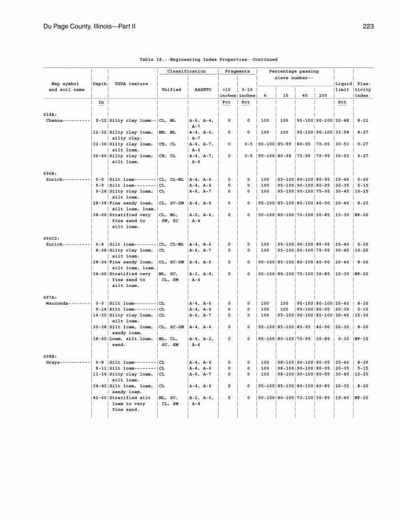
Du Page County, Illinois—Part II 223
Table 18.--Engineering Index Properties--Continued________________________________________________________________________________________________________________________ | | | Classification | Fragments | Percentage passing | | ___________________________________ | | | | | | | sieve number-- | | Map symbol |Depth| USDA texture | | | | |___________________________|Liquid| Plas- and soil name | | | Unified | AASHTO | >10 | 3-10 | | | | |limit |ticity | | | | |inches|inches| 4 | 10 | 40 | 200 | |index________________________________________________________________________________________________________________________ | In | | | | Pct | Pct | | | | | Pct | __ ___ ___ ___ | | | | | | | | | | | |614A: | | | | | | | | | | | | Chenoa----------| 0-12|Silty clay loam--|CL, ML |A-6, A-4, | 0 | 0 | 100 | 100 |95-100|90-100|32-48 | 8-21 | | | | A-7 | | | | | | | | |12-32|Silty clay loam, |MH, ML |A-4, A-6, | 0 | 0 | 100 | 100 |95-100|90-100|33-58 | 8-27 | | silty clay. | | A-7 | | | | | | | | |32-36|Silty clay loam, |CH, CL |A-4, A-7, | 0 | 0-5 |90-100|85-99 |80-95 |70-95 |30-53 | 9-27 | | silt loam. | | A-6 | | | | | | | | |36-60|Silty clay loam, |CH, CL |A-4, A-7, | 0 | 0-5 |90-100|80-98 |75-95 |70-95 |30-53 | 9-27 | | silt loam. | | A-6 | | | | | | | | | | | | | | | | | | | |696B: | | | | | | | | | | | | Zurich----------| 0-5 |Silt loam--------|CL, CL-ML |A-4, A-6 | 0 | 0 | 100 |95-100|90-100|80-95 |25-40 | 5-20 | 5-9 |Silt loam--------|CL |A-4, A-6 | 0 | 0 | 100 |95-100|90-100|80-95 |20-35 | 5-15 | 9-28|Silty clay loam, |CL |A-6, A-7 | 0 | 0 | 100 |95-100|90-100|75-95 |30-45 |10-25 | | silt loam. | | | | | | | | | | |28-38|Fine sandy loam, |CL, SC-SM |A-4, A-6 | 0 | 0 |95-100|85-100|80-100|40-90 |20-40 | 8-20 | | silt loam, loam.| | | | | | | | | | |38-60|Stratified very |CL, ML, |A-2, A-6, | 0 | 0 |90-100|80-100|70-100|30-85 |15-30 |NP-20 | | fine sand to | SM, SC | A-4 | | | | | | | | | | silt loam. | | | | | | | | | | | | | | | | | | | | | |696C2: | | | | | | | | | | | | Zurich----------| 0-8 |Silt loam--------|CL, CL-ML |A-4, A-6 | 0 | 0 | 100 |95-100|90-100|80-95 |25-40 | 5-20 | 8-28|Silty clay loam, |CL |A-6, A-7 | 0 | 0 | 100 |95-100|90-100|75-95 |30-45 |10-25 | | silt loam. | | | | | | | | | | |28-34|Fine sandy loam, |CL, SC-SM |A-4, A-6 | 0 | 0 |95-100|85-100|80-100|40-90 |20-40 | 8-20 | | silt loam, loam.| | | | | | | | | | |34-60|Stratified very |ML, SC, |A-2, A-4, | 0 | 0 |90-100|80-100|70-100|30-85 |15-30 |NP-20 | | fine sand to | CL, SM | A-6 | | | | | | | | | | silt loam. | | | | | | | | | | | | | | | | | | | | | |697A: | | | | | | | | | | | | Wauconda--------| 0-9 |Silt loam--------|CL |A-4, A-6 | 0 | 0 | 100 | 100 |95-100|80-100|25-40 | 8-20 | 9-14|Silt loam--------|CL |A-4, A-6 | 0 | 0 | 100 | 100 |95-100|80-95 |20-35 | 5-15 |14-30|Silty clay loam, |CL |A-6, A-7 | 0 | 0 | 100 |95-100|90-100|85-100|30-45 |15-30 | | silt loam. | | | | | | | | | | |30-38|Silt loam, loam, |CL, SC-SM |A-4, A-6 | 0 | 0 |95-100|85-100|80-95 |40-90 |20-35 | 8-20 | | sandy loam. | | | | | | | | | | |38-60|Loam, silt loam, |ML, CL, |A-4, A-2, | 0 | 0 |95-100|80-100|70-95 |30-85 | 0-30 |NP-15 | | sand. | SC, SM | A-6 | | | | | | | | | | | | | | | | | | | |698B: | | | | | | | | | | | | Grays-----------| 0-8 |Silt loam--------|CL |A-4, A-6 | 0 | 0 | 100 |98-100|90-100|80-95 |25-40 | 8-20 | 8-11|Silt loam--------|CL |A-4, A-6 | 0 | 0 | 100 |98-100|90-100|80-95 |20-35 | 5-15 |11-34|Silty clay loam, |CL |A-6, A-7 | 0 | 0 | 100 |98-100|90-100|80-95 |30-45 |15-25 | | silt loam. | | | | | | | | | | |34-42|Silt loam, loam, |CL |A-4, A-6 | 0 | 0 |95-100|85-100|80-100|40-85 |20-35 | 8-20 | | sandy loam. | | | | | | | | | | |42-60|Stratified silt |ML, SC, |A-2, A-6, | 0 | 0 |90-100|80-100|70-100|30-85 |15-40 |NP-20 | | loam to very | CL, SM | A-4 | | | | | | | | | | fine sand. | | | | | | | | | | | | | | | | | | | | | |
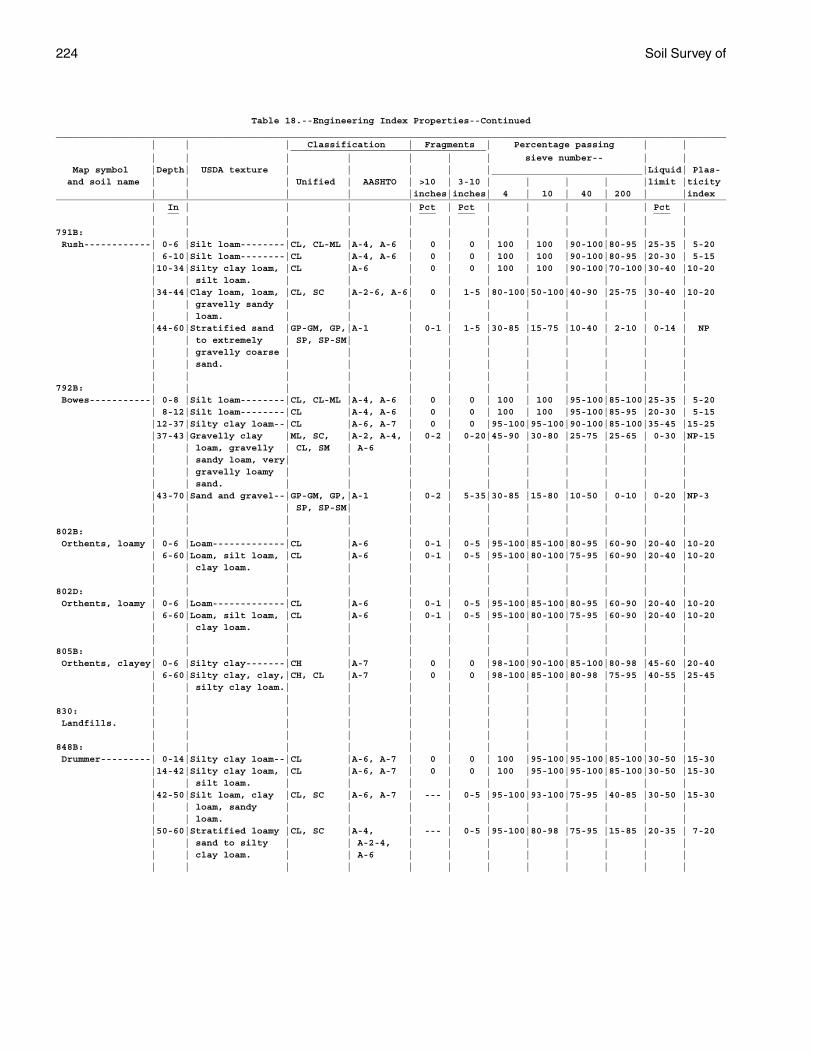
224 Soil Survey of
Table 18.--Engineering Index Properties--Continued________________________________________________________________________________________________________________________ | | | Classification | Fragments | Percentage passing | | ___________________________________ | | | | | | | sieve number-- | | Map symbol |Depth| USDA texture | | | | |___________________________|Liquid| Plas- and soil name | | | Unified | AASHTO | >10 | 3-10 | | | | |limit |ticity | | | | |inches|inches| 4 | 10 | 40 | 200 | |index________________________________________________________________________________________________________________________ | In | | | | Pct | Pct | | | | | Pct | __ ___ ___ ___ | | | | | | | | | | | |791B: | | | | | | | | | | | | Rush------------| 0-6 |Silt loam--------|CL, CL-ML |A-4, A-6 | 0 | 0 | 100 | 100 |90-100|80-95 |25-35 | 5-20 | 6-10|Silt loam--------|CL |A-4, A-6 | 0 | 0 | 100 | 100 |90-100|80-95 |20-30 | 5-15 |10-34|Silty clay loam, |CL |A-6 | 0 | 0 | 100 | 100 |90-100|70-100|30-40 |10-20 | | silt loam. | | | | | | | | | | |34-44|Clay loam, loam, |CL, SC |A-2-6, A-6| 0 | 1-5 |80-100|50-100|40-90 |25-75 |30-40 |10-20 | | gravelly sandy | | | | | | | | | | | | loam. | | | | | | | | | | |44-60|Stratified sand |GP-GM, GP,|A-1 | 0-1 | 1-5 |30-85 |15-75 |10-40 | 2-10 | 0-14 | NP | | to extremely | SP, SP-SM| | | | | | | | | | | gravelly coarse | | | | | | | | | | | | sand. | | | | | | | | | | | | | | | | | | | | | |792B: | | | | | | | | | | | | Bowes-----------| 0-8 |Silt loam--------|CL, CL-ML |A-4, A-6 | 0 | 0 | 100 | 100 |95-100|85-100|25-35 | 5-20 | 8-12|Silt loam--------|CL |A-4, A-6 | 0 | 0 | 100 | 100 |95-100|85-95 |20-30 | 5-15 |12-37|Silty clay loam--|CL |A-6, A-7 | 0 | 0 |95-100|95-100|90-100|85-100|35-45 |15-25 |37-43|Gravelly clay |ML, SC, |A-2, A-4, | 0-2 | 0-20|45-90 |30-80 |25-75 |25-65 | 0-30 |NP-15 | | loam, gravelly | CL, SM | A-6 | | | | | | | | | | sandy loam, very| | | | | | | | | | | | gravelly loamy | | | | | | | | | | | | sand. | | | | | | | | | | |43-70|Sand and gravel--|GP-GM, GP,|A-1 | 0-2 | 5-35|30-85 |15-80 |10-50 | 0-10 | 0-20 |NP-3 | | | SP, SP-SM| | | | | | | | | | | | | | | | | | | | |802B: | | | | | | | | | | | | Orthents, loamy | 0-6 |Loam-------------|CL |A-6 | 0-1 | 0-5 |95-100|85-100|80-95 |60-90 |20-40 |10-20 | 6-60|Loam, silt loam, |CL |A-6 | 0-1 | 0-5 |95-100|80-100|75-95 |60-90 |20-40 |10-20 | | clay loam. | | | | | | | | | | | | | | | | | | | | | |802D: | | | | | | | | | | | | Orthents, loamy | 0-6 |Loam-------------|CL |A-6 | 0-1 | 0-5 |95-100|85-100|80-95 |60-90 |20-40 |10-20 | 6-60|Loam, silt loam, |CL |A-6 | 0-1 | 0-5 |95-100|80-100|75-95 |60-90 |20-40 |10-20 | | clay loam. | | | | | | | | | | | | | | | | | | | | | |805B: | | | | | | | | | | | | Orthents, clayey| 0-6 |Silty clay-------|CH |A-7 | 0 | 0 |98-100|90-100|85-100|80-98 |45-60 |20-40 | 6-60|Silty clay, clay,|CH, CL |A-7 | 0 | 0 |98-100|85-100|80-98 |75-95 |40-55 |25-45 | | silty clay loam.| | | | | | | | | | | | | | | | | | | | | |830: | | | | | | | | | | | | Landfills. | | | | | | | | | | | | | | | | | | | | | | | |848B: | | | | | | | | | | | | Drummer---------| 0-14|Silty clay loam--|CL |A-6, A-7 | 0 | 0 | 100 |95-100|95-100|85-100|30-50 |15-30 |14-42|Silty clay loam, |CL |A-6, A-7 | 0 | 0 | 100 |95-100|95-100|85-100|30-50 |15-30 | | silt loam. | | | | | | | | | | |42-50|Silt loam, clay |CL, SC |A-6, A-7 | --- | 0-5 |95-100|93-100|75-95 |40-85 |30-50 |15-30 | | loam, sandy | | | | | | | | | | | | loam. | | | | | | | | | | |50-60|Stratified loamy |CL, SC |A-4, | --- | 0-5 |95-100|80-98 |75-95 |15-85 |20-35 | 7-20 | | sand to silty | | A-2-4, | | | | | | | | | | clay loam. | | A-6 | | | | | | | | | | | | | | | | | | | |
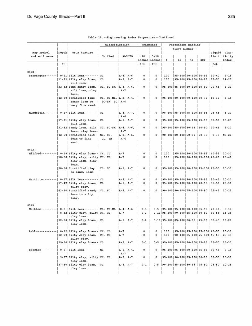
Du Page County, Illinois—Part II 225
Table 18.--Engineering Index Properties--Continued________________________________________________________________________________________________________________________ | | | Classification | Fragments | Percentage passing | | ___________________________________ | | | | | | | sieve number-- | | Map symbol |Depth| USDA texture | | | | |___________________________|Liquid| Plas- and soil name | | | Unified | AASHTO | >10 | 3-10 | | | | |limit |ticity | | | | |inches|inches| 4 | 10 | 40 | 200 | |index________________________________________________________________________________________________________________________ | In | | | | Pct | Pct | | | | | Pct | __ ___ ___ ___ | | | | | | | | | | | |848B: | | | | | | | | | | | | Barrington------| 0-11|Silt loam--------|CL |A-4, A-6 | 0 | 0 | 100 |95-100|90-100|80-95 |30-40 | 8-18 |11-32|Silty clay loam, |CL |A-6, A-7 | 0 | 0 | 100 |95-100|95-100|80-95 |35-50 |11-25 | | silt loam. | | | | | | | | | | |32-42|Fine sandy loam, |CL, SC-SM |A-4, A-6, | 0 | 0 |95-100|85-100|80-100|60-90 |20-45 | 8-20 | | silt loam, clay | | A-7 | | | | | | | | | | loam. | | | | | | | | | | |42-60|Stratified fine |CL, CL-ML,|A-2, A-4, | 0 | 0 |95-100|80-100|70-100|30-70 |15-30 | 5-15 | | sandy loam to | SC-SM, SC| A-6 | | | | | | | | | | very fine sand. | | | | | | | | | | | | | | | | | | | | | | Mundelein-------| 0-17|Silt loam--------|CL |A-4, A-7, | 0 | 0 |98-100|95-100|95-100|85-95 |25-45 | 5-20 | | | | A-6 | | | | | | | | |17-31|Silty clay loam, |CL |A-6, A-7 | 0 | 0 |95-100|95-100|95-100|75-95 |35-50 |15-25 | | silt loam. | | | | | | | | | | |31-42|Sandy loam, silt |CL, SC-SM |A-4, A-6, | 0 | 0 |95-100|85-100|80-95 |60-90 |20-45 | 8-20 | | loam, clay loam.| | A-7 | | | | | | | | |42-60|Stratified silt |ML, SC, |A-2, A-6, | 0 | 0 |90-100|80-100|60-90 |20-75 | 0-35 |NP-20 | | loam to fine | CL, SM | A-4 | | | | | | | | | | sand. | | | | | | | | | | | | | | | | | | | | | |849A: | | | | | | | | | | | | Milford---------| 0-18|Silty clay loam--|CH, CL |A-7 | 0 | 0 | 100 |95-100|90-100|75-95 |40-55 |20-30 |18-50|Silty clay, silty|CH, CL |A-7 | 0 | 0 | 100 |95-100|90-100|75-100|40-60 |20-40 | | clay loam, clay | | | | | | | | | | | | loam. | | | | | | | | | | |50-60|Stratified clay |CL, SC |A-6, A-7 | 0 | 0 |95-100|95-100|90-100|45-100|25-50 |10-30 | | to sandy loam. | | | | | | | | | | | | | | | | | | | | | | Martinton-------| 0-17|Silt loam--------|CL |A-6, A-7 | 0 | 0 |95-100|95-100|90-100|75-95 |30-45 |10-20 |17-42|Silty clay loam, |CL |A-6, A-7 | 0 | 0 |95-100|95-100|90-100|70-95 |35-50 |20-30 | | silty clay. | | | | | | | | | | |42-60|Stratified sandy |CL, SC |A-6, A-7 | 0 | 0 |90-100|80-100|75-100|35-90 |25-45 |10-25 | | loam to silty | | | | | | | | | | | | clay. | | | | | | | | | | | | | | | | | | | | | |854B: | | | | | | | | | | | | Markham---------| 0-8 |Silt loam--------|CL, CL-ML |A-4, A-6 | 0-1 | 0-5 |95-100|95-100|90-100|85-95 |23-40 | 6-17 | 8-32|Silty clay, silty|CH, CL |A-7 | 0-2 | 0-10|95-100|90-100|85-100|80-90 |40-54 |15-28 | | clay loam. | | | | | | | | | | |32-60|Silty clay loam, |CL |A-6, A-7 | 0-2 | 0-10|95-100|85-100|80-95 |75-90 |30-45 |13-26 | | clay loam. | | | | | | | | | | | | | | | | | | | | | | Ashkum----------| 0-12|Silty clay loam--|CH, CL |A-7 | 0 | 0 | 100 |95-100|95-100|75-100|40-55 |20-30 |12-29|Silty clay loam, |CH, CL |A-7 | 0 | 0 | 100 |90-100|85-100|75-100|45-65 |20-35 | | silty clay. | | | | | | | | | | |29-60|Silty clay loam--|CL |A-6, A-7 | 0-1 | 0-5 |95-100|85-100|80-100|75-95 |35-50 |15-30 | | | | | | | | | | | | Beecher---------| 0-9 |Silt loam--------|ML |A-6, A-4, | 0 | 0 |95-100|95-100|90-100|85-95 |30-45 | 7-15 | | | | A-7 | | | | | | | | | 9-37|Silty clay, silty|CH, CL |A-6, A-7 | 0 | 0 |95-100|90-100|85-100|80-95 |35-55 |15-30 | | clay loam. | | | | | | | | | | |37-60|Silty clay loam, |CL |A-6, A-7 | 0-1 | 0-5 |90-100|85-100|80-95 |75-90 |28-50 |10-25 | | clay loam. | | | | | | | | | | | | | | | | | | | | | |
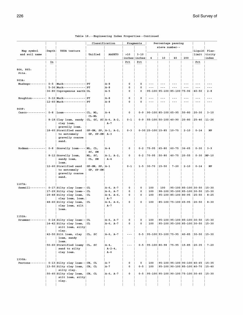
226 Soil Survey of
Table 18.--Engineering Index Properties--Continued________________________________________________________________________________________________________________________ | | | Classification | Fragments | Percentage passing | | ___________________________________ | | | | | | | sieve number-- | | Map symbol |Depth| USDA texture | | | | |___________________________|Liquid| Plas- and soil name | | | Unified | AASHTO | >10 | 3-10 | | | | |limit |ticity | | | | |inches|inches| 4 | 10 | 40 | 200 | |index________________________________________________________________________________________________________________________ | In | | | | Pct | Pct | | | | | Pct | __ ___ ___ ___ | | | | | | | | | | | |864, 865: | | | | | | | | | | | | Pits. | | | | | | | | | | | | | | | | | | | | | | | |903A: | | | | | | | | | | | | Muskego---------| 0-5 |Muck-------------|PT |A-8 | 0 | 0 | --- | --- | --- | --- | --- | --- | 5-36|Muck-------------|PT |A-8 | 0 | 0 | --- | --- | --- | --- | --- | --- |36-80|Coprogenous earth|OL |A-5 | 0 | 0 |95-100|95-100|85-100|75-96 |40-50 | 2-8 | | | | | | | | | | | | Houghton--------| 0-12|Muck-------------|PT |A-8 | 0 | 0 | --- | --- | --- | --- | --- | --- |12-60|Muck-------------|PT |A-8 | 0 | 0 | --- | --- | --- | --- | --- | --- | | | | | | | | | | | |969F: | | | | | | | | | | | | Casco-----------| 0-8 |Loam-------------|CL, ML, |A-4 | 0 | 0-9 |90-100|85-100|65-95 |50-80 |20-30 | 3-10 | | | CL-ML | | | | | | | | | | 8-18|Clay loam, sandy |CL, GC, SC|A-6, A-2, | 0-1 | 0-9 |55-100|50-100|40-90 |20-80 |25-46 |11-26 | | clay loam, | | A-7 | | | | | | | | | | gravelly loam. | | | | | | | | | | |18-60|Stratified sand |GP-GM, SP,|A-1, A-2, | 0-3 | 0-30|25-100|15-85 |10-75 | 2-10 | 0-14 | NP | | to extremely | GP, SP-SM| A-3 | | | | | | | | | | gravelly coarse | | | | | | | | | | | | sand. | | | | | | | | | | | | | | | | | | | | | | Rodman----------| 0-8 |Gravelly loam----|ML, CL, |A-4 | 0 | 0-2 |75-95 |65-80 |60-75 |36-65 | 0-30 | 3-9 | | | SC, SM | | | | | | | | | | 8-12|Gravelly loam, |ML, SC, |A-1, A-2, | 0 | 0-2 |70-95 |50-80 |40-75 |20-55 | 0-30 |NP-10 | | sandy loam, | CL, SM | A-4 | | | | | | | | | | loam. | | | | | | | | | | |12-60|Stratified sand |GP-GM, SP,|A-1 | 0-1 | 1-5 |30-70 |15-50 | 7-20 | 2-10 | 0-14 | NP | | to extremely | GP, SP-SM| | | | | | | | | | | gravelly coarse | | | | | | | | | | | | sand. | | | | | | | | | | | | | | | | | | | | | |1107A: | | | | | | | | | | | | Sawmill---------| 0-17|Silty clay loam--|CL |A-6, A-7 | 0 | 0 | 100 | 100 |95-100|85-100|30-50 |15-30 |17-29|Silty clay loam--|CL |A-6, A-7 | 0 | 0 | 100 |98-100|95-100|85-100|30-50 |15-30 |29-48|Silty clay loam, |CL |A-4, A-6, | 0 | 0 | 100 |95-100|85-100|80-95 |25-50 | 8-25 | | clay loam, loam.| | A-7 | | | | | | | | |48-60|Silty clay loam, |CL |A-4, A-6, | 0 | 0 | 100 |85-100|75-100|65-95 |20-50 | 8-30 | | clay loam, silt | | A-7 | | | | | | | | | | loam. | | | | | | | | | | | | | | | | | | | | | |1152A: | | | | | | | | | | | | Drummer---------| 0-14|Silty clay loam--|CL |A-6, A-7 | 0 | 0 | 100 |95-100|95-100|85-100|30-50 |15-30 |14-42|Silty clay loam, |CL |A-6, A-7 | 0 | 0 | 100 |95-100|95-100|85-100|30-50 |15-30 | | silt loam, silty| | | | | | | | | | | | clay. | | | | | | | | | | |42-50|Silt loam, clay |CL, SC |A-6, A-7 | --- | 0-5 |95-100|93-100|75-95 |40-85 |30-50 |15-30 | | loam, sandy | | | | | | | | | | | | loam. | | | | | | | | | | |50-60|Stratified loamy |CL, SC |A-4, | --- | 0-5 |95-100|80-98 |75-95 |15-85 |20-35 | 7-20 | | sand to silty | | A-2-4, | | | | | | | | | | clay loam. | | A-6 | | | | | | | | | | | | | | | | | | | |1330A: | | | | | | | | | | | | Peotone---------| 0-13|Silty clay loam--|CH, CL |A-7 | 0 | 0 | 100 |95-100|95-100|90-100|40-65 |15-35 |13-50|Silty clay loam, |CH, CL |A-7 | 0 | 0-5 | 100 |95-100|90-100|85-100|40-70 |15-40 | | silty clay. | | | | | | | | | | |50-60|Silty clay loam, |CH, CL |A-6, A-7 | 0 | 0-5 |95-100|95-100|90-100|75-100|30-60 |15-30 | | silt loam, silty| | | | | | | | | | | | clay. | | | | | | | | | | | | | | | | | | | | | |
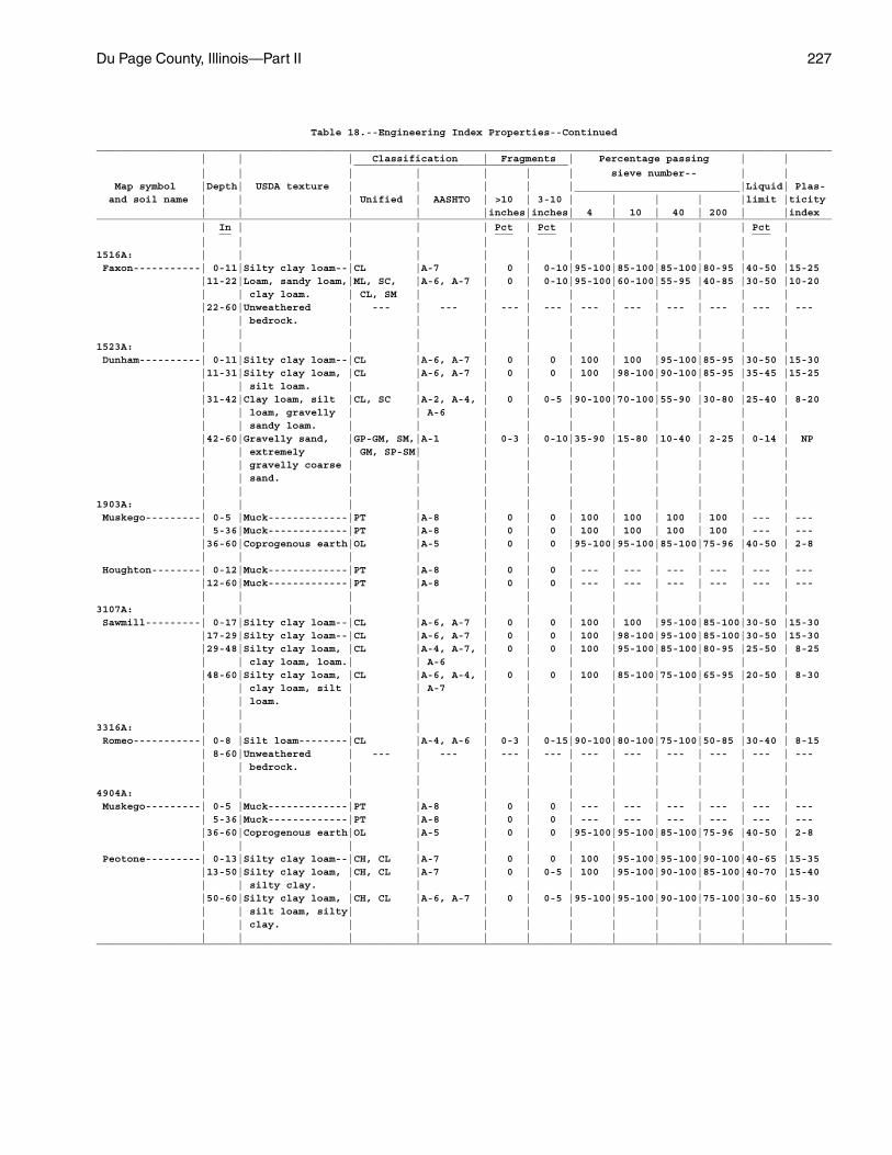
Du Page County, Illinois—Part II 227
Table 18.--Engineering Index Properties--Continued________________________________________________________________________________________________________________________ | | | Classification | Fragments | Percentage passing | | ___________________________________ | | | | | | | sieve number-- | | Map symbol |Depth| USDA texture | | | | |___________________________|Liquid| Plas- and soil name | | | Unified | AASHTO | >10 | 3-10 | | | | |limit |ticity | | | | |inches|inches| 4 | 10 | 40 | 200 | |index________________________________________________________________________________________________________________________ | In | | | | Pct | Pct | | | | | Pct | __ ___ ___ ___ | | | | | | | | | | | |1516A: | | | | | | | | | | | | Faxon-----------| 0-11|Silty clay loam--|CL |A-7 | 0 | 0-10|95-100|85-100|85-100|80-95 |40-50 |15-25 |11-22|Loam, sandy loam,|ML, SC, |A-6, A-7 | 0 | 0-10|95-100|60-100|55-95 |40-85 |30-50 |10-20 | | clay loam. | CL, SM | | | | | | | | | |22-60|Unweathered | --- | --- | --- | --- | --- | --- | --- | --- | --- | --- | | bedrock. | | | | | | | | | | | | | | | | | | | | | |1523A: | | | | | | | | | | | | Dunham----------| 0-11|Silty clay loam--|CL |A-6, A-7 | 0 | 0 | 100 | 100 |95-100|85-95 |30-50 |15-30 |11-31|Silty clay loam, |CL |A-6, A-7 | 0 | 0 | 100 |98-100|90-100|85-95 |35-45 |15-25 | | silt loam. | | | | | | | | | | |31-42|Clay loam, silt |CL, SC |A-2, A-4, | 0 | 0-5 |90-100|70-100|55-90 |30-80 |25-40 | 8-20 | | loam, gravelly | | A-6 | | | | | | | | | | sandy loam. | | | | | | | | | | |42-60|Gravelly sand, |GP-GM, SM,|A-1 | 0-3 | 0-10|35-90 |15-80 |10-40 | 2-25 | 0-14 | NP | | extremely | GM, SP-SM| | | | | | | | | | | gravelly coarse | | | | | | | | | | | | sand. | | | | | | | | | | | | | | | | | | | | | |1903A: | | | | | | | | | | | | Muskego---------| 0-5 |Muck-------------|PT |A-8 | 0 | 0 | 100 | 100 | 100 | 100 | --- | --- | 5-36|Muck-------------|PT |A-8 | 0 | 0 | 100 | 100 | 100 | 100 | --- | --- |36-60|Coprogenous earth|OL |A-5 | 0 | 0 |95-100|95-100|85-100|75-96 |40-50 | 2-8 | | | | | | | | | | | | Houghton--------| 0-12|Muck-------------|PT |A-8 | 0 | 0 | --- | --- | --- | --- | --- | --- |12-60|Muck-------------|PT |A-8 | 0 | 0 | --- | --- | --- | --- | --- | --- | | | | | | | | | | | |3107A: | | | | | | | | | | | | Sawmill---------| 0-17|Silty clay loam--|CL |A-6, A-7 | 0 | 0 | 100 | 100 |95-100|85-100|30-50 |15-30 |17-29|Silty clay loam--|CL |A-6, A-7 | 0 | 0 | 100 |98-100|95-100|85-100|30-50 |15-30 |29-48|Silty clay loam, |CL |A-4, A-7, | 0 | 0 | 100 |95-100|85-100|80-95 |25-50 | 8-25 | | clay loam, loam.| | A-6 | | | | | | | | |48-60|Silty clay loam, |CL |A-6, A-4, | 0 | 0 | 100 |85-100|75-100|65-95 |20-50 | 8-30 | | clay loam, silt | | A-7 | | | | | | | | | | loam. | | | | | | | | | | | | | | | | | | | | | |3316A: | | | | | | | | | | | | Romeo-----------| 0-8 |Silt loam--------|CL |A-4, A-6 | 0-3 | 0-15|90-100|80-100|75-100|50-85 |30-40 | 8-15 | 8-60|Unweathered | --- | --- | --- | --- | --- | --- | --- | --- | --- | --- | | bedrock. | | | | | | | | | | | | | | | | | | | | | |4904A: | | | | | | | | | | | | Muskego---------| 0-5 |Muck-------------|PT |A-8 | 0 | 0 | --- | --- | --- | --- | --- | --- | 5-36|Muck-------------|PT |A-8 | 0 | 0 | --- | --- | --- | --- | --- | --- |36-60|Coprogenous earth|OL |A-5 | 0 | 0 |95-100|95-100|85-100|75-96 |40-50 | 2-8 | | | | | | | | | | | | Peotone---------| 0-13|Silty clay loam--|CH, CL |A-7 | 0 | 0 | 100 |95-100|95-100|90-100|40-65 |15-35 |13-50|Silty clay loam, |CH, CL |A-7 | 0 | 0-5 | 100 |95-100|90-100|85-100|40-70 |15-40 | | silty clay. | | | | | | | | | | |50-60|Silty clay loam, |CH, CL |A-6, A-7 | 0 | 0-5 |95-100|95-100|90-100|75-100|30-60 |15-30 | | silt loam, silty| | | | | | | | | | | | clay. | | | | | | | | | | | | | | | | | | | | | |________________________________________________________________________________________________________________________
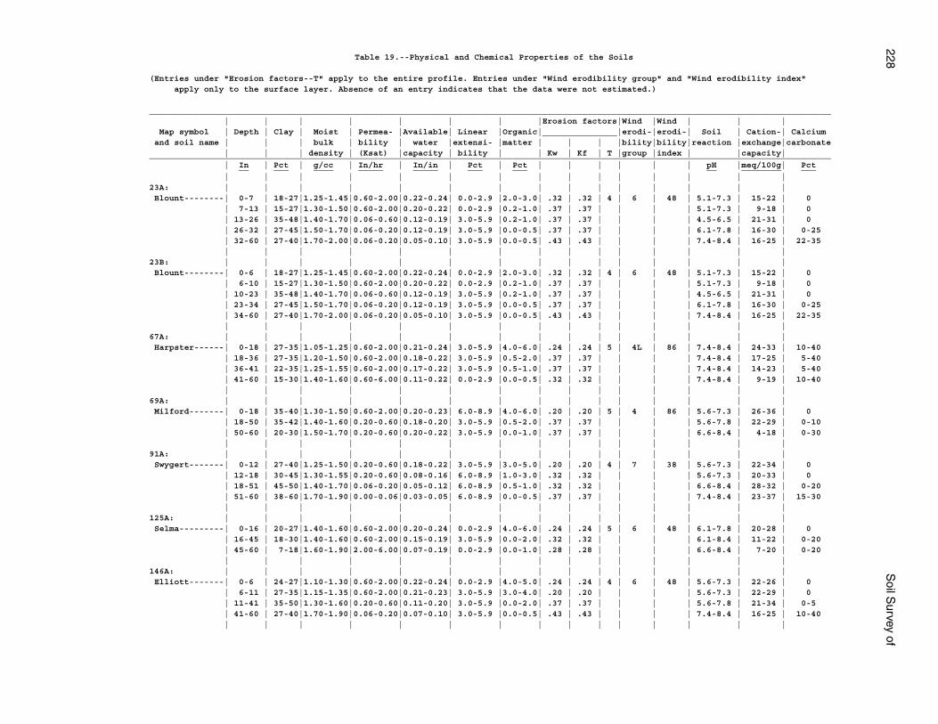
228S
oil Survey of
Table 19.--Physical and Chemical Properties of the Soils
(Entries under "Erosion factors--T" apply to the entire profile. Entries under "Wind erodibility group" and "Wind erodibility index" apply only to the surface layer. Absence of an entry indicates that the data were not estimated.)
_________________________________________________________________________________________________________________________________________ | | | | | | | |Erosion factors|Wind |Wind | | | Map symbol | Depth | Clay | Moist | Permea- |Available| Linear |Organic|_______________|erodi-|erodi-| Soil | Cation-| Calcium and soil name | | | bulk | bility | water |extensi- |matter | | | |bility|bility|reaction |exchange|carbonate | | | density | (Ksat) |capacity | bility | | Kw | Kf | T |group |index | |capacity|_________________________________________________________________________________________________________________________________________ | In | Pct | g/cc | In/hr | In/in | Pct | Pct | | | | | | pH |meq/100g| Pct __ ___ ____ _____ _____ ___ ___ __ ________ ___ | | | | | | | | | | | | | | |23A: | | | | | | | | | | | | | | | Blount--------| 0-7 | 18-27|1.25-1.45|0.60-2.00|0.22-0.24| 0.0-2.9 |2.0-3.0| .32 | .32 | 4 | 6 | 48 | 5.1-7.3 | 15-22 | 0 | 7-13 | 15-27|1.30-1.50|0.60-2.00|0.20-0.22| 0.0-2.9 |0.2-1.0| .37 | .37 | | | | 5.1-7.3 | 9-18 | 0 | 13-26 | 35-48|1.40-1.70|0.06-0.60|0.12-0.19| 3.0-5.9 |0.2-1.0| .37 | .37 | | | | 4.5-6.5 | 21-31 | 0 | 26-32 | 27-45|1.50-1.70|0.06-0.20|0.12-0.19| 3.0-5.9 |0.0-0.5| .37 | .37 | | | | 6.1-7.8 | 16-30 | 0-25 | 32-60 | 27-40|1.70-2.00|0.06-0.20|0.05-0.10| 3.0-5.9 |0.0-0.5| .43 | .43 | | | | 7.4-8.4 | 16-25 | 22-35 | | | | | | | | | | | | | | |23B: | | | | | | | | | | | | | | | Blount--------| 0-6 | 18-27|1.25-1.45|0.60-2.00|0.22-0.24| 0.0-2.9 |2.0-3.0| .32 | .32 | 4 | 6 | 48 | 5.1-7.3 | 15-22 | 0 | 6-10 | 15-27|1.30-1.50|0.60-2.00|0.20-0.22| 0.0-2.9 |0.2-1.0| .37 | .37 | | | | 5.1-7.3 | 9-18 | 0 | 10-23 | 35-48|1.40-1.70|0.06-0.60|0.12-0.19| 3.0-5.9 |0.2-1.0| .37 | .37 | | | | 4.5-6.5 | 21-31 | 0 | 23-34 | 27-45|1.50-1.70|0.06-0.20|0.12-0.19| 3.0-5.9 |0.0-0.5| .37 | .37 | | | | 6.1-7.8 | 16-30 | 0-25 | 34-60 | 27-40|1.70-2.00|0.06-0.20|0.05-0.10| 3.0-5.9 |0.0-0.5| .43 | .43 | | | | 7.4-8.4 | 16-25 | 22-35 | | | | | | | | | | | | | | |67A: | | | | | | | | | | | | | | | Harpster------| 0-18 | 27-35|1.05-1.25|0.60-2.00|0.21-0.24| 3.0-5.9 |4.0-6.0| .24 | .24 | 5 | 4L | 86 | 7.4-8.4 | 24-33 | 10-40 | 18-36 | 27-35|1.20-1.50|0.60-2.00|0.18-0.22| 3.0-5.9 |0.5-2.0| .37 | .37 | | | | 7.4-8.4 | 17-25 | 5-40 | 36-41 | 22-35|1.25-1.55|0.60-2.00|0.17-0.22| 3.0-5.9 |0.5-1.0| .37 | .37 | | | | 7.4-8.4 | 14-23 | 5-40 | 41-60 | 15-30|1.40-1.60|0.60-6.00|0.11-0.22| 0.0-2.9 |0.0-0.5| .32 | .32 | | | | 7.4-8.4 | 9-19 | 10-40 | | | | | | | | | | | | | | |69A: | | | | | | | | | | | | | | | Milford-------| 0-18 | 35-40|1.30-1.50|0.60-2.00|0.20-0.23| 6.0-8.9 |4.0-6.0| .20 | .20 | 5 | 4 | 86 | 5.6-7.3 | 26-36 | 0 | 18-50 | 35-42|1.40-1.60|0.20-0.60|0.18-0.20| 3.0-5.9 |0.5-2.0| .37 | .37 | | | | 5.6-7.8 | 22-29 | 0-10 | 50-60 | 20-30|1.50-1.70|0.20-0.60|0.20-0.22| 3.0-5.9 |0.0-1.0| .37 | .37 | | | | 6.6-8.4 | 4-18 | 0-30 | | | | | | | | | | | | | | |91A: | | | | | | | | | | | | | | | Swygert-------| 0-12 | 27-40|1.25-1.50|0.20-0.60|0.18-0.22| 3.0-5.9 |3.0-5.0| .20 | .20 | 4 | 7 | 38 | 5.6-7.3 | 22-34 | 0 | 12-18 | 30-45|1.30-1.55|0.20-0.60|0.08-0.16| 6.0-8.9 |1.0-3.0| .32 | .32 | | | | 5.6-7.3 | 20-33 | 0 | 18-51 | 45-50|1.40-1.70|0.06-0.20|0.05-0.12| 6.0-8.9 |0.5-1.0| .32 | .32 | | | | 6.6-8.4 | 28-32 | 0-20 | 51-60 | 38-60|1.70-1.90|0.00-0.06|0.03-0.05| 6.0-8.9 |0.0-0.5| .37 | .37 | | | | 7.4-8.4 | 23-37 | 15-30 | | | | | | | | | | | | | | |125A: | | | | | | | | | | | | | | | Selma---------| 0-16 | 20-27|1.40-1.60|0.60-2.00|0.20-0.24| 0.0-2.9 |4.0-6.0| .24 | .24 | 5 | 6 | 48 | 6.1-7.8 | 20-28 | 0 | 16-45 | 18-30|1.40-1.60|0.60-2.00|0.15-0.19| 3.0-5.9 |0.0-2.0| .32 | .32 | | | | 6.1-8.4 | 11-22 | 0-20 | 45-60 | 7-18|1.60-1.90|2.00-6.00|0.07-0.19| 0.0-2.9 |0.0-1.0| .28 | .28 | | | | 6.6-8.4 | 7-20 | 0-20 | | | | | | | | | | | | | | |146A: | | | | | | | | | | | | | | | Elliott-------| 0-6 | 24-27|1.10-1.30|0.60-2.00|0.22-0.24| 0.0-2.9 |4.0-5.0| .24 | .24 | 4 | 6 | 48 | 5.6-7.3 | 22-26 | 0 | 6-11 | 27-35|1.15-1.35|0.60-2.00|0.21-0.23| 3.0-5.9 |3.0-4.0| .20 | .20 | | | | 5.6-7.3 | 22-29 | 0 | 11-41 | 35-50|1.30-1.60|0.20-0.60|0.11-0.20| 3.0-5.9 |0.0-2.0| .37 | .37 | | | | 5.6-7.8 | 21-34 | 0-5 | 41-60 | 27-40|1.70-1.90|0.06-0.20|0.07-0.10| 3.0-5.9 |0.0-0.5| .43 | .43 | | | | 7.4-8.4 | 16-25 | 10-40 | | | | | | | | | | | | | | |
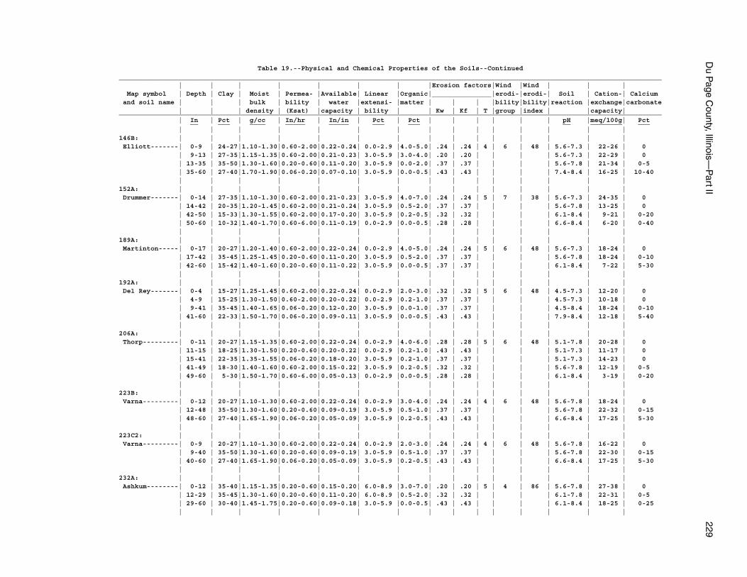
Du P
age County, Illinois—
Part II
229
Table 19.--Physical and Chemical Properties of the Soils--Continued_________________________________________________________________________________________________________________________________________ | | | | | | | |Erosion factors|Wind |Wind | | | Map symbol | Depth | Clay | Moist | Permea- |Available| Linear |Organic|_______________|erodi-|erodi-| Soil | Cation-| Calcium and soil name | | | bulk | bility | water |extensi- |matter | | | |bility|bility|reaction |exchange|carbonate | | | density | (Ksat) |capacity | bility | | Kw | Kf | T |group |index | |capacity|_________________________________________________________________________________________________________________________________________ | In | Pct | g/cc | In/hr | In/in | Pct | Pct | | | | | | pH |meq/100g| Pct __ ___ ____ _____ _____ ___ ___ __ ________ ___ | | | | | | | | | | | | | | |146B: | | | | | | | | | | | | | | | Elliott-------| 0-9 | 24-27|1.10-1.30|0.60-2.00|0.22-0.24| 0.0-2.9 |4.0-5.0| .24 | .24 | 4 | 6 | 48 | 5.6-7.3 | 22-26 | 0 | 9-13 | 27-35|1.15-1.35|0.60-2.00|0.21-0.23| 3.0-5.9 |3.0-4.0| .20 | .20 | | | | 5.6-7.3 | 22-29 | 0 | 13-35 | 35-50|1.30-1.60|0.20-0.60|0.11-0.20| 3.0-5.9 |0.0-2.0| .37 | .37 | | | | 5.6-7.8 | 21-34 | 0-5 | 35-60 | 27-40|1.70-1.90|0.06-0.20|0.07-0.10| 3.0-5.9 |0.0-0.5| .43 | .43 | | | | 7.4-8.4 | 16-25 | 10-40 | | | | | | | | | | | | | | |152A: | | | | | | | | | | | | | | | Drummer-------| 0-14 | 27-35|1.10-1.30|0.60-2.00|0.21-0.23| 3.0-5.9 |4.0-7.0| .24 | .24 | 5 | 7 | 38 | 5.6-7.3 | 24-35 | 0 | 14-42 | 20-35|1.20-1.45|0.60-2.00|0.21-0.24| 3.0-5.9 |0.5-2.0| .37 | .37 | | | | 5.6-7.8 | 13-25 | 0 | 42-50 | 15-33|1.30-1.55|0.60-2.00|0.17-0.20| 3.0-5.9 |0.2-0.5| .32 | .32 | | | | 6.1-8.4 | 9-21 | 0-20 | 50-60 | 10-32|1.40-1.70|0.60-6.00|0.11-0.19| 0.0-2.9 |0.0-0.5| .28 | .28 | | | | 6.6-8.4 | 6-20 | 0-40 | | | | | | | | | | | | | | |189A: | | | | | | | | | | | | | | | Martinton-----| 0-17 | 20-27|1.20-1.40|0.60-2.00|0.22-0.24| 0.0-2.9 |4.0-5.0| .24 | .24 | 5 | 6 | 48 | 5.6-7.3 | 18-24 | 0 | 17-42 | 35-45|1.25-1.45|0.20-0.60|0.11-0.20| 3.0-5.9 |0.5-2.0| .37 | .37 | | | | 5.6-7.8 | 18-24 | 0-10 | 42-60 | 15-42|1.40-1.60|0.20-0.60|0.11-0.22| 3.0-5.9 |0.0-0.5| .37 | .37 | | | | 6.1-8.4 | 7-22 | 5-30 | | | | | | | | | | | | | | |192A: | | | | | | | | | | | | | | | Del Rey-------| 0-4 | 15-27|1.25-1.45|0.60-2.00|0.22-0.24| 0.0-2.9 |2.0-3.0| .32 | .32 | 5 | 6 | 48 | 4.5-7.3 | 12-20 | 0 | 4-9 | 15-25|1.30-1.50|0.60-2.00|0.20-0.22| 0.0-2.9 |0.2-1.0| .37 | .37 | | | | 4.5-7.3 | 10-18 | 0 | 9-41 | 35-45|1.40-1.65|0.06-0.20|0.12-0.20| 3.0-5.9 |0.0-1.0| .37 | .37 | | | | 4.5-8.4 | 18-24 | 0-10 | 41-60 | 22-33|1.50-1.70|0.06-0.20|0.09-0.11| 3.0-5.9 |0.0-0.5| .43 | .43 | | | | 7.9-8.4 | 12-18 | 5-40 | | | | | | | | | | | | | | |206A: | | | | | | | | | | | | | | | Thorp---------| 0-11 | 20-27|1.15-1.35|0.60-2.00|0.22-0.24| 0.0-2.9 |4.0-6.0| .28 | .28 | 5 | 6 | 48 | 5.1-7.8 | 20-28 | 0 | 11-15 | 18-25|1.30-1.50|0.20-0.60|0.20-0.22| 0.0-2.9 |0.2-1.0| .43 | .43 | | | | 5.1-7.3 | 11-17 | 0 | 15-41 | 22-35|1.35-1.55|0.06-0.20|0.18-0.20| 3.0-5.9 |0.2-1.0| .37 | .37 | | | | 5.1-7.3 | 14-23 | 0 | 41-49 | 18-30|1.40-1.60|0.60-2.00|0.15-0.22| 3.0-5.9 |0.2-0.5| .32 | .32 | | | | 5.6-7.8 | 12-19 | 0-5 | 49-60 | 5-30|1.50-1.70|0.60-6.00|0.05-0.13| 0.0-2.9 |0.0-0.5| .28 | .28 | | | | 6.1-8.4 | 3-19 | 0-20 | | | | | | | | | | | | | | |223B: | | | | | | | | | | | | | | | Varna---------| 0-12 | 20-27|1.10-1.30|0.60-2.00|0.22-0.24| 0.0-2.9 |3.0-4.0| .24 | .24 | 4 | 6 | 48 | 5.6-7.8 | 18-24 | 0 | 12-48 | 35-50|1.30-1.60|0.20-0.60|0.09-0.19| 3.0-5.9 |0.5-1.0| .37 | .37 | | | | 5.6-7.8 | 22-32 | 0-15 | 48-60 | 27-40|1.65-1.90|0.06-0.20|0.05-0.09| 3.0-5.9 |0.2-0.5| .43 | .43 | | | | 6.6-8.4 | 17-25 | 5-30 | | | | | | | | | | | | | | |223C2: | | | | | | | | | | | | | | | Varna---------| 0-9 | 20-27|1.10-1.30|0.60-2.00|0.22-0.24| 0.0-2.9 |2.0-3.0| .24 | .24 | 4 | 6 | 48 | 5.6-7.8 | 16-22 | 0 | 9-40 | 35-50|1.30-1.60|0.20-0.60|0.09-0.19| 3.0-5.9 |0.5-1.0| .37 | .37 | | | | 5.6-7.8 | 22-30 | 0-15 | 40-60 | 27-40|1.65-1.90|0.06-0.20|0.05-0.09| 3.0-5.9 |0.2-0.5| .43 | .43 | | | | 6.6-8.4 | 17-25 | 5-30 | | | | | | | | | | | | | | |232A: | | | | | | | | | | | | | | | Ashkum--------| 0-12 | 35-40|1.15-1.35|0.20-0.60|0.15-0.20| 6.0-8.9 |3.0-7.0| .20 | .20 | 5 | 4 | 86 | 5.6-7.8 | 27-38 | 0 | 12-29 | 35-45|1.30-1.60|0.20-0.60|0.11-0.20| 6.0-8.9 |0.5-2.0| .32 | .32 | | | | 6.1-7.8 | 22-31 | 0-5 | 29-60 | 30-40|1.45-1.75|0.20-0.60|0.09-0.18| 3.0-5.9 |0.0-0.5| .43 | .43 | | | | 6.1-8.4 | 18-25 | 0-25 | | | | | | | | | | | | | | |
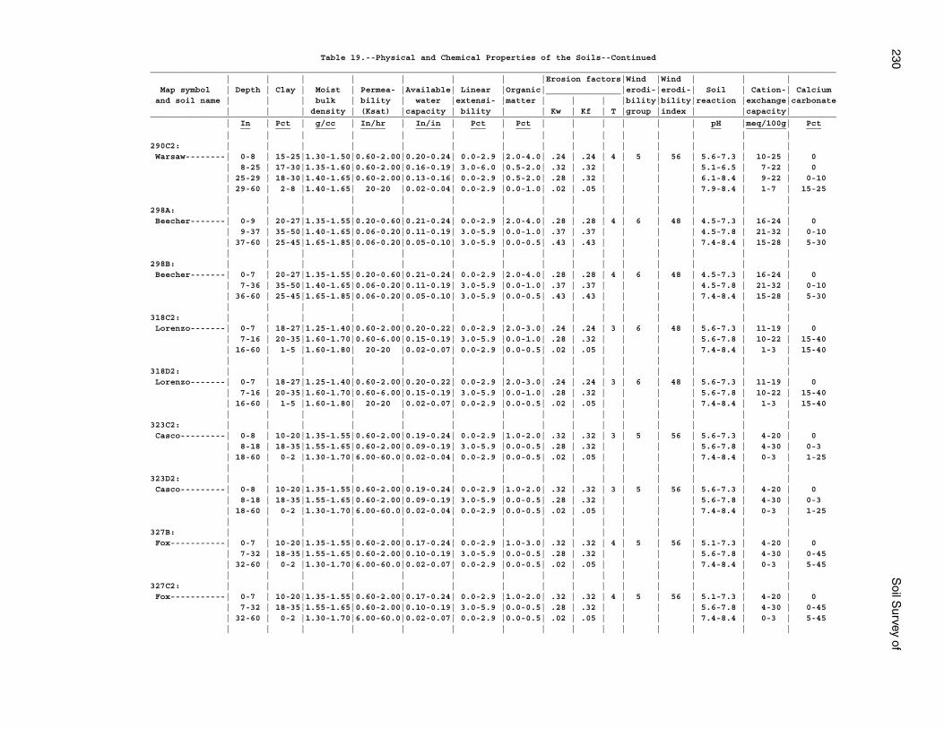
230S
oil Survey of
Table 19.--Physical and Chemical Properties of the Soils--Continued_________________________________________________________________________________________________________________________________________ | | | | | | | |Erosion factors|Wind |Wind | | | Map symbol | Depth | Clay | Moist | Permea- |Available| Linear |Organic|_______________|erodi-|erodi-| Soil | Cation-| Calcium and soil name | | | bulk | bility | water |extensi- |matter | | | |bility|bility|reaction |exchange|carbonate | | | density | (Ksat) |capacity | bility | | Kw | Kf | T |group |index | |capacity|_________________________________________________________________________________________________________________________________________ | In | Pct | g/cc | In/hr | In/in | Pct | Pct | | | | | | pH |meq/100g| Pct __ ___ ____ _____ _____ ___ ___ __ ________ ___ | | | | | | | | | | | | | | |290C2: | | | | | | | | | | | | | | | Warsaw--------| 0-8 | 15-25|1.30-1.50|0.60-2.00|0.20-0.24| 0.0-2.9 |2.0-4.0| .24 | .24 | 4 | 5 | 56 | 5.6-7.3 | 10-25 | 0 | 8-25 | 17-30|1.35-1.60|0.60-2.00|0.16-0.19| 3.0-6.0 |0.5-2.0| .32 | .32 | | | | 5.1-6.5 | 7-22 | 0 | 25-29 | 18-30|1.40-1.65|0.60-2.00|0.13-0.16| 0.0-2.9 |0.5-2.0| .28 | .32 | | | | 6.1-8.4 | 9-22 | 0-10 | 29-60 | 2-8 |1.40-1.65| 20-20 |0.02-0.04| 0.0-2.9 |0.0-1.0| .02 | .05 | | | | 7.9-8.4 | 1-7 | 15-25 | | | | | | | | | | | | | | |298A: | | | | | | | | | | | | | | | Beecher-------| 0-9 | 20-27|1.35-1.55|0.20-0.60|0.21-0.24| 0.0-2.9 |2.0-4.0| .28 | .28 | 4 | 6 | 48 | 4.5-7.3 | 16-24 | 0 | 9-37 | 35-50|1.40-1.65|0.06-0.20|0.11-0.19| 3.0-5.9 |0.0-1.0| .37 | .37 | | | | 4.5-7.8 | 21-32 | 0-10 | 37-60 | 25-45|1.65-1.85|0.06-0.20|0.05-0.10| 3.0-5.9 |0.0-0.5| .43 | .43 | | | | 7.4-8.4 | 15-28 | 5-30 | | | | | | | | | | | | | | |298B: | | | | | | | | | | | | | | | Beecher-------| 0-7 | 20-27|1.35-1.55|0.20-0.60|0.21-0.24| 0.0-2.9 |2.0-4.0| .28 | .28 | 4 | 6 | 48 | 4.5-7.3 | 16-24 | 0 | 7-36 | 35-50|1.40-1.65|0.06-0.20|0.11-0.19| 3.0-5.9 |0.0-1.0| .37 | .37 | | | | 4.5-7.8 | 21-32 | 0-10 | 36-60 | 25-45|1.65-1.85|0.06-0.20|0.05-0.10| 3.0-5.9 |0.0-0.5| .43 | .43 | | | | 7.4-8.4 | 15-28 | 5-30 | | | | | | | | | | | | | | |318C2: | | | | | | | | | | | | | | | Lorenzo-------| 0-7 | 18-27|1.25-1.40|0.60-2.00|0.20-0.22| 0.0-2.9 |2.0-3.0| .24 | .24 | 3 | 6 | 48 | 5.6-7.3 | 11-19 | 0 | 7-16 | 20-35|1.60-1.70|0.60-6.00|0.15-0.19| 3.0-5.9 |0.0-1.0| .28 | .32 | | | | 5.6-7.8 | 10-22 | 15-40 | 16-60 | 1-5 |1.60-1.80| 20-20 |0.02-0.07| 0.0-2.9 |0.0-0.5| .02 | .05 | | | | 7.4-8.4 | 1-3 | 15-40 | | | | | | | | | | | | | | |318D2: | | | | | | | | | | | | | | | Lorenzo-------| 0-7 | 18-27|1.25-1.40|0.60-2.00|0.20-0.22| 0.0-2.9 |2.0-3.0| .24 | .24 | 3 | 6 | 48 | 5.6-7.3 | 11-19 | 0 | 7-16 | 20-35|1.60-1.70|0.60-6.00|0.15-0.19| 3.0-5.9 |0.0-1.0| .28 | .32 | | | | 5.6-7.8 | 10-22 | 15-40 | 16-60 | 1-5 |1.60-1.80| 20-20 |0.02-0.07| 0.0-2.9 |0.0-0.5| .02 | .05 | | | | 7.4-8.4 | 1-3 | 15-40 | | | | | | | | | | | | | | |323C2: | | | | | | | | | | | | | | | Casco---------| 0-8 | 10-20|1.35-1.55|0.60-2.00|0.19-0.24| 0.0-2.9 |1.0-2.0| .32 | .32 | 3 | 5 | 56 | 5.6-7.3 | 4-20 | 0 | 8-18 | 18-35|1.55-1.65|0.60-2.00|0.09-0.19| 3.0-5.9 |0.0-0.5| .28 | .32 | | | | 5.6-7.8 | 4-30 | 0-3 | 18-60 | 0-2 |1.30-1.70|6.00-60.0|0.02-0.04| 0.0-2.9 |0.0-0.5| .02 | .05 | | | | 7.4-8.4 | 0-3 | 1-25 | | | | | | | | | | | | | | |323D2: | | | | | | | | | | | | | | | Casco---------| 0-8 | 10-20|1.35-1.55|0.60-2.00|0.19-0.24| 0.0-2.9 |1.0-2.0| .32 | .32 | 3 | 5 | 56 | 5.6-7.3 | 4-20 | 0 | 8-18 | 18-35|1.55-1.65|0.60-2.00|0.09-0.19| 3.0-5.9 |0.0-0.5| .28 | .32 | | | | 5.6-7.8 | 4-30 | 0-3 | 18-60 | 0-2 |1.30-1.70|6.00-60.0|0.02-0.04| 0.0-2.9 |0.0-0.5| .02 | .05 | | | | 7.4-8.4 | 0-3 | 1-25 | | | | | | | | | | | | | | |327B: | | | | | | | | | | | | | | | Fox-----------| 0-7 | 10-20|1.35-1.55|0.60-2.00|0.17-0.24| 0.0-2.9 |1.0-3.0| .32 | .32 | 4 | 5 | 56 | 5.1-7.3 | 4-20 | 0 | 7-32 | 18-35|1.55-1.65|0.60-2.00|0.10-0.19| 3.0-5.9 |0.0-0.5| .28 | .32 | | | | 5.6-7.8 | 4-30 | 0-45 | 32-60 | 0-2 |1.30-1.70|6.00-60.0|0.02-0.07| 0.0-2.9 |0.0-0.5| .02 | .05 | | | | 7.4-8.4 | 0-3 | 5-45 | | | | | | | | | | | | | | |327C2: | | | | | | | | | | | | | | | Fox-----------| 0-7 | 10-20|1.35-1.55|0.60-2.00|0.17-0.24| 0.0-2.9 |1.0-2.0| .32 | .32 | 4 | 5 | 56 | 5.1-7.3 | 4-20 | 0 | 7-32 | 18-35|1.55-1.65|0.60-2.00|0.10-0.19| 3.0-5.9 |0.0-0.5| .28 | .32 | | | | 5.6-7.8 | 4-30 | 0-45 | 32-60 | 0-2 |1.30-1.70|6.00-60.0|0.02-0.07| 0.0-2.9 |0.0-0.5| .02 | .05 | | | | 7.4-8.4 | 0-3 | 5-45 | | | | | | | | | | | | | | |
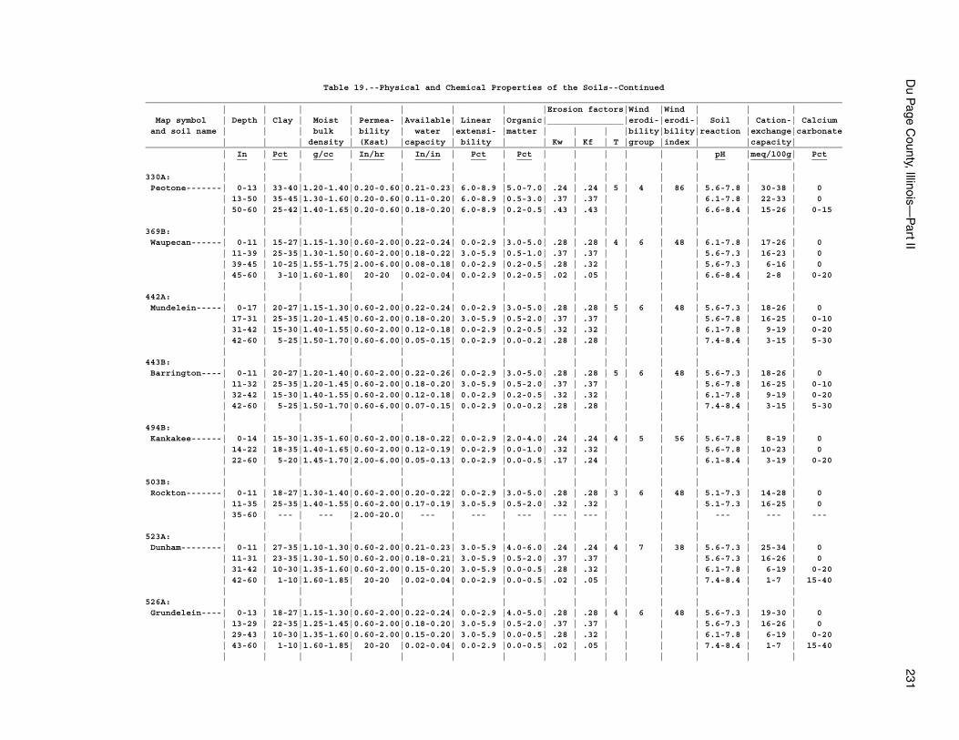
Du P
age County, Illinois—
Part II
231
Table 19.--Physical and Chemical Properties of the Soils--Continued_________________________________________________________________________________________________________________________________________ | | | | | | | |Erosion factors|Wind |Wind | | | Map symbol | Depth | Clay | Moist | Permea- |Available| Linear |Organic|_______________|erodi-|erodi-| Soil | Cation-| Calcium and soil name | | | bulk | bility | water |extensi- |matter | | | |bility|bility|reaction |exchange|carbonate | | | density | (Ksat) |capacity | bility | | Kw | Kf | T |group |index | |capacity|_________________________________________________________________________________________________________________________________________ | In | Pct | g/cc | In/hr | In/in | Pct | Pct | | | | | | pH |meq/100g| Pct __ ___ ____ _____ _____ ___ ___ __ ________ ___ | | | | | | | | | | | | | | |330A: | | | | | | | | | | | | | | | Peotone-------| 0-13 | 33-40|1.20-1.40|0.20-0.60|0.21-0.23| 6.0-8.9 |5.0-7.0| .24 | .24 | 5 | 4 | 86 | 5.6-7.8 | 30-38 | 0 | 13-50 | 35-45|1.30-1.60|0.20-0.60|0.11-0.20| 6.0-8.9 |0.5-3.0| .37 | .37 | | | | 6.1-7.8 | 22-33 | 0 | 50-60 | 25-42|1.40-1.65|0.20-0.60|0.18-0.20| 6.0-8.9 |0.2-0.5| .43 | .43 | | | | 6.6-8.4 | 15-26 | 0-15 | | | | | | | | | | | | | | |369B: | | | | | | | | | | | | | | | Waupecan------| 0-11 | 15-27|1.15-1.30|0.60-2.00|0.22-0.24| 0.0-2.9 |3.0-5.0| .28 | .28 | 4 | 6 | 48 | 6.1-7.8 | 17-26 | 0 | 11-39 | 25-35|1.30-1.50|0.60-2.00|0.18-0.22| 3.0-5.9 |0.5-1.0| .37 | .37 | | | | 5.6-7.3 | 16-23 | 0 | 39-45 | 10-25|1.55-1.75|2.00-6.00|0.08-0.18| 0.0-2.9 |0.2-0.5| .28 | .32 | | | | 5.6-7.3 | 6-16 | 0 | 45-60 | 3-10|1.60-1.80| 20-20 |0.02-0.04| 0.0-2.9 |0.2-0.5| .02 | .05 | | | | 6.6-8.4 | 2-8 | 0-20 | | | | | | | | | | | | | | |442A: | | | | | | | | | | | | | | | Mundelein-----| 0-17 | 20-27|1.15-1.30|0.60-2.00|0.22-0.24| 0.0-2.9 |3.0-5.0| .28 | .28 | 5 | 6 | 48 | 5.6-7.3 | 18-26 | 0 | 17-31 | 25-35|1.20-1.45|0.60-2.00|0.18-0.20| 3.0-5.9 |0.5-2.0| .37 | .37 | | | | 5.6-7.8 | 16-25 | 0-10 | 31-42 | 15-30|1.40-1.55|0.60-2.00|0.12-0.18| 0.0-2.9 |0.2-0.5| .32 | .32 | | | | 6.1-7.8 | 9-19 | 0-20 | 42-60 | 5-25|1.50-1.70|0.60-6.00|0.05-0.15| 0.0-2.9 |0.0-0.2| .28 | .28 | | | | 7.4-8.4 | 3-15 | 5-30 | | | | | | | | | | | | | | |443B: | | | | | | | | | | | | | | | Barrington----| 0-11 | 20-27|1.20-1.40|0.60-2.00|0.22-0.26| 0.0-2.9 |3.0-5.0| .28 | .28 | 5 | 6 | 48 | 5.6-7.3 | 18-26 | 0 | 11-32 | 25-35|1.20-1.45|0.60-2.00|0.18-0.20| 3.0-5.9 |0.5-2.0| .37 | .37 | | | | 5.6-7.8 | 16-25 | 0-10 | 32-42 | 15-30|1.40-1.55|0.60-2.00|0.12-0.18| 0.0-2.9 |0.2-0.5| .32 | .32 | | | | 6.1-7.8 | 9-19 | 0-20 | 42-60 | 5-25|1.50-1.70|0.60-6.00|0.07-0.15| 0.0-2.9 |0.0-0.2| .28 | .28 | | | | 7.4-8.4 | 3-15 | 5-30 | | | | | | | | | | | | | | |494B: | | | | | | | | | | | | | | | Kankakee------| 0-14 | 15-30|1.35-1.60|0.60-2.00|0.18-0.22| 0.0-2.9 |2.0-4.0| .24 | .24 | 4 | 5 | 56 | 5.6-7.8 | 8-19 | 0 | 14-22 | 18-35|1.40-1.65|0.60-2.00|0.12-0.19| 0.0-2.9 |0.0-1.0| .32 | .32 | | | | 5.6-7.8 | 10-23 | 0 | 22-60 | 5-20|1.45-1.70|2.00-6.00|0.05-0.13| 0.0-2.9 |0.0-0.5| .17 | .24 | | | | 6.1-8.4 | 3-19 | 0-20 | | | | | | | | | | | | | | |503B: | | | | | | | | | | | | | | | Rockton-------| 0-11 | 18-27|1.30-1.40|0.60-2.00|0.20-0.22| 0.0-2.9 |3.0-5.0| .28 | .28 | 3 | 6 | 48 | 5.1-7.3 | 14-28 | 0 | 11-35 | 25-35|1.40-1.55|0.60-2.00|0.17-0.19| 3.0-5.9 |0.5-2.0| .32 | .32 | | | | 5.1-7.3 | 16-25 | 0 | 35-60 | --- | --- |2.00-20.0| --- | --- | --- | --- | --- | | | | --- | --- | --- | | | | | | | | | | | | | | |523A: | | | | | | | | | | | | | | | Dunham--------| 0-11 | 27-35|1.10-1.30|0.60-2.00|0.21-0.23| 3.0-5.9 |4.0-6.0| .24 | .24 | 4 | 7 | 38 | 5.6-7.3 | 25-34 | 0 | 11-31 | 23-35|1.30-1.50|0.60-2.00|0.18-0.21| 3.0-5.9 |0.5-2.0| .37 | .37 | | | | 5.6-7.3 | 16-26 | 0 | 31-42 | 10-30|1.35-1.60|0.60-2.00|0.15-0.20| 3.0-5.9 |0.0-0.5| .28 | .32 | | | | 6.1-7.8 | 6-19 | 0-20 | 42-60 | 1-10|1.60-1.85| 20-20 |0.02-0.04| 0.0-2.9 |0.0-0.5| .02 | .05 | | | | 7.4-8.4 | 1-7 | 15-40 | | | | | | | | | | | | | | |526A: | | | | | | | | | | | | | | | Grundelein----| 0-13 | 18-27|1.15-1.30|0.60-2.00|0.22-0.24| 0.0-2.9 |4.0-5.0| .28 | .28 | 4 | 6 | 48 | 5.6-7.3 | 19-30 | 0 | 13-29 | 22-35|1.25-1.45|0.60-2.00|0.18-0.20| 3.0-5.9 |0.5-2.0| .37 | .37 | | | | 5.6-7.3 | 16-26 | 0 | 29-43 | 10-30|1.35-1.60|0.60-2.00|0.15-0.20| 3.0-5.9 |0.0-0.5| .28 | .32 | | | | 6.1-7.8 | 6-19 | 0-20 | 43-60 | 1-10|1.60-1.85| 20-20 |0.02-0.04| 0.0-2.9 |0.0-0.5| .02 | .05 | | | | 7.4-8.4 | 1-7 | 15-40 | | | | | | | | | | | | | | |
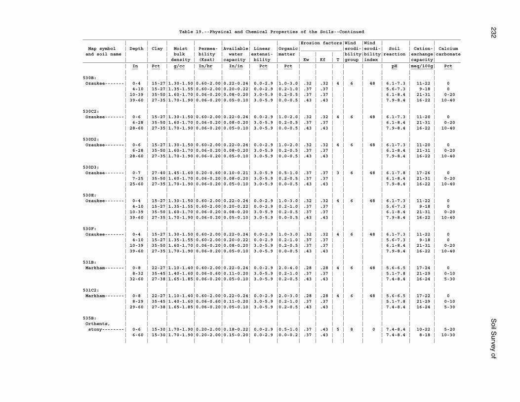
232S
oil Survey of
Table 19.--Physical and Chemical Properties of the Soils--Continued_________________________________________________________________________________________________________________________________________ | | | | | | | |Erosion factors|Wind |Wind | | | Map symbol | Depth | Clay | Moist | Permea- |Available| Linear |Organic|_______________|erodi-|erodi-| Soil | Cation-| Calcium and soil name | | | bulk | bility | water |extensi- |matter | | | |bility|bility|reaction |exchange|carbonate | | | density | (Ksat) |capacity | bility | | Kw | Kf | T |group |index | |capacity|_________________________________________________________________________________________________________________________________________ | In | Pct | g/cc | In/hr | In/in | Pct | Pct | | | | | | pH |meq/100g| Pct __ ___ ____ _____ _____ ___ ___ __ ________ ___ | | | | | | | | | | | | | | |530B: | | | | | | | | | | | | | | | Ozaukee-------| 0-4 | 15-27|1.30-1.50|0.60-2.00|0.22-0.24| 0.0-2.9 |1.0-3.0| .32 | .32 | 4 | 6 | 48 | 6.1-7.3 | 11-22 | 0 | 4-10 | 15-27|1.35-1.55|0.60-2.00|0.20-0.22| 0.0-2.9 |0.2-1.0| .37 | .37 | | | | 5.6-7.3 | 9-18 | 0 | 10-39 | 35-50|1.60-1.70|0.06-0.20|0.08-0.20| 3.0-5.9 |0.2-0.5| .37 | .37 | | | | 6.1-8.4 | 21-31 | 0-20 | 39-60 | 27-35|1.70-1.90|0.06-0.20|0.05-0.10| 3.0-5.9 |0.0-0.5| .43 | .43 | | | | 7.9-8.4 | 16-22 | 10-40 | | | | | | | | | | | | | | |530C2: | | | | | | | | | | | | | | | Ozaukee-------| 0-6 | 15-27|1.30-1.50|0.60-2.00|0.22-0.24| 0.0-2.9 |1.0-2.0| .32 | .32 | 4 | 6 | 48 | 6.1-7.3 | 11-20 | 0 | 6-28 | 35-50|1.60-1.70|0.06-0.20|0.08-0.20| 3.0-5.9 |0.2-0.5| .37 | .37 | | | | 6.1-8.4 | 21-31 | 0-20 | 28-60 | 27-35|1.70-1.90|0.06-0.20|0.05-0.10| 3.0-5.9 |0.0-0.5| .43 | .43 | | | | 7.9-8.4 | 16-22 | 10-40 | | | | | | | | | | | | | | |530D2: | | | | | | | | | | | | | | | Ozaukee-------| 0-6 | 15-27|1.30-1.50|0.60-2.00|0.22-0.24| 0.0-2.9 |1.0-2.0| .32 | .32 | 4 | 6 | 48 | 6.1-7.3 | 11-20 | 0 | 6-28 | 35-50|1.60-1.70|0.06-0.20|0.08-0.20| 3.0-5.9 |0.2-0.5| .37 | .37 | | | | 6.1-8.4 | 21-31 | 0-20 | 28-60 | 27-35|1.70-1.90|0.06-0.20|0.05-0.10| 3.0-5.9 |0.0-0.5| .43 | .43 | | | | 7.9-8.4 | 16-22 | 10-40 | | | | | | | | | | | | | | |530D3: | | | | | | | | | | | | | | | Ozaukee-------| 0-7 | 27-40|1.45-1.60|0.20-0.60|0.10-0.21| 3.0-5.9 |0.5-1.0| .37 | .37 | 3 | 6 | 48 | 6.1-7.8 | 17-26 | 0 | 7-25 | 35-50|1.60-1.70|0.06-0.20|0.08-0.20| 3.0-5.9 |0.2-0.5| .37 | .37 | | | | 6.1-8.4 | 21-31 | 0-20 | 25-60 | 27-35|1.70-1.90|0.06-0.20|0.05-0.10| 3.0-5.9 |0.0-0.5| .43 | .43 | | | | 7.9-8.4 | 16-22 | 10-40 | | | | | | | | | | | | | | |530E: | | | | | | | | | | | | | | | Ozaukee-------| 0-4 | 15-27|1.30-1.50|0.60-2.00|0.22-0.24| 0.0-2.9 |1.0-3.0| .32 | .32 | 4 | 6 | 48 | 6.1-7.3 | 11-22 | 0 | 4-10 | 15-27|1.35-1.55|0.60-2.00|0.20-0.22| 0.0-2.9 |0.2-1.0| .37 | .37 | | | | 5.6-7.3 | 9-18 | 0 | 10-39 | 35-50|1.60-1.70|0.06-0.20|0.08-0.20| 3.0-5.9 |0.2-0.5| .37 | .37 | | | | 6.1-8.4 | 21-31 | 0-20 | 39-60 | 27-35|1.70-1.90|0.06-0.20|0.05-0.10| 3.0-5.9 |0.0-0.5| .43 | .43 | | | | 7.9-8.4 | 16-22 | 10-40 | | | | | | | | | | | | | | |530F: | | | | | | | | | | | | | | | Ozaukee-------| 0-4 | 15-27|1.30-1.50|0.60-2.00|0.22-0.24| 0.0-2.9 |1.0-3.0| .32 | .32 | 4 | 6 | 48 | 6.1-7.3 | 11-22 | 0 | 4-10 | 15-27|1.35-1.55|0.60-2.00|0.20-0.22| 0.0-2.9 |0.2-1.0| .37 | .37 | | | | 5.6-7.3 | 9-18 | 0 | 10-39 | 35-50|1.60-1.70|0.06-0.20|0.08-0.20| 3.0-5.9 |0.2-0.5| .37 | .37 | | | | 6.1-8.4 | 21-31 | 0-20 | 39-60 | 27-35|1.70-1.90|0.06-0.20|0.05-0.10| 3.0-5.9 |0.0-0.5| .43 | .43 | | | | 7.9-8.4 | 16-22 | 10-40 | | | | | | | | | | | | | | |531B: | | | | | | | | | | | | | | | Markham-------| 0-8 | 22-27|1.10-1.40|0.60-2.00|0.22-0.24| 0.0-2.9 |2.0-4.0| .28 | .28 | 4 | 6 | 48 | 5.6-6.5 | 17-24 | 0 | 8-32 | 35-45|1.40-1.60|0.06-0.60|0.11-0.20| 3.0-5.9 |0.2-1.0| .37 | .37 | | | | 5.1-7.8 | 21-29 | 0-10 | 32-60 | 27-38|1.65-1.85|0.06-0.20|0.05-0.10| 3.0-5.9 |0.2-0.5| .43 | .43 | | | | 7.4-8.4 | 16-24 | 5-30 | | | | | | | | | | | | | | |531C2: | | | | | | | | | | | | | | | Markham-------| 0-8 | 22-27|1.10-1.40|0.60-2.00|0.22-0.24| 0.0-2.9 |2.0-3.0| .28 | .28 | 4 | 6 | 48 | 5.6-6.5 | 17-22 | 0 | 8-29 | 35-45|1.40-1.60|0.06-0.60|0.11-0.20| 3.0-5.9 |0.2-1.0| .37 | .37 | | | | 5.1-7.8 | 21-29 | 0-10 | 29-60 | 27-38|1.65-1.85|0.06-0.20|0.05-0.10| 3.0-5.9 |0.2-0.5| .43 | .43 | | | | 7.4-8.4 | 16-24 | 5-30 | | | | | | | | | | | | | | |535B: | | | | | | | | | | | | | | | Orthents, | | | | | | | | | | | | | | | stony--------| 0-6 | 15-30|1.70-1.90|0.20-2.00|0.18-0.22| 0.0-2.9 |0.5-1.0| .37 | .43 | 5 | 8 | 0 | 7.4-8.4 | 10-22 | 5-20 | 6-60 | 15-30|1.70-1.90|0.20-2.00|0.15-0.20| 0.0-2.9 |0.0-0.2| .37 | .43 | | | | 7.4-8.4 | 8-18 | 10-30 | | | | | | | | | | | | | | |
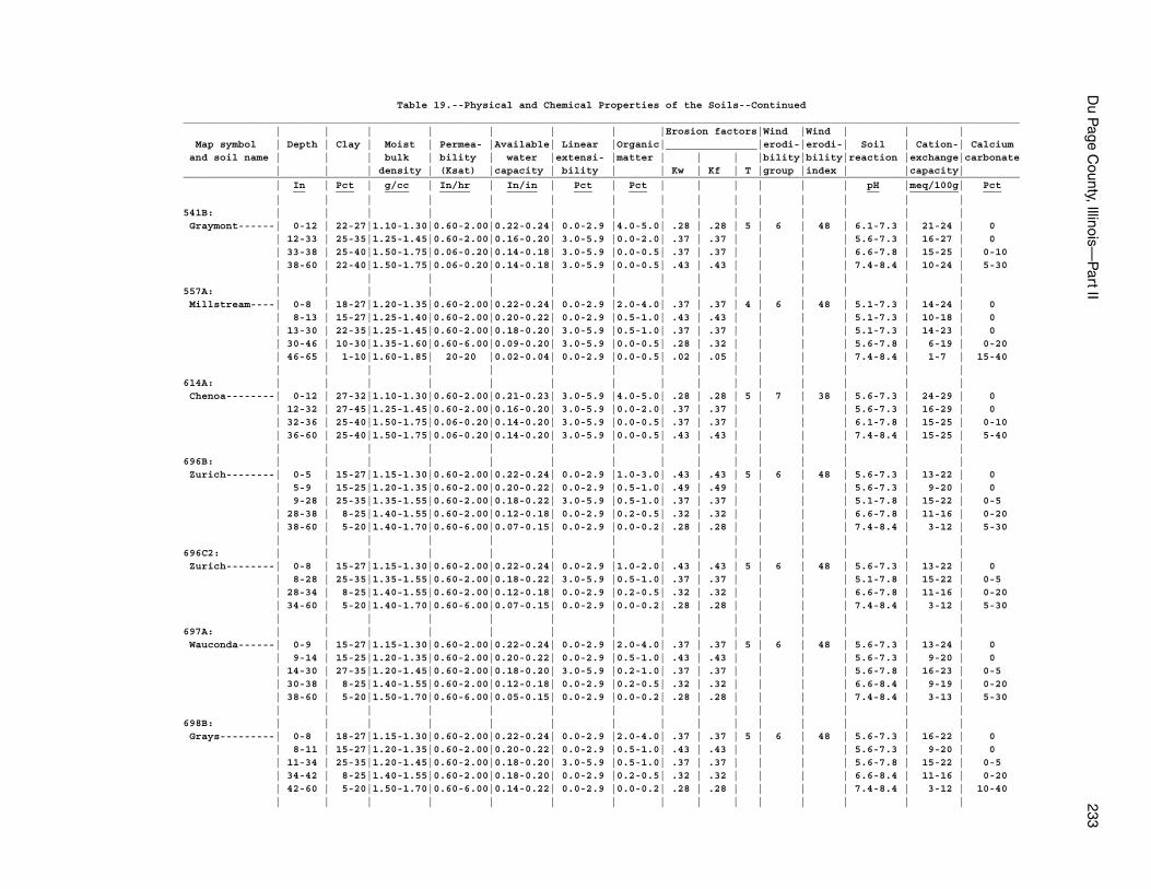
Du P
age County, Illinois—
Part II
233
Table 19.--Physical and Chemical Properties of the Soils--Continued_________________________________________________________________________________________________________________________________________ | | | | | | | |Erosion factors|Wind |Wind | | | Map symbol | Depth | Clay | Moist | Permea- |Available| Linear |Organic|_______________|erodi-|erodi-| Soil | Cation-| Calcium and soil name | | | bulk | bility | water |extensi- |matter | | | |bility|bility|reaction |exchange|carbonate | | | density | (Ksat) |capacity | bility | | Kw | Kf | T |group |index | |capacity|_________________________________________________________________________________________________________________________________________ | In | Pct | g/cc | In/hr | In/in | Pct | Pct | | | | | | pH |meq/100g| Pct __ ___ ____ _____ _____ ___ ___ __ ________ ___ | | | | | | | | | | | | | | |541B: | | | | | | | | | | | | | | | Graymont------| 0-12 | 22-27|1.10-1.30|0.60-2.00|0.22-0.24| 0.0-2.9 |4.0-5.0| .28 | .28 | 5 | 6 | 48 | 6.1-7.3 | 21-24 | 0 | 12-33 | 25-35|1.25-1.45|0.60-2.00|0.16-0.20| 3.0-5.9 |0.0-2.0| .37 | .37 | | | | 5.6-7.3 | 16-27 | 0 | 33-38 | 25-40|1.50-1.75|0.06-0.20|0.14-0.18| 3.0-5.9 |0.0-0.5| .37 | .37 | | | | 6.6-7.8 | 15-25 | 0-10 | 38-60 | 22-40|1.50-1.75|0.06-0.20|0.14-0.18| 3.0-5.9 |0.0-0.5| .43 | .43 | | | | 7.4-8.4 | 10-24 | 5-30 | | | | | | | | | | | | | | |557A: | | | | | | | | | | | | | | | Millstream----| 0-8 | 18-27|1.20-1.35|0.60-2.00|0.22-0.24| 0.0-2.9 |2.0-4.0| .37 | .37 | 4 | 6 | 48 | 5.1-7.3 | 14-24 | 0 | 8-13 | 15-27|1.25-1.40|0.60-2.00|0.20-0.22| 0.0-2.9 |0.5-1.0| .43 | .43 | | | | 5.1-7.3 | 10-18 | 0 | 13-30 | 22-35|1.25-1.45|0.60-2.00|0.18-0.20| 3.0-5.9 |0.5-1.0| .37 | .37 | | | | 5.1-7.3 | 14-23 | 0 | 30-46 | 10-30|1.35-1.60|0.60-6.00|0.09-0.20| 3.0-5.9 |0.0-0.5| .28 | .32 | | | | 5.6-7.8 | 6-19 | 0-20 | 46-65 | 1-10|1.60-1.85| 20-20 |0.02-0.04| 0.0-2.9 |0.0-0.5| .02 | .05 | | | | 7.4-8.4 | 1-7 | 15-40 | | | | | | | | | | | | | | |614A: | | | | | | | | | | | | | | | Chenoa--------| 0-12 | 27-32|1.10-1.30|0.60-2.00|0.21-0.23| 3.0-5.9 |4.0-5.0| .28 | .28 | 5 | 7 | 38 | 5.6-7.3 | 24-29 | 0 | 12-32 | 27-45|1.25-1.45|0.60-2.00|0.16-0.20| 3.0-5.9 |0.0-2.0| .37 | .37 | | | | 5.6-7.3 | 16-29 | 0 | 32-36 | 25-40|1.50-1.75|0.06-0.20|0.14-0.20| 3.0-5.9 |0.0-0.5| .37 | .37 | | | | 6.1-7.8 | 15-25 | 0-10 | 36-60 | 25-40|1.50-1.75|0.06-0.20|0.14-0.20| 3.0-5.9 |0.0-0.5| .43 | .43 | | | | 7.4-8.4 | 15-25 | 5-40 | | | | | | | | | | | | | | |696B: | | | | | | | | | | | | | | | Zurich--------| 0-5 | 15-27|1.15-1.30|0.60-2.00|0.22-0.24| 0.0-2.9 |1.0-3.0| .43 | .43 | 5 | 6 | 48 | 5.6-7.3 | 13-22 | 0 | 5-9 | 15-25|1.20-1.35|0.60-2.00|0.20-0.22| 0.0-2.9 |0.5-1.0| .49 | .49 | | | | 5.6-7.3 | 9-20 | 0 | 9-28 | 25-35|1.35-1.55|0.60-2.00|0.18-0.22| 3.0-5.9 |0.5-1.0| .37 | .37 | | | | 5.1-7.8 | 15-22 | 0-5 | 28-38 | 8-25|1.40-1.55|0.60-2.00|0.12-0.18| 0.0-2.9 |0.2-0.5| .32 | .32 | | | | 6.6-7.8 | 11-16 | 0-20 | 38-60 | 5-20|1.40-1.70|0.60-6.00|0.07-0.15| 0.0-2.9 |0.0-0.2| .28 | .28 | | | | 7.4-8.4 | 3-12 | 5-30 | | | | | | | | | | | | | | |696C2: | | | | | | | | | | | | | | | Zurich--------| 0-8 | 15-27|1.15-1.30|0.60-2.00|0.22-0.24| 0.0-2.9 |1.0-2.0| .43 | .43 | 5 | 6 | 48 | 5.6-7.3 | 13-22 | 0 | 8-28 | 25-35|1.35-1.55|0.60-2.00|0.18-0.22| 3.0-5.9 |0.5-1.0| .37 | .37 | | | | 5.1-7.8 | 15-22 | 0-5 | 28-34 | 8-25|1.40-1.55|0.60-2.00|0.12-0.18| 0.0-2.9 |0.2-0.5| .32 | .32 | | | | 6.6-7.8 | 11-16 | 0-20 | 34-60 | 5-20|1.40-1.70|0.60-6.00|0.07-0.15| 0.0-2.9 |0.0-0.2| .28 | .28 | | | | 7.4-8.4 | 3-12 | 5-30 | | | | | | | | | | | | | | |697A: | | | | | | | | | | | | | | | Wauconda------| 0-9 | 15-27|1.15-1.30|0.60-2.00|0.22-0.24| 0.0-2.9 |2.0-4.0| .37 | .37 | 5 | 6 | 48 | 5.6-7.3 | 13-24 | 0 | 9-14 | 15-25|1.20-1.35|0.60-2.00|0.20-0.22| 0.0-2.9 |0.5-1.0| .43 | .43 | | | | 5.6-7.3 | 9-20 | 0 | 14-30 | 27-35|1.20-1.45|0.60-2.00|0.18-0.20| 3.0-5.9 |0.2-1.0| .37 | .37 | | | | 5.6-7.8 | 16-23 | 0-5 | 30-38 | 8-25|1.40-1.55|0.60-2.00|0.12-0.18| 0.0-2.9 |0.2-0.5| .32 | .32 | | | | 6.6-8.4 | 9-19 | 0-20 | 38-60 | 5-20|1.50-1.70|0.60-6.00|0.05-0.15| 0.0-2.9 |0.0-0.2| .28 | .28 | | | | 7.4-8.4 | 3-13 | 5-30 | | | | | | | | | | | | | | |698B: | | | | | | | | | | | | | | | Grays---------| 0-8 | 18-27|1.15-1.30|0.60-2.00|0.22-0.24| 0.0-2.9 |2.0-4.0| .37 | .37 | 5 | 6 | 48 | 5.6-7.3 | 16-22 | 0 | 8-11 | 15-27|1.20-1.35|0.60-2.00|0.20-0.22| 0.0-2.9 |0.5-1.0| .43 | .43 | | | | 5.6-7.3 | 9-20 | 0 | 11-34 | 25-35|1.20-1.45|0.60-2.00|0.18-0.20| 3.0-5.9 |0.5-1.0| .37 | .37 | | | | 5.6-7.8 | 15-22 | 0-5 | 34-42 | 8-25|1.40-1.55|0.60-2.00|0.18-0.20| 0.0-2.9 |0.2-0.5| .32 | .32 | | | | 6.6-8.4 | 11-16 | 0-20 | 42-60 | 5-20|1.50-1.70|0.60-6.00|0.14-0.22| 0.0-2.9 |0.0-0.2| .28 | .28 | | | | 7.4-8.4 | 3-12 | 10-40 | | | | | | | | | | | | | | |
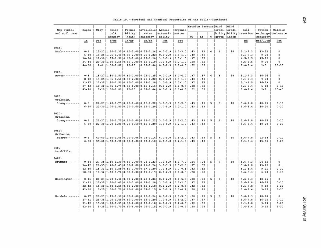
234S
oil Survey of
Table 19.--Physical and Chemical Properties of the Soils--Continued_________________________________________________________________________________________________________________________________________ | | | | | | | |Erosion factors|Wind |Wind | | | Map symbol | Depth | Clay | Moist | Permea- |Available| Linear |Organic|_______________|erodi-|erodi-| Soil | Cation-| Calcium and soil name | | | bulk | bility | water |extensi- |matter | | | |bility|bility|reaction |exchange|carbonate | | | density | (Ksat) |capacity | bility | | Kw | Kf | T |group |index | |capacity|_________________________________________________________________________________________________________________________________________ | In | Pct | g/cc | In/hr | In/in | Pct | Pct | | | | | | pH |meq/100g| Pct __ ___ ____ _____ _____ ___ ___ __ ________ ___ | | | | | | | | | | | | | | |791B: | | | | | | | | | | | | | | | Rush----------| 0-6 | 15-27|1.20-1.35|0.60-2.00|0.22-0.24| 0.0-2.9 |1.0-3.0| .43 | .43 | 4 | 6 | 48 | 5.1-7.3 | 13-22 | 0 | 6-10 | 15-25|1.25-1.40|0.60-2.00|0.20-0.22| 0.0-2.9 |0.5-1.0| .49 | .49 | | | | 5.1-7.3 | 9-20 | 0 | 10-34 | 22-30|1.35-1.50|0.60-2.00|0.18-0.20| 3.0-5.9 |0.5-1.0| .37 | .37 | | | | 4.5-6.5 | 15-22 | 0 | 34-44 | 20-30|1.40-1.55|0.60-2.00|0.15-0.19| 3.0-5.9 |0.2-1.0| .28 | .32 | | | | 4.5-6.5 | 9-20 | 0 | 44-60 | 2-6 |1.60-1.80| 20-20 |0.02-0.04| 0.0-2.9 |0.0-0.5| .02 | .05 | | | | 7.4-8.4 | 1-5 | 10-35 | | | | | | | | | | | | | | |792B: | | | | | | | | | | | | | | | Bowes---------| 0-8 | 18-27|1.30-1.50|0.60-2.00|0.22-0.25| 0.0-2.9 |2.0-4.0| .37 | .37 | 4 | 6 | 48 | 5.1-7.3 | 16-24 | 0 | 8-12 | 15-25|1.35-1.50|0.60-2.00|0.20-0.22| 0.0-2.9 |0.5-1.0| .43 | .43 | | | | 5.1-7.3 | 9-20 | 0 | 12-37 | 27-35|1.30-1.50|0.60-2.00|0.18-0.20| 3.0-5.9 |0.0-1.0| .37 | .37 | | | | 5.1-6.5 | 16-23 | 0 | 37-43 | 10-30|1.55-1.75|0.60-6.00|0.10-0.16| 0.0-2.9 |0.0-0.5| .28 | .32 | | | | 5.1-8.4 | 6-18 | 0-10 | 43-70 | 3-10|1.60-1.80| 20-20 |0.02-0.04| 0.0-2.9 |0.0-0.5| .02 | .05 | | | | 7.4-8.4 | 2-7 | 10-40 | | | | | | | | | | | | | | |802B: | | | | | | | | | | | | | | | Orthents, | | | | | | | | | | | | | | | loamy--------| 0-6 | 22-27|1.70-1.75|0.20-0.60|0.18-0.22| 3.0-5.9 |0.5-2.0| .43 | .43 | 5 | 6 | 48 | 5.6-7.8 | 10-25 | 0-10 | 6-60 | 22-30|1.70-1.80|0.20-0.60|0.16-0.20| 3.0-5.9 |0.2-1.0| .43 | .43 | | | | 5.6-8.4 | 10-20 | 0-20 | | | | | | | | | | | | | | |802D: | | | | | | | | | | | | | | | Orthents, | | | | | | | | | | | | | | | loamy--------| 0-6 | 22-27|1.70-1.75|0.20-0.60|0.18-0.22| 3.0-5.9 |0.5-2.0| .43 | .43 | 5 | 6 | 48 | 5.6-7.8 | 10-25 | 0-10 | 6-60 | 22-30|1.70-1.80|0.20-0.60|0.16-0.20| 3.0-5.9 |0.2-1.0| .43 | .43 | | | | 5.6-8.4 | 10-20 | 0-20 | | | | | | | | | | | | | | |805B: | | | | | | | | | | | | | | | Orthents, | | | | | | | | | | | | | | | clayey-------| 0-6 | 40-60|1.50-1.65|0.00-0.06|0.08-0.14| 6.0-9.0 |0.5-2.0| .43 | .43 | 5 | 4 | 86 | 5.6-7.8 | 22-38 | 0-10 | 6-60 | 35-60|1.60-1.90|0.00-0.06|0.03-0.10| 6.0-9.0 |0.2-1.0| .43 | .43 | | | | 6.1-8.4 | 15-35 | 0-25 | | | | | | | | | | | | | | |830: | | | | | | | | | | | | | | | Landfills. | | | | | | | | | | | | | | | | | | | | | | | | | | | | | |848B: | | | | | | | | | | | | | | | Drummer-------| 0-14 | 27-35|1.10-1.30|0.60-2.00|0.21-0.23| 3.0-5.9 |4.0-7.0| .24 | .24 | 5 | 7 | 38 | 5.6-7.3 | 24-35 | 0 | 14-42 | 20-35|1.20-1.45|0.60-2.00|0.21-0.24| 3.0-5.9 |0.5-2.0| .37 | .37 | | | | 5.6-7.8 | 13-25 | 0 | 42-50 | 15-33|1.30-1.55|0.60-2.00|0.17-0.20| 3.0-5.9 |0.2-0.5| .32 | .32 | | | | 6.1-8.4 | 9-21 | 0-20 | 50-60 | 10-32|1.40-1.70|0.60-6.00|0.11-0.19| 0.0-2.9 |0.0-0.5| .28 | .28 | | | | 6.6-8.4 | 6-20 | 0-40 | | | | | | | | | | | | | | | Barrington----| 0-11 | 20-27|1.20-1.40|0.60-2.00|0.22-0.26| 0.0-2.9 |3.0-5.0| .28 | .28 | 5 | 6 | 48 | 5.6-7.3 | 18-26 | 0 | 11-32 | 25-35|1.20-1.45|0.60-2.00|0.18-0.20| 3.0-5.9 |0.5-2.0| .37 | .37 | | | | 5.6-7.8 | 16-25 | 0-10 | 32-42 | 15-30|1.40-1.55|0.60-2.00|0.12-0.18| 0.0-2.9 |0.2-0.5| .32 | .32 | | | | 6.1-7.8 | 9-19 | 0-20 | 42-60 | 5-25|1.50-1.70|0.60-6.00|0.07-0.15| 0.0-2.9 |0.0-0.2| .28 | .28 | | | | 7.4-8.4 | 3-15 | 5-30 | | | | | | | | | | | | | | | Mundelein-----| 0-17 | 20-27|1.15-1.30|0.60-2.00|0.22-0.24| 0.0-2.9 |3.0-5.0| .28 | .28 | 5 | 6 | 48 | 5.6-7.3 | 18-26 | 0 | 17-31 | 25-35|1.20-1.45|0.60-2.00|0.18-0.20| 3.0-5.9 |0.5-2.0| .37 | .37 | | | | 5.6-7.8 | 16-25 | 0-10 | 31-42 | 15-30|1.40-1.55|0.60-2.00|0.12-0.18| 0.0-2.9 |0.2-0.5| .32 | .32 | | | | 6.1-7.8 | 9-19 | 0-20 | 42-60 | 5-25|1.50-1.70|0.60-6.00|0.05-0.15| 0.0-2.9 |0.0-0.2| .28 | .28 | | | | 7.4-8.4 | 3-15 | 5-30 | | | | | | | | | | | | | | |
Du P
age County, Illinois—
Part II
235
Table 19.--Physical and Chemical Properties of the Soils--Continued_________________________________________________________________________________________________________________________________________ | | | | | | | |Erosion factors|Wind |Wind | | | Map symbol | Depth | Clay | Moist | Permea- |Available| Linear |Organic|_______________|erodi-|erodi-| Soil | Cation-| Calcium and soil name | | | bulk | bility | water |extensi- |matter | | | |bility|bility|reaction |exchange|carbonate | | | density | (Ksat) |capacity | bility | | Kw | Kf | T |group |index | |capacity|_________________________________________________________________________________________________________________________________________ | In | Pct | g/cc | In/hr | In/in | Pct | Pct | | | | | | pH |meq/100g| Pct __ ___ ____ _____ _____ ___ ___ __ ________ ___ | | | | | | | | | | | | | | |849A: | | | | | | | | | | | | | | | Milford-------| 0-18 | 35-40|1.30-1.50|0.60-2.00|0.20-0.23| 6.0-8.9 |4.0-6.0| .20 | .20 | 5 | 4 | 86 | 5.6-7.3 | 26-36 | 0 | 18-50 | 35-42|1.40-1.60|0.20-0.60|0.18-0.20| 3.0-5.9 |0.5-2.0| .37 | .37 | | | | 5.6-7.8 | 22-29 | 0-10 | 50-60 | 20-30|1.50-1.70|0.20-0.60|0.20-0.22| 3.0-5.9 |0.0-1.0| .37 | .37 | | | | 6.6-8.4 | 4-18 | 0-30 | | | | | | | | | | | | | | | Martinton-----| 0-17 | 20-27|1.20-1.40|0.60-2.00|0.22-0.24| 0.0-2.9 |4.0-5.0| .24 | .24 | 5 | 6 | 48 | 5.6-7.3 | 18-24 | 0 | 17-42 | 35-45|1.25-1.45|0.20-0.60|0.11-0.20| 3.0-5.9 |0.5-2.0| .37 | .37 | | | | 5.6-7.8 | 18-24 | 0-10 | 42-60 | 15-42|1.40-1.60|0.20-0.60|0.11-0.22| 3.0-5.9 |0.0-0.5| .37 | .37 | | | | 6.1-8.4 | 7-22 | 5-30 | | | | | | | | | | | | | | |854B: | | | | | | | | | | | | | | | Markham-------| 0-8 | 22-27|1.10-1.40|0.60-2.00|0.22-0.24| 0.0-2.9 |2.0-4.0| .28 | .28 | 4 | 6 | 48 | 5.6-6.5 | 17-24 | 0 | 8-32 | 35-45|1.40-1.60|0.06-0.60|0.11-0.20| 3.0-5.9 |0.2-1.0| .37 | .37 | | | | 5.1-7.8 | 21-29 | 0-10 | 32-60 | 27-38|1.65-1.85|0.06-0.20|0.05-0.10| 3.0-5.9 |0.2-0.5| .43 | .43 | | | | 7.4-8.4 | 16-24 | 5-30 | | | | | | | | | | | | | | | Ashkum--------| 0-12 | 35-40|1.15-1.35|0.20-0.60|0.15-0.20| 6.0-8.9 |3.0-7.0| .20 | .20 | 5 | 4 | 86 | 5.6-7.8 | 27-38 | 0 | 12-29 | 35-45|1.30-1.60|0.20-0.60|0.11-0.20| 6.0-8.9 |0.5-2.0| .32 | .32 | | | | 6.1-7.8 | 22-31 | 0-5 | 29-60 | 30-40|1.45-1.75|0.20-0.60|0.09-0.18| 3.0-5.9 |0.0-0.5| .43 | .43 | | | | 6.1-8.4 | 18-25 | 0-25 | | | | | | | | | | | | | | | Beecher-------| 0-9 | 20-27|1.35-1.55|0.20-0.60|0.21-0.24| 0.0-2.9 |2.0-4.0| .28 | .28 | 4 | 6 | 48 | 4.5-7.3 | 16-24 | 0 | 9-37 | 35-50|1.40-1.65|0.06-0.20|0.11-0.19| 3.0-5.9 |0.0-1.0| .37 | .37 | | | | 4.5-7.8 | 21-32 | 0-10 | 37-60 | 25-45|1.65-1.85|0.06-0.20|0.05-0.10| 3.0-5.9 |0.0-0.5| .43 | .43 | | | | 7.4-8.4 | 15-28 | 5-30 | | | | | | | | | | | | | | |864, 865: | | | | | | | | | | | | | | | Pits. | | | | | | | | | | | | | | | | | | | | | | | | | | | | | |903A: | | | | | | | | | | | | | | | Muskego-------| 0-5 | 0-0 |0.10-0.21|0.60-6.00|0.35-0.45| --- | 60-90 | --- | --- | 1 | 2 | 134 | 5.6-7.3 | 140-180| 0 | 5-36 | 0-0 |0.10-0.21|0.60-6.00|0.35-0.45| --- | 60-90 | .10 | .10 | | | | 5.6-7.3 | 150-190| 0 | 36-80 | 18-35|0.30-1.10|0.06-0.20|0.18-0.24| 3.0-5.9 |6.0-20 | .28 | .28 | | | | 6.6-8.4 | 10-45 | 60-80 | | | | | | | | | | | | | | | Houghton------| 0-12 | 0-0 |0.20-0.35|0.20-6.00|0.35-0.45| --- | 70-99 | --- | --- | 3 | 2 | 134 | 4.5-7.8 | 140-200| 0 | 12-60 | 0-0 |0.15-0.25|0.20-6.00|0.35-0.45| --- | 70-99 | --- | --- | | | | 4.5-7.8 | 100-200| 0 | | | | | | | | | | | | | | |969F: | | | | | | | | | | | | | | | Casco---------| 0-8 | 10-20|1.35-1.55|0.60-2.00|0.19-0.24| 0.0-2.9 |1.0-3.0| .32 | .32 | 3 | 5 | 56 | 5.6-7.3 | 4-20 | 0 | 8-18 | 18-35|1.55-1.65|0.60-2.00|0.09-0.19| 3.0-5.9 |0.0-0.5| .28 | .32 | | | | 5.6-7.8 | 4-30 | 0-3 | 18-60 | 0-2 |1.30-1.70|6.00-60.0|0.02-0.04| 0.0-2.9 |0.0-0.5| .02 | .05 | | | | 7.4-8.4 | 0-3 | 1-25 | | | | | | | | | | | | | | | Rodman--------| 0-8 | 8-25|1.20-1.50|2.00-6.00|0.10-0.12| 0.0-2.9 |2.0-4.0| .20 | .24 | 3 | 8 | 0 | 6.6-7.8 | 5-18 | 0-15 | 8-12 | 5-25|1.10-1.50|2.00-6.00|0.09-0.12| 0.0-2.9 |0.0-2.0| .28 | .32 | | | | 6.6-7.8 | 1-14 | 0-25 | 12-60 | 0-10|1.60-1.70| 20-20 |0.02-0.04| 0.0-2.9 |0.0-1.0| .02 | .05 | | | | 7.4-8.4 | 1-6 | 10-45 | | | | | | | | | | | | | | |1107A: | | | | | | | | | | | | | | | Sawmill-------| 0-17 | 27-35|1.20-1.40|0.60-2.00|0.21-0.23| 3.0-5.9 |4.0-5.0| .28 | .28 | 5 | 7 | 38 | 6.1-7.8 | 24-31 | 0 | 17-29 | 27-35|1.20-1.40|0.60-2.00|0.21-0.23| 3.0-5.9 |1.0-3.0| .28 | .28 | | | | 6.1-7.8 | 18-27 | 0 | 29-48 | 25-35|1.30-1.45|0.60-2.00|0.17-0.20| 3.0-5.9 |0.2-2.0| .32 | .32 | | | | 6.1-7.8 | 17-25 | 0-10 | 48-60 | 18-35|1.35-1.50|0.60-2.00|0.15-0.19| 3.0-5.9 |0.2-1.0| .32 | .32 | | | | 6.1-8.4 | 11-23 | 0-30 | | | | | | | | | | | | | | |
236S
oil Survey of
Table 19.--Physical and Chemical Properties of the Soils--Continued_________________________________________________________________________________________________________________________________________ | | | | | | | |Erosion factors|Wind |Wind | | | Map symbol | Depth | Clay | Moist | Permea- |Available| Linear |Organic|_______________|erodi-|erodi-| Soil | Cation-| Calcium and soil name | | | bulk | bility | water |extensi- |matter | | | |bility|bility|reaction |exchange|carbonate | | | density | (Ksat) |capacity | bility | | Kw | Kf | T |group |index | |capacity|_________________________________________________________________________________________________________________________________________ | In | Pct | g/cc | In/hr | In/in | Pct | Pct | | | | | | pH |meq/100g| Pct __ ___ ____ _____ _____ ___ ___ __ ________ ___ | | | | | | | | | | | | | | |1152A: | | | | | | | | | | | | | | | Drummer-------| 0-14 | 27-35|1.10-1.30|0.60-2.00|0.21-0.23| 3.0-5.9 |4.0-7.0| .24 | .24 | 5 | 7 | 38 | 5.6-7.3 | 24-35 | 0 | 14-42 | 20-35|1.20-1.45|0.60-2.00|0.21-0.24| 3.0-5.9 |0.5-2.0| .37 | .37 | | | | 5.6-7.3 | 13-25 | 0 | 42-50 | 15-33|1.30-1.55|0.60-2.00|0.17-0.20| 3.0-5.9 |0.2-0.5| .32 | .32 | | | | 6.1-8.4 | 9-21 | 0-20 | 50-60 | 10-32|1.40-1.70|0.60-6.00|0.11-0.19| 0.0-2.9 |0.0-5.0| .28 | .28 | | | | 6.6-8.4 | 6-20 | 0-40 | | | | | | | | | | | | | | |1330A: | | | | | | | | | | | | | | | Peotone-------| 0-13 | 33-40|1.20-1.40|0.20-0.60|0.21-0.23| 6.0-8.9 |5.0-7.0| .24 | .24 | 5 | 4 | 86 | 5.6-7.8 | 30-38 | 0 | 13-50 | 35-45|1.30-1.60|0.20-0.60|0.11-0.20| 6.0-8.9 |0.5-3.0| .37 | .37 | | | | 6.1-7.8 | 22-33 | 0 | 50-60 | 25-42|1.40-1.65|0.20-0.60|0.18-0.20| 6.0-8.9 |0.2-0.5| .43 | .43 | | | | 6.6-8.4 | 15-26 | 0-15 | | | | | | | | | | | | | | |1516A: | | | | | | | | | | | | | | | Faxon---------| 0-11 | 28-30|1.20-1.40|0.60-2.00|0.20-0.24| 3.0-5.9 |3.0-7.0| .28 | .28 | 2 | 7 | 38 | 6.6-7.8 | 22-32 | 0 | 11-22 | 18-30|1.40-1.60|0.60-2.00|0.12-0.19| 3.0-5.9 |0.5-2.0| .28 | .32 | | | | 6.6-7.8 | 10-22 | 0-10 | 22-60 | --- | --- |2.00-20.0| --- | --- | --- | --- | --- | | | | --- | --- | --- | | | | | | | | | | | | | | |1523A: | | | | | | | | | | | | | | | Dunham--------| 0-11 | 27-35|1.10-1.30|0.60-2.00|0.21-0.23| 3.0-5.9 |4.0-6.0| .24 | .24 | 4 | 7 | 38 | 5.6-7.3 | 25-34 | 0 | 11-31 | 23-35|1.30-1.50|0.60-2.00|0.18-0.21| 3.0-5.9 |0.5-2.0| .37 | .37 | | | | 5.6-7.3 | 16-26 | 0 | 31-42 | 10-30|1.35-1.60|0.60-2.00|0.15-0.20| 3.0-5.9 |0.0-0.5| .28 | .32 | | | | 6.1-7.8 | 6-19 | 0-20 | 42-60 | 1-5 |1.60-1.85| 20-20 |0.02-0.04| 0.0-2.9 |0.0-0.5| .02 | .05 | | | | 7.4-8.4 | 1-7 | 15-40 | | | | | | | | | | | | | | |1903A: | | | | | | | | | | | | | | | Muskego-------| 0-5 | 0-0 |0.10-0.21|0.60-6.00|0.35-0.45| --- | 60-90 | .10 | .10 | 1 | 2 | 134 | 5.6-7.3 | 140-180| 0 | 5-36 | 0-0 |0.10-0.21|0.60-6.00|0.35-0.45| --- | 60-90 | .10 | .10 | | | | 5.6-7.3 | 150-190| 0 | 36-60 | 18-35|0.30-1.10|0.06-0.20|0.18-0.24| 3.0-5.9 |6.0-20 | .28 | .28 | | | | 6.6-8.4 | 10-45 | 60-80 | | | | | | | | | | | | | | | Houghton------| 0-12 | 0-0 |0.20-0.35|0.20-6.00|0.35-0.45| --- | 70-99 | --- | --- | 3 | 2 | 134 | 4.5-7.8 | 140-200| 0 | 12-60 | 0-0 |0.15-0.25|0.20-6.00|0.35-0.45| --- | 70-99 | --- | --- | | | | 4.5-7.8 | 100-200| 0 | | | | | | | | | | | | | | |3107A: | | | | | | | | | | | | | | | Sawmill-------| 0-17 | 27-35|1.20-1.40|0.60-2.00|0.21-0.23| 3.0-5.9 |4.0-5.0| .28 | .28 | 5 | 7 | 38 | 6.1-7.8 | 24-31 | 0 | 17-29 | 27-35|1.20-1.40|0.60-2.00|0.21-0.23| 3.0-5.9 |1.0-3.0| .28 | .28 | | | | 6.1-7.8 | 18-27 | 0 | 29-48 | 25-35|1.30-1.45|0.60-2.00|0.17-0.20| 3.0-5.9 |0.2-2.0| .32 | .32 | | | | 6.1-7.8 | 17-25 | 0-10 | 48-60 | 18-35|1.35-1.50|0.60-2.00|0.15-0.19| 3.0-5.9 |0.2-1.0| .32 | .32 | | | | 6.1-8.4 | 11-23 | 0-30 | | | | | | | | | | | | | | |3316A: | | | | | | | | | | | | | | | Romeo---------| 0-8 | 15-27|1.20-1.30|0.60-2.00|0.22-0.24| 0.0-2.9 |3.0-5.0| .32 | .32 | 1 | 6 | 48 | 6.1-8.4 | 15-26 | 0-20 | 8-60 | --- | --- |0.01-0.06| --- | --- | --- | --- | --- | | | | --- | --- | --- | | | | | | | | | | | | | | |
Du P
age County, Illinois—
Part II
237
Table 19.--Physical and Chemical Properties of the Soils--Continued_________________________________________________________________________________________________________________________________________ | | | | | | | |Erosion factors|Wind |Wind | | | Map symbol | Depth | Clay | Moist | Permea- |Available| Linear |Organic|_______________|erodi-|erodi-| Soil | Cation-| Calcium and soil name | | | bulk | bility | water |extensi- |matter | | | |bility|bility|reaction |exchange|carbonate | | | density | (Ksat) |capacity | bility | | Kw | Kf | T |group |index | |capacity|_________________________________________________________________________________________________________________________________________ | In | Pct | g/cc | In/hr | In/in | Pct | Pct | | | | | | pH |meq/100g| Pct __ ___ ____ _____ _____ ___ ___ __ ________ ___ | | | | | | | | | | | | | | |4904A: | | | | | | | | | | | | | | | Muskego-------| 0-5 | 0-0 |0.10-0.21|0.60-6.00|0.35-0.45| --- | 60-90 | .10 | .10 | 1 | 2 | 134 | 5.6-7.3 | 140-180| 0 | 5-36 | 0-0 |0.10-0.21|0.60-6.00|0.35-0.45| --- | 60-90 | .10 | .10 | | | | 5.6-7.3 | 150-190| 0 | 36-60 | 18-35|0.30-1.10|0.06-0.20|0.18-0.24| 3.0-5.9 |6.0-20 | .28 | .28 | | | | 6.6-8.4 | 10-45 | 60-80 | | | | | | | | | | | | | | | Peotone-------| 0-13 | 33-40|1.20-1.40|0.20-0.60|0.21-0.23| 6.0-8.9 |5.0-7.0| .24 | .24 | 5 | 4 | 86 | 5.6-7.8 | 30-38 | 0 | 13-50 | 35-45|1.30-1.60|0.20-0.60|0.11-0.20| 6.0-8.9 |0.5-3.0| .37 | .37 | | | | 6.1-7.8 | 22-33 | 0 | 50-60 | 25-42|1.40-1.65|0.20-0.60|0.18-0.20| 6.0-8.9 |0.2-0.5| .43 | .43 | | | | 6.6-8.4 | 15-26 | 0-15 | | | | | | | | | | | | | | |_________________________________________________________________________________________________________________________________________
238 Soil Survey of
Table 20.--Water Features
(Depths of layers are in feet. See text for definitions of terms used in this table. Estimates of the frequency of ponding and flooding apply to the entire year rather than to individual months or groups of months. Absence of an entry indicates that the feature is not a concern or that data were not estimated.)
____________________________________________________________________________________________________________ | | | Water table | Ponding | Flooding | | | | | ___________________________________________________________________________ Map symbol |Hydro-|Months | Upper | Lower |Surface| Duration |Frequency | Duration | Frequency and soil name |logic | | limit | limit | water | | | | |group | | | | depth | | | |____________________________________________________________________________________________________________ | | | | | | | | |23A: | | | | | | | | | Blount----------| C |Jan-May|0.5-2.0|2.0-4.0| --- | --- | --- | --- | --- | | | | | | | | |23B: | | | | | | | | | Blount----------| C |Jan-May|0.5-2.0|2.0-4.0| --- | --- | --- | --- | --- | | | | | | | | |67A: | | | | | | | | | Harpster--------| B |Jan-May|0.0-1.0| >6.0 |0.0-0.5|Brief-----|Frequent | --- | --- | | | | | | | | |69A: | | | | | | | | | Milford---------| B |Jan-May|0.0-1.0| >6.0 |0.0-0.5|Brief-----|Frequent | --- | --- | | | | | | | | |91A: | | | | | | | | | Swygert---------| C |Jan-May|1.0-2.0|2.0-5.0| --- | --- | --- | --- | --- | | | | | | | | |125A: | | | | | | | | | Selma-----------| B |Jan-May|0.0-1.0| >6.0 |0.0-0.5|Brief-----|Frequent | --- | --- | | | | | | | | |146A: | | | | | | | | | Elliott---------| C |Jan-May|1.0-2.0|2.0-4.0| --- | --- | --- | --- | --- | | | | | | | | |146B: | | | | | | | | | Elliott---------| C |Jan-May|1.0-2.0|2.0-4.0| --- | --- | --- | --- | --- | | | | | | | | |152A: | | | | | | | | | Drummer---------| B |Jan-May|0.0-1.0| >6.0 |0.0-0.5|Brief-----|Frequent | --- | --- | | | | | | | | |189A: | | | | | | | | | Martinton-------| C |Jan-May|1.0-2.0| >6.0 | --- | --- | --- | --- | --- | | | | | | | | |192A: | | | | | | | | | Del Rey---------| C |Jan-May|0.5-2.0|2.0-4.5| --- | --- | --- | --- | --- | | | | | | | | |206A: | | | | | | | | | Thorp-----------| C |Jan-May|0.0-1.0| >6.0 |0.0-0.5|Brief-----|Frequent | --- | --- | | | | | | | | |223B: | | | | | | | | | Varna-----------| C |Feb-Apr|2.0-3.5|3.5-5.0| --- | --- | --- | --- | --- | | | | | | | | |223C2: | | | | | | | | | Varna-----------| C |Feb-Apr|2.0-3.5|3.5-5.0| --- | --- | --- | --- | --- | | | | | | | | |232A: | | | | | | | | | Ashkum----------| B |Jan-May|0.0-1.0| >6.0 |0.0-0.5|Brief-----|Frequent | --- | --- | | | | | | | | |290C2: | | | | | | | | | Warsaw----------| B |Jan-Dec| >6.0 | >6.0 | --- | --- | --- | --- | --- | | | | | | | | |298A: | | | | | | | | | Beecher---------| C |Jan-May|0.5-2.0|2.0-4.0| --- | --- | --- | --- | --- | | | | | | | | |298B: | | | | | | | | | Beecher---------| C |Jan-May|0.5-2.0|2.0-4.0| --- | --- | --- | --- | --- | | | | | | | | |318C2: | | | | | | | | | Lorenzo---------| B |Jan-Dec| >6.0 | >6.0 | --- | --- | --- | --- | --- | | | | | | | | |
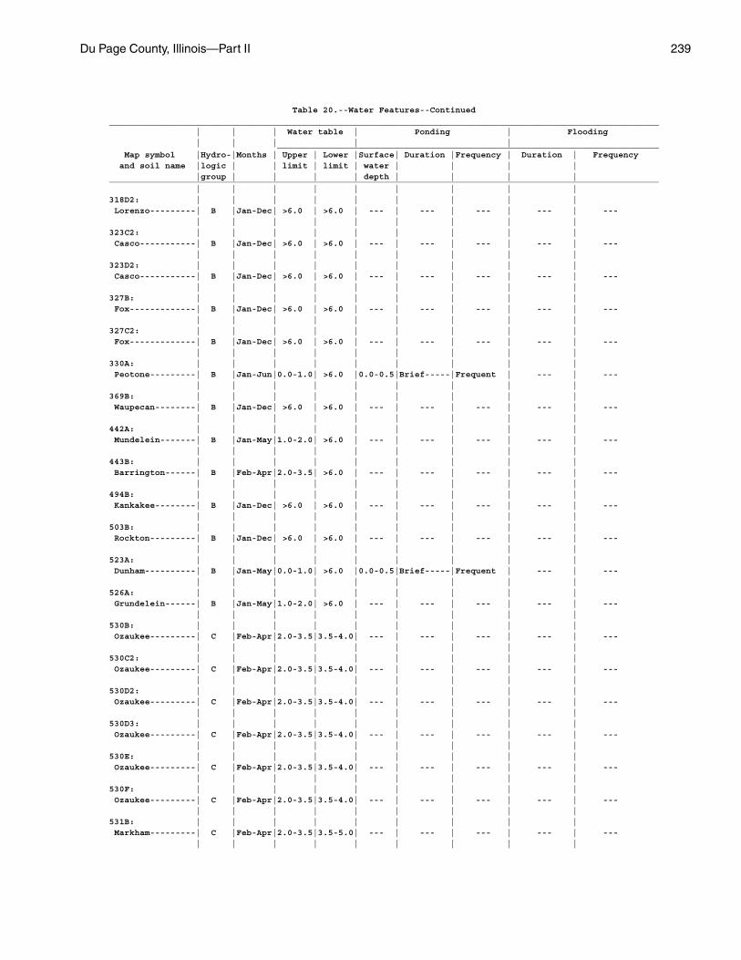
Du Page County, Illinois—Part II 239
Table 20.--Water Features--Continued____________________________________________________________________________________________________________ | | | Water table | Ponding | Flooding | | | | | ___________________________________________________________________________ Map symbol |Hydro-|Months | Upper | Lower |Surface| Duration |Frequency | Duration | Frequency and soil name |logic | | limit | limit | water | | | | |group | | | | depth | | | |____________________________________________________________________________________________________________ | | | | | | | | |318D2: | | | | | | | | | Lorenzo---------| B |Jan-Dec| >6.0 | >6.0 | --- | --- | --- | --- | --- | | | | | | | | |323C2: | | | | | | | | | Casco-----------| B |Jan-Dec| >6.0 | >6.0 | --- | --- | --- | --- | --- | | | | | | | | |323D2: | | | | | | | | | Casco-----------| B |Jan-Dec| >6.0 | >6.0 | --- | --- | --- | --- | --- | | | | | | | | |327B: | | | | | | | | | Fox-------------| B |Jan-Dec| >6.0 | >6.0 | --- | --- | --- | --- | --- | | | | | | | | |327C2: | | | | | | | | | Fox-------------| B |Jan-Dec| >6.0 | >6.0 | --- | --- | --- | --- | --- | | | | | | | | |330A: | | | | | | | | | Peotone---------| B |Jan-Jun|0.0-1.0| >6.0 |0.0-0.5|Brief-----|Frequent | --- | --- | | | | | | | | |369B: | | | | | | | | | Waupecan--------| B |Jan-Dec| >6.0 | >6.0 | --- | --- | --- | --- | --- | | | | | | | | |442A: | | | | | | | | | Mundelein-------| B |Jan-May|1.0-2.0| >6.0 | --- | --- | --- | --- | --- | | | | | | | | |443B: | | | | | | | | | Barrington------| B |Feb-Apr|2.0-3.5| >6.0 | --- | --- | --- | --- | --- | | | | | | | | |494B: | | | | | | | | | Kankakee--------| B |Jan-Dec| >6.0 | >6.0 | --- | --- | --- | --- | --- | | | | | | | | |503B: | | | | | | | | | Rockton---------| B |Jan-Dec| >6.0 | >6.0 | --- | --- | --- | --- | --- | | | | | | | | |523A: | | | | | | | | | Dunham----------| B |Jan-May|0.0-1.0| >6.0 |0.0-0.5|Brief-----|Frequent | --- | --- | | | | | | | | |526A: | | | | | | | | | Grundelein------| B |Jan-May|1.0-2.0| >6.0 | --- | --- | --- | --- | --- | | | | | | | | |530B: | | | | | | | | | Ozaukee---------| C |Feb-Apr|2.0-3.5|3.5-4.0| --- | --- | --- | --- | --- | | | | | | | | |530C2: | | | | | | | | | Ozaukee---------| C |Feb-Apr|2.0-3.5|3.5-4.0| --- | --- | --- | --- | --- | | | | | | | | |530D2: | | | | | | | | | Ozaukee---------| C |Feb-Apr|2.0-3.5|3.5-4.0| --- | --- | --- | --- | --- | | | | | | | | |530D3: | | | | | | | | | Ozaukee---------| C |Feb-Apr|2.0-3.5|3.5-4.0| --- | --- | --- | --- | --- | | | | | | | | |530E: | | | | | | | | | Ozaukee---------| C |Feb-Apr|2.0-3.5|3.5-4.0| --- | --- | --- | --- | --- | | | | | | | | |530F: | | | | | | | | | Ozaukee---------| C |Feb-Apr|2.0-3.5|3.5-4.0| --- | --- | --- | --- | --- | | | | | | | | |531B: | | | | | | | | | Markham---------| C |Feb-Apr|2.0-3.5|3.5-5.0| --- | --- | --- | --- | --- | | | | | | | | |
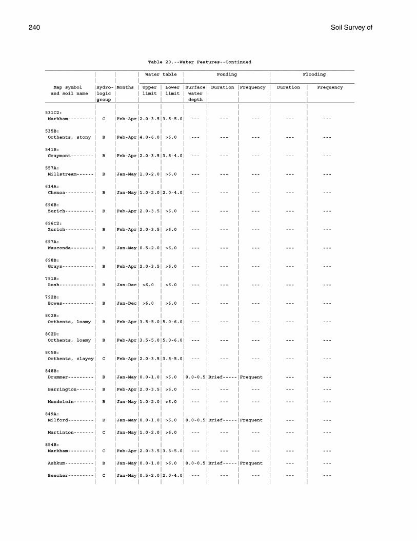
240 Soil Survey of
Table 20.--Water Features--Continued____________________________________________________________________________________________________________ | | | Water table | Ponding | Flooding | | | | | ___________________________________________________________________________ Map symbol |Hydro-|Months | Upper | Lower |Surface| Duration |Frequency | Duration | Frequency and soil name |logic | | limit | limit | water | | | | |group | | | | depth | | | |____________________________________________________________________________________________________________ | | | | | | | | |531C2: | | | | | | | | | Markham---------| C |Feb-Apr|2.0-3.5|3.5-5.0| --- | --- | --- | --- | --- | | | | | | | | |535B: | | | | | | | | | Orthents, stony | B |Feb-Apr|4.0-6.0| >6.0 | --- | --- | --- | --- | --- | | | | | | | | |541B: | | | | | | | | | Graymont--------| B |Feb-Apr|2.0-3.5|3.5-4.0| --- | --- | --- | --- | --- | | | | | | | | |557A: | | | | | | | | | Millstream------| B |Jan-May|1.0-2.0| >6.0 | --- | --- | --- | --- | --- | | | | | | | | |614A: | | | | | | | | | Chenoa----------| B |Jan-May|1.0-2.0|2.0-4.0| --- | --- | --- | --- | --- | | | | | | | | |696B: | | | | | | | | | Zurich----------| B |Feb-Apr|2.0-3.5| >6.0 | --- | --- | --- | --- | --- | | | | | | | | |696C2: | | | | | | | | | Zurich----------| B |Feb-Apr|2.0-3.5| >6.0 | --- | --- | --- | --- | --- | | | | | | | | |697A: | | | | | | | | | Wauconda--------| B |Jan-May|0.5-2.0| >6.0 | --- | --- | --- | --- | --- | | | | | | | | |698B: | | | | | | | | | Grays-----------| B |Feb-Apr|2.0-3.5| >6.0 | --- | --- | --- | --- | --- | | | | | | | | |791B: | | | | | | | | | Rush------------| B |Jan-Dec| >6.0 | >6.0 | --- | --- | --- | --- | --- | | | | | | | | |792B: | | | | | | | | | Bowes-----------| B |Jan-Dec| >6.0 | >6.0 | --- | --- | --- | --- | --- | | | | | | | | |802B: | | | | | | | | | Orthents, loamy | B |Feb-Apr|3.5-5.0|5.0-6.0| --- | --- | --- | --- | --- | | | | | | | | |802D: | | | | | | | | | Orthents, loamy | B |Feb-Apr|3.5-5.0|5.0-6.0| --- | --- | --- | --- | --- | | | | | | | | |805B: | | | | | | | | | Orthents, clayey| C |Feb-Apr|2.0-3.5|3.5-5.0| --- | --- | --- | --- | --- | | | | | | | | |848B: | | | | | | | | | Drummer---------| B |Jan-May|0.0-1.0| >6.0 |0.0-0.5|Brief-----|Frequent | --- | --- | | | | | | | | | Barrington------| B |Feb-Apr|2.0-3.5| >6.0 | --- | --- | --- | --- | --- | | | | | | | | | Mundelein-------| B |Jan-May|1.0-2.0| >6.0 | --- | --- | --- | --- | --- | | | | | | | | |849A: | | | | | | | | | Milford---------| B |Jan-May|0.0-1.0| >6.0 |0.0-0.5|Brief-----|Frequent | --- | --- | | | | | | | | | Martinton-------| C |Jan-May|1.0-2.0| >6.0 | --- | --- | --- | --- | --- | | | | | | | | |854B: | | | | | | | | | Markham---------| C |Feb-Apr|2.0-3.5|3.5-5.0| --- | --- | --- | --- | --- | | | | | | | | | Ashkum----------| B |Jan-May|0.0-1.0| >6.0 |0.0-0.5|Brief-----|Frequent | --- | --- | | | | | | | | | Beecher---------| C |Jan-May|0.5-2.0|2.0-4.0| --- | --- | --- | --- | --- | | | | | | | | |
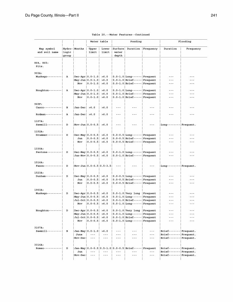
Du Page County, Illinois—Part II 241
Table 20.--Water Features--Continued____________________________________________________________________________________________________________ | | | Water table | Ponding | Flooding | | | | | ___________________________________________________________________________ Map symbol |Hydro-|Months | Upper | Lower |Surface| Duration |Frequency | Duration | Frequency and soil name |logic | | limit | limit | water | | | | |group | | | | depth | | | |____________________________________________________________________________________________________________ | | | | | | | | |864, 865: | | | | | | | | | Pits. | | | | | | | | | | | | | | | | | |903A: | | | | | | | | | Muskego---------| A |Dec-Apr|0.0-1.0| >6.0 |0.0-1.0|Long------|Frequent | --- | --- | |May-Jun|0.0-1.0| >6.0 |0.0-1.0|Brief-----|Frequent | --- | --- | | Nov |0.0-1.0| >6.0 |0.0-1.0|Brief-----|Frequent | --- | --- | | | | | | | | | Houghton--------| A |Dec-Apr|0.0-1.0| >6.0 |0.0-1.0|Long------|Frequent | --- | --- | |May-Jun|0.0-1.0| >6.0 |0.0-1.0|Brief-----|Frequent | --- | --- | | Nov |0.0-1.0| >6.0 |0.0-1.0|Brief-----|Frequent | --- | --- | | | | | | | | |969F: | | | | | | | | | Casco-----------| B |Jan-Dec| >6.0 | >6.0 | --- | --- | --- | --- | --- | | | | | | | | | Rodman----------| A |Jan-Dec| >6.0 | >6.0 | --- | --- | --- | --- | --- | | | | | | | | |1107A: | | | | | | | | | Sawmill---------| D |Nov-Jun|0.0-0.5| >6.0 | --- | --- | --- |Long--------|Frequent. | | | | | | | | |1152A: | | | | | | | | | Drummer---------| D |Dec-May|0.0-0.5| >6.0 |0.0-0.5|Long------|Frequent | --- | --- | | Jun |0.0-0.5| >6.0 |0.0-0.5|Brief-----|Frequent | --- | --- | | Nov |0.0-0.5| >6.0 |0.0-0.5|Brief-----|Frequent | --- | --- | | | | | | | | |1330A: | | | | | | | | | Peotone---------| D |Dec-May|0.0-0.5| >6.0 |0.0-1.0|Long------|Frequent | --- | --- | |Jun-Nov|0.0-0.5| >6.0 |0.0-1.0|Brief-----|Frequent | --- | --- | | | | | | | | |1516A: | | | | | | | | | Faxon-----------| D |Nov-Jun|0.0-0.5|0.5-3.5| --- | --- | --- |Long--------|Frequent. | | | | | | | | |1523A: | | | | | | | | | Dunham----------| D |Dec-May|0.0-0.5| >6.0 |0.0-0.5|Long------|Frequent | --- | --- | | Jun |0.0-0.5| >6.0 |0.0-0.5|Brief-----|Frequent | --- | --- | | Nov |0.0-0.5| >6.0 |0.0-0.5|Brief-----|Frequent | --- | --- | | | | | | | | |1903A: | | | | | | | | | Muskego---------| D |Dec-Apr|0.0-0.5| >6.0 |0.0-1.0|Very long |Frequent | --- | --- | |May-Jun|0.0-0.5| >6.0 |0.0-1.0|Long------|Frequent | --- | --- | |Jul-Oct|0.0-0.5| >6.0 |0.0-1.0|Brief-----|Frequent | --- | --- | | Nov |0.0-0.5| >6.0 |0.0-1.0|Long------|Frequent | --- | --- | | | | | | | | | Houghton--------| D |Dec-Apr|0.0-0.5| >6.0 |0.0-1.0|Very long |Frequent | --- | --- | |May-Jun|0.0-0.5| >6.0 |0.0-1.0|Long------|Frequent | --- | --- | |Jul-Oct|0.0-0.5| >6.0 |0.0-1.0|Brief-----|Frequent | --- | --- | | Nov |0.0-0.5| >6.0 |0.0-1.0|Long------|Frequent | --- | --- | | | | | | | | |3107A: | | | | | | | | | Sawmill---------| B |Jan-May|0.0-1.0| >6.0 | --- | --- | --- |Brief-------|Frequent. | | June | --- | --- | --- | --- | --- |Brief-------|Frequent. | |Nov-Dec| --- | --- | --- | --- | --- |Brief-------|Frequent. | | | | | | | | |3316A: | | | | | | | | | Romeo-----------| D |Jan-May|0.0-0.5|0.5-1.0|0.0-0.5|Brief-----|Frequent |Brief-------|Frequent. | | Jun | --- | --- | --- | --- | --- |Brief-------|Frequent. | |Nov-Dec| --- | --- | --- | --- | --- |Brief-------|Frequent. | | | | | | | | |
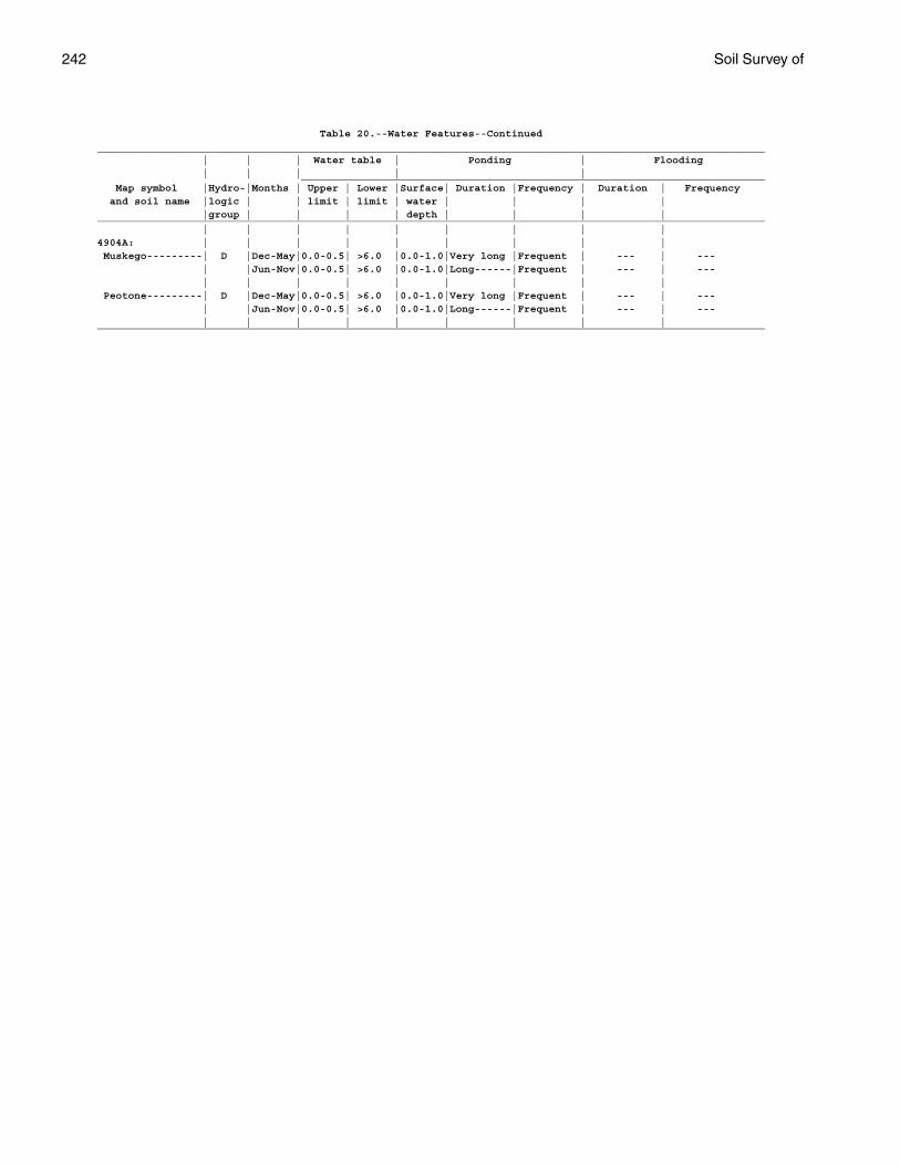
242 Soil Survey of
Table 20.--Water Features--Continued____________________________________________________________________________________________________________ | | | Water table | Ponding | Flooding | | | | | ___________________________________________________________________________ Map symbol |Hydro-|Months | Upper | Lower |Surface| Duration |Frequency | Duration | Frequency and soil name |logic | | limit | limit | water | | | | |group | | | | depth | | | |____________________________________________________________________________________________________________ | | | | | | | | |4904A: | | | | | | | | | Muskego---------| D |Dec-May|0.0-0.5| >6.0 |0.0-1.0|Very long |Frequent | --- | --- | |Jun-Nov|0.0-0.5| >6.0 |0.0-1.0|Long------|Frequent | --- | --- | | | | | | | | | Peotone---------| D |Dec-May|0.0-0.5| >6.0 |0.0-1.0|Very long |Frequent | --- | --- | |Jun-Nov|0.0-0.5| >6.0 |0.0-1.0|Long------|Frequent | --- | --- | | | | | | | | |____________________________________________________________________________________________________________
Du P
age County, Illinois—
Part II
243
Table 21.--Soil Features
(See text for definitions of terms used in this table. Absence of an entry indicates that the feature is not a concern or that data were not estimated.)
_____________________________________________________________________________________________________________________________________ | Restrictive layer | Subsidence | | Risk of corrosion _____________________________________________________________________ _____________________________ Map symbol | | Depth | | | | | Potential | Uncoated | and soil name | Kind |to top |Thickness| Hardness |Initial| Total | for | steel | Concrete | | | | | | |frost action| |_____________________________________________________________________________________________________________________________________ | | In | In | | In | In | | | __ __ __ __ | | | | | | | | |23A, 23B: | | | | | | | | | Blount-------------|Dense material---| 30-48 | --- | --- | --- | --- |High--------|High--------|High. | | | | | | | | |67A: | | | | | | | | | Harpster-----------| --- | >80 | --- | --- | --- | --- |High--------|High--------|Low. | | | | | | | | |69A: | | | | | | | | | Milford------------| --- | >80 | --- | --- | --- | --- |High--------|High--------|Low. | | | | | | | | |91A: | | | | | | | | | Swygert------------|Dense material---| 35-55 | --- | --- | --- | --- |Moderate----|High--------|Low. | | | | | | | | |125A: | | | | | | | | | Selma--------------| --- | >80 | --- | --- | --- | --- |High--------|High--------|Low. | | | | | | | | |146A, 146B: | | | | | | | | | Elliott------------|Dense material---| 20-45 | --- | --- | --- | --- |Moderate----|High--------|Moderate. | | | | | | | | |152A: | | | | | | | | | Drummer------------| --- | >80 | --- | --- | --- | --- |High--------|High--------|Moderate. | | | | | | | | |189A: | | | | | | | | | Martinton----------| --- | >80 | --- | --- | --- | --- |Moderate----|High--------|Moderate. | | | | | | | | |192A: | | | | | | | | | Del Rey------------| --- | >80 | --- | --- | --- | --- |High--------|High--------|Moderate. | | | | | | | | |206A: | | | | | | | | | Thorp--------------| --- | >80 | --- | --- | --- | --- |High--------|High--------|Moderate. | | | | | | | | |223B, 223C2: | | | | | | | | | Varna--------------|Dense material---| 24-60 | --- | --- | --- | --- |Moderate----|Moderate----|Moderate. | | | | | | | | |232A: | | | | | | | | | Ashkum-------------| --- | >80 | --- | --- | --- | --- |High--------|High--------|Moderate. | | | | | | | | |290C2: | | | | | | | | | Warsaw-------------| --- | >80 | --- | --- | --- | --- |Moderate----|Low---------|Moderate. | | | | | | | | |298A, 298B: | | | | | | | | | Beecher------------|Dense material---| 24-45 | --- | --- | --- | --- |High--------|High--------|High. | | | | | | | | |
244S
oil Survey of
Table 21.--Soil Features--Continued_____________________________________________________________________________________________________________________________________ | Restrictive layer | Subsidence | | Risk of corrosion _____________________________________________________________________ _____________________________ Map symbol | | Depth | | | | | Potential | Uncoated | and soil name | Kind |to top |Thickness| Hardness |Initial| Total | for | steel | Concrete | | | | | | |frost action| |_____________________________________________________________________________________________________________________________________ | | In | In | | In | In | | | __ __ __ __ | | | | | | | | |318C2, 318D2: | | | | | | | | | Lorenzo------------| --- | >80 | --- | --- | --- | --- |Moderate----|Moderate----|Moderate. | | | | | | | | |323C2, 323D2: | | | | | | | | | Casco--------------| --- | >80 | --- | --- | --- | --- |Moderate----|Moderate----|Low. | | | | | | | | |327B, 327C2: | | | | | | | | | Fox----------------| --- | >80 | --- | --- | --- | --- |Moderate----|Moderate----|Moderate. | | | | | | | | |330A: | | | | | | | | | Peotone------------| --- | >80 | --- | --- | --- | --- |High--------|High--------|Moderate. | | | | | | | | |369B: | | | | | | | | | Waupecan-----------| --- | >80 | --- | --- | --- | --- |High--------|Moderate----|Moderate. | | | | | | | | |442A: | | | | | | | | | Mundelein----------| --- | >80 | --- | --- | --- | --- |High--------|High--------|Moderate. | | | | | | | | |443B: | | | | | | | | | Barrington---------| --- | >80 | --- | --- | --- | --- |High--------|Moderate----|Moderate. | | | | | | | | |494B: | | | | | | | | | Kankakee-----------| --- | >80 | --- | --- | --- | --- |Moderate----|Low---------|Low. | | | | | | | | |503B: | | | | | | | | | Rockton------------|Bedrock | 20-40 | --- |Indurated--------| --- | --- |Moderate----|Low---------|Low. | (paralithic). | | | | | | | | | | | | | | | | |523A: | | | | | | | | | Dunham-------------| --- | >80 | --- | --- | --- | --- |High--------|High--------|Moderate. | | | | | | | | |526A: | | | | | | | | | Grundelein---------| --- | >80 | --- | --- | --- | --- |High--------|High--------|Moderate. | | | | | | | | |530B, 530C2, 530D2, | | | | | | | | | 530D3, 530E, 530F: | | | | | | | | | Ozaukee-----------|Dense material---| 20-40 | --- | --- | --- | --- |Moderate----|High--------|Low. | | | | | | | | |531B, 531C2: | | | | | | | | | Markham------------|Dense material---| 20-55 | --- | --- | --- | --- |Moderate----|Moderate----|Moderate. | | | | | | | | |535B: | | | | | | | | | Orthents, stony----| --- | >80 | --- | --- | --- | --- |Moderate----|Low---------|Low. | | | | | | | | |541B: | | | | | | | | | Graymont-----------| --- | >80 | --- | --- | --- | --- |High--------|High--------|Moderate. | | | | | | | | |
Du P
age County, Illinois—
Part II
245
Table 21.--Soil Features--Continued_____________________________________________________________________________________________________________________________________ | Restrictive layer | Subsidence | | Risk of corrosion _____________________________________________________________________ _____________________________ Map symbol | | Depth | | | | | Potential | Uncoated | and soil name | Kind |to top |Thickness| Hardness |Initial| Total | for | steel | Concrete | | | | | | |frost action| |_____________________________________________________________________________________________________________________________________ | | In | In | | In | In | | | __ __ __ __ | | | | | | | | |557A: | | | | | | | | | Millstream---------| --- | >80 | --- | --- | --- | --- |High--------|High--------|Moderate. | | | | | | | | |614A: | | | | | | | | | Chenoa-------------| --- | >80 | --- | --- | --- | --- |Moderate----|High--------|Moderate. | | | | | | | | |696B, 696C2: | | | | | | | | | Zurich-------------| --- | >80 | --- | --- | --- | --- |High--------|Moderate----|Moderate. | | | | | | | | |697A: | | | | | | | | | Wauconda-----------| --- | >80 | --- | --- | --- | --- |High--------|High--------|Moderate. | | | | | | | | |698B: | | | | | | | | | Grays--------------| --- | >80 | --- | --- | --- | --- |High--------|Moderate----|Moderate. | | | | | | | | |791B: | | | | | | | | | Rush---------------| --- | >80 | --- | --- | --- | --- |High--------|Moderate----|Moderate. | | | | | | | | |792B: | | | | | | | | | Bowes--------------| --- | >80 | --- | --- | --- | --- |High--------|Moderate----|Moderate. | | | | | | | | |802B, 802D: | | | | | | | | | Orthents, loamy----| --- | >80 | --- | --- | --- | --- |Moderate----|Moderate----|Moderate. | | | | | | | | |805B: | | | | | | | | | Orthents, clayey---| --- | >80 | --- | --- | --- | --- |Moderate----|High--------|High. | | | | | | | | |830: | | | | | | | | | Landfills. | | | | | | | | | | | | | | | | | |848B: | | | | | | | | | Drummer------------| --- | >80 | --- | --- | --- | --- |High--------|High--------|Moderate. | | | | | | | | | Barrington---------| --- | >80 | --- | --- | --- | --- |High--------|Moderate----|Moderate. | | | | | | | | | Mundelein----------| --- | >80 | --- | --- | --- | --- |High--------|High--------|Moderate. | | | | | | | | |849A: | | | | | | | | | Milford------------| --- | >80 | --- | --- | --- | --- |High--------|High--------|Low. | | | | | | | | | Martinton----------| --- | >80 | --- | --- | --- | --- |Moderate----|High--------|Moderate. | | | | | | | | |854B: | | | | | | | | | Markham------------|Dense material---| 20-55 | --- | --- | --- | --- |Moderate----|Moderate----|Moderate. | | | | | | | | | Ashkum-------------| --- | >80 | --- | --- | --- | --- |High--------|High--------|Moderate. | | | | | | | | |
246 Table 21.--Soil Features--Continued_____________________________________________________________________________________________________________________________________ | Restrictive layer | Subsidence | | Risk of corrosion _____________________________________________________________________ _____________________________ Map symbol | | Depth | | | | | Potential | Uncoated | and soil name | Kind |to top |Thickness| Hardness |Initial| Total | for | steel | Concrete | | | | | | |frost action| |_____________________________________________________________________________________________________________________________________ | | In | In | | In | In | | | __ __ __ __ | | | | | | | | |854B: | | | | | | | | | Beecher------------|Dense material---| 24-45 | --- | --- | --- | --- |High--------|High--------|High. | | | | | | | | |864, 865: | | | | | | | | | Pits. | | | | | | | | | | | | | | | | | |903A: | | | | | | | | | Muskego------------| --- | >80 | --- | --- | --- | 35-45 |High--------|Moderate----|Moderate. | | | | | | | | | Houghton-----------| --- | >80 | --- | --- | 6-18 | 55-60 |High--------|High--------|Moderate. | | | | | | | | |969F: | | | | | | | | | Casco--------------| --- | >80 | --- | --- | --- | --- |Moderate----|Moderate----|Low. | | | | | | | | | Rodman-------------| --- | >80 | --- | --- | --- | --- |Low---------|Low---------|Low. | | | | | | | | |1107A: | | | | | | | | | Sawmill------------| --- | >80 | --- | --- | --- | --- |High--------|High--------|Low. | | | | | | | | |1152A: | | | | | | | | | Drummer------------| --- | >80 | --- | --- | --- | --- |High--------|High--------|Moderate. | | | | | | | | |1330A: | | | | | | | | | Peotone------------| --- | >80 | --- | --- | --- | --- |High--------|High--------|Moderate. | | | | | | | | |1516A: | | | | | | | | | Faxon--------------|Bedrock (lithic) | 20-40 | --- |Indurated--------| --- | --- |High--------|High--------|Low. | | | | | | | | |1523A: | | | | | | | | | Dunham-------------| --- | >80 | --- | --- | --- | --- |High--------|High--------|Moderate. | | | | | | | | |1903A: | | | | | | | | | Muskego------------| --- | >80 | --- | --- | --- | 35-45 |High--------|Moderate----|Moderate. | | | | | | | | | Houghton-----------| --- | >80 | --- | --- | 6-18 | 55-60 |High--------|High--------|Moderate. | | | | | | | | |3107A: | | | | | | | | | Sawmill------------| --- | >80 | --- | --- | --- | --- |High--------|High--------|Low. | | | | | | | | |3316A: | | | | | | | | | Romeo--------------|Bedrock (lithic) | 2-10 | --- |Indurated--------| --- | --- |Moderate----|Moderate----|Low. | | | | | | | | |4904A: | | | | | | | | | Muskego------------| --- | >80 | --- | --- | --- | 35-45 |High--------|Moderate----|Moderate. | | | | | | | | | Peotone------------| --- | >80 | --- | --- | --- | --- |High--------|High--------|Moderate. | | | | | | | | |__________________________________________________________________________________________________________________________________
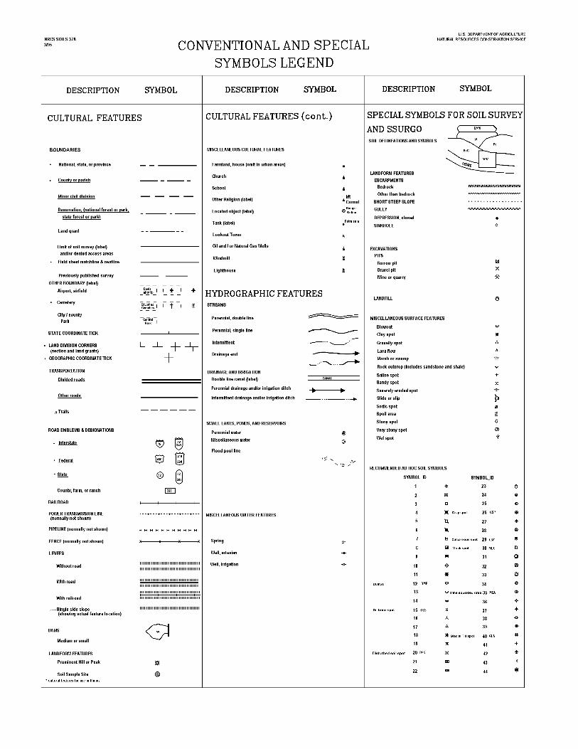
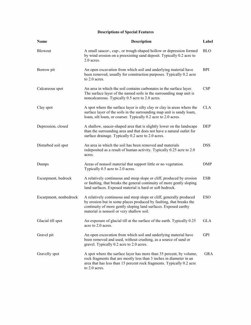
Descriptions of Special Features
Name Description Label
Blowout A small saucer-, cup-, or trough-shaped hollow or depression formedby wind erosion on a preexisting sand deposit. Typically 0.2 acre to2.0 acres.
BLO
Borrow pit An open excavation from which soil and underlying material havebeen removed, usually for construction purposes. Typically 0.2 acreto 2.0 acres.
BPI
Calcareous spot An area in which the soil contains carbonates in the surface layer.The surface layer of the named soils in the surrounding map unit isnoncalcareous. Typically 0.5 acre to 2.0 acres.
CSP
Clay spot A spot where the surface layer is silty clay or clay in areas where thesurface layer of the soils in the surrounding map unit is sandy loam,loam, silt loam, or coarser. Typically 0.2 acre to 2.0 acres.
CLA
Depression, closed A shallow, saucer-shaped area that is slightly lower on the landscapethan the surrounding area and that does not have a natural outlet forsurface drainage. Typically 0.2 acre to 2.0 acres.
DEP
Disturbed soil spot An area in which the soil has been removed and materialsredeposited as a result of human activity. Typically 0.25 acre to 2.0acres.
DSS
Dumps Areas of nonsoil material that support little or no vegetation.Typically 0.5 acre to 2.0 acres.
DMP
Escarpment, bedrock A relatively continuous and steep slope or cliff, produced by erosionor faulting, that breaks the general continuity of more gently slopingland surfaces. Exposed material is hard or soft bedrock.
ESB
Escarpment, nonbedrock A relatively continuous and steep slope or cliff, generally producedby erosion but in some places produced by faulting, that breaks thecontinuity of more gently sloping land surfaces. Exposed earthymaterial is nonsoil or very shallow soil.
ESO
Glacial till spot An exposure of glacial till at the surface of the earth. Typically 0.25acre to 2.0 acres.
GLA
Gravel pit An open excavation from which soil and underlying material havebeen removed and used, without crushing, as a source of sand orgravel. Typically 0.2 acre to 2.0 acres.
GPI
Gravelly spot A spot where the surface layer has more than 35 percent, by volume,rock fragments that are mostly less than 3 inches in diameter in anarea that has less than 15 percent rock fragments. Typically 0.2 acreto 2.0 acres.
GRA
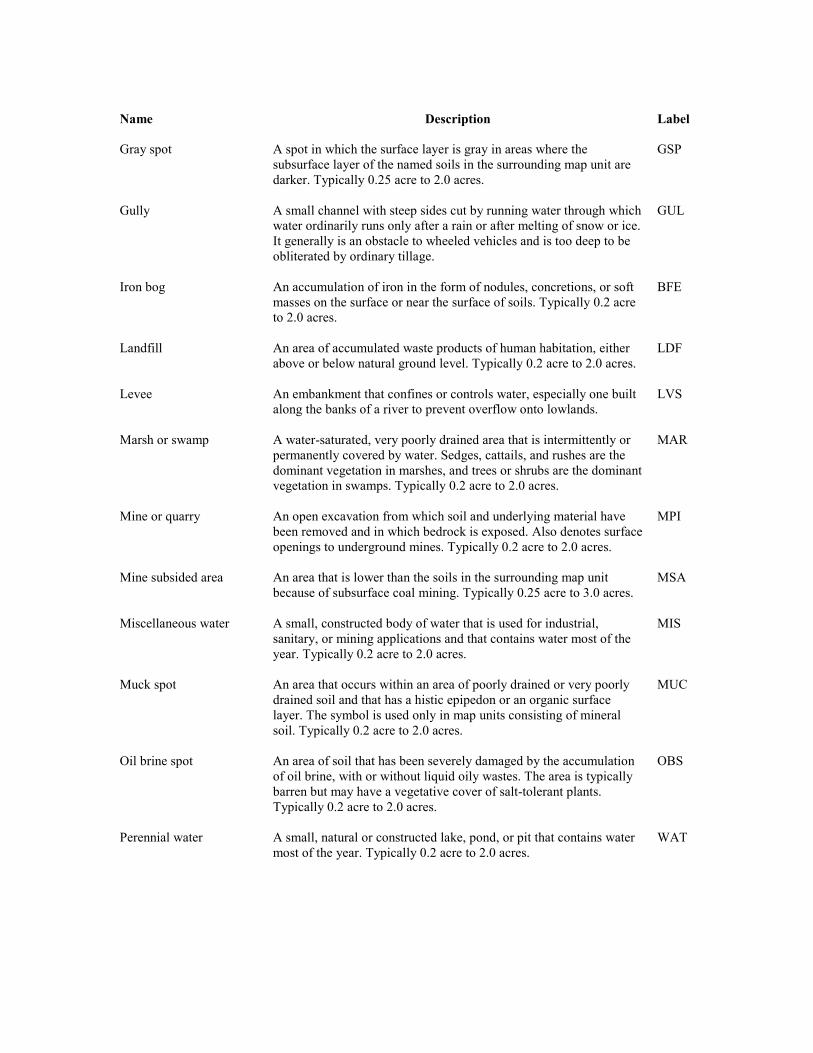
Name Description Label
Gray spot A spot in which the surface layer is gray in areas where thesubsurface layer of the named soils in the surrounding map unit aredarker. Typically 0.25 acre to 2.0 acres.
GSP
Gully A small channel with steep sides cut by running water through whichwater ordinarily runs only after a rain or after melting of snow or ice.It generally is an obstacle to wheeled vehicles and is too deep to beobliterated by ordinary tillage.
GUL
Iron bog An accumulation of iron in the form of nodules, concretions, or softmasses on the surface or near the surface of soils. Typically 0.2 acreto 2.0 acres.
BFE
Landfill An area of accumulated waste products of human habitation, eitherabove or below natural ground level. Typically 0.2 acre to 2.0 acres.
LDF
Levee An embankment that confines or controls water, especially one builtalong the banks of a river to prevent overflow onto lowlands.
LVS
Marsh or swamp A water-saturated, very poorly drained area that is intermittently orpermanently covered by water. Sedges, cattails, and rushes are thedominant vegetation in marshes, and trees or shrubs are the dominantvegetation in swamps. Typically 0.2 acre to 2.0 acres.
MAR
Mine or quarry An open excavation from which soil and underlying material havebeen removed and in which bedrock is exposed. Also denotes surfaceopenings to underground mines. Typically 0.2 acre to 2.0 acres.
MPI
Mine subsided area An area that is lower than the soils in the surrounding map unitbecause of subsurface coal mining. Typically 0.25 acre to 3.0 acres.
MSA
Miscellaneous water A small, constructed body of water that is used for industrial,sanitary, or mining applications and that contains water most of theyear. Typically 0.2 acre to 2.0 acres.
MIS
Muck spot An area that occurs within an area of poorly drained or very poorlydrained soil and that has a histic epipedon or an organic surfacelayer. The symbol is used only in map units consisting of mineralsoil. Typically 0.2 acre to 2.0 acres.
MUC
Oil brine spot An area of soil that has been severely damaged by the accumulationof oil brine, with or without liquid oily wastes. The area is typicallybarren but may have a vegetative cover of salt-tolerant plants.Typically 0.2 acre to 2.0 acres.
OBS
Perennial water A small, natural or constructed lake, pond, or pit that contains watermost of the year. Typically 0.2 acre to 2.0 acres.
WAT
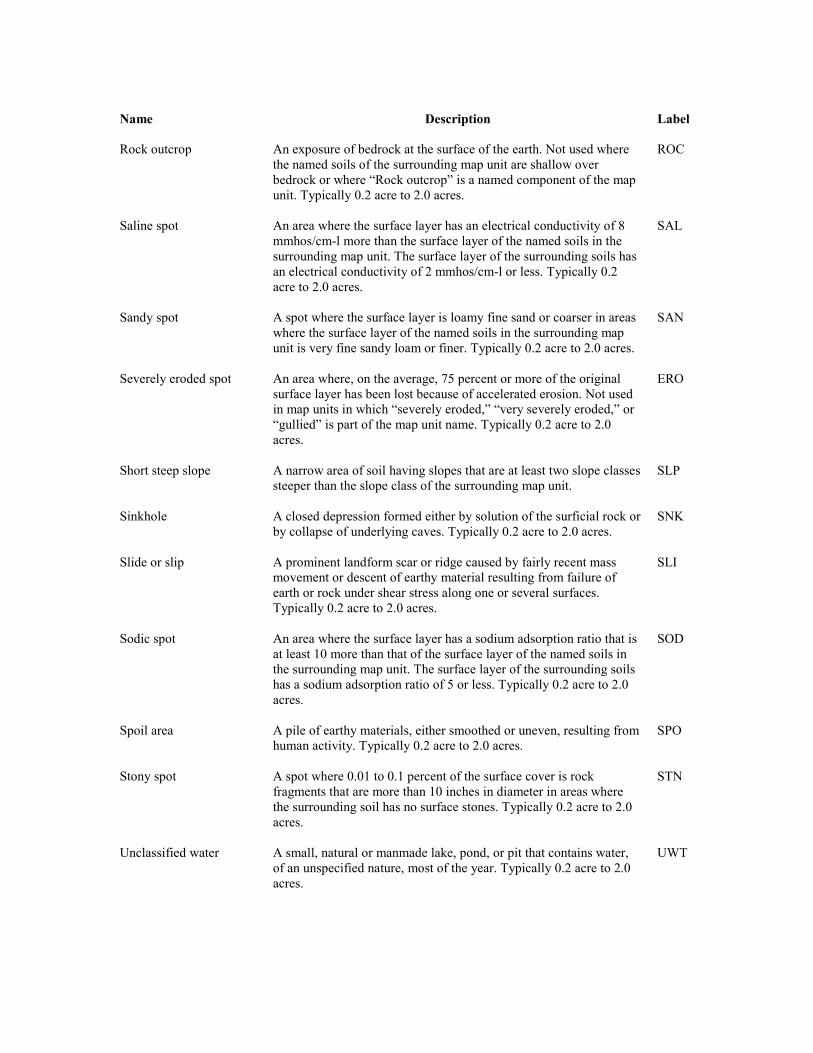
Name Description Label
Rock outcrop An exposure of bedrock at the surface of the earth. Not used wherethe named soils of the surrounding map unit are shallow overbedrock or where “Rock outcrop” is a named component of the mapunit. Typically 0.2 acre to 2.0 acres.
ROC
Saline spot An area where the surface layer has an electrical conductivity of 8mmhos/cm-l more than the surface layer of the named soils in thesurrounding map unit. The surface layer of the surrounding soils hasan electrical conductivity of 2 mmhos/cm-l or less. Typically 0.2acre to 2.0 acres.
SAL
Sandy spot A spot where the surface layer is loamy fine sand or coarser in areaswhere the surface layer of the named soils in the surrounding mapunit is very fine sandy loam or finer. Typically 0.2 acre to 2.0 acres.
SAN
Severely eroded spot An area where, on the average, 75 percent or more of the originalsurface layer has been lost because of accelerated erosion. Not usedin map units in which “severely eroded,” “very severely eroded,” or“gullied” is part of the map unit name. Typically 0.2 acre to 2.0acres.
ERO
Short steep slope A narrow area of soil having slopes that are at least two slope classessteeper than the slope class of the surrounding map unit.
SLP
Sinkhole A closed depression formed either by solution of the surficial rock orby collapse of underlying caves. Typically 0.2 acre to 2.0 acres.
SNK
Slide or slip A prominent landform scar or ridge caused by fairly recent massmovement or descent of earthy material resulting from failure ofearth or rock under shear stress along one or several surfaces.Typically 0.2 acre to 2.0 acres.
SLI
Sodic spot An area where the surface layer has a sodium adsorption ratio that isat least 10 more than that of the surface layer of the named soils inthe surrounding map unit. The surface layer of the surrounding soilshas a sodium adsorption ratio of 5 or less. Typically 0.2 acre to 2.0acres.
SOD
Spoil area A pile of earthy materials, either smoothed or uneven, resulting fromhuman activity. Typically 0.2 acre to 2.0 acres.
SPO
Stony spot A spot where 0.01 to 0.1 percent of the surface cover is rockfragments that are more than 10 inches in diameter in areas wherethe surrounding soil has no surface stones. Typically 0.2 acre to 2.0acres.
STN
Unclassified water A small, natural or manmade lake, pond, or pit that contains water,of an unspecified nature, most of the year. Typically 0.2 acre to 2.0acres.
UWT
Name Description Label
Very stony spot A spot where 0.1 to 3.0 percent of the surface cover is rockfragments that are more than 10 inches in diameter in areas wherethe surface cover of the surrounding soil is less than 0.01 percentstones. Typically 0.2 acre to 2.0 acres.
STV
Wet depression A shallow, concave area within an area of poorly drained or verypoorly drained soils in which water is ponded for intermittentperiods. The concave area is saturated for appreciably longer periodsof time than the surrounding soil. Typically 0.2 acre to 2.0 acres.
WDP
Wet spot A somewhat poorly drained to very poorly drained area that is atleast two drainage classes wetter than the named soils in thesurrounding map unit. Typically 0.2 acres to 2.0 acres.
WET
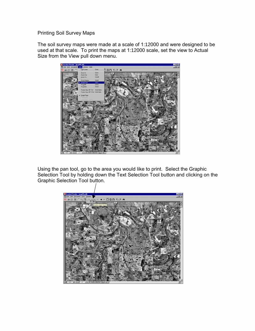
Printing Soil Survey Maps
The soil survey maps were made at a scale of 1:12000 and were designed to beused at that scale. To print the maps at 1:12000 scale, set the view to ActualSize from the View pull down menu.
Using the pan tool, go to the area you would like to print. Select the GraphicSelection Tool by holding down the Text Selection Tool button and clicking on theGraphic Selection Tool button.
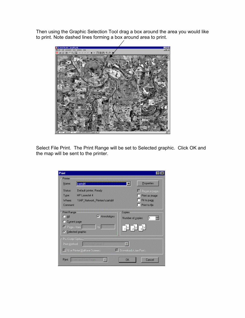
Then using the Graphic Selection Tool drag a box around the area you would liketo print. Note dashed lines forming a box around area to print.
Select File Print. The Print Range will be set to Selected graphic. Click OK andthe map will be sent to the printer.