soil moisture anomaly (sma) · lisflood soil water balance model – for example regarding soil...
TRANSCRIPT
Copernicus European Drought Observatory (EDO): http://edo.jrc.ec.europa.eu/ © European Commission, 2019.
- 1 -
EDO INDICATOR FACTSHEET
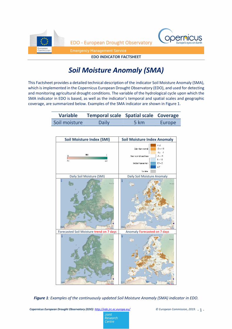
Soil Moisture Anomaly (SMA) This Factsheet provides a detailed technical description of the indicator Soil Moisture Anomaly (SMA), which is implemented in the Copernicus European Drought Observatory (EDO), and used for detecting and monitoring agricultural drought conditions. The variable of the hydrological cycle upon which the SMA indicator in EDO is based, as well as the indicator’s temporal and spatial scales and geographic coverage, are summarized below. Examples of the SMA indicator are shown in Figure 1.
Variable Temporal scale Spatial scale Coverage
Soil moisture Daily 5 km Europe
Soil Moisture Index (SMI) Soil Moisture Index Anomaly
Daily Soil Moisture (SMI) Daily Soil Moisture Anomaly
Forecasted Soil Moisture trend on 7 days Anomaly Forecasted on 7 days
Figure 1: Examples of the continuously updated Soil Moisture Anomaly (SMA) indicator in EDO.
Copernicus European Drought Observatory (EDO): http://edo.jrc.ec.europa.eu/ © European Commission, 2019.
- 2 -
The Soil Moisture Anomaly (SMA) indicator that is implemented in the Copernicus European Drought Observatory (EDO) is used for determining the start and duration of agricultural drought conditions, which arise when soil moisture availability to plants drops to such a level that it adversely affects crop yield, and hence, agricultural production. The SMA indicator in EDO is computed every 10-day (dekad) as anomalies of soil moisture index derived from the JRC’s in-house LISFLOOD hydrological model (de Roo et al. 2000), and which has been shown to be effective for drought detection purposes (Laguardia and Niemeyer, 2008).
Soil moisture (or soil water content) is an important variable for plant growth, and - together with precipitation and evapotranspiration - is a basic component of the hydrological cycle. The SMA indicator in EDO, which is computed based on daily estimates of soil moisture produced by the JRC’s LISFLOOD hydrological model, and their anomalies relative to a climatological reference period (1995- last available full year), shows both the dekad soil moisture content and anomalies, as well as daily forecasted conditions for seven days ahead (see Figure 1). The SMA indicator is used to detect and monitor agricultural drought, which is one of three main types of drought that are defined according to the variables of the hydrological cycle (i.e., precipitation; soil moisture; groundwater; streamflow) that are most affected. Meteorological drought is a prolonged period of less than average rainfall in a given region, which generally precedes agricultural drought, when there is reduced crop production due to insufficient soil moisture, and hydrological drought, when there is below-normal water availability in rivers, streams, reservoirs, lakes, or groundwater.
The SMA indicator which is implemented in EDO is computed based on estimates of daily soil water content, which is one of the output parameters of the JRC’s LISFLOOD hydrological model. Soil water content is converted into the soil moisture index (SMI, ranging between 0 and 1), which is computed by normalizing the soil moisture between the wilting point and the field capacity, following the approach suggested by van Genuchten (1987). SMI is equal to 0 when the soil is severely dry (wilting point) and equal to 1 when the soil moisture is above the field capacity. The SMA indicator is computed in three main steps, as described below. 1. Calculation of daily soil moisture content: LISFLOOD is a hydrological rainfall-runoff model which has been developed by the JRC of the European Commission in order to reproduce the hydrology of large and trans-national European river catchments (de Roo et al., 2000; van der Knijff et al., 2008), and which currently runs operationally within the Copernicus European Flood Awareness System (EFAS, http://www.efas.eu/). Input data for the LISFLOOD model include daily meteorological observations for the European continent, updated with a two-day delay, which are obtained from the JRC’s MARS-AGRI4CAST database1, and which are extended for seven days using numerical
1 http://agri4cast.jrc.ec.europa.eu/DataPortal/

Copernicus European Drought Observatory (EDO): http://edo.jrc.ec.europa.eu/ © European Commission, 2019.
- 3 -
weather forecasts produced by the European Centre for Medium-Range Weather Forecasts (ECMWF). The LISFLOOD model simulates soil moisture in two surface layers (skin layer and root zone) separately for forested and other layers. These four soil moisture layers are averaged daily to derive a single mean root zone soil moisture conditions to be successively standardized into SMI, as:
SMI = 1 −1
1 + (𝜃
𝜃50)
6
where is the daily soil moisture and 50 is the mean between the wilting point and the field capacity. 2. Calculation of daily soil moisture anomalies: For each location (grid-cell), the dekad soil moisture anomaly (SMA) is calculated as follows:
SMA = SMI𝑡 − SMI̅̅ ̅̅ ̅
𝛿SMI
where SMI𝑡 is the dekad average SMI for the dekad t of the current year, SMI̅̅ ̅̅ ̅ is the long-term average and δSMI is the standard deviation, which are both calculated for the same period t with a baseline period of 1995-last available full year (e.g., 1995-2018 for maps in 2019). According to this definition, the anomaly values are expressed as units of standard deviation. 3. Calculation of the forecasted trend: The forecasted values of daily soil moisture and anomalies are calculated over the ECMWF numerical weather forecast. In practice, the LISFLOOD model calculates soil moisture from the most recent observation for the following seven days. The forecasted values provide an estimate of the conditions of both SMI and SMA 7 days ahead of the current date.
The EDO MapServer automatically updates (every dekad) the maps of SMI and SMA; additionally, the forecasts of daily SMI and SMA are updated every day based on the most recent data available and the weather forecast. These maps provide information on the spatial distribution of soil water, and its evolution over time. The SMI data can be used as a direct indicator for determining the start and duration of water stress. The SMA is related to the occurrence of agricultural drought since it represents the deviation of the current conditions from the usual status of water availability. In this regard, negative anomalies (i.e., < -1) are usually associated with drought conditions. Soil moisture content is also strongly connected to plant biomass accumulation (i.e. gross primary production) in many environments (e.g. dry; semi-arid; arid) where water availability is the main limiting factor. The maps of soil moisture content and soil moisture anomalies, shown in Figure 1, can be used as a “proxy” for the presence of potential drought conditions, as indicated by low values of soil moisture index and large negative deviations from the long-term average conditions.

Copernicus European Drought Observatory (EDO): http://edo.jrc.ec.europa.eu/ © European Commission, 2019.
- 4 -
Strengths: The dekad update of the SMA indicator in EDO, together with the use of weather forecast data,
provides timely information on the modelled soil moisture content, and of the spatial extension of the area affected by or at risk of drought conditions. Moreover, analysis of a time-series of SMA indicators can be used to estimate the duration and the severity of drought.
Weaknesses: The various conceptual generalizations and scientific assumptions that are intrinsic in the
LISFLOOD soil water balance model – for example regarding soil physics, land use, canopy cover, meteorological data interpolation, etc. – and also the calibration of the model, may produce in some case large approximations of the actual soil moisture content, and a progressive divergence with the real conditions.
o de Roo, A., C. Wesseling, and W. van Deursen. 2000. Physically based river basin modelling
within a GIS: the LISFLOOD model, Hydrological Processes, 14, 1981–1992. https://doi.org/10.1002/1099-1085(20000815/30)14:11/12<1981::AID-HYP49>3.0.CO;2-F.
o Laguardia, G. and S. Niemeyer. 2008. On the comparison between the LISFLOOD modelled and the ERS/SCAT derived soil moisture estimates. Hydrology and Earth System Sciences, 12, 1339-1351. https://www.hydrol-earth-syst-sci.net/12/1339/2008/.
o van der Knijff, J., J. Younis, and A. de Roo. 2008. LISFLOOD: A GIS-based distributed model for river basin scale water balance and flood simulation. International Journal of Geographical Information Science, Vol. 24, No. 2, p. 189-212. Doi: 10.1080/13658810802549154.
o Van Genuchten, M.T., 1987. A numerical model for water and solute movement in and below
root zone. Research Report No 121. U.S. Salinity Laboratory, USDA, ARS: Riverside, California, USA.