soil erosion in europe (boardman/soil erosion in europe) || macedonia
TRANSCRIPT
1.24
Macedonia
Ivan Blinkov and Alexandar Trendafilov
Department of Erosion and Surveying, Faculty of Forestry, University ‘St Cyril and Methodius’,1000 Skopje, Macedonia
1.24.1 PHYSICAL GEOGRAPHY
The Republic of Macedonia (RM) is located in the central part of the Balkan Peninsula. It is a landlocked
country having an area of 25 713 km2 with approximately 80% of the entire territory in hilly and mountainous
regions. About 2 % of the land area is covered by water comprising 35 large and small rivers, three natural
lakes (Ohrid Lake, Prespa Lake, Dojran Lake) and over 100 reservoirs. The population of the country is around
2 million, of which about 60 % live in urban areas and the overall population density is 81 inhabitants per km2.
The major urban centres are Skopje, Bitola, Tetovo, Kumanovo, Veles, Prilep, Stip, Ohrid, Strimica and
Gostivar.
Industry is the dominant sector, accounting for 35% of the gross social product (GSP) and 39.9% of
employment. Agriculture combined with forestry and fishing and the service sector account for 22% and 30%
of the GSP, respectively.
Although the RM is small in area, it shows a great diversity of relief forms, geological formations, climate,
plants and soils.
The difference in altitude is from 40 to 2764 m above sea level. The territory of the RM belongs to three basins: the
Black Sea (44 km2 or 0.17%), the Adriatic (3359 km2 or 13.07%) and the Aegean (22 310 km2 or 86.76%). The main
river is the Vardar with a catchment area of 20 545 km2 (79.9% of the whole territory).
As a result of the heterogeneity of natural conditions, the territory of the RM can be distributed into eight
climate–soil–vegetation zones. About 56% of the territory belongs to two zones (continental submediterranean
and warm continental). The average annual temperature is 10.5 �C, with absolute extremes of 44.3 and
�31.5 �C. Average annual precipitation is 660 mm.
Soil Erosion in Europe Edited by J. Boardman and J. Poesen# 2006 John Wiley & Sons, Ltd. ISBN: 0-470-85910-5
About 25% (634 000 ha) of the total land area is pasture, 25% (550 000 ha) arable, 55 300 ha meadows,
57 000 ha vineyards and orchards, 8% (20 5000 ha) barren, 37.5% (965 650 ha) forest, 2% lakes and 2.5%
urban or industrial land. The 1982 Physical Plan projected an increase in forest land and a decrease in
agricultural land over the forthcoming decades. About 60% of the population live in urban areas and over the
last 20 years there have been absolute decreases in population in many of the rural areas.
Fertile land is scarce, with 82% of arable land in fertility classes IV–VII. Because of recent declines in the
rural population and economic activity, fallow and uncultivated land is increasing in area, comprising about
160 000 ha in 1993, or 30% of arable land. About 70% of arable land is privately owned and plans are under
way to privatize the remainder.
Pasture constitutes about 634 000 ha but yields are well below potential, averaging only about
270 kg ha�1 (potential yields could be as high as 800 kg ha�1). The low yields may also indicate that
some of this land may be more appropriate as forest. In the past, much pastureland in Macedonia, as
elsewhere in the Balkans, was previously forested. Pasture is managed by the public enterprise
‘Macedonian Pastures’.
Forest reserves cover about 1� 106 ha or 37.5% of the land area of Macedonia. This is characteristic of oak
stands. About 50% of forests comprise pure and mixed oak stands (480 000 ha), 29% (285 000 ha) beech, 8%
(80 000 ha) black pine and Scotch pine and 15% other stands. About 67% of forests are coppiced. Degraded
forests and shrubs cover 262 000 ha (27%) of the forest land. A substantial proportion of the forest is located
on steeply sloping land, where forest cover is necessary for soil conservation and watershed protection
purposes, and where logging is restricted.
Urban growth has not always been accompanied by adequate infrastructure development, and urban
expansion has frequently taken place on high-quality agricultural land. According to some estimates, about
0.5% of agricultural land is lost annually to construction.
1.24.2 HISTORICAL EVIDENCE FOR EROSION
A lot of natural conditions in RM (climate condition, topography, vegetation cover, geology) contribute to high
rates of erosion. Also, poor arable farming, grazing management and deforestation in the past have contributed
to erosion, a problem affecting all of the country.
Deforestation was extreme before World War II. In the 13–14th centuries, German miners arrived in
Macedonia and started mining activities especially in the east and north-east. They cut forests and used wood
for fuel and mining construction.
The Turkish Ottoman Empire governed Macedonia for five centuries from the 14th to the beginning of the
20th century. Wood from forests in the central part of Macedonia was fully cut and transported along the River
Vardar to Thessalonica. Today in that area, part of the left side of the river in Central Macedonia is possibly the
only semi-desert in Europe.
Forests around the settlements were also degraded. Low education levels, insufficient awareness, social
structure and poverty were reasons for extensive forest destruction around the settlements.
1.24.3 CURRENT EROSION PROCESSES
There is an Erosion Map prepared at a scale of 1:50 000 in a database version. This version was finished in
1992. The digital version was finished in 2002.
The empirical methodology of Gavrilovic (which is similar to methodology of Poljakov) was used for
mapping erosion intensity.
290 Soil Erosion in Europe
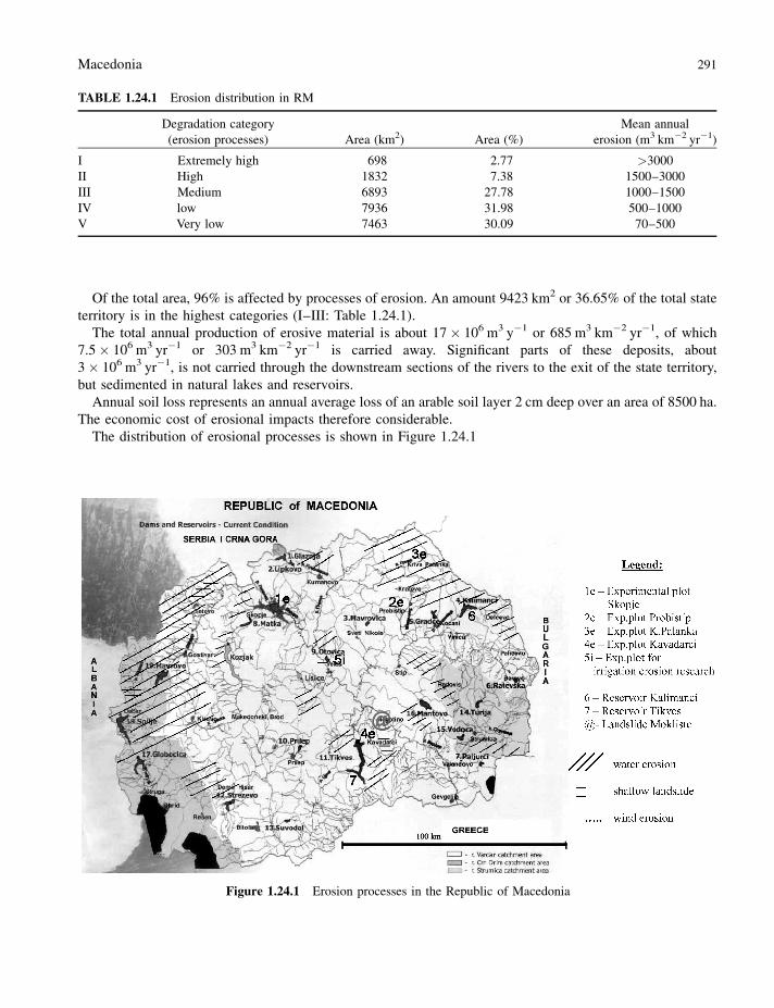
Of the total area, 96% is affected by processes of erosion. An amount 9423 km2 or 36.65% of the total state
territory is in the highest categories (I–III: Table 1.24.1).
The total annual production of erosive material is about 17� 106 m3 y�1 or 685 m3 km�2 yr�1, of which
7.5� 106 m3 yr�1 or 303 m3 km�2 yr�1 is carried away. Significant parts of these deposits, about
3� 106 m3 yr�1, is not carried through the downstream sections of the rivers to the exit of the state territory,
but sedimented in natural lakes and reservoirs.
Annual soil loss represents an annual average loss of an arable soil layer 2 cm deep over an area of 8500 ha.
The economic cost of erosional impacts therefore considerable.
The distribution of erosional processes is shown in Figure 1.24.1
TABLE 1.24.1 Erosion distribution in RM
Degradation category
(erosion processes) Area (km2) Area (%)
Mean annual
erosion (m3 km�2 yr�1)
I Extremely high 698 2.77 >3000
II High 1832 7.38 1500–3000
III Medium 6893 27.78 1000–1500
IV low 7936 31.98 500–1000
V Very low 7463 30.09 70–500
Figure 1.24.1 Erosion processes in the Republic of Macedonia
Macedonia 291
1.24.3.1 Soil Loss on Experimental Plots
Research has been carried out on experimental plots with an area of 100 m2 where sediment is collected at the
downstream edge and later analysed in a laboratory (Jovanovski and Blinkov, 1992–98). Collectors were
perforated and buried in the soil to allow drainage of water while retaining the sediment.
There are four different locations: Skopje (Figure 1.24.1, marked 1e), Probistip (2e), Kriva Palanka (3e) and
Kavadarci (4e), with two experimental plots, one of which is natural vegetation (grass, bushes, trees) and the
other simulates an arable area. The data (sediment) were gathered during the period 1993–98 several times
during the year (Table 1.24.2–1.24.4).
Although there are insufficient data, preliminary relationships between the annual soil loss and the slope
were estimated:
y ¼ 329:1x� 3884:5 ðr2 ¼ 0:91Þ
TABLE 1.24.2 Basic characteristics of the experimental plots
Skopje (1e) Probistip (2e) K. Palanka(3e) Kavadarci (4e)
Land use Abandoned arable land
Slope (%) 11 21 27 16
Bad rock Palaeogene sediments Neogene sediments Gneiss and
micaschists
Palaeogene
sediments
Soil type Chromic cambisol Smolnitza (vertisol) Chromic cambisol Colluvial soil
Vegetation cover (%) 90 100 90 95
TABLE 1.24.3 Mean annual precipitation [P (mm)] and temperature [t (�C)] during the research period and long period
of observation
Skopje (1e) Probistip (2e) K. Palanka (3e) Kavadarci (4e)
Period P (mm) t (�C) P (m) t (�C) P (mm) t (�C) P (mm) t (�C)
1993–98 404.3 12.9 442.6 12.8 540.2 10.3 497.5 13.7
1951–90 501.7 12.5 471.8 12.8 633.5 10.1 476.7 13.8
Ratio: data 1993–98 (D1)/data 1951–90 (D2)
D1/D2 0.81 1.03 0.94 1.00 0.85 1.02 1.04 0.99
TABLE 1.24.4 Mean annual soil and nutrient losses on experimental plots
Mean annual soil and nutrient losses
Soil K2O P2O5 N Humus
Plot (t ha�1) (kg ha�1) (kg ha�1) (kg ha�1) (kg ha�1)
Skopje (1e) 0.040 0.021 0.008 0.172 1.929
Probistip (2e) 3.833 1.598 0.401 1.370 19.226
K. Palanka (3e) 4.773 1.426 0.737 2.704 33.546
Kavadarci (4e) 0.498 0.228 0.109 0.082 2.063
292 Soil Erosion in Europe
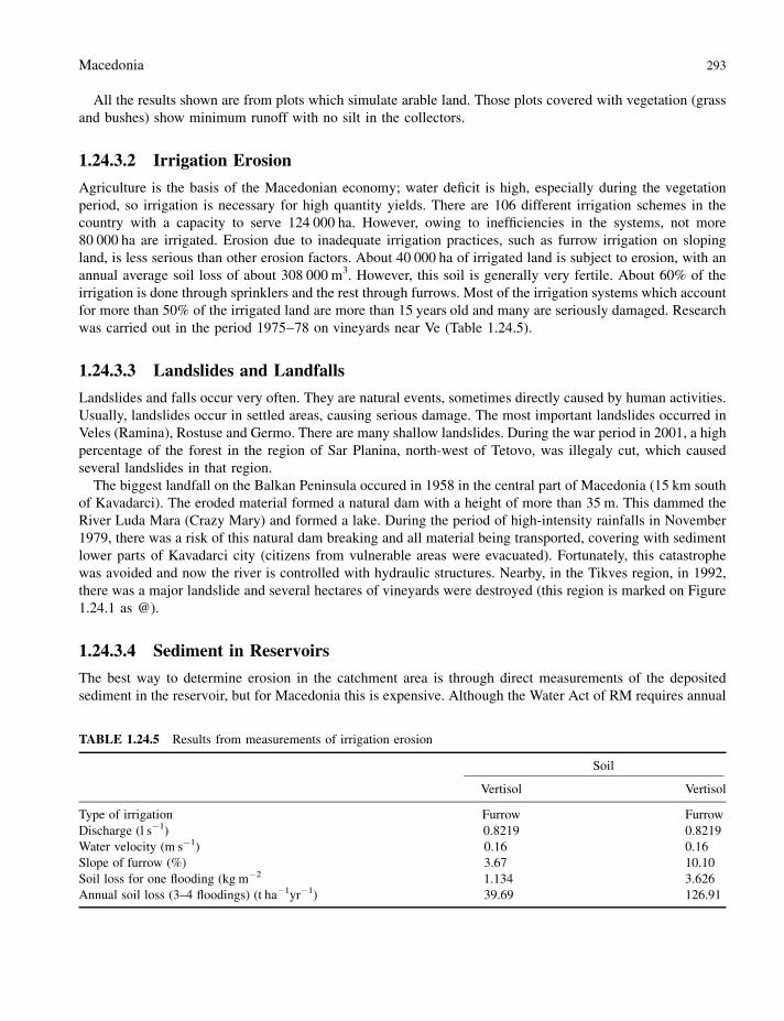
All the results shown are from plots which simulate arable land. Those plots covered with vegetation (grass
and bushes) show minimum runoff with no silt in the collectors.
1.24.3.2 Irrigation Erosion
Agriculture is the basis of the Macedonian economy; water deficit is high, especially during the vegetation
period, so irrigation is necessary for high quantity yields. There are 106 different irrigation schemes in the
country with a capacity to serve 124 000 ha. However, owing to inefficiencies in the systems, not more
80 000 ha are irrigated. Erosion due to inadequate irrigation practices, such as furrow irrigation on sloping
land, is less serious than other erosion factors. About 40 000 ha of irrigated land is subject to erosion, with an
annual average soil loss of about 308 000 m3. However, this soil is generally very fertile. About 60% of the
irrigation is done through sprinklers and the rest through furrows. Most of the irrigation systems which account
for more than 50% of the irrigated land are more than 15 years old and many are seriously damaged. Research
was carried out in the period 1975–78 on vineyards near Ve (Table 1.24.5).
1.24.3.3 Landslides and Landfalls
Landslides and falls occur very often. They are natural events, sometimes directly caused by human activities.
Usually, landslides occur in settled areas, causing serious damage. The most important landslides occurred in
Veles (Ramina), Rostuse and Germo. There are many shallow landslides. During the war period in 2001, a high
percentage of the forest in the region of Sar Planina, north-west of Tetovo, was illegaly cut, which caused
several landslides in that region.
The biggest landfall on the Balkan Peninsula occured in 1958 in the central part of Macedonia (15 km south
of Kavadarci). The eroded material formed a natural dam with a height of more than 35 m. This dammed the
River Luda Mara (Crazy Mary) and formed a lake. During the period of high-intensity rainfalls in November
1979, there was a risk of this natural dam breaking and all material being transported, covering with sediment
lower parts of Kavadarci city (citizens from vulnerable areas were evacuated). Fortunately, this catastrophe
was avoided and now the river is controlled with hydraulic structures. Nearby, in the Tikves region, in 1992,
there was a major landslide and several hectares of vineyards were destroyed (this region is marked on Figure
1.24.1 as @).
1.24.3.4 Sediment in Reservoirs
The best way to determine erosion in the catchment area is through direct measurements of the deposited
sediment in the reservoir, but for Macedonia this is expensive. Although the Water Act of RM requires annual
TABLE 1.24.5 Results from measurements of irrigation erosion
Soil
Vertisol Vertisol
Type of irrigation Furrow Furrow
Discharge (l s�1) 0.8219 0.8219
Water velocity (m s�1) 0.16 0.16
Slope of furrow (%) 3.67 10.10
Soil loss for one flooding (kg m�2 1.134 3.626
Annual soil loss (3–4 floodings) (t ha�1yr�1) 39.69 126.91
Macedonia 293
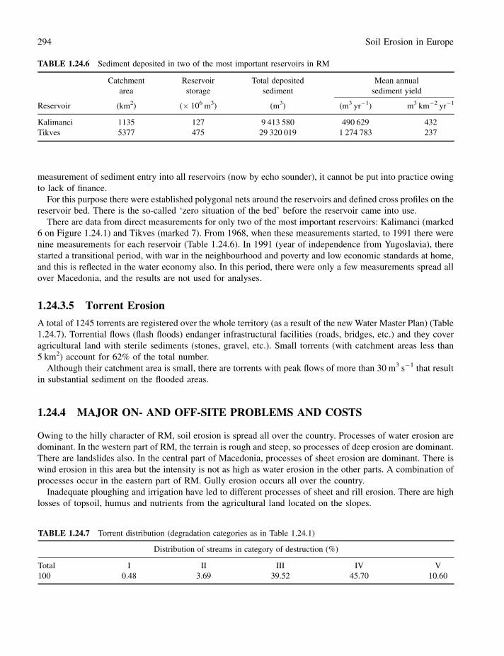
measurement of sediment entry into all reservoirs (now by echo sounder), it cannot be put into practice owing
to lack of finance.
For this purpose there were established polygonal nets around the reservoirs and defined cross profiles on the
reservoir bed. There is the so-called ‘zero situation of the bed’ before the reservoir came into use.
There are data from direct measurements for only two of the most important reservoirs: Kalimanci (marked
6 on Figure 1.24.1) and Tikves (marked 7). From 1968, when these measurements started, to 1991 there were
nine measurements for each reservoir (Table 1.24.6). In 1991 (year of independence from Yugoslavia), there
started a transitional period, with war in the neighbourhood and poverty and low economic standards at home,
and this is reflected in the water economy also. In this period, there were only a few measurements spread all
over Macedonia, and the results are not used for analyses.
1.24.3.5 Torrent Erosion
A total of 1245 torrents are registered over the whole territory (as a result of the new Water Master Plan) (Table
1.24.7). Torrential flows (flash floods) endanger infrastructural facilities (roads, bridges, etc.) and they cover
agricultural land with sterile sediments (stones, gravel, etc.). Small torrents (with catchment areas less than
5 km2) account for 62% of the total number.
Although their catchment area is small, there are torrents with peak flows of more than 30 m3 s�1 that result
in substantial sediment on the flooded areas.
1.24.4 MAJOR ON- AND OFF-SITE PROBLEMS AND COSTS
Owing to the hilly character of RM, soil erosion is spread all over the country. Processes of water erosion are
dominant. In the western part of RM, the terrain is rough and steep, so processes of deep erosion are dominant.
There are landslides also. In the central part of Macedonia, processes of sheet erosion are dominant. There is
wind erosion in this area but the intensity is not as high as water erosion in the other parts. A combination of
processes occur in the eastern part of RM. Gully erosion occurs all over the country.
Inadequate ploughing and irrigation have led to different processes of sheet and rill erosion. There are high
losses of topsoil, humus and nutrients from the agricultural land located on the slopes.
TABLE 1.24.6 Sediment deposited in two of the most important reservoirs in RM
Catchment
area
Reservoir
storage
Total deposited
sediment
Mean annual
sediment yield
Reservoir (km2) (� 106 m3) (m3) (m3 yr�1) m3 km�2 yr�1
Kalimanci 1135 127 9 413 580 490 629 432
Tikves 5377 475 29 320 019 1 274 783 237
TABLE 1.24.7 Torrent distribution (degradation categories as in Table 1.24.1)
Distribution of streams in category of destruction (%)
Total I II III IV V
100 0.48 3.69 39.52 45.70 10.60
294 Soil Erosion in Europe
Torrential flows are very frequent. There is no city in Macedonia without problems with torrents and their
consequences: sedimentation of material in the urban area, damaged streets, bridges, houses and other
infrastructure and sometimes with human victims.
Sedimentation in reservoirs is one of the greatest problems. Hence water management enterprises are
interested in erosion processes and have invested in anti-erosion measures.
1.24.5 SOIL CONSERVATION AND POLICIES
Measures to control erosion were initiated in the early 1900s, aimed mostly at protecting rivers and reservoirs.
Following the passage of the Law on Financing Melioration Systems, these measures were strengthened, and
as of 1985, 285 basins were regulated. The water management projections anticipate continuing this work.
Given likely budgetary constraints over the coming years, it would be advisable to prioritize these investments.
Measures to control erosion on deforested barren lands have also been under way since 1945, when
restrictions were placed on nomadic breeding of goats and sheep in forests. This measure, although unpopular,
led to a recovery of degraded forest and shrub land.
There were few Acts directly related to erosion control in the past: the Act for Afforestation of Bareland
(1951), Act for Erosion Control on Steep Slopes (1952) and Act for Steep Slope Protection and Torrent
Control (1957). Later, these Acts were suspended.
As part of the erosion control programme, an ‘Afforestation Fund’ was established in 1970. Under these
measures, 164 360 ha were afforested, which was 260% more than planned. Since 1990, afforestation has
declined 10-fold, mainly because of budget constraints. In an environment of limited available resources, a
programme to prioritize areas for afforestation would be useful. There are conflicts in certain areas between
afforestation of barren lands and preservation of pastures, even if their quality is poor.
The new Physical Plan of RM (proposal version 2003), predicts afforestation of 80 000 ha of bareland
spread over the country. The best way of addressing this issue is through close consultation with farmers and
adoption of an integrated approach to watershed management.
Until 1990, anti-erosion measures and activities were on a ‘higher level’ and institutional support was
higher. There were sections for erosion control in all regional water management enterprises. There were parts
of the budget aimed at erosion control.
Now, the situation is the opposite. Unfortunately, erosion is one the largest environmental and economic
problems in RM, but there is no special Act for erosion control. There are some articles in other regulations
(Water Act, Forest Law, Agricultural Land Act, Promotion of the Environment Act), but implementation of
these articles is not sufficient for adequate erosion control.
RM ratified the UNCCD convention in 2002. Soil erosion is seen as the most important natural contributor
to land degradation and desertification in RM. There is an ongoing project, ‘National capacity self assessment
for implementation of UNCCD’. A few projects related to UNCCD are planned: national strategy and national
and regional action plans.
1.24.6 CONCLUSIONS
Owing to the natural conditions, soil erosion is one of the greatest environmental problems in RM. The
vegetation cover is not sufficient to combat erosion processes. Also, some human activities in the last 13 years
have contributed to an increase in erosion processes.
Illegal forest cutting, especially in war-affected areas, is a major problem. Forest fires in 2000 destroyed
48 000 ha of forest (4% of the forests in RM). Traditional livestock farming is associated with overgrazing,
Macedonia 295
particularly with recent increases in the number of goats. Inadequate agricultural practices as a result of
farmers’ poverty also contribute.
The major problems related to erosion processes are as follows:
1. loss of topsoil (including humus and nutrients), especially from agricultural land located on steep slopes;
2. decreasing soil physical quality;
3. physiological changes and the loss of natural vegetation;
4. disturbance of the water regime, which results in high erosion rates and flash floods;
5. sedimentation in reservoirs.
At the moment 36% of the area is highly eroded and 8% of the area is bare. During the period of socialism,
there were numerous anti-erosion activities and soil erosion was reduced, but most activities stopped recently.
Erosion is a major problem and one of the priorities for RM is combating this phenomenon.
REFERENCES
Blinkov I, Blinkov D. 2002. SoER (State of Environment Report) – (Topic – Soil). Electronic version on the Ministry of the
Environment of the Republic of Macedonia website: http://www.moepp.gov.mk.
Blinkov I, Petrovski P. 2000. Soil degradation, current attitudes toward it, prospects as regards concrete action projects in the
Republic of Macedonia. Presented at The Soil Campaign, Prague Conference, SCEEC, NIS, CAC, Current State and
Future Perspectives, Prague.
Blinkov I, Trendafilov A. 2002. Erosion processes in the Republic of Macedonia. Presented at the International Conference
‘Natural and Socio-Economic Effects of Erosion Control in Mountainous Regions’, 10–13 December 2002, Belgrade/
Vrujci Spa.
Gesovski S. 2002. Erosion intensity as a result of furrow irrigation on vineyards of ZIK ‘‘Lozar’’ near the reservoir
‘‘Mladost’’; newspaper ‘‘Problems in Water Management’’, special edition - 30 years of Water Development Institute,
Skopje 1882.
Gorgevic M, Trendafilov A, Jelic D, Georgievski S, Popovski, A. 2003. ‘‘Erosion map of the RM’’ - Water Development
Institute - Skopje - part I - textual, part II - maps 1: 50 000 and 1: 250 000, digital version - (2002).
Jovanovski S, Blinkov I, Micevski L, Vasilevski K. 1999. ‘‘Influence of soil, land cover, rainfall intensity and slopes on the
erosion intensity in Central and Eastern Macedonia’’ - scientific project supported by Ministry of Science of the Republic
of Macedonia, final report 1999.
NEAP (National Environmental Action Plan). Government of the Republic of Macedonia � Ministry of Urbanism,
Construction and Environmental Protection 1997.
Water Master Plan of the RM (on-going project) http://www.wmp.gov.mk/indexasp.asp? MyId¼’E.
WDI (Water Development Institute). (1969–90). Results from Direct Measuring of Deposited Sediment in the Reservoirs in
RM. WDI, Skopje.
296 Soil Erosion in Europe