sloping island natural and cultural values survey 2015dpipwe.tas.gov.au/documents/sloping island...
TRANSCRIPT

Depar tment of Pr imar y Industr ies, Par ks, Water and Environment
Sloping Island
natural and cultural values survey 2015
Slop
ing Islan
d natural and cultural values survey 2
01
5
A partnership program between the Hamish Saunders Memorial Trust, New Zealand and the
Natural and Cultural Heritage Division, DPIPWE, Tasmania

Sloping Island natural and cultural values survey 2015
A partnership program between the Hamish Saunders Memorial Trust, New Zealand and the Natural and Cultural Heritage Division, DPIPWE, Tasmania.
© Department of Primary Industries, Parks, Water and Environment
ISSN: 1441-0680 (print) ISSN: 1838-7403 (electronic)
Cite as: Natural and Cultural Heritage Division (2016). Sloping Island natural and cultural values survey 2015. Hamish Saunders Memorial Trust, New Zealand and Natural and Cultural Heritage Division, DPIPWE, Hobart. Nature Conservation Report Series 16/1.
Design and Layout: Land Tasmania Design Unit. Main cover photo: Permian mudstone shore platform north west coast of Sloping Island. Inside front cover photo: Looking west from Sloping Island across Frederick Henry Bay. Inside back cover photo: Navigation light on north western tip of Sloping Island.
Unless otherwise credited, the copyright of all images remains with the Department of Primary Industries, Parks Water and Environment.

1
Sloping Island
natural and cultural values survey 2015
A partnership program between the Hamish Saunders Memorial Trust, New Zealand and the
Natural and Cultural Heritage Division, DPIPWE, Tasmania

Contents

3Hamish Saunders Memorial Island Sur vey Report • Sloping Island
Forward . . . . . . . . . . . . . . . . . . . . . . . . . . . . . . . . . . . . . . . . . . . . . . . . . 4
Hamish Saunders . . . . . . . . . . . . . . . . . . . . . . . . . . . . . . . . . . . . . . . . . . . . . . . . . . 6
Acknowledgements . . . . . . . . . . . . . . . . . . . . . . . . . . . . . . . . . . . . . . . . . . . . . . . . 7
Summary of key results . . . . . . . . . . . . . . . . . . . . . . . . . . . . . . . . . . . . . . . . . . . . . 7
Introduction . . . . . . . . . . . . . . . . . . . . . . . . . . . . . . . . . . . . . . . . . . . . 10
Travel award recipient reports . . . . . . . . . . . . . . . . . . . . . . . . . . . . . . . . . . . . . . 15
Natalie de Burgh . . . . . . . . . . . . . . . . . . . . . . . . . . . . . . . . . . . . . . . . . . . . . . 15
Ella Imber Ireland . . . . . . . . . . . . . . . . . . . . . . . . . . . . . . . . . . . . . . . . . . . . . . 19
Acronyms . . . . . . . . . . . . . . . . . . . . . . . . . . . . . . . . . . . . . . . . . . . . . . . . . . . . . . . 23
Aerial survey of Sloping Island . . . . . . . . . . . . . . . . . . . . . . . . . . . . . . . . 24
Sloping Island: geology and geomorphology . . . . . . . . . . . . . . . . . . . . 32
Soil investigations on Sloping Island . . . . . . . . . . . . . . . . . . . . . . . . . . . 44
Cavernous weathering in dolerite at Isle of Caves . . . . . . . . . . . . . . . . . . . 54
Sloping Island vegetation . . . . . . . . . . . . . . . . . . . . . . . . . . . . . . . . . . . . 64
Weed management on Sloping Island . . . . . . . . . . . . . . . . . . . . . . . . . . 80
Invertebrates of Sloping Island . . . . . . . . . . . . . . . . . . . . . . . . . . . . . . . 94
Vertebrate fauna of Sloping Island . . . . . . . . . . . . . . . . . . . . . . . . . . . 106
Sloping Island Short-tailed Shearwater survey . . . . . . . . . . . . . . . . 122
Little Penguins on Sloping Island . . . . . . . . . . . . . . . . . . . . . . . . . . . . . 126
A lithic knapping floor on Sloping Island . . . . . . . . . . . . . . . . . . . . . . 136
Sloping Island – Historic structures and features . . . . . . . . . . . . . . . 154

4
Forward
5Hamish Saunders Memorial Island Sur vey Report • Sloping Island
Louise Wilson
General Manager Natural and Cultural Heritage Division
This report documents the results from the 2015 Hamish Saunders Memorial Trust survey to Sloping Island in Tasmania’s south east . The Trust’s mission is to nurture future leaders in the knowledge, conservation and management of marine (including island and coastal) environments . To this end the partnership between the Tasmanian Government and the Hamish Saunders Memorial Trust has again provided a unique opportunity for two young natural scientists to participate in a multidisciplinary scientific survey of one of Tasmania’s unique islands . There was a high level of interest by applicants for the two positions offered by the Trust. In a first for the program, the Trust selected one young scientist from Australia (Ella Imber Ireland) and one from New Zealand (Natalie de Burgh) . Previous surveys had only been open to New Zealand applicants . Both 2015 travel award recipients made the most of the trip to Sloping Island and the program provided them with valuable experience and opportunities in important conservation work across a range of disciplines working alongside Tasmanian specialists. In another first for the program, Aboriginal and historic heritage specialist staff from the Department of Primary Industries, Parks, Water and Environment (DPIPWE) took part in the survey, broadening the coverage of this island survey .

6
The 2015 survey has provided valuable natural and cultural heritage information that will not only be of general interest but specifically will be useful in the ongoing management of Sloping Island by the Tasmanian Parks and Wildlife Service (PWS) as part of Tasmania’s reserve system .
Since the Trust was established in 2005, ten island surveys have been undertaken . Previous surveys have been conducted on: Tasman Island, Three Hummock Island, Prime Seal Island, the islands of Macquarie Harbour, Inner Sister Island, Schouten Island, Flinders Island, South Bruny (and offshore islands) and lungtalanana (Clarke Island) .
Hamish Saunders Hamish Saunders was a New Zealander volunteer who died tragically in 2003 while conducting survey work on a Tasmanian endangered species program . Hamish graduated from Waikato University with a First Class Honours and Master degree in marine geology . He later completed a postgraduate GIS course with distinction. He also achieved qualifications as a scuba dive instructor, was a good sportsman and was talented, not solely academically, but also as an all-round individual .
As an explorer, Hamish achieved in his 26 years much of which most only dream . From Antarctica to the Galapagos, Central America, South America, South-East Asia, Europe and Australia, he combined his passion for the natural world and conservation with that of an interest in local cultures and people . Not only did he travel to these places, but he also took a great interest in the people around him . He touched many lives . Hamish was a remarkable and talented young man . The passion and enthusiasm he engendered in those whom he met and the gentle leadership he embodied is his legacy .
The island survey program is dedicated to the memory of Hamish Saunders and intended as a platform for emerging leaders in nature conservation . The Tasmanian Government’s commitment and long-term support for the program is reaffirmed in the publication of each of the expedition reports .
For more information about Hamish and the Trust, visit http://www.hamishsaunders.com/ and past island survey reports http://dpipwe.tas.gov.au/conservation/publications-forms-and-permits/publications/nature-conservation-report-series/hamish-saunders-memorial-trust-island-survey-reports

7Hamish Saunders Memorial Island Sur vey Report • Sloping Island
AcknowledgementsThanks are due to the Hamish Saunders Memorial Trust for participating in the program, particularly Alan and David Saunders, and the Trust’s travel award recipients, Natalie de Burgh and Ella Imber Ireland who took part in the 2015 Sloping Island survey .
The Parks and Wildlife Service (PWS) provided boat transport to and from the island and this is greatly appreciated . Mark Monks, Peter Bird and Peter Feil, all from the Seven Mile Beach PWS field centre operated the boat and safely transported personal and gear on and off the island . The Marine Conservation Team of DPIPWE facilitated transport to the Isle of Caves .
Jane McGee and Peter Voller provided agency support . The DPIPWE Hamish Saunders Steering Committee is thanked for assisting in the team selection .
We thank the many people who provided their time and expertise, some in a volunteer capacity, across the range of specialties dealt with in the report .
The editor especially thanks participants for writing up the results of the survey in a timely manner . Thanks to Brett Littleton from the Land Tasmania Division for his design and layout of the report .
Finally, a big thank you to all those who participated in the island survey and who were lucky enough to visit Sloping Island as part of the program .
Summary of key resultsThe Sloping Island survey covered a range of subject areas and significantly added to the knowledge of both the natural and cultural values of the island and this work will prove useful in managing the reserve .
The use of a Remotely Piloted Aircraft System to obtain high resolution aerial imagery prior to the field survey on Sloping Island proved extremely useful in both planning for and conducting on ground field work across a range of disciplines . The use of such technology is likely to play an increasing role in natural and cultural surveys into the future .
The geology and geomorphology of the island were briefly surveyed with a subsequent revision to the Tasmanian Geoconservation Database recommended and the stability of the aeolian sands identified as a potential management issue . The soils of Sloping Island were mapped in detail and comprised three broad soil types . Detail descriptions and mapping of the unusual cave formations on the Isle of Caves (3 .8 km north of Sloping Island) was undertaken for the first time .
The resolution and reliability of the vegetation mapping of Sloping Island was greatly improved with a total of 12 TASVEG communities mapped, including three threatened communities. A vascular flora species list for the island was comprised listing some 143 species .
Mapping of the populations of three listed weed species, serrated tussock, African boxthorn and Spanish heath, was undertaken and it was found that weed management on Sloping Island is at a critical juncture and it is recommended that a coordinated management approach of the three species is undertaken with adequate resourcing .
Stability of the aeolian sands that cover the island is

8
dependent upon maintenance of good vegetation cover and this should be considered in any fire and weed management planning on the island .
The terrestrial invertebrate fauna of Sloping Island is representative of similar, disturbed, dry forest sites in southeast Tasmania, the composition of which predominantly consists of widespread, hardy taxa and introduced species. The role of fire in regenerating tree species that in turn support the existence of the current invertebrate biota should be considered .
Prior to the current survey vertebrate fauna of Sloping Island was poorly known . This survey recorded 40 vertebrates, seven mammals, 31 birds and two reptile species . Eradicating Feral Cats from Sloping Island is a high priority for management and follow up surveys to estimate cat densities are needed .
Short-tailed Shearwater colonies were found to have increased by 3 .6 ha and 10,200 burrows over the last 20 to 40 years . Serrated tussock and African boxthorn are present in and adjacent to shearwater colonies and have the potential to adversely impact on the population and removal of these weeds is recommended .
A Little Penguin survey found that the penguins now occupy a greater area of the island than when the colonies were last mapped in 1999 .
One Aboriginal Heritage site, a stone artefact workshop, was described in detail and is thought to be early to mid-Holocene in age (6-8,000 years BP) .
Sloping Island has a rich Colonial history including whaling stations, a convict probation station and agricultural grazing . The study increased the documentation at a number of sites and it is recommended that a Conservation Management Plan is needed for the cultural heritage of Sloping Island .

9Hamish Saunders Memorial Island Sur vey Report • Sloping Island

10
Introduction

11Hamish Saunders Memorial Island Sur vey Report • Sloping Island
Michael Comfort
The 2015 Hamish Saunders Memorial Trust Island Survey was conducted on Sloping Island and this document reports on the results of the survey . The island is located in south eastern Tasmania at 42˚47’ South and 147˚38’ East. It is within Frederick Henry Bay, just off the north western tip of Tasman Peninsula (Figure 1) and lies 27 kilometres east south east of Hobart city . The island is approximately 1 .8 kilometres long north south and a little over one kilometre wide at its broadest and covers 117 .2 hectares . It is roughly oval shaped with a gentle sloping north and north-east coastline and a steep rocky western coast . Cliffs rise to two central summits joined by a saddle (Brothers et al . 2001) . Maximum elevation is some 70 metres above sea level .

12
Sloping Island
Sloping Island was used by Aboriginal people with shell middens and artefact scatters present . The island was also used as a whaling station, a probation station and for agriculture (PWS 2002) . As such it contains a modified native vegetation cover that is naturally revegetating. There are, however still some significant weed species present .
Sloping Island is part of the Lime Bay State Reserve and its surrounding waters are within the Sloping Island Marine Conservation Area . It is managed by the Parks and Wildlife Service (PWS) . Isle of Caves, the subject of a cave mapping exercise conducted as part of this survey, is four kilometres north of Sloping Island (Figure 1), and constitutes the Isle of Caves Nature Reserve . It is 1 .4 hectares in size .
The 2015 Hamish Saunders Memorial Island Trust Survey to Sloping Island differed to previous programs in a number of ways . Firstly, the Trust selected one Tasmanian young scientist along with one New Zealander to participate in the survey . (All previous surveys had involved the selection of New Zealanders
only) . A second difference was the inclusion of Department of Primary Industries Parks Water and Environment (DPIPWE) Aboriginal and Historic Heritage specialists to expand the scope of the survey from a purely natural values survey. This reflects recent organisational changes within the Department with the Resource Management and Conservation Division being restructured in January 2015 to become the Natural and Cultural Heritage Division with the incorporation of Aboriginal Heritage Tasmania and Heritage Tasmania . Another difference was the use of new technology by way of a Remotely Piloted Aircraft System (RPAS) to obtain a high resolution aerial mosaic image of the island prior to the field trip. The image was used in both planning field work and for reference during the course of the on ground field work. The RPAS was also flown to obtain more detailed images during the island survey . The relative close proximity of Sloping Island to Hobart enabled a number of researches to visit the island as day trips, thus broadening the range of disciplines covered . Table 1 lists the survey team and the number of days that participants spent on the island .
Isle of Caves
Figure 1. Location of Sloping Island.

13Hamish Saunders Memorial Island Sur vey Report • Sloping Island
Name Affiliation/survey role Days on the island
Jason Bradbury DPIPWE, Natural Values Conservation Branch 1Geodiversity
Sally Bryant Volunteer, Tasmanian Land Conservancy 4Vertebrate fauna
Natalie de Burgh Travel award recipient (New Zealand) 4Field assistance
Michael Comfort DPIPWE, Natural Values Conservation Branch 5 (1)
Expedition leader and logistical supportSamuel Dix DPIPWE, Aboriginal Heritage Tasmania 2
Aboriginal heritageRolan Eberhard DPIPWE, Natural Values Conservation Branch 2 (1) (2)
Karst - Isle of CavesChris Grose DPIPWE, Natural Values Conservation Branch 4
SoilsFelicity Hargraves DPIPWE, Natural Values Conservation Branch 1
VegetationGreg Hocking DPIPWE, Wildlife Management Branch 2
ShearwatersChristine Howells Volunteer with the Tasmanian Herbarium 1
VegetationElla Imber Ireland Travel award recipient (Tasmania) 4
Field assistanceAlex Matthews DPIPWE, Biosecurity Tasmania 4
WeedsGreg Middleton Volunteer 1 (2)
Karst - Isle of CavesJo Potter DPIPWE, Policy and Conservation Advice Branch 1
InvertebratesKaren Richards DPIPWE, Policy and Conservation Advice Branch 1
InvertebratesPeter Rigozzi DPIPWE, Parks and Wildlife Service 1
Historic heritageJohn Stephenson DPIPWE, Heritage Tasmania 1
Historic heritageSam Thalmann DPIPWE, Wildlife Management Branch 1 (2)
Birds - Isle of CavesHamish Treeby DPIPWE, Aboriginal Heritage Tasmania 3 (1)
Aboriginal heritage and RPASHannah Waterhouse DPIPWE, Wildlife Management Branch 4
Penguins
Notes:(1) Includes reconnaissance trip to the island to undertake Remote Piloted Aircraft System (RPAS) survey, 17
November 2015 .(2) Includes geomorphic and bird survey of Isle of Caves, 2 March 2016 .
Table 1. Survey team participants, affiliations, main survey focus areas and number of days spent on the island.

14
As noted in Table 1, a reconnaissance trip to the island was carried out on 17 November 2015 with the aim of using a RPAS to obtain a detailed aerial image of the island . This was accomplished and the image proved very useful in both planning field work and conducting the on ground field work. The main survey program was conducted over four days between 7 and 10 December 2015 with a subsequent brief geomorphic survey of the nearby Isle of Caves undertaken on 2 March 2016 . During the main survey, a base camp was established on the east coast on a low cobblestone platform . The camp consisted of a
number of small hiking tents to accommodate team members and a simple camp shelter to cook and eat under . Cooking was undertaken on a portable gas stove and drinking water transported to the island in 20 litre containers .
Access to the Island was facilitated by the PWS using the six metre aluminium craft Tantrum . A crew of two from PWS operated the boat from Primrose Sands, six kilometres north east of Sloping Island . Despite the relative closeness of Sloping Island to Hobart, a number of logistical challenges faced the team including adverse weather and a bushfire on
PWS boat crew and main survey team back on dry land on completion of the survey. Left to right, Peter Feil (PWS), Chris Grose, Hannah Waterhouse, Ella Imber Ireland, Natalie de Burgh, Sally Bryant, Alex Mathews, Michael Comfort, Mark Monks (PWS).

15Hamish Saunders Memorial Island Sur vey Report • Sloping Island
the nearby Tasman Peninsular . Due to deteriorating weather conditions, the decision was made to leave the island one day earlier than originally planned and after a couple of wet trips in heavy seas the team was taken safely off the island on 10 December . Despite this, the majority of the planned survey work was still able to be undertaken . One component of the original survey plan that was not able to be done due to the early departure, a geomorphic survey of the nearby Isle of Caves, was rescheduled as a day trip on 2 March 2016 . The Marine Conservation Team of DPIPWE provided boat transport for this component of the survey .
ReferencesBrothers N ., Pemberton D ., Pryor, H . and Halley, V . (2001) . Tasmania Offshore Islands: seabirds and other natural features . Tasmanian Museum and Art Gallery, Hobart .
Parks and Wildlife Service . (2002) . Small south east Islands Draft Management Plan . DPIPWE, Hobart .
New Zealand travel award recipient report
Natalie de BurghThe Hamish Saunders Memorial Trust expedition to Sloping Island really was an adventure in all senses of the word . For starters, probably because of the proximity of the island to the mainland our transport was a six metre dinghy - nicknamed a tinny or wet boat (and some of us certainly got wet on the return trip). It was my first real taste of leaving civilisation behind, and my first foray into the big wide world having recently finished my ecology degree from university .
For a bit of background - Sloping Island is uninhabited, the lack of a permanent water source probably contributing to the ultimate abandonment of the penal colony and farm. We did find a very deep well however that suggested it wasn’t from lack of trying . Once we arrived on the shore, setting up camp was harder said than done as our campsite was on what was really an extension of the rocky shoreline . It was covered in bracken, and I was to discover hordes of sugar ants the length of my thumb nail .
After an early lunch we made our first foray into the interior of the island and the aerial photos I had seen really had not done the density of the bracken any justice . Resulting from past clearances for the farm, in places the bracken was as tall as me and required giant high steps to wade through it . I had to hope I didn’t encounter a less forgiving dead branch (which I did on a regular basis) . The sheer density of vegetation makes it understandable how, on the third day, Ella managed to stand on an enormous brushtail possum! I’m not sure who was more afraid, the possum or us . First on the agenda was setting up the trap lines – Elliot traps designed to catch small mammals . It was a bit of a novelty for me coming from New Zealand using non lethal traps (and it turns out – a much more cute-fluffy-animal-filled experience). We set out four lines of 24 traps in different habitat types, in the bracken, casuarina forest, shearwater colony and tussock which took the rest of the afternoon . There was a large bush fire on the neighbouring peninsular during the day, the smoke billowing across the length of the island . Once dusk fell we could see the orangey glow from the flames which were pretty spectacular but scarily devastating .
During the night I was woken by an animal calling from right outside my tent – I could actually hear said creature moving around which was probably one of the most terrifying moments in my life . It’s hilarious to talk about now because in the morning it turned

16
out my creatures of the night were Little Penguins (no more than 30 cm tall) . Our campsite was right next to one of their ‘runways’ up into their burrows which they go to at night and head back to the ocean before dawn . Although to be fair for such small adorable creatures their calls are pretty terrifying and loud!
Having gotten very little sleep during the night, the next morning we set off to check the traps . After being warned that we probably wouldn’t catch much after one trapping night imagine the excitement when the first trap was closed! Carefully opening the door, our quarry was pronounced a house mouse . The mouse was unceremoniously tipped from the trap into a bag so we could get a hold of him to measure
face and rear foot length and then paint his nails with nail polish . The nail polish was so we could identify any recaptures in the following days but was still hilarious to be painting tiny mouse toe nails with ‘red carpet’ red . We had some pretty fabulous mice after we were done with them . After a few captures I had a go at transferring the mice from the trap into the bag and soon got the hang of it until I became a little too confident and in my rush the mouse escaped, wriggling out the gap between the trap and the bag . Luckily that was my first and last escapee. We also had two traps with two mice in them! Not expecting to see another gave us a bit of a fright opening a trap to reset it only to see another mouse . By the end of the morning however after the excitement of our first capture it was fair to say our enthusiasm for house
Nataile assisting with the survey of the Aboriginal site.

17Hamish Saunders Memorial Island Sur vey Report • Sloping Island
mice began to wane . It turned out all we caught on the island for the next two days were house mice .
Identifying a species by its scats was not something we covered at university, but can be pretty critical in determining its presence in an area, or in our case the island . We came across small mammal droppings that were clearly larger than a mouse – which is why we remained hopeful about catching it in our traps, but the creature must have been too sneaky to be caught . After seeing the information gleaned from droppings, I kept an eye out on the ground for any more . I came across some I hadn’t seen before and it was identified as pademelon (a small wallaby) - although it was unusual that we had not seen any . The evidence was mounting for presence of pademelons after a skull was discovered with characteristic wallaby features . Positive identification was achieved after a clear sighting by one of the team members – it felt like real detective work! Cat scats were also identified along with typical cat kill sites of Short-tailed Shearwater although they were never seen on any of the camera traps .
During the afternoon we were estimating the population of Short-tailed Shearwaters . We walked the GPS around the extent of the burrows to estimate area, then conducted several 100 m transects counting the number of burrows one metre either side of the transect line and tested occupancy of burrows . It turns out that shoving a stick down a hole to see if a bird grabs it requires more technique than you would think . I never achieved a ‘positive’ result despite my best efforts, although I was not unhappy at not having to force myself shoulder deep into the sandy ground where a potential angry bird was waiting to bite at me – we left that up to Greg . No one particularly wanted the job of walking the GPS around the colony for the simple fact that walking on seabird burrows is terrifying . The lengthy burrow systems under the sandy soil is guaranteed to
collapse with the weight of a human at some point, and not knowing if the ground is stable beneath your feet is not a particularly pleasant feeling . Unfortunately we did collapse some tunnels, but luckily only two cave-ins buried actual birds and we were able to dig them out, even salvaging the egg in one case . It rained pretty consistently throughout the afternoon and the combination of falling through, and shoving arms into damp, sandy soils by the end of the day we were very very mucky .
The following morning as a result from the bush bashing, heat and then damp my feet swelled up! They were very sore and painful to walk on . Nevertheless we set out to check the traps . By now we knew the routine and despite our hopes we again got house mice – and a lot of them. The novelty had definitely worn off by this stage . The wind was so strong during the day that the boat (did I mention it was a dinghy?) was unable to bring anyone to or off the island, so Greg was marooned for an additional night . The afternoon’s task was completing the shearwater population estimates for the northern colony and by now we had the drill down . Although this time we were on the exposed end of the island and had to contend with strong winds which in several instances I thought I was going to be blown away!
That evening shortly after dark we followed the shoreline around to where Hannah had identified a major ‘runway’ for Little Penguins . Of course our campsite was also next to one – as I had discovered two nights previously . Within two minutes of sitting down on the rocky shoreline a penguin appeared from the water! It was magical watching him look around before proceeding up towards the hill where we could hear rustling about in the long grass . With their tiny legs and enormous feet I was surprised they were able to scale the steep hill I had struggled up earlier in the day! Soon more penguins arrived in ones and twos . Then a group of four came all at once,

18
pausing at our presence . One of the group spooked, crashing into another and knocking him over – what proceeded looked more like a clown show with penguins running in circles in different directions . It was pretty hilarious, but they sorted themselves out eventually and traipsed up to their burrows .
On the Thursday we collected up all the traps – more mice as expected . Then we had the unenviable task of carrying all 96 traps back to the campsite . Not only were they heavy but an awkward shape to try and lift above the bracken, and then down the steep slope to the campsite . After lunch we were back
up the northern end of the island helping with the archaeological site which consisted of the flint off cuts from Aboriginal tool working. Most of the flints were marked with a red square and then a Remotely Piloted Aircraft System was flown over to take aerial photographs of all the artefacts at very high resolution .
Then at 2 .30pm we received a text from base – we had to leave the island that afternoon or we would be stuck on the island for the next five days due to the high winds forecasted . It was a quick march back to our base camp and rapid packing up . By 5:00pm
Ella and Nataile marking a trapped mouse.

19Hamish Saunders Memorial Island Sur vey Report • Sloping Island
everyone and everything was loaded onto the dinghy, unfortunately for one side of the boat however the wind was already picking up and let’s just say there was a lot of sea spray . Maybe more wave than spray . All too soon we were back on the mainland and saying our goodbyes .
The nature of our flurried exit left no real conclusion to the adventure . In hindsight it was probably the best and the hardest trip I have ever been on – I had such enjoyment but was also thrown well outside my comfort zone . I was able to spend time with an amazing and dedicated group of people in a stunning environment – so different yet so similar to New Zealand . It was also probably the longest time I have gone without a shower! Having finished my degree in ecology only two weeks earlier this experience has given me a taste for the world outside of university, of places to go, creatures to see and a whole vast globe of opportunity .
I want to say a huge thank you to the Hamish Saunders Memorial Trust for giving me an opportunity to grow both professionally and personally in an experience that I am sure will shape my future career . I also wanted to thank Mike for doing such an amazing job with the organisation and logistics of the trip, and looking after us so well . To Sally for taking us under your wing and showing us the ways of the field researcher. To Greg for putting up with our feeble attempts at measuring occupancy, Hannah, Alex and Chris for being such awesome team members and finally Ella for putting up with me as co-research assistant! I thought we made a great team .
.
Tasmanian travel award recipient report
Ella Imber IrelandWhen I think back to my time on Sloping Island as a volunteer in the 2015 Hamish Saunders Island Survey Expedition, I feel truly blessed . I remember when first applying for the position I was aware of how competitive selection would be, so when I received the congratulatory email telling me I would be a part of the expedition, I could hardly believe it! I was so honoured and excited, knowing that this trip would be an opportunity to apply and broaden my academic and practical experiences in a program I am genuinely interested in . It would also be an exclusive insight of professional scientists in action in the field whilst experiencing Sloping Island’s flora and fauna. I have been studying a Bachelor of Science degree (majoring in Plant Science, minoring in Zoology) for three years, and with each field trip I become more and more certain that it’s these experiences that drive my passion. Therefore, a week in the field and out of the exam room to further develop my knowledge of Tasmania’s biodiversity sounded too good to be true . Unknowingly, the opportunity was so much more than what I thought it would be .
The night before we left for the trip, I met the New Zealand volunteer, Natalie de Burgh, and the staff staying on the island (Michael Comfort, Sally Bryant, Chris Grose, Alex Matthews and Hannah Waterhouse) . Over dinner we chatted about ourselves, our interests, our role on the island and a brief summary of the island’s past uses and known natural values . Michael, the team leader, is in charge of the planning of the trip, Sally has been to all of the Hamish Saunders trips surveying birds and mammals, Chris’ role on the island is soil profiling, Alex would be examining weeds and Hannah surveying penguins .

20
Early the next day I was picked up by Michael, loaded my gear into the ute and set off for Primrose Sands where we were to meet the other campers and Karen Richards and Jo Potter, both who specialise in invertebrates, to then take a short boat trip across to Sloping Island .
We established camp and went out to set Elliot and pitfall traps . We set four lines of Elliot traps, one in the middle of the island in the thick scrub, one amongst a Short-tailed Shearwater colony on the coast, one amongst an Allocasuarina tree line that hugged the coast and the last line was along the coastal cliffs near
camp. Once finished for the day, we returned to the campsite for a cup of tea and dinner . For each night on the island, a different staff member cooked .
After a day of walking through the bush my sleeping bag was a welcome sight . During the night, I slept to the sounds of waves, screeching penguins and the fluttering of shearwater wings. Camping with everyone of the island was really enjoyable, I wouldn’t of had it any other way . I have never eaten so well camping, Tasmanian wines, olives and cheese! Not a bad way to camp at all!
Over the next three days Sally, Chris, Natalie and I
Ella surveying shearwater burrow.

21Hamish Saunders Memorial Island Sur vey Report • Sloping Island
checked the Elliot traps . We caught only house mice . The mice processing involved recording mouse weight, measuring pes length and painting the mouse’s back toenails with ‘carpet-red’ coloured nail polish (to distinguish recaptures) . By the end, I was an expert mice manicurist . In the pitfall traps we caught some metallic skinks . We also set up some camera traps as we had found a scat that looked suspiciously like a cat’s along with some shearwater carcasses, typical cat prey .
While out checking the traps, I always had my binoculars ready to explore the sky at a swoops notice. I had packed my bird, scat, flora and track books, thinking that they might come in handy, but I didn’t even use them! I was working with experts who knew the answer to my every question . Sally had even assisted the author in writing one of the field books I carried! Once, we spotted a brown falcon’s nest 20 m high in a Eucalyptus tree on one of our trap lines .
No snakes were recorded on the island, which is fortunate as portions of the island are densely covered in bracken and shrubs, making it difficult to see where you place your feet . At one stage when hiking through the bracken to check traps, I tripped over a Ring-tailed Possum! Other fauna we recorded were Little Penguins, Short-tailed Shearwaters, Swamp Harriers, Rabbits and Pacific, Kelp, and Silver gulls.
In the afternoons Natalie and I assisted Greg Hocking in his Short-tailed Shearwater surveys . We used a GPS to track the perimeter of the colony and perform a line transect, recording the number of shearwater burrows and percentage burrow occupancy . We found that the burrows were very densely situated, it was a struggle to walk along the transect line without stepping through a burrow! Checking the burrows for occupancy was a technique involving saying goodbye to your arm up to the shoulder joint as you inserted a stick deep into the burrows to see whether it was occupied (occupancy indicated by a sharp peck on the stick) .
Back at camp I assisted Alex in pressing plant samples he had collected . He talked about weeds on the island; the serrated tussock, Spanish heath and African boxthorn (a weed I got to know intimately when I stepped on a thorn and it went through my shoe and into my foot) . As Chris removed the thorn he talked about soil profiling, how he initially interprets the expected soil from observable flora and then compares that to the soil core sample . He noted to me that there was evidence of fire present in the soil from certain parts of the island .
When out in the field checking traps, I discussed with Sally about her life and career at DPIPWE and Tasmanian Land Conservancy . I found what she told me fascinating, so far she has had a very exciting and rewarding career, for which she considers herself lucky . I felt inspired by our talk. The most significant thing she said, for me in particular, is when she mirrored what I had said in my application for the program, and I would like to share what I had written again:
‘From my personal experience of studying a particular area, examining the smaller parts that make the whole lets you see the bigger picture more clearly, and creates an attachment to that place that you would have otherwise not experienced as a mere visitor .’
Sally also encouraged me to think actively and holistically when in the field, incorporating soil, vegetation, fauna, flora and pests. She stated that conservation strategies to improve the health-state of Sloping Island would perhaps involve pest-eradication of cats, rabbits and invasive weeds . We brainstormed possible management recommendations over a cup of tea . To me this was enlightening, as although staff members on the island may be specialised, it requires incorporation of their specific disciplines to see the ‘bigger picture’ and form an over-arching conservation management plan .

22
On the last day, Natalie and I joined Sam Dix and Hamish Treeby in tagging Aboriginal heritage artefacts by using red laminated cards to identify stones thought to be flint or offcuts, to later be visually captured by an Remotely Piloted Aircraft System (RPAS) . It is presumed that this one side of the island was originally an indigenous workshop due to the number of flint offcuts found there and with the presumed rescue island, Hogs Island, located between Sloping Island and the main landmass of Lime Bay . I was fascinated to see the RPAS being incorporated into surveying techniques . The indigenous relics were individually measured, manually photographed close-up, and then the RPAS was used to take aerial photos of the entire area to form a visual electronic map in which you can click on any singular artefact to view close-up photos and access specific information.
Whilst assisting, we soon received news that our time on Sloping Island was to be reduced due to weather conditions affecting the boat trip back to Primrose Sands . I was sad to have our expedition end prematurely, but I feel like I have explored the 100 hectare island well and left feeling like I had completely emerged myself as much as I could have . From my participation as a volunteer with such amazing staff, each specialised and easy to befriend, I feel like I took something away from spending time with each of them .
Subsequently to the trip, Natalie and I joined Michael the following day to clean the Elliott traps and were shown the DPIPWE captive Tasmanian devil insurance population . This for me was a particularly rewarding experience . As I recently was involved in capturing wild devils for monitoring disease prevalence, I was interested to see the other side of the conservation movement against Devil Facial Tumour Disease (DFTD) regarding breeding in insurance populations .
Being in the field, to me, is the most important and enticing aspect into why I want to be involved in natural science . After being cooped up in exam rooms, it was a delight to be on an island camping, exploring, and actively learning with fellow scientists . I think a love for being in the field is a given for an ecologist, I can see why this is the area Hamish and the other professionals dedicate their lives . I would like to duly thank Michael, for an unforgettable experience and exampling the critical thinking that has to go into planning a trip such as this, in particular managing the lack of fresh water on the island when dealing with tea enthusiasts!
The Sloping Island expedition gave me the ability to apply and broaden my academic and practical experiences, and allowed me to transition from being a passive student to actively working in the science field with specialist coworkers. I want to thank all the professional staff I had the opportunity to meet, DPIPWE and the Saunders family for the program you have initiated, bringing together ecologists to continue Hamish’s work with the same passion . With this experience, I feel forwardly prepared for my science career ahead, in which I intend to focus on management and conservation of vegetation and wildlife .

23Hamish Saunders Memorial Island Sur vey Report • Sloping Island
Being involved in a program such as the Hamish Saunders Memorial Island Survey, was a humbling experience, and I feel privileged to have been involved, not only for the benefits I gained, but also to have contributed information to the wider scientific community for potential conservation of Sloping Island . I see there is potential for further investigation into the presence of cats on the island and also of future pest-eradication of invasive fauna and flora to improve the condition of the native biodiversity and overall health of the island . I have nothing but wonderful memories from my time there, and have formed a new fond attachment to the island . I was aware of this post-expedition, when visiting family who live at Sloping Main (directly opposite the island) and looking across to the distant land mass, feeling sentimental and thinking of how one day I would love to return to complete a consequent survey . I feel excitement for the future volunteers and I am even slightly jealous! You will have a wonderful time!
AcronymsAHO Aboriginal Heritage Officer
AHR Aboriginal Heritage Register
AHT Aboriginal Heritage Tasmania
CMP Conservation Management Plan
DGPS Differential Global Positioning System
DPIPWE Department of Primary Industries, Parks, Water and Environment
DFTD Devil Facial Tumour Disease
DSM Digital Surface Model
GSD Ground Sample Distance
GPS Global Positioning System
HSMT Hamish Saunders Memorial Trust
LIDAR Laser Imaging Detection and Ranging
MGA Map Grid of Australia
NCH Natural and Cultural Heritage (a Division of DPIPWE)
NCST National Commission on Soil and Terrain
PWS Parks and Wildlife Service
QVMAG Queen Victoria Museum and Art Gallery
RMC Resource Management Conservation (a former Division of DPIPWE)
RPAS Remotely Piloted Aircraft System
TAHO Tasmanian Archives and Heritage Office
TASVEG Digital vegetation map of Tasmania
theLIST The Land Information System Tasmania

24
Aerial survey of Sloping Island

25Hamish Saunders Memorial Island Sur vey Report • Sloping Island
Hamish Treeby
Project description - provide aerial survey for multidisciplinary project
Sloping Island is a small island nature reserve managed by the Parks and Wildlife Service located off the coast of the Tasman Peninsula . The high resolution aerial survey of the 117 hectare island was undertaken as part of the Hamish Saunders Memorial Trust island survey . The survey was conducted prior to the main field expedition to allow for survey data to be used by a number of field teams researching the geology, soil, heritage, flora and fauna of the island. The survey data was used in the planning and conduct of fieldwork as well as in post field work analysis alongside other data collected in the field.

26
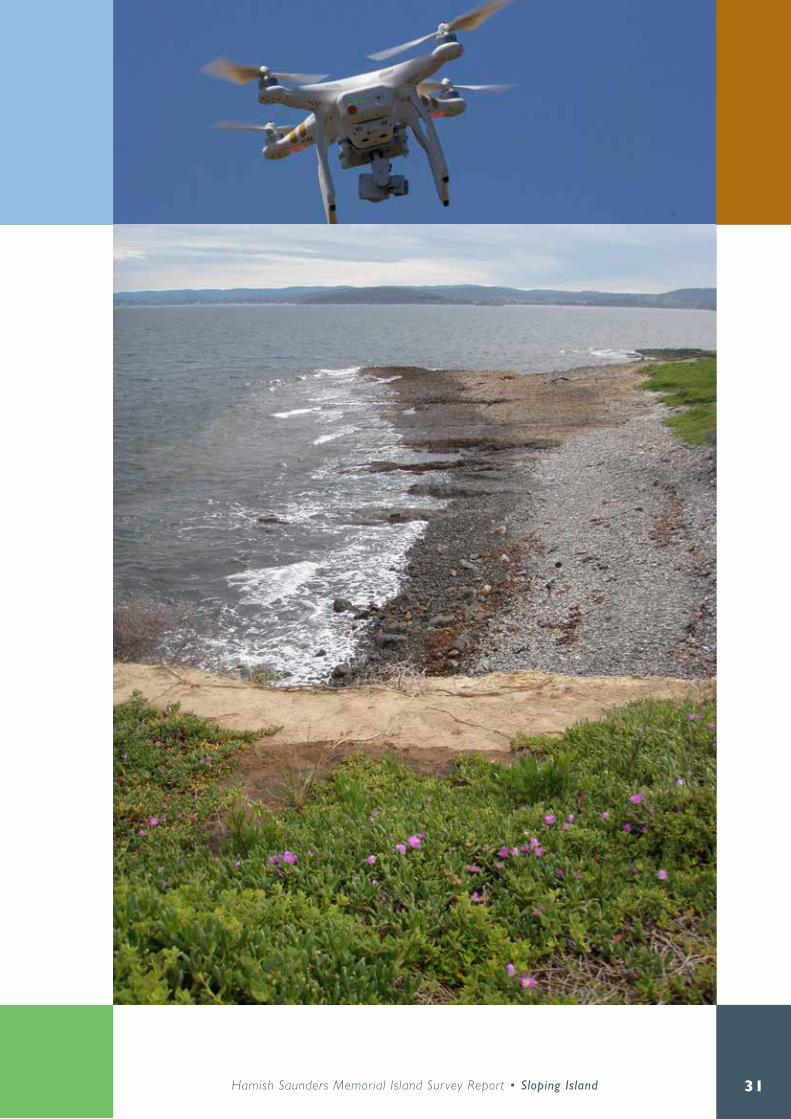
Data acquisition - flying low and slowTo map the entire island, 695 images were acquired from an altitude of 120 m above ground using a small multi rotor aircraft (Figure 1). The flight was undertaken semi-autonomously making use of the onboard GPS . The camera is mounted with a three axis gimbal ensuring that the imagery is captured at 90 degrees to the earth’s surface irrespective of any instability in the aircraft resulting from strong winds or other factors .
The flight was controlled from a high point towards the centre of the island to ensure optimal control throughout the duration of the mission . The low
altitude, slow speed and even coverage of the flight path (Figure 2) ensured that the imagery captured would be suitable for photogrammetric processing .
Processing - measure twice, cut onceThe 695 images were used to calculate a dense point cloud representing the entire island as a series of points in 3D space . The processing of the images acquired at a flight altitude of 120 m combined with the 20 mm focal length of the 12 .4 megapixel camera allowed for a 6 .5 cm ground sample distance (GSD) within the model and subsequent outputs . Corrections were made to the recorded camera positions based on the generation of the 3D model . The average camera location error respective to the GPS positions recorded for the camera during the mission was 7 .15 m . Ground control points based on existing features were used to geo-rectify the output to within approximately 10 m of other spatial datasets . Real world accuracy could be further improved to within 20 cm (3 x GSD) if required by incorporating differential GPS data that was recorded on the island .
As the primary use for this data is to measure features within the surveyed area and against theLIST (the Land Information System Tasmania) mapping layers, the in-model accuracy (average 15 cm) achieved was deemed sufficient for this purpose. This level of accuracy allows for highly precise measurements within the survey data whilst also being sufficient for integration with other spatial data that has a similar level of real world accuracy .
Figure 1. Hamish Treeby preparing the multi rotor aircraft for use on Sloping island.

27Hamish Saunders Memorial Island Sur vey Report • Sloping Island
Figure 2. Flight path flown by the Remote Piloted Aircraft System over Sloping Island 17 November 2015.

28
Results - data mattersThe high resolution aerial survey of the island was made available to all field teams in the month prior to the week-long field expedition in order to be used as a part of the planning process .
The ability to take precise measurements of features within the orthorectified imagery is of particular benefit to mapping heritage features. Extremely precise measurements can be made within the mapping data that would not be possible using photographs that are simply stitched together as this would introduce parallax error amongst other issues . The other advantage of the photogrammetric processing is the ability to carry out measurements in 3D space . Using the model, properties such as height and volume can be calculated to a high level of precision . For this project elevation data was represented in a Digital Surface Model (DSM) of the entire island .
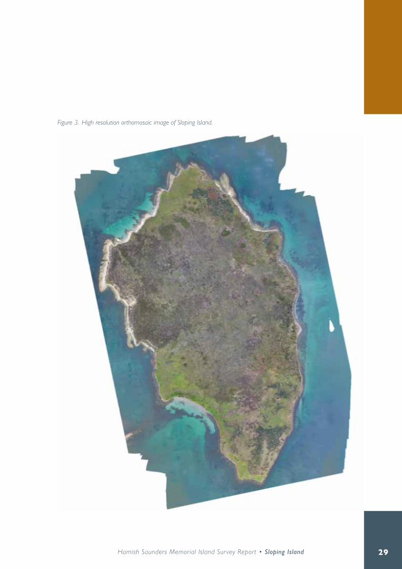
The high resolution orthomosaic (Figure 3) was uploaded to theLIST for access by the project teams as well as access by anyone else within DPIPWE or the wider State government to use for further work on this project or any other work carried out in the area in the future .
The advantage of having this data accessible via theLIST is that it will be possible to easily compare aerial surveys of the same area such as this over time . The time between survey could be at any interval . For example, a survey such as this one could be conducted at an interval of three or four times a year to monitor changes over time that may otherwise not be detected. The other benefit of this survey method is the reduced impact on the environment in comparison to ground based surveys that can be an issue in sensitive areas such as the shearwater rookeries on the island .
“The aerial survey allowed us to detect features not apparent in other data sets and plan our entire field work program in detail prior to even stepping on to the island” - PWS Officer
The feedback from the users of the data was that it proved to be highly useful and has the potential to make differences in how work is carried out in the future . As people become more accustomed to this type of improved data, the ways in which it is used to improve both research and operational work will increase .
Discussion and recommendations - same challenges, new solutionsThe ability to collect data this way is made possible by the rapid commercialisation of Remotely Piloted Aircraft Systems (RPAS) in the consumer market . The explosion in the availability of this relatively cheap technology has itself been driven by the increases in economies of scale of the production of sensors as they have been increasingly integrated into mobile phones over the past decade .
By making the deliberate business decision to utilise technology from the consumer sector of the market it is possible to more readily adapt and take advantage of the exponential growth trend that is apparent in this market space . The development of the technology as a result of rapidly increasing sales of consumer hardware is increasing and beginning to bridge the gap into commercial applications The use of consumer technology also keeps costs much lower than would be the case if trying to implement more traditional ‘turn key’ industry solutions . Such solutions are an order of magnitude more expensive in both upfront and ongoing costs as well as being prone to rapid obsolescence .
29Hamish Saunders Memorial Island Sur vey Report • Sloping Island
Figure 3. High resolution orthomosaic image of Sloping Island.

30
Further advances in sensor technology and the increased adoption of other sensor types such as LIDAR, multispectral, hyper spectral and heat detecting sensors will allow for a wide range of remote sensing possibilities previously either not possible at such a high resolution or only possible at a much greater cost .
The collection of images using the Remotely Piloted Aircraft (Figures 3 and 4) is only a part of the process for generating useful information that can be used for decision making . The hardware should be considered as a part of an end to end workflow beginning with the acquisition of the data from the airborne sensor to the processing of results, and finally to allowing the end user to view and interrogate the results effectively .
This technology has the potential to significantly alter the way we conduct environmental monitoring and other tasks across a wide range of business units and scientific disciplines. Similar capabilities are being developed within other Australian state government natural resource management organisations, with Tasmania being one of the first. The full benefits of this disruptive technology should continue to be explored by DPIPWE and the wider state government for the large number of advantages it is able to provide .
Advantages of this new capabilityDramatic increase in efficiency and effectiveness of meeting information requirements and outcomes from field work.
Highly detailed and accurate data not obtainable through ground survey methods .
Seamless integration with GIS software and theLIST .
Cost-effective alternative to LIDAR and in many cases a better solution .
Not impacted by cloud cover like satellites and higher altitude aircraft .
Figure 4. Three dimensional model for Sloping Island generated from aerial photography captured by the Remotely Piloted Aircraft System.
31Hamish Saunders Memorial Island Sur vey Report • Sloping Island

32
Sloping Island: geology and geomorphology

33Hamish Saunders Memorial Island Sur vey Report • Sloping Island
Jason Bradbury
Introduction
Methods
Six hours were spent in circumambulation of Sloping Island on 10 December 2015 . Targets for investigation were identified by examination of Remotely Piloted Aircraft System (RPAS) imagery supplied by H . Treeby (pers . comm .) that provided at least an order of magnitude greater resolution than standard aerial photographs .
Previous work
The earliest known geological map showing any detail of Sloping Island is that of Reid (1922), which suggested that the island was composed entirely of ‘Trias-Jura’ sandstones and shales bisected by an upper Mesozoic diabase dyke less than 40 chains wide . The map of Brill and Hale (1954) divided the sedimentary rocks into Permian and Triassic sequences and more accurately depicted the distribution and age of the Jurassic dolerite intrusions, although failed to indicate any Quaternary sediments . The most recently published map (Gulline 1982 and Figure 1) provides good representation of the distribution of the various lithologies . However the accompanying explanatory notes (Gulline 1984) make no mention of Sloping Island, which is tacit statement that the island provides a nondescript example of the rock sequence predominant throughout much of southeastern Tasmania .

34
Bedrock geology
Permian mudstoneThe oldest exposed rocks are cream to tan weathering, well bedded sub-horizontal mudstones, siltstones and minor sandstone . No fossils were observed although ‘a few’ spiriferoid brachiopods were noted by Brill and Hale (1954) . The presence of a variety of lonestones however is diagnostic of a Permian age and glacio-marine depositional setting .
The Sloping Island Permian sequence is most concisely exposed in the west coast cliff around GDA 94 5244 300 N (Figure 2) . Traversing north the shore platform bedding planes step up through the stratigraphy to the westernmost extent of the island and then down again, almost to the northern point . Altogether no more than an estimated 20 m of stratigraphic section is exposed . Similar rocks occur on the north east coast of the island and might be expected to lie lower in the sequence however Gulline (1982) has mapped that exposure as fault
bounded and the structure is complicated by intrusion of Jurassic dolerite .
Gulline’s (1982) correlation with the Fern Tree Formation appears reasonable, although that unit is now mapped as Abels Bay Formation in the Fern Tree type area (Calver and Latinovic 2002) . Abels Bay Formation is also the preferred nomenclature of Reid et al . (2014), who describe it as a generally monotonous sequence of mostly non fossiliferous paralic (coastal zone) siltstone and mudstone some 145 – 210 m thick . A single angular cobble of glistening quartz sandstone found amongst assorted debris at the base of a west coast cliff near 5244 525 N matches Gulline’s
Figure 1. Geology of Sloping Island, extracted from Gulline 1982. Pf = Permian Fern Tree Formation correlate, TRs = Triassic quartz sandstone, Jdl = Jurassic dolerite, Qhw = Holocene windblown sand.

35Hamish Saunders Memorial Island Sur vey Report • Sloping Island
(1984) description of the Risdon Sandstone correlate in the Sorell map sheet area . That would place most of the Sloping Island sequence within the fossiliferous Malbina Formation below the Abels Bay Formation . However no prominent quartz sandstone marker horizon was observed in the shore platforms further north, implying that the source of the clast is merely a thin, probably discontinuous bed and not a true correlate of the Risdon Sandstone .
A notable feature of some shore platform bedding plane exposure is the presence of concentrically lined ovoid protuberances and hollows ranging in size from 10 to 100+cm (Figure 3) . These are inferred to be diagenetic concretions arising from
some initial chemical anomaly such as a fossil or labile dropstone . The nature of that anomaly can only be guessed at because in all observed examples the cores of the concretions had weathered away . The concentric layering most likely represents successive reaction fronts and in other areas the most common cementing material is carbonate (Marshall and Pirrie 2013) although that was not tested . Similar concretions in Permian strata, albeit at differing stratigraphic levels, are known from Satellite Island (Banks et al . 1955), the Kingston area (Paxton 1968) and, closer to Sloping Island, at various locations around the South Arm peninsula (Bradbury pers . obs .) .
Figure 2. Much of the Permian sequence is exposed in this approximately 10 m high west coast cliff although contact with the underlying dolerite (foreground) is obscured.

36
Triassic sandstoneApproximately 20 m thickness of sandstone is somewhat poorly exposed along a short section of the east coast of Sloping Island (Figure 4) . It is very thinly bedded and some low angle cross bedding is apparent . The sandstone is well sorted and of medium grain size and predominantly quarztose composition with few feldspathic or lithic grains . That suggests a stratigraphic position low within the Upper Parmeener Supergroup sequence . A light ferruginous colouration indicates an oxidizing environment and, together with the sedimentary structure, freshwater deposition . Such juxtapositions of marine and freshwater sedimentary rocks are typical of the Tasmania Basin, which was dissected by faulting
associated with Gondwana breakup and dispersal .
Jurassic doleriteThe youngest bedrock of Sloping Island is Jurassic dolerite, which occupies both north and south points and much of the east coast . It dates from around 175 million years ago, when tens of thousands of cubic kilometres of 1150 degree Celsius magma was injected to shallow crustal levels where it cooled and solidified into great sheets up to 500 m thick (Leaman 2002) . The rock so formed is typically hard, dense and blue-grey when fresh, with interlocked crystals of mostly pyroxene and feldspar some 2 – 3 mm in size .
Figure 3. Concentric concretionary layering surrounding weathered out core, toe of boot for scale.

37Hamish Saunders Memorial Island Sur vey Report • Sloping Island
Columnar jointing, the result of cooling contraction, is common although not ubiquitous . Most of the dolerite of Sloping Island fits that description.
Contacts between intrusive dolerite and intruded host rocks are very often not exposed because the finer grain size of the chilled margin renders it susceptible to weathering . However one such contact is visible at low tide at 552300E 5245 250N on the northwest coast . There the contact is conformable with bedding in the Permian mudstones that overly the dolerite . The mudstones have been subject to contact metamorphism and have developed a degree of columnar jointing (Figure 5) . The most obviously intense metamorphism of the host however occurs about 90 m to the south although less than two
metres higher in the sequence where an apparently fine grained bed has been very strongly hornfelsed. Columnar jointing of various beds continues another 200 m to the south, suggesting that the dolerite remains at very shallow depth below the surficial Permian rocks and is likely to be contiguous with the dolerite exposed in the southern portion of the island .
In contrast the less well exposed dolerite – Permian contacts on the northeastern side of the island show little in the way of obvious intrusive relations apart from some close spaced platy jointing of the dolerite near the southern contact . Gulline’s (1982) interpretation of those as faulted contacts appears reasonable . Dolerite – Triassic sandstone contacts
Figure 4. Triassic quartz sandstone exposed at base of east coast cliff. GPS unit for scale is 225 mm long.

38
were poorly exposed beneath cobbles and high tide although at least one relatively narrow dyke of dolerite was noted . The east and west coast dolerites occur at different stratigraphic levels and are therefore likely to represent separate sills . They may even represent different intrusive events although they were not differentiated in the field.
Geomorphology
Inland landformsThe inland terrain is one of low rolling hills, as is characteristic of extensive tracts of southeastern Tasmania . No perennial streams were observed on the island, much of which is covered in fine grained, well sorted and rounded unconsolidated sand . Brill and Hale (1954) suggested that the extensive loose surficial sand of the nearby Green Head – Lime Bay area was derived by weathering of Triassic sandstone . However that mechanism cannot apply on Sloping Island where the purported Triassic source rocks are
Figure 5. Conformable intrusive contact between dolerite in the wetted foreground shore platform and hornfelsed sedimentary rocks of the low cliff, note incipient columnar jointing of the host. The field of view is approximately seven metres wide.

39Hamish Saunders Memorial Island Sur vey Report • Sloping Island
of very limited extent . Instead it is agreed with Guilline (1982) that the sand is of windblown origin, as that is consistent with grain size, sorting and rounding . However Guilline’s supposition of a Holocene age is also contraindicated by lack of a source area . It is therefore proposed that the aeolian deposits are of Pleistocene age and cotemporaneous with glacial stage low sea level, when Frederick Henry Bay would have been occupied by a sparsely vegetated cold savannah . Ten kilometres away on the western side of the bay aeolian sediments with pollen indicative of cold and dry conditions have been radiocarbon dated to around 20 000 years ago (Colhoun 1977), shortly after the Last Glacial Maximum .
While the surficial sands are generally loose, low coastal scarps on the eastern side of the island expose a similarly fine but indurated tan coloured sand with sparse charcoal fragments . The lower sand may simply be older, which might imply a penultimate glacial phase age . More likely however is that the sands are of the same age, with the upper layer remaining unconsolidated due to a combination of leaching of soluble material and constant bioturbation by burrowing seabirds .
Two small springs on the south western coastal slope occur at the boundary of loose and consolidated sand. Kirkpatrick (1973) briefly described a number of other soaks that were not observed, those are
Figure 6. Vegetated and largely inactive sea cliff approximately five metres high, above gradation between narrow boulder beach and sandy low tide terrace on the southwest coast.

40
presumed to have dried under the drought conditions currently prevailing . A low east coast scarp exposes a small area of cracking clay (probably dolerite derived) with a few angular clasts of what appear to be Triassic sandstone . This is interpreted as a slope deposit and is possibly of late Neogene to early Quaternary age . More extensive slope deposits overlie some of the west coast Permian strata although those are more likely associated with development of the Holocene coastal slope and cliffs .
Coastal landformsThe area of the island above the mean high water mark is 1 .174 km2 while the length of the MHWM polyline is 5 .138 km . As such coastal landforms are the predominant geomorphological feature . Sandy beaches are restricted to a 220 m stretch of low tide terrace in the southwest and a 50 m pocket between west coast shore platforms . Much of the coastline is cliffed, with the convex cliffs on the eastern shore exceeding 20 m height, although elsewhere most are lower . Many cliffs, especially those cut in dolerite or Triassic sandstone, are not currently subject to active coastal erosion and may be extensively vegetated (Figure 6) . Cliff recession is however active in places on the northwest coast where a small landslip and several instances of recent block fall and slab topple of Permian rocks were observed .
Much of the east coast consists of a narrow, active beach of locally derived cobbles and boulders, with one or two low relief berms in places . Where multiple berms are present the uppermost may be sparsely
Figure 7. A stitched panorama of west coast shore platform showing progressive development, from left to right: quarried low tide cliff, zone of enlarged joint openings, relatively smooth central bedding plane surface displaying both master and minor joints, weathered remnants of overlying bed and cliff with some undercutting due to weathering at mean high water level.

41Hamish Saunders Memorial Island Sur vey Report • Sloping Island
vegetated . In contrast the highest berms on the south west coast appear inactive and are relatively densely vegetated. Perhaps the most significant coastal depositional feature on the island is the small cobbly cuspate foreland near the centre of the east coast, upon which the expedition camp was located . Its position would appear to represent the point of balance between two oppositely directed drivers of longshore drift . Wind roses for nearby Hobart Airport (Bureau of Meteorology 2016) show a clear predominance of northwest winds at 9:00 am, although those are subdominant to a southeasterly sea breeze at 3:00 pm . With some 14 km of fetch the waves driven by a strong northwesterly wind would reach sufficient energy to transport cobble sized clasts southwards along the east coast by longshore drift processes . Opposing that are the southerly swell waves, which although of much greater open water magnitude must loose considerable energy to diffraction before impinging upon the east coast of Sloping Island .
Below the cliffs and cobble beaches the coastline underlain by Permian rocks consists of almost continuous intertidal shore platforms (Figure 7) . These exceed 25 m in width in places and are essentially bedding plane surfaces, which dip gently seawards . The seaward edge is typically an irregular but abrupt truncation although a permanently submerged lower bed may extend another 10 m . Many concretion hollows contain rounded cobbles and appear to be enlarging as potholes however most platforms support little in the way of loose debris . Weathering notches at the base of cliffs are present but uncommon . A similar although somewhat narrower shore platform developed on Abels Bay Formation rocks at Kangaroo Bluff was described in detail by Sanders (1968), who attributed its formation to wave quarrying of rocks weakened by weathering with little contribution by abrasion . That would appear a reasonable genetic interpretation of the Sloping Island platforms, while their greater width might be attributed to a more energetic wave climate .

42
Management implications
Geoconservation valuesThe entire island is currently listed on the Tasmanian Geoconservation Database (https://www.naturalvaluesatlas.tas.gov.au) under the name ‘Sloping Island chert boulders’ . These were briefly described by Sutherland (1972) as cherty boulders, probably washed up from offshore, that had been used by Aboriginals to fashion stone tools . However no chert was observed amongst the abundant coastal cobble and boulder deposits of Sloping Island . Although a couple of artifact scatters were observed these were not disturbed to examine the nature of the flaked material. Instead an unworked well rounded sample of a dark, fine grained, hard dense rock type abundant as beach pebbles and cobbles in the northwest of the island was collected for further study . Petrographic examination (R . Bottrill pers . comm .) showed the rock to be a hornfelsed Permian sandstone . The distribution of similar cobbles indicates that their source is associated with either the intrusive contact shown in Figure 5 or the strongly hornfelsed bed a short distance to its south .
The TGD entry shall be updated with a revised description and polygon .
Other management implicationsSea level rise due to climate change is likely to reactivate coastal recession however no local mitigation could reasonably be expected given the scale of the issue and the relative insignificance of the values threatened . The aeolian sands are also prone to reactivation, as demonstrated by a deflated area in the north and the occurrence of sand overlying Holocene beach cobbles of unweathered dolerite in several places on the east coast (see Figure 2 in Grose, this volume) . Stability of the aeolian sands is dependent upon maintenance of good vegetation cover and that should be considered in fire and weed management planning .

43Hamish Saunders Memorial Island Sur vey Report • Sloping Island
ReferencesBanks, M .R ., Hale, G .E .A . and Yaxley, M .L . (1955) . The Permian rocks of Woody Island, Tasmania . Papers and Proceedings of the Royal Society of Tasmania, 89: 219 – 229 .
Brill, K .G . and Hale, G .E . (1954) . Geological map of the north-western end of Tasman Peninsula – a revision . Papers and Proceedings of the Royal Society of Tasmania, 88: 279 – 284 .
Bureau of Meteorology (2016) . Climate statistics for Australian locations: Summary statistics Hobart Airport . http://www.bom.gov.au/climate/averages/tables/cw_094008.shtml (accessed 25/2/2016) .
Calver, C .R . and Latinovic, M . (compilers) (2002) . Digital Geological Atlas 1:25 000 Scale Series Sheet 5224 Taroona . Mineral Resources Tasmania, Hobart .
Colhoun, E .A . (1977) . A sequence of late Quaternary deposits at Pipe Clay Lagoon, southeastern Tasmania . Papers and Proceedings of the Royal Society of Tasmania, 111: 1 – 12 .
Gulline A .B . (1982) . Geological Atlas 1:50 000 Series, Sheet 83 (8412N) Sorell . Tasmania Department of Mines, Hobart .
Gulline A .B . (1984) . Geological Survey Explanatory Report, Sheet 83 (8412N) . Sorell . Geological Atlas 1:50 000 Series, Tasmania Department of Mines, Hobart .
Kirkpatrick, J .B . (1973) . The vegetation of Sloping Island, Tasmania . Victorian Naturalist, 90: 312 – 321 .
Leaman, D . (2002) . The rock which makes Tasmania . Leaman Geophysics, Hobart .
Marshall, J .D . and Pirrie, D . (2013) . Carbonate concretions – explained . Geology Today 29: 53 – 62 .
Paxton, G . (1968) . The geology of the Kingston area . Papers and Proceedings of the Royal Society of Tasmania, 102: 31 - 41 .
Reid, A .M . (1922) . Geological sketch map of the Tasman Peninsula coalfield. Plate XVI in Loftus Hills M .B .E ., Reid, A .M ., Nye, P .B ., Keid, H .G .W . and Reid, W .D . 1922 . The coal resources of Tasmania . Tasmania Department of Mines Geological Survey Mineral Resources No . 7 .
Reid, C .M ., Forsyth, S .M ., Clarke, M .J . and Bacon, C . (2014) . The Parmeener Supergroup – Late Carboniferous to Triassic . In Corbett, K .D ., Quilty, P .G . and Calver, C .R . (eds .) Geological evolution of Tasmania. Geological Society of Australia special publication 24 .
Sanders, N .K . (1968) . The development of Tasmanian shore platforms . PhD thesis, University of Tasmania .
Sutherland, F.L. (1972). The classification, distribution, analysis and sources of materials in flaked stone implements of Tasmanian aborigines . Records of the Queen Victoria Museum no . 42 .

44
Soil investigations on Sloping Island

45Hamish Saunders Memorial Island Sur vey Report • Sloping Island
Chris Grose
This report comprises the findings from a brief visit to Sloping Island in December 2015 as part of the Hamish Saunders Memorial Trust Expedition to the island .
Location
Sloping Island is roughly 117 ha in size and lies at 42˚57’S, 147˚38’E in Frederick Henry Bay, just off the north-western tip of the Tasman Peninsula in south-eastern Tasmania .
Topography
Sloping Island is roughly oval in shape, being approximately 1 .5 km long and 750 m wide . It rises to two high points of 70 m and 58 m separated by a low saddle . The northern end of the island typically has more gentle gradients than the southern end although the entire island appears bounded by a steep slope at least three or four meters in height (and often greater) that drops to the sea shore . A number of short, dry watercourses were observed around the island and some areas of land slip were also observed on the eastern side of the island, most likely a result of undercutting of sediments by wave action .

46
Geology The geology of the island is mapped predominantly as windblown sand deposits of Quaternary age that conceal a variety of underlying rock types including Jurassic Dolerite, Permian and Triassic mudstones and occasional sandstones . The hard rocks are most evident along the coastal margins and cliffs of Permian mudstone occur along the western side of the island while outcrops of dolerite outcrop at the north and south tips of the island as well as along the eastern shore . Platforms of Permian sediments are evident around parts of the north west and north-eastern shores . At a point near the northern tip of the island Jurassic dolerite intruded into mudstones has led to baking of the Permian sediments into cherty material used by aboriginals for making stone implements (Gulline, 1984) remnants of which can still be found scattered across the land surface . On occasion windblown sands cover solid geology right to the coastline .
VegetationThe vegetation of Sloping Island is discussed in other sections of this document and earlier investigations have been reported by Kirkpatrick (1973) . In summary, sandy areas across much of the island are dominated by Pteridium esculentum and Lomandra longifolia, often accompanied by Eucalyptus viminalis (along east coast) and E. tenuiramis elsewhere . Around the coastal margins, typically associated with shearwater or penguin rookeries, extensive areas of Tetrogonia implexicoma are found, together with areas of Solanum laciniatum . Where soils have developed from Permian mudstones, typically in the north-west of the island, Casuarina constricta woodland occurs . Areas of Banksia marginata are found around the island often associated with P. esculentum and L.
longifolia . Small stands of Acacia melanonoxylon were also observed .
SoilsIn his paper on the Vegetation of Sloping Island, Kirkpatrick (1973) relates many of the vegetation communities recorded to the soil types on which they occur – a pattern with which the current author broadly concurs . A combination of vegetation boundaries, photo interpretation and local observation has been used to generate the soil boundaries identified in the soil map provided in Figure 1.
During the course of this study the island was traversed several times and detailed soil descriptions made at 18 locations identified in advance of visiting the island based on vegetation patterns observed in the detailed remotely piloted aircraft system imagery captured specifically for the expedition. Further quick soil inspections were made periodically to confirm the soil type as the island was traversed and notes made on any significant vegetation changes or other points of interest . A standard 50 mm Eijalkamp soil auger was used to excavate the soil and the profiles was described using standard soil description terminology (NCST 2009) and the Munsell soil colour charts (1990 revised edition) . The Australian Soil Classification (revised edition) was used to classify the soils . It should be noted that due to the dry conditions on the island at the time of the visit, and the nature of the soils themselves, it was typically very difficult to retrieve a descent soil core using the hand auger and therefore depths of horizons are tentative and colours described may be a result of some mixing of soil layers .
Three soil types were observed and recorded during the investigation with the two more significant soils showing some variation in profile morphology.

47Hamish Saunders Memorial Island Sur vey Report • Sloping Island
Figure 1. Soil sites and soil boundaries, Sloping Island. WBS = windblown sand soils; SoD = soils on dolerite, SoM = soils on Permian mudstone. SI17 = soil description site ID. A and B = landslip locations; C = deflation surface with aboriginal stone artifacts; D = old well; E = quarry.

48
Soil developed on aeolian sandsThese soils cover the greater part of the island and have the greatest diversity of vegetation species . Soil depth varies depending on topographic position and proximity to solid bedrock . Around the coastline windblown sands were observed to overlie directly on to dolerite, rounded beach cobbles and tertiary clays . A thin layer of windblown sand was also observed in the old well overlying the Permian mudstone (Point D in Figure 1) . Two small areas of landslip were observed, both on the steep slopes on the eastern side of the island (marked A and B in Figure 1). The first had a headwall of deep windblown sand and the second a thin covering of sand over
heavier textured tertiary sediments . It is possible that both these events could have been triggered by wave action undermining the toe slope at beach level . In the north eastern part of the island, near the existing navigation light, deflation of the original sand cover has left a small area of exposed weathered dolerite upon which many Aboriginal stone artifacts were observed (C in Figure 1) . The time sequence for the creation of artifacts and removal of sand cover is unclear . It is possible that the artifacts were created while a vegetation and sand cover were still present and that the artifacts may have become incorporated into the sandy material . Removal of the vegetation cover in this area, either at the time of artifact creation or through some other subsequent event, allowed deflation of the sands down to the current weathered dolerite surface, thereby exposing the remnant artifacts . Around the high point of the island cobbles of dolerite were observed scattered around though the soil type was still that of the windblown sands . Site SI22, at the southern tip of the island contained many dolerite rocks in a loose, sandy matrix that proved difficult to auger to any meaningful depth though there was much evidence of shearwater rookeries .
Where penguin and shearwater rookeries are found much mixing of the soil horizons has occurred and determining soil horizons from soil auger samples is impossible .
Local variation means that the thickness of the A horizon is quite variable and colours can be lighter or darker depending on the vegetation and the degree of soil mixing .
Figure 2. Landslip and toe slope erosion, Sloping Island.

49Hamish Saunders Memorial Island Sur vey Report • Sloping Island
A typical profile from the windblown sands is described below:
Soil Classification: Grey- or Brown-Orthic Tenosol
Horizon Depth (m) DescriptionA 0-0 .18 Dark greyish brown (10YR 4/2, moist), dark grey (10 YR 4/1, dry), loamy fine sand;
loose, single grain structure; few very fine roots; water repellent; field pH 5.B1 0 .18-0 .4 Dark greyish brown (10YR 4/2, moist), dark grey (10 YR 4/1, dry), fine sand; loose,
single grain structure; field pH 6.B2 0 .4-0 .8 Yellowish brown (10YR 5/4, moist), greyish brown (10 YR 5/2, dry), fine sand; loose,
single grain structure; field pH 5.
Figure 3. Windblown sands directly overlying rounded dolerite beach cobbles (Regolithic brown-orthic Tenosol).

50
Soils of the Permian sedimentsOnly four sites were augured in this soil type and while broad similarities were apparent between the various sites there were also significant differences. At the margins of the Casuarina forest, within which this soil type occurs, the Permian sediments are overlapped by windblown sands with the thickness of the sand layer increasing further away from the woodland . At the old well site (marked D in Figure 1) about 50 cm of sand was observed overlying weathered Permian sediments while at the old quarry (E in Figure 1) shallow (probably eroded) sandy clay loams overlay Permian mudstones. A typical profile is described below:
Figure 4. Typical profile of the windblown sands. This profile, located in the centre of the island, is darker in colour than those around the margins that are associated with the shearwater rookeries.

51Hamish Saunders Memorial Island Sur vey Report • Sloping Island
Soil Classification: Grey or Brown Kurosols
Horizon Depth (m) DescriptionA 0-0 .18 Very dark greyish brown (10YR 3/2) moist, greyish brown (10YR 5/2) to light
brownish grey (10YR 6/2) dry, fine sandy loam; few fine roots; water repellent; field pH 5 .5 .
B1 0 .18-0 .40 Dark greyish brown (10YR 4/2) moist, brown (10YR 5/3) to light grey (10YR 7/2) dry, fine sandy loam to fine sandy clay loam or clay loam; may contain few angular mudstone medium gravels; field pH 5.
B2 0 .4-0 .6 Dark brown (7 .5YR 3/3) to yellowish brown (10YR 5/4) moist, brown (7 .5YR 4/4) to very pale brown (10YR 7/4) dry, silty clay loam to light clay; field pH 5.5.
R 0 .65 Mudstone .
Figure 5. Typical soil profile of the Permian sediments (Grey Kurosol).

52
Soils on doleriteOne site was described that appears to be developed on dolerite or dolerite colluvium . While it has a thin covering of windblown sand this soil is quite different to others observed on the island .
Soil Classification: Black Chromosol
Horizon Depth (m) DescriptionA 0-0 .18 Black (10YR 2/1) moist, very dark greyish brown (10YR 3/2) dry, loamy fine sand; few
very fine roots; field pH 6.B1 0 .18-0 .4 Black (10YR 2/1) moist, heavy clay; field pH 7.B2 0 .4-0 .6 Black (10YR 2/1) moist, heavy clay; field pH 8.5.R 0 .6 Dolerite

53Hamish Saunders Memorial Island Sur vey Report • Sloping Island
Management ImplicationsSloping Island currently falls under the management of the Tasmanian Parks and Wildlife Service with the most recent management activities relating to control of weed species on the island . Apart from the areas of landslip on the eastern side of the island and some cliff erosion on the western side there was no evidence of active soil erosion or declining soil condition observed . The soils developed from windblown sands provide an ideal nesting habitat for shearwaters and penguins and the soils occurring within the rookeries are much disturbed though there is no sign of erosion . The greatest threat to the soils of the island is probably fire that would remove existing vegetation cover leaving the predominantly loose sandy soils susceptible to raindrop impact . Given that many of the sandy soils are also somewhat water repellent there is a risk that surface runoff might occur, despite the porous nature of the sandy soils, leading to erosion, particularly on some steeper slopes around the margins of the island .
ReferencesGulline, A .B . (1984 .) Geological Survey Explanatory Report, Sheet 83 (8412N) . Sorell. Geological Atlas 1:50 000 Series . Mineral Resources Tasmania, Hobart .
Isbell, R .F . (2002) . The Australian Soil Classification Revised Edition . CSIRO Publishing, Collingwood, Victoria .
Kirkpatrick J .B . (1973) . The vegetation of Sloping Island Tasmania . Victorian Naturalist 90: 313-321 .
NCST . (2009) . Australian Soil and Land Survey Field Handbook . 3rd Edition CSIRO Publishing, Collingwood, Victoria .

54
Cavernous Weathering in Dolerite at Isle of Caves

55Hamish Saunders Memorial Island Sur vey Report • Sloping Island
Rolan Eberhard
Introduction
Isle of Caves is located in Frederick Henry Bay 3 .9 km north of Sloping Island and was included in the Hamish Saunders Expedition as an adjunct to the geodiversity survey . Adverse weather precluded access to the island as scheduled during the expedition and this report is based on a follow-up investigation on 2 March 2016 . The aims of the trip were to continue an earlier initiative to map the caves (part of an ongoing inventory of non-karstic caves by Greg Middleton), to describe their morphology and otherwise survey the geodiversity values of the island .
Isle of Caves is a rocky outlier of Jurassic age dolerite with an area of two hectares . The coastline is 560 m long based on theList 1:25,000 coastline layer . The island is essentially a small hill cut off from the mainland prior to 6000 years before present by rising post-glacial seas . Erosion by wave action has steepened the margins of the hill to form a discontinuous barrier of steep rocky seaward slopes and low cliffs (Figure 1) . The shoreline varies from intertidal platforms up to 10 m wide, small gulches and steep boulder beaches . The interior of the island is a stony plateau with minimal soil, occupied by nesting seabirds (see Appendix 1 in Bryant this volume) . The weed African boxthorn (Lycium ferocissimum) is prominent .

56
The cavernous nature of the island came to attention during the circumnavigation of Tasmania by Matthew Flinders in 1798 . Flinders named the island after anchoring in its lee whilst exploring between Frederick Henry Bay and Norfolk Bay . The explorer Bruny D’Entrecasteaux had previously charted the island’s position in 1792-3 .
More recently, Dixon (1996) briefly described the caves in his State-wide inventory of island geodiversity, commenting on their joint-controlled forms and associated tafoni-style weathering i .e . granular disintegration of rock to produce cavernous features sometimes likened to honeycomb . The reference to tafoni is significant as this form of weathering is typical of sandstone and granitic rock but rarely seen in
dolerite . Based on Dixon’s report, Isle of Caves was listed on the Tasmanian Geoconservation Database (www .naturalvaluesatlas .tas .gov .au) as a ‘notable example of type’. The geosite is classified as follows, following the system devised by Bradbury (2014): class = surficial; theme = coastal and estuarine; type = littoral or peritidal .
Results and discussionThis survey identified five principal caves (Figure 2). Four of these are concentrated at the south-eastern end of the island along an 80 m reach of shoreline, potentially the most sheltered aspect of the island . Various other small cavernous features are present
Figure 1. Isle of Caves from the north. Note figure standing at the entrance to North Cave for scale.

57Hamish Saunders Memorial Island Sur vey Report • Sloping Island
Figure 2. Map of Isle of Caves indicating the locations of the principal caves. Basemap: State orthophoto (www.thelist.tas.gov.au).

58
Figure 3. Cave maps. The cave names are informal.

59Hamish Saunders Memorial Island Sur vey Report • Sloping Island
but were considered too minor to warrant separate description . A steep-sided gulch at the south-western end of the island may be a collapsed former sea cave . In this context it is noteworthy that the limited depth of rock above some of the caves suggests that their partial collapse is geologically imminent .
The Isle of Caves Blowhole cave was not examined in detail, being largely submerged below sea level . Under certain conditions water forced into the cave by wave action is forcibly expelled as spume due to compression of air trapped inside the cavity . All other caves are located towards the upper limit of the swash zone and were dry when inspected at low tide in March 2016 . The caves are clean washed and some contain driftwood .
The density of caves on this small island is unusual . However, the scale of cavernous development is modest compared to sea caves in dolerite on other parts of the Tasmanian coast . Some of these other caves extend underground for tens of metres and are substantial coastal landforms (Colhoun 1977, Kiernan 1979, Jackson 1981, Dixon 1996) . In contrast, the largest cavernous feature at Isle of Caves does not extend beyond nine metres of its entrance drip line . None has a true dark zone and artificial lighting is not required to explore them . As discussed below, their significance lies in morphology rather than scale.
Typically, sea caves in dolerite in Tasmania are formed through the progressive enlargement of chiefly vertical fractures such as joints . This promotes
Figure 4. Flinders Cave. The cave entrance is about six metres wide and four metres high.

60
the development of caves with relatively simple morphologies, namely linear tunnels with orthogonal or upwards tapering cross-sections (e .g . sea caves at Cape Raoul, Cape Queen Elizabeth, Maingon Bay and Tasman Head) . Some exceptions to this have been noted: a dolerite sea cave with a branching planform at Spectacled Head, 5 .5 km from Isle of Caves (Jackson 1981), and an arch in densely jointed dolerite at Mars Bluff, Bruny Island (Middleton 2015) . The Isle of Caves features differ again in tending towards compact, alcove-like morphologies resembling tafoni . This can be seen in the map of North Cave (Figure 3), the form of which is characterised by the similar order of magnitude of the internal dimensions in all planes . This tendency is less pronounced in the more
southern caves, which are developed at the heads of gulches which may be unroofed sections of former cave passages (Figure 4) .
This lack of linearity in the caves does not reflect an absence or infrequency of joints in the host dolerite. The bedrock is moderately fine-grained and perforated by dense networks of intersecting joints in both vertical and horizontal planes . Chemical decomposition of rock surrounding these joints on the shoreline has produced numerous sphaeroidally-weathered joint-bound blocks (‘onion skin weathering’ – see Leaman 2002, pp . 131-132) . The positions of the caves correlate with zones of intense jointing and/or large, dilated joints and it is clear that certain
Figure 5. Crystalline deposits associated with major joints in Flinders Cave; note rounded corestone weathering out of bedrock above hammer. The green tinge to the crystalline efflorescence is probably algae.

61Hamish Saunders Memorial Island Sur vey Report • Sloping Island
joint orientations have been more influential than others in forming them . The cluster of caves at the south-eastern end of the island show a degree of alignment with major NE/SW and SE/NW joints, whereas North Cave is affected by an easterly joint set. The profiles of the paired entrances Norfolk and Tom Thumb Caves are strongly controlled by steeply dipping parallel joints, although the degree linearity in their internal forms is unexceptional .
The nature of rock debris accumulated on the floor of the caves provides further evidence concerning the role of joints in speleogenesis at Isle of Caves . The debris comprises a combination of rounded corestones produced by the aforementioned sphaeroidal weathering process and blocky angular debris not obviously affected by deep chemical weathering . Both classes of material could have been washed into the caves but a proportion of each is clearly derived internally . The evidence for this can be seen in the cave walls, which display in situ corestones in various stages of weathering out of the bedrock (Figure 5) . Similarly, blocky angular debris on the cave floors can be matched to scars in shattered rock on the adjacent walls . These observations imply at least two speleogenetic processes .
Firstly, the corestones indicate gradual chemical decomposition of the bedrock along joint-bound blocks, releasing crumbly material and ultimately the central kernel . Secondly, the angular fraction indicates vertical stoping of undercut rock masses through mechanical failure . It is inferred that the density of cross-cutting joints and weathering along joint fractures predispose the rock to this form of mechanical failure . The expansion of clays released during weathering likely plays a critical role in this . In a coastal setting such as Isle of Caves this tendency may be compounded by the action of marine salts precipitating out in fractures .
Several of the caves display whitish crystalline coatings on their walls (Figure 5) . Apparently similar material is present as sugary veins occupying larger dilated joints . The following minerals were identified in a sample of the latter from Flinders Cave: stellerite (42%), heulandite (33%), smectite (24%), gypsum (1%) and quartz (possible trace) . This zeolite-clay assemblage is typical of those found in veins and breccias in Jurassic dolerite in many places in Tasmania (Bottrill and Woolley 2016) .
Consideration of the essentially terrestrial speleogenetic processes described above should not overshadow the fundamental importance of marine action in initiating the caves. The cave floors align closely with the level of adjacent wave-cut shore platforms (except Isle of Caves blowhole which is largely below sea level) and it can be assumed that wave action has been instrumental in eroding out the base of the cavities . Reworking of abrasive lithic materials accumulated on the cave floors would assist this process . However, Isle of Caves is not exposed to particularly energetic oceanic wave conditions, especially the more sheltered eastern aspect where most of the caves are found . This may have militated against the development of more extensive, strongly linear caves .

62
SummaryThe cavernous landforms of the Isle of Caves are an interesting case study in non-karstic speleogenesis . Although not tafoni sensu stricto, the principal caves display tafoni-like morphologies which are atypical of dolerite sea caves in Tasmania . This is probably due to a combination of factors related to wave climate and the speleogenetic role of subcutaneous chemical decomposition in densely jointed dolerite bedrock . The caves are robust features and require no immediate management attention .
AcknowledgmentsGreg Middleton for company in the field and permission to reproduce his cave maps . Marine staff from DPIPWE Wildlife Management Branch for providing transport to Isle of Caves . Ralph Bottrill and Richie Woolley from Mineral Resources Tasmania for laboratory analysis .
ReferencesBottrill, R . S . and R . N . Woolley (2016) . Mineralogy: Rocks: Isle of Caves, Mineral Resources Tasmania, Laboratory Report LJN2016-018 (unpublished) .
Bradbury, J. (2014). A keyed classification of natural geodiversity for land management and nature conservation purposes . Proceedings of the Geologists’ Association 125: 329 – 349 .
Colhoun, E . A . (1977) . The Remarkable Cave, southeastern Tasmania - its geomorphological development and environmental history . Papers & Proceedings of the Royal Society of Tasmania 111: 29-39 .
Dixon, G . (1996) . A reconnaissance inventory of sites of geoconservation significance on Tasmanian islands. Parks & Wildlife Service, Hobart .
Jackson, P . (1981) . Dolerite sea cave at Dodges Ferry . Southern Caver 12(3): 48-49 .
Kiernan, K . (1979) . Sea caves and morphological karst on the Tasmanian coastline . Southern Caver 11(2): 2-23 .
Leaman, D . (2002) . The Rock Which Makes Tasmania. Hobart, The author .
Middleton, G . (2015) . Caves and arch at Mars Bluff, Bruny Island . Speleo Spiel 411: 19-22 .

63Hamish Saunders Memorial Island Sur vey Report • Sloping Island

64
Sloping Island vegetation

65Hamish Saunders Memorial Island Sur vey Report • Sloping Island
Felicity Hargraves
Introduction
This survey aims to provide a current ground-truthed vegetation map of Sloping Island . The mapping will be used to identify the trend and nature of the changes in the distribution of the island’s vegetation since 1973, by comparing Kirkpatrick’s vegetation mapping of Sloping Island (Kirkpatrick, 1973) with the current mapping .
Vegetation change on Sloping Island since 1973 corresponds to the cessation of agricultural practices, the increase of shearwater rookery activity and burning of the vegetation . Other vegetation disturbance is reportedly a result of rabbit activity on the island . The Tasmanian Parks and Wildlife Service (PWS, 2002) reported the denudation of vegetation in rookeries by rabbits . Brothers et al . (2001) states that on Sloping Island rabbit populations undergo radical seasonal fluctuations and can cause severe denudation of vegetation which leads to erosion and burrow collapse in shearwater colonies . PWS (2002) considered that the condition of Sloping Island had not yet recovered from past agricultural use .

66
MethodsThe vegetation communities of Sloping Island were identified and mapped during a one-day field trip on 10 December 2015 . A preliminary TASVEG vegetation map was prepared from Kirkpatrick’s 1973 Sloping Island mapping, current aerial imagery taken via a remotely piloted aircraft system (Treeby, 2015) and serrated tussock mapping (DPIPWE, 2009) . The resultant draft map was used to direct and prioritise ground-truthing of vegetation communities on the island . A GPS tracking GIS tablet displaying aerial imagery and TASVEG community boundaries was used to undertake real-time boundary mapping . The island was traversed across its southern end and then through its center before returning along the eastern coast . The north and western coasts were identified by line of sight. The dominant canopy species (of all structural layers) were recorded for each community . Mapping boundaries and vegetation classifications where adjusted in the field according to current TASVEG vegetation community descriptions (Kitchener and Harris, 2013) .
ResultsThe vegetation of Sloping Island comprises 12 TASVEG communities . These are divided into the categories of modified land, eucalypt woodland, native grasslands, non-eucalypt forest and scrub . A flora species list for Sloping Island was compiled by Mathews as part of the weed survey on the island (Mathews this volume) and is included here as Appendix 1 .
Significant vegetation communities of Sloping IslandThree significant vegetation communities listed as threatened Native Vegetation Communities under the Tasmanian Nature Conservation Act (2002) were identified on Sloping Island. These are: Eucalyptus viminalis/Eucalyptus globulus coastal forest and woodland (DVC), Eucalyptus tenuiramis forest and woodland on sediments (DTO) and Rookery halophytic herbland (SRH) (a sub-community of the listed community Seabird rookery complex) .
A general comparison between the vegetation mapping of Sloping Island in 1973 (Kirkpatrick) and in 2015 is made, where relevant, in the following community descriptions and summarised in the discussion .
Community descriptions-composition of vegetation communities on Sloping IslandEucalyptus woodland (DVG, DVC and DTO)
Eucalyptus viminalis grassy forest and woodland (DVG) and Eucalyptus viminalis/E. globulus coastal forest and woodland (DVC) .
Two species of Eucalyptus are found on the eastern half of Sloping Island . E. viminalis is common while only a few individuals of E. tenuiramis were located, mainly on the hilltops. The trees vary from five to eight metres in height, are sparsely distributed and show signs of dieback . About half of the trees are dead and many of the remaining trees have poor canopy health . The only recruitment that is evident is of Eucalyptus viminalis saplings to three metres in height located in the center of Sloping Island . These

67Hamish Saunders Memorial Island Sur vey Report • Sloping Island
0 250 500125
Metres
TASVEG Legend
Agricultural, urban and exotic vegetation
(FPF) Pteridium esculentum fernland
(FWU) Weed infestation
Dry eucalypt forest and woodland
(DTO) Eucalyptus tenuiramis forest and woodland on sediments
(DVG) Eucalyptus viminalis grassy forest and woodland
(DVC) Eucalyptus viminalis - Eucalyptus globulus coastal forest and woodland
Native grassland
(GHC) Coastal grass and herbfield
(GSL) Lowland grassy sedgeland
Non-eucalypt forest and woodland
(NAD) Acacia dealbata forest
(NAV) Allocasuarina verticillata forest
(NBA) Bursaria - Acacia woodland and scrub
Other natural environments
(ORO) Lichen lithosere
(OSM) Sand, mud
Scrub, heathland and coastal complexes
(SCH) Coastal heathland
(SRH) Rookery halophytic herbland
¯
Figure 1. TASVEG map of vegetation communities of Sloping Island 2015.

68
eucalypts can be categorised as three TASVEG woodland communities; Eucalyptus viminalis grassy forest and woodland (DVG) on well drained sites on dolerite; Eucalyptus viminalis/E. globulus coastal forest and woodland (DVC) located on recently deposited sands and Eucalyptus tenuiramis forest and woodland on sediments (DTO) .
DVG has an open understory of Poa labillardierei with Pteridium esculentum, Lomandra longifolia, Carpobrotus rossii and occasional shrubs of Acacia dealbata, Dodonaea viscosa and Bursaria spinosa . DTO has a shrubby understory of Acacia verticillata, Banksia marginata, Epacris impressa, Pteridium esculentum, Lomandra longifolia, and Astroloma humifusum . DVC has a sparse heathy cover of Epacris impressa, Aotus ericoides, Cassinia aculeata, Pimelea linifolia, Lomandra longifolia, Poa labillardierei, Pteridium esculentum, Lepidosperma concavum and Leptospermum scoparium .
Allocasuarina verticillata low open forest (NAV)
This community is confined to the westerly aspects of the island where Kirkpatrick (1973) suggests it avoids sandy soils and is tolerant of salt laden sea breezes . The extent of NAV has slightly increased since 1973 by invading surrounding open heathland . Where canopy cover is dense NAV lacks an understory, while in sparser stands in the north-west the understory includes scattered shrubs of Pomaderris elliptica, Olearia phlogopappa and Pultenaea daphnoides . The lowest structural layer comprises the ubiquitous Lomandra longifolia, thickets of Astroloma humifusum and occasional plants of Epacris impressa and Dianella brevicaulis .
Figure 2. The vegetation of Sloping Island in 1973 (Kirkpatrick).

69Hamish Saunders Memorial Island Sur vey Report • Sloping Island
Figure 3. Eucalyptus woodland on the steep eastern slopes of Sloping Island.
Figure 4. Allocasuarina verticillata (NAV) on northern Sloping Island.

70
Coastal heath (SCH)
The western coastal heath has a canopy dominated by Banksia marginata and Lomandra longifolia and is currently in transition from Lowland sedgy grassland (GSL) to coastal heath (SCH) . The vegetation is also mapped as SCH in areas where eucalypt woodland has declined . Heathland on the eastern side of the Island is taller (to three metres) and sheltered from ocean salt laden winds, while heath on the western side of the island is short (generally less than one metre in height) and may have been burnt more regularly and subjected to wind pruning .
In the west a short heathland dominated by Banksia marginata and Lomandra longifolia has a diverse scattering of shrubs of Allocasuarina monilifera, Leucopogon parviflora, Epacris impressa, Lepidosperma concavum, Bossiaea cinerea, Aotus ericoides, Amperea xiphoclada, Pteridium esculentum, Dianella brevicaulis, Stylidium graminifolium, Dianella brevicaulis, Xanthosia pilosa, Astroloma humifusum and Hibbertia acicularis .
In the east, tall thickets up to three metres of Acacia verticillata, A. suaveolens, A. dealbata, Banksia marginata, Allocasuarina monilifera and Olearia phlogopappa occur . At these sites there is a ground layer of sedges and heathy plants of Coprosma nitens, Lissanthe strigosa, Pultenaea daphnoides, Astroloma humifusum, Epacris impressa, Dianella brevicaulis, Lomandra longifolia and Lepidosperma longitudinal .
Figure 5. Coastal heath (SCH) on western Sloping Island.

71Hamish Saunders Memorial Island Sur vey Report • Sloping Island
Bursaria – Acacia woodland and scrub (NBA)
Several thickets of Acacia melanoxylon can be found across the Island and is mapped within Bursaria –Acacia woodland and scrub (NBA) . The understory is sparse and includes Lepidosperma laterale, Pteridium esculentum and Tetragonia implexicoma . Kirkpatrick (1973) observed that these thickets occurred on the island where there are soaks .
Lowland sedgey grassland (GSL) (Lomandra longifolia herbland (Kirkpatrick 1973))
Kirkpatrick (1973) had mapped lowland sedgey grassland (GSL) as a large area in the south western half of the Island . Kirkpatrick suggests that this area probably represents a fire and grazing induced degeneration of Eucalypt woodland (Kirkpatrick 1973) . While Lomandra longifolia is still a dominant element of the vegetation across the Island, the GSL community is now much reduced and occurs in a small area in the south west . It is mainly converted to Rookery halophytic herbland (SRH) on the coast and succeeds to Coastal heath (SCH) inland . The dominant cover of GSL is Lomandra longifolia, Pteridium esculentum and Lepidosperma concavum .
Figure 6. Acacia melanoxylon thickets in soak areas (mapped as NBA).

72
Halophytic herbland (SRH)
Halophytic herbland (SRH) is a community adapted to the bioturbaceaous and high nutrient impact of seabird rookeries . The dominant cover is Tetragonia implexicoma forming large ground-cover mats . Smaller mats of Carpobrotus rossii and low shrubs of Rhagodia candolleana are common . The large woody herb Solanum laciniatum has formed large patches in the north and south of the Island . Near the coastal fringes of the community more diversity is found with Atriplex cinerea, Austrostipa stipoides, Distichlis distichophylla and a few shrubs of Myoporum insulare .
Weed infestation (FWU)
Several weed infestations were large enough to map on the Island. These include the nationally significant noxious weed, serrated tussock (Nassella trichotoma), which has been present on the Island since the 1950s when the island was actively farmed (PWS, 2002), African boxthorn (Lycium ferocissimum), and radiata pine (Pinus radiata) . Other weeds are addressed comprehensively in the Weed Management section of this report .
Figure 7. Lowland sedgy grassland (GSL) on the west coast of Sloping Island.

73Hamish Saunders Memorial Island Sur vey Report • Sloping Island
Coastal grass and herbland (GHC)
Coastal grass and herbland (GCH) is located on the south west of the island though is much reduced since 1973 . Previous areas of GHC have been encroached upon by Halophytic herbland (SRH) .
Pteridium esculentum fernland(FPF)
The area of the island occupied by bracken (Pteridium esculentum) has reduced to half of its 1973 distribution . This is mostly due to invasion by Halophytic herbland (SRH) and particularly the large herb kangaroo apple (Solanum laciniatum) . A small area in the north east has been invaded by serrated tussock .
Figure 8. Halophytic herbland (SRH), southern Sloping Island.

74
DiscussionThe TASVEG mapping has been considerably updated . Previous to this survey only six TASVEG vegetation communities were (mostly inaccurately) mapped on the island . This survey has mapped in much greater detail and with field accuracy 12 TASVEG communities. The new communities identified include the three threatened communities: Rookery halophytic herbland (SRH), Eucalyptus viminalis/E. globulus coastal forest and woodland (DVC) and Eucalyptus tenuiramis forest and woodland on sediments (DTO) .
In 2015 the island’s vegetation is well on the way to recovery from its past of grazing (with the exception of rabbits), clearing and settlement which ceased in the 1960’s . The island is still susceptible to unauthorised and too frequent burning of its vegetation . Rookeries have expanded into bracken and native grasslands, such that there has been an approximately four-fold increase in the 1973 area of Rookery halophytic herbland (SRH) . A reduction in the 1973 mapped area of Coastal grassland complex (GHC), lowland sedgy grassland (GSL) and Pteridium esculentum fernland (FPF) is largely due to the expansion of SRH . The area of coastal heathland has approximately doubled since 1973 as a result of replacing GSL and the decline of woodlands .
The composition of the communities described by Kirkpatrick (1973) has changed little though the extent of these communities is substantially altered . Most of these changes are positive and indicate the progression of Sloping Island’s return to its more natural state prior to human-related disturbance . The exception is the decline in both extent and condition of the eucalypt woodlands, DVC and DTO, both of which are listed as threatened communities . The distribution of eucalypt woodland is now less than half of its 1973 distribution . There is no evidence to
link the decline of eucalypt woodland with possible drought conditions with the last 30 years of annual rainfall records for the region collected from the Eagle Hawk Neck station showing no trend towards a reduction of rainfall (Appendix 2 - Australian Bureau of Meteorology) . It is speculated that the decline in recruitment and condition may be due to grazing pressure from rabbits and/or a too-high frequency of burning .
ReferencesBrothers N ., Pemberton D ., Pryor, H . and Halley, V . (2001) . Tasmania Offshore Islands: seabirds and other natural features . Tasmanian Museum and Art Gallery, Hobart .
DPIPWE . (2009) . Sloping Island Serrated Tussock infestation map .
Kirkpatrick J .B . (1973) . The vegetation of Sloping Island Tasmania . Victorian Naturalist 90: 313-321 .
Kitchener, A . and Harris, S . (2013) . From Forest to Fjaeldmark: descriptions of Tasmania’s vegetation . Edition 2 . DPIPWE Hobart .
Parks and Wildlife Service DPIPWE . (2002) . Small south east Islands Draft Management Plan . DPIPWE, Hobart .
Treeby H . (2015), Sloping Island aerial imagery www. thelist.tas.gov.au

75Hamish Saunders Memorial Island Sur vey Report • Sloping Island
Appendix 1Vascular flora species list for Sloping Island. Introduced (i) and declared weed (d) status also given. Based on Kirkpatrick (1973) . Additional records were sourced from the Tasmanian Herbarium, collections and observations during the present survey by A . Matthews and C . Howells .
FAMILY SCIENTIFIC NAME COMMON NAME
DICOTYLEDONEAEAPIACEAE Daucus glochidiatus ^ Australian carrotAIZOACEAE Carpobrotus rossii *^ native pigface
Disphyma crassifolium subsp clavellatum *^ roundleaf pigfaceTetragonia implexicoma * bower spinach
APIACEAE Lilaeopsis polyantha * jointed swampstalksASTERACEAE Carduus tenuiflorus * winged thistle i d
Cassinia aculeata subsp aculeata * dolly bushCirsium vulgare ^ spear thistle iChrysocephalum apiculatum † common everlastingChrysocephalum semipapposum † clustered everlastingCoronidium scorpioides † button everlastingCotula coronopifolia *^ water buttons iHypochaeris radicata ^ flatweed iLagenophora sp ® bottle daisyLeontodon saxatilis ^ lesser hawkbit iLeptinella reptans ^ creeping cotulaOlearia phlogopappa subsp phlogopappa *^ common dusty daisybushOsteospermum fruticosum * blue eyed susan iOzothamnus ferrugineus *^ tree everlastingSenecio biserratus * jagged fireweedSenecio pinnatifolius ^† coast groundselSonchus oleraceus ^ sow thistle iVellerophyton dealbatum *^ white cudweed i
BRASSICACEAE Cackile maritima * searocket iCAMPANULACEAE Lobelia anceps *^ angled lobeliaCARYOPHYLLACEAE Sagina procumbens * spreading pearlwort iCASUARINACEAE Allocasuarina littoralis * ^ black sheoak
Allocasuarina monilifera ^ necklace sheoakAllocasuarina verticillata *^ drooping sheoak
CHENOPODIACEAE Atriplex cinerea* grey saltbushAtriplex prostrata *^ creeping orache iChenopodium album ^ lamb’s quarters iChenopodium glaucum * pale goosefoot iEinadia nutans * climbing saltbushRhagodia candolleana subsp candolleana *^ coastal saltbushSarcocornia quinqueflora *^ beaded glasswort
CONVOLVULACEAE Dichondra repens ^ kidney weedCRASSULACEAE Crassula sieberiana * stonecropDILLENIACEAE Hibbertia empetrifolia subsp empetrifolia * scrambling guinea flower
Hibbertia procumbens ^ spreading guinea flowerHibbertia prostrata ^ bundled guinea flower
EPACRIDACEAE Astroloma humifusum *^ native cranberryEpacris impressa *^ common heathLeptecophylla juniperina subsp juniperina * common pinkberryLeucopogon parviflorus *^ coast beardheathLissanthe strigosa ^ peach heath
ERICACEAE Erica lusitanica ‡ Spanish heath i d

76
EUPHORBIACEAE Amperea xiphoclada *^ broom spurgeFABACEAE Aotus ericoides ^† common aotus
Bossiaea cinerea ^ showy bossiaeaBossiaea obcordata ^ spiny bossiaeaBossiaea prostrata *^ creeping bossiaeaDaviesia sejugata † disjunct bitter-peaKennedia prostrata *^ running postmanMedicago sp ^ burclover iPultenaea daphnoides * ^ heartleaf bushpea
GENTIANACEAE Centaurium erythraea * ^ common centaury iGERANIACEAE Geranium potentilloides ^ cinquefoil geranium
Pelargonuim australe ^ native storksbillPelargonium X domesticum ^ regal geranium i
GOODENIACEAE Selliera radicans *^ shiny swampmatHALORAGACEAE Gonocarpus tetragynus ^ common raspwortLAMIACEAE Marrubium vulgare *^ white horehound i dLAURACEAE Cassytha glabella * slender dodderlaurelMIMOSACEAE Acacia dealbata subsp dealbata *^ silver wattle
Acacia genistifolia * spreading wattleAcacia melanoxylon *^ blackwoodAcacia myrtifolia * redstem wattleAcacia suaveolens ^ sweet wattleAcacia verticillata subsp verticillata *^ prickly moses
MYOPORACEAE Myoporum insulare *^ common boobiallaMYRTACEAE Eucalyptus tenuiramis silver peppermint
Eucalyptus viminalis subsp viminalis *^ white gumLeptospermum scoparium *^ common teatree
ONAGRACEAE Epilobium sp † willowherbOXALIDACEAE Oxalis corniculata ^ creeping woodsorrel i
Oxalis sp ® woodsorrelPITTOSPORACEAE Bursaria spinosa *^ prickly boxPOLYGALACEAE Comesperma volubile * blue love creeperPOLYGONACEAE Acetosella vulgaris ^ sorrel i
Rumex crispus ^ curly dock iPRIMULACEAE Lysimachia arvensis ^ scarlet pimperneli
Samolus repens ^ creeping brookweedPROTEACEAE Banksia marginata *^ silver banksiaRHAMNACEAE Pomaderris elliptica var elliptica*^ yellow dogwoodROSACEAE Acaena X anserovina ^ hybrid burr
Rosa rubiginosa ^ sweet briar iRUTACEAE Correa alba var rotundifolia *^ white correaSANTALACEAE Exocarpos cupressiformis * native cherry
Exocarpos strictus ^ dwarf native cherrySAPINDACEAE Dodonea viscosa subsp spathulata * hop bushSCROPHULARIACEAE Verbascum virgatum ^ twiggy mullein iSOLANACEAE Lycium ferocissimum *^ African boxthorn i d
Solanum laciniatum * kangaroo appleSTYLIDIACEAE Stylidium graminifolium * narrowleaf trigger plantTHYMELAEACEAE Pimelea humilis ^ common riceflower
Pimelea linifolia ^ slender riceflowerURTICACEAE Urtica urens ^ annual nettle iVIOLACEAE Viola hederacea ^ Native violet
MONOCOTYLEDONEAEAGAVACEAE Phormium tenax * New Zealand flax i

77Hamish Saunders Memorial Island Sur vey Report • Sloping Island
CENTROLEPIDACEAE Centrolepis strigosa ^ hairy centrolepisCYPERACEAE Carex appressa ^ tall sedge
Ficinia nodosa ^ knotted club-rushIsolepis cernua ^ tufted club-rushIsolepis platycarpa * flatfruit clubsedgeIsolepis producta * nutty clubsedgeLepidosperma concavum *^ sand swordsedge
JUNCACEAE Juncus bufonius ^ toad rushJuncus capitatus ^ dwarf rush iJuncus krausii subsp australis ^ sea rushJuncus pallidus *^ pale rushJuncus planifolius *^ broadleaf rush
LILIACEAE Dianella brevicaulis *^ shortstem flax lilyDianella tasmanica *^ forest flax lily
PoaCEAE Aira caryophyllea ^ silver hair-grass iAnthoxanthum odoratum *^ sweet vernal-grass iAustrodanthonia caespitosa ^ common wallaby-grassAustrodanthonia laevis ^ smooth wallaby-grassAustrostipa flavescens † coast spear-grassAustrostipa mollis ^† soft spear-grassAustrostipa rudis subsp australis † veined spear-grassAustrostipa stipoides ^ prickly spear-grassAustrostipa stuposa † corkscrew spear-grassDeyeuxia quadriseta ^ bent-grassDichelachne crinata *^ longhair plume-grassDistichlis distichophylla ^ Australian salt-grassHolcus lantanus *^ Yorkshire fog iLachnagrostis aemula ^ tumbling blown-grassNassella trichotoma *^ serrated tussock i dPhragmites australis ^ common reedPoa labillardierei var labillardierei * silver tussock-grassPoa poiformis ^ coast tussock-grassPolypogon monspeliensis ^ annual beard-grass iRytidosperma racemosum var racemosum † wallaby-grass
XANTHORRHOEACEAE Lomandra longifolia *^ sagg
GYMNOSPERMAECUPRESSACEAE Cupressus macrocarpa ‡ macrocarpa iPINACEAE Pinus radiata * radiata pine i
PTERIDOPHYTABLECHNACEAE Blechnum wattsii * hard waterfernDENNSTAEDTIACEAE Hypolepis rugulosa * ruddy groundfern
Pteridium esculentum subsp esculentum *^ brackenDRYOPTERIACEAE Polystichum proliferum * mother shield fernPOLYPODACEAE Microsorium pustulatum ^ kangaroo fern
* Collected 2015 Hamish Saunders Memorial Trust (HSMT) expedition by A . Matthews and C . Howells . Specimens lodged with the Tasmanian Herbarium^ Recorded in Kirkpatrick J .B . (1973) . The vegetation of Sloping Island Tasmania . Victorian Naturalist 90: 313-321 .† Species previously lodged with the Tasmanian Herbarium® Collected 2015 HSMT expedition, but not suitable for accession to the Tasmanian Herbarium‡ Observed 2015 HSMT expedition, but not collected

78
Appendix 2Annual Rainfall for 1960 to 2015 at Eagle Hawk Neck (Australian Bureau of Meteorology)
Year annual rainfall Eagle Hawk Neck
1960 8971961 8791962 7411963 5591964 11391965 7541966 8801967 7021968 5421969 10271970 11031971 11021972 681
No records for 1973 to 19801981 7901982 7031983 8681984 9981985 12951986 9671987 7371988 8241989 9621990 8901991 8841992 8081993 8811994 8131995 11751996 10381997 7621998 8931999 6032000 6862001 10592002 7952003 8772004 7612005 9052006 5862007 7432008 6892009 11162010 7232011 10692013 8782013 10062014 6362015 757

79Hamish Saunders Memorial Island Sur vey Report • Sloping Island

80
Weed management on Sloping Island

81Hamish Saunders Memorial Island Sur vey Report • Sloping Island
Alex Matthews
Introduction
The ecosystems of small islands, like those in the south-east of Tasmania, can be particularly sensitive to the introduction of non-native species, a process aided by human disturbances such as habitat modification (Towns and Ballantine, 1993) . These islands are often home to genetically or morphologically distinct species and sub-species of flora and fauna, and can provide important habitat for species such as migratory seabirds, meaning that they are of high conservation value (Whittaker and Fernandez-Palacios, 2007) .
Sloping Island is located in Frederick Henry Bay, just off the northern tip of the Tasman Peninsula . The presence of middens and other artefacts show that the island was historically visited by indigenous peoples, most likely thanks to its proximity to the mainland and the large breeding colonies of Short-tailed Shearwaters that seasonally nest there . Since the arrival of Europeans, the island has been used variously as a penal colony, a whaling station and up to the mid-20th century as a farm (Smith, 2002) . As a consequence of this activity and the absence of any biosecurity protocols, a host of non-native plant species have become established on the island, including several significant weed species.

82
The Small South-East Islands Draft Management Plan (PWS 2002), the key guiding document for the management of small islands in the south-eastern region of Tasmania, identifies a number of weed species as being established on Sloping Island, including serrated tussock (Nassella trichotoma), African boxthorn (Lycium ferrocisimum) and Spanish heath (Erica lusitanica) . All three species are declared weeds under the Weeds Management Act 1993, List B pests under the Plant Quarantine Act 1997 and both serrated tussock and African boxthorn have been listed as Weeds of National Significance by the Australian Weeds Council . As such, all three are priority species for control and eradication .
Since the end of permanent habitation there has been intermittent weed management on Sloping Island . In 2002 the Management Plan for Serrated Tussock and Other Weeds on Sloping Island (Smith 2002) was published, setting out a series of recommendations for management of serrated tussock, African boxthorn and Spanish heath . Section 4 .2 of the Small South-East Islands Draft Management Plan (PWS 2002) supports the implementation of the weed management plan on Sloping Island .
A key recommendation of the weed management plan is that a co-ordinated approach for the three species should occur on an annual basis to provide the best chance for control and even eradication . However, since the publication of the plan, management attempts have not been contiguous, with the most recent activity occurring in 2011, mainly focusing on the control of African boxthorn (Meis 2011), and in 2012, working on serrated tussock (A . Hrasky pers . comm .) . As a result, the goals set out by the plan are not likely to have been met and in some cases populations may have even increased .
The aim of this survey for the 2015 Hamish Saunders Memorial Trust expedition was to map serrated tussock, African boxthorn and Spanish heath populations on Sloping Island to provide a snapshot of their current size, density and health . The data gained from this survey will be used to assess the validity of existing management strategy and provide knowledge to inform recommendations for future control .
MethodsField surveys for population mapping of serrated tussock (Nassella trichotoma), African boxthorn (Lycium ferrocisimum) and Spanish heath (Erica lusitanica) were undertaken on Sloping Island on 7-10 December 2015 . Reports by Smith (2002) and Meiss (2011), as well as a 2009 serrated tussock population density map (DPIPWE) (Appendix 1) were used to provide guidance on areas where weed populations were historically known to occur. Identification of target species was aided by the Tasmanian Weed Handbook (Hyde-Wyatt and Morris 1975) .
Population location data was collected using a Garmin GPS map 60CSx . The geographical map datum used was the Map Grid of Australia MGA 94 Zone 55 with coordinates expressed in eastings (6 digits) and northings (7 digits) . Attributes recorded for each population were based on those outlined in A Field Manual for Surveying and Mapping Nationally Significant Weeds (McNaught et al . 2006) . The data collected was used to generate population distribution maps for each species; the background imagery utilised the Statewide DigitalGlobe ‘SatelliteMosiacRGB’ layer .

83Hamish Saunders Memorial Island Sur vey Report • Sloping Island
Figure 1. Serrated tussock populations observed on Sloping Island - December 2015.

84
Findings
Serrated tussockFour main populations of serrated tussock were identified on Sloping Island: on the far north-west corner of the island in the area known as the ‘Paddock’, in the centre of the island to the north of the old well, on the far south-east tip of the island and on the far north-east corner of the Island (Figure 1) .
North-west
The population in the north-west was by far the most extensive, covering an area of approximately three hectares . Due to historical clearing for agricultural purposes the area was mostly open sparse grassland interspersed with low heath and emergent
Allocasuarina verticillata . While several stands of large established mature serrated tussocks were identified, the majority of individuals were intermediates, many bearing seed heads, and emergent seedlings . The highest densities of seedlings were observed in areas with minimal coverage from other species, with several sub-population counts estimated as over 200 individuals within a surveyed area . A conservative base population estimate for this area was around 1500 individuals; however in reality this figure is likely to be much higher .
Central
The population in the centre of the island occurred in small clearings between dense stands of Acacia verticillata, Astroloma humifusum and Pomaderris elliptica . Due to competition from other grass species,
Figure 2. Serrated tussock in open heath amongst Allocasuarina woodland.
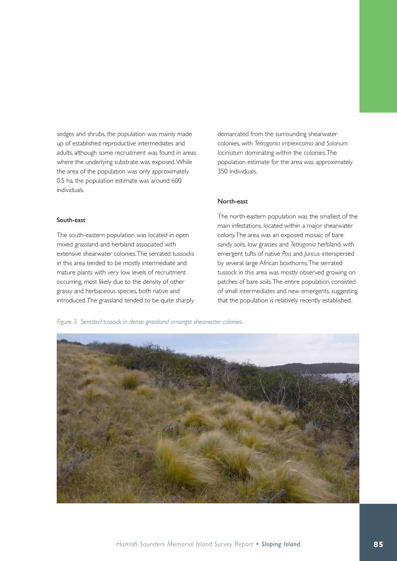
85Hamish Saunders Memorial Island Sur vey Report • Sloping Island
sedges and shrubs, the population was mainly made up of established reproductive intermediates and adults, although some recruitment was found in areas where the underlying substrate was exposed . While the area of the population was only approximately 0 .5 ha, the population estimate was around 600 individuals .
South-east
The south-eastern population was located in open mixed grassland and herbland associated with extensive shearwater colonies . The serrated tussocks in this area tended to be mostly intermediate and mature plants with very low levels of recruitment occurring, most likely due to the density of other grassy and herbaceous species, both native and introduced . The grassland tended to be quite sharply
demarcated from the surrounding shearwater colonies, with Tetragonia implexicoma and Solanum laciniatum dominating within the colonies . The population estimate for the area was approximately 350 individuals .
North-east
The north-eastern population was the smallest of the main infestations, located within a major shearwater colony . The area was an exposed mosaic of bare sandy soils, low grasses and Tetragonia herbland, with emergent tufts of native Poa and Juncus interspersed by several large African boxthorns . The serrated tussock in this area was mostly observed growing on patches of bare soils . The entire population consisted of small intermediates and new emergents, suggesting that the population is relatively recently established .
Figure 3. Serrated tussock in dense grassland amongst shearwater colonies.

86
Figure 4. African boxthorn populations observed on Sloping Island - December 2015.

87Hamish Saunders Memorial Island Sur vey Report • Sloping Island
Supporting this is the low population estimate, with only around 70-100 individuals observed .
A lone individual was observed on the eastern side of the island, likely to be the result of seed dispersal via human activities . It is probable other such individuals were present on the island, but not easily visible due to dense undergrowth .
African boxthornTwo major African boxthorn populations were identified in the north/north-east and the south-west on exposed coastlines associated with shearwater and
penguin colonies (Figure 4) . Many of the individuals in these populations were large, mature adults (av . 5-10 m diameter) . Most of these mature plants showed signs of previous treatment, with an overall dead appearance and evidence of mechanical cutting to the main trunks. However, of 69 mature adults identified in these areas only two appeared to be fully dead, while the remainder were observed with re-sprouting foliage . In the south-west population, two healthy mature adults were located further inland within the shearwater colony . An outlier in the north-east population was found growing against the northern wall of the old farm shed .
In addition to the mature adults in the north/north-
Figure 5. African boxthorns in Tetragonia herbland.

88
Figure 6. Spanish heath populations observed on Sloping Island - December 2015.

89Hamish Saunders Memorial Island Sur vey Report • Sloping Island
eastern and south western populations, numerous juvenile African boxthorns were also observed . The highest density of juveniles occurred along the gently sloping far northern coast, with around 80 individuals estimated within 300 m west along the coastline from the navigation light, before Tetragonia implexicoma herbland transitioned into Allocasuarina verticillata forest . Recruitment along the steeper north-eastern and south-western coastlines was much lower, with only 19 and 16 juveniles observed in these areas respectively .
A third smaller population of African boxthorns was identified on the north-west of the island, in and around the area known as the ‘Paddock’ . In contrast to the other populations, all 23 of the plants were small-to-intermediate juveniles, with no large adults observed . Additionally, rather than growing along the exposed coastline, most boxthorns in the population were found further inland amongst open Allocasuarina verticillata forest or low grassy scrubland .
During the survey, no African boxthorns were found more than 150 m inland from the coast, in areas of dense coastal heath and sedgeland, or where heavy canopy cover existed .
Spanish heathThe main Spanish heath population observed during the survey was located in a 0 .1 ha area on the eastern side of the island approximately 150 m south-east of the old farm sheds (Figure 6) . The vegetation of the area was comprised mainly of open native grassland and sedgeland, bordered by open Acacia melanoxylon woodland . The Spanish heath population was estimated to comprise of around 150-200 individuals .
The majority of mature adults, around 40 individuals, appeared to be either dead or in poor condition,
most likely due to herbicidal treatment in 2011 (Meiss 2011) . Approximately 90 healthy juveniles were observed within the population, mostly in open patches where competition from other species was low .
A second smaller population of 10 to 15 individuals was observed approximately 130 m south-east of the main population amongst low Acacia melanoxylon and Ozothamnus ferrugineus . As with the main population the adults were found to be in poor condition while the emergent juveniles were healthy .
Several individual plants were discovered along an east-west line through dense Lomandra longifolia sedgeland across the centre of the island, while a third small population was observed on the boundary of the sedgeland and the open shearwater colonies on the western side of the island .
Other weedsSeveral common pasture weeds were observed in the grasslands on the south of the island, including sweet vernal grass (Anthoxanthum odoratum) and Yorkshire fog (Holcus lantanus), as well as white horehound (Marrubium vulgare) and winged thistle (Carduus tenuiflorus), both declared weeds . An established population of New Zealand flax (Phormium tenax), which is known to be expanding its range in other south-eastern areas of the state (C . Howells pers . comm .), was observed next to the beach on the south west of the island .

90
Management recommendationsThe findings of the weed survey conducted for the Hamish Saunders Memorial Trust expedition indicate that the issue of weed management on Sloping Island is at a critical juncture . High levels of recruitment in all three key species, particularly for serrated tussock, are of immediate concern . If the new cohort of plants is allowed to reach maturity and set seed then future control is likely to be extremely difficult. Moreover, uncontrolled population expansion would represent a waste of the time, resources and funding expended on previous management efforts, as well as having a negative impact on the significant environmental and
cultural values of the island .
In addition, due to Sloping Island’s designation as a State Reserve, the failure to appropriately control invasive weed species would represent a contravention of the management objectives set out in Schedule 1 of the National Parks and Reserves Management Act 2002 .
On a more positive note, the survey did reveal evidence of enduring effects from previous control attempts, most visible in the generally poor condition of adult plants in the African boxthorn and Spanish heath populations . If further management is undertaken during this window of opportunity, ensuring that mature plants are kept in a suppressed
Figure 7. Dying adult Spanish heath with healthy juveniles emerging.

91Hamish Saunders Memorial Island Sur vey Report • Sloping Island
state and juveniles are removed before they can become mature, then reproductive fitness will be negatively affected . As a result future control will become less intensive, requiring reduced effort and expenditure, and total eradication may even be attainable .
However, this outcome will only be possible if a commitment to funding and resources for the regular co-ordinated management of all three species is reached . The ongoing presence, and current resurgence, of weed populations on Sloping Island indicates that intermittent and narrowly focused control attempts are not effective and only represent a long term waste of resources for ultimately no net gain .
Validity of the weed management planThe results of the current survey show that overall the distribution of weed populations on Sloping Island has remained largely unchanged . As such, the recommendations outlined in the Management Plan for Serrated Tussock and Other Weeds on Sloping Island (Smith 2002) remain valid, although they should be implemented with reference to updated population data from subsequent studies .
A review of the control measures outlined in the management plan should be undertaken prior to the commencement of any further fieldwork. This review process would have a twofold purpose: to ensure that all chemical applications meet current regulations and to identify where new knowledge or technology has superseded suggested controls .
The recommendations for the management of weed populations in areas with Aboriginal and historic heritage sites as set out in Appendix 1
and Appendix 2 of the plan should continue to be followed, with spraying being the preferred method . It is important that weed control operations do not negatively impact Aboriginal and heritage sites, as the preservation of these features is a key function of a State Reserve as set out in the National Parks and Reserves Management Act 2002 . Current advice is that any plans for future works should be checked by Aboriginal Heritage Tasmania to see if they will impact on any sites (S . Dix pers . comm .) .
Many weed populations on Sloping Island are located within shearwater and penguin nesting colonies . The ground in these areas is extremely unstable due to the high numbers of burrows and any work should be planned in such a way as to minimise disturbance, as stated in the management plan . As a further recommendation, a set of protocols for working within colony areas should be developed to ensure that a consistent, lowest-risk approach is taken, thus maintaining conservation values .
As an extension of the existing management plan, a hygiene and biosecurity protocol should be established to minimise human-assisted spread of weeds around the island . This is particularly important in the case of serrated tussock, where the small tufted seeds are easily transported on boots, clothing and equipment, and could potentially even be transported back across to the mainland . The implementation of a hygiene plan is supported by the Southern Tasmanian Weed Strategy 2011-2016 (Temple-Smith 2011), which includes Sloping Island within its remit .
Future technologyAdvances in Remotely Piloted Aircraft System (RPAS) technology has the potential to revolutionise the way that weed management is conducted, especially in remote areas such as Sloping Island . Hamish Treeby,

92
Spatial Information Analyst from the Natural and Cultural Heritage Division of DPIPWE, suggests that RPAS could potentially be implemented for detection, mapping and even targeted application of spraying as well as ongoing monitoring of weeds, as is being trialled in Queensland (pers . comm .) .
RPAS technology is already used by DPIPWE for aerial survey work and could be adapted for use in weed management . According to Treeby “The RPAS would create a high resolution map of the target area, like what was performed on Sloping Island, then use object based detection to automatically identify and classify areas that are weeds . Although not currently used by DPIPWE, multispectral sensors could also be used to further improve weed detection ability based on the differences in near infrared spectral response specific to various weed species. To give an idea of aerial application, this platform can be programmed to only target the patches identified as weeds over a large area, meaning cost savings in labour and pesticides, as well as less contamination to the environment . The cost of these systems is already very affordable and will only continue to get cheaper, but even at current prices the business case is probably justified.”
AcknowledgementsThank you to Christine Howells for assistance in collecting, identifying and preparing plant specimens, as well as creating species lists and updating taxonomic names; Felicity Hargraves, Karen Stewart, Kiowa Fenner, Nicole Gill, Sam Dix and Hamish Treeby for advice and assistance; Tom Priestley for a sterling effort inputting data and creating maps; Catherine and Kathleen Matthews for editing advice; and the 2015 HSMT crew for a great week .
ReferencesDPIPWE . (2009) . Sloping Island Serrated Tussock infestation map .
Hyde-Wyatt B .H and Morris D .I . (1975) . Tasmania Weed Handbook: A guide to the identification of the main weeds of crops and pastures in Tasmania. DPIPWE, Hobart .
McNaught I ., Thackway R ., Brown L . and Parsons M . (2006) . A Field Manual for Surveying and Mapping Nationally Significant Weeds . Bureau of Rural Sciences, Canberra .
Meiss A . (2011) . Slopen Island Weed Management Report. Unpublished report, circulated to DPIPWE, available from author on request .
Parks and Wildlife Service . (2002) . Small South-East Islands Draft Management Plan . DPIPWE, Hobart .
Smith S . (2002) . Management Plan for Serrated Tussock and Other Weeds on Sloping Island. Tasharvest, Blackmans Bay, Tasmania .
Temple-Smith R . (2011) . Southern Tasmanian Weed Strategy 2011-2016 . NRM South, Hobart .
Towns D . and Ballantine W .J . (1993) . Conservation and restoration of New Zealand Island ecosystems . Trends in Ecology and Evolution 8: 452-457 .
Whittaker R .J . and Fernández-Palacios J .M . (2007) . Island Biogeography: Ecology, Evolution and Conservation . Oxford University Press Inc ., New York .

93Hamish Saunders Memorial Island Sur vey Report • Sloping Island
Appendix 1Sloping Island serrated tussock infestation - May 2009 .

94
Invertebrates of Sloping Island

95Hamish Saunders Memorial Island Sur vey Report • Sloping Island
Karen Richards and Josephine Potter
Introduction
Seldom researched, the result is that little is known about the invertebrate fauna diversity of many of Tasmania’s islands . While some specific work has been undertaken on museum and private collecting trips, e .g . K . Bonham (reporting on the molluscan fauna of four islands) and J . Winray (on invertebrates of several Furneaux Islands), as well as surveys of specific islands e.g. Rodondo Island (Carlyon et al . 2015), Flinders Island (NCH 2014a), Clarke Island (NCH 2014b) and Schouten Island (Reid 2011), as yet there has been no systematic approach to recording the diversity of terrestrial invertebrate taxa across the islands . Marine invertebrates at several island locations have also been mentioned in books including Gillham (2000) and Brothers et al . (2001), although not in any detail, and limited invertebrate data, either marine or terrestrial, is recorded on databases such as the Natural Values Atlas (www .naturalvaluesatlas .dpipwe .tas .gov .au) . Few entomological researchers have visited Sloping Island and prior to this expedition, it would appear that the Queen Victoria Museum and Art Gallery (QVMAG) sponsored three hour trip to Sloping Island by Kevin Bonham (Bonham 2006) represents the most extensive terrestrial invertebrate research on this island .

96
MethodsTwo one-day visits to the island were planned, the first was to deploy traps and collect specimens, and the second to recover traps and survey locations not reached on day one .
A transect consisting of ten pitfall traps was established on the eastern side of the island to record the ground-dwelling (litter) invertebrate fauna, but time limitations for this day trip precluded placement of a second transect elsewhere . The pitfall traps, containing 40 ml of ethylene glycol used as preservative, were placed at 10–15 m intervals and deployed for four days . The transect, running in a north south direction, was located to sample multiple habitat types, beginning at the break of slope within
the dry Eucalyptus viminalis community (552353E 5244364N GDA) and extending into the grassland/Lomandra longifolia field (552746E 5244213N GDA), thus maximising the opportunity to record a cross section of invertebrates .
In conjunction with the pitfalls a number of other methods were employed . Four leaf litter funnel traps were positioned beneath Eucalyptus viminalis and Acacia melanoxylon trees at two locations on the eastern side of the Island . The traps, containing 90% ethanol as preservative for the captured specimens, were also in place for four days . Leaf litter searches beneath individual or clumped eucalypts were also undertaken .
Opportunistic hand collection of invertebrates occurred wherever circumstances allowed, and digital
Figure 1. Josephine Potter recording lepidopterans. Figure 2. Neolucia hobartensis hobartensis on Stylidium sp.

97Hamish Saunders Memorial Island Sur vey Report • Sloping Island
images of invertebrates were taken where a positive identification using this method was considered possible . Several specimens and images were also recorded by fellow expeditioners .
Flowering plants, of which there were few at the time of the visit, were visually inspected for the presence of invertebrates, as were dead and dying juvenile Acacia dealbata, which included examination of stems and trunks for the presence of emergence holes .
A butterfly survey was undertaken by Josephine Potter, who employed a meandering survey technique, aiming to cover multiple vegetation types on the island, as
many as time permitted during the four and half hour survey window . A hand-held net was used to capture butterfly species for closer inspection. The complete field guide to butterflies of Australia reference book (Braby 2004) was used to assist in identifying butterfly species and digital images were taken for identification purposes (Figure 1) . All specimens were released on site. The locations of observed butterflies were recorded using a handheld GPS; the vegetation type was identified, as were any food plants that butterflies or larvae were feeding upon .
All invertebrate specimens collected will be deposited at the Tasmanian Museum and Art Gallery .
Site numberGPS
15521 2488
25519 2442
35527 2441
45528 2446
Incidentalcollections
Invertebrate group
millipedes 1centipedes 1other beetles 4 3bugs 1pseudoscorpions 1spiders/harvestmen 1scorpions 1mites 1isopods (slaters) 1amphipods 1snails 2 2 2 4 1Total spp. 6 9 6 4 1
Snail species
Caryodes dufresnii 2 1 1 5Paralaoma caputspinulae 1Paralaoma cf.halli 1Magilaoma penolensis 2Pernagera officeri 3 10 10 2
Table 1. Invertebrate fauna of Sloping Island (Bonham 2006).

98
Results Due to unfavorable weather conditions, we were unable to return to the island therefore the traps had to be located and emptied by other team members and returned to Hobart . Unfortunately, not all pitfall or litter traps were recovered . Examination of the collected material was undertaken in the subsequent weeks following collection . Appendix 1 provides a list of the species recorded from this survey .
The butterfly survey revealed two species of butterfly present on the island, Neolucia agricola insulana (fringed heath-blue) and Neolucia hobartensis hobartensis (montane heath-blue) . Both species were observed in coastal heathland vegetation feeding on
flowers of Olearia phlogopappa (dusty daisybush) and N. h. hobartensis was also observed feeding on flowers of Stylidium sp . (trigger plant) (Figure 2) .
The only other data on invertebrate fauna of Sloping Island was collected by Kevin Bonham for QVMAG . A summary of this data is presented here (Table 1), with the kind permission of Dr Bonham and QVMAG .
Figure 3. Caryodes dufresnii in leaf litter.

99Hamish Saunders Memorial Island Sur vey Report • Sloping Island
DiscussionThe terrestrial invertebrate fauna of Sloping Island is representative of similar, disturbed, dry forest sites in southeast Tasmania, the composition of which predominantly consists of widespread, hardy taxa and introduced species . European colonisation and land use practices have heavily impacted much of the island . This, together with the lack of permanent fresh water, presents challenges for the establishment of a more diverse invertebrate fauna .
With no flowing, permanent, or even ephemeral water source on the island, Sloping Island is an inhospitable environment for many invertebrate groups . The conditions prevent colonisation by invertebrate species with an aquatic or semi-aquatic life-stage, and if flying individuals of such species do
manage to reach the island, establishment would not be possible . Patchy woody vegetation combined with the dry environment limits the available habitat for woody debris-dependent invertebrate fauna on the island . Circumstances are such that fallen branches and dead trees remain solid and decay very slowly, thus providing suitable habitat for minimal organisms requiring decomposing material . Other groups, such as the terrestrial mollusc fauna, are also less diverse with only the hardiest of species surviving under the moisture extremes (Appendix1 and Table 1; Figure 3) .
The ground beetle diversity was low and patchy across the areas surveyed . Most commonly, the composition was dominated by several species of darkling beetles (Tenebrionidae), although fragments of some flying beetles including the longhorn beetle Stenoderus suturalis and the elaterid Agrypnus sp . were
Figure 4. Parasitised Opodipthera helena cocoon.

100
uncovered amongst the leaf litter at two locations and unidentified microcoleopterans were also present in the litter funnel trap samples .
However, the island does represent good habitat for some groups, most notably the ants . Being dry and having well-draining soils, the island was found to support several species, some in high numbers . Ants were most abundant and the greatest diversity was observed in the E. viminalis forest on the eastern side of the island . Many ant species utilise multiple food resources, harvesting seeds or feeding on plant and insect exudates, so the reduced invertebrate taxon is not an impediment to their survival .
Perhaps unsurprisingly, given the abundance of grasses and shrubs available, Lepidoptera made a
significant contribution to the island’s invertebrate diversity . The moth diversity was plentiful perhaps as a direct influence of this group’s ability to utilise diverse habitats, while butterflies were represented by only two species . Some of the observations of the moths included spent (parasitised) cocoons of the Helena gum moth Opodipthera helena (Figure 4), recorded in patches of Eucalyptus viminalis forest, the leaves of which are the food resource for the larvae . The Cossid moth Endoxyla lituratus (Figure 5) was observed resting on an Acacia dealbata sapling and numerous emergence holes of this species were present on dead and dying A. dealbata stems, many of which showed extensive damage from feeding Calyptorhynchus funereus (yellow-tailed black cockatoo) which relish the larvae . At least two species of tussock moths Lymantriidae (Figure 6) occupied areas supporting grasslands and Lomandra longifolia, and two species of day-flying moths (Pollanisus spp) were present in reasonable densities in the lowland grassy sedgeland. Numerous other unidentified microlepidopterans were also observed .
The low numbers of butterflies observed may have been due to a combination of factors including the dryness of the island and associated lack of flowering plants which would provide a valuable nectar resource for these species . Additionally, the survey took place on a windy day with only occasional patches of sunshine, which may have resulted in some butterflies being undetected as they may have been sheltering from the wind and possibly also not warm enough to fly.
Figure 5. Endoxyla lituratus on Acacia dealbata stem.

101Hamish Saunders Memorial Island Sur vey Report • Sloping Island
Aarachnid diversity was also substantial . Some images of spiders were taken by team members; however specimens were not collected on the expedition .
A deficit of some flowering species of the Helichrysum and Leptospermum genera has limited the numbers and diversity of flower-pollinating insect species. While clearly species of flower chafers were present and the most common beetles recorded on the sparsely occurring Cassinia aculeata and Ozothamnus ferrugineus, suggesting sufficient habitat is available to maintain the populations, it is probable that many are able to make the journey from the Tasmanian mainland . Likewise, the most common beetle recorded Diphucephala colaspidoides (green
chafer), which was in plague proportions in 2015/16 in several coastal areas in Tasmania, can migrate to the island, and is equally happy consuming Acacia dealbata foliage and pollen . The extensive damage to the remaining A. dealbata juveniles on the island is testament to this species’ voracious appetite for foliage. Tabanidae (march fly), some of which also pollinate flowers, were rarely seen, perhaps reflecting the scarcity of accessible warm-blooded mammals to provide a blood meal, which is necessary for females to breed .
Figure 6. Tussock moth (Lymantriidae sp) on Pteridium esculentum.

102
RecommendationsWhile many of the species recorded in this snapshot survey are widespread and relatively abundant, the likely decline of the Acacia dealbata community will have lasting effects on the Islands’ invertebrate community composition . Several of the invertebrate species recorded are reliant on Acacia species as a food resource, including Endoxyla lituratus, as well as subterranean hemipteran species, which are themselves an important food source for many ant species .
Management of the island specifically for invertebrate fauna is not a realistic proposition . The limited diversity of native vegetation and lack of available fresh water are the principal factors contributing to the dearth of invertebrate species present . However, some low-intensity patchwork burning in areas where Acacia and Eucalyptus seed sources occur could prove to be beneficial in regenerating the tree species and in turn supporting the existence of the current invertebrate biota . Such low intensity burning may indeed stimulate the propagation of dormant seed of flora not presently recorded, some of which could greatly enhance the invertebrate diversity of the island .
ReferencesBonham, K . (2006) . Invertebrate island research. Unpublished report to the Queen Victoria Museum and Art Gallery, Launceston .
Bothers, N ., Pemberton, D ., Pryor, H . and Halley, V . (2001) . Tasmania’s off-shore islands: seabirds and other natural features . Tasmanian Museum and Art Gallery .
Braby, M . (2004) . The complete field guide to butterflies of Australia . CSIRO Publishing, Victoria .
Carlyon, K ., Visoiu, M ., Hawkins, C ., Richards, K . and Alderman, R . (2015) . Rodondo Island, Bass Strait: Biodiversity and Oil Spill Response Survey, January 2015 . Natural and Cultural Heritage Division, DPIPWE, Hobart . Nature Conservation Report Series 15/04 .
Gillham, M .E . (2000) . Island hopping in Tasmania’s roaring forties. Arthur H . Stockwell Ltd . Devon .
Natural and Cultural Heritage Division (2014a) . Flinders Island: Natural Values Survey 2012 . Hamish Saunders Memorial Trust, New Zealand and Natural and Cultural Heritage Division, DPIPWE, Hobart . Nature Conservation Report Series 14/1 .
Natural and Cultural Heritage Division (2014b) . lungtalanana (Clarke Island), Natural Values Survey 2014 . Hamish Saunders Memorial Trust, New Zealand and Natural and Cultural Heritage Division, DPIPWE, Hobart . Nature Conservation Report Series 15/2 .
Reid, A. (2011). Schouten Island Scientific Expedition 2011 . Hamish Saunders Memorial Trust, New Zealand and Resource Management and Conservation Division, DPIPWE, Hobart . Nature Conservation Report Series 11/2 .

103Hamish Saunders Memorial Island Sur vey Report • Sloping Island
Appendix 1Invertebrate fauna of Sloping Island recorded on 2015 Hamish Saunders island survey .
Order FamilyGenus and species
Common namehand collecting /observation
pitfalls leaf litter trap
other team members
Coleoptera Scarabidae Diphucephala colaspidoides
green chafer * * *
Scarabidae Heteronyx dimidiatus
flower chafer * *
Scarabidae Phyllotocus rufipennis
flower chafer *
Scarabidae Sericesthis nigrolineata
dusty pasture scarab
* *
Buprestidae Castiarina ocelligera
jewel beetle *
Elateridae Agrypnus sp click beetle *Elateridae sp 1 click beetle *Cantharidae Chauliognathus
lugubris* *
Meneristes sp darkling beetle * *sp 1 darkling beetle * *sp 1 *Stenoderus suturalis * *
Staphylinidae sp 1 rove beetle *Unidentified sp 1 microbeetle *Curclionidae sp 1 * *Curclionidae sp 2 *Curclionidae sp 3 *
Diptera Muscidae Musca sp. *Mecoptera Harpobittacus sp hanging fly *Unidentified sp 1 *Unidentified sp 2 *Unidentified sp 3 * *Formicidae Camponotus
consobrinusred and black ant * *
Iridomyrmix sp 1 ants * *Unidentified sp 1 micro ant * *
sp 1 *Braconidae Callibracon
capitatorwhite-flanked braconid wasp
*
Braconidae sp 1 *Braconidae sp 2 *
Isopoda Porcello scaber slater (introduced) * *

104
Unidentified sp 1 slater (native_1) *Unidentified sp 2 slater (native_2) *
Amphipoda Unidentified sp 1 * *Lepidoptera Zygaenidae Pollanisus
viridipulverulentusSatin-green Forester (day flying)
*
Zygaenidae Pollanisus subdolosa
day-flying moth *
Lymantriidae Acyphas leucmelas Tussock moth *Opodiphthera helena
Helena gum moth *
Cossidae Endoxyla lituratus wattle goat moth * *Lycaenidae Neolucia agricola
insulanafringed heath-blue *
Lycaenidae Neolucia hobartensis hobartensis
montane heath-blue
*
Unidentified sp 1 mirco-lepidopertan_1
*
Unidentified sp 2 mirco-lepidopertan_2
*
Arachnida Unidentified sp 1 orb-weaver *Lycosidae sp 1 wolf spider *Clubionidae Clubiona sp sac spiders *Unidentified sp 1 *Unidentified sp 2 *Unidentified sp 3 *
Hemiptera Cicadidae Giledia sp cicada *Eriococcidae Eriococcus sp. scale bugs *Unidentified sp 1 plant hopper *
Mollusca Caryodidae Caryodes dufresnii * *Charopidae Pernagera officeri *
Helicarion curveri *Helicidae Cornu aspersum common garden
snail*
Scorpionida Bothriuridae Cercophonius squama
scorpion *
Acari Unidentified sp 1 mites_Prostigmata group
*
Unidentified sp 2 mites_Prostigmata group
*
Unidentified sp 3 mites_Mesostigmata group
*
Henicops sp. centipede (juveniles)
*
Orthoptera Gryllotalpa australis mole cricket * *

105Hamish Saunders Memorial Island Sur vey Report • Sloping Island

106
Vertebrate fauna of Sloping Island

107Hamish Saunders Memorial Island Sur vey Report • Sloping Island
Sally Bryant
Introduction
Prior to this survey, the vertebrate fauna of Sloping Island was poorly known with only a few specific surveys being undertaken over long intermittent periods . A survey in 1999 by Brothers et al . (2001) mapped the breeding colonies of Little Penguin and Short-tailed Shearwater and recorded 12 species in total with five known or assumed to be breeding on the island. Wakefield visited the island several times during a similar time and recorded Kelp Gulls, Caspian Tern and Pied and Sooty Oystercatchers on Sloping and nearby Hog Island (Bryant 2002) . European Rabbits are known to be on the island with past attempts to control them during the 1980’s being unsuccessful (RPDC 2003) . At one time Goats were also present, probably associated with the farming lease, but these have long since been removed (DPIWE 2002) . The island’s close proximity to mainland Tasmania means there is a regular interchange of bird species, while the legacy of past occupation and more recent human visitation, including poaching of shearwaters, constantly influences the island’s natural ecosystem (DPIWE 2002) .
108
MethodsVertebrate surveys were undertaken from 7 to 11 Dec 2015 during which the island was well covered inland and coastally by foot by most members of the Hamish Saunders Memorial Trust (HSMT) survey team who all contributed fauna observations . Small mammal Elliott traps, baited with oats and peanut butter, were set in transects in different habitats with approximately 40 m trap spacing (total of 112 traps) . At the start and end of each transect a 10 litre bucket trap targeting reptiles and amphibians was buried so the rim was flush at ground level (total of eight bucket traps) . Motion sensor cameras (Scout Guard SG560Z Zero Glow 8 m camera, setting mode-camera, photo size 5MP, one photo per 30 seconds, flash range 15 m, date and time stamp on, 8GB SD camera card) were set at a vantage point along each transect with fish oil used as a lure (total of seven cameras). Elliott and bucket traps were checked daily and any animal caught was weighed, measured and released, with a small dab of red paint to indicate capture .
Bird surveys, using the two hectare search methodology of the Birds Australia Atlas of Australian Birds Project www.birdsaustralia.com.au, recorded all species by sight and sound within (or flying over) the search area during a 20 minute period. Specific surveys for the Forty-spotted Pardalote Pardalotus quadragintus were undertaken in white gum woodland using the methodology of Bryant (2010) . The sandy beaches and rocky coasts were surveyed by walking slowly along the entire length actively searching for nests above the high tide mark . Gull counts were made but Little Penguin and Short-tailed Shearwater population estimates were conducted by other team members and this information is reported elsewhere . Appendix 1 reports on a survey of birds on the nearby Isle of Caves that was conducted by Sam Thalmann on 2 March 2016 (DPIWE) during the
visit mapping the caves and reported by Eberhard in this volume . Species nomenclature follows Christidis and Boles (2008) and GPS data is GDA94 .
A summary of survey effort:
• 112 Elliott traps in 7 locations over 3 nights• 8 bucket traps in 4 locations over 3 nights• 7 motion sensor cameras in 6 locations active for
3 to 4 nights • 7 x 2 ha bird surveys plus random searching for
birds• 2 Forty-spotted Pardalote surveys (at N552813
E5244294 and N552575 E5244603)• 1 coastal shorebird survey (sandy beaches and
rocky coast)• Count of Kelp Gull breeding colony and Pacific
Gulls• Scats collected and identified separately by B.
Lazenby (DPIPWE)

109Hamish Saunders Memorial Island Sur vey Report • Sloping Island
SPECIES IDENTIFIED (* endemic, # exotic)
Sightings and notes this trip (∆ = confirmed breeding, Ω = suspected breeding)
2 ha Bird Search
MAMMALS
# Feral Cat Felis catus
Ω- shearwater wings littered across colony, scat confirmed by B, Lazenby, ? cat fur ball with claw
# European Rabbit Oryctolagus cuniculus
∆ - camera, sighted, diggings, droppings . Widespread across island, animals in good condition
# House Mouse Mus musculus
∆ - traps, droppings . Widespread on island especially tussock grassland, animals in good condition
Water Rat Hydromys chrysogaster
One carcass found midway along Sloping Reef beach
Brushtail Possum Trichosurus vulpecula
∆ - camera, sighted, diggings, droppings . Widespread across island, animals in good condition
Ringtail Possum Pseudocheirus peregrinus
∆ camera, sighted, diggings, droppings . Mainly woodland and forest, animals in good condition
* Tasmanian Pademelon Thylogale billardierii
Species confirmed by scats and alleged sightings but no other firm evidence obtained
BIRDS
Brown Quail Coturnix ypsilophora
Ω- small coveys of 1 to 3 birds flushed on two occasions from tussock grassland
W1, W2
Short-tailed Shearwater Ardenna tenuirostris
∆ - surface eggs observed, burrows occupied, adults on camera returning to burrows
Camp, S
Little Penguin Eudyptula minor
∆- adults seen, heard, recorded on camera returning to burrows, runways recently active
Camp
Black-faced Cormorant Phalacrocorax fuscescens
∆ - 6 adults roosting on Sloping Reef and 2 nests id . on the high point of the reef
White-faced Heron Egretta novaehollandiae
2 to 3 birds regularly seen flying past camp site or along the coast Camp
White-bellied Sea-Eagle Haliaeetus leucogaster
Ω- one pair active on the island, collapsed nest at N552870E5244138, pair possibly rebuilding
B, Camp, S
Swamp Harrier Circus approximans
∆ - regularly foraging over tussock, 3 active nests found with eggs and chicks, carcass found
B, S
Brown Falcon Falco berigora
Ω - one pair regularly foraging over island, old nest and ? active nest sighted
Camp, W1
*Tasmanian Native Hen Tribonyx mortierii
∆ - near watercourse in southwest, estimate about 10 birds, one pair with 3 chicks ~ 1 week old
B, S
Sooty Oystercatcher Haematopus fuliginosus
Ω - pair defending Sloping Reef Beach, total of 4 birds seen Camp, S
Pied Oystercatcher Haematopus longirostris
∆ - nest with 2 eggs on Sloping Reef Beach, total of 6 birds regularly seen
Camp, W1
Kelp Gull Larus dominicanus
∆- breeding colony on coast opposite Sloping Reef, 19 nests active, fluffy chicks a few days old
B, S
Pacific Gull Larus pacificus
Ω- a pair of birds seen near empty nest in rock shelf, 4 birds in total seen
Camp, W1
Silver Gull Chroicocephalus novaehollandiae
Small flocks seen coastally and flying over Camp, S, W1
Shining Bronze-Cuckoo Chalcites lucidus
Repeated calling in casuarinas and woodland Camp
Table 1. Vertebrate fauna recorded on Sloping Island December 2015.

110
Pallid Cuckoo Cacomantis pallidus
Repeated calling in casuarinas and woodland S
Laughing Kookaburra Dacelo novaeguineae
One bird calling above campsite on last evening Camp
Yellow-rumped Thornbill Acanthiza chrysorrhoa
Small flocks seen in Banksia grove and herbfield B, C
Spotted Pardalote Pardalotus punctatus
Ω- small numbers in woodland, inland and around the coast B, Camp, W1, W2
New Holland Honeyeater Phylidonyris novaehollandiae
Ω- commonly observed, active especially in NZ flax and coastal woodland
B, Camp, C, S, W1, W2
Grey Butcherbird Cracticus torquatus
Ω - calling regularly, estimate 2 to 3 pairs resident B, Camp, W1
Grey Fantail Rhipidura fuliginosa
Ω- commonly seen in casuarina and eucalypt woodland, estimate up to 10 pairs resident
Camp, C, H, S
Forest Raven Corvus tasmanicus
Ω- regularly seen and heard, 1 to 2 pairs resident, large stick nests seen
B, Camp, C, S
Scarlet Robin Petroica boodang
∆- small numbers in banksia groves and woodland, nests found, estimate 5 pairs
B, Camp, C, W1
* Dusky Robin Melanodryas vittata
Small number heard calling, bird seen near old homestead H
Silvereye Zosterops lateralis
∆ - very active, flocks commonly seen and heard in all habitats on the island, nest found
B, Camp, C, H, W1
Welcome Swallow Hirundo neoxena
Ω- 4 to 6 birds foraging in banksia groves C
Tree Martin Petrochelidon nigricans
Ω- foraging in banksia woodland and eucalypts behind campsite B, W2
#Common Blackbird Turdus merula
Ω - small numbers heard calling coastally and in woodland and pines near homestead
B, C, H, W1
#Common Starling Sturnus vulgaris
Flocks seen coastally, 30+ birds were roosting in large boxthorn above the Kelp Gull colony
S
Beautiful Firetail Stagonopleura bella
One bird heard calling in tussock at edge of casuarina transect N552239E5244327
C
REPTILES
Whites Skink Egernia whitii
∆ - captured in bucket traps and many large individuals commonly seen basking during the day
Metallic Skink Niveoscincus metallicus
∆ - captured in bucket traps, on camera, many different sized individual seen on rocks and tussock
2 ha Bird Searches: B Banksia grove, Camp, C Casuarina forest, H old homestead, S Shearwater Colony west, W1 woodland inland, W2 woodland along coast

111Hamish Saunders Memorial Island Sur vey Report • Sloping Island
SURVEY METHOD
GPS LOCATION 8/12/15 9/12/15 10/12/15 11/12/15
Forest 24 trap transectStart + end
N520973E5243373N552559E5244453
2House Mouse
5House Mouse
4House Mouse
collected
Forest Camera#51
N552562E5244393 active active active 16 fauna pics, Brushtail Possum, Ringtail Possum, Metallic Skink
Forest Bucket 1 N520973E5243373 active active active 1 Metallic SkinkForest Bucket 2 N552559E5244453 active active active 1 Whites SkinkTussock 24 trap transectStart + end
N552503E5244180N552258E5244131
14House Mouse
13House Mouse (1 recapture)
12House Mouse (3
collected
Tussock Bucket 1 N552503E5244180 active active active 3 Metallic SkinkTussock Bucket 2 N552258E5244131 active active active 2 Metallic SkinkCasuarina 24 trap transect Start + end
N552239E5244327N552077E5244497
4House Mouse
3House Mouse
1House Mouse
collected
Casuarina Bucket 1
N552234E5244337 active active active 1 Metallic Skink
Casuarina Bucket 2
N552077E5244497 active active active 1 Metallic Skink
Casuarina Camera #18
N552197E5244352 active active active 4 fauna pics, Rabbit, Brushtail Possum
Casuarina Camera #58
N552095E5244476 active active active 246 images, nil fauna pics
Shearwater west 24 trap transect start + end
N552385E5244001N552168E5244230
11House Mouse
8House Mouse
8House Mouse (2
collected
Shearwater west Camera#80
N552232E5244085 active active active 16 fauna pics, Kelp Gull, 1 unidentified mammal
Shearwater west Bucket 1
N552316E5244044 active active active 2 Metallic Skink
Shearwater west Bucket 2
N552168E5244230 active active active 3 Metallic Skink
Camp coast 8 trap transect Start + end
N552909E5244609N552891E5244508
not set 2 House Mouse
1 House Mouse
nil captures
Camp Camera #83
N552911E5244398 active active active 3 fauna pics, Little Penguin
Shearwater east 8 trap transect start + end
N552852E5243995N552890E5244054
not set nil captures
1House Mouse
4 House Mouse
Shearwater east Camera #36
N552783E5243992 active active active 71 fauna pics of S-tailed Shearwater, Brushtail Possum, Rabbit, Forest Raven
Penguin runway Camera #6
N552903E5244402 active active active 36 fauna pics of Little Penguin, Brushtail Possum
Table 2. Fauna captured at each location on Sloping Island according to trap method.
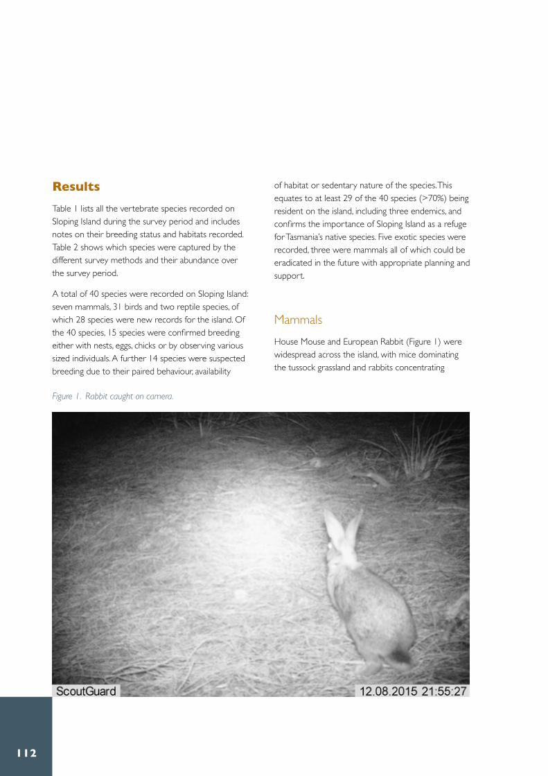
112
ResultsTable 1 lists all the vertebrate species recorded on Sloping Island during the survey period and includes notes on their breeding status and habitats recorded . Table 2 shows which species were captured by the different survey methods and their abundance over the survey period .
A total of 40 species were recorded on Sloping Island: seven mammals, 31 birds and two reptile species, of which 28 species were new records for the island . Of the 40 species, 15 species were confirmed breeding either with nests, eggs, chicks or by observing various sized individuals . A further 14 species were suspected breeding due to their paired behaviour, availability
of habitat or sedentary nature of the species . This equates to at least 29 of the 40 species (>70%) being resident on the island, including three endemics, and confirms the importance of Sloping Island as a refuge for Tasmania’s native species . Five exotic species were recorded, three were mammals all of which could be eradicated in the future with appropriate planning and support .
MammalsHouse Mouse and European Rabbit (Figure 1) were widespread across the island, with mice dominating the tussock grassland and rabbits concentrating
Figure 1. Rabbit caught on camera.

113Hamish Saunders Memorial Island Sur vey Report • Sloping Island
more in the shearwater colonies where the soil is friable and boxthorn provides cover . Table 2 provides details on the capture rate of House Mice . Ringtail Possums were recorded in woodland and Casuarina forest but given the relative limited amount of these habitats their population is likely to be relatively confined. In contrast, Brushtail Possums were more widespread as indicated by their droppings and camera evidence (Table 2) . They foraged in Casuarina woodland and Banksia groves as well as shearwater colonies using boxthorn and other fringing vegetation for cover . Tasmanian Pademelon remained elusive . No individuals were seen but their droppings were widespread (verified by B. Lazenby) and numerous runways and tussock nests were located .
The most important mammal information was that of Feral Cats . While no cats were seen or detected on camera, a number of indicators confirmed cat presence . Severed shearwater wings were strewn across the surface of the shearwater colony on the southeastern side, reminiscent of that on Tasman Island before the Feral Cat eradication program (Figure 2) . Predator scats were collected and identified as carnivore/cat by B. Lazenby, a fur ball was collected containing a ?Brushtail Possum claw (Figure 3) and various other carcasses were seen suggesting cat predation (Rabbit and Swamp Harrier) .
Figure 2. Severed short-tailed shearwater wings suggesting cat predation.
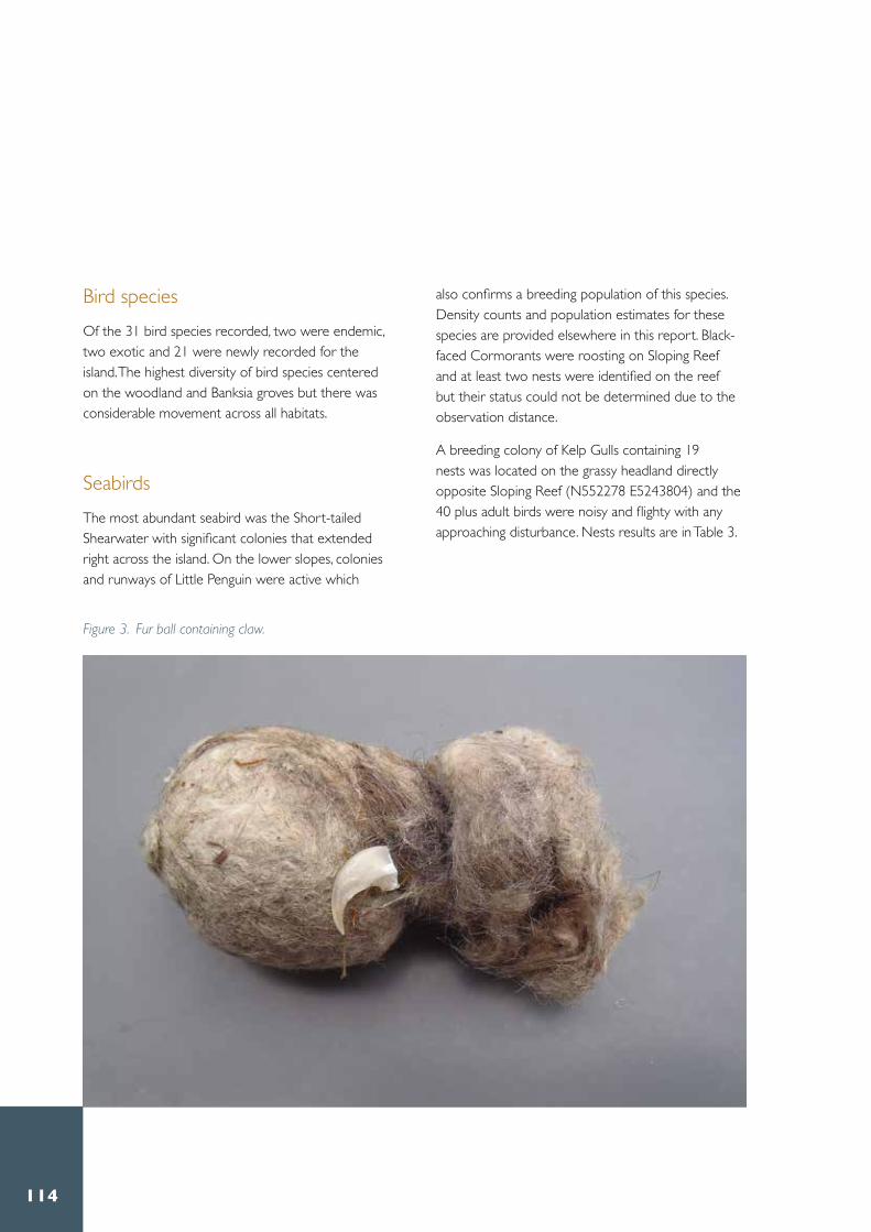
114
Bird speciesOf the 31 bird species recorded, two were endemic, two exotic and 21 were newly recorded for the island . The highest diversity of bird species centered on the woodland and Banksia groves but there was considerable movement across all habitats .
SeabirdsThe most abundant seabird was the Short-tailed Shearwater with significant colonies that extended right across the island . On the lower slopes, colonies and runways of Little Penguin were active which
also confirms a breeding population of this species. Density counts and population estimates for these species are provided elsewhere in this report . Black-faced Cormorants were roosting on Sloping Reef and at least two nests were identified on the reef but their status could not be determined due to the observation distance .
A breeding colony of Kelp Gulls containing 19 nests was located on the grassy headland directly opposite Sloping Reef (N552278 E5243804) and the 40 plus adult birds were noisy and flighty with any approaching disturbance . Nests results are in Table 3 .
Figure 3. Fur ball containing claw.

115Hamish Saunders Memorial Island Sur vey Report • Sloping Island
Table 3. Status of Kelp Gull nests on colony surveyed on Sloping Island opposite Sloping Reef.
No. Kelp Gull nests Status
4 empty2 1 egg3 2 eggs4 3 eggs4 1 fluffy chick2 2 fluffy chicks19 4 empty, 20 eggs, 8 chicks
Small numbers of two to three Pacific Gulls were seen around the coast and one nest identified on a rock shelf on the east coast at N552165 E5245168 was empty but had an attendant pair .
Shorebirds A pair of Pied Oystercatchers attended a nest containing two eggs on Sloping Beach at N552417 E5243930 (Figure 4) . A pair of agitated Sooty Oystercatchers nearby could well have been breeding to the south on the rocky shingle but no nest was found . No Hooded Plover Thinornis rubricollis or Red-capped Plover Charadrius ruficapillus were seen and habitat for migratory waders was very limited .
Figure 4. Pied Oystercatchers nest on Sloping Beach.

116
RaptorsThree species of raptor were breeding on the island . A pair of White-bellied Sea-eagles were seen daily and a previously known nest at N552870 E5244138 had fallen and was in a state of decay . Due to their regular sightings it is likely this pair were rebuilding either on the island or nearby on the Lime Bay headland . Swamp Harriers foraged constantly over tussock grassland and woodland and three active nests were found during this survey . One nest at N552735 E5244569 contained three eggs, a second nest at N552694 E5244731 had one newborn chick and two eggs, and a third nest at N552696 E5244180 contained three newborn chicks being fed pieces of
rabbit by an adult (Figure 5) . An adult harrier carcass was found in a shearwater colony near a boxthorn at N552385 E5244001 with only the rear section of the wings, legs and tail feathers remaining .
One pair of Brown Falcon regularly foraged over the woodland and disused agricultural land across the northern end of the island . Two stick nests were located, one at N552575 E5244603 on an Eucalyptus viminalis branch about 30 meters high in a grove of approximately 50 trees but the tree was dead and the nest dilapidated . The second nest at N552082 E5244489 about 20 m high in a sparsely canopied eucalypt showed no sign of activity but an adult Brown Falcon hovered overhead calling and swooping in an agitated state .
Figure 5. Swamp Harrier nest.

117Hamish Saunders Memorial Island Sur vey Report • Sloping Island
Understory and ground nesting birdsHollow nesting species were absent but a range of typical understory and foliage feeding bird species were recorded, though species diversity and number of individuals was relatively low . This is to be expected as the forest and understory habitat providing food resources needed by honeyeaters was sparse and in relatively poor condition and freshwater was scant everywhere on the island . Eucalypt trees were suffering drought and many showed extensive dieback and defoliation . White Gum habitat was limited and no Forty-spotted Pardalote were detected . Ground nesting habitat comprised largely tussock, bracken and herb land and a small number of Brown Quail were flushed and about ten Tasmanian Native Hen, some with newborn chicks were seen on the southern wetter portion of the island. A flock of 30
plus Common Starling were roosting in a boxthorn adjacent to the Kelp Gull colony .
ReptilesTwo species of skink were recorded . The Metallic Skink and White’s Skink were both captured in bucket traps and commonly seen in most habitats across the island . Large individuals of White’s Skink were regularly seen basking under debris or rock crevices on slopes (Figure 6) .
Figure 6. White’s Skink found sheltering under corrugated iron near the campsite.

118
Discussion While small in size and relatively close to mainland Tasmania, Sloping Island contains a range of significant vertebrate fauna and is worthy of its high reserve status and management (DPIWE 2002) . This survey recorded a total of 40 vertebrate species with 28 being new records for the island . Sloping Island is particularly important for Short-tailed Shearwater and Little Penguin as it offers refuge relatively free from human disturbance . Resident shorebirds continue to occupy and breed around the coast in low numbers with the most notable change since Brothers and Wakefield’s surveys being the increase in Kelp Gull numbers, which reflects a state wide trend. Raptors like Swamp Harrier and Brown Falcon that can forage low over tussock grassland have been favoured by the abundance of introduced prey species like rabbits and rodents . An even greater species diversity could well exist on Sloping Island because some species were not targeted during this survey (e .g . bats) and the survey period was short especially for camera trapping and use of alternative lures .
The island did lack some key fauna groups probably due to its few structurally complex vegetation types especially mature forest and access to permanent freshwater water . Absences include waterfowl and wetland species, larger sized nectivorous and insectivorous trunk gleaning species, hollow nesting species like parrots and migratory shorebirds . Over the years of occupation burning of the tussock grassland and establishment of feral species like cats has probably eliminated or reduced ground nesting species like small mammals, and birds like Tasmanian Scrubwren, Bronzewing sp . and Bassian Thrush, etc . Drought has caused dieback in the forest areas and trees, especially eucalypts, are now being defoliated through insect attack and over-browsing . However, Sloping Island’s close proximity to mainland feeder sites means that as woodland habitat recovers many species will migrate and re-occupy available niches .
In summary, Sloping Island is an important biodiverse Tasmanian island requiring priority protection and ongoing management .

119Hamish Saunders Memorial Island Sur vey Report • Sloping Island
Recommendations1 . Eradicating Feral Cats from Sloping Island is a high
priority for management and follow up surveys to estimate cat densities are needed . Installing cameras for longer periods and placing them around the shearwater and gull colonies may be advantageous .
2 . Any future rabbit or rodent eradication program should consider the dependence of raptors on these prey species especially during the breeding season, and time their removal accordingly .
3 . Removal of boxthorn from the coast may reduce rabbit cover and starling roosts although alternate habitat is available for both these species .
AcknowledgementsSincere thanks to Mike Comfort as expert expedition leader and all HSMT team members for their help and friendship throughout the survey . Thanks also to Billy Lazenby from DPIPWE for identifying mammal scats .
ReferencesBird Australia Atlas of Australian Birds Project www.birdsaustralia.com.au .
Brothers, N ., Pemberton, D ., Pryor, H . and Halley, V . (2001) Tasmania’s Offshore Islands: Seabirds and other Natural Features . Tasmanian Museum and Art Gallery, Hobart .
Bryant, S .L . (2002) . Conservation assessment of beach nesting and migratory shorebirds in Tasmania . Natural Heritage Trust Project NWP 11990 . Nature Conservation Branch, DPIPWE .
Bryant, S .L . (2010) . Conservation Assessment of the Endangered Forty-spotted Pardalote 2009 – 2010 . Report to Tasmanian Government and NRM South, Tasmanian Land Conservancy, Hobart .
Christidis, L . and W .E . Boles . (2008) Systematics and Taxonomy of Australian Birds . CSIRO Publishing, Melbourne .
DPIWE . (2002) . Small south east Islands Draft Management Plan. DPIWE, Hobart .
RPDC (2003) . State of the Environment Report: Tasmania 2003 . Resource Planning and Development Commission, Tasmania .

120
Appendix 1
Isle of Caves avifauna
Sam Thalmann
SummaryThe Isle of Caves was surveyed by DPIPWE staff for geoconservation (see Eberhard this volume) and avifauna values on 2 March 2016 . While the timing for this survey is outside of the peak breeding period for many seabirds, valuable data on species presence and particularly the increase in the breeding population of Black-faced Cormorant (Phalacrocorax fuscescens) was obtained . Furthermore, the evidence of ingested plastic remains within the cormorant breeding colony necessitates further investigation .
ResultsSeven species were recorded during the survey (Table 1) . Three species previously recorded were not sighted, however this is likely due to the timing of the survey and short duration on the island. Pacific Gulls were recorded for the first time.
A significant area on the top of the island is occupied by a colony of breeding Black-faced Cormorants . There was evidence that a number of chicks had fledged, with approximately 60 forming a crèche, and a further 23 still remaining on their nest . The colony size is suggested to contain up to 500 breeding pairs and requires further investigation .
Discussion and recommendationsThe breeding colony of Black-faced Cormorants would be an ideal site for ongoing monitoring of this species . In association with the amount of marine debris observed to have been collected by these birds for nesting material, and the evidence of ingested marine plastic debris, this colony is well placed for quantifying these interactions .
For effective management of seabird assemblages on these islands the completion of the Small South-East Island Draft Management Plan, should be a priority . Timing of maintenance of the automated navigation light situated on the high point of the island should be limited to outside of the peak cormorant breeding season (September to February) to limit disturbance .
ReferencesDPIWE . (2002) . Small south east Islands Draft Management Plan . DPIWE, Hobart .

121Hamish Saunders Memorial Island Sur vey Report • Sloping Island
Bird species # Non-native
Sighting notes - this survey * Inferred/observed as breeding
Previous reference
Black faced Cormorant Phalacrocorax carbo
* At least 25 chicks remaining on nest, with a further 60 pre fledging chick creching, approximately 150 adults on plateau area and shoreline .
DPIPWE 2002
Sooty Oystercatcher Haematopus fuliginosus
3 Sooty Oystercatchers on rocky shoreline DPIPWE 2002
Pied Oystercatcher Haematopus longirostris
2 Pied Oystercatchers on NW rocky shoreline DPIPWE 2002
Kelp Gull Larus dominicanus
* At least 20 fledgings from this year. Over 50 adults sighted on rock shoreline and Island plateau .
DPIPWE 2002
Pacific Gull Larus pacificus
Six Pacific Gulls on rocky shoreline New record
Silver Gull Chroicocephalus novaehollondiae
* Numerous Silver Gulls , with one recent fledging observed DPIPWE 2002
Eurasian Skylark # Alauda arvensis
Heard calling from plateau DPIPWE 2002
House Sparrow # Passer domesticus
Flock of ~8 sparrows in boxthorn bush DPIPWE 2002
Little Penguin Eudyptula minor
2-3 individuals within rock crevices on eastern side DPIPWE 2002
Crested Tern Thalasseus bergii
Not recorded in this survey DPIPWE 2002
Caspian Tern Hydroprogne caspia
Not recorded in this survey DPIPWE 2002
Table 1. Bird species recorded on Isle of Caves.

122
Sloping Island Short-tailed Shearwater survey

123Hamish Saunders Memorial Island Sur vey Report • Sloping Island
Greg Hocking and Ross Monash
On 8 and 9 December 2015, the Short-tailed Shearwater colonies on Sloping Island were surveyed by a team led by Greg Hocking as part of the Hamish Saunders Memorial Trust Island survey .
Two colonies of Short-tailed Shearwaters (Ardenna
tenuirostris) are present on the island . One colony is situated on the north of the island and the other on the south of the Island . These colonies have previously been harvested by the Aboriginal people of the region, evidence of which is readily seen in the abundance of artifacts around the margins of the colonies . The island has also been a penal colony, a whaling station and up to the mid-20th century as a farm and it is expected that the shearwaters, or muttonbirds as they are known, would provide a welcome change of diet and would have been harvested in large numbers .
Both colonies were mapped using a hand held Garmin GPS to determine the extent of each colony (Figure 1) . Five 100 x 2 metre transects were randomly located within each colony and burrows counted to determine the density of burrows within each colony . A sample of burrows was also investigated by hand to determine the presence or absence of adult breeding birds incubating their single egg laid at this time of year .

124
The northern colony extended across 10 ha with a burrow density of 0 .41 (±0 .03) burrows per m2 with 48 .06 percent of burrows investigated found to be occupied . This suggests the northern colony contained 41,075 (± 3,388) burrows and approximately 21,524 breeding pairs .
The southern colony occupied 8 .62 ha with a burrow density of 0 .52 (± 0 .04) burrows per m2 with 48 .06 percent of burrows investigated found to be occupied . Suggesting the southern colony contained approximately 44,645 (± 3,532) burrows and 21,458 breeding pairs at the time of the survey .
The last recorded survey of Short-tailed Shearwaters, undertaken during the period 1975 to 1995, (Skira et.al 1996) reported a total colony area on Sloping Island of 15 ha, with a burrow density of 0 .51 burrows per m2 and estimated a total of 76,500 burrows . This suggests that the area of Short-tailed Shearwater colony on the island has increased by approximately 3 .6 ha and 10, 200 burrows over the past 20 to 40 years .
Figure 1. Shearwater colonies on Sloping Island as mapped December 2015.

125Hamish Saunders Memorial Island Sur vey Report • Sloping Island
Management RecommendationsShearwater colonies typically have high levels of disturbance due to the frequent digging activities of the birds . As a result they frequently support high levels of exotic weed infestation with no apparent adverse effect on the shearwater population . The apparent increase in the extent of the Sloping Island shearwater colony suggests that weeds are not currently impacting on the colony .
Populations of serrated tussock (Nassella trichotoma), and isolated individuals of African boxthorn (Lycium ferrocisimum) are present in and adjacent to both the northern and southern shearwater colonies . Both of these weeds have the potential to adversely impact on shearwater populations by restricting access to soil in which to burrow . Examples of this impact from boxthorn infestations are readily seen in the Furneaux Group of islands of Bass Strait . Serrated tussock is likely to have a similar impact .
ReferenceSkira, I .J, Brothers, N .P, and Pemberton, D . (1996) . Distribution, abundance and conservation status of Short-tailed shearwater (Puffinus tenuirostris) in Tasmania Australia . Marine Ornithology Vol 24 No . 1 and 2 pp 1 – 14 .

126
Little Penguins on Sloping Island

127Hamish Saunders Memorial Island Sur vey Report • Sloping Island
Hannah Waterhouse
Introduction
Little Penguins (Eudyptula minor) are the smallest of the penguin species (Klomp and Woehler 1991) and are the only penguin to breed on the Australian mainland (Stevenson and Woehler 2007) . They are found across the southern coastline of Australia, as well as Tasmania and New Zealand (Stevenson and Woehler 2007, Dann 1992) .
Tasmania has the largest population, which is estimated at 100 000 breeding pairs (Stevenson and Woehler 2007) . There have been minimal studies undertaken on Sloping Island, with the most notable avifauna study completed by Brothers et
al . (2001) . They determined that there was an established colony of approximately 2 000 pairs and produced a burrow distribution map (Brothers et al . 2001) .

128
Little Penguins can be a difficult animal to accurately survey, as they display an asynchronous breeding season . This is caused by prey availability (Hobday 1992, Gales 1984), climatic fluctuations and location (Stevenson and Woehler 2007) . In Tasmania, the breeding season often occurs from August through to February, with eggs being laid between September and November, although they can breed at any time of the year (Brothers et al . 2001) . The Hamish Saunders Memorial Trust survey was undertaken in early December and was therefore toward the end of the predicted breeding season, assuming that there was no local differentiation .
The majority of burrows are located close to the
coast and the penguins will come ashore as close as possible . This is most likely a combination of reducing the energy expenditure required to walk, as well as limiting their exposure to potential predators (Weerheim et al . 2003, Klomp and Woehler 1991) . Little Penguins will use the same landfall site and runways to access their burrow and appear reluctant or possibly unable to take an alternate route if this access is blocked (Weerheim et al . 2003) .
The aim of this survey was to determine the distribution of Little Penguins across Sloping Island . Additional data would be taken on any preferred vegetation or substrate, as well as the stage in the breeding cycle .
Figure 1. Three major penguin runways on the west coast of Sloping Island.

129Hamish Saunders Memorial Island Sur vey Report • Sloping Island
MethodsAs previously mentioned, Little Penguins retain the same landfall site and runway to access their burrows . This provides a simple method of determining their distribution around Sloping Island .
The coastline was divided into areas that contained similar vegetation, substrate and geomorphology The number of runways were counted within each section and classified into two categories.
The runways were classified as either major or minor. Major runways were defined as having exposed soil, a clear depth to the path as the vegetation has grown up along the sides and a width of greater than 25 cm (Figures 1 and 2) . A larger group of penguins would use them for access to their burrows, therefore suggesting that the area contains a preferred habitat . Minor runways were defined as flattened vegetation, occasional small areas of exposed soil and a width of less than 25 cm . These would be used by only a small number of breeding pairs . Many runways were also evident by the presence of penguin faeces .
Figure 2. Major penguin runway on the north coast of Sloping Island.

130
ResultsThe coastline was divided into fourteen sections, with the GPS coordinates recorded at the start and end of these areas, as shown in Table 1 .
There were a total of 96 major runways and 112 minor runways around the island . Although it is possible that the occasional minor runway was created through erosion, small rock slides or wind flattening the vegetation. There were a variety of terrain and vegetation types . The level of vegetation cover was recorded, rather than the specific plant species, as Little Penguins will burrow under most plants, whether native or introduced, as long as it provides sufficient protection (Marker and Wind 2003) . Table 2 displays the number of runways in each section and the associated terrain and vegetation .
Major runways were determined to be of more value, as those paths would be used by a higher density of penguins and were less likely to have been created
by other factors . Using ArcGIS, the number of major runways was used to create a map, providing a visual tool for the distribution around the coastline of Sloping Island (Figure 3) .
DiscussionLittle Penguin runways were found around the entire coastline, except for one section on the mid-west coast . This area had steep cliffs, minimal vegetation and very shallow soils and was therefore not ideal for the construction of burrows . Little Penguins are able to burrow in a wide variety of habitats, including sandy soil, hollows, caves, rock crevices, tree stumps and under dense vegetation (Stevenson and Woehler 2007, Weerheim et al . 2003) . This generalist behaviour has allowed them to inhabit the majority of the coastline of Sloping Island .
Many of the runways were located in areas that were easily accessible from the water and consisted of
Section GPS Start GPS Finish
1 N552798 E5244421 N552695 E52447532 N552695 E5244753 N552690 E52447483 N552690 E5244748 N552553 E52447674 N552533 E5244767 N552436 E52449445 N552436 E5244944 N552341 E52450306 N552341 E5245030 N552229 E52451207 N552229 E5245120 N551936 E52447808 N551936 E5244780 N551824 E52446959 N551824 E5244695 N552001 E524409110 N552001 E5244091 N552099 E524382711 N552099 E5243827 N552367 E524359812 N552367 E5243598 N552587 E524336113 N552587 E5243361 N552767 E524359814 N552767 E5243598 N552798 E5244421
Table 1. GPS points of each section around the coastline.

131Hamish Saunders Memorial Island Sur vey Report • Sloping Island
SectionMajor runways
Minor runways
Terrain Vegetation Cover
1 9 11 Cobblestone beaches, rock faces . Medium slope
Trees and overhanging vegetation
2 10 11 Cobblestone beaches . Low slope . Some overhanging vegetation, coastal scrub
3 9 3 Cobblestone beaches, some sand . Low slope
Very few trees, some coastal scrub
4 3 4 Cliff faces, rock flats, some sand dunes
Vegetation starting half way up cliff face
5 4 2 Mudstone rock flats, cliff faces. Some large rocks on beach
No coastal vegetation except thick African boxthorn at northern end
6 6 2 Dolerite rocks increasing in size and forming into cliff faces
Very thick African boxthorn along coastline
7 16 7 Large dolerite rocks and cliff faces, changing to mudstone flats.
Coastal scrub
8 3 0 Cobblestone beaches with some sand, mudstone flats
Coastal scrub
9 0 4 Cliff faces, rock flats, shallow soils Minimal vegetation, mostly on top of cliffs
10 4 8 Large dolerite rocks, rock flats. Medium-high slope
Thick coastal scrub on slope
11 10 9 Sandy beach, medium rocks further inland . Medium-low slope
Thick coastal scrub
12 6 9 Large dolerite rocks, cliff faces . Some large rock flats
Coastal scrub after rock formations
13 5 21 Large dolerite rocks, small cliff faces . Medium-low slope
Coastal scrub
14 11 21 Cobblestone beaches . Medium slope
Coastal scrub
Table 2. The number of runways, terrain and vegetation cover in each section around Sloping Island.

132
Figure 3. Major runway distribution around the coastline, the red line thickens as the number of runways in that section increases.

133Hamish Saunders Memorial Island Sur vey Report • Sloping Island
cobblestone or sandy beaches, as well as mudstone rock platforms . These provide an easy access and departure point for the penguins . The runways were often not completely visible at the shoreline, except for some faecal remains, and instead only became obvious at the vegetation level . The number of runways increased in areas that contained dense coastal scrub or thick African boxthorn . This would provide adequate protection from both potential predators and the natural elements .
The map produced by Brothers et al . (2001) showed that Little Penguins inhabited the southern, as well as smaller areas along the northern and eastern coastlines . This study indicates that the penguins are across a wider range than first described. Active runways were found around almost the entire island .
Suggesting that either the island penguin colony has grown and they are needing to use a larger area, or that they are at a lower density . This may be caused by changes in suitable nesting habitat, but it is impossible to accurately determine this without a long term dataset .
No eggs or chicks were found in any of the burrows that were checked and only a small proportion of them were occupied . This suggests that all chicks had fledged and the breeding season had concluded and that the adults had not started moulting yet .
Figure 4. Little Penguin nesting in a small cave.

134
Management recommendationsThe most recent Little Penguin population survey was conducted on Sloping Island in 1999 (Brothers et al . 2001) . Annual population counts could be undertaken, in addition to monitoring the distribution of the colony, as there is the possibility of seasonal movements due to changes in prey availability or terrain alteration .
Sloping Island has had several weeds introduced in the past, primarily serrated tussock, Spanish heath and African boxthorn . These have quickly spread and are found across many parts of the island . Weed management is important, but Little Penguins are known to be opportunistic and build burrows under any vegetation that provides a sufficient level of protection (Figure 4) . There were many runways, as well as vocalisations heard from under
African boxthorn plants during this survey . Coastal weed management should be conducted after the breeding season to reduce disturbance and the risk of destroying burrows . If possible, visual observations should be made first to determine whether there are penguin burrows under the weed before it is sprayed or removed .
Invasive species monitoring is significant in protecting the colonies of breeding seabirds . Little Penguins are relatively vulnerable in their burrow and while travelling to and from the ocean (Figure 5) . It is highly likely that Feral Cats have been introduced to the island and they are known to prey on penguins, as shown by a study on Wedge Island in Tasmania (Dann 1992) and depending on the population size of cats, they could potentially kill a large number . There is little that can be done to protect penguins, other than removing the cats from the island .
Figure 5. Little Penguins returning to water before dusk, image from motion activated remote camera.

135Hamish Saunders Memorial Island Sur vey Report • Sloping Island
At sea, Little Penguins are vulnerable to oil spills, fishing lines, nets and boat strikes, as well as the growing level of plastics that are being discarded . The final management recommendation would be to make regular observations on the rubbish pollution and any oil spills in the water surrounding Sloping Island .
ConclusionSloping Island is an important offshore breeding site for Little Penguins . As it is isolated from the mainland of Tasmania, it provides an opportunity to protect this area without external movement of invasive species and limited human disturbance . The population fluctuations and the full impacts of the previously mentioned threats are unknown, so it is important to maintain a long term dataset to enable the most appropriate management of this area (Stevenson and Woehler 2007, Fortescue 1999) .
AcknowledgementsI would like to thank Candida Barclay and Tom Priestley for their assistance in the planning and data analysis, as well as Natalie Bool for her advice on Little Penguins . A big thank you to the Hamish Saunders Memorial Tust team for being supportive and making the island experience very enjoyable .
ReferencesBrothers, N ., Pemberton, D ., Pryor, H . and Halley, V . (2001) . Tasmania’s offshore islands: seabirds and other natural features . Tasmanian Museum and Art Gallery, Hobart .
Dann, P .M . (1992) . Distribution, population trends and factors influencing the population size of Little Penguins Eudyptula minor on Phillip Island, Victoria . Emu 91: 263-272 .
Fortescue, M . (1999) . Temporal and spatial variation in breeding success of the little penguin Eudyptula minor on the east coast of Australia . Marine Ornithology 27:21-28 .
Gales, R . (1984) . Breeding seasons and double brooding of the Little Penguin Eudyptula minor in New Zealand . Emu 85: 127-130 .
Hobday, D .K . (1992) . Abundance and distribution of pilchard and Australian anchovy as prey species for the Little Penguin Eudyptula minor at Phillip Island, Victoria . Emu 91: 342-354 .
Klomp, N .I . and Wooler, R .D . (1991) . Patterns of arrival and departure by breeding Little Penguins at Penguin Island, Western Australia . Emu 91: 32-35 .
Marker, P . and Wind, A . (2003) . Guidelines for works in areas of Little Penguin habitat. Coastcare, Tasmania .
Stevenson, C . and Woehler, E .J . (2007) . Population decreases in Little Penguins Eudyptula minor in southeastern Tasmania, Australia, over the past 45 years . Marine Ornithology 35: 71-76 .
Weerheim, M .S ., Klomp, N .I ., Brunsting, A .M .H . and Komdeur, J . (2003), Population size, breeding habitat and nest site distribution of little penguins (Eudyptula minor) on Montague Island, New South Wales . Wildlife Research 30: 151-157 .

136
A lithic knapping floor on Sloping Island – archaeology
of sustenance and survival

137Hamish Saunders Memorial Island Sur vey Report • Sloping Island
Samuel Dix
Introduction
The area under investigation is located between grid references E5222541, N5245068 and E552406, N5245278 on Sloping Island, located approximately 1 .5 kilometres from Lime Bay and 5 .8 kilometres from Carlton Bluff in Frederick Henry Bay (Figure 1 and Figure 5) . The islands highest point is approximately sixty meters above sea level towards the south and has an area of approximately 1 .17 km² . The targeted archaeological survey was focused on the north east quadrant of the island where past archaeological surveys have found a possible procurement site for the manufacturing of stone tools . This site has previously been recorded as AH 1490 (artefact scatter, small midden scatter and possible quarry) on the Aboriginal Heritage Register .
This work was conducted on behalf of the Hamish Saunders Memorial Trust by archaeologist Samuel Dix with the assistance of Spatial Information Analyst Hamish Treeby . A glossary is provided at the end of this report for technical terminology .

138
Sloping IslandArchaeological Investigation - Hamish Saunders Memorial Trust
Created on 18/02/2016
This map is intended for use by the nominated recipient, for research purposes only. The map cannot be used for any other purposeswithout written permission from AHT.Information about Aboriginal heritage sites and instruments issued by AHT is confidential and is not for public dissemination.
GDA94 - Zone 551:53K
Created by Samuel Dix
Hamish Saunders Memorial Trust
AH Item
Legend:
AH Instrument
Figure 1. Frederick Henry Bay and the Location of Sloping Island.

139Hamish Saunders Memorial Island Sur vey Report • Sloping Island
AimsThe aim of this survey was to undertake a detailed archaeological examination of a portion of Sloping Island to determine the presence of a possible stone reduction site where raw material was worked to produce tools .
The analysis of stone artefacts provides an understanding of early life and technology, and how populations utilised such implements for day to day life . Lithic analysis aids greatly in the understanding of the tools that were produced, how they were produced, and gives a glimpse into economic strategies applied to day to day life . Spatially representing these within an archaeological site recording enables more accurate interpretation of this knapping event . The lithic analysis consisted of surface finds only. As a result, this is only a sample of the lithic material present and does not account for possible sub-surface archaeology .
Site historyArchaeologist Denise Gaughwin (1985) conducted the only major research lead survey for Aboriginal heritage on Sloping Island . This was a part of a larger survey for Aboriginal sites on the Tasman Peninsula . Gaughwin (1985) only surveyed the coastal margins and one transect through the centre of the island from north to south . During this survey, six sites were recorded including two artefact scatters and four shell middens . There were two previously recorded sites prior to this survey . To date, the Aboriginal Heritage Register (AHR) notes two isolated artefacts, eight artefact scatters and a stone quarry site (recorded three times) . Four of these sites, predominantly artefact scatters, are associated with midden exposures . There are also three separately recorded midden sites . Today there are 16 sites recorded on
the island with this report specifically dealing with AH 1490 and AH 9100 .
Prior to Gaughwin’s survey, the site being investigated in this report (AH 1490) was recorded by Graeme Towney in 1981 . This brief site recording form described the site as a midden scatter, artefact scatter and a possible quarry source . No other information was provided by the recorder about the site or its extent .
Aboriginal Heritage Officer (AHO) Leigh Maynard conducted a survey of the island in March 2002 for a proposed program of weed removal and revegetation . This report defined the boundaries of seven of the Aboriginal heritage sites on the island, including those being examined in this project where he seems to have amalgamated AH 1490 into AH 9100 (stone quarry) . However, his report also states that due to limited visibility, the full extent of sites could not be accurately surveyed (Maynard 2002:7) . Unfortunately, Maynard never documented the sites from his investigation with Aboriginal Heritage Tasmania (AHT), and AHT have no site recording forms for the area . Comparing Maynard’s map to the records in the AHR, the extent of AH 9100 is more than likely a re-recording of AH 1409, although this has not been acknowledged in his report (see Maynard 2002:5) .
There are no ethnographic references made about the occupation and use of Sloping Island by pre and post colonization Aboriginal populations . Because of the lack of ethnographic and archaeological data, no firm understanding for the sites’ abandonment can be understood .
Sloping Island has been used as a whaling station, probation station and pastoral grazing land since the 1820s . This has caused much of the island to be impacted by post-colonial land modification. This has potentially impacted on a number of the sites on the

140
island . A full analysis of this historical disturbance to the landscape is provided in the discussion section of this report .
Flora, fauna and geologyThe area under investigation consists of thick coverage of Carpobrotus rossii (pig face), which covers portions of the site (Figure 2) . This is blanketed in sections, but does show signs of track ways made by Puffinus tenuirostris (mutton-bird) through this vegetation where the bare soil was exposed . Intermixed with the C. rossii are scatters of Poa poiformis (coast tussock) throughout the site extent .
Lycium ferocissimum (African boxthorn) is present on the island with larger deposits scattered throughout the survey area . The majority of L. ferocissimum remains are evidence of a weed eradication program on the island (Figure 3) . These remains are piled in areas along the coast, and in some areas, seem to have fallen to the water’s edge .
P. tenuirostris burrows cover the majority of the area south and west of the area being surveyed, but not in the recorded site itself (Figure 4) . In 1995 there were a recoded 7650 borrows on the island (Skira et al . 1996:12) . Skira et al . (1996:5) notes that P. tenuirostris are fairly recent to Sloping Island . It is recorded that there were no rookeries on the island in the 1800s
Figure 2. Carpobrotus rossii (pig face) and Poa poiformis (coast tussock) at the survey area.
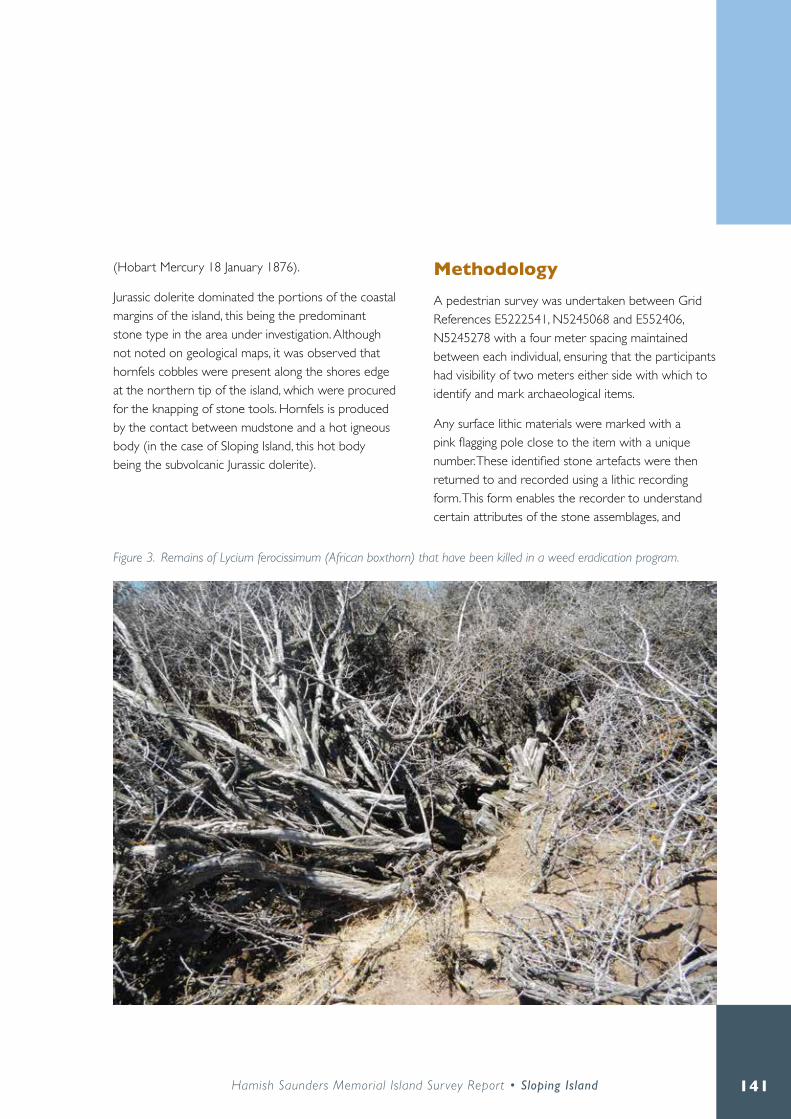
141Hamish Saunders Memorial Island Sur vey Report • Sloping Island
(Hobart Mercury 18 January 1876) .
Jurassic dolerite dominated the portions of the coastal margins of the island, this being the predominant stone type in the area under investigation . Although not noted on geological maps, it was observed that hornfels cobbles were present along the shores edge at the northern tip of the island, which were procured for the knapping of stone tools . Hornfels is produced by the contact between mudstone and a hot igneous body (in the case of Sloping Island, this hot body being the subvolcanic Jurassic dolerite) .
MethodologyA pedestrian survey was undertaken between Grid References E5222541, N5245068 and E552406, N5245278 with a four meter spacing maintained between each individual, ensuring that the participants had visibility of two meters either side with which to identify and mark archaeological items .
Any surface lithic materials were marked with a pink flagging pole close to the item with a unique number. These identified stone artefacts were then returned to and recorded using a lithic recording form . This form enables the recorder to understand certain attributes of the stone assemblages, and
Figure 3. Remains of Lycium ferocissimum (African boxthorn) that have been killed in a weed eradication program.

142
define whether they are ‘one-off ’ scatter sites, or components of a lithic knapping floor. The recording of specific attributes associated with stone artefacts reflects various areas of inquiry that can be explored about ancient lifeways . The artefact recording form was developed by Samuel Dix for the project . The information recorded on this form included: artefact type, rock type, flake length, flake width, flake thickness, platform width, platform thickness, platform type, number of platforms for cores, number of flake scars for cores, overhang removal, retouch location, cortex type and percentage of cortex on dorsal surface . The dorsal and ventral surface of each artefact was photographed and catalogued alongside
the number assigned to them in the lithic recording form .
This analysis was directed at surface finds only and does not account for potential sub-surface archaeology . A better and more accurate interpretation can only be obtained through further archaeological work which would involve the excavation of sample areas of the site . This would better represent the assemblage size, manufacturing techniques, and possible age of the site .
Figure 4. Puffinus tenuirostris (mutton-bird) burrows to the south of the site.

143Hamish Saunders Memorial Island Sur vey Report • Sloping Island
Figure 5. Site extent of AH 1490.

144
ResultsThis investigation successfully recorded the extent of a lithic knapping floor, where the reduction of stone was carried out in the production of stone tools (Figure 5) . This site was previously designated AH 1490 on the Aboriginal Heritage Register (AHR), recorded by Graeme Towney, and amalgamated into AH 9100 by Leigh Maynard as a quarry site . From the recent investigation, this designation as a quarry source has now been reassigned to an ‘artefact scatter’ (for the purposes of the Aboriginal Heritage Register that does not categorise the site feature ‘lithic knapping floor’).
The site has an approximate area of 3400 m² and extended from the 26 m contour to the coast . No physical surface artefact link between AH 9100 and AH 1490 could be found to help establish the site as one large complex . However, the sites are inherently linked as all of the stone artefacts recorded were derived from this hornfels cobble sourced at AH 9100 (Figure 6) . Further sub-surface excavation between these areas may help establish this connection . Moore (2000:61) does state that it is quite common for flaking sites in Tasmania to be located away from a quarry or procurement source . Moore (2000:62) notes that the lack of on-source artefacts at these sites show a process of collecting
Figure 6. Cobbled beach where the hornfels cobbles were procured.

145Hamish Saunders Memorial Island Sur vey Report • Sloping Island
material from a source to be worked in a separate location . This seems to be the case with AH 9100 and AH 1490 .
Despite the original 1981 site recording by Graeme Towney stating there was a midden scatter at the site, no evidence of this could be found in or around AH 1490 and AH 9100 .
86 stone artefacts were identified within the area. The majority of these finds included unmodified flakes (with diagnostic features), and debitage (no diagnostic features, but were angular and of the same stone typology as surrounding finds). 12 cores were identified, with six being identified as multi-platform
cores, and six as single platform cores . Only two retouched flakes were found, and one large bifacial flaked cobble chopper (Figures 7 and 8). Platform overhang removal was only identified on 16 of the flakes, with 22 showing no sign of this process. The correlation of this data is described in the discussion section of this report .
DiscussionFrom the survey it has been determined that the area designated AH 1490 on the Aboriginal Heritage Register is a lithic knapping floor associated with the reduction of raw material to produce stone
Figure 7. Graph representing stone artefact typology at AH 1490.

146
implements . Although not recorded as a part of this survey due to time limitations, the site is closely associated with a hornfels stone procurement source located to the north of the island on a cobbled beach at grid reference E552298, N5245294 (AH 9100 – Figure 6) . As AH 1490 contents are made wholly of stone artefacts, this discussion will analyse these items in relation to the site in general .
Collins (1975:18), Flenniken and White (1985) and Moore (2000) present approaches in understanding the stone reduction sequence, and how these may be presented in a lithic knapping floor. There are considered to be generally five levels of reduction
when creating stone implements . These levels can also greatly assist in generating an understanding of sites such as this knapping floor as to what processes in the stone reduction sequence the site represents . The following list has been compiled from observations by Collins (1975:18), Flenniken and White (1985) and Moore (2000):
• Selection of raw material: Workable material is either procured from a known quarry source by removing larger stone nodules with larger boulders, or in the case of Sloping Island, appropriate hornfels cobbles collected from the beach .
• The production of macro-flakes, debitage and cores: Using a hammer stone the raw material is shaped into a workable shape that remove small and large and/or irregular flakes (debitage) to produce a core .
• The production of flakes: Flakes start to be removed from the core . These are generally elongated and this process may produce smaller debitage from the fracturing process .
• Further production of micro-flakes: As mentioned above, the process of dislodging flakes from a core may produce smaller debitage material .
• Exhausted core: The core no longer has the ability to produce flakes. In some cases cores can be reshaped into tools themselves, or discarded .
Of considerable interest in identifying this site as a knapping floor site is the analysis of cortex present on the dorsal surface of many of the flakes. Generally, the removal of the cortex within a reduction sequence details the first process in core preparation. The primary aim of this process is to change the size and shape of the raw material into a piece of stone that has the ability to produce flakes. To do this, the raw material needs to be prepared into a core where a suitable platform is established so individual flakes can
Figure 8. Example of Flakes from Sloping Island (drawn by Samuel Dix).

147Hamish Saunders Memorial Island Sur vey Report • Sloping Island
be removed by a hammer stone (see Holdaway and Stern 2004:206) . Therefore the presence or absence of cortex and the percentage of that material that is left behind on the dorsal surface of a flake is an important indication of the percentage of stone worked to remove the cortex to produce a workable core .
Of these, 27 artefacts exhibited signs of cortex being present on the dorsal surface, with eight having one-hundred percent cortex coverage . Ten artefacts had five to ten percent coverage, where six had thirty to fifty percent. Three artefacts have between sixty to eighty percent cortex coverage. Ten flakes and ten debitage pieces all contained varying amounts of cortex. This means that twenty out of sixty five flakes and debitage pieces recorded contain some level of cortex. Close to half of the flakes and debitage identified contained the outer crust of the raw material . This shows that there was a concerted effort in this area to remove the outer lining of the stone and prepare a core for further flake reduction. In doing so, the person modifying the stone is removing the sections of stone that are not conducive to good tool production and leaving this behind .
The term ‘debitage’ is used here to reflect to some degree the term ‘flaked pieces’ coined by Hiscock (1982) . Here, Hiscock assigned the term to a small percentage of a larger assemblage that showed signs of deliberate flaking, but could not be assigned to a specific artefact category. Huys (2014:50), however states that if there is no demonstrable evidence of the item being deliberately manufactured, then it was probably not (see discussion below) .
Throughout the world, it is acknowledged that there are many natural or mechanical ways in which natural deposits of stones can be chipped to resemble stone artefacts . These can be either through mechanical means (such as through machinery, for example graders, chipping fragments of stone), as well as
natural means (including water, frost or heat naturally cracking stone) . In this instance, it is concluded that the debitage recorded at Sloping Island is artefactual, as all pieces were the same stone typology as identified flakes and tools with diagnostic features, and are more than likely the result of the reduction sequence . Coles (1972:15) states that an ordinary stone knapping site is likely to contain a larger percentage of waste flakes or debitage to finished tools of about 200:1 . It is therefore believed that the angular flakes designated debitage in this report are the result of knapping, and not that of natural or mechanical means .
The average platform width and thickness was 30 .71 mm x 11 mm. The removal of a flake from a core may produce a lip on the larger platform of a core . The removal of this lip from the core allows the stone knapper to better detach successive flakes from the core . This may be the case if the knapper is wishing to produce thinner flakes or, in some cases, conserve the amount of stone that is removed from a core . This removal is present on the dorsal surface of the flake at the proximal end. The removal of this lip or overhang before the flake is detached from the core is present on the flake, and is recognized by a series of smaller flake scars that are directly below the platform on the dorsal surface . Early reduction flakes generally have attributes resulting in a larger and deeper platform, such as those observed in this examination, adding to the theory of the site being a workshop area as opposed to a random artefact scatter of discarded flakes (Moore 2000:59). Only sixteen of the thirty eight recorded flaked pieces show signs of overhang removal meaning that there was a deliberate attempt not to remove the overhang, and therefore possibly create larger flakes
Despite the clear evidence of bioturbation of the site and the erosion of sand and artefacts from this 26 m contour of the site (Figure 9), it is quite possible that

148
the sand was deposited during the last glacial period (c . 12-14,000 years ago - Chris Grose pers . comm . 2016) and was utilised by Aboriginal people visiting the site in the early to mid-Holocene period (c . 8,000 years BP) . However, further analysis of the soils is required to confirm the precise date of this sand deposit (Chris Grose pers . comm . 2016) . Evidence of subterranean archaeology was not present in the bioturbation of the sand by P. tenuirostris . As such, it could be plausible to hypothesise that these stone artefacts were made on the surface of this dune, and were thus the first humans present in the area working this stone .
Interestingly, Carlton Bluff (5 .8 kilometres by sea from Sloping Island) was subjected to radiocarbon dating of midden material by Grote Reber (1965) . This was one of the first archaeological sites to be
dated in Tasmanian (Neil 1981:1) . A radiocarbon date was obtained from the base level of the excavation showing it to be 8700 +/- 200 BP . At the time, these dates were the earliest record for an open midden in Tasmania, and Australia as a whole (Neil 1981:1) . All other midden sites at the time in Eastern Tasmania were around 5,000 to 6,000 BP, meaning that the Carlton Bluff area predates most other sites by two to three thousand years . The analysis of this site deals specifically with midden material and the hunter-gatherer exploitation of these species . Neil (1981:111) states that:
Hunter-gatherer occupation during the mid-Holocene appears to have been episodic . The mid-Holocene economic strategy appears to have been specialised, in terms of the limited range of economic species exploited, but not intensive in terms of the total
Figure 9. Example of incline where soil and artefacts have eroded down the incline of the bank.

149Hamish Saunders Memorial Island Sur vey Report • Sloping Island
weight of the archaeological deposit . This apparently non-intensive economy may reflect the relative instability of the mid-Holocene maritime situation, in particular, oscillation in sea level and fluctuating sedimentation regimes .
The underlying issue of this specific site is that the hunter-gatherer economy of the area was seasonal, and that certain species were exploited at different times seasonally . This may also be the case for the early occupation of Sloping Island .
These excavations also show that during the mid-Holocene (c . 6,000 - 8,000 BP), there was an eventual decline in the amount of Katelysia shell within the sediments; the preferences turning towards oyster and mussel (Neil 1981:111) . This was due to paleoenvironmental change .
It is plausible, depending on the comparisons between this site and the early sand dune on Sloping Island, that these two sites probably have similar seasonal occupation traits . Where no midden material was identified at this Sloping Island site, further midden analysis of other sites on the island would assist in comparing possible trends in food economies and possibly help further date seasonal occupation of the island
An understanding of the historical changes to the landscape is important in understanding how the site presents itself today, and how it may be impacted in the future . In the instance of AH 1490 and AH 9100, it could be that the land was cleared when the island was used as a convict probation station, for whaling purposes or when it was farming land . It is noted in Thompson (2007:107) that a whaling grant from a sandy beach in an inlet at the north east of the island was established in the 1820s with buildings being erected on a flattened area in 1825 by Messrs Bethune and Grant (Kostoglou
1995b:71) . Thompson (2007:159, 170, 173) also quotes a number of references relating to the sites potential for agricultural activities as well as timber getting for the colony which may account partially for the clearing of the site . Speculatively though, the establishment of a whaling station close to the site would have required the procurement of wood fuel for processing the whale blubber as well as constructing accommodation . Thus the most logical way of completing this would be to remove trees from the closest point to the station, which could quite possibly have been at the site of AH 1490 and AH 9100 . This has in turn resulted in the landscape seen today and the environmental impacts this has had to the sandy soils of the area .
The trying out process in treating whale blubber involved larger portions of blubber recovered from the whale being reduced to smaller pieces and placed in the trypot cauldron . The process of boiling the whale blubber required the whalers to light a fire under these pots at very precise temperatures (Kostoglou 1995a:20) . These trypots were placed into drystone ‘U’ shaped enclosures, where fuel was placed under the pot, with airflow supplied by a gap in this ‘U’ shaped wall or a chimney (Kostoglou 1995a:26) . This required the felling and gathering of timber for this boiling process . Added to this, the workers on these stations were required to build living and working quarters . These quarters consisted of living spaces, workshops for carpenters, coopers and blacksmiths (Kostoglou 1995a:17) . These buildings were predominantly timber huts; the raw materials possibly procured from the resources available to them (Kostoglou 1995a:21) . Kostoglou (1995a:27) also states that in the early stages of station life, the surrounding timbers would have almost been exclusively used for this rendering process until exhausted, where other forms of fuel would have been required to keep the pots burning .

150
As stated, the Bethune and Grant Sloping Island station is the only station located closest to AH1490 and AH 9100, and the area likely to be where most of the land clearing occurred . Kostoglou (1995b:72) notes that there are scant archaeological remains associated with this 1820s whaling operations, and those present must not be discounted as being the remains of the islands other occupants; mainly the probation station in the 1840s and farming activities in the 1850s . Either way, it is hypothesised that the site AH 1490 observed today is one that has been modified significantly by environmental changes that have occurred due to deliberate vegetation clearing .
ConclusionIn conclusion, this site appears to be the remains of a stone artefact ‘workshop’ . Appropriate hornfels cobbles were procured from the beach to the north of the island and moved to higher ground at approximately 26 m above sea level (Figure 10) . This area was relatively flat with a gentle slope running east, that quickly turned into a twenty degree incline approximately twenty meters above sea level to the shores edge . The soils were sandy, well drained, and suitable for temporary campsites . Moore (2000:63) notes that this practice of moving cobbles off-source was common in eastern Tasmania . Jones (1971:231) adds ‘suitable blocks of stone, prepared cores, large flakes or artefact blanks were removed from such quarries and carried for trimming into finished artefacts . These activities usually took place on living or workshop sites . The implements were then ready to be used for various processing and manufacturing activities which tended to take place at living sites near hearth sites’ . There were no signs of smashed or modified beach cobbles at AH 9100. The reduced stone was made into a more manageable core for future work, possible trade, or made into a workable
implement that would have been used elsewhere on the island or transported back to the mainland .
Without the aid of further archaeological work, a date for the site cannot be obtained . However, analysing the soil makeup of the site, the lack of evidence of subterranean artefacts in the burrows of the sand dune, and the comparisons with other nearby radiocarbon dated site, it is hypothesised that this site may be early to mid-Holocene in age (6-8,000 years BP) .
With the arrival of the British in 1804, significant change occurred for the Aboriginal people in the area and the island was at some stage abandoned by them . With the establishment of whaling stations, farms and a probation station on the island, there was a considerable change to the landscape . The early whalers at the island possibly cleared the vegetation at the site of AH 1490 and AH 9100 to feed the fires for blubber processing . This caused the landscape surrounding AH 1490 and AH 9100 to have the appearance it has today .
Without the aid of sub-surface excavation, it is difficult to determine the full extent of artefacts in the area . Bowdler (1980:5) reiterates this by stating ‘… excavated assemblages are infinitely superior to surface collections .’ Further to this, it is also held that understanding of a site can only come from a broader analysis of all economic and ecological factors that make up an area (Bowdler 1980:5) . Knowing this, only a glimpse of the full function of the site is available without the further work of a regional survey of the island, and archaeological excavation . Only then can a more complete understanding of the site be gained . There are also inherent limitations pertaining to the archaeological evidence . There are many aspects to archaeological remains that do not survive (such as organic materials) . There are also a range of artefacts that are beyond the interpretation of archaeology

151Hamish Saunders Memorial Island Sur vey Report • Sloping Island
without other means of investigation . Philip Barker (1982:204) notes ‘a reed pipe will tell us its range of notes but not the tunes played on it’ . Only with more extensive archaeological work can a more directed interpretation of the site be obtained .
In respect to other known quarry/procurement sites with prominent reduction areas (for example Oyster Cove near Margate and Flinty Point at Sorell), this site is considerably smaller . It is hypothesised that the reduction site was only used sporadically for a short period of time, much like the early Carlton Bluff site . However, sub-surface archaeology could disprove this theory . One comparative example comes from the excavation work of Crown
Lagoon by Lourandos (1977) . This site revealed the production of flaking floors, where the Aboriginal people temporarily camping here partook in the creation and modification of stone implements. In this instance, Lourandos (1977:222) interpreted the site as being a ‘… series of temporary camps orientated chiefly around the maintenance and utilisation of flaked stone tools used to manufacture and maintain wooden implements …’ It is possible this could also be said for AH 1490 .
Figure 10. Level elevated area of AH 1490 where the knapping floor is believed to have been originally situated.

152
Management recommendationsAboriginal heritage in Tasmania is protected under the Aboriginal Relics Act 1975 (the Act) .
Under the provisions of the Act any work that should occur within the bounds of AH 1490 and AH 9100 will require a permit to interfere . There are natural and environmental occurrences that may cause the site to be impacted that cannot be managed without a program of conservation monitoring . As discussed, some of the site is believed to have been eroded from the 26 m contour of the hill where material has moved down the slope with the soils .
As such, it is possible that the boundaries for this site may change depending on the environmental movements of these artefacts . It also needs to be understood that this area has only been mapped by the surface expression of artefacts, and may change with the uncovering of sub-surface archaeology in the area . As stated, it is reasonable to assume that AH 1490 and AH 9100 are connected, however, no surface expression could be found to prove this . Further sub-surface archaeology may be able to provide these answers . It is recommended that future surveys of the island are co-ordinated around possible incursions of this geological meeting which may yield further evidence of Aboriginal stone quarrying or procurement on the island .
ReferencesBowdler, S . (1980) . Stone tools as economic markers? New evidence from the Stockyard Site, Hunter Island . Paper presented at Recent Research into Technology in Australian Material Culture: Past and Present, Canberra, May 23-24, 1980
Barker, P . (1982) . Techniques of Archaeological Excavation . London: B .T . Batsford Ltd .
Coles, J . (1972) Field archaeology in Britain . London: Methuen,
Collins, M . 1975 Lithic technology as a means of processual inference . In E . Swanson (ed .) Lithic Technology, pp .15-34 . Mouton: The Hague .
Flenniken, J. J.P. White. 1985 Australian flaked stone tools: A technological perspective . Records of the Australian Museum 36:131-151
Gaughwin, D 1985 ‘An Archaeological Reconnaissance of the Tasman Peninsula, February 1984’, Australian Archaeology 20:38–57 .
Hiscock, P .D . 1982 . A technological analysis of quartz assemblages from the south coast . In S . Bowdler (ed .) Coastal Archaeology in Eastern Australia, pp .32-45 . Canberra: Department of Prehistory, Research School of Pacific Studies, Australian National University
Holdaway, S . N . Stern . (2004) . A Record in Stone: The Study of Australia’s Flaked Stone Artefacts . Melbourne: Aboriginal Studies Press .
Huys, S . (2014) . An Aboriginal heritage assessment of the proposed Haywards Shipyard expansion project . Unpublished report for Crisp Bros Haywards .
Jones, R (1971) . Rocky Cape and the Problem of the Tasmanians Volume 2 . Unpublished PhD thesis for the University of Sydney .
Kostoglou, P . (1995a), Shore Based Whaling in Tasmania Archaeological Research Project . Volume 1: Results of Fieldwork . Hobart: Parks and Wildlife Service .
Kostoglou, P . (1995b) . Shore Based Whaling in Tasmania Archaeological Research Project . Volume 2: Results of Fieldwork . Hobart: Parks and Wildlife Service .

153Hamish Saunders Memorial Island Sur vey Report • Sloping Island
Lourandos, H . (1977) . Stone tools, settlement, adaptation: a Tasmanian example . In R .V .S . Wright (ed .) Stone Tools as Cultural Markers, pp .219-224 . Canberra: Australian Institute of Aboriginal Studies .
Maynard, L . (2002) . A report of an Aboriginal heritage values assessment of a proposed weed removal and revegetation project on Sloping Island . Unpublished report for the Aboriginal Heritage Section, DPIPWE .
Moore, M .W . (2000) . Lithic technology in Tasmania . Archaeology in Oceania 35:57-73
Neil, R . (1981) . Analysis of Invertebrate Fauna from Lower Estuarine Midden Site, Southeast Tasmania . Unpublished BA (Hons) Thesis, University of New England
Reber, G . (1965) . Aboriginal Carbon Dates from Tasmania . Mankind 6 (6): 264 - 268
Skira, I .J ., N .P . Brothers, and D . Pemberton (1996) . Distribution, abundance and conservation status of Short-tailed Shearwaters Puffinus tenuirostris in Tasmania, Australia . Marine Ornithology 24: 1–14 .
Thompson, J . (2007) . Probation in Paradise: The Story of Convict Probationers on Tasman’s
and Forestier’s Peninsulas, Van Diemen’s Land, 1841–1857 . Hobart: Self-published .
Newspapers: Hobart Mercury 18 January 1876
GlossaryBioturbation – the reworking and modification of soils that have been impacted by animals and plants .
BP - Before Present – the number of years before ‘present’ . In archaeology it is standard practice for the ‘present’ to be 1 January 1950, the year radiocarbon
dating became standard practice in dating .
Cores – A core is fashioned from raw material where striking suitable platforms are shaped so a hammer stone can remove a flake when struck.
Cortex – Cortex is the outer layer on the surface of the raw material before it is worked into a functional core .
Distal – The termination end of the flake where the flake has been detached from a core. This is opposite to the striking platform
Dorsal – The ‘back’ of a flaked stone. This is represented by negative flakes scars, or where previous flakes have been removed when this flake was still part of a core . The dorsal surface can also comprise of cortex in the reduction process .
Platform (striking platform) – a generally flat portion of a flake where it once was attached to a core before it was stuck by a hammer stone at the proximal end of the flake.
Proximal – The top of the flake where the platform is present .
Retouch – Retouch is the evidence of micro-flaking along a margin of the stone artefact where deliberate flaking has occurred to re-sharpen or modify the shape of a flake minimally for a desired purpose.
Ventral – the inner part of the flake which was attached to the core before being dislodged . The ventral surface always contains a convex bulb at the top proximal portion of the flake as well as other features such as erraillure scars, rippling etc .

154
Sloping Island – Historic structures and features

155Hamish Saunders Memorial Island Sur vey Report • Sloping Island
John Stephenson and Peter Rigozzi
Introduction
Sloping Island has a rich Colonial history extending almost 200 years, distinct phases of occupation include whaling stations, a convict probation station and post-convict grazing . An assessment of the archaeological remains of the island was conducted by staff from Parks and Wildlife Service and Heritage Tasmania, with the aim of recording accurate location information for known features and formulating management recommendations for their ongoing conservation . The 2015 survey was successful in confirming locations for previously identified features and some additional features were identified, thus increasing our understanding of the historic heritage of the island .

156
MethodologyA review of previous historic research and archaeological surveys was conducted prior to conducting fieldwork in order to identify knowledge gaps. This review identified the Probation Station as the priority for this study . A desktop analysis was conducted of high resolution aerial photos (in Treeby, this volume) in order to identify high priority targets requiring confirmation in the field, this was an important stage as it was clear that not all features could be accessed with a single site visit to the island . Ground truthing of the above features was conducted on 8 December 2015, boat access and poor weather reduced the time on the island to about five hours. The material, size and condition of features was photographed and recorded, and locations were recorded by a Trimble R8 DGPS . The DGPS data was processed on return from the island . Additional historic research was conducted post-survey to investigate research questions that were identified during the site visit .
The history of Sloping IslandThe island has witnessed three main phases of development since European settlement; bay whaling (1824-32), the convict system (1841-73) and grazing leases (1879-1950s) .
Bay whaling Bethune and Grant established the first whaling station on a sandy beach to the north of the island in 1824, it was manned by a crew of 18 and managed by James Kelly (Kostoglou 1995 p .46 and 58) . This was followed by the 1826 establishment of a station on the eastern side by Kemp and Co ., which was
later leased by Thomas Lucas (Evans 1993) . An 1832 grazing lease to George Meredith is thought to represent the end of whaling on Sloping Island (Hobart Town Gazette 21 Apr 1832) .
Probation station In 1833 coal was discovered north of Slopen Main on the Tasman Peninsula, approximately three kilometres east of Sloping Island (Colonial Times 15 Oct 1833) . A convict manned coal mine was soon operating, bringing increased government and military attention to the area, leading to the eventual cancellation of the grazing lease (The Hobart Town Courier 1 Jun 1838) .
Transportation of convicts to New South Wales was stopped in 1840, at the same time as the announcement of a new centralised system for managing convicts in Van Diemen’s Land, which is referred to as the Probation System (Brand 1990) . Sloping Island Probation Station was one of the first prisons to be constructed as part of the new system . The location was personally inspected by Governor Franklin, who stated that the island was ‘… in every way adapted for answering the due control and discipline of a gang of convicts’ (Launceston Courier 21 May 1841) . This recommendation was openly mocked in the Hobart newspapers (Colonial Times 25 May 1841 p .2) .
An 1842 plan of the Sloping Island Probation Station illustrates seven distinct buildings constructed of ‘spars covered with bark’, with the Superintendent’s Quarters of rubble stone (Figure 1) . By October 1843 these huts were in the process of being replaced by a series of stone buildings that could accommodate up to 300 men (TAHO CON1/1/9 file 855, 1844). A lack of materials and experienced tradesmen delayed the rebuilding process (TAHO CON1/1/9 file 855, 1844). No plans of the stone

157Hamish Saunders Memorial Island Sur vey Report • Sloping Island
buildings have been found and it is not clear if they were all completed .
Prisoner numbers peaked in July 1844 at 176 (Thompson 2007, p .111) . In August 1844 the superintendent requested permission to move the prisoners to Wedge Bay, primarily due to a shortage of fresh water, permission was granted in September 1844, thus representing the close of the Sloping Island Probation Station. (TAHO CON1/1/24 file 2041, 1844) . Although the station had been formally abandoned, it appears the island continued to play a small part in the convict system for another thirty years . It appears the agricultural land was worked by a small number of ticket-of-leave men, while remaining
huts were used for accommodation when needed for visiting magistrates and Governors (The Courier 25 April 1849 and 20 April 1850, Thomson 2007, p .159 and 163) . The semaphore station was operating until 1873, working in conjunction with a boat crew that was responsible for chasing absconders from the peninsula (The Mercury 16 Apr 1874, p .3, Thomson 2007, p .159 and 163) .
Figure 1. Probation Station Slopen Island, 1842 (Thompson 2007).

158
Post-convict grazing leases An 1873 survey for potential agricultural areas on the Tasman Peninsula found about thirty acres of cleared ground, three of which were under cultivation, and very little standing timber (The Mercury, 13 Aug 1873, p .2) . Two wooden buildings were still standing, with another two in ruins, there was no mention of the stone buildings (Thompson 2007, p .173) . A grazing lease was taken up by Mr William Rennie (The Mercury 28 Mar 1879, p .2) . Following the death of Mr Rennie in 1888, the lease was advertised for sale with improvements to the island that included 80 acres of cultivated ground, one acre of fruit trees, and a four-room cottage with external kitchen (The Mercury 17 Mar 1888 and Tasmanian News 12 Apr 1888):
Various lessees continued to graze sheep and cattle on the island until the 1950s (Launceston Examiner, Fri 27 Apr 1888, The Mercury 21 Sep 1907, 9 Apr
1926 and 18 Mar 1952) . The island was gazetted as a nature reserve in 1981 and reclassified as part of the Lime Bay State Reserve in 2001 .
The built history of Sloping Island is summarised in Table 1, note that some phases of occupation overlap and despite the above research it was not possible to confirm all dates and phases of occupation.
Previous archaeological studiesA 1995 survey of shore based whaling stations in Tasmania found possible evidence for the remains of both whaling stations on Slopen Island (Kostoglou 1995b) . It is believed Bethune and Grant’s Station was located above a sandy beach to the north east of the island, while Kemp and Co . / Lucas’ Station was located on a rocky beach to the east of the Island
Bay whaling
1824-28 Bethune and Grant Whaling Station on North-East of the Island1828-1832 Lucase Whaling Station on the eastern side of IslandConvict era
1838-1841 Sloping Island Guard House?1841-1843 Sloping Island Probation Station (Bark Huts), pop . 151 in 18431843-1844 Sloping Island P .S . (Stone Buildings), max pop . 176 in Jul ‘44, disbanded in Oct .1844-60s? Farming continues (ticket-of leave men?) and Constables Hut located on island .1845-1850s Accommodation for visiting officials.1863-65+ Boat Crew stationed on island1841?-1873 Semaphore Station operationalGrazing leases
1873 Agricultural survey recorded 2 wooden buildings and the ruins of another two .1879-1888 Island leased by Mr William Rennie, containing a 4 bedroom cottage .1888-1950s Various lesseesNature reserve
1981 Managed by Parks and Wildlife Service
Table 1. Chronology of built heritage on Sloping Island.

159Hamish Saunders Memorial Island Sur vey Report • Sloping Island
Figure 2. Sloping Island archaeological remains (composite of previous surveys).

160
(Kostoglou 1995b, p .72-73) (Figure 2) . Two previous studies of the Probation Station have identified stone walls, brick scatter, topographic features, chimneys and a shaft (PWS 1981 and Truscott 1994) . Truscott (1984) referred to a dilapidated brick and iron structure located in the north of her survey area . It was believed that this structure represented a later phase of occupation over a convict era building . Sketch maps illustrating approximate positions were made for both of these surveys (Figure 2), although detailed location information was not recorded .
ResultsThe survey of historic cultural heritage on Sloping Island has accurately located and photographed fourteen significant features associated with the probation station and later periods, including the remains of the semaphore station, remains of a number of buildings, a convict period quarry and a well or exploration shaft (Figure 3) . Each of these features is listed with a brief description, coordinates and an image in the inventory listed in Appendix 1 . Most of the features have been noted in previous reports and sketch maps, but without accurate location data . The quarry site was of particular interest as it was not recorded in previous surveys, nor had location information been provided for the semaphore station and nearby hut .
The preliminary step of undertaking a desktop survey of high resolution aerial imagery has proved to be successful in efficiently locating sites. The island is not easy to cover on foot and attempting to locate previously reported features with only the sketch-maps available would have been a much slower process .
The whole site survey was undertaken in a single day, including travel time, and it was always expected
that further surveys would be necessary . A number of known historic features on the island were not visited due to lack of time . These include the two early whaling stations on the north east of the island and a convict period feature previously described as a cistern near the north western shoreline . These known features have been included in the inventory as placeholders . A number of minor landform and vegetation features identified from the aerial image as being of possible interest were also not visited and have not been listed in the inventory . Annotated aerial images showing the location of these features will be placed on record at PWS for future reference . A number of artefacts were noted in and around the buildings, but no attempt was made to document these other than including them in the photographic record .
Statement of significanceA complete assessment of the historic heritage values of Sloping Island has not been conducted as part of this study . However the historic research conducted thus far and the features identified during the site visit, indicate that Sloping Island Probation Station is of very high historic heritage significance for its ability to demonstrate the development and workings of the probation system that managed convicts transported to Australia between 1841-1853, a significant reform in the management of convicts that was only pursued in Tasmania . The remnant buildings, surface and subsurface features of the Sloping Island Probation Station demonstrate historic aspects of the establishment, layout and operation of a probation station . The archaeological potential of the site is high, having the potential to increase our understanding both of Tasmania’s penal system and the lives of those who lived under it .

161Hamish Saunders Memorial Island Sur vey Report • Sloping Island
Figure 3. Sloping Island historic heritage features.

162
The 1995 archaeological study of the bay whaling stations concluded that the remains demonstrated minimal significance, as their origin could not confidently be tied solely to the whaling era, and a high level of disturbance meant that the remains no longer demonstrate the former use of the site (Kostoglou 1995b) . As these features were not surveyed as part of this project this earlier assessment is not challenged .
Assessments against each of the criteria of the Historic Cultural Heritage Act 1995 are presented in Appendix 2 .
Management recommendationsA Conservation Management Plan (CMP) is needed for the historic cultural heritage of Sloping Island . This would include gathering the available documentary, physical and oral evidence, assessing the significance of individual features and the island as a whole and developing appropriate management policies . It is acknowledged that this will require considerable resources which may not be available in the immediate future . In the interim, it is clear that features associated with the probation station are of very high significance and should be managed accordingly . To this end, it is highly likely that a nomination for the Tasmanian Heritage Register will be made as a result of the current survey .
Documentary evidence related to the probation station and later periods is scant and a full site survey will assist with identifying features and assessing significance. It is therefore recommended to accurately locate the remaining previously documented sites on the island and to survey all sites that were identified in aerial photographs as being of interest . Detailed recording of the sites of high significance would also be beneficial and would assist
with ongoing monitoring of the rate of deterioration .
There are a number of interim measures that can be taken to minimise deterioration of the remaining structures on the island and to make them safe . Maintaining a philosophy of minimal impact on historic fabric is the recommended approach at this stage . Basic recommendations are included for each of the items in the inventory (Appendix 1) . A set of general guidelines and further detail for each of the sites will be required to assist field staff in carrying out the works . The primary consideration for most of the stone structures is vegetation management, particularly of larger scrub and tree growth in the vicinity of the walls . Repointing and minor reconstruction is also appropriate in some cases to stabilise weathered and crumbling walls, but this should be kept to a minimum until a CMP has been prepared . Despite the vulnerability of mud and stone ruins to weathering, it is neither desirable nor practical at this stage to install protective roofs over any of the structures . Likewise, introduction of new materials such as hard mortar capping is not recommended at this stage .
AcknowledgementsThe authors would like to thank Mike Comfort for leading and organising the 2015 Hamish Saunders Memorial Expedition . Special thanks goes to the HMST steering committee for the inclusion of the heritage discipline this year, it is felt that the results of this report demonstrate the wide range of skillsets and resources available within DPIPWE and the benefits of a collaborative approach to field work and management . We acknowledge the Geospatial Infrastructure Branch of DPIPWE for the use of DGPS equipment that was used for recording the location information of the historic features .

163Hamish Saunders Memorial Island Sur vey Report • Sloping Island
ReferencesBrand, I . 1990, The Convict Probation System: Van Diemen’s Land, 1839-1854 . Blubber Head Press .
Colonial Times: 15 October 1833
Colonial Times Tuesday 25 May 1841, Hobart Town: May 25, 1841.
The Courier : Wednesday 25 April 1849
The Courier : Wednesday 17 April 1850
Evans, K . 1993, Shore Based Whaling in Tasmania – Historical Research Project, Vol. 2 . Unpublished Report for the Parks and Wildlife Service .
The Hobart Town Courier Fri 1 June 1838, Commissioners Office May 25.
Hobart Town Gazette: Saturday 21 April 1832
Kostoglou, P . 1995a, Shore Based Whaling in Tasmania, Archaeological Research Project Vol. 1, Unpublished Report for the Parks and Wildlife Service .
Kostoglou, P . 1995b, Shore Based Whaling in Tasmania, Archaeological Research Project Vol. 2, Unpublished Report for the Parks and Wildlife Service .
Launceston Courier : Friday 21 May 1841
Launceston Examiner, Friday 27 April 1888, Tasmanian News.
The Mercury, Wednesday 13 August 1873, p . 2, Tasman’s Peninsula, Mr Surveyor Blackwood’s Report. Hobart Town, July 8th, 1873.
The Mercury, Thursday 16 April 1874, p . 3, Police Court.
The Mercury, Friday 28 March 1879, p . 2, Sale and Lease of Crown Lands.
The Mercury, Saturday 17 March 1888 p .1, Family Notices.
The Mercury, Saturday 21 September 1907, p . 7, Sale of Crown Lands.
The Mercury, Friday 9 April 1926, p . 10, Hobart Land Sale.
The Mercury, Tuesday 18 March, p . 14 1952, Public Notices.
Parks and Wildlife Service 1981, Archaeology – Slopen Island, Hog Island and Long Point Surveys 1981, File M2/66/277(2) .
Tasmanian Archives and Heritage Office (TAHO) 1844,Slopen Island – re building of station there – 1844 . CON1/1/9 file 855.
Tasmanian Archives and Heritage Office (TAHO) 1844, Wedge Bay Station – proposal to abandon Slopen Island as Inalid Probation Station and remove to Wedge Bay – suggestions re this – hospital to be built – Aug 1844. CON1/1/24 file 2041.
Tasmanian News, Thursday 12 April 1888, p .4,
Thompson, John 2007, Probation in Paradise: The story of convict probationers on Tasman’s and Forestier’s Peninsulas, Van Diemen’s Land, 1841-1857, J Thompson, Hobart
Truscott, M .C . 1994 . Survey of Historic Sites on the Tasman Peninsula, Port Arthur Conservation Project, unpublished report for the Port Arthur Historic Site Management Authority .

164
Appendices
Name: Brick and corrugated galvanised iron shed
E: 552522 N: 5244942 Source: DGPS
Description: Collapsed timber-framed galvanised iron shed with a poor quality concrete floor. The shed incorporates earlier walls of convict-period bricks into its structure . These walls are the only standing brick structure on the island . The brick bond is quite random and it is unclear how much of the remaining brickwork is from the convict period and how much is from later rebuilds . The shed was probably built during the late farm period . Images from the 1980s show the shed as significantly larger and substantially intact.Significance: Convict-period elements are of very high significance and have high archaeological potential for understanding the development of the probation station . The CGI shed demonstrates later use of the island .Management: The unstable standing timber frames should be made safe by temporary propping or by recording and dismantling with archaeological supervision . Further assessment of the structure is required to determine the history of construction and significance of different elements.
Inventory item: 1
Name: Stone farm building
E: 552560 N: 5244775 Source: DGPS
Description: Remnant perimeter walls of rubble construction approximately 12m x 6m x 1 .5m high . The stonework appears to be from different periods with a mixture of stone types and varying quality of work, indicating possible reuse during the farm period of an earlier convict period structure . The aerial image shows a possible addition to the northern side .Significance: High with high archaeological potential .Management: Detailed recording and ongoing vegetation management are recommended . The walls are gradually deteriorating but reconstruction work aimed at stabilising the structure would be of questionable benefit at this stage as it could further confuse the history of construction .
Inventory item: 2
Appendix 1: Results – Inventory of recorded historic features

165Hamish Saunders Memorial Island Sur vey Report • Sloping Island
Name: Stone footings
E: 552551 N: 5244748 Source: DGPS
Description: Rubble footings approximately 10m x 6m to a maximum of 0 .6m high . Significance: High with high archaeological potential .Management: Detailed recording is recommended . Prevent the growth of large scrub or trees near the structure .
Inventory item: 3
Name: Waterhole and trench
E: 552523 N: 5244695 Source: DGPS
Description: The site comprises a shallow depression and adjacent stone-lined trench approximately 2m wide . The function of these features is unclear but it seems likely that they were associated with water storage . However, it is also possible that the trench could have been a sawpit .Significance: Very high, with high archaeological potential for understanding the operation of the probation station .Management: A detailed survey is recommended to determine the full layout and function of these features . Ongoing vegetation management is required to prevent further damage from scrub and tree growth adjacent to walls .
Inventory item: 4
Name: Brick scatter
E: 552530 N: 5244699 Source: DGPS
Description: Brick scatter near item 4 above . Significance: Archaeological potential .Management: Prevent growth of scrub or trees on mound .
Inventory item: 5

166
Name: Stone chimney
E: 552585 N: 5244730 Source: DGPS
Description: Remains of stone chimney with earthen mortar, probably from the probation station period .Significance: High with high archaeological potential .Management: Survey to determine the extents of the building . Ongoing vegetation management is required to prevent the growth of large plants which may damage the structure .
Inventory item: 6
Name: Stone wall
E: 552572 N: 5244706 Source: DGPS
Description: Remains of stone wall covered with vegetation and built-up soil .Significance: Archaeological potential .Management: Prevent the growth of scrub or trees on the mound .
Inventory item: 7
Name: Stone cells
E: 552564 N: 5244643 Source: DGPS
Description: Ruins of probable probation-period cells . Five or six cells of total 12m x 4m, with attached 6m x 8m structure - possibly a guard house or dormitory . Maximum wall height approximately 1 .5 m . Rubble construction with earthen mortar .Significance: Very high, with very high archaeological potential for understanding the development and operation of the probation station .Management: A detailed survey is recommended to determine the original floor plan of the building. Ongoing vegetation management is required to prevent growth of large plants in or near the structure . Stabilisation of the structure is important and minimal reconstruction to this end is appropriate .
Inventory item: 8

167Hamish Saunders Memorial Island Sur vey Report • Sloping Island
Name: Quarry
E: 552402 N: 5244530 Source: DGPS
Description: Convict-period quarry with clearly visible quarry faces, benching, waste piles and a quantity of quarried stone suitable for rubble wall construction .Significance: Very high, with high archaeological potential for understanding the development and operation of the probation station .Management: No active management is required . Further study is recommended to determine the method of transportation to the settlement .
Inventory item: 9
Name: Shaft and fence
E: 552497 N: 5244428 Source: DGPS
Description: Unlined shaft of undetermined purpose; perhaps a well or exploration shaft . The remains of a collapsed barrier fence surround the shaft . Significance: High with high archaeological potential .Management: Make safe with appropriate signage and a new barrier fence outside the existing fence .
Inventory item: 10
Name: Cistern
E: 551942 N: 5244840 Source: Aerial image /Listmap
Description: This feature was not surveyed due to lack of time . 1980s images and a recent aerial image show it as a water-filled excavation approximately 4m x 4m and stone-lined on two sides . It probably dates from the convict period .Significance: Very high with high archaeological potential for understanding the operation of the probation station .Management: Site survey required .
Inventory item: 11

168
Name: Semaphore station
E: 552668 N: 5244140 Source: DGPS
Description: Rock pile on the hilltop indicating the probable location of the semaphore station . Significance: Very high with high archaeological potential for understanding the operation of the probation station .Management: Prevent growth of scrub and trees on the rock pile . An archaeological investigation to locate any remaining features would be beneficial.
Inventory item: 12
Name: Depression near semaphore
E: 552667 N: 5244104 Source: DGPS
Description: Possible hut site . A few bricks are scattered nearby but there are too few to conclusively indicate a building .Significance: Unknown .Management: An archaeological investigation may help to explain whether this feature is of significance.
Inventory item: 13
Name: Fence posts
E: 552538 N: 5244604 Source: DGPS
Description: Two standing fence posts from the farming period .Significance: Archaeological potential to assist in understanding the farming period .Management: No active management required .
Inventory item: 14
Name: Remains of jetty
E: 552812 N: 5244777 Source: Previous reports
Description: Jetty footing . Not visited due to lack of time .Significance: Archaeological potential . Management: Locate site and record .
Inventory item: 15
No image

169Hamish Saunders Memorial Island Sur vey Report • Sloping Island
Name: Grant & Bethune whaling station
E: 552762 N: 5244933 Source: Previous reports
Description: Remains of whaling station . Not visited due to lack of time .Significance: Archaeological potential for further understanding the whaling industry on the island .Management: Locate site and record .
Inventory item: 16
No image
Name: Lucas whaling station
E: 552892 N: 5244383 Source: Previous reports
Description: Remains of whaling station . Not visited due to lack of time .Significance: Archaeological potential for further understanding the whaling industry on the island .Management: Locate site and record .
Inventory item: 17
No image
Name: Introduced trees
Location E: N: Source:
Description: A number of macrocarpa pine trees are growing around the probation station / farm building precinct . Some appear to be self-seeded but a number appear to be deliberate plantings from the farm period, The trees adjacent to feature one appear to have been planted in rows . These trees were popular as windbreaks on the Tasman Peninsula during the 1920s and following decades .Significance: Introduced trees identified as original plantings have cultural significance for their association with the farming period . Self-seeded introduced trees have no cultural significance and may be removed.Management: A significance assessment of the introduced pine trees and other known introduced plants is recommended to identify those that should be retained .
Inventory item: 18

170
Appendix 2: Significance Assessment
Statement of Significance:Sloping Island Probation Station is of historic heritage significance for its ability to demonstrate the development and workings of the probation system that managed convicts transported to Australia between 1841-1853, a significant reform in the management of convicts that was only pursued in Tasmania . The remnant buildings, surface and subsurface features and of the Sloping Island Probation Station demonstrate historical aspects of the establishment, layout and operation of a probation station . The archaeological potential of the site is high, having the potential to increase our understanding both of Tasmania’s penal system and the lives of those who lived under it .
a. History
The Sloping Island Probation Station demonstrates the development and workings of the probation system, a system of penal management unique to Tasmania. The difficulties in supplying the station with building materials and fresh water, and resourcing the station with experienced personnel is important in demonstrating the failings of the probation system which led to the eventual abandonment of the probation system . The probation station is also important in its ability to demonstrate the decline of the probation system and transportation in general, and the evolution from convict management to free settlement and recycling of buildings when needed .
b. Rarity
Probation stations are rare throughout Australia as their introduction coincided with the end of transportation to New South Wales . They were only established in Tasmania, with a high concentration on the Tasman Peninsula – contributing to the national significance of the Tasman Peninsula as a unique, geographical concentration of penal facilities .
c. Research Potential
The Sloping Island Probation Station contains ruins, landscape elements, subsurface remains and cultural deposits that document the historical development of the place and have the potential to shed light on undocumented aspects of station operation and the workings and of the Tasmanian convict system in general . The station complex, which includes the staff and convict accommodation, cells, quarry, well and semaphore station has a high degree of archaeological integrity with remaining above and below ground fabric able to elucidate the economy and social structure of the settlement .
d. Representative N/Ae. Creative / Technical N/Af. Community N/Ag. Association It has previously been recommended that the Sloping Island Probation Station represents an association with
Governors Sir John Franklin and Sir John Eardley Wilmot (Truscott 1994), however further investigation is recommended to confirm that this association is demonstrated in the archaeological remains. Likewise the whaling stations represent the labor of prominent Tasmanian entrepreneurs Walter Angus Bethune and Anthony Fenn Kemp, and whalers Thomas Lucas and James Kelly, but further investigation is required to confirm if this association is evident in the archaeological record .
h. Aesthetic N/A

This work is copyright. It may be reproduced for study, research or training purposes subject to an acknowledgment of the sources and no commercial use or sale. Requests and enquiries concerning reproduction and rights should be addressed to the Branch Manager, Natural Values Conservation Branch, DPIPWE or the Hamish Saunders Memorial Trust, Auckland, New Zealand.

Natural and Cultural Her itage Divis ionDepar tment of Pr imar y Industr ies, Par ks, Water and EnvironmentGPO Box 44 Hobar t TAS 7001www.dpipwe .tas.gov.au
1105
6BL
Slop
ing Islan
d natural and cultural values survey 2
01
5