site management and monitoring plan: five hawaii ocean disposal
TRANSCRIPT
____________________________________
____________________________________
SMMP for Five Hawaii Ocean Disposal Sites December 15, 2015
Site Management and Monitoring Plan:Five Hawaii Ocean Disposal Sites
2015 Update
Prepared by:
U.S. Environmental Protection Agency, Region IX Dredging and Sediment Management Team (WTR-4)
75 Hawthorne StreetSan Francisco, California 94106
and
U.S. Army Corps of Engineers Honolulu District
Regulatory Office, CEPOH-RO, Building 230Fort Shafter, Hawaii 96858
SMMP for Five Hawaii Ocean Disposal Sites December 15, 2015
Table of Contents
I. INTRODUCTION.....................................................................................................................1
II. MANAGEMENT PLAN FOR FIVE HAWAII OCEAN DISPOSAL SITES .........................4
A. BACKGROUND .........................................................................................................................4B. BASELINE ASSESSMENT ..........................................................................................................6
1. Current Environmental Conditions at the South Oahu ODMDS ................................... 62. Current Environmental Conditions at the Hilo ODMDS ............................................... 83. Current Environmental Conditions at the Nawiliwili ODMDS ..................................... 94. Current Environmental Conditions at the Port Allen ODMDS .................................... 115. Current Environmental Conditions at the Kahului ODMDS........................................ 11
C. DREDGED MATERIAL QUANTITY AND QUALITY ...................................................................13D. STANDARD PERMIT CONDITIONS FOR SITE USE-APPLICABLE TO ALL FIVE ODMDS ...........13E. ADDITIONAL PROJECT-SPECIFIC CONDITIONS .......................................................................17F. ALTERNATE PERMIT/PROJECT CONDITIONS ..........................................................................17G. COMPLIANCE WITH DISPOSAL SITE USE REQUIREMENTS ......................................................17
III. MONITORING PLAN FOR FIVE HAWAII OCEAN DISPOSAL SITES.........................18
A. MONITORING GOALS AND OBJECTIVES .................................................................................18B. IMPLEMENTING THE MONITORING OBJECTIVES.....................................................................19
1. Assess the Extent of Dredged Material Deposition (“Footprint Mapping”) ..................... 192. Evaluate Sediment Physical and Chemical Characteristics ............................................ 213. Evaluate Onsite vs Offsite Benthic Communities ........................................................... 234. Reference Sites ................................................................................................................ 24
IV. SITE MANAGEMENT ACTIONS............................................................................................. 25
V. LONG-TERM ANTICIPATED SITE USE...........................................................................26
VI. ROLES AND RESPONSIBILITIES.....................................................................................27
VII. SMMP REVIEW SCHEDULE ................................................................................................... 27
VIII. EFFECTIVE DATE..............................................................................................................27
IX. REFERENCES ......................................................................................................................28
APPENDIX A................................................................................................................................29
FIGURES 1. Five ocean dredged material disposal sites serve Hawaii ports and harbors ...................... 2 2. Relative depth profiles of the 5 Hawaii ocean disposal sites ........................................... 3 3. The South Oahu ODMDS, offshore of Honolulu, Oahu, Hawaii .................................... 7 4. The Hilo ODMDS, offshore of the city of Hilo, Hawaii .................................................. 8 5. Nawiliwili and Port Allen ODMDSs are off the south shore of Kauai, Hawaii ............. 10 6. The Kahului ODMDS is north of Kahului, Maui, Hawaii ............................................. 12 7. Location of the South Oahu Reference (SOR) Site in Relation to the South Oahu
Disposal Site ................................................................................................................... 25

SMMP for Five Hawaii Ocean Disposal Sites December 15, 2015
TABLES 1. Dimensions and Center Coordinates for Hawaii ODMDSs and their SDZs ..................... 2 2. Disposal volumes (cy) at the 5 Hawaii ODMDS following designation in 1981 ........... 5 3. Typical Physical and Chemical Parameters Analyzed in Ocean Disposal Site
Sediment Monitoring ..................................................................................................... 22 4. Summary of Site Management and Monitoring Responsibilities ................................. 27
SMMP for Five Hawaii Ocean Disposal Sites December 15, 2015
SITE MANAGEMENT AND MONITORING PLAN (SMMP) FORFIVE HAWAII OCEAN DREDGED MATERIAL DISPOSAL SITES
I. INTRODUCTION
The Marine Protection, Research and Sanctuaries Act (MPRSA) of 1972 (33 USC Section 1401 et seq., as amended) is the primary legislative authority regulating the disposal of dredged material into ocean waters. The MPRSA prohibits disposal activities that would unreasonably degrade or endanger human health or the marine environment. Under MPRSA, the U.S. Environmental Protection Agency (EPA) and the U.S. Army Corps of Engineers (USACE) have joint authority for managing ocean dredged material disposal sites (ODMDSs) and for regulating the transportation of dredged material for ocean disposal. EPA is responsible for designating permanent disposal sites and enforcing disposal site use conditions, while USACE is the permitting authority for projects proposing to discharge material at an EPA-designated ocean disposal site. USACE must include any EPA-required conditions in ocean disposal permits it issues. For disposal site serving the state of Hawaii, EPA Region IX and the USACE Honolulu District are the managing offices.
Management of an ocean disposal site consists of:
(a) regulation of the quantities and types of materials disposed including the times, rates, and methods of disposal;
(b) development and maintenance of an effective monitoring program for the site;
(c) recommendations concerning changes in site use, disposal amounts, or disposal timing based on periodic evaluation of site monitoring results; and
(d) enforcement of site use and permit conditions.
Section 506 of the Water Resources Development Act of 1992 amended Section 102(c) of the MPRSA. The amendments require, in part, that a site management and monitoring plan be developed for each designated ocean disposal site. A site management and monitoring plan consists of six components:
a baseline assessment of conditions at the site;
consideration of the quantity of the material to be disposed of at the site, and the presence, nature, and bioavailability of the contaminants in the material;
special management conditions or practices to be implemented at the site that are necessary for protection of the environment;
a program for monitoring the site;
consideration of the anticipated use of the site over the long term. including any need for management of the site after its closure; and
a schedule for review and revision of the plan.
1
SMMP for Five Hawaii Ocean Disposal Sites December 15, 2015
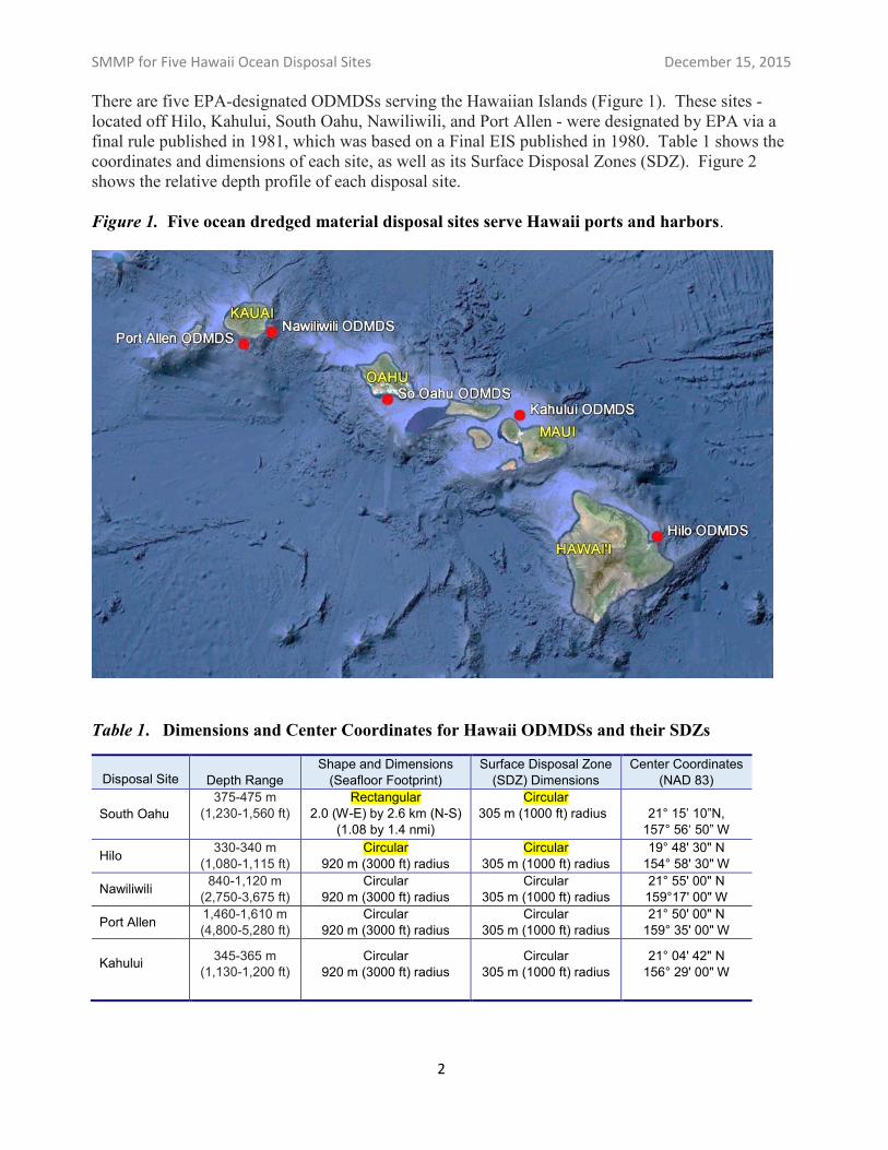
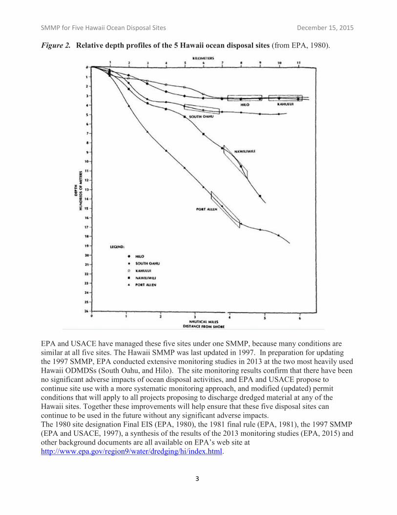
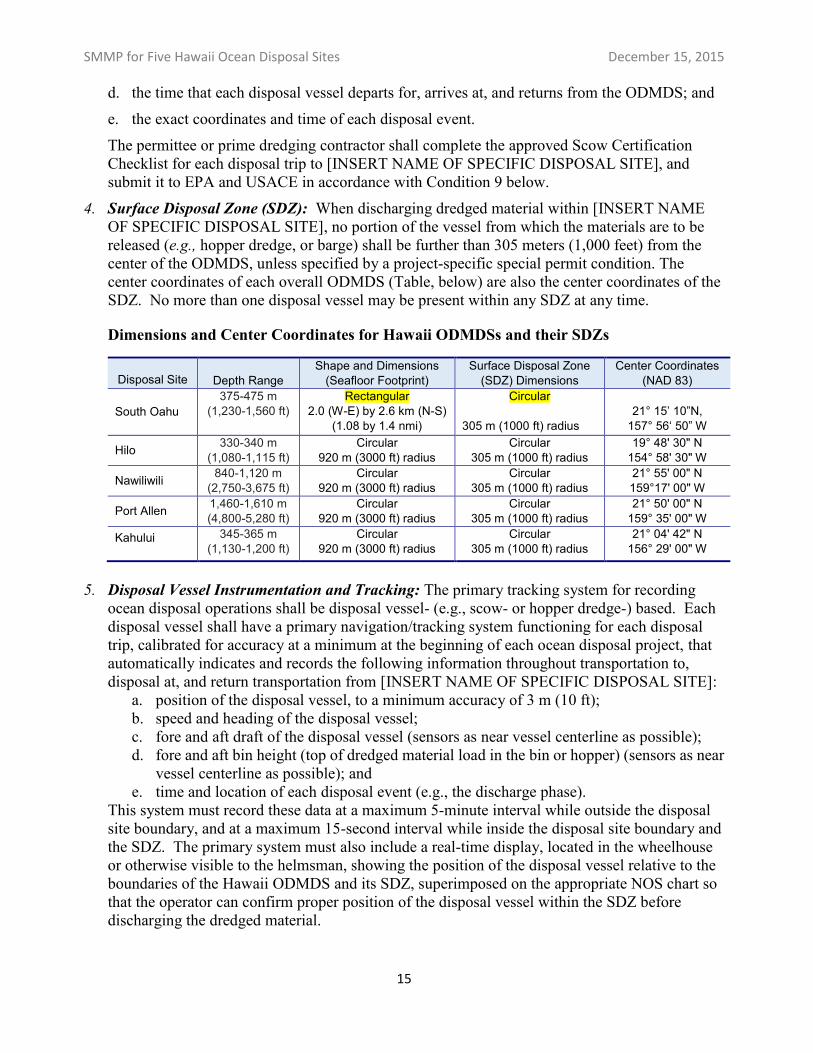
There are five EPA-designated ODMDSs serving the Hawaiian Islands (Figure 1). These sites -located off Hilo, Kahului, South Oahu, Nawiliwili, and Port Allen - were designated by EPA via a final rule published in 1981, which was based on a Final EIS published in 1980. Table 1 shows the coordinates and dimensions of each site, as well as its Surface Disposal Zones (SDZ). Figure 2 shows the relative depth profile of each disposal site.
Figure 1. Five ocean dredged material disposal sites serve Hawaii ports and harbors.
Table 1. Dimensions and Center Coordinates for Hawaii ODMDSs and their SDZs
Disposal Site Depth Range Shape and Dimensions (Seafloor Footprint)
Surface Disposal Zone (SDZ) Dimensions
Center Coordinates (NAD 83)
South Oahu 375-475 m
(1,230-1,560 ft) Rectangular
2.0 (W-E) by 2.6 km (N-S) (1.08 by 1.4 nmi)
Circular 305 m (1000 ft) radius 21° 15’ 10”N,
157° 56‘ 50” W
Hilo 330-340 m (1,080-1,115 ft)
Circular 920 m (3000 ft) radius
Circular 305 m (1000 ft) radius
19° 48' 30" N 154° 58' 30" W
Nawiliwili 840-1,120 m (2,750-3,675 ft)
Circular 920 m (3000 ft) radius
Circular 305 m (1000 ft) radius
21° 55' 00" N 159°17' 00" W
Port Allen 1,460-1,610 m (4,800-5,280 ft)
Circular 920 m (3000 ft) radius
Circular 305 m (1000 ft) radius
21° 50' 00" N 159° 35' 00" W
Kahului 345-365 m (1,130-1,200 ft)
Circular 920 m (3000 ft) radius
Circular 305 m (1000 ft) radius
21° 04' 42" N 156° 29' 00" W
2
SMMP for Five Hawaii Ocean Disposal Sites December 15, 2015
Figure 2. Relative depth profiles of the 5 Hawaii ocean disposal sites (from EPA, 1980).
EPA and USACE have managed these five sites under one SMMP, because many conditions are similar at all five sites. The Hawaii SMMP was last updated in 1997. In preparation for updating the 1997 SMMP, EPA conducted extensive monitoring studies in 2013 at the two most heavily used Hawaii ODMDSs (South Oahu, and Hilo). The site monitoring results confirm that there have been no significant adverse impacts of ocean disposal activities, and EPA and USACE propose to continue site use with a more systematic monitoring approach, and modified (updated) permit conditions that will apply to all projects proposing to discharge dredged material at any of the Hawaii sites. Together these improvements will help ensure that these five disposal sites can continue to be used in the future without any significant adverse impacts. The 1980 site designation Final EIS (EPA, 1980), the 1981 final rule (EPA, 1981), the 1997 SMMP (EPA and USACE, 1997), a synthesis of the results of the 2013 monitoring studies (EPA, 2015) and other background documents are all available on EPA’s web site at http://www.epa.gov/region9/water/dredging/hi/index.html.
3
SMMP for Five Hawaii Ocean Disposal Sites December 15, 2015
II. MANAGEMENT PLAN FOR FIVE HAWAII OCEAN DISPOSAL SITES
A. Background
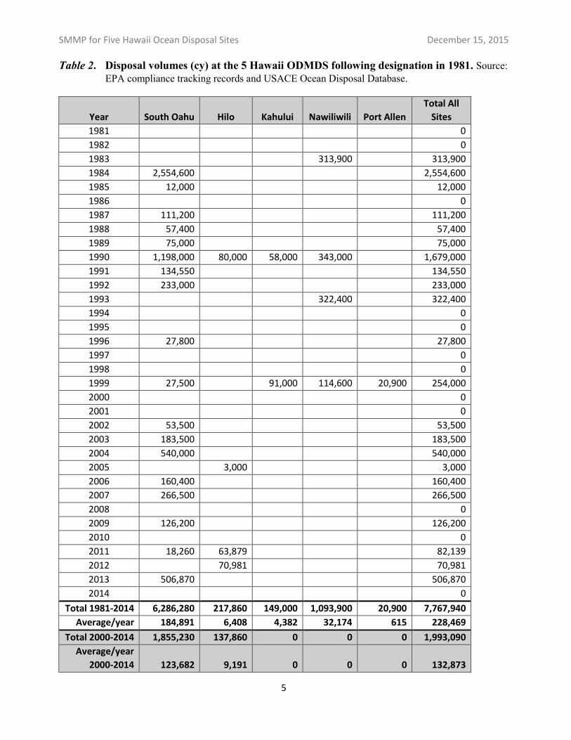
Since the sites were designated, disposal has occurred at each to varying degrees. The disposal history for each of the five Hawaii ODMDSs over the 24 years since they were designated is shown in Table 2. This disposal history confirms the expectation in the Final EIS that the South Oahu site would be the most regularly and heavily used of the five Hawaii sites, due to ongoing dredging needs of the US Navy in addition to periodic dredging of Honolulu Harbor. The Final EIS projected that the other sites would each receive approximately an order of magnitude less disposal than the South Oahu site. This expectation has also held true on average; in fact, no disposal at all has occurred at the Kahului, Nawiliwili, or Port Allen disposal sites since 1999.
It is important to understand that the MPRSA and Ocean Dumping Regulations prohibit ocean disposal of dredged material that is toxic or significantly contaminated. The volumes shown in Table 1 represent dredged material that was determined by EPA and USACE to be suitable for ocean disposal based on appropriate physical, chemical, and biological testing as outlined in the national Ocean Testing Manual (OTM) (EPA and USACE, 1991). Material that does not pass these tests is either left in place (not dredged) or is disposed at an appropriate non-aquatic disposal site such as a landfill or other contained placement site.
Until 2013, there was limited post-disposal monitoring at any of the five Hawaii ocean disposal sites. EPA and USACE coordinated with the US Geological Survey (USGS) to expand an offshore acoustic monitoring effort in 1993, to include coverage of all of the Hawaii ODMDSs (Dadey et al., 1996, Torresan and Gardner, 2000). The USGS surveys confirmed that evidence of past disposal events (even those from before the 1981 site designations) remains detectable. This is largely due to the difference in physical character (grain size, presence of coral rubble) between sediment dredged from the relatively shallow harbors compared to the native sediments at the deep disposal sites. The USGS survey work also found that dredged material was present well outside the boundaries of the current (or historic, pre-1981) disposal sites, and underlined the importance of automatically tracking disposal vessels and documenting precise disposal locations. Therefore, in the early 2000s, EPA and USACE began to require “black-box” satellite-based tracking of all disposal scows.1 Since then, there have been no “short-dumps” except for a single partial mis-dump at the South Oahu site in 2006.
Starting in 2013, EPA began to implement a national ocean disposal site monitoring policy intended to ensure that all designated sites around the country that are actively used are monitored at least once every 10 years, subject to available funding. EPA identified the two most heavily-used Hawaii sites (South Oahu and Hilo) as among the highest priority nationally to start to bring into compliance with this goal. Therefore, in 2013, EPA conducted extensive monitoring of the South Oahu and Hilo ODMDSs for the first time since site designation. The decision to monitor these two sites with the limited funding available was based on the fact that they have been the only Hawaii sites used at all since 1999 (see Table 2).
The 1997 SMMP but did not specify that the system show the position of the disposal scow itself (as opposed to the tug or towing vessel), nor did it require “black box” recording of the actual disposal location. So independent confirmation that disposal only occurred at the center of the disposal site was difficult. But beginning in the 2000s, as both commercial GPS accuracy and vessel sensor technology advanced, EPA and USACE began requiring sophisticated automatic tracking systems as conditions for all ocean disposal permits.
4
1
SMMP for Five Hawaii Ocean Disposal Sites December 15, 2015
Table 2. Disposal volumes (cy) at the 5 Hawaii ODMDS following designation in 1981. Source: EPA compliance tracking records and USACE Ocean Disposal Database.
Year South Oahu Hilo Kahului Nawiliwili Port Allen
Total All
Sites
1981 0
1982 0
1983 313,900 313,900
1984 2,554,600 2,554,600
1985 12,000 12,000
1986 0
1987 111,200 111,200
1988 57,400 57,400
1989 75,000 75,000
1990 1,198,000 80,000 58,000 343,000 1,679,000
1991 134,550 134,550
1992 233,000 233,000
1993 322,400 322,400
1994 0
1995 0
1996 27,800 27,800
1997 0
1998 0
1999 27,500 91,000 114,600 20,900 254,000
2000 0
2001 0
2002 53,500 53,500
2003 183,500 183,500
2004 540,000 540,000
2005 3,000 3,000
2006 160,400 160,400
2007 266,500 266,500
2008 0
2009 126,200 126,200
2010 0
2011 18,260 63,879 82,139
2012 70,981 70,981
2013 506,870 506,870
2014 0
Total 1981-2014 6,286,280 217,860 149,000 1,093,900 20,900 7,767,940
Average/year 184,891 6,408 4,382 32,174 615 228,469
Total 2000-2014 1,855,230 137,860 0 0 0 1,993,090
Average/year
2000-2014 123,682 9,191 0 0 0 132,873
5
SMMP for Five Hawaii Ocean Disposal Sites December 15, 2015
B. Baseline Assessment
The five Hawaii ODMDSs are all in relatively deep water marine environments. Baseline conditions at the five sites (and potential alternative locations) were originally assessed during the site designation process. Details of the original baseline conditions are included in the site designation Final EIS cited above, and are further discussed in EPA 2015. An updated conditions assessment for the Hawaii sites is provided below.
1. Current Environmental Conditions at the South Oahu ODMDS
The South Oahu disposal site (Figure 3) is in Mamala Bay approximately 4 nautical miles offshore (south) of the Pearl Harbor entrance, at a depth of 375-475 m (1,230-1,560 ft). It is the only Hawaii ODMDS with a rectangular boundary on the seafloor (all the others have circular boundaries). This site is by far the most frequently and heavily used of all the Hawaii ODMDSs. A total of approximately 6.3 million cy of suitable dredged material (81% of all disposal at all Hawaii sites combined) has been disposed at the this site since it was designated in 1981. Most of this volume (over 4.4 million cy) was disposed prior to 2000 (i.e., before “black box” disposal scow tracking and monitoring became required) (see Table 2). Some of the early (pre-2000) material was clearly dumped outside the disposal site boundary. The 2013 monitoring surveys therefore encompassed not only the disposal site itself but also a substantial surrounding area.
The synthesis report for the 2013 monitoring surveys (EPA, 2015) compares current conditions at the South Oahu site to baseline conditions documented in the 1980 site designation EIS (EPA, 1980). It also compares physical, chemical, and biological conditions on the dredged material deposit with the native sediment outside of the dredged material deposit. As summarized below, there have been minor physical changes due to disposal operations (as expected), but there have been no significant adverse chemical or biological impacts either on-site or off-site.
Physical conditions: Native sediments (absent any dredged material deposit) at the South Oahu disposal site are sandy (75% sand, 12% gravel, and only 13% silt and clay). Disposal operations have resulted in a shift in physical (grain size) characteristics compared to pre-disposal baseline conditions. Disposal site sediments now have a higher percentage of gravel (approximately 22%), and a higher percentage of silt and clay (33 percent). These physical changes were expected because dredged material from ports and harbors in Hawaii typically have more fines (silts and clays) than occur naturally on the deep seafloor of Mamala Bay. Similarly, dredging projects on Oahu often encounter and dispose of small coral rubble. Despite this shift in grain size, the fundamental physical character of the disposal site as a relatively featureless sedimentary environment and habitat for benthic organisms has not changed.
Chemical conditions: Limited sediment chemistry collected for the 1980 EIS was compared with on-site and off-site samples collected in 2013 (EPA, 2015). Dredged material disposal operations at South Oahu since 1981 have not appreciably increased contaminant loading either on-site, or relative to the surrounding environs. One minor exception is copper, which on average is slightly elevated on-site (59 ppm) compared to the 1980 baseline (31 ppm). The current on-site copper concentration is higher than the NOAA ER-L screening level (34 ppm), but is much lower than the ER-M screening level (270 ppm) where toxicity effects are likely to occur. As discussed earlier, sediments that contain toxic pollutants in toxic amounts are prohibited from being discharged. All sediments discharged at ocean disposal sites must be fully evaluated to ensure they
6
SMMP for Five Hawaii Ocean Disposal Sites December 15, 2015
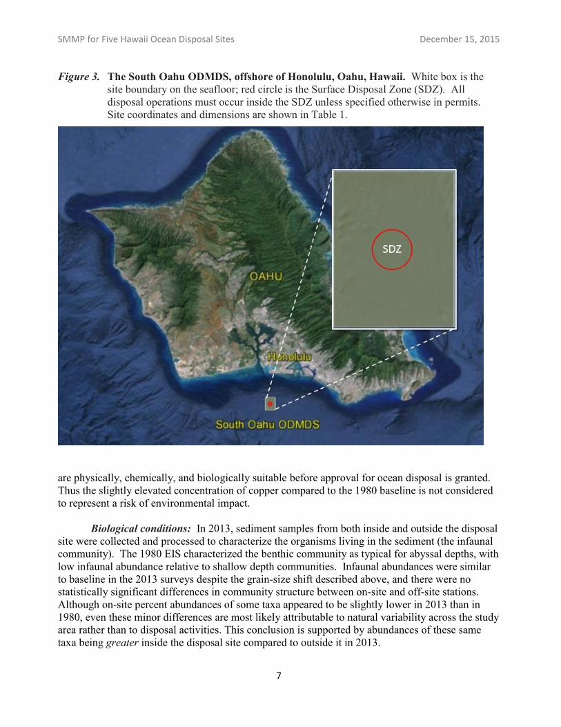
Figure 3.The South Oahu ODMDS, offshore of Honolulu, Oahu, Hawaii. White box is the site boundary on the seafloor; red circle is the Surface Disposal Zone (SDZ). All disposal operations must occur inside the SDZ unless specified otherwise in permits. Site coordinates and dimensions are shown in Table 1.
are physically, chemically, and biologically suitable before approval for ocean disposal is granted. Thus the slightly elevated concentration of copper compared to the 1980 baseline is not considered to represent a risk of environmental impact.
Biological conditions: In 2013, sediment samples from both inside and outside the disposal site were collected and processed to characterize the organisms living in the sediment (the infaunal community). The 1980 EIS characterized the benthic community as typical for abyssal depths, with low infaunal abundance relative to shallow depth communities. Infaunal abundances were similar to baseline in the 2013 surveys despite the grain-size shift described above, and there were no statistically significant differences in community structure between on-site and off-site stations. Although on-site percent abundances of some taxa appeared to be slightly lower in 2013 than in 1980, even these minor differences are most likely attributable to natural variability across the study area rather than to disposal activities. This conclusion is supported by abundances of these same taxa being greater inside the disposal site compared to outside it in 2013.
7
SMMP for Five Hawaii Ocean Disposal Sites December 15, 2015
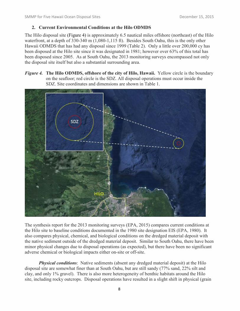
2. Current Environmental Conditions at the Hilo ODMDS The Hilo disposal site (Figure 4) is approximately 6.5 nautical miles offshore (northeast) of the Hilo waterfront, at a depth of 330-340 m (1,080-1,115 ft). Besides South Oahu, this is the only other Hawaii ODMDS that has had any disposal since 1999 (Table 2). Only a little over 200,000 cy has been disposed at the Hilo site since it was designated in 1981; however over 63% of this total has been disposed since 2005. As at South Oahu, the 2013 monitoring surveys encompassed not only the disposal site itself but also a substantial surrounding area.
Figure 4.The Hilo ODMDS, offshore of the city of Hilo, Hawaii. Yellow circle is the boundary on the seafloor; red circle is the SDZ. All disposal operations must occur inside the SDZ. Site coordinates and dimensions are shown in Table 1.
The synthesis report for the 2013 monitoring surveys (EPA, 2015) compares current conditions at the Hilo site to baseline conditions documented in the 1980 site designation EIS (EPA, 1980). It also compares physical, chemical, and biological conditions on the dredged material deposit with the native sediment outside of the dredged material deposit. Similar to South Oahu, there have been minor physical changes due to disposal operations (as expected), but there have been no significant adverse chemical or biological impacts either on-site or off-site.
Physical conditions: Native sediments (absent any dredged material deposit) at the Hilo disposal site are somewhat finer than at South Oahu, but are still sandy (77% sand, 22% silt and clay, and only 1% gravel). There is also more heterogeneity of benthic habitats around the Hilo site, including rocky outcrops. Disposal operations have resulted in a slight shift in physical (grain
8
SMMP for Five Hawaii Ocean Disposal Sites December 15, 2015
size) characteristics compared to pre-disposal baseline conditions. Disposal site sediments on average now have a somewhat lower percentage of sand (60%) and a somewhat higher percentage of silt and clay (30%). One distinction relative to South Oahu is that there is an accumulation of small rock and coral rubble at the very center of the Hilo site. This kind of material descends rapidly to the seafloor with little dispersion compared to finer sediments. Since much less sediment has been disposed at Hilo than at South Oahu, there has been little opportunity for subsequent disposal events to cover these larger particles at the center of the site. Also, since most of the disposal at Hilo has taken place after scow tracking became routine in the early 2000s, this rubbly material is more concentrated (i.e., it was more accurately discharged at the center of the site, in contrast to much of the early disposal at South Oahu). Except at the immediate center of the disposal site, the minor shift in grain size has not changed the fundamental physical character of the site itself as a relatively featureless sedimentary environment and habitat for benthic organisms.
Chemical conditions: Limited sediment chemistry collected for the 1980 EIS was compared with on-site and off-site samples collected in 2013 (EPA, 2015). Dredged material disposal operations at Hilo since 1981 have not appreciably increased contaminant loading either on-site, or relative to the surrounding environs. The one minor exception, again, is copper, which on average is slightly elevated (42 ppm) compared to the 1980 baseline (36 ppm). However, the slightly elevated copper concentration was found shoreward and outside of the disposal site. Possible explanations include contaminants from other shore-side sources, or historic short-dumping from disposal scows (prior to the early 2000’s). The elevated off-site copper concentration is slightly higher than the NOAA ER-L screening level (34 ppm), but is much lower than the ER-M screening level (270 ppm) where toxicity effects are likely to occur. As discussed earlier, sediments that contain toxic pollutants in toxic amounts are prohibited from being discharged. All sediments discharged at ocean disposal sites must be fully evaluated to ensure they are suitable before approval for ocean disposal is granted. Thus the slightly elevated concentration of copper compared to the 1980 baseline is not considered to represent a risk of environmental impact.
Biological conditions: In 2013, sediment samples from both inside and outside the disposal site were collected and processed to characterize the organisms living in the sediment (the infaunal community). The 1980 EIS characterized the benthic community at the Hilo site as typical for abyssal depths, with low infaunal abundances relative to shallow depth communities. Compared to data presented in the site designation EIS, few differences are apparent. Certain infaunal taxa appear to be very slightly lower on-site compared to off-site in 2013 (though not statistically significantly so). However, the same taxa were lower both inside and outside the disposal site. Similarly, mollusks were more abundant region-wide than they were in 1980. As noted earlier, the native benthic environment around the Hilo site is more heterogeneous than around the South Oahu site to begin with. These minor differences in infaunal abundances therefore are at least substantially attributable to natural variability across the study area rather than to dredged material disposal activities.
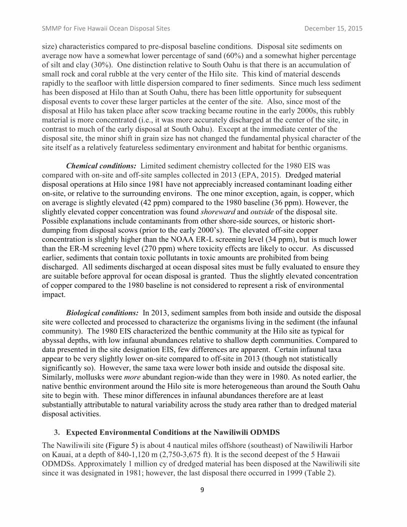
3. Expected Environmental Conditions at the Nawiliwili ODMDS The Nawiliwili site (Figure 5) is about 4 nautical miles offshore (southeast) of Nawiliwili Harbor on Kauai, at a depth of 840-1,120 m (2,750-3,675 ft). It is the second deepest of the 5 Hawaii ODMDSs. Approximately 1 million cy of dredged material has been disposed at the Nawiliwili site since it was designated in 1981; however, the last disposal there occurred in 1999 (Table 2).
9
SMMP for Five Hawaii Ocean Disposal Sites December 15, 2015
Figure 5. Nawiliwili and Port Allen ODMDSs are off the south shore of Kauai, Hawaii. Yellow circles are the boundaries on the seafloor; red circles are the SDZs. All disposal operations must occur inside the SDZs. Coordinates and dimensions for each site are shown in Table 1.
The Nawiliwili site, like the Port Allen and Kahului sites, has not been physically monitored since it was originally designated. Therefore current environmental conditions are unknown. Although no disposal has occurred in over 25 years, it can be expected that physical indicators of historic disposal would still be evident, as has been found to be the case at and around the Hilo and South Oahu sites. However, only physical effects (sediment grain size and texture differences, and a shift from predominately basaltic native sediments to carbonate-dominated dredged material deposits) are expected to persist. Otherwise, conditions at the site should remain similar to those described in the 1980 site designation EIS. The EIS noted that the disposal site has a rolling topography strewn with rocks and boulders over a silty-sand bottom (somewhat sandier than the other Hawaii ODMDSs), and that its grain size is less variable than the shallower alternative site that was evaluated. The disposal site also had substantially lower populations of mollusks and polychaetes, and slower bottom currents, than the shallower alternative site.
EPA expects to conduct comprehensive monitoring at this site in 2017, following resumption of disposal operations planned by USACE for 2016. This monitoring will assess the condition of the physical, chemical, and biological environment at and in the vicinity of the site. As at other ODMDSs, only material that passes extensive sediment physical, chemical, and toxicity testing will be approved for ocean disposal at the Nawiliwili site. The post-disposal site monitoring will
10
SMMP for Five Hawaii Ocean Disposal Sites December 15, 2015
confirm whether the pre-disposal sediment testing was in fact representative of the quality of the material disposed, and that significant chemical contamination has not occurred. Similarly, EPA and USACE require disposal operations to be closely tracked to ensure that disposal only occurs properly within the disposal site. The post-disposal site monitoring, coupled with the disposal tracking information, will confirm whether the site is performing adequately (i.e., that deposition is occurring primarily within the site boundaries as intended).
4. Expected Environmental Conditions at the Port Allen ODMDS
The Port Allen disposal site (also shown on Figure 5) is approximately 4 nautical miles offshore (south) of Port Allen Harbor on Kauai, at a depth of 1,460-1,610 m (4,800-5,275 ft). It is the deepest of the 5 Hawaii ODMDSs. It has also seen the least amount of dredged material disposal (approximately 21,000 cy) of any of the Hawaii ODMDSs since their designation in 1981. The last disposal at the Port Allen occurred in 1999 (Table 2).
Like the Nawiliwili and Kahului sites, the Port Allen site has not been physically monitored since it was originally designated. Therefore current environmental conditions are unknown. Although no disposal has occurred in over 25 years, it can be expected that some physical indicators of the minor volume of historic disposal would still be evident, as has been found to be the case at and around the Hilo and South Oahu sites. However, only physical effects (sediment grain size and texture differences) are expected to persist. Otherwise, conditions at the site should remain similar to those described in the 1980 site designation EIS. The EIS noted that the disposal site has a flat topography strewn with rocks, boulders and cobbles on a silty-sand bottom. The disposal site is less diverse physically and biologically than the shallower alternative site that was evaluated.
Port Allen dredging by USACE, with disposal at the Port Allen ODMDS, is currently planned to occur in 2018. EPA expects to conduct monitoring at this disposal site in the year following the disposal operations, subject to available monitoring funds. When conducted, this monitoring will assess the condition of the physical, chemical, and biological environment at and in the vicinity of the site. As at other ODMDSs, only material that passes extensive sediment physical, chemical, and toxicity testing will be approved for ocean disposal at the Port Allen site. The post-disposal site monitoring will confirm that the pre-disposal sediment testing was in fact representative of the quality of the material disposed, and that significant chemical contamination has not occurred. Similarly, EPA and USACE require disposal operations to be closely tracked to ensure that disposal only occurs properly within the disposal site. The post-disposal site monitoring, coupled with the disposal tracking information, will confirm whether the site is performing adequately (i.e., that deposition is occurring primarily within the site boundaries as intended).
5. Expected Environmental Conditions at the Kahului ODMDS
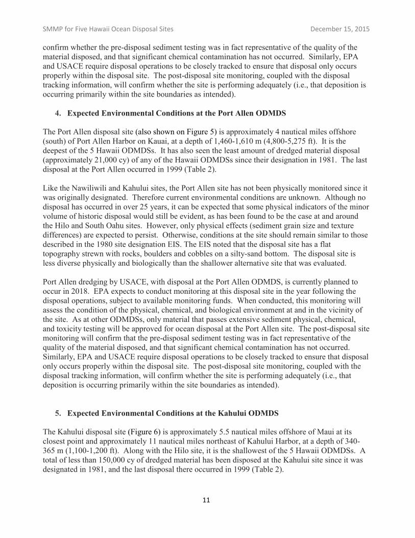
The Kahului disposal site (Figure 6) is approximately 5.5 nautical miles offshore of Maui at its closest point and approximately 11 nautical miles northeast of Kahului Harbor, at a depth of 340-365 m (1,100-1,200 ft). Along with the Hilo site, it is the shallowest of the 5 Hawaii ODMDSs. A total of less than 150,000 cy of dredged material has been disposed at the Kahului site since it was designated in 1981, and the last disposal there occurred in 1999 (Table 2).
11
SMMP for Five Hawaii Ocean Disposal Sites December 15, 2015
Figure 6.The Kahului ODMDS is north of Kahului, Maui, Hawaii. Yellow circle is the boundary on the seafloor; red circle is the SDZ. All disposal operations must occur inside the SDZ. Site coordinates and dimensions are shown in Table 1.
Like the Nawiliwili and Port Allen sites, the Kahului site has not been physically monitored since it was originally designated. Therefore current environmental conditions are unknown. Although no disposal has occurred in over 25 years, it can be expected that physical indicators of historic disposal would still be evident, as has been found to be the case at and around the Hilo and South Oahu sites. However, only physical effects (sediment grain size and texture differences, and a shift from predominately basaltic native sediments to carbonate-dominated dredged material deposits) are expected to persist. Otherwise, conditions at the site should remain similar to those described in the 1980 site designation EIS. The EIS noted that the disposal site has relatively smooth silty-sand bottom, and that it is less diverse physically and biologically than the shallower alternative site that was evaluated.
EPA also expects to conduct comprehensive monitor this site in 2017, following resumption of disposal operations planned by USACE for 2016. This monitoring will assess the condition of the physical, chemical, and biological environment at and in the vicinity of the site. As at other ODMDSs, only material that passes extensive sediment physical, chemical, and toxicity testing will be approved for ocean disposal at the Kahului site. The post-disposal site monitoring will confirm whether the pre-disposal sediment testing was in fact representative of the quality of the material
12
SMMP for Five Hawaii Ocean Disposal Sites December 15, 2015
disposed, and that significant chemical contamination has not occurred. Similarly, EPA and USACE require disposal operations to be closely tracked to ensure that disposal only occurs properly within the disposal site. The post-disposal site monitoring, coupled with the disposal tracking information, will confirm whether the site is performing adequately (i.e., that deposition is occurring primarily within the site boundaries as intended).
C. Dredged Material Quantity and Quality
All of the Hawaii ODMDSs are in relatively deep water, and there is no annual limit on disposal volume at any of the sites. Nor is there any seasonal restriction on use of any of the disposal sites. However, as needed, EPA and/or USACE may place volume limits and seasonal or other restrictions in individual project’s permits or authorizations. Also, alternatives to ocean disposal (including beneficial uses) are considered on a project-by-project basis to ensure that the minimum necessary volume of dredged material is disposed at any ODMDS.
All five Hawaii ODMDSs are restricted to the authorized disposal of suitable dredged material, only. The suitability of dredged material for ocean disposal is determined based on criteria in the MPRSA, and in EPA’s Ocean Dumping Regulations (40 CFR Part 227). EPA and USACE have published a joint national sediment testing manual entitled Evaluation of Dredged Material Proposed for Ocean Disposal (EPA and USACE, 1991), otherwise known as the Ocean Testing Manual or OTM. The OTM outlines the sampling and testing approach needed to comply with the MPRSA and EPA’s regulations. (If EPA Region IX and the Honolulu District USACE develop more specific regional sediment testing guidance in the future, it would be in addition to the provisions of the OTM.)
Dredging project proponents (including USACE) wishing to dispose of material at any Hawaiian ODMDS must first develop a sediment sampling and analysis plan (SAP) that describes the specific physical, chemical, and biological testing to be done for the project in accordance with the OTM. EPA and USACE must approve the adequacy of the SAP and review the subsequent testing results. Any dredged material that contains levels of chemical contaminants in other than “trace” amounts, that exhibits toxicity in either suspended or solid phase tests, or that includes pollutants that are likely to bioaccumulate in the food web to levels of biological concern, are NOT suitable for ocean disposal. Even sediments that have been adequately characterized and found by EPA and USACE to be suitable for ocean disposal will not be permitted for ocean disposal if there is a practicable alternative available (including a beneficial use option). For example, clean sand that is otherwise suitable for ocean disposal generally will not be permitted for disposal if it can feasibly be used to nourish area beaches.
Finally, if ocean disposal of suitable dredged material is authorized, all of the standard permit conditions listed below in Section D will be included in the permit. (Note that EPA and USACE may also include any other conditions they deem necessary, on a project-by-project basis.)
D. Standard Permit Conditions for Site Use – Applicable to All Five ODMDS
All permits or federal project authorizations for use of the any of the five Hawaii ODMDS shall include the following conditions, unless approval for a modified or alternative permit condition is sought and granted in advance pursuant to section (F) below:
13
SMMP for Five Hawaii Ocean Disposal Sites December 15, 2015
Definitions
“Permit” and “permittee” as used herein mean ocean dumping permits issued by USACE under Section 103 of the MPRSA, and to USACE and its contracts or other authorizations for USACE dredging projects (see MPRSA section 103(e) and 40 CFR Part 220.2).
“Towing vessel” is any self-propelled tug or other vessel used to transport (tow or push) the “disposal vessel” (see #3 following) for any portion of the transit to any ODMDS.
“Disposal vessel” is any barge, scow, or self-propelled vessel (such as a hopper dredge) that carries dredged material during transit and from which the dredged material is discharged, typically by opening the hull or doors in the bottom of the hull.
“Transit” or “transport” to the disposal site begins as soon as dredged material loading into the disposal vessel is completed and a towing vessel begins moving the disposal vessel to the disposal site.
“Surface Disposal Zone” or “SDZ” is the 605 m (1,000 foot) radius circle at the center of each disposal site (see Table 2), within which the disposal vessel must discharge all of the dredged material.
Standard Conditions
1. Prohibition on Leaking or Spilling During Transport: The permittee shall ensure that dredged material is not leaked or spilled from disposal vessels during transit to [INSERT NAME OF SPECIFIC DISPOSAL SITE]. Transportation of dredged material shall only be allowed when weather and sea state conditions will not interfere with safe transportation and will not create risk of spillage, leak or other loss of dredged material during transit. Disposal vessels must not be loaded beyond a level at which dredged material would be expected to be spilled in transit under anticipated sea state conditions. No disposal vessel trips shall be initiated when the National Weather Service has issued a gale warning for local waters during the time period necessary to complete dumping operations.
2. Prohibition on Trash and Debris; use of Grizzly: Only dredged material determined in advance by EPA and USACE to be suitable for ocean disposal may be discharged at [INSERT NAME OF SPECIFIC DISPOSAL SITE]. Uncharacterized dredged material, vessels, trash, and other debris are prohibited from being discharged at the sites. In order to exclude large trash and debris (including rocks and coral rubble) from being disposed at the sites, all mechanically dredged material must be placed into scows through a steel mesh or chain “grizzly” with openings of no more than 12 inches by 12 inches. Material retained on the grizzly must be removed and disposed of separately. EPA and USACE may on a case-by-case basis waive the requirement to use a grizzly if they determine that trash and debris are unlikely to be present in the area to be dredged.
3. Scow Certification Checklist: The permittee shall submit a Scow Certification Checklist form to EPA and USACE for review and approval prior to the commencement of any ocean disposal operations. The Scow Certification Checklist form will be used to document:
a. the volume of material dredged and loaded into each vessel for disposal;
b. the location from which the material in each barge was dredged (e.g., reach or dredge unit identifier);
c. the marine weather forecast and sea-state conditions anticipated during the transit period;
14
SMMP for Five Hawaii Ocean Disposal Sites December 15, 2015
d. the time that each disposal vessel departs for, arrives at, and returns from the ODMDS; and
e. the exact coordinates and time of each disposal event.
The permittee or prime dredging contractor shall complete the approved Scow Certification Checklist for each disposal trip to [INSERT NAME OF SPECIFIC DISPOSAL SITE], and submit it to EPA and USACE in accordance with Condition 9 below.
4. Surface Disposal Zone (SDZ): When discharging dredged material within [INSERT NAME OF SPECIFIC DISPOSAL SITE], no portion of the vessel from which the materials are to be released (e.g., hopper dredge, or barge) shall be further than 305 meters (1,000 feet) from the center of the ODMDS, unless specified by a project-specific special permit condition. The center coordinates of each overall ODMDS (Table, below) are also the center coordinates of the SDZ. No more than one disposal vessel may be present within any SDZ at any time.
Dimensions and Center Coordinates for Hawaii ODMDSs and their SDZs
Disposal Site Depth Range Shape and Dimensions (Seafloor Footprint)
Surface Disposal Zone (SDZ) Dimensions
Center Coordinates (NAD 83)
South Oahu 375-475 m
(1,230-1,560 ft) Rectangular
2.0 (W-E) by 2.6 km (N-S) (1.08 by 1.4 nmi)
Circular
305 m (1000 ft) radius 21° 15’ 10”N, 157° 56‘ 50” W
Hilo 330-340 m (1,080-1,115 ft)
Circular 920 m (3000 ft) radius
Circular 305 m (1000 ft) radius
19° 48' 30" N 154° 58' 30" W
Nawiliwili 840-1,120 m (2,750-3,675 ft)
Circular 920 m (3000 ft) radius
Circular 305 m (1000 ft) radius
21° 55' 00" N 159°17' 00" W
Port Allen 1,460-1,610 m (4,800-5,280 ft)
Circular 920 m (3000 ft) radius
Circular 305 m (1000 ft) radius
21° 50' 00" N 159° 35' 00" W
Kahului 345-365 m (1,130-1,200 ft)
Circular 920 m (3000 ft) radius
Circular 305 m (1000 ft) radius
21° 04' 42" N 156° 29' 00" W
5. Disposal Vessel Instrumentation and Tracking: The primary tracking system for recording ocean disposal operations shall be disposal vessel- (e.g., scow- or hopper dredge-) based. Each disposal vessel shall have a primary navigation/tracking system functioning for each disposal trip, calibrated for accuracy at a minimum at the beginning of each ocean disposal project, that automatically indicates and records the following information throughout transportation to, disposal at, and return transportation from [INSERT NAME OF SPECIFIC DISPOSAL SITE]:
a. position of the disposal vessel, to a minimum accuracy of 3 m (10 ft); b. speed and heading of the disposal vessel; c. fore and aft draft of the disposal vessel (sensors as near vessel centerline as possible); d. fore and aft bin height (top of dredged material load in the bin or hopper) (sensors as near
vessel centerline as possible); and e. time and location of each disposal event (e.g., the discharge phase).
This system must record these data at a maximum 5-minute interval while outside the disposal site boundary, and at a maximum 15-second interval while inside the disposal site boundary and the SDZ. The primary system must also include a real-time display, located in the wheelhouse or otherwise visible to the helmsman, showing the position of the disposal vessel relative to the boundaries of the Hawaii ODMDS and its SDZ, superimposed on the appropriate NOS chart so that the operator can confirm proper position of the disposal vessel within the SDZ before discharging the dredged material.
15
SMMP for Five Hawaii Ocean Disposal Sites December 15, 2015
6. Back-Up Navigation System: If the primary disposal tracking system fails during transit, the navigation system on the pushing or towing vessel (e.g. tug, if any), meeting the minimum accuracy requirement listed above, may be used to complete that disposal trip by maneuvering the pushing or towing vessel so that, given the compass heading and any tow cable length to the scow (“lay back”), the estimated scow position would be within the SDZ (i.e., within 305 m or 1,000 ft of the center of the disposal site). In such cases the pushing or towing vessel’s position, any tow cable length, and the compass heading to the disposal vessel must be recorded and reported. Further disposal operations using a disposal vessel whose navigation tracking system has failed must cease until the primary disposal-tracking capabilities are restored.
7. Posting Disposal Vessel Tracking Data on the Internet: Within 24 hours of the completion of each disposal trip, data recorded from the primary disposal tracking system must be posted by a third party contractor to a World Wide Web (internet) site accessible by EPA Region IX, the Honolulu District USACE, and any other entity specified by EPA or USACE in project-specific permits. The internet site must be searchable by disposal trip number and date, and at a minimum for each disposal trip it must provide a visual display of: the disposal vessel transit route to the ODMDS; the beginning and ending locations of the disposal event; and the disposal vessel speed and draft throughout the transit (Appendix A shows an example web site posting of these data for one disposal trip, in this case to the South Oahu site). The requirement for posting this information on the Web is independent from the hard-copy reporting requirements listed in Special Conditions 9 and 11, below.
8. E-Mail Alerts: The third-party system must also generate and distribute “e-mail alerts” regarding any degree of apparent dumping outside the Surface Disposal Zone of [INSERT NAME OF SPECIFIC DISPOSAL SITE] (“mis-dumping”), and regarding any apparent substantial leakage/spillage or other loss of material during transport to the ODMDS. Substantial leakage/spillage or other loss shall be defined as an apparent loss of draft of one foot or more between the time that the disposal vessel begins the trip to the ODMDS and the time the disposal phase (discharge) begins. E-mail alerts for any disposal trip must be sent within 24 hours of the dredging contractor or permittee becoming aware of the apparent issue, to Brian Ross ([email protected]) and Allan Ota ([email protected]) at EPA Region IX, to [INSERT NAME AND EMAIL OF HONOLULU DISTRICT PM] and [email protected] at the Honolulu District USACE, and to other addressees as may be indicated by EPA or USACE on a project-specific basis.
9. Record-Keeping, and Monthly Reporting: In addition to the requirement in Special Condition 7, above, for posting data on the Web, the permittee shall collect and maintain daily records (including but not limited to the approved Scow Certification Checklist) of: the amount of material dredged and loaded into each barge (or hopper) for disposal; the location from which the material in each load was dredged; the weather report for and sea-state conditions anticipated during the transit period; the time that each disposal vessel departs for, arrives at and returns from the ODMDS; and the exact location and time of each disposal. The permittee shall also collect and maintain, for each ocean disposal trip, both electronic data and printouts from the GPS-based primary disposal tracking system (or the backup navigation tracking system when appropriate) showing transit routes, disposal vessel draft readings, disposal coordinates, and the time and position of the disposal vessel when dumping was commenced and completed. These daily records shall be compiled at a minimum for each month during which ocean disposal operations occur, and provided in reports, certified accurate by the dredging contractor and the permittee, to both EPA and USACE. Each monthly report
16
SMMP for Five Hawaii Ocean Disposal Sites December 15, 2015
shall include the electronic tracking and disposal vessel draft data for each disposal trip on CD-ROM (or other media approved by EPA and USACE), as well as hard copy reproductions of the Scow Certification Checklists and printouts listed above. The monthly reports shall include a cover letter describing any problems complying with these Conditions, the cause(s) of the problems, any steps taken to rectify the problems, and whether the problems occurred on subsequent disposal trips.
10. 24-Hour Notification Requirement for Potential Leaks or Mis-Dumps: The permittee shall report any anticipated, potential, or actual variances from compliance with these Standard Conditions, and any additional project-specific Special Conditions, to EPA Region IX and the Honolulu District USACE within 24 hours of discovering such a situation. A message from an operational “e-mail alert” system, as described in Condition 8 above, will be considered as fulfilling this 24-hour notification requirement. In addition, the permittee shall prepare and submit a detailed report of any such compliance problems on a weekly basis by noon Monday, to EPA Region IX and the Honolulu District USACE. These reports shall describe the cause(s) of the problems, any steps taken to rectify the problems, and whether the problems occurred on subsequent disposal trips.
11. Project Completion Report: Within 60 days following the completion of ocean disposal operations, the permittee shall submit to EPA Region IX and the Honolulu District USACE a completion letter summarizing the total number of disposal trips and the overall volume of material (estimated bin volume as well as in-situ volume calculated from a post-dredge survey) disposed at any Hawaii ODMDS for the project, and whether any of this dredged material was excavated from outside the areas authorized for ocean disposal or was dredged deeper than authorized by the permit.
E. Additional Project-Specific Conditions
For any Hawaii ocean disposal project, EPA or USACE may include additional project-specific conditions that they determine are necessary to facilitate safe use of the ODMDS, to prevent potential harm to the environment, to facilitate accurate monitoring of site use, or to facilitate compliance with the requirements of the MPRSA. For example, project-specific conditions could include timing restrictions to avoid sensitive environmental periods (such as peak coral spawning times) or operational restrictions on methods of transportation and disposal.
F. Alternative Permit/Project Conditions
Alternatives to these standard permit conditions may be authorized in advance if the permittee demonstrates to the satisfaction of EPA and USACE: that the alternative conditions are sufficient to accomplish the specific intended purpose of the original permit condition; that they will not increase the risk of harm to the environment or the health or safety of persons; and that they will not impede monitoring of compliance with the MPRSA, the ocean disposal regulations, or the project’s permit.
G. Compliance with Disposal Site Use Requirements
Enforcement action for a violation or non-compliance with any Standard, project-specific, or alternative ocean disposal permit condition may be initiated by EPA and/or USACE as appropriate. Examples include but are not limited to: disposal of unsuitable or uncharacterized material; disposal
17
SMMP for Five Hawaii Ocean Disposal Sites December 15, 2015
outside the designated boundaries of the site due to mis-dumping or spillage; disposal at a time or in a manner not specifically authorized; failure to maintain or provide required records). If a compliance or enforcement action is initiated, consequences may include interruption or cessation of disposal operations, monetary penalties, or additional monitoring activities to be carried out by the permittee. (Additional monitoring activities may include one or more of the monitoring elements described for periodic site monitoring below.)
III. MONITORING PLAN FOR FIVE HAWAII OCEAN DISPOSAL SITES
Periodic monitoring of each actively used ocean disposal site is used to confirm the conclusions of the original site designation EIS that unacceptable adverse impacts are not being caused by disposal, and to confirm that the site use requirements of the SMMP are adequately protecting the site and the surrounding area. Site monitoring is expected to occur at least once every 10 years at actively used disposal sites, subject to availability of funding and survey vessels. The results of this periodic monitoring are used to determine current conditions at the sites, which are to be compared against baseline conditions and against previous site monitoring surveys. Specific monitoring goals and objectives are discussed in Section III A.
EPA's 1980 site designation EIS documented the original baseline conditions at the five Hawaii ODMDS. Current conditions for the South Oahu and Hilo sites are updated in this SMMP at Section II B, above, based on extensive monitoring conducted at those sites in 2013 (EPA, 2015). Site monitoring of the Hawaii ocean disposal sites includes physical, chemical, and biological components, as outlined in Section III B.
A. Monitoring Goals and Objectives
Simply stated, the goal of periodic monitoring of the five Hawaii ocean disposal sites is to confirm:
a) whether only acceptable quality dredged material has been disposed at the site;
b) whether significant quantities of dredged material have been disposed outside the designated site boundary; and
c) whether any significant contaminant-related impacts to the benthic community are occurring inside or outside the site.
The monitoring plan includes the following specific objectives:
(1) assess the extent of dredged material deposition in relation to the disposal site boundaries, to confirm deposition is occurring in the smallest area necessary;
(2) evaluate sediment physical and chemical characteristics within and surrounding the site to confirm the adequacy of pre-dredge sediment quality testing; and
(3) evaluate the potential impacts dredged material disposal may have on the benthic communities within and surrounding the disposal site.
18
SMMP for Five Hawaii Ocean Disposal Sites December 15, 2015
The monitoring program employs physical, chemical, and biological sampling to help EPA and USACE verify whether disposal operations are being carried out in compliance with permit requirements, environmental regulations, and this SMMP. This monitoring also enables the agencies to identify appropriate management actions (see Section IV, below) should potential impacts be identified.
B. Implementing the Monitoring Objectives
1. Assess the Extent of Dredged Material Deposition (“Footprint Mapping”)
Objective 1 involves mapping the physical footprint of dredged material deposition within and surrounding the disposal site boundaries. The “footprint map” has several valuable purposes, including:
Confirming that deposition of dredged material is occurring as predicted. Disposal operations conducted properly within the SDZ are expected to result in deposition on the seafloor that remains primarily within the site boundary. Significant deposits outside the site boundary may indicate that mis-dumping (discharge not within the SDZ as required) has occurred subsequent to any previous site monitoring event, or that oceanographic conditions at the site are different than expected. Mis-dumping may be identified by disposal vessel tracking and addressed as a project-specific compliance or enforcement matter. However, if oceanographic conditions are causing dredged material to deposit in an unexpected area, a site management action may be needed to address any resulting impact.
Identifying appropriate locations for subsequent chemical and biological sampling. A key approach in the site monitoring program is comparison of samples from within the dredged material footprint with samples taken from outside the dredged material footprint. For this reason, footprint mapping is generally conducted just before chemical and biological samples are collected. The footprint map is used to select appropriate locations for these subsequent samples.
Long-term physical trend assessment. Footprint maps compiled over multiple site monitoring surveys can be compared to help assess site performance over time. This can help identify the need for potential long-term management actions (such as a need to expand site boundaries, or move the SDZ) well before unacceptable impacts may occur.
Different tools and approaches may be used to conduct successful footprint mapping surveys. For the relatively deep water in which all five Hawaii ODMDSs are located, some tools are more useful for identifying dredged material deposits while other tools are more useful for identifying other kinds of features on the seafloor such as reef outcroppings, etc. The choice of appropriate method(s) will be based on the focus of the individual survey and the degree of information already available from previous mapping surveys, if any. Footprint mapping surveys may include one or more of the following:
Side-scan sonar surveys. This system, towed at depth close to the bottom, effectively creates a map of textural differences on the seafloor across large areas. It can show bottom features
19
SMMP for Five Hawaii Ocean Disposal Sites December 15, 2015
such as reefs and outcroppings, as well as other objects (i.e., vessels), and can also help identify the areas of dredged material deposits when the texture of the dredged material is different enough from that of the native seafloor sediment. Dredged material from Hawaiian Islands dredging projects can indeed often be differentiated from native sediments in this way, and the Dadey et al. (1996) and Torresan and Gardner (2000) studies used this method. However, side-scan sonar surveys cannot determine the depth of a dredged material deposit, or identify the age of the deposit. Thus, at a site where disposal is ongoing, side-scan surveys may not be able to differentiate the extent of footprints from past years vs more recent years. Also, side-scan surveys may have less positional accuracy than other methods because they are performed by towing a submerged instrument package behind the survey vessel.
Multibeam bathymetric surveys. In recent years multibeam surveys have been employed successfully at several ocean disposal sites in Region IX. Like side-scan, high-resolution multibeam bathymetric surveys are useful for mapping bottom features such as reef outcrops and for identifying dredged material deposits based on backscatter (textural differences). Multibeam surveys also provide detailed depth information about the seafloor, and are generally more accurate as to geographic location of identified features than side-scan surveys because the instruments are mounted directly to the survey vessel’s hull and the collected data is synchronized with the ship’s GPS system. However, at the depth range of the Hawaii ocean disposal sites, multibeam-collected depth information, while accurate to a meter or less, would not be useful for detecting thinner dredged material deposits at the edges of the dredged material footprint.
Sub-bottom profiling surveys. Unlike the survey methods described above that provide a “plan view” looking down on the seafloor, sub-bottom profiling can identify cross-sectional views of discrete layers of sediments and underlying bedrock many meters beneath the seafloor. Thicker portions of dredged material deposits over native sediments can be identified, but sub-bottom surveys generally cannot distinguish sediment layers that are less than a meter in thickness. As such this method may be more valuable, for example, to monitor the cumulative growth of a disposal mound over time (many years) as opposed to identifying the area of recently deposited material. Typical sub-bottom profile results are available for the South Oahu disposal site in EPA (2015).
Sediment Profile Imaging (SPI) surveys. This method combines both plan view and cross-sectional images (photographs) of the surface sediments. Unlike the footprint mapping survey tools described above, the high resolution cross-sectional SPI photographs can distinguish dredged material layers as thin as a few millimeters, and up to about 20 centimeters. It can also often distinguish recently deposited material from previous years’ deposits. Thus it is an appropriate tool for identifying the full extent (margins) of the dredged material footprint. In addition to mapping dredged material presence and absence at a sampling station, SPI images can also address some Objective 3 (biological) issues by identifying such parameters as the depth of the biologically mixed zone and the relative stage of recolonization of the sediment by benthic organisms. In practice, SPI surveys are almost always included in site monitoring surveys in Region IX, even when some of the other footprint mapping tools mentioned are also employed. Examples of plan view and cross-sectional images from SPI surveys in Hawaii can be found in EPA (2015).
20
SMMP for Five Hawaii Ocean Disposal Sites December 15, 2015
2. Evaluate Sediment Physical and Chemical Characteristics
Objective 2 involves retrieving sediment samples from numerous locations in and around the ocean disposal site, and analyzing the sediment samples in the laboratory. Using information from the footprint mapping survey, care is taken to collect samples representative of both dredged material that has deposited at the site (“onsite” or “footprint” samples), and native sediment unaffected by dredged material (“offsite” samples) for comparison. At all stations sampled, sufficient sediment should be collected to support not only the physical and chemical analyses called for in Objective 2, but also to conduct biological analyses, if needed, under Objective 3 (see Section B3).
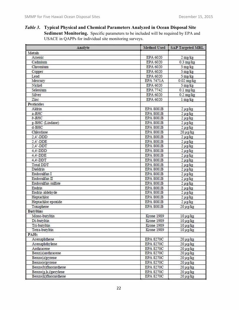
Various physical and chemical analyses may be appropriate depending on the disposal site, its history, and the management issues to be addressed. However, sediment samples are typically analyzed for physical parameters such as grain size, for “conventional” chemical parameters such as organic carbon content, and for a suite of potential pollutants including heavy metals, organotins, polycyclic aromatic hydrocarbons (PAHs), polychlorinated biphenyls (PCBs), pesticides, and dioxin-like compounds (Table 3). Any additional contaminants of concern identified in pre-dredge testing of sediments that were ultimately disposed at a site would also be a focus of the chemistry analyses.
The appropriate off-site reference sediment location (for example, that is used in the pre-dredge testing program for individual projects), should be sampled as well and all the same analyses conducted on it (see Section B4 below, regarding reference sediment sites).
For each disposal site monitored, details of sampling locations and numbers, sample handling and processing procedures, contaminants of concern, and analytical methods (including appropriate limits of detection) must be determined by EPA in advance and included in the Quality Assurance Project Plan (QAPP) or its equivalent for that monitoring event.
The results of physical and chemical analyses of onsite and offsite sediments (including any reference site sediments) are evaluated to address the following management questions:
Are “onsite” or “footprint” sediments more contaminated than expected based on pre-dredge (pre-disposal) testing? The answer to this question helps confirm whether the pre-disposal testing program is adequately regulating the quality of material permitted to be disposed at the site.
Are “offsite” sediments more contaminated than baseline conditions or previously monitored conditions? The answer to this question helps to identify whether contaminants in dredged material disposed at the site may be having potential impacts outside the site boundary. In such a case, analysis of benthic community samples collected for Objective 3 evaluation may be triggered.
In practice, EPA often collects and preserves benthic community samples during Objective 2 sampling. However, processing and analysis of benthic community samples may not occur unless triggered as described above.
21
SMMP for Five Hawaii Ocean Disposal Sites December 15, 2015
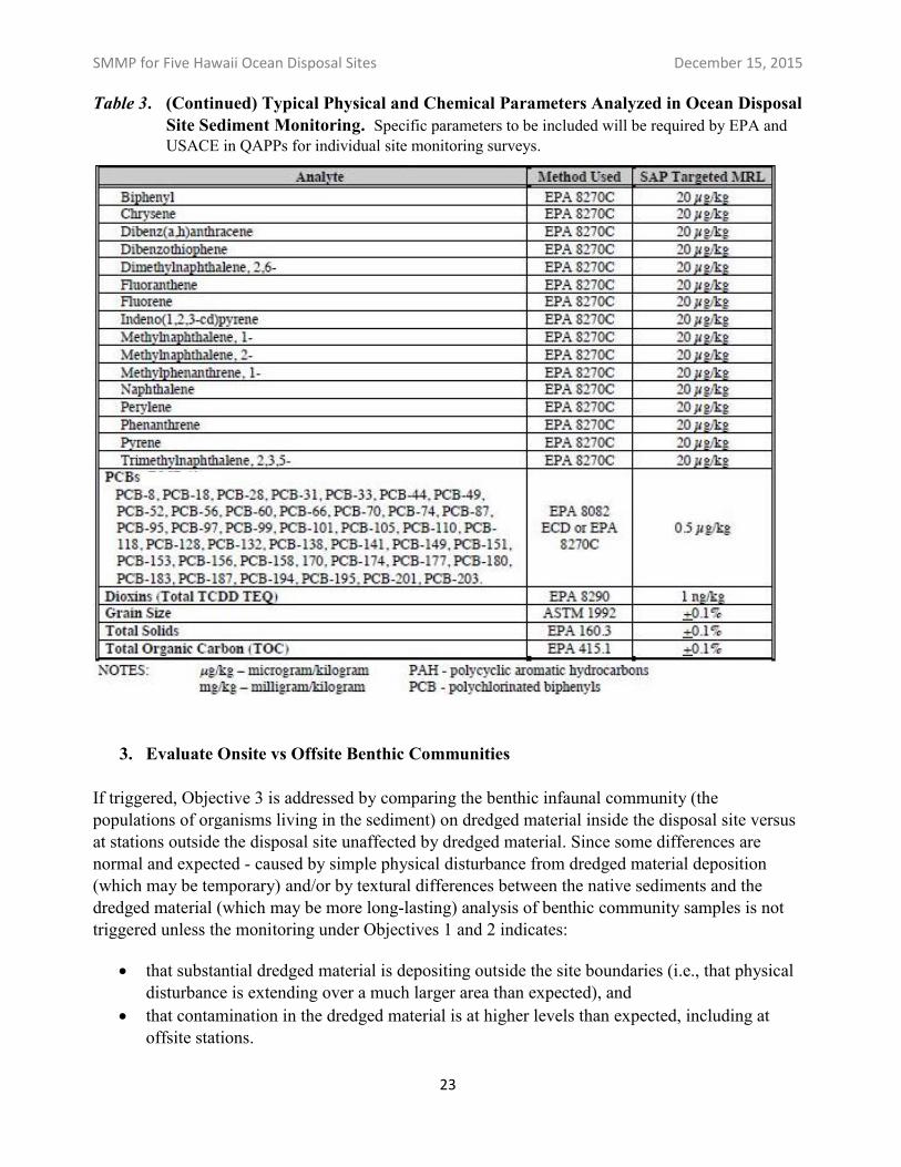
Table 3. Typical Physical and Chemical Parameters Analyzed in Ocean Disposal Site Sediment Monitoring. Specific parameters to be included will be required by EPA and USACE in QAPPs for individual site monitoring surveys.
22
SMMP for Five Hawaii Ocean Disposal Sites December 15, 2015
Table 3. (Continued) Typical Physical and Chemical Parameters Analyzed in Ocean Disposal Site Sediment Monitoring. Specific parameters to be included will be required by EPA and USACE in QAPPs for individual site monitoring surveys.
3. Evaluate Onsite vs Offsite Benthic Communities
If triggered, Objective 3 is addressed by comparing the benthic infaunal community (the populations of organisms living in the sediment) on dredged material inside the disposal site versus at stations outside the disposal site unaffected by dredged material. Since some differences are normal and expected - caused by simple physical disturbance from dredged material deposition (which may be temporary) and/or by textural differences between the native sediments and the dredged material (which may be more long-lasting) analysis of benthic community samples is not triggered unless the monitoring under Objectives 1 and 2 indicates:
that substantial dredged material is depositing outside the site boundaries (i.e., that physical disturbance is extending over a much larger area than expected), and
that contamination in the dredged material is at higher levels than expected, including at offsite stations.
23
SMMP for Five Hawaii Ocean Disposal Sites December 15, 2015
As noted in Section B1 above, the SPI and plan-view images typically collected during Objective 1 footprint mapping also provide important information about benthic community structure at onsite vs offsite stations. In some instances this information may be adequate to address Objective 3, without analyzing the separate benthic infauna samples for species-specific density and diversity parameters.
4. Reference Sites
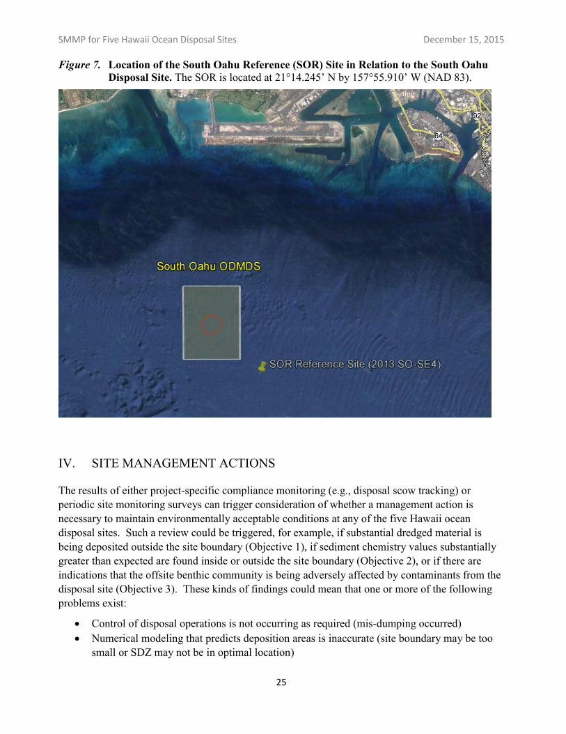
Sediment from an appropriate designated reference site is tested as a key point of comparison for each (project-specific) pre-dredge chemical and biological testing program. In the past several years, clean subtidal sand from Lanakai Beach, Oahu, was used as the reference sediment in pre-dredge sediment testing programs for proposed dredging projects throughout Hawaii. While useful in evaluating the material to be dredged and discharged, the Lanakai beach sand is not appropriate for evaluating onsite vs offsite conditions at the disposal site (for example, regarding benthic community structure). Therefore EPA evaluated data from the 2013 monitoring around South Oahu and Hilo, and identified certain unaffected offsite locations as potential reference locations for these two sites. Since then, EPA has worked with USACE and other dredging project proponents to subject one of the prospective reference sites’ sediment to full Tier III suitability testing under the OTM in order to develop an initial Reference Site Database.
As of the date of this SMMP, EPA has collected enough data to confirm that station “SO-SE4” from the 2013 site monitoring (see EPA, 2015) is an appropriate reference sediment location for the South Oahu disposal site. For purposes of future site management and testing, this station is now designated as the South Oahu Reference site, or SOR (Figure 7), and it is located at 21°14.245’ N by 157°55.910’ W (NAD 83). This site will be surveyed and sampled in association with future periodic monitoring of the South Oahu disposal site (and possibly other Hawaii disposal sites as well) and analyzed for the same parameters addressed under Objectives 1 and 2, and if triggered Objective 3. Also, testing programs for future dredging projects will be required to include sampling of the SOR sediment and to fully test it alongside their project sediments, until such time as EPA and USACE approve a Reference Site Database for SOR. Finally, until such time as EPA and USACE may identify appropriate disposal-site specific reference sites for the other Hawaii OMDMDs, testing programs for projects proposing to use any of the other disposal sites will be required to test the SOR sediment (or will be allowed to compare to the SOR Reference Database once it is approved, as discussed below).
Data from 2014 sediment testing of the SOR by USACE, collected in support of harbor dredging planned for 2016, are already included in the preliminary SOR Database. As Hawaii dredging projects continue to conduct sediment testing (including testing of this reference site) we expect that sufficient data will be available to publish the SOR Database and to start allowing project proponents the option to compare their sediment test results directly against it. (Project proponents must understand however, that evaluation against the SOR Database will be based on means and not statistically compared. This is environmentally conservative in that it can result in some sediments being deemed unsuitable for ocean disposal that might have “passed” if the SOR had been tested and compared statistically.)
24
SMMP for Five Hawaii Ocean Disposal Sites December 15, 2015
Figure 7.Location of the South Oahu Reference (SOR) Site in Relation to the South Oahu Disposal Site. The SOR is located at 21°14.245’ N by 157°55.910’ W (NAD 83).
IV. SITE MANAGEMENT ACTIONS
The results of either project-specific compliance monitoring (e.g., disposal scow tracking) or periodic site monitoring surveys can trigger consideration of whether a management action is necessary to maintain environmentally acceptable conditions at any of the five Hawaii ocean disposal sites. Such a review could be triggered, for example, if substantial dredged material is being deposited outside the site boundary (Objective 1), if sediment chemistry values substantially greater than expected are found inside or outside the site boundary (Objective 2), or if there are indications that the offsite benthic community is being adversely affected by contaminants from the disposal site (Objective 3). These kinds of findings could mean that one or more of the following problems exist:
Control of disposal operations is not occurring as required (mis-dumping occurred) Numerical modeling that predicts deposition areas is inaccurate (site boundary may be too
small or SDZ may not be in optimal location)
25
SMMP for Five Hawaii Ocean Disposal Sites December 15, 2015
Characterization of dredged material prior to disposal was inadequate, or unpermitted contaminated material may have been disposed at the site
Depending on the issue triggering a site management review, EPA and/or USACE may determine that it is necessary to modify, suspend, or terminate site use overall (or for individual projects as appropriate). In general, EPA shall modify site use rather than suspend or terminate site use, when site use modification will be sufficient to eliminate the adverse environmental impacts identified.
More specifically, potential management actions by EPA and USACE may include such measures as:
Additional investigations to confirm and delineate the source or extent of the problem, including additional site monitoring or enforcement action as appropriate;
Modification of the Surface Disposal Zone location or the seafloor boundaries of the site; Change to or additional restrictions on permissible times, rates and total volume of dredged
material that may be disposed at a site; Change to or additional restrictions on the method of disposal or transportation for disposal
at a site; Change to or additional limitations on the allowable type or quality of dredged materials
based on their physical, chemical, toxicity, or bioaccumulation characteristics; or Permanent site closure if this is the only means for eliminating adverse environmental
impacts.
If management actions taken by EPA and USACE would result in permanent changes to this SMMP (e.g., for all users), the SMMP will be updated with opportunity for public comment.
V. LONG-TERM ANTICIPATED USE
The five Hawaii ODMDS's are in deep water compared to many disposal sites nationwide, and only relatively small volumes of suitable dredged material are disposed at most of the sites at infrequent intervals. Therefore no annual or overall capacity limitations are needed.
No unacceptable adverse impacts resulting from previous disposal are known to have occurred based on site monitoring conducted to date, and significant adverse effects are not expected in the future based on current sediment quality acceptability and compliance tracking requirements. Therefore, it is anticipated that use of the sites can continue indefinitely.
At all five Hawaii ocean disposal sites benthic recolonization, with no long-term associated environmental impact, would be expected should any site ever be closed in the future. Rapid recolonization will occur both within and outside of the site, as demonstrated by the monitoring studies at SF-DODS (Germano and Associates, Inc., 2010).
26
SMMP for Five Hawaii Ocean Disposal Sites December 15, 2015
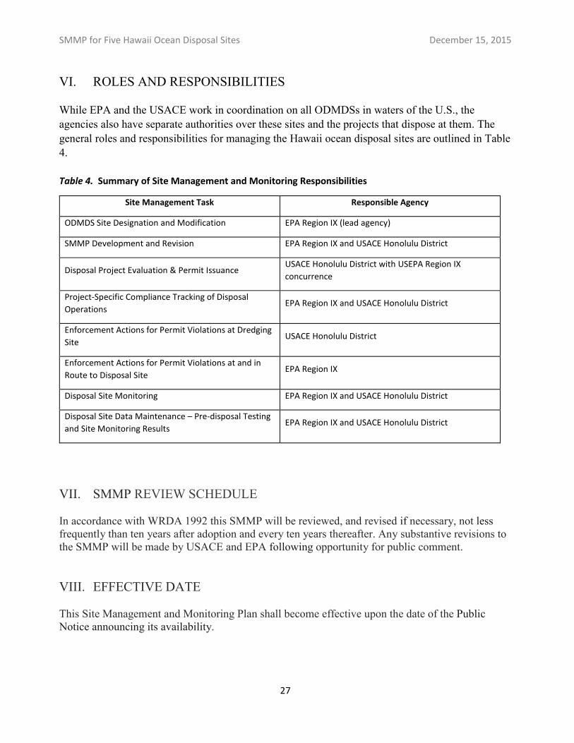
VI. ROLES AND RESPONSIBILITIES
While EPA and the USACE work in coordination on all ODMDSs in waters of the U.S., the agencies also have separate authorities over these sites and the projects that dispose at them. The general roles and responsibilities for managing the Hawaii ocean disposal sites are outlined in Table 4.
Table 4. Summary of Site Management and Monitoring Responsibilities
Site Management Task Responsible Agency
ODMDS Site Designation and Modification EPA Region IX (lead agency)
SMMP Development and Revision EPA Region IX and USACE Honolulu District
Disposal Project Evaluation & Permit Issuance USACE Honolulu District with USEPA Region IX
concurrence
Project-Specific Compliance Tracking of Disposal
Operations EPA Region IX and USACE Honolulu District
Enforcement Actions for Permit Violations at Dredging
Site USACE Honolulu District
Enforcement Actions for Permit Violations at and in
Route to Disposal Site EPA Region IX
Disposal Site Monitoring EPA Region IX and USACE Honolulu District
Disposal Site Data Maintenance – Pre-disposal Testing
and Site Monitoring Results EPA Region IX and USACE Honolulu District
VII. SMMP REVIEW SCHEDULE
In accordance with WRDA 1992 this SMMP will be reviewed, and revised if necessary, not less frequently than ten years after adoption and every ten years thereafter. Any substantive revisions to the SMMP will be made by USACE and EPA following opportunity for public comment.
VIII. EFFECTIVE DATE
This Site Management and Monitoring Plan shall become effective upon the date of the Public Notice announcing its availability.
27
SMMP for Five Hawaii Ocean Disposal Sites December 15, 2015
IX. REFERENCES
Dadey, K., M. Torresan, and A. Ota. 1996. An integrated, coordinated study of the effects of dredged material on the marine environment – Mamala Bay example. Water Quality 96, Proceedings of the 11th Seminar, 26 February- 1 March, Seattle, Washington.
Germano, J., P. Myre, L. Read, and D. Carey. 2010. Review/Synthesis of Historical Environmental Monitoring Data Collected at the San Francisco Deep Ocean Disposal Site (SF-DODS) in Support of EPA Regulatory Decision to Revise the Site’s Management and Monitoring Plan. Prepared for US EPA Region 9, 75 Hawthorne Street, San Francisco, CA 94105. EPA Order No. EP069000274. Prepared by Germano and Assoc., Inc., Bellevue, WA. http://www3.epa.gov/region9/water/dredging/sfdods/SfDodsMonitorSynRev6-10final.pdf
Torresan, M. and J. Gardner. 2000. Acoustic Mapping of the Regional Seafloor Geology in and Around Hawaiian Ocean Dredged-Material Disposal Sites: U.S. Geological Survey Open-File Report 00-124, http://pubs.usgs.gov/of/2000/0124/
U.S. Environmental Protection Agency, 1980. Final Environmental Impact Statement (EIS) for the Hawaii Dredged Material Disposal Sites Designation. Marine Protection Branch, Washington, D.C. 20460. http://www3.epa.gov/region9/water/dredging/hi/index.html
U.S. Environmental Protection Agency, 1981. Final Rule. Ocean Dumping – Final Designation of Sites. F.R. 46, 115. Pages 31412-31413. June 16, 1981. http://www3.epa.gov/region9/water/dredging/hi/wh-frl1853-4-hawaii-dredging-fedreg-final-rule.pdf
U.S. Environmental Protection Agency. 2015. 2013 HAWAII OCEAN DISPOSAL SITE MONITORING SYNTHESIS REPORT. Prepared by Dredging and Sediment Management Team, EPA Region IX, San Francisco, CA. http://www3.epa.gov/region09/water/dredging/hi/2013-hawaii-ocean-survey-synthesis-report-2015.pdf
U.S. Environmental Protection Agency and U.S. Army Corps of Engineers. 1991. Evaluation of dredged material proposed for ocean disposal, testing manual. (OTM) EPA Report 503/8-91/001. Prepared by EPA Office of Marine and Estuarine Protection, Washington, DC.
U.S. Environmental Protection Agency and U.S. Army Corps of Engineers. 1997. Special Joint Public Notice, Site Management Plan (SMP) for the Hawaii Ocean Dredged Material Disposal Sites. http://www3.epa.gov/region9/water/dredging/hi/pub-notice-site-mgmnt-plan-hawaii-dredged-material-sites-1997.pdf
28
SMMP for Five Hawaii Ocean Disposal Sites December 15, 2015
APPENDIX A
Example of a disposal scow tracking posting to the web, showing:
Disposal vessel route from dredging location to the ocean disposal site; Close-up of the disposal event inside the disposal site’s SDZ; Plot showing disposal vessel draft and speed throughout the disposal trip
29
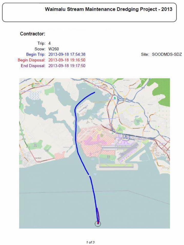
Waimalu Stream Maintenance Dredging Project - 2013
Contractor:
Trip: 4 Scow: W260
Begin Trip: 2013-09-18 17:54:38 Site: SOODMDS-SDZ Begin Disposal : 2013-09-18 ·1 9:16:50
End Disposal: 2013-09-1 8 19:1 7:50
.. •'
/
•• ;;:. ' .....
1 of3
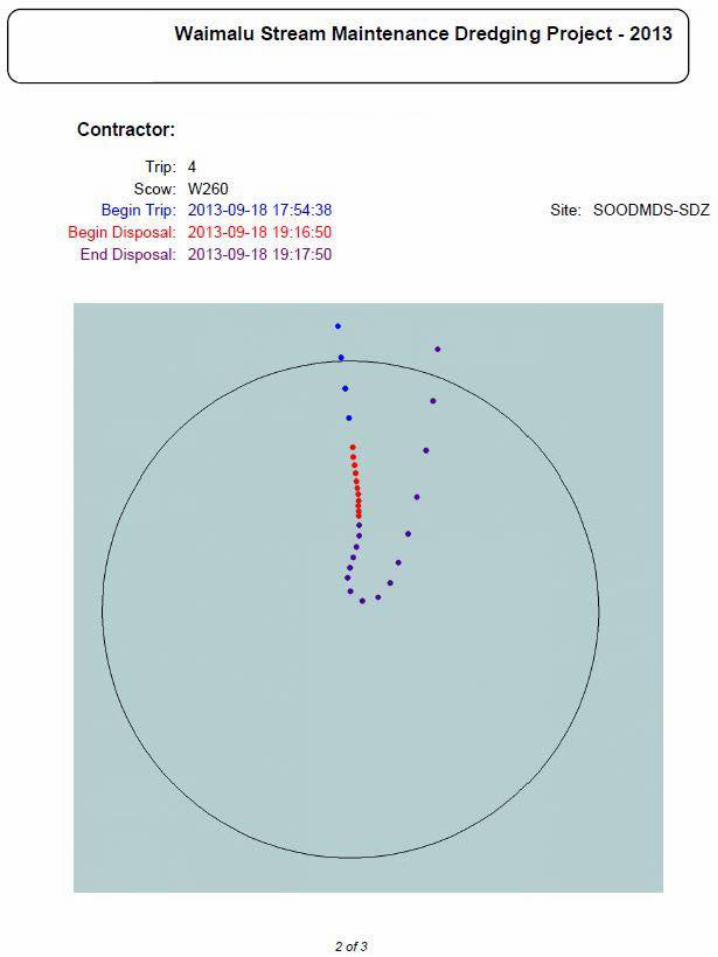
• • • •
• • • • • • • • •
•
Waimalu Stream Maintenance Dredging Project - 2013
Contractor:
Trip: 4 Scow: W260
Begin Trip: 2013-09-18 17:54:38 Site: SOODMDS-SDZ
Begin Disposal: 2013-09-1 8 19:16:50 End Disposal: 2013-09-1 8 19:17:50
• •
• • •
i •
• •
•
2of3
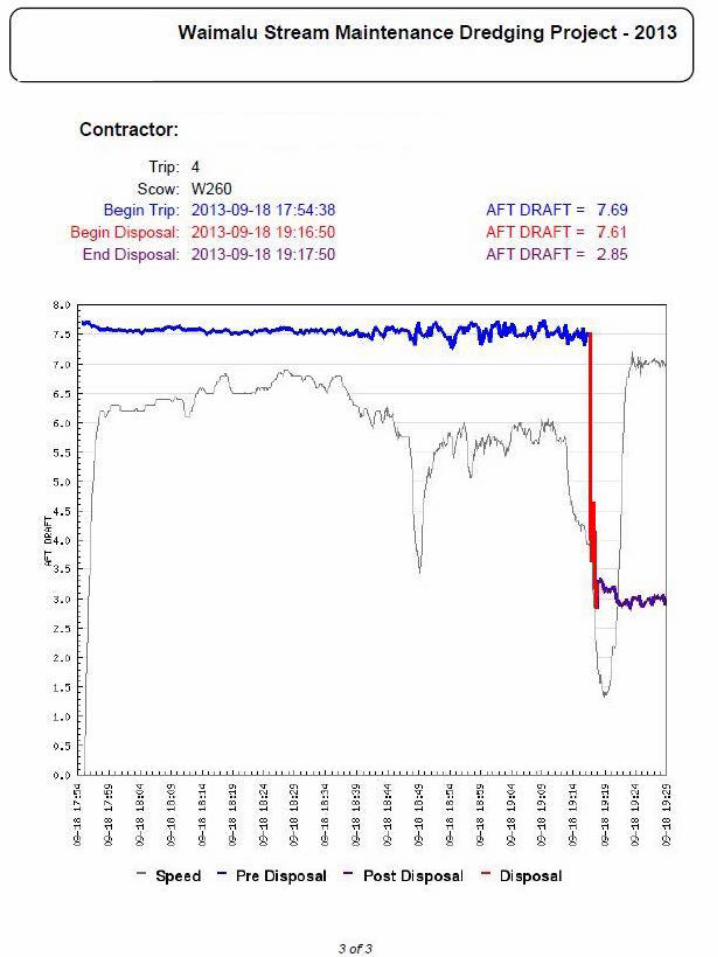
•••
•• ••
Waimalu Stream Maintenance Dredging Project - 2013
Contractor:
Trip: 4 Scow: W260
Begin Trip: 2013-09-18 17:54:38
Begin Disposal: 2013-09-18 19:16:50 End Disposal: 2013-09-1 8 19:17:50
s.o
1.>
1. 0
6.~
S.5
s.o
t:4.5 ·< ~ o4. ()
~3.5 3.0
..Z.> . l .:i
1.0
9.5
•) . () Q ~ v ~ v v ~ v "1 '!1 ?. ?. r! <l <l <;? ~ ~ m 0 m m m m m ~ ~ ~ ~ ~~ ~ ~ ~ " m ® m 0 m m m m m n n n n" " " " " ~ 8 8 ~ ~ ~ ~ ~ ~
- Speed - Pre Disposal
••<;? v ?:
~
"' Q
"1 m m 0 m ~ ~ ~ ~
m
" m
" 0
" m n
8 8 ~ ~
- Post Disposal
3 of3
AFT DRAFT = AFT DRAFT = AFT DRAFT =
v ~ 0 "1 ?. ?. n m ~ ~ ~ ~ ~ ~ ~
m m m 0,..," " " ~ 8 ~ ~
- Disposal
7.69 7.61 2.85
•• v ~
" <l <l a. ~ ~ ~ ~ ~
m m m n " " ~ 8 ~