sigmet - australia's official weather forecasts & weather ... of meteorology > weather...
TRANSCRIPT
> BUREAU OF METEOROLOGY> WEATHER SERVICES> AVIATION
AVIATION WEATHER PRODUCTS
SIGMET
SIGMETA SIGMET is a warning issued to provide urgent advice to aircraft of the actual or expected occurrence, in areas over which meteorological watch is being maintained, of weather
phenomena that are potentially hazardous. A SIGMET will contain information on one of the
following phenomena:
Code Description
OBSC TS Obscured thunderstorms
EMBD TS Embedded thunderstorms
FRQ TS Frequent thunderstorms
SQL TS Squall line thunderstorms
OBSC TSGR Obscured thunderstorms with hail
EMBD TSGR Embedded thunderstorms with hail
FRQ TSGR Frequent thunderstorms with hail
SQL TSGR Squall line thunderstorms with hail
TC Tropical cyclone
SEV TURB Severe turbulence
SEV ICE Severe icing
SEV ICE FZRA Severe icing due to freezing rain
SEV MTW Severe mountain wave
HVY DS Heavy duststorm
HVY SS Heavy sandstorm
VA Volcanic ash
RDOACT CLD Radioactive cloud
A SIGMET will provide information on the location, extent, intensity and expected evolution
of the specified phenomenon.
SIGMETs for thunderstorms are only issued when they are:
• obscured(OBSC)byhazeorsmoke
• embedded(EMBD)withincloudlayers
• frequent(FRQ),i.e.withlittleornoseparationbetweencloudsandcoveringmorethan
75% of the area affected
• squallline(SQL)thunderstormsalongalineofabout100nauticalmilesormoreinlength,
with little or no separation between clouds
SIGMETforthunderstormsdonotincludereferencetocumulonimbuscloud(CB)orassociated icing and turbulence as these are implied as occurring.
Pilots in command of aircraft encountering any phenomenon in this table not notified by SIGMET must report details of the phenomenon in an AIREP SPECIAL
FURTHER INFORMATIONAviation Weather Services
Visit us at www.bom.gov.au
The format given here is valid until 29 May 2013*
*Refer to http://www.bom.gov.au/aviation/data/education/awp-sigmet.pdf for the new format.
SIGMET for tropical cyclones include cumulonimbus but not associated icing and turbulence as these are implied as occurring.
Responsibility for the issuance of SIGMET within the Australian Flight Information RegionsSIGMETsforvolcanicasharetheresponsibilityoftheVolcanicAshAdvisoryCentre,Darwin.
SIGMETsfortropicalcyclonesaretheresponsibilityoftheTropicalCycloneWarningCentresinPerth,DarwinandBrisbane.
SIGMETsforturbulenceandicingaboveFL185aretheresponsibilityoftheAviationWeatherCentre,Melbourne.
SIGMETforallotherphenomenaaretheresponsibilityoftheMeteorologicalWatchOfficeslocatedinPerth,Darwin,Adelaide,Hobart,Melbourne,SydneyandBrisbane.
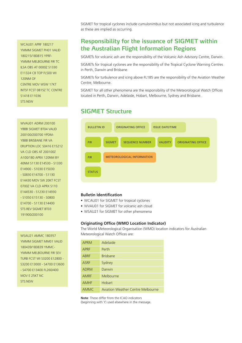
SIGMET Structure
Bulletin Identification• WCAU01forSIGMETfortropicalcyclones
• WVAU01forSIGMETforvolcanicashcloud
• WSAU21forSIGMETforotherphenomena
Originating Office (WMO Location Indicator)TheWorldMeteorologicalOrganisation(WMO)locationindicatorsforAustralianMeteorologicalWatchOfficesare:
APRM Adelaide
APRF Perth
ABRF Brisbane
ASRF Sydney
ADRM Darwin
AMRF Melbourne
AMHF Hobart
AMMC AviationWeatherCentreMelbourne
Note:ThesedifferfromtheICAOindicators(beginningwithY)usedelsewhereinthemessage.
WSAU21AMMC180357
YMMMSIGMETMM01VALID
180439/180839YMMC-
YMMMMELBOURNEFIRSEV
TURBFCSTWIS3200E12800-
S3200E13000-S4700E13600
-S4700E13400FL260/400
MOVE25KTNC
STS:NEW
WVAU01ADRM200100
YBBBSIGMETBT04VALID
200100/200700YPDM-
YBBBBRISBANEFIRVA
ERUPTIONLOCS0416E15212
VACLDOBSAT200100Z
A100/180APRX120NMBY
40NMS1130E14530-S1330
E14900-S1030E15030
-S0830E14700-S1130
E14430MOVSW20KTFCST
0700ZVACLDAPRXS110
E144530-S1230E14930
-S1050E15130-S0800
E14700-S1130E14400
STS:REVSIGMETBT03
191900/200100
WCAU01APRF180217
YMMMSIGMETPH01VALID
180215/180815YPRF-
YMMMMELBOURNEFIRTC
ILSAOBSAT0000ZS1330
E11324CBTOPFL500WI
120NMOF
CENTREMOVWSW17KT
INTSFFCST0815ZTCCENTRE
S1418E11036
STS:NEW
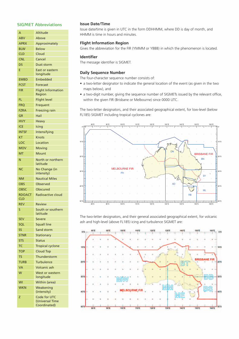
Issue Date/TimeIssuedate/timeisgiveninUTCintheformDDHHMM,whereDDisdayofmonth,andHHMMistimeinhoursandminutes.
Flight Information RegionGivestheabbreviationfortheFIR(YMMMorYBBB)inwhichthephenomenonislocated.
IdentifierThe message identifier is SIGMET.
Daily Sequence NumberThefour-charactersequencenumberconsistsof:
• atwo-letterdesignatortoindicatethegenerallocationoftheevent(asgiveninthetwo
mapsbelow),and
• atwo-digitnumber,givingthesequencenumberofSIGMETsissuedbytherelevantoffice,
withinthegivenFIR(BrisbaneorMelbourne)since0000UTC.
Thetwo-letterdesignators,andtheirassociatedgeographicalextent,forlow-level(belowFL185)SIGMETincludingtropicalcyclonesare:
Thetwo-letterdesignators,andtheirgeneralassociatedgeographicalextent,forvolcanicashandhigh-level(aboveFL185)icingandturbulenceSIGMETare:
A Altitude
ABV Above
APRX Approximately
BLW Below
CLD Cloud
CNL Cancel
DS Dust storm
E East or eastern longitude
EMBD Embedded
FCST Forecast
FIR Flight Information Region
FL Flight level
FRQ Frequent
FZRA Freezing rain
GR Hail
HVY Heavy
ICE Icing
INTSF Intensifying
KT Knots
LOC Location
MOV Moving
MT Mount
N North or northern latitude
NC No Change (in intensity)
NM Nautical Miles
OBS Observed
OBSC Obscured
RDOACT CLD
Radioactive cloud
REV Review
S South or southern latitude
SEV Severe
SQL Squall line
SS Sand storm
STNR Stationary
STS Status
TC Tropical cyclone
TOP Cloud Top
TS Thunderstorm
TURB Turbulence
VA Volcanic ash
W West or western longitude
WI Within (area)
WKN Weakening (intensity)
Z Code for UTC (Universal Time Coordinated)
SIGMET Abbreviations
MELBOURNE FIR
BRISBANE FIR
PH
BN
AD
ML
DN
SY
HB
160°E
160°E
150°E
150°E
140°E
140°E
130°E
130°E
120°E
120°E
110°E
110°E
100°E
100°E
90°E
90°E
80°E
80°E0° 0°
10°S 10°S
20°S 20°S
30°S 30°S
40°S 40°S
50°S 50°S
Originating Office (ICAO Location Indicator)TheInternationalCivilAviationOrganization(ICAO)locationindicatorsforAustralianMeteorologicalWatchOfficesare:
YPRM Adelaide
YPRM Perth
YBRF Brisbane
YSRF Sydney
YPDM Darwin
YMRF Melbourne
YMHF Hobart
YMMC AviationWeatherCentreMelbourne
Flight Information RegionThisgivestheabbreviationandfullnamefortheFIRinwhichthephenomenonislocated.
Meteorological InformationThis section includes:
• typeofphenomenon
• observedorforecast
• location,bothhorizontalandverticalextent
• movementorexpectedmovement
• expectedchangeinintensity
• forecastpositionattheendofthevalidityperiod(onlyinSIGMETforTCandVA)
The first point of a polygon is not repeated when describing the horizontal extent of an event.
SIGMETfortropicalcyclonesdonotincludereferencetocumulonimbuscloud(CB)orassociated icing and turbulence as these are implied as occurring.
Cancel SIGMETIf during the validity period of a SIGMET, the phenomenon for which the SIGMET is no longer occurring or is no longer expected, the SIGMET is cancelled by issuing a SIGMET with theabbreviationCNLinlieuofmeteorologicalinformation.CNLisalsoincludedonthestatus line.
SIGMET StatusThe status line indicates whether the SIGMET is:
• NEW-theSIGMETisforanewphenomenon.
• REV-theSIGMETreviewsanearlierSIGMETforthephenomenon.
• CNL-theSIGMETcancelsacurrentSIGMET.
WSAU21AMMC180720
YMMMSIGMETMM02VALID
180720/180839YMMC-
YMMMMELBOURNE
FIRCNLSIGMETMM01
180439/180839
STS:CNLSIGMETMM01
180439/180839
Airservices Australia is the official distributor of aviation forecasts, warnings and observations issued by the Bureau of Meteorology. Airservices’ flight briefing services are available at www.airservicesaustralia.com. Telephone contact details for elaborative briefings are contained in Airservices’ Aeronautical Information Publication Australia (AIP), which is available online through their website.
Other brochures produced by the Bureau of Meteorology’s aviation weather services program can be
found at www.bom.gov.au/aviation/knowledge-centre.
© CommonwealthofAustralia,17May2012