short term floods mitigation measures after … term floods mitigation measures after thailand...
TRANSCRIPT

1 Assoc. Prof. Dr. Sucharit Koontanakulvong
Short term floods mitigation measures after Thailand Floods 2011
By Assoc. Prof. Dr. Sucharit Koontanakulvong
Faculty of Engineering
Chulalongkorn University
Abstract
During July-November 2011, Chao Phraya Plain of Thailand suffered from the serious
flooding started in July in the northern area and the flood went downward to midstream area in
September and reached Bangkok area in October. It was the first time that flood water reached the
inner part of the capital city, Bangkok, and also caused flash flood to many main industrial estates in
the suburb of Bangkok. The damages of this flooding was estimated to be more than ten times of the
previous major past flooding especially to the industrial sector and were in the ranking number four of
disaster damages in the world. The floods also induced huge impacts to the world’s insurance
industry and industrial logistic supply chain system.
After the floods, Thai Government increased particular concern over floods mitigation
measures including both immediate and sustainable measures. The Strategic Formulation Committee
on Water Management Resources (SFCWMR) was set up to draft the mitigation measures. This paper
summarized the directions and plans for short term flood mitigation measures by which some plans
had been implemented in the passing years. The effectiveness and some concerns for further
improvement were also commented for future flood planning.
Keyword: Thailand, floods, short term, mitigation plan, Chao Phraya, Bangkok
1. Introduction
During July-November 2011, Chao Phraya Plain of Thailand suffered from the serious
flooding started in July in the northern area and the flood went downward to midstream area in
September and reached Bangkok area in October. It was the first time that flood water reached the
inner part of the capital city, Bangkok, and also caused flash flood to many main industrial estates in
the suburb of Bangkok. The damages of this flooding were estimated to be more than ten times of the
previous major past flooding especially to the industrial sector and were in the ranking number four of
disaster damages in the world. As of Dec 1, 2011, World Bank estimated the total loss to be 45.7
billion US dollars (World Bank, 2011) which exceeded the fourth loss in the world, i.e. California
Earthquake (42.0 billion US dollars, Bo Zhang, 2011). The floods also induced huge impacts to the
world’s insurance and industrial supply chain system, e.g. hard disk, automotive, and electronics
industries.
2 Assoc. Prof. Dr. Sucharit Koontanakulvong
After the floods, Thai Government increased particular concern over floods mitigation
measures including both immediate and sustainable measures. The Strategic Formulation Committee
on Water Resources Management (SFCWRM) was set up to draft the mitigation measures. The
committee had set two subcommittees, i.e. for short and long term measures, to collect and draft the
measures and projects proposed from the concerned authorities to the Government.
This paper summarized the directions and plans for short term flood mitigation measures
which had been implemented in the passing years. The effectiveness and some improvement were
also commented for future planning.
2. Flood events
Floods 2011 induced a lot of damage to water control structures along the Chao Phraya
River and more than 30 water control structures were damaged by high river level (Fig. 1). The
overflow floodwater flowed through paddy field in the form of flood sheet flow and finally
overflowed the flood protection dyke into the industrial estate area in the rapid time. The flood water
caused huge damages to high technology machines in the main seven industrial estates in the vicinity
of Bangkok area. The flood area can be estimated from satellite images and the flood area in
September 2011 and 2012 in the Chao Phraya basin are 10,375 and 3,070.28 sq km (Fig. 2)
respectively. One of the main causes was the long duration and high amount of rainfall that also
induced correspondingly long duration and high runoff volume during August-October.

3 Assoc. Prof. Dr. Sucharit Koontanakulvong
Water drainage and water distribution in 2011
Drainage in river
Drainage to canals
Drainage through damaged gate
Drainage out of the area
700
900
360
200
40
1,500
40
0100
230
280980
400
21048
230
800
51
320300
20
44518
400
4,600
1230
42
40
24
24
11
54
1,100
200208
70
85
50
980
674
123 426
322 10
75
3070
P
P
P
P
P P
P
P525
774
627
367
P
P
1
2
3
8
4
56
7910
14 Sep 11 Overflow at Bangchomsri Gate
1
14 Sep 11 Kongtanung gate broken 15 m.
2
15 Sep 11 Phragarm gate broken 40 m
3
17 Sep 11 Dyke at Bantakaopod broken 20x4500 m
4
18 Sep. 11 12.00 AM.Overflow Chainart dam spillway 1000 m
5
19 Sep 11 04.00 AMDyke at Pholathem broken 1000 m.
6
21 Sep 11 04.00 AM.Dyke at Manorom, Chainartbroken
7
22 Sep 11 Dyke at Maharat at km. 4+100
And km 5+700 broken 30 m
8
24 Sep 11 14.00 PM.Dyke at Kaokadi, Chainartbroken 10 m
9
3 Oct 11 Chongkart, Chainart at km 291+400 broken 20 m
10
11
Sep-Oct 11 11 gates broken caused overflow of 900 cms
900
261
11
P
P
24P
Figure 1 Floods water movement during September – October 2011 (SFCWRM, 2012)
Figure 2 Comparisons of flood area in September 2011 and 2012
Table 1 and 2 show water balance of floods 2011 in the upper and lower central plains of
the Chao Phraya Plain. Water storage in the area equals to inflow minus outflow volume. The flood
volume in the area can be estimated from the water storage volume minus water retention volume (if
any) in the area.

4 Assoc. Prof. Dr. Sucharit Koontanakulvong
Table 1 shows the water balance of the upper central plain which covers the area
downstream of two big dams, i.e. Bhumipol and Sirikit Dams, to Nakornsawan Province (at C2
station, upstream of Chao Phraya Delta) and Table 2 shows the water balance of the lower central
plain which covers the downstream of Nakornsawan Province to Chao Phraya River Mouth. The
analysis of water balance is based on the data from May to November 2011. With the inflow, outflow
and storage of the upper and lower Chao Phraya River basins in monthly basis, the amount of net
water storage, which indicated the flood volume, can be estimated. The net flood storages are
estimated to be 6180 and 14818 MCM in the upper (Table 1) and lower zones respectively (Table 2)
resulting in 20,998 MCM of the total flood volume that needed to be considered for future flood
mitigation planning.
Table 1 Flood water sources- Upper zone (May-Oct 2011)
Volume (MCM) Percentage (%) Total Inflow 40928 100 Release from Bhumipol Dam 3776 9 Inflow Wang River ( W 4 A) 3520 9 Inflow from Yom River ( Y 16)
11124 27 Release from Sirikit Dam 5209 13 Estimated runoff from rainfall 17298 42 Outflow through C2 34748 85 Net accumulated flood storage 6180 15
Table 2 Flood water sources- Lower zone (May-Oct 2011)
Volume (MC) Percentage (%) Total inflow 57696 100 Inflow ( through C2) 37545 65 Inflow from Dams (Pasak etc.) 4227 7 Estimated runoff from rainfall 15924 28 Total outflow 42879 74 Out flow (through West:Tachin) 1799 3 Out flow (through Chao Phraya) 38324 66 Out flow (through East zone) 2757 5 Net accumulated flood storage 14818 26
5 Assoc. Prof. Dr. Sucharit Koontanakulvong
3. Mitigation principles
The Strategic Formulation Committee on Water Resources Management (SFCWRM), set
up by the Government, had set the flood mitigation principle into eight schemes to cope with various
aspects of flood planning as follows:
(1) Reforestation scheme,
(2) Annual water management scheme,
(3) Structural rehabilitation scheme,
(4) Flood data, prediction and warning system,
(5) Flood fighting scheme
(6) Retention and compensation scheme
(7) Organization and regulations improvement scheme
(water, land use, forest, retention),
(8) Social participation, recognition scheme.
The principles cover both hard (structure, facilities) and soft (organization, system)
measures. Flood mitigation and planning should integrated many of hard and soft measures together.
However, this may take time for implementation. Since the situations were serious for both recovery
works and future planning, the Committee decided to set up two subcommittee; one of which is to
take care of immediate term measures (immediate repair and short term improvement works) and the
other is to responsible for long term measures (sustainable (medium and long) planning). The
immediate term subcommittee took care the repair works and immediate measures including water
management related projects in order to be able to handle 2012 flood mitigation works with lessen
impacts if the same flood water volume would come. To handle the water related projects, the
working group was set to consider the prevention and mitigation guidelines and to propose mitigation
projects for immediate/short term measures that should be able to implement (immediately) within
one or two years. The guidelines are as follows:
(1) Make use of the existing structures with the consideration of local characteristics in each area,
(2) Enhance storage and drainage capacity,
(3) Prevent floods in community and economic zones,
(4) Implement supportive measures (if needed).
The long term subcommittee took care the drafting of sustainable water resources
development plan in the future which can sustain future floods. The implementation of the long term
measures will be supported by the special flood relief budget under special loan act.

6 Assoc. Prof. Dr. Sucharit Koontanakulvong
4. Immediate/short term framework
Based on the in-depth discussions among agencies concerned, the action plan for
immediate/short term measure projects had been drafted and the main objectives are to prevent and
mitigate urgent floods (SFCWRM, 2012), improve drainage capacity, and increase water management
capacity. The action plan for the flood prevention and mitigation of floods in the short term was set
as shown in the following figure.
In the upstream area, more water retention mechanisms, e.g. dam control, retention area
etc., were considered. In the middle area, the repair of main structures to control excess flood water
(which means flow above the defined discharge which may cause overflow in some downstream
areas) and improvement work for emergency retention area were considered. In the downstream area,
the improvement of drainage capacity toward the sea, e.g. dredging, installation of more pumps, dyke
repair etc., were considered. There are 1043 projects under six work plans and the budget of 42,973 M
baht is set for implementation. The SFCWRM agreed with the proposed work plan in January 2012
and the cabinet approved the budget framework in February 2012. The main immediate/short term
activities can be categorized into six groups as follows.
(1) Structural Repair works with effective solution
As mentioned earlier that the floods 2011 caused huge damages to water control
structures especially in the main Chao Phraya River and within the limited time constraint, the
focused repair works had been chosen to better the flood operation in the coming floods 2012. The
repair works comprised of water gates, dykes, and roads. Besides, the additional flood protection

7 Assoc. Prof. Dr. Sucharit Koontanakulvong
scheme with permanent dyke structures for special zone such as industrial estate (Fig. 3) was also
planned.
Saharatananakorn
Heigthen road as dykeอย.3011 3.0 ม.(+6.5 m MSL)
Box culvert for drainage 1.80 x1.80 m
Rotchana
High tech
Bangpain
Factory land
Drainage pipe 2.10 x 2.10 mDOH.3477 dyke +6.0 - +5.0
m MSL
DOH.33097 dyke +5.0 - +4.5
m MSL
Navanakorn
Bangkradi
DOH.9 Barrier 1.2 m.
(+4.0 m MSL)
DOH.347 Barrier 1.2 m.
(+4.0 m MSL)
DOH.306 heigthen 0.6 ม.
(+4.0 m MSL)
อย.2045 dyke + 6.0 m MSL
12/23/2011 26คณะทํางานโครงสร้างพื�นฐานระยะเร่งด่วน-กยน.
Figure 3 Embankment in the industrial estate and road heightening (SFCWRM, 2012)
(2) Upstream area works
Water level in the Chao Phraya River normally reaches its peak in September every year
and if the peak is sufficiently high, it will cause floods and induce damages. The review on reservoir
water release was done by another working group to lessen the peak flow during September. A
guideline for reservoir release of the main dams was drafted (Fig. 4) so that water will be released
before August and minimum or zero release in September and October can be controlled with
increased efficiency. Based on this measure, it is estimated that about 5000 MCM can be stored in the
upstream dam and the peak at C2 (Nakornsawan) can be reduced about 600 cms during the flood
event.

8 Assoc. Prof. Dr. Sucharit Koontanakulvong
Dam Operation Adjustment
Figure 4 Dam operation adjustment (RID, 2012)
(3) Midstream area works
In case of emergency, the retention area was prepared to divert excess flood water to be
stored for a certain period of time to refrain the high flood peak both from rainfall and runoff from the
upstream. Detail investigations on the appropriate site for retention use were explored and the
improvement work such as dredging, dyking and pumping facilities, were planned to better the
control of inflow-outflow-storage in the retention area. The area of about 2.1 M rai (about 336,000
hectares) in the north area covering the area of Phitsanulok, Phichit and Nakornsawan Province and
the south area covering the area of Nakornsawan, Chainart, Singburi Province, had been prepared to
cut flood peak for this emergency situation and the sample of the retention area is shown in Fig. 5.
With these measures, the flood storage of about 5000 MCM can be stored in the retention area if
needed.

9 Assoc. Prof. Dr. Sucharit Koontanakulvong
Lower Chao Phraya
7 zone1. L1: Left side of
Chao Phraya River Chainat-Lopburi River
2. L2: Area between Chao Phraya River-Lopburi River
3. L3: Area between the Klong Chainat-Lopburi River
4. L4: Area between Chao Phraya River-Noi River
5. L5: Area between Noi River-Tha Chin River
6. L6: Right side of Tha Chin River
7. L7: Pug Hai-Chao Chet-Bang Barn Area
Figure 5 Retention area preparation (RID, 2012)
(4) Downstream area works
In the downstream area (south of Ayuthaya Province to the sea) the water drainage route
improvements were set to drain flood water through Tha Chin, Chao Phraya, Bangpakong Rivers and
through small canal networks to the Gulf of Thailand as urgent works. Massive dredging activities
were planned to improve the drainage capacity with the installation of pumping and heightening low
dykes along the river. The drainage capacity improvement works in the Bangkok East were planned,
in case of necessity, to drain flood water from Khlong 1-7 of the Chao Phraya River east. While the
flood water from Khlong 8-14 of the Chao Phraya River east will drain through Khlong 13 and 14
through Phraya Chaiyanuchit canal to the pumping stations along the shoreline of the Gulf of
Thailand. Some flood water may also pass through Bangkok area, if necessary and available, for
emergency purpose (about 300 cms). The locations of improvement project are shown in Fig 6-1 with
five main projects as below (Supot, 2012).

10 Assoc. Prof. Dr. Sucharit Koontanakulvong
The drainage capacity improvement works in the Bangkok west were also planned to
receive excessive flood water from the north of the Chao Phraya River west. Again, if necessary and
available, some flood water from the north area may pass through Taweewatana canal to Pasicharoen
canal (about 75 cms) to Tachin River or down to Mahachai canal and finally to the sea. The locations
of improvement project are shown in Fig 6-2 with five main projects as below (Supot, 2012).

11 Assoc. Prof. Dr. Sucharit Koontanakulvong
จุดตดิตั �งเครื�องวัดอัตราการไหลของนํ �า
จุดตดิตั �งเครื�องผลักดันนํ �าแรงดันสูง
จุดตดิตั �งเครื�องผลักดันนํ �าธรรมดา
Figure 6-1 Drainage capacity improvement in East BKK (SFCWRM, 2012)
จุดตดิตั �งเครื�องวัดอัตราการไหลของ
นํ �า
West BMA Improvement Plan(to cover 75 cms from outside)
จุดตดิตั �งเครื�องผลักดันนํ �าแรงดันสูง
จุดตดิตั �งเครื�องผลักดันนํ �าธรรมดา
Q = 75 cms.
Figure 6-2 Drainage capacity improvement in West BKK (SFCWRM, 2012)
(5) Flood fighting system
Central warehouse system is set up to register the stock list of necessary equipment
(central equipment: mobile pumps, cars, relief life bags etc.) to share among agencies during
emergency operation under a single command unit. New scheme of water jet pump in the canal for the
low land area is also prepared to improve the drainage capacity.

12 Assoc. Prof. Dr. Sucharit Koontanakulvong
(6) Single command management system
During the flood event, the Flood Relief Operation Center (FROC) was established as a
task force in early October 2011 to guide the flood fighting operation of all concerned agencies, after
that the Flood Recovery and Restoration Committee was set up to plan for the relief and restoration
works. In the early November the Strategic Formulation Committee for Water Resources
Management (SCFWRM) was established to prepare for short and long term water management
planning. Under the prime minister office, the National Water Policy and Flood (NWPFC) was
established in February 2012 as recommended by SCWRM with the Water and Flood Management
committee (WFMC) as an operational unit to gather flood situations and decide on water operation
and as a single command unit to guide the water operation to the concerned agencies. The integrated
information system (Fig. 7) with facilities of data monitoring, transfer, display, computing, and
weather forecasting is also planned to be installed for operational decision making. This single
command unit will monitor, guide the operation of water management and also will be a main body
for long term project implementation.
Single Command of NWOC
27
Figure 7 Information system (NWOC) under single command (Supot, 2012)
5. Short term implementation progress
For the short team remedial measures, the Government had approved the budget for social
assistance to the affected people, upstream plantation and infrastructure improvement. The budget for
infrastructure improvement was also divided into the immediate and short term infrastructure
improvement projects. The immediate improvement projects included 624 projects with the approved
budget of 13343 M baht and the short term improvement projects included 419 projects with the
13 Assoc. Prof. Dr. Sucharit Koontanakulvong
approved budget of 25,637 M baht. The main improvement activities are structural repair, dyke
improvement, road heightening, dredging, pump installation, retention area preparation etc.
Based on the WFMC progress report, the overall implementation progress is 43% while the
immediate projects finished 87% and the short term projects finished 14% based on the reported
figures as of November 9, 2012 (as shown in Table 3, there are some project groups that have already
been implemented but some projects need more detailed document for budget approval and caused
report delay). The projects are also classified into east, west Chao Phraya region and central
equipment and the progress in each type is 25%, 7% and unknown respectively. The project
implementation will be proceeded for further construction during the summer period (April-May) of
2013.
The main obstacles are budget approval process (some projects need more detailed document for
approval), meteorological effect and negotiations with communities for land entering.

14 Assoc. Prof. Dr. Sucharit Koontanakulvong
Table 3 Immediate and short term flood improvement project progress (as of Nov. 9, 12)
Title Budget (M฿) No. of Project Progress (%) Remark
a) Immediate Term Project
1 Ministry of Transport 2491 44 92
2 Ministry of Agriculture 6251 129 96
3 Ministry of Science and Technology 1985 24 68
4 Ministry of Interior 1846 150 62
5 Ministry of Defense 770 277 100
Subtotal 13343 624 87%
b) Short term Project
b1 East Chao Phraya
1 Ministry of Transport 15716 1 140 n.a.
2 Ministry of Agriculture 2027 98 32
3 Ministry of Interior 1220 2 93
4 Ministry of Industry 3237 6 90 Ind. Estate
5 Ministry of Education 171 1 n.a.
Subtotal 22371 2 247 25%
b2 West Chao Phraya
6 Ministry of Transport 6008 3 49 n.a.
7 Ministry of Agriculture 488 25 95
Subtotal 6496 4 74 7%
b3 Central Equipments
8 Ministry of Defense 20 1 n.a. water jet pumps
9 Ministry of Interior 129 1 n.a. for BMA
Subtotal 149 2 n.a.
C) Retention Pond Improvement
1 Ministry of Agriculture 614 5 96 n.a.
total 42973 1043 43%
Remark:
1: approved only 11898 M฿
2: approved only 18553 M฿
3: approved only 5823 M฿
4: approved only 6311 M฿
5: approved only 519 M฿
n.a. : some projects in the group waiting for final approval, then, no progress reporting

15 Assoc. Prof. Dr. Sucharit Koontanakulvong
6. Short term mitigation system effectiveness
With the planned immediate/short term mitigation plan, many improvement works had
been implemented from March to September 2012, e.g. dyke repair/improvement dredging dyke and
road as flood dyke protection (Fig. 8), installation of water jet pump, dam release rule adjustment (Fig.
4), retention area preparedness. With the measures, it is expected that the excessive flood water like
2011 can be better controlled via dam operation adjustment (about 5000 mcm), emergency retention
area (about 5000 mcm) and drainage capacity improvement (about 2000 mcm). The control peak
flow at C2 is set to be 3600 cms and if the peak exceeds 3600 cms, it may cause floods or overbank at
downstream. During floods 2011, the peak flow at C2 station exceeded 3600 cms for more than a
month. With rough estimation, the short term plan can handle about 60 % of control flood peak of
2011 and can reduce the runoff peak in the main Chao Phraya River and flood damage considerably
if the same volume of flood water (like 2011) comes. Besides, the Prime Minister herself also paid an
intention and followed up the plan and implementation via site visit and meeting with Governors via
teleconference periodically.
before during
Ratnimit Road
Pracharuamchai Road
before during
Heightening road as dyke (Samwa District)
Figure 8 Heightening the road to be used as flood protection dyke (BMA, 2012)
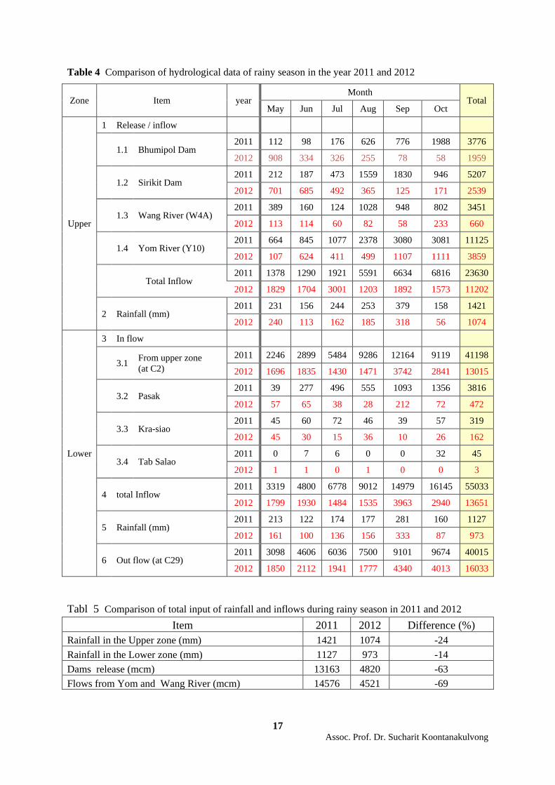
Table 4 showed the comparison of the monthly hydrological data during rainy season in
the year 2011 and 2012. The input of water into the Central Plain can be divided into three major
sources, i.e. runoff induced from the rainfall in the area, dam release, natural runoff (from the Yom
and Wang Rivers).

16 Assoc. Prof. Dr. Sucharit Koontanakulvong
If we considered by area, rainfall during rainy season in the year 2012 (upper central
plain: 1074 mm, lower central plain: 973 mm) decreased from the year 2011 (upper: 1421, lower:
1127 mm) by 24 % in the upper, 14 % in the lower or 20 % in average. The dam release during rainy
season in the year 2012 (4820 mcm) also decreased from the year 2011 (13163 mcm) or 63 %. The
natural inflow (no big dam upstream) from the Yom and Wang River in the rainy season also
decreased from 14576 mcm (2011) to 4521 mcm (2012) or 69 % (as shown in Table 5). The effect of
the dam release adjustment can be seen clearly from the water situation in 2012 while water flow in
the Chao Phraya River was better managed with the 30 % of peak decrease in September at
Nakornsawan (station C 2) and with the 59 % of peak decrease in October at Ayuthaya (station C 29).
For short term measures, RID will control normal flow limit at Nokornsawan (C2 station) to be not
more than 2700 cms and prepare the downstream facilities to cover the flow condition. Hence, in
2012, the peak flow was at 1838 cms (September 11, 6.00 AM) and much below the normal control
limit. In case there is much rain and runoff, and the flow at C2 is over 2700 cms, various emergency
measures such as dam release control, utilization of upstream and downstream retention area (north
of Bansai Station, C29) will be adopted to control the flow at Nakornsawan (C2) not to be over 3600
cms (SFCWRM, 2012).
17 Assoc. Prof. Dr. Sucharit Koontanakulvong
Table 4 Comparison of hydrological data of rainy season in the year 2011 and 2012
Zone Item year Month
Total May Jun Jul Aug Sep Oct
Upper
1 Release / inflow
1.1 Bhumipol Dam 2011 112 98 176 626 776 1988 3776
2012 908 334 326 255 78 58 1959
1.2 Sirikit Dam 2011 212 187 473 1559 1830 946 5207
2012 701 685 492 365 125 171 2539
1.3 Wang River (W4A) 2011 389 160 124 1028 948 802 3451
2012 113 114 60 82 58 233 660
1.4 Yom River (Y10) 2011 664 845 1077 2378 3080 3081 11125
2012 107 624 411 499 1107 1111 3859
Total Inflow 2011 1378 1290 1921 5591 6634 6816 23630
2012 1829 1704 3001 1203 1892 1573 11202
2 Rainfall (mm) 2011 231 156 244 253 379 158 1421
2012 240 113 162 185 318 56 1074
Lower
3 In flow
3.1 From upper zone (at C2)
2011 2246 2899 5484 9286 12164 9119 41198 2012 1696 1835 1430 1471 3742 2841 13015
3.2 Pasak 2011 39 277 496 555 1093 1356 3816
2012 57 65 38 28 212 72 472
3.3 Kra-siao 2011 45 60 72 46 39 57 319
2012 45 30 15 36 10 26 162
3.4 Tab Salao 2011 0 7 6 0 0 32 45
2012 1 1 0 1 0 0 3
4 total Inflow 2011 3319 4800 6778 9012 14979 16145 55033
2012 1799 1930 1484 1535 3963 2940 13651
5 Rainfall (mm) 2011 213 122 174 177 281 160 1127
2012 161 100 136 156 333 87 973
6 Out flow (at C29) 2011 3098 4606 6036 7500 9101 9674 40015
2012 1850 2112 1941 1777 4340 4013 16033 Tabl 5 Comparison of total input of rainfall and inflows during rainy season in 2011 and 2012
Item 2011 2012 Difference (%) Rainfall in the Upper zone (mm) 1421 1074 -24 Rainfall in the Lower zone (mm) 1127 973 -14 Dams release (mcm) 13163 4820 -63 Flows from Yom and Wang River (mcm) 14576 4521 -69

18 Assoc. Prof. Dr. Sucharit Koontanakulvong
The water situation in 2012 was lessened, compared with flood in 2011, due to less
rainfall. The rainfall peak occurred only in September but with better control on dam release, the peak
runoff reduced significantly. Table 5 showed the input of water into the Chao Phraya River system
during rainy season (May-October) in 2011 and 2012. It can be noticed that the rainfall in the rainy
season (May to October) decreased by 14 % in the lower zone and decreased by 24 % in the upper
zone while the dam total release and total runoff from the Yom and Wang River in the rainy season
decreased by 63 % and 69 % respectively. The effect from dam control adjustment can be noticed
from this information. The floods in 2012 happened only in specific area locally like in low land area,
i.e. Bang Rakam, Phitsanulok, Ayuthaya , and in the cities, i.e. Sukhothai, Bangkok due to the high
intensified rainfall within the area in September (318 mm in the upper and 333 mm in the lower zone).
Rapid floods in Bangkok urban area caused by the limited drainage capacity compared with high
intensified rainfall in the short period of time. Besides floods in the Ladkrabang Industrial Estate,
Bangkok area happened due to the broken dyke also happened but with immediate counter actions.
Overall water situations in the year 2012 were under control due to less rainfall and better
dam release control via the newly setup single command with better coordination and responses. The
water information through the center called NWOC (website called Water4Thai) also gave better
operation decision and communication to the publics. Flood fighting system also could provide
necessary assistance to local authorities when needed.
7. Issues left
The construction works regarding the immediate/short term mitigation plan are
implemented about 50 % in terms of budget spent due to many delay factors, i.e. budget approval
process, bidding, contracting, site readiness etc. Further monitoring on the construction progress is
still needed.
More communication for flood system planning of each agencies concerned is necessary
for better coordination for improvement works and flood operation.
The process of participation in the stages of planning, operation, review among local and
government, and within government agencies should be carefully taken into account for smooth
project implementation especially for the long term planning.
At the moment, Thai Government decided to use the tendering approach using
local/international consultant services for long term plan (concept, goals, approach, implementations).
Many remarks in the selection process and implementation works are still questionable, e.g. design
and build scheme, design and EIA process, contract administration process etc., that if any obstacles
happened, this may cause implementation delay or project termination and needed further follow up
of the progress.

19 Assoc. Prof. Dr. Sucharit Koontanakulvong
8. Concluding remarks
Floods 2011 was due to high and long rainfall pattern, besides the coordination for flood
fighting was also ineffective. To counter with flood issue, eight principles and implementation guides
were drafted as a framework for planning of both immediate and long terms.
Short term plan was drafted and implemented to counter the flood volume like 2011 and
comprised of eight work plans. The measures helped lessen the water load in 2012 from the upstream
especially from the dam release and the measure of retention area utilization to lower the flood peak
was also prepared as backup measures if necessary.
Thai Government decided to tender the long term plan for international bidding so that
the implementation process can be done faster and gain international acceptance at the same time.
Some concerned on long term planning, implementation, coordination within the implementation
stages and agencies concerned and consultancy contract administration are still left as questions and
need close monitoring on how the progress will be developed.
9. Acknowledgement
The authors would like to thank to the authorities involved in immediate/short term
planning within the working committee that provide all valuable comments and document. During
the manuscript preparation, data from authorities website and some power points were also kindly
provided. Special thanks to Chulalongkorn University who support our research unit and the Thailand
Research Fund who supports our financial research fund.
10. References
BMA, Construction progress pictures of the Flood Protection Projects, 2012.
(DDS website: http://dds.bangkok.go.th/dds_now/index.php)
Bo Zhang 2011. “Top 5 Most Expensive Natural Disasters in History,” AccuWeather.com.
(http://www.accuweather.com/en/weather-news/top-5-most-expensive-natural-d/474659)
Chulalongkorn, 2007. Flood 2006 Assessment Report, jointly with the Royal Irrigation Department,
Bangkok: September . (in Thai).
Chulalongkorn 2001. Flood 2011 Situation, Technical Report, Faculty of Engineering, November.
(in Thai).
Chulalongkorn 2013. Water Situation in 2012 compared with 2011, Technical Report, Faculty of
Engineering, May (in Thai).
DOH 2012. “Short term construction progress report.”
(http://www.doh.go.th/project_uncon.aspx?c_id=23&sc_id=6322)
EGAT 2012. Bhimipol and Sirikit Dam data, (http://water.egat.co.th/waternew/).
GISTDA 2011. Flood area from satellite images.
(http://flood.gistda.or.th/tiled/radarsat2/y2011 & y2012/)
20 Assoc. Prof. Dr. Sucharit Koontanakulvong
Kanwarn Deesuwan 2012. Why floods in BMA, Faculty Talk Seminar, Faculty of Engineering,
Chulalongkorn University, held on Oct 3, 2012 (in Thai).
Lertviroj Kowatana 2012. Thailand Flood Management, PAWEES 2012, Thailand, Nov 27.
Piyatida H. 2012. Water Situation in the Chao Phraya Basin in 2012, Faculty Talk Seminar, Faculty
of Engineering, Chulalongkorn University, Oct 3. (in Thai).
RID, Daily water report and short term construction progress report, (RID website).
(Now changed to ONWFMC instead).
RID 2012. Rainfall, river and dam discharge and river water level.
(http://water.rid.go.th/flood/flood/daily.pdf)
RID 2012. Dam release adjustment guideline, study report under working team, March. (in Thai).
RID 2012. Proposed flood retention area, study report under working team, March . (in Thai).
SCWRM 2012. Budget for Flood Remediation in the year 2012
(http://www.waterforthai.go.th/managewater-13/)
SFCWRM 2012. Immediate Term Flood Mitigation Report, Jan. (in Thai).
SFCWRM 2012. Long Term Strategy for Flood Prevention and Mitigation in Chao Phraya Basin, Jan
14,.
Sucharit Koontanakulvong 2012. Lessons learned from Bangkok Floods 2011 and what’s next ? ,
presented at the 10th Kyoto University Southeast Asia Forum 2012, Thailand , March 17.
Sucharit Koontanakulvong 2012. Thailand Floods 2011 – Causes and Future Management System,
Proc. SSMS2012, TAIWAN, MAY.
Sucharit Koontanakulvong 2012. Thailand Floods 2011 – Causes and Long Term Measures - With
CC Consideration, Presented at Workshop on Natural Disaster And Climate Change in
ASIA, NOV 5-7 , Equatorial Hotel, Bangi, Malaysia.
Supot T. 2012, Thailand Water Resources Management and Single Command, ONWF, 2012.
TMD 2012. Rainfall data. (http://hydromet.tmd.go.th/Monitor/Forecast.aspx)
WFMC 2012. Progress Report on Floods Relief and Improvement Projects, November 9.
WFMC 2012. Budget for Flood Remediation in the year 2012.
(http://www.waterforthai.go.th/managewater-13/) (reference for Table 3)
World Bank 2011. “ The World Bank Supports Thailand’s Post-Floods Recovery Effect”, December
13. (Retrieved 25 January 2012).
(http://www.worldbank.org/en/news/feature/2011/12/13/world-bank-supports-thailands-
post-floods-recovery-effort)
(Remarks: This article was translated from my article published in Japanese version in the report no
22 on “Major Thailand Floods 2011”, published by IDE-JETRO, September 23, 2013)