shetland local development plan - shetland islands …€¦ · 7 foreword i am very pleased to...
TRANSCRIPT

DEVELOPMENT PLANLOCAL
Shetland Local Development Plan
2014

2
Shetland
Local Development Plan 2014 Adopted September 2014 © Shetland Islands Council, All rights reserved. www.shetland.gov.uk

3
Contents Foreword .................................................................................................................... 7
Introduction ................................................................................................................ 9
Context ..................................................................................................................... 11
A vision for Shetland’s planning role within Scotland – National Context ................. 13
Local Development Plan .......................................................................................... 14
Spatial Strategy for Shetland .................................................................................... 15
Proposed Development Sites and Allocations .......................................................... 15
Areas of Best Fit ....................................................................................................... 15
General Policies ....................................................................................................... 19
Introduction ........................................................................................................... 19
GP1 Sustainable Development ............................................................................. 19
GP2 General Requirements for All Development .................................................. 20
GP3 All Development: Layout and Design ............................................................ 22
Natural Heritage ....................................................................................................... 24
Introduction ........................................................................................................... 24
NH1 International and National Designations ....................................................... 24
NH2 Protected Species ......................................................................................... 25
NH3 Furthering the Conservation of Biodiversity .................................................. 26
NH4 Local Designations........................................................................................ 27
NH5 Soils .............................................................................................................. 28
NH 6 Geodiversity ................................................................................................. 29
NH 7 Water Environment ...................................................................................... 30
Historic Environment ................................................................................................ 31
Introduction ........................................................................................................... 31
HE1 Historic Environment ..................................................................................... 31

4
HE2 Listed Buildings ............................................................................................. 31
HE3 Conservation Areas....................................................................................... 32
HE4 Archaeology .................................................................................................. 33
HE5 Gardens and Designed Landscapes ............................................................. 34
HE6 Trees and Woodlands ................................................................................... 34
Coastal Development ............................................................................................... 35
Introduction ........................................................................................................... 35
CST1 Coastal Development.................................................................................. 36
Housing .................................................................................................................... 38
Introduction ........................................................................................................... 38
H1 Effective Land Supply ...................................................................................... 38
H2 Areas of Best Fit .............................................................................................. 39
H3 All Housing Development ................................................................................ 40
H4 Affordable Housing .......................................................................................... 40
H5 Siting and Design ............................................................................................ 41
H6 Amenity Space in Housing Developments....................................................... 41
H7 Residential Caravans and other Temporary Residential Structures ................ 42
H8 Uninhabited Islands ......................................................................................... 42
Economic Development ........................................................................................... 43
Introduction ........................................................................................................... 43
ED1 Support for Business and Industry ................................................................ 43
ED2 Commercial and Business Developments ..................................................... 44
ED3 Lerwick Town Centre .................................................................................... 44
Transport .................................................................................................................. 45
Introduction ........................................................................................................... 45
TRANS1 Integrated Transport .............................................................................. 45
TRANS2 Inter-Island Links.................................................................................... 47

5
TRANS3 Access and Parking Standards .............................................................. 47
Renewable Energy ................................................................................................... 49
Introduction ........................................................................................................... 49
RE1 Renewable Energy ........................................................................................ 49
Minerals .................................................................................................................... 51
Introduction ........................................................................................................... 51
M1 Minerals Policy ................................................................................................ 51
Waste ....................................................................................................................... 52
Introduction ........................................................................................................... 52
W1 Waste Hierarchy ............................................................................................. 52
W2 Waste Management Facilities ......................................................................... 52
W3 Closed Landfill Sites ....................................................................................... 53
W4 Contaminated Land ........................................................................................ 53
W5 Waste Management Plans and facilities in all new developments .................. 54
Water and Drainage ................................................................................................. 55
Introduction ........................................................................................................... 55
WD1 Flooding Avoidance...................................................................................... 55
WD2 Waste Water ................................................................................................ 56
WD3 SuDs ............................................................................................................ 57
Community Facilities ................................................................................................ 58
Introduction ........................................................................................................... 58
CF 1 Community Facilities and Services (incl. Education) .................................... 58
CF 2 Open Space ................................................................................................. 59
Appendices .............................................................................................................. 61
Schedule of Land Owned by Shetland Islands Council ......................................... 62
Glossary ................................................................................................................ 64
List of Supplementary Guidance ........................................................................... 75

6
Sites with Development Potential .......................................................................... 76
Areas of Best Fit Maps ........................................................................................ 179
Designated Sites Map ......................................................................................... 180
Proposals Maps .................................................................................................. 181

7
Foreword I am very pleased to introduce the Shetland Local Development Plan, which sets out the Council's land use strategy for the next 20 years. The Council is committed to helping build a healthy economy and strong communities and this Plan is a fundamental means to achieving this in a way that respects and conserves its environment and natural resources.
The Shetland Local Development Plan comes at a time of continuing change; there has been a transformation of the Islands over the past few decades while the future continues to present many new opportunities and challenges that also have the potential for significant change to our economy and environment.
Shetland's unique character is born of geographic isolation, the need for self-sufficiency and the coming together of social and cultural influences. The key characteristic of Shetland’s geography is its proximity to the sea, which continues to be the important driver behind many land use developments as well.
The Shetland Local Development Plan sets out the Council's vision and spatial strategy that recognises existing development and promotes sustainable growth. The strategy is supported by a framework for delivery that will: promote economic growth; result in sustainably located and planned housing; support appropriate transport and infrastructure planning; and conserve and protect biodiversity and the natural environment. The outcomes are of vital importance to Shetland in the long term and include: improving Shetland's environmental, social and economic sustainability; better meeting our communities' housing, economic, social, and environmental needs and aspirations; and improved consideration of our environmental, cultural and recreational assets when land use planning decisions are being made. Within the context of Shetland's acknowledged importance in the national context the Plan will have a pivotal role in helping to sustain all that is special about Shetland - its people, character and qualities.
The Shetland Marine Spatial Plan forms part of the Supplementary Guidance to the Shetland Local Development Plan and will provide an important framework to help balance competing demands in the coastal and marine area. It will be a key tool in achieving sustainable economic growth, through existing and new marine industries and activities whilst ensuring the marine environment is properly safeguarded.
The Shetland Local Development Plan has been finalised following an extensive period of discussion and consultation with the whole community of Shetland, from individuals to stakeholder groups, including economic entities and other parts of government. The Plan is intended to be used as the basis for land use planning decisions and will contribute to the development and review of much other Council, and non-Council, policy and thinking.
Alistair Cooper
Chair of the Development Committee

8

9
Introduction “Planning guides the future development and use of land. Planning is about where development should happen, where it should not and how it interacts with its surroundings. This involves promoting and facilitating development while protecting and enhancing the natural and built environment in which we live, work and spend our leisure time. Careful attention to layout, design and construction should result in places where people want to be” Scottish Planning Policy, para 3. The Shetland Islands Local Development Plan (referred to as ‘the Plan’) sets out a Vision and Spatial Strategy for the development of land in the Shetland Islands over the next 10‐20 years. The Council’s Planning Service will use the land use planning policies contained in the Plan for determining applications submitted under the Planning (Scotland) Acts. The Plan will be kept under review and replaced every 5 years. When the Plan is formally adopted, it will replace the current Shetland Islands Structure Plan and Local Plan and will provide the planning framework for the whole of the Shetland Islands. Until adoption the Proposed Plan will be a material planning consideration. This Plan is the outcome of research, continuous dialogue with stakeholders and consultation. Extensive public consultation beyond the statutory requirements has occurred during the production of the Plan. Responses gained through the Main Issues consultation (March 2010) provided the direction of the Plan and the Shetland Spatial Strategy. The Shetland Islands Housing Needs Demand Assessment, the Local Housing Strategy, the Community Plan, the Corporate Plan and the Single Outcome Agreement also inform the Plan. The Plan is consistent with the National Planning Framework (NPF) and Scottish Planning Policy (SPP) and, where relevant, takes account of other national policy and legislation such as the Climate Change (Scotland) Act 2009; The Flood Risk Management Act 2009; The Nature Conservation (Scotland) Act 2004, Designing Places (2008), Designing Streets (2010), Scottish Historic Environment Policy (2011), and the Scotland River Basin Management Plan 2009. Several other documents have been produced in parallel with the Plan including;
• The Action Programme: Identifies the actions that will help implement the Plan; who is responsible for the delivery of these actions; and indicative timescales.
10
• Supplementary Guidance detailed below, which have the same status as the
Plan. o Business and Industry o Local Landscape Area o Local Nature Conservation Sites o Natural Heritage o Historic Environment o Parking and Access Standards o Flooding and Drainage o Aquaculture Policy o Works Licence Policy
• The Strategic Environmental Assessment Revised Environmental Report,
which is required by the Environmental Assessment (Scotland) Act 2005 (this document includes the Habitats Regulations Appraisal of the Local Development Plan).

11
Context Shetland is an archipelago of over 100 islands lying over 200 miles from Aberdeen. According to the 2009 population estimates, Shetland has a population of 22,210 people dispersed across 16 inhabited islands. Over 31 per cent of the population live in the town of Lerwick and 50 per cent of the total population live in Lerwick or within a 10 mile radius. The main links to the Scottish mainland are via ferry, which sails overnight from Lerwick to Aberdeen; and via direct flights to Aberdeen, Glasgow, Edinburgh and Inverness. Within Shetland the island communities are served by a combination of inter-island ferries and air services. Frequent ferries run to Bressay, Whalsay, Unst, Yell and Fetlar; services run several times per week to Fair Isle, Foula, Skerries and Papa Stour.

Tórshavn
Bergen
Brussels
London
Edinburgh
Aberdeen
365km (228 miles) 360km (225miles)
477k
m (2
98 m
iles)
338k
m (2
11m
iles)
957k
m (5
98m
iles)
1,08
8km
(680
mile
s)
Shetland’s Location

13
A vision for Shetland’s planning role within Scotland – National Context The Scottish Government’s ‘National Planning Framework for Scotland 2’ indicates that the primary development goals for Scottish Authorities to 2030 should be to:
• Contribute to a wealthier and fairer Scotland by supporting sustainable economic growth and improved competitiveness and connectivity
• Promote a greener Scotland by contributing to the achievement of climate
change targets and protecting and enhancing the quality of the natural and built environments
• Help build safer, stronger and healthier communities, by promoting improved
opportunities and a better quality of life
• Contribute to a smarter Scotland by supporting the development of the knowledge economy.
The role of Planning within Shetland’s Strategic Vision The Shetland Community Planning Partnership and the Scottish Government are working to achieve the above aims at a local level through annual Single Outcome Agreements throughout the life of the Shetland Local Development Plan to deliver measurable improvement on key social economic and environmental indicators. These include measures to tackle climate change, promote healthier lifestyles, regenerate disadvantaged communities and improve transport and telecommunications links. The Single Outcome Agreement mechanism should be a powerful vehicle for change in the Islands because it brings together stakeholders and the Scottish Government to make sure undertakings are carried out. The Shetland Local Development Plan should therefore be consistent and effective in supporting the objectives of the Agreements and becoming a method for promoting their delivery in spatial planning terms. Alongside the Single Outcome Agreement, Shetland Islands Council has developed a strategic vision for the Islands in the 2010- 2012 Corporate Plan. The targets in the Corporate Plan form part of the basis of the vision for the Shetland Local Development Plan.

14
Local Development Plan A Vision for Shetland “Work together for a future that is better and brighter. In particular, we aim to create a secure livelihood, look after our stunning environment and care well for our people and our culture.” Shetland Resolution (2004). Land use planning can assist in achieving the Shetland Resolution by;
• Enhancing existing communities throughout Shetland by encouraging sustainable economic development to create strong, healthy, vibrant communities where diversity is recognised and celebrated, ensuring they are attractive and inclusive places to live.
• Supporting new and existing sustainable economic opportunities, including
employment, housing, transport, communications and community facilities.
• Promoting the efficient and sustainable use of natural resources and material assets such as land, water, soil, buildings and infrastructure whilst minimising waste.
• Conserving and promoting Shetland’s historic environment and cultural
traditions, recognising their contribution to Shetland’s sustainable economic growth, and the quality of life of its people.
• Furthering the conservation of biodiversity and geodiversity throughout
Shetland, including landscapes and seascapes.
• Encouraging new development of good quality that is environmentally sensitive, accessible to all, utilises sustainable design techniques and low carbon or renewable energy technologies.
• Protecting and enhancing areas for recreation.
• Supporting better access across the Islands, in particular supporting
sustainable and active transport solutions, such as by foot, cycle and public transport, and enabling people to access services, employment and other opportunities.
• Ensuring policies reflect the Council’s commitment to the Climate Change (Scotland) Act 2009 through encouraging measures to maintain good air quality, reduce carbon emissions and mitigate against or anticipate the effects of global climate change.

15
Spatial Strategy for Shetland The planning system has a key role to play in delivering sustainable development and the creation of sustainable, vibrant, and mixed communities, where everyone is able to participate and support healthy lifestyles. Planning decisions should promote development that safeguards and enhances the long-term needs of the economy; society and those living within it; and the environment. To assist sustainable economic growth and support the development of an inclusive society based on Shetland’s dispersed settlement pattern, the Plan identifies allocated land; sites with development potential; and Areas of Best Fit.
Proposed Development Sites and Allocations Through extensive consultation on the Main Issues Report, Shetland has opted for a developer-led allocations based system. Between March 2010 and April 2012, the ‘Call for Sites’ process invited developers and landowners to submit potential development sites for consideration. Many landowners have come forward with their aspirations for development but without detailed plans. Therefore these areas have been assessed as ‘sites with development potential’ and will progress to an allocation status through the Action Programme when more detailed proposals are established. A function of the Plan is to meet the requirements of the Local Housing Strategy (LHS) in providing a generous and developable land supply for housing. The Plan has identified sufficient land throughout Shetland to meet the requirements of the LHS. The Plan is also required to identify land suitable for other uses such as industry.
Areas of Best Fit In 2004, the Community Planning Board agreed on seven localities for Shetland:
• North Isles • Whalsay & Skerries • North Mainland • West Mainland • Central • Lerwick & Bressay • South

16
The localities provide a basis for service planning at a local community level. The Areas of Best Fit (AoBF) have been identified to provide a focus for growth within and adjacent to the largest community in each locality and the large islands in Shetland, whilst recognising the dispersed settlement pattern of Shetland. Within AoBF amenities such as schools, shops, employment and essential infrastructure are all readily available through a range of sustainable transport options; and will support large, medium and small scale developments. AoBF have been identified as desirable for development because they;
• Can connect to the main sewer • Are within 800 m (walking distance) of two of the following; convenience store/
post office (only one in any count), GP surgery, primary school, public hall and play park
• No part of any of the Shetland Mainland AoBF is more than 400 metres from a public bus service (either feeder buses or primary routes)
• No part of any AoBF is below the 5m contour or shown on the SEPA flood maps.
• Low likelihood of having significant impacts on biodiversity including European or locally designated nature conservation sites
Each locality has an AoBF and these have been identified as;
1. Baltasound 2. Mid Yell 3. Symbister 4. Brae 5. Aith 6. Scalloway 7. Lerwick 8. Sandwick
Maps of the AoBF can be seen in an appendix to this document. It should be noted that the creation of an AoBF does not preclude development elsewhere nor does it mean that land must be developed. The creation of AoBF is to focus development near to existing services, transport links and facilities, in order to promote sustainable economic growth thus creating strong vibrant communities throughout Shetland, where as many people as possible are able to access services, employment and other opportunities, and lead healthy lifestyles.

17
Outwith Areas of Best Fit The policies and proposals of the Plan seek to balance community and environmental considerations and benefits, enabling opportunities for sustainable development in established settlements outwith AoBF. Planning applications can still be submitted at any time and will be assessed against the relevant policies. Proposals that do not support, or are remote from established communities are unlikely to be permitted.


19
General Policies Introduction Development plans are concerned primarily with the efficient use of land, buildings and infrastructure as these are important for the wellbeing of an area and the creation of high quality sustainable places. These policies provide clear guidance on what will or will not be permitted at locations throughout Shetland.
GP1 Sustainable Development Development will be planned to meet the economic and social needs of Shetland in a manner that does not compromise the ability of future generations to meet their own needs and to enjoy the area’s high quality environment. Tackling climate change and associated risks is a major consideration for all development proposals. New residential, employment, cultural, educational and community developments should be in or adjacent to existing settlements that have basic services and infrastructure in order to enhance their viability and vitality and facilitate ease of access for all. This will be achieved through Allocations, Sites with Development Potential and Areas of Best Fit. Justification The Planning etc. (Scotland) Act 2006 places a duty on planning authorities to contribute to sustainable development. SPP highlights the need to incorporate sustainable development and the tackling of climate change into the development plan process. Enabling sustainable development requires coordinated action, combining economic competitiveness and social inclusion with environmental quality. The planning system is important as a means of integrating policies and decision making through its influence over the location of development and other ways in which the land is used. Planning decisions should favour the most sustainable option, promoting development that safeguards and enhances the long-term needs of the economy, society and the environment. All relevant issues must be considered together before a decision is made, looking at long-term implications as well as short-term effects. This general development policy, together with those that follow, takes into account the need to help mitigate and adapt to the causes of climate change. It also aims to ensure that sustainable development is delivered in a fair, concise and consistent manner; promoting development, but protecting our environment, built heritage and the amenity of those adjacent users affected by development proposals.

20
To meet the economic and social needs of Shetland this plan identifies allocated land and sites with development potential. In addition AoBF have been identified to provide a focus for growth within and adjacent to the largest community in each locality and large islands in Shetland. Within AoBF amenities such as schools, shops, employment and essential infrastructure are all readily available through a range of transport options, maximising opportunities for all. New housing, employment and community development is encouraged within these areas, particularly on previously developed land. Opportunities are sought to promote active travel within these communities. GP2 General Requirements for All Development Applications for new buildings or for the conversion of existing buildings should meet all of the following General Requirements: a. Developments should not adversely affect the integrity or viability of sites designated for their landscape and natural heritage value. b. Development should not occur any lower than 5 metres Above Ordnance Datum (Newlyn) unless the development meets the requirements of Policy WD1; c. Development should be located, constructed and designed so as to minimise the use of energy and to adapt to impacts arising from climate change, such as the increased probability of flooding; water stress, such as water supply; health or community impacts as a result of extreme climatic events; and a change in richness of biodiversity. d. Suitable water, waste water and surface water drainage must be provided; e. All new buildings shall avoid a specified and rising proportion of the projected greenhouse gas emissions from their use, through the installation and operation of low and zero-carbon generating technologies (LZCGT). The proportion of such emissions shall be specified in the council’s Supplementary Guidance – Design. That guidance will also set out the approach to existing buildings which are being altered or extended, including historic buildings, and the approach to applications where developers are able to demonstrate that there are significant technical constraints to using on-site low and zero carbon generating technologies. f. Suitable access, car parking and turning should be provided; g. Development should not adversely affect areas, buildings or structures of archaeological, architectural or historic interest; h. Development should not sterilise mineral reserves; i. Development should not sterilise allocated sites as identified within the Shetland Local Development Plan; j. Development should not have a significant adverse effect on existing uses;

21
k. Development should not compromise acceptable health and safety standards or levels; l. Development should be consistent with National Planning Policy, other Local Development Plan policies and Supplementary Guidance.
Justification
A forward-looking, visionary and ambitious Plan will guide future development. This Plan provides potential developers and investors with guidance and the opportunity to participate in shaping the future of Shetland’s communities; and give a structure within which decisions can be made with confidence. The Plan will lead and guide change. These General Requirements set out to:
• Ensure that Shetland’s natural and man-made resources are used sustainably;
• Maintain and enhance the natural heritage and landscape character of Shetland;
• Maintain and enhance the vitality and viability of existing settlements; • Reflect the established settlement pattern; • Support the rural population and reduce rural depopulation; • Reinforce existing development patterns; • Reduce servicing costs; • Promote well ordered, sustainable, accessible and safe development; • Support and implement the requirements of the Climate Change (Scotland)
Act 2009; • Make best use of existing infrastructure and services; • Build safe, pleasant and successful communities • Promote opportunities for participation and healthy lifestyles
Forthcoming Supplementary Guidance - Design will provide more information on minimising energy use.

22
GP3 All Development: Layout and Design All new development should be sited and designed to respect the character and local distinctiveness of the site and its surroundings. The proposed development should make a positive contribution to:
• maintaining identity and character • ensuring a safe and pleasant space • ensuring ease of movement and access for all • a sense of welcome • long term adaptability, and • good use of resources
The Planning Authority may request a Masterplan and/ or Design and Access Statement in support of development proposals. A Masterplan should be submitted with applications where Major Development is proposed; Major Development is defined in the Town and Country Planning (Hierarchy of Developments) (Scotland) Regulations 2009, Reg 2 (1). Further details for these requirements are set out in Supplementary Guidance. Justification Good design brings many benefits – a diverse mix of uses and housing types, increased values and reduced energy consumption. Most importantly it can lead to a better quality of life for everyone and ensure thriving and successful communities. Design is a material consideration in determining planning applications and in Designing Places (2001) the Scottish Government set out its expectations of the planning system to deliver high standards of design in development and redevelopment projects. Respecting and/or responding to site context ensures that Shetland’s distinctiveness and identity in terms of landscape and townscape plays a central role in determining patterns of development. Development should be sited to harmonise with the key features of the surrounding area with particular attention being made to massing, form and design details, particularly within sensitive areas such as Conservation Areas, the National Scenic Area, Local Landscape Areas, Historic Landscapes and where the setting of Listed Buildings and Scheduled Ancient Monuments may be affected.

23
Masterplanning and design statements are tools to achieve an inclusive design process. The extent of the design process will depend on the size of the development site and type of development proposed. The masterplan process should be used for large-scale housing developments and where mixed use developments are proposed. Design guidance sets out the step-by-step process towards achieving healthy, inclusive and sustainable communities.

24
Natural Heritage Introduction The Local Development Plan has a significant role to play in the conservation of natural heritage in Shetland. The natural heritage of Shetland is internationally renowned and its quality is one of the Islands’ principal assets, making Shetland an attractive place to live and visit. The varied and important natural heritage of Shetland is made up of the habitats and species present, the landscape and geodiversity and is reflected in the range of designated sites across the Islands, as well as important areas outside these sites. This chapter draws together policies that protect biodiversity, geodiversity and landscape from the detrimental effects of development, as well as maximising potential benefits to natural heritage. In this way, the importance of Shetland’s natural heritage is acknowledged and its role as an important cornerstone of locally significant industries recognised. A map of designated sites can be found in the appendix to this document.
NH1 International and National Designations Any development proposal that is likely to have a significant effect on an internationally important site, (Special Area of Conservation (SAC), Special Protection Areas (SPA) or Ramsar Sites) and is not directly connected with or necessary to the conservation management of that site will be subject to an assessment of the implications for the site’s conservation objectives. Development that could have a significant effect on a site will only be permitted where:
• An appropriate assessment has demonstrated that it will not adversely affect the integrity of the site, or
• There are no alternative solutions, and • There are imperative reasons of over-riding public interest that may, for sites not
hosting a priority habitat type and/or priority species, be of a social or economic nature.
Development that affects a National Scenic Area (NSA), National Nature Reserve (NNR) or a Site of Special Scientific Interest (SSSI) will only be permitted where:
• It will not adversely affect the integrity of the area or the qualities or protected features for which it has been designated, or
• Any such adverse effects are clearly outweighed by social, environmental or economic benefits of national importance.

25
NH2 Protected Species Where there is good reason to suggest that a species protected under the Wildlife and Countryside Act 1981 (as amended), Annex IV of the Habitats Directive or Annex 1 of the Birds Directive is present on site, or may be affected by a proposed development, the Council will require any such presence to be established. If such a species is present, a plan should be provided to avoid or mitigate any adverse impacts on the species, prior to determining the application. Planning permission will not be granted for development that would be likely to have an adverse effect on a European Protected Species unless the Council is satisfied that:
• The development is required for preserving public health or public safety or for other imperative reasons of overriding public interest including those of a social or economic nature and beneficial consequences of primary importance for the environment; and
• There is no satisfactory alternative; and • The development will not be detrimental to the maintenance of the population of
the European Protected Species concerned at a favourable conservation status in their natural range.
Planning permission will not be granted for development that would be likely to have an adverse effect on a species protected under Schedule 5 (animals) or 8 (plants) of the Wildlife and Countryside Act 1981 (as amended) unless the Council is satisfied that:
• Undertaking the development will give rise to, or contribute towards the achievement of, a significant social, economic or environmental benefit; and
• There is no satisfactory solution. Planning permission will not be granted for development that would be likely to have an adverse effect on a species protected under Schedules 1, 1A or A1 (birds) of the Wildlife and Countryside Act 1981 (as amended), unless the Council is satisfied that:
o The development is required for preserving public health or public safety; and There is no other satisfactory solution.
Applicants should submit supporting evidence for any development meeting these criteria, demonstrating both the need for the development and that a full range of possible alternative courses of action have been properly examined and none found to acceptably meet the need identified. The Council will apply the precautionary principle where the impacts of a proposed development on natural heritage are uncertain but potentially significant. Where development is constrained on the grounds of uncertainty, the potential for research, surveys or assessments to remove or reduce uncertainty should be considered. Further guidance can be found in Supplementary Guidance – Natural Heritage.

26
Justification Certain natural heritage features, whether they be of habitats, species, landscape or geological or geomorphological in nature, are protected under European and/ or UK law. Their presence on or near a development site will require consideration to ensure compliance with the relevant legislation and more generally that no adverse effect on the population or feature arises, including cumulatively. On occasion a species licence as well as planning permission will be required. NH3 Furthering the Conservation of Biodiversity Development will be considered against the Council’s obligation to further the conservation of biodiversity and the ecosystem services it delivers. The extent of these measures should be relevant and proportionate to the scale of the development. Proposals for development that would have a significant adverse effect on habitats or species identified in the Shetland Local Biodiversity Action Plan, Scottish Biodiversity List, UK Biodiversity Action Plan, Annexes I and II of the Habitats Directive, Annex I of the Birds Directive (if not included in Schedule 1 of the Wildlife and Countryside Act) or on the ecosystem services of biodiversity, including any cumulative impact, will only be permitted where it has been demonstrated by the developer that;
• The development will have benefits of overriding public interest including those of a social or economic nature that outweigh the local, national or international contribution of the affected area in terms of habitat or populations of species; and
• Any harm or disturbance to the ecosystem services, continuity and integrity of the habitats or species is avoided, or reduced to acceptable levels by mitigation.
Further guidance is provided in Supplementary Guidance - Natural Heritage.
Justification The Council is legally obliged to further the conservation of biodiversity under the Nature Conservation (Scotland) Act 2004. Biodiversity means the variety of life. Biodiversity provides ecosystem services such as:
• Soil formation and cycling of water • Climate regulation • Food, medicines and other materials • Outdoor learning and recreation • Spiritual uplift and restorative therapy • An important part of our arts, cultures and traditions

27
NH4 Local Designations Development that affects a Local Nature Conservation Site or Local Landscape Area will only be permitted where:
• It will not adversely affect the integrity of the area or the qualities for which it has been identified; or
• Any such effects are clearly outweighed by social, environmental or economic benefits.
More information and guidance can be found in: Supplementary Guidance – Local Nature Conservation Sites Supplementary Guidance – Local Landscape Areas
Justification Local Nature Conservation Sites (LNCS) identify sites of nature conservation value at the local scale; they may have been selected for their biodiversity or geodiversity interest. The identification of these sites early in the planning process will allow for effective avoidance of unacceptable effects on the integrity of these sites, increasing the transparency of the process. Local Nature Conservation Sites have the potential to help the Council to identify and prioritise action for habitats and species, in support of the biodiversity duty, and as a contribution to implementing the UK Biodiversity Action Plan, Scottish Biodiversity Strategy and the Local Biodiversity Action Plan. The reason for designation of Local Landscape Areas is primarily to safeguard and enhance the character and quality of landscapes which are important or particularly valued locally or regionally. The creation of Local Landscape Areas can increase awareness of the distinctive character and special qualities of local landscapes and support outdoor recreation, physical activity and local tourism.

28
NH5 Soils Development will only be permitted where appropriate measures are taken to maintain soil resources and functions to an extent that is considered relevant and proportionate to the scale of the development. Proposals that will have an unacceptable effect on soil resources and functions will only be permitted where it has been demonstrated that:
• The development will have benefits of overriding public interest including those of a social or economic nature that outweigh the local, national or international contribution of the affected area in terms of its soil functions;
• Any harm or disturbance to the soil resources and functions is avoided or reduced to acceptable levels by suitable mitigation.
Evidence of the adoption of best practice in the movement of, storage, management, reuse and reinstatement of soils must be submitted along with any planning application. For certain scales of development a soil management plan will be required. This should demonstrate that risks to soils, such as unnecessary disturbance, degradation and erosion have been avoided Further guidance is provided in Supplementary Guidance – Natural Heritage
Justification Soil formation processes involve long timescales and soils should be viewed as a finite and non-renewable resource. Soils are one of Shetland’s greatest natural assets and are the heart of most terrestrial life. The Scottish Soil Framework sets out the many functions of soils, including:
• Providing the basis for food and other biomass production • Underpinning nationally and internationally valued rare habitats and
sustaining biodiversity • Controlling and regulating environmental interactions, for example water flow
and quality • Storing carbon • Maintaining the balance of gases in the air • Preserving cultural and archaeological heritage • Providing raw materials • Providing a platform for buildings and roads
Soils fulfil important socio-economic and environmental roles; therefore it is important that Shetland’s soils are managed sustainably, in order that they can retain the capacity to carry out their many vital functions.

29
NH 6 Geodiversity Development will only be permitted where appropriate measures are taken to protect and/or enhance important geological and geomorphological resources and sites, including those of educational or research value. Proposals that will have an unavoidable effect on geodiversity will only be permitted where it has been demonstrated that:
• The development will have benefits of overriding public interest including those of a social or economic nature that outweigh the local, national or international contribution of the affected area in terms of its geodiversity;
• Any loss of geodiversity is reduced to acceptable levels by mitigation, and a record is made prior to any loss.
For certain scales of development where a soil management plan is required, reference should also be made to geodiversity on site. Further guidance is provided in Supplementary Guidance – Natural Heritage
Justification Geodiversity is the variety of rocks, minerals, fossils, landforms, sediments and soils, together with the natural processes that form and alter them. Shetland’s geodiversity is very diverse, especially for a relatively small land area, and is of international significance. Geodiversity can be regarded as a finite non-renewable resource that underpins many different types of services that ecosystems provide, including:
• The physical basis of the landscape; • An influence on terrestrial and marine habitats, wildlife and the use of land
and water; • Resources for many aspects of economic development; • Influence on the character of the built environment; • A resource for education and research; and • A knowledge base to help adapt to climate change and mitigate natural
hazards; • Resources for a variety of recreation and outdoor activities.
The relationship between geodiversity and biodiversity is fundamental. Most habitats cannot exist without the supporting medium of soils and soils cannot form without weathering processes acting on underlying sub-soils and rocks.

30
NH 7 Water Environment Development will only be permitted where appropriate measures are taken to protect the marine and freshwater environments to an extent that is relevant and proportionate to the scale of development. Development adjacent to a watercourse or water body must be accompanied by sufficient information to enable a full assessment of the likely effects. Where there is potential for the development to have an adverse impact the applicant/developer must demonstrate that:
• There will be no deterioration in the ecological status of the watercourse or water body;
• It does not encroach on any existing buffer strips and that access to these buffer strips has been maintained; and
• Both during the construction phase and after completion it would not significantly affect:
o Water quality flows in adjacent watercourses or areas downstream o Natural flow patterns and sediment transport processes in all water
bodies or watercourses.
Justification The Council has a duty to protect, and where possible improve, Shetland’s water environment in its role as a responsible authority under the Water Framework Directive. It is a key objective of the Scottish River Basin Management Plan and the Shetland Area Management Plan that water bodies and watercourses achieve good ecological status and that there is no deterioration in the current ecological status. The water environment includes burns, rivers, ponds, lochs, wetlands, standing, tidal or coastal waters as well as ground water. A water body is generally defined as still water e.g. lochs and ponds and a watercourse as moving water e.g. burns and rivers. The creation and maintenance of buffer strips can help reduce flooding in the surrounding landscape, allow for the maintenance of watercourses, reduce pollution from nearby developments and allow for a wildlife corridor to be maintained or established.

31
Historic Environment Introduction Most local environments have an historic dimension that contributes to its quality and character. The historic environment covers ancient monuments, archaeological sites and landscapes, historic buildings, townscapes, gardens and designed landscapes, as well as our marine heritage. All these assets are recognised as having particular value, and through the planning system the Council will seek to manage these elements in a sustainable way. A map of designated sites can be found in the appendix to this document. HE1 Historic Environment The Council should presume in favour of the protection, conservation and enhancement of all elements of Shetland’s historic environment, which includes buildings, monuments, landscapes and areas. Justification
The historic environment includes ancient monuments, archaeological sites and landscapes, historic buildings, townscapes, gardens and designed landscapes and our marine heritage. The context and setting of historic features in the landscape and the patterns of past use are also part of the historic environment. The historic environment is a key part of Shetland’s cultural heritage, enhancing regional and local distinctiveness and providing a sense of identity and continuity for communities. It contributes to economic growth, and can act as a catalyst for successful regeneration and community-building. It also contributes to sustainable development through the energy and material invested in older buildings, and their scope for adaptation and re-use. HE2 Listed Buildings Development affecting a listed building, or its setting, should preserve the building, its setting, and any features of special architectural or historic interest that it possesses. The layout, design, materials, scale, siting and use of any development should be appropriate to the character and appearance of the listed building and its setting. Proposals for the total or substantial demolition of a listed building should only be supported where it can clearly be demonstrated that every effort has been made to retain it.
32
Justification
Listing is the process that identifies, designates and provides statutory protection for buildings of special architectural or historic interest. In assessing applications under the Planning (Scotland) Acts that affect a listed building the planning authority is required to have special regard to the desirability of preserving the building, or its setting, or any features of special architectural or historic interest that it possesses. Once lost, listed buildings cannot be replaced; they can be robbed of their special interest either by inappropriate alteration or by demolition. Therefore there is a presumption against demolition or other works that adversely affect the special interest of a listed building or its setting. Additional policies on development affecting Listed Buildings are set out in Supplementary Guidance HE3 Conservation Areas Development within a conservation area or affecting its setting should preserve or enhance its character. The design, materials, scale, siting and use of any development should be appropriate to the character of the conservation area and its setting. Where an existing building contributes positively to the character of the conservation area, proposals for total or substantial demolition should only be supported where it can clearly be demonstrated that every effort has been made to retain it. The planning authority should preserve the amenity value of trees in conservation areas. Justification
Conservation areas are areas of special architectural or historic interest. In assessing applications under the Planning (Scotland) Acts the planning authority is required to have special regard to the desirability of preserving or enhancing the character and appearance of these areas. The importance of the building and its contribution to the character and appearance of any part of the conservation area are key considerations when assessing demolition proposals. If the building is considered to be of any value, either in itself or as part of a group, a positive attempt should be made to achieve its retention, restoration and sympathetic conversion to some other compatible use. Where demolition is deemed acceptable, careful consideration should be given to the design and quality of the replacement scheme.

33
The planning authority also has powers to preserve trees in conservation areas in the interests of amenity. Additional policies on development within Conservation Areas are set out in Supplementary Guidance HE4 Archaeology Scheduled monuments, designated wrecks and other identified nationally important archaeological resources should be preserved in situ, and within an appropriate setting. Developments that have an adverse effect on scheduled monuments and designated wrecks or the integrity of their settings should not be permitted unless there are exceptional circumstances. All other significant archaeological resources should be preserved in situ wherever feasible. Where preservation in situ is not possible the planning authority should ensure that developers undertake appropriate archaeological excavation, recording, analysis, publication and archiving in advance of and/ or during development. Justification
Scheduled monuments are archaeological sites, buildings or structures of national or international importance. Where works requiring consent under the Planning (Scotland) Acts affect a scheduled monument, the protection of the monument and its setting are important considerations. Where planning controls extend offshore, the planning authority should ensure that development will not adversely affect the integrity and setting of wrecks designated under the Protection of Wrecks Act 1973 or as Historic Marine Protected Areas under the Marine (Scotland) Act 2010. Archaeological sites and monuments are important and finite resources that have the potential to increase our knowledge of the past, and should be protected and preserved in situ wherever feasible. The planning authority should consider the presence and potential presence of archaeological assets when making decisions on planning applications. Where preservation in situ is not possible the planning authority should ensure that developers undertake appropriate excavation and/ or recording of the site. Additional policies on development and archaeology are set out in Supplementary Guidance.

34
HE5 Gardens and Designed Landscapes Development affecting gardens and designed landscapes should protect, preserve and enhance such places and should not impact adversely upon their character, upon important views to, from and within them, or upon the site or setting of component features that contribute to their value. Justification
Gardens and designed landscapes are defined as grounds that have been laid out for artistic effect. Gardens and designed landscapes are often the setting of important buildings and, in addition to parkland, woodland, water and formal garden elements, can often have significant archaeological and scientific interest. An Inventory of Gardens and Designed Landscapes of national importance is compiled by Historic Scotland. The planning authority has a role in protecting, preserving and enhancing gardens and designed landscapes included in the Inventory and gardens and designed landscapes of regional and local importance. The effect of a proposed development on a garden or designed landscape should be a consideration in decisions on planning applications. Change should be managed to ensure that the significant elements justifying designation are protected or enhanced. HE6 Trees and Woodlands The planning authority should protect trees, groups of trees and areas of woodland by making Tree Preservation Orders where this appears expedient in the interests of amenity and/ or that the trees, groups of trees or woodlands are of cultural or historical significance. The planning authority should ensure that, through the development management process, adequate provision is made for the preservation and planting of trees. Justification
The planning authority may make Tree Preservation Orders to protect individual and groups of trees considered important for amenity or for their cultural or historic interest. The planning authority has a duty to ensure, whenever it is appropriate, that in granting planning permission for any development adequate provision is made for the preservation and planting of trees.
35
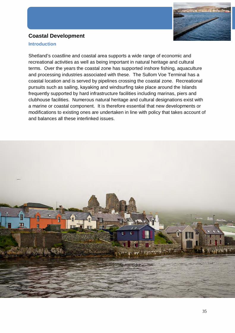
Coastal Development Introduction Shetland’s coastline and coastal area supports a wide range of economic and recreational activities as well as being important in natural heritage and cultural terms. Over the years the coastal zone has supported inshore fishing, aquaculture and processing industries associated with these. The Sullom Voe Terminal has a coastal location and is served by pipelines crossing the coastal zone. Recreational pursuits such as sailing, kayaking and windsurfing take place around the Islands frequently supported by hard infrastructure facilities including marinas, piers and clubhouse facilities. Numerous natural heritage and cultural designations exist with a marine or coastal component. It is therefore essential that new developments or modifications to existing ones are undertaken in line with policy that takes account of and balances all these interlinked issues.

36
CST1 Coastal Development Proposals for developments and infrastructure in the coastal zone (above Mean Low Water Mark of Ordinary Spring Tides) will only be permitted where the proposal can demonstrate that:
• It will not have a significant impact, either individually or cumulatively, on the natural, built environment and cultural heritage resources either in the sea or on land;
• The location, scale and design are such that it will not have a significant
adverse impact.
• It does not result in any deterioration in ecological status or potential for any water body or prevent it from achieving good ecological status in the future;
• There is no significant adverse impact on other users of marine resources, and/
or neighbouring land. Proposals for marine aquaculture developments or amendments to existing fish farm developments will require to have regard to the foregoing criteria and will be assessed against the Supplementary Guidance Policy for Aquaculture. All proposals will be assessed against the Shetland Islands Marine Spatial Plan that sets out a spatial strategy and policy framework to guide marine developments in the coastal waters around Shetland. The Marine Spatial Plan identifies the constraints developers are required to consider when contemplating development in the coastal area and will form supplementary guidance to this plan.
Justification
Any proposal for development in the coastal area has to consider a wide range of marine activity and resource use many of which have an economic, environmental and social impact both in the sea and on neighbouring land. Activities will include marine renewables and other forms of energy extraction, marine infrastructure, aquaculture, maritime activities and recreation. Planning control for aquaculture extends to both the freshwater and marine environments. Finfish and shellfish farming are very significant components of the

37
local economy and SPP requires planning authorities to support the sustainable economic development of new and modified farms in appropriate locations. There is also a need to ensure that potential adverse effects on the environment are minimised and potential conflicts with other users of the marine or freshwater resource are minimised. To this end development proposals will be assessed in line with the Council’s Policy for Aquaculture that forms Supplementary Guidance to the Development Plan. Whilst local authority planning control in the coastal area from Mean Low Water Springs to the limit of territorial waters extends to aquaculture only, the council must take account of all activities around Shetland’s coast. The council has a duty of development control and safe navigation in respect of marine development placed upon it by the Zetland County Council Act 1974. Under these powers the council intends that the criteria set out in the first paragraph of Policy CST1 will apply to developments and infrastructure below high water mark out to 12 nautical miles. For all other new marine developments or variations to existing marine infrastructure, proposals will be assessed against the Council’s Works Licence Policy that details the policy framework for determination of applications.

38
Housing Introduction There will continue to be a demand for more homes in Shetland throughout the life of this Plan regardless of whether the population increases or declines, not least because the household size is continuing to fall. Scottish Planning Policy (SPP) requires the Local Development Plan to enable the development of well designed, energy efficient, good quality housing with mixed communities in sustainable locations and to allocate a generous supply of land to meet the housing requirements identified across all tenures. The Shetland Housing Need and Demand Assessment (HNDA) completed in September 2010, provides the evidence of affordable housing need in Shetland and has been used to inform the Plan. H1 Effective Land Supply Through the provision of Allocations and Sites with Development Potential the Council will seek to identify an effective land supply to meet the housing needs of Shetland for the lifetime of this Plan and beyond. If Planning Permission is granted on Allocated Sites or Sites with Development Potential and development has commenced for a use or layout not in accordance with the allocation description in the Plan the remainder of the site will be re-assessed and may be withdrawn. Justification
Allocating a generous supply of land for housing in the Local Development Plan will give the flexibility necessary for the continued delivery of new housing even if unpredicted changes to the effective land supply occur during the life of the Plan. Having a variety of sites ensures that there is a range and choice of locations for residential development allocated throughout Shetland. This ensures that the requirements of the HNDA and the LHS are met.

39
H2 Areas of Best Fit This plan identifies 8 areas of Best Fit throughout Shetland in order to promote sustainable locations for residential or residentially compatible Development in every locality. The 8 Areas of Best Fit identified on proposals map are: Baltasound Mid Yell Symbister Brae Aith Scalloway Lerwick Sandwick Major Developments (developments in excess of 50 units or 2 hectares - as defined in the Town and Country Planning (Hierarchy of Developments) (Scotland) Regulations 2009, Reg 2 (1) and as included in the Schedule) should only occur within Areas of Best Fit unless the applicant can provide evidence of demand in an alternative area or that no land is available for development within the best fit area.
Justification
Areas of Best Fit (AoBF) have been identified to provide a focus for growth within and adjacent to the largest community in each of the seven localities in Shetland. In the North Isles, Areas of Best Fit have been identified at both Baltasound and Mid Yell; this means there are eight Areas of Best Fit. Within Areas of Best Fit amenities such as schools, shops, employment and essential infrastructure are readily available through a range of transport options. All areas identified as Areas of Best Fit;
• Can connect to the main sewer • Are within 800 m (walking distance) of two of the following; convenience store/
post office (only one in any count), GP surgery, primary school, public hall, play park
• No part of any of the Shetland Mainland AoBF is more than 400 metres from a public bus service (either feeder buses or primary routes)
• No part of any AoBF is below the 5m contour or shown on the SEPA flood maps.

40
• Low likelihood of having significant impacts on biodiversity including European or locally designated nature conservation sites
The desk study information has been refined following site visits to confirm the boundaries, considering topography and existing settlement pattern. H3 All Housing Development New residential development should take place in Allocated Sites, Sites with Development Potential, Areas of Best Fit, on Brownfield Land or on Undeveloped Land within existing settlements in that order of desirability. Isolated residential development in the open countryside will not be supported. Justification
By establishing this order of developed priorities, the Plan aims to create vibrant and sustainable communities throughout Shetland to make the best use of existing investment and infrastructure, and to avoid the ineffectual scattering of scarce resources. Isolated residential development in the open countryside is not sustainable as it does not strengthen or enhance existing communities and creates an excessive burden on services and the public purse. H4 Affordable Housing The Council will work in partnership with private developers, other housing organisations and agencies to ensure the provision of affordable and social rented housing to meet need throughout Shetland. New housing developments should provide for the needs of those seeking housing in the area.
Justification
Affordable housing is broadly defined as housing of reasonable quality that is affordable to people on modest incomes. It is the responsibility of this Plan to identify sufficient land for the building of affordable housing to meet the needs identified within the HNDA and the LHS. Enabling the provision of affordable housing has the potential to remove barriers to employment, supporting sustainable economic growth, and to reduce homelessness.

41
H5 Siting and Design Development will be supported if it fits well into the surrounding landscape and settlement pattern. For example, where the settlement pattern dictates, dwellings should be sited within or adjoining a group of at least two or more buildings of domestic scale. The proposed dwellings should not result in linear development that would cause a road safety problem that may require remedial works or would sterilise future development opportunities. All new residential development should meet the requirements of the residential Design Policy as set out in forthcoming Supplementary Guidance.
Justification
The delivery of housing does not rely solely on the allocation of appropriate land in this Plan. Planning applications will be supported if they contribute to the sustainability, vitality and viability of existing settlements and the protection and enhancement of the landscape, natural, built and cultural heritage, biodiversity and the wider environment, including consideration of flood risk. H6 Amenity Space in Housing Developments All new residential development should provide an appropriate amount of private amenity space. New residential development proposals of 20 dwellings or more should incorporate a minimum of 0.12 acres (0.05ha.) of informal communal space. Developments that result in a significant loss of outdoor privacy of existing residents will not be permitted. In making provision for open space in developments opportunities should, where appropriate, be taken to landscape areas in order to promote and enhance local biodiversity and encourage active lifestyles, recognising the health benefits of both.
Justification
All housing developments require the provision of some open garden space to locate washing lines, refuse bins, storage for bicycles, etc and for occupants to have the opportunity to enjoy and benefit from outdoor space close to their home.

42
The provision of community space or amenity areas is important in residential developments as it provides a formal outdoor space for the residents’ enjoyment. Examples include: allotments, seating areas, children’s play areas and planted areas. Such spaces are particularly important in high-density developments where private gardens are limited. H7 Residential Caravans and other Temporary Residential Structures Applications for the siting of residential caravans and other temporary structures for residential purposes, or proposals for the blocking-in of existing structures, will be subject to the same criteria and policies that apply to applications for new dwellings. Proposals for residential caravans will be granted temporary planning permission only; site restoration conditions will be applied.
Justification
Residential caravans are residential units and will be treated in the same way as applications for new dwellings. The climate in Shetland is harsh and temporary structures have a limited useful life. Granting permission for a limited period with restoration conditions will ensure that units are removed and sites restored before they can become derelict. H8 Uninhabited Islands The Council will not support the re-population of, or the creation of new dwellings on, uninhabited islands.
Justification
The Council’s strategy encourages development on the presently inhabited islands, spending considerable sums of money on services supporting these communities. The Council will not support the re-population of any of the other 80 or so uninhabited islands throughout Shetland because it is contrary to the Plan’s vision and spatial strategy; and also the general policies set out in GP1-3. Planning applications for the creation of new dwellings on uninhabited islands will be refused.

43
Economic Development Introduction The Local Development Plan has a key role to play in maintaining the number of economically active people throughout Shetland by supporting the development of business and industry. Generating and promoting new jobs in existing communities embraces the principles of sustainability, reducing the need to travel and maintaining the viability of local services and infrastructure. This section draws together policies that support sustainable economic growth across Shetland strengthening established industries and providing opportunities for emerging industries. ED1 Support for Business and Industry The Council encourages the creation of sustainable economic development opportunities and business developments in accordance with General Policies (GP1, GP2, and GP3). Areas for business and industrial uses have been identified through the Plan process and are contained within Supplementary Guidance – Business and Industry. Residentially compatible development will be encouraged within settlements throughout Shetland in order to contribute to the development of strong, healthy, vibrant and sustainable rural communities.
Justification
The Plan has a key role to play in facilitating opportunities for sustainable economic growth in order to contribute to robust, thriving and diverse communities. By promoting and encouraging development opportunities, whilst protecting and enhancing Shetland’s unique natural and historic environment the need and desire for sustainable economic development across Shetland is supported. Scottish Planning Policy highlights the importance of sustainable economic growth and diverse economies in rural areas.

44
ED2 Commercial and Business Developments The Council will support proposals for retail and commercial and business developments that promote employment opportunities, community benefits, rural diversification and tourism related ventures and contribute to the viability of existing settlements where they comply with General Policies (GP1, GP2, and GP3) and do not conflict with residential amenity.
Justification
Throughout Shetland commercial and business developments, including rural shops and post offices, play a crucial role in maintaining existing settlements and facilitating them to thrive as viable communities. In supporting rural enterprises the Plan seeks to strengthen rural communities by enabling rural businesses to flourish. By providing accessible services to all this will help to diversify and sustain the rural economy, and retain the rural population, ED3 Lerwick Town Centre The Council supports the ongoing regeneration and development of the Lerwick town centre to ensure the future vibrancy, vitality and sustainability of the area. Supplementary Guidance – Lerwick Town Centre outlines priorities for the town centre and provides detailed guidance on town centre developments.
Justification
Lerwick town centre lies within a Conservation Area and provides an important function as a cultural and administrative centre for Shetland. Therefore it is essential that the town centre is maintained, promoted as a centre for tourism and developed to meet the needs of the community today and into the future. In line with Scottish Planning Policy actions that encourage improvements and strengthen the distinctive quality of the Lerwick town centre will be supported.

45
Transport Introduction The development of an efficient and integrated transport system is essential to meet the long-term social and economic needs of Shetland. Shetland’s transport system relies heavily on the private car for the movement of people. Commerce and industry are also dependent on the transportation of goods by road. The existing settlement pattern is characterised by numerous scattered communities, this makes access to key services such as education, health care and employment difficult to achieve locally. The Plan’s policies for transport support the protection, retention and improvement of the transport infrastructure including public transport by land, air and sea and by other alternatives to the use of private transport. The creation of new footpaths and cycle ways in and around settlements, particularly the promotion of safe access between residential areas, public transport and community facilities will help to build sustainable, healthy communities. TRANS1 Integrated Transport The relationship between transport and land use strongly influences the pattern of development. The Shetland Local Development Plan and the Shetland Transport Strategy prepared by ZetTrans, Shetland’s Regional Transport Partnership in association with external agencies, operators and providers should integrate different modes of transport to support sustainable economic growth and improve access to jobs and training, improve social inclusion and well-being and develop healthy communities. The Council will support proposals that;
1. sustain and develop the economy of Shetland through maintaining an appropriate level of accessibility by road, sea and air;
2. support the provision and improvement of public transport services and
information across Shetland in accordance with the approved spatial strategy;
3. reduce the need to travel through decentralisation of development opportunities, thereby reducing commuting;
4. promote awareness of travel options in order to limit traffic growth;

46
5. develop public transport corridors and promote innovative and flexible public transport usage;
6. develop facilities for walking and cycling as an alternative and healthy means
of transport;
7. support an improved path network within and between settlements;
8. improve the human environment by promoting road design that meets the policy framework set out in Designing Streets and the six qualities of successful places as set out in Designing Places ;
9. undertake selected road improvement, bridge or tunnel building or
reconstruction projects where these can be justified by gains in terms of; long-term funding, economic growth, safety, environment, accessibility, inclusion and integration;
10. improve and enhance access to Lerwick town centre and other existing
settlements by all forms of transport;
Justification
The development of an efficient and integrated transport system is essential to meet the long-term social, economic and environmental needs of Shetland. Transport is vital to enabling access to jobs and training, services and other opportunities, such as sport, leisure and community groups. The development of successful places depends on connectivity; the relationship between movement and land use is a key factor. The creation of new and the protection of existing footpaths, Core Paths and other routes in and around settlements are essential for providing safe access between residential areas, community facilities and public transport routes and assist in ensuring Shetland’s communities are healthy, by promoting physical activity. Further guidance regarding Core Paths will be contained in the forthcoming Supplementary Guidance – Open Space
47
TRANS2 Inter-Island Links The Council is committed to supporting and safeguarding Shetland’s air services, ferry services and associated infrastructure. Development proposals that prejudice the present or future operation of transport routes including fixed link approach routes and services will not be permitted.
Justification
It is important to ensure the scope for expansion of travel facilities and to consider the effect of proposed development on the present and future operation of the inter-island transport network. Air and ferry services require associated operational land and safe approach routes. The possibility of future expansion of air and ferry services or the installation of related new facilities must be borne in mind when considering developments in the surrounding areas. Consultation areas around ferry terminals are shown on the locality maps. Applications for planning permission within these areas will be considered on their own merit in the light of proposals for terminal improvement and expansion. Developments that could prejudice a transport route, and access to it, or its operation will not be permitted. Health and Safety Executive, and Civil Aviation Authority exclusion and safeguarding zones already restrict development at many of Shetland’s piers and airports. Consideration is being given to the replacement of one or more of the ferry services with fixed links. Until such time as the fixed links may be constructed, the Shetland Islands Council inter island ferry service will continue to be seen as the main lifeline link to the isles. Land reserved for the potential development of a fixed link between Lerwick and Bressay is shown on the Lerwick locality Proposals Map.
TRANS3 Access and Parking Standards All developments should provide:
• A safe and adequate access, visibility splay and turning area in accordance with the standards set out in Supplementary Guidance – Residential Access
• Adequate car parking and service facilities in accordance with the
Council’s current standards, which are set out in Supplementary Guidance – Parking Standards.

48
Justification
Safe access, appropriate and adequate vehicular circulation and parking are essential for good development and the creation of safe and successful places. Details of standards and requirements for access, circulation and vehicle parking are contained in Supplementary Guidance – Parking Standards and Residential Access.

49
Renewable Energy Introduction In response to the Climate Change (Scotland) Act 2009 the Scottish Government has set targets of generating 30% of all Scottish energy needs including 11% of heat demand to be met by renewable sources by 2020. The success of renewable energy developments is a key mechanism for delivering the ongoing efforts for climate change mitigation and the move towards a low carbon society. Shetland is well placed to make a positive contribution to these national targets through the development of the outstanding renewable resource available such as wind, wave and tidal. The Council is committed to harnessing the benefits from renewable energy for the good of the community at large. This Plan has a key role in supporting development of the diverse range of renewable energy technologies in order to maximise the associated social and economic opportunities whilst protecting the environment. Appropriately targeted renewable energy development has the potential to reduce Shetland’s reliance on fossil fuels, thus offering protection against rising oil and gas prices. RE1 Renewable Energy The Council is committed to delivering renewable energy developments that contribute to the sustainable development of Shetland. Proposals for renewable energy developments will be supported where it can be demonstrated that there are no unacceptable impacts on people (benefits and disbenefits for communities and tourism and recreation interests) the natural and water environment, landscape, historic environment and the built environment and cultural heritage of Shetland. All proposals for renewable energy developments will be assessed with consideration of their cumulative impacts. Further detailed guidance on renewable developments is provided in Supplementary Guidance - Onshore Wind Energy which will contain the spatial framework for large scale wind energy developments of 20MW and above generating capacity. Justification
Renewable energy comes from natural sources that are constantly and sustainably replenished such as sunlight, wind, rain, tides, wave and biomass; it also includes energy from waste. This policy and related guidance supports and facilitates the alternative generation of energy whilst safeguarding Shetland’s unique natural and historic environment.

50
Renewable energy developments can provide a sustainable opportunity for diversification within the Shetland economy. There is potential for communities and small businesses to invest in ownership of renewable energy projects or develop their own projects for the benefit of local communities. The Scottish Government’s targets are to reduce emissions by 42% by 2020 and by 80% by 2050 through the Climate Change (Scotland) Act 2009. Development Plans have a duty to contribute to sustainable development and encourage zero and low carbon developments. Shetland demonstrates a number of strengths that support the development of renewable technologies and the Plan seeks to support these opportunities ensuring that Shetland’s renewable energy potential is optimised. Supplementary Guidance identifies broad areas of search illustrating areas where there are no known significant constraints to large scale windfarm developments. It will also give detailed guidance on renewable energy.

51
Minerals Introduction Minerals are an important national resource and they make an essential contribution to Shetland's prosperity by meeting industry's need for raw materials and creating employment opportunities. Whilst it is acknowledged that minerals can only be worked where they are found, it is also recognised that this need must be reconciled with care for the environment, particularly in relation to the natural and built heritage and communities. M1 Minerals Policy The Council is keen to encourage diverse employment opportunities throughout Shetland and encourage sustainability. Mineral and aggregate reserves have the potential to provide employment and locally sourced materials for construction, in addition to supplying export markets. The Council should seek to safeguard aggregate sources and mineral deposits, to ensure where possible, Shetland’s need is met using local resources. Commercial extraction will be allowed in suitable locations in accordance with Supplementary Guidance – Minerals. Justification
An adequate and steady supply of minerals is essential to support sustainable economic growth. The minerals industry provides raw material for construction, manufacturing, agriculture and other sectors. Continuity of supply to meet demand depends on the availability of land with workable deposits having planning permission for extraction. Detailed policies relating to the safeguarding and extraction of Shetlands aggregate sources and mineral deposits will be detailed in Supplementary Guidance – Minerals.

52
Waste Introduction Scottish Government has adopted Zero Waste as a goal. This means eliminating the unnecessary use of raw materials, sustainable design, resource efficiency and waste prevention, reusing products wherever possible, and recovering value from products when they reach the end of their lives either through recycling, composting or energy recovery, in accordance with the waste hierarchy. Within Shetland there are sufficient large scale facilities to deal with waste arising over the lifetime of the Plan; however opportunities for small scale additional recycling may exist. Proposals for new landfill sites will not be supported as there is currently sufficient provision. W1 Waste Hierarchy The Council will support proposals for waste management facilities that fulfil the requirements of national and local waste strategies, or plans, and take account of the waste hierarchy recognising the difficulties of remote geographical localities, transportation costs and the impact this has on the potential to recycle low-value materials. Justification
The Scottish Government has adopted Zero Waste as its goal. This means eliminating the unnecessary use of raw materials, sustainable design, resource efficiency and waste prevention, reusing products wherever possible, and recovering value from products when they reach the end of their lives either through recycling, composting or energy recovery, in accordance with the waste hierarchy. Additionally, waste should be dealt with as close as possible to where it is produced. W2 Waste Management Facilities Waste management activities and waste related industries, including those dealing with special waste or Naturally Occurring Radioactive Material (NORM) waste, will be encouraged to locate in the area around Greenhead, Rova Head and Dales Voe. Applications will also be supported in other areas indentified for industrial or storage and distribution uses. Proposals for new or extended waste management sites outwith these allocations will be supported where it is clearly demonstrated that there is no acceptable allocated alternative sites or preferable disposal options available. Existing waste management sites will be safeguarded from development that would sterilise or prevent their future development or extension.

53
Justification
Modern waste management infrastructure is designed and regulated to high standards and is similar to other industrial processes. At present, Shetland exports some special waste for treatment and disposal on the British mainland. Waste that is not appropriate to be pre-treated in Shetland may have to be sent to specialised facilities on the British mainland. Proposals for special waste sites will be judged in accordance with the Shetland Waste Plan and Scotland’s Zero Waste Plan. In exceptional circumstances, such as an industrial or shipping accident or the spread of disease in livestock, it may be necessary to set up special facilities for waste treatment and disposal outside the notified areas. Information on the location of existing waste management sites is available from SEPA's website at www.sepa.org.uk Shetland’s proximity to, and links with, the oil and gas industry place it in an ideal position to service its waste disposal requirements. North Sea oil-decommissioning has the potential to generate important employment opportunities in Shetland. The decommissioning industry has a need for the disposal of certain low-level radioactive wastes that do not have any resource value; NORM will need to be disposed of at appropriate waste management sites. W3 Closed Landfill Sites Proposals for new buildings intended for either human and animal occupation on closed and disused landfill sites should not be permitted, however proposals for the re-use of landfill sites, which exploit opportunities for habitat creation, enhancement and management, should be supported. Justification
Once landfill working has ceased, the site should be restored at the earliest opportunity. After-uses that result in environmental improvement, rather than simply restoring land to its previous state, or which add to the cultural, recreational or environmental assets of an area are encouraged. Restoration should be designed and implemented to the highest standards. W4 Contaminated Land Where development is proposed at a site known to be contaminated, or at a site where there is a reasonable expectation of contamination, the applicant will be required to undertake suitable investigation and appropriate remediation measures before the commencement of any new use

54
Justification
Under Part II A of the Environmental Protection Act 1990, the Council is required to inspect land for contamination and to prepare a Contaminated Land Strategy. Where contaminated land is identified, the Council has a duty to secure its remediation. SEPA has a duty to regulate and secure remediation of “special sites”; there are no ‘special sites’ currently within Shetland. W5 Waste Management Plans and facilities in all new developments Developers must submit an appropriate Site Waste Management Plan (SWMP), which demonstrates how the waste generated by the development during the construction phase will be dealt with, including how the materials will be reused, recycled and how any remaining waste will be disposed of, in accordance with the waste hierarchy. Adequate space must be provided for storage and collection of all waste and appropriate recycling facilities within the completed development. Justification
The planning system has a crucial role in delivering objectives and targets of the Zero Waste Plan. It ranks the different ways in which we can deal with our waste in terms of sustainability. The hierarchy identifies the prevention of waste as the highest priority, followed by reuse, recycling, recovery of other value (e.g. energy), with disposal as the least desirable option. A Site Waste Management Plan is an important way to help achieve sustainable waste management during the construction and operation of developments. It is crucial to the delivery of the Zero Waste Plan to ensure that sustainable waste management is fully considered in all new development and it is important for waste management and recycling to be “built in” to development as early as possible in order to minimise waste, ensure efficiency of collection and maximise recycling.

55
Water and Drainage Introduction The provision of sustainable drainage infrastructure is essential in maintaining and enhancing a good quality water environment in Shetland. The risk of flooding from all sources, including from sea level rise, is likely to increase with projected changes in climate. The Council is obliged, as a responsible authority under the Flood Risk Management (Scotland) Act 2009 and the Water Environment and Water Services (Scotland) Act 2003, to effectively and sustainably manage this risk. The policies within this chapter ensure the adequate provision of water supplies and drainage for surface and waste water in all new developments and to protect and enhance the quality of Shetland’s water resources and minimise the likelihood of flooding in any new development. WD1 Flooding Avoidance Proposals to build below the 5 metre contour (5 metres above Ordnance Datum, Newlyn) or in other areas shown to be at risk of flooding or coastal erosion, will not be permitted unless a suitable Flood risk assessment is provided that demonstrates the following:
• The development does not create a flood risk to existing or proposed properties and/ or surrounding land.
• Appropriate acceptable mitigation measures can be undertaken to ensure no significant adverse impact on the natural and built environment as well as cultural heritage.
If there is any doubt the precautionary principle will apply. Further policy and guidance on undertaking a Flood Risk Assessment can be found in Supplementary Guidance Flooding and Drainage.
Justification
It is widely accepted that sea levels are on the rise and that storms will become more frequent and more severe. Around Shetland a relative sea level rise between 0.4 and 0.6 metres is predicted by the end of the 21st century which may result in serious consequences for established coastal settlements. The Council will not approve new development at low ground levels near to the coast where there is a significant risk of future inundation or erosion.

56
The Planning Service has continued to administer the analysis of the reported incidents of flooding which illustrates that the most common source of flooding was historically inundation by the sea. Analysis of the reported incidents illustrates that coastal inundation is still an issue but increasingly incidents are the result of heavy rainfall. Coastal flooding events occur when an unusually high tide affects low lying property and the worst effects result when the high tide coincides with a severe weather incident. Again, climate change predictions state that such events will occur more often and become more severe. Analysis of available data including 1 in 200 year coastal flood levels, SEPA flood maps, UK climate projections and historical storm surge levels have led to the use of the 5m contour for the purpose of determining when a flood risk assessment should be required. A study undertaken in 2009, which predicts the scenario for Shetland in the future, forms important background research on which Development Plan policies relating to flooding and climate change are based. Practical application of these findings vindicates the requirement for the submission of a Flood Risk Assessment (including an additional allowance for climate change), in support of any planning application for proposed development, or in areas shown to be at risk from flooding. The results of the Flood Risk Assessment will be used to determine whether the development is acceptable on flood risk grounds. WD2 Waste Water New developments which require waste water disposal and are located within or adjacent to settlements are expected to connect to the public sewer . Where a connection to the public sewer is not achievable and a wastewater system such as a private septic tank is proposed the developer should demonstrate that:
• There should be no detrimental effect, including cumulative effect, on the surrounding uses, natural, built environment and cultural heritage.
Further policy guidance can be found in Supplementary Guidance Water and Drainage

57
Justification
The water environment has a finite capacity to receive pollutants. The provision of sustainable drainage infrastructure is essential in protecting, maintaining and improving the water environment. This policy seeks to protect watercourses and water bodies by limiting the potential adverse impacts of foul drainage. WD3 SuDs All development proposals that will give rise to surface water run-off should incorporate Sustainable Drainage Systems (SuDS). Further policy and guidance on the design and implementation of SuDS can be found in Supplementary Guidance Water and Drainage. Justification
The aim of SuDS is to attenuate the flow of surface water off the development site as well as provide treatment to minimise the pollutants reaching existing waterbodies, thereby protecting, maintaining or enhancing the water environment. SuDS are a sequence of water management practices and facilities designed to drain surface water in a manner that will provide a more sustainable approach to surface water management than the conventional practice of routing run-off through a pipe to a watercourse.

58
Community Facilities Introduction The Plan policies ensure as far as possible that all forms of community facilities, including health and social care, education and recreation opportunities, are available and accessible to Shetland’s entire population. Despite its relatively isolated position and low population, the community facilities and services provided in Shetland are extremely good. However, the traditional pattern of dispersed housing makes their provision and maintenance challenging. The Plan strategy supports these facilities by encouraging development within AoBF and in existing settlements where community facilities already exist. The Plan’s policies also seek to ensure that new development can achieve environmental and community benefits by improving access, safeguarding public health, assisting nature conservation, helping to regenerate the built heritage and conserving and enhancing the Shetland landscape. CF 1 Community Facilities and Services (incl. Education) The Council encourages proposals for the provision of community facilities, services and infrastructure that respect Shetland’s culture and natural and historic environment. Proposals should relate sympathetically to the landscape of which they are a part, and to the scale and existing level of activity in the locality. Justification
Shetland is well provided with community facilities and services. The Plan encourages development within existing settlements and provides the land use framework to maintain sufficient numbers of people, particularly in rural areas, so as to sustain local facilities and services, and build strong communities. However, it is important to ensure that the unique and irreplaceable qualities of Shetland’s landscape, settled areas and the amenities of local residents are protected from inappropriate development.
New uses that encourage rural diversification, provide employment or community benefits will be supported, particularly where they involve the imaginative and sensitive re-use of the land and buildings.
Land reserved at the Lower Staney Hill, for educational purposes in the Shetland Local Plan (2004) has been retained and is indicated on the Proposals Map. If the new High School is built at this site consideration will be given to the redevelopment options for the existing Anderson High School site at the Knab (site ref: LK 015).

59
The burial ground at the Knab, Lerwick, is estimated to have less than twenty years remaining. At the next Shetland Local Development Plan Review, suitable sites for a Lerwick Burial Ground will be investigated.
Many agencies are involved in the provision of services and facilities and it is very important that the Council works in partnership with the strategies and plans of other public agencies and the voluntary sector. The Community Plan is one of the main public documents that ties together the plans and aspirations of providers and users.
CF 2 Open Space Development that will improve or add to the current levels of open space will be supported. Development proposals that adversely impact on established recreation areas identified in the Open Space Audit and Strategy, and other important open spaces that contribute to the recreational amenity or environmental quality of an area will not be supported. Compensatory provision made elsewhere within the community area of at least equal size and quality that contributes positively to settlement character and sense of community will be considered. Details of the identified open spaces will be included in the forthcoming Supplementary Guidance – Open Space.
Justification
Access to good quality open spaces and opportunities for sport, recreation and reflection makes an important contribution to the health and wellbeing of everyone. Good quality open spaces are important for the contribution they make to amenity and their role in nature conservation, biodiversity, recreation and physical activity. Open green space can also have other benefits such as mitigating the effects of flooding in built up areas. There is a general presumption against the development of designated open space, unless there is evidence within the Council’s Open Space Audit that development will not result in a deficit of that type of space in the local area and that alternative locations for development have been considered. The poor condition of an area of open space due to inadequate maintenance or neglect is not justification for redevelopment nor can it be assumed that areas of unmaintained open space will remain unmaintained if acceptable re-development proposals are submitted. If planning permission is granted within an area designated as open space, replacement space should be provided of an appropriate type, quantity, accessibility and quality. New development should include measures to improve access to

60
existing areas of open space. Consideration should be given to linking these areas with core paths.

61
Appendices • Schedule of Land Owned by the Shetland Islands Council • Glossary • List of Supplementary Guidance • Sites With Development Potential • Areas of Best Fit Maps • Designated Sites Maps • Proposals Maps

62
Schedule of Land Owned by Shetland Islands Council Section 15 (3) of the Planning etc. (Scotland) Act 2006 requires that the Plan contains a Schedule of Land in the ownership of Shetland Islands Council that is affected by site specific policies and proposals for development in the Plan.
Description of land owned by Shetland Islands Council
Current Use Proposed Use
Local Development Plan Reference
New Use
Veensgarth, Tingwall
Grazing Housing CL004 Proposed Development Sites
Kirkadale, Walls Grazing Housing WM004 Proposed Development Sites
Scatsta Mixed Employment NM004 Proposed Development Sites
Sella Ness Mixed Employment NM005 Proposed Development Sites
Firth Grazing Housing NM006 Proposed Development Sites
Upper Lea, Firth Vacant Housing NM007 Proposed Development Site
Firth Camp Allotments Allotments NM008 Proposed Development Site
Maidenfield, Mossbank
Grazing Housing NM009 Proposed Development Site
Braehead, Mossbank
Grazing Housing NM010 Proposed Development Site
Bankhead, Mossbank
Grazing Housing NM011 Proposed Development Site
Hall, Mossbank Grazing Housing NM012 Proposed Development Site
Oxlee, Lerwick Grazing Housing LK008 Proposed Development Site
Ness of Sound, Lerwick
Grazing Mixed 031p Proposed Development Site
Lower Sound, Lerwick
Vacant Housing LK009 Proposed Development Site
Seafield, Lerwick Playing Field Mixed LK010 Proposed Development Site
Staney Hill, Lerwick Mixed Industrial LK011 Proposed Development Site
Staney Hill, Lerwick Housing Development
Housing LK012 Proposed Development Site (Crossover with 042a and 042b)
2010/209/PCD To remove 32 no existing chalets, redevelopment of ex chalet

63
sites and adjacent site to provide 76 no housing units
Norstane, Lerwick Vacant Housing LK013 Proposed Development Site
Gremista Industrial Estate, Lerwick
Education Employment LK014 Proposed Development Site (Crossover with LK018)
Anderson High School, Lerwick
Education Mixed LK015 Proposed Development Site
Horseshoe Close, Virkie, Dunrossness
Vacant Housing SM009 Proposed Development Site
Loch of Haggrista, Sullom
Quarry Quarry NM013 Proposed Development Site
Hillside, Voe Common Grazing
Housing NM016 Proposed Development Site
Valladale, Urafirth Common Grazing
Housing NM019 Proposed Development Site
Sella Ness, Scasta Employment Industrial NM020 Proposed Development Site
Stucca, Hillswick Common Grazing
Housing NM017 Proposed Development Site
Stucca, Hillswick Common Grazing
Housing NM018 Proposed Development Site
Aith Area of Best Fit
Areas of Best Fit
Sandwick Area of Best Fit
Areas of Best Fit
Symbister Area of Best Fit
Areas of Best Fit
Brae Area of Best Fit
Areas of Best Fit
Mid Yell Area of Best Fit
Areas of Best Fit
Baltasound Area of Best Fit
Areas of Best Fit
Scalloway Area of Best Fit
Areas of Best Fit
Lerwick Area of Best Fit
Areas of Best Fit

64
Glossary Action Programme: A working document, which sets out, in very broad terms, how and by whom the key elements of the Local Development Plan strategy will be implemented.
Active Travel: An approach to travel and transport that focuses on physical activity (walking and cycling) as opposed to motorised and carbon-dependent means.
Affordable Housing: Broadly defined as housing of a reasonable quality that is affordable to people on modest incomes. Low cost market and subsidised housing (irrespective of tenure, ownership - whether exclusive or shared - or financial arrangements) that will be available to people who cannot afford to rent or buy houses generally available on the open market.
Aims: Targets the Plan wants to help achieve.
Allocation: Land identified in the Plan as appropriate for a specific use or mix of uses.
Amenity: The physical and social features of settlements and countryside that contribute to creating a comfortable and desirable living environment.
Ancient monument: A monument or site of archaeological importance which is in the guardianship of the Scottish Ministers.
Appropriate Assessment: is one part of the Habitats Regulations Appraisal process. An appropriate assessment is required where the plan-making body determines that the plan is likely to have a significant effect on a Natura 2000 site and is likely to have a significant effect on the site (either alone or in combination with other plans or projects).
Bad Neighbour Development: Development that has a harmful impact on the surrounding area such as waste disposal, scrap yard, mineral extraction. The definition is set out in Schedule 3 of The Town and Country Planning (Development Management Procedure) (Scotland) Regulations 2008.
Biodiversity: Biodiversity is the total variety of life on earth. It includes every living species of plant and animal, and also includes the genes that make them what they are and the communities that they form. It is not restricted to the rare or threatened species, but includes the whole of the natural world from the commonplace to the critically endangered.
Biological Records Centre: The core element of the Shetland Biological Records Centre (SBRC) is a comprehensive database containing up-to-date information about Shetland’s wildlife. The information is available to everyone.

65
Brownfield Sites: These are sites that have previously been developed or used for some purpose which has ceased. It excludes private and public gardens, sports and recreation grounds, woodlands and amenity open spaces.
Built Environment: All man-made built structures including built and archaeological remains from all periods whether technically built or not (e.g. middens, etc.).
Character: A combination of features that distinguish an area. These include architectural styles, main uses, landscape type, etc. A proposal would be ‘out of character’ if it would introduce features not in keeping with those that make up an area’s existing character.
Circulars: Statements of Government policy containing guidance on policy implementation through legislative or procedural change.
Climate Change: The long-term change in the statistical distribution of weather patterns over periods ranging from decades to millions of years. It may be a change in average weather conditions or the distribution of events round that average (e.g.: more or fewer extreme weather events).
Coastal Zone: The coastal zone is defined as Mean High Water Springs out to 12 nautical miles.
Community Facility: A service or facility, which support or enhance a community. It can be public or private.
Community Planning: The process by which the Council brings together other key agencies and organisations to form a strategy to provide for the future well-being of the community they serve. The Community Plan builds on a vision for the future of the area and how the public agencies will work in partnership to achieve the vision.
Commuted Sum: One-off payment made by developers to the Council instead of providing facilities or a service, and which takes away responsibility to make such provision.
Conservation Area: An area designated under the Town and Country Planning (Scotland) Act 1997 as being of special architectural or historic interest.
Contaminated Land: Land that has been polluted by, for example, former heavy industrial uses or waste tips.
Core Paths Network: The Land Reform (Scotland) Act 2003 requires local authorities to prepare a plan for a system of “core paths” to give people reasonable access throughout their area. Section 17 of the Act provides the definition of what a system of core paths may include.

66
Culvert: A conduit used to enclose a flowing body of water. For example, it may be used to allow water to pass underneath a road.
Cumulative Impact: Relates to potential changes by a proposed development in conjunction with any other developments (not just similar developments) or as the combined effect of a set of developments, taken together. This includes proposals that have been permitted as well as those that have been submitted and are waiting to be determined. It can relate to landscape and visual effects as well as a wider range of social, economic and environmental effects.
Departure (from the Plan): A planning application considered not being in accordance with a Plan but which due to exceptional circumstances, the planning authority intends to approve. Significant departures must be notified to Scottish Ministers.
Derelict Land: There is no statutory definition of derelict land, but it is defined administratively as "land so damaged by industrial or other development that it is incapable of beneficial use without treatment".
Design Statement: Used to explain the design principles on which the development is based and to illustrate the design solution.
Designated Sites: These are sites that are designated for their value for nature conservation or their landscape value.
Developer Contributions: Payments made to the Council or another agency, or alternatively, work in kind, to help improve the infrastructure (e.g. roads, open space, waste-water treatment, restoring worked-out mineral sites) so that the development can go ahead.
Development Brief: A detailed document for an area allocated for development in a plan. The brief provides information to possible developers on issues such as the preferred siting, design and layout of buildings, and the need for associated infrastructure and services.
Development Management: The process for determining whether a proposed development should receive planning permission.
Development Plan: Sets out how land could be used over the next few years. By law the Council needs to produce a local development plan for Shetland. The Plan is the basis for determining planning applications.
Development Plan Scheme: The document setting out the Council’s intentions for preparing the local development plan in the next few years.

67
Effective Housing Land Supply: Identified land that is free or is expected to be free of development constraints in the plan period.
Environmental Assessment: A process by which the environmental effects of a development proposal by virtue of such factors as nature, size and location are systematically assessed, also giving consideration to alternative solutions and mitigating measures.
Energy from Waste (EfW): Energy that is recovered by thermally treating waste such as by incineration.
Existing Settlement: A settlement that has a range of neighbourhood facilities, for example, a primary school, shop, church and/or health centre.
Flood Risk: The combination of the probability of a flood and of the potential adverse consequences, associated with a flood for human health, the environment, cultural heritage and economic activity.
Flood Risk Assessment: An assessment that is carried out to predict and assess the probability of flooding for a particular site or area and any impact the proposed development might have on the area and recommends mitigation measures.
Geodiversity: is the variety of rocks, fossils, landforms, sediments and soils, together with the natural processes that shape and alter them, forming the basis for landscapes and the foundation upon which plants, animals and people live. This resource enables us to interpret past geological processes, such as continental drift, volcanism and ice ages, as well as helping us understand contemporary global change. Geodiversity also represents a valuable asset for economic development, recreation and leisure activities.
Greenfield Site: Land which has not been developed.
Habitat: The environment in which a species lives at any stage in its life cycle.
Habitat Regulations Appraisal: Article 6(3) of the EC Habitats Directive requires that any plan (or project), that is not directly connected with or necessary to the management of a European site, but would be likely to have a significant effect on such a site, either individually or in combination with other plans or projects, shall be subject to an ‘appropriate assessment’. This procedure is applied in Scotland through The Conservation (Natural Habitats, &c.) Regulations 1994 (as amended).
Historic Environment: The physical legacy of thousands of years of human activity in the form of monuments, buildings, sites and landscapes.
Historic Scotland: The body responsible for safeguarding Scotland’s built heritage.

68
Hjaltland Housing Association (HHA): A non-profit making organisation committed to meeting specific housing needs in Shetland.
Impact Assessment: A study based on expert professional opinion which gives a detailed assessment of a particular development and its impact e.g. environmental impact, retail impact, transport impact, visual impact, etc.
Incremental Impact: Impact arising from a number of developments which, individually and in themselves, may have insignificant effects but together combine to create a significant impact.
Inert Waste: Building materials and other non-toxic, non-degradable and non-leaching waste.
Infill Development: Development within a built up area, usually involving building on a gap site or between two buildings.
Infrastructure: The basic services needed to support development. These include water supply and sewerage facilities, roads, transportation, local community, shopping and other facilities.
Inventory of Gardens and Designed Landscapes: Compiled by Historic Scotland an inventory of gardens and designed landscapes of national importance.
Isolated Coast: Areas of wild or natural coastline that are characterised by the absence of occupied settlement, lack of road infrastructure, and absence of human activity on or offshore, both industrial, power, port, military or tourism related.
Key Agencies: Key agencies are bodies specified by Scottish Ministers who are under a duty to engage with planning authorities in the preparation of the development plan.
Landfill/form: Landfill being an area of land identified for the deposit of waste. Landform being the deposit of waste on or above the existing contours of the ground.
Landscape Character Assessment: An analytical technique which identifies, describes and maps areas classified according to various landscape character types. The forces of change in each type are then assessed, together with an evaluation of the capacity to accommodate change without altering its intrinsic character.
Listed Building: A building or structure that is included in the list compiled by Historic Scotland as being of special architectural or historic interest.
Local Biodiversity Action Plan (LBAP): A document for use by all kinds of organisations to help sustain biodiversity. A national Plan is produced for the whole of the UK, the local biodiversity action plan for Shetland is called the “Living Shetland Project”.
69
Local Development Plan: Important document setting out the Council’s spatial strategy, policies and proposals for development and the use of land. It forms the basis for determining planning applications.
Local Development Plan Examination: Hearing held before a Government appointed person to consider formal representations and objections to the approved Plan.
Local Housing Strategy: Documents the need and demand for housing, as well as wider housing issues, based on an assessment of housing, demographic, economic and community issues.
Local Landscape Areas (LLAs): Identified in supplementary guidance, Local Landscape Areas are to ensure sympathetic siting and design of new development to help to protect and enhance some of Shetland’s unique environment.
Local Nature Conservation Site: Non-statutory designation of sites of biodiversity and/or geodiversity importance made by local authorities. The primary purpose of LNCS is to highlight to planners and developers areas of nature conservation interest and to ensure the protection of their special features from damage by development.
Local Transport Strategy: sets the framework for transport in Shetland and guides decision making on transport issues.
Low and Zero Carbon Generating Technologies (LZCGT): include; wind turbines, water turbines, heat pumps (all varieties), solar thermal panels, photovoltaic panels, combined heat and power units (fired by low emission sources) fuel cells, biomass boilers/stoves and biogas.
Main Issues Report: The Main Issues Report is a consultation document produced as part of the Local development Plan to stimulate debate and discussion on the main planning issues facing Shetland in both the long and short term.
Marine Consultation Areas (MCAs): Areas identified by SNH (Scottish Natural Heritage) as deserving of protection by reason of the quality and sensitivity of the marine environment. MCAs have no statutory basis, however the Council consults SNH on proposals that could damage the interests of the site.
Marine Renewable Energy: the generation of electricity from wave, tidal or (offshore) wind resources, as appropriate to a location.
Masterplan: A document that explains how a site or series of sites will be developed. It will describe how the proposal will be implemented, and sets out the costs, phasing and timing of development. A masterplan is usually prepared by specialists, or on behalf of, an organisation that owns the site or controls the development process.

70
Material Considerations: Matters in addition to the Development Plan that the Council may wish to take into account when making a planning decision. Material considerations in planning must be factors relating to the use and development of land.
Major Development: As defined in Town and country Planning (Hierarchy of Development) (Scotland) Regulations 2009 Regulation 2(1) and as included in the Schedule. (e.g. The development comprises 50 or more dwellings; or (b) The area of the site is or exceeds 2 hectares).
Mitigation: Measures that are identified for the prevention, minimisation or offset of adverse effects.
Mixed Use: This refers to the practice of allowing more than one type of compatible uses on a site. This can for example mean a combination of housing, business, and community uses, or that any of these uses are suitable on the site.
Monitoring Statement: Looks at how Shetland has changed since the 2001 Structure Plan and 2004 Local Plan were issued. The Monitoring Statement and Background Paper were published alongside the Main Issues Report for the Local Development Plan in March 2010.
National Nature Reserves (NNRs): Designated under the National Parks and Access to the Countryside Act, 1949. Reserves are managed for their value for environmental education, natural heritage awareness and demonstration of best practice management.
National Planning Framework (NPF): The Scottish Government’s strategy for Scotland’s long-term spatial development.
National Scenic Areas (NSAs): Areas that are nationally important for their landscape quality. There are stricter planning controls within NSAs and planning authorities have to take care that new development does not detract from the scenic quality of the area.
Natura 2000 Network: EU wide network of nature conservation sites (SACs and SPAs) established under the EC Habitats and Birds Directives. Ramsar sites are also protected under this statutory regime.
NORM: Naturally Occurring Radioactive Material.
Notification/Safeguarding Zones: Defined areas within which a specified Government agency or department must be notified of development proposals. Examples include airports and locations where hazardous or dangerous materials are stored.

71
Objectives: Objectives are statements of specific outcomes that are to be achieved.
Open Space: Open space includes greenspace consisting of any vegetated land or structure, water or geological feature within and on the edges of settlements, including allotments, trees, woodland, paths and civic space consisting of squares, market places and other paved or hard landscaped area with a civic function.
Orkney and Shetland Area Management Plan: Supplements the River Basin Management Plan for the Scotland river basin district and focuses on local actions which will bring important benefits for drinking water, flood prevention, natural habitats and will help mitigate the effects of climate change.
Placemaking: To ensure that the most sustainable sites are used for development and that the design process, layout structure and form provide a development that is appropriate to the local context and supports a sustainable community.
Planning Advice Note (PAN): A series of Scottish Government documents on specific planning issues, providing advice on good practice and information to planning authorities.
Precautionary Principle: The principle that authorities should act cautiously to avoid damaging the environment or wellbeing of communities (in a way that cannot be reversed) in situations where the scientific evidence is not proven but the possible damage could be significant.
Proposed Plan: A stage in the preparation of the Local Development Plan. This forms the Plan that a planning authority would wish to adopt and will seek representations upon.
Ramsar Sites: wetland areas of high ecological value. Designated under the Convention on Wetlands of International Importance.
Residentially Compatible Development: Activities and uses that can take place in a residential area without detriment to the amenity of the area or its residents.
Retail Impact Assessment: A study that assesses the likely effect a new development will have on existing shops.
River Basin Management Plan: A requirement of the Water Framework Directive that has led to the preparation of River Basin Management Plans that promote sustainable water use in a way which protects and improves the water environment.
Scheduled Ancient Monument: A monument or site of archaeological importance that has been scheduled for protection by Historic Scotland under the terms of the Ancient Monuments and Archaeological Areas Act 1979. Special consent from
72
Historic Scotland is required for any form of works affecting the monument, in addition to any planning permission required.
Scottish Environment Protection Agency (SEPA): Scotland’s environmental regulator, responsible for the protection and improve the environment.
Scottish Natural Heritage (SNH): A government funded body responsible to Scottish Ministers whose task is to secure the conservation and enhancement of Scotland’s natural heritage, so that it can be sustained for future generations.
Scottish Planning Policy: Scottish Government planning policy on land use.
Scottish Water: The public body responsible for the provision of clean water and the management of wastewater.
Section 75 Agreements: Legal agreement made under Section 75 of the Town and Country Planning (Scotland) Act 1997, to regulate the future use of land.
Single Outcome Agreement (SOA): The purpose of the SOA is to identify areas for improvement and to deliver better outcomes for the people of Shetland, through specific commitments made by the Council, its community planning partners and the Scottish Government.
Sites of Special Scientific Interest (SSSIs): areas of special interest by reason of their flora, fauna, geological or physiographical features. Notified under the Wildlife and Countryside Act, 1981.
Soil Resource: a biologically active mixture of weathered minerals, organic and inorganic compounds, living organisms, air and water, which provides the foundation for life in terrestrial ecosystems.
Special Areas of Conservation (SACs): areas identified as supporting rare, endangered and vulnerable habitats or species. Designated under European Directive 92/43/EEC on the Conservation of Natural Habitats and of Wild Flora and Fauna (the ‘Habitats Directive’). Together with SPAs they form the Natura 2000 network of protected sites across the European Community.
Special Needs Housing: Housing for particular groups of the population designed or adapted to meet their needs and/or has additional management support.
Special Protection Areas (SPAs): important habitats for rare, threatened or migratory birds. Classified under European Directive 79/409/EEC on the Conservation of Wild Birds, (the ‘Birds Directive’).
Strategic Environmental Assessment: An assessment of the environmental impacts of any plan, programme or strategy of any public body in Scotland as required by the Environmental Assessment (Scotland) Act 2005 which transposes

73
the Strategic Environmental Assessment Directive (Directive 2001/42/EC on the assessment of the effect of certain plans and programmes on the environment).
Supplementary Guidance: A document that gives further detail on policies and proposals within the Plan and has the same statutory basis as the Plan itself once adopted.
Structure Plan: Is part of the previous Development Plan setting out the strategic land-use policy framework for Shetland. It consists of a Written statement, a Key Diagram and a Report of Survey.
Sustainable Development: This means enabling development that meets today’s needs without compromising the ability of future generations to meet their own needs. In other words, it means promoting better quality of life and better quality environments for ourselves and for our children and grandchildren. Sustainable development is a key aim of Shetland Islands Council and the UK Government.
Sustainable Drainage Systems (SuDS): Drainage techniques used to treat and return surface water run-off from developments (roof water, road run-off, hard standing areas) to the water environment (rivers, burns, groundwater, lochs) without adverse impact upon people or the environment. Further guidance can be found in CIRIA’s SuDS Manual C697 or Sewers for Scotland 2nd Edition. SUDS are specifically designed to reduce flooding by attenuating the water flow, to allow for sedimentation, filtration and biodegradation and to fit into their environmental setting.
Tenure Mix: A mix of different types of housing: affordable, rented or part-rented and private owner-occupied in order to create better mixed, economically viable and sustainable communities.
Traffic Calming: Physical measures designed to slow traffic to improve environmental and safety conditions for local communities.
Transport Infrastructure: Transport services and facilities, including roads, bus services, and air and ferry links that are needed to allow development to take place.
Tree Preservation Order: An Order make by the Council to preserve trees or woodlands that are considered to be of high amenity value.
Use Classes: The statutory instrument termed the Town and Country Planning (Use Classes) (Scotland) Order 1997/3061, which sets out various classes of use for the purpose of clarifying when a change of use requires planning permission. Summarised below:
Use class 1: Shops Use class 2: Financial, professional & other services Use class 3: Food and drink Use class 4: Business
74
Use class 5: General industrial Use class 6: Storage or distribution Use class 7: Hotels and hostels Use class 8: Residential institutions Use class 9: Houses Use class 10: Non residential institutions Use class 11: Assembly and leisure
Types of development not belonging to the above classes are referred to as ‘sui generis’ uses (e.g. fun fairs, scrap yards and hot food takeaways).
Viability: A measure of the capacity to attract ongoing investment for maintenance, improvement and adaptation to changing needs.
Vitality: Measure of how busy a settlement or town centre is.
Vitality and Viability: Taken together, these give an indication of the health of an existing settlement or town centre.
Vision Statement: a broad statement of how the development of an area could and should occur and matters that may affect that development.
Wastewater: This is the term used for all types of drainage e.g. sewage, surface water runoff.
Waste Hierarchy: refers to the three (or four) Rs of reduce, re-use, recycle (and recover), which classify waste management strategies according to their desirability.
Waste Management Facilities: Facilities for the sorting, recycling, treatment and disposal of municipal and commercial waste.
Water Bodies: Bodies of water including rivers, burns, lochs, ponds, boggy wet land, water held under the ground and coastal waters.
Water Framework Directive: The Directive sets a framework that should provide substantial benefits for the long-term sustainable management of all inland and coastal water bodies.
Water Stress: Water stress occurs when the demand for water exceeds the available amount during a certain period or when poor quality restricts its use.
Waterfront: Sites with at least one boundary that fronts directly onto the sea.
Windfall Sites: Development sites which are not identified through forward planning processes but become available for various ad hoc reasons.
Zero Waste Plan: A national plan that proposes to increase resource efficiency and waste prevention in order to reduce the amount of municipal and commercial waste.

75
List of Supplementary Guidance
Business and Industry
Local Landscape Areas
Local Nature Conservation Sites
Natural Heritage
Historic Environment
Parking Standards
Residential Access
Water and Drainage
Aquaculture Policy
Works Licence Policy

76
Sites with Development Potential
Ref NO.
Site Address Applicant Current Use Potential Future Use
BR001 East Ham, Bressay Richard Geoffrey Care
Residential Housing
BR002 Ham, Bressay Theo Smith Crofting Mixed Use CL001 Sundibanks, Scalloway R. Eunson Rough Grazing Housing CL002 Sundibanks, Scalloway Bobby
Elphinstone Rough Grazing Housing
CL003 Strand, Tingwall Bobby Elphinstone
Rough grazing Housing
CL004 Veensgarth, Tingwall Shetland Islands Council
Grazing Housing
CL005 Veensgarth, Tingwall Hjaltland Housing Association
See form Housing
CL006 Northouse Croft, Bridge End, Burra
Thomas Fullerton for Elizabeth Fullerton
Crofting Housing
CL007 House, Bridge End, Burra
James John Christie
Grazing Housing
CL008 Old School Road, Trondra
June Porter Currently Unused / Grazing Ponies
Housing
LK001 Decca Station, Lerwick Brian Anderson Agriculture Industrial LK002 Black Hill Industrial
Estate, Lerwick Lerwick Port Authority
See form Industrial
LK003 Gremista, Lerwick Lerwick Port Authority
Currently virgin hill ground currently undeveloped & mainly rough grazing
Industrial
LK004 Gremista, Lerwick Lerwick Port Authority
Currently virgin hill ground currently undeveloped & mainly rough grazing
Industrial
LK005 Rova Head, Lerwick Lerwick Port Authority
See form Industrial
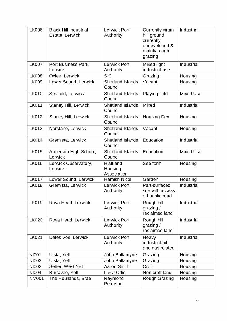
77
LK006 Black Hill Industrial Estate, Lerwick
Lerwick Port Authority
Currently virgin hill ground currently undeveloped & mainly rough grazing
Industrial
LK007 Port Business Park, Lerwick
Lerwick Port Authority
Mixed light industrial use
Industrial
LK008 Oxlee, Lerwick SIC Grazing Housing LK009 Lower Sound, Lerwick Shetland Islands
Council Vacant Housing
LK010 Seafield, Lerwick Shetland Islands Council
Playing field Mixed Use
LK011 Staney Hill, Lerwick Shetland Islands Council
Mixed Industrial
LK012 Staney Hill, Lerwick Shetland Islands Council
Housing Dev Housing
LK013 Norstane, Lerwick Shetland Islands Council
Vacant Housing
LK014 Gremista, Lerwick Shetland Islands Council
Education Industrial
LK015 Anderson High School, Lerwick
Shetland Islands Council
Education Mixed Use
LK016 Lerwick Observatory, Lerwick
Hjaltland Housing Association
See form Housing
LK017 Lower Sound, Lerwick Hamish Nicol Garden Housing LK018 Gremista, Lerwick Lerwick Port
Authority Part-surfaced site with access off public road
Industrial
LK019 Rova Head, Lerwick Lerwick Port Authority
Rough hill grazing / reclaimed land
Industrial
LK020 Rova Head, Lerwick Lerwick Port Authority
Rough hill grazing / reclaimed land
Industrial
LK021 Dales Voe, Lerwick Lerwick Port Authority
Heavy industrial/oil and gas related
Industrial
NI001 Ulsta, Yell John Ballantyne Grazing Housing NI002 Ulsta, Yell John Ballantyne Grazing Housing NI003 Setter, West Yell Aaron Smith Croft Housing NI004 Burravoe, Yell L & J Odie Non croft land Housing NM001 The Houllands, Brae Raymond
Peterson Rough Grazing Housing

78
NM002 Roebrek, Brae Andrew & Barbara Hall
Rough Grazing Housing
NM003 Burravoe, Brae John Tait Fallow Housing NM004 Scasta Shetland Islands
Council Mixed Industrial
NM005 Sellaness Shetland Islands Council
Industrial Industrial
NM006 Firth Shetland Islands Council
Grazing Housing
NM007 Upper Lea, Firth Shetland Islands Council
Vacant Housing
NM008 Firth Camp Shetland Islands Council
Allotments Allotments
NM009 Maidenfield, Mossbank Shetland Islands Council
Grazing Housing
NM010 Braehead, Mossbank Shetland Islands Council
Grazing Housing
NM011 Bankhead, Mossbank Shetland Islands Council
Grazing Housing
NM012 Hall, Mossbank Shetland Islands Council
Grazing Housing
NM013 Loch of Haggrister Shetland Islands Council
Quarry Industrial
NM014 Hall Park, Vidlin James Johnson Rough Grazing Housing NM015 Busta, Brae Jimmy Johnson Agricultural Housing NM016 Hillside, Voe Shetland Islands
Council Common Grazing
Housing
NM017 Stucca, Hillswick Shetland Islands Council
Common Grazing
Housing
NM018 Stucca, Hillswick Shetland Islands Council
Common Grazing
Housing
NM019 Vallandale Shetland Islands Council
Common Grazing
Housing
NM020 Sellaness Shetland Islands Council
Emp Industrial
NM021 Railsbrough, South Nesting
Mr & Mrs P. Rutherford
Rough grazing Housing
SM001 Stove, Sandwick Rosemary Inkster
Unused Housing
SM002 Dalsetter, Dunrossness Michael Stewart Rough Grazing Housing SM003 Heathery Park,
Gulberwick Dennis Leask No detail given Housing
SM004 Hillside, Gulberwick Dennis Leask No detail given Housing SM005 Quee, Cunningsburgh Mrs Violet Smith Grazing Housing SM006 Flugalee, Mrs Violet Smith Grazing Housing

79
Cunningsburgh SM007 Upswall, Wester Quarff Mrs Violet Smith Grazing Housing SM008 Upper Couster, Easter
Quarff Mrs Violet Smith Grazing Housing
SM009 Horseshoe Close, Dunrossness
Shetland Islands Council
Vacant Housing
SM010 Spiggie, Dunrossness Duncan E Kidson
Fallow Park Housing
SM011 Stove, Sandwick George Kerr Housing SM012 Stove, Sandwick Mrs Caroline
Thomson Occasional Grazing
Housing
SM013 Whilfigarth, Sandwick Mrs Caroline Thomson
Occasional Grazing
Housing
SM014 Haygreen, Sandwick Mrs Caroline Thomson
Occasional Grazing
Housing
SM015 Junior High School, Sandwick
Mrs Caroline Thomson
Occasional Grazing
Housing
SM016 Bigton Shop R. Morrison Housing SM017 Hestingott, Dunrossness Black & Budge
Ltd Cattle/sheep grazing
Housing
SM018 Scatness, Dunrossness Black & Budge Ltd
Cattle/sheep grazing
Housing
SM019 Scatness, Dunrossness Black & Budge Ltd
Cattle/sheep grazing
Housing or Industrial
SM020 Toab, Dunrossness Black & Budge Ltd
Farm Steading Housing
SM021 Aithsetter, Cunningsburgh
Mrs H. J. Mackenzie
Grazing Housing
SM022 Ellangownan, Gulberwick
Paul Stephen Goudie
Grazing ponies & silage
Housing
SM023 Scatness, Dunrossness Martin Burgess Grazing Housing SM024 Whilligarth, Dunrossness Martin Burgess Grazing Wind turbines SM025 Hamarsenn,
Dunrossness Martin Burgess Grazing Housing
SM026 Spiggie, Dunrossness Martin Burgess Grazing Housing SM027 Upper Kjurkhul, Easter
Quarff James Wilson Crofting Land Housing
SM028 Hall, Easter Quarff James Wilson Crofting Land Housing WM001 Nesbister, Whiteness Maurice
Anderson Agriculture Housing
WM002 Hellister, Weisdale Brian Anderson Agriculture Housing WM003 Gardie, Weisdale Brian Anderson Agriculture Housing WM004 Kirkidale, Walls Shetland Islands
Council Grazing Housing

80
WM005 Kirkhouse, South Whiteness
Hunter & Morrisons
See form Housing
WM006 Breck, South Whiteness Hunter & Morrisons
See form Housing
WM007 Gardens Croft, Sandness
Frances Taylor Field Housing
WM008 Aith Hall Hjaltland Housing Association
See form Housing
WM009 Whitelaw Road, Aith Hjaltland Housing Association
See form Housing
WM010 Wormadale, Whiteness Andrew G S Morrison
Garage/Store and waste garden ground
Housing
WM011 Wormadale, Whiteness Andrew G S Morrison
Garage/Store and waste garden ground
Housing
WM012 Gronnack, Whiteness Firm of Grains Bros
Rough Grazing Housing

81
This site is proposed for housing.
All development must conform to the appropriate policies set out in the Shetland Local Development Plan and related Supplementary Guidance when approved.
The site has development potential for small scale development.
A buffer will be required around watercourses.
Details of water supply availability should be sought from Scottish Water.
Any development on this site will be required to have adequate access, parking and circulation layout. Contact the Council Roads Service for information.
Any development in this area must connect to the public sewer. Major new (or significant upgrading of) wastewater infrastructure may be required in order to accommodate development on this site.

82
This site is proposed for housing.
All development must conform to the appropriate policies set out in the Shetland Local Development Plan and related Supplementary Guidance when approved.
The site has development potential for small scale development.
A buffer will be required around watercourses.
Any development in this area must connect to the public sewer. Major new (or significant upgrading of) wastewater infrastructure may be required in order to accommodate development on this site.
Details of water supply availability and sewerage infrastructure should be sought from Scottish Water.
Any development on this site will be required to have adequate access, parking and circulation layout. Contact the Council Roads Service for information.
Further guidance on flood risk for this site is provided in the Council’s Strategic Flood Risk Assessment

83
This site is proposed for housing.
All development must conform to the appropriate policies set out in the Shetland Local Development Plan and related Supplementary Guidance when approved.
A buffer will be required around watercourses.
Any development in this area must connect to the public sewer.
Details of water supply availability and sewerage infrastructure should be sought from Scottish Water.
This site has issues regarding access. Any development on this site will be required to have adequate access, parking and circulation layout. Contact the Council Roads Service for information.

84
This site is proposed for housing.
All development must conform to the appropriate policies set out in the Shetland Local Development Plan and related Supplementary Guidance when approved.
A buffer will be required around watercourses.
Any development in this area must connect to the public sewer.
Details of water supply availability and sewerage infrastructure should be sought from Scottish Water.
This site has issues regarding access. Any development on this site will be required to have adequate access, parking and circulation layout. Contact the Council Roads Service for information.

85
This site is proposed for housing.
This site may be at risk of flooding and a flood risk assessment (FRA) will be required to determine which areas of the site, if any, can be developed.
Part or all of this site lies beneath the 5m contour.
Drainage impact assessment will be required.
All development must conform to the appropriate policies set out in the Shetland Local Development Plan and related Supplementary Guidance when approved.
A full Design Statement including details of development phasing will be required for this site.
Details of water supply availability and sewerage infrastructure should be sought from Scottish Water.
Any development in this area must connect to the public sewer.
This site has issues regarding access. Any development on this site will be required to have adequate access, parking and circulation layout. Contact the Council Roads Service for information.
A project has been initiated to upgrade capacity at the Tronafirth sewage treatment works, which serves this area.” in the site notes for this site.

86
Further guidance on flood risk for this site is provided in the Council’s Strategic Flood Risk Assessment.
This site is proposed for housing.
This site may be at risk of flooding and a flood risk assessment (FRA) will be required to determine which areas of the site, if any, can be developed.
Part or all of this site lies beneath the 5m contour.
All development must conform to the appropriate policies set out in the Shetland Local Development Plan and related Supplementary Guidance when approved.
A buffer will be required around watercourses.
Any development in this area must connect to the public sewer.
Details of water supply availability and sewerage infrastructure should be sought from Scottish Water.
Any development on this site will be required to have adequate access, parking and circulation layout. Contact the Council Roads Service for information.
Further guidance on flood risk for this site is provided in the Council’s Strategic Flood Risk Assessment.

87
This site is proposed for housing.
All development must conform to the appropriate policies set out in the Shetland Local Development Plan and related Supplementary Guidance when approved.
Any development in this area must connect to the public sewer.
Details of water supply availability and sewerage infrastructure should be sought from Scottish Water.
Any development on this site will be required to have adequate access, parking and circulation layout. Contact the Council Roads Service for information.
A full Design Statement including details of development phasing will be required for this site.
This proposed site is within 250m of a listed building, please contact the Heritage Section prior to progressing with this development to ensure this historic setting is not compromised. Consideration should be given to the following factors: design, layout, density and setting when developing detailed proposals.
A project has been initiated to upgrade capacity at the Tronafirth sewage treatment works, which serves this area.” in the site notes for this site.

88
This site is proposed for housing. All development must conform to the appropriate policies set out in the Shetland Local Development Plan and related Supplementary Guidance when approved.
Details of water supply availability and sewerage infrastructure should be sought from Scottish Water.
Any development on this site will be required to have adequate access, parking and circulation layout. Contact the Council Roads Service for information.

89
This site is proposed for housing.
All development must conform to the appropriate policies set out in the Shetland Local Development Plan and related Supplementary Guidance when approved.
A buffer will be required around watercourses.
Details of water supply availability and sewerage infrastructure should be sought from Scottish Water.
Any development on this site will be required to have adequate access, parking and circulation layout. Contact the Council Roads Service for information.
A Core Path is close to the site, for further information please contact the Heritage Section.

90
This site is proposed for housing.
All development must conform to the appropriate policies set out in the Shetland Local Development Plan and related Supplementary Guidance when approved.
A buffer will be required around watercourses.
If a public sewer becomes available in this area prior to the site being developed, there would be a requirement to connect. In the absence of a public sewer, the site has potential only for small scale development. Details of water supply availability and sewerage infrastructure should be sought from Scottish Water.
Any development on this site will be required to have adequate access, parking and circulation layout. Contact the Council Roads Service for information.
A Core Path is present within the site, for further information please contact the Heritage Section

91
This site is proposed for industrial use.
Light industry only.
The site has potential subject to the south eastern quadrant being reserved for low industry developments that are compatible with the neighbouring residential site.
Major new (or significant upgrading of) wastewater infrastructure may be required in order to accommodate development on this site.
Details of water supply availability and sewerage infrastructure should be sought from Scottish Water.
This site has issues regarding access. Any development on this site will be required to have adequate access, parking and circulation layout. Contact the Council Roads Service for information.
It is an environmental designation the site may contain contaminated land. Contact Environmental Health for more information.

92
This site is proposed for industrial use.
All development must conform to the appropriate policies set out in the Shetland Local Development Plan and related Supplementary Guidance when approved.
Any development in this area must connect to the public sewer.
Details of water supply availability and sewerage infrastructure should be sought from Scottish Water.
Any development on this site will be required to have adequate access, parking and circulation layout. Contact the Council Roads Service for information.

93
This site is proposed for industrial use.
All development must conform to the appropriate policies set out in the Shetland Local Development Plan and related Supplementary Guidance when approved.
A buffer will be required around watercourses.
Any development in this area must connect to the public sewer.
Details of water supply availability and sewerage infrastructure should be sought from Scottish Water.
Any development on this site will be required to have adequate access, parking and circulation layout. Contact the Council Roads Service for information.

94
This site is proposed for industrial use.
All development must conform to the appropriate policies set out in the Shetland Local Development Plan and related Supplementary Guidance when approved.
A buffer will be required around watercourses.
Any development in this area must connect to the public sewer.
Details of water supply availability and sewerage infrastructure should be sought from Scottish Water.
Any development on this site will be required to have adequate access, parking and circulation layout. Contact the Council Roads Service for information.
This site may be at risk of flooding and a flood risk assessment (FRA) will be required to determine which areas of the site, if any, can be developed.
Part or all of this site lies beneath the 5m contour.
Further guidance on flood risk for this site is provided in the Council’s Strategic Flood Risk Assessment.

95
This site is proposed for industrial use.
Major new (or significant upgrading of) wastewater infrastructure may be required in order to accommodate development on this site. Early discussion with Scottish Water will be required.
All development must conform to the appropriate policies set out in the Shetland Local Development Plan and related Supplementary Guidance when approved.
A buffer will be required around watercourses.
Any development in this area must connect to the public sewer.
Any development on this site will be required to have adequate access, parking and circulation layout. Contact the Council Roads Service for information.

96
This site is proposed for industrial use.
All development must conform to the appropriate policies set out in the Shetland Local Development Plan and related Supplementary Guidance when approved.
A buffer will be required around watercourses.
Any development in this area must connect to the public sewer.
Details of water supply availability and sewerage infrastructure should be sought from Scottish Water.
Any development on this site will be required to have adequate access, parking and circulation layout. Contact the Council Roads Service for information.
The site may be at risk of flooding and a flood risk assessment (FRA), including a catchment based assessment of drainage, will be required to determine which areas can be developed and to identify the works required.
Further guidance on flood risk for this site is provided in the Council’s Strategic Flood Risk Assessment.

97
This site is proposed for industrial use. All development must conform to the appropriate policies set out in the Shetland Local Development Plan and related Supplementary Guidance when approved.
A buffer will be required around watercourses.
Any development in this area must connect to the public sewer.
Details of water supply availability and sewerage infrastructure should be sought from Scottish Water.
Any development on this site will be required to have adequate access, parking and circulation layout. Contact the Council Roads Service for information.
Part or all of this site lies beneath the 5m contour.
This site may be at risk of flooding and a flood risk assessment (FRA) will be required to determine which areas of the site, if any, can be developed.
Major new (or significant upgrading of) wastewater infrastructure may be required in order to accommodate development on this site.
Further guidance on flood risk for this site is provided in the Council’s Strategic Flood Risk Assessment.

98
This site is proposed for housing.
All development must conform to the appropriate policies set out in the Shetland Local Development Plan and related Supplementary Guidance when approved.
A buffer will be required around watercourses.
Any development in this area must connect to the public sewer. There are capacity issues in the drainage network at the south-west end of Lerwick potentially affecting this site.
Details of water supply availability and sewerage infrastructure should be sought from Scottish Water.
Any development on this site will be required to have adequate access, parking and circulation layout. Contact the Council Roads Service for information.
There is low risk of archaeology in this area, please contact the Shetland Archaeologist at the Shetland Amenity Trust for further information.
This site may be at risk of flooding and a flood risk assessment (FRA) will be required to determine which areas of the site, if any, can be developed.
A full Design Statement including details of development phasing will be required for this site.
Further guidance on flood risk for this site is provided in the Council’s Strategic Flood Risk Assessment.

99
This site is proposed for housing.
All development must conform to the appropriate policies set out in the Shetland Local Development Plan and related Supplementary Guidance when approved.
Any development in this area must connect to the public sewer.
Details of water supply availability and sewerage infrastructure should be sought from Scottish Water.
Any development on this site will be required to have adequate access, parking and circulation layout. Contact the Council Roads Service for information.

100
This site is for mixed use.
This site may be at risk of flooding and a flood risk assessment (FRA) will be required to determine which areas of the site, if any, can be developed.
All development must conform to the appropriate policies set out in the Shetland Local Development Plan and related Supplementary Guidance when approved.
Any development in this area must connect to the public sewer.
Details of water supply availability and sewerage infrastructure should be sought from Scottish Water.
Any development on this site will be required to have adequate access, parking and circulation layout. Contact the Council Roads Service for information.
Part or all of this site lies beneath the 5m contour.
There are capacity issues in the drainage network at the south-west end of Lerwick potentially affecting this site.
Further guidance on flood risk for this site is provided in the Council’s Strategic Flood Risk Assessment.

101
This site is proposed for industrial use.
All development must conform to the appropriate policies set out in the Shetland Local Development Plan and related Supplementary Guidance when approved.
A buffer will be required around watercourses.
Any development in this area must connect to the public sewer.
Details of water supply availability and sewerage infrastructure should be sought from Scottish Water.
Any development on this site will be required to have adequate access, parking and circulation layout. Contact the Council Roads Service for information.
There is low risk of archaeology in this area, please contact the Shetland Archaeologist at the Shetland Amenity Trust for further information.

102
This site is proposed for housing.
All development must conform to the appropriate policies set out in the Shetland Local Development Plan and related Supplementary Guidance when approved.
A buffer will be required around watercourses.
Any development in this area must connect to the public sewer.
Details of water supply availability and sewerage infrastructure should be sought from Scottish Water.
Any development on this site will be required to have adequate access, parking and circulation layout. Contact the Council Roads Service for information.
A full Design Statement including details of development phasing will be required for this site.
There is low risk of archaeology in this area, please contact the Shetland Archaeologist at the Shetland Amenity Trust for further information.
Major new (or significant upgrading of) wastewater infrastructure may be required in order to accommodate development on this site.
There is water infrastructure running through this site, please contact Scottish Water for advice.
Views from the summit of North Staney Hill must be protected.

103
This site is proposed for housing.
All development must conform to the appropriate policies set out in the Shetland Local Development Plan and related Supplementary Guidance when approved.
Any development in this area must connect to the public sewer.
Details of water supply availability and sewerage infrastructure should be sought from Scottish Water.
Any development on this site will be required to have adequate access, parking and circulation layout. Contact the Council Roads Service for information.
This site has issues regarding access. Any development on this site will be required to have adequate access, parking and circulation layout. Contact the Council Roads Service for information.
Please note there is evidence of previous military activity within 250m of this site. Please contact Environmental Health for further details.

104
This site is proposed for industrial use.
All development must conform to the appropriate policies set out in the Shetland Local Development Plan and related Supplementary Guidance when approved.
Any development in this area must connect to the public sewer.
Details of water supply availability and sewerage infrastructure should be sought from Scottish Water.
Any development on this site will be required to have adequate access, parking and circulation layout. Contact the Council Roads Service for information.
There is water infrastructure running through this site, please contact Scottish Water for advice.

105
This site is proposed for mixed use.
A full Design Statement including details of development phasing will be required for this site.
All development must conform to the appropriate policies set out in the Shetland Local Development Plan and related Supplementary Guidance when approved.
Any development in this area must connect to the public sewer. Details of water supply availability should be sought from Scottish Water.
Any development on this site will be required to have adequate access, parking and circulation layout. Contact the Council Roads Service for information.
There is low risk of archaeology in this area, please contact the Shetland Archaeologist at the Shetland Amenity Trust for further information.
This proposed site is within 250m of a number of listed buildings, please contact the Heritage Section prior to progressing with this development to ensure this historic setting is not compromised. Consideration should be given to the following factors: design, layout, density and setting when developing detailed proposals.
This proposed site is within 250m of a Scheduled Monument, please contact the Shetland Archaeologist at the Shetland Amenity Trust prior to progressing with this development to ensure the setting of the Scheduled Monument is not compromised.

106
This site is proposed for housing.
All development must conform to the appropriate policies set out in the Shetland Local Development Plan and related Supplementary Guidance when approved.
A buffer will be required around watercourses.
Any development in this area must connect to the public sewer.
Details of water supply availability and sewerage infrastructure should be sought from Scottish Water.
Any development on this site will be required to have adequate access, parking and circulation layout. Contact the Council Roads Service for information.
Please note there is evidence of previous military activity within this site. Please contact Environmental Health for further details.
There is low risk of archaeology in this area, please contact the Shetland Archaeologist at the Shetland Amenity Trust for further information.
There are capacity issues in the drainage network at the south-west end of Lerwick potentially affecting this site.

107
This site is proposed for housing.
All development must conform to the appropriate policies set out in the Shetland Local Development Plan and related Supplementary Guidance when approved.
Any development in this area must connect to the public sewer.
Details of water supply availability and sewerage infrastructure should be sought from Scottish Water.
Any development on this site will be required to have adequate access, parking and circulation layout. Contact the Council Roads Service for information.
A Core Path is present along the boundary of the site for further information please contact the Heritage Section for more information.
This site has issues regarding access. Any development on this site will be required to have adequate access, parking and circulation layout. Contact the Council Roads Service for information.
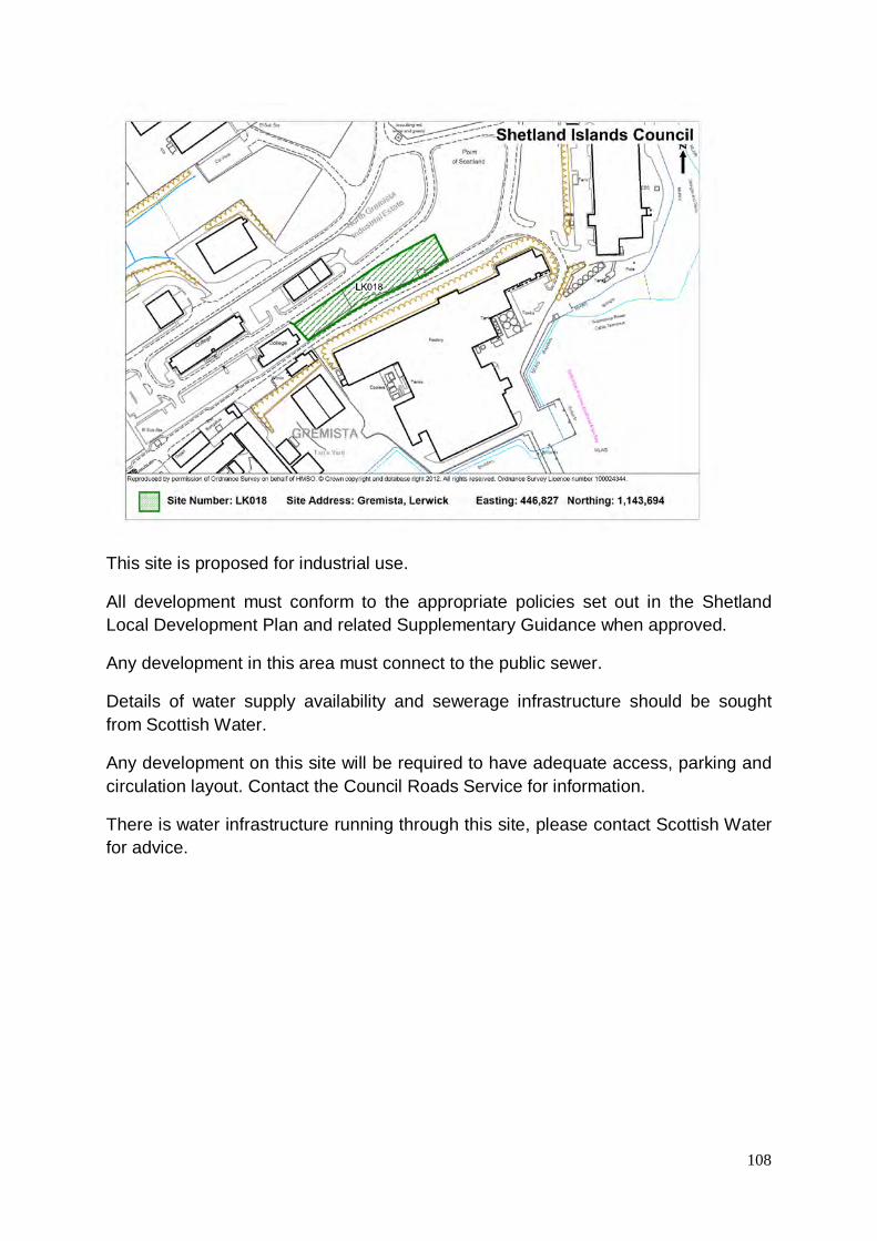
108
This site is proposed for industrial use.
All development must conform to the appropriate policies set out in the Shetland Local Development Plan and related Supplementary Guidance when approved.
Any development in this area must connect to the public sewer.
Details of water supply availability and sewerage infrastructure should be sought from Scottish Water.
Any development on this site will be required to have adequate access, parking and circulation layout. Contact the Council Roads Service for information.
There is water infrastructure running through this site, please contact Scottish Water for advice.

109
This site is proposed for industrial use.
All development must conform to the appropriate policies set out in the Shetland Local Development Plan and related Supplementary Guidance when approved.
A buffer will be required around watercourses.
Any development in this area must connect to the public sewer.
Details of water and waste water supply availability should be sought from Scottish Water.
Any development on this site will be required to have adequate access, parking and circulation layout. Contact the Council Roads Service for information.
Part or all of this site lies beneath the 5m contour.
Potential odour issues from existing waste water treatment works, early discussion with Scottish Water is advised.
The site may be at risk of flooding and a flood risk assessment (FRA), including a catchment based assessment of drainage, will be required to determine which areas can be developed and to identify the works required.
Further guidance on flood risk for this site is provided in the Council’s Strategic Flood Risk Assessment.

110
This site is proposed for industrial use.
This site is at risk of flooding and a flood risk assessment (FRA) will be required to determine which areas of the site, if any, can be developed.
All development must conform to the appropriate policies set out in the Shetland Local Development Plan and related Supplementary Guidance when approved.
A buffer will be required around watercourses.
Any development in this area must connect to the public sewer.
Details of water supply availability and sewerage infrastructure should be sought from Scottish Water.
Any development on this site will be required to have adequate access, parking and circulation layout. Contact the Council Roads Service for information.
Potential odour issues from existing waste water treatment works, early discussion with Scottish Water is advised.
Part or all of this site lies beneath the 5m contour.
Further guidance on flood risk for this site is provided in the Council’s Strategic Flood Risk Assessment.
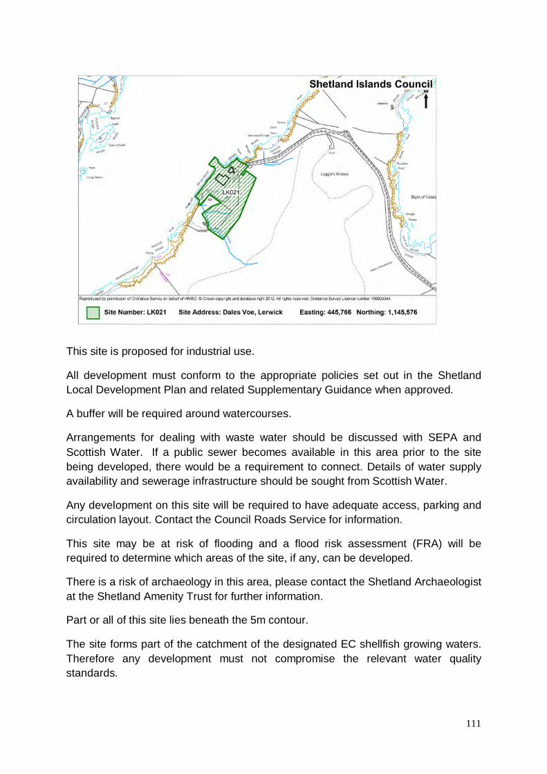
111
This site is proposed for industrial use.
All development must conform to the appropriate policies set out in the Shetland Local Development Plan and related Supplementary Guidance when approved.
A buffer will be required around watercourses.
Arrangements for dealing with waste water should be discussed with SEPA and Scottish Water. If a public sewer becomes available in this area prior to the site being developed, there would be a requirement to connect. Details of water supply availability and sewerage infrastructure should be sought from Scottish Water.
Any development on this site will be required to have adequate access, parking and circulation layout. Contact the Council Roads Service for information.
This site may be at risk of flooding and a flood risk assessment (FRA) will be required to determine which areas of the site, if any, can be developed.
There is a risk of archaeology in this area, please contact the Shetland Archaeologist at the Shetland Amenity Trust for further information.
Part or all of this site lies beneath the 5m contour.
The site forms part of the catchment of the designated EC shellfish growing waters. Therefore any development must not compromise the relevant water quality standards.

112
Further guidance on flood risk for this site is provided in the Council’s Strategic Flood Risk Assessment.

113
This site is proposed for housing.
All development must conform to the appropriate policies set out in the Shetland Local Development Plan and related Supplementary Guidance when approved.
A buffer will be required around watercourses.
Any development in this area should connect to the public sewer.
Details of water supply availability and sewerage infrastructure should be sought from Scottish Water.
Any development on this site will be required to have adequate access, parking and circulation layout. Contact the Council Roads Service for information.
This site may be at risk of flooding and a flood risk assessment (FRA) will be required to determine which areas of the site, if any, can be developed.
There is low risk of archaeology in this area, please contact the Shetland Archaeologist at the Shetland Amenity Trust for further information.
This proposed site is within 250m of a listed building, please contact the Heritage Section prior to progressing with this development to ensure this historic setting is not compromised. Consideration should be given to the following factors: design, layout, density and setting when developing detailed proposals.
Part or all of this site lies beneath the 5m contour.

114
Further guidance on flood risk for this site is provided in the Council’s Strategic Flood Risk Assessment.

115
This site is proposed for housing.
All development must conform to the appropriate policies set out in the Shetland Local Development Plan and related Supplementary Guidance when approved.
A buffer will be required around watercourses.
Any development in this area must connect to the public sewer.
Details of water supply availability and sewerage infrastructure should be sought from Scottish Water.
Any development on this site will be required to have adequate access, parking and circulation layout. Contact the Council Roads Service for information.
This proposed site is within 250m of a listed building, please contact the Heritage Section prior to progressing with this development to ensure this historic setting is not compromised. Consideration should be given to the following factors: design, layout, density and setting when developing detailed proposals.

116
This site is proposed for housing.
All development must conform to the appropriate policies set out in the Shetland Local Development Plan and related Supplementary Guidance when approved.
A buffer will be required around watercourses.
Any development in this area must connect to the public sewer.
Details of water supply availability and sewerage infrastructure should be sought from Scottish Water.
Any development on this site will be required to have adequate access, parking and circulation layout. Contact the Council Roads Service for information.

117
This site is proposed for housing.
All development must conform to the appropriate policies set out in the Shetland Local Development Plan and related Supplementary Guidance when approved.
A buffer will be required around watercourses.
Any development in this area must connect to the public sewer.
Details of water supply availability and sewerage infrastructure should be sought from Scottish Water.
Any development on this site will be required to have adequate access, parking and circulation layout. Contact the Council Roads Service for information.
This site may be at risk of flooding and a flood risk assessment (FRA) will be required to determine which areas of the site, if any, can be developed.

118
This site is proposed for housing.
All development must conform to the appropriate policies set out in the Shetland Local Development Plan and related Supplementary Guidance when approved.
A buffer will be required around watercourses.
Details of water supply availability and sewerage infrastructure should be sought from Scottish Water.
Any development on this site will be required to have adequate access, parking and circulation layout. Contact the Council Roads Service for information.
This site may be at risk of flooding and a flood risk assessment (FRA) will be required to determine which areas of the site, if any, can be developed.
Any proposals should be low density to reflect the existing development pattern.
Part or all of this site lies beneath the 5m contour.
Further guidance on flood risk for this site is provided in the Council’s Strategic Flood Risk Assessment.

119
This site is proposed for housing.
A full Design Statement including details of development phasing will be required for this site.
All development must conform to the appropriate policies set out in the Shetland Local Development Plan and related Supplementary Guidance when approved.
A buffer will be required around watercourses.
Any development in this area must connect to the public sewer.
Details of water supply availability and sewerage infrastructure should be sought from Scottish Water.
Any development on this site will be required to have adequate access, parking and circulation layout. Contact the Council Roads Service for information.
Core path is along the boundary of the site for further information please contact the Heritage Section.
The site may be at risk of flooding and a flood risk assessment (FRA) or a drainage impact assessment (DIA) will be required to determine which areas of the site, if any, can be developed.

120
This site is proposed for housing.
All development must conform to the appropriate policies set out in the Shetland Local Development Plan and related Supplementary Guidance when approved.
A buffer will be required around watercourses.
Any development in this area must connect to the public sewer.
Details of water supply availability and sewerage infrastructure should be sought from Scottish Water.
Any development on this site will be required to have adequate access, parking and circulation layout. Contact the Council Roads Service for information.
Major new (or significant upgrading of) wastewater infrastructure may be required in order to accommodate development on this site.
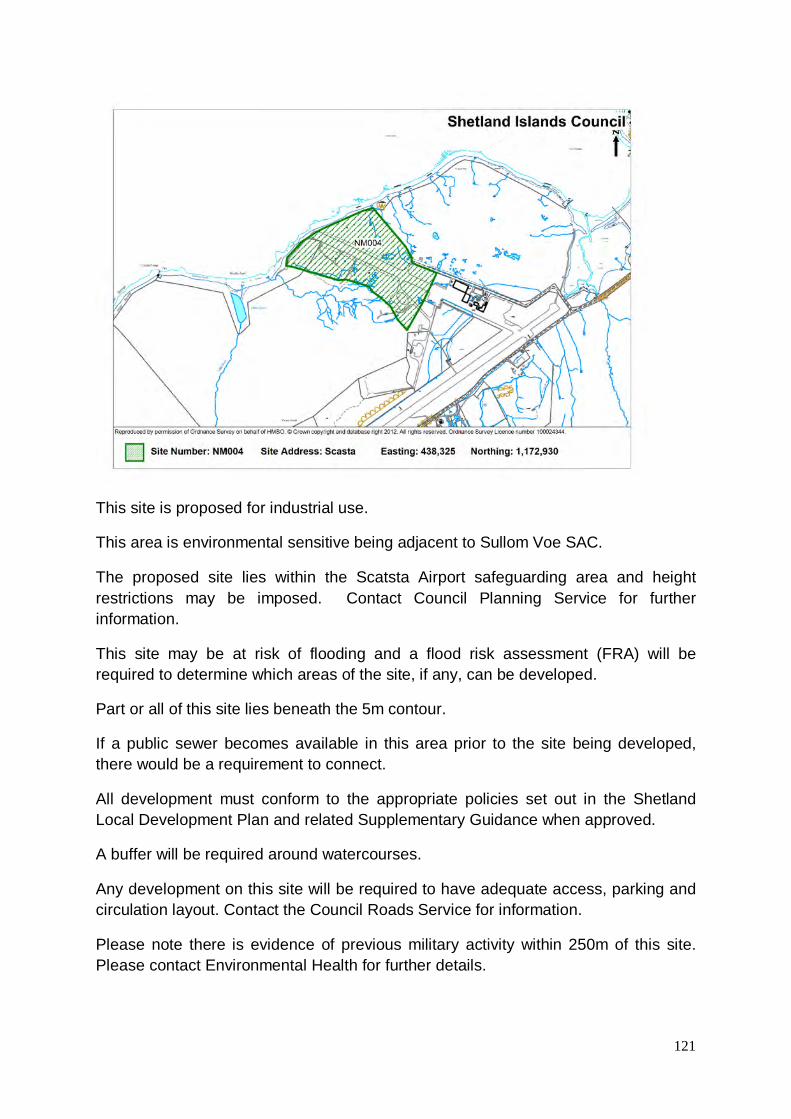
121
This site is proposed for industrial use.
This area is environmental sensitive being adjacent to Sullom Voe SAC.
The proposed site lies within the Scatsta Airport safeguarding area and height restrictions may be imposed. Contact Council Planning Service for further information.
This site may be at risk of flooding and a flood risk assessment (FRA) will be required to determine which areas of the site, if any, can be developed.
Part or all of this site lies beneath the 5m contour.
If a public sewer becomes available in this area prior to the site being developed, there would be a requirement to connect.
All development must conform to the appropriate policies set out in the Shetland Local Development Plan and related Supplementary Guidance when approved.
A buffer will be required around watercourses.
Any development on this site will be required to have adequate access, parking and circulation layout. Contact the Council Roads Service for information.
Please note there is evidence of previous military activity within 250m of this site. Please contact Environmental Health for further details.

122
Further guidance on flood risk for this site is provided in the Council’s Strategic Flood Risk Assessment.
This site is proposed for industrial use.
All development must conform to the appropriate policies set out in the Shetland Local Development Plan and related Supplementary Guidance when approved.
A buffer will be required around watercourses.
If a public sewer becomes available in this area prior to the site being developed, there would be a requirement to connect. Details of water supply availability and sewerage infrastructure should be sought from Scottish Water.
Any development on this site will be required to have adequate access, parking and circulation layout. Contact the Council Roads Service for information.
There is low risk of archaeology in this area, please contact the Shetland Archaeologist at the Shetland Amenity Trust for further information.
Please note there is evidence of previous military activity within this site. Please contact Environmental Health for further details.

123
This site is proposed for housing.
All development must conform to the appropriate policies set out in the Shetland Local Development Plan and related Supplementary Guidance when approved.
A buffer will be required around watercourses.
Any development in this area must connect to the public sewer.
Details of water supply availability and sewerage infrastructure should be sought from Scottish Water.
Any development on this site will be required to have adequate access, parking and circulation layout. Contact the Council Roads Service for information.
A full Design Statement including details of development phasing will be required for this site.
Part of the site has been used for landfill. Please contact Environmental Health.
The site may be at risk of flooding and a flood risk assessment (FRA) or a drainage impact assessment (DIA) will be required to determine which areas of the site, if any, can be developed.

124
This site is proposed for housing.
A full Design Statement including details of development phasing will be required for this site.
All development must conform to the appropriate policies set out in the Shetland Local Development Plan and related Supplementary Guidance when approved.
A buffer will be required around watercourses.
Any development in this area must connect to the public sewer.
Details of water supply availability and sewerage infrastructure should be sought from Scottish Water.
Any development on this site will be required to have adequate access, parking and circulation layout. Contact the Council Roads Service for information.
Upgrading of major wastewater infrastructure may be required in order to accommodate development on this site.
The site may be at risk of flooding and a flood risk assessment (FRA) or a drainage impact assessment (DIA) will be required to determine which areas of the site, if any, can be developed.

125
This site is proposed for allotments.
All development must conform to the appropriate policies set out in the Shetland Local Development Plan and related Supplementary Guidance when approved.

126
This site is proposed for housing.
All development must conform to the appropriate policies set out in the Shetland Local Development Plan and related Supplementary Guidance when approved.
A buffer will be required around watercourses.
Any development in this area must connect to the public sewer.
Details of water supply availability and sewerage infrastructure should be sought from Scottish Water.
Any development on this site will be required to have adequate access, parking and circulation layout. Contact the Council Roads Service for information.
This site may be at risk of flooding and a flood risk assessment (FRA) will be required to determine which areas of the site, if any, can be developed.
There is water infrastructure running through this site, please contact Scottish Water for advice.

127
This site is proposed for housing.
All development must conform to the appropriate policies set out in the Shetland Local Development Plan and related Supplementary Guidance when approved.
A buffer will be required around watercourses.
Any development in this area must connect to the public sewer.
Details of water supply availability and sewerage infrastructure should be sought from Scottish Water.
Any development on this site will be required to have adequate access, parking and circulation layout. Contact the Council Roads Service for information.
This site may be at risk of flooding and a flood risk assessment (FRA) will be required to determine which areas of the site, if any, can be developed.
This proposed site is within 250m of a listed building, please contact the Heritage Section prior to progressing with this development to ensure this historic setting is not compromised. Consideration should be given to the following factors: design, layout, density and setting when developing detailed proposals.
A Core Path is present within the site for further information please contact the Heritage Section.

128
This site is proposed for housing.
All development must conform to the appropriate policies set out in the Shetland Local Development Plan and related Supplementary Guidance when approved.
This site may be at risk of flooding and a flood risk assessment (FRA) will be required to determine which areas of the site, if any, can be developed.
A buffer will be required around watercourses.
Part or all of this site lies beneath the 5m contour.
Any development in this area must connect to the public sewer.
There is water infrastructure running along the boundary of the site. Details of water supply availability should be sought from Scottish Water.
This site has issues regarding access. Any development on this site will be required to have adequate access, parking and circulation layout. Contact the Council Roads Service for information.
This proposed site is within 250m of a listed building, please contact the Heritage Section prior to progressing with this development to ensure this historic setting is not compromised. Consideration should be given to the following factors: design, layout, density and setting when developing detailed proposals.
There may be issues regarding the power cable please contact Scottish Hydro Electric.
Further guidance on flood risk for this site is provided in the Council’s Strategic Flood Risk Assessment.

129
This site is proposed for housing.
All development must conform to the appropriate policies set out in the Shetland Local Development Plan and related Supplementary Guidance when approved.
A buffer will be required around watercourses.
Any development in this area must connect to the public sewer.
There is a 4” and a 2” distribution main, details of water supply availability should be sought from Scottish Water.
This site has issues regarding access. Any development on this site will be required to have adequate access, parking and circulation layout. Contact the Council Roads Service for information.
This proposed site is within 250m of a listed building, please contact the Heritage Section prior to progressing with this development to ensure this historic setting is not compromised. Consideration should be given to the following factors: design, layout, density and setting when developing detailed proposals.
A Core Path is present along the east boundary of the site, for further information please contact the Heritage Section.
There is a risk of archaeology in this area, please contact the Shetland Archaeologist at the Shetland Amenity Trust for further information.

130
Further guidance on flood risk for this site is provided in the Council’s Strategic Flood Risk Assessment.
This site is proposed for industrial use.
All development must conform to the appropriate policies set out in the Shetland Local Development Plan and related Supplementary Guidance when approved.
There is a risk of archaeology in this area, please contact the Shetland Archaeologist at the Shetland Amenity Trust for further information.
If a public sewer becomes available in this area prior to the site being developed, there would be a requirement to connect.

131
This site is proposed for housing.
Major new (or significant upgrading of) wastewater infrastructure may be required in order to accommodate development on this site.
The location of part of this site is not considered sympathetic to the existing settlement pattern and therefore only part of this site is included.
All development must conform to the appropriate policies set out in the Shetland Local Development Plan and related Supplementary Guidance when approved.
A buffer will be required around watercourses.
Any development in this area must connect to the public sewer.
Details of water supply availability and sewerage infrastructure should be sought from Scottish Water.
Any development on this site will be required to have adequate access, parking and circulation layout. Contact the Council Roads Service for information.

132
This site is proposed for housing.
All development must conform to the appropriate policies set out in the Shetland Local Development Plan and related Supplementary Guidance when approved.
A buffer will be required around watercourses.
Any development in this area must connect to the public sewer.
Details of water supply availability and sewerage infrastructure should be sought from Scottish Water.
Any development on this site will be required to have adequate access, parking and circulation layout. Contact the Council Roads Service for information.
A full Design Statement including details of development phasing will be required for this site.
This site may be at risk of flooding and a flood risk assessment (FRA) will be required to determine which areas of the site, if any, can be developed.
Major new (or significant upgrading of) wastewater infrastructure may be required in order to accommodate development on this site.
This proposed site is within 250m of a Scheduled Ancient Monument, please contact the Shetland Archaeologist at the Shetland Amenity Trust prior to progressing with this development to ensure the setting of the Scheduled Monument is not compromised.

133
This site is proposed for housing.
All development must conform to the appropriate policies set out in the Shetland Local Development Plan and related Supplementary Guidance when approved.
A buffer will be required around watercourses.
Details of water supply availability and sewerage infrastructure should be sought from Scottish Water.
Major new (or significant upgrading of) wastewater infrastructure may be required in order to accommodate development on this site.
This site has issues regarding access. Any development on this site will be required to have adequate access, parking and circulation layout. Contact the Council Roads Service for information.

134
This site is proposed for housing.
All development must conform to the appropriate policies set out in the Shetland Local Development Plan and related Supplementary Guidance when approved.
A buffer will be required around watercourses.
Any development in this area must connect to the public sewer.
Details of water supply availability and sewerage infrastructure should be sought from Scottish Water.
Any development on this site will be required to have adequate access, parking and circulation layout. Contact the Council Roads Service for information.
There is high risk of archaeology in this area, please contact the Shetland Archaeologist at the Shetland Amenity Trust for further information.
Further guidance on flood risk for this site is provided in the Council’s Strategic Flood Risk Assessment.

135
This site is proposed for housing.
A full Design Statement including details of development phasing will be required for this site.
Major new (or significant upgrading of) wastewater infrastructure may be required in order to accommodate development on this site.

136
This site is proposed for housing.
All development must conform to the appropriate policies set out in the Shetland Local Development Plan and related Supplementary Guidance when approved.
A buffer will be required around watercourses.
Any development in this area must connect to the public sewer.
Details of water supply availability and sewerage infrastructure should be sought from Scottish Water.
This site has issues regarding access. Any development on this site will be required to have adequate access, parking and circulation layout. Contact the Council Roads Service for information.
Major new (or significant upgrading of) wastewater infrastructure may be required in order to accommodate development on this site.

137
This site is proposed for industrial use.
The proposed site lies within the Scatsta Airport safeguarding area and height restrictions may be imposed. Contact Council Planning Service for further information.
Should not conflict with existing development on the site.
Proposed site adjacent to Sullom Voe SAC.
Part or all of this site lies beneath the 5m contour.
This site may be at risk of flooding and a flood risk assessment (FRA) will be required to determine which areas of the site, if any, can be developed.
Further guidance on flood risk for this site is provided in the Council’s Strategic Flood Risk Assessment.

138
This site is proposed for housing.
All development must conform to the appropriate policies set out in the Shetland Local Development Plan and related Supplementary Guidance when approved.
Details of water supply availability and sewerage infrastructure should be sought from Scottish Water.
Any development on this site will be required to have adequate access, parking and circulation layout. Contact the Council Roads Service for information.

139
This site is proposed for housing.
All development must conform to the appropriate policies set out in the Shetland Local Development Plan and related Supplementary Guidance when approved.
A buffer will be required around watercourses.
Any development in this area must connect to the public sewer.
Details of water supply availability and sewerage infrastructure should be sought from Scottish Water.
This site has issues regarding access. Any development on this site will be required to have adequate access, parking and circulation layout. Contact the Council Roads Service for information.

140
This site is proposed for housing.
All development must conform to the appropriate policies set out in the Shetland Local Development Plan and related Supplementary Guidance when approved.
This proposed site is within 250m of a listed building, please contact the Heritage Section prior to progressing with this development to ensure this historic setting is not compromised. Consideration should be given to the following factors: design, layout, density and setting when developing detailed proposals.
This proposed site is within 250m of a Scheduled Monument, please contact the Shetland Archaeologist at the Shetland Amenity Trust prior to progressing with this development to ensure the setting of the Scheduled Monument is not compromised.
The site lies within the CAA Sumburgh Airport safeguarding area – height restrictions may be applied – contact Highlands and Islands Airport Ltd (HIAL) for more information.

141
This site is proposed for housing.
All development must conform to the appropriate policies set out in the Shetland Local Development Plan and related Supplementary Guidance when approved.
A buffer will be required around watercourses.
Any development in this area must connect to the public sewer.
Details of water supply availability and sewerage infrastructure should be sought from Scottish Water.
Surface water drainage may be a problem in this area any development must not compromise existing arrangement.
Any development on this site will be required to have adequate access, parking and circulation layout. Contact the Council Roads Service for information.
A full Design Statement including details of development phasing will be required for this site.

142
This site is proposed for housing.
All development must conform to the appropriate policies set out in the Shetland Local Development Plan and related Supplementary Guidance when approved.
Any development on this site will be required to have adequate access, parking and circulation layout. Contact the Council Roads Service for information.
There is risk of archaeology in this area, please contact the Shetland Archaeologist at the Shetland Amenity Trust for further information.
Any development in this area must connect to the public sewer.
Details of water supply availability should be sought from Scottish Water.

143
This site is proposed for housing.
All development must conform to the appropriate policies set out in the Shetland Local Development Plan and related Supplementary Guidance when approved.
A Core Path is present within the site for further information please contact the Heritage Section
Any development on this site will be required to have adequate access, parking and circulation layout. Contact the Council Roads Service for information.
Any development in this area must connect to the public sewer.
Details of water supply availability and sewerage infrastructure should be sought from Scottish Water.
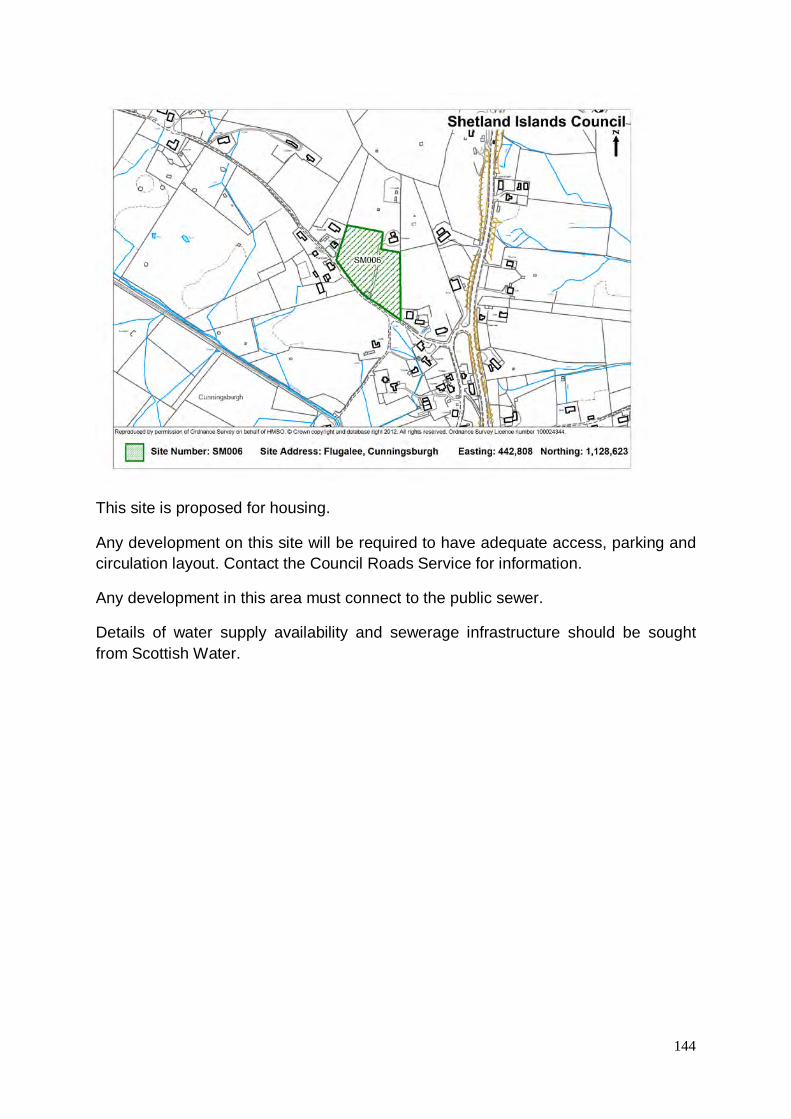
144
This site is proposed for housing.
Any development on this site will be required to have adequate access, parking and circulation layout. Contact the Council Roads Service for information.
Any development in this area must connect to the public sewer.
Details of water supply availability and sewerage infrastructure should be sought from Scottish Water.

145
This site is proposed for housing.
All development must conform to the appropriate policies set out in the Shetland Local Development Plan and related Supplementary Guidance when approved.
A buffer will be required around watercourses.
No waste water treatment in area.
Details of water supply availability and sewerage infrastructure should be sought from Scottish Water.
Any development on this site will be required to have adequate access, parking and circulation layout. Contact the Council Roads Service for information.
Please note there is evidence of previous military activity within 250m of this site. Please contact Environmental Health for further details.
A Core Path is present within the site for further information please contact the Heritage Section.

146
This site is proposed for housing.
All development must conform to the appropriate policies set out in the Shetland Local Development Plan and related Supplementary Guidance when approved.
A buffer will be required around watercourses.
Details of water supply availability and sewerage infrastructure should be sought from Scottish Water.
Any development on this site will be required to have adequate access, parking and circulation layout. Contact the Council Roads Service for information.
Major new (or significant upgrading of) wastewater infrastructure will be required in order to accommodate development on this site.
The site may be at risk of flooding and a flood risk assessment (FRA) will be required to determine which areas of the site, if any, can be developed.
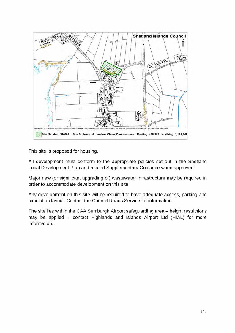
147
This site is proposed for housing.
All development must conform to the appropriate policies set out in the Shetland Local Development Plan and related Supplementary Guidance when approved.
Major new (or significant upgrading of) wastewater infrastructure may be required in order to accommodate development on this site.
Any development on this site will be required to have adequate access, parking and circulation layout. Contact the Council Roads Service for information.
The site lies within the CAA Sumburgh Airport safeguarding area – height restrictions may be applied – contact Highlands and Islands Airport Ltd (HIAL) for more information.

148
This site is proposed for housing.
All development must conform to the appropriate policies set out in the Shetland Local Development Plan and related Supplementary Guidance when approved.
Low density or single house development would be appropriate for this site.
Please note there is evidence of previous military activity within 250m of this site. Please contact Environmental Health for further details.
Any development on this site will be required to have adequate access, parking and circulation layout. Contact the Council Roads Service for information.
Details of water supply availability and sewerage infrastructure should be sought from Scottish Water.
The site lies within the CAA Sumburgh Airport safeguarding area – height restrictions may be applied – contact Highlands and Islands Airports Ltd (HIAL) for more information.

149
This site is proposed for housing.
All development must conform to the appropriate policies set out in the Shetland Local Development Plan and related Supplementary Guidance when approved.
A buffer will be required around watercourses.
Any development in this area must connect to the public sewer.
Details of water supply availability and sewerage infrastructure should be sought from Scottish Water.
Any development on this site will be required to have adequate access, parking and circulation layout. Contact the Council Roads Service for information.
This site has issues regarding access. Any development on this site will be required to have adequate access, parking and circulation layout. Contact the Council Roads Service for information.

150
This site is proposed for housing.
All development must conform to the appropriate policies set out in the Shetland Local Development Plan and related Supplementary Guidance when approved.
Any development in this area must connect to the public sewer.
Details of water supply availability and sewerage infrastructure should be sought from Scottish Water.
Any development on this site will be required to have adequate access, parking and circulation layout. Contact the Council Roads Service for information.

151
This site is proposed for housing.
All development must conform to the appropriate policies set out in the Shetland Local Development Plan and related Supplementary Guidance when approved.
Any development in this area must connect to the public sewer.
Details of water supply availability and sewerage infrastructure should be sought from Scottish Water.
Any development on this site will be required to have adequate access, parking and circulation layout. Contact the Council Roads Service for information.

152
This site is proposed for housing.
All development must conform to the appropriate policies set out in the Shetland Local Development Plan and related Supplementary Guidance when approved.
Any development in this area must connect to the public sewer.
Details of water supply availability and sewerage infrastructure should be sought from Scottish Water.
Any development on this site will be required to have adequate access, parking and circulation layout. Contact the Council Roads Service for information.

153
This site is proposed for housing.
A full Design Statement including details of development phasing will be required for this site.
All development must conform to the appropriate policies set out in the Shetland Local Development Plan and related Supplementary Guidance when approved.
A buffer will be required around watercourses.
Any development in this area must connect to the public sewer.
Details of water supply availability and sewerage infrastructure should be sought from Scottish Water.
Any development on this site will be required to have adequate access, parking and circulation layout. Contact the Council Roads Service for information.

154
This site is proposed for housing.
All development must conform to the appropriate policies set out in the Shetland Local Development Plan and related Supplementary Guidance when approved.
A buffer will be required around watercourses.
Any development in this area must connect to the public sewer.
Details of water supply availability and sewerage infrastructure should be sought from Scottish Water.
Any development on this site will be required to have adequate access, parking and circulation layout. Contact the Council Roads Service for information.

155
This site is proposed for housing.
A full Design Statement including details of development phasing will be required for this site.
Please note there is evidence of previous military activity within 250m of this site. Please contact Environmental Health for further details.
Any development on this site will be required to have adequate access, parking and circulation layout. Contact the Council Roads Service for information.
Details of water supply availability and sewerage infrastructure should be sought from Scottish Water.
Any development in this area must connect to the public sewer.
The site lies within the CAA Sumburgh Airport safeguarding area – height restrictions may be applied – contact Highlands and Islands Airport Ltd (HIAL) for more information.

156
This site is proposed for housing.
All development must conform to the appropriate policies set out in the Shetland Local Development Plan and related Supplementary Guidance when approved.
A buffer will be required around watercourses.
Any development in this area must connect to the public sewer.
Details of water supply availability and sewerage infrastructure should be sought from Scottish Water.
Any development on this site will be required to have adequate access, parking and circulation layout. Contact the Council Roads Service for information.
Please note there is evidence of previous military activity within 250m of this site. Please contact Environmental Health for further details.
The site lies within the CAA Sumburgh Airport safeguarding area – height restrictions may be applied – contact Highlands and Islands Airport Ltd (HIAL) for more information.

157
This site is proposed for housing or industrial use.
This site may be at risk of flooding and a flood risk assessment (FRA) will be required to determine which areas of the site, if any, can be developed.
Please note there is evidence of previous military activity within 250m of this site. Please contact Environmental Health for further details.
This proposed site is within 250m of a Scheduled Monument, please contact the Shetland Amenity Trust prior to progressing with this development to ensure the setting of the Scheduled Monument is not compromised.
Any development in this area must connect to the public sewer.
Details of water supply availability and sewerage infrastructure should be sought from Scottish Water.
Any development on this site will be required to have adequate access, parking and circulation layout. Contact the Council Roads Service for information.
There is low risk of archaeology in this area, please contact the Shetland Archaeologist at the Shetland Amenity Trust for further information.
The site lies within the CAA Sumburgh Airport safeguarding area – height restrictions may be applied – contact Highlands and Islands Airport Ltd (HIAL) for more information.
Part or all of this site lies beneath the 5m contour.

158
Further guidance on flood risk for this site is provided in the Council’s Strategic Flood Risk Assessment.
This site is proposed for housing.
Please note there is evidence of previous military activity within 250m of this site. Please contact Environmental Health for further details.
This proposed site is within 250m of a Scheduled Monument, please contact the Shetland Archaeologist at the Shetland Amenity Trust prior to progressing with this development to ensure the setting of the Scheduled Monument is not compromised.
Any development in this area must connect to the public sewer.
Any development on this site will be required to have adequate access, parking and circulation layout. Contact the Council Roads Service for information.
The site lies within the CAA Sumburgh Airport safeguarding area – height restrictions may be applied – contact Highlands and Islands Airport Ltd (HIAL) for more information.

159
This site is proposed for housing.
A full Design Statement including details of development phasing will be required for this site.
All development must conform to the appropriate policies set out in the Shetland Local Development Plan and related Supplementary Guidance when approved.
A buffer will be required around watercourses.
Any development in this area must connect to the public sewer.
Details of water supply availability and sewerage infrastructure should be sought from Scottish Water.
Any development on this site will be required to have adequate access, parking and circulation layout. Contact the Council Roads Service for information.

160
This site is proposed for housing.
All development must conform to the appropriate policies set out in the Shetland Local Development Plan and related Supplementary Guidance when approved.
A buffer will be required around watercourses.
Any development in this area must connect to the public sewer.
Details of water supply availability and sewerage infrastructure should be sought from Scottish Water.
Any development on this site will be required to have adequate access, parking and circulation layout. Contact the Council Roads Service for information.
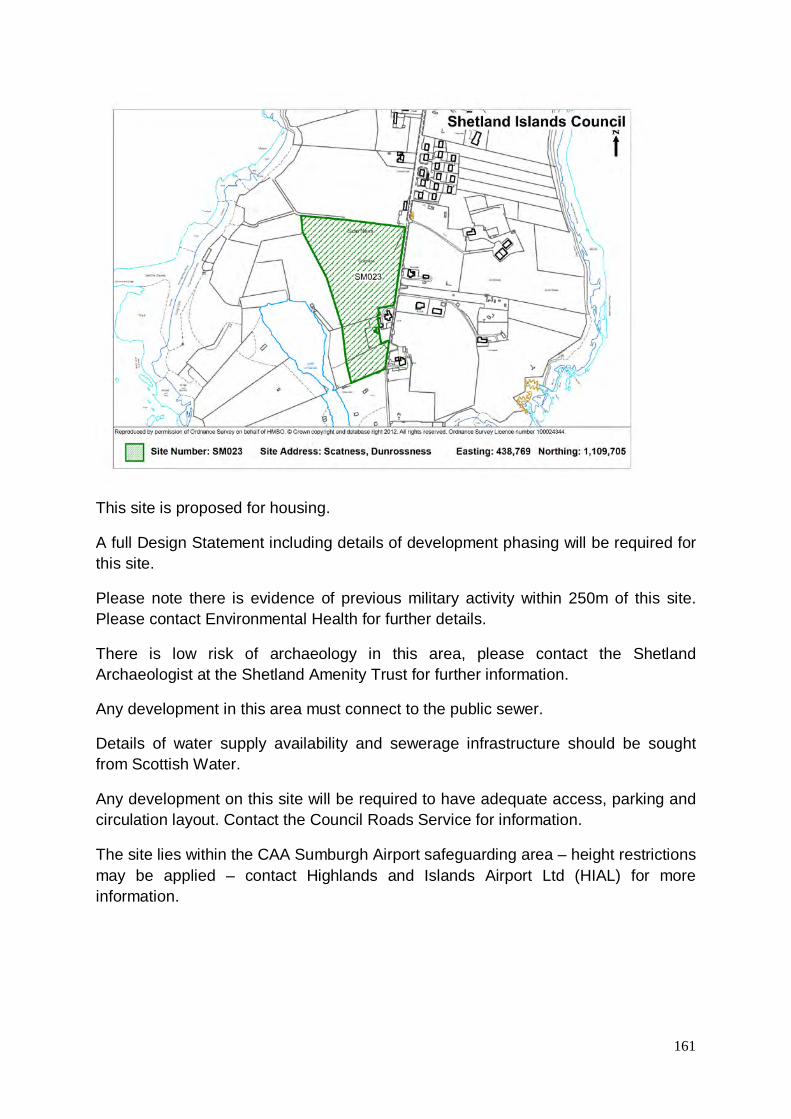
161
This site is proposed for housing.
A full Design Statement including details of development phasing will be required for this site.
Please note there is evidence of previous military activity within 250m of this site. Please contact Environmental Health for further details.
There is low risk of archaeology in this area, please contact the Shetland Archaeologist at the Shetland Amenity Trust for further information.
Any development in this area must connect to the public sewer.
Details of water supply availability and sewerage infrastructure should be sought from Scottish Water.
Any development on this site will be required to have adequate access, parking and circulation layout. Contact the Council Roads Service for information.
The site lies within the CAA Sumburgh Airport safeguarding area – height restrictions may be applied – contact Highlands and Islands Airport Ltd (HIAL) for more information.

162
This site is proposed for wind turbines.
Some capacity for small scale domestic wind turbine development.
A buffer will be required around watercourses.
Any development on this site will be required to have adequate access, parking and circulation layout. Contact the Council Roads Service for information.
All development must conform to the appropriate policies set out in the Shetland Local Development Plan and related Supplementary Guidance when approved.
The site lies within the CAA Sumburgh Airport safeguarding area – height restrictions may be applied – contact Highlands and Islands Airport Ltd (HIAL) for more information.

163
This site is proposed for housing.
All development must conform to the appropriate policies set out in the Shetland Local Development Plan and related Supplementary Guidance when approved.
The site has development potential for small scale development.
A buffer will be required around watercourses.
If a public sewer becomes available in this area prior to the site being developed, there would be a requirement to connect.
Details of water supply availability and sewerage infrastructure should be sought from Scottish Water.
Any development on this site will be required to have adequate access, parking and circulation layout. Contact the Council Roads Service for information.

164
This site is proposed for housing.
All development must conform to the appropriate policies set out in the Shetland Local Development Plan and related Supplementary Guidance when approved.
The site has development potential for small scale development.
A buffer will be required around watercourses.
If a public sewer becomes available in this area prior to the site being developed, there would be a requirement to connect.
Details of water supply availability and sewerage infrastructure should be sought from Scottish Water.
Any development on this site will be required to have adequate access, parking and circulation layout. Contact the Council Roads Service for information.
The site lies within the CAA Sumburgh Airport safeguarding area – height restrictions may be applied – contact Highlands and Islands Airport Ltd (HIAL) for more information.

165
This site is proposed for housing.
All development must conform to the appropriate policies set out in the Shetland Local Development Plan and related Supplementary Guidance when approved.
A buffer will be required around watercourses.
Details of water supply availability and sewerage infrastructure should be sought from Scottish Water.
Any development on this site will be required to have adequate access, parking and circulation layout. Contact the Council Roads Service for information.
If a public sewer becomes available in this area prior to the site being developed, there would be a requirement to connect.

166
This site is proposed for housing.
All development must conform to the appropriate policies set out in the Shetland Local Development Plan and related Supplementary Guidance when approved.
If a public sewer becomes available in this area prior to the site being developed, there would be a requirement to connect. In the absence of a public sewer, the site has potential only for small scale development.
Details of water supply availability and sewerage infrastructure should be sought from Scottish Water.
Any development on this site will be required to have adequate access, parking and circulation layout. Contact the Council Roads Service for information.

167
This site is proposed for housing.
A full Design Statement including details of development phasing will be required for this site.
All development must conform to the appropriate policies set out in the Shetland Local Development Plan and related Supplementary Guidance when approved.
A buffer will be required around watercourses.
Any development in this area must connect to the public sewer.
Details of water supply availability and sewerage infrastructure should be sought from Scottish Water.
Any development on this site will be required to have adequate access, parking and circulation layout. Contact the Council Roads Service for information.
Surface water drainage appraisal will be required.

168
This site is proposed for housing.
This site may be at risk of flooding and a flood risk assessment (FRA) will be required to determine which areas of the site, if any, can be developed.
All development must conform to the appropriate policies set out in the Shetland Local Development Plan and related Supplementary Guidance when approved.
A buffer will be required around watercourses.
Any development in this area must connect to the public sewer.
Details of water supply availability and sewerage infrastructure should be sought from Scottish Water.
Any development on this site will be required to have adequate access, parking and circulation layout. Contact the Council Roads Service for information.
Part or all of this site lies beneath the 5m contour.
Further guidance on flood risk for this site is provided in the Council’s Strategic Flood Risk Assessment.

169
This site is proposed for housing.
A full Design Statement including details of development phasing will be required for this site.
All development must conform to the appropriate policies set out in the Shetland Local Development Plan and related Supplementary Guidance when approved.
Any development in this area must connect to the public sewer.
This proposed site is within 250m of a listed building, please contact the Heritage Section prior to progressing with this development to ensure this historic setting is not compromised.
Details of water supply availability and sewerage infrastructure should be sought from Scottish Water.
Any development on this site will be required to have adequate access, parking and circulation layout. Contact the Council Roads Service for information.

170
This site is proposed for housing.
All development must conform to the appropriate policies set out in the Shetland Local Development Plan and related Supplementary Guidance when approved.
Any development in this area must connect to the public sewer.
Details of water supply availability and sewerage infrastructure should be sought from Scottish Water.
Any development on this site will be required to have adequate access, parking and circulation layout. Contact the Council Roads Service for information.

171
This site is proposed for housing.
All development must conform to the appropriate policies set out in the Shetland Local Development Plan and related Supplementary Guidance when approved.
A buffer will be required around watercourses.
Major new (or significant upgrading of) wastewater infrastructure will be required in order to accommodate development on this site.
If a public sewer becomes available in this area prior to the site being developed, there would be a requirement to connect. In the absence of a public sewer, the site has potential only for small scale development.
Details of water supply availability and sewerage infrastructure should be sought from Scottish Water.
Any development on this site will be required to have adequate access, parking and circulation layout. Contact the Council Roads Service for information.
There is high risk of archaeology in this area, please contact the Shetland Archaeologist at the Shetland Amenity Trust for further information.
Site is adjacent to a Sites of Special Scientist Interest contact Scottish Natural Heritage for more information.

172
This site is proposed for housing.
All development must conform to the appropriate policies set out in the Shetland Local Development Plan and related Supplementary Guidance when approved.
Major new (or significant upgrading of) wastewater infrastructure will be required in order to accommodate development on this site.
If a public sewer becomes available in this area prior to the site being developed, there would be a requirement to connect.
Details of water supply availability and sewerage infrastructure should be sought from Scottish Water.
Any development on this site will be required to have adequate access, parking and circulation layout. Contact the Council Roads Service for information.

173
This site is proposed for housing.
All development must conform to the appropriate policies set out in the Shetland Local Development Plan and related Supplementary Guidance when approved.
Any development in this area must connect to the public sewer.
Details of water supply availability and sewerage infrastructure should be sought from Scottish Water.
Any development on this site will be required to have adequate access, parking and circulation layout. Contact the Council Roads Service for information.

174
This site is proposed for housing.
All development must conform to the appropriate policies set out in the Shetland Local Development Plan and related Supplementary Guidance when approved.
A buffer will be required around watercourses.
Any development in this area must connect to the public sewer.
Details of water supply availability and sewerage infrastructure should be sought from Scottish Water.
Any development on this site will be required to have adequate access, parking and circulation layout. Contact the Council Roads Service for information.
There is low risk of archaeology in this area, please contact the Shetland Archaeologist at the Shetland Amenity Trust for further information.
This site may be at risk of flooding and a flood risk assessment (FRA) will be required to determine which areas of the site, if any, can be developed.
This proposed site is within 250m of a listed building, please contact the Heritage Section prior to progressing with this development to ensure this historic setting is not compromised. Consideration should be given to the following factors: design, layout, density and setting when developing detailed proposals.
Part or all of this site lies beneath the 5m contour.

175
Further guidance on flood risk for this site is provided in the Council’s Strategic Flood Risk Assessment.
This site is proposed for housing.
A full Design Statement including details of development phasing will be required for this site.
All development must conform to the appropriate policies set out in the Shetland Local Development Plan and related Supplementary Guidance when approved.
A buffer will be required around watercourses.
Details of water supply availability and sewerage infrastructure should be sought from Scottish Water.
Any development on this site will be required to have adequate access, parking and circulation layout. Contact the Council Roads Service for information.
Major new (or significant upgrading of) wastewater infrastructure may be required in order to accommodate development on this site.

176
This site is proposed for housing.
All development must conform to the appropriate policies set out in the Shetland Local Development Plan and related Supplementary Guidance when approved.
A buffer will be required around watercourses.
Any development in this area must connect to the public sewer.
Details of water supply availability and sewerage infrastructure should be sought from Scottish Water.
Any development on this site will be required to have adequate access, parking and circulation layout. Contact the Council Roads Service for information.

177
This site is proposed for housing.
All development must conform to the appropriate policies set out in the Shetland Local Development Plan and related Supplementary Guidance when approved.
A buffer will be required around watercourses.
Any development in this area must connect to the public sewer.
Details of water supply availability and sewerage infrastructure should be sought from Scottish Water.
Any development on this site will be required to have adequate access, parking and circulation layout. Contact the Council Roads Service for information.

178
This site is proposed for housing.
All development must conform to the appropriate policies set out in the Shetland Local Development Plan and related Supplementary Guidance when approved.
A buffer will be required around watercourses.
Any development in this area must connect to the public sewer.
Details of water supply availability and sewerage infrastructure should be sought from Scottish Water.
This site may be at risk of flooding and a flood risk assessment (FRA) will be required to determine which areas of the site, if any, can be developed.
Part or all of this site lies beneath the 5m contour.
This site has issues regarding access. Any development on this site will be required to have adequate access, parking and circulation layout. Contact the Council Roads Service for information.
A full Design Statement including details of development phasing will be required for this site.
Further guidance on flood risk for this site is provided in the Council’s Strategic Flood Risk Assessment.

178
Areas of Best Fit Maps To see the Maps, please click on the link below: Areas of Best Fit Maps

179
Designated Sites Map To see the Maps, please click on the link below: Designated Sites Map

180
Proposals Maps To see the Maps, please click on the link below: Proposals Maps
