sfra user guide - st. helens · st helens council sfra - user guide report final draft 1 ......
TRANSCRIPT

St Helens Council SFRA - User Guide Report FINAL DRAFT 1
SFRA User Guide
This User Guide provides specific guidance for the SFRA and should be used by all involved in the development planning process. This Guide contains four key chapters comprising:
Guidance for Spatial Planners Guidance for Development Management Guidance for Developers Guidance for Flood Risk Management
SFRA Mapping
A suite of strategic flood risk maps have been produced for the SFRA. These maps should be used to locate development away from areas at high risk of flooding.
Future development planning also needs to make reference to this suite of strategic flood risk maps, as well as any updated information provided by the LPA and Environment Agency.
Use of SFRA Data
Whilst all data used in the preparation of this SFRA has been supplied to the LPA (including reports, mapping, GIS datasets and development allocation assessments) there is a need to maintain controls over the data and how it is applied and modified. It is anticipated that the SFRA and associated maps will be published on the Council's website as a set of interactive GeoPDFs. As the central source of SFRA data, these maps should be made available for download.
The LPA will be able to use the flood outlines and flood risk data used in this SFRA for internal use. The use of this information must consider the context within which it was produced. The use of this data will fall under the license agreement between the LPA and the Environment Agency as it has been produced using Environment Agency data. It should be remembered that more detailed FRAs, where required, should seek to refine the understanding of flood risk from all sources to any particular site.
SFRA data should not be passed on to third parties outside of the LPA. Any third party wishing to use existing Environment Agency flood risk datasets should contact Environment Agency External Relations department. A charge is likely to apply for the use of this data.

St Helens Council SFRA - User Guide Report FINAL DRAFT 2
Contents 1 Guidance for Spatial Planners .........................................................................10
1.1 Introduction ..........................................................................................................10 1.2 Sequential Test....................................................................................................11 1.3 Exception Test .....................................................................................................12 1.4 Applying the Sequential Test and assessing the likelihood of passing the
Exception Test .....................................................................................................13 1.5 Flood Risk and other Land Use Policies..............................................................15
2 Guidance for Development Management........................................................17
2.1 Introduction ..........................................................................................................18 2.2 The Sequential Test and Exception Test.............................................................18 2.3 Supporting the FRA Process ...............................................................................19
3 Guidance for Developers ..................................................................................20
3.1 Introduction ..........................................................................................................20 3.2 The Sequential Test and Exception Test.............................................................21 3.3 Site specific Flood Risk Assessments .................................................................22 3.4 FRA Guidance .....................................................................................................25 3.5 Critical Drainage Areas........................................................................................27 3.6 Considering risk of flooding from other sources ..................................................27
4 Guidance for Flood Risk Management ............................................................32
4.1 Introduction ..........................................................................................................32 4.2 Strategic Approach ..............................................................................................32 4.3 Potential mitigation measures .............................................................................32
Appendices ..................................................................................................................... i
A . Flood Risk Concepts......................................................................................... i
B . Stakeholder Engagement and Data Management ..........................................xi
C . Flood Risk Vulnerability Classification ...........................................................xiii
D . Sustainable Drainage Systems ........................................................................xv
E . Flood Risk Mitigation ........................................................................................xx
List of Figures Figure 1-1: First and Second Pass of Proposed Development Sites Sequential
Test......................................................................................................................14
Figure 1-2: Identifying the Likelihood of Passing the Exception Test ......................14
Figure 3-1: FRA Preparation..........................................................................................25
Figure A-2 (Source-Pathway-Receptor model) ............................................................viii

St Helens Council SFRA - User Guide Report FINAL DRAFT 3
List of Tables Table 2-1: FRA considerations and SFRA supporting evidence ...............................19
Table 3-1: Development types and application of Sequential and Exception Tests....................................................................................................................21
Table 3-2: FRA considerations and SFRA supporting evidence ...............................24
Table A1: Reservoir Consequence Classification....................................................... iv
Table A2: NFCDD Condition Ratings for Flood Defences ..........................................v
Table A3: Flood Hazard ratings..................................................................................... ix
Table B1: Stakeholder Involvement..............................................................................xi
Figure D1: SuDS Management Train Principle ............................................................xv
Table D1: Suitability of SuDS Techniques ...................................................................xvi

St Helens Council SFRA - User Guide Report FINAL DRAFT 4
Abbreviations ABD Areas Benefiting from Defences AEP Annual Exceedance Probability CFMP Catchment Flood Management Plans AIMS Asset Information Management System CLG Communities and Local Government COW Critical Ordinary Watercourses CRR Community Risk Register CSO Combined Sewer Overflow DPDs Development Plan Documents DTM Digital Terrain Model EA Environment Agency ELA Employment Land Availability EU European Union FCERM Flood and Coastal Erosion Risk Management FRA Flood Risk Assessment FRM Flood Risk Management LDDs Local Development Documents LDF Local Development Framework LIDAR Light Detection and Ranging LPAs Local Planning Authorities NFCDD National Fluvial and Coastal Defence Database PPS Planning Policy Statement NPPF National Planning Policy Framework RFRA Regional Flood Risk Assessment RBMP River Basin Management Plans RPB Regional Planning Bodies RPG Regional Planning Guidance RSS Regional Spatial Strategy SA Sustainability Appraisal SAB SuDS Approval Body SCI Statement of Community Involvement SEA Strategic Environmental Assessment SFRA Strategic Flood Risk Assessment SHLAA Strategic Housing Land Availability Assessment SMP Shoreline Management Plans SoP Standard of Protection SuDS Sustainable (Urban) Drainage Systems SWMP Surface Water Management Plan UDP Unitary Development Plan uFMfSW updated Flood Map for Surface Water WCS Water Cycle Study WFD Water Framework Directive YW Yorkshire Water

St Helens Council SFRA - User Guide Report FINAL DRAFT 5
Glossary Actual risk
The risk posed to development situated within a defended area (i.e. behind defences), is expressed in terms of the probability that the defence will be overtopped, and/or the probability that the defence will suffer structural failure and the consequences should the failure occur.
Annual exceedence probability
The estimated probability of a flood of given magnitude occurring or being exceeded in any year. Expressed as, for example, 1 in 100 chance or 1 per cent Annual Exceedence Probability (AEP).
Adoption of sewers
The transfer of responsibility for the maintenance of a system of sewers to a sewerage undertaker.
Attenuation
Reduction of peak flow and increased duration of a flow event usually by temporary storage of flood water.
Catchment Flood Management Plans (CFMP)
A strategic planning tool through which the Environment Agency seeks to work with other key decision-makers within a river catchment to identify and agree policies for sustainable flood risk management.
Climate change
Long-term variations in global temperatures and weather patterns, as a consequence of both natural causes and as a result of human activity.
Compensation storage
A floodplain area introduced to compensate for the loss of storage as a result of land raising for development purposes.
Design event
A historic or notional flood event of a given annual flood probability, against which the suitability of a proposed development is assessed and mitigation measures, if any, are designed.
Design event exceedence
Flooding resulting from an event which exceeds the magnitude for which the defences protecting a development were designed (see residual risk).
Design flood level
The maximum estimated water level during the design event.
DG5 register
Register held by water companies on the location of properties at risk of flooding from public sewers
Exceedence flow
Excess flow that emerges on the surface once the conveyance capacity of a drainage system is exceeded.

St Helens Council SFRA - User Guide Report FINAL DRAFT 6
Extreme Flood Outline
Flood ‘zone’ maps released by the Environment Agency in showing anticipated undefended 0.1% AEP flood extents in a consistent manner throughout the UK.
Flood defence
Flood defence infrastructure, such as flood walls and embankments, intended to protect an area against flooding to a specified standard of protection.
Flood Map
A map produced by the Environment Agency providing an indication of the likelihood of flooding within all areas of England and Wales, assuming there are no flood defences. Only covers flooding from rivers and the sea.
Floodplain
Area of land that borders a watercourse, an estuary or the sea, over which water flows in times of flood, or would flow but for the presence of flood defences where they exist.
Flood Estimation Handbook (FEH)
Provides current methodologies for estimation of flood flows for the UK.
Flood Risk Management (FRM)
The introduction of mitigation measures (or options) to reduce the risk posed to property and life as a result of flooding. It is not just the construction of physical flood defences.
Flood risk management strategy
A long-term approach setting out the objectives and options for managing flood risk, taking into account a broad range of technical, social, environmental and economic issues.
Flood Risk Assessment (FRA)
A study to assess the risk to an area or site from flooding, now and in the future, and to assess the impact that any changes or development on the site will have on flood risk to the site and elsewhere. It may also identify, particularly at more local levels, how to manage those changes to ensure that flood risk is not increased.
Flood risk management measure
Any measure which reduces flood risk such as flood defences.
Flood Zone
A geographic area within which the flood risk is in a particular range, as defined by EA flood mapping.
Fluvial
Flooding caused by overtopping of rivers or stream banks.
Freeboard
The difference between the flood defence level and the design flood level, which includes a safety margin for residual uncertainties.
Greenfield land
Land that has not been previously developed.
ISIS
ISIS is a software package used for 1-Dimensional river modelling. It is used as an analysis tool for flood risk mapping, flood forecasting and other aspects of flood risk management analysis.

St Helens Council SFRA - User Guide Report FINAL DRAFT 7
Local Plan
Local Plans make strategic provision for the long-term use of land and buildings, providing a framework for local decision making and the reconciliation of competing development and conservation interests.
Main River
A watercourse designated on a statutory map of Main Rivers, maintained by Defra, on which the Environment Agency has permissive powers to construct and maintain flood defences (and powers to control development).
Major development
A major development is:
a) where the number of dwellings to be provided is ten or more, or the site area is greater than 0.5 ha or
b) non-residential development, where the floor space to be provided is greater than 1,000 m2 or the site area is greater than 1 ha.
National Planning Policy Framework (NPPF)
The National Planning Policy Framework sets out the Government’s planning policies for England and how these are expected to be applied. This replaces PPS25.
Ordinary watercourse
All rivers, streams, ditches, drains, cuts, dykes, sluices, sewers (other than public sewer) and passages through which water flows which do not form part of a Main River. Local authorities and, where relevant, Internal Drainage Boards have similar permissive powers on ordinary watercourses, as the Environment Agency has on Main Rivers.
Permitted development rights
Qualified rights to carry out certain limited forms of development without the need to make an application for planning permission, as granted under the terms of the Town and Country Planning (General Permitted Development) Order (2010).
Planning Policy Statement (PPS)
A statement of policy issued by central Government to replace Planning Policy Guidance notes.
Pound length
The length of a section of canal between locks is referred to as pound length.
Previously developed land
Land which is or was occupied by a permanent structure, including the curtilage of the developed land and any associated fixed surface infrastructure (PPS3 Annex B) (often referred to as Brownfield land).
Reservoir (large raised)
A reservoir that holds at least 10,000 cubic metres of water above natural ground level, as defined by the Flood and Water management Act (2010).
Residual risk
The risk which remains after all risk avoidance, reduction and mitigation measures have been implemented.
Resilience
Constructing a building in such a way that although flood water may enter the building, its impact is minimised, structural integrity is maintained and repair, drying & cleaning are facilitated.

St Helens Council SFRA - User Guide Report FINAL DRAFT 8
Resistance
Constructing a building in such a way as to prevent flood water entering the building or damaging its fabric. This has the same meaning as flood proof.
Return period
The long-term average period between events of a given magnitude which have the same annual exceedence probability of occurring.
Risk
The threat to property and life as a result of flooding, expressed as a function of probability (that an event will occur) and consequence (as a result of the event occurring).
Runoff
The flow of water from an area caused by rainfall.
Section 106 Agreement
Section 106 of the Town and Country Planning Act 1990 (as amended) allowing local planning authorities to negotiate arrangements whereby the developer makes some undertaking if he/she obtains planning permission. These are known interchangeably as planning agreements, planning obligations or planning gain.
Section 106 (Water Industry Act 1991)
A key section of the Water Industry Act 1991, relating to the right of connection to a public sewer.
Standard of Protection (SOP)
The design event or standard to which a building, asset or area is protected against flooding, generally expressed as an annual exceedence probability.
Strategic Environmental Assessment (SEA)
European Community Directive (2001/42/EC) which assesses the effects of certain plans and programmes on the environment.
Strategic Flood Risk Assessment (SFRA)
The assessment of flood risk on a catchment-wide basis for proposed development in a Local Planning Authority area. Should be first point of consultation in all development proposals.
Sustainable Drainage Systems (SuDS)
A sequence of management practices and control structures, often referred to as SuDS, designed to drain water in a more sustainable manner than some conventional techniques. Typically these are used to attenuate runoff from development sites and involve infiltration to groundwater wherever feasible.
Sustainability Appraisal (SA)
An integral part of the plan-making process which seeks to appraise the economic, social and environmental effects of a plan in order to inform decision-making that aligns with sustainable development principles.
TUFLOW
TUFLOW is a software package used for 2-Dimensional river modelling. It is used as an analysis tool for flood risk management.
Vulnerability Classes
NPPF (Table 3) provides a vulnerability classification to assess which uses of land maybe appropriate in each flood risk zone.
St Helens Council SFRA - User Guide Report FINAL DRAFT 9
Washland
An area of the floodplain that is allowed to flood or is deliberately flooded by a river or stream for flood management purposes.
Water Framework Directive (WFD)
A European Community Directive (2000/60/EC) of the European Parliament and Council designed to integrate the way water bodies are managed across Europe. It requires all inland and coastal waters to reach “good status" or "good potential status” by 2015 through a catchment-based system of River Basin Management Plans, incorporating a programme of measures to improve the status of all natural water bodies.
Windfall sites
Sites which become available for development unexpectedly and are therefore not included as allocated land in a planning authority’s development plans.

St Helens Council SFRA - User Guide Report FINAL DRAFT 10
1 Guidance for Spatial Planners
1.1 Introduction
1.1.1.1 The SFRA provides the basis for the sequential approach. The LPA should consider flood risk, the mechanism of flooding as well as the spatial distributions and development vulnerability in all stages of the development planning process.
1.1.1.2 The SFRA promotes positive planning to deliver strategic opportunities that reduce flood risk to communities.
The purpose of this section of the report is to provide guidance to Spatial Planners ondealing with allocations using the SFRA.
• Scope the Sustainability Appraisal of the Local Plan
o Screen development options
o Produce appropriate flood risk indicators
• Avoid sites at high risk of flooding where no other planning objectives outweigh flood risk
o Using Sustainability Appraisal and Site Assessment Spreadsheet.
• Carry out the Sequential Test on proposed development sites
o Using information provided in the SFRA and Site Assessment Spreadsheet to avoid sites at high risk.
• Identify those sites where a greater understanding of flood risk is required
o These should include key development sites at high risk of flooding.
• Identify the likelihood of sites passing the Exception Test
o Using the Sustainability Appraisal to assess development sites with regards to other planning objectives and assign weight given to flood risk as a planning constraint;
o Using information provided in the SFRA to assess the level of risk to each site and likelihood of it remaining safe. If a site cannot pass all the criteria of the Exception Test it cannot be approved.
• Allocate appropriate development through the Sustainability Appraisal
o Produce evidence that both Tests have been applied by noting the outcome and decisions made to avoid, substitute or allocate the site.
• Draft flood risk policies and develop guidance on each allocated site within the Sustainability Appraisal
o Guidance should include the need for site-specific FRAs.

St Helens Council SFRA - User Guide Report FINAL DRAFT 11
1.1.1.3 Throughout the risk-based sequential testing process, opportunities to minimise flood risk at each stage of the planning process need to be considered. The primary aim of these actions is to ensure that risks to people and property are effectively managed. The hierarchy of management decisions and actions comprise:
Avoidance, by locating new development outside areas at risk of flooding; Substitution, by changing from more vulnerable to less vulnerable land uses; and, Control & Mitigation of residual risks, by implementing suitable flood risk
management measures.
1.1.1.4 The SFRA provides information on flood risk allowing the LPA to:
Produce appropriate policies for development control and site allocation; Produce appropriate flood risk indicators that inform the Sustainability Appraisal; Undertake the Sequential Test and (with sufficient and suitable information)
Exceptions Testing; and, Allocate appropriate land use for development.
1.1.1.5 It is recommended that a supporting document is prepared, by the LPA, recording decisions made for each proposed development site. This should include all evidence considered in making a decision and this record will form the evidence base that demonstrates that both the Sequential and Exception Test have been applied.
1.1.1.6 In granting planning permission it will be the requirement of Development Control officers to confirm that all parts of the Exception Test have been addressed. During the initial spatial planning stage, only the likelihood of passing the Exception Test can be assessed. To pass the Exception Test a site-specific FRA will be required to identify constraints and demonstrate that safe development is achievable.
1.1.1.7 The SFRA also provides information to allow planners to make strategic decisions that identify the amount and type of development that may be suitable in the community. It also summarises potential strategic mitigation strategies that may be required for development to be feasible in the area.
1.2 Sequential Test
1.2.1.1 When allocating or approving land for development in flood risk areas, those responsible for making development decisions are expected to demonstrate that there are no suitable alternative development sites located in lower flood risk areas.
1.2.1.2 The Sequential Test is the key driver for the SFRA. In order to carry out the Sequential Test the LPA need to know:
Spatial extent of flood risk within the whole LPA area Flood Zones
• Flood Zone 1 – Low Probability: less than 0.1% AEP fluvial flood event
• Flood Zone 2 – Medium Probability: between a 1% AEP and 0.1% AEP fluvial flood event
• Flood Zone 3a – High Probability: with a 1% AEP or greater fluvial flood event
• Flood Zone 3b – Functional Floodplain: land where water has to flow or be stored in times of flood. This is land which would flood with an annual probability of 1 in 20 (5% AEP) or greater in any year or is designed to flood in an extreme (0.1% AEP) flood.
Flooding from other sources Location of proposed development sites and the proposed vulnerability of that
development in flood risk terms.

St Helens Council SFRA - User Guide Report FINAL DRAFT 12
1.2.1.3 There are a number of steps that Spatial Planners may follow when Sequentially Testing sites and assessing the likelihood that a site will pass the Exception Test. These are:
The LPA is required to prioritise the allocation of land for development in ascending order from FZ 1 to FZ 3 (including subdivisions of FZ 3 into FZ 3a and FZ 3b);
The general approach to be followed when assessing sites is included as Figure 1-1. This, combined with the information provided in the Site Assessment Spreadsheet, should be used to identify those sites to be avoided where risk is considered too great;
Identify those sites where substitution is possible due to high percentage of land within lower flood risk areas;
Using Figure 1-2, identify those sites that may pass the Exception Test. Remove those
sites where: a. There is little or no planning justification; b. Where sites are located on Greenfield land; c. Where development will require drastic and complicated mitigation measures
to make the site safe. Produce a supporting document recording all decisions made during the decision-
making process. Each proposed development site should be referenced and the decisions made to avoid, substitute, or allocate the site and the evidence and/or reasoning used to make the decision should be recorded.
1.2.1.4 There are a number of key challenges faced by the LPA in applying the Sequential Test. The Sequential Test is purely based on the Flood Zones, but these zones only take account of fluvial and tidal flooding, which ignore the presence of flood risk management measures such as defences. Other sources of flooding must also be considered in the spatial distribution of development such as surface water flooding, identified through the updated Flood Map for Surface Water (uFMfSW). However, it can be problematic to map the spatial extent of flooding from other sources as well as matching the level of risk associated with other sources with those presented within the three Flood Zones. For instance, Flood Zone 3 cannot be directly related to a high susceptible area at risk of surface water flooding as the probability and consequences are significantly different.
1.2.1.5 Whilst it may not be appropriate to avoid development at risk from other sources of flooding, risk should be considered when taking a sequential approach to land use or the substitution of lower development vulnerability in higher risk areas within a development site.
1.3 Exception Test
1.3.1.1 If the Sequential Test has been successfully applied and the LPA cannot allocate development in lower flood risk areas, then the vulnerability of development should be considered.
1.3.1.2 Only once the vulnerability of the development is defined should an assessment be made of whether or not that development is appropriate within that Flood Zone and whether the Exception Test needs to be applied.
1.3.1.3 Where new development is exceptionally necessary within areas at risk of flooding, Government policy aims to make it safe without increasing flood risk elsewhere and where possible reducing overall flood risk.
1.3.1.4 NPPF provides a good explanation as to what type of development the Exception Test needs to be applied. In some situations, for certain types of development, it is not appropriate to use the Exception Test to justify development. For example, highly vulnerable development cannot be justified within the high risk zone through the use of the Exception Test.

St Helens Council SFRA - User Guide Report FINAL DRAFT 13
1.3.1.5 It will be the requirement of Development Management officers to make sure all parts of the Exception Test have been passed in granting planning permission. At a Spatial Planning stage, only the likelihood of passing the Exception Test can be assessed, as actually passing the Test will require the completion of a site-specific FRA to determine if the site and its occupiers will be safe during times of flood.
1.3.1.6 What should be done at this early stage of the planning process is to identify those sites in which the Exception Test is required and to avoid those sites in which flood risk is too great, using the information provided in the SFRA, or there is no overriding planning objectives for that development.
1.4 Applying the Sequential Test and assessing the likelihood of passing the Exception Test
1.4.1.1 This section provides the following guidance on how Spatial Planners are to apply the Sequential and Exception Test within the Sustainability Appraisal of LDDs.
1.4.1.2 What the following guidance will do, if followed appropriately, is produce clear and transparent evidence that both the Sequential and Exception Test have been applied.
1.4.1.3 The guidance provided in this SFRA User Guide should be interpreted as a practicable approach in how the LPA should apply the Sequential and Exception Tests within the preparation of Local Plans.
1.4.2 Spatial Planning Flow Diagrams and Tables
1.4.2.1 The following flow diagrams and tables provide a recommended approach for Spatial Planners in applying the two tests, keeping in mind the flood risk management hierarchy of avoid, substitute, control and mitigate, whilst identifying and allocating sustainable development sites.
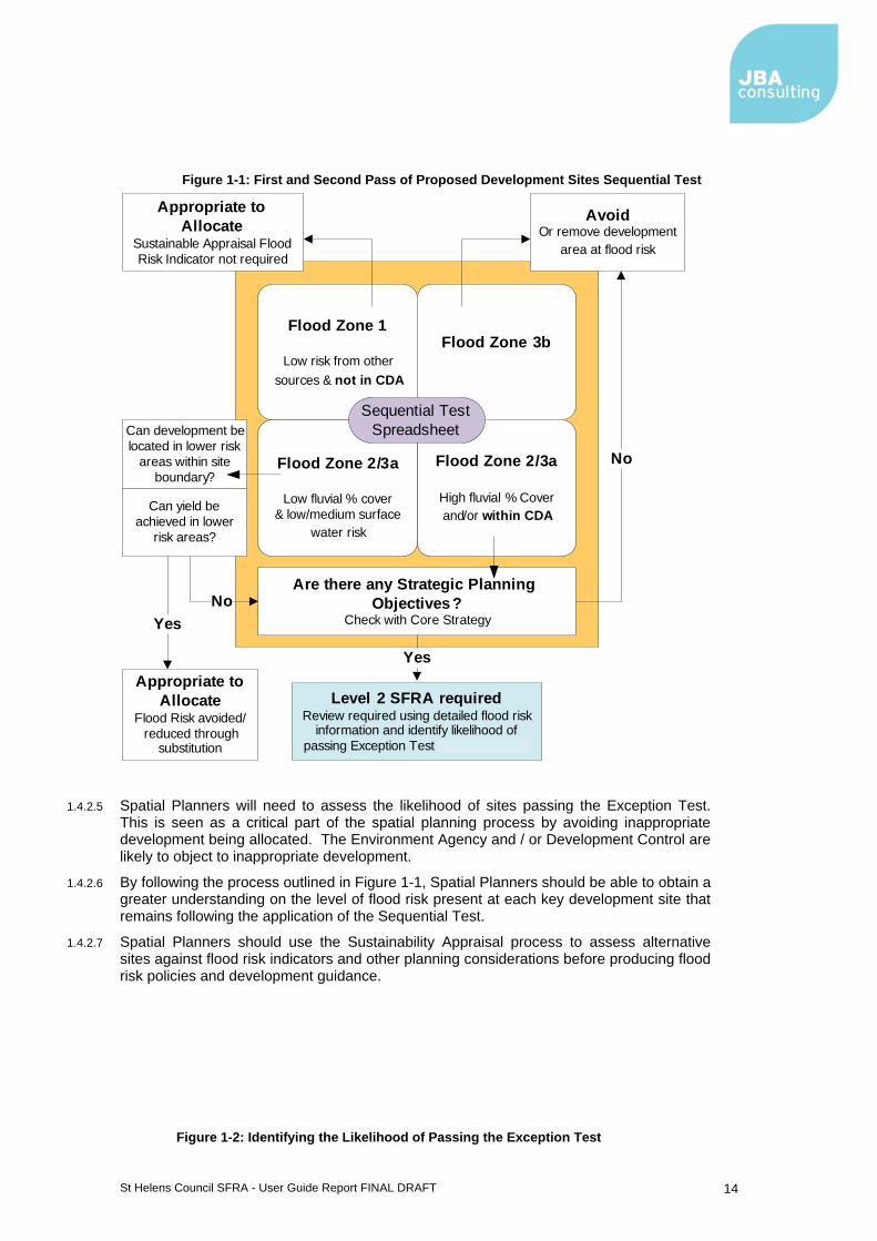
1.4.2.2 Figure 1-2, illustrates the Sequential and Exception Tests as a process. The main inputs being the evidence provided in the SFRA and the LPA Core Strategy and Sustainability Appraisal. The flow diagram begins by the LPA assessing alternative development options at a strategic scale using the Sustainability Appraisal. This expands to use evidence provided in the SFRA to avoid inappropriate development sites, substitution within the site boundary and identifying those sites requiring Exception Testing. The flow diagram concludes by revisiting and updating the Sustainability Appraisal with the allocation of development sites.
1.4.2.3 During this process there is a need to identify which sites should be avoided or substituted, those which can go forward, or once the Sequential Test has been applied how to assess if the site will remain safe during the Exception Test. This is a step wise process and must be documented, but a challenging one as a number of the criteria used are qualitative and based on experienced judgement.
1.4.2.4 Figure 1-1 provides additional guidance on using the Site Assessment Spreadsheet produced in the SFRA. Figure 1-2 provides guidance on how to assess the likelihood of sites passing the Exception Test using key questions and evidence.
St Helens Council SFRA - User Guide Report FINAL DRAFT 14
Figure 1-1: First and Second Pass of Proposed Development Sites Sequential Test
Flood Zone 1
Low risk from other sources & not in CDA
Flood Zone 2/3a
High fluvial % Cover and/or within CDA
Flood Zone 2/3a
Low fluvial % cover & low/medium surface
water risk
Flood Zone 3b
Are there any Strategic Planning Objectives?
Check with Core Strategy
AvoidOr remove development
area at flood risk
Can yield be achieved in lower
risk areas?
Level 2 SFRA requiredReview required using detailed flood risk
information and identify likelihood of passing Exception Test (see Figure 2-5)
Can development be located in lower risk
areas within site boundary?
Appropriate to Allocate
Sustainable Appraisal Flood Risk Indicator not required
No
Appropriate to Allocate
Flood Risk avoided/reduced through
substitution
Yes
YesNo
Sequential Test Spreadsheet
1.4.2.5 Spatial Planners will need to assess the likelihood of sites passing the Exception Test. This is seen as a critical part of the spatial planning process by avoiding inappropriate development being allocated. The Environment Agency and / or Development Control are likely to object to inappropriate development.
1.4.2.6 By following the process outlined in Figure 1-1, Spatial Planners should be able to obtain a greater understanding on the level of flood risk present at each key development site that remains following the application of the Sequential Test.
1.4.2.7 Spatial Planners should use the Sustainability Appraisal process to assess alternative sites against flood risk indicators and other planning considerations before producing flood risk policies and development guidance.
Figure 1-2: Identifying the Likelihood of Passing the Exception Test

St Helens Council SFRA - User Guide Report FINAL DRAFT 15
Level 2 SFRADetailed Flood Risk Information
Actual Risk
Are flood depths > 1.5mAre flood hazards dangerous for most or higher?
Climate Change sensitive?Are mitigation measures significant?
Could requirement for compensational storage impact of yields achievable?
Will development add more buildings/people to the community at risk?
Residual Risk
Are they Acceptable?Is the community covered by a flood warning system?Can appropriate access & egress routes be identified?
Is flood risk an urban design issue?Are compensation works possible?
Are mitigation measures achievable/appropriate and could they reduce risk to the surrounding community?
Proposed development site is unlikely to pass the
Exception Test on flood risk grounds. The site should be
avoided at this stage and withdrawn from the
Sustainability Appraisal
Assess alternative development options using Sustainability Appraisal , balancing flood risk
against other planning objectives
Key Questions
SFRA Evidence
Fluvial Depth Maps Fluvial Hazard Maps
Climate Change Sensitivity Maps
SFRA User Guide Table 5-1
SFRA Evidence
Fluvial Overtopping Depth & Hazard Maps
Breach Depth & Hazard MapsCanal Hazard Zones Maps
Flood Risk Management Maps
Yes
No
No
Yes
Produce Evidence Base and Allocate Development Sites within Sustainability
Appraisal
1.5 Flood Risk and other Land Use Policies
1.5.1.1 Flood risk is a material consideration in land use planning decision making and can greatly impact on the sustainability of various land uses in all locations. Having applied the Sequential Test and Exception Test where necessary, the resultant assessment of appropriateness and associated flood risk information will then influence the land use planning decision at whatever level it is being considered.
1.5.1.2 Land use policies and wider strategic decisions involving social and economic development in the LDDs will be influenced and shaped by the sequential approach informed by this SFRA.
1.5.1.3 For instance, Green Infrastructure (GI) is a planned and managed network of natural environmental components and green spaces that intersperse and connect the urban centres, suburbs and rural fringe consisting of:
Open Spaces – parks, woodlands, nature reserves, lakes Linkages – River corridors and canals, pathways and cycle routes and greenways Networks of “urban green” – private gardens, street trees, verges and green roofs

St Helens Council SFRA - User Guide Report FINAL DRAFT 16
1.5.1.4 With regards to flood risk, green spaces can be used to manage storm flows and free up water storage capacity in existing infrastructure to reduce risk of damage to urban property, particularly in city centres and vulnerable urban regeneration areas. GI can also improve accessibility to waterways and improve water quality, supporting regeneration and improving opportunity for leisure, economic activity and biodiversity.
GI should be incorporated into master planning and individual sites, directed by the need to retain exceedence flood paths and the natural attenuation of flood flows.
1.5.1.5 Areas identified as functional floodplain within the SFRA can act as river corridors which would provide an excellent linkage of GI and can provide flood storage during a flood event. Areas identified within the urban environment or upstream of Critical Drainage Areas (CDA) should be incorporated into GI strategies. Opening up land to create flow paths or flood storage areas can help protect current and future developments.

St Helens Council SFRA - User Guide Report FINAL DRAFT 17
2 Guidance for Development Management
The aim of this Section is to provide guidance on the use of the SFRA by Development Management.
When reviewing individual planning applications, Planners should use the Guidance in this SFRA User Guide, NPPF and the PPS25 Practice Guide to:
• Check whether the Sequential Test and/or the Exception Test have already been applied
o Refer developer to Local Plan and supporting evidence to identify if the Sequential Test has been applied and development is likely to pass the Exception Test (a site may have already been assessed) ;
o If evidence is available, the Sequential Test and likelihood of passing the Exception Test have been assessed. If no evidence is available, developers must carry out the Sequential and Exception Tests.
• Refer developer to the following in order for them to apply the Sequential and Exception Tests
o SFRA (to inform Sequential Test);
o Site Assessment Spreadsheet (to compare similar sites already assessed);
o SFRA (to inform Exception Test);
o SFRA maps (to review scale and nature of flood risk and residual risk);
• Consult with Environment Agency and other relevant stakeholders to
o Assess flood risk constraints identified on site using the SFRA
• Scope an appropriate FRA
o What is the scale and nature of risk from all sources?
o Does the site lie within a CDA?
o Are there any strategic mitigation requirements identified in the SFRA or Local Plan?
• Consult with Environment Agency over FRA acceptance/approval
St Helens Council SFRA - User Guide Report FINAL DRAFT 18
2.1 Introduction
2.1.1.1 The LPA are the decision-makers on planning applications for new development. Whilst it is the developer’s responsibility to fully consider flood risk issues, the LPA should be involved during any pre-application discussions.
2.1.1.2 Following on from recommendations made in the Pitt Review, Development Management must take some of the roles and responsibilities from the Environment Agency as the first point of call in Flood Risk Management and planning applications.
2.1.1.3 Flood risk needs to be considered at a strategic level by Development Control officers, even though applications for proposed developments are submitted on a site by site basis. Applications may need to fit within a wider flood risk management strategy for an area rather than on a site by site basis.
2.1.1.4 Consideration of flood risk within the context of an individual planning application highlights flood risk that may be taken into account using information provided within the SFRA, as well as the guidance provided in NPPF and the EA's Standing Advice.
2.1.1.5 Development Management officers must always consider development from a strategic view point and the accumulative effect of all proposed development taking place, even though applications for developments are submitted at a site level. It should not be presumed that flood risk has been understood at a strategic high level and that one application may need to fit within a flood risk management strategy for an area.
2.2 The Sequential Test and Exception Test
2.2.1.1 Even if the proposed site is already identified as having been Sequentially Tested and having passed the Sequential Test, supported by the findings of the SFRA, (and transparent evidence that the Sequential Test has been passed) the developer must still apply the sequential approach to site layout when matching land use vulnerability.
2.2.1.2 However, where a site has not been identified as tested, then the Sequential Test will need to be applied i.e. the developer will need to provide evidence to the LPA that there are no other reasonable available sites where the development could be located. The LPA will then use this information to apply the Sequential Test. This particularly applies to Windfall Sites that have not been previously allocated.
2.2.1.3 Developers will need to provide evidence that the Exception Test can be passed. This will be needed for allocated sites and windfall sites, if required according to the vulnerability of the proposed land use, areas requiring redevelopment or regeneration, redevelopment of existing single properties or changes of use (changes of use only apply to caravan, camping, chalet sites or mobile home sites). Development Management will then need to review the evidence provided and decide whether a site passes the Exception Test.
2.2.1.4 Development in certain existing communities may find it difficult to pass both the Sequential Test and Exception Test due to the nature of flood risk and/or the scale of mitigation which would be required in order to make the development safe. In these instances, development applications should be refused and these areas should be transformed into flood risk policies by the LPA.

St Helens Council SFRA - User Guide Report FINAL DRAFT 19
2.3 Supporting the FRA Process
2.3.1.1 All development applications must be supported by an appropriate site-specific FRA in accordance with the guidance provided in PPS25 Practice Guide Section 3.70 to 3.89.
2.3.1.2 At the earliest practical stage, Development Management should refer developers to the SFRA including the associated flood risk mapping. The developer should also be referred to the appropriate flood risk policies which could potentially influence their development proposals.
2.3.1.3 If a site has been identified as being at risk of flooding from any source, Development Management and the developer should consult the Environment Agency and other relevant flood risk consultees, such as Yorkshire Water and the Canal and River Trust, to identify known flood-related site constraints and agree the scope of an FRA.
2.3.1.4 The Environment Agency Standing Advice should be used at this stage. This can be accessed online (http://www.environment-agency.gov.uk/research/planning/82584.aspx).
2.3.1.5 The Environment Agency is a statutory consultee for specific categories of development where flood risk is an issue. Table 2-1 outlines when a more detailed FRA may be required.
Table 2-1: FRA considerations and SFRA supporting evidence
Considerations Supporting evidence in the SFRA
The development other than minor development is situated in Flood Zone 2 and 3
Flood Zone maps or Flood Map on Environment Agency website if updated. See PPS25 Practice Guide Section 2.43 for definition of minor developments
The development is situated in Flood Zone 1, but there are critical drainage problems (i.e. the development lies within a Critical Drainage Area) or the site has been identified as being at risk of flooding from other sources. (The requirement for an FRA in this instance is not set out in the SFRA but would need to be a local policy matter for it to be justified and should be discussed in more detail with Council planning officers)
Critical Drainage Area maps (Level 2 SFRA), Updated Flood Map for Surface Water maps
The development is at risk of flooding from other sources of flooding
Updated Flood Map for Surface Water maps, Areas Susceptible to Ground Water Flooding map
The development is situated behind flood defences (possibility of overtopping during extreme flood event or breach)
Flood Risk Management maps, Flood Zone maps, climate change maps. Depth and hazard maps for both the 1 in 100 year and 1 in 1000 year flood events from FRM modelling studies (Level 2 SFRA)
The development exceeds 1ha in size Consult Environment Agency
The development is within 20 m of the bank top of a Main River – the Environment Agency will have to consent to any work within 8 m of a Main River and are likely to object in principal to any development within these areas
Consult Environment Agency
Any culverting operation or development which controls the flow of any Main River or stream. Ordinary Watercourses are now the responsibility of LLFAs and IDBs
Consult Environment Agency

St Helens Council SFRA - User Guide Report FINAL DRAFT 20
3 Guidance for Developers
3.1 Introduction
3.1.1.1 The SFRA provides the evidence base for developers to assess flood risk at a strategic level and determine the requirements of an appropriate site-specific FRA.
3.1.1.2 Developers will need to liaise closely with the LPA in the first instance to determine if a site is suitable for development. If a site is considered suitable then developers should prepare a site-specific FRA.
3.1.1.3 Developers should consider all sources of flood risk when assessing the suitability of a site. Guidance on developing within Critical Drainage Areas (CDA) and areas at risk from sources other than fluvial flooding is provided in this section
The aim of this Section is to provide guidance to Developers on using the SFRA.
Developers should use the Guidance in this SFRA User Guide, NPPF and the PPS25 Practice Guide to:
• Assess whether the site is a
o Windfall development, allocated development, within a regeneration area, single property or change of use to identify if Sequential and Exception Tests are required.
• Check whether the Sequential Test and/or the Exception Test have already been applied
o Request information from the LPA on whether the Sequential Test or likelihood of the site passing the Exception Test have been assessed;
o If not, provide evidence to the LPA that the site passes the Sequential Test and will pass the Exception Test.
• Consult with LPA Development Control, the Environment Agency and the wider group of flood risk consultees, where appropriate, to scope an appropriate FRA if required
o Guidance on FRAs provided in this SFRA User Guide;
o Also refer to Environment Agency Standing Advice, CIRIA Report C624, NPPF, PPS25 Practice Guide;
o Consult LPA emergency planners if required.
• Submit FRA to Development Control and Environment Agency for approval, where necessary
St Helens Council SFRA - User Guide Report FINAL DRAFT 21
3.2 The Sequential Test and Exception Test
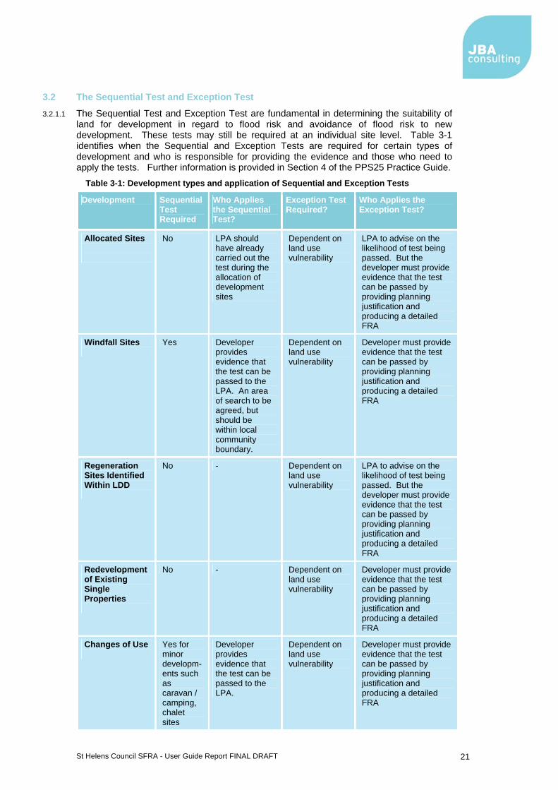
3.2.1.1 The Sequential Test and Exception Test are fundamental in determining the suitability of land for development in regard to flood risk and avoidance of flood risk to new development. These tests may still be required at an individual site level. Table 3-1 identifies when the Sequential and Exception Tests are required for certain types of development and who is responsible for providing the evidence and those who need to apply the tests. Further information is provided in Section 4 of the PPS25 Practice Guide.
Table 3-1: Development types and application of Sequential and Exception Tests
Development Sequential Test Required
Who Applies the Sequential Test?
Exception Test Required?
Who Applies the Exception Test?
Allocated Sites
No LPA should have already carried out the test during the allocation of development sites
Dependent on land use vulnerability
LPA to advise on the likelihood of test being passed. But the developer must provide evidence that the test can be passed by providing planning justification and producing a detailed FRA
Windfall Sites
Yes Developer provides evidence that the test can be passed to the LPA. An area of search to be agreed, but should be within local community boundary.
Dependent on land use vulnerability
Developer must provide evidence that the test can be passed by providing planning justification and producing a detailed FRA
Regeneration Sites Identified Within LDD
No - Dependent on land use vulnerability
LPA to advise on the likelihood of test being passed. But the developer must provide evidence that the test can be passed by providing planning justification and producing a detailed FRA
Redevelopment of Existing Single Properties
No - Dependent on land use vulnerability
Developer must provide evidence that the test can be passed by providing planning justification and producing a detailed FRA
Changes of Use
Yes for minor developm-ents such as caravan / camping, chalet sites
Developer provides evidence that the test can be passed to the LPA.
Dependent on land use vulnerability
Developer must provide evidence that the test can be passed by providing planning justification and producing a detailed FRA
St Helens Council SFRA - User Guide Report FINAL DRAFT 22
3.3 Site specific Flood Risk Assessments
3.3.1.1 The principal aims of an FRA are to determine the level of flood risk to a site and to confirm that suitable flood management measures can be developed to control flooding, and safeguard life and property, without increasing risk to the surrounding area.
3.3.1.2 Once the site has been Sequentially Tested, and has been identified as being likely to pass the Exception Test, a site-specific FRA should be undertaken. The LPA and EA should be consulted in order to determine the content and scope of the FRA.
3.3.1.3 There are three levels of FRA:
Level 1 is a screening study used to identify whether there are any flooding or surface water management issues that need to be considered further;
Level 2 is a scoping study that should be undertaken if the Level 1 FRA indicates that there are flood risk issues that need further consideration; and,
Level 3, which is a detailed study, where further quantitative analysis is required to fully assess flood issues and confirm that effective mitigation measures can be implemented to control flood risk.
3.3.1.4 The SFRA is an assessment of flood risk at a strategic level. This information can be used to provide evidence for Level 1 and Level 2 FRAs. Where a more detailed FRA is required, then a developer should undertake a detailed assessment of the flood risk at the site. The scope of the FRA should be agreed by the developer through consultation with the LPA and EA.
3.3.1.5 Where a more detailed FRA is required the developer should undertake a detailed assessment of the flood risk to the site, using the SFRA to appraise flood risk issues and referring to the guidance in this SFRA User Guide, NPPF, PPS25 Practice Guide and CIRIA Report Development and Flood Risk. Developers should satisfy themselves that the data provided in this SFRA is up-to-date and accurate for use in their development proposals.
3.3.1.6

St Helens Council SFRA - User Guide Report FINAL DRAFT 23
Table 3-2 indicates when a more detailed FRA is likely to be required. The actual scope of the FRA should be agreed between the developer, LPA and Environment Agency before it is undertaken.

St Helens Council SFRA - User Guide Report FINAL DRAFT 24
Table 3-2: FRA considerations and SFRA supporting evidence
Considerations Supporting evidence in the SFRA
The development other than minor development is situated in Flood Zone 2 and 3
Flood Zone maps or Flood Map on Environment Agency website if updated. See PPS25 Practice Guide Section 2.43 for definition of minor developments
The development is situated in Flood Zone 1, but there are critical drainage problems (i.e. the development lies within a Critical Drainage Area) or the site has been identified as being at risk of flooding from other sources
Critical Drainage Area maps (Level 2 SFRA), Updated Flood Map for Surface Water maps, consult appropriate LLFA
The development is at risk of flooding from other sources of flooding
Updated Flood Map for Surface Water maps, Areas Susceptible to Ground Water Flooding map
The development is situated behind flood defences (possibility of overtopping during extreme flood event or breach)
Flood Risk Management maps, Flood Zone maps, climate change maps. Depth and hazard maps for both the 1 in 100 year and 1 in 1000 year flood events from FRM modelling studies (Level 2 SFRA)
The development exceeds 1ha in size Consult Environment Agency
The development is within 20 m of the bank top of a Main River – the Environment Agency will have to consent to any work within 8 m of a Main River and are likely to object in principal to any development within these areas.
Consult Environment Agency
Any culverting operation or development which controls the flow of any Main River or stream. Ordinary Watercourses are now the responsibility of LLFAs and IDBs
Consult Environment Agency, consult appropriate LLFA / IDB
3.3.1.7 The detail required for each level of FRA is highlighted in Figure 3-1. The production of a site-specific FRA can be seen as an iterative process with those carrying out a Level 1 FRA before moving on to a Level 2 and finally a Level 3. It is appropriate to review the level of risk present and assess whether development is appropriate and achievable at each stage of the assessment.
3.3.1.8 Significant consultation with the LPA and EA may be required for complex development proposals. Complex developments may need to include flood mitigation measures and compensatory storage.
3.3.1.9 Figure 3-1 also links the evidence provided in the SFRA which can inform the decision making process.

St Helens Council SFRA - User Guide Report FINAL DRAFT 25
Figure 3-1: FRA Preparation
IdentifySourcesPathwaysReceptors
Primary & Secondary Hazards
DetermineTypes of impactScale of impact
Potential compensation measures
ConfirmMitigation measures
are suitable for development
Test for:Climate Change
adaptabilityExtreme event performance of
measures
Critical Phase: Reduce
The impacts of mitigation
measures and development
MitigatePotential Surface water-runoff from
the sites
Broad assessment of flood hazard
Simplified assessment of consequences/
impacts of development Detailed
assessment of current risks to
development with mitigation
Test for robustness
Design of compensation works
Design of flow balancing
Level 1/2 FRA(Screening & Scoping)
Level 3 FRA(Detailed Assessment)
Level 1-2 SFRA (Input)
EA Flood Map
Level 1 SFRASources identified
Level 2 SFRAResidual risks
Is the site within Critical Drainage
Area?PPS25 SUDS
Recommendations
Are there any strategic Flood Risk Mitigation
requirements identified in Level 2 SFRA?
SummaryResidual risks
Off-site impactsMitigation Measures employed
SFRA Climate Change Sensitivity Maps
Rev
iew
aga
inst
Gui
delin
es b
efor
e pr
ocee
ding
Level 2 SFRADepths & Hazard
maps
3.4 FRA Guidance
3.4.1.1 Flood Risk Assessments should follow the approach recommended by:
The Environment Agency Standing Advice (http://www.environment-agency.gov.uk/research/planning/82584.aspx)
CIRIA Report C624 Development and Flood Risk (Guidance for the Construction Industry) and;
NPPF; PPS25 Practice Guide
3.4.1.2 These documents describe when an FRA is required and the general issues that should be considered. The key requirements of a FRA are provided in Section 3 of the PPS25 Practice Guide. In general, the FRA should address the following issues:
1. Development Description and Locations What is the type of development and where will it be located? What is the vulnerability classification of the current and future building use?
St Helens Council SFRA - User Guide Report FINAL DRAFT 26
Has the development site been assessed during the Level 1 and Level 2 SFRAs? (If so has the Sequential and Exceptions Testing been completed already?)
2. Definition of Flood Hazard What are the sources of flooding at the site? For each source how would flooding occur, referencing any historical records. What existing surface water drainage infrastructure is present on the site?
(Consult with LPA, EA and United Utilities) 3. Probability Confirm the FZ designation for the site (refer to the Flood Zone (FZ) maps) Determine the actual and residual risks at the site (refer to the FZ maps, depth
and hazards maps (Level2 SFRA) and Flood Risk Management maps What are the discharge rates and volumes generated by the existing site and
proposed development? 4. Climate Change How is flood risk at the site likely to be affected by climate change?
5. Flood Risk Management Measures How will the site be protected from flooding, including the potential impacts of
climate change, over the lifetime of the development? 6. Off Site Impacts How will the proposed development and measures be implemented to protect the
site from flooding and control surface water run-off be designed and implemented?
7. Residual Risks What flood-related risks will remain after mitigation measures have been
implemented? How, and by whom, will these risks be managed over the lifetime of the
development? Is an emergency Flood Plan required?
8. Groundwater This mechanism of flooding should be considered particularly when determining
the acceptability of SuDS schemes as a way of managing surface water drainage. Developers should consult with the LPA and EA at an early stage of the assessment.
9. Sewer systems Where the SFRA has identified a risk of surface water flooding, any water that
escapes from the sewer system would tend to follow similar flow paths and pond in similar locations.
Developers should take account of the guidance for development in CDAs. Where required, liaison with United Utilities should be undertaken at an early stage in the assessment process to confirm localised sewer flooding problems that could affect the site.
Future development should be designed so that it does not increase existing sewer flooding problems.
St Helens Council SFRA - User Guide Report FINAL DRAFT 27
3.5 Critical Drainage Areas
In certain locations an increase in the rate of surface water runoff is known to make development susceptible to localised flooding. Insufficient capacity in the surface water drainage system may exacerbate localised flood risk in areas outside of the EA Flood Zones.
A detailed FRA would be expected for planned development within these areas regardless of Flood Zone designation. This should demonstrate that new development is not at risk of flooding from existing drainage systems, will not increase risk to adjacent development or land and will include appropriate mitigation measures to safely control surface water runoff.
Ideally, developers shall work closely with the LPA, EA and United Utilities to develop strategies that manage surface water runoff. Where Greenfield development is proposed, the aim should be to not increase runoff rates above the existing Greenfield rates. Where brownfield development is proposed then the EA actually seek a reduction in the overall runoff rate. Wherever possible, this should be achieved through the use of SuDS, constructed within the development site.
The effectiveness of a flow management scheme within a single site is limited by site constraints including (but not limited to) topography, geology (soil permeability), development density, adoption issues and available area. The design, construction and ongoing maintenance regime of such a scheme must be carefully defined at an early stage.
LPAs can designate CDAs as high flood risk areas.
3.6 Considering risk of flooding from other sources
3.6.1.1 Flood Risk Assessments (FRA) must take account of flood risk from all sources. The SFRA provides a more detailed analysis of actual and residual risk associated with flooding. At some locations there may be hydraulic interactions between different flooding sources. Where this is the case the FRA should look at the possible interactions in more detail. A FRA should reference any completed Surface Water Management Plan for guidance.
3.6.2 Canals
3.6.2.1 A FRA should consider the residual risk associated with canals overtopping and breaching. The developer should liaise with the LPA and Canal and River Trust to determine applicable emergency planning arrangements.
St Helens Council SFRA - User Guide Report FINAL DRAFT 28
3.6.3 Considering the general risk of canal flooding
3.6.3.1 Developers should be aware that any site that is at or below canal water level may be subject to canal flooding. However, the canal water volume is finite and a FRA should be used to show in detail what residual risk could be associated with the canal. In its mitigation, building resilience into low level properties may apply or land may be raised.
3.6.4 Reservoirs
3.6.4.1 As part of a FRA, the developer should undertake a zone of search around their site to identify any reservoirs that lie on higher land. The risk of flooding from reservoirs should be considered in the FRA (which will be subject to the available data and national security implications of such an assessment).
3.6.4.2 Where this identifies smaller reservoirs, the FRA should determine the owner and maintenance regime of the reservoir. A more detailed investigation of the effects of the reservoir overtopping or failing should be undertaken. The developer should then liaise with the LPA and reservoir owner to determine applicable emergency planning requirements or mitigation needs. Where there is significant flood hazard identified to the site from such failure, and especially from unmaintained reservoirs, the developer should liaise closely with the LPA about the suitability of the site for development.
3.6.5 Drainage for new developments
3.6.5.1 Development has the potential to cause an increase in impermeable area, an associated increase in surface water runoff rates and volumes, and a consequent potential increase in downstream flood risk due to overloading of sewers, watercourses, culverts and other drainage infrastructure. The sewer network in many places across Yorkshire was designed to drain less development than that exists today. Development has added flow over time and the drainage network is known to be at capacity in many places.
3.6.5.2 Controlling surface water discharges from new development is a crucial consideration if flood risk to new and existing development downstream is to be effectively managed. Planned development can also play a role in reducing the number of properties that are directly at risk from surface water flooding. The Planning System has a key role to play in settings standards for sustainable drainage from new developments and ensuring that developments are designed to take account of the risk from surface water flooding. Sustainable drainage plays an important part in reducing flows in the sewer network and in meeting environmental targets, alongside investment in maintenance and new capacity by United Utilities. United Utilities plan their investment on a five year rolling cycle, in consultation with key partners, including the Environment Agency.
3.6.5.3 Sustainable drainage and the use of Sustainable Drainage Systems (SuDS) is supported by the policy direction in Future Water1, Making Space for Water2, the Pitt Review3 and the Flood and Water Management Act4 that provides for more sustainable management of the water cycle, working in partnership across different agencies and new responsibilities for local flood risk management. In particular, the Flood and Water Management Act requires developers where practicable, to include sustainable drainage in new developments to reduce flood risk and improve water quality. It includes ‘a requirement on developers to demonstrate that they have met national standards for the application of SuDS techniques before they can connect any residual surface water drainage to a public sewer (amending section 106 of the Water Industry Act 1991).’ As part of their new responsibility for local flood risk management, local authorities will be responsible for approving SuDS for new developments and adopting and maintaining them as part of a SuDS Approval Body (SAB).
1 Defra (2008) Future Water 2 Defra, Department for Transport, HM Treasury and Office of the Deputy Prime Minister (2005) Making Space for water: Taking forward a new Government strategy for flood and coastal erosion risk management in England; First Government response to the autumn 2004 Making space for water consultation exercise 3 The Pitt Review (2008) Learning lessons from the 2007 floods 4 Defra (2010) Flood and Water Management Act © Crown Copyright

St Helens Council SFRA - User Guide Report FINAL DRAFT 29
3.6.5.4 Recognising the above, drainage from new developments should incorporate storage, with residual discharge of surface water to the following networks in order of preference:
Infiltration drainage (e.g. SuDS - soakaways) Discharge to a watercourse Discharge to a public sewer
3.6.5.5 The choice of system will be determined by local ground conditions (including groundwater levels). Whilst infiltration SuDS may be the most suitable for new development, developers must consider the risk of contamination to underlying aquifers.
3.6.5.6 The guidance below should be used in addition to the Environment Agency Standing Advice5.
3.6.6 Development sites in the wider local authority districts
3.6.6.1 Developers should use the following guidance regarding surface water runoff from new developments:
Allowable discharge rates
Development should deliver Greenfield runoff on Greenfield sites up to a 1 in 100 year storm event, considering climate change
Development should aim for a reduction in surface water runoff rates of at least 30% for Brownfield sites up to a 1 in 100 year storm event, considering climate change
Development should be designed so that there is no flooding to the development in a 1 in 30 year event and so that there is no property flooding in a 1 in 100 year plus climate change event
There may be local variations on this where outfalls are directly to larger watercourses and hence surface water discharges from development sites can pass downstream before the main peak on the watercourse.
3.6.6.2 Wherever possible, this should be achieved through the implementation of SuDS. Source control should be considered firstly. There may be opportunities to deliver SuDS through integrated solutions for collections of strategic sites. The future ownership and maintenance of SuDS systems should be discussed at the planning application stage with the relevant sections of the LPA (including Highways and Drainage), United Utilities and the Environment Agency. More detail on SuDS is available in Appendix D.
3.6.6.3 The developer should liaise closely with the local authority drainage engineer, the Environment Agency and United Utilities to determine appropriate discharge rates. The developer should prove that surface water discharges from the site will not have an adverse impact on flood risk elsewhere, with reference to investment planning by United Utilities that may increase the capacity of the sewer network in the area.
Overland flow paths
3.6.6.4 Underground drainage systems have a finite capacity and regard should always be given to larger events when the capacity of the network will be exceeded. Hence there is a need to design for exceedance. This should be considered alongside any surface water flows likely to enter a development site from the surrounding area.
5 Environment Agency. Flood Risk Standing Advice for England - PPS25 National Version 2.0. Can be accessed online at http://www.environment-agency.gov.uk/research/planning/82584.aspx
St Helens Council SFRA - User Guide Report FINAL DRAFT 30
3.6.6.5 Master planning should ensure that existing overland flow paths are retained within the development. As a minimum the developer should investigate, as part of a FRA, the likely depths and extents of surface water flooding on a development site when the national updated Flood Map for Surface Water (uFMfSW) indicates that there is a risk of surface water flooding. This is a precautionary, but an appropriate approach to reduce the risk of flooding to new developments. Green infrastructure should be used wherever possible to accommodate such flow paths. Floor levels should always be set a minimum of 300mm above adjacent roads to reduce the consequences of any localised flooding.
3.6.6.6 The effectiveness of a flow management scheme within a single site is heavily limited by site constraints including (but not limited to) topography, geology (soil permeability), development density, existing drainage networks within the site and surrounding area, adoption issues and available area. The design, construction and ongoing maintenance regime of such a scheme must be carefully defined at an early stage and a clear and comprehensive understanding of the catchment hydrological processes (i.e. nature and capacity of the existing drainage system) is essential.
3.6.7 Critical Drainage Areas
Certain locations are particularly sensitive to an increase in the rate and volume of surface water runoff from new development. There are generally known local flooding problems associated with these areas. These areas help to define the proposed Critical Drainage Areas (CDAs) in the SFRA. Specific drainage requirements are required in these areas to help reduce local flood risk. The SFRA has designated CDAs as high flood risk areas.
3.6.7.1 These are areas with complex surface water flooding problems that would benefit from a drainage strategy, which is most effectively carried out through a Surface Water Management Plan (SWMP).
3.6.7.2 The proposed CDAs, recommended in the SFRA, should be designated as part of a Level 2 SFRA and refined over time as more detailed information on flood risk and local flood management assets, including sewered catchments, becomes available.
3.6.7.3 In these areas, a detailed FRA is required regardless of which Flood Zone that applies. This should demonstrate that new development is not at risk from flooding from existing drainage systems or potential overland flow routes. It should also demonstrate that the development will not adversely affect existing flooding conditions by the use of appropriate mitigation measures. The FRA should define and address the constraints that will govern the design of the drainage system and layout of the development site.
3.6.7.4 The Environment Agency Standing Advice allows developers to screen online for the level of flood risk assessment that is appropriate for a development with regard to the NPPF Flood Zones. This highlights the need for a FRA in Flood Zones 2 and 3 and in Flood Zone 1 where there are critical drainage problems. The Standing Advice notes that for developments in Flood Zone 1 FRA Guidance Note 16 should be followed:
3.6.7.5 ‘In areas where the Local Planning Authority has identified drainage problems through a Strategic Flood Risk Assessment or Surface Water Management Plan and they have indicated that a formal flood risk assessment is required’. FRA Guidance Note 1 requires FRAs to provide ‘Proposals for surface water management that aims to not increase, and where practicable reduce the rate of runoff from the site as a result of the development (in accordance with sustainable drainage principles, and the Local Planning Authority’s published SFRA).’
3.6.7.6 Proposals for development in Critical Drainage Areas should follow the guidance and standards as set out below for developments that are within any Flood Zone.
6 Environment Agency. Flood Risk Assessment (FRA) Guidance Note 1, Development Greater Than 1 Hectare (ha) in Flood Zone 1 (and Critical Drainage areas less than 1ha) Can be accessed online at http://www.environment-agency.gov.uk/static/documents/Research/FRAGuidanceNote1.pdf

St Helens Council SFRA - User Guide Report FINAL DRAFT 31
Allowable discharge rates
3.6.7.7 Development should seek to reduce existing local flooding problems and not add to them. The following guidance should be followed:
Development should deliver Greenfield runoff on Greenfield sites up to a 1% AEP storm event, considering climate change
Development should aim for a minimum reduction in surface water runoff rates of 50% for Brownfield sites, with an aim of reducing runoff to Greenfield rates up to a 1% AEP storm event, considering climate change
Development should be designed so that there is no flooding to the development in a 1 in 3.33 AEP event and so that there is no property flooding in a 1 in 100 year plus climate change event
3.6.7.8 Over time, it is envisaged that local authorities will commission drainage strategies (see below) to determine in more detail and establish the evidence base for set reductions in surface water runoff from development sites. With regard to this, the developer should liaise closely with the Environment Agency, United Utilities and LPA as soon as possible to determine an appropriate reduction in runoff rate and volume with reference to discharge limits as laid down by any completed SWMP or Drainage Strategy for that area.
3.6.7.9 Wherever possible, this should be achieved through the implementation of SuDS. Source control should be considered firstly. There may be opportunities to deliver SuDS though integrated solutions for collections of strategic sites. The future ownership and maintenance of SuDS systems should be discussed at the planning application stage with the relevant sections of the LPA (including Highways and Drainage), United Utilities and the Environment Agency. This approach should be taken unless the developer can demonstrate that this is not feasible and that there will be no adverse impact caused by the development elsewhere.
3.6.7.10 This is supported by Category 4 of the Code for Sustainable Homes, which requires developers to ensure that peak run-off rates and run-off volumes will be no greater than the pre-development conditions as a minimum. However, the code recommends that attenuation of the additional flows caused by development should be related to the degree of flood risk in an area. In ‘high flooding risk areas’ 100% of the additional volume should be attenuated.7 Planning Policy Statement 18 allows Local Planning Authorities to stipulate high levels of the code where there are local circumstances that allow and warrant it.
3.6.8 Integrated drainage
3.6.8.1 There is the potential for groups of development sites coming forward to share a central and integrated solution for managing surface water runoff. This is best investigated further through a SWMP or a Drainage Strategy. Such solutions can provide great benefits besides water management, including providing recreational facilities, improving biodiversity and making communities a better place to live. Where there are several sites that would share a communal facility, such sites may be funded through developer Section 106 or Community Infrastructure Levy payments. Drainage Strategies can be particularly useful for considering, recommending the implementation of and long term management arrangements for SuDS and setting appropriate runoff rates from new development.
7 CLG (2006) Code for Sustainable Homes 8CLG (2007) Planning Policy Statement: Planning and Climate Change - Supplement to Planning Policy Statement 1
St Helens Council SFRA - User Guide Report FINAL DRAFT 32
4 Guidance for Flood Risk Management
4.1 Introduction
4.1.1.1 Throughout the risk-based sequential approach, opportunities should be taken to minimise flood risk at every stage of the planning process.
4.1.1.2 Mitigation measures should be seen as a last resort to address flood risk issues.
4.1.1.3 Mitigation measures must be designed to provide an appropriate level of protection to a site for the lifetime of the development. At many sites it may be technically feasible to mitigate or manage flood risk. However, the potential impacts of mitigation measures on flood risk to the surrounding community must be considered. Where the depth of flooding is substantial, these mitigation measures may result in practical constraints to development with significant financial implications.
4.1.1.4 The minimum acceptable standard of protection against flooding for new property within flood risk areas is the 1% AEP flood event for fluvial flooding, including allowance for climate change over the lifetime of the development.
4.2 Strategic Approach
4.2.1.1 Mitigation measures should be considered on a strategic basis to avoid a piecemeal approach and partnership is advocated between the LPA and EA. Measures should also be integrated with wider EA flood risk management works and strategies such as the CFMP.
4.2.1.2 Outline flood risk mitigation strategies should consider the wider, cumulative impacts of mitigation. This requires master-planning an area from a flood-risk perspective.
4.2.1.3 In summary, taking a strategic approach to flood risk management involves consideration of:
Avoidance of development in flood risk areas; Implementing a sequential approach to site layout, substituting higher vulnerability
development in lower flood risk areas; Considering flooding from all sources; Wherever possible, using open land or green infrastructure to reduce risk, (e.g. by
providing compensatory flood storage); Adopting mitigation measures that contribute to the wider community objectives
for flood risk management in risk areas, (developers should aim to reduce risk to the wider community);
The design and use of SuDS; and, Preparing emergency flood plans.
4.3 Potential mitigation measures
4.3.1.1 Mitigation measures should fit into the wider strategic FRM approach, that is advocated for a community and ensure that there is no increase in flood risk to the surrounding community. The developer should liaise closely the Environment Agency and Development Management as to what mitigation measures may be suitable.
4.3.1.2 A summary of mitigation measures has been produced in Appendix E.

St Helens Council SFRA - User Guide Report FINAL DRAFT i
Appendices
A . Flood Risk Concepts
A.1 Introduction
Flooding is a natural process and can happen at any time in a wide variety of locations. It constitutes a temporary covering of land not normally covered by water and presents a risk when people, infrastructure and development and environmental assets are present in the area which floods. Assets at risk from flooding can include housing, transport and public service infrastructure, commercial and industrial enterprises, agricultural land and the environmental and cultural heritage.
Climate change predictions are that flood risk will increase due to more frequent severe storms bringing higher intensity rainfall and increasing run-off from land and buildings. This will cause rivers and streams to experience higher than normal flood flows and levels, and sewers and drains to surcharge more frequently than at present. The focus of activity in meeting these challenges in the future will be on flood risk management as opposed to simply providing flood defences. It is now widely recognised that whilst we cannot always prevent flooding we can manage the risks of it happening and reduce the consequences when flooding does happen.
As authorities, the EA and LPAs, should embrace effective flood risk management issues and actions. The focus should aim to reduce flood risks through a variety on measures including:
Through the planning process ensuring that vulnerable land uses are located away from high flood risk areas;
Providing flood warning and emergency planning in flood risk areas; Raising awareness of flood risks amongst vulnerable communities; Constructing and maintaining appropriately designed surface water sewers and
culverts; Using temporary and demountable flood defences and various flood prevention
systems to buildings where appropriate; Constructing new flood defences where they are sustainable, and improving and
maintaining those already existing; and Constructing weirs, sluices and other flood flow control and management structures.
Pro-active land use planning has a key role to play in flood risk management as it is one of the few activities that can result in the avoidance of flood risk as opposed to other activities that can only hope to reduce it. Effective flood risk management through the planning system is achieved through a hierarchy where:
Avoidance of inappropriate development in high risk zones takes priority; Substitution of lower vulnerability uses when avoidance is not considered possible;
and Mitigation if avoidance and substitution are not possible, then mitigation of risks using
a variety of techniques may be considered. Flood risk assessment at all levels of planning and for all major developments is
critical to inform decision-making by planners and developers.
A.2 Sources of Flooding
Flooding can occur from many different sources and may be experienced in isolation or as a

St Helens Council SFRA - User Guide Report FINAL DRAFT ii
combined flooding event. Different types and forms of flooding present a range of different risks. The associated hazards of speed of inundation, depth and duration of flooding can vary greatly.
With climate change, the frequency, pattern and severity of flooding are expected to change and become more damaging with time.
Major causes of flooding are:
Coastal flooding is caused by higher sea levels than normal causing tidal water to overflow onto the land;
Inland flooding is caused by prolonged and/or intense rainfall resulting in excess water flowing overland, ponding in natural hollows and low-lying areas or behind obstructions;
River flooding occurs when the capacity of a watercourse is exceeded or a channel is blocked and excess water spills out from the channel onto adjacent low lying areas or floodplain;
Flooding from artificial drainage systems occurs when flow entering a system, such as an urban storm water drainage system, exceeds its discharge capacity, it becomes blocked or it cannot discharge due to a high water level in the receiving watercourse;
Groundwater flooding occurs when the level of water stored in the ground rises as a result of prolonged rainfall to ground level;
Estuarial flooding may occur due to a combination of tidal and fluvial flows, with tidal levels being dominant in most cases; and
A less frequent form of flooding arises from the failure of infrastructure designed to store or carry water (for example, the breach of a dam, a leaking canal or a burst water main), or to protect an area against flooding (e.g. breach of a flood defence, failure of a flap valve or pumping station or blockage of a pipe or culvert). Because of the sudden onset, the impacts of this form of flooding can be severe.
Historically the adopted approach in many SFRAs has been not to consider other sources of flooding as a spatial or strategic issue. Through good design and attenuation of drainage inputs to sensitive watercourses, mitigation was the accepted way forward.
Increases in flooding impacting on people and property, due to development can be caused:
Upstream by restricting the capacity and conveyance function of the watercourse and floodplain system;
Downstream by decreasing the volume available for flood storage on the floodplain, altering flow routes on the floodplain or by changes to the channel which can increase the flow discharged to downstream locations; and
By increasing runoff from reduced permeability surfaces, such as roads, roofs and car parks.
Fluvial Flooding
Flooding from watercourses is associated with the exceedance of channel capacity during higher flows. The process of flooding from watercourses depends on a number of catchment characteristics including; geographical location, variation in rainfall, steepness of the channel and surrounding floodplain and infiltration and rate of runoff (linked to land use i.e. degree of urbanisation). It is possible to generalise catchments into; large and relatively flat or small and steep, the two giving very different responses during large rainfall events.
The form of the floodplain, either natural or urbanised, can influence flooding from watercourses. The location of buildings and roads can significantly influence flood depths and velocities by altering flow directions and reducing the volume of storage within the floodplain. Critical structures such as bridge and culverts can also significantly reduce

St Helens Council SFRA - User Guide Report FINAL DRAFT iii
capacity creating pinch points within the floodplain. These structures are also vulnerable to blockage by natural debris within the channel or by fly tipping and waste.
Surface Water Flooding
Flooding of land from surface water runoff is usually caused by intense rainfall that may only last a few hours and follows natural valley lines, creating flow paths along roads and through and around developments and ponding in low spots, which often coincide with fluvial floodplains in low lying areas. Hence any area at risk of fluvial flooding will almost certainly be at risk of surface water flooding.
Flooding in urban areas can also be attributed to sewers. Sewers are normally designed to a maximum of a 1 in 30 year design standard and hence sewer flooding problems will often be associated with more frequent storm events, when sewers can become blocked or fail. In the larger events that are less frequent but have a higher consequence, surface water will exceed the sewer system and flow across the surface of the land, often following the same flow paths and ponding in the same areas as overland flows.
Both ‘Making Space for Water’ and ‘Future Water’ recognise the importance of integrated urban drainage and the summer flooding of 2007 highlighted that surface water flooding can cause mass distress, damage and disruption. The Foresight Report (2004) estimated that 80,000 properties are at very high risk from surface water flooding (1 in 10 chance of occurring in any one year).
Groundwater Flooding
The occurrence of groundwater flooding is usually very local and unlike flooding from rivers and the sea, does not generally pose a significant risk to life due to the slow rate at which the water level rises. However, groundwater flooding can persist for a long period and cause significant damage to property, especial in urban areas, if not considered in development planning. In most cases groundwater flooding cannot easily be eliminated although the impact on buildings can be mitigated to some extent through various measures.
Flooding from Drainage Systems
Flooding from artificial drainage systems occurs when flow entering a system, such as an urban storm water drainage system, exceeds its discharge capacity, it becomes blocked or it cannot discharge due to a high water level in the receiving watercourse.
Foul sewers and surface water drainage systems are spread extensively across the urban areas with various interconnected systems discharging to treatment works and into local watercourses.
Typically foul systems will comprise a network of drainage sewers, sometimes with linked areas of separate and combined drainage, all discharging to sewage treatment works. Combined Sewer Overflows (CSOs) provide an overflow release from the drainage system into local watercourses or surface water systems during times of high flows.
Surface water systems will typically collect surface water drainage separately from the foul sewerage and discharge directly into watercourse.
A major cause of sewer flooding is often due to the connection of surface water drains to discharge into the combined sewer systems. Sewer capacity can then become an issue in large rainfall events causing the backing up of flood waters internally within properties or discharging through manholes.
Insufficient capacity can also become an issue where urban areas develop over time, with improved sewerage infrastructure provision not always provided to accommodate the additional flows.
English and Welsh water companies are required to maintain a register of flooding incidences due to hydraulic capacity problems on the sewage network. This database identifies
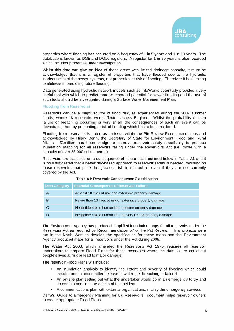
St Helens Council SFRA - User Guide Report FINAL DRAFT iv
properties where flooding has occurred on a frequency of 1 in 5 years and 1 in 10 years. The database is known as DG5 and DG10 registers. A register for 1 in 20 years is also recorded which includes properties under investigation.
Whilst this data can give an idea of those areas with limited drainage capacity, it must be acknowledged that it is a register of properties that have flooded due to the hydraulic inadequacies of the sewer systems, not properties at risk of flooding. Therefore it has limiting usefulness in predicting future flooding.
Data generated using hydraulic network models such as InfoWorks potentially provides a very useful tool with which to predict more widespread potential for sewer flooding and the use of such tools should be investigated during a Surface Water Management Plan.
Flooding from Reservoirs
Reservoirs can be a major source of flood risk, as experienced during the 2007 summer floods, where 18 reservoirs were affected across England. Whilst the probability of dam failure or breaching occurring is very small, the consequences of such an event can be devastating thereby presenting a risk of flooding which has to be considered.
Flooding from reservoirs is noted as an issue within the Pitt Review Recommendations and acknowledged by Hilary Benn, the Secretary of State for Environment, Food and Rural Affairs. £1million has been pledge to improve reservoir safety specifically to produce inundation mapping for all reservoirs falling under the Reservoirs Act (i.e. those with a capacity of over 25,000 cubic metres).
Reservoirs are classified on a consequence of failure basis outlined below in Table A1 and it is now suggested that a better risk-based approach to reservoir safety is needed, focusing on those reservoirs that pose the greatest risk to the public, even if they are not currently covered by the Act.
Table A1: Reservoir Consequence Classification
Dam Category Potential Consequence of Reservoir Failure
A At least 10 lives at risk and extensive property damage
B Fewer than 10 lives at risk or extensive property damage
C Negligible risk to human life but some property damage
D Negligible risk to human life and very limited property damage
The Environment Agency has produced simplified inundation maps for all reservoirs under the Reservoirs Act as required by Recommendation 57 of the Pitt Review. Trial projects were run in the North West to develop the specification for these maps and the Environment Agency produced maps for all reservoirs under the Act during 2009.
The Water Act 2003, which amended the Reservoirs Act 1975, requires all reservoir undertakers to prepare Flood Plans for those reservoirs where the dam failure could put people’s lives at risk or lead to major damage.
The reservoir Flood Plans will include:
An inundation analysis to identify the extent and severity of flooding which could result from an uncontrolled release of water (i.e. breaching or failure)
An on-site plan setting out what the undertaker would do in an emergency to try and to contain and limit the effects of the incident
A communications plan with external organisations, mainly the emergency services Defra's ‘Guide to Emergency Planning for UK Reservoirs’, document helps reservoir owners to create appropriate Flood Plans.
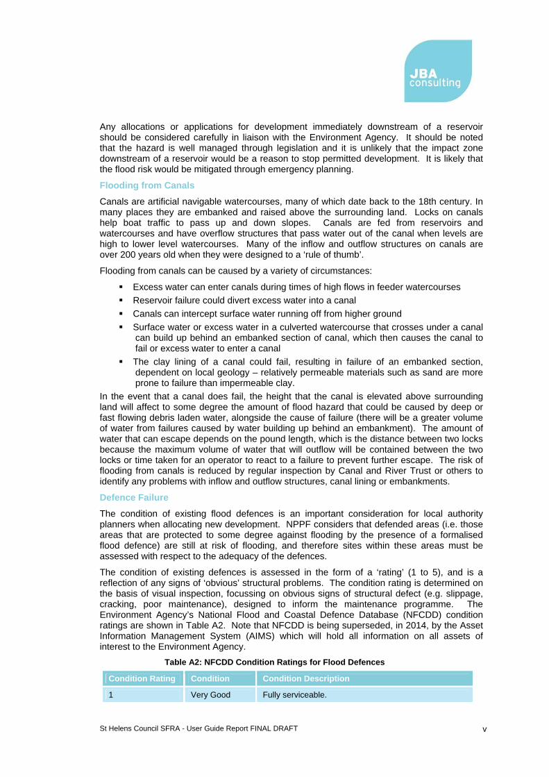
St Helens Council SFRA - User Guide Report FINAL DRAFT v
Any allocations or applications for development immediately downstream of a reservoir should be considered carefully in liaison with the Environment Agency. It should be noted that the hazard is well managed through legislation and it is unlikely that the impact zone downstream of a reservoir would be a reason to stop permitted development. It is likely that the flood risk would be mitigated through emergency planning.
Flooding from Canals
Canals are artificial navigable watercourses, many of which date back to the 18th century. In many places they are embanked and raised above the surrounding land. Locks on canals help boat traffic to pass up and down slopes. Canals are fed from reservoirs and watercourses and have overflow structures that pass water out of the canal when levels are high to lower level watercourses. Many of the inflow and outflow structures on canals are over 200 years old when they were designed to a ‘rule of thumb’.
Flooding from canals can be caused by a variety of circumstances:
Excess water can enter canals during times of high flows in feeder watercourses Reservoir failure could divert excess water into a canal Canals can intercept surface water running off from higher ground Surface water or excess water in a culverted watercourse that crosses under a canal
can build up behind an embanked section of canal, which then causes the canal to fail or excess water to enter a canal
The clay lining of a canal could fail, resulting in failure of an embanked section, dependent on local geology – relatively permeable materials such as sand are more prone to failure than impermeable clay.
In the event that a canal does fail, the height that the canal is elevated above surrounding land will affect to some degree the amount of flood hazard that could be caused by deep or fast flowing debris laden water, alongside the cause of failure (there will be a greater volume of water from failures caused by water building up behind an embankment). The amount of water that can escape depends on the pound length, which is the distance between two locks because the maximum volume of water that will outflow will be contained between the two locks or time taken for an operator to react to a failure to prevent further escape. The risk of flooding from canals is reduced by regular inspection by Canal and River Trust or others to identify any problems with inflow and outflow structures, canal lining or embankments.
Defence Failure
The condition of existing flood defences is an important consideration for local authority planners when allocating new development. NPPF considers that defended areas (i.e. those areas that are protected to some degree against flooding by the presence of a formalised flood defence) are still at risk of flooding, and therefore sites within these areas must be assessed with respect to the adequacy of the defences.
The condition of existing defences is assessed in the form of a ‘rating’ (1 to 5), and is a reflection of any signs of ‘obvious’ structural problems. The condition rating is determined on the basis of visual inspection, focussing on obvious signs of structural defect (e.g. slippage, cracking, poor maintenance), designed to inform the maintenance programme. The Environment Agency’s National Flood and Coastal Defence Database (NFCDD) condition ratings are shown in Table A2. Note that NFCDD is being superseded, in 2014, by the Asset Information Management System (AIMS) which will hold all information on all assets of interest to the Environment Agency.
Table A2: NFCDD Condition Ratings for Flood Defences
Condition Rating Condition Condition Description
1 Very Good Fully serviceable.

St Helens Council SFRA - User Guide Report FINAL DRAFT vi
Condition Rating Condition Condition Description
2 Good Minor defects.
3 Fair Some cause for concern. Requires careful monitoring.
4 Poor Structurally unsound now or in the future.
5 Very Poor Completely failed and derelict.
The condition of existing flood defences and whether they will continue to be maintained and/or improved in the future, is an issue that needs to be considered as part of the risk based sequential approach and in light of this, whether proposed land allocations are appropriate and sustainable. In addition, detailed FRAs will need to explore the condition of defences thoroughly, especially where these defences are informal and contain a wide variation of condition grades.
Defences that are not in good condition could be prone to failure during a flood event. Defences that offer a low standard of protection are likely to overtop during flood events that are more extreme than the event that they were designed to protect against. Flood risk associated with defence infrastructure is residual; however, the risks can be significant due to sudden onset and velocities reached by flood waters should a defence overtop or fail.
Flood Warning
The Environment Agency has the lead role in providing flood warnings in England and Wales. The aim of the flood warning service is to reduce risk to life, distress to people and damage to property caused by flooding by providing accurate, timely flood warnings to residents within the floodplain of rivers, estuaries and coasts; to the media and partner organisations.
It is crucial that people at risk receive appropriate flood warnings and take action to protect themselves and their property. Within the Environment Agency corporate plan “Creating a Better Place9” the Agency has highlighted three main targets:
To have 80% of properties at risk in the floodplain in England and Wales receiving and appropriate flood warning service
75% of people who live in flood risk areas take appropriate action by 2011 To have major incident plans in place for high flood risk areas.
9 Environment Agency (2006) Creating a Better Place: Corporate Strategy 2006-2011

St Helens Council SFRA - User Guide Report FINAL DRAFT vii
Flood Warning Codes include10:
The flood warnings are used to reduce the overall impact of flooding of people and property by lowering the vulnerability of the receptor. This is done by providing a warning which can then be used to remove people at risk or to relocate valuable possessions to higher levels.
Overview
Flooding in urban areas can come from a variety of sources and when flooding occurs it is often not clear where the water has come from. The draft ‘Flood and Water Management Act’ defines local flood risk, for which local authorities will have a local leadership role, as the risk of flooding from ordinary watercourses (smaller watercourses that are not under the jurisdiction of the Environment Agency), surface water and groundwater.
Prior to the major flood events in summer 2007, the understanding of non Main River flooding was based on anecdotal evidence or described within Critical Ordinary Watercourse (COW) investigations undertaken by the Environment Agency. Little data could be abstracted from the water companies on sensitive drainage catchments where runoff impacts of new development could be significant on combined sewer systems. However, a significant proportion of recent flood insurance claims are due to flooding from non Main River sources, so this issue will become larger with a more energised climate.
Historically the adopted approach in many SFRAs has been not to consider other sources of flooding as a spatial or strategic issue.
Summer 2007 provided a stark reminder that the significance of capacity exceedance of artificial and natural drainage systems can be severe for many communities. Therefore a clear example was provided that flooding from all sources should be scoped into a SFRA and they should be taken into account through the planning system, and that new methods of rapid screening of these risks are required. On the back of the Pitt review, the Environment Agency prepared the national map showing areas susceptible to surface water flooding. This was developed by JBA from research for the Making Space for Water programme. JBA has
10 http://www.environment-agency.gov.uk/homeandleisure/floods/31618.aspx

St Helens Council SFRA - User Guide Report FINAL DRAFT viii
since developed the 2nd generation Flood Map for Surface Water in 2010 and the most recent 3rd generation Updated Flood Map for Surface Water in 2013.
Development can increase flood risk elsewhere in the following ways:
Upstream by restricting the capacity and conveyance function of the watercourse and floodplain system
Downstream by decreasing the volume available for flood storage on the floodplain, altering flow routes on the floodplain or by changes to the channel which can increase the flow discharged to downstream locations
By increasing run-off from reduced permeability surfaces, such as roads, roofs and car parks
A.3 Flooding Likelihood & Consequence
Flood risk is generally accepted to be a combination of the likelihood of flooding and the potential consequences arising. It is assessed using the source – pathway – receptor model as shown in Figure A-2 below. This is a standard environmental risk model common to many hazards and should be the starting point of any FRA. However, it should be remembered that flood risk can come from many different sources and pathways and not simply those shown in the simplified form below.
Figure A-2 (Source-Pathway-Receptor model)
The principal sources of flooding are rainfall or higher than normal sea and river levels, the principal pathways are rivers, drains, sewers, overland flow and river and coastal floodplains and their defence assets. The receptors may include people, their property and the environment. All three elements must be present for flood risk to arise. Mitigation measures have little or no effect on sources of flooding but they can block or impede pathways or remove receptors.
The planning process is primarily concerned with the location of receptors, taking appropriate account of potential sources and pathways that might put those receptors at risk.
It is important to define the components of flood risk in order to apply this guidance in a consistent manner.

St Helens Council SFRA - User Guide Report FINAL DRAFT ix
Likelihood
Likelihood of flooding is normally expressed as a percentage probability based on the average frequency measured or extrapolated from records over a large number of years. A 1% probability indicates the flood level that is expected to be exceeded on average once in 100 years, i.e. it has a 1 in 100 chance of occurring in any one year.
Considered over the lifetime of development, such an apparently low frequency or rare flood has a significant probability of occurring.
Consequence
Consequences of flooding depend on the hazards caused by flooding (depth of water, speed of flow, rate of onset, duration, wave-action effects, water quality) and the vulnerability of receptors (type of development, nature, e.g. age and structure of the population, presence and reliability of mitigation measures etc).
Flood risk is then normally expressed in terms of the following relationship:
Flood risk = Probability of flooding x Consequences of flooding
A.4 Flooding Impacts on Property, People & the Environment
Flooding has a wide range of social impacts which may be difficult to delineate as they are interconnected, cumulative and often not quantifiable.
In small urban or steep upland catchments which have a very rapid response to rainfall, or with flooding due to infrastructure failure, flood waters can rise very quickly and put life at risk. Even shallow water flowing at 2 m/s can knock children and many adults off their feet and vehicles can be moved by water of 300 mm depth. The risks rise if the flood water is carrying debris.
The impact on people as a result of the stress and trauma of being flooded, or even of being under the threat of flooding, can be immense. This also extends to whole communities. Long term impacts can arise due to chronic illnesses and stress. Flood water contaminated by sewage or other pollutants (e.g. chemicals stored in garages or commercial properties) is particularly likely to cause illnesses, either directly as a result of contact with the polluted flood water or indirectly as a result of sediments left behind.
The degree to which populations are at risk from flooding is, therefore, not solely dependent upon proximity to the source of the threat or the physical nature of the flooding. Social factors also play a significant role in determining risk. Although people may experience the same flood, in the same area, at the same time, their levels of suffering are likely to differ greatly as a result of basic social differences. These differences will affect vulnerability in a variety of ways including an individual's or community’s response to risk communication (flood warning) and physical and psychological recovery in the aftermath of a flood. How individuals and communities experience the impact will also vary depending on their awareness of the risk of flooding, preparedness for the flood event and the existence or lack of coping strategies.
Flood hazard is based on a multiplier of flood depth, flood velocity and a debris factor11 and is presented on the following scale:
Table A3: Flood Hazard ratings
Hazard to people Hazard to people classification
No Hazard
11 Defra and Environment Agency (2006) The Flood Risks to People Methodology, Flood Risks to People Phase 2, FD2321 Technical Report 1, HR Wallingford et al. wrote the report for Defra/EA Flood and Coastal Defence R&D Programme, March 2006.

St Helens Council SFRA - User Guide Report FINAL DRAFT x
Hazard to people Hazard to people classification
Very Low Hazard “Flood zone with shallow flowing water or deep standing water”
Caution
Danger for some “Danger: flood zone with deep or fast flowing water”
Includes children, the elderly and the infirm
Danger for most “Danger: flood zone with deep fast flowing water”
Includes the general public
Danger for all “Extreme danger: flood zone with deep fast flowing water”
Includes the emergency services
Flooding Impacts on Property
Flooding can cause severe property damage. Flood water is likely to damage internal finishes, contents, electrical and other services and possibly cause structural damage. The physical effects can have significant long-term impacts, with reoccupation sometimes not being possible for over a year. The costs of flooding are increasing, partly due to increasing amounts of electrical and other sophisticated equipment within developments.
The damage flooding can cause to businesses and infrastructure, such as transport or utilities like electricity and water supply, can have significant detrimental impacts on local and regional economies. The long-term closure of businesses, for example, can lead to job losses and other economic impacts.
New development or regeneration in flood risk areas has its additional short and long-term costs. The need to build resistant and resilient properties could significantly increase overall costs of development, whilst ongoing maintenance and insurance increase future expenditure.
Flooding Impacts on the Environment
Environmental impacts can be significant and include soil erosion, bank erosion, landslips and damage to vegetation. There can also be detrimental impacts on habitats, flora and fauna and water quality caused by various pollutants carried by floodwater.
Conversely, flooding can have a beneficial role in natural habitats. Many wetland habitats are dependent on annual flooding for their sustainability and can contribute to the storing of flood waters to reduce flood risk elsewhere. It is important to recognise the value of maintenance or restoration of natural riparian zones such as grasslands which protect the soils from erosion and ‘natural’ meadows which can tolerate flood inundation. The use of Green Infrastructure throughout river corridors can also play a vital role in enhancing the river environment as well as safeguarding land from future development, protecting people and buildings from flooding and reducing flood risk downstream.
A natural floodplain can help accommodate climate change and improve the quality of rivers and associated wetlands to help achieve ‘good ecological status’ or ‘good potential ecological status’ by 2015 under the Water Framework Directive (WFD). Meeting WFD objectives involves not only ecosystems, water quality, drought and flood impact considerations but also physical characteristics and morphology of the river channel, floodplain and associated structures.
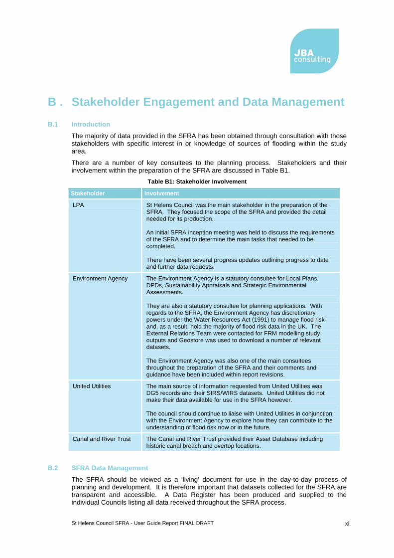
St Helens Council SFRA - User Guide Report FINAL DRAFT xi
B . Stakeholder Engagement and Data Management
B.1 Introduction
The majority of data provided in the SFRA has been obtained through consultation with those stakeholders with specific interest in or knowledge of sources of flooding within the study area.
There are a number of key consultees to the planning process. Stakeholders and their involvement within the preparation of the SFRA are discussed in Table B1.
Table B1: Stakeholder Involvement
Stakeholder Involvement
LPA St Helens Council was the main stakeholder in the preparation of the SFRA. They focused the scope of the SFRA and provided the detail needed for its production. An initial SFRA inception meeting was held to discuss the requirements of the SFRA and to determine the main tasks that needed to be completed. There have been several progress updates outlining progress to date and further data requests.
Environment Agency The Environment Agency is a statutory consultee for Local Plans, DPDs, Sustainability Appraisals and Strategic Environmental Assessments. They are also a statutory consultee for planning applications. With regards to the SFRA, the Environment Agency has discretionary powers under the Water Resources Act (1991) to manage flood risk and, as a result, hold the majority of flood risk data in the UK. The External Relations Team were contacted for FRM modelling study outputs and Geostore was used to download a number of relevant datasets. The Environment Agency was also one of the main consultees throughout the preparation of the SFRA and their comments and guidance have been included within report revisions.
United Utilities The main source of information requested from United Utilities was DG5 records and their SIRS/WIRS datasets. United Utilities did not make their data available for use in the SFRA however. The council should continue to liaise with United Utilities in conjunction with the Environment Agency to explore how they can contribute to the understanding of flood risk now or in the future.
Canal and River Trust The Canal and River Trust provided their Asset Database including historic canal breach and overtop locations.
B.2 SFRA Data Management
The SFRA should be viewed as a ‘living’ document for use in the day-to-day process of planning and development. It is therefore important that datasets collected for the SFRA are transparent and accessible. A Data Register has been produced and supplied to the individual Councils listing all data received throughout the SFRA process.

St Helens Council SFRA - User Guide Report FINAL DRAFT xii
All data was reviewed on receipt and its quality assessed through professional judgement.
Most data requested was of the quality expected. Whilst the majority of the datasets could be mapped geographically using Geographic Information Systems (GIS), helping to visualise the risk of flooding, others were not. Historical flooding information was provided in both GIS format and through discussion with Council drainage engineers.
The Data Register will allow intended users of the SFRA to review the datasets used and for a central group to manage and update datasets when needed. The Data Register also states the name and organisation of who the data was supplied by. The names and organisations listed in the Data Register should be the first point of contact for any update to the SFRA to make sure the most up-to-date datasets are used.
B.3 Supplying SFRA Data
Whilst all data collected and produced during the SFRA process has been supplied to each LPA (report, maps, GIS data, Development Assessment Spreadsheet, data register) there should be controls on its use. It is anticipated that the SFRA report and associated maps will be published as GeoPDFs, and made available for download, on the Councils websites, acting as the central source of SFRA data.
The use of much of the SFRA data will fall under the license agreement between the LPA and the Environment Agency as it has been produced using Environment Agency data.
The SFRA data should not be passed on to any third parties outside of the LPA. Any third party wishing to use existing Environment Agency flood risk datasets should contact the External Relations department in the Environment Agency. A charge is likely to apply for the use of this data.

St Helens Council SFRA - User Guide Report FINAL DRAFT xiii
C . Flood Risk Vulnerability Classification Flood risk vulnerability classifications provide recognition that not all land uses have the same vulnerability to flooding. Some land uses such as residential developments are more vulnerable to the potential loss of life and damage to personal property and possessions than shops and offices for example. Five flood risk vulnerability classifications are contained in NPPF and the PPS25 Practice Guide and these include:
Essential infrastructure Highly vulnerable More vulnerable Less vulnerable Water compatible development
Flood Zone 1 – Low Probability
From a flood risk perspective all land uses are acceptable within Flood Zone 1. Flood risk is not considered to be a significant constraint to development and all land uses, included in the vulnerability classifications listed above are appropriate in this zone
A Screening Study will be required for development in this zone. This will determine whether further assessment of flood risk is required. This will take account of historical flood records of localised flooding, site specific considerations and the surface water proposals for the development, including mitigation.
However, due to potential impact on local flood risk, a full FRA will be required for all developments greater than 1ha in size. This will include further consideration of surface water drainage and onsite mitigation measures that may be required, particularly where the capacity of the surface water sewer or receiving watercourse is limited. This assessment will be undertaken by the developer of the site and should be appropriate to the scale, nature and location of the development. The Council’s Drainage Engineers and the EA will be able to advise potential developers as to their specific requirements on a site by site basis.
Flood Zone 2 – Medium Probability
Subject to the application of the Sequential Flood Risk Test, suitable types of development in Flood Zone 2 include:
Essential infrastructure More vulnerable Less vulnerable Water compatible development.
Highly vulnerable uses should only be permitted in this zone if the Exception Test is passed. The SFRA is unable to assess whether the site will pass parts a. and b. of the Exception Test. However, the Council must be able to demonstrate the need for development through the spatial planning process.
An FRA will be required for all development in this zone. The FRA will need to assess the current level of flood risk as well as the level of flood risk following development. Development plans for the site will need to demonstrate that flood risk can be effectively and safely managed without increasing flood risk elsewhere.
Proposals will also need to demonstrate that access and egress to the development can be maintained during an extreme flood event and that development is set at an appropriate level. A further level of analysis, such as a breach / overtopping scenario assessment, may be required where development is planned behind or adjacent to existing defences in order to

St Helens Council SFRA - User Guide Report FINAL DRAFT xiv
test the sustainability and robustness of the mitigation measures. In keeping with Flood Zone 1, other flood risk constraints, such as incidents of localised flooding and other site-specific considerations will need to be addressed. Again, detailed FRAs will be undertaken by the developer of the site and the EA will be able to advise potential developers as to their specific requirements on a site by site basis.
Flood Zone 3 – High Probability
A Sequential Flood Risk Test is used to prioritise sites in order of vulnerability to flood risk and their acceptability for development. Developers should primarily focus on lower Flood Zones in preference to Flood Zone 3. Any proposals for development within Flood Zone 3 will require developers to undertake a detailed FRA. It should be noted that constraints to development are likely to be significant and developers should seek advice from the Council and the EA as to the specific requirements for assessment.
Flood Zone 3 is subdivided into Zones 3a and 3b. Flood Zone 3b is the portion of floodplain that provides natural and/or managed attenuation and is considered to be functional floodplain. NPPF describes Zone 3b as land where water has to flow or be stored in times of flood. Flood Zone 3b should be identified as part of the SFRA.
Zone 3a is potentially suitable for water compatible and less vulnerable land uses. The more vulnerable and essential infrastructure uses should only be permitted in this zone if the Exception Test is passed. Highly vulnerable development should not be permitted in this zone.
In Zone 3b, only essential infrastructure (subject to Exception Testing) and water compatible uses may be permitted. Where sites are partially located within Flood Zone 3b, it is recommended that the Council should avoid development by specifying water compatible uses or preferably public open space for these areas.
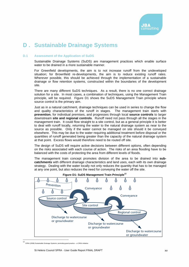
St Helens Council SFRA - User Guide Report FINAL DRAFT xv
D . Sustainable Drainage Systems
D.1 Assessment of the Application of SuDS
Sustainable Drainage Systems (SuDS) are management practices which enable surface water to be drained in a more sustainable manner.
For Greenfield developments, the aim is to not increase runoff from the undeveloped situation; for Brownfield re-developments, the aim is to reduce existing runoff rates. Wherever possible, this should be achieved through the implementation of a sustainable drainage or flow retention systems, constructed within the boundaries of the development site.
There are many different SuDS techniques. As a result, there is no one correct drainage solution for a site. In most cases, a combination of techniques, using the Management Train principle, will be required. Figure D1 shows the SuDS Management Train principle where source control is the primary aim.
Just as in a natural catchment, drainage techniques can be used in series to change the flow and quality characteristics of the runoff in stages. The management train starts with prevention, for individual premises, and progresses through local source controls to larger downstream site and regional controls. Runoff need not pass through all the stages in the management train. It could flow straight to a site control, but as a general principle it is better to deal with runoff locally, returning the water to the natural drainage system as near to the source as possible. Only if the water cannot be managed on site should it be conveyed elsewhere. This may be due to the water requiring additional treatment before disposal or the quantities of runoff generated being greater than the capacity of the natural drainage system at that point. Excess flows would therefore need to be routed off site.
The design of SuDS will require active decisions between different options, often depending on the risks associated with each course of action. The risks of an area flooding have to be balanced with the costs of protecting the area from different levels of floods.
The management train concept promotes division of the area to be drained into sub-catchments with different drainage characteristics and land uses, each with its own drainage strategy. Dealing with the water locally not only reduces the quantity that has to be managed at any one point, but also reduces the need for conveying the water off the site.
Figure D1: SuDS Management Train Principle12
12 CIRIA (2008) Sustainable Drainage Systems: promoting good practice – a CIRIA initiative

St Helens Council SFRA - User Guide Report FINAL DRAFT xvi
SuDS can reduce the amount and rate of runoff by a combination of infiltration, storage, and conveyance through a number of SuDS techniques. Their suitability however, relies on site conditions such as permeability and ground water levels, as summarised in Table D1.
Table D1: Suitability of SuDS Techniques
SuDS Technique Infiltration Storage Conveyance
Green Roofs
Permeable Paving
Rainwater Harvesting
Swales
Detention Basins
Ponds
Wetlands
Source: PPS25 Practice Guide
Local Planning Authorities should:
Promote the use of SuDS for the management of run-off Ensure their policies and decisions on development applications support and
complement the Building Regulations on sustainable rainwater drainage, giving priority to infiltration followed by discharge to watercourses and lastly discharge to sewers
Adopt policies for incorporating SuDS requirements in the Local Plan and Local Development Documents
Encourage developers to utilise SuDS wherever practicable, if necessary through the use of appropriate planning conditions
Develop joint strategies with sewerage undertakers and the Environment Agency to further encourage the use of SuDS
D.2 SuDS Guidance
For further information on the design of SuDS see CIRIA publications (www.ciria.org):
National Standards for sustainable drainage systems (2011): https://www.gov.uk/government/uploads/system/uploads/attachment_data/file/82421/suds-consult-annexa-national-standards-111221.pdf
C521 : SuDS design manual for Scotland and N. Ireland (2000) C522 : SuDS design manual for England and Wales (2000) C523 : SuDS - best practice Manual (2001) C582 : SuDS - Source control using constructed pervious surfaces (2002) C609 : SuDS - hydraulic, structural and water quality advice (2004) C625 : Model Agreements for SuDS (2004) C697 : The SuDS Manual (2007) C698 : Site Handbook for the Construction of SuDS (2007)
St Helens Council SFRA - User Guide Report FINAL DRAFT xvii
D.3 Drainage for new developments
Development has the potential to cause an increase in impermeable area, an associated increase in surface water runoff rates and volumes, and a consequent potential increase in downstream flood risk due to overloading of sewers, watercourses, culverts and other drainage infrastructure. New development has added flow over time and drainage networks are known to be at capacity in many places.
Controlling surface water discharges from new development is a crucial consideration if flood risk to new and existing development is to be effectively managed. Planned development can also play a role in reducing the number of properties that are directly at risk from surface water flooding. The Planning System has a key role to play in setting standards for sustainable drainage from new developments and ensuring that developments are designed to take account of risk from surface water flooding. Sustainable drainage plays an important part in reducing flows in the sewer network and in meeting environmental targets; alongside investment in maintenance and new capacity by United Utilities. United Utilities plan their investment on a five year rolling cycle, in consultation with key partners, including the Environment Agency.
Wherever possible, this should be achieved through the implementation of SuDS. Source control should be considered firstly. There may be opportunities to deliver SuDS though integrated solutions for collections of strategic sites. The future ownership and maintenance of SuDS systems should be discussed at the planning application stage with the relevant sections of the LPA (including Highways and Drainage), United Utilities and the Environment Agency.
The developer should liaise closely with the local authority drainage engineer, the Environment Agency and United Utilities to determine appropriate discharge rates. The developer should prove that surface water discharges from the site will not have an adverse impact on flood risk elsewhere, with reference to investment planning by United Utilities that may increase the capacity of the sewer network in the area.
The Council should make clear its approach to surface water management. All proposals for development must consider how surface water will be effectively controlled, and also propose SuDS techniques to fully attenuate surface water generated on the development site. The aim of this approach is to prevent any increase in surface water discharge to receiving watercourses or drainage infrastructure and prevent any increase in flood risk as a result of development.
The planning system has a key role to play in settings standards for SuDS from new developments and ensuring that developments are designed to take account of the risk from surface water flooding. Sustainable drainage and the use of SuDS is supported by the policy direction in Future Water13, Making Space for Water14, the Pitt Review15 and the Flood and Water Management Act16 that provides for more sustainable management of the water cycle, working in partnership across different agencies and new responsibilities for local flood risk management. In particular, the Flood and Water Management Act requires developers where practicable, to include sustainable drainage in new developments to reduce flood risk and improve water quality. It includes ‘a requirement on developers to demonstrate that they have met national standards for the application of SuDS techniques before they can connect any residual surface water drainage to a public sewer (amending section 106 of the Water
13 Defra (2008) Future Water 14 Defra, Department for Transport, HM Treasury and Office of the Deputy Prime Minister (2005) Making Space for water: Taking forward a new Government strategy for flood and coastal erosion risk management in England; First Government response to the autumn 2004 Making space for water consultation exercise 15 The Pitt Review (2008) Learning lessons from the 2007 floods 16 Defra (2010) Flood and Water Management Act © Crown Copyright

St Helens Council SFRA - User Guide Report FINAL DRAFT xviii
Industry Act 1991).’ As part of their new responsibility for local flood risk management, local authorities will be responsible for approving SuDS for new developments and adopting and maintaining them as part of a SuDS Approval Body (SAB).
Recognising the above, drainage from new developments should incorporate storage, with residual discharge of surface water to the following networks in order of preference:
Infiltration drainage (e.g. SuDS - soakaways) Discharge to a watercourse Discharge to a public sewer
The choice of system will be determined by local ground conditions (including groundwater levels). Whilst infiltration SuDS may be the most suitable for new development, developers must consider the risk of contamination to underlying aquifers.
Local flood risk management will be an important responsibility for local authorities in the future, which includes managing the risk of flooding from surface water, groundwater and ordinary watercourses. Many of the localised flooding problems can be related to local watercourses that have been culverted as past development has taken place. The condition and standard of protection of these watercourses are unknown but they can be a significant source of flood risk. Flooding in the urban environment is difficult to separate into distinct sources and in reality surface water flooding will be from a combination of overland flows, sewers and highways gullies backing up and surcharging at manholes, local watercourses overtopping, culverts surcharging and potentially high groundwater levels. This is one reason why it is important for one body (the local authority) to take the lead in local FRM delivery.
D.4 Suitability of Sites for Infiltration/SuDS
The suitability of ground conditions including, for example, seasonal groundwater levels and soil permeability will need to be determined prior to development.
Sites assessed to be of low suitability will need to include sustainable solutions that do not depend on infiltration. Several SuDS storage alternatives may be suitable for sites where permeability is poor, and infiltration is not deemed appropriate. These include:
Source control measures including rainwater recycling and drainage Filter strips and swales, which are vegetated features that hold and drain water
downhill mimicking natural drainage patterns Basins and ponds to hold excess water after rain and allow controlled discharge that
avoids flooding.
D.5 Critical Drainage Areas
Certain locations are particularly sensitive to an increase in the rate and volume of surface water runoff from new development. There are generally known local flooding problems associated with these areas. These areas help to define the proposed Critical Drainage Areas (CDAs) in the SFRA. Specific drainage requirements are required in these areas to help reduce local flood risk. The SFRA has designated CDAs as high flood risk areas.
These are areas with complex surface water flooding problems that would benefit from a drainage strategy, which is most effectively done in a SWMP.
The proposed CDAs, recommended in the SFRA, should be designated as part of a Level 2 SFRA and refined over time as more detailed information on flood risk and local flood management assets, including sewered catchments, becomes available.
In these areas, a detailed FRA is required regardless of which Flood Zone that. This should demonstrate that new development is not at risk from flooding from existing drainage systems

St Helens Council SFRA - User Guide Report FINAL DRAFT xix
or potential overland flow routes. It should also demonstrate that the development will not adversely affect existing flooding conditions by the use of appropriate mitigation measures. The FRA should define and address the constraints that will govern the design of the drainage system and layout of the development site.
The Environment Agency Standing Advice allows developers to screen online for the level of flood risk assessment that is appropriate for a development with regard to the NPPF Flood Zones. This highlights the need for a FRA in Flood Zones 2 and 3 and in Flood Zone 1 where there are critical drainage problems. The Standing Advice notes that for developments in Flood Zone 1 FRA Guidance Note 1 should be followed:
‘In areas where the Local Planning Authority has identified drainage problems through a Strategic Flood Risk Assessment or Surface Water Management Plan and they have indicated that a formal flood risk assessment is required’. FRA Guidance Note 1 requires FRAs to provide ‘Proposals for surface water management that aims to not increase, and where practicable reduce the rate of runoff from the site as a result of the development (in accordance with sustainable drainage principles, and the Local Planning Authority’s published SFRA).’
Proposals for development in Critical Drainage Areas should follow the guidance and standards as set out below for developments that are within any Flood Zone.
Development should seek to reduce existing local flooding problems and not add to them. The following guidance should be followed:
Development should deliver Greenfield runoff on Greenfield sites up to a 1% AEP storm event, considering climate change
Development should aim for a minimum reduction in surface water runoff rates of 50% for Brownfield sites, with an aim of reducing runoff to Greenfield rates up to a 1% AEP storm event, considering climate change
Development should be designed so that there is no flooding to the development in a 1 in 3.33 AEP event and so that there is no property flooding in a 1 in 100 year plus climate change event
Over time, it is envisaged that local authorities will commission drainage strategies (see below) to determine in more detail and establish the evidence base for set reductions in surface water runoff from development sites. With regard to this, the developer should liaise closely with the Environment Agency, United Utilities and LPA as soon as possible to determine an appropriate reduction in runoff rate and volume with reference to discharge limits as laid down by any completed SWMP or Drainage Strategy for that area.
Wherever possible, this should be achieved through the implementation of SuDS. Source control should be considered firstly. There may be opportunities to deliver SuDS though integrated solutions for collections of strategic sites. The future ownership and maintenance of SuDS systems should be discussed at the planning application stage with the relevant sections of the LPA (including Highways and Drainage), United Utilitiesand the Environment Agency. This approach should be taken unless the developer can demonstrate that this is not feasible and that there will be no adverse impact caused by the development elsewhere.

St Helens Council SFRA - User Guide Report FINAL DRAFT xx
E . Flood Risk Mitigation
E.1 Introduction
Throughout the risk-based sequential approach, opportunities should be taken to minimise flood risk at every stage of the planning process. Mitigation measures should be seen as a last resort to address flood risk issues.
Mitigation measures must be designed to provide an appropriate level of protection to a site for the lifetime of the development. At many sites it may be technically feasible to mitigate or manage flood risk. However, the potential impacts of mitigation measures on flood risk to the surrounding community must be considered. Where the depth of flooding is substantial, these mitigation measures may result in practical constraints to development with significant financial implications.
The minimum acceptable standard of protection against flooding for new property within flood risk areas is the 1% AEP flood event for fluvial flooding, including allowance for climate change over the lifetime of the development.
E.2 Strategic approach
Mitigation measures should be considered on a strategic basis to avoid a piecemeal approach and partnership is advocated between the LPA and EA. Measures should also be integrated with wider EA flood risk management works and strategies such as the CFMP.
Outline flood risk mitigation strategies should consider the wider, cumulative impacts of mitigation. This requires master-planning an area from a flood-risk perspective.
In summary, taking a strategic approach to flood risk management involves consideration of:
Avoidance of development in flood risk areas; Implementing a sequential approach to site layout, substituting higher vulnerability
development in lower flood risk areas; Considering flooding from all sources; Wherever possible, using open land or green infrastructure to reduce risk, (e.g. by
providing compensatory flood storage); Adopting mitigation measures that contribute to the wider community objectives for
flood risk management in risk areas, (developers should aim to reduce risk to the wider community);
The design and use of SuDS; and, Preparing emergency flood plans.
E.3 EU Floods Directive & the Flood Risk Regulations
European Flood Directive (2007) sets out EU’s approach to managing flood risk and aims to improve the management of the risk floods pose to human health, the environment, cultural heritage and economic activity.
The Directive was translated into English law by the Flood Risk Regulations (FRR) 2009 and outlines the requirement for the Environment Agency and Lead Local Flood Authorities (LLFA) to create Preliminary Flood Risk Assessments (PFRAs), with the aim of identifying significant Flood Risk Areas.
PFRAs should cover the entire area for local flood risk (focusing on ordinary watercourses, surface water and groundwater flooding). Where significant Flood Risk Areas are identified using a national approach (and locally reviewed), the LLFA are then required to undertake
St Helens Council SFRA - User Guide Report FINAL DRAFT xxi
flood risk hazard mapping and Flood Risk Management Plans (FRMPs).
The FRMP will need to consider objectives for flood risk management (reducing the likelihood and consequences of flooding) and measures to achieve those objectives.
The Environment Agency have implemented one of the exceptions for creating PFRAs, etc for main rivers and coastal flooding, as they already have mapping (i.e. Flood Map) and plans (i.e. CFMPs) in place to deal with this. The Environment Agency have therefore focused their efforts on assisting LLFAs through this process.
E.4 Flood & Water Management Act 2010
The Flood and Water Management Act (FWMA)17 received Royal Assent on 8th April 2010. The Act creates unifying legislation covering all forms of flooding and shifting the emphasis from building defences to managing risk. The Act creates clearer roles and responsibilities and provides for a more risk-based approach. Local authorities have a new lead role in managing local flood risk (from surface water, ground water and ordinary watercourses) and a strategic overview role for all flood risk for the Environment Agency.
The Act aims to:
Reduce the likelihood and impacts of flooding Improve the ability to manage the risk of flooding, by clarifying who is responsible for
what Reduce pollution and improve water quality Give water companies better powers to conserve water during drought Reduce red tape and other burdens on water and sewerage companies Improve the overall efficiency of the industry.
The content and implications of the Act provide considerable opportunities for improved and integrated land use planning and flood risk management by local authorities and other key partners. The integration and synergy of strategies and plans at national, regional and local scales, is increasingly important to protect vulnerable communities and deliver sustainable re-generation and growth. Key areas of the Act have particular implications for local authorities, land use planning and related flood risk. These include:
To give the Environment Agency an overview of all flood and coastal erosion risk management and unitary and county councils the lead in managing the risk of all local floods
Local authorities will have an enhanced leadership role in local flood risk management which includes ensuring that flood risk from all sources, including from surface run-off, groundwater and ordinary watercourses, is identified, taken account of in the spatial planning process and managed as part of locally agreed work programmes
Local authorities will develop a suite of measures for managing local flood risk, for example, surface water mapping, appropriate development planning and collating information on flood risk and drainage assets
County and unitary authorities will be responsible for local flood risk assessment and lead in ensuring the production of SFRAs and SWMPs
SFRAs will provide the evidence to allow LPAs to factor flood risk into their Local Plans, DPDs and individual planning proposals, and help to determine where SWMPs are needed
17 http://www.defra.gov.uk/publications/2012/12/14/pb13844-fmwa-progress/
St Helens Council SFRA - User Guide Report FINAL DRAFT xxii
County and unitary authorities will lead new local partnerships and have responsibility for adopting and maintaining sustainable drainage systems (SuDS) in new development, where they affect more than one property
County or unitary authorities, the Environment Agency and IDBs will have powers to formally designate natural and man-made features (similar in principle to the Listed Buildings classification), which help to manage flood or coastal risk; they will give formal consent before anyone can change or remove the feature and use enforcement powers where needed
To encourage the uptake of sustainable drainage systems by removing the automatic right to connect to sewers and providing for unitary and county councils to adopt SuDS for new developments and redevelopments
Surface water connection to public sewers will be conditional on meeting new national standards for SuDS, and the approval of a SuDS approving body will be needed, and a certificate issued, before development can begin
Increased emphasis is needed on enabling flood water to safely flow overland with green infrastructure and safe flow routes being identified as part of flood risk assessments
All relevant authorities will have a duty to cooperate and share information Right to Connect (Water Industry Act, 1991) S106 of the act has been amended by
the FWMA so that for new developments the approved sustainable drainage system must be constructed to connect to the public sewer network
This will need to be approved to the new National SuDS Standards by the Lead Local Flood Authority
Once constructed, the LLFA will adopt the system and becomes responsible for maintaining it.
E.5 Reducing flood risk through site layout and design
Flood risk should be considered at an early stage in deciding the layout and design of a site to provide an opportunity to reduce flood risk within the development.
A risk-based approach should be applied to try to locate more vulnerable land use to higher ground, while more flood-compatible development (e.g. vehicular parking, recreational space) can be located in higher risk areas.
Waterside areas, or areas along known flow routes, can be used for recreation, amenity and environmental purposes, allowing the preservation of flow routes and flood storage, whilst at the same time providing valuable social and environmental benefits contributing to other sustainability objectives. Landscaping should ensure safe access to higher ground from these areas, and avoid the creation of isolated islands as water levels rise.
The EA will have to consent any works within 8 metres of a main river. It is likely that the EA will require an unobstructed access and maintenance easement within these areas.

St Helens Council SFRA - User Guide Report FINAL DRAFT xxiii
E.6 Modification of ground levels
Modifying ground levels to raise the land above the required flood level is an effective way of reducing flood risk to the site in question.
However, in most areas of fluvial flood risk, conveyance or flood storage may be reduced by raising land within the floodplain, adversely impacting on flood risk downstream. Compensatory flood storage must be provided, in general, on a level for level, volume for volume basis on land that does not currently flood but is adjacent to the floodplain. In general it should be in the vicinity of the site and within the red line of the planning application boundary (unless the site is strategically allocated).
Where a site is entirely within the floodplain it is not possible to provide onsite compensatory storage.
The need for compensatory storage must been discussed at the earliest stage of planning as this will be a major constraint as this requirement may have significant implications for the yields achieved for individual sites.
E.7 Local flood storage
Where development reduces the volume of floodplain storage it will be necessary to provide compensatory storage locally. This could be an environmental wetland area, designated washland (designed to flood) or a flood basin. This can also be considered within urban design if areas are designated to flood in a flood event (e.g. ground floor of a development with residential occupancy on first floor).
On a strategic catchment-wide scale, appropriately located flood storage basins and washlands can not only provide a reduction in flood risk, but can also enhance and contribute to wetland restoration and habitat creation as well as potentially increasing the recreational value of many river corridors. For upstream flood storage schemes to maximise benefits downstream, they need to be located in suitable areas of the catchment. Locating flood storage basins too high in the catchment could mean that a large proportion of a flood event is still able to travel downstream from other areas in the catchment.
The need for compensatory storage must be discussed at the earliest stage of planning as this will provide a major constraint on development. This requirement may have significant implications for the yields achieved for individual sites due to the associated land take this may require.
E.8 Raised defences
Construction of raised floodwalls or embankments to protect new development is not a preferred option, as a residual risk of flooding will remain. Compensatory storage must be provided where raised defences remove storage from the floodplain.
Temporary or demountable defences are not acceptable flood protection for new development.
E.9 Developer contributions to flood defences
In some cases, it may be necessary for the developer to make a contribution to the improvement of flood defence provision that would benefit both the development and the local community.

St Helens Council SFRA - User Guide Report FINAL DRAFT xxiv
E.10 Building design
Raising of floor levels within a development avoids damage to the interior, furnishings and electrics in times of flood. If it has been agreed with the EA that, in a particular instance, the raising of floor levels is acceptable, they should normally be raised to 600mm above the maximum water level during a 1% AEP event including allowance for climate change.
Making the ground floor of a building water-compatible (for example a garage or basement), is an effective way of raising living space above flood levels.
Constructing a building on stilts is not considered an acceptable means of flood mitigation for new development. However it may be allowed in special circumstances if it replaces an existing solid building, as it can improve flood flow routes. In these cases attention should always be paid to safe access and egress and legal protection should be given to ensure the ground floor use is not changed in the future.
E.11 Resistance and resilience
The 2007 document ‘Improving the Flood Performance of New Buildings’18 provides further details on possible resistance and resilience measures.
E.12 Temporary barriers
Temporary barriers consist of moveable flood defences that can be fitted to doorways and windows. On a smaller scale it is likely that the EA will require an unobstructed access and maintenance easement within these areas, temporary snap-on covers for airbricks and air vents can also be fitted to prevent the entrance of flood water.
E.13 Permanent barriers
Permanent barriers can include built-up doorsteps, rendered brick walls and toughened glass barriers.
E.14 Wet-proofing
This involves designing interiors to reduce damage caused by flooding by, for example:
Installing electrical circuitry at a higher level with power cables being carried down from the ceiling rather than up from the floor
Using water-resistant materials for floors, walls and fixtures. Resilience measures will be specific to the nature of the flood risk, and as such will be informed and determined by a FRA.
E.15 Making development safe
Safe access and egress
The developer must ensure that safe access and egress can be provided to an appropriate level for the type of development.
As part of a FRA, the developer should, with the EA, review the acceptability of the proposed access.
For the purpose of the SFRA it is considered appropriate to provide low hazard access and egress routes associated with new housing developments. Environment Agency guidance
18 Communities and Local Government (2007) Improving the Flood Performance of New Buildings – Flood Resilient Construction

St Helens Council SFRA - User Guide Report FINAL DRAFT xxv
suggests that all development should have dry access and egress routes in the 1% AEP event.
E.16 Making Space for Water
Opportunities for river restoration and enhancement
All new development close to rivers should consider the opportunity to improve and enhance the river environment. Developments should look at opportunities for river restoration and enhancement as part of the development. Options include backwaters, de-silting, in-channel habitat enhancement and removal of structures. When designed properly, such measures can have benefits such as reducing the costs of maintaining hard engineering structures, reducing flood risk, improving water quality and increasing biodiversity. Social benefits are also gained by increasing green space and access to the river.
Opportunities for floodplain restoration
It is an objective of NPPF to safeguard land from development that may be required for current or future flood management. In areas of high flood risk there may be a strong case for allowing previously developed sites to return to natural functional floodplain in urban areas where they can convey and store flood water reducing the risk of flooding to development.
Buffer strips
Developers should set back development from the landward toe of fluvial defences (or top of bank where defences do not exist) and this distance should be agreed with the EA. This provides a buffer strip to ‘make space for water’, and ensure access to defences is maintained.
E.17 Recommendations for surface water management
LLFAs should co-ordinate any future surface water management work. The Defra Surface Water Management Plan Guidance (2009) supports the use of SFRAs in providing the evidence base for where SWMPs are required.
Surface water management needs to take a holistic approach, taking into account all the sources of local flood risk, including from sewers, overland flow, culverted and open watercourses and groundwater. A suite of options are available for surface water management including source control, such as the implementation of SuDS, increasing the capacity of sewers, structures or watercourses, storing excess water and managing exceedance flows through urban design and "Green Infrastructure". SWMPs should provide the opportunity to undertake detailed sewer modelling and pool together the knowledge and understanding from different organisations to help assess options to reduce surface water flood risk to new and existing development.
Options to reduce flood risk in one location should not increase risk upstream or downstream. SWMP areas may cross one or more local authority area and several local authorities, the Environment Agency and United Utilitiescan be brought together in a SWMP partnership to develop sustainable options to manage surface water flood risk.
There is the potential for groups of development sites coming forward to share a central and integrated solution for managing surface water runoff. This is best investigated further through a SWMP or a Drainage Strategy. Such solutions can provide great benefits besides water management, including providing recreational facilities, improving biodiversity and making communities a better place to live. Where there are several sites that would share a communal facility, such sites may be funded through developer Section 106 or Community Infrastructure Levy payments. Drainage Strategies can be particularly useful for considering, recommending the implementation of and long term management arrangements for SuDS and setting appropriate runoff rates from new development.