sensorml-nt: innovative cloud service sensor...
TRANSCRIPT
SENSORML-NT: INNOVATIVE CLOUD SERVICE
SENSOR DESCRIPTION FOR MOBILE DEVICES
HANDLING ENVIRONMENTAL ISSUES
NAZI TABATABAEI YAZDI
UNIVERSITI SAINS MALAYSIA
2011

SENSORML-NT: INNOVATIVE CLOUD SERVICE
SENSOR DESCRIPTION FOR MOBILE DEVICES
HANDLING ENVIRONMENTAL ISSUES
BY
NAZI TABATABAEI YAZDI
Thesis submitted in partial fulfillment of the
requirements for the degree of Master of Science
February 2011
ii
DECLARATION
1 Chapter 1
Name: Nazi Tabatabaei Yazdi
Matric No: P-COM0064/09
Faculty: School of Computer Sciences
Thesis Title: SENSORML-NT: INNOVATIVE CLOUD SERVICE SENSOR
DESCRIPTION FOR MOBILE DEVICES HANDLING
ENVIRONMENTAL ISSUES
I hereby declare that this thesis in I have submitted to SCHOOL OF COMPUTER
SCIENCES on 21/02/2011 is my own work. I have stated all references used for the
completion of my thesis.
I agree to prepare electronic copies of the said thesis to the external examiner or
internal examiner for the determination of amount of words used or to check on
plagiarism should a request be made.
I make this declaration with the believe that what is stated in this declaration is true
and the thesis as forwarded is free from plagiarism as provided under Rule 6 of the
Universities and University Colleges (Amendment) Act 2008, University Science
Malaysia Rules (Student Discipline) 1999.
I conscientiously believe and agree that the University can take disciplinary actions
against me under Rule 48 of the Act should my thesis be found to be the work or
ideas of other persons.
Student’s Signature: Date: 21/02/2011
Acknowledgement of receipt by: Date:

iii
ACKNOWLEDGEMENTS
The experiences I have had during this period of pursuing Masters in
Universiti Sains Malaysia have been very rewarding both academically and
personally. I wish to sincerely thank a few individuals who have played a big part in
my journey of pursuing Masters.
First I would like to thank my supervisor Dr. Chan Huah Yong for his
guidance, supervision and inspiration throughout the course of this research. His
views and approach towards the understanding of the concepts has been absolutely
exceptional and has helped me immensely in my research. Furthermore, my sincere
thanks to Professor Rosni Abdullah for her support, guidance and her valuable and
fair feedback.
I also wish to thank Puan Norliza Hani Md. Ghazali, for kindly translating the
abstract of my thesis to Malay language.
Finally, I wish to thank my parents, brother and sister for their prayers,
blessings and love without which I would have never been able to complete this
thesis.
Thank you all once again!

iv
TABLE OF CONTENTS
DECLARATION ......................................................................................................... ii
ACKNOWLEDGEMENTS ........................................................................................ iii
TABLE OF CONTENTS ............................................................................................ iv
LIST OF TABLES ....................................................................................................... x
LIST OF FIGURES .................................................................................................... xi
LIST OF ABBREVIATIONS ................................................................................... xiv
ABSTRAK ............................................................................................................... xvii
ABSTRACT .............................................................................................................. xix
CHAPTER 1: INTRODUCTION
1.1 Introduction ...................................................................................................... 1
1.2 Background ...................................................................................................... 2
1.3 Research Problem............................................................................................. 4
1.4 Objectives ......................................................................................................... 5
1.5 Importance and Significance of this Research ................................................. 6
1.6 Scope of the Research ..................................................................................... 6

v
1.7 Contribution .................................................................................................... 7
1.8 Organization of Thesis .................................................................................... 7
1.9 Summary of Chapter ....................................................................................... 8
CHAPTER 2: LITERATURE SURVEY
2.1 Introduction ...................................................................................................... 9
2.2 Mobile phones as sensors .............................................................................. 10
2.2.1 Challenges of mobile devices ............................................................ 13
2.2.2 Previous attempts .............................................................................. 13
2.2.3 Summary ........................................................................................... 15
2.3 Open GeoSMS .............................................................................................. 16
2.3.1 Related work ..................................................................................... 16
2.3.2 Summary ........................................................................................... 17
2.4 Standardizing Sensors for universal observation .......................................... 18
2.4.1 Sensor and sensor network Standardizations .................................... 18
2.4.1.1 Introduction ........................................................................... 18
2.4.1.2 Sensor Network ..................................................................... 18
vi
2.4.1.3 Related Work ........................................................................ 19
2.4.1.4 Sensor Web ........................................................................... 19
2.4.1.5 SensorML .............................................................................. 21
2.4.1.6 Summary ............................................................................... 22
2.4.2 Geographic Information System (GIS) .............................................. 22
2.4.2.1 Spatial data infrastructure (SDI) ............................................ 25
2.4.2.1.1 Metadata ................................................................. 26
2.4.2.2 Geospatial Standards ............................................................. 27
2.4.2.3 OGC Sensor Web Enablement (SWE) ................................... 28
2.5. Conclusion .................................................................................................... 32
CHAPTER 3: RESEARCH METHODOLOGY
3.1 Introduction .................................................................................................... 33
3.2 The type of evaluation .................................................................................... 33
3.3 Research Procedures ...................................................................................... 34
3.4 Theoretical Framework .................................................................................. 34
3.5 Research Design ............................................................................................. 35

vii
3.5.1 Purpose of Study ................................................................................ 35
3.5.2 Type of Investigation ......................................................................... 35
3.5.3 Type of Investigation ......................................................................... 36
3.5.4 Unit of Analysis ................................................................................. 36
3.5.5 Time Horizon .................................................................................... 36
3.5.6 Summary of the research design elements ........................................ 37
3.6 Limitation on the Research ............................................................................ 37
3.7 List of Assumptions ....................................................................................... 38
3.8 Summary ........................................................................................................ 38
CHAPTER 4: PROPOSED TECHNIQUE
4.1 Overview ....................................................................................................... 39
4.2 Proposed Methodology Architecture ............................................................. 39
4.2.1 Proposed Mobile Device Technique ................................................. 39
4.2.1.1. Proposed Communication Method ........................................ 40
4.2.1.2. Proposed Method of using Mobile devices as Sensor ........... 40
4.2.2. Proposed Web service Method .......................................................... 41

viii
4.3. Proposed translation method ......................................................................... 42
4.4. Sum up of the Proposed Method ................................................................... 43
4.5. Evaluation method ........................................................................................ 45
4.6 Conclusion .................................................................................................... 45
CHAPTER 5: SIMULATION OF GEOSMS-TRANSLATOR
5.1 Introduction .................................................................................................... 46
5.2 Ngclusm_GPS_SkypeGeoSMS Program ..................................................... 46
5.2.1 GeoSMS Packet ................................................................................ 51
5.3 SMS gateway ................................................................................................ 52
5.3.1 SMS sent and received packed .......................................................... 55
5.4 SensorML translation service ........................................................................ 57
5.5 Choosing a Sensor Web platform ................................................................ 64
5.6 Validation ...................................................................................................... 70
5.7 Conclusion .................................................................................................... 74
ix
CHAPTER 6: CONCLUSION AND FUTURE WORKS
6.1 Introduction .................................................................................................... 75
6.2 Research Contributions .................................................................................. 75
6.3 Conclusion ..................................................................................................... 76
6.4 Scope of Future Works................................................................................... 77
REFERENCES ........................................................................................................... 78
APPENDICES
Appendix A ................................................................................................................ 84
Appendix B ................................................................................................................ 99
Appendix C .............................................................................................................. 116
Appendix D .............................................................................................................. 141

x
LIST OF TABLES
Table 5.1: Open GeoSMS format Structure and definitions ...................................... 51
Table 5.2: Format of normal received SMS package ................................................. 56

xi
LIST OF FIGURES
Figure 2.1: A mobile sensing architecture (Lane et al. 2010) ................................... 12
Figure 2.2: A shared sensor network of mobile phones (Kansal et al. 2007) ........... 15
Figure 2.3: System Design of the LBS Test (Mok et al. 2004) ................................. 17
Figure 2.4: Sensor Web concept (OpenGeoSpatial) ................................................. 20
Figure 2.5: Visualizing the data stored as theme layers (Gistownofchapelhill) ....... 24
Figure 2.6: Essential elements of the SDI .................................................................. 26
Figure 2.7: Harmonizing some of the available standards, illustrating OGC SWE
framework overview in place .................................................................. 31
Figure 3.1: Evaluation flow model............................................................................. 33
Figure 3.2: Proposed research sub-processes ............................................................ 34
Figure 3.3: Elements of research design: Summary .................................................. 37
Figure4.1: Ocean observation applications of SWE (lbxjournal) ............................. 42
Figure 4.2: Part one of the Sensor Description flow .................................................. 43
Figure 4.3: Part two of the Sensor Description flow .................................................. 44
Figure 4.4: Part three of the Sensor Description flow ................................................ 44
Figure 5.1: The simulated GeoSMS program in Visual Studio ................................. 47
xii
Figure 5.2: Simulation running on Windows 7 .......................................................... 47
Figure 5.3: The simulation of creating location and other needed data ..................... 48
Figure 5.4: Illustration of the massage format created to be sent .............................. 49
Figure 5.5: Part of the coding needed to generate the GeoSMS for Skype ............... 50
Figure 5.6: Point of Interest (POI) Format (Format P) ............................................. 51
Figure 5.7: Skype asking permission from the user to allow external programs to
access ....................................................................................................... 52
Figure 5.8: illustrates an example of received GeoSMS packet ................................ 54
Figure 5.9: An example of a normal sent SMS package ............................................ 55
Figure 5.10: An example of a normal received SMS package ................................... 56
Figure 5.11: A sample of the captured GeoSMS packet ............................................ 57
Figure 5.12: The designed XML SensorML schema (i)-(vi). .................................... 63
Figure 5.13: Sensor.Network data streams explore ................................................... 64
Figure 5.14.: Creating new POST Output Stream ..................................................... 65
Figure 5.15: The XML description schema definition of HTTP POST (i)-(ii). ......... 67
Figure 5.16: Online Model of creating new data stream ............................................ 67
Figure 5.17: Example scenario of the creating data stream ....................................... 68

xiii
Figure 5.18: Online example scenario of the XML data for creating a new data
stream .................................................................................................... 68
Figure 5.19: Sample scenario successfully created the new DataStream .................. 69
Figure 5.20: VAST SensorML validator web service. ............................................... 70
Figure 5.21: A scenario of SensorML-NT is successfully created and validated ...... 71
Figure 5.22: SensorML TableView Uploader ............................................................ 72
Figure 5.23: Generated tables of the SensorML description...................................... 73
Figure 5.24: Generated tables of a sample scenario using the URL of the
Sensor.Network data streams ................................................................ 74

xiv
LIST OF ABBREVIATIONS
AGPS Assisted Global Positioning System
API Application Programming Interface
CAT Web Catalog Service
CEOS Committee for Earth Observing Satellites
DISA US Defense Information Systems Agency
EPA Environmental Protection Agency
GeoLocation Geographic Location
GIS Geographic Information System
GML Geography Markup Language
GPS Global Positioning System
HTML Hyper Text Markup Language
HTTP Hyper Text Transfer Protocol
ISO International Standards Organization
J2ME Java 2 Platform, Micro Edition
JITC US Joint Interoperability Test Command
LBS Location Based Services
MGR Mobile-to-Grid Gateway Replication
NASA National Aeronautics and Space Administration
xv
NGA US National GeoSpatial-Intelligence Agency
O&G Observation and Measurement
OASIS Organization for the Advancement of Structured Information
Standards
OGC Open Geospatial Consortium
OGSI Open Grid Services Infrastructure
Open GeoSMS Open Geospatial Consortium Short Message Systems
PDA Personal Digital Assistants
PND Personal Navigation Devices
POI Point of Interest
REST Representational State Transfer
SAIC Science Applications International Corporation
SDI Spatial Data Infrastructure
SensorML Sensor Model Language
SensorML-NT Sensor Model Language – Network Translator
SFS Simple Features – SQL
SMS Short Message Systems
SN Sensor Network
SOAP Simple Object Access Protocol
SOS Station SOS Station
SSG Sensor Service Grid

xvi
SWE Sensor Web Enablement
TML Trivial Markup Language
W3C World Wide Web Consortium
WCS Web Coverage Service
Wi-Fi Wireless Fidelity
WMS Web Map Service
WPS Web Processing Service
WSN Wireless Sensor Network
WSRF Web Services Resource Framework
XML Extensible Markup Language

xvii
SENSORML-NT: PERIHALAN PENGESAN KHIDMAT AWAN
YANG INOVATIF UNTUK PERANTI MUDAH ALIH YANG
MENANGANI MASALAH ALAM SEKITAR
ABSTRAK
Peranti mudah alih hari ini boleh didapati di mana-mana dan semakin
banyak dilengkapi dengan set pengesan terbenam yang berkuasa. Disebabkan oleh
sifat pengunaan peranti-peranti ini, ia secara tidak langsung telah membina satu
rangkaian pengesan berskala besar di serata dunia. Jika diperhatikan, kepintaran
pengguna yang mengawal peranti-peranti mudah alih serta pengesannya mampu
memberikan lebih nilai pada data yang dikumpul. Objektif tesis ini ialah untuk
menggunakan khidmat Awan secara inovatif untuk menangani masalah-masalah
alam sekitar, dengan menjadikan peranti mudah alih sebagai pengesan. Penggunaan
perihalan pengesan dapat membuka peluang-peluang besar dalam menghasilkan satu
landasan global yang berkuasa, yang mampu melenyapkan batasan rangkaian asas
pengesan mudah alih. Rangka ini mampu merevolusi banyak sektor dalam masalah
alam sekitar, iaitu mengumpul, memantau, memproses maklumat dan menstor. Tesis
ini menyarankan SensorML-NT (Sensor Model Language-Network Translator),
menggunakan piawai Open Geospatial Consortium (OGC) (SensorML dan Open
GeoSMS). Spesifikasi ini mencirikan satu palam lutsinar dan memainkan perihalan
pengesan automatik untuk peranti mudah alih. Mengikut pelaksanaan, yang
diwujudkan dalam rangka seni bina yang dirumus, pendekatan ini telahpun dinilai
untuk menyelesaikan rangkuman peranti mudah alih terhadap data georuang
menerusi khidmat Awan. Skema SensorML yang terakhir dihasilkan, kemudiannya
xviii
disahkan menggunakan VisAnalysis dan khidmat sesawang pengesah Systems
Technology (VAST) SensorML dengan memberikan URL bagi arus data kami pada
“Sensor.Network”.
xix
SENSORML-NT: INNOVATIVE CLOUD SERVICE SENSOR
DESCRIPTION FOR MOBILE DEVICES HANDLING
ENVIRONMENTAL ISSUES
ABSTRACT
Today’s mobile devices are pervasive and equipped with growing sets of
powerful embedded sensors. Due to the application nature of these devices, they
have unsought build a large scale sensor network worldwide. Notice that the
intelligence of human users controlling mobile devices and its sensors will give the
collected data more value. The objective of this thesis is to innovatively use the
Cloud services for handling environmental issues, considering mobile devices as
sensors. Applying sensor description, allows significant opportunities for producing a
powerful global platform which eliminates the limitations of basic mobile sensor
networks. This framework can revolutionize many sectors of environmental issues,
i.e., collecting, monitoring, processing the information and storing. This thesis
proposed the SensorML-NT (Sensor Model Language-Network Translator), using
the Open Geospatial Consortium (OGC) standards (SensorML and Open GeoSMS).
This specification features a transparent plug and play automated sensor description
for mobile devices. According to the implementation, established in a formulated
architectural framework, this approach has been evaluated for solving the mobile
device comprehension to geospatial data via Cloud services. The final SensorML
schema created is later validated using VisAnalysis and Systems Technology
(VAST) SensorML validator web service by giving the URL of our data stream on
“Sensor.Network”.

1
CHAPTER 1
INTRODUCTION
1.1. Introduction
Today‟s mobile devices are equipped with at least two sensors: the camera
and the microphone. If there would be a way to collect and process the data, the
mobile devices can be considered as sensing nodes. Additionally, it is possible to
connect other sensors to the mobile phones using capabilities such as Bluetooth. Due
to the nature of these mobile devices, the widespread and ubiquitous around the
world, they have unsought build a large scale sensor network. Furthermore, for
places that installing immobile sensors are impossible, not allowed or even may be
expensive, this ability of mobile device, allows, efficiently sensing more
environmental information. Also, each mobile device is associated with a human
user, whose intelligence and assistant, may often be used, to enhance their
functionality.
The goal of this research is to enhance the usability of the available mobile
devices, for handling the environmental issues using the Cloud; considering the
Sensor Web Enablement (SWE) framework which is one of the main standards of
Open Geospatial Consortium (OGC) and integrating it with the Open GeoSMS
specification that is designed to be used by short message systems (SMS)
applications on mobile phones, to share Location Based Services (LBS) Information
(OGC 09-142r1).

2
Grid and distributed systems are connection of super computers, clusters,
networks and other resources which produce a virtual environment that is
geographically invisible, and can support more heterogeneous collections. Grid
computing is optimized for workloads that are composed of several independent
processes or jobs, that do require sharing any data during the computation process
between jobs, which violates the requirements of being deterministic. So it is clear
that, the grid services are a great and useful choice for processing environmental
issues.
From the other point of view, this ability will only help collecting
environmental information. However for using this information, they must first be
processed. Due to their limited resources such as, (slow processors, limited
memories, single tasking, etc,) the data cannot be fully processed on the mobile
devices; for a faster and better processing also for solving big and time consuming
global problems such as environmental issues, the use cloud and distributed
computing are obligatory.
This proposed research will illustrate a more scalable and transparent way for
using widespread and ubiquitous mobile devices around the globe to manage spatial
data using the Cloud; Creating a plug and play mobile sensor to add new data to data
bases.
1.2. Background
In the past, mobile handset devices were just wireless cell phones used for
mobile telecommunications (i.e., mobile telephony, text messaging or data
3
transmission), over a cellular network of specialized base stations known as cell
sites. However, these days mobile devices (e.g., personal digital assistants (PDA),
smart phones, laptops, and wearable computers) are increasingly popular amongst
those who require the assistance and convenience of a conventional computer in
environments where carrying one could not be practical.
Due to the rapid growth in technology and cost effectiveness for the
researchers, mobile grid computing is an interesting research area. The main
advantages for using the mobile devices is its ability to interact with the Cloud any
time at any place, collaborating to share data, resources, innovative user experience,
convenience and novel application experience. In the same way, the number of
devices available in a mobile grid can be unpredictable, because at any point they can
leave and some other devices can join the network. However, the device can be
disconnected for several reasons, for example due to battery power loss, by
movement out of the communication coverage or probably by turning the device off
by the user (Ahuja and Myers, 2006; Magoules and Thi, 2009).
The grid-based mobile environment will allow mobile devices to interact
effectively and efficiently by off-loading resource demanding to more powerful
devices and computers (Millard et al., 2005). Although, mobile device facilitates the
user by giving the advantage in terms of primary resources and computing platform,
they also have serious limitations in terms of computational power, storage area and
above all the security prospective (Millard et al., 2005).
4
The use of mobile devices that act as sensors will play an important role,
handling the environmental issues of a considerable size. To create a feasible
solution which will undertake the accessing, collaboration and sharing, one could
apply the available standards that handle the environmental data, using the base grid
technologies. However, the data that is sent by the mobile device itself must be
readable and useful. The data which is sensed by the mobile device must be collected
and converted by a particular standard, so it can be usable. Therefore, a middle
component for converting the Open GeoSMS, received from the mobile device, is
obligatory.
1.3. Research Problem
Due to the limited recourses which mobile devices have (i.e., limited power,
memory, slow processors, etc), to get results which they require, they need to be
connected to the Cloud. However, connecting a mobile device to a distributed system
and getting useful results, has its own challenges.
Firstly, the mobile device has to find a way to contact to the Cloud. The data
that is collected by the mobile device must be converted to a standard type.
Additionally, the request should have an understandable format, for both the mobile
user and the Cloud services. The system must understand the message, translating it,
and then redirect it to a particular system that is specified for the job; causing the
system the transparency. Finally, the destination server, should process the data,
categorize and storing it in an understandable and efficient manner.
5
Lastly, the other fundamental challenges, is the scalability of the Cloud.
Where in this context, the scalability which is addressed, has the following
definitions: First, how the system can adapt adding numbers of the mobile sensors
and sensor data ensuring the system scalability. Second, how to enhance a system
that adapts to the scalability of the processing tool managing huge data properly.
On the other hand, for a using the collected information, one should use a
standard method, so the data can be understandable. Thus, the role of the worldwide
standard organizations, are very important. For this thesis, due to the need for
handling environmental and spatial data, mainly the OGC is used and also
introduced.
1.4. Objectives
The objectives of this thesis are to study and find a better solution for
handling environment issues using mobile devices to gain the following advantages:
Finding a more solid and comprehensive ways to collect the numerous
amount of geospatial environmental data from around the globe any
time needed;
Using the mobile devices as sensing nodes as opposed to systems where
they are using basic sensor networks;
Saving and categorizing the information in a standard manner that can
be understandable and usable for systems / users that are performing
according to OGC standards;
6
Overall, a more scalable sensing platform with a higher transparency for the
mobile devices will be the main research purpose of this study.
1.5. Importance and Significance of this Research
Individuals frequently own a collection of mobile devices. With the growing
numbers of powerful embedded sensors available in them, they can observe and
collect data. Oppose to basic sensor networks, because of the intelligent human users,
the collected data would be more valuable. The mobile devices could be used in
situations where basic sensors cannot be employed (e.g., tunnels, shopping malls,
earthquake, etc.). To be able to handle the environmental issues, there would be the
need for huge amount of data over long period of time; therefore, with the help of
voluntary data a richer data base could be achieved.
1.6. Scope of the Research
The scopes of this research are as follows:
A survey for the possible solutions that can be used to connect the
mobile devices to the Cloud;
A study on how one can handle environmental data by the use of
mobile devices;
After finding the best possible answer for this research, it will also be
tried to do a simulation of an enhanced version web service, using a
mobile phone to act as a sensor;

7
All materials used and investigated in this thesis are limited to the
standard and published work related to this research.
The main concern of this thesis is limited to the transparency for the mobile
user, supporting sensor plug and play which includes registering mobile node and
archiving, which leads to a scalable system.
1.7. Contribution
The contribution of this thesis is to introduce an innovative way of
communicating between the mobile devices and the Cloud in an improved manner
for using mobiles devices as sensing nodes so they can be used in handling
environmental issues. Creating a web service which can guarantee more
transparency, automation and accessibility for the users; also the capability to Plug
and Play mobile devices.
1.8. Organization of Thesis
Chapter 2 includes all the relevant literature review of the present topic and
study. A general introduction of the use of web services for handling mobile device
communication will be given. The literature starts with the review of using Mobile
phones as sensors; continuing by, spatial data handling and standards from Open
Geospatial Consortium, for standardizing the platform and data.
Chapter 3 contains the research methodology of the topic. The chapter begins
with the research procedures, continued by introducing the theoretical framework,
the justification of the research problem, research design, and the existing limitation
of the research, also the list of assumptions.

8
Chapter 4 contains the purposes the techniques of using the mobile devices as
sensors, communication methods, and the selected methods web services, and further
details about the methodology are gathered.
Chapter 5 contains the detailed overview of the simulation framework, the
various tools that were used; followed by a scenario which has been chosen for
presentation and evaluation purpose of the platform‟s workflow.
Chapter 6 contains the conclusion and scope of the future works in the area of
this research is discussed.
1.9. Summary of chapter
In this chapter, first the general backgrounds of the research problem or the
introduction has been concluded, continued by the research statement, research
questions, scope which must be achieved, the importance and significance of the
research. At the end, the summary of what will be covered in the next chapters has
been included.

9
CHAPTER 2
LITERATURE REVIEW
2.1. Introduction
This chapter will explore the literatures that are relevant to understanding the
development of, and interpreting the results of this convergent study. Throughout this
chapter, the use of cloud for handling mobile device communication will be
introduced; in such a way, which they can be used as sensing devices, for
environmental issues. It is in this chapter that we also describe the basic assumptions
for the problem solving of this research, and also the methods of interpreting the
results.
The first part of this literature survey will cover reasons, for using mobile
devices as sensing nodes; In brief, how they would be involved in handling
environmental issues would be mentioned. Hence, the existing limitations will argue
with the review of previous attempts, the existing communication methods of mobile
devices are also introduced.
The other presented overview in this chapter would be, a summary of
research literature on effective problem solving using the Open Geospatial
Consortium (OGC) standards for the environmental information. Consequently, the
importance of using standardization and also metadata will be projected, and
therefore, a comprehensive overview of Standardizing Sensors and the universal
observation with the role of SensorML will be presented.

10
2.2. Mobile phones as sensors
With the rapidly growing numbers, mobile phones are turning to the central
computer and communication devices for people, noting that they are mostly
equipped with rich sets of embedded sensors. Anywhere people are, mobile devices
can be found. It is Important to note that the mobile phones have minimum one
sensor (i.e., microphone); however, new mobile devices are also equipped with
cameras, and other sensors such as accelerometer, digital compass, gyroscope and
GPS are widely available on many mobile devices. Other sensors can also be easily
connected to mobile devices using their capabilities such as Bluetooth.
Furthermore, due to the nature of the mobile devices, they are widespread and
present everywhere (especially at the same time) around the world, so they have
unsought build a large scale sensor network (Lane et al., 2010; Kansal et al., 2007).
Using mobile devices as sensors has a significant advantage over basic
wireless sensor network, due to the intelligence of the human user, associated with
mobile phone. Firstly, a relatively predictable power supply, based on an initiated
charging (Kansal et al., 2007). Next, providing a wider coverage also lowering the
cost, where static sensors are hard to deploy or cannot be installed. Note that, No
single entity can place sensors across the complete coverage domain required by an
application, such as subways, public parks, shopping malls, and hotels. Additionally,
there might not be a need for sensors to be available at all times. Lastly, more
relevant and useful data will be collected, with the assist of the human user. For
instance, aim the sensors, to that particular direction for data collection. Likewise,
only using the mobile phone to capture voluntary data (GoodChild 2009), that are not

11
predicted such as natural disasters for instance flood. Having in mind, Mobility
increases the overall accessibility (Millard et al., 2005).
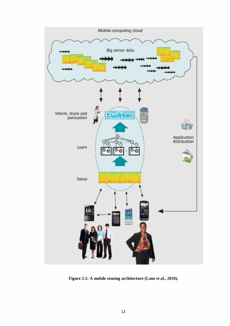
In spite all the research, “mobile phone sensing is still in its infancy”.
Mentioned by (Lane et al., 2010), on the sensing architecture, there are little or no
consensus for the mobile and Cloud. Furthermore, without interpretation, the raw
data that is collected by the mobile devices are worthless. Figure 2.1, shows a mobile
sensing architecture.
12
Figure 2.1: A mobile sensing architecture (Lane et al., 2010).

13
2.2.1. Challenges of mobile devices
While mobile devices are growing, still there are a large number of challenges
that these devices are facing. Limitations such as memory, processing power and the
communication channels, impose great difficulties to provide user as an option to
solve complex problems (Palmer et al., 2009; Ozturk and Altilar 2007) considers
PDAs and mobile phones in the same category (i.e. minioms) since they share the
same communication protocols, although they have different hardware and software.
Additionally, the existing and growing number of wireless mobile devices
often demands more computational power than currently provided by their devices
(Kurkovsky et al., 2004). Relatively, to overcome the limitations of the mobile
devices, several attempts have been addressed by previous authors.
2.2.2. Previous attempts
A grid based mobile environment allows mobile devices to become more
efficient by offloading resource-demanding work to powerful processors
(Venkata 2007); this paper uses a java based mobile device. (Mangs et al., 2008) also
presents a framework, enabling the mobile devices to access web services on Globus-
based grids. On the other hand, (Chu and Humphrey 2004) introduces Mobile
OGSI.NET to overcome the limitations for mobile devices which do not support
OGSI runtimes.
However, the existing middleware platform, Globus, does not fully address
mobility (Sajjad et al., 2005). Due to this weakness, the real ontology services would
be available via gateways; as used by (Grabowski et al., 2006) to overcome the

14
limitations faced while using J2ME technology. (Minh et al., 2005) also introduce a
new mobile-to-grid Gateway Replication (MGR) to improve the reliability of grid
services provided to mobile devices.
(Millard et al., 2005; Guan et al., 2005; Tzu-Chi et al., 2005; Phan et al.,
2002) employed the proxy as the central of the infrastructure, that allow the local
mobile devices look ahead to the next generation of WSRF-GRID infrastructure
(Web Services Resource Framework). The proxy based architecture, allows
favourable deployment, interoperability, scalability, adaptively, and fault-tolerance to
emerge as well.
Illustrated in Figure 2.2., is the shared sensor network of mobile phones,
introduced by (Kansal et al., 2007). This system consists of 3 key entities:
Sensors: the mobile devices which sense the physical world.
Network Infrastructure: includes a data repository that stores all the
sensor data provided by the mobile devices, a tasking server that
enables applications to program the sensor network as per their
requirements, and a sensor proxy that allows disconnected operation for
sensors while making their data available to applications.
Users: applications that access the shared Sensor Network or human
users who access the sensor data through a graphical user interface.

15
Figure 2.2: A shared sensor network of mobile phones (Kansal et al., 2007).
2.2.3. Summary
To conclude, previous authors have tried to overcome the limitations of basic
mobile devices by connecting them to the gird and grid services. Moreover, with the
use of proxy servers, they guaranteed a more reliable connectivity while there is
mobility. Furthermore, there are practices on using the mobile phone as sensors;
however, there are little consensus on Cloud and mobile devices.
Thus, most attempts are based on wireless connection, such as Wi-Fi.
However, communication using mobile phones via the internet might not always be
possible. On the other hand, cellular networks have a higher coverage for these
devices. So far, cellular networks would be a suitable option to overcome the existing
communication problems and might even be less costly.

16
2.3. Open GeoSMS
Open GeoSMS specification of OGC, designed to be used by Short Message
System (SMS) Applications on mobile devices capable of handling SMS, facilitate
the communication among different Location Based Service (LBS) or applications.
Open GeoSMS proposing reason is to standardize the LBS information, solving the
barrier in LBS industry development caused by the dissimilarity of different
applications. Thus, without causing much effort or cost, SMS is the best choice
(OGC 09-142r1).
2.3.1. Related work
Increasingly popular worldwide, Location Based Services (LBS) applications
cover a wide spectrum of wireless users, for fleet management in location
identification, for cases such as emergency, or travel aids. Current methods of
GeoLocation would be classified into: GPS-based, cellular network based, or a
combinations of both aka AGPS (AssistedGPS) (Mok et al., 2004; OGC 09-142r1).
(Mok et al., 2004) research, developed with ESRI's GIS Active
X-MapObjects, sends a request to the service gateway for the mobile device's
location. The location polling system is illustrated in Figure 2.3. The Position of the
mobile device is send via internet, for the mobile device equipped with JAVA SIM
card. The end the relevant information would be sent to the mobile device by SMS
message.

17
Figure 2.3: System Design of the LBS Test (Mok et al., 2004).
(Licoppe et al., 2009) methodology, experiments an empirical apparatus for
collecting and aggregating data, using mobile phone; concerning the locations of
users and their communications. (Hester et al., 2010) as part of Mission 4636, after a
7.0 magnitude earthquake struck Haiti on 12 January 2010, conducted Crowd
sourced Translation. Crowd sourcing, filter, verify, translate, and geo-tag, all the
incoming SMS reports, by distributed entity.
2.3.2. Summary
To sum up, worldwide humanitarian crises would be facilitated with effective
responses sharing information, with the use of distributed, SMS-based systems
(Hester et al., 2010). Previous authors have tried to overcome existing information
sharing challenges, with the use of SMS-based systems; also geo-locating the
devices. The best specification available, Open GeoSMS, introduces a standardized
messaging format. However, there are no exact attempts on how it can use the
mobile devices as sensing nodes.

18
2.4. Standardizing Sensors for universal observation
In this part, the available standardization for sensors and sensor networks also
the standards for geographic information systems is covered.
2.4.1. Sensor and sensor network Standardizations
2.4.1.1. Introduction
Although all sensing devices can give an output, there must be a definition of
what this output result defines. For instance, if collecting temperature, our sensing
device would be a thermometer, and the output result could in Celsius or Fahrenheit
or other measurements units. In this part, Standardizing Sensors for universal
observation is gathered in brief.
2.4.1.2. Sensor Network
A Sensor Network (SN) is a group of computer accessible network of
specialized transducers, spatially distributed devices, with a communications
infrastructure intended to monitor and record conditions at diverse locations.
Commonly monitored parameters are temperature, humidity, pressure, wind direction
and speed, illumination intensity, vibration intensity, sound intensity, power-line
voltage, chemical concentrations, pollutant levels and vital human body functions. A
sensor network allows us to observe, and respond to phenomena in the natural
environment, and in the physical and cyber infrastructure (Botts et al.,2007; Chao-
Tung et al., 2008).

19
2.4.1.3. Related Work
Related to the existing work, the fields of sensor network and grid computing
would be grouped in 3 categories:
SensorWebs- to enable timely and secure access to sensor readings,
different kinds of sensors are connected together via middleware;
Sensors to Grid- to facilitate scientific collaborations,
Different sensors and instruments are connected to the grid, for research
and visualization;
Sensor Networks to grid- aims to integrate sensor network, mainly by
the grid services and enable queries on „live‟ data.
(Tham 2006), describes a concept of Sensor-Grid computing and the
architecture of SensorGrid. This paper shows the uses of SensorGrid for event
detection, classification and decision-making. Although, this architecture builds on
the three categories, there are limitations due the centralized approach.
2.4.1.4. Sensor Web
Sensor Webs are often confused with “distributed sensors” or “sensor
networks”. Nevertheless, as sensor networks mature, a common set of operations
emerge; gathering in a conceptual framework, the Sensor Web is created (Kobialka
et al., 2009). The unique feature of the Sensor Web is that the information gathered
by one node is shared and used by other the nodes. In contrast, a sensor web is a type
of web accessible sensor networks or geographic information system (GIS) and

20
archived sensor data that can be discovered and accessed using standard protocols
and Application Program Interface (APIs) (Botts et al., 2007;
Delin and Shannon 2001).
Sensor networks simply gather data and information gathered by a
particular node, in a network where it is not influence by the behavior of another
node. Simply saying, sensor web enables distributed discovery, exchange and
processing of spatially distributed data, available from multiple sensor networks or
the internet (Fairgrieve et al., 2009). Figure 2.4 illustrates the Sensor Web concept.
Figure 2.4: Sensor Web concept (OpenGeoSpatial).
21
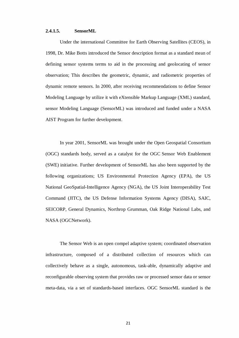
2.4.1.5. SensorML
Under the international Committee for Earth Observing Satellites (CEOS), in
1998, Dr. Mike Botts introduced the Sensor description format as a standard mean of
defining sensor systems terms to aid in the processing and geolocating of sensor
observation; This describes the geometric, dynamic, and radiometric properties of
dynamic remote sensors. In 2000, after receiving recommendations to define Sensor
Modeling Language by utilize it with eXtensible Markup Language (XML) standard,
sensor Modeling Language (SensorML) was introduced and funded under a NASA
AIST Program for further development.
In year 2001, SensorML was brought under the Open Geospatial Consortium
(OGC) standards body, served as a catalyst for the OGC Sensor Web Enablement
(SWE) initiative. Further development of SensorML has also been supported by the
following organizations; US Environmental Protection Agency (EPA), the US
National GeoSpatial-Intelligence Agency (NGA), the US Joint Interoperability Test
Command (JITC), the US Defense Information Systems Agency (DISA), SAIC,
SEICORP, General Dynamics, Northrop Grumman, Oak Ridge National Labs, and
NASA (OGCNetwork).
The Sensor Web is an open compel adaptive system; coordinated observation
infrastructure, composed of a distributed collection of resources which can
collectively behave as a single, autonomous, task-able, dynamically adaptive and
reconfigurable observing system that provides raw or processed sensor data or sensor
meta-data, via a set of standards-based interfaces. OGC SensorML standard is the

22
predominant standardized mechanism of describing sensor resources for Sensor
Webs (Zyl and Vahed 2009).
2.4.1.6. Summary
To sum up, while Sensor networks coordinate monitoring of particular
phenomena by linking spatially distributed sensors, Sensor Webs are distinct; its
loosely couple web services, enabling distribute discovery, exchange and processing
the sensing nodes that are interpolated using standardized interfaces. To include
interaction beyond sensor-to-sensor exchanges, (such as, sensor-to-forecast model
exchange) making observation available, the role of Web applications come in play
(Fairgrieve et al., 2009; Durbha et al., 2009).
Additionally, SensorML is one of the mechanisms for describing sensor
resources on the web. Furthermore, completely distributed workflow descriptions on
the web are facilitates by SensorML. However some existing challenges still remain
on how to fully capture the requirements as relating to open and distributed
environments using SensorML which some extensions are required (Zyl and Vahed
2009).
2.4.2. Geographic Information System (GIS)
Many environmental problems and habitat-monitoring tasks, disaster
managements and etc., require near real-time field mapping and precise positional
information (Tsou et al., 2004). Also, many of our decisions depend on the details of
our immediate surroundings and require information about specific places on the
23
earth surface. They are called geographical information, due to the fact that they are
distinguishing one location from another, to make decisions for the appropriate place.
Geographic information, allows us to apply general principles to specific
conditions of each location, track what is happening at any place, and also helps us to
understand how one place differs from another; similarly, this is essential for
effective planning and decision making.
Geographic information system (GIS) is used generically for any computer-
based capability for manipulating geographical data. A GIS not only includes
hardware and software, but also the spatial data used for input data. Geographic
information attaches a variety of qualities and characteristic to geographical
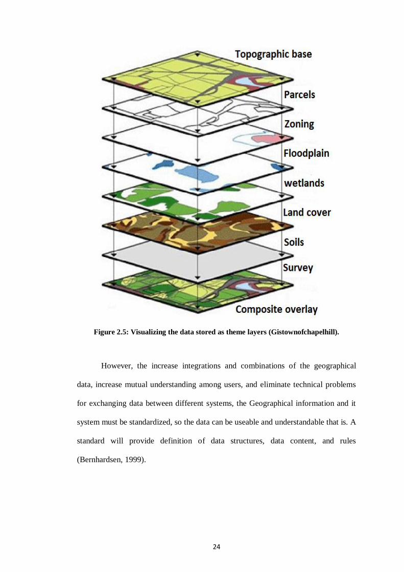
locations, illustrated in Figure 2.5., These qualities may be any physical parameter,
such as temperature, soil moisture level, as well as classifications according to type
of vegetation, zoning, and ownerships and so on (Bernhardsen 1999).
24
Figure 2.5: Visualizing the data stored as theme layers (Gistownofchapelhill).
However, the increase integrations and combinations of the geographical
data, increase mutual understanding among users, and eliminate technical problems
for exchanging data between different systems, the Geographical information and it
system must be standardized, so the data can be useable and understandable that is. A
standard will provide definition of data structures, data content, and rules
(Bernhardsen, 1999).