section i: introduction & overview executive summary...
TRANSCRIPT
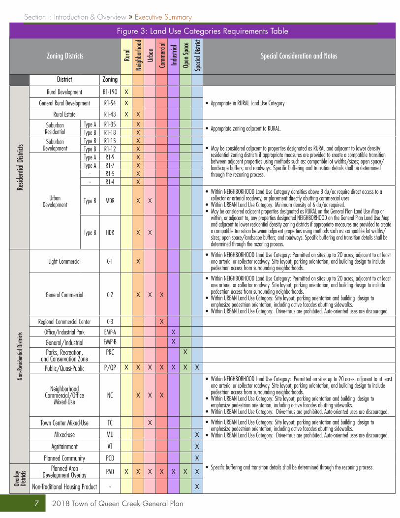
» Land Use ElementThis element includes the Land Use Map (Figure 1: Land Use Map) and Land Use Categories (Figure 2: Land Use Categories) that designate the location, density, and intensity of land for a variety of uses. Figure 3: Land Use Categories Requirements Table describes requirements associated with specific zoning categories within each Land Use Category.
Goal 1: Maintain the Town’s unique community character.Goal 2: Effectively manage the Town’s growth.Goal 3: Ensure long-term employment diversity and economic stability.Goal 4: Promote seamless development between the Town and adjacent jurisdictions.
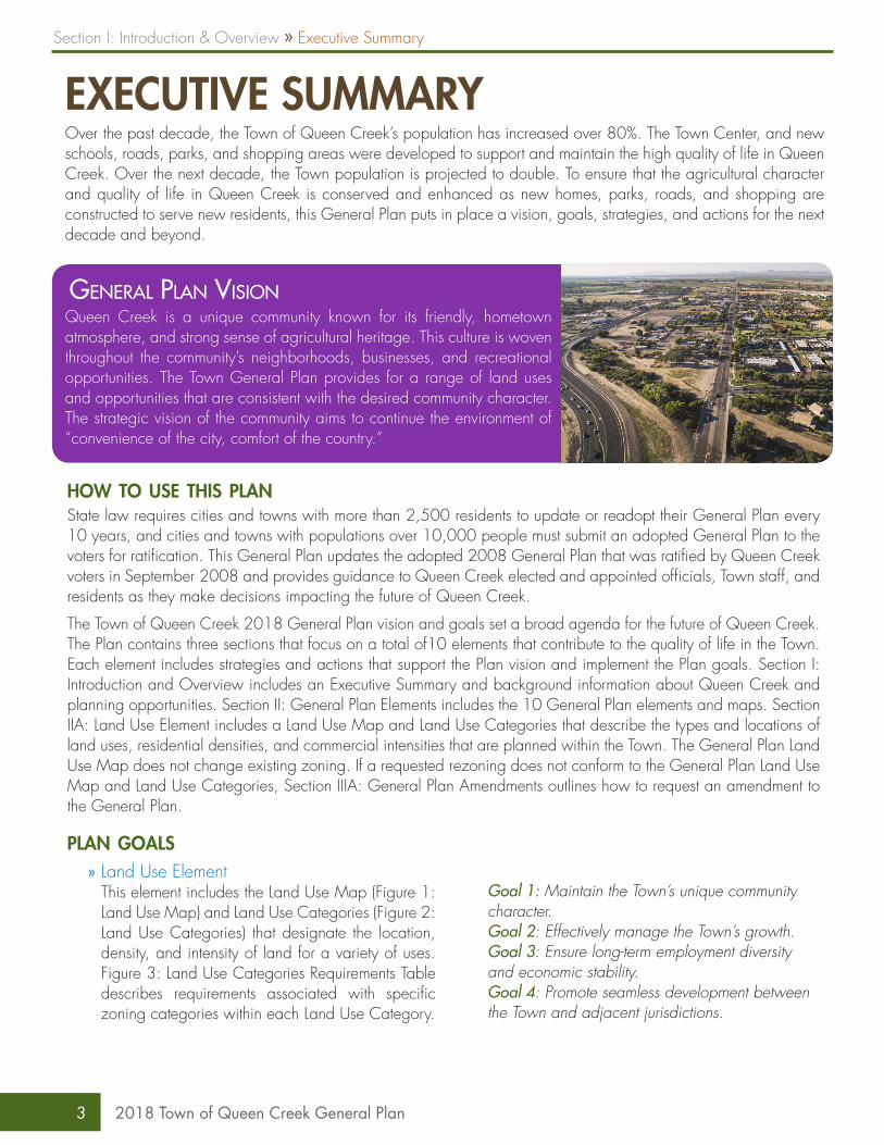
General Plan VisionQueen Creek is a unique community known for its friendly, hometown atmosphere, and strong sense of agricultural heritage. This culture is woven throughout the community’s neighborhoods, businesses, and recreational opportunities. The Town General Plan provides for a range of land uses and opportunities that are consistent with the desired community character. The strategic vision of the community aims to continue the environment of “convenience of the city, comfort of the country.”
how to use this planState law requires cities and towns with more than 2,500 residents to update or readopt their General Plan every 10 years, and cities and towns with populations over 10,000 people must submit an adopted General Plan to the voters for ratification. This General Plan updates the adopted 2008 General Plan that was ratified by Queen Creek voters in September 2008 and provides guidance to Queen Creek elected and appointed officials, Town staff, and residents as they make decisions impacting the future of Queen Creek.
The Town of Queen Creek 2018 General Plan vision and goals set a broad agenda for the future of Queen Creek. The Plan contains three sections that focus on a total of10 elements that contribute to the quality of life in the Town. Each element includes strategies and actions that support the Plan vision and implement the Plan goals. Section I: Introduction and Overview includes an Executive Summary and background information about Queen Creek and planning opportunities. Section II: General Plan Elements includes the 10 General Plan elements and maps. Section IIA: Land Use Element includes a Land Use Map and Land Use Categories that describe the types and locations of land uses, residential densities, and commercial intensities that are planned within the Town. The General Plan Land Use Map does not change existing zoning. If a requested rezoning does not conform to the General Plan Land Use Map and Land Use Categories, Section IIIA: General Plan Amendments outlines how to request an amendment to the General Plan.
plan goals
EXECUTIVE SUMMARYOver the past decade, the Town of Queen Creek’s population has increased over 80%. The Town Center, and new schools, roads, parks, and shopping areas were developed to support and maintain the high quality of life in Queen Creek. Over the next decade, the Town population is projected to double. To ensure that the agricultural character and quality of life in Queen Creek is conserved and enhanced as new homes, parks, roads, and shopping are constructed to serve new residents, this General Plan puts in place a vision, goals, strategies, and actions for the next decade and beyond.
Section I: Introduction & Overview » Executive Summary
3 2018 Town of Queen Creek General Plan
» Housing ElementGoal 1: Provide a diverse range of quality housing options for current and future residents.
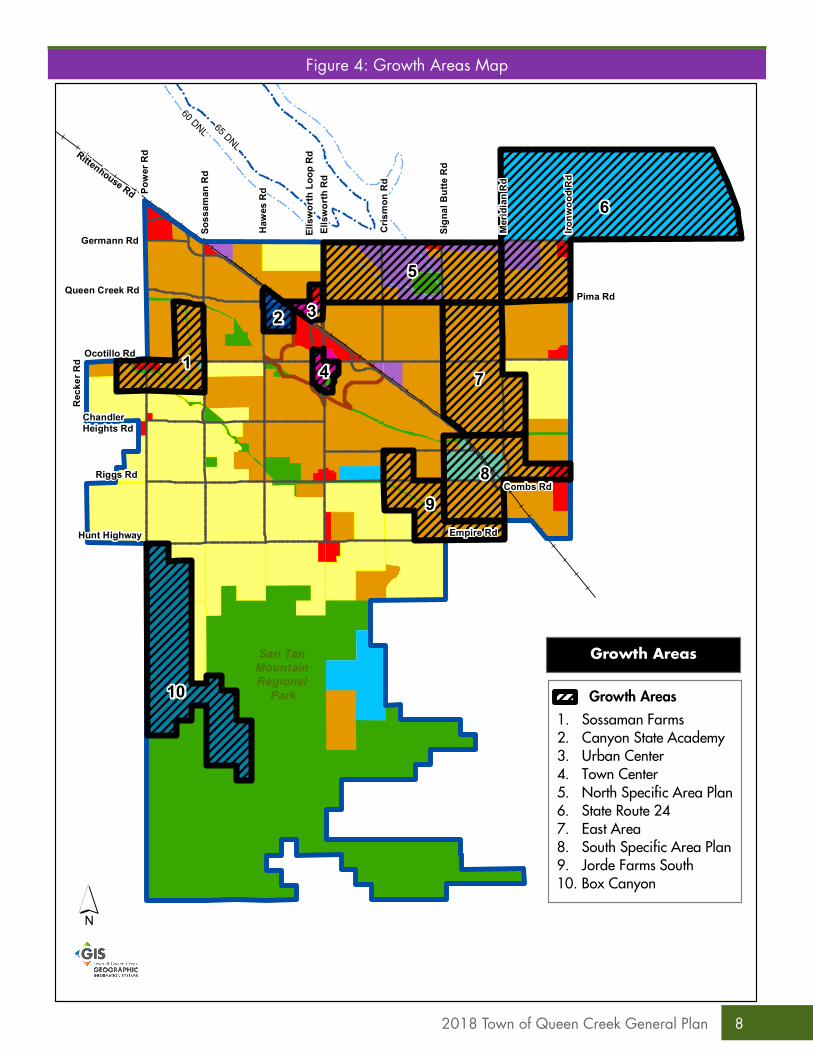
» Growth Areas Element This element provides guidance for areas where new development is needed to accommodate future population. The Growth Areas Map (Figure 4: Growth Areas Map) identifies planned Growth Areas. Goal 1: Plan for and prepare to guide development within growth areas.
» Circulation Element The Circulation Element includes a Circulation Map (Figure 5: Transportation System Map) that describes current and planned arterial and collector streets and on-street bicycle routes.Goal 1: Develop a multimodal transportation system for all users.
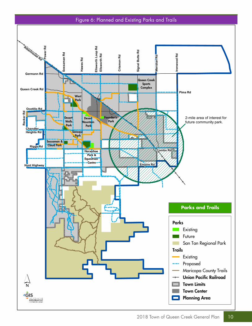
» Recreation, Parks, & Open Space ElementThe Parks and Recreation Element incorporates, by reference, the adopted Parks and Recreation Master Plan and includes maps that describe current and planned parks, trails, and open space (Figure 6: Planned and Existing Parks and Trails).Goal 1: Develop a comprehensive park system to provide open spaces and recreation opportunities appropriate to a community the size of Queen Creek.Goal 2: Provide parks and recreation programs that reflect the culture and character of Queen Creek, and that leverage existing and planned recreation facilities.Goal 3: Leverage parks and recreation facilities to promote economic development.Goal 4: Coordinate with other jurisdictions and public and private entities to expand recreation opportunities for Queen Creek residents and visitors.Goal 5: Design parks and trails that are safe.
» Environmental ElementGoal 1: Protect and improve air quality.Goal 2: Reduce the amount of solid waste.Goal 3: Prevent pollution of the Queen Creek and Sonoqui washes and groundwater system.Goal 4: Promote environmental sensitivity in the built environment.Goal 5: Maintain the desert character and environment in the San Tan Foothills.
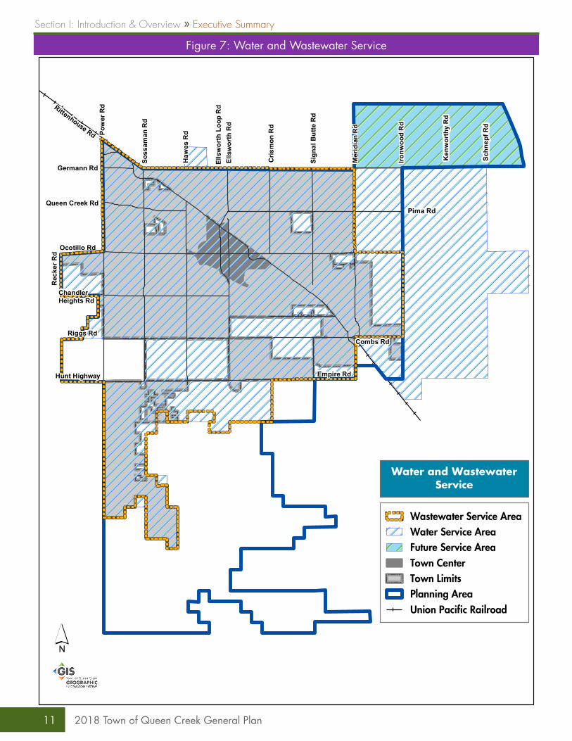
» Water Resources ElementThe Water Element describes an approach to meeting the water needs of the Town. Figure 7: Water and Wastewater Service describes the Town of Queen Creek water and wastewater service areas.Goal 1: Effectively and efficiently manage water resources.Goal 2: Protect and conserve water resources
» Economic Development ElementGoal 1: Attract private investment and foster job creation in Queen Creek.Goal 2: Create an entrepreneurial culture that fosters new ideas and the creation of new business.Goal 3: Position Queen Creek as the agritainment capital of Arizona.Goal 4: Leverage trails and outdoor recreation to attract visitors.Goal 5: Plan for and invest in the infrastructure that supports economic development.Goal 6: Generate more economic synergy within the Town Center.Goal 7: Develop a robust Queen Creek economic development marketing program.
» Cost of Development ElementGoal 1: Maintain a consistent level of high quality services for all Queen Creek residents.
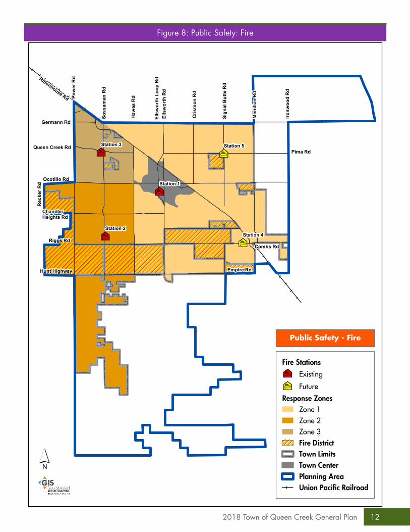
» Public Safety ElementThe Public Safety Element describes how the Town will meet its public safety (fire, police, and emergency medical services) needs and responsibilities as the Town grows. Figures 8: Public Safety: Fire and 9: Public Safety: Police show existing emergency service locations.Goal 1: Foster a safe and vibrant community to enhance the quality of life.Goal 2: Increase community trust, interactions, involvement, accountability and enhance the Maricopa County Sheriff’s Office (MCSO) District 6 identity in the Town of Queen Creek.
42018 Town of Queen Creek General Plan
!
!
!
!
!
!
!
!
!
!
!
!
!
!
!
!
!
!
!
!
!
!
!
!!
!
!
!
!
!
!
!
!
!
!
!
!
!
!
!
!
!
!
!
!
!
!
!
!
!
!
!
!
!
!
!
!
!
!
!
!
!
!
!!
!
!
!
!
!
!
!
!
!
!
!
!
!
!
!
!
!
!
!
!
!
!
!
!
!
!
!
!
!
!
!
!
!
!
!
!
!
Rittenhouse Rd Pow
er R
d
Soss
aman
Rd
Haw
es R
d
Ells
wor
th R
dEl
lsw
orth
Loo
p R
d
Cris
mon
Rd
Sign
al B
utte
Rd
Mer
idia
n R
d
Ironw
ood
Rd
Combs Rd
Empire Rd
Germann Rd
Queen Creek Rd
Ocotillo Rd
Rec
ker R
d
Chandler Heights Rd
Riggs Rd
Hunt Highway
San Tan Mountain Regional
Park
60 DNL65 DNL
Pima Rd
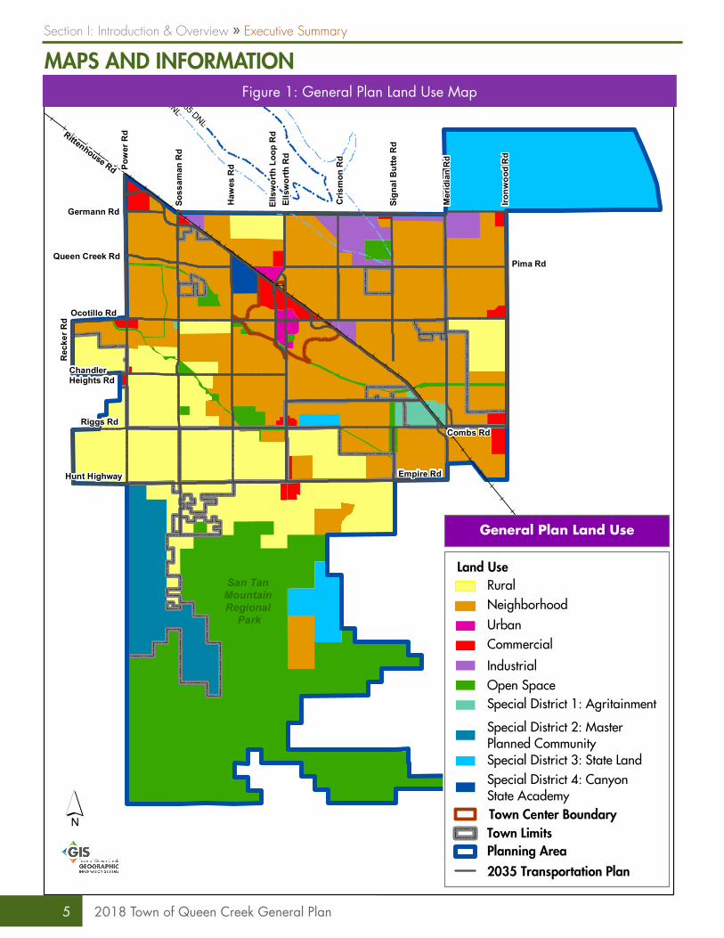
General Plan Land Use
´
RuralNeighborhoodUrbanCommercial
IndustrialOpen Space
2035 Transportation Plan
Land Use
Special District 1: Agritainment
Special District 3: State Land
Town LimitsPlanning Area
Town Center Boundary
Special District 2: MasterPlanned Community
Special District 4: CanyonState Academy
MAPS AND INFORMATIONFigure 1: General Plan Land Use Map
Section I: Introduction & Overview » Executive Summary
5 2018 Town of Queen Creek General Plan
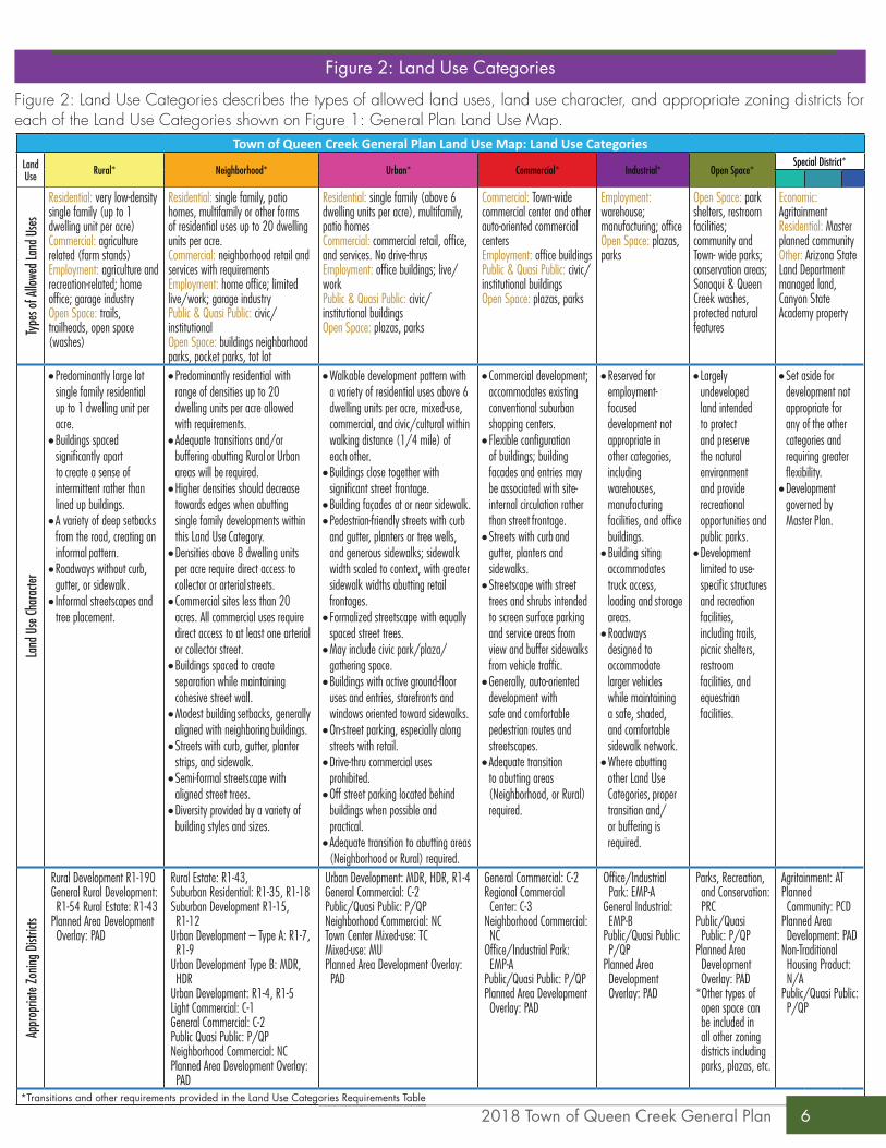
Figure 2: Land Use Categories
Figure 2: Land Use Categories describes the types of allowed land uses, land use character, and appropriate zoning districts for each of the Land Use Categories shown on Figure 1: General Plan Land Use Map.
Town of Queen Creek General Plan Land Use Map: Land Use CategoriesLand Use Rural* Neighborhood* Urban* Commercial* Industrial* Open Space*
Special District*
Type
s of A
llowe
d Lan
d Use
s
Residential: very low-density single family (up to 1 dwelling unit per acre) Commercial: agriculture related (farm stands) Employment: agriculture and recreation-related; home offi ce; garage industry Open Space: trails, trailheads, open space (washes)
Residential: single family, patio homes, multifamily or other forms of residential uses up to 20 dwelling units per acre. Commercial: neighborhood retail and services with requirements Employment: home offi ce; limited live/work; garage industry Public & Quasi Public: civic/institutional Open Space: buildings neighborhood parks, pocket parks, tot lot
Residential: single family (above 6 dwelling units per acre), multifamily, patio homes Commercial: commercial retail, offi ce, and services. No drive-thrus Employment: offi ce buildings; live/work Public & Quasi Public: civic/institutional buildings Open Space: plazas, parks
Commercial: Town-wide commercial center and other auto-oriented commercial centers Employment: offi ce buildings Public & Quasi Public: civic/institutional buildings Open Space: plazas, parks
Employment: warehouse; manufacturing; offi ceOpen Space: plazas, parks
Open Space: park shelters, restroom facilities; community and Town- wide parks; conservation areas; Sonoqui & Queen Creek washes, protected natural features
Economic: Agritainment Residential: Master planned community Other: Arizona State Land Department managed land, Canyon State Academy property
Land
Use
Char
acter
• Predominantly large lot single family residential up to 1 dwelling unit per acre.
• Buildings spaced signifi cantly apart to create a sense of intermittent rather than lined up buildings.
• A variety of deep setbacks from the road, creating an informal pattern.
• Roadways without curb, gutter, or sidewalk.
• Informal streetscapes and tree placement.
• Predominantly residential with range of densities up to 20 dwelling units per acre allowed with requirements.
• Adequate transitions and/or buffering abutting Rural or Urban areas will be required.
• Higher densities should decrease towards edges when abutting single family developments within this Land Use Category.
• Densities above 8 dwelling units per acre require direct access to collector or arterial streets.
• Commercial sites less than 20 acres. All commercial uses require direct access to at least one arterial or collector street.
• Buildings spaced to create separation while maintaining cohesive street wall.
• Modest building setbacks, generally aligned with neighboring buildings.
• Streets with curb, gutter, planter strips, and sidewalk.
• Semi-formal streetscape with aligned street trees.
• Diversity provided by a variety of building styles and sizes.
• Walkable development pattern with a variety of residential uses above 6 dwelling units per acre, mixed-use, commercial, and civic/cultural within walking distance (1/4 mile) of each other.
• Buildings close together with signifi cant street frontage.
• Building façades at or near sidewalk.• Pedestrian-friendly streets with curb
and gutter, planters or tree wells, and generous sidewalks; sidewalk width scaled to context, with greater sidewalk widths abutting retail frontages.
• Formalized streetscape with equally spaced street trees.
• May include civic park/plaza/gathering space.
• Buildings with active ground-fl oor uses and entries, storefronts and windows oriented toward sidewalks.
• On-street parking, especially along streets with retail.
• Drive-thru commercial uses prohibited.
• Off street parking located behind buildings when possible and practical.
• Adequate transition to abutting areas (Neighborhood or Rural) required.
• Commercial development; accommodates existing conventional suburban shopping centers.
• Flexible confi guration of buildings; building facades and entries may be associated with site-internal circulation rather than street frontage.
• Streets with curb and gutter, planters and sidewalks.
• Streetscape with street trees and shrubs intended to screen surface parking and service areas from view and buffer sidewalks from vehicle traffi c.
• Generally, auto-oriented development with safe and comfortable pedestrian routes and streetscapes.
• Adequate transition to abutting areas (Neighborhood, or Rural) required.
• Reserved for employment- focused development not appropriate in other categories, including warehouses, manufacturing facilities, and offi ce buildings.
• Building siting accommodates truck access, loading and storage areas.
• Roadways designed to accommodate larger vehicles while maintaining a safe, shaded, and comfortable sidewalk network.
• Where abutting other Land Use Categories, proper transition and/or buffering is required.
• Largely undeveloped land intended to protect and preserve the natural environment and provide recreational opportunities and public parks.
• Development limited to use- specifi c structures and recreation facilities, including trails, picnic shelters, restroom facilities, and equestrian facilities.
• Set aside for development not appropriate for any of the other categories and requiring greater fl exibility.
• Development governed by Master Plan.
Appr
opria
te Zo
ning D
istric
ts
Rural Development R1-190General Rural Development: R1-54 Rural Estate: R1-43
Planned Area Development Overlay: PAD
Rural Estate: R1-43, Suburban Residential: R1-35, R1-18 Suburban Development R1-15, R1-12
Urban Development – Type A: R1-7, R1-9
Urban Development Type B: MDR, HDR
Urban Development: R1-4, R1-5Light Commercial: C-1General Commercial: C-2Public Quasi Public: P/QPNeighborhood Commercial: NCPlanned Area Development Overlay: PAD
Urban Development: MDR, HDR, R1-4General Commercial: C-2Public/Quasi Public: P/QPNeighborhood Commercial: NCTown Center Mixed-use: TCMixed-use: MUPlanned Area Development Overlay: PAD
General Commercial: C-2Regional Commercial Center: C-3
Neighborhood Commercial: NC
Offi ce/Industrial Park: EMP-A
Public/Quasi Public: P/QPPlanned Area Development Overlay: PAD
Offi ce/Industrial Park: EMP-A
General Industrial: EMP-B
Public/Quasi Public: P/QP
Planned Area Development Overlay: PAD
Parks, Recreation, and Conservation: PRC
Public/Quasi Public: P/QP
Planned Area Development Overlay: PAD
*Other types of open space can be included in all other zoning districts including parks, plazas, etc.
Agritainment: ATPlanned Community: PCD
Planned Area Development: PAD
Non-Traditional Housing Product: N/A
Public/Quasi Public: P/QP
*Transitions and other requirements provided in the Land Use Categories Requirements Table
62018 Town of Queen Creek General Plan
Zoning Districts Rura
l
Neigh
borh
ood
Urba
n
Comm
ercia
l
Indu
strial
Open
Spac
e
Spec
ial D
istric
t
Special Consideration and Notes
District Zoning
Resid
entia
l Dist
ricts
Rural Development R1-190 X
• Appropriate in RURAL Land Use Category.General Rural Development R1-54 X
Rural Estate R1-43 X X
Suburban Residential
Type A R1-35 X• Appropriate zoning adjacent to RURAL.
Type B R1-18 XSuburban
DevelopmentType B R1-15 X
• May be considered adjacent to properties designated as RURAL and adjacent to lower density residential zoning districts if appropriate measures are provided to create a compatible transition between adjacent properties using methods such as: compatible lot widths/sizes; open space/landscape buffers; and roadways. Specific buffering and transition details shall be determined through the rezoning process.
Type B R1-12 X
Urban Development
Type A R1-9 XType A R1-7 X
- R1-5 X- R1-4 X
Type B MDR X X• Within NEIGHBORHOOD Land Use Category densities above 8 du/ac require direct access to a
collector or arterial roadway, or placement directly abutting commercial uses• Within URBAN Land Use Category: Minimum density of 6 du/ac required.• May be considered adjacent properties designated as RURAL on the General Plan Land Use Map or
within, or adjacent to, any properties designated NEIGHBORHOOD on the General Plan Land Use Map and adjacent to lower residential density zoning districts if appropriate measures are provided to create a compatible transition between adjacent properties using methods such as: compatible lot widths/sizes; open space/landscape buffers; and roadways. Specific buffering and transition details shall be determined through the rezoning process.
Type B HDR X X
Non-
Resid
entia
l Dist
ricts
Light Commercial C-1 X• Within NEIGHBORHOOD Land Use Category: Permitted on sites up to 20 acres, adjacent to at least
one arterial or collector roadway. Site layout, parking orientation, and building design to include pedestrian access from surrounding neighborhoods.
General Commercial C-2 X X X
• Within NEIGHBORHOOD Land Use Category: Permitted on sites up to 20 acres, adjacent to at least one arterial or collector roadway. Site layout, parking orientation, and building design to include pedestrian access from surrounding neighborhoods.
• Within URBAN Land Use Category: Site layout, parking orientation and building design to emphasize pedestrian orientation, including active facades abutting sidewalks.
• Within URBAN Land Use Category: Drive-thrus are prohibited. Auto-oriented uses are discouraged.
Regional Commercial Center C-3 X
Office/Industrial Park EMP-A X
General/Industrial EMP-B X
Parks, Recreation, and Conservation Zone
PRC X
Public/Quasi-Public P/QP X X X X X X X
Neighborhood Commercial/Office
Mixed-UseNC X X X
• Within NEIGHBORHOOD Land Use Category: Permitted on sites up to 20 acres, adjacent to at least one arterial or collector roadway. Site layout, parking orientation, and building design to include pedestrian access from surrounding neighborhoods.
• Within URBAN Land Use Category: Site layout, parking orientation and building design to emphasize pedestrian orientation, including active facades abutting sidewalks.
• Within URBAN Land Use Category: Drive-thrus are prohibited. Auto-oriented uses are discouraged.
Town Center Mixed-Use TC X • Within URBAN Land Use Category: Site layout, parking orientation and building design to emphasize pedestrian orientation, including active facades abutting sidewalks.
• Within URBAN Land Use Category: Drive-thrus are prohibited. Auto-oriented uses are discouraged.Mixed-use MU X
Agritainment AT X
• Specific buffering and transition details shall be determined through the rezoning process.Planned Community PCD X
Over
lay
Distr
icts Planned Area
Development Overlay PAD X X X X X X X
Non-Traditional Housing Product - X
Figure 3: Land Use Categories Requirements Table
Section I: Introduction & Overview » Executive Summary
7 2018 Town of Queen Creek General Plan
!
!
!
!
!
!
!
!
!
!
!
!
!
!
!
!
!
!
!
!
!
!
!
!!
!
!
!
!
!
!
!
!
!
!
!
!
!
!
!
!
!
!
!
!
!
!
!
!
!
!
!
!
!
!
!
!
!
!
!
!
!
!
!!
!
!
!
!
!
!
!
!
!
!
!
!
!
!
!
!
!
!
!
!
!
!
!
!
!
!
!
!
!
!
!
!
!
!
!
!
!
Rittenhouse Rd Pow
er R
d
Soss
aman
Rd
Haw
es R
d
Ells
wor
th R
dEl
lsw
orth
Loo
p R
d
Cris
mon
Rd
Sign
al B
utte
Rd
Mer
idia
n R
d
Ironw
ood
Rd
Combs Rd
Empire Rd
Germann Rd
Queen Creek Rd
Ocotillo Rd
Rec
ker R
d
Chandler Heights Rd
Riggs Rd
Hunt Highway
San Tan Mountain Regional
Park
65 DNL
60 DNL
Pima Rd
6
5
7
3
4
2
1
10
9
8
Growth Areas
´
1. Sossaman Farms2. Canyon State Academy3. Urban Center4. Town Center5. North Specific Area Plan6. State Route 247. East Area8. South Specific Area Plan 9. Jorde Farms South10. Box Canyon
Growth Areas
Figure 4: Growth Areas Map
82018 Town of Queen Creek General Plan
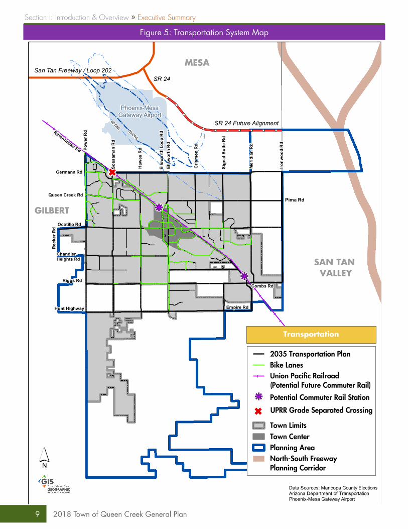
Figure 5: Transportation System Map
G
Rittenhouse Rd Pow
er R
d
Soss
aman
Rd
Haw
es R
d
Ells
wor
th R
dEl
lsw
orth
Loo
p R
d
Cris
mon
Rd
Sign
al B
utte
Rd
Mer
idia
n R
d
Ironw
ood
Rd
Combs Rd
Empire Rd
Germann Rd
Queen Creek Rd
Ocotillo Rd
Rec
ker R
d
Chandler Heights Rd
Riggs Rd
Hunt Highway
!
!
!
!
!
!
!
!
!
!
!
!
!
!
!
!
!
!
!
!
!
!!
!
!
!
!
!
!
!
!
!
!
!
!
!
!
!
!
!
!
!
!
!
!
!
!
!
!
!
!
!
!
!
!
!
!
!
!!
!
!
!
!
!
!
!
!
!
!
!
!
!
!
!
!
!
!
!
!
!
!
!
!
!
!
!
!
!
!
!
!
!
kj
kj
Phoenix-MesaGateway Airport
MESA
GILBERT
SAN TAN VALLEY
San Tan Freeway / Loop 202SR 24
60 DNL 65 DNL
SR 24 Future Alignment
Pima Rd
Transportation
´Data Sources: Maricopa County ElectionsArizona Department of TransportationPhoenix-Mesa Gateway Airport
2035 Transportation Plan
kj Potential Commuter Rail Station
Town LimitsTown CenterPlanning Area
G UPRR Grade Separated Crossing
Union Pacific Railroad(Potential Future Commuter Rail)
North-South Freeway Planning Corridor
Bike Lanes
Section I: Introduction & Overview » Executive Summary
9 2018 Town of Queen Creek General Plan
Rittenhouse Rd Pow
er R
d
Soss
aman
Rd
Haw
es R
d
Ells
wor
th R
dEl
lsw
orth
Loo
p R
d
Cris
mon
Rd
Sign
al B
utte
Rd
Mer
idia
n R
d
Ironw
ood
Rd
Combs Rd
Empire Rd
Germann Rd
Queen Creek Rd
Ocotillo Rd
Rec
ker R
d
Chandler Heights Rd
Riggs Rd
Hunt Highway
2-mile area of interest for future community park.
Queen CreekSports
Complex
Founder's Park
Desert Mountain
Park
Horseshoe Park &
Equestrian Centre
WestPark
Desert WellsPark
Sonoqui Park
Sossaman &Cloud Park
Pima Rd
ParksExistingFutureSan Tan Regional Park
TrailsExistingProposedMaricopa County TrailsUnion Pacific RailroadTown LimitsTown CenterPlanning Area
Parks and Trails
´
Figure 6: Planned and Existing Parks and Trails
102018 Town of Queen Creek General Plan
Rittenhouse Rd Pow
er R
d
Soss
aman
Rd
Haw
es R
d
Ells
wor
th R
dEl
lsw
orth
Loo
p R
d
Cris
mon
Rd
Sign
al B
utte
Rd
Mer
idia
n R
d
Ironw
ood
Rd
Combs Rd
Empire Rd
Germann Rd
Queen Creek Rd
Ocotillo Rd
Rec
ker R
d
Chandler Heights Rd
Riggs Rd
Hunt Highway
Schn
epf R
d
Ken
wor
thy
Rd
Pima Rd
Wastewater Service AreaWater Service AreaFuture Service AreaTown CenterTown LimitsPlanning AreaUnion Pacific Railroad
Water and WastewaterService
´
Figure 7: Water and Wastewater Service
Section I: Introduction & Overview » Executive Summary
11 2018 Town of Queen Creek General Plan
²µ²µ
²µ
²µ
²µ
Rittenhouse Rd Pow
er R
d
Soss
aman
Rd
Haw
es R
d
Ells
wor
th R
dEl
lsw
orth
Loo
p R
d
Cris
mon
Rd
Sign
al B
utte
Rd
Mer
idia
n R
d
Ironw
ood
Rd
Combs Rd
Empire Rd
Germann Rd
Queen Creek Rd
Ocotillo Rd
Rec
ker R
d
Chandler Heights Rd
Riggs Rd
Hunt Highway
Pima Rd
Station 2Station 4
Station 3
Station 1
Station 5
Fire Stations
²µ Existing
²µ Future
Response ZonesZone 1Zone 2Zone 3Fire DistrictTown LimitsTown CenterPlanning AreaUnion Pacific Railroad
Public Safety - Fire
´
Figure 8: Public Safety: Fire
122018 Town of Queen Creek General Plan
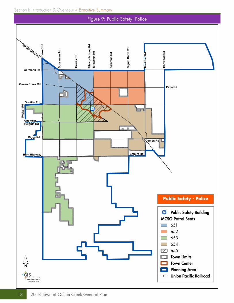
Figure 9: Public Safety: Police
ca
Rittenhouse Rd Pow
er R
d
Soss
aman
Rd
Haw
es R
d
Ells
wor
th R
dEl
lsw
orth
Loo
p R
d
Cris
mon
Rd
Sign
al B
utte
Rd
Mer
idia
n R
d
Ironw
ood
Rd
Combs Rd
Empire Rd
Germann Rd
Queen Creek Rd
Ocotillo Rd
Rec
ker R
d
Chandler Heights Rd
Riggs Rd
Hunt Highway
Pima Rd
ca Public Safety BuildingMCSO Patrol Beats
651652653654655Town LimitsTown CenterPlanning AreaUnion Pacific Railroad
Public Safety - Police
´
Section I: Introduction & Overview » Executive Summary
13 2018 Town of Queen Creek General Plan
» Rural Land Use Category and General Plan Map• Rezoning request for 10 or more acres of
land that is not in conformance with the Land Use Character, Land Use Types, Appropriate Zoning Districts, or the Land Use Categories Requirements Table.
• A rezoning request that would create 10 or more contiguous acres of zoning not in conformance with the General Plan.
» Neighborhood Land Use Category and General Plan Map• Rezoning request for 5 or more acres of land
that is not in conformance with the Land Use Character, Land Use Types, Appropriate Zoning Districts, or the Land Use Categories Requirements Table.
• A rezoning request that would create more than 5 contiguous acres of zoning not in conformance with the General Plan.
» Urban Land Use Category and General Plan Map• Rezoning request for land greater than one (1)
acre that is not in conformance with the Land Use Character, Land Use Type, appropriate Zoning Districts, or the Land Use Categories Requirements Table.
• Any request for a drive-thru.• Any rezoning request that would create more
than 5 contiguous acres of zoning not in conformance with the General Plan.
» Commercial and Industrial Categories and General Plan Map• Rezoning request for land greater than 20
acres that is not in conformance with the Land Use Character, Land Use Type, appropriate Zoning Districts, or the Land Use Categories Requirements Table.
• A rezoning request that would create 20 or more contiguous acres of zoning not in conformance with the General Plan.
» Special District, Open Space, or Agritainment Categories and General Plan Map• Any rezoning request not in conformance
in the Special District, Open Space, or Agritainment Land Use Categories.
» Text Changes• Changes to the text of the Land Use
Categories, Land Use Categories Requirements Table, descriptions on the Land Use legend, or the elimination or substantial modification of any goals or strategies to the General Plan.
general plan amendmentsMajor AmendmentsMajor Amendments to the General Plan may be submitted annually. Minor Amendments to the General Plan may be submitted at any time during the calendar year. More information on the General Plan Amendment process is located in Section III: General Plan Administration: General Plan Amendments.
A Major General Plan Amendment would be required for any change to the text of the following Land Use Categories:
Any rezoning request that is less than the size limit established in the above sections may be approved through the rezoning process and will not require a Major General Plan Amendment. During the rezone review request, consideration will be given to maintain a compatible transition between adjacent properties.
Minor AmendmentsMinor Amendments include text amendments, such as updates to goals and strategies which do not change their meaning or intent, to demographic or statistical information, and updates or modifications to actions. Updates to maps included in this General Plan (excluding the Land Use Map) may be done through a Minor General Plan Amendment request. Requests for Minor Amendments would be recommended by the Planning and Zoning Commission to the Town Council. Minor Amendment requests can be considered at any Planning and Zoning Commission and Town Council public meeting.
Any rezoning request that is less than the size limit established in the above sections may be approved through the rezoning process and will not require a Minor General Plan Amendment. During the rezone review request, consideration will be given to maintain a compatible transition between adjacent properties.
142018 Town of Queen Creek General Plan
1. Whether this change in the General Plan land use map will result in a shortage of land for other planned uses (for example and not limited to, will this change result in a substantial and undesirable reduction in the amount of available land for employment or higher density housing development?)
2. Does the proposed amendment constitute an overall improvement to the Queen Creek General Plan and is not solely for the good or benefit of a particular landowner or owners at a particular point in time.
3. The degree to which the proposed amendment will impact the whole community or a portion of the community by:
a. Significantly altering acceptable existing land use patterns in a way that is contrary to the goals, strategies and actions identified in the adopted General Plan.
b. Requiring larger or more extensive improvements to roads, sewer, or water systems than are needed to support the prevailing land uses and which may negatively impact development of other lands. The Commission and/or the Town Council may also consider the degree to which the need for such improvements will be mitigated pursuant to binding commitments by the applicant, a public agency, or other sources when the impacts of the uses permitted pursuant to the General Plan amendment will be felt.
c. Resulting in adverse impacts on existing uses due to increased traffic congestion that will not be accommodated by planned roadway improvements or other planned transportation improvements such as and not limited to non-motorized transportation alternatives, transit, or self driving vehicles.
d. Affecting the livability of the surrounding area or the health and safety of present or future residents.
4. Consistency of the proposed amendment with the vision, goals, strategies, and actions of the adopted General Plan.
5. Whether there was an error or oversight in the original General Plan adoption in that the Council did not fully consider facts, projects or trends which could reasonably exist in the future.
6. Whether events subsequent to the General Plan adoption have superseded the Council’s original premises and findings made upon Plan adoption.
7. Whether any or all of the Council’s original premises and findings regarding General Plan adoption were unsubstantiated.
8. Whether events subsequent to the General Plan adoption may have changed the character and/or condition of the area so as to make the application acceptable
9. The extent to which the benefits of the Plan amendment outweigh any of the impacts identified in the above subsections.
Findings of FactIn determining whether the proposed amendment should be approved, the Commission and Town Council shall consider the following factors:
Section I: Introduction & Overview » Executive Summary
15 2018 Town of Queen Creek General Plan
162018 Town of Queen Creek General Plan
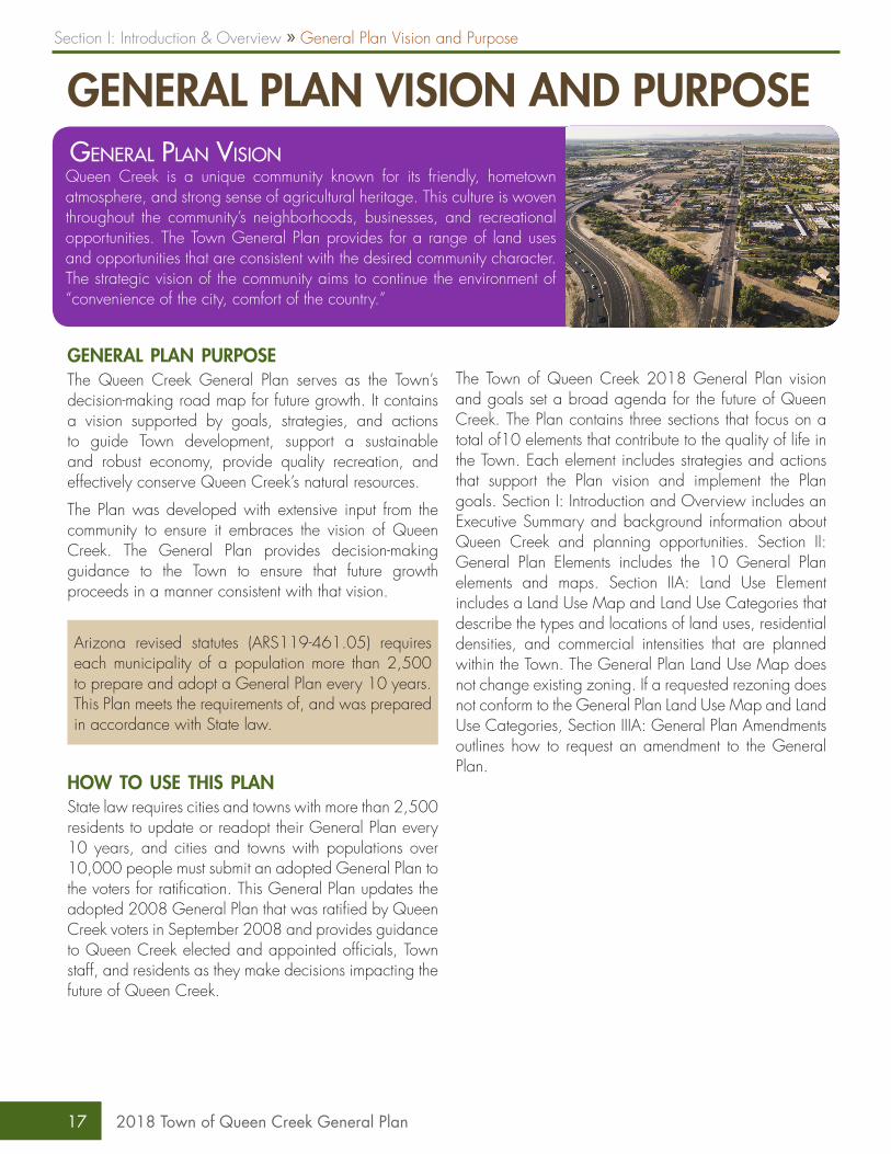
GENERAL PLAN VISION AND PURPOSE
general plan purposeThe Queen Creek General Plan serves as the Town’s decision-making road map for future growth. It contains a vision supported by goals, strategies, and actions to guide Town development, support a sustainable and robust economy, provide quality recreation, and effectively conserve Queen Creek’s natural resources.
The Plan was developed with extensive input from the community to ensure it embraces the vision of Queen Creek. The General Plan provides decision-making guidance to the Town to ensure that future growth proceeds in a manner consistent with that vision.
Arizona revised statutes (ARS119-461.05) requires each municipality of a population more than 2,500 to prepare and adopt a General Plan every 10 years. This Plan meets the requirements of, and was prepared in accordance with State law.
how to use this planState law requires cities and towns with more than 2,500 residents to update or readopt their General Plan every 10 years, and cities and towns with populations over 10,000 people must submit an adopted General Plan to the voters for ratification. This General Plan updates the adopted 2008 General Plan that was ratified by Queen Creek voters in September 2008 and provides guidance to Queen Creek elected and appointed officials, Town staff, and residents as they make decisions impacting the future of Queen Creek.
The Town of Queen Creek 2018 General Plan vision and goals set a broad agenda for the future of Queen Creek. The Plan contains three sections that focus on a total of10 elements that contribute to the quality of life in the Town. Each element includes strategies and actions that support the Plan vision and implement the Plan goals. Section I: Introduction and Overview includes an Executive Summary and background information about Queen Creek and planning opportunities. Section II: General Plan Elements includes the 10 General Plan elements and maps. Section IIA: Land Use Element includes a Land Use Map and Land Use Categories that describe the types and locations of land uses, residential densities, and commercial intensities that are planned within the Town. The General Plan Land Use Map does not change existing zoning. If a requested rezoning does not conform to the General Plan Land Use Map and Land Use Categories, Section IIIA: General Plan Amendments outlines how to request an amendment to the General Plan.
General Plan VisionQueen Creek is a unique community known for its friendly, hometown atmosphere, and strong sense of agricultural heritage. This culture is woven throughout the community’s neighborhoods, businesses, and recreational opportunities. The Town General Plan provides for a range of land uses and opportunities that are consistent with the desired community character. The strategic vision of the community aims to continue the environment of “convenience of the city, comfort of the country.”
Section I: Introduction & Overview » General Plan Vision and Purpose
17 2018 Town of Queen Creek General Plan
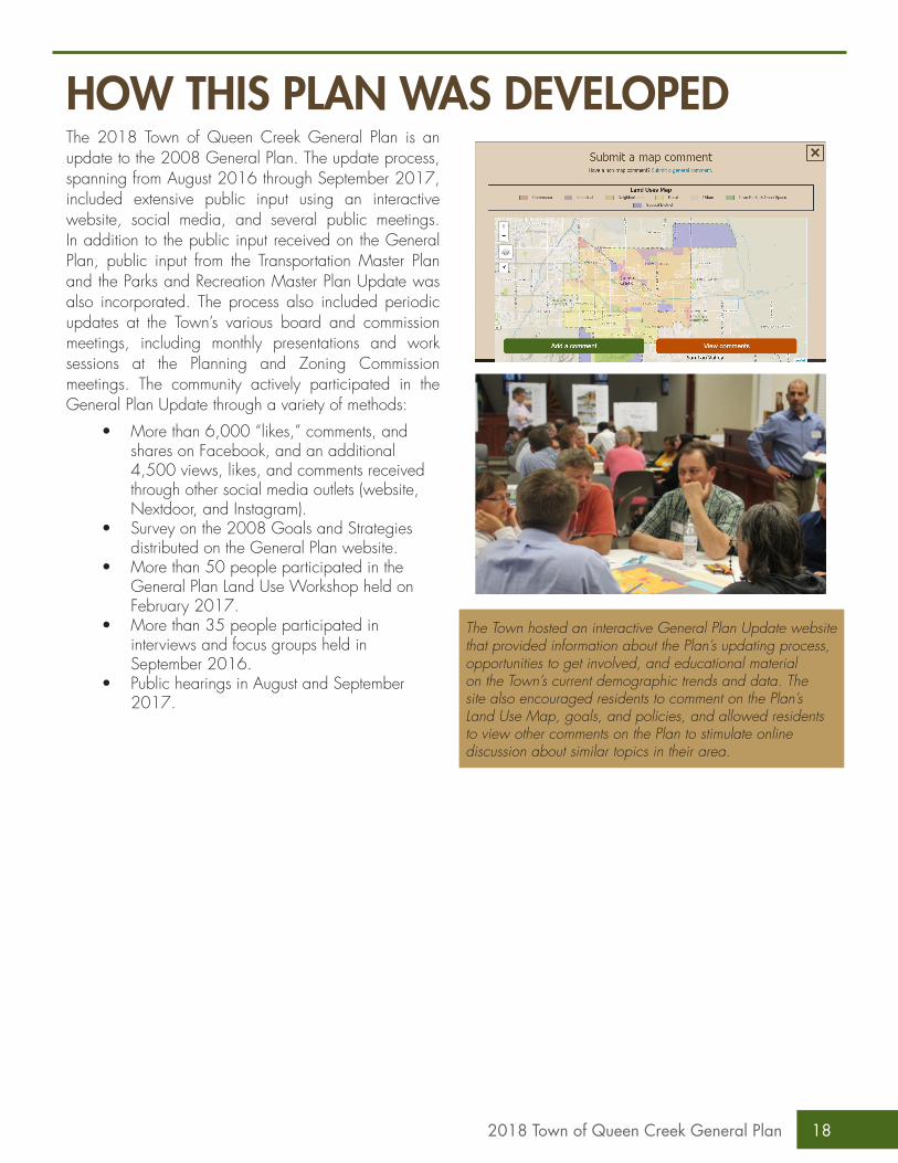
The 2018 Town of Queen Creek General Plan is an update to the 2008 General Plan. The update process, spanning from August 2016 through September 2017, included extensive public input using an interactive website, social media, and several public meetings. In addition to the public input received on the General Plan, public input from the Transportation Master Plan and the Parks and Recreation Master Plan Update was also incorporated. The process also included periodic updates at the Town’s various board and commission meetings, including monthly presentations and work sessions at the Planning and Zoning Commission meetings. The community actively participated in the General Plan Update through a variety of methods:
• More than 6,000 “likes,” comments, and shares on Facebook, and an additional 4,500 views, likes, and comments received through other social media outlets (website, Nextdoor, and Instagram).
• Survey on the 2008 Goals and Strategies distributed on the General Plan website.
• More than 50 people participated in the General Plan Land Use Workshop held on February 2017.
• More than 35 people participated in interviews and focus groups held in September 2016.
• Public hearings in August and September 2017.
The Town hosted an interactive General Plan Update website that provided information about the Plan’s updating process, opportunities to get involved, and educational material on the Town’s current demographic trends and data. The site also encouraged residents to comment on the Plan’s Land Use Map, goals, and policies, and allowed residents to view other comments on the Plan to stimulate online discussion about similar topics in their area.
HOW THIS PLAN WAS DEVELOPED
182018 Town of Queen Creek General Plan
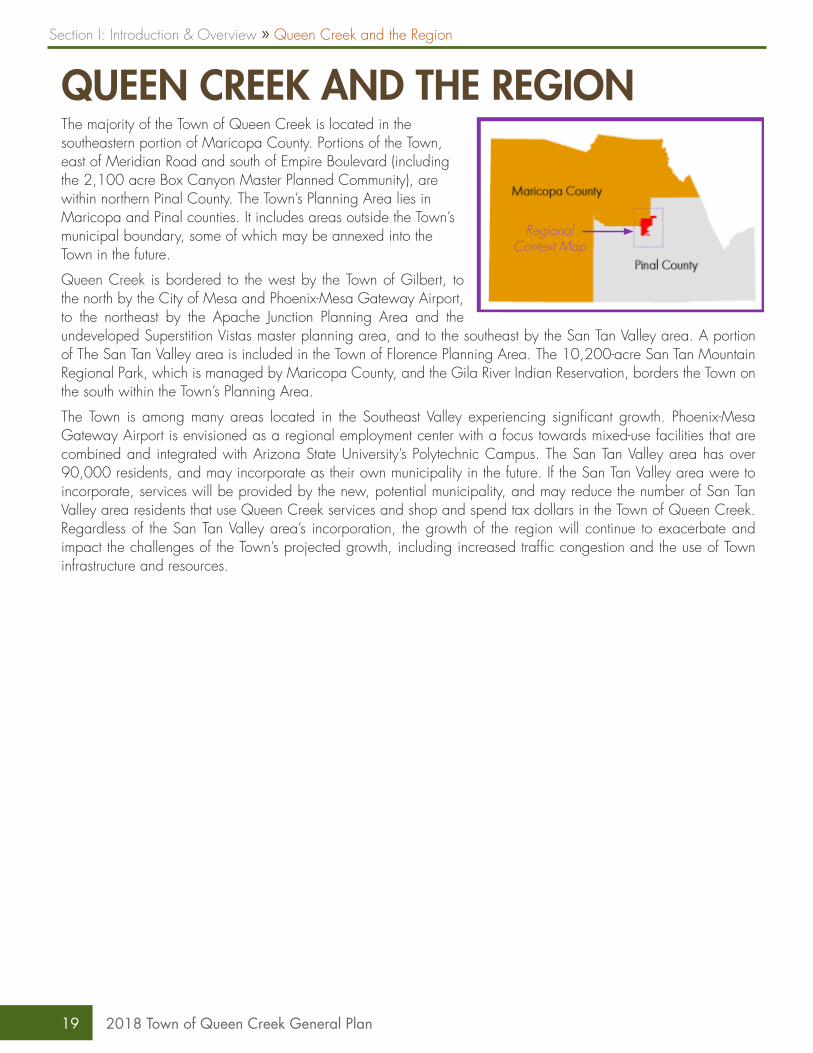
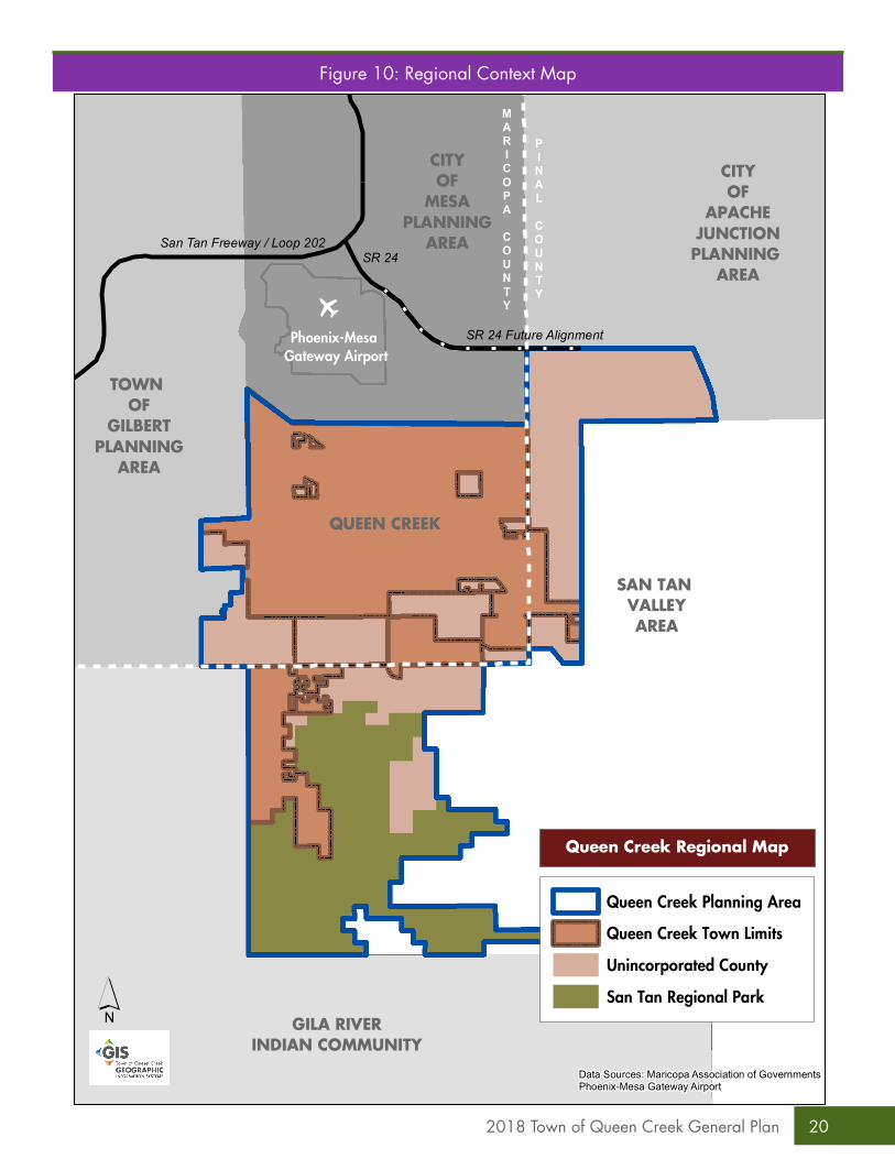
QUEEN CREEK AND THE REGIONThe majority of the Town of Queen Creek is located in the southeastern portion of Maricopa County. Portions of the Town, east of Meridian Road and south of Empire Boulevard (including the 2,100 acre Box Canyon Master Planned Community), are within northern Pinal County. The Town’s Planning Area lies in Maricopa and Pinal counties. It includes areas outside the Town’s municipal boundary, some of which may be annexed into the Town in the future.
Queen Creek is bordered to the west by the Town of Gilbert, to the north by the City of Mesa and Phoenix-Mesa Gateway Airport, to the northeast by the Apache Junction Planning Area and the undeveloped Superstition Vistas master planning area, and to the southeast by the San Tan Valley area. A portion of The San Tan Valley area is included in the Town of Florence Planning Area. The 10,200-acre San Tan Mountain Regional Park, which is managed by Maricopa County, and the Gila River Indian Reservation, borders the Town on the south within the Town’s Planning Area.
The Town is among many areas located in the Southeast Valley experiencing significant growth. Phoenix-Mesa Gateway Airport is envisioned as a regional employment center with a focus towards mixed-use facilities that are combined and integrated with Arizona State University’s Polytechnic Campus. The San Tan Valley area has over 90,000 residents, and may incorporate as their own municipality in the future. If the San Tan Valley area were to incorporate, services will be provided by the new, potential municipality, and may reduce the number of San Tan Valley area residents that use Queen Creek services and shop and spend tax dollars in the Town of Queen Creek. Regardless of the San Tan Valley area’s incorporation, the growth of the region will continue to exacerbate and impact the challenges of the Town’s projected growth, including increased traffic congestion and the use of Town infrastructure and resources.
Regional Context Map
Section I: Introduction & Overview » Queen Creek and the Region
19 2018 Town of Queen Creek General Plan
CITYOF
MESAPLANNING
AREA
TOWN OF
GILBERTPLANNING
AREA
SAN TAN VALLEYAREA
San Tan Freeway / Loop 202SR 24
SR 24 Future Alignment
GILA RIVERINDIAN COMMUNITY
CITYOF
APACHEJUNCTIONPLANNING
AREA
MARICOPA
COUNTY
PINAL
COUNTYo
Phoenix-Mesa Gateway Airport
QUEEN CREEK
Queen Creek Regional Map
´Data Sources: Maricopa Association of GovernmentsPhoenix-Mesa Gateway Airport
Queen Creek Planning Area
Queen Creek Town Limits
Unincorporated County
San Tan Regional Park
Figure 10: Regional Context Map
202018 Town of Queen Creek General Plan
Queen Creek’s high quality of life and unique lifestyle make the Town a desirable place to live, play and learn. The Town celebrates its heritage by incorporating agricultural and equestrian features into its parks, commercial areas, and neighborhoods.
Quality of Life
STRATEGIC THEMESThis General Plan identifies four strategic themes: Quality of Life, Economy, Environment, and Health which act as overarching principles that augment the Vision of the General Plan. The goals, strategies, and actions for all elements support the implementation of these four strategic themes and further realization of the General Plan Vision.
A vibrant and diverse economy will result in jobs for residents, provide attractive options for shopping and dining and increased revenues for Town services. The economy of Queen Creek generates revenues that pay for public services and amenities.
Economy
The natural environment is a fundamental component of the high quality of life offered by the Town. The Queen Creek and Sonoqui washes provide a unique element to the community, adding both recreation and environmental opportunities. Sustainable practices will help keep Queen Creek a highly desirable place to live, now and in the future.
Environment
Creating a healthier community benefits everyone; the Centers for Disease Control (CDC) states that the effects of the community design choices we make, and the opportunities those choices afford or deny, can influence mental and physical health. Research indicates that providing opportunities for physical activity such as walking, interaction with others that comes from informal interactions and strong social institutions, and access to transit, parks, trails, and paths all contribute to a healthier community.
Health
Section I: Introduction & Overview » Strategic Themes
21 2018 Town of Queen Creek General Plan
Maintaining agricultural character and heritageThe 2018 General Plan recognizes the importance of the Town’s agricultural character and heritage. To celebrate the agricultural character of the Town, the General Plan Land Use Map includes the Rural Land Use Category and Agritainment Special District areas that are designated for development that conserves the Town’s agricultural history. The General Plan Land Use Map also classifies 35% of the land within the Town Planning Area for rural development appropriate for densities of one dwelling unit per acre or less (a significant portion of this area is unincorporated). The General Plan Land Use Map and Plan goals, strategies and actions designation will help to ensure that rural and equestrian areas will remain a significant feature of the Town even as the projected population of Queen Creek increases 78% over the next decade.
Incorporated Queen Creek is nearing build-outSlightly less than eight percent of the land in the Town is vacant and unplanned. To preserve opportunities for future development, and encourage a more efficient use of land, this General Plan creates a neighborhood category that permits a range of housing densities that use the Town’s remaining land efficiently and maximizes opportunities for new development.
Creating options for a variety of lifestyles and demographics Queen Creek has a diverse population with varying needs. The median age is 30.3 years old and the average household size is 3.44; however, 36% of Queen Creek households have two or less people. Currently, Queen Creek offers fewer multifamily units than Chandler, Gilbert or Mesa. To enable the Town’s youngest residents housing options when they move out of their parent’s homes, and to provide options for families when their children leave home as well as others seeking a more walkable lifestyle, the General Plan creates two types of Land Use Categories. The Urban Land Use Category encourages high-density housing in walking distance to shopping, employment and services, and the Neighborhood Land Use Category allows for a diversity of housing types and densities.
Reduce congestion through land use and design that supports a variety of transportation modesThe Town of Queen Creek adopted the Multimodal Transportation Master Plan in December 2016. Included in the plan are recommendations for a variety of improvements to the roadway system, including the construction of additional lanes and arterial roadway connections. However, even with those identified improvements, many roads are still likely to experience congestion. A 2012 Land Use and Traffic Congestion study by the Arizona Department of Transportation found higher density corridors had considerably less congestion than suburban corridors due to a better mix of land use that led to shorter trips, more transit and non-motorized travel, and fewer vehicle miles traveled. Encouraging land use patterns that mix uses in an appropriate manner can help to reduce future congestion in Town and enhance the quality of life for residents.
Planning for Superstition VistasThe Queen Creek Planning Area includes over 3,500 acres of unplanned land within the Superstition Vistas Planning Area managed by the Arizona State Land Department. Many of the original plans for the area have been shelved since the 2008 Great Recession, however as the economy continues to recover, interest in the area is increasing. The planned extension of SR 24 is aligned along the northern border of the Town’s planning area, and is planned to be constructed within the next decade. This will provide another option for vehicles to access the US 60 and Loop 202 via future connections to Signal Butte and Ironwood roads, and provide access to the portion of the Superstition Vistas land within the Town Planning Area. When the Arizona State Land Department is prepared to plan and dispose of this land for development, the General Plan provides guidance for the planning and development of this land through the Land Use and Growth Areas Elements that encourage land uses that provide new jobs and take advantage of best land use and practices.
TOWN-WIDE PLANNING CONSIDERATIONSThis section identifies specific considerations that affect the Town as a whole and influence how we plan for the future.
222018 Town of Queen Creek General Plan
Working regionally to enhance the role of the Town in the regionLocated between the growing areas of south Gilbert, Phoenix-Mesa Gateway Airport, San Tan Valley area and the Superstition Vistas Planning Area, Queen Creek has the opportunity to become a regional hub with a unique lifestyle. As a regional hub, the Town can benefit from visitor spending, and visitors can support a variety of shopping and services that require a larger market area than the Town alone can provide. To help the Town remain an important regional destination and determine its role in the larger region, it will be important to ensure that Queen Creek is informed as areas around the Town are developed. This will ensure that development in the surrounding communities does not negatively impact the quality of life in Queen Creek. To help maintain the lifestyle and high quality of life in the Town as the areas around it continue to develop, this Plan includes strategies for inter-jurisdictional cooperation and participation.
Providing employment and land use options that could reduce congestion and travel timesThe average Queen Creek resident commute time is eight minutes longer than the average Maricopa County resident. Almost all of the Town’s wage earners do not work in Queen Creek; in 2016, 95% of all Queen Creek working residents commuted outside of Queen Creek for work, adding to the traffic congestion. Part of the reason so many Queen Creek residents work outside of the Town is a lack of employment opportunities within Queen Creek. Providing opportunities for high-wage employment in Queen Creek could help reduce traffic congestion and diversify the economy. These opportunities could be provided in offices in the Town Center, high tech operations in the industrial areas near Phoenix-Mesa Gateway Airport, and in the health care field.
Developing a walkable Town Center This General Plan creates an Urban Land Use Category that encourages walkable, mixed-use development. Throughout this General Plan update process, residents stated they wanted walkable areas that offered shopping, dining, and entertainment. Nationally, downtowns and main streets are replacing auto-oriented commercial centers as places that people want to be. Statistics show that millennials (people born between 1980 and 2000) and older adults (Baby Boomers) are choosing to live in well-designed, higher density, walkable, mixed-use, communities. A 2013 survey by the National Association of Realtors found a majority prefer houses with small yards (55 percent) with an easy walk to schools, stores and restaurants over houses with large yards (40 percent) lacking walkability to area destinations. This General Plan includes Land Use Categories and goals, strategies, and actions that support a walkable Town Center.
Creating and building on unique economic assets within the TownThe South Area Specific Plan, adopted in 2015, includes the Queen Creek Olive Mill and Schnepf Farms within an Agritainment Land Use Category. This General Plan incorporates the South Specific Area Plan by reference, and identifies an additional Agritainment area at the planned Sossaman Farms development. These areas are unique economic engines that celebrate the Town’s agricultural history.
The North Specific Area Plan, also adopted in 2015 and incorporated into this Plan by reference, creates more areas for housing, and conserves areas under the Phoenix-Mesa Gateway Airport noise contours for industrial development.
While the General Plan Land Use Map designates the Horseshoe Park & Equestrian Centre (HPEC) as a park, it is also an important economic asset that is unique to the Town. In addition to equestrian-based events that attract visitors, HPEC hosts other regional and statewide events that result in increased revenues for the Town.
Section I: Introduction & Overview » Town Wide Planning Considerations
23 2018 Town of Queen Creek General Plan

Conserving and enhancing the Queen Creek and Sonoqui washesThe Queen Creek and Sonoqui washes are iconic features of the Town. Residents use the washes for both physical fitness (walking, biking, running) and social activities (hiking groups, scout adventures, equestrian activities). The washes also provide unique desert environments for wildlife and contribute to the reduction of the urban heat island effect. Historically, the Town has diligently maintained public access to the washes as development has occurred alongside them. Continuing to maintain access and the quality environment of the washes is recommended in this Plan.
Designing a healthy communityStatistics show that where we live impacts our health as much as our genetics. Feeling connected to our neighbors, having choices to be physically active, how we travel, having access to healthy food, employment and healthcare, and feeling safe and economically secure all impact our mental and physical health. People in good health generally have a higher quality of life and how we build our communities influences all of these factors. Through the General Plan, Queen Creek can put in place policies and strategies that result in walkable, transit supportive neighborhoods that are connected to parks, retail, and community services.
Less than 8% of the land in the
Town is vacant and unplanned.
Healthy communities help to reduce the
incidence of chronic, obesity related
disease.
242018 Town of Queen Creek General Plan