section 2: options - northeastlink.vic.gov.au · this chapter outlines the approach taken to...
TRANSCRIPT

Section 2: Options
Chapter 5
February 2018
Section 2: Options ii
Contents
Section 2: Summary ...................................................................................................................................... iii
5 Options assessment ...................................................................................................................... 5—1
5.1 Assessment approach .................................................................................................... 5—1
5.2 Identifying potential corridors ....................................................................................... 5—2
5.2.1 Key factors in identifying corridors ............................................................................................ 5—2
5.2.2 Issues common to all corridors .................................................................................................. 5—3
5.3 Assessment framework ................................................................................................. 5—4
5.3.1 A three-stage process ................................................................................................................ 5—4
5.3.2 Criteria for options assessment ................................................................................................. 5—5
5.4 Assessing the corridor options....................................................................................... 5—6
5.4.1 Corridor option D ....................................................................................................................... 5—6
5.4.2 Corridor option B ....................................................................................................................... 5—7
5.4.3 Corridor option C ....................................................................................................................... 5—7
5.4.4 Corridor option A ....................................................................................................................... 5—8

Section 2: Options iii
Section 2: Summary As described in Chapter 4, a connected freeway was assessed as being the strategic option that best addresses the cross-city orbital connectivity and capacity problems identified in Chapter 2. This option provides for the construction of a freeway-standard road (known as North East Link) linking the M80 to the Eastern Freeway and incorporating connections to the wider arterial road network.
To determine the preferred corridor for the connected freeway, four broad options (A, B, C and D) were identified and considered. These corridor options were then evaluated against the North East Link’s Project Objectives and Guiding Principles.
The options assessment process has been guided by the Australian Transport Assessment and Planning (ATAP) Guidelines. A three-tiered approach was adopted to narrow down a long list of possible corridor options to a preferred option:
Stage 1: Strategic Merit Test (SMT) – an assessment of a corridor’s alignment with the North East Link Project Objectives
Stage 2: Rapid appraisal – an initial indicative assessment of the scale of a corridor’s benefits and costs as assessed against the Project Objectives and Guiding Principles
Stage 3: Detailed appraisal – a more detailed assessment of a corridor’s benefits and costs as assessed against Project Objectives and Guiding Principles.
The Strategic Merit Test and rapid appraisal set aside corridor options D and B as they performed poorly against the Project Objectives and Guiding Principles compared to the other corridors.
The detailed appraisal found that corridor option A – from the Eastern Freeway at Nunawading to the M80 at Greensborough– performs significantly more effectively in relation to the Project Objectives and Guiding Principles than corridor option C. Corridor option A provides more benefits to the transport network, removes more vehicles off local roads and has a lower whole of life cost. In summary, corridor option A:
Provides the best opportunity to make connections to the existing road network that respond to travel demand through, in and out of the north east of Melbourne, meaning that corridor option A attracts the most through traffic to the new link of all the options considered.
Provides better connectivity for all freight journeys and serves a greater number of freight catchments for trucks travelling across the city’s north, north east, east and south east, meaning that this option offers the best opportunity of all the options considered to remove trucks from local roads in the north east.
Works together effectively with the road network in the north east, having the greatest ability of all the options to reduce traffic on existing arterial roads and provide opportunities to improve conditions for more local journeys and on-road public transport.
Provides better access for businesses and households in the north, north east, east and south east to workers, jobs and services (because it connects close to areas of greater economic and employment activity). Corridor option A also provides the greatest improvement in business access to labour markets of all the corridor options considered.
Provides the opportunity to deliver an integrated Doncaster Busway solution along the Eastern Freeway, as well as addressing existing capacity and connectivity issues on the freeway.
Provides the best opportunity to upgrade, connect and expand walking and cycling infrastructure in the north east.

Section 2: Options ii
Overall, corridor option A offers the most cost-effective solution and the maximum benefits. Based on the assessment, corridor option A was selected to proceed to business case assessment and the planning and environmental approvals process.

Section 2: Options 5—1
5 Options assessment Following the comprehensive assessment process summarised in Chapter 4, a connected freeway was identified as being the strategic option that most effectively addresses orbital connectivity and capacity problems described in Chapter 2. This option provides for the construction of a freeway-standard road link (known as North East Link) between the Eastern Freeway and the M80, incorporating connections to the wider arterial road network.
This chapter outlines the approach taken to identify and assess corridor options for North East Link.
5.1 Assessment approach
Investigations into potential corridors for North East Link began in early 2017.
The North East Link Authority sought early input from the community, local councils, non-government organisations and government agencies on key issues such as community values, current traffic issues and transport-related problems in the north east. Reflecting the views and information provided during this consultation, North East Link has been developed with a strong focus on supporting business and jobs growth in communities across Melbourne's north, east and south east, while also improving cross-city connectivity and helping to address critical traffic, freight and amenity issues.
As discussed in Chapter 3, Project Objectives and Guiding Principles reflecting this focus have been established and are being used to guide the investigation of project options and the overall development of the project.1 These objectives and principles – supported by specific appraisal criteria and measures – guided the assessment of potential corridors options for North East Link. The Project Objectives and Guiding Principles are shown below. The corridor options assessment framework developed for the project is discussed in section 5.3.
Table 5-1 North East Link Project Objectives and Guiding Principles
Project Objectives
Objective 1
Improve business access and growth in Melbourne's north, east and south east
Objective 2
Improve household access to employment and education in Melbourne's north, east and south east
Objective 3
Improve freight and supply chain efficiency across the north, east and south east
Objective 4
Improve access, amenity and safety for communities in the north east
Guiding Principles
Guiding Principle 1
Minimise impacts on communities
Guiding Principle 2
Minimise impacts on environmental and cultural assets
Guiding Principle 3
Minimise impacts during the construction phase
Guiding Principle 4
Optimise the efficient use of resources
1 The Project Objectives and Guiding Principles also reflect the broader transport system objectives and decision-making principles of the Transport Integration Act 2010. Appendix B provides further information about how the project is aligned to the Act.
Section 2: Options 5—2
5.2 Identifying potential corridors
Studies extending back to 1929 (when the concept of a Melbourne ‘ring road’ was first raised) have recognised the need for a link between the M3 Eastern Freeway/EastLink and the M80. However, a preferred route has never been identified and no established road reservation exists to allow for or protect such a link. Therefore, a broad set of potential alignment options were initially identified, including those considered in previous studies and others not previously considered.
5.2.1 Key factors in identifying corridors
Key factors in identifying potential corridor options for North East Link included:
Assessing existing and future traffic conditions and transport movements
Investigating existing road corridors and utilities easements that could be used for freeway corridors
Identifying potential corridors and constraints to these corridors (such as difficult terrain, sensitive environmental areas and important community assets)
Considering treatments such as tunnels to avoid sensitive environmental and urban areas or to mitigate surface impacts
Considering likely geology and geotechnical influences and areas suitable for tunnel construction
Identifying opportunities for connectivity with the existing road network
Considering current and future patterns of land use and development in the north east, including impacts on Melbourne’s Urban Growth Boundary.
A surface road-only option through any part of the north east was discounted early in the assessment process due to its potential impacts on areas of environmental sensitivity and existing development.
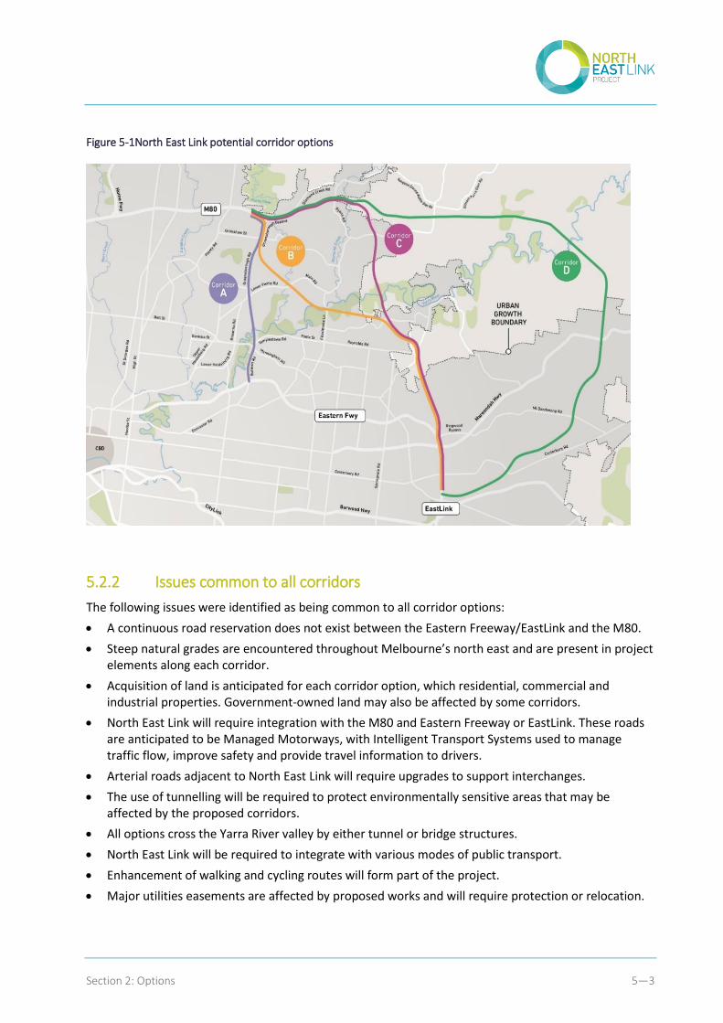
Four broad corridor options were identified initially, as shown in Figure 5-1.
Consulting with the community
NELA sought early input from the community, local councils and non-government organisations before starting to evaluate the four potential project corridors.
In May 2017, NELA canvassed community opinion about the project via a widely advertised opt-in survey. The aim of the survey was to understand different views, including about what people valued about living and working in the north east, their thoughts on current traffic problems and how North East Link should be designed and developed. NELA also asked how people would like to be involved as the project proceeds.
In August 2017, the four potential corridors were announced, along with the Project Objectives and Guiding Principles. Through extensive face-to-face and online consultation, NELA asked people to comment on whether they felt the objectives and principles would deliver the North East Link they wanted in the way they wanted. The four corridors showed minimum tunnel sections, mainly determined according to early assessments of potential social and environmental impacts. An important part of NELA’s consultation was asking the community whether these minimum lengths of tunnel were adequate and appropriate. The corridor maps also showed indicative interchange locations to enable discussion about how these might affect communities and road users.
The corridor options assessment considered feedback and information provided by the community and stakeholders, alongside evidence from technical investigations. The assessment also considered questions raised by community members and stakeholders, which identified areas where further research was required or where information was lacking, clarified what is and isn’t acceptable to sections of the community, and helped to understand likely issues, concerns, opportunities and ‘hot spots’ that could arise regardless of which corridor was chosen.
Further information about how community input informed the corridor options assessment is provided in Appendix E.
Section 2: Options 5—3
Figure 5-1North East Link potential corridor options
5.2.2 Issues common to all corridors
The following issues were identified as being common to all corridor options:
A continuous road reservation does not exist between the Eastern Freeway/EastLink and the M80.
Steep natural grades are encountered throughout Melbourne’s north east and are present in project elements along each corridor.
Acquisition of land is anticipated for each corridor option, which residential, commercial and industrial properties. Government-owned land may also be affected by some corridors.
North East Link will require integration with the M80 and Eastern Freeway or EastLink. These roads are anticipated to be Managed Motorways, with Intelligent Transport Systems used to manage traffic flow, improve safety and provide travel information to drivers.
Arterial roads adjacent to North East Link will require upgrades to support interchanges.
The use of tunnelling will be required to protect environmentally sensitive areas that may be affected by the proposed corridors.
All options cross the Yarra River valley by either tunnel or bridge structures.
North East Link will be required to integrate with various modes of public transport.
Enhancement of walking and cycling routes will form part of the project.
Major utilities easements are affected by proposed works and will require protection or relocation.

Section 2: Options 5—4
5.3 Assessment framework
5.3.1 A three-stage process
A three-stage framework was adopted to select a project corridor, guided by the options assessment process recommended in the Australian Transport Assessment and Planning (ATAP) Guidelines.
As shown in Figure 5-2, this framework comprises a series of ‘filters’, with options being scrutinised in greater detail as they advance through each stage. The process seeks to filter out unsatisfactory and lower performing options before considerable resources are spent on further assessment and development. As the process progresses, more options are rejected. The project option is the one that passes through all the filters.
Figure 5-2 Options assessment process
Source: ATAP Guidelines
The purpose of each stage is as follows:
Stage 1: Strategic Merit Test (SMT) – an initial indicative assessment of the scale of a corridor option’s alignment with the Project Objectives. This stage of the process enabled an initial filtering of options, with the best performing options moving forward to the rapid appraisal.
Stage 2: Rapid appraisal – an initial indicative assessment of the scale of a corridor option’s benefits and costs, assessed against the Project Objectives and Guiding Principles. At the end of this stage, the corridor options and complementary measures that appeared to yield net benefits proceeded to detailed appraisal.
Stage 3: Detailed appraisal – a more detailed evaluation of the benefits, costs and other impacts of the remaining corridor options, assessed against the Project Objectives and Guiding Principles. At the end of this stage, the best performing option proceeded to assessment as part of the business case for North East Link.
Section 2: Options 5—5
The final appraisal confirms the analysis undertaken in the detailed appraisal and includes a risk assessment, detailed costings and a comprehensive economic appraisal of the selected option. The final appraisal forms part of this business case.
As each stage progressed, the assessment considered feedback, information provided and questions raised by the community and stakeholders, alongside evidence from technical investigations. Priority issues identified and considered included:
Reducing congestion on key roads in Melbourne’s north east
Removing trucks that do not need to be on roads in Melbourne’s north east
Providing better connections for people to access jobs and education opportunities
Helping businesses to better connect with each other and to workers across Melbourne
Making freight journeys more efficient and reliable
Improving public transport connections and travel times
Improving connections for pedestrians and cyclists
Protecting the environment, culture, heritage and open spaces
Minimising the impacts from construction-related traffic as the project is being built.
5.3.2 Criteria for options assessment
Specific criteria and measures for the options assessment were developed for the detailed appraisal stage of the options assessment, linked to the Project Objectives and Guiding Principles. Criteria covered business, household, freight, amenity, environmental, construction and resource impacts. Measures were identified for each criterion and determined using a range of inputs that included:
Modelled traffic conditions and microsimulation modelling
Updated land use modelling
GIS data
Potential impacts on utilities based on existing data and reports
Updated geotechnical information
Constructability assessment
Existing available planning and environmental information further informed by field studies
Risk adjusted cost estimates.
Most measures were quantitative; some were qualitative. The results for each measure was then rated in accordance with the guidance presented in the tables below.
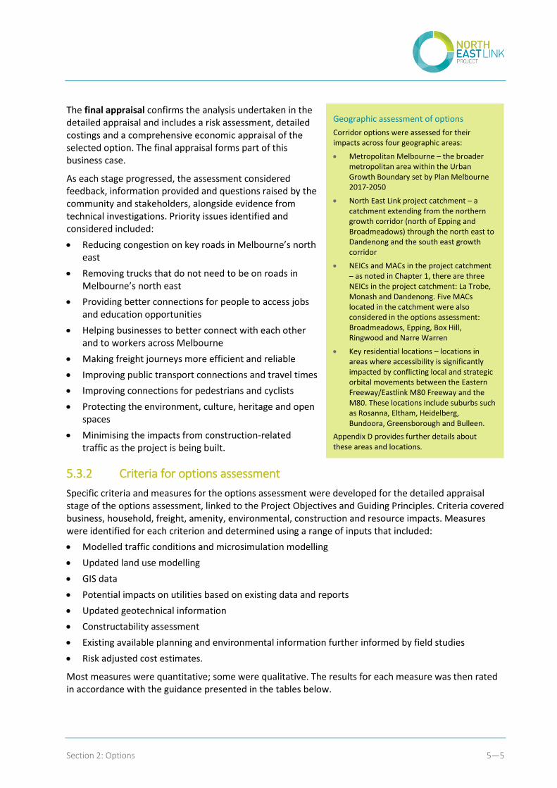
Geographic assessment of options
Corridor options were assessed for their impacts across four geographic areas:
Metropolitan Melbourne – the broader metropolitan area within the Urban Growth Boundary set by Plan Melbourne 2017-2050
North East Link project catchment – a catchment extending from the northern growth corridor (north of Epping and Broadmeadows) through the north east to Dandenong and the south east growth corridor
NEICs and MACs in the project catchment – as noted in Chapter 1, there are three NEICs in the project catchment: La Trobe, Monash and Dandenong. Five MACs located in the catchment were also considered in the options assessment: Broadmeadows, Epping, Box Hill, Ringwood and Narre Warren
Key residential locations – locations in areas where accessibility is significantly impacted by conflicting local and strategic orbital movements between the Eastern Freeway/Eastlink M80 Freeway and the M80. These locations include suburbs such as Rosanna, Eltham, Heidelberg, Bundoora, Greensborough and Bulleen.
Appendix D provides further details about these areas and locations.
Section 2: Options 5—6
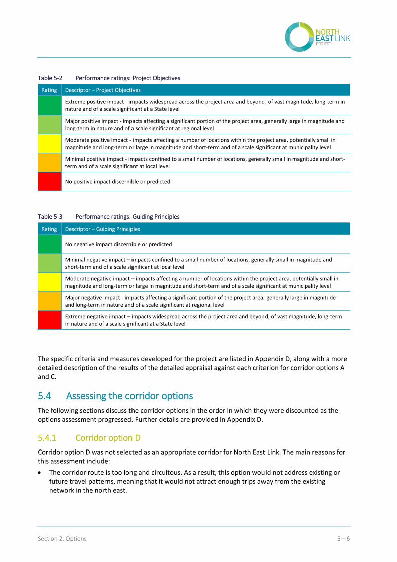
Table 5-2 Performance ratings: Project Objectives
Rating Descriptor – Project Objectives
Extreme positive impact - impacts widespread across the project area and beyond, of vast magnitude, long-term in nature and of a scale significant at a State level
Major positive impact - impacts affecting a significant portion of the project area, generally large in magnitude and long-term in nature and of a scale significant at regional level
Moderate positive impact - impacts affecting a number of locations within the project area, potentially small in magnitude and long-term or large in magnitude and short-term and of a scale significant at municipality level
Minimal positive impact - impacts confined to a small number of locations, generally small in magnitude and short-term and of a scale significant at local level
No positive impact discernible or predicted
Table 5-3 Performance ratings: Guiding Principles
Rating Descriptor – Guiding Principles
No negative impact discernible or predicted
Minimal negative impact – impacts confined to a small number of locations, generally small in magnitude and short-term and of a scale significant at local level
Moderate negative impact – impacts affecting a number of locations within the project area, potentially small in magnitude and long-term or large in magnitude and short-term and of a scale significant at municipality level
Major negative impact - impacts affecting a significant portion of the project area, generally large in magnitude and long-term in nature and of a scale significant at regional level
Extreme negative impact – impacts widespread across the project area and beyond, of vast magnitude, long-term in nature and of a scale significant at a State level
The specific criteria and measures developed for the project are listed in Appendix D, along with a more detailed description of the results of the detailed appraisal against each criterion for corridor options A and C.
5.4 Assessing the corridor options
The following sections discuss the corridor options in the order in which they were discounted as the options assessment progressed. Further details are provided in Appendix D.
5.4.1 Corridor option D
Corridor option D was not selected as an appropriate corridor for North East Link. The main reasons for this assessment include:
The corridor route is too long and circuitous. As a result, this option would not address existing or future travel patterns, meaning that it would not attract enough trips away from the existing network in the north east.

Section 2: Options 5—7
The road network in this area is rural in nature and very steep, and does not provide for appropriate connections to a new freeway.
The corridor’s location outside the Urban Growth Boundary in areas of very low population density (now and in the future) limits the project’s potential to provide better access for businesses or workers. It also has the potential to create development pressure in Green Wedge areas outside the boundary, which does not align with the objectives of Plan Melbourne.
5.4.2 Corridor option B
Corridor option B was not selected as an appropriate corridor for North East Link. The main reasons for this assessment include:
The solution provided by this corridor is not satisfactory as it is likely to attract more east-west oriented trips and has limited ability to provide relief to the critically congested north-south arterial road network.
Due to the unbalanced spacing location of the interchanges, feeder roads are likely to be affected to a greater extent as traffic would need to travel further distances to access the new link’s alignment.
There would be significant impacts on utility services, including high voltage power lines that cannot be moved underground without incurring substantial costs.
Extensive tunnelling requirements would lead to a very high cost solution.
Following options D and B being set aside, a detailed assessment of was carried out on corridor options A and C. This assessment set aside Corridor C, as summarised in the following sections. A more detailed account of this assessment is provided in Appendix D.
5.4.3 Corridor option C
Corridor option C was not selected as an appropriate corridor for North East Link. The main reasons for this assessment include:
The available connections to the existing road network from this corridor are not well suited to the levels of traffic likely to be using them, resulting in lower use of a route through this corridor and less trips being attracted from the existing network (compared to Corridor A).
While the corridor supports long-distance trips between the north and south east of Melbourne, it provides limited support for the key origins and destinations of the wide range of trips currently travelling into and out of the north east – both now and into the future (compared to Corridor A).
The corridor provides little support for or integration with the strategic arterial road network through the north east, resulting in lower levels of traffic on the new link and providing less truck relief on roads in the north east (compared to Corridor A).
The location of the corridor weaves across the Urban Growth Boundary through Green Wedge areas of low population density and has the potential to generate development pressure in these areas, contrary to the objectives of Plan Melbourne.
Extensive tunnelling requirements would lead to a significantly higher cost solution.

Section 2: Options 5—8
5.4.4 Corridor option A
The detailed assessment found that corridor option A performs significantly more effectively in relation to the Project Objectives and Guiding Principles than corridor option C. Corridor A provides more benefits to the transport network, removes more vehicles off local roads and has a significant cheaper whole of life cost. The main reasons for this assessment include:
Corridor option A provides the best opportunity to make connections to the existing road network that respond to travel demand through, in and out of the north east of Melbourne. This means that corridor option A attracts the most through traffic to the new link out of all the options considered, reducing demand on key arterial roads.
It provides better connectivity for all freight journeys and serves a greater number of freight catchments for trucks travelling across the north, north east and south east of Melbourne (compared to corridor option C). This means that the corridor provides the best opportunity to achieve a significant redistribution of trucks from local streets in the north east.
By working effectively with the existing road network in the north east, the corridor has the greatest ability of all the options considered to reduce traffic on existing arterial road networks and provide opportunities to improve conditions for more local journeys and on-road public transport.
By connecting close to areas of greater activity, it provides better access for businesses and residents in the north, north east, east and south east to workers, jobs and services. It provides the greatest improvement in business access to labour markets of all the corridor options considered, particularly the opportunity to stimulate jobs growth in the La Trobe National Employment and Innovation Cluster (NEIC) and between the Broadmeadows, Epping, Ringwood and Box Hill Metropolitan Activity Centres (MACs).
In enhancing the Eastern Freeway to cater for additional North East Link traffic, the corridor addresses capacity and connectivity issues in the operation of the freeway, ‘future proofing’ it for growth
It provides the best opportunity to improve public transport on the existing road network and delivers the infrastructure required for an integrated Doncaster Busway solution along the Eastern Freeway
It provides the best opportunity to connect and expand existing walking and cycling facilities in the north east.
Overall, corridor A provides a more optimal, efficient and well-used roadway than the other options considered and unlocks greater capacity on the arterial road network. It also extracts the most value from existing infrastructure by making better and more efficient use of the Eastern Freeway. While delivering greater benefits, it also has significantly lower capital and operational costs than corridor option C.
Based on the assessment undertaken, corridor option A was selected as the corridor to be taken through for business case assessment and planning and environmental approvals.