section 19 report markeaton - derby city council | derby ... · previous flood risk study 2 2....
TRANSCRIPT

Section 19 Report Markeaton Derby City Council
09 December2014
Atkins Markeaton Section 19 Report | Version 2.0 | 09 December 2014 | 5135286 ii
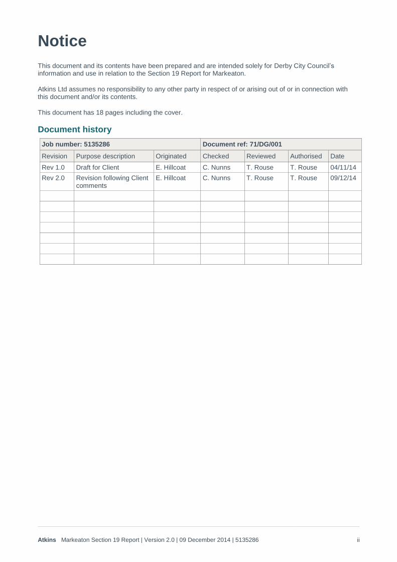
Notice
This document and its contents have been prepared and are intended solely for Derby City Council’s information and use in relation to the Section 19 Report for Markeaton.
Atkins Ltd assumes no responsibility to any other party in respect of or arising out of or in connection with this document and/or its contents.
This document has 18 pages including the cover.
Document history
Job number: 5135286 Document ref: 71/DG/001
Revision Purpose description Originated Checked Reviewed Authorised Date
Rev 1.0 Draft for Client E. Hillcoat C. Nunns T. Rouse T. Rouse 04/11/14
Rev 2.0 Revision following Client comments
E. Hillcoat C. Nunns T. Rouse T. Rouse 09/12/14
Atkins Markeaton Section 19 Report | Version 2.0 | 09 December 2014 | 5135286 iii
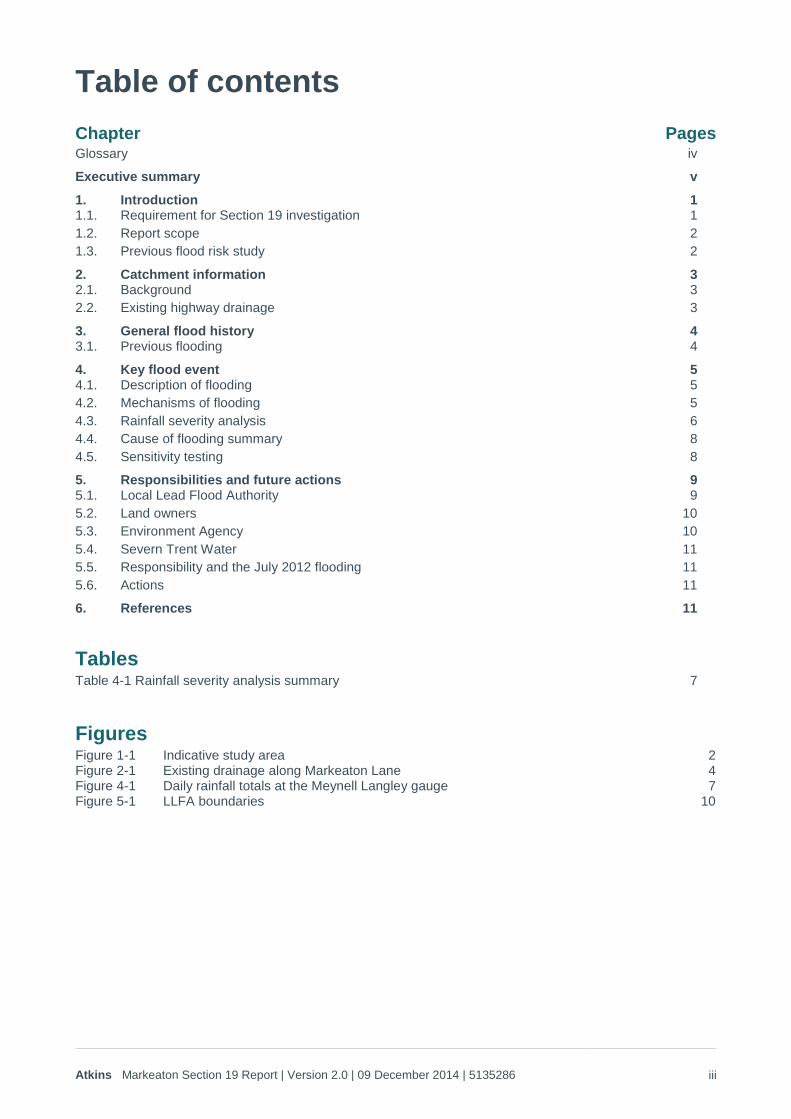
Table of contents
Chapter Pages Glossary iv
Executive summary v
1. Introduction 1 1.1. Requirement for Section 19 investigation 1 1.2. Report scope 2 1.3. Previous flood risk study 2
2. Catchment information 3 2.1. Background 3 2.2. Existing highway drainage 3
3. General flood history 4 3.1. Previous flooding 4
4. Key flood event 5 4.1. Description of flooding 5 4.2. Mechanisms of flooding 5 4.3. Rainfall severity analysis 6 4.4. Cause of flooding summary 8 4.5. Sensitivity testing 8
5. Responsibilities and future actions 9 5.1. Local Lead Flood Authority 9 5.2. Land owners 10 5.3. Environment Agency 10 5.4. Severn Trent Water 11 5.5. Responsibility and the July 2012 flooding 11 5.6. Actions 11
6. References 11
Tables Table 4-1 Rainfall severity analysis summary 7
Figures Figure 1-1 Indicative study area 2 Figure 2-1 Existing drainage along Markeaton Lane 4 Figure 4-1 Daily rainfall totals at the Meynell Langley gauge 7 Figure 5-1 LLFA boundaries 10
Atkins Markeaton Section 19 Report | Version 2.0 | 09 December 2014 | 5135286 iv
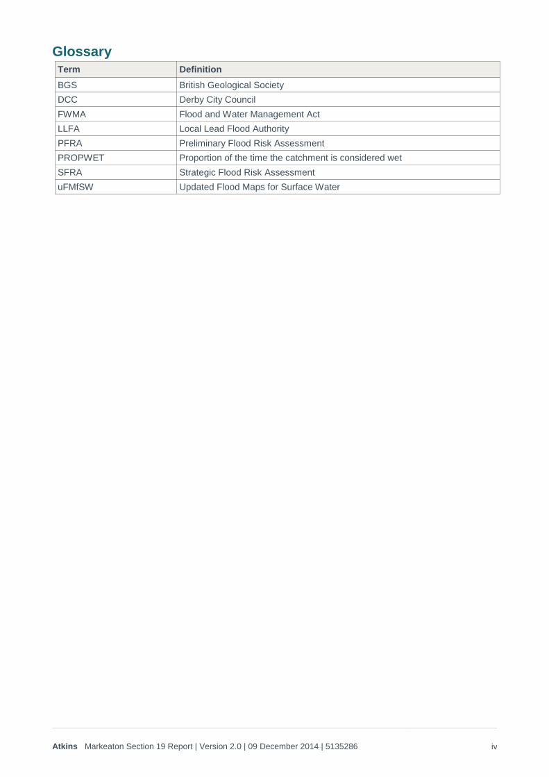
Glossary
Term Definition
BGS British Geological Society
DCC Derby City Council
FWMA Flood and Water Management Act
LLFA Local Lead Flood Authority
PFRA Preliminary Flood Risk Assessment
PROPWET Proportion of the time the catchment is considered wet
SFRA Strategic Flood Risk Assessment
uFMfSW Updated Flood Maps for Surface Water
Atkins Markeaton Section 19 Report | Version 2.0 | 09 December 2014 | 5135286 v
Executive summary
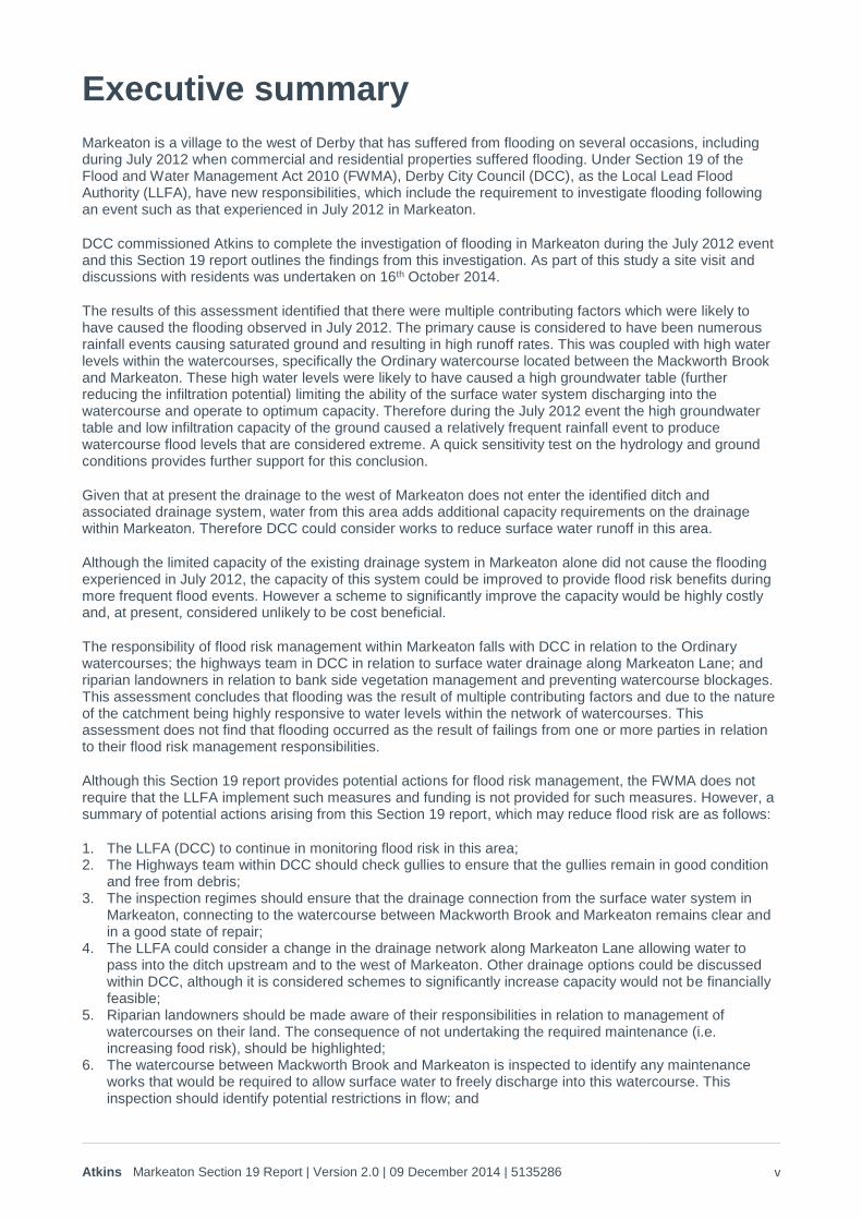
Markeaton is a village to the west of Derby that has suffered from flooding on several occasions, including during July 2012 when commercial and residential properties suffered flooding. Under Section 19 of the Flood and Water Management Act 2010 (FWMA), Derby City Council (DCC), as the Local Lead Flood Authority (LLFA), have new responsibilities, which include the requirement to investigate flooding following an event such as that experienced in July 2012 in Markeaton.
DCC commissioned Atkins to complete the investigation of flooding in Markeaton during the July 2012 event and this Section 19 report outlines the findings from this investigation. As part of this study a site visit and discussions with residents was undertaken on 16th October 2014.
The results of this assessment identified that there were multiple contributing factors which were likely to have caused the flooding observed in July 2012. The primary cause is considered to have been numerous rainfall events causing saturated ground and resulting in high runoff rates. This was coupled with high water levels within the watercourses, specifically the Ordinary watercourse located between the Mackworth Brook and Markeaton. These high water levels were likely to have caused a high groundwater table (further reducing the infiltration potential) limiting the ability of the surface water system discharging into the watercourse and operate to optimum capacity. Therefore during the July 2012 event the high groundwater table and low infiltration capacity of the ground caused a relatively frequent rainfall event to produce watercourse flood levels that are considered extreme. A quick sensitivity test on the hydrology and ground conditions provides further support for this conclusion.
Given that at present the drainage to the west of Markeaton does not enter the identified ditch and associated drainage system, water from this area adds additional capacity requirements on the drainage within Markeaton. Therefore DCC could consider works to reduce surface water runoff in this area.
Although the limited capacity of the existing drainage system in Markeaton alone did not cause the flooding experienced in July 2012, the capacity of this system could be improved to provide flood risk benefits during more frequent flood events. However a scheme to significantly improve the capacity would be highly costly and, at present, considered unlikely to be cost beneficial.
The responsibility of flood risk management within Markeaton falls with DCC in relation to the Ordinary watercourses; the highways team in DCC in relation to surface water drainage along Markeaton Lane; and riparian landowners in relation to bank side vegetation management and preventing watercourse blockages. This assessment concludes that flooding was the result of multiple contributing factors and due to the nature of the catchment being highly responsive to water levels within the network of watercourses. This assessment does not find that flooding occurred as the result of failings from one or more parties in relation to their flood risk management responsibilities.
Although this Section 19 report provides potential actions for flood risk management, the FWMA does not require that the LLFA implement such measures and funding is not provided for such measures. However, a summary of potential actions arising from this Section 19 report, which may reduce flood risk are as follows:
1. The LLFA (DCC) to continue in monitoring flood risk in this area; 2. The Highways team within DCC should check gullies to ensure that the gullies remain in good condition
and free from debris; 3. The inspection regimes should ensure that the drainage connection from the surface water system in
Markeaton, connecting to the watercourse between Mackworth Brook and Markeaton remains clear and in a good state of repair;
4. The LLFA could consider a change in the drainage network along Markeaton Lane allowing water to pass into the ditch upstream and to the west of Markeaton. Other drainage options could be discussed within DCC, although it is considered schemes to significantly increase capacity would not be financially feasible;
5. Riparian landowners should be made aware of their responsibilities in relation to management of watercourses on their land. The consequence of not undertaking the required maintenance (i.e. increasing food risk), should be highlighted;
6. The watercourse between Mackworth Brook and Markeaton is inspected to identify any maintenance works that would be required to allow surface water to freely discharge into this watercourse. This inspection should identify potential restrictions in flow; and
Atkins Markeaton Section 19 Report | Version 2.0 | 09 December 2014 | 5135286 vi
7. At this stage further study is not considered necessary. However, if in the future DCC consider that further assessment of the flooding mechanisms in this catchment would be beneficial groundwater monitoring could be commissioned. This could improve understanding of how wet the catchment is in reality. The results from a groundwater monitoring scheme would be used to support a more detailed hydrological assessment.
Atkins Markeaton Section 19 Report | Version 2.0 | 09 December 2014 | 5135286 1
1. Introduction
1.1. Requirement for Section 19 investigation
1.1.1. National driver Under the Flood and Water Management Act (FWMA) 2010 a Lead Local Flood Authority (LLFA), such as Derby City Council (DCC), have responsibilities in relation to the investigation of flood events. This requirement falls under Section 19 of the FMWA which states:
(1) On becoming aware of a flood in its areas, a LLFA must, to the extent that it considers necessary or appropriate, investigate-
(a) Which risk management authorities have relevant flood risk management functions; and (b) Whether each of those risk management authorities has exercised, or is proposing to exercise, those functions in response to the flood.
(2) Where an authority carried out an investigation under subsection (1) it must – (a) Publish the results of its investigation, and (b) Notify any relevant risk management authorities.
1.1.2. Local driver Thresholds for the requirement of a Section 19 report are locally identified and so can differ between LLFAs. DCC follow an approach in relation to their responsibilities under Section 19 of the FWMA 2010, consistent with the approach currently employed by Derbyshire County Council. Therefore for consistency with Derbyshire County Council, the same thresholds are proposed for DCC. These are as follows:
Number of properties internally flooded - An event where records or anecdotal evidence shows that five or more residential properties, or two or more non-residential properties (industrial/commercial) affecting employment, have been internally flooded.
Critical infrastructure impacted by the flood - An event which leads to a protracted impact on a key utility service (water, sewage treatment, electricity distribution, gas distribution, telecommunications, rail network, strategic road network) in excess of 12 hours before restoration of the service.
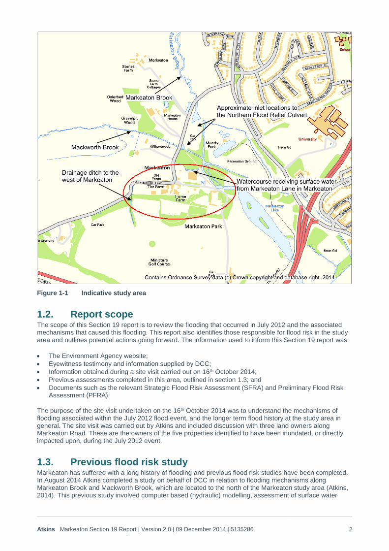
During summer 2012 there was substantial flooding of the Markeaton Lane highways and local properties in the village of Markeaton. One residential property and two non-residential properties suffered internal flooding. An additional commercial site was impacted due to access restrictions caused by the flooding and visitor numbers were reduced which was attributed to Markeaton Lane being impassable to the north of Markeaton village. Based on these impacts this flood event falls within the threshold set above and as such DCC are required to complete a Section 19 report for the July 2012 flood event that occurred in Markeaton. The study area for this Section 19 report is shown on Figure 1-1.
Atkins Markeaton Section 19 Report | Version 2.0 | 09 December 2014 | 5135286 2
Figure 1-1 Indicative study area
1.2. Report scope The scope of this Section 19 report is to review the flooding that occurred in July 2012 and the associated mechanisms that caused this flooding. This report also identifies those responsible for flood risk in the study area and outlines potential actions going forward. The information used to inform this Section 19 report was:
The Environment Agency website;
Eyewitness testimony and information supplied by DCC;
Information obtained during a site visit carried out on 16th October 2014;
Previous assessments completed in this area, outlined in section 1.3; and
Documents such as the relevant Strategic Flood Risk Assessment (SFRA) and Preliminary Flood Risk Assessment (PFRA).
The purpose of the site visit undertaken on the 16th October 2014 was to understand the mechanisms of flooding associated within the July 2012 flood event, and the longer term flood history at the study area in general. The site visit was carried out by Atkins and included discussion with three land owners along Markeaton Road. These are the owners of the five properties identified to have been inundated, or directly impacted upon, during the July 2012 event.
1.3. Previous flood risk study Markeaton has suffered with a long history of flooding and previous flood risk studies have been completed. In August 2014 Atkins completed a study on behalf of DCC in relation to flooding mechanisms along Markeaton Brook and Mackworth Brook, which are located to the north of the Markeaton study area (Atkins, 2014). This previous study involved computer based (hydraulic) modelling, assessment of surface water
Atkins Markeaton Section 19 Report | Version 2.0 | 09 December 2014 | 5135286 3
runoff and details of the current drainage system along Markeaton Lane. The resultant flood extents from this study were compared to an approximation of the flood extent experienced in July 2012.
This previous study identified that the flooding observed in July 2012 could not be recreated (through hydraulic modelling) based on river flooding alone. This modelling included simulating flows in excess of the 1 in 100 annual probability event and modelling culverts with blockages above anticipated levels. The modelling indicated that whilst river flooding is expected along Markeaton Brook and Mackworth Brook following periods of heavy rainfall, the predicted flooding does not cover the extents observed in July 2012, nor would result in internal property flooding.
The previous study identified that surface water runoff could have been a significant contributing factor to flooding during July 2012. The study used topographic data to determine surface water flow paths that would occur under the assumption that rainfall could not infiltrate the ground, resulting in overland flow. The resultant flow paths are considered relatively consistent with the flood extents observed in July 2012.
To test the sensitivity of the modelling, the 1 in 100 annual probability flows were arbitrarily doubled, as a representation of extreme flows. Although the resultant flood extents were larger than the flooding experienced in July 2012, the outlines were more similar to the event than the estimated 1 in 100 annual probability flows.
In summary, this previous assessment concluded that the July 2012 flood event was not the result of river flooding alone and that surface water runoff was a significant contributing factor. The results from this previous study have been used to inform this Section 19 report.
2. Catchment information
2.1. Background The village of Markeaton is located to the north west of Derby and to the north of the study area are the Markeaton Brook and Mackworth Brook. There are complex hydraulic interactions between these two watercourses through the existing arrangement of weirs and high level overflows to the west side of Markeaton Park. These two watercourses join downstream of Markeaton and flow eastwards through Derby city centre before discharging into the River Derwent. Based on the Environment Agency Flood Zone mapping, available on the Environment Agency website1, Markeaton is located within Flood Zone 1 (low risk) and Flood Zone 2 (medium risk).
The Markeaton Brook was culverted through the city centre during the 1800s, mainly to improve public health of the residents. Following a major flood event in Derby in the 1930s, two major culverts were constructed to divert flood water away from the city centre. One of these was the Northern Flood Culvert designed to relieve the Markeaton Brook. The Markeaton and Mackworth brooks are connected to the Northern Flood Culvert via weirs at Markeaton Lane.
Markeaton and Mackworth Brooks are designated as Main River to the east of Markeaton Lane, downstream of the Northern Flood Culvert inlets (shown on Figure 1-1) and hence are the responsibility of the Environment Agency. Under Markeaton Lane, and along the upstream reaches, the watercourse is designated as an Ordinary watercourse which therefore falls under the responsibility of the LLFA and as such DCC within the Derby city boundary and Derbyshire County Council within the Amber Valley District.
A further parameter that may impact on flood risk within a catchment, is that upstream of Markeaton the watercourse passes through rural areas that are primarily used for agriculture. The underlying geology of the catchment and within the study area is Mudstone with superficial deposits of clay, silt, sand and gravel.
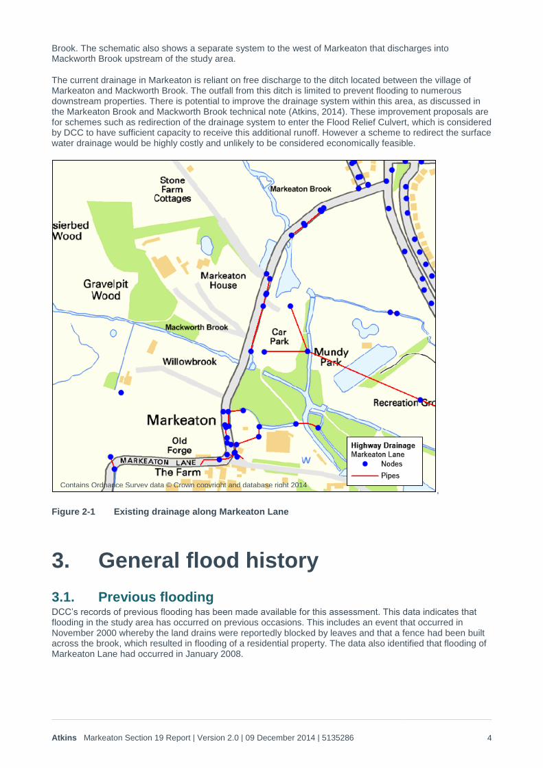
2.2. Existing highway drainage Markeaton Lane has an existing drainage system in place. A model schematic of this drainage systems is shown in Figure 2-1, whereby pipes reflect the pipe network and culverts, and the nodes represent the inlet and outlets to this system. The drainage system schematic, Figure 2-1, shows that surface water on Markeaton Lane in Markeaton enters the ditch located between the village of Markeaton and Mackworth
1 http://maps.environment-agency.gov.uk/wiyby/wiyby
Atkins Markeaton Section 19 Report | Version 2.0 | 09 December 2014 | 5135286 4
Brook. The schematic also shows a separate system to the west of Markeaton that discharges into Mackworth Brook upstream of the study area.
The current drainage in Markeaton is reliant on free discharge to the ditch located between the village of Markeaton and Mackworth Brook. The outfall from this ditch is limited to prevent flooding to numerous downstream properties. There is potential to improve the drainage system within this area, as discussed in the Markeaton Brook and Mackworth Brook technical note (Atkins, 2014). These improvement proposals are for schemes such as redirection of the drainage system to enter the Flood Relief Culvert, which is considered by DCC to have sufficient capacity to receive this additional runoff. However a scheme to redirect the surface water drainage would be highly costly and unlikely to be considered economically feasible.
,
Figure 2-1 Existing drainage along Markeaton Lane
3. General flood history
3.1. Previous flooding DCC’s records of previous flooding has been made available for this assessment. This data indicates that flooding in the study area has occurred on previous occasions. This includes an event that occurred in November 2000 whereby the land drains were reportedly blocked by leaves and that a fence had been built across the brook, which resulted in flooding of a residential property. The data also identified that flooding of Markeaton Lane had occurred in January 2008.
Contains Ordnance Survey data © Crown copyright and database right 2014
Atkins Markeaton Section 19 Report | Version 2.0 | 09 December 2014 | 5135286 5
The PFRA (Derby City Council, 2011) mentions the 1931/32 event that prompted the construction of the Northern Relief culvert. In addition to this event the PFRA also provides a list of previous flooding events, which includes the event that occurred in November 2000 along the Markeaton Brook.
The current SFRA for Derby City (Derby City Council, 2010) has been reviewed to identify the general flood history within this study area. The SFRA states that “there have been a number of minor incidents within the City boundaries in the last 10-15 years”. The SFRA identifies that several areas which have experienced flooding are in areas that are not identified to be at risk based on the Environment Agency river flood mapping. The study area for this Section 19 report is considered to be one of these areas.
Information provided by residents during the site visit (16th October 2014) indicates that flooding in the study area has occurred on numerous occasions including events in 2001 and 2007. Additional events were recalled although dates of these events could not be provided. It was also stated that four to five weeks after the July 2012 flooding the area was flooded for a second time.
Further online website searches have been completed, however this has not revealed any further flood events not documented above.
4. Key flood event
4.1. Description of flooding For the purposes of the previous Markeaton Brook study (Atkins, 2014) a description of the flood event was provided by DCC. This included eyewitness testimonies of DCC staff and the use of the Environment Agency’s updated Flood Maps for Surface Water (uFMfSW) as an approximation of the flood event (as considered representative by DCC). Information supplied by residents during the site visit has also been used to outline the flooding that occurred in July 2012. Although there are discrepancies between the details included in the various accounts of flooding at this location, a general description of the event has been summarised as follows:
Preceding wet conditions resulted in a low infiltration potential of the ground causing significant volumes of runoff from the surrounding fields discharging to Markeaton Lane;
The surface water runoff along the Markeaton Lane caused ponding on the carriageway resulting in the road becoming impassable to vehicles; and
High water levels within the Mackworth Brook, and the watercourse located between Mackworth Brook and Markeaton, caused overspill from the watercourses systems, and which prevented the drainage system discharging to the watercourses.
During the site visit, two of the three residents reported that the flood water remained deep for a relatively short period with the majority of the water receding after a few (2-4) hours. Questions were also posed in regards to the Ordinary watercourse located between Markeaton village and Mackworth Brook, although the responses were not consistent. One report mentioned that on a relatively frequent basis this watercourse flows at capacity with small areas of out of bank flooding (which does not cause property or infrastructure flooding) although another report suggested that this did not occur on a frequent basis.
4.2. Mechanisms of flooding The previous study into flooding along Markeaton Lane (Atkins, 2014) used hydraulic modelling to test various river flood scenarios such as blockages and increasing flow rates. The hydraulic modelling did not result in significant out of bank flooding during the 1 in 100 annual probability river flood event, including culvert blockages. It was therefore concluded that the flooding which occurred along Markeaton Lane in July 2012 was not the result of river sources alone. The hydraulic modelling did provide flood extents that were more similar to the July 2012, albeit slightly more extreme, when the 1 in 100 annual probability flows are arbitrarily doubled.
The previous study also identified surface water flow paths and the resultant flood extents were considered consistent with the available records associated with the Environment Agency’s uFMfSW and as such the July 2012 event.
Atkins Markeaton Section 19 Report | Version 2.0 | 09 December 2014 | 5135286 6
The previous report (Atkins, 2014) stated that a high water table could have resulted in groundwater flooding, or potentially reducing the infiltration potential of the ground resulting in exacerbating surface water flooding. Geology maps have been used to assess this. The Environment Agency’s aquifer mapping for Markeaton Lane and the surrounding areas classifies the superficial deposits as a Secondary A aquifer and the bedrock as a Secondary B aquifer. Based on the Environment Agency’s groundwater vulnerability mapping this geology indicates minor aquifers of high to intermediate vulnerability.
The British Geological Society (BGS) geology mapping available to DCC identifies the underlying bedrock in the study area as Mudstone and the superficial geology as clay, slit, sand and gravel. This BGS groundwater mapping, also available to DCC indicates that in general the water table is 3m or less from the ground surface and that the study area falls within the area categorised as very high risk of groundwater flooding (highest category of risk).
The above geological information indicates that the groundwater levels are hydraulically linked to water levels within the Markeaton Brook, Mackworth Brook and the other watercourses in this catchment. Therefore during periods of high water levels in the watercourses the water table is likely to be close to the ground surface reducing infiltration. Once the peak of river flow passes and the water levels within the watercourse recede, it is likely that the water table will also recede. Discussions with residents during the site visit support this conclusion.
During the site visit residents highlighted that there is limited surface water drainage to serve Markeaton Lane to the west of Markeaton. This limited capacity causes water to flow along the road, as experienced during the July 2012. During the site visit it was identified that there is likely to be limited drainage at this location. A ditch is located parallel to Markeaton Road which is culverted under the road before eventually discharging to the Mackworth Brook upstream of Markeaton. Owing to a stone wall, water flowing eastwards along Markeaton Lane cannot discharge into this ditch, hence resulting in flow towards Markeaton.
4.3. Rainfall severity analysis A rainfall severity analysis has been completed to provide an indication of event rarity of the rainfall that led up to the flooding experienced on the 6th July 2012. Anecdotal information provided by DCC indicates that prior to the flooding event the area had experienced an extended period of multiple rainfall events. To validate these testimonies, the long term rainfall record has also been reviewed for this analysis.
There are currently three rain gauges located around Derby that are maintained by the Environment Agency, listed below
Meynell Langley (gauge ref: 3588) – located at SK 2840 4026. A tipping bucket gauge.
Denby Pottery (gauge ref: 3767) – located at SK 3918 4737. A tipping bucket gauge.
Draycott (gauge ref: 3574) – located at SK 4310 3358. A tipping bucket gauge.
The location of these three rain gauges in relation to the study area is outlined in Table 4-1.
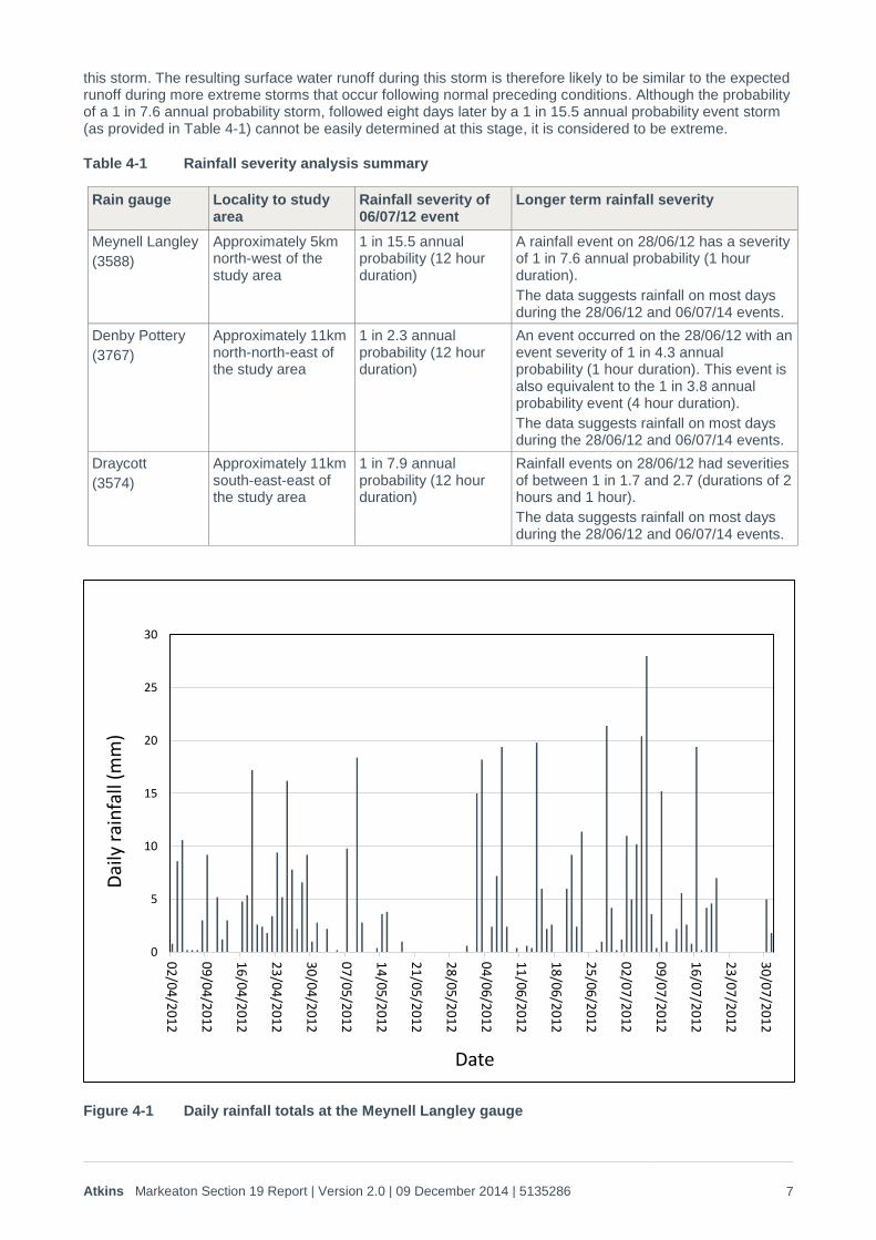
The 15 minute rainfall record for the event, and the four months leading up to the event, have been provided by the Environment Agency for these three rain gauges. A summary of the rainfall analysis has been provided in Table 4-1. The Meynell Langley gauge is closest to the study area and the daily total rainfall at this gauge is shown in Figure 4-1 to demonstrate the longer term rainfall record in this area.
The rainfall severity analysis indicates that a storm occurred within the catchment on the 28th June, which based on the data available for closest gauge, has been estimated to have an annual probability of greater than 1 in 7. There are no records of flooding occurring on or immediately after this June event. It is also evident that rainfall continued between this storm and the event that occurred on the 6th July. This supports the theory that the ground became saturated at the end of June 2012, potentially during the rainfall on 28th June 2012 and that continued rainfall between this date and early July caused the ground to remain saturated.
Based on the information supplied from the three rain gauges it is considered that the rainfall event that potentially caused the flooding on the 6th July is more frequent than the 1 in 15 annual probability event. A storm with a 1 in 15 annual probability is not considered extreme under normal conditions such as when a proportion of the rainfall can infiltrate the ground. However as a result of earlier storms and continued rainfall until the 6th July storm, the ground had become and remained saturated resulting in minimal infiltration during
Atkins Markeaton Section 19 Report | Version 2.0 | 09 December 2014 | 5135286 7
this storm. The resulting surface water runoff during this storm is therefore likely to be similar to the expected runoff during more extreme storms that occur following normal preceding conditions. Although the probability of a 1 in 7.6 annual probability storm, followed eight days later by a 1 in 15.5 annual probability event storm (as provided in Table 4-1) cannot be easily determined at this stage, it is considered to be extreme.
Table 4-1 Rainfall severity analysis summary
Rain gauge Locality to study area
Rainfall severity of 06/07/12 event
Longer term rainfall severity
Meynell Langley
(3588)
Approximately 5km north-west of the study area
1 in 15.5 annual probability (12 hour duration)
A rainfall event on 28/06/12 has a severity of 1 in 7.6 annual probability (1 hour duration).
The data suggests rainfall on most days during the 28/06/12 and 06/07/14 events.
Denby Pottery
(3767)
Approximately 11km north-north-east of the study area
1 in 2.3 annual probability (12 hour duration)
An event occurred on the 28/06/12 with an event severity of 1 in 4.3 annual probability (1 hour duration). This event is also equivalent to the 1 in 3.8 annual probability event (4 hour duration).
The data suggests rainfall on most days during the 28/06/12 and 06/07/14 events.
Draycott
(3574)
Approximately 11km south-east-east of the study area
1 in 7.9 annual probability (12 hour duration)
Rainfall events on 28/06/12 had severities of between 1 in 1.7 and 2.7 (durations of 2 hours and 1 hour).
The data suggests rainfall on most days during the 28/06/12 and 06/07/14 events.
Figure 4-1 Daily rainfall totals at the Meynell Langley gauge
0
5
10
15
20
25
30
02
/04
/20
12
09
/04
/20
12
16
/04
/20
12
23
/04
/20
12
30
/04
/20
12
07
/05
/20
12
14
/05
/20
12
21
/05
/20
12
28
/05
/20
12
04
/06
/20
12
11
/06
/20
12
18
/06
/20
12
25
/06
/20
12
02
/07
/20
12
09
/07
/20
12
16
/07
/20
12
23
/07
/20
12
30
/07
/20
12
Dai
ly r
ain
fall
(mm
)
Date
Atkins Markeaton Section 19 Report | Version 2.0 | 09 December 2014 | 5135286 8
In addition to the standard rainfall severity analysis completed above an additional task was considered beneficial following the discussions with residents on 16th October 2014. During these discussions it was suggested that subsequent de-silting (following the July 2012 flooding) of the culverts under Markeaton Lane prevented flooding occurring on later dates, specifically December 2012. However rainfall analysis was completed in regards to the rainfall occurring during and leading up to December 2012. This analysis (at the Meynell Langley gauge) indicated that whilst heavy rainfall did occur during this period there were no rainfall events that exceeded the 1 in 1.5 annual probability. The rainfall event with a 1 in 1.5 annual probability occurred on 24th November 2012. The rainfall that occurred in December 2012, at the Meynell Langley gauge is considered no more severe that the 1 in 1 annual probability event. This analysis concludes that the rainfall event and the antecedent conditions, associated with the July 2012 event were more extreme in the Markeaton area in comparison to the December 2012 conditions.
4.4. Cause of flooding summary The assessment completed for this study indicates that the flood which occurred during July 2012 was the result of a combination of sources. The modelling indicates that the July 2012 event did not occur as a result of river flooding only. This conclusion was supported through the discussions with local residents.
The rainfall analysis indicates that the series of storms leading up to the July 2012 flood event individually are not considered extreme, but could be classed as so when reviewing the overall record. Whilst the overall event is classed as severe (i.e. combination of multiple storms), flooding has occurred in Markeaton on numerous previous occasions and therefore it is likely that there were other contributing factors. This is likely to be the hydraulic connectivity been the watercourses and groundwater, and the ability of the surface water drainage system to discharge into the watercourse between the Mackworth Brook and Markeaton.
Improving conveyance would promote discharge from the surface water drainage system and aid in reducing risk.
4.5. Sensitivity testing The above assessment has identified that the hydraulic modelling demonstrates flood extents more similar to the July 2012 event when more extreme flows are modelled, and that wet ground conditions preceded an approximate 1 in 15.5 rainfall event in July 2012. Based on these conclusions it was considered beneficial to undertake a quick sensitivity test in relation to the existing hydrology within the model and ground conditions.
The estimate of flow rates used for the hydraulic modelling assessment (Atkins, 2014) were reviewed. It was recognised that the catchment parameters used to estimate flow did not represent a particularly wet catchment. The PROPWET catchment descriptor, that indicates the percentage the catchment is wet (which is based on a measure of soil moisture deficit), was at a value of 35% (as defined in the Flood Estimation Handbook CD-ROM). This is the set value within the FEH CD-ROM and it is not normally appropriate to change this value for hydraulic modelling studies, such as that completed for the original hydraulic modelling. The Centre for Ecology and Hydrology2 states that “PROPWET values range from over 80% in the wettest catchments to less than 20% in the driest parts of the country”. Therefore a value of 35% would represent a relatively dry catchment.
To represent an extremely wet catchment, i.e. such as that predicted before the July 2012 event, the value of PROPWET was increased to 90% to represent a conservative indication of catchment wetness. Through increasing this value the resultant flow rates in the Markeaton and Mackworth Brooks, following a relatively common rainfall event (of say 1 in 10 and 1 in 15), were similar to the arbitrarily doubled flows (the 1 in 100 annual probability flows doubled) that created an outline considered relatively similar (although slightly conservative) to the July 2012 flood extents.
This sensitivity assessment was completed as a quick check, and therefore would require significantly more testing to provide a robust assessment, such as further hydrologic assessment and groundwater monitoring. However it does provide support for the above conclusion in relation to the cause of flooding associated with the July 2012, i.e. the flooding was the result of an extremely wet catchment followed by a 1 in 15 annual probability rainfall event.
2 Centre for Ecology and Hydrology. http://www.ceh.ac.uk/data/nfra/data/other_catchment.html
Atkins Markeaton Section 19 Report | Version 2.0 | 09 December 2014 | 5135286 9
5. Responsibilities and future actions
5.1. Local Lead Flood Authority As the LLFA, DCC is responsible for the coordination of flood risk management, maintaining a register of flood management assets and as stated earlier within this report, investigating flood incidents above set thresholds within the Derby city area.
It is required that the LLFA maintains a record of flood management assets, which if they fail, would have a significant impact on flood risk. Further information in regards to the requirement of an asset register is outlined within Section 21 of the FWMA.
Whilst the LLFA can identify the mechanisms of flooding and identify actions to manage flood risk, the FWMA does not require the LLFA to implement such measures or provide funding for recommendations outlined within this Section 19 report.
In line with the Land Drainage Act (1991), Section 25, the LLFA has powers to serve notice on individuals, requiring the maintenance of flows within Ordinary watercourses.
DCC as the local highways authority is responsible for the management of surface water on Markeaton Lane and maintaining the drainage infrastructure to acceptable design standards. Following discussion with DCC it was identified that DCC have maintained the drainage system such that it has and continues to operate to the design capacities. However it recognised that improvements could be considered to the existing drainage system. Should DCC wish to improve the drainage system within this area the following two schemes could be considered.
One option to limit the volume of water flowing easterly to Markeaton would be to allow water to pass into the ditch that is culverted under Markeaton Lane before this ditch discharges into Mackworth Brook. This area is shown by the two most westerly nodes in Figure 2-1. Although this option would need to be considered in further detail, it has the potential to provide a quick, relatively low cost option, to reduce the surface water runoff flowing towards Markeaton.
The second area where potential drainage improvements could be considered is within the existing drainage system in Markeaton, which is currently limited owing to the outfall to the ditch located between the village of Markeaton and Mackworth Brook. There is potential that the drainage system could be improved, although it is considered unlikely that a system to provide significantly higher capacity would be cost beneficial.
Although two potential options for improved surface water drainage have been discussed, this assessment has identified that the July 2012 flooding was the result of an extremely wet catchment. The evidence suggests that even with a redesigned surface water drainage system, the July 2012 flooding would have been the same severity as observed. Therefore, whilst an improved surface water drainage system would provide flood risk benefits to lower magnitude events, flooding during extreme events (such as July 2012) may not be significantly improved.
As mentioned in section 2 the Markeaton and Mackworth Brooks are designated as Ordinary watercourses under Markeaton Lane and along the upstream reaches. Therefore DCC have permissive enforcement powers in relation to these watercourses (under and upstream of Markeaton Lane) and is the associated consenting authority for works.
The Derby City boundary falls to the west of Markeaton, but does not encompass the north bank of Mackworth Brook to the west of Markeaton Lane. The area to the east of this boundary falls under the responsibility of DCC, however to the west the area is within the Amber Valley district and therefore Derbyshire County Council as the LLFA. These areas of responsibility are shown on Figure 5-1.
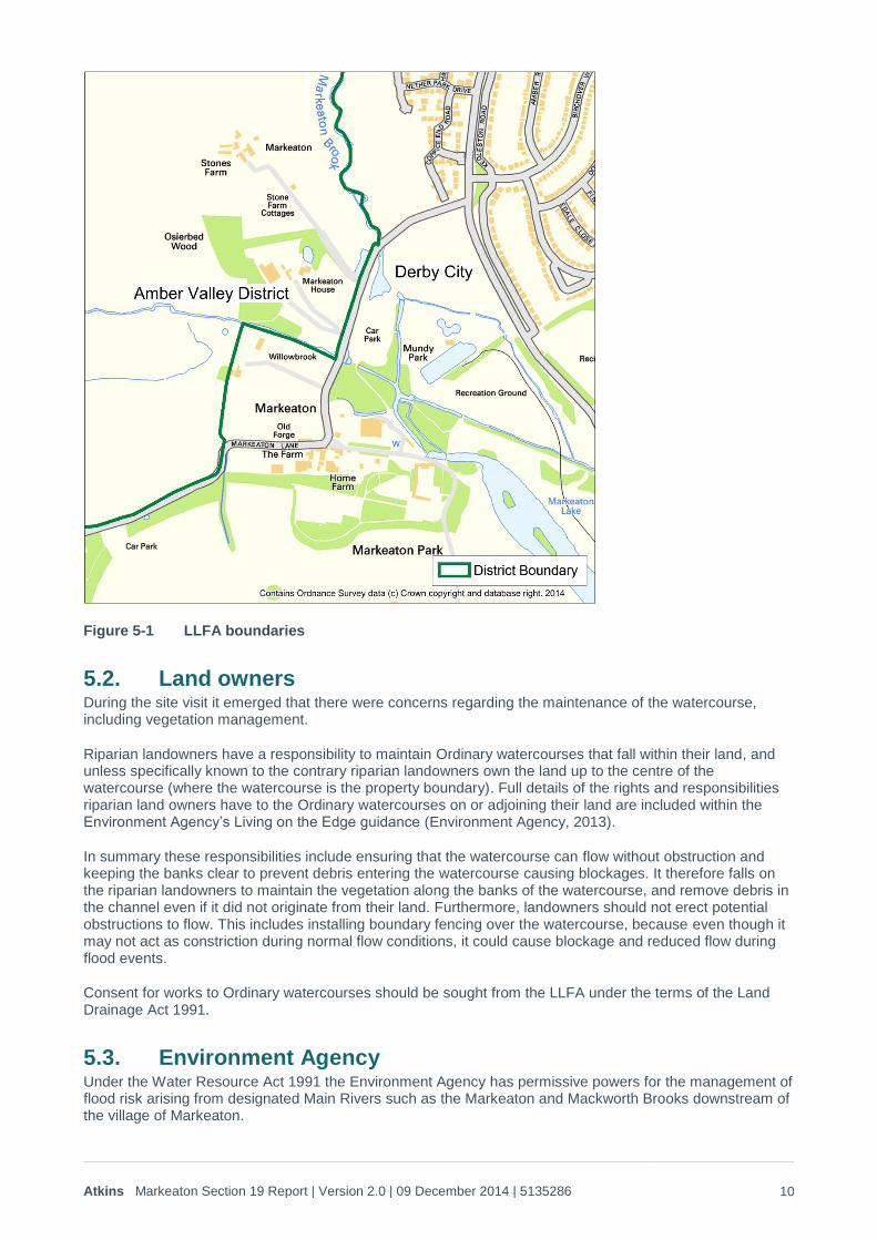
Atkins Markeaton Section 19 Report | Version 2.0 | 09 December 2014 | 5135286 10
Figure 5-1 LLFA boundaries
5.2. Land owners During the site visit it emerged that there were concerns regarding the maintenance of the watercourse, including vegetation management.
Riparian landowners have a responsibility to maintain Ordinary watercourses that fall within their land, and unless specifically known to the contrary riparian landowners own the land up to the centre of the watercourse (where the watercourse is the property boundary). Full details of the rights and responsibilities riparian land owners have to the Ordinary watercourses on or adjoining their land are included within the Environment Agency’s Living on the Edge guidance (Environment Agency, 2013).
In summary these responsibilities include ensuring that the watercourse can flow without obstruction and keeping the banks clear to prevent debris entering the watercourse causing blockages. It therefore falls on the riparian landowners to maintain the vegetation along the banks of the watercourse, and remove debris in the channel even if it did not originate from their land. Furthermore, landowners should not erect potential obstructions to flow. This includes installing boundary fencing over the watercourse, because even though it may not act as constriction during normal flow conditions, it could cause blockage and reduced flow during flood events.
Consent for works to Ordinary watercourses should be sought from the LLFA under the terms of the Land Drainage Act 1991.
5.3. Environment Agency Under the Water Resource Act 1991 the Environment Agency has permissive powers for the management of flood risk arising from designated Main Rivers such as the Markeaton and Mackworth Brooks downstream of the village of Markeaton.
Atkins Markeaton Section 19 Report | Version 2.0 | 09 December 2014 | 5135286 11
Consent for works in, under, over or within 8m of main rivers and for certain works within the floodplain should be sought from the Environment Agency under the terms of the Water Resources Act 1991.
5.4. Severn Trent Water Severn Trent Water is responsible for the management of flood risk from the sewer system within Derby and ensuring properties are not at risk of flooding during normal wet conditions. The sewer system includes surface water, foul water and combined (both surface water and foul water) systems. However within the study area the surface water system is associated with drainage of the highways and therefore falls under the remit of the Highways team within DCC. Therefore Severn Trent Water is not responsible for surface water drainage within the study area.
5.5. Responsibility and the July 2012 flooding This assessment concludes that flooding was the result of multiple contributing factors and due to the nature of the catchment being highly responsive to water levels within the network of watercourses. Owing to these causes and the nature of the catchment, this assessment does not find that flooding occurred as the result of failings from one or more parties in relation to their flood risk management responsibilities.
5.6. Actions This study has identified a list of recommended actions which are anticipated to reduce the risk of flooding. These actions are:
1. The LLFA (DCC) to continue to monitor flood risk in this area; 2. The Highways team within DCC should check gullies to ensure that the gullies remain in good condition
and free from debris; 3. The inspection regimes should also ensure that the drainage connection from the surface water system
in Markeaton, connecting to the watercourse between Mackworth Brook and Markeaton remains clear and in a good state of repair;
4. In the future, the LLFA could consider a change in the drainage network along Markeaton Lane allowing water to pass into the ditch upstream and to the west of Markeaton. Other drainage options could be discussed within DCC, although it is considered schemes to significantly increase capacity would not be financially feasible;
5. Riparian landowners should be made aware of their responsibilities in relation to management of watercourses on their land. The consequence of not undertaking the required maintenance (i.e. increasing food risk), should be outlined;
6. The watercourse between Mackworth Brook and Markeaton is inspected to identify any maintenance works that would be required to allow surface water to freely discharge into this watercourse. This inspection should identify potential restrictions in flow; and
7. At this stage further study is not considered necessary. However, if in the future DCC consider that further assessment of the flooding mechanisms in this catchment would be beneficial groundwater monitoring could be commissioned. This could improve understanding of the wetness values of the catchment. The results from a groundwater monitoring scheme would be used to support a more detailed hydrological assessment.
6. References
Atkins. (2014). Markeaton Brook and Mackworth Brook Technical Note.
Derby City Council. (2010). Derby City Strategic Flood Risk Assessment.
Derby City Council. (2011). Preliminary Flood Risk Assessment.
Environment Agency. (2013). Living on the Edge - A guide to your rights and responsibilities of riverside ownership.

© Atkins Ltd except where stated otherwise. The Atkins logo, ‘Carbon Critical Design’ and the strapline ‘Plan Design Enable’ are trademarks of Atkins Ltd.
Liz Hillcoat Atkins Ltd Western House (Block B) Peterborough Business Park Lynch Wood Peterborough PE2 6FZ
Email: [email protected] Telephone: 01733 366900 Direct telephone: 01733 366904