satellite data distribution roadmap – goes-r · aerosol optical depth fire/hot spot...
TRANSCRIPT

Satellite Data Distribution Roadmap – GOES-R
Curaçao5 September 2016 Agenda Item 4.2

Overview of WMO Members in RA III satellite reception systems
State / Territory Present satellite data reception systems
Planned or potential futuresystems
Argentina GVAR, HRPT DR X-band
Bolivia
Brazil (INMET): GVAR(INPE): GVAR, GNC-A, EUMETCast-A, HRPT, DRX-band
(INMET): GNC-A(INPE): GRB, GNC-A,DR X-band
Chile GNC-A Purchased three (3) GRB systems
Colombia
Ecuador GVAR
France (Guyana)
Guyana GVAR
Paraguay GVAR, EUMETCast-A
Peru GRB or GNC-A
Suriname
Uruguay
Venezuela

Overview of WMO Members in RA IV satellite reception systemsState / Territory Present satellite data reception
systemsPlannedd or potential futuresystems
Antigua and Barbuda HttpBahamasBarbados GVARBelize ftp/http, EMWIN GRBBCT GVAR (1 country), EMWIN
(4 countries)Canada GVAR GRB (E, W)ColombiaCosta Rica GRBCubaCuracao and SintMaarten
GVAR, NOAAPort, EMWIN
Dominica ftp/http, EMWIN GNC-ADominican RepublicEl SalvadorFrance (DOM/TOM)Guatemala

Overview of WMO Members in RA IV satellite reception systemsState / Territory Present satellite data reception
systemsPlanned or potential futuresystems
Haiti
Honduras
Jamaica Via the Internet Possibly via the Internet but plans are fluid.
Mexico
Netherlands (Aruba) GVAR, NOAAPORT,EMWIN
GRB, GNC-A
Nicaragua
Panama GVAR GRB
Saint Lucia ftp/http GRB
Trinidad and Tobago GVAR GRB

Data Access
Source: http://www.goes-r.gov/users/user-systems.html

Comprehensive Large Array-data Stewardship System (CLASS); NOAA’s information technology system designed
to support long-term, secure preservation andstandards-based access to environmental datacollections and information .◦ There are 80 data families in CLASS.◦ Each family of data may contain many data types.◦ Altogether there are 300 datasets in CLASS
accessible through its web interface.◦ The most popular are the original radiance datasets
from GOES, POES, and S-NPP.◦ Data distribution formats available are raw, AREA,
NetCDF, GIF, and JPEG
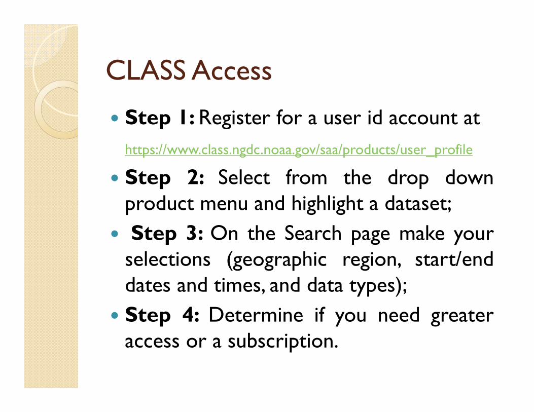
CLASS Access
Step 1: Register for a user id account athttps://www.class.ngdc.noaa.gov/saa/products/user_profile
Step 2: Select from the drop downproduct menu and highlight a dataset;
Step 3: On the Search page make yourselections (geographic region, start/enddates and times, and data types);
Step 4: Determine if you need greateraccess or a subscription.


Advanced Weather Interactive Processing System (AWIPS)
AWIPS II is a weather forecasting display andanalysis package being developed by theNational Weather Service and Raytheon.
AWIPS II is an open-source Java applicationwhich consists of the EDEX data server toingest and decode meteorological data sets,and the CAVE client for data rendering andanalysis.
Source code is available athttp://unidata.github.io/awips2/docs/install/install-cave.html

AWIPS System Requirements EDEX Data Server◦ Operating System 64-bit Red Hat / CentOS 6 (x86_64) ◦ CPUs Min 4 cores, recommend 8 ◦ RAM Min 8 GB, recommend 16 (2xJVM at
1.5GB, one at 4 GB) ◦ Disk Space Min 250 GB, recommend 500 GB 256 GB Solid State Drive Required for high-volume data
ingest (NEXRAD3 and CONDUIT gfs/gefs) CAVE Client◦ Operating System 64-bit Red Hat / CentOS 6 (x86_64)
Memory/RAM Min 4 GB ◦ Disk Space 650 MB ◦ Video/Graphics Adapter NVIDIA GPU with 2 GB video
memory and OpenGL support

AWIPS Data Distribution The University Corporation for Atmospheric
Research (UCAR) has funds to install a GOES-Rdownlink;
Imagery and products that will be ingestedavailable to as wide a user base as possible mainlythrough remote server (e.g., McIDAS ADDE, TDSand potentially AWIPS EDEX) access;
Internet Data Distribution (IDD) system to"push“ products to end users, but there arerestrictions on who can participate in the IDD.
The data is pushed continuously through IDDwith a peak rate of 60GB and it is growing.

Production Distribution and Access (PDA) Purpose of the Production Distribution and Access
(PDA) system is to serve as a distribution system for near real-time users.
Products which will be available are:• GOES-R• S-NPP/JPSS
To access PDA, requestors must: • Have an operational need for near real-time data• Agree to adhere to the rules of behavior on the Data
Access Request form• Understand that requests may be prioritized due to data
volume issues.• Send data access request form to:

Data Access Policy
Access Policy : http://www.ospo.noaa.gov/Organization/About/access.html
DATA ACCESS REQUEST FORM
LINK

GRB System

Level 1b ProductsLevel 1b Products
Advance Baseline Imager (ABI)
Radiances
Geostationary Lightning Mapper (GLM)
Lightning Detection: Events, Groups & Flashes
Space Environment In-Situ Suite (SEISS)
Energetic Heavy Ions
Magnetospheric Electrons & Protons: Low Energy
Magnetospheric Electrons & Protons: Med & High Energy
Solar & Galactic Protons
Magnetometer (MAG)
Geomagnetic Field
Extreme Ultraviolet and X-ray Irradiance Suite (EXIS)
Solar Flux: EUV
Solar Flux: X-ray Irradiance
Solar Ultraviolet Imager (SUVI)
Solar EUV Imagery

Level 2 ProductsLevel 2 Products
Aerosol Detection (Including Smoke/Dust) Downward Shortwave Radiation: Surface
Aerosol Optical Depth Fire/Hot Spot Characterization
Clear Sky Masks Hurricane Intensity Estimation
Cloud and Moisture Imagery Land Surface Temperature (Skin)
Cloud Optical Depth Legacy Vertical Moisture Profile
Cloud Particle Size Distribution Legacy Vertical Temperature Profile
Cloud Top Height Rainfall Rate/QPE
Cloud Top Phase Reflected Shortwave Radiation: TOA
Cloud Top Pressure Sea Surface Temperature (Skin)
Cloud Top Temperature Snow Cover
Derived Motion Winds Total Precipitable Water
Derived Stability Indices Volcanic Ash: Detection and Height
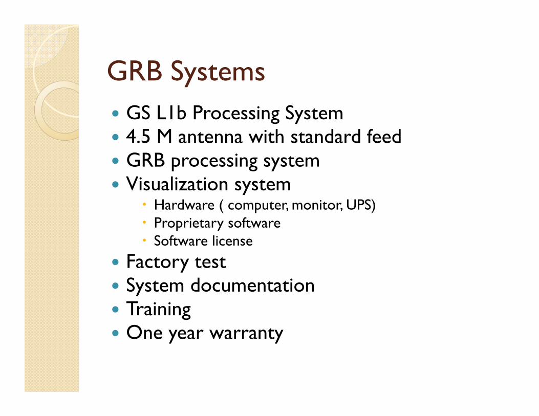
GRB Systems GS L1b Processing System 4.5 M antenna with standard feed GRB processing system Visualization system
Hardware ( computer, monitor, UPS) Proprietary software Software license
Factory test System documentation Training One year warranty
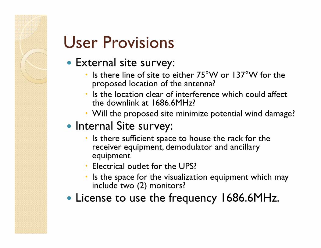
User Provisions External site survey:
Is there line of site to either 75°W or 137°W for the proposed location of the antenna?
Is the location clear of interference which could affect the downlink at 1686.6MHz?
Will the proposed site minimize potential wind damage? Internal Site survey:
Is there sufficient space to house the rack for the receiver equipment, demodulator and ancillary equipment
Electrical outlet for the UPS? Is the space for the visualization equipment which may
include two (2) monitors? License to use the frequency 1686.6MHz.

Time line for Delivery

GRB Access from the Cloud (1)
Vendor Provision Includes hardware; No antenna needed; Level 1b products;
User Provides: The software for visualization; 5Mbps Internet bandwidth sufficient for the
movement of 31Mbps of data every 15 minutes.
OR

GRB Access from the Cloud (2)
Vendor Provision Level 1b and Level 2 data and/or products;
User Provides: Hardware for visualization; The software for visualization; An Internet pipe to accommodate a data download
of approximately 330Mb every 15 minutes or shorter (if Level 2 data is to be downloaded).
.

Data as a Service from the Cloud
User defines the product type, geographicarea, resolution, map projection and deliveryfrequency of the products required.
User defines any specialized use of the datae.g. archiving imagery, web use etc.
User provides a PC(s) for displaying the imagery.
Service provider provides secure access to the data in the “cloud” with all the necessary software, map projections for display.

Data as a Service
Vendor Provision All Level 1b data files and transfer them to the user
within five minutes of acquisition from the GOESsatellite.
User Provision Hardware for visualization; The software for visualization;
User defines the product type,geographic area, resolution, and deliveryfrequency of the products required.