san ysidro pedestrian plan · san ysidro pedestrian plan ... sunset lane safety improvements sy-8...
TRANSCRIPT
San Ysidro Pedestrian Plan Pedestrian Master Plan – Phase 4
San Ysidro Community Description The San Ysidro Community is located in the southernmost part of the City of San Diego, adjacent to the international border with Mexico; pedestrians crossing the San Ysidro border make up part of the traffic at the busiest international border in the world. San Ysidro is bounded by the Otay Mesa-Nestor Community and State Highway 905 in the north, by the Tijuana River Valley in the west, by the Otay Mesa Community in the east, and by the international border in the south.
The San Ysidro Community has a patchwork of residential developments of varying ages and densities that are served by their own internal streets. The community is physically divided by the trolley line and Interstates 5 and 805. Access to freeways is provided by several major streets. Pedestrian bridges are provided across the I-5 and I-805.
Commercial activity occurs along the historic San Ysidro Boulevard which is the primary thoroughfare and has a mix of auto-oriented and pedestrian-oriented commercial and residential development. The Las Americas Center is an auto-oriented regional shopping center on Camino de la Plaza in the southernmost portion of the community.
Community Outreach The project was presented to the San Ysidro Community Planning Group in November 2012. At that time, the Focus Area was presented and community members were encouraged to complete Walk Audits and the Online Survey. No surveys were completed online for the San Ysidro community.
Since San Ysidro was going through the Community Plan Update process that began before this project, significant community input related to pedestrian issues had already been collected. This input was utilized for the Pedestrian Master Plan process as well.
San Ysidro residents and business owners were also invited to attend two Open House events held in December 2012 to review the recommendations for their community. At each Open House, recommendations for all Phase 4 communities were presented and participants were encouraged to provide input and complete surveys to share their thoughts and ideas on the plan. In addition, the Pedestrian Master Plan project was presented at the Community Plan Update Meeting in January 2013. A comprehensive Powerpoint presentation was given at this community wide event.
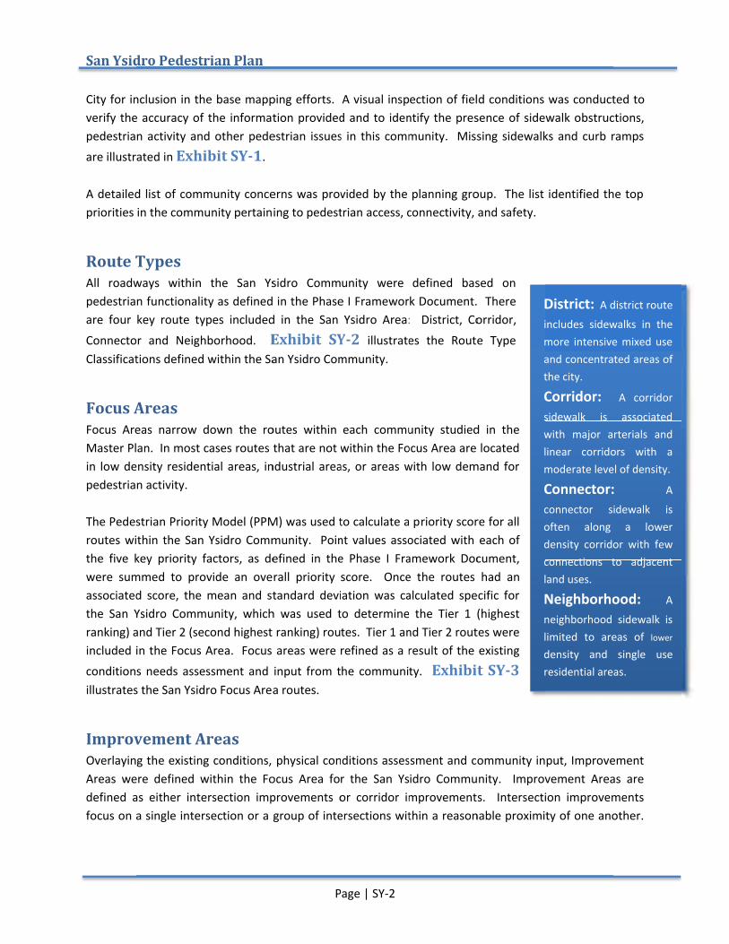
Inventory of Missing Sidewalks and Curb Ramps The City of San Diego and SANDAG provided detailed information regarding missing sidewalks and existing curb ramps. GIS files for existing sidewalks and curb ramps were provided by SANDAG and the
San Ysidro
City for inclusion in the base mapping efforts. A visual inspection of field conditions was conducted to verify the accuracy of the information provided and to identify the presence of sidewalk obstructions, pedestrian activity and other pedestrian issues in this community. Missing sidewalks and curb ramps are illustrated in A detailed list of community concerns was provided by the planning group. The list identified the top priorities in the communit
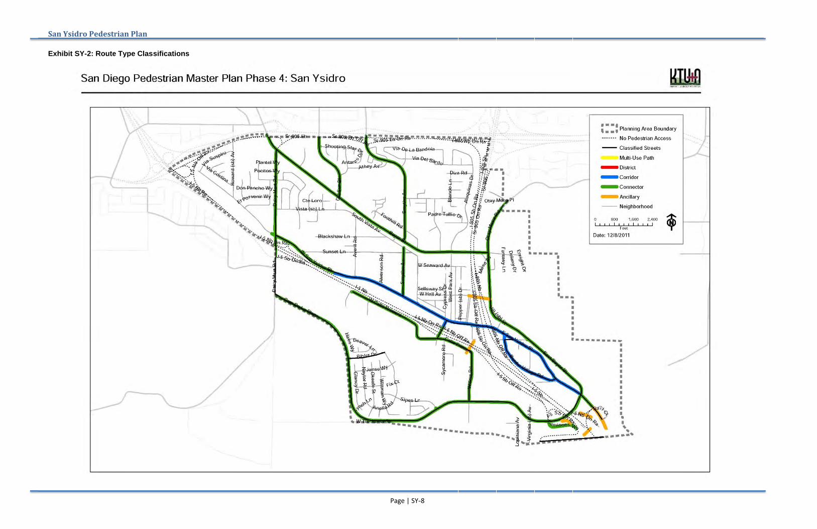
Route TypesAll roadways within the San Ysidro Community were defined based on pedestrian functionality as defined in the Phase I Framework Document. There are four key route types inclConnector and Neighborhood. Classifications defined within the San Ysidro Community.
Focus AreasFocus Areas narrow down Master Plan. In most cases routes that are not within the Focus Area are located in low density residential areas, industrial areas, or areas with low demand for pedestrian activity. The Pedestrian Priority Model (PPM) was used to calculate a proutes within the San Ysidro Community. Point values associated with each of the five key priority factors, as defined in the Phase I Framework Document, were summed to provide an overall priority score. Once the routes had an associated score, the mean and standard deviation was calculated specific for the San Ysidro Community, which was used to determine the Tier 1 (highest ranking) and Tier 2 (second highest ranking) routes. Tier 1 and Tier 2 routes were included in the Focus Areconditions needs assessment and input from the community. illustrates the San Ysidro Focus Area routes.
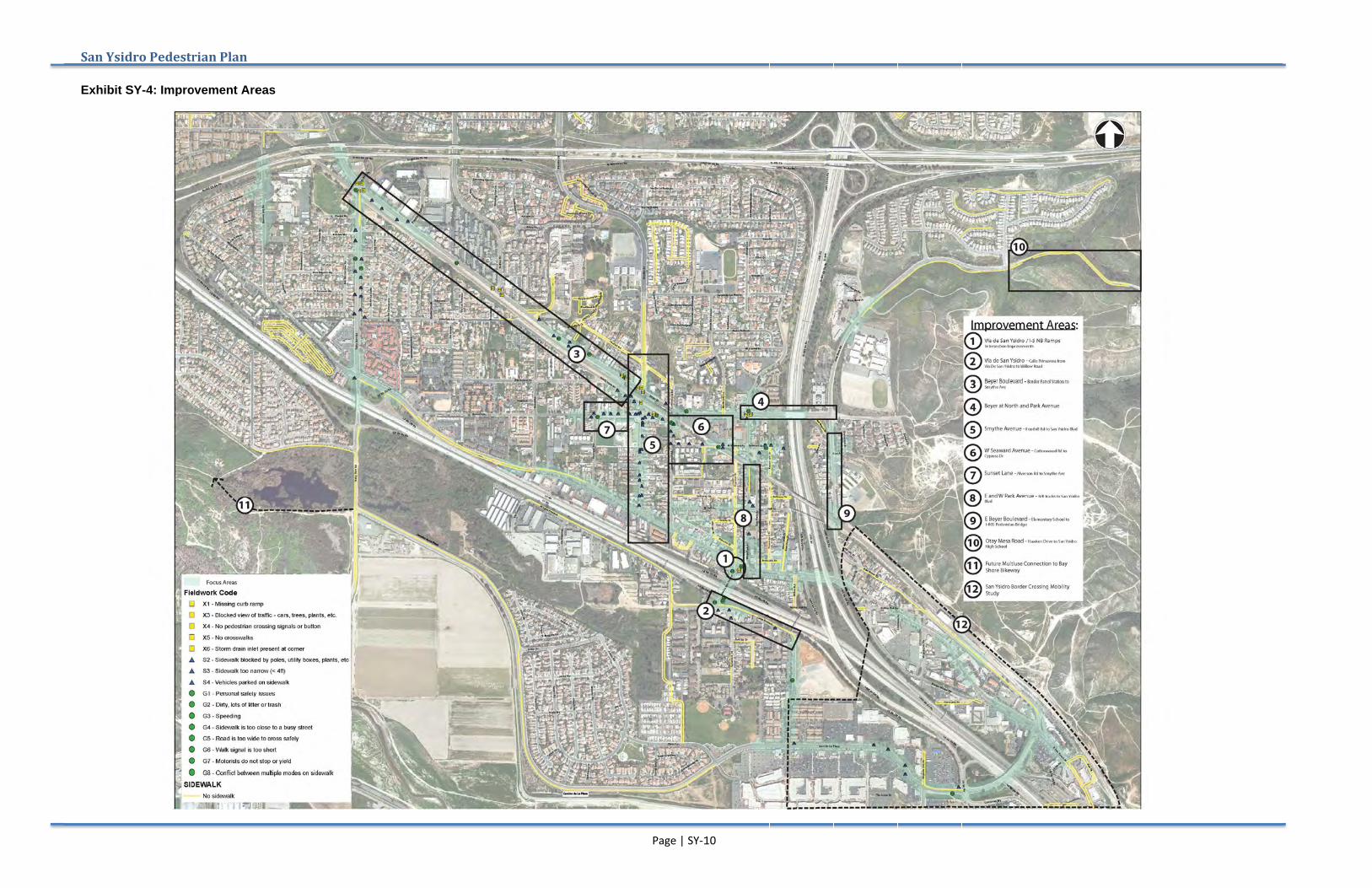
Improvement Overlaying the existing conditions, physical conditions assesAreas were defined within the Focus Area for the defined as either intersection improvements or corridor improvements. Intersection improvements focus on a single intersec
San Ysidro Pedestrian Plan
for inclusion in the base mapping efforts. A visual inspection of field conditions was conducted to verify the accuracy of the information provided and to identify the presence of sidewalk obstructions,
an activity and other pedestrian issues in this community. Missing sidewalks and curb ramps are illustrated in Exhibit
A detailed list of community concerns was provided by the planning group. The list identified the top priorities in the communit
oute Types roadways within the San Ysidro Community were defined based on
pedestrian functionality as defined in the Phase I Framework Document. There are four key route types inclConnector and Neighborhood. Classifications defined within the San Ysidro Community.
Focus Areas Focus Areas narrow down Master Plan. In most cases routes that are not within the Focus Area are located in low density residential areas, industrial areas, or areas with low demand for pedestrian activity.
The Pedestrian Priority Model (PPM) was used to calculate a proutes within the San Ysidro Community. Point values associated with each of the five key priority factors, as defined in the Phase I Framework Document, were summed to provide an overall priority score. Once the routes had an
iated score, the mean and standard deviation was calculated specific for the San Ysidro Community, which was used to determine the Tier 1 (highest ranking) and Tier 2 (second highest ranking) routes. Tier 1 and Tier 2 routes were included in the Focus Areconditions needs assessment and input from the community. illustrates the San Ysidro Focus Area routes.
Improvement AreasOverlaying the existing conditions, physical conditions assesAreas were defined within the Focus Area for the defined as either intersection improvements or corridor improvements. Intersection improvements focus on a single intersec
Pedestrian Plan
for inclusion in the base mapping efforts. A visual inspection of field conditions was conducted to verify the accuracy of the information provided and to identify the presence of sidewalk obstructions,
an activity and other pedestrian issues in this community. Missing sidewalks and curb ramps Exhibit SY-1.
A detailed list of community concerns was provided by the planning group. The list identified the top priorities in the community pertaining to pedestrian access, connectivity, and safety.
roadways within the San Ysidro Community were defined based on pedestrian functionality as defined in the Phase I Framework Document. There are four key route types included in the San Ysidro Area: District, Corridor, Connector and Neighborhood. Exhibit SYClassifications defined within the San Ysidro Community.
Focus Areas narrow down the routes within each community studieMaster Plan. In most cases routes that are not within the Focus Area are located in low density residential areas, industrial areas, or areas with low demand for
The Pedestrian Priority Model (PPM) was used to calculate a proutes within the San Ysidro Community. Point values associated with each of the five key priority factors, as defined in the Phase I Framework Document, were summed to provide an overall priority score. Once the routes had an
iated score, the mean and standard deviation was calculated specific for the San Ysidro Community, which was used to determine the Tier 1 (highest ranking) and Tier 2 (second highest ranking) routes. Tier 1 and Tier 2 routes were included in the Focus Area. Focus areas were refined as a result of the existing conditions needs assessment and input from the community. illustrates the San Ysidro Focus Area routes.
Areas Overlaying the existing conditions, physical conditions assesAreas were defined within the Focus Area for the defined as either intersection improvements or corridor improvements. Intersection improvements focus on a single intersection or a group of intersections within a reasonable proximity of one another.
Page | SY
for inclusion in the base mapping efforts. A visual inspection of field conditions was conducted to verify the accuracy of the information provided and to identify the presence of sidewalk obstructions,
an activity and other pedestrian issues in this community. Missing sidewalks and curb ramps
A detailed list of community concerns was provided by the planning group. The list identified the top y pertaining to pedestrian access, connectivity, and safety.
roadways within the San Ysidro Community were defined based on pedestrian functionality as defined in the Phase I Framework Document. There
uded in the San Ysidro Area: District, Corridor, Exhibit SY
Classifications defined within the San Ysidro Community.
the routes within each community studieMaster Plan. In most cases routes that are not within the Focus Area are located in low density residential areas, industrial areas, or areas with low demand for
The Pedestrian Priority Model (PPM) was used to calculate a proutes within the San Ysidro Community. Point values associated with each of the five key priority factors, as defined in the Phase I Framework Document, were summed to provide an overall priority score. Once the routes had an
iated score, the mean and standard deviation was calculated specific for the San Ysidro Community, which was used to determine the Tier 1 (highest ranking) and Tier 2 (second highest ranking) routes. Tier 1 and Tier 2 routes were
a. Focus areas were refined as a result of the existing conditions needs assessment and input from the community. illustrates the San Ysidro Focus Area routes.
Overlaying the existing conditions, physical conditions assesAreas were defined within the Focus Area for the defined as either intersection improvements or corridor improvements. Intersection improvements
tion or a group of intersections within a reasonable proximity of one another.
Page | SY-2
for inclusion in the base mapping efforts. A visual inspection of field conditions was conducted to verify the accuracy of the information provided and to identify the presence of sidewalk obstructions,
an activity and other pedestrian issues in this community. Missing sidewalks and curb ramps
A detailed list of community concerns was provided by the planning group. The list identified the top y pertaining to pedestrian access, connectivity, and safety.
roadways within the San Ysidro Community were defined based on pedestrian functionality as defined in the Phase I Framework Document. There
uded in the San Ysidro Area: District, Corridor, Exhibit SY-2 illustrates the Route Type
Classifications defined within the San Ysidro Community.
the routes within each community studieMaster Plan. In most cases routes that are not within the Focus Area are located in low density residential areas, industrial areas, or areas with low demand for
The Pedestrian Priority Model (PPM) was used to calculate a proutes within the San Ysidro Community. Point values associated with each of the five key priority factors, as defined in the Phase I Framework Document, were summed to provide an overall priority score. Once the routes had an
iated score, the mean and standard deviation was calculated specific for the San Ysidro Community, which was used to determine the Tier 1 (highest ranking) and Tier 2 (second highest ranking) routes. Tier 1 and Tier 2 routes were
a. Focus areas were refined as a result of the existing conditions needs assessment and input from the community.
Overlaying the existing conditions, physical conditions assesAreas were defined within the Focus Area for the San Ysidro Community. Improvement Areasdefined as either intersection improvements or corridor improvements. Intersection improvements
tion or a group of intersections within a reasonable proximity of one another.
for inclusion in the base mapping efforts. A visual inspection of field conditions was conducted to verify the accuracy of the information provided and to identify the presence of sidewalk obstructions,
an activity and other pedestrian issues in this community. Missing sidewalks and curb ramps
A detailed list of community concerns was provided by the planning group. The list identified the top y pertaining to pedestrian access, connectivity, and safety.
roadways within the San Ysidro Community were defined based on pedestrian functionality as defined in the Phase I Framework Document. There
uded in the San Ysidro Area: District, Corridor, illustrates the Route Type
the routes within each community studied in the Master Plan. In most cases routes that are not within the Focus Area are located in low density residential areas, industrial areas, or areas with low demand for
The Pedestrian Priority Model (PPM) was used to calculate a priority score for all routes within the San Ysidro Community. Point values associated with each of the five key priority factors, as defined in the Phase I Framework Document, were summed to provide an overall priority score. Once the routes had an
iated score, the mean and standard deviation was calculated specific for the San Ysidro Community, which was used to determine the Tier 1 (highest ranking) and Tier 2 (second highest ranking) routes. Tier 1 and Tier 2 routes were
a. Focus areas were refined as a result of the existing conditions needs assessment and input from the community. Exhibit
Overlaying the existing conditions, physical conditions assessment and community input, Improvement San Ysidro Community. Improvement Areas
defined as either intersection improvements or corridor improvements. Intersection improvements tion or a group of intersections within a reasonable proximity of one another.
District:includes sidewalks in the more intensive mixed use and concentrated areas of the city.
Corridor: sidewalk is associated with major arterials and linear corridors m
Connector: connector sidewalk is often along a lower density corridor with few connections to adjacent land uses.
Neighborhood: neighborhoodlimited to areas of density and single use residential areas.
for inclusion in the base mapping efforts. A visual inspection of field conditions was conducted to verify the accuracy of the information provided and to identify the presence of sidewalk obstructions,
an activity and other pedestrian issues in this community. Missing sidewalks and curb ramps
A detailed list of community concerns was provided by the planning group. The list identified the top y pertaining to pedestrian access, connectivity, and safety.
roadways within the San Ysidro Community were defined based on pedestrian functionality as defined in the Phase I Framework Document. There
uded in the San Ysidro Area: District, Corridor, illustrates the Route Type
d in the Master Plan. In most cases routes that are not within the Focus Area are located in low density residential areas, industrial areas, or areas with low demand for
riority score for all routes within the San Ysidro Community. Point values associated with each of the five key priority factors, as defined in the Phase I Framework Document, were summed to provide an overall priority score. Once the routes had an
iated score, the mean and standard deviation was calculated specific for the San Ysidro Community, which was used to determine the Tier 1 (highest ranking) and Tier 2 (second highest ranking) routes. Tier 1 and Tier 2 routes were
a. Focus areas were refined as a result of the existing Exhibit SY-3
sment and community input, Improvement San Ysidro Community. Improvement Areas
defined as either intersection improvements or corridor improvements. Intersection improvements tion or a group of intersections within a reasonable proximity of one another.
District: A district route
includes sidewalks in the more intensive mixed use and concentrated areas of the city.
Corridor: sidewalk is associated with major arterials and linear corridors moderate level of density.
Connector: connector sidewalk is often along a lower density corridor with few connections to adjacent land uses.
Neighborhood: neighborhood limited to areas of density and single use residential areas.
for inclusion in the base mapping efforts. A visual inspection of field conditions was conducted to verify the accuracy of the information provided and to identify the presence of sidewalk obstructions,
an activity and other pedestrian issues in this community. Missing sidewalks and curb ramps
A detailed list of community concerns was provided by the planning group. The list identified the top
sment and community input, Improvement San Ysidro Community. Improvement Areas
defined as either intersection improvements or corridor improvements. Intersection improvements tion or a group of intersections within a reasonable proximity of one another.
A district route
includes sidewalks in the more intensive mixed use and concentrated areas of
Corridor: A corridor
sidewalk is associated with major arterials and linear corridors with a
oderate level of density.
Connector: A
connector sidewalk is often along a lower density corridor with few connections to adjacent
Neighborhood: A
sidewalk is limited to areas of lower density and single use residential areas.
for inclusion in the base mapping efforts. A visual inspection of field conditions was conducted to verify the accuracy of the information provided and to identify the presence of sidewalk obstructions,
an activity and other pedestrian issues in this community. Missing sidewalks and curb ramps
A detailed list of community concerns was provided by the planning group. The list identified the top
sment and community input, Improvement San Ysidro Community. Improvement Areas are
defined as either intersection improvements or corridor improvements. Intersection improvements tion or a group of intersections within a reasonable proximity of one another.
Corridor improvements focus on improvements either along a roadway or through a series of intersections.
The Pedestrian Master Plan improvement concepts address deficiencies and provide recommendations based largely on existing conditions.Community Pedestrian Master Plan contains recommendations that could be implemented in a shorter time frame than many potentially larger
For the San Ysidro CoSY-4 and summarized inrecommendations for each Improvement Area are described in detail.
Priority Score The Improvement Areas and recommended projects within each improvement areaevaluated against priority ranking criteria established during Phase I of the Pedestrian Master Plan. Priority scores were based connectivity and accessibility.
Corridor improvements focus on improvements either along a roadway or through a series of intersections.
The Pedestrian Master Plan improvement concepts address deficiencies and provide recommendations based largely on existing conditions.
ommunity Plan UpdatePedestrian Master Plan contains recommendations that could be implemented in a shorter time frame than many potentially larger
the San Ysidro Community, ten Improvement Areas were defined, which are illustrated in and summarized in
recommendations for each Improvement Area are described in detail.
Priority Score The Improvement Areas and recommended projects within each improvement areaevaluated against priority ranking criteria established during Phase I of the Pedestrian Master Plan. Priority scores were based connectivity and accessibility.
Corridor improvements focus on improvements either along a roadway or through a series of
The Pedestrian Master Plan improvement concepts address deficiencies and provide recommendations based largely on existing conditions.
pdate (CPU) process that is developing a loPedestrian Master Plan contains recommendations that could be implemented in a shorter time frame than many potentially larger-scale projects being considered for the long term as part of the CPU
mmunity, ten Improvement Areas were defined, which are illustrated in and summarized in the table on the following page
recommendations for each Improvement Area are described in detail.
The Improvement Areas and recommended projects within each improvement areaevaluated against priority ranking criteria established during Phase I of the Pedestrian Master Plan. Priority scores were based on issues and connectivity and accessibility.
Page | SY
Corridor improvements focus on improvements either along a roadway or through a series of
The Pedestrian Master Plan improvement concepts address deficiencies and provide recommendations based largely on existing conditions. It should be noted that
process that is developing a loPedestrian Master Plan contains recommendations that could be implemented in a shorter time frame
scale projects being considered for the long term as part of the CPU
mmunity, ten Improvement Areas were defined, which are illustrated in the table on the following page
recommendations for each Improvement Area are described in detail.
The Improvement Areas and recommended projects within each improvement areaevaluated against priority ranking criteria established during Phase I of the Pedestrian Master Plan.
on issues and recommen
Page | SY-3
Corridor improvements focus on improvements either along a roadway or through a series of
The Pedestrian Master Plan improvement concepts address deficiencies and provide recommendations It should be noted that
process that is developing a loPedestrian Master Plan contains recommendations that could be implemented in a shorter time frame
scale projects being considered for the long term as part of the CPU
mmunity, ten Improvement Areas were defined, which are illustrated in the table on the following page
recommendations for each Improvement Area are described in detail.
The Improvement Areas and recommended projects within each improvement areaevaluated against priority ranking criteria established during Phase I of the Pedestrian Master Plan.
recommendations associated with walkability, safety,
Corridor improvements focus on improvements either along a roadway or through a series of
The Pedestrian Master Plan improvement concepts address deficiencies and provide recommendations It should be noted that San Ysidro
process that is developing a long term vision of the community.Pedestrian Master Plan contains recommendations that could be implemented in a shorter time frame
scale projects being considered for the long term as part of the CPU
mmunity, ten Improvement Areas were defined, which are illustrated in the table on the following page. Following the exhibit
recommendations for each Improvement Area are described in detail.
The Improvement Areas and recommended projects within each improvement areaevaluated against priority ranking criteria established during Phase I of the Pedestrian Master Plan.
dations associated with walkability, safety,
Corridor improvements focus on improvements either along a roadway or through a series of
The Pedestrian Master Plan improvement concepts address deficiencies and provide recommendations San Ysidro community is undergoing a ng term vision of the community.
Pedestrian Master Plan contains recommendations that could be implemented in a shorter time frame scale projects being considered for the long term as part of the CPU
mmunity, ten Improvement Areas were defined, which are illustrated in ollowing the exhibit
The Improvement Areas and recommended projects within each improvement areaevaluated against priority ranking criteria established during Phase I of the Pedestrian Master Plan.
dations associated with walkability, safety,
City of San Diego
Corridor improvements focus on improvements either along a roadway or through a series of
The Pedestrian Master Plan improvement concepts address deficiencies and provide recommendations community is undergoing a
ng term vision of the community.Pedestrian Master Plan contains recommendations that could be implemented in a shorter time frame
scale projects being considered for the long term as part of the CPU.
mmunity, ten Improvement Areas were defined, which are illustrated in Exhibit ollowing the exhibits and table,
The Improvement Areas and recommended projects within each improvement area were then evaluated against priority ranking criteria established during Phase I of the Pedestrian Master Plan.
dations associated with walkability, safety,
City of San Diego
Corridor improvements focus on improvements either along a roadway or through a series of
The Pedestrian Master Plan improvement concepts address deficiencies and provide recommendations community is undergoing a
ng term vision of the community. The Pedestrian Master Plan contains recommendations that could be implemented in a shorter time frame
Exhibit and table,
ere then evaluated against priority ranking criteria established during Phase I of the Pedestrian Master Plan.
dations associated with walkability, safety,

San Ysidro
Improvement Area Recommendations
Improvement Area
SY-1 Via De San Ysidro / IRamp Intersection Improvements
SY-2 Calle Primera Walkability Improvements
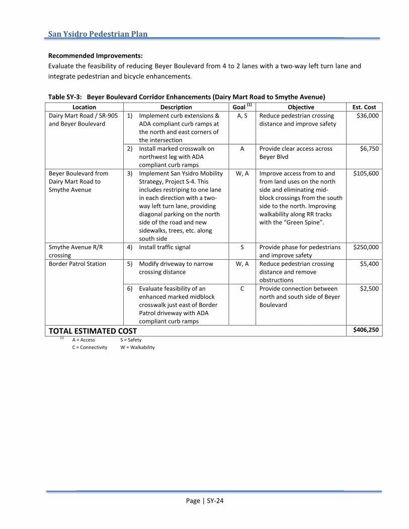
SY-3 Beyer Boulevard Corridor Enhancements (Dairy Mart Road to Smythe Avenue)
SY-4 Beyer Boulevard Walkability Improvements (North Lane to Otay Mesa Road)
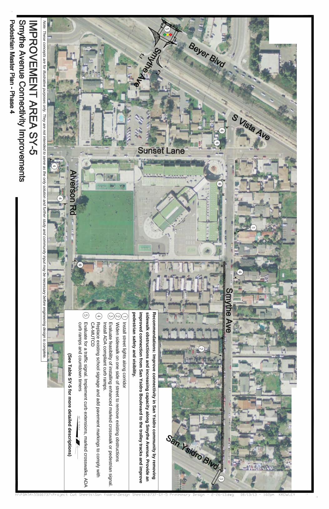
SY-5 Smythe Avenue Connectivity Improvements
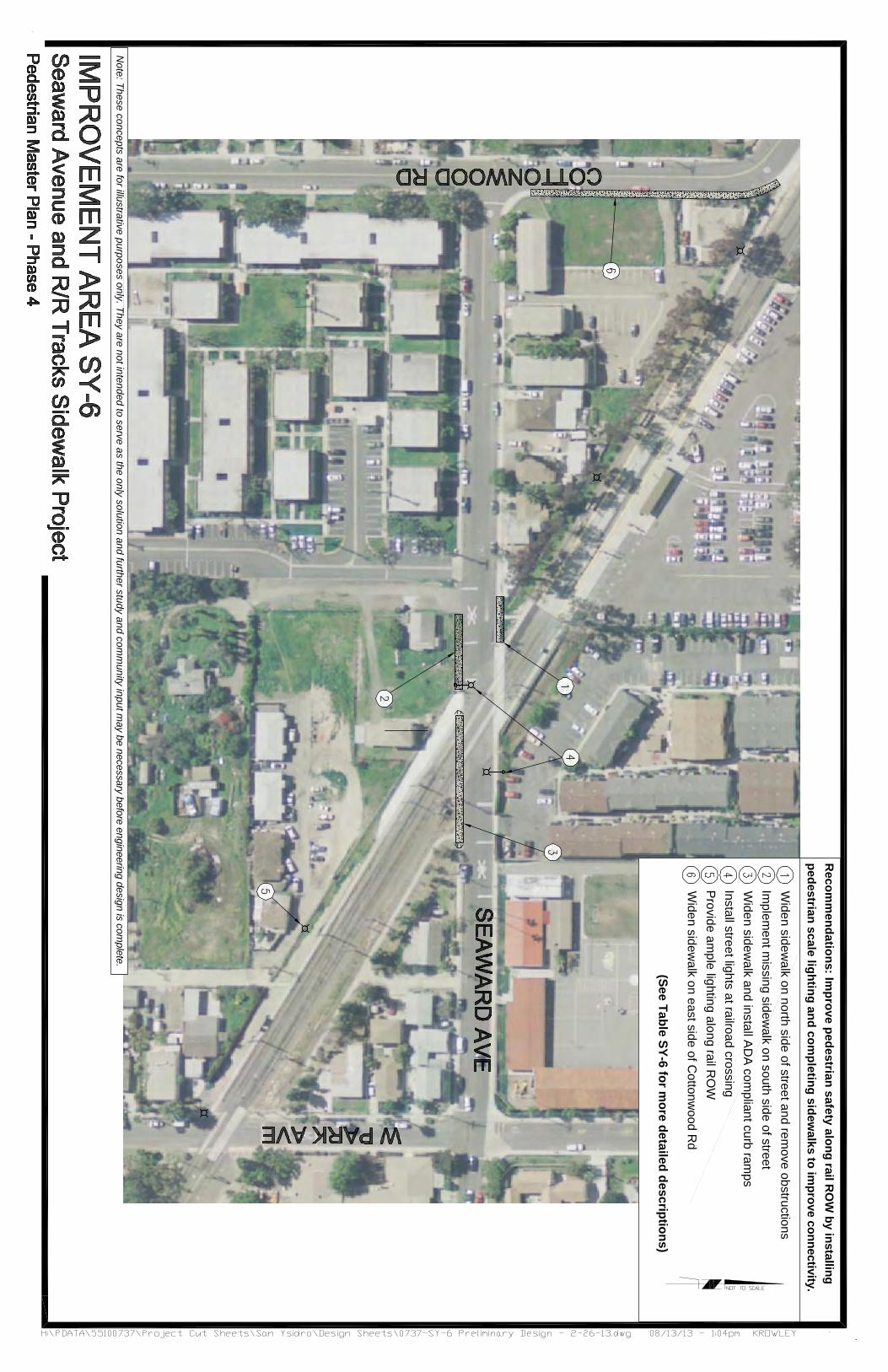
SY-6 Seaward Avenue and R/R Tracks Sidewalk Project
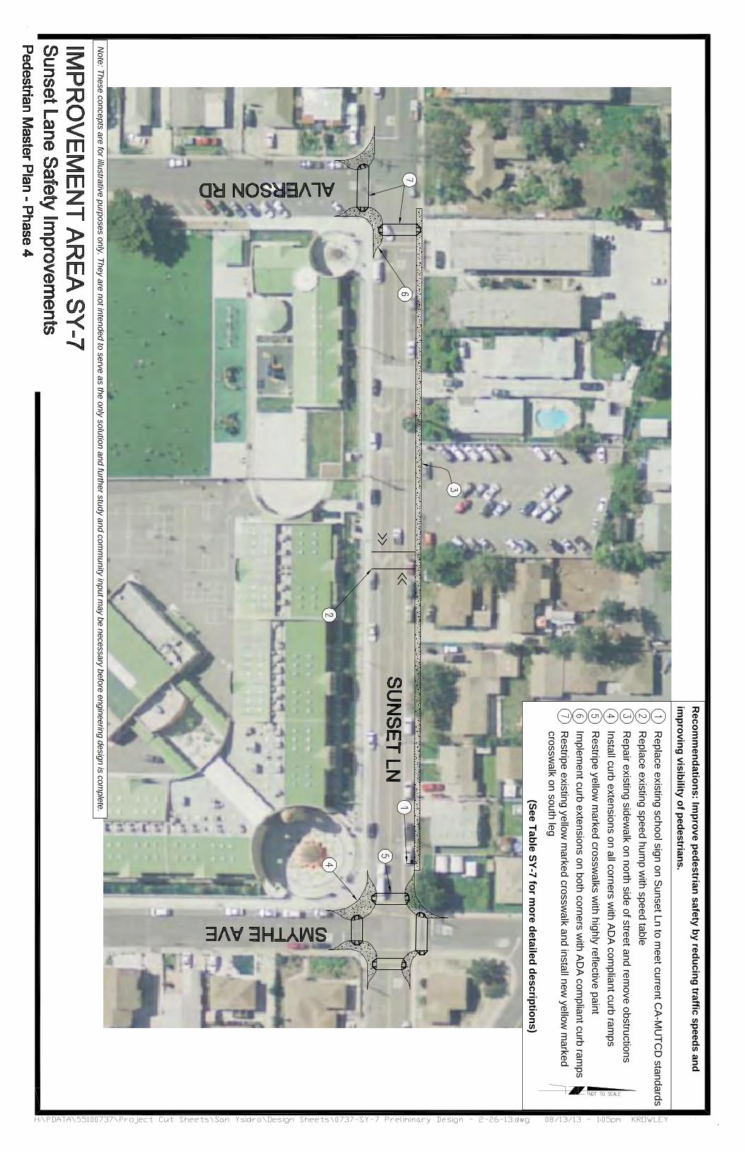
SY-7 Sunset Lane Safety Improvements
SY-8 East and West Park Avenue Improvements
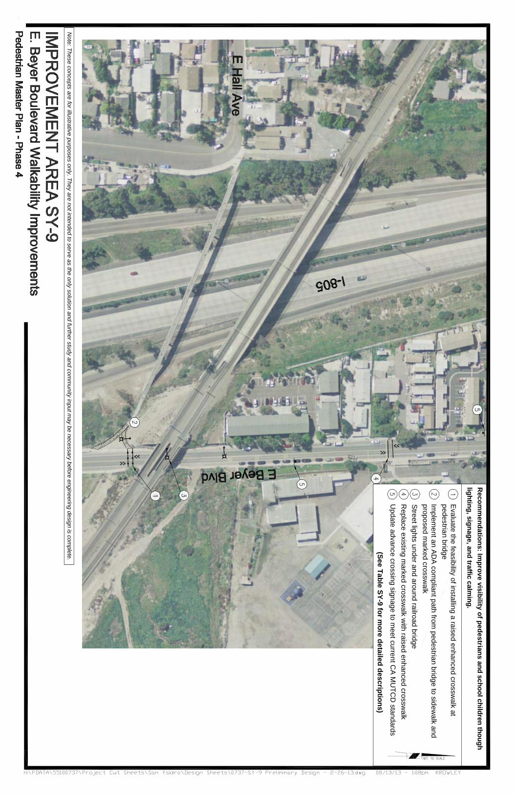
SY-9 E. Beyer Boulevard Walkability Improvements
San Ysidro Pedestrian Plan
Improvement Area Recommendations
Improvement Area
an Ysidro / I-5 Northbound Intersection Improvements
Calle Primera Walkability Improvements
Beyer Boulevard Corridor Enhancements (Dairy Mart Road to Smythe Avenue)
Beyer Boulevard Walkability Improvements (North Lane to Otay Mesa Road)
Smythe Avenue Connectivity Improvements
Seaward Avenue and R/R Tracks Sidewalk Project
Sunset Lane Safety Improvements
East and West Park Avenue Improvements
E. Beyer Boulevard Walkability Improvements
Pedestrian Plan
Improvement Area Recommendations
Improvement Area
5 Northbound Intersection Improvements
Calle Primera Walkability
Beyer Boulevard Corridor Enhancements (Dairy Mart Road to
Beyer Boulevard Walkability Improvements (North Lane to Old
Smythe Avenue Connectivity
Seaward Avenue and R/R Tracks
Sunset Lane Safety Improvements
East and West Park Avenue
E. Beyer Boulevard Walkability
Page | SY
Improvement Area Recommendations
Improve pedestrian safety at freeway rampsinstalling a traffic signal (funded by private development) Implement new sidewalk along north side of Calle Primera to improve access to transit and access to existing pedestrian bridge.
Evaluate the feasibility of reducing Beyer from 4 to 2 lanesintegrate pedestrian and bicycle enhancements.
Install missing sidewalks and street lights to improve safety and walkability.
Improve connectivity in removing sidewalk obstructions and increasing capacity along Smythe from San Ysidro Boulevard to the trolley tracks and improve pedestrian safety and visibility.
Improve pedestrian safety along rail ROW by installing pedestrian scale lighting and completing sidewalks to improve connectivity.
Improve pedestrian safety by reducing traffic speeds and improving visibility
Improve pedestrian circulation around the Recreation Center with wider sidewalks and traffic calming.
Improve visibility through lighting, signage, and traffic calming.
Page | SY-4
Recommendations
Improve pedestrian safety at freeway rampsinstalling a traffic signal (funded by private development)
new sidewalk along north side of Calle Primera to improve access to transit and access to existing pedestrian bridge.
Evaluate the feasibility of reducing Beyer from 4 to 2 lanes with a twointegrate pedestrian and bicycle enhancements.
Install missing sidewalks and street lights to improve walkability.
Improve connectivity in the removing sidewalk obstructions and increasing capacity along Smythe Avenue. Provide an improved connection from San Ysidro Boulevard to the trolley tracks and improve pedestrian safety and visibility.
Improve pedestrian safety along rail ROW by installing pedestrian scale lighting and completing sidewalks to
connectivity.
Improve pedestrian safety by reducing traffic speeds and improving visibility of pedestrians.
Improve pedestrian circulation around the Recreation Center with wider sidewalks and traffic calming.
Improve visibility of pedestrians and school children through lighting, signage, and traffic calming.
Recommendations
Improve pedestrian safety at freeway rampsinstalling a traffic signal (funded by private
new sidewalk along north side of Calle Primera to improve access to transit and access to
Evaluate the feasibility of reducing Beyer with a two-way left turn lane
integrate pedestrian and bicycle enhancements.
Install missing sidewalks and street lights to improve
the San Ysidro community by removing sidewalk obstructions and increasing capacity
Avenue. Provide an improved connection from San Ysidro Boulevard to the trolley tracks and improve pedestrian safety and visibility.
Improve pedestrian safety along rail ROW by installing pedestrian scale lighting and completing sidewalks to
Improve pedestrian safety by reducing traffic speeds of pedestrians.
Improve pedestrian circulation around the Recreation Center with wider sidewalks and traffic calming.
of pedestrians and school children through lighting, signage, and traffic calming.
Improve pedestrian safety at freeway ramps By installing a traffic signal (funded by private
new sidewalk along north side of Calle Primera to improve access to transit and access to the
Evaluate the feasibility of reducing Beyer Boulevard way left turn lane and
integrate pedestrian and bicycle enhancements.
Install missing sidewalks and street lights to improve
San Ysidro community by removing sidewalk obstructions and increasing capacity
Avenue. Provide an improved connection from San Ysidro Boulevard to the trolley tracks and
Improve pedestrian safety along rail ROW by installing pedestrian scale lighting and completing sidewalks to
Improve pedestrian safety by reducing traffic speeds
Improve pedestrian circulation around the Recreation Center with wider sidewalks and traffic calming.
of pedestrians and school children through lighting, signage, and traffic calming.
Priority Score
By installing a traffic signal (funded by private 22.5
new sidewalk along north side of Calle the 17
Boulevard and 16
Install missing sidewalks and street lights to improve 15
San Ysidro community by removing sidewalk obstructions and increasing capacity
Avenue. Provide an improved connection from San Ysidro Boulevard to the trolley tracks and
21
Improve pedestrian safety along rail ROW by installing pedestrian scale lighting and completing sidewalks to 15
Improve pedestrian safety by reducing traffic speeds 15
Improve pedestrian circulation around the Recreation 16
15
Priority Score
22.5
Improvement Area
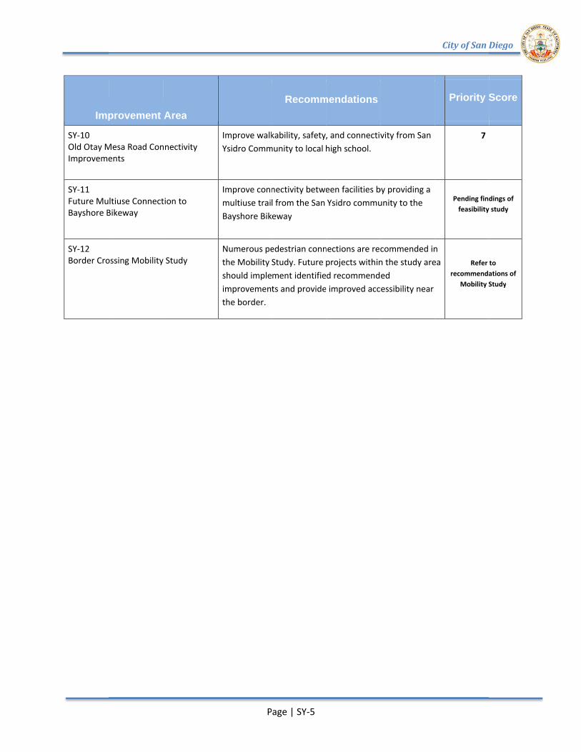
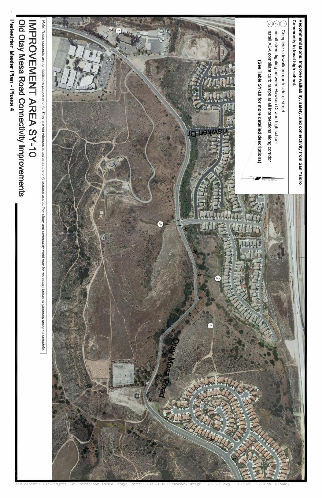
SY-10 Old Otay Mesa Road Connectivity Improvements
SY-11 Future Multiuse Connection to Bayshore Bikeway
SY-12 Border Crossing Mobility Study
Improvement Area
Otay Mesa Road Connectivity Improvements
Future Multiuse Connection to Bayshore Bikeway
Border Crossing Mobility Study
Improvement Area
Otay Mesa Road Connectivity
Future Multiuse Connection to
Border Crossing Mobility Study
Page | SY
Improve walkability, safety, and connectivity from San Ysidro Community to local high school.
Improve connectivity between facilities by providing a multiuse trail from Bayshore Bikeway
Numerous pedestrian connections are recommended in the Mobility Study. Future projects within the study area should implement identified recommended improvements and provide improved accessibility near the border.
Page | SY-5
Recommendations
Improve walkability, safety, and connectivity from San ommunity to local high school.
Improve connectivity between facilities by providing a multiuse trail from the San Ysidro community to the Bayshore Bikeway
Numerous pedestrian connections are recommended in the Mobility Study. Future projects within the study area should implement identified recommended improvements and provide improved accessibility near
Recommendations
Improve walkability, safety, and connectivity from San ommunity to local high school.
Improve connectivity between facilities by providing a the San Ysidro community to the
Numerous pedestrian connections are recommended in the Mobility Study. Future projects within the study area should implement identified recommended improvements and provide improved accessibility near
Improve walkability, safety, and connectivity from San
Improve connectivity between facilities by providing a the San Ysidro community to the
Numerous pedestrian connections are recommended in the Mobility Study. Future projects within the study area should implement identified recommended improvements and provide improved accessibility near
City of San Diego
Priority Score
7
Pending findings of feasibility study
Numerous pedestrian connections are recommended in the Mobility Study. Future projects within the study area
improvements and provide improved accessibility near
Refer to recommendations of
Mobility Study
City of San Diego
Priority Score
Pending findings of feasibility study
Refer to recommendations of
Study
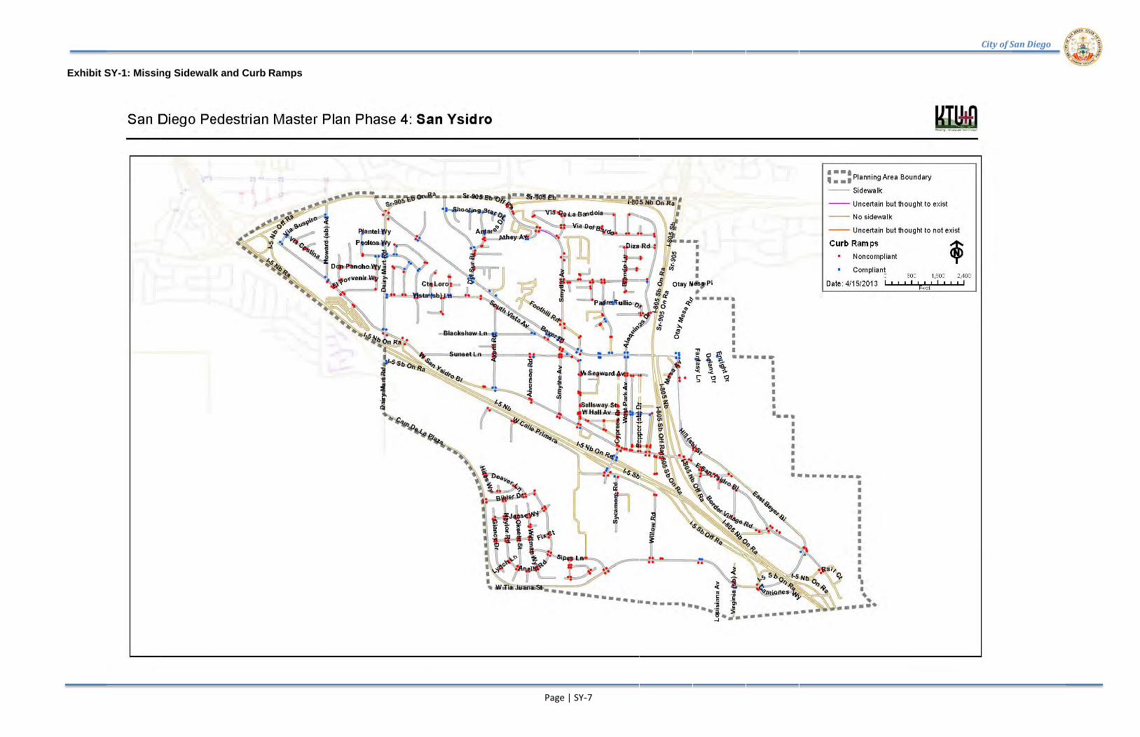
Exhibit SY
Exhibit SY-1: Missing Sidewalk and Curb Ramps
Missing Sidewalk and Curb Ramps
Missing Sidewalk and Curb Ramps
Missing Sidewalk and Curb Ramps
Page | SY-
-7
City of San Diego City of San Diego
San Ysidro Exhibit SY
San Ysidro Pedestrian Plan
SY-2: Route Type Classifications
Pedestrian Plan
Route Type Classifications
Route Type Classifications Route Type Classifications
Page | SY--8
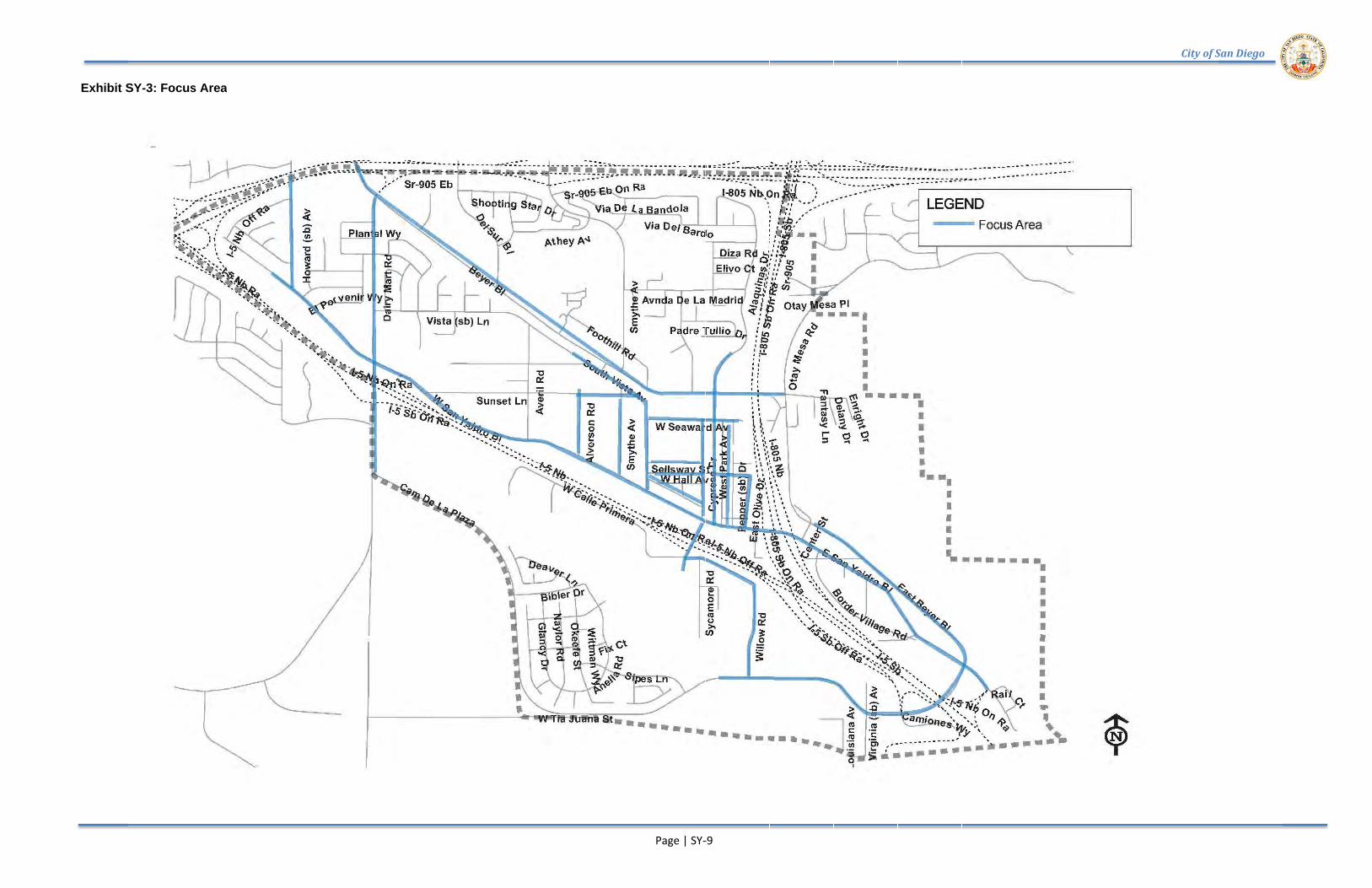
Exhibit SY
Exhibit SY-3: Focus Area
Focus Area
Page | SY-
-9
City of San Diego City of San Diego
San Ysidro Exhibit SY
San Ysidro Pedestrian Plan
Exhibit SY-4: Improvement Areas
Pedestrian Plan
Improvement Areas
Improvement Areas
Page | SY-1010

San Ysidro
This page intentionally left blank.
San Ysidro Pedestrian Plan
This page intentionally left blank.
Pedestrian Plan
This page intentionally left blank.
Page | SY
Page | SY-6
Install traffic signal with street lighting
Recom
mendations: Im
prove pedestrian safety at freeway ram
ps byinstalling a traffic signal (funded by private developm
ent)
(See Table SY-1 for more detailed descriptions)
Note: These concepts are for illustrative purposes only. They are not intended to serve as the only solution and further study and com
munity input m
ay be necessary before engineering design is complete.
Recom
mendations: Im
plement new
sidewalk along north side of C
alle Primera to
improve access to transit and access to existing pedestrian bridge.
(See Table SY-2 for more detailed descriptions)
Note: These concepts are for illustrative purposes only. They are not intended to serve as the only solution and further study and com
munity input m
ay be necessary before engineering design is complete.
Implem
ent sidewalk on north side of street
Install street lights along Calle P
rimera from
Via de San Ysidro to pedestrianbridgeR
estripe marked crossw
alks. Install AD
A compliant curb ram
ps at Via De
San Ysidro
Improve transit stop im
mediately w
est of Via de San Ysidro
Recom
mendations: Evaluate the feasibility of reducing B
eyer Boulevard from
4 to 2lanes w
ith a two-w
ay left turn lane and integrate pedestrian and bicycleenhancem
ents.
(See Table SY-3 for more detailed descriptions)
Note: These concepts are for illustrative purposes only. They are not intended to serve as the only solution and further study and com
munity input m
ay be necessary before engineering design is complete.
Implem
ent curb extensions and AD
A com
pliant curb ramps at D
airy Mart R
d /B
eyer BlvdInstall m
arked crosswalk w
ith AD
A compliant curb ram
psIm
plement im
provements in M
obility Strategy, Project S-4Install signalM
odify Border Patrol Station drivew
ay to reduce crossing distancesE
valuate feasibility of an enhanced marked crossw
alk with AD
A com
pliantcurb ram
ps
Recom
mendations: Install m
issing sidewalks and street lights to im
provew
alkability.
(See Table SY-4 for more detailed descriptions)
Note: These concepts are for illustrative purposes only. They are not intended to serve as the only solution and further study and com
munity input m
ay be necessary before engineering design is complete.
Implem
ent curb extensions on all four cornersR
estripe crosswalks w
ith ADA
compliant curb ram
psIm
plement sidew
alks on North Lane w
ith ADA com
pliant curb ramps at
intersectionsInstall street lighting on both sides of Beyer BlvdIm
plement m
issing sidewalk on B
eyer Blvd
Recom
mendations: Im
prove connectivity in San Ysidro comm
unity by removing
sidewalk obstructions and increasing capacity along Sm
ythe Avenue. Provide an
improved connection from
San Ysidro Boulevard to the trolley tracks and im
provepedestrian safety and visibility.
(See Table SY-5 for more detailed descriptions)
Note: These concepts are for illustrative purposes only. They are not intended to serve as the only solution and further study and com
munity input m
ay be necessary before engineering design is complete.
Install street lights along corridorW
iden sidewalk on one side of street to rem
ove existing obstructionsE
valuate feasibility of installing enhanced marked crossw
alk or pedestrian signal.Install A
DA
compliant curb ram
ps.R
eplace existing school signage and add pavement m
arkings to comply w
ithC
A-MU
TCD
Evaluate for a traffic signal. Im
plement curb extensions, m
arked crosswalks, AD
Acurb ram
ps and countdown tim
ers
Recom
mendations: Im
prove pedestrian safety along rail RO
W by installing
pedestrian scale lighting and completing sidew
alks to improve connectivity.
(See Table SY-6 for more detailed descriptions)
Note: These concepts are for illustrative purposes only. They are not intended to serve as the only solution and further study and com
munity input m
ay be necessary before engineering design is complete.
Widen sidew
alk on north side of street and remove obstructions
Implem
ent missing sidew
alk on south side of streetW
iden sidewalk and install A
DA com
pliant curb ramps
Install street lights at railroad crossingP
rovide ample lighting along rail R
OW
Widen sidew
alk on east side of Cottonw
ood Rd
Recom
mendations: Im
prove pedestrian safety by reducing traffic speeds andim
proving visibility of pedestrians.
(See Table SY-7 for more detailed descriptions)
Note: These concepts are for illustrative purposes only. They are not intended to serve as the only solution and further study and com
munity input m
ay be necessary before engineering design is complete.
Replace existing school sign on Sunset Ln to m
eet current CA-M
UTC
D standards
Replace existing speed hum
p with speed table
Repair existing sidew
alk on north side of street and remove obstructions
Install curb extensions on all corners with AD
A compliant curb ram
psR
estripe yellow m
arked crosswalks w
ith highly reflective paintIm
plement curb extensions on both corners w
ith ADA com
pliant curb ramps
Restripe existing yellow
marked crossw
alk and install new yellow
marked
crosswalk on south leg

Recom
mendations: Im
prove pedestrian circulation around the Recreation C
enterw
ith wider sidew
alks and traffic calming.
(See Table SY-8 for more detailed descriptions)
Note: These concepts are for illustrative purposes only. They are not intended to serve as the only solution and further study and com
munity input m
ay be necessary before engineering design is complete.
Widen sidew
alk (min 5') along basketball and tennis courts
Implem
ent curb extensions with AD
A com
pliant curb ramps
Install marked crossw
alks on stop-controlled legs of E and W Park A
ve with
AD
A com
pliant curb ramps
Stripe diagonal parking
Implem
ent ADA
accessible path through parkIm
plement new
sidewalk
Recom
mendations: Im
prove visibility of pedestrians and school children thoughlighting, signage, and traffic calm
ing.
(See Table SY-9 for more detailed descriptions)
Note: These concepts are for illustrative purposes only. They are not intended to serve as the only solution and further study and com
munity input m
ay be necessary before engineering design is complete.
Evaluate the feasibility of installing a raised enhanced crossw
alk atpedestrian bridgeIm
plement an AD
A com
pliant path from pedestrian bridge to sidew
alk andproposed m
arked crosswalk
Street lights under and around railroad bridge
Replace existing m
arked crosswalk w
ith raised enhanced crosswalk
Update advance crossing signage to m
eet current CA M
UTC
D standards
Recom
mendations: Im
prove walkabilty, safety, and connectivity from
San YsidroC
omm
unity to local high school.
(See Table SY-10 for more detailed descriptions)
Note: These concepts are for illustrative purposes only. They are not intended to serve as the only solution and further study and com
munity input m
ay be necessary before engineering design is complete.
Com
plete sidewalk on north side of street
Install street lighting between H
awken D
r and high schoolInstall A
DA
compliant curb ram
ps at all intersections along corridor
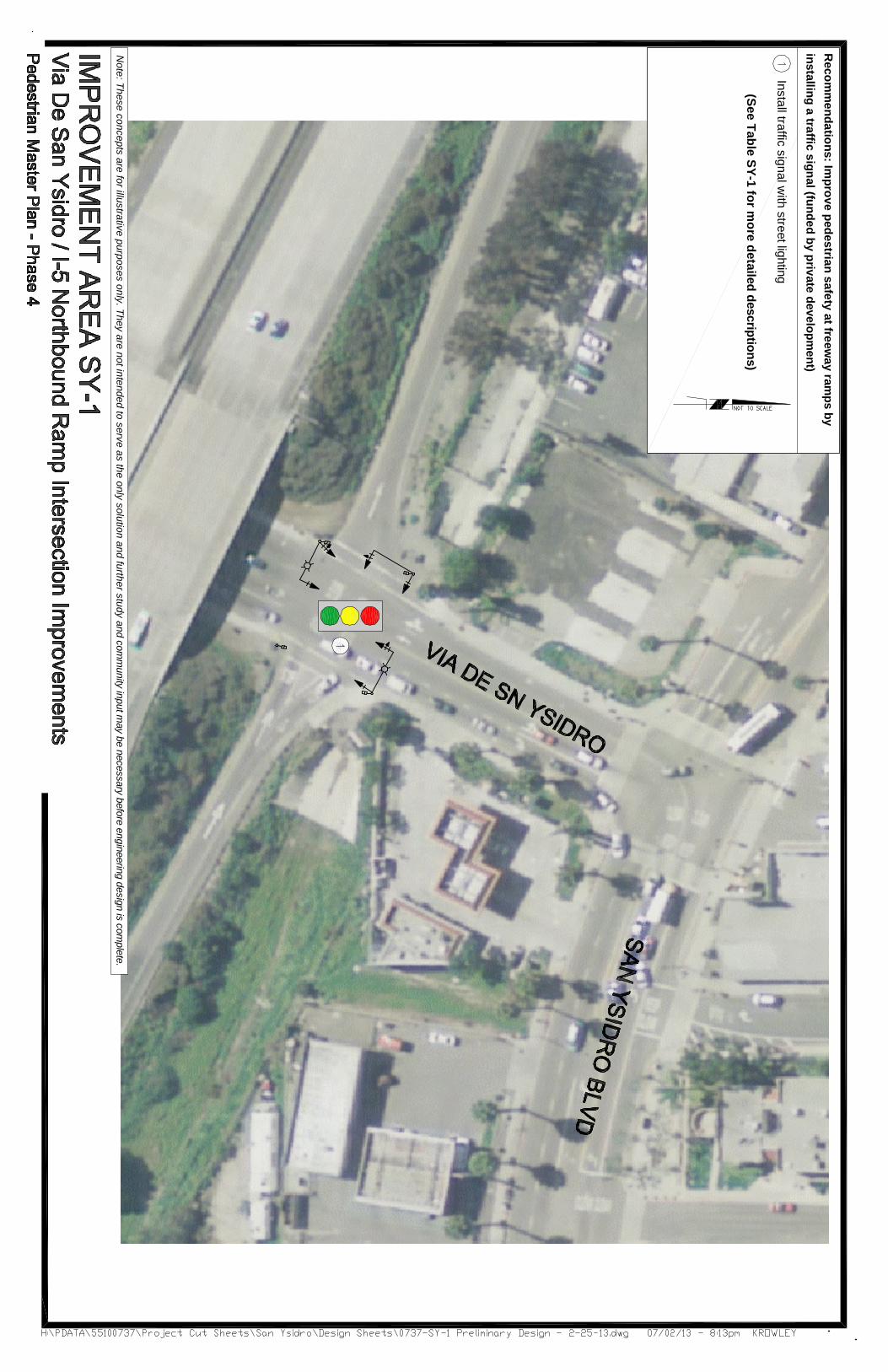
Improvement Area SYVia De San Ysidro / I Purpose & Need:Turning vehicles at tpedestrians crossing at that intersection. As a result of vehicles not yielding to pedestrians, there have been several pedestrianfreeway ramps, a traffic signal at the I
Recommended Improvements:Improve pedestrian safety at freeway ramps
Table SY-1
Via De San Ysidro / I
TOTAL ESTIMATED COST(1) A = Access
C = Connectivity
I-5 Northbound
Improvement Area SYVia De San Ysidro / I-5 Northbound Ramp Intersection Improvements
Purpose & Need: Turning vehicles at the Ipedestrians crossing at that intersection. As a result of vehicles not yielding to pedestrians, there have been several pedestrianfreeway ramps, a traffic signal at the I
ecommended Improvements:Improve pedestrian safety at freeway ramps
1: Via De San Ysidro / I
Location Via De San Ysidro / I-5 on ramp
TOTAL ESTIMATED COSTA = Access C = Connectivity
5 Northbound Off-Ramp
Improvement Area SY-1:5 Northbound Ramp Intersection Improvements
he I-5 Northbound Ramps located at Via De San Ysidro pose a safety risk pedestrians crossing at that intersection. As a result of vehicles not yielding to pedestrians, there have been several pedestrian-related accidents at this location. In order to improve pedestrian safety at the freeway ramps, a traffic signal at the I
ecommended Improvements: Improve pedestrian safety at freeway ramps
Via De San Ysidro / I-5 Northbound Ramp Intersection Improvements
5 on ramp 1)
TOTAL ESTIMATED COST with/ street lighting S = Safety
W = Walkability
Ramp
Page | SY
: 5 Northbound Ramp Intersection Improvements
5 Northbound Ramps located at Via De San Ysidro pose a safety risk pedestrians crossing at that intersection. As a result of vehicles not yielding to pedestrians, there have
related accidents at this location. In order to improve pedestrian safety at the freeway ramps, a traffic signal at the I-5 Northbound on/off ramp is recommended.
Improve pedestrian safety at freeway ramps by installing a traffic signal
5 Northbound Ramp Intersection Improvements
Description Install traffic signal
(funded by private development)
with/ street lighting
W = Walkability
I-5 Northbound
Page | SY-21
5 Northbound Ramp Intersection Improvements
5 Northbound Ramps located at Via De San Ysidro pose a safety risk pedestrians crossing at that intersection. As a result of vehicles not yielding to pedestrians, there have
related accidents at this location. In order to improve pedestrian safety at the 5 Northbound on/off ramp is recommended.
by installing a traffic signal
5 Northbound Ramp Intersection Improvements
Goal (1)
Install traffic signal (funded by private development)
S
with/ street lighting
5 Northbound On
5 Northbound Ramp Intersection Improvements
5 Northbound Ramps located at Via De San Ysidro pose a safety risk pedestrians crossing at that intersection. As a result of vehicles not yielding to pedestrians, there have
related accidents at this location. In order to improve pedestrian safety at the 5 Northbound on/off ramp is recommended.
by installing a traffic signal.
5 Northbound Ramp Intersection Improvements
(1) Improve pedestrian safety
On-Ramp
Via de San Ysidro /
5 Northbound Ramps located at Via De San Ysidro pose a safety risk pedestrians crossing at that intersection. As a result of vehicles not yielding to pedestrians, there have
related accidents at this location. In order to improve pedestrian safety at the 5 Northbound on/off ramp is recommended.
5 Northbound Ramp Intersection Improvements
Objective Improve pedestrian safety
Via de San Ysidro /
City of San Diego
5 Northbound Ramps located at Via De San Ysidro pose a safety risk pedestrians crossing at that intersection. As a result of vehicles not yielding to pedestrians, there have
related accidents at this location. In order to improve pedestrian safety at the
Improve pedestrian safety
Via de San Ysidro / I-5 Northbound
City of San Diego
5 Northbound Ramps located at Via De San Ysidro pose a safety risk for pedestrians crossing at that intersection. As a result of vehicles not yielding to pedestrians, there have
related accidents at this location. In order to improve pedestrian safety at the
Est. Cost $250,000
$250,000
5 Northbound
San Ysidro
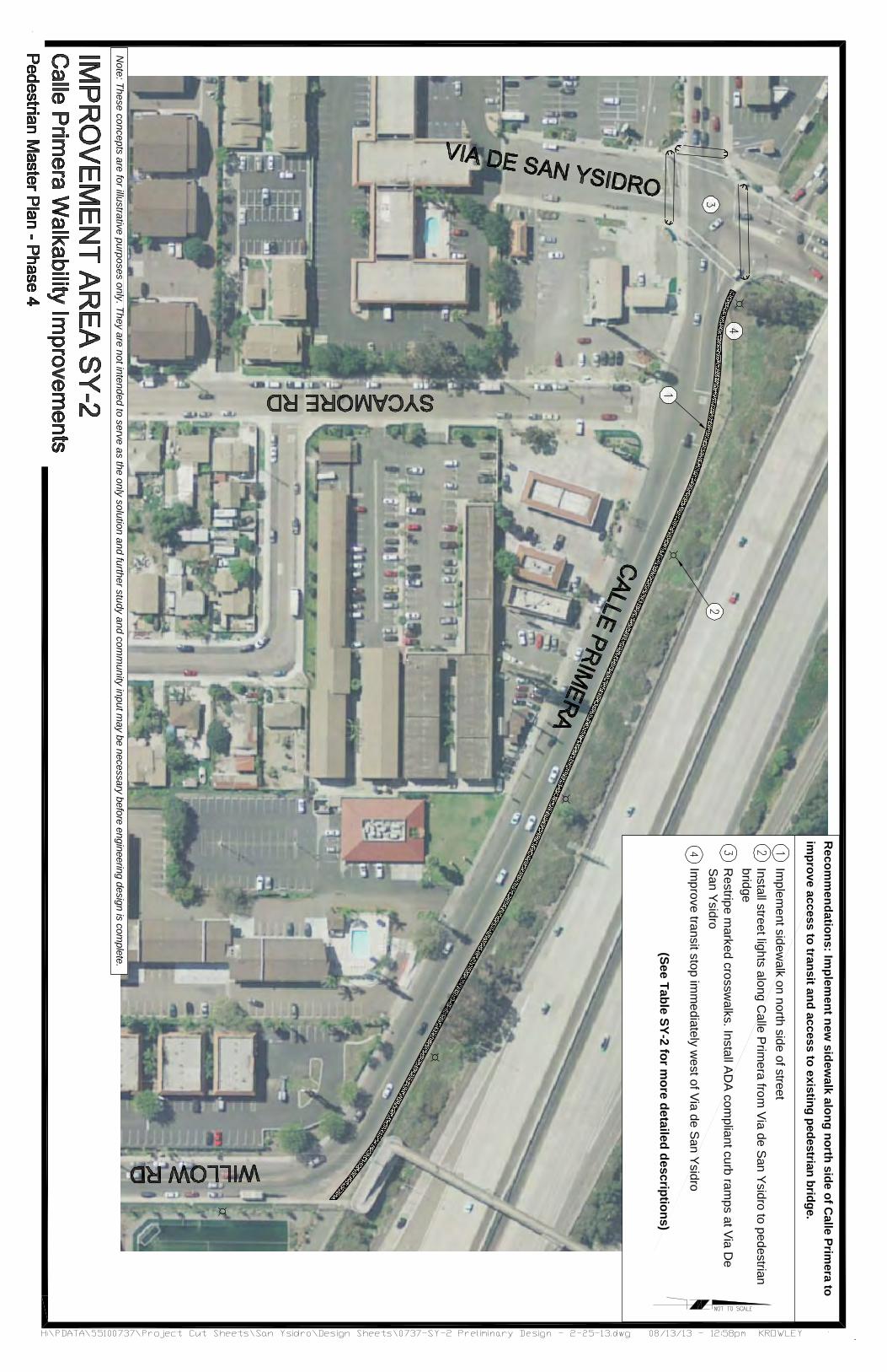
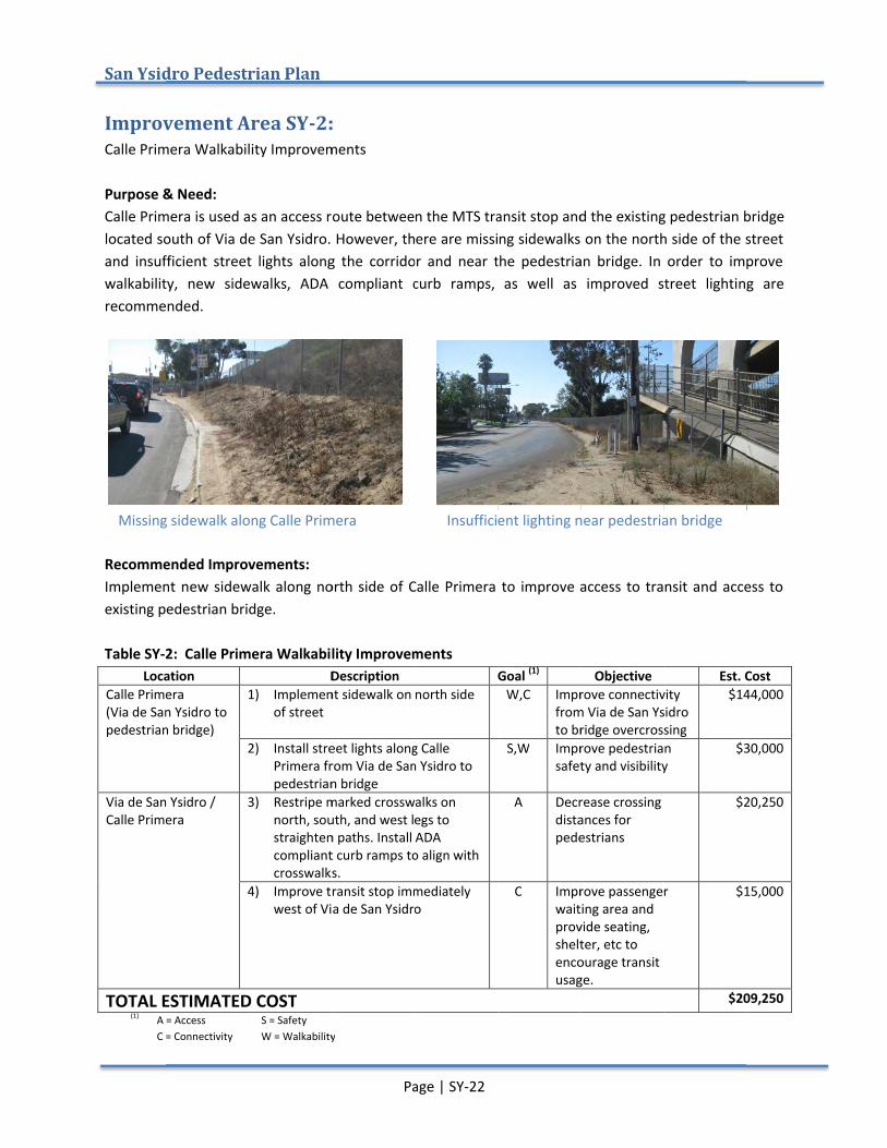
Improvement Area SYCalle Primera Walkability Improvements Purpose & Need:Calle Primera is used as an access route between the MTS transit stop and the existing pedestrian bridge located south of Via de San Ysidro. However, there are missing sidewalks on the north side of the street and insufficient walkability, new sidewalks, ADA compliant curb ramps, as well as improved street lighting are recommended.
Recommended Improvements:Implementexisting pedestrian bridge. Table SY-2
LocationCalle Primera (Via de San Ysidro to pedestrian bridge)
Via de San Ysidro / Calle Primera
TOTAL ESTIMATED COST(1) A = Access
C = Connectivity
Missing sidewalk along Calle Primera
San Ysidro Pedestrian Plan
Improvement Area SYCalle Primera Walkability Improvements
Purpose & Need: Calle Primera is used as an access route between the MTS transit stop and the existing pedestrian bridge located south of Via de San Ysidro. However, there are missing sidewalks on the north side of the street
insufficient street lights along the cowalkability, new sidewalks, ADA compliant curb ramps, as well as improved street lighting are recommended.
ecommended Improvements:Implement new sidewalk along north side of Calle Primera to improve access to transit and access to existing pedestrian bridge.
2: Calle Primera Walkability Improvements Location
Calle Primera (Via de San Ysidro to pedestrian bridge)
1)
2)
Via de San Ysidro / Calle Primera
3)
4)
TOTAL ESTIMATED COSTA = Access C = Connectivity
Missing sidewalk along Calle Primera
Pedestrian Plan
Improvement Area SY-2:Calle Primera Walkability Improvements
Calle Primera is used as an access route between the MTS transit stop and the existing pedestrian bridge located south of Via de San Ysidro. However, there are missing sidewalks on the north side of the street
street lights along the cowalkability, new sidewalks, ADA compliant curb ramps, as well as improved street lighting are
ecommended Improvements: new sidewalk along north side of Calle Primera to improve access to transit and access to
existing pedestrian bridge.
: Calle Primera Walkability Improvements Description
1) Implementof street
2) Install street lights along Calle Primera from Via de San Ysidro to pedestrian bridge
3) Restripe marked north, south, and west legs to straighten paths. Install ADA compliant curb ramps to align crosswalks.
4) Improve transit stop immediately west of Via de San Ysidro
TOTAL ESTIMATED COST S = Safety
W = Walkability
Missing sidewalk along Calle Primera
Page | SY
: Calle Primera Walkability Improvements
Calle Primera is used as an access route between the MTS transit stop and the existing pedestrian bridge located south of Via de San Ysidro. However, there are missing sidewalks on the north side of the street
street lights along the corridor walkability, new sidewalks, ADA compliant curb ramps, as well as improved street lighting are
new sidewalk along north side of Calle Primera to improve access to transit and access to
: Calle Primera Walkability Improvements Description
Implement sidewalk on north side
street lights along Calle from Via de San Ysidro to
pedestrian bridge marked crosswalks on
north, south, and west legs to straighten paths. Install ADA compliant curb ramps to align crosswalks. Improve transit stop immediately west of Via de San Ysidro
W = Walkability
Missing sidewalk along Calle Primera
Page | SY-22
Calle Primera is used as an access route between the MTS transit stop and the existing pedestrian bridge located south of Via de San Ysidro. However, there are missing sidewalks on the north side of the street
rridor and near the pedestrian bridge. In order to improve walkability, new sidewalks, ADA compliant curb ramps, as well as improved street lighting are
new sidewalk along north side of Calle Primera to improve access to transit and access to
: Calle Primera Walkability Improvements
sidewalk on north side
street lights along Calle from Via de San Ysidro to
crosswalks on north, south, and west legs to straighten paths. Install ADA compliant curb ramps to align with
Improve transit stop immediately west of Via de San Ysidro
Insufficient
Calle Primera is used as an access route between the MTS transit stop and the existing pedestrian bridge located south of Via de San Ysidro. However, there are missing sidewalks on the north side of the street
near the pedestrian bridge. In order to improve walkability, new sidewalks, ADA compliant curb ramps, as well as improved street lighting are
new sidewalk along north side of Calle Primera to improve access to transit and access to
Goal (1) W,C Improve connectivity
from Via de San Ysidro to bridge overcrossing
S,W Improve pedestrian safety and visibility
A Decrease crossing distances for pedestrians
C Improve passenger waiting area and provide seating, shelter, etc to encourage transit usage.
Insufficient lighting near pedestrian bridge
Calle Primera is used as an access route between the MTS transit stop and the existing pedestrian bridge located south of Via de San Ysidro. However, there are missing sidewalks on the north side of the street
near the pedestrian bridge. In order to improve walkability, new sidewalks, ADA compliant curb ramps, as well as improved street lighting are
new sidewalk along north side of Calle Primera to improve access to transit and access to
Objective Improve connectivity from Via de San Ysidro to bridge overcrossingImprove pedestrian safety and visibility
Decrease crossing distances for pedestrians
Improve passenger waiting area and provide seating, shelter, etc to encourage transit usage.
lighting near pedestrian bridge
Calle Primera is used as an access route between the MTS transit stop and the existing pedestrian bridge located south of Via de San Ysidro. However, there are missing sidewalks on the north side of the street
near the pedestrian bridge. In order to improve walkability, new sidewalks, ADA compliant curb ramps, as well as improved street lighting are
new sidewalk along north side of Calle Primera to improve access to transit and access to
Est. CostImprove connectivity from Via de San Ysidro to bridge overcrossing
$144,000
Improve pedestrian safety and visibility
$30,000
Decrease crossing $20,250
Improve passenger $15,000
$209,250
lighting near pedestrian bridge
Calle Primera is used as an access route between the MTS transit stop and the existing pedestrian bridge located south of Via de San Ysidro. However, there are missing sidewalks on the north side of the street
near the pedestrian bridge. In order to improve walkability, new sidewalks, ADA compliant curb ramps, as well as improved street lighting are
new sidewalk along north side of Calle Primera to improve access to transit and access to
Est. Cost 144,000
30,000
20,250
15,000
209,250
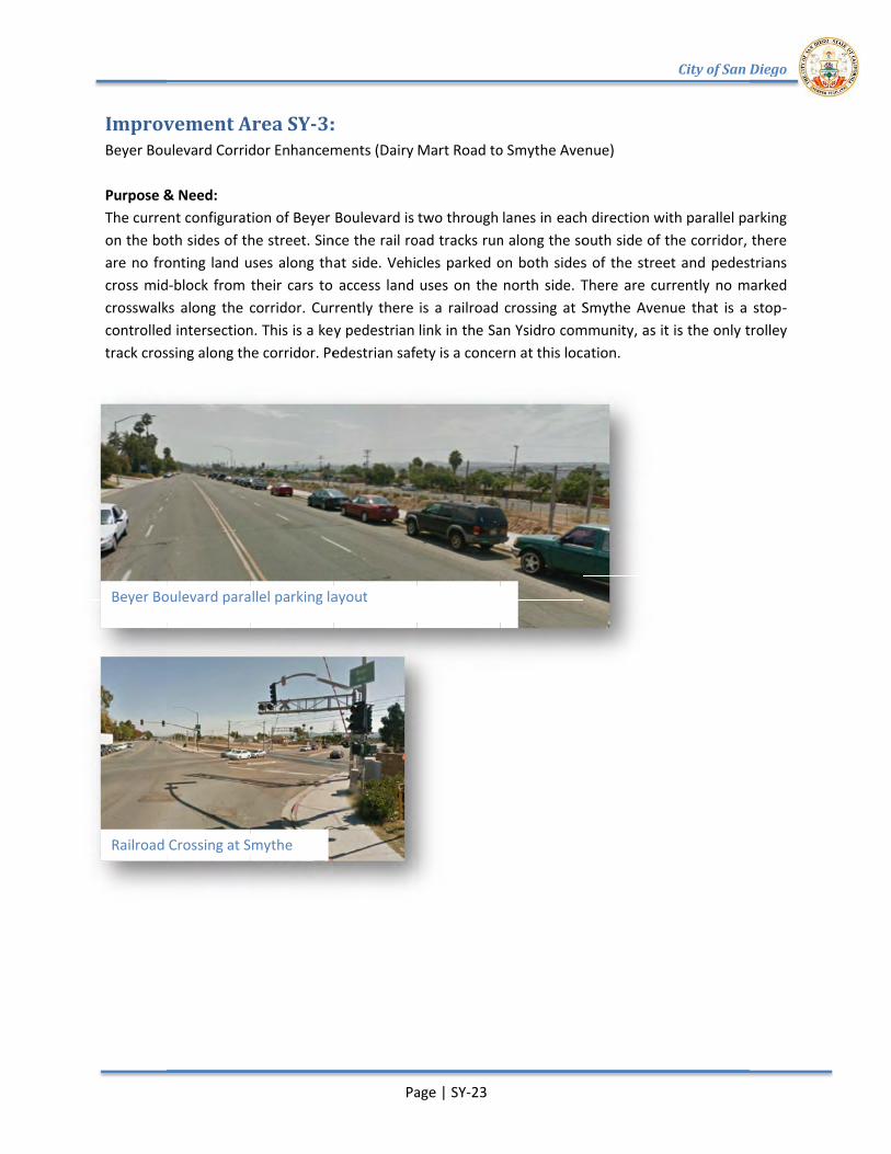
Railroad Crossing at Smythe
Beyer Boulevard parallel parking layout
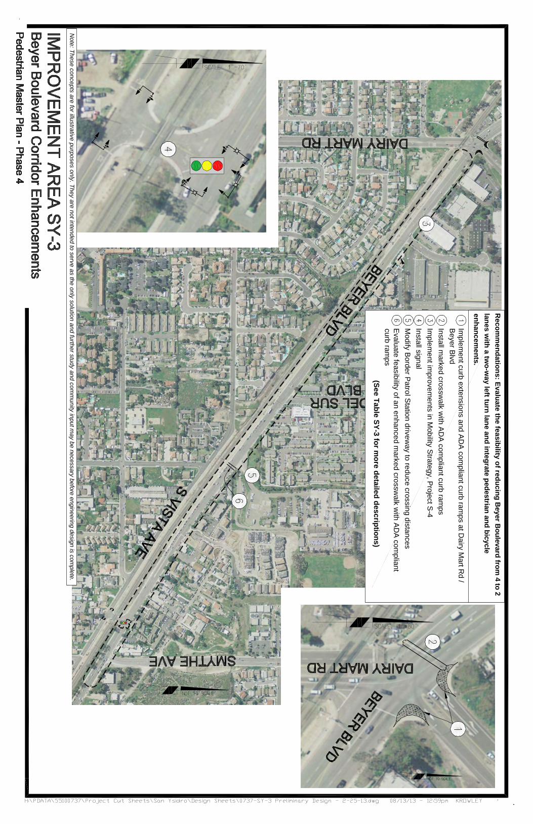
Improvement Area SYBeyer Boulevard Corridor Enhancements (Dairy Mart Road to Smythe Avenue) Purpose & Need:The current configuration of Beyer Boulevard is two through lanes in on the both sides of the street. Since the rail road tracks run along the south side of the corridor, there are no fronting land uses along that side. Vehicles parked on both sides of the street and pedestrians cross midcrosswalks along the corridor. Currently there is a railroad crossing at Smythe Avenue that is a stopcontrolled intersection. This is a key pedestrian link in thetrack crossing along the corridor. Pedestrian safety is a concern at this location.
Railroad Crossing at Smythe
Beyer Boulevard parallel parking layout
mprovement Area SYBeyer Boulevard Corridor Enhancements (Dairy Mart Road to Smythe Avenue)
Purpose & Need: The current configuration of Beyer Boulevard is two through lanes in on the both sides of the street. Since the rail road tracks run along the south side of the corridor, there are no fronting land uses along that side. Vehicles parked on both sides of the street and pedestrians
d-block from their cars to access land uses on the north side. There are currently no marked crosswalks along the corridor. Currently there is a railroad crossing at Smythe Avenue that is a stopcontrolled intersection. This is a key pedestrian link in thetrack crossing along the corridor. Pedestrian safety is a concern at this location.
Railroad Crossing at Smythe
Beyer Boulevard parallel parking layout
mprovement Area SY-3:Beyer Boulevard Corridor Enhancements (Dairy Mart Road to Smythe Avenue)
The current configuration of Beyer Boulevard is two through lanes in on the both sides of the street. Since the rail road tracks run along the south side of the corridor, there are no fronting land uses along that side. Vehicles parked on both sides of the street and pedestrians
block from their cars to access land uses on the north side. There are currently no marked crosswalks along the corridor. Currently there is a railroad crossing at Smythe Avenue that is a stopcontrolled intersection. This is a key pedestrian link in thetrack crossing along the corridor. Pedestrian safety is a concern at this location.
Page | SY
Beyer Boulevard parallel parking layout
: Beyer Boulevard Corridor Enhancements (Dairy Mart Road to Smythe Avenue)
The current configuration of Beyer Boulevard is two through lanes in on the both sides of the street. Since the rail road tracks run along the south side of the corridor, there are no fronting land uses along that side. Vehicles parked on both sides of the street and pedestrians
block from their cars to access land uses on the north side. There are currently no marked crosswalks along the corridor. Currently there is a railroad crossing at Smythe Avenue that is a stopcontrolled intersection. This is a key pedestrian link in thetrack crossing along the corridor. Pedestrian safety is a concern at this location.
Page | SY-23
Beyer Boulevard Corridor Enhancements (Dairy Mart Road to Smythe Avenue)
The current configuration of Beyer Boulevard is two through lanes in on the both sides of the street. Since the rail road tracks run along the south side of the corridor, there are no fronting land uses along that side. Vehicles parked on both sides of the street and pedestrians
block from their cars to access land uses on the north side. There are currently no marked crosswalks along the corridor. Currently there is a railroad crossing at Smythe Avenue that is a stopcontrolled intersection. This is a key pedestrian link in the San Ysidro communitytrack crossing along the corridor. Pedestrian safety is a concern at this location.
Beyer Boulevard Corridor Enhancements (Dairy Mart Road to Smythe Avenue)
The current configuration of Beyer Boulevard is two through lanes in each direction with parallel parking on the both sides of the street. Since the rail road tracks run along the south side of the corridor, there are no fronting land uses along that side. Vehicles parked on both sides of the street and pedestrians
block from their cars to access land uses on the north side. There are currently no marked crosswalks along the corridor. Currently there is a railroad crossing at Smythe Avenue that is a stop
San Ysidro communitytrack crossing along the corridor. Pedestrian safety is a concern at this location.
Beyer Boulevard Corridor Enhancements (Dairy Mart Road to Smythe Avenue)
each direction with parallel parking on the both sides of the street. Since the rail road tracks run along the south side of the corridor, there are no fronting land uses along that side. Vehicles parked on both sides of the street and pedestrians
block from their cars to access land uses on the north side. There are currently no marked crosswalks along the corridor. Currently there is a railroad crossing at Smythe Avenue that is a stop
San Ysidro community, as it is the only trolley track crossing along the corridor. Pedestrian safety is a concern at this location.
City of San Diego
each direction with parallel parking on the both sides of the street. Since the rail road tracks run along the south side of the corridor, there are no fronting land uses along that side. Vehicles parked on both sides of the street and pedestrians
block from their cars to access land uses on the north side. There are currently no marked crosswalks along the corridor. Currently there is a railroad crossing at Smythe Avenue that is a stop
s it is the only trolley
City of San Diego
each direction with parallel parking on the both sides of the street. Since the rail road tracks run along the south side of the corridor, there are no fronting land uses along that side. Vehicles parked on both sides of the street and pedestrians
block from their cars to access land uses on the north side. There are currently no marked crosswalks along the corridor. Currently there is a railroad crossing at Smythe Avenue that is a stop-
s it is the only trolley
San Ysidro
Recommended Improvements:Evaluate thintegrate pedestrian and Table SY-3
LocationDairy Mart Road / SRand Beyer Boulevard
Beyer Boulevard from Dairy Mart Road to Smythe Avenue
Smythe Avenue R/R crossing Border Patrol Station
TOTAL ESTIMATED COST(1) A = Access
C = Connectivity
San Ysidro Pedestrian Plan
ecommended Improvements:Evaluate the feasibility of reducing Beyer Boulevard from 4 to 2 lanintegrate pedestrian and
3: Beyer Boulevard Corridor Enhancements (Dairy Mart Road to Smythe Avenue)Location
Dairy Mart Road / SR-905 and Beyer Boulevard
Beyer Boulevard from Dairy Mart Road to Smythe Avenue
Smythe Avenue R/R
Border Patrol Station
TOTAL ESTIMATED COSTA = Access C = Connectivity
Pedestrian Plan
ecommended Improvements: e feasibility of reducing Beyer Boulevard from 4 to 2 lan
integrate pedestrian and bicycle enhancements.
: Beyer Boulevard Corridor Enhancements (Dairy Mart Road to Smythe Avenue)
905 1) ImplementADA compliant curb rampsthe north and east corners of the intersection
2) Install markednorthwest leg with ADA compliant curb ramps
3) Implement San Ysidro Mobility Strategy, Project Sincludes restriping toin each direction with a twoway left turn lane, providing diagonal parking on the north side of the road and new sidewalks, trees, etc. along south side
4) Install
5) Modify crossing distance
6) Evaluate feasibility of an enhanced marked midblock crosswalk just east of Border Patrol driveway with ADA compliant curb ramps
TOTAL ESTIMATED COST S = Safety
W = Walkability
Page | SY
e feasibility of reducing Beyer Boulevard from 4 to 2 lanbicycle enhancements.
: Beyer Boulevard Corridor Enhancements (Dairy Mart Road to Smythe Avenue)Description
Implement curb extensions & ADA compliant curb rampsthe north and east corners of the intersection Install marked crosswalk on northwest leg with ADA compliant curb rampsImplement San Ysidro Mobility Strategy, Project S-4. This includes restriping toin each direction with a twoway left turn lane, providing diagonal parking on the north side of the road and new sidewalks, trees, etc. along south side Install traffic signal
Modify driveway to narrow crossing distance
Evaluate feasibility of an enhanced marked midblock crosswalk just east of Border Patrol driveway with ADA compliant curb ramps
W = Walkability
Page | SY-24
e feasibility of reducing Beyer Boulevard from 4 to 2 lanbicycle enhancements.
: Beyer Boulevard Corridor Enhancements (Dairy Mart Road to Smythe Avenue)Description
curb extensions & ADA compliant curb ramps at the north and east corners of
crosswalk on northwest leg with ADA compliant curb ramps Implement San Ysidro Mobility
4. This includes restriping to one lane in each direction with a two-way left turn lane, providing diagonal parking on the north side of the road and new sidewalks, trees, etc. along
to narrow
Evaluate feasibility of an enhanced marked midblock crosswalk just east of Border Patrol driveway with ADA compliant curb ramps
e feasibility of reducing Beyer Boulevard from 4 to 2 lanes with a two
: Beyer Boulevard Corridor Enhancements (Dairy Mart Road to Smythe Avenue)Goal (1)
A, S Reduce pedestrian crossing distance and improve safety
A Provide clear access across Beyer Blvd
W, A Improve access from to and from land uses on the north side and eliminating midblock cside to the north. Improving walkability along RR tracks with the “Green Spine”.
S Provide phase for and improve safety
W, A Reduce pedestrian crossing distance and remove obstructions
C Provide connection between north and south side of Beyer Boulevard
with a two-way left turn lane
: Beyer Boulevard Corridor Enhancements (Dairy Mart Road to Smythe Avenue)Objective
Reduce pedestrian crossing distance and improve safety
Provide clear access across Beyer Blvd
Improve access from to and from land uses on the north side and eliminating midblock crossings from the south side to the north. Improving walkability along RR tracks with the “Green Spine”.
Provide phase for and improve safetyReduce pedestrian crossing distance and remove obstructions Provide connection between north and south side of Beyer Boulevard
way left turn lane
: Beyer Boulevard Corridor Enhancements (Dairy Mart Road to Smythe Avenue) Objective
Reduce pedestrian crossing distance and improve safety
Provide clear access across
Improve access from to and from land uses on the north side and eliminating mid-
rossings from the south side to the north. Improving walkability along RR tracks with the “Green Spine”.
Provide phase for pedestrians and improve safety Reduce pedestrian crossing distance and remove
Provide connection between north and south side of Beyer
way left turn lane and
Est. Cost $36,000
$6,750
$105,600
$250,000
$5,400
$2,500
$406,250

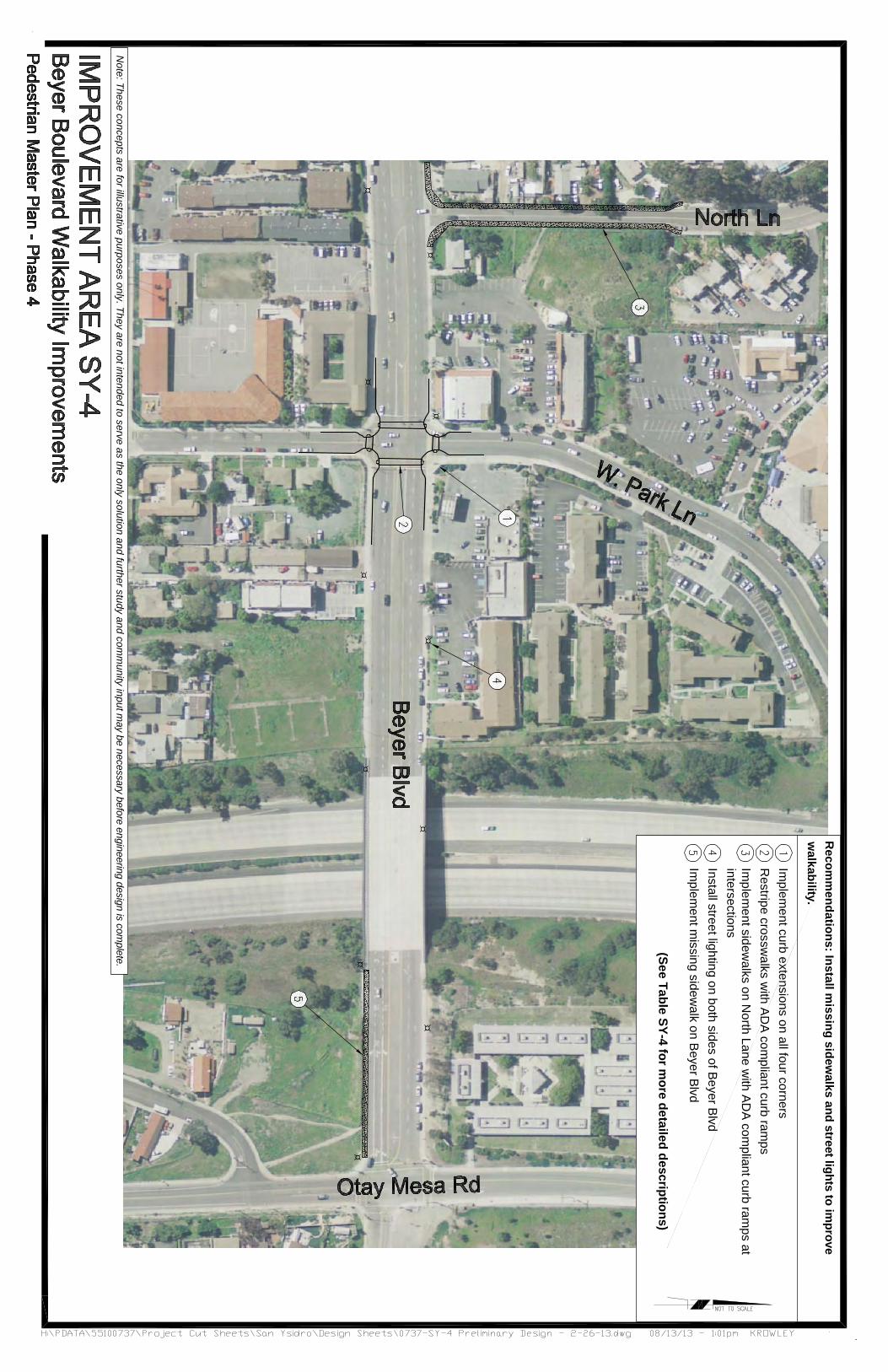
Improvement Area SYBeyer Boulevard Walkability Improvements (North Lane to Purpose & Need:Beyer Boulevard links churches, schools, and residential homes within the San Ysidro community. Although there are marked crosswalks at the signalized intersection Beyer Bouleveard / W. Park Avenue, the crossing distances are long and uninviting for pedestrians. North Lane connects a large residential area to Beyer Boulevard. The sidewalk on this corridor ends on Avenida de La Cruz and transitions to a raised asphaltshoulder on North Lane, which is often obstructed by overgrown foliage. There are no street lights along Beyer Boulevard, making this route dark and uninviting for pedestrians. It is also a primary route for High School students heading toward Otay Mesa Road.
Recommended Improvements:Install missing sidewalks and street lights to improve walkability.
Table SY-4Location
Beyer Boulevard and West Park Lane
North Lane
Beyer Boulevard
TOTAL ESTIMATED COST(1) A = Access
C = Connectivity
Improvement Area SYBeyer Boulevard Walkability Improvements (North Lane to
Purpose & Need: Beyer Boulevard links churches, schools, and residential homes within the San Ysidro community. Although there are marked crosswalks at the signalized intersection Beyer Bouleveard / W. Park Avenue, the crossing distances are long and uninviting for pedestrians. North Lane connects a large residential area to Beyer Boulevard. The sidewalk on this corridor ends on Avenida de La Cruz and transitions to a raised asphaltshoulder on North Lane, which is often obstructed by overgrown foliage. There are no street lights along Beyer Boulevard, making this route dark and uninviting for pedestrians. It is also a primary route for High School students heading toward Otay
oad.
ecommended Improvements:Install missing sidewalks and street lights to improve walkability.
4: Beyer Boulevard Walkability Improvements (North Lane to Otay Mesa Road)Location
Beyer Boulevard West Park Lane
1)
2)
North Lane 3)
Beyer Boulevard 4)
5)
TOTAL ESTIMATED COSTA = Access C = Connectivity
Improvement Area SY-4:Beyer Boulevard Walkability Improvements (North Lane to
Beyer Boulevard links churches, schools, and residential homes within the San Ysidro community. Although there are marked crosswalks at the signalized intersection Beyer Bouleveard / W. Park Avenue, the crossing distances are long and uninviting for pedestrians. North Lane connects a large residential area to Beyer Boulevard. The sidewalk on this corridor ends on Avenida de La Cruz and transitions to a raised asphaltshoulder on North Lane, which is often obstructed by overgrown foliage. There are no street lights along Beyer Boulevard, making this route dark and uninviting for pedestrians. It is also a primary route for High School students heading toward Otay
ecommended Improvements: Install missing sidewalks and street lights to improve walkability.
: Beyer Boulevard Walkability Improvements (North Lane to Otay Mesa Road)Description
1) Implementcorner of the intersection
2) Restripe marked install ADA compliant curb ramps
3) Implementstreet with ADA compliant curb ramps at intersections
4) Install street lightingstreet
5) Implement805 crossing to Otay Mesa Road (south side)
TOTAL ESTIMATED COST S = Safety
W = Walkability
Page | SY
: Beyer Boulevard Walkability Improvements (North Lane to
Beyer Boulevard links churches, schools, and residential homes within the San Ysidro community. Although there are marked crosswalks at the signalized intersection of Beyer Bouleveard / W. Park Avenue, the crossing distances are long and uninviting for pedestrians. North Lane connects a large residential area to Beyer Boulevard. The sidewalk on this corridor ends on Avenida de La Cruz and transitions to a raised asphalt shoulder on North Lane, which is often obstructed by overgrown foliage. There are no street lights along Beyer Boulevard, making this route dark and uninviting for pedestrians. It is also a primary route for High School students heading toward Otay
Install missing sidewalks and street lights to improve walkability.
: Beyer Boulevard Walkability Improvements (North Lane to Otay Mesa Road)Description
Implement curb extensionscorner of the intersection
marked crosswalks and install ADA compliant curb ramps
Implement sidewalk on both sides of with ADA compliant curb
ramps at intersections Install street lighting on both sides of
Implement missing sidewalk from805 crossing to Otay Mesa Road (south side)
W = Walkability
Page | SY-25
Beyer Boulevard Walkability Improvements (North Lane to Old
Install missing sidewalks and street lights to improve walkability.
: Beyer Boulevard Walkability Improvements (North Lane to Otay Mesa Road)
curb extensions at each corner of the intersection
crosswalks and install ADA compliant curb ramps
sidewalk on both sides of with ADA compliant curb
on both sides of
sidewalk from I-805 crossing to Otay Mesa Road
Asphalt shoulder
Old Otay Mesa Road)
Install missing sidewalks and street lights to improve walkability.
: Beyer Boulevard Walkability Improvements (North Lane to Otay Mesa Road)Goal (1)
W, S Reduce pedestrian crossing distance and improve visibility
A, S Enhance visibility of crosswalks and pedestrian access for all users
W, A Improve access for pedestrians
S Improve visibility of pedestrians
A,C Improve access for pedestrians
Asphalt shoulder along North Lane
Otay Mesa Road)
: Beyer Boulevard Walkability Improvements (North Lane to Otay Mesa Road)Objective
Reduce pedestrian crossing distance and improve visibility Enhance visibility of crosswalks and pedestrian access for all usersImprove access for pedestrians
Improve visibility of pedestrians Improve access for pedestrians
along North Lane
City of San Diego
: Beyer Boulevard Walkability Improvements (North Lane to Otay Mesa Road) Objective
Reduce pedestrian crossing distance and
Enhance visibility of crosswalks and pedestrian access for all users Improve access for
Improve visibility of
Improve access for
along North Lane
City of San Diego
Est. Cost $60,000
$27,000
$97,500
$48,000
$289,500
$522,000
San Ysidro
Improvement Area SYSmythe Avenue Connectivity Improvements Purpose & Need:Smythe Avenue connects from the commercial zone on San Ysidro Boulevard in the south area of the community to the residential area located north near the trolley tracks and Beyer Boulevard. Many residential homes as well as Sunset Elementary School have direct access to this corridor. The sidewalks are narrow,near the railroad tracks. Fire hydrants, utility poles, and street signs obstruct the pedestrian path withNorth of the railroad tracks there are no sidewalks provided on the street netw
Recommended Improvements:
Improve connectivity in San Ysidro sidewalk obstructions and increasing capacity along Smythe Avenue. Provide an improved connection from San Ysidro Boulevard to theand visibility
Table SY-5Location
Smythe Avenue (San Ysidro Boulevard to Trolley ROW)
Smythe Avenue at Sunset Elementary School Smythe Avenue / Beyer Boulevard
TOTAL ESTIMATED COST(1)
San Ysidro Pedestrian Plan
Improvement Area SYSmythe Avenue Connectivity Improvements
Purpose & Need: Smythe Avenue connects from the commercial zone on San Ysidro Boulevard in the south area of the community to the residential area located north near the trolley tracks and Beyer Boulevard. Many residential homes as well as Sunset Elementary School have direct access to this corridor. The sidewalks are narrow, near the railroad tracks. Fire hydrants, utility poles, and street signs obstruct the pedestrian path withNorth of the railroad tracks there are no sidewalks provided on the street network in this improvement area.
ecommended Improvements:
Improve connectivity in San Ysidro sidewalk obstructions and increasing capacity along Smythe Avenue. Provide an improved connection from San Ysidro Boulevard to the trolley tracand visibility.
5: Smythe Avenue Connectivity ImprovementsLocation
Smythe Avenue (San Ysidro Boulevard to Trolley ROW)
1)
2)
3)
Smythe Avenue at Sunset Elementary
4)
Smythe Avenue / Beyer Boulevard
5)
TOTAL ESTIMATED COST(1) A = Access
Pedestrian Plan
Improvement Area SY-5:Smythe Avenue Connectivity Improvements
Smythe Avenue connects from the commercial zone on San Ysidro Boulevard in the south area of the community to the residential area located north near the trolley tracks and Beyer Boulevard. Many residential homes as well as Sunset Elementary School have direct access to this corridor. The
often crowded and not well lit, especially near the railroad tracks. Fire hydrants, utility poles, and street signs obstruct the pedestrian path withNorth of the railroad tracks there are no sidewalks provided on
ork in this improvement area.
ecommended Improvements:
Improve connectivity in San Ysidro sidewalk obstructions and increasing capacity along Smythe Avenue. Provide an improved connection from San Ysidro
trolley tracks and improve pedestrian safety
: Smythe Avenue Connectivity ImprovementsDescription
Install street
Widen sidewalksstreet to remove obstructions
Evaluate the feasibility of installing an enhanced pedestrian signalthe intersection at San Ysidro Boulevard. Install ADA compliant curb ramps.
Replace existing school zone signageand add pavement markings meet current
Evaluate for aImplement curb extensions on all corners withramps, marked crosswalks and countdown timers
TOTAL ESTIMATED COST S = Safety
Page | SY
: Smythe Avenue Connectivity Improvements
Smythe Avenue connects from the commercial zone on San Ysidro Boulevard in the south area of the community to the residential area located north near the trolley tracks and Beyer Boulevard. Many residential homes as well as Sunset Elementary School have direct access to this corridor. The
often crowded and not well lit, especially near the railroad tracks. Fire hydrants, utility poles, and street signs obstruct the pedestrian path within the existing sidewalks. North of the railroad tracks there are no sidewalks provided on
ork in this improvement area.
Improve connectivity in San Ysidro community by removing sidewalk obstructions and increasing capacity along Smythe Avenue. Provide an improved connection from San Ysidro
ks and improve pedestrian safety
: Smythe Avenue Connectivity ImprovementsDescription
Install street lights
Widen sidewalks on one side of to remove existing
obstructions Evaluate the feasibility of installing
enhanced marked crosswalk pedestrian signal on the westthe intersection at San Ysidro
Install ADA compliant
Replace existing school zone signageand add pavement markings meet current CA- MUTCD standardsEvaluate for a traffic signal
curb extensions on all with ADA compliant curb
ramps, marked crosswalks and countdown timers
S = Safety C = Connectivity
Page | SY-26
Smythe Avenue connects from the commercial zone on San Ysidro Boulevard in the south area of the community to the residential area located north near the trolley tracks and Beyer Boulevard. Many residential homes as well as Sunset Elementary School have direct access to this corridor. The
often crowded and not well lit, especially near the railroad tracks. Fire hydrants, utility poles, and street
the existing sidewalks. North of the railroad tracks there are no sidewalks provided on
community by removing sidewalk obstructions and increasing capacity along Smythe Avenue. Provide an improved connection from San Ysidro
ks and improve pedestrian safety
: Smythe Avenue Connectivity Improvements Goal
side of
Evaluate the feasibility of installing marked crosswalk or a
west leg of the intersection at San Ysidro
Install ADA compliant
Replace existing school zone signage and add pavement markings to
standards traffic signal.
curb extensions on all ADA compliant curb
ramps, marked crosswalks and
A,
C = Connectivity
Smythe Avenue connects from the commercial zone on San Ysidro Boulevard in the south area of the community to the residential area located north near the trolley tracks and Beyer Boulevard. Many residential homes as well as Sunset Elementary School have direct access to this corridor. The
often crowded and not well lit, especially near the railroad tracks. Fire hydrants, utility poles, and street
the existing sidewalks. North of the railroad tracks there are no sidewalks provided on
community by removing sidewalk obstructions and increasing capacity along Smythe Avenue. Provide an improved connection from San Ysidro
ks and improve pedestrian safety
Goal (1) S Improve pedestrian
night A, W Provide ADA compliant route
C Establish preferred pedestrian route
S Improve visibility of school zone
A, S, W Improve safety at intersectionreduce pedestrian crossing distancecompliant intersection
W = Walkability
Railroad t
Crowded sidewalks
ObjectiveImprove pedestrian
Provide ADA compliant route
Establish preferred pedestrian route
Improve visibility of school
Improve safety at intersectioneduce pedestrian crossing
distances and provide ADA compliant intersection
W = Walkability
Railroad tracks along Smythe Avenue
Crowded sidewalks
Objective Improve pedestrian visibility at
Provide ADA compliant route
Establish preferred pedestrian
Improve visibility of school
Improve safety at intersection, educe pedestrian crossing
rovide ADA compliant intersection
racks along Smythe Avenue
Crowded sidewalks in residential area
Est. Cost $54,000
$270,000
$2,500
$1,400
$77,000
$405,950
racks along Smythe Avenue
in residential area
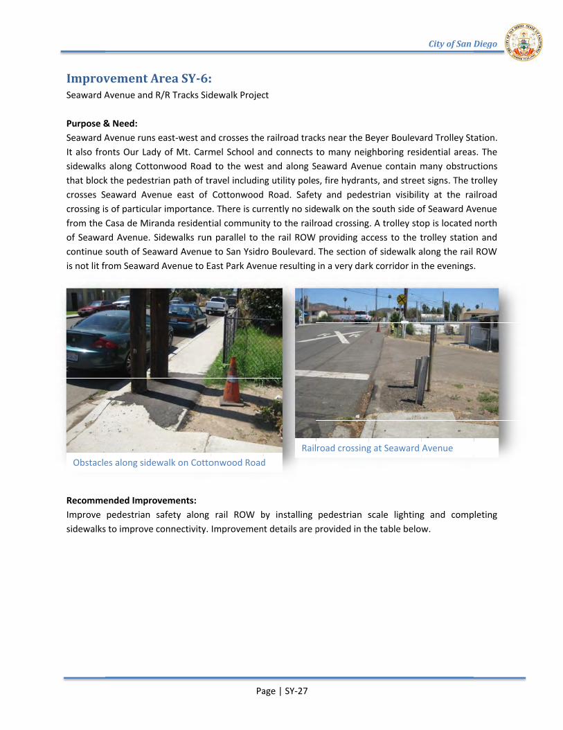
Improvement Area SYSeaward Avenue and R/R Tracks Sidewalk Project Purpose & Need:Seaward Avenue runs eastIt also fronts Our Lady of Mt. Carmel School and connects to many neighboring residential areas.sidewalks along Cottonwood Road to the west and along Seaward Avenue contain many obstructions that block the pedestrian path of travel including utility poles, fire hydrants, and street signs. The trolley crosses Seaward Avenue east of Cottonwood Roacrossing is of particular importance. There is currently no sidewalk on the south side of Seaward Avenue from the of Seaward Avenue. Sidewalks run parallel to the rail ROW providing access to the trolley station and continue south of Seaward Avenue to San Ysidro Boulevard. The section of sidewalk along the rail ROW is not lit from Seaward Avenue to East Park Ave
Recommended Improvements:Improve pedestrian safety along rail ROW by installing pedestrian scale lightinsidewalks to improve connectivity.
Obstacles along sidewalk
Improvement Area SYAvenue and R/R Tracks Sidewalk Project
Purpose & Need: Seaward Avenue runs eastIt also fronts Our Lady of Mt. Carmel School and connects to many neighboring residential areas.sidewalks along Cottonwood Road to the west and along Seaward Avenue contain many obstructions that block the pedestrian path of travel including utility poles, fire hydrants, and street signs. The trolley crosses Seaward Avenue east of Cottonwood Roacrossing is of particular importance. There is currently no sidewalk on the south side of Seaward Avenue
Casa de Miranda residential community to the railroad crossing. A trolley stop is located of Seaward Avenue. Sidewalks run parallel to the rail ROW providing access to the trolley station and continue south of Seaward Avenue to San Ysidro Boulevard. The section of sidewalk along the rail ROW is not lit from Seaward Avenue to East Park Ave
ecommended Improvements:Improve pedestrian safety along rail ROW by installing pedestrian scale lightinsidewalks to improve connectivity.
Obstacles along sidewalk
Improvement Area SY-6:Avenue and R/R Tracks Sidewalk Project
Seaward Avenue runs east-west and crosses the railroad tracks near the Beyer Boulevard Trolley Station. It also fronts Our Lady of Mt. Carmel School and connects to many neighboring residential areas.sidewalks along Cottonwood Road to the west and along Seaward Avenue contain many obstructions that block the pedestrian path of travel including utility poles, fire hydrants, and street signs. The trolley crosses Seaward Avenue east of Cottonwood Roacrossing is of particular importance. There is currently no sidewalk on the south side of Seaward Avenue
Casa de Miranda residential community to the railroad crossing. A trolley stop is located of Seaward Avenue. Sidewalks run parallel to the rail ROW providing access to the trolley station and continue south of Seaward Avenue to San Ysidro Boulevard. The section of sidewalk along the rail ROW is not lit from Seaward Avenue to East Park Ave
ecommended Improvements: Improve pedestrian safety along rail ROW by installing pedestrian scale lightinsidewalks to improve connectivity.
Obstacles along sidewalk on Cottonwood Road
Page | SY
: Avenue and R/R Tracks Sidewalk Project
west and crosses the railroad tracks near the Beyer Boulevard Trolley Station. It also fronts Our Lady of Mt. Carmel School and connects to many neighboring residential areas.sidewalks along Cottonwood Road to the west and along Seaward Avenue contain many obstructions that block the pedestrian path of travel including utility poles, fire hydrants, and street signs. The trolley crosses Seaward Avenue east of Cottonwood Roacrossing is of particular importance. There is currently no sidewalk on the south side of Seaward Avenue
Casa de Miranda residential community to the railroad crossing. A trolley stop is located of Seaward Avenue. Sidewalks run parallel to the rail ROW providing access to the trolley station and continue south of Seaward Avenue to San Ysidro Boulevard. The section of sidewalk along the rail ROW is not lit from Seaward Avenue to East Park Avenue resulting in a very
Improve pedestrian safety along rail ROW by installing pedestrian scale lightin Improvement details are provided in the table below.
on Cottonwood Road
Page | SY-27
Avenue and R/R Tracks Sidewalk Project
west and crosses the railroad tracks near the Beyer Boulevard Trolley Station. It also fronts Our Lady of Mt. Carmel School and connects to many neighboring residential areas.sidewalks along Cottonwood Road to the west and along Seaward Avenue contain many obstructions that block the pedestrian path of travel including utility poles, fire hydrants, and street signs. The trolley crosses Seaward Avenue east of Cottonwood Road. Safety and pedestrian visibility at the railroad crossing is of particular importance. There is currently no sidewalk on the south side of Seaward Avenue
Casa de Miranda residential community to the railroad crossing. A trolley stop is located of Seaward Avenue. Sidewalks run parallel to the rail ROW providing access to the trolley station and continue south of Seaward Avenue to San Ysidro Boulevard. The section of sidewalk along the rail ROW
nue resulting in a very
Improve pedestrian safety along rail ROW by installing pedestrian scale lightinImprovement details are provided in the table below.
on Cottonwood Road Railroad crossing at Seaward
west and crosses the railroad tracks near the Beyer Boulevard Trolley Station. It also fronts Our Lady of Mt. Carmel School and connects to many neighboring residential areas.sidewalks along Cottonwood Road to the west and along Seaward Avenue contain many obstructions that block the pedestrian path of travel including utility poles, fire hydrants, and street signs. The trolley
d. Safety and pedestrian visibility at the railroad crossing is of particular importance. There is currently no sidewalk on the south side of Seaward Avenue
Casa de Miranda residential community to the railroad crossing. A trolley stop is located of Seaward Avenue. Sidewalks run parallel to the rail ROW providing access to the trolley station and continue south of Seaward Avenue to San Ysidro Boulevard. The section of sidewalk along the rail ROW
nue resulting in a very dark
Improve pedestrian safety along rail ROW by installing pedestrian scale lightinImprovement details are provided in the table below.
Railroad crossing at Seaward
west and crosses the railroad tracks near the Beyer Boulevard Trolley Station. It also fronts Our Lady of Mt. Carmel School and connects to many neighboring residential areas.sidewalks along Cottonwood Road to the west and along Seaward Avenue contain many obstructions that block the pedestrian path of travel including utility poles, fire hydrants, and street signs. The trolley
d. Safety and pedestrian visibility at the railroad crossing is of particular importance. There is currently no sidewalk on the south side of Seaward Avenue
Casa de Miranda residential community to the railroad crossing. A trolley stop is located of Seaward Avenue. Sidewalks run parallel to the rail ROW providing access to the trolley station and continue south of Seaward Avenue to San Ysidro Boulevard. The section of sidewalk along the rail ROW
dark corridor in the evenings.
Improve pedestrian safety along rail ROW by installing pedestrian scale lighting and completing Improvement details are provided in the table below.
Railroad crossing at Seaward
City of San Diego
west and crosses the railroad tracks near the Beyer Boulevard Trolley Station. It also fronts Our Lady of Mt. Carmel School and connects to many neighboring residential areas.sidewalks along Cottonwood Road to the west and along Seaward Avenue contain many obstructions that block the pedestrian path of travel including utility poles, fire hydrants, and street signs. The trolley
d. Safety and pedestrian visibility at the railroad crossing is of particular importance. There is currently no sidewalk on the south side of Seaward Avenue
Casa de Miranda residential community to the railroad crossing. A trolley stop is located of Seaward Avenue. Sidewalks run parallel to the rail ROW providing access to the trolley station and continue south of Seaward Avenue to San Ysidro Boulevard. The section of sidewalk along the rail ROW
corridor in the evenings.
g and completing Improvement details are provided in the table below.
Railroad crossing at Seaward Avenue
City of San Diego
west and crosses the railroad tracks near the Beyer Boulevard Trolley Station. It also fronts Our Lady of Mt. Carmel School and connects to many neighboring residential areas. The sidewalks along Cottonwood Road to the west and along Seaward Avenue contain many obstructions that block the pedestrian path of travel including utility poles, fire hydrants, and street signs. The trolley
d. Safety and pedestrian visibility at the railroad crossing is of particular importance. There is currently no sidewalk on the south side of Seaward Avenue
Casa de Miranda residential community to the railroad crossing. A trolley stop is located north of Seaward Avenue. Sidewalks run parallel to the rail ROW providing access to the trolley station and continue south of Seaward Avenue to San Ysidro Boulevard. The section of sidewalk along the rail ROW
corridor in the evenings.
g and completing
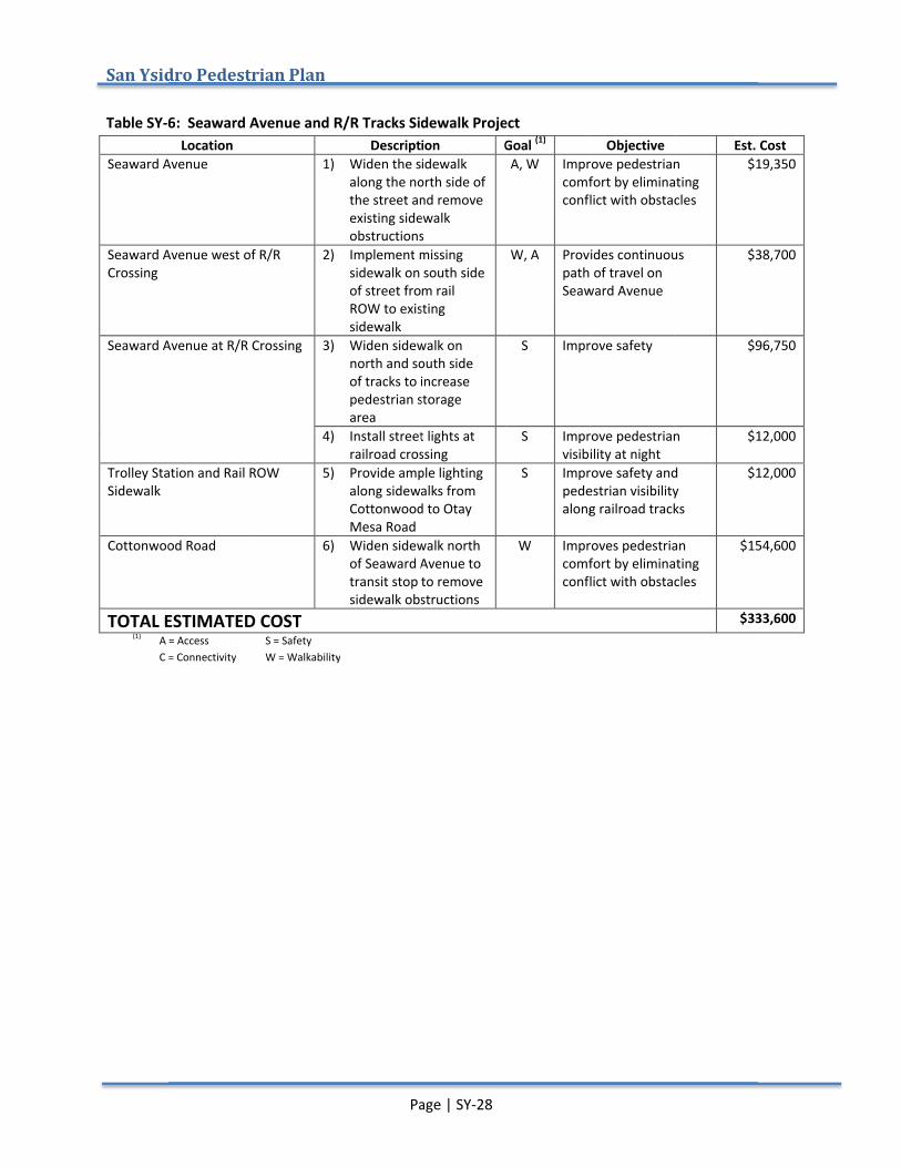
San Ysidro
Table SY-6
Seaward Avenue
Seaward Avenue west of R/R Crossing
Seaward Avenue at R/R Crossing
Trolley Station and Rail ROW Sidewalk
Cottonwood Road
TOTAL ESTIMATED COST(1) A = Access
C = Connectivity
San Ysidro Pedestrian Plan
6: Seaward Avenue and R/R Tracks Sidewalk ProjectLocation
Seaward Avenue
Seaward Avenue west of R/R
Seaward Avenue at R/R Crossing
Trolley Station and Rail ROW
Cottonwood Road
TOTAL ESTIMATED COSTA = Access C = Connectivity
Pedestrian Plan
: Seaward Avenue and R/R Tracks Sidewalk Project
1)
Seaward Avenue west of R/R 2)
Seaward Avenue at R/R Crossing 3)
4)
Trolley Station and Rail ROW 5)
6)
TOTAL ESTIMATED COST S = Safety
W = Walkability
Page | SY
: Seaward Avenue and R/R Tracks Sidewalk ProjectDescription
Widen the sidewalk along the north side of the street and remove existing sidewalk obstructions
Implement missingsidewalk on south side of street from rail ROW to existing sidewalk
Widen sidewalk on north and south side of tracks to increase pedestrian storage area
Install street lightsrailroad crossing
Provide ample lighting along sidewalks from Cottonwood to Otay Mesa Road
Widen sidewalk north of Seaward Avenue to transit stop to remove sidewalk obstructions
W = Walkability
Page | SY-28
: Seaward Avenue and R/R Tracks Sidewalk ProjectDescription Goal
sidewalk along the north side of the street and remove existing sidewalk obstructions
missing sidewalk on south side of street from rail ROW to existing
Widen sidewalk on north and south side of tracks to increase pedestrian storage
Install street lights at railroad crossing Provide ample lighting along sidewalks from Cottonwood to Otay
Widen sidewalk north of Seaward Avenue to transit stop to remove sidewalk obstructions
: Seaward Avenue and R/R Tracks Sidewalk Project Goal (1)
A, W Improve pedestrian comfort by eliminating conflict with obstacles
W, A Provides continuous path of travel on Seaward Avenue
S Improve safety
S Improve pedestrian visibility at night
S Improve safety and pedestrian visibility along railroad tracks
W Improves pedestrian comfort by eliminating conflict with obstacles
Objective Improve pedestrian comfort by eliminating conflict with obstacles
Provides continuous path of travel on Seaward Avenue
Improve safety
Improve pedestrian visibility at night Improve safety and pedestrian visibility along railroad tracks
Improves pedestrian comfort by eliminating conflict with obstacles
Est. CostImprove pedestrian comfort by eliminating conflict with obstacles
$19,350
Provides continuous $38,700
$96,750
Improve pedestrian $12,000
Improve safety and pedestrian visibility along railroad tracks
$12,000
Improves pedestrian comfort by eliminating conflict with obstacles
$154,600
$333,600
Est. Cost 19,350
38,700
96,750
12,000
12,000
154,600
333,600

Improvement Area SYSunset Lane Safety Improvements Purpose & Need:Sunset Lane fronts Sunset Elementary School and provides a connection from the Smythe Avenue trolley crossing to the surrounding residential areas and churches. Traffic calming devices have been installed (speed humps) to address traffic speed on this corrwhich results lighting is needed to improve pedestrian safety. The intersection of Alverson Road and Sunset Lane is located on the western edge of the elementarpedestrian crossing distance and visibility are recommended. A field review of signs in the area indicate that existing school signs do not meet current CApavement markings should be replaced.
Sunset Lane / Alverson Road Intersection at Sunset Elementary School
Improvement Area SYSunset Lane Safety Improvements
Purpose & Need: Sunset Lane fronts Sunset Elementary School and provides a connection from the Smythe Avenue trolley crossing to the surrounding residential areas and churches. Traffic calming devices have been installed (speed humps) to address traffic speed on this corridor. There are few street lights in the area which results in dark sidewalks after sunset. Additional street lighting is needed to improve pedestrian safety. The intersection of Alverson Road and Sunset Lane is located on the western edge of the elementarpedestrian crossing distance and visibility are recommended. A field review of signs in the area indicate that existing school signs do not meet current CApavement markings should be replaced.
Sunset Lane / Alverson Road Intersection at Sunset Elementary School
Improvement Area SY-7:Sunset Lane Safety Improvements
Sunset Lane fronts Sunset Elementary School and provides a connection from the Smythe Avenue trolley crossing to the surrounding residential areas and churches. Traffic calming devices have been installed (speed humps) to address traffic
idor. There are few street lights in the area in dark sidewalks after sunset. Additional street
lighting is needed to improve pedestrian safety. The intersection of Alverson Road and Sunset Lane is located on the western edge of the elementary school. Improvements for pedestrian crossing distance and visibility are recommended. A field review of signs in the area indicate that existing school signs do not meet current CA-MUTCD standards. All signs and pavement markings should be replaced.
Sunset Lane / Alverson Road Intersection at Sunset Elementary School
Page | SY
:
Sunset Lane fronts Sunset Elementary School and provides a connection from the Smythe Avenue trolley crossing to the surrounding residential areas and churches. Traffic calming devices have been installed (speed humps) to address traffic
idor. There are few street lights in the area in dark sidewalks after sunset. Additional street
lighting is needed to improve pedestrian safety. The intersection of Alverson Road and Sunset Lane is located on the
y school. Improvements for pedestrian crossing distance and visibility are recommended. A field review of signs in the area indicate that existing school
MUTCD standards. All signs and pavement markings should be replaced.
Sunset Lane / Alverson Road Intersection at Sunset Elementary School
Page | SY-29
Sunset Lane fronts Sunset Elementary School and provides a connection from the Smythe Avenue trolley crossing to the surrounding residential areas and churches. Traffic calming devices have been installed (speed humps) to address traffic
idor. There are few street lights in the area in dark sidewalks after sunset. Additional street
lighting is needed to improve pedestrian safety. The intersection of Alverson Road and Sunset Lane is located on the
y school. Improvements for pedestrian crossing distance and visibility are recommended. A field review of signs in the area indicate that existing school
MUTCD standards. All signs and
Sunset Lane / Alverson Road Intersection at Sunset Elementary School
Sunset Lane fronts Sunset Elementary School and provides a connection from the Smythe Avenue trolley crossing to the surrounding residential areas and churches. Traffic calming devices have been installed (speed humps) to address traffic
idor. There are few street lights in the area in dark sidewalks after sunset. Additional street
lighting is needed to improve pedestrian safety. The intersection of Alverson Road and Sunset Lane is located on the
y school. Improvements for pedestrian crossing distance and visibility are recommended. A field review of signs in the area indicate that existing school
MUTCD standards. All signs and
Sunset Lane residential area
Sunset Lane / Alverson Road Intersection at Sunset Elementary School
Sunset Lane residential area
City of San Diego
Sunset Lane residential area
City of San Diego
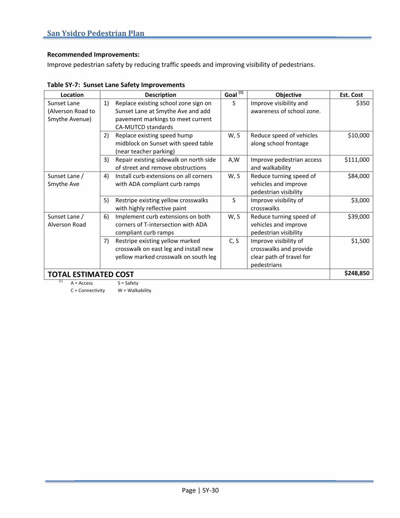
San Ysidro
Recommended Improvements:Improve pedestrian safety by Table SY-7
LocationSunset Lane (Alverson Road to Smythe Avenue)
Sunset Lane / Smythe Ave
Sunset Lane / Alverson Road
TOTAL ESTIMATED COST(1) A = Access
C = Connectivity
San Ysidro Pedestrian Plan
ecommended Improvements:Improve pedestrian safety by
7: Sunset Lane Safety ImprovementsLocation
Sunset Lane (Alverson Road to Smythe Avenue)
1)
2)
3)
Sunset Lane / Smythe Ave
4)
5)
Sunset Lane / Alverson Road
6)
7)
TOTAL ESTIMATED COSTA = Access C = Connectivity
Pedestrian Plan
ecommended Improvements: Improve pedestrian safety by reducing traffic speeds and
: Sunset Lane Safety ImprovementsDescription
Replace existing school zone signSunset Lane at Smythe Avepavement markings to CA-MUTCD standards
Replace existing speed hump midblock on Sunset with speed table (near teacher parking)
Repair existing sidewalk of street and remove obstructions
Install curb extensions on all cornerswith ADA compliant curb ramps
Restripe existingwith highly reflective paint
Implement curb extensions on both corners of T-intersection with ADA compliant curb ramps
Restripe existingcrosswalk on east leg andyellow marked
TOTAL ESTIMATED COST S = Safety
W = Walkability
Page | SY
reducing traffic speeds and
: Sunset Lane Safety Improvements Description
Replace existing school zone signSunset Lane at Smythe Avepavement markings to meet
standards Replace existing speed hump midblock on Sunset with speed table (near teacher parking) Repair existing sidewalk on north side
and remove obstructionsInstall curb extensions on all cornerswith ADA compliant curb ramps
Restripe existing yellow crosswalks with highly reflective paint
curb extensions on both intersection with ADA
compliant curb ramps existing yellow marked
crosswalk on east leg and installyellow marked crosswalk on south leg
W = Walkability
Page | SY-30
reducing traffic speeds and improving visibility of pedestrians
Replace existing school zone sign on Sunset Lane at Smythe Ave and add
meet current
Replace existing speed hump midblock on Sunset with speed table
on north side and remove obstructions
Install curb extensions on all corners with ADA compliant curb ramps
crosswalks
curb extensions on both intersection with ADA
yellow marked install new
crosswalk on south leg
improving visibility of pedestrians
Goal (1) S Improve visibility and
awareness of school zone.
W, S Reduce speed of vehicles along school frontage
A,W Improve pedestrian access and walkability
W, S Reduce turning speed of vehicles and improve pedestrian visibility
S Improve visibility of crosswalks
W, S Reduce turning speed of vehicles and pedestrian visibility
C, S Improve visibility of crosswalks and provide clear path of travel for pedestrians
improving visibility of pedestrians
ObjectiveImprove visibility and awareness of school zone.
Reduce speed of vehicles along school frontage
Improve pedestrian access and walkability Reduce turning speed of vehicles and improve pedestrian visibilityImprove visibility of crosswalks Reduce turning speed of vehicles and improve pedestrian visibilityImprove visibility of crosswalks and provide clear path of travel for pedestrians
improving visibility of pedestrians.
Objective Improve visibility and awareness of school zone.
Reduce speed of vehicles along school frontage
Improve pedestrian access
Reduce turning speed of vehicles and improve pedestrian visibility Improve visibility of
Reduce turning speed of improve
pedestrian visibility Improve visibility of crosswalks and provide clear path of travel for
Est. Cost $350
$10,000
$111,000
$84,000
$3,000
$39,000
$1,500
$248,850
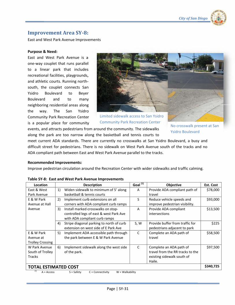
Improvement Area SYEast and West Park Avenue Improvements Purpose & Need:East and West Park Avenue is a one-way couplet that runs parallel to a linear park that includes recreational facilities, playgrounds, and athletic courts. Running nortsouth, the couplet connects San Ysidro Boulevard to Beyer Boulevard and to many neighboring residential areas along the way.Community Park Recreation Center is a popular place for community events, and attracts pedestrians from around the community. The sidewalks along the park are too narrow along the basketball and tennis courts to meet current ADA standards. Tdifficult street for pedestrians. ADA compliant path between East and West Park Avenue parallel to the tracks.
RecommeImprove pedestrian circulation around the Recreation Center
Table SY-8Location
East & West Park Avenue E & W Park Avenue at Hall Avenue
E & W Park Avenue at Trolley CrossingW Park Avenue South of Trolley Tracks
TOTAL ESTIMATED COST(1) A = Access
Improvement Area SYEast and West Park Avenue Improvements
Purpose & Need: East and West Park Avenue is a
way couplet that runs parallel to a linear park that includes recreational facilities, playgrounds, and athletic courts. Running nortsouth, the couplet connects San Ysidro Boulevard to Beyer Boulevard and to many neighboring residential areas along the way. The San Ysidro Community Park Recreation Center is a popular place for community events, and attracts pedestrians from around the community. The sidewalks along the park are too narrow along the basketball and tennis courts to meet current ADA standards. Tdifficult street for pedestrians. ADA compliant path between East and West Park Avenue parallel to the tracks.
ecommended Improvements:Improve pedestrian circulation around the Recreation Center
8: East and West Park Avenue ImprovementsLocation
East & West Park Avenue
1) Widen sidewalk bas
E & W Park Avenue at Hall
2) Implementcorners
3) Install marked crosswalks on stopcontrolled legs of east & west Park Ave with ADA compliant curb ramps
4) Stripe diagonal parking to north ofextension on west side of E Park Ave
E & W Park Avenue at Trolley Crossing
5) Implementthe park between E & W Park Avenue
W Park Avenue South of Trolley
6) Implementof the park.
ESTIMATED COSTA = Access
Improvement Area SY-8:East and West Park Avenue Improvements
East and West Park Avenue is a way couplet that runs parallel
to a linear park that includes recreational facilities, playgrounds, and athletic courts. Running north-south, the couplet connects San Ysidro Boulevard to Beyer Boulevard and to many neighboring residential areas along
The San Ysidro Community Park Recreation Center is a popular place for community events, and attracts pedestrians from around the community. The sidewalks along the park are too narrow along the basketball and tennis courts to meet current ADA standards. There are currently no crosswalks at San Ysidro Boulevard, a busy and difficult street for pedestrians. There is no sidewalk on West Park Avenue south of the tracks and no ADA compliant path between East and West Park Avenue parallel to the tracks.
nded Improvements: Improve pedestrian circulation around the Recreation Center
: East and West Park Avenue ImprovementsDescription
Widen sidewalk basketball & tennis courts Implement curb extensions on all corners with ADA compliant curb rampsInstall marked crosswalks on stopcontrolled legs of east & west Park Ave with ADA compliant curb rampsStripe diagonal parking to north ofextension on west side of E Park AveImplement ADA athe park between E & W Park Avenue
Implement sidewalk along the west side of the park.
ESTIMATED COST S = Safety
Page | SY
Limited sidewalk access to San Ysidro Community Park Recreation Center
: East and West Park Avenue Improvements
East and West Park Avenue is a way couplet that runs parallel
to a linear park that includes recreational facilities, playgrounds,
-south, the couplet connects San Ysidro Boulevard to Beyer Boulevard and to many neighboring residential areas along
The San Ysidro Community Park Recreation Center is a popular place for community events, and attracts pedestrians from around the community. The sidewalks along the park are too narrow along the basketball and tennis courts to
here are currently no crosswalks at San Ysidro Boulevard, a busy and here is no sidewalk on West Park Avenue south of the tracks and no
ADA compliant path between East and West Park Avenue parallel to the tracks.
Improve pedestrian circulation around the Recreation Center
: East and West Park Avenue ImprovementsDescription
Widen sidewalk to minimum of 5’ ketball & tennis courts
curb extensions on all with ADA compliant curb ramps
Install marked crosswalks on stopcontrolled legs of east & west Park Ave with ADA compliant curb rampsStripe diagonal parking to north ofextension on west side of E Park Ave
ADA accessible path through the park between E & W Park Avenue
sidewalk along the west side
C = Connectivity
Page | SY-31
Limited sidewalk access to San Ysidro Community Park Recreation Center
events, and attracts pedestrians from around the community. The sidewalks along the park are too narrow along the basketball and tennis courts to
here are currently no crosswalks at San Ysidro Boulevard, a busy and here is no sidewalk on West Park Avenue south of the tracks and no
ADA compliant path between East and West Park Avenue parallel to the tracks.
Improve pedestrian circulation around the Recreation Center
: East and West Park Avenue Improvements
to minimum of 5’ along
curb extensions on all with ADA compliant curb ramps
Install marked crosswalks on stop-controlled legs of east & west Park Ave with ADA compliant curb ramps Stripe diagonal parking to north of curb extension on west side of E Park Ave
ccessible path through the park between E & W Park Avenue
sidewalk along the west side
W = Walkability
Limited sidewalk access to San Ysidro Community Park Recreation Center
events, and attracts pedestrians from around the community. The sidewalks along the park are too narrow along the basketball and tennis courts to
here are currently no crosswalks at San Ysidro Boulevard, a busy and here is no sidewalk on West Park Avenue south of the tracks and no
ADA compliant path between East and West Park Avenue parallel to the tracks.
Improve pedestrian circulation around the Recreation Center with wider sidewalks and traffic calming
Goal (1) A Provide ADA compliant path of
travelS Reduce vehicle speeds and
improve pedestrian visibility. A Provide ADA compliant
intersections
S, W Provide buffer from traffic for pedestrians adjacent to park
C Complete an ADA path of travel
C Complete an ADA path of travel from the RR tracks to the existing sidewalk south of Haile.
W = Walkability
Limited sidewalk access to San Ysidro Community Park Recreation Center
events, and attracts pedestrians from around the community. The sidewalks along the park are too narrow along the basketball and tennis courts to
here are currently no crosswalks at San Ysidro Boulevard, a busy and here is no sidewalk on West Park Avenue south of the tracks and no
ADA compliant path between East and West Park Avenue parallel to the tracks.
with wider sidewalks and traffic calming
ObjectiveProvide ADA compliant path of travel Reduce vehicle speeds and improve pedestrian visibility. Provide ADA compliant intersections
Provide buffer from traffic for pedestrians adjacent to parkComplete an ADA path of travel
Complete an ADA path of travel from the RR tracks to the existing sidewalk south of Haile.
No crosswalk present at San Ysidro Boulevard
City of San Diego
here are currently no crosswalks at San Ysidro Boulevard, a busy and here is no sidewalk on West Park Avenue south of the tracks and no
with wider sidewalks and traffic calming
Objective Provide ADA compliant path of
Reduce vehicle speeds and improve pedestrian visibility. Provide ADA compliant
Provide buffer from traffic for pedestrians adjacent to park Complete an ADA path of
Complete an ADA path of travel from the RR tracks to the existing sidewalk south of
No crosswalk present at San Ysidro Boulevard
City of San Diego
here are currently no crosswalks at San Ysidro Boulevard, a busy and here is no sidewalk on West Park Avenue south of the tracks and no
with wider sidewalks and traffic calming.
Est. Cost Provide ADA compliant path of $78,000
$93,000
$13,500
$225
$58,500
travel from the RR tracks to the $97,500
$340,725
No crosswalk present at San Ysidro Boulevard
No crosswalk present at San
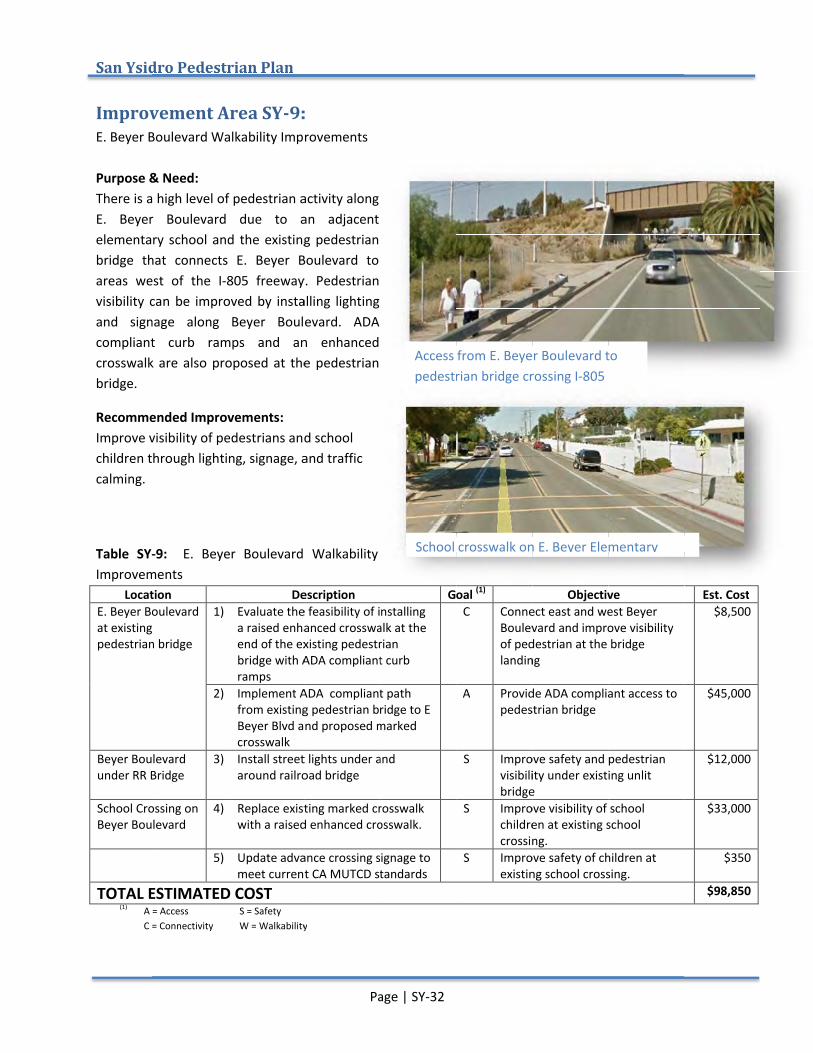
San Ysidro
Improvement Area SYE. Beyer Boulevard Walkability Improvements Purpose & Need:There is a high level of pedestrian activity along E. Beyer Boulevard due to an adjacent elementary school and the existing pedestrian bridge that connects E. Beyer Boulevard to areas west of the Ivisibility can be improved by installing lighting and signage along Beyer Boulevard. ADA compliant curb ramps and an enhanccrosswalk are also proposed at the pedestrian bridge.
Recommended Improvements:Improve visibility of pedestrians and school children through lighting, signage, and traffic calming.
Table SY-Improvements
LocationE. Beyer Boulevard at existing pedestrian bridge
Beyer Boulevard under RR Bridge
School Crossing on Beyer Boulevard
TOTAL ESTIMATED (1) A = Access
C = Connectivity
San Ysidro Pedestrian Plan
Improvement Area SYE. Beyer Boulevard Walkability Improvements
Purpose & Need: There is a high level of pedestrian activity along E. Beyer Boulevard due to an adjacent elementary school and the existing pedestrian bridge that connects E. Beyer Boulevard to
west of the I-805 freeway. visibility can be improved by installing lighting and signage along Beyer Boulevard. ADA compliant curb ramps and an enhanccrosswalk are also proposed at the pedestrian
commended Improvements:Improve visibility of pedestrians and school children through lighting, signage, and traffic
-9: E. Beyer Boulevard Walkability Improvements
Location E. Beyer Boulevard at existing pedestrian bridge
1)
2)
Beyer Boulevard under RR Bridge
3)
School Crossing on Beyer Boulevard
4)
5)
TOTAL ESTIMATED A = Access C = Connectivity
Pedestrian Plan
Improvement Area SY-9:E. Beyer Boulevard Walkability Improvements
There is a high level of pedestrian activity along E. Beyer Boulevard due to an adjacent elementary school and the existing pedestrian bridge that connects E. Beyer Boulevard to
805 freeway. visibility can be improved by installing lighting and signage along Beyer Boulevard. ADA compliant curb ramps and an enhanccrosswalk are also proposed at the pedestrian
commended Improvements: Improve visibility of pedestrians and school children through lighting, signage, and traffic
E. Beyer Boulevard Walkability
Description Evaluate the feasibility of installing
a raised enhancedend of the existing pedestrian bridge with ADA compliant curb ramps
Implement ADA compliant path from existing pedestrian bridgeBeyer Blvd and proposedcrosswalk
Install street lights under around railroad
Replace existing marked crosswalk with a raised
Update advance crossing signage to meet current CA MUTCD standards
TOTAL ESTIMATED COST S = Safety
W = Walkability
Page | SY
: E. Beyer Boulevard Walkability Improvements
There is a high level of pedestrian activity along E. Beyer Boulevard due to an adjacent elementary school and the existing pedestrian bridge that connects E. Beyer Boulevard to
805 freeway. Pedestrian visibility can be improved by installing lighting and signage along Beyer Boulevard. ADA compliant curb ramps and an enhanced crosswalk are also proposed at the pedestrian
Improve visibility of pedestrians and school children through lighting, signage, and traffic
E. Beyer Boulevard Walkability
Description Evaluate the feasibility of installing
enhanced crosswalk at the end of the existing pedestrian
with ADA compliant curb
ADA compliant path from existing pedestrian bridgeBeyer Blvd and proposed marked
Install street lights under and around railroad bridge
Replace existing marked crosswalk raised enhanced crosswalk.
Update advance crossing signage to meet current CA MUTCD standards
W = Walkability
Page | SY-32
Access from E. Beyer Boulevard to pedestrian bridge crossing I
School crosswalk
There is a high level of pedestrian activity along E. Beyer Boulevard due to an adjacent elementary school and the existing pedestrian bridge that connects E. Beyer Boulevard to
Pedestrian visibility can be improved by installing lighting and signage along Beyer Boulevard. ADA
ed crosswalk are also proposed at the pedestrian
E. Beyer Boulevard Walkability
GoalEvaluate the feasibility of installing
crosswalk at the end of the existing pedestrian
with ADA compliant curb
ADA compliant path from existing pedestrian bridge to E
marked
and
Replace existing marked crosswalk crosswalk.
Update advance crossing signage to meet current CA MUTCD standards
Access from E. Beyer Boulevard to pedestrian bridge crossing I
chool crosswalk on
Goal (1) C Connect east and wes
Boulevard and improve visibility of pedestrian at the bridge landing
A Provide ADA compliant access to pedestrian bridge
S Improve safety and pedestrian visibility under existing unlit bridge
S Improve visibility of school children at existing school crossing.
S Improve safety of children at existing school crossing.
Access from E. Beyer Boulevard to pedestrian bridge crossing I-805
on E. Beyer Elementary
ObjectiveConnect east and wesBoulevard and improve visibility of pedestrian at the bridge landing
Provide ADA compliant access to pedestrian bridge
Improve safety and pedestrian visibility under existing unlit bridge Improve visibility of school children at existing school crossing. Improve safety of children at existing school crossing.
Access from E. Beyer Boulevard to
Beyer Elementary
Objective Connect east and west Beyer Boulevard and improve visibility of pedestrian at the bridge
Provide ADA compliant access to
Improve safety and pedestrian visibility under existing unlit
Improve visibility of school children at existing school
Improve safety of children at existing school crossing.
Est. Cost $8,500
$45,000
$12,000
$33,000
$350
$98,850
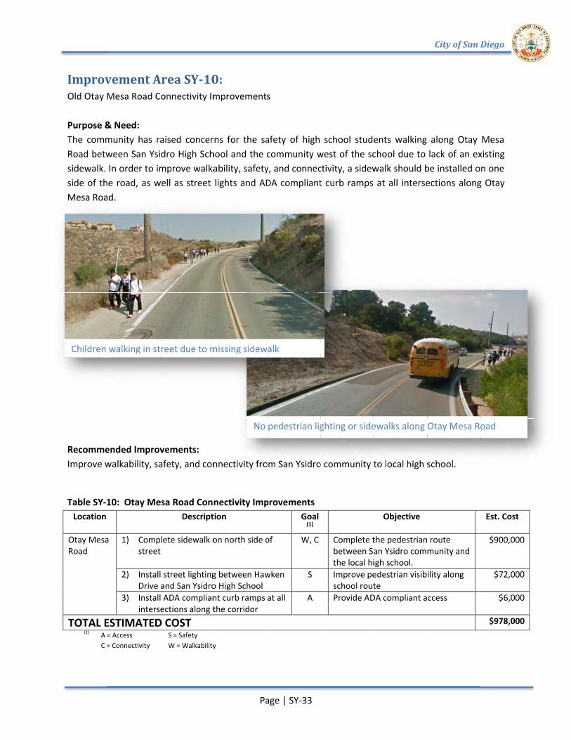
Improvement Area SYOld Otay Mesa Road Connectivity Improvements Purpose & Need:The community has raised concerns for the safety of high school students walking along Otay MesRoad between San Ysidro High Ssidewalk. In order to improve walkability, safety, and connectside of the road, as well as street lights and ADA compliant curb ramps at all intersections along Otay Mesa Road.
Recommended Improvements:Improve walkability, safety, and connectivity from San Ysidro community to local high school
Table SY-10
Location
Otay Mesa Road
TOTAL ESTIMATED COST(1) A = Access
C = Connectivity
Children walking in street due to missing sidewalk
Improvement Area SYOtay Mesa Road Connectivity Improvements
Purpose & Need: community has raised concerns for the safety of high school students walking along Otay Mes
Road between San Ysidro High Ssidewalk. In order to improve walkability, safety, and connectside of the road, as well as street lights and ADA compliant curb ramps at all intersections along Otay Mesa Road.
ecommended Improvements:Improve walkability, safety, and connectivity from San Ysidro community to local high school
10: Otay Mesa Road Connectivity Improvements
Otay Mesa 1) Complete sidewalk on north side of street
2) Install street lighting between Hawken Drive and San Ysidro High School
3) Install ADA compliant curb ramps at all intersections along the corridor
TOTAL ESTIMATED COSTA = Access C = Connectivity
Children walking in street due to missing sidewalk
Improvement Area SY-10Otay Mesa Road Connectivity Improvements
community has raised concerns for the safety of high school students walking along Otay MesRoad between San Ysidro High School and the community west of the school due to lack of an existing sidewalk. In order to improve walkability, safety, and connectside of the road, as well as street lights and ADA compliant curb ramps at all intersections along Otay
ecommended Improvements: Improve walkability, safety, and connectivity from San Ysidro community to local high school
: Otay Mesa Road Connectivity ImprovementsDescription
Complete sidewalk on north side of street
Install street lighting between Hawken Drive and San Ysidro High SchoolInstall ADA compliant curb ramps at all intersections along the corridor
TOTAL ESTIMATED COST S = Safety
W = Walkability
Children walking in street due to missing sidewalk
Page | SY
10: Otay Mesa Road Connectivity Improvements
community has raised concerns for the safety of high school students walking along Otay Meschool and the community west of the school due to lack of an existing
sidewalk. In order to improve walkability, safety, and connectside of the road, as well as street lights and ADA compliant curb ramps at all intersections along Otay
Improve walkability, safety, and connectivity from San Ysidro community to local high school
: Otay Mesa Road Connectivity ImprovementsDescription
Complete sidewalk on north side of
Install street lighting between Hawken Drive and San Ysidro High School Install ADA compliant curb ramps at all intersections along the corridor
W = Walkability
No pedestrian lighting or sidewalks along Otay Mesa Road
Children walking in street due to missing sidewalk
Page | SY-33
Otay Mesa Road Connectivity Improvements
community has raised concerns for the safety of high school students walking along Otay Meschool and the community west of the school due to lack of an existing
sidewalk. In order to improve walkability, safety, and connectside of the road, as well as street lights and ADA compliant curb ramps at all intersections along Otay
Improve walkability, safety, and connectivity from San Ysidro community to local high school
: Otay Mesa Road Connectivity Improvements Goal
(1) Complete sidewalk on north side of W, C
Install street lighting between Hawken
S
Install ADA compliant curb ramps at all A
No pedestrian lighting or sidewalks along Otay Mesa Road
Children walking in street due to missing sidewalk
community has raised concerns for the safety of high school students walking along Otay Meschool and the community west of the school due to lack of an existing
sidewalk. In order to improve walkability, safety, and connectivity, a sidewalk should be installed on one side of the road, as well as street lights and ADA compliant curb ramps at all intersections along Otay
Improve walkability, safety, and connectivity from San Ysidro community to local high school
Complete the pedestrian route between San Ysidrothe local high Improve pedestrian visibility along school routeProvide ADA compliant access
No pedestrian lighting or sidewalks along Otay Mesa Road
community has raised concerns for the safety of high school students walking along Otay Meschool and the community west of the school due to lack of an existing
ivity, a sidewalk should be installed on one side of the road, as well as street lights and ADA compliant curb ramps at all intersections along Otay
Improve walkability, safety, and connectivity from San Ysidro community to local high school
Objective
Complete the pedestrian route between San Ysidro communitythe local high school. Improve pedestrian visibility along school route Provide ADA compliant access
No pedestrian lighting or sidewalks along Otay Mesa Road
City of San Diego
community has raised concerns for the safety of high school students walking along Otay Meschool and the community west of the school due to lack of an existing
ivity, a sidewalk should be installed on one side of the road, as well as street lights and ADA compliant curb ramps at all intersections along Otay
Improve walkability, safety, and connectivity from San Ysidro community to local high school.
Complete the pedestrian route community and
Improve pedestrian visibility along
Provide ADA compliant access
No pedestrian lighting or sidewalks along Otay Mesa Road
City of San Diego
community has raised concerns for the safety of high school students walking along Otay Mesa chool and the community west of the school due to lack of an existing
ivity, a sidewalk should be installed on one side of the road, as well as street lights and ADA compliant curb ramps at all intersections along Otay
Est. Cost
$900,000
$72,000
$6,000
$978,000
No pedestrian lighting or sidewalks along Otay Mesa Road
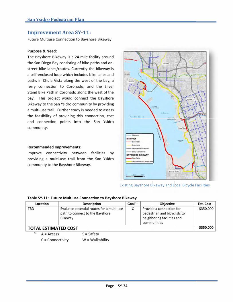
San Ysidro
Improvement Area SYFuture Multiuse Connection Purpose & Need:The Bayshore the San Diego Baystreet bike lanes/routesa self-enclosed loop which includes bike lanes and paths in Chula Vferry connection to Coronado, and the Silver Stand Bike Path in Coronado along the west of the bay. This project wouldBikeway to the San Ysidro community by providing a multi-use trail. the feasibility of providing this connection, cost and connection points into the San Ysidro community.
Recommended Improvements:Improve connectivity between facilities by providing a multicommunity
Table SY-11
LocationTBD
TOTAL ESTIMATED COST(1) A = Access
C = Connectivity
San Ysidro Pedestrian Plan
Improvement Area SYture Multiuse Connection
Purpose & Need: Bayshore Bikeway is a 24
the San Diego Bay consisting of bike paths and onstreet bike lanes/routes
enclosed loop which includes bike lanes and paths in Chula Vista along the west of the bay, a ferry connection to Coronado, and the Silver Stand Bike Path in Coronado along the west of the
This project wouldBikeway to the San Ysidro community by providing
use trail. Further studthe feasibility of providing this connection, cost and connection points into the San Ysidro community.
ecommended Improvements:Improve connectivity between facilities by providing a multi-use trail from community to the Bayshore Bikeway
11: Future Multiuse Connection to Location
Evaluate potential routes for a path to Bikeway
TOTAL ESTIMATED COSTA = Access C = Connectivity
Pedestrian Plan
Improvement Area SY-11ture Multiuse Connection to Bays
ikeway is a 24-mile facility around consisting of bike paths and on
street bike lanes/routes. Currently the bikeway is enclosed loop which includes bike lanes and
ista along the west of the bay, a ferry connection to Coronado, and the Silver Stand Bike Path in Coronado along the west of the
This project would connect the Bayshore Bikeway to the San Ysidro community by providing
Further study is needed to assess the feasibility of providing this connection, cost and connection points into the San Ysidro
ecommended Improvements: Improve connectivity between facilities by
use trail from the Bayshore Bikeway
: Future Multiuse Connection to Description
Evaluate potential routes for a path to connect to the Bikeway
TOTAL ESTIMATED COST S = Safety
C = Connectivity W = Walkability
Page | SY
11: to Bayshore Bikeway
mile facility around consisting of bike paths and on
Currently the bikeway is enclosed loop which includes bike lanes and
ista along the west of the bay, a ferry connection to Coronado, and the Silver Stand Bike Path in Coronado along the west of the
connect the Bayshore Bikeway to the San Ysidro community by providing
y is needed to assess the feasibility of providing this connection, cost and connection points into the San Ysidro
Improve connectivity between facilities by use trail from the San Ysidro
the Bayshore Bikeway.
: Future Multiuse Connection to Bayshore BikewayDescription
Evaluate potential routes for a multiconnect to the Bayshore
S = Safety W = Walkability
Page | SY-34
hore Bikeway
mile facility around consisting of bike paths and on-
Currently the bikeway is enclosed loop which includes bike lanes and
ista along the west of the bay, a ferry connection to Coronado, and the Silver Stand Bike Path in Coronado along the west of the
connect the Bayshore Bikeway to the San Ysidro community by providing
y is needed to assess the feasibility of providing this connection, cost and connection points into the San Ysidro
Improve connectivity between facilities by the San Ysidro
Bayshore BikewayGoal
multi-use Bayshore
W = Walkability
Existing Bayshore Bikeway and Local Bicycle Facilities
Bayshore Bikeway Goal (1)
C Provide a connection for pedestrian and bicyclists to neighboring facilities and communities
Existing Bayshore Bikeway and Local Bicycle Facilities
ObjectiveProvide a connection for pedestrian and bicyclists to neighboring facilities and communities
Existing Bayshore Bikeway and Local Bicycle Facilities
Objective Provide a connection for pedestrian and bicyclists to neighboring facilities and
Existing Bayshore Bikeway and Local Bicycle Facilities
Est. Cost $350,000
$350,000
Existing Bayshore Bikeway and Local Bicycle Facilities
Improvement Area SYSan Ysidro Border Crossing Mobility Study Purpose & Need:The General Services Administration (GSA) has plans to upgrade and expand both pedestrianvehicular border inspection fborder in the worldexisting transportation facilities increase in volumeto reconfigurorder to mediate the potential increase in mobility conflicts
Stakeholders indicated the desire and mobility to, from, and within theencourage economic development.to consolidate transportation facilities and services at the border into an Intermodal Transportation Center (ITC) that combines elements of the Grand Central Station and international gateway goals from the San Ysidro Community Plan.
“Reconfiguring proximity to bothseen as a goals for an iconic gateway and economic catalyst.
Recommended Improvements:Numerous pedestrian study area should implement identified accessibility near the border. Table SY-12
LocationBorder Station
(1) A = AccessC = Connectivity
Improvement Area SYSan Ysidro Border Crossing Mobility Study
Purpose & Need: The General Services Administration (GSA) has plans to upgrade and expand both pedestrianvehicular border inspection fborder in the world, in order to accommodate higher volumes of pedestrians and vehicles. existing transportation facilities increase in volume. As a result,
econfigure the border area toorder to mediate the potential increase in mobility conflicts
Stakeholders indicated the desire and mobility to, from, and within theencourage economic development.to consolidate transportation facilities and services at the border into an Intermodal Transportation Center (ITC) that combines elements of the Grand Central Station and international gateway goals from the San Ysidro Community Plan.
Reconfiguring the areaproximity to both the border and community for all modes of transportation serving the border was
solution to resolving existing and future conflicts andgoals for an iconic gateway and economic catalyst.
ecommended Improvements:Numerous pedestrian study area should implement identified accessibility near the border.
12 Location
Border Station Implementthe San Ysidro Border Crossing Mobility Study and provide pedestrian connectivity to the future Intermodal Transportation Center
A = Access C = Connectivity
Improvement Area SY-12San Ysidro Border Crossing Mobility Study
The General Services Administration (GSA) has plans to upgrade and expand both pedestrianvehicular border inspection facilities
in order to accommodate higher volumes of pedestrians and vehicles. existing transportation facilities already experience deficiencies and
As a result, the San Ysidro the border area to improve mobility, circulation, and access as part of the expansion
order to mediate the potential increase in mobility conflicts
Stakeholders indicated the desire to create a border that and mobility to, from, and within theencourage economic development.to consolidate transportation facilities and services at the border into an Intermodal Transportation Center (ITC) that combines elements of the Grand Central Station and international gateway goals from the San Ysidro Community Plan.
the area into an ITC that provides sufficient physical facilities, efficient operations, and the border and community for all modes of transportation serving the border was
solution to resolving existing and future conflicts andgoals for an iconic gateway and economic catalyst.
ecommended Improvements: Numerous pedestrian connections are recommended in the Mobility Study. Future projects within the study area should implement identified accessibility near the border.
DescriptionImplement improvements identified in the San Ysidro Border Crossing Mobility Study and provide pedestrian connectivity to the future Intermodal Transportation Center
S = SafetyC = Connectivity W = Walkability
Page | SY
12: San Ysidro Border Crossing Mobility Study
The General Services Administration (GSA) has plans to upgrade and expand both pedestrianacilities at the San Ysidro P
in order to accommodate higher volumes of pedestrians and vehicles. already experience deficiencies and he San Ysidro POE Reconfiguration Mobility Study has
improve mobility, circulation, and access as part of the expansionorder to mediate the potential increase in mobility conflicts
to create a border that and mobility to, from, and within the community and that creates a gateway to the community to encourage economic development. An overarching goal between the community and stakeholders to consolidate transportation facilities and services at the border into an Intermodal Transportation Center (ITC) that combines elements of the Grand Central Station and international gateway goals from
into an ITC that provides sufficient physical facilities, efficient operations, and the border and community for all modes of transportation serving the border was
solution to resolving existing and future conflicts andgoals for an iconic gateway and economic catalyst.
connections are recommended in the Mobility Study. Future projects within the study area should implement identified recommended improvements and provide improved
Description improvements identified in
the San Ysidro Border Crossing Mobility Study and provide pedestrian connectivity to the future Intermodal Transportation Center
S = Safety W = Walkability
Page | SY-35
The General Services Administration (GSA) has plans to upgrade and expand both pedestrianSan Ysidro Port of
in order to accommodate higher volumes of pedestrians and vehicles. already experience deficiencies and
POE Reconfiguration Mobility Study has improve mobility, circulation, and access as part of the expansion
order to mediate the potential increase in mobility conflicts.
to create a border that improves pedestrian and vehicular connections community and that creates a gateway to the community to
An overarching goal between the community and stakeholders to consolidate transportation facilities and services at the border into an Intermodal Transportation Center (ITC) that combines elements of the Grand Central Station and international gateway goals from
into an ITC that provides sufficient physical facilities, efficient operations, and the border and community for all modes of transportation serving the border was
solution to resolving existing and future conflicts andgoals for an iconic gateway and economic catalyst.”
connections are recommended in the Mobility Study. Future projects within the recommended improvements and provide improved
Goalimprovements identified in
the San Ysidro Border Crossing Mobility
connectivity to the future Intermodal
A, C
W = Walkability
The General Services Administration (GSA) has plans to upgrade and expand both pedestrianort of Entry (POE), the busiest internationa
in order to accommodate higher volumes of pedestrians and vehicles. already experience deficiencies and lack the capacity to handle this
POE Reconfiguration Mobility Study has improve mobility, circulation, and access as part of the expansion
mproves pedestrian and vehicular connections community and that creates a gateway to the community to
An overarching goal between the community and stakeholders to consolidate transportation facilities and services at the border into an Intermodal Transportation Center (ITC) that combines elements of the Grand Central Station and international gateway goals from
into an ITC that provides sufficient physical facilities, efficient operations, and the border and community for all modes of transportation serving the border was
solution to resolving existing and future conflicts and deficiencies, and supporting community
connections are recommended in the Mobility Study. Future projects within the recommended improvements and provide improved
Goal (1) A, C Create a vibrant and seamless
connection from Mexico to the community of San Ysidro and providimproved pedestrian access to the community
The General Services Administration (GSA) has plans to upgrade and expand both pedestrianntry (POE), the busiest internationa
in order to accommodate higher volumes of pedestrians and vehicles. lack the capacity to handle this
POE Reconfiguration Mobility Study has improve mobility, circulation, and access as part of the expansion
mproves pedestrian and vehicular connections community and that creates a gateway to the community to
An overarching goal between the community and stakeholders to consolidate transportation facilities and services at the border into an Intermodal Transportation Center (ITC) that combines elements of the Grand Central Station and international gateway goals from
into an ITC that provides sufficient physical facilities, efficient operations, and the border and community for all modes of transportation serving the border was
deficiencies, and supporting community
connections are recommended in the Mobility Study. Future projects within the recommended improvements and provide improved
ObjectiveCreate a vibrant and seamless connection from Mexico to the community of San Ysidro and providimproved pedestrian access to the community
City of San Diego
The General Services Administration (GSA) has plans to upgrade and expand both pedestrianntry (POE), the busiest internationa
in order to accommodate higher volumes of pedestrians and vehicles. However, the lack the capacity to handle this
POE Reconfiguration Mobility Study has presented improve mobility, circulation, and access as part of the expansion
mproves pedestrian and vehicular connections community and that creates a gateway to the community to
An overarching goal between the community and stakeholders to consolidate transportation facilities and services at the border into an Intermodal Transportation Center (ITC) that combines elements of the Grand Central Station and international gateway goals from
into an ITC that provides sufficient physical facilities, efficient operations, and the border and community for all modes of transportation serving the border was
deficiencies, and supporting community
connections are recommended in the Mobility Study. Future projects within the recommended improvements and provide improved
Objective Create a vibrant and seamless connection from Mexico to the community of San Ysidro and providimproved pedestrian access to the
City of San Diego
The General Services Administration (GSA) has plans to upgrade and expand both pedestrian and ntry (POE), the busiest international
However, the lack the capacity to handle this
goals improve mobility, circulation, and access as part of the expansion in
mproves pedestrian and vehicular connections community and that creates a gateway to the community to
An overarching goal between the community and stakeholders was to consolidate transportation facilities and services at the border into an Intermodal Transportation Center (ITC) that combines elements of the Grand Central Station and international gateway goals from
into an ITC that provides sufficient physical facilities, efficient operations, and the border and community for all modes of transportation serving the border was
deficiencies, and supporting community
connections are recommended in the Mobility Study. Future projects within the recommended improvements and provide improved
community of San Ysidro and provide improved pedestrian access to the