sampling for platinum in the yentna district,...
TRANSCRIPT
SAMPLING FOR PLATINUM IN THE YENTNA DISTRICT, ALASKA
By Jeffrey Y. Foley
* * * * * * * * * * * * * * * * * * * * * * Field Report - January, 1983
II. S. DEPARTMENT OF THE INTERIOR
James S. Watt, Secetary
BUREAU OF MINES
TARLE OF CONTENTS
Page
Introduction and Summary...................................
Peters Creek - Cache Creek Area.............................
Kahiltna River Area.........................................
Recommendations.............................................
References ..................................................
ILLUSTRATIONS
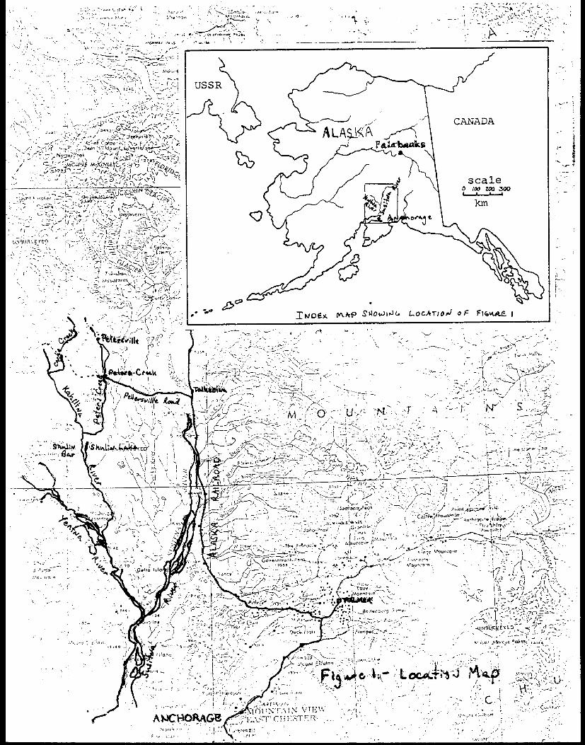
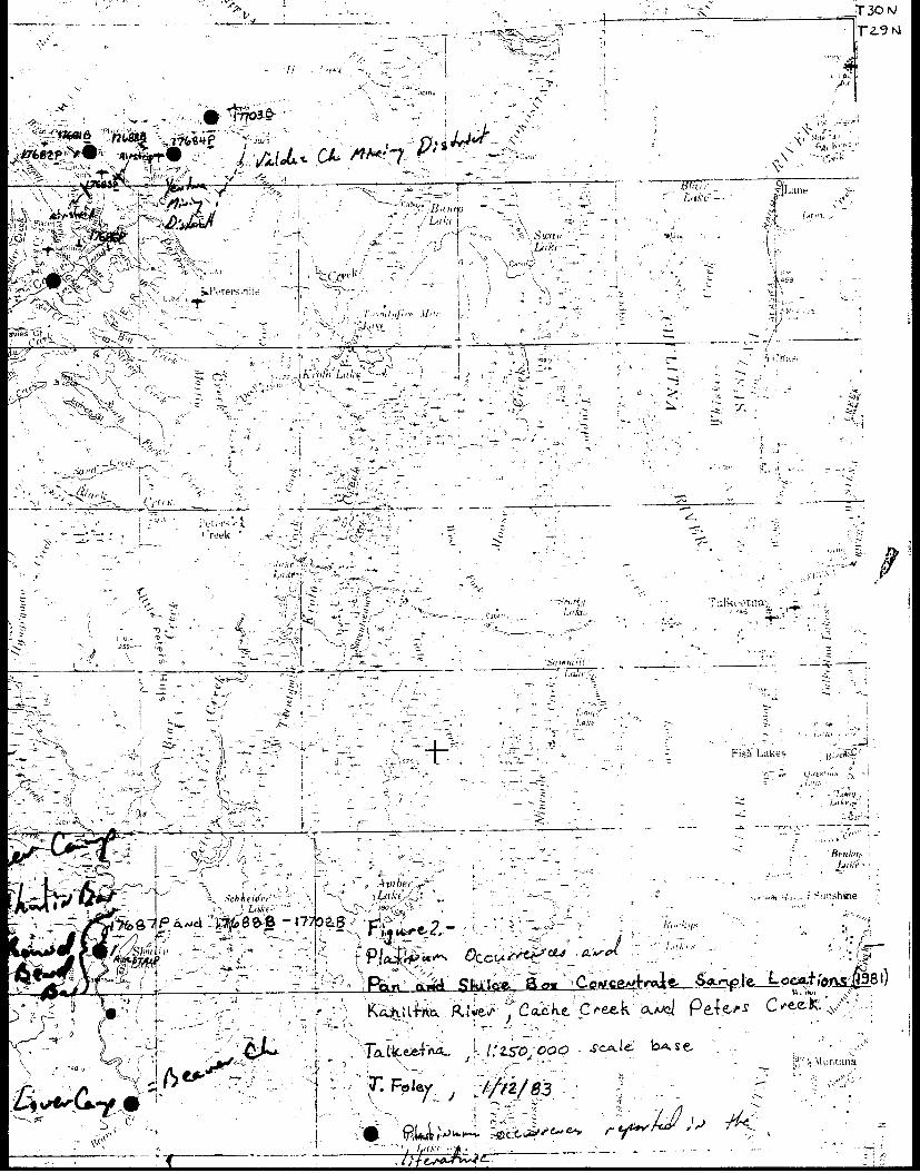
FIGURE 1. Location map...................................
FIGURE 2. Platinum occurrences and pan and sluice box
concentrate sample locations (1981).........................
TABLES
1. Pan and sluice concentrate samples from
Cache Creek and Peters Creek................................
2. Pan and sluice box concentrate samples from
Shulin Bar, Kahiltna River. ............. ........
SAMPLING FOR PLATINUM IN THE YENTNA nISTRICT, ALASKA
By Jeffrey Y. Foleyl
INTRODUCTION AND SUMMARY
The Bureau of Mines Alaska Field Operations Center (AFOC) is currently
investigating reports of platinum in the state. Numerous reports of
platinum metals in placer gold concentrates from the Yentna Mining
District are contained in the literature (l17).2 Among these are refer-
ences to occurrences in the Peters Creek-Cache Creek area and occur-
rences in the Kahiltna River area (fig. 1).
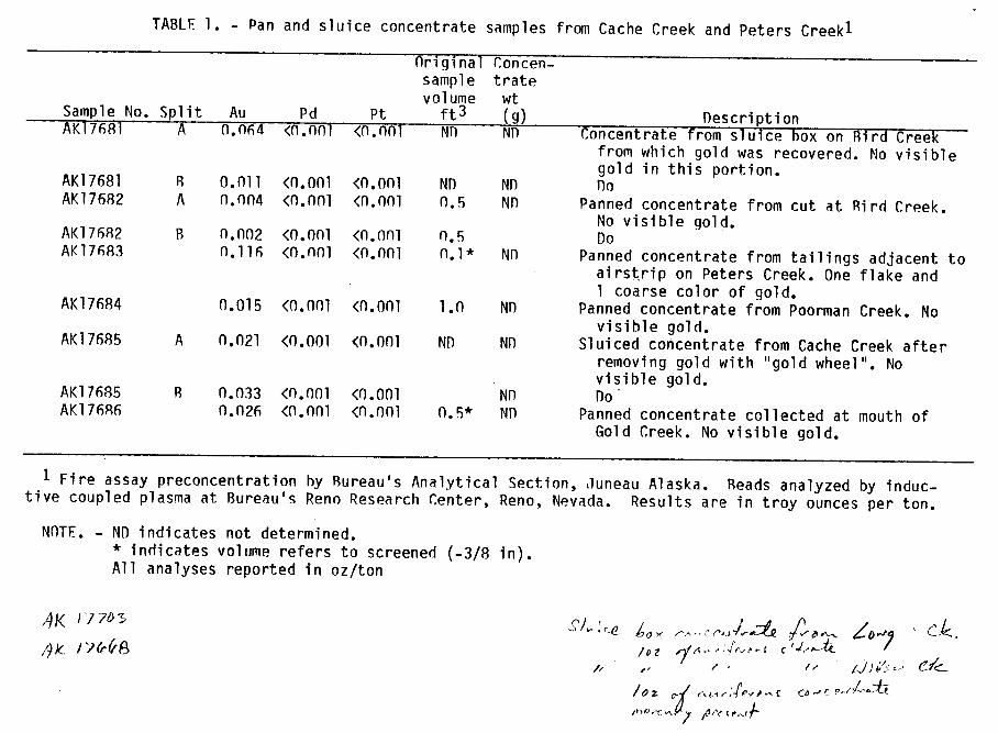
Pan concentrate samples were collected in the Peters Creek - Cache
Creek area and from Shulin Bar on the Kahiltna River by the writer.
Sluice box concentrates were donated by miners working in these areas.
All samples were analyzed for gold, platinum and palladium by the
Bureau's Reno Research Center. Gold concentrations ranged from
<n.nnn2 oz/ton to 0.605 oz/ton, however, no platinum or palladium
were detected.
The Peters Creek, Cache Creek and upper Kahiltna River areas are
accessible by the Petersville Road (fig. 1 and 2) during dryer summer
months. There are landing strips on the east and west sides of Peters
Creek near the mouth of the canyon. The lower Kahiltna River is access-
ible by a landing strip at Shulin Lake (fig. 1 and 2). The Kahiltna
1 Geologist, U.S. Bureau of Mines, AFOC, Fairbanks, Alaska2 Underlined numbers in parentheses refer to items listed in the
references at the end of this report.
River is navigable downstream from the mouth of Peters Creek during the
summer months.
PETERS CREEK - CACHE CREEK AREA
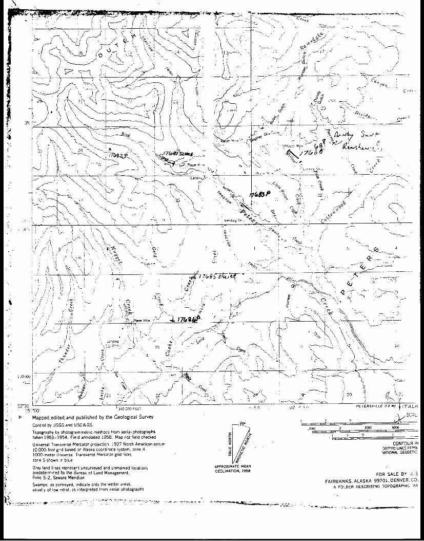
Three days were spent by the writer in the Peters Creek and Cache Creek
area during Jluly, 1981. Pan concentrate samples were collected from
Gold Creek, Bird Creek and Poorman Creek (fig. 2 and table 1). Sluice
box concentrates were donated by operators on Cache Creek and Bird Creek
(fig. 1 and table 1). No platinum or palladium were detected in any of
the samples collected but any platinum metals present in the sluice box
concentrates were probably removed with the gold during cleaning. The
pan concentrates were derived from volumes ranging from 3 to 6 pans
(screened).
Peters Creek, Cache Creek and most of their tributaries have been
mined recently by conventional bulldozer, loader and sluice box methods,
and mining continues on most of them.
CU
~~
0 4
WV
C
Q
*J 1.
O0)..-
0) C
C
4 4-
( -)o
L.
0
£
*U
>
-I.
U
*
v V-I
v r
nU0)
-s C
.C
C
>
4'
<
4 C
.)
=
4- *-
LJ
o X
~t~ )
0)
*_ a)
C >
4-3
E
4
0) *
C
>, (L
i00
0 0
0O~)
0 4g-)
CM
-~~
~~
C
0)~~
~-r
u- 4
CC
C
- )
*
a)U
Ln 0
(L)D
E
0
m0aJ
XO
0) .L
L.
E
E
C
E
ocn
L
N
-C
) 04
'C
0 u
0 o
L
=
*-n 4-
4) Q
- (A
L
. L
m
L
C
O-_
c
a) ._
=
tU-C
o 4-
4 '(
o _.-U
S
-c6.C
L- 3U
- L
4U
a)
.-
.U
v
C>
C
v L
0 )*
0 a)
4) .-
a) >
cc
r~
~~
~~
~~
~~
~~
~~
~~
~-
v-r 4J
4- 4-
ww
3:
4- C
D
;c
CJ ~~~~~~~E
_
L
Q
u
m UE
:
Lt
L
*.O-O0
L. E EL
-LE
4oo V0
*)
-U V
7 04
C
4LD
-4O C
C
-V
4-0
4-)
*
.-cnC
LC
C
C
0 C
- C
*
a) ,
0) c
c4- a
£ o o o ut
cn- O
U
a C
A
U(/
4 L
0) *
L)0)C
C
M
) 0)>
(
U)
W
O
*_ -~
4
)C
CC
- Q
C
O
m
C
a)'C
,-0. C
0-_O-_
0 ,
a C a
LC
S O
¢
C
C
LO
30
O
*4- )
*
L
LQ
t*_Q _(
-~~
~~
~
*'-
C~
~~
~~
~~
~
L CC~
-0)
.-
C
.n
")
0) 0)
*4-'
U.-
U4'
U
O'C
>
-0 U
0)
4L
C-.'.,-
E
C.>
'a
Cn
0O)
.- -
Ofu
O
C
- O
C
C
o
O
C-
aI- *-r
oC
o
CU
* ,
0) 4-) W
-"'~
C
=C
C
Z
C
>
L-
>
.=
a
CD
O
0>
OflC
'V
. _ )0-V
5
oE0)0.-
0a C
) 0,-
CL
C
)
U
4..0.
0.
0.
c/ 0
IL)
C
0)
£4- C
C
0. M
C
' 4-
Z0)
CC
C
C
C
C/-)
n:
C
L 4
-..
U)
ea *
a (U
~~~~~~~U
0) cV
)0 -t
4c * ._
u0
OI-
C.~
Y
C
~ -
CL
~ 4)-
UV
_
C4-)C
C
*
.*
*
C
*
>tCL
50 E
-£- t
:C
C
C
_ z
C
_-W
4-) '-'VO~4-
C
C
C
L
U)>
C
0)
0) C
.<
.
C
c _
--_-
_ _
_ -_
v L
0)
C
O
C
CC
C
C
C
C
C
C
C
C4C
L
U
4-'C
C
C
C
C
C
C
C
C
0) U
' CC
L
*
*
.*
.*
*
*
*'
U)
U)
._cC
I)V
0-
-c -
--
y-
---
C
C
LA
U)
C
CC
C
C
C
O
CC
>
0)
.- L
C
v C
C
C
C
C
C
C
C
C
o
cC
E
-*-V
... *
*
.*
-*
*
*
*
L 4-
cCC
C
C
C
C
C
C
C
C
c 0 )
0)0 VIV
V
"V
\.'
V
V
'V
C
v o-
w
L0)
C
t .
er
N
T
S _
v7 tc
4
-)tV
00) 4L
IV
r-~~
~~
~~
~~
~~
~~
~~
~~
C\)d
k)
Cm
)I.C
VV
a)
E C
0m.
.-C
C-
_n cL..
LL
4-)0.
: C
C
C
C
- C
C
C
C
4-'=
o-<
I: *
.* *
L
.-
*
C2
C
CL
C
CC
C
C
C
C
CC
)
>*)
Q4
- U
0
m
CIV
L (n)0<
=
L m
:c
C
t C
X
a-p
.C C
*
>,0
*_ C
-0 C
U
): C
C
C
0 C
: <
C
L
C
Y
-
-.
C
kc
(c#C kc
k '.0
0..C
t"
'r
r- r-- r---
-r
-. r-r---
0 IN
E
---- --
--
L. C
-
m
~~~e N
e I--,
!:z -1Z
LL
I
V)
<
<
<
<
<
<
<
<
<
U0)
Cvl
'-4>
Z
._)
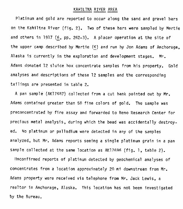
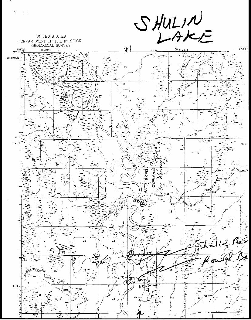
KAHILTNA RIVER AREA
Platinum and gold are reported to occur along the sand and gravel bars
on the Kahiltna River (fig. 2). Two of these bars were sampled by Mertie
and others in 1917 (6, pp. 262-3). A placer operation at the site of
the upper camp described by Mertie (6) and run by Jon Adams of Anchorage,
Alaska is currently in the exploration and development stages. Mr.
Adams donated 12 sluice box concentrate samples from his property. Gold
analyses and descriptions of these 12 samples and the corresponding
tailings are presented in table 2.
A pan sample (AK17687) collected from a cut bank pointed out by Mr.
Adams contained greater than 5n fine colors of gold. The sample was
preconcentrated by fire assay and forwarded to Reno Research Center for
precious metal analysis, during which the bead was accidentally destroy-
ed. No platinum or palladium were detected in any of the samples
analyzed, but Mr. Adams reports seeing a single platinum grain in a pan
sample collected at the same location as AK17696 (fig. 1, table 2).
Unconfirmed reports of platinum detected by geochemical analyses of
concentrates from a location approximately 20 mi downstream from Mr.
Adams property were received via telephone from Mr. Jack Lewis, a
realtor in Anchorage, Alaska. This location has not been investigated
by the Bureau.
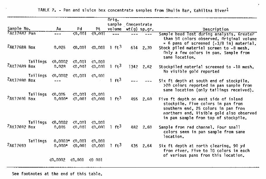
TABLF 2. - Pan and sluice box concentrate samples from Shulin Bar, Kahiltna Riverl
Orig.sample Concentrate
Sample No. Au Pd Pt volume wt(g) sp.gr. Description7AK17687 Pan --- <0.nn0 <n.no0 --- Sample bead lost during analysis. Greater
than 50 colors observed. Original volume= 6 pans of screened (-3/8 in) material.
2AK17688 Box 0.025 <0.o0l <0.nol 1 ft3 614 2.70 Stock piled material screen to -8 mesh.Only a few colors in pan. Sample fromsame location.
Tailings <0.0002 <0.001 <0.0012AK17689 Box 0.n28 <0.nn0 <0.0n0 1 ft3 1342 2.62 Stockpiled material screened to -18 mesh.
No visible gold reportedTailings <0.0002 <0.001 <0.001
2AK1769n Box --- 1 ft 3 --- --- Six ft depth at south end of stockpile.>2n colors reported in pan sample fromsame location (only tailings received).
Tailings <0.005 <0.o0l <n.on12AK17691 Box n.0nn* <0.0nl <0.n0l 1 ft3 455 2.60 Five ft depth on east side of inland
stockpile. Five colors in pan fromsouthern end, 25 colors in pan fromnorthern end. Visible gold also observedin pan sample from top of stockpile.
Tailings <0.0002 <0.001 <0.0012AK17692 Box n.005 <n.nol <n.nn0 1 ft3 482 2.60 Sample from red channel. Four small
colors seen in pan sample from samelocation.
Tailings 0.on03* <0.001 <0.0012AK17693 n.n0n* <0.nol <0.ool 1 ft3 435 2.64 Six ft depth at north clearing, 90 yd
from river. Five to 10 colors in eachof various pans from this location.
<0.0002 <0.001 <0 001
See footnotes at the end of this table.
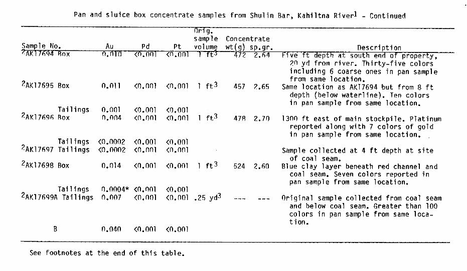
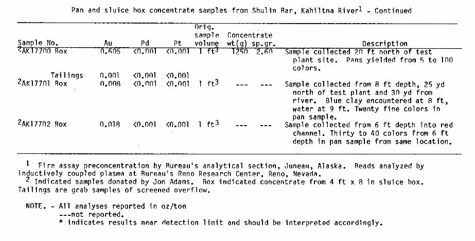
Pan and sluice box concentrate samples from Shulin Bar, Kahiltna Riverl - Continued
Orig.sample Concentrate
Sample No. Au Pd Pt volume wt(g) sp.gr. Description2AK17694 Box n.nin <n.n01 <0.on0 1 ft3 47? 2.64 Five ft depth at south end of property,
2n yd from river. Thirty-five colorsincluding 6 coarse ones in pan samplefrom same location.
2AK17695 Box n.0l1 <0.0n0 <0.001 1 ft3 457 2.65 Same location as AK17694 but from 8 ftdepth (below waterline). Ten colorsin pan sample from same location.
Tailings 0.001 <0.001 <0.0012AK17696 Box n.n04 <0.0n0 <0.onl 1 ft3 478 2.70 l3nn ft east of main stockpile. Platinum
reported along with 7 colors of goldin pan sample from same location.
Tailings <0.0002 <0.001 (0.0012AK17697 Tailings <(.n0n2 <0.n0l <n.nnl Sample collected at 4 ft depth at site
of coal seam.2AK17698 Box 0.014 <0.001 <0.001 1 ft3 524 2.60 Blue clay layer beneath red channel and
coal seam. Seven colors reported inpan sample from same location.
Tailings 0.0004* <0.001 <0.0012AK17699A Tailings n.007 <0.n0l <0.0Ol .25 yd3 --- --- Original sample collected from coal seam
and below coal seam. Greater than 100colors in pan sample from same loca-tion.
B n.04n <0.0nl <0.ool
See footnotes at the end of this table.
Pan and sluice box concentrate samples from Shulin Bar, Kahiltna Riverl - Continued
Orig.sample Concentrate
Sample No. Au Pd Pt volume wt(g) sp.gr. Description6AK177no Box 0.605 <0.nnl <n.0o0 1 ft3 1210 2.6n Sample collected 2n ft north of test
plant site. Pans yielded from 5 to 100colors.
Tailings 0.001 <0.001 <0.0012AK177nl Box 0.nn8 <0.n0l <0.0ol 1 ft3 --- Sample collected from 8 ft depth, 25 yd
north of test plant and 3n yd fromriver. Blue clay encountered at 8 ft,water at 9 ft. Twenty fine colors inpan sample.
2AK17702 Box O.Ol8 <0.001 <0.001 1 ft3 --- Sample collected from 6 ft depth into redchannel. Thirty to 40 colors from 6 ftdepth in pan sample from same location.
1 Fire assay preconcentration by Rureau's analytical section, Juneau, Alaska. Reads analyzed byinductively coupled plasma at Bureau's Reno Research Center, Reno, Nevada.2 Indicated samples donated by Jon Adams. Box indicated concentrate from 4 ft x 8 in sluice box.
Tailings are grab samples of screened overflow.
NOTE. - All analyses reported in oz/ton---not reported.* indicates results near detection limit and should be interpreted accordingly.
RECOMMENDATI ONS
The potential for significant gold-platinum placer resources still
exists in the Yentna Districe in spite of the negative results
obtained during this investigation.
It is recommended that additional sluice concentrate samples be
obtained. These samples might be obtained from local miners. Where
samples are warranted but no mining is taking place bulk concentrate
samples Xsould be collected by the Bureau, using a 6 in suction dredge
and sluice box to increase sample size and to enhance recovery of any
platinum metals present.
REFERENCES
1. Brooks, A. H. and others. Mineral Resources of Alaska, report
on progress of investigations in 1911. U.S. Geol. Survey Bull. 520,
1912, 360 pp.
2. Clark, A. L. and C. C. Hawley. Reconnaissance Geology, Mineral
Occurrences, and Geochemical Anomalies of the Yentna District, Alaska.
U.S. Geol. Survey OFR 68-3q, 1968, 64 pp.
3. Cobb, E. H. Placer Deposits of Alaska. U.S. Geol. Survey Prof.
Paper 1374, 1973, 213 pp.
4. Hawley, C. C. and Associates. Mineral Appraisal of Lands Adjacent
to Mt. McKinely National Park, Alaska. Prepared for IJ.S.-BuMines,
Contract J01661in7, lQ7R, 2 parts.
5. Martin, G. C. and others. Mineral Resources of Alaska, report on
progress of investigations in 1917. U1.S. Geol. Survey Bull. 692, 1919,
408 pp.
6. Mertie, J.R. Platinum-Rearing Gold Placers of the Kahiltna Valley.
U.S. Geol. Survey Bull. 692, 1919, pp. 233-264.
7. . The Economic Geology of the Platinum Metals. U.S. Geol.
Survey Prof. Paper 630, 1969, 120 pp.
8. Reed, B. L. and S. W. Nelson. Geologic Map of the Talkeetna
Quadrangle, Alaska. U.S. Geol. Survey Misc. Field Studies Map MF-870-A,
1977, 1 plate.
9. Reed, R. L. and others. Mineral Resource Map of the Talkeetna
Quadrangle, Alaska. U.S. Geol. Survey Misc. Field Studies Map MF-870-D,
1978, 1 plate.
\ .,;M MK LE-,, r
r H t O-/X scale
<~~~~~~~~~~~~~~~~~~~~~~~o wou awo
S b -0 ;@ v S < ; v
S~~~~~~~~~~~~~~~~~~~~~~~iox 240ii '~CTO, oF 'of IX
~~~~10 C tA~iLah ~f p4pz
( .. ''t^,z t ,, ;4 - 11 - .- VTCEW-
g ~AWI-ORA GGE ~, ' .' s >lr
30 NJ
-4
84P
�7 �Bq if(Lak(J�j
Su
-A,;%,Petersmile
mim .1fil,
arv es C�--�7
Co" J,:,'7
eek
Ta� -eovml�.
2,
741
"4�
hav,
71�
F' Ii Lake�- k4-
�A,v
4
Amber.,-Schpoder
��mshirie�Lake-- 380
IB 177DP-s jdf
OC 4A
UsK��K 14� k 0"xI pe-tie--'s e-
ZS 0040 Sc-A., -Montana
Fa fa�7
/'okcLit
35'
| .. 14 X ef :;~~~~~~~~~- -~ -' .-- - -
7 ' __ -X :- _X.
8~ ~ ~ i- , r -, N , -'i i<2
//-~~~~~~- .5 kE K x0 0 f /lr s ;
T-~~~~~~~~~~~~~~~~~~~~~~~~~~~~~~~~~
k~~~~~~~~~~ ,¢, C'-' <1 .. _C
mL nX1 5 \-A
V (~~~M"- 109
FEE. 1 -, / W r \ -& \ ; v <120 - 3
* > *<_UtQ f~~~~~~7 d j -/2/ 0\U' ',j>- \ _ _- 2
ISI 00 340 000 FEET , 9 2, 50 ;a PETERSVILLE o 2PruMg JTA LKtahen 1953-1954. Fieid annotated 1958. Map not f1ield c
zone 5 shown in blue /5'- 1
-V I,~ ~ ~~~~~~~~~~-
Gray ladlnsrpeetusree n nakdlc tin APPOXI A MA
^-1, , r .- , -*' h -
FEE! -C't -K
55,3 -V ~~~~~~~~~~~~~~~~ ~~~~~ e.. - 5, .5 ~ ~ ~ ET RS ILE0.? !1 'T L
V ND~~~~~~~~~. - 3 ~~~~~~~~~~~~~K>- -'- 3000 00 60Topography by__ot___mmeri ethos frm aeial hotoraph
zone show innblue
Swa ps a potrye, ndiat oly hewete areas.- ~usualy f lw rlie, asintrprtedfro aeial hotgrahs FODERDESCIBIG TPOG APHC M
/ .5~~~~~~~:
UNITED STATES
GEOLOGICAL SURVEY
151T 605000m E. yR 0 RO P8W fTALk-62'15'
z-~~~~~~~~~~~~~~~~~~~~~~~~~~~~~~~~~~~~~~~~~~~~~~~-
6903000m. N.I
P757
-I~~~~~~~~~~~~~~~~~~~~~3.7~~~~2
710~~~~~~~~~~~~~~~~~~~~~~~~~~~~~~~~~~~~~~~~~~~0
8 - 12' 8~~~~~~~~~~~~~~~~~~~~~~~~~~~~~~~~~~~8
_ _ _ _ _ _ _ j -- 2,~~~~~~~~~~~ I_ -