royal borough of kensington and chelsea ... requirements 6th...royal borough of kensington and...
TRANSCRIPT

1
ROYAL BOROUGH OF KENSINGTON AND CHELSEA
SUBMISSION REQUIREMENTS FOR PLANNING APPLICATIONS
6th April 2015
The following table is a comprehensive list of the potential submissions you may need to make in order for the Royal Borough to be able to
process your planning application successfully. This document is divided into three sections – do read through all three parts carefully.
The first section sets out the requirements that are obligatory in order for your application to be validated; these are mostly national
requirements, defined by Statutory Instruments.
The second section sets out the local requirements that might well be necessary for the successful processing of your application,
depending upon its precise nature. The matters set out in this section are not needed in order for your application to be validated, but may
be crucial in order to demonstrate that relevant planning policies have been satisfied by your proposals - failing to submit them at the
outset, with your application, could jeopardise what could otherwise be a favourable decision on your application.
The third section contains useful additional explanation guidance for submission of applications.
Should you require further information as to whether your particular proposal requires a certain document, please contact our planning advice
line, ‘PlanningLine’, on 020 7361 3012.

2
SECTION ONE
OBLIGATORY REQUIREMENTS FOR VALIDATION OF APPLICATIONS
We prefer you to submit applications electronically, using the government’s national online ‘Planning Portal’ : the vast majority of our applications are now submitted this way. http://www.planningportal.gov.uk/planning/applications/ When using the Planning Portal, please be aware that the Council will NOT ACCEPT any documents that need to be printed on paper greater than size A3. Please DO NOT submit drawings to us that are not formatted for printing at A3 or less, as your application will be deemed invalid and you will be asked to resubmit in line with our requirements. For applications submitted electronically via The Planning Portal you must adhere to the following guidelines:
1. Submit all necessary documents in one ‘go’.
2. Maximum print size for any drawing of A3. DO NOT submit drawings that have to be printed at A2, A1 or A0, as we will not accept these and
your application will be deemed invalid. For drawings at A2, A1 or A0, please submit the application form online and forward hard copies of
the plans to the department. Please make it clear within your online application that hard copies are in the post.
3. Maximum single attachment file size of 5MB Maximum application file size of 25MB
4. All drawings should be attached as .pdf files (file types for non-drawings are .jpg, .doc and .xls will also be accepted)
5. Ensure all drawings are categorised by type, as presented on the Portal
If any of the necessary information listed in SECTION ONE is absent, then you should expect that your application will NOT BE VALIDATED.
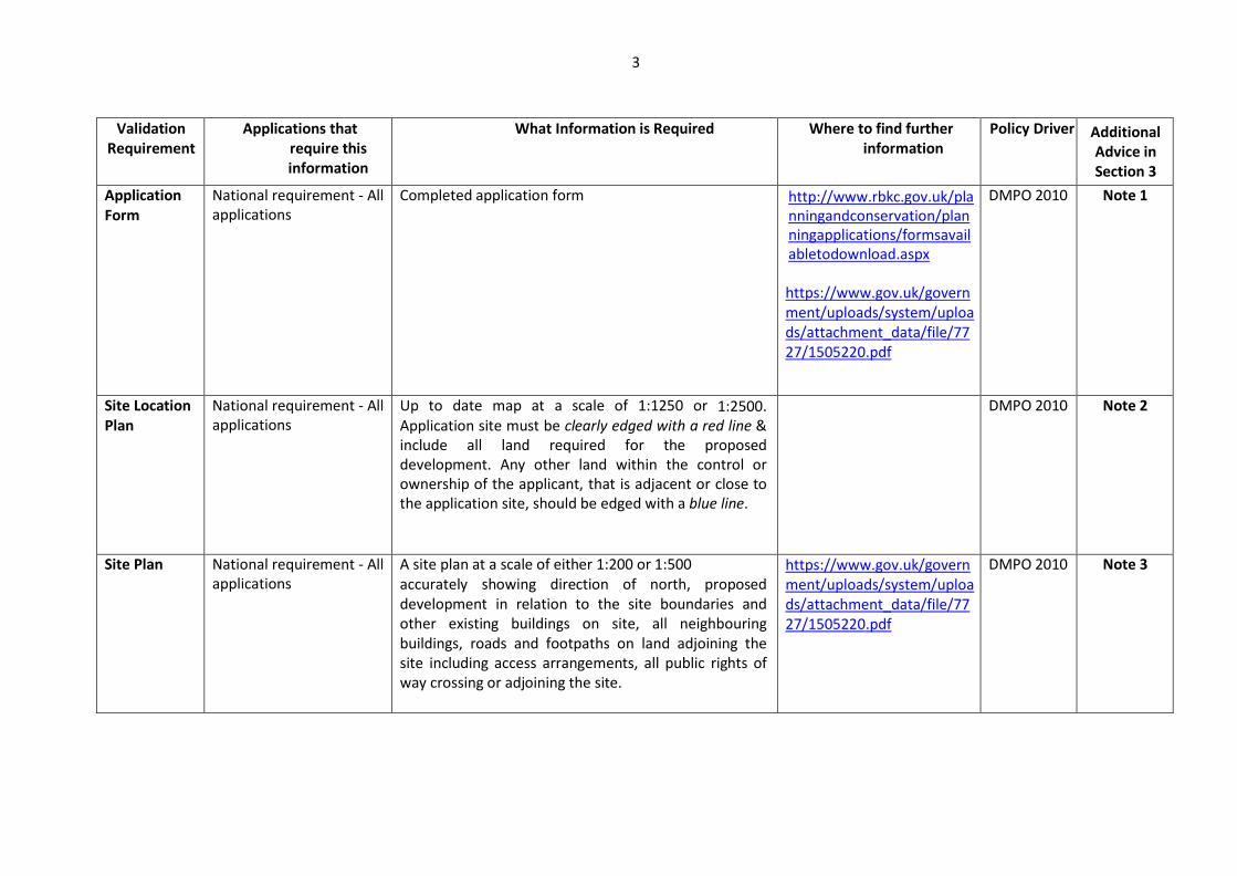
3
Validation Requirement
Applications that require this information
What Information is Required Where to find further information
Policy Driver Additional Advice in Section 3
Application Form
National requirement - All applications
Completed application form http://www.rbkc.gov.uk/planningandconservation/planningapplications/formsavailabletodownload.aspx
https://www.gov.uk/government/uploads/system/uploads/attachment_data/file/7727/1505220.pdf
DMPO 2010 Note 1
Site Location Plan
National requirement - All applications
Up to date map at a scale of 1:1250 or 1:2500. Application site must be clearly edged with a red line & include all land required for the proposed development. Any other land within the control or ownership of the applicant, that is adjacent or close to the application site, should be edged with a blue line.
DMPO 2010 Note 2
Site Plan National requirement - All applications
A site plan at a scale of either 1:200 or 1:500 accurately showing direction of north, proposed development in relation to the site boundaries and other existing buildings on site, all neighbouring buildings, roads and footpaths on land adjoining the site including access arrangements, all public rights of way crossing or adjoining the site.
https://www.gov.uk/government/uploads/system/uploads/attachment_data/file/7727/1505220.pdf
DMPO 2010 Note 3

4
Validation Requirement
Applications that require this information
What Information is Required Where to find further
information Policy Driver Additional
advice in Section 3
Existing and Proposed Elevations
National requirement - All applications that involve the creation of new or changes to external aspects of the property
Drawings at a scale of 1:50 or 1:100 (1:50 often preferable), illustrating all relevant external parts. Show existing and proposed elevations beside each other if possible. Where a proposed elevation adjoins another building, or is in close proximity, the drawing should clearly show the relationship between the buildings & detail the relative positions of openings, parapets, levels etc on each property. Blank elevations should also be included for clarity. All drawings must include a scale bar showing lengths of 1m and 10m, and key dimensions
https://www.gov.uk/government/uploads/system/uploads/attachment_data/file/7727/1505220.pdf
DMPO 2010 Note 4
Existing and Proposed Floor Plans
National requirement - All applications that involve the creation of new or changes to the floor plans of a property
Drawings at a scale of 1:50 or 1:100 showing floorplans of the existing buildings & the proposed building, identifying each relevant floor/ part floor, roof, and means of access. Where existing buildings or walls are to be demolished, these should be clearly shown. The proposed plans should be shown in context with the site boundary and any existing adjacent buildings. Applications for change of use need to be accompanied by floor plans, annotated where helpful, to indicate the extent of the existing and proposed use within the land or building
All drawings must include a scale bar showing lengths of 1m and 10m, and key dimensions
DMPO 2010 Note 4

5
Validation Requirement
Applications that require this information
What Information is Required Where to find further
information Policy Driver Additional
advice in Section 3
Existing and Proposed Section Drawings
National requirement - Where a proposal involves a change in ground levels, a change in height, on sloping sites, or sites involving different levels such as lower ground floors or basements, with lightwells and garden levels often best shown in section.
Drawings at a scale of 1:50 or 1:100 (1:50 often preferable) showing cross-sections through the proposed buildings containing details of existing site levels, and finished floor levels with the levels related to a fixed datum point off-site, and showing the proposals in relation to adjoining buildings. Use spot levels and cross/long sections as necessary. Annotation may be very useful. All drawings must include a scale bar showing lengths of 1m and 10m, and key dimensions
https://www.gov.uk/government/uploads/system/uploads/attachment_data/file/7727/1505220.pdf
DMPO 2010 Note 4
Appropriate Fee
National requirement - Any application that requires a fee to be paid – please see the current fee regulations (Nov 2012 onwards) available at http://www.planningportal.gov.uk/uploads/english_application_fees.pdf
Full payment at the time of submission by cash, cheque, debit or credit card
Cheques made payable to RBKC A Covering letter is very useful.
https://www.gov.uk/government/uploads/system/uploads/attachment_data/file/7727/1505220.pdf
DMPO 2010 Note 5
Design and Access Statement (DAS)
National requirement. Recently the need for these has been reduced to apply only to certain applications – see Note 6 for details.
Report to illustrate the process that has led to the finally submitted development proposal, explaining the approach, justification, and detail of the design, and to describe the standards of accessibility that would be designed into the development.
https://www.gov.uk/government/uploads/system/uploads/attachment_data/file/7727/1505220.pdf
http://webarchive.nationalarchives.gov.uk/20110118095356/http:/www.cabe.org.uk/publications/design-and-access-statements
DMPO 2010 Note 6
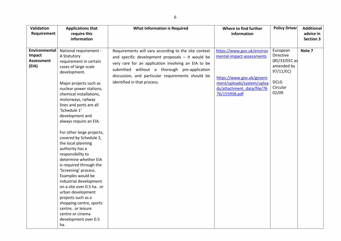
6
Validation Requirement
Applications that require this information
What Information is Required Where to find further information
Policy Driver Additional advice in Section 3
Environmental Impact Assessment (EIA)
National requirement - A Statutory requirement in certain cases of large scale development.
Major projects such as nuclear power stations, chemical installations, motorways, railway lines and ports are all ‘Schedule 1’ development and always require an EIA.
For other large projects, covered by Schedule 2, the local planning authority has a responsibility to determine whether EIA is required through the ‘Screening’ process. Examples would be industrial development on a site over 0.5 ha. or urban development projects such as a shopping centre, sports centre, or leisure centre or cinema development over 0.5 ha.
Requirements will vary according to the site context
and specific development proposals – it would be
very rare for an application involving an EIA to be
submitted without a thorough pre-application
discussion, and particular requirements should be
identified in that process.
https://www.gov.uk/environmental-impact-assessments https://www.gov.uk/government/uploads/system/uploads/attachment_data/file/7676/155958.pdf
European Directive (85/33/EEC as amended by 97/11/EC) DCLG Circular 02/09
Note 7
7
SECTION TWO
INFORMATION LIKELY TO BE NEEDED IN ORDER FOR YOUR APPLICATION TO BE ASSESSED BY THIS AUTHORITY
If the information listed in SECTION TWO is not submitted, or is submitted but in inadequate form, but is found by the planning authority to be
necessary to demonstrate relevant policies have been satisfied, then your application will usually be refused.
The onus is upon an applicant to demonstrate that a key policy has been satisfied, or a certain key consideration properly addressed. It is important to
remember “Failure to demonstrate that………...” is a common Reason for Refusal, and normally an avoidable outcome. It should be an unnecessary cost and
frustration to both applicants and neighbours for an application to have to be refused because drawings or other documents are either inadequate, or
absent.
If you think certain documents are not required to accompany your application then please provide a brief explanation as why in your submission. This
information has been prepared having regard to Communities and Local Government ‘Guidance on information requirements and validation’ and
‘Development Management Policy Annex: Information requirements and validation for planning applications’ both of March 2010.
If you received pre-application advice through the planning Advice Service then it would be worthwhile to run over your pre-application advice letter again,
to ensure any recommendations within it regarding information needed to assess an application have not been overlooked. If any pieces of advice in the
pre-application letter have not been followed, then this would put your application at risk unless a convincing justification is presented as to why.
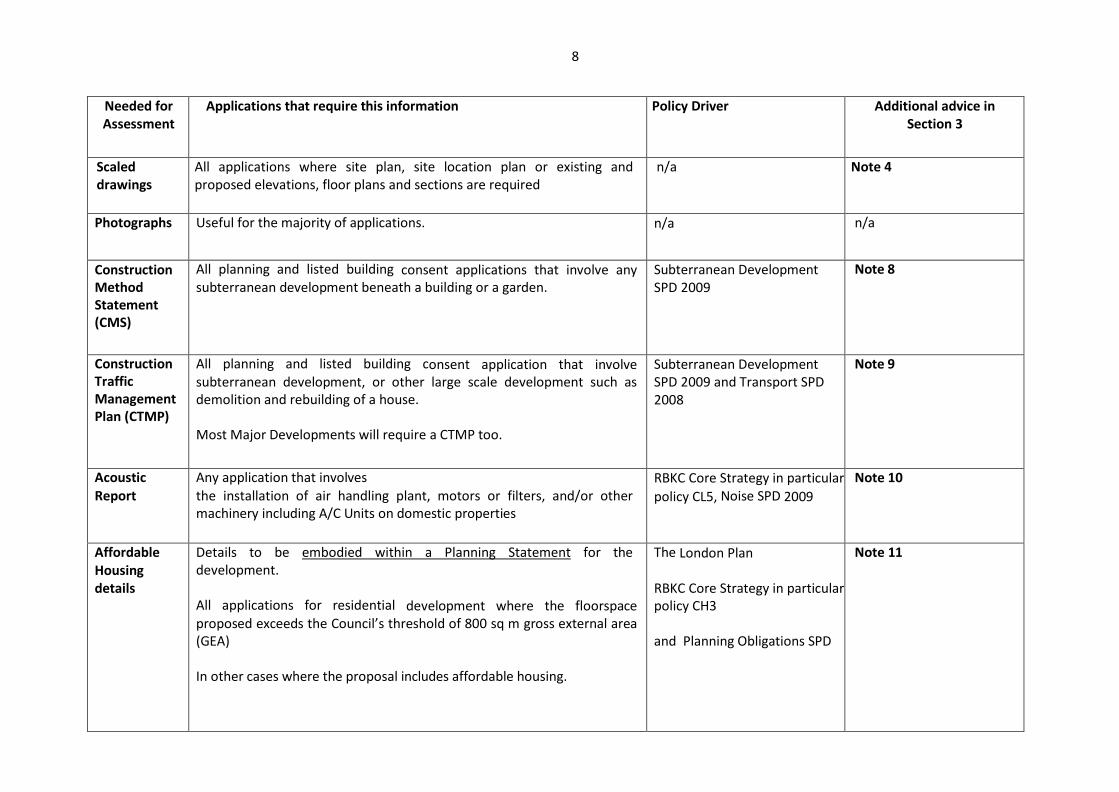
8
Needed for Assessment
Applications that require this information Policy Driver Additional advice in Section 3
Scaled drawings
All applications where site plan, site location plan or existing and proposed elevations, floor plans and sections are required
n/a Note 4
Photographs Useful for the majority of applications. n/a n/a
Construction Method Statement (CMS)
All planning and listed building consent applications that involve any subterranean development beneath a building or a garden.
Subterranean Development SPD 2009
Note 8
Construction Traffic Management Plan (CTMP)
All planning and listed building consent application that involve subterranean development, or other large scale development such as demolition and rebuilding of a house. Most Major Developments will require a CTMP too.
Subterranean Development SPD 2009 and Transport SPD 2008
Note 9
Acoustic Report
Any application that involves the installation of air handling plant, motors or filters, and/or other machinery including A/C Units on domestic properties
RBKC Core Strategy in particular
policy CL5, Noise SPD 2009
Note 10
Affordable Housing details
Details to be embodied within a Planning Statement for the development. All applications for residential development where the floorspace proposed exceeds the Council’s threshold of 800 sq m gross external area (GEA)
In other cases where the proposal includes affordable housing.
The London Plan RBKC Core Strategy in particular policy CH3 and Planning Obligations SPD
Note 11
9
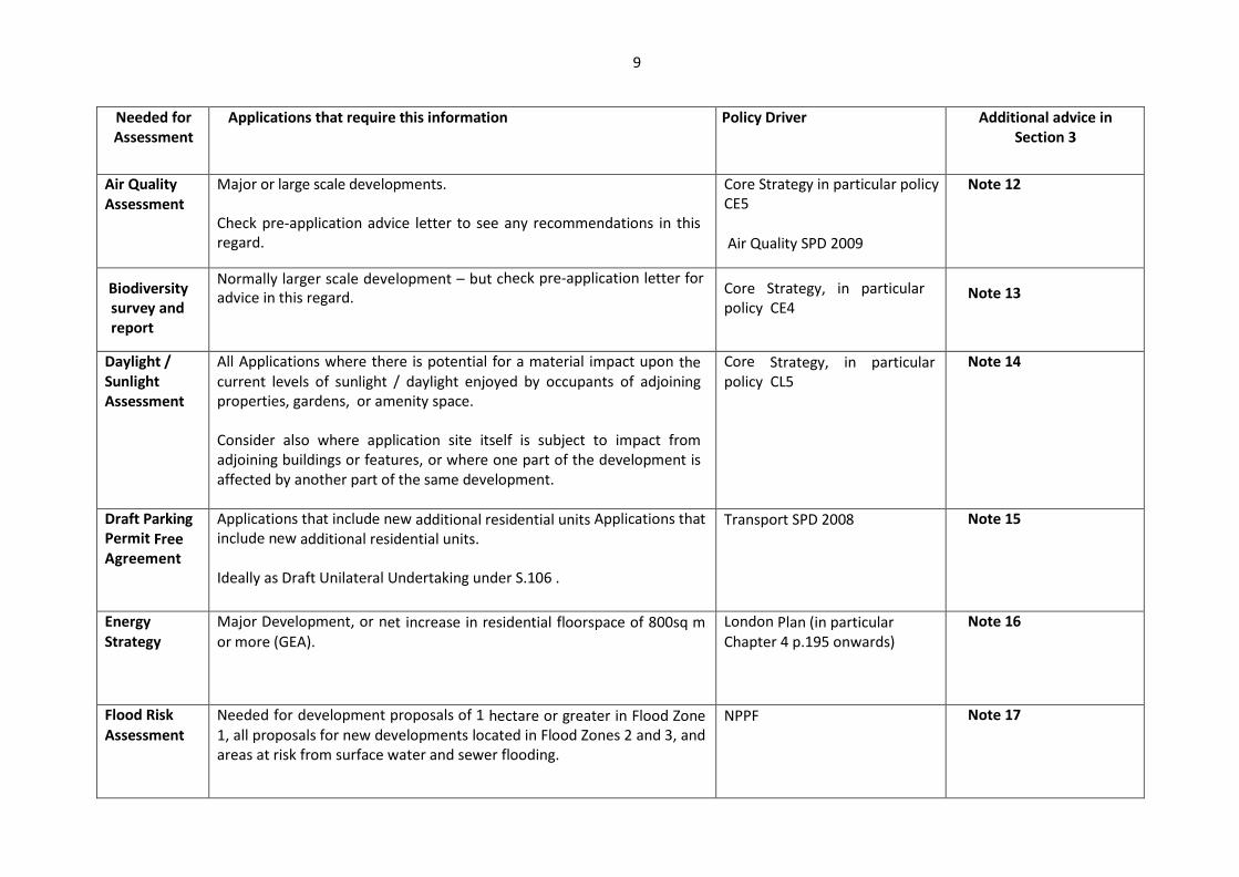
Needed for Assessment
Applications that require this information Policy Driver Additional advice in Section 3
Air Quality Assessment
Major or large scale developments. Check pre-application advice letter to see any recommendations in this regard.
Core Strategy in particular policy CE5
Air Quality SPD 2009
Note 12
Biodiversity survey and report
Normally larger scale development – but check pre-application letter for advice in this regard.
Core Strategy, in particular policy CE4
Note 13
Daylight / Sunlight Assessment
All Applications where there is potential for a material impact upon the current levels of sunlight / daylight enjoyed by occupants of adjoining properties, gardens, or amenity space. Consider also where application site itself is subject to impact from adjoining buildings or features, or where one part of the development is affected by another part of the same development.
Core Strategy, in particular policy CL5
Note 14
Draft Parking Permit Free Agreement
Applications that include new additional residential units Applications that include new additional residential units. Ideally as Draft Unilateral Undertaking under S.106 .
Transport SPD 2008 Note 15
Energy Strategy
Major Development, or net increase in residential floorspace of 800sq m or more (GEA).
London Plan (in particular Chapter 4 p.195 onwards)
Note 16
Flood Risk Assessment
Needed for development proposals of 1 hectare or greater in Flood Zone 1, all proposals for new developments located in Flood Zones 2 and 3, and areas at risk from surface water and sewer flooding.
NPPF Note 17

10
Needed for Assessment
Applications that require this information Policy Driver Additional advice in Section 3
Floorspace Schedule
Applications for the creation of new residential units, also very useful to present floorspace details in retail development.
London Plan, and Core Strategy Policy CH2
Note 18
Heritage Statement / Archaeological Survey
Applications that affect any heritage asset and applications that involve development which will lead to intrusive ground works in an area identified as being of known archaeological interest, potential archaeological importance, or affecting nationally important remains, whether scheduled or not.
Core Strategy Policies CL1, CL2, CL3 and CL4 NPPF (in particular Chapter 12, page 30)
Note 19
Contaminated Land Assessment
All new development with a sensitive end use, a minimum of a Preliminary Risk Assessment (PRA) will be required regardless of the history of the site, contaminated or otherwise. All new developments on adjoining land.
NPPF Part 2A of Environmental Protection Act 1990
Note 20
Planting and Landscaping Details
Applications that involve significant works to outdoor areas (apart from COU & alterations to existing buildings).
Core Strategy Policy CH6 Note 21
Lighting information
All proposals involving provision of publicly accessible space, in the vicinity of residential property, a Listed Building or a Conservation Area, or advertisements, where external lighting would be provided or made necessary by the development.
Core Strategy policy CL2 Note 22
Parking and Access Arrangements
All non-householder applications that would result in loss or increase in parking provision. Applications for change of use, or for new residential units.
Transport SPD 2008 Note 23

11
Needed for Assessment
Applications that require this information Policy Driver Additional advice in Section 3
Planning Contributions: Obligations / Draft Heads of Terms / CIL
Any development that may not be acceptable in planning terms may require an Obligation under S.106 in order to make it acceptable – please see SPD for further information. Liability for the Community Infrastructure Levy (CIL) is capable of being a material consideration. Comprehensive floorspace information must be submitted for the Council to be able to calculate an accurate CIL liability
Planning Obligations SPD 2010 S106 tests in CIL Regulation 122 CIL Charging Schedule CIL Regulation 123 List
Note 24
Planning Statement
Major developments, proposals contrary to policie(s) of the development plan/ Local Development Framework (LDF), and any other situation where approach to certain policies, or rationale behind certain details or approaches, or links to other sites/previous permissions etc, need to be explained. Any application requiring an explanation or justification.
NPPF , Core Strategy various policies And other adopted documents such as SPDs
Note 25
Servicing Management Plan
COU applications to A1 food retail, all commercial developments with off-street servicing and / or where the floor space is greater than 200m2
Transport SPD 2008 Note 26
Site Waste Management Plan
Major Developments Core Strategy Policy CE3 Note 27
Statement of Community Involvement
Major Developments
LDF and NPPF Note 28

12
Needed for Assessment
Applications that require this information Policy Driver
Additional advice in Section 3
Sustainability Assessment
Major Developments – non residential.
Net increase in residential floorspace of 800 sqm or more (GEA) (new build residential) Net increase in residential floorspace of 800 sqm or more (GEA) Subterranean Development
The London Plan
Core Strategy Policy CE1
Subterranean Development SPD Eco-Homes
Note 29
Sustainable Drainage Systems (SuDS) Strategy SuDS report
Major developments Minor development which will increase impermeable surfaces on the site
Core Strategy Policy CE2 (e), NPPF,
Planning Practice Guidance Flood Risk
and Coastal Change, Written
MinisterialSstatement 18th December
2014.
Policy CE2 (e)
Tall Buildings Impact
Assessment
Any application for a new tall building (as defined by the SPD on Building Heights).
London Plan Building Heights SPD 2010
Note 30
Town Centre Impact Assessment
Applications for retail, leisure, office and tourism developments over 2,500 square metres gross floorspace.
Retail, leisure, office and tourism developments below 2,500 square metres which are not in an existing centre. Any development that could significantly affect the vitality of one or more town centres.
Core Strategy policies CK2, CK3, CF1, CF2, CF3, and CF4
Note 31
Transport Assessment
Developments likely to have a significant impact on traffic congestion, transport, or parking.
Transport SPD 2008
Core Strategy policy CT1
Note 32

13
Needed for Assessment
Applications that require this information Policy Driver
Additional advice in Section 3
Travel Plan 30 residential units or more, commercial developments of more than 1000m2 (10,758ft2) gross floor area (GFA), or schools (of any size) and restaurants with more than 100 seats or more than 200m2 (2152ft2) GFA.
Transport SPD (2008)
Core Strategy policy CT1
Note 32
Tree Survey / Arboricultural Implications
Where there are trees within the application site, or on land adjacent to it that could influence, or be affected by, the development (including street trees)
Trees and Development SPD Note 33
Ventilation/ Extraction Details
Applications for use within Use Classes A3, A4, and A5 and any other uses where cooking will take place on a commercial scale or where substantial ventilation or extraction is proposed to be installed. Details also needed for significant retail, business, industrial or leisure or similar developments close to residential properties.
CL5 of Core Strategy Noise SPD
Note 34
14
SECTION THREE – ADVICE NOTES
Between pre-application advice, the table of documents in Sections One and Two, and the further advice presented here in Section Three, you should be clear as to what information you need to submit, and why. If you think certain documents or information might sometimes be useful for assessing similar proposals but in this particular case they do not apply, then make this clear in your covering letter.
If you are choosing to submit your application electronically via the Planning Portal please be aware that the Council will NOT ACCEPT any documents that need to be printed on paper greater than size A3. Please DO NOT submit drawings to us that are not formatted for printing at A3 or less, as your application will be deemed invalid and you will be asked to resubmit in line with our requirements.
NOTE 1 - Completed Application Form
All of the relevant questions should be completed and if not relevant to the application, then the words “Not Applicable” or N/A should be inserted for clarity. Please ensure that the Description of Development is both full and accurate.
Under the 1990 Town and Country Planning Act (read in conjunction with Article 7 of the General Development Procedure Order 1995) all applications for planning permission must be accompanied by the relevant certificates concerning the ownership of the application site. Please ensure you have completed the Ownership Certificate (A, B, C or D as applicable), the Agricultural Holdings Certificate (except for advertisement consent only applications), and the declaration. Ensure you sign and date each of these sections – otherwise, your application is likely to be invalid.
For a certificate an ‘owner’ is anyone with a freehold interest or a leasehold interest the unexpired term of which is not less than 7 years.
• Certificate A must be completed when the applicant is the sole owner of the site. • Certificate B must be completed when all of the owner(s) of the site are known
If Certificate B has been completed notice must be served on all of the owners of the site in question.
• Certificate C must be completed when some of the owners of the site are known but not all.
• Certificate D must be completed when none of the owners of the site are known.

15
The Agricultural Holdings Certificate is required whether or not the site includes an agricultural holding. Please sign part a) if the site is not an Agricultural Holding. Applications through the Planning Portal can be made via: http://www.planningportal.gov.uk/planning/applications/ For applications for ‘prior approval’ for rear extensions outside Conservation Areas under the Town and Country Planning (General Permitted Development) (Amendment) (England) Order 2013 the application form and relevant information can be found on the Planning Portal at: http://www.planningportal.gov.uk/uploads/1app/guidance/guidance_note-larger_home_extension.pdf NOTE 2 - Site Location Plan
All applications must be accompanied by a site location plan based upon an up to date map at a scale of 1:1250 or 1:2500. Where possible the location should show at least two named roads and surrounding buildings identified by road and building number.
The application site must be clearly edged with a red line. It should include all of the land required to carry out the proposed development. Any other land within the control or ownership of the applicant that is adjacent or close to the application site should be edged with a blue line.
Site Location Plans can be obtained from the Central Library. There is a charge for this service. NOTE 3 - Site Plan
All applications should include a site plan at a scale of either 1:200 (Householder Application) or 1:500 (Other Applications). This should accurately show: • The direction of north.
• The proposed development in relation to the site boundaries and other existing buildings on site, with written dimensions including those to the site boundaries.
• All the buildings, roads and footpaths on land adjoining the site including all points of access.
• All public rights of way crossing or adjoining the site.
16
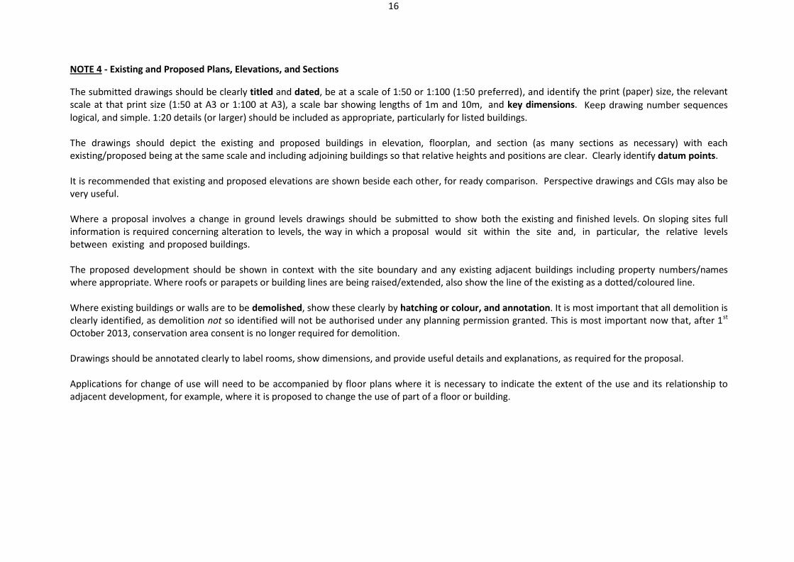
NOTE 4 - Existing and Proposed Plans, Elevations, and Sections
The submitted drawings should be clearly titled and dated, be at a scale of 1:50 or 1:100 (1:50 preferred), and identify the print (paper) size, the relevant
scale at that print size (1:50 at A3 or 1:100 at A3), a scale bar showing lengths of 1m and 10m, and key dimensions. Keep drawing number sequences logical, and simple. 1:20 details (or larger) should be included as appropriate, particularly for listed buildings. The drawings should depict the existing and proposed buildings in elevation, floorplan, and section (as many sections as necessary) with each existing/proposed being at the same scale and including adjoining buildings so that relative heights and positions are clear. Clearly identify datum points. It is recommended that existing and proposed elevations are shown beside each other, for ready comparison. Perspective drawings and CGIs may also be very useful. Where a proposal involves a change in ground levels drawings should be submitted to show both the existing and finished levels. On sloping sites full information is required concerning alteration to levels, the way in which a proposal would sit within the site and, in particular, the relative levels between existing and proposed buildings. The proposed development should be shown in context with the site boundary and any existing adjacent buildings including property numbers/names where appropriate. Where roofs or parapets or building lines are being raised/extended, also show the line of the existing as a dotted/coloured line. Where existing buildings or walls are to be demolished, show these clearly by hatching or colour, and annotation. It is most important that all demolition is clearly identified, as demolition not so identified will not be authorised under any planning permission granted. This is most important now that, after 1st October 2013, conservation area consent is no longer required for demolition. Drawings should be annotated clearly to label rooms, show dimensions, and provide useful details and explanations, as required for the proposal. Applications for change of use will need to be accompanied by floor plans where it is necessary to indicate the extent of the use and its relationship to adjacent development, for example, where it is proposed to change the use of part of a floor or building.
17
NOTE 5 - Appropriate fee
Every application should be submitted with the appropriate fee. You are strongly advised to include a covering letter to explain how you have calculated the fee, or explaining why you think a fee is not required in this instance.
Where it is necessary to pay a fee for the application this can be paid by cash, cheque, or credit/debit card. If paying by cheque, please write the application address clearly on the back of the cheque. All cheques should be made payable to Royal Borough of Kensington and Chelsea. Further information on the correct fee payable for each development can be found at http://www.planningportal.gov.uk/uploads/english_application_fees.pdf NOTE 6 - Design and Access Statement (DAS)
A design and access statement is a short report accompanying and supporting a planning application to illustrate the process that has led to the development proposal, and to explain the proposal in a structured way. The level of detail required in a design and access statement depends on the scale and complexity of the application, and the length of the statement varies accordingly. Statement lengths should be proportionate to the complexity of the application. As of 25th June 2013, Design and Access Statements are required for: (1) development which is ‘major’ development;
(2) all applications for listed building consent
(3) development in a Conservation Area, consisting of —
provision of one or more dwellinghouses; or
provision of any building or buildings where the floor space created by the development is 100 square metres or more.
The design and access statement should cover both the design principles and concepts that have been applied to the proposed development and how issues relating to access to the development have been dealt with. It should:
(i) explain the design principles and concepts that have been applied to the development;

18
(ii) demonstrate the steps taken to appraise the context of the development and how the design of the development takes that context into account;
(iii) explain the approach taken to access, and how policies relating to access in relevant local development documents have been taken into account;
(iv) state what, if any, consultation has been undertaken on issues relating to access to the development and what account has been taken of the outcome of any such consultation; and
(v) explain how any specific issues which might affect access to the development have been addressed.
Access for the emergency services should also be explained where relevant. Such information may include circulation routes round the site and egress from buildings in the event of emergency evacuation.
For outline applications, where access is reserved, the application should still indicate the location of points of access to the site. Statements accompanying such applications should, however, clearly explain the principles which will be used to inform the access arrangements for the final development at all scales from neighbourhood movement patterns where appropriate to the treatment of individual access points to buildings. A DAS is NOT REQUIRED for applications to develop land without compliance with conditions previously attached, made pursuant to s.73 of the 1990 Act, or for applications proposing a material change in use of existing buildings or land.
Note 7 - Environmental Impact Assessment
The Town and Country Planning (Environmental Impact Assessment) (England & Wales) Regulations 1999 (Statutory Instrument 1999 No. 293) – also known as the EIA Regulations – form part of the development control system in England and relate to certain types of development.
The EIA Regulations relate to a European Union Directive (Directive 85/337/EEC as amended by Directive 97/11/EC on the assessment of the effect of certain public and private projects on the environment), and give planning authorities a means of ensuring that they can take account of the environmental, economic and social implications of individual developments in their decisions on planning applications.
Detailed guidance can be found in the governments’ guide to Environmental Impact Assessments at: https://www.gov.uk/environmental-impact-assessments Schedule 1 projects require an EIA in every case; Schedule 2 projects require an EIA only if the particular project in question is judged likely to give rise to significant environmental effects. Definitions of Schedule 1 and Schedule 2 Projects can be found at Appendices 2 and 3.
19
Where an EIA is required, Appendix 4 to the guidance sets out the information that should be included in an Environmental Statement. The information in the Environmental Statement has to be taken into consideration when the local planning authority decides whether to grant planning consent. It may be helpful for a developer to request a ‘screening opinion’ (i.e. to determine whether EIA is required) from the local planning authority before submitting a planning application. In cases, where a full EIA is not required, the local planning authority may still require environmental information to be provided.
Note 8 - Subterranean Construction Method Statement
In accordance with the adopted Subterranean Development Supplementary Planning Document (May 2009), the Council a Construction Method Statement (CMS) is necessary for any planning or Listed Building Consent application for subterranean development to be assessed.
The CMS must provide specific details of the excavation, temporary works and construction techniques, supported by structural calcs, including details of the potential impact of the subterranean development on the existing and neighbouring structures, based on the specific site characteristics, including the type of geology and hydrology found in the area. This must be prepared and signed off by a Chartered Civil Engineer (MICE) or Structural Engineer (MI Struct.E) and submitted with the planning application.
The CMS must set out borehole /soil test results, and site specific construction drawings and calculations in a detailed structural engineering report. In particular, the CMS will need to address the following: 1. how the geology is capable of supporting the loads and construction techniques to be imposed; 2. the impact of the subterranean development, and associated construction and temporary works, on the structural integrity and natural ability for
movement of existing and surrounding structures, utilities, infrastructure and man-made cavities, such as tunnels; 3. Whether the development would initiate slope instability which may threaten neighbouring land or buildings; 4. the impact of the subterranean development on drainage, sewage, surface water and ground water, flows and levels; how any geological, hydrological
and structural concerns have been satisfactorily addressed; the engineering details of the scheme, including proposals for the excavation and construction;
5. the impact of the proposed subterranean development on the structural stability of the existing and adjoining buildings, especially listed buildings; 6. the impact of the proposed subterranean development on existing and proposed trees; 7. the sequence for the temporary works, which mitigates the effects on neighbours; and the details and design of the preferred method of
Temporary Works (see the British Standards for Temporary Works BS 5975). The Council’s Subterranean Development SPD (2009) can be found here:
http://www.rbkc.gov.uk/planningandconservation/planningpolicy/supplementaryplanning/subterraneandevelopmentspd.aspx

20
NOTE 9 - Construction Traffic Management Plan (CTMP) A Construction Traffic Management Plan is one of the key mechanisms whereby the planning system can help mitigate the impact of significant construction works upon neighbours’ living conditions, helping to minimise disruption and on-street obstruction. Absence of a CTMP would make it very hard to assess the practicalities of implementing a development proposal involving significant construction works, such as excavation of a basement or demolition and rebuilding of a house. The Statement needs to a demonstrate proportionate and sensible response to the requirements of the development balanced against impact upon the surroundings, and needs to reflect the site location, nearby buildings and their points of access. There is a presumption in favour of retaining skips, materials, and equipment within the site and only as a last resort on the highway. Ultimately road restrictions in the area and other construction sites already in operation will need to be accounted for, which may result in a need in the future to amend the detail of a CTMP; nevertheless, the CTMP to be submitted at the application stage should go as far as it can to envisage the issues that are likely to be applicable in the future. The statement should include:
1. Routeing of demolition, excavation and construction vehicles, including a response to existing or known projected major building works at other sites in
the vicinity; 2. Access arrangements to the site; 3. Estimated number of vehicles per day/week; 4. Details of any vehicle holding area; 5. Details of the vehicle call up procedure; 6. Estimates for the number and type of parking suspensions that will be required; 7. Details of any diversion or other disruption to the public highway during demolition, excavation and construction works; and 8. Work programme and/or timescale for each phase of the demolition, excavation and construction works. 9. details of measures to protect pedestrians and other highway users from construction activities on the highway 10. Work programme and/or timescale for each phase of the demolition, excavation and construction works; 11. A strategy for coordinating the connection of services on site with any programmed work to utilities upon adjacent land; and 12. Where works cannot be contained wholly within the site a plan should be submitted showing the site layout on the highway including extent of
hoarding, position of nearby trees in the highway or adjacent gardens, pedestrian routes, parking bay suspensions and remaining road width for vehicle movements.
The Council’s Transport SPD (2008) can be found here:
http://www.rbkc.gov.uk/planningandconservation/planningpolicy/supplementaryplanning/transportspd.aspx

21
NOTE 10 - Acoustic Report
In accordance with the requirements of the adopted Noise SPD (2009), applications for residential and commercial developments including places of entertainment and all applications where external plant and equipment is proposed should be submitted with a noise survey and report prepared by a competent acoustician, normally a member of the Institute of Acoustics. This report should contain results of noise surveys to determine the range of ambient and background noise levels. This report should also contain time periods and parameters measured in accordance with this SPD. It should also contain details of noise assessments, predictions and calculations. The report should give recommendations and specifications of works, where necessary, that are required in order for the development to comply with this SPD.
Any works necessary to control noise should be detailed on the planning application drawings. Where external noise attenuation equipment is proposed, such as acoustic enclosures or acoustic screens, the noise survey report should demonstrate the location, size and visual impact of such equipment on the host building. This is especially important with regard to historical buildings or buildings situated in Conservation Areas. Noise measurement surveys undertaken to establish ambient and background noise levels should be undertaken in accordance with the recommendations of BS 7445-1:2003.
Noise surveys and reports will generally be required for developments including: 1. Building services and other external plant 2. Residential and noise sensitive developments 3. Subterranean developments
4. New places of entertainment 5. Where there are increases in road traffic
However if you are unsure please seek pre-application advice from the Environmental Health team on 0207 361 3002 or email [email protected].
The Noise SPD is available here: http://www.rbkc.gov.uk/planningandconservation/planningpolicy/supplementaryplanning/noisespd.aspx
22
NOTE 11 - Affordable Housing
A full description of the affordable housing offer, to comply with the relevant policies, will be necessary in support of all applications for residential development where the floorspace proposed exceeds the Council’s threshold of 800 sq m gross external area (GEA), and in other cases where the proposal specifically provides for affordable housing. Policy may change, and this advice will be updated when that occurs.
The statement should explain what, if any provisions are to be made for affordable housing including details of the location, number and mix of the affordable housing units, including numbers of habitable rooms, bedrooms, and the floorspace (GIA) of each unit and total residential floorspace (GEA).
Statements should take into account the advice in the National Planning Policy Framework (NPPF), The London Plan, Royal Borough of Kensington and Chelsea’s Core Strategy, and as a planning obligation will be necessary to secure the provision of the affordable housing. See our SPD on Planning Obligations available at: http://www.rbkc.gov.uk/planningandconservation/planningpolicy/supplementaryplanning/planningobligations.aspx
Our Core Strategy at: http://www.rbkc.gov.uk/planningandconservation/planningpolicy/corestrategy.aspx
And the London Plan at: http://www.london.gov.uk/thelondonplan/thelondonplan.jsp
NOTE 12 - Air Quality Assessment
In accordance with the requirements laid out in the Air Quality SPD (2009) the Council will require that applicants for planning permission for major development (as defined in the London Plan) demonstrate a reduction in the expected emissions from a development relative to its previous or current use. Where a development is likely to result in increased emissions, developers will be expected to include proposals for the reduction/mitigation of these emissions in a detailed emissions assessment. This may be included within an Environmental Impact Assessment (EIA), or as advised at pre-application stage.
Needs to explain the strategy for reducing emissions from all areas of the development, including transport, heating and energy use, using a range of low emissions strategies or mitigation proposals. Where manufacturer’s data is available total emissions (g/annum or kg/annum) from boiler and plant may be calculated from the emissions data and hours of operation. For new boilers and plant this should be available; however, for older gas boilers where it is not, developers may use the NI 194 emissions toolkit developed by Defra to estimate building emissions. A further tool, the Croydon Development Emissions Tool (CDET), is currently being finalised by Croydon Council and may be recommended in future for the purpose of carrying out emission assessments. Both stationary and Transport emissions can be determined through the use of dispersion models.
23
Further advice is available in: http://www.rbkc.gov.uk/planningandconservation/planningpolicy/supplementaryplanning/airqualityspd.aspx and further guidance for builders in the Environment part of the Council’s website, at: http://www.rbkc.gov.uk/environmentandtransport/airquality/adviceforbuilders.aspx
NOTE 13 - Biodiversity Survey and Report
A) Biodiversity & Protected Species
Applications that involve the change of use / modification / demolition (including in part) of the following should include a species survey, assessment and mitigation report. The report should be undertaken by a suitably qualified professional, in accordance with good practice guidelines. • Buildings with wooden cladding or hanging tiles within 200m of woodland or water, Pre-1960 buildings within 200m of woodland or water; or Pre-1919 buildings within 400m of woodland or water; • Tunnels, kilns, ice houses, air raid shelters, and similar underground structures ; • Bridges, aqueducts and viaducts; • Lighting of Churches and listed buildings or flood lighting within 50m of woodland, water; Hedgerows / lines of trees with a connection to woodland or water; • Works involving felling or lopping veteran trees, trees with obvious cracks, holes and cavities or trees with a diameter greater than 1m at chest height; • Major proposals within 500m of the perimeter of a pond, or 200m of rivers, streams, canals, lakes or other aquatic habitats; • Minor proposals within 100m of a pond or adjacent to rivers, streams, canals, lakes or other aquatic habitats.
B) Designated Sites, Habitats and Geological Features
Applications that would affect any of the following must provide an ecological survey assessment and mitigation report, unless an exception applies. The report should be undertaken by a suitably qualified professional, in accordance with good practice guidelines.
• Special Area of Conservation (SAC) or Site of Special Scientific Interest (SSSI); • Site of Nature Conservation Importance (SNCI) - which there are 24 in RBKC; • Priority habitats - as defined in the RBKC Local Biodiversity Action Plan
• Secondary woodland or trees or scrub used for nesting by breeding birds; • Urban greenspace (e.g. parks, allotments, flower-rich road verges, embankments etc).
24
Applications that would affect any of the following geological features below must provide a geological survey, assessment and mitigation report, undertaken by a suitably qualified professional, unless an exception applies: • River and stream sections; • Underground tunnels; • Buried geological interest; • Road, rail and canal cuttings;
Please seek advice if you are uncertain whether a piece of land is a Priority Habitat or covered by other designation. Detailed guidance on dealing with the impact of development on biodiversity and geological conservation is provided in the NPPF (in particular Chapter 11) https://www.gov.uk/government/uploads/system/uploads/attachment_data/file/6077/2116950.pdf And the accompanying Guide to Good Practice for biodiversity (2006) https://www.gov.uk/government/publications/planning-for-biodiversity-and-geological-conservation-a-guide-to-good-practice A Biodiversity and Species report may be waived if, following consultation at the pre-application stage, it is confirmed in writing by the Council that a survey/report is not required, or a risk assessment, undertaken by a suitably qualified person, is submitted demonstrating that no protected species are present, or that none would be adversely affected by the proposal. NOTE 14 - Daylight / Sunlight Assessment
Given the tight proximity of buildings in the borough, impact upon daylight and sunlight, as well as sense of enclosure, are frequently controversial issues with proposed development. Planning permission may be refused unless it is demonstrated that the living conditions of nearby residents will not be harmed. Where there is potential for a material impact a daylight, vertical sky component, sunlight availability and shadow study should be undertaken and assessed against the criteria set out in the British Research Establishment document on sunlight and daylight ‘Site Layout Planning for Daylight and Sunlight – A Guide to Good Practice’. It is often necessary to include both VSC and ADF predictions. There are other methodologies, but the BRE guidance is the most commonly used methodology and the one favoured by the Council in presenting a sunlight/daylight analysis. Further advice is available at http://www.brebookshop.com/details.jsp?id=326792 The BRE Guide to Good Practice can be purchased through this link. Anyone can prepare an assessment, but you are advised to use a competent daylight professional to do this for you. Impact upon daylight and sunlight levels enjoyed by occupants of neighbouring property can be measured mathematically. Impact in terms of an increased
25
‘sense of enclosure’ to neighbours is measured by judgement rather than calculation; if you can see that there may be an increased enclosing effect to neighbouring property, then you can explain, in a Planning Statement or as an attachment to a daylight assessment, what you have done to mitigate such an effect and how you consider the development would satisfy this part of policy CL5. NOTE 15 - Draft Parking Permit Free – Unilateral Undertaking The Council requires applications including new additional residential units to be accompanied by a draft permit-free Unilateral Undertaking, which will need to be in the form specified in the standard template maintained on the Council’s website. Applicants should provide up to date office copy entries from the Land registry for all parties who have an interest in the development site, including leaseholders and freeholders and anyone who has a charge over the site. The Undertaking should clearly identify which units within a development are to be permit-free, particularly where the requirement does not apply to all properties (for example where there are additional residential units being created in an existing residential use). The draft Undertaking will then be considered by the Director of Law and Administration who will liaise with the applicant before confirming it is satisfactory and ready for signature. The Undertaking will usually need to be signed and completed to the satisfaction of the Director of Law and Administration before planning permission is granted - otherwise the application may be refused. See further information at: http://www.rbkc.gov.uk/pdf/transport_spd2008.pdf
NOTE 16 - Energy Strategy
The London Plan requires all applications for Major development to include a statement on the potential implications of the development on sustainable design and construction principles. This statement should address demolition, construction and long-term management, so that the Council can ensure that the same sustainability principles are included in new development The Mayor seeks to ensure that developments minimise the use of new aggregates and do not use insulating and other materials containing substances which contribute to climate change through
ozone depletion. Developers should demonstrate how best practice and appropriate mitigation measures will be used to reduce environmental impact of demolition and construction.
http://www.london.gov.uk/thelondonplan/docs/londonplan08.pdf

26
NOTE 17 - Flood Risk Assessment (FRA)
A Flood Risk Assessment identifies and assesses the risks of all forms of flooding to and from the development and demonstrates how these flood risks will be managed, taking climate change into account. An FRA needs to accompany development proposals of one hectare or greater in Flood Zone 1 and all proposals for new developments located in Flood Zones 2 and 3, should be accompanied by an FRA. An FRA should be specific to the development being proposed, and proportionate to its scale and location.
An FRA will also be required where the proposed development or change of use to a more vulnerable class may be subject to other sources of flooding, or where there are identified drainage problems or high risk of surface water or sewer flooding.
For developments that are for new dwellings or for non–residential extensions including industrial, commercial and leisure extensions with a footprint that exceeds 250m2 that lie within Flood Zones 2 or 3, applicants will need to submit a statement demonstrating how they have applied a sequential approach at a site level to minimise risk by directing the most vulnerable development to areas of lowest flood risk, matching vulnerability of land use to flood risk.
Ideally this should be completed at the earliest stage of a pre-application process. An FRA is not needed for a site allocated in development plans which have been through the application of the Sequential Test, as informed by a Strategic Flood Risk Assessment. Further advice on what should be included within a Flood Risk Assessment and to download a template for a sequential test, please consult the Environment Agency website: http://www.environment-agency.gov.uk/research/planning/82587.aspx And see the Technical Guidance to the National Planning Policy Framework at: http://www.environment-agency.gov.uk/static/documents/Business/NPPF_technical_guidance_published_27Mar2012.pdf
NOTE 18 - Floor Space/Accommodation Schedule
In accordance with Policy CH2 of the Core Strategy, applications for the creation of new residential units should include a schedule of accommodation in
table form presenting residential unit types, mix, tenure, and floor space – listed in both GEA and GIA. A Schedule will be needed whether new units are being proposed, OR the number of units is being reduced through ‘deconversion’. In the case of ‘deconversion’ of buildings currently divided into small flats, a full schedule of the number, type and size of existing and proposed units should be provided to enable the net change in the number and size of units to be assessed.

27
NOTE 19 - Heritage Statement
Heritage assets include listed buildings, buildings within Conservation Areas, or buildings of particular merit or interest outside designated Conservation Areas. The Government’s expectations for applications that affect heritage assets are set out in paragraph 128 of the National Planning Policy Framework (NPPF). Applications for Listed Building Consent need to include a Listed Building Appraisal, which should describe:
• a schedule of works to the listed building, and an analysis of the impact of these works on the significance of the archaeology, history, architecture and character of the building/structure along with a statement explaining the justification for the proposed works and principles which inform the methodology proposed for their implementation;
• contextual and detailed photographs of the buildings/structure as existing to illustrate any features which are proposed to be altered or removed;
• where reinstatement of lost or damaged features is proposed, where possible, historic evidence to support the detail of reinstatement should be provided i.e. historic plans or photographs;
• for any alterations, replacement, or installation of features such as windows, doors and shopfronts, elevation plans and sectional drawings to a scale of 1:20 or less. Further details of features such as architrave, cills, horns, glazing bars, lintels, transom, mullions, panelling, mouldings, meeting rails etc may need to be at a scale of 1:5 or less;
• a detailed specification for all proposed materials including, where appropriate samples.
For applications either related to or impacting on the setting of heritage assets, a written statement that includes plans showing historic features, listed buildings, historic parks & gardens, scheduled ancient monuments, an analysis of significance for archaeology, history & character of building/structure, justification for proposed works, & impact on the special character of listed building, its setting & setting of adjacent listed buildings, or upon character or appearance of a Conservation Area.
The scope and degree of detail necessary in the appraisal will vary according to the particular circumstances of each application. Applicants are advised to discuss proposals at pre-application stage with a planning officer and/or a conservation officer. For assessing impact upon archaeology, applications that involve development which will lead to intrusive ground works in an area identified as being of known archaeological interest, potential archaeological importance, or affecting nationally important archaeological remains, whether scheduled or not, should provide an archaeological desk top assessment; a field evaluation report should be provided if that has been advised at pre-application enquiry. For further guidance in the NPPF see: http://www.english-heritage.org.uk/professional/advice/hpg/decisionmaking/NPPF/ And: https://www.gov.uk/government/uploads/system/uploads/attachment_data/file/6077/2116950.pdf

28
NOTE 20 - Land Contamination Assessment
For all new development with a sensitive end use (e.g. residential, nurseries, schools) a minimum of a Preliminary Risk Assessment (PRA) will be required regardless of the history of the site, contaminated or otherwise. Also, for all new developments on land which adjoins an affected contamination site a PRA will be required as a minimum.
Dependent on the site and the end use and the potential for contamination to affect the development proposals, it may be a requirement that a PRA, Site Investigation and Risk Assessment and Remediation Strategy need to be submitted with the application.
It is essential for applicants to address potential pollution matters early in pre-application discussions with planning officers. Further advice on contaminated land can be found in the Environment Agency’s website: http://www.environment-agency.gov.uk/research/planning/40407.aspx And in the ‘Environment’ part of the Council’s website: http://www.rbkc.gov.uk/environmentandtransport/landcontamination/dealingwithcontaminatedland.aspx
NOTE 21 - Landscaping and Planting Details
In accordance with Policy CR6 of the Core Strategy, applications for planning permission that involve significant works to the outdoor areas (apart from
change of use and alterations to existing buildings) should be accompanied by details of landscaping, hard and soft. Ideally should not be necessary as a separate document – best depicted/annotated on submitted plans, wherever possible. Existing trees and other vegetation should, where practicable, be retained in new developments and protected during the construction of the development. New trees and shrubs should be identified clearly in their positions, by species and size, on proposed garden plans.
29
NOTE 22 - Lighting Information
When designing external lighting, whether to illuminate advertisements or to illuminate buildings or spaces, give careful thought as to the position of neighbours’ windows, and how neighbouring properties might be affected. Lighting may be very useful to highlight the architecture of a building, but can also have a deleterious effect upon the living conditions enjoyed by neighbours. In accordance with the general requirements of Policy CL2 of the Core Strategy, all proposals involving the provision of publicly accessible developments, in the vicinity of residential property, a Listed Building or a Conservation Area, where external lighting would be provided or made necessary by the development, should be required to be accompanied by details of external lighting and the proposed hours when the lighting would be switched on. These details should include a clear layout plan with light spread and beam orientation if applicable, and a diagram showing the intensity of illumination – can be annotated on submitted plans as long as clearly displayed. See government advice on lighting at: http://www.planningportal.gov.uk/permission/commonprojects/lighting/
NOTE 23 - Parking and Access Arrangements
In accordance with the details set out in the Transport Supplementary Planning Document (December 2008), all non-householder applications should include details of existing and proposed parking provision, including cycle parking, and a justification of the level of provision - best included upon submitted plans as annotations. Applications that include new additional residential units should be accompanied by a draft permit-free Unilateral Undertaking, which will need to be in the form and containing the terms and planning obligations specified in the template maintained on the Council’s website – www.rbkc.gov.uk/planning).
You should also include up to date office copy entries from the Land registry for all parties who have an interest in the development site, including leaseholders and freeholders and anyone who has a charge over the site. The undertaking should clearly identify which units within a development are to be permit-free if the requirement does not apply to all properties (for example where there are additional residential units being created in an existing residential use). The draft Unilateral Undertaking will then be considered by the Director of Law and Administration who will liaise with the applicant before confirming it is satisfactory and ready for signature. The unilateral undertaking will generally need to be signed and completed to the satisfaction of the Director of Law and Administration before planning permission is granted otherwise the application may be refused. The Council’s Transport SPD (2q009) can be found here: http://www.rbkc.gov.uk/pdf/transport_spd2008.pdf
30
NOTE 24 - Planning Contributions: Obligations/Draft Heads of Terms/Community Infrastructure Levy
Planning Obligations and Draft Head of Terms Planning obligations (or “section 106 agreements”1) are private agreements negotiated between local planning authorities and persons with an interest in a piece of land (or “developers”), and are intended to make acceptable development which would otherwise be unacceptable in planning terms.
In accordance with the adopted Supplementary Planning Document on Planning Obligations (August 2010), in appropriate cases where s106
requirements are known, developers will be required to submit draft or executed unilateral planning obligations as part of their planning application, for example, where a permit free obligation is needed. Where a unilateral obligation is not appropriate, developers should use the adopted SPD to submit and identify the heads of terms of the s106 agreement with their planning application, using the Royal Borough’s standard legal agreements. Also see the Council’s advice regarding Obligations at:
http://www.rbkc.gov.uk/planningandconservation/planningpolicy/supplementaryplanning/planningobligationss.aspx Further information regarding planning obligations is available in National Planning Practice Guidance on ‘ Planning Obligations’ at:
http://planningguidance.planningportal.gov.uk/blog/guidance/planning-obligations/
Community Infrastructure Levy (CiL) The CIL is a charge levied on the net increase in floorspace arising from development in order to fund infrastructure that is needed to support development in the area. CIL runs alongside Planning Obligations / Section 106 Agreements which will continue to operate.
The Mayor of London’s CIL Charging Schedule took effect on 1 April 2012 and the Borough CIL Charging Schedule took effect on 6 April 2015.
Liability for the Community Infrastructure Levy (CIL) is capable of being a material consideration. Comprehensive floorspace information must be submitted for the Council to be able to calculate an accurate CIL liability. To this end, the Council recommends the submission of a CIL Form accompanied by a completed CIL Calculator with a planning application where there is any net increase in floorspace or where all of the existing floorspace is ‘vacant’.
Full details on CIL including calculating CIL, CIL forms and CIL procedures can be found on the Council’s dedicated CIL webpage at www.rbkc.gov.uk/cil.

31
NOTE 25 - Planning Statement
A planning statement is a key part of many planning applications, identifying the context for a proposed development and including an assessment of how the proposed development accords with relevant national, regional and local planning policies.
A Planning Statement should support all “major” developments, any developments contrary to policies(s) of the development plan, and any other situation where approach to certain policies, or rationale behind certain details or approaches, or links to other sites/previous permissions etc, need to be explained. Also where specified in pre-application advice, and any application requiring some written description and justification, including Certificates of Lawfulness, or any proposal necessitating balancing of policies or considerations that pull in different directions. Well presented Statements will be key to justifying loss of uses, such as offices or social and community uses, that are the subject of ‘presumptions in favour of retention’ in development plan policies. If the application is, in some way(s), departing from pre-application advice, the Planning Statement is where an explanation should be presented as to why.
The Statement should explain how the proposal relates in policy terms to national and regional planning guidance, the development plan (meaning both London Plan and the Core Strategy of this Council’s Local Development Framework), and adopted Supplementary Planning Documents. It should also include details of consultations with the local planning authority and wider community/statutory consultees undertaken prior to submission. Applications which involve the loss of retail use, loss of commercial use, o r loss of social and community uses will need to demonstrate that harm will not be caused by weighing market and other economic information alongside environmental and social benefits, take full account of any longer term factors and benefits, as well as the costs, of development, such as job creation or improved productivity including any wider benefits to national, regional or local economies; and explain why the proposals would help to meet the wider objectives of the development plan.
For development within open spaces or causing a loss of open space, applications should be accompanied by plans showing any areas of existing or proposed open space within or adjoining the application site. ‘Open space’ includes space falling within the definition of that term in the Town and Country Planning Act 1990. All applications involving new residential development will be required to show open space to be associated with the development, or to justify lack of provision or under provision. Applications exceeding the local authority threshold will be required to make provision for the recreation needs of the prospective residents by either on site provision or by providing a commuted sum to the Council for the equivalent enhancement of public open space or recreational provision in the nearby area. Either means of provision will require a s106 Agreement, in accordance with the Planning Obligations SPD (or CiL from 2014 onwards). If the application is relying upon viability or marketing information to justify why an exception to adopted policy is being sought, then that case should be set out, supported by convincing evidence, in the Planning Statement. Remember that ‘failure to convince’ could result in refusal of a planning application. A Planning Statement can accompany almost any application, including an application for a Certificate of Lawful Development, where some explanation of background, fact, detail, balance, probability, or argument is relevant.

32
For applications for shopfronts, a short statement explaining how the new shopfront would accord with the Council’s Shopfronts Design Guide (2011) would be useful: http://www.rbkc.gov.uk/planningandconservation/planningpolicy/supplementaryplanning/shopfrontsspd.aspx
NOTE 26 - Servicing Management Plans A draft Servicing Management Plan will be required for all A1 food retail, all commercial developments with off-street servicing and / or where the floor
space is greater than 200m2. The plan should include:
1. how delivery vehicles and servicing will be managed at the site; 2. the hours of deliveries and servicing, timed to avoid peak traffic hours; 3. how deliveries will be controlled to ensure the development does not adversely affect the highway; 4. explanation of the controls on the types and sizes of vehicles accessing the site to ensure they are appropriate to the local area and
environmentally acceptable in terms of exhaust and noise emissions. The plan should comply with the London Lorry Control Scheme, operated by London Councils and with any other heavy goods vehicle controls. Where no off-street servicing space is provided but where on-street servicing is likely to occur a plan showing when and where legal servicing can take place on-street should be included. More detail can be found within the adopted Transport SPD (2008):
http://www.rbkc.gov.uk/pdf/transport_spd2008.pdf
NOTE 27 - Site Waste Management Plan (SWMP) All construction projects over £300,000 in England must have a Site Waste Management Plan ( SWMP), and this should be submitted with your application to demonstrate the proposal will accord with Policy CE3 of the Core Strategy. A SWMP should identify type & volume of material to be demolished and/or excavated, opportunities for reuse & recovery of materials & demonstrate how off-site disposal of waste will be minimised & managed
You should not start large scale construction work until you have an SWMP in place. The SWMP must include:
what kind of waste your site produces

33
how you dispose of the waste, eg reuse, recycle, landfill who your waste carrier is and their registration number the address and environmental permit or exemption number of the site where your waste is going
The SWMP should identify the type and volume of material to be demolished and/or excavated, opportunities for the reuse and recovery of materials and to demonstrate how off-site disposal of waste will be minimised and managed. See https://www.gov.uk/site-waste-construction-plans and for a template of a SWMP go to: http://www.wrap.org.uk/content/site-waste-management-plans-1
NOTE 28 - Statement of Community Involvement (SCI)
A Statement of Community Involvement (SCI) will normally only be needeed for major development applications. It explains how the applicant has complied with the requirements for pre- application consultation set out in the Royal Borough of Kensington and Chelsea’s adopted
Statement of Community Involvement and seek to demonstrate that the views of the local community have been sought, and taken into account, in the formulation of development proposals.
Remember that the NPPF encourages consultation with neighbours, and it is helpful to the Council to understand what contact you have had with neighbours over proposals even with smaller householder schemes. This information can be incorporated in a Planning Statement, or just in a covering letter for the application.
Find further information on SCIs at: http://www.rbkc.gov.uk/planningandconservation/planningpolicy/localdevelopmentframework.aspx
NOTE 29 - Sustainability Appraisal
Sustainability Statements will be required for all major planning applications which demonstrate the sustainability principles of the proposed development, including the positive and negative environmental, social and economic considerations.
A BREEAM assessment certified by an accredited assessor is required for all non-residential major developments, which would establish the sustainability performance of your buildings.
A Code for Sustainable Homes assessment certified by an accredited assessor is required for all new build residential units that create more than 800 sq m of new floor space GEA (gross external area). The Code aims to protect the environment by providing guidance on the construction of high performance homes built with sustainability in mind Assessments are carried out in two phases:

34
a) An initial assessment and interim certification is carried out at the design stage. This is based on design drawings, specifications and commitments
which results in interim certificate of compliance.
b) Final assessment and certification is carried out after construction. Based on the design stage review, this includes a confirmation of compliance
including site records and visual inspection.
An EcoHomes assessment certified by an accredited assessor is required for all applications that result in a net increase in residential floor space of 800
sq.m or more (GEA) and for all subterranean developments. EcoHomes is a version of BREEAM for homes. It provides an authoritative rating for new,
converted or renovated homes, and covers houses, flats and apartments. It is the Council’s chosen method to assess the sustainability performance of
extensions and refurbishments as the Code for Sustainable Homes would not be applicable in these cases.
See the following links:
http://www.breeam.org/about.jsp?id=66
http://www.breeam.org/page.jsp?id=86 http://www.breeam.org/page.jsp?id=21 And the London Plan at: http://www.london.gov.uk/priorities/planning/london-plan
NOTE 30 - Tall Buildings Impact Assessment
In accordance with the requirements of the Building Heights SPD (September 2010), all applications for new tall buildings should include an assessment of the following:
Visual impact assessment study to illustrate the impact on the context, especially on heritage assets and significant views, including computer-generated zone of visual influence and impact on local, medium and long distant views from relevant assessment points defined by the Council. Proposals should be shown in daylight, and night conditions, and in different seasons.
Physical impact assessment study to illustrate the impact on micro climatic conditions (wind tunnel studies, sun path studies, overshadowing, heat island and glare studies), privacy and overlooking, telecommunications, and subterranean service infrastructure.
Movement statement that provides a traffic impact assessment, including car parking, pedestrian movement and public transport needs, and
35
a servicing strategy. Building services strategy, including building systems and enclosure, energy consumption and efficiency, lighting (day and night time), waste
storage and disposal, and maintenance.
Sustainability statement outlining how the building will apply best sustainable practices, including energy management and production, resource conservation, materials specification and waste management. A recognised method of sustainability assessment should be used (e.g., BREEAM, EcoHomes).
The greater the scale, impact and complexity of the proposals, the more detailed and comprehensive the statements should be. An Environmental Impact Assessment (EIA) is likely to be required for tall building proposals. To avoid duplication, on submission the applicants may wish to include the above impact studies within the EIA. Applications submitted without the above supporting information may lead to a planning refusal on the grounds of insufficient information to allow the application to be fully and effectively assessed. The SPD can be found here http://www.rbkc.gov.uk/planningandconservation/planningpolicy/supplementaryplanning/buildingheightspd.aspx Applicants are strongly encouraged to discuss their proposals for tall buildings with planning and design officers as pre-applications, with discussions beginning as early as the concept stage. Draft plans and initial design statement and impact studies are important to these discussions and should be made available to the officers at the earliest opportunity.
The following 2007 guidance by the Design Council/CABE is still useful, although references in it to Planning Policy Statements (PPS’s) are now redundant, having been replaced by the NPPF http://www.designcouncil.org.uk/Documents/Documents/Publications/CABE/guidance-on-tall-buildings.pdf NOTE 31 - Town Centre Impact Assessment
Applications for main town centre uses (as defined below) which are proposed to be located outside Primary Shopping Areas or identified town centres should be accompanied by evidence providing:
• a needs assessment, including quantitative and qualitative need, justifying the development; • details of the sequential approach undertaken that have led to the proposed site being selected site (excluding extensions to existing developments if
they are less than 200 sq. m); • an assessment of the proposed development’s impact on the vitality and viability of existing centres; • an assessment of how the chosen location is accessible.

36
Main town centre uses are defined as:
• retail; • leisure, entertainment facilities, and more intensive sport and recreation uses such as cinemas, restaurants, bars and pubs, night-clubs, casinos, or
health and fitness centres; • offices, both commercial and those of public bodies; and
• arts, culture and tourism (theatres, museums, galleries and concert halls, hotels, and conference facilities).
Further advice on town centres can be found in the National Planning Policy Framework (NPPF), with Chapter 2 (page 7 onwards) of particular relevance: https://www.gov.uk/government/uploads/system/uploads/attachment_data/file/6077/2116950.pdf NOTE 32 - Transport Assessments and Travel Plans
In accordance with the requirements of the Transport SPD, and ensure new development is consistent with Policy CT1 of the Core Strategy a full Transport Assessment (TA) will be required for developments likely to have significant transport impacts. These are likely to include the following scales of development but may include other types of development as necessary: 30 residential units or more; commercial developments of more than 1000m2 (10,758ft2) gross floor area (GFA); schools of any size; hotels with 50 beds or more resulting from a proposal, and restaurants with more than 100 seats or more than 200m2 (2152ft2) GFA.
A shorter Transport Statement (TS) will still be required when the development is expected to generate relatively low numbers of trips or traffic flows with minor transport impacts. Its purpose would be to cover matters such as trip generation resulting from the development, description of PTAL levels, improvements to site accessibility, car parking provision and internal vehicular circulation, traffic impacts of servicing requirements and the net level of change over any current development within the site. Transport Assessments should be based on TfL’s ‘Transport Assessment Best Practice Guidance’ 2010: http://www.tfl.gov.uk/assets/downloads/transport-assessment-best-practice-guidance.pdf In order to avoid unnecessary duplication of survey data applicants should contact the Transportation Team at an early stage. Further information on the thresholds involved can be found within the Transportation SPD available at http://www.rbkc.gov.uk/pdf/transport_spd2008.pdf
A Travel Plan is a package of practical measures to reduce car travel to and from a proposed site, and to encourage the promotion of more sustainable
37
forms of transport by increasing the awareness of travel options. Travel Plans should be submitted as part of the application alongside the Transport Assessment. The Travel Plan will be secured by way of a condition on the permission, or by inclusion within a Planning Obligation under s.106. Travel Plans should be produced in accordance with TfL’s ‘Guidance on Workplace Travel Planning’ 2008: http://theihe.org/knowledge-network/uploads/Guidance-workplace-travel-planning-2008.pdf It is accepted that Travel Plans submitted along with an initial application are likely to be in outline form, but where full details of the occupant are known, or where the application is for the expansion of an existing use, a full Travel Plan would be preferred.
A Travel Plan will be required for the following scales and types of development: those of 80 residential units or more; commercial developments of more than 2500m2 (26,896ft2) GFA; retail developments of 1000m2 (10,758ft2) or more; hotels with 50 beds or more; schools of any size; other types of development that the Council may determine from time to time – your pre-application advice might elaborate. NOTE 33 - Tree Survey/Arboricultural Implications
Where there are trees within the application site, or on land adjacent to it that could influence or be affected by the development (including street trees) regard should be given to the Council’s ‘Trees and Development - Supplementary Planning Document’ SPD (2010): http://theihe.org/knowledge-network/uploads/Guidance-workplace-travel-planning-2008.pdf
Seeking pre-application advice from the Council’s Arboricultural team is recommended to enable applicants to establish what level of information they will be required to submit. The following information should normally be submitted as part of a planning application:
Land Survey - Land surveys should be precise and show all relevant site features, including accurate location and identification of all trees, hedgerows and shrubs over 2m in height and/or with a stem diameter of 7.5cm measured at 1.5m above ground level. This survey should be made available as scale drawings (preferably 1:100 or 1:200) and in a commonly agreed digital format, if available, before any application for planning permission is submitted. The survey should also include: Spot heights of ground level throughout the site and location of trees on adjoining land less than half a tree height from the site boundary.
Tree Survey - All trees should be numbered on the land survey plan. Where appropriate, due to dense tree cover, tags with a corresponding
number should be attached to all trees. A tree survey should only be undertaken by a suitably qualified Arboriculturist with experience of trees on development sites and will be expected to meet the requirements of sections 4.2 to 4.4 of British Standard 5837: 2005 ‘Trees in relation to construction - Recommendations, (or the current revision of this document). It should assess all existing trees, including those on neighbouring land that may be affected by the development, and should include at least the following information;
38
Species Details – Tree species, height (in metres), diameter of the trunk (measured at 1.5m above ground level on single stem trees and immediately above the root flare on multi-stemmed trees), canopy spread in metres in relation to all four compass points (to be recorded on tree survey plan), height of crown base (i.e. clearance above ground of lowest branches; in metres), age class (young, middle age, mature, over mature, veteran), assessment of condition (physiological and structural), tree management recommendations (e.g. Remove deadwood, crown lift etc), desirability for retention in accordance with Table 1 of BS 5837: 2005. Retention categories should be clearly differentiated on plans
Arboricultural Method Statement (AMS)
Landscaping/tree planting scheme. For further advice contact: The Arboricultural Section, Planning and Borough Development, Royal Borough of Kensington and Chelsea, Town Hall,
Hornton Street, London W8 7NX. Telephone: 020 7361 2767 Email: [email protected] NOTE 34 – Details of Ventilation/Extraction Equipment
Given the tight proximity of residential and commercial uses in the borough, noise and odour are frequently controversial issues. Planning permission may be refused, unless it is demonstrated that the living conditions of nearby residents will not be harmed. In accordance with the requirements of Policy CL5 of Core Strategy, details of the position and design of ventilation and extraction equipment, including elevational plans of the ducting, odour abatement techniques and acoustic (noise) characteristics, will be required to accompany all applications for the use of premises for purposes within Use Classes A3 (Restaurants and Cafes), A4 (Drinking Establishments) and A5 (Hot Food Takeaways) and any other uses where cooking will take place on a commercial scale. This information (excluding odour abatement techniques unless specifically required) will also be required for significant retail, business, industrial or leisure or other similar developments where substantial ventilation or extraction is proposed to be installed. Further guidance as to how this Council approaches the issue of noise can be found in the Noise SPD (2009): http://www.rbkc.gov.uk/planningandconservation/planningpolicy/supplementaryplanning/noisespd.aspx
END