rotenberger wildlife management area operation … · rotenberger wildlife management area...
TRANSCRIPT

ROTENBERGER WILDLIFE MANAGEMENT AREA
OPERATION PLAN
MARCH 2010

Rotenberger Wildlife Management Area Operation Plan
i March 2010
Prepared by
South Florida Water Management District
in cooperation with
and
Please direct any questions or comments to:
Jeremy McBryan, PE, CFM Lead Engineer
3301 Gun Club Road West Palm Beach, Florida 33406
(561) 686-8800 [email protected]
Brian Garrett Staff Environmental Scientist
3301 Gun Club Road West Palm Beach, Florida 33406
(561) 682-6653 [email protected]
Acknowledgement: This operation plan is a direct result of the collaboration and hard work of Deborah Drum, Tracey Piccone, Delia Ivanoff, George Hwa, Paul Linton, Ron Bearzotti, Jennifer Ketterlin, Marsha Ward, Michael Anderson, Ernest Marks, Tracy Robb, Dianne Hughes, and Kelli Edson.

Rotenberger Wildlife Management Area Operation Plan
ii March 2010
ROTENBERGER WILDLIFE MANAGEMENT AREA OPERATION PLAN STRUCTURE REFERENCE
Structure ID
Structure Type Function Design
Capacity (cfs)Emergency
Back-up PowerOperation
Type
Page Containing Description
Notes
G-410 Pump Station Inflow to Rotenberger
from STA-5 Discharge Canal
2 @ 120 (total = 240) None Local and
Remote 5
G-402A
One 54-inch diameter culvert
with vertical slide gate
Discharge from Rotenberger to Miami
Canal 60 None - manual
operation Local 7
G-402B
One 54-inch diameter culvert
with vertical slide gate
Discharge from Rotenberger to Miami
Canal 60 None - manual
operation Local 7
G-402C
One 54-inch diameter culvert
with vertical slide gate
Discharge from Rotenberger to Miami
Canal 60 None - manual
operation Local 7
G-402D
One 42-inch diameter culvert
with vertical slide gate
Discharge from Rotenberger to STA-5
Discharge Canal / Miami Canal
60 None - manual operation Local 7

Rotenberger Wildlife Management Area Operation Plan
iii March 2010
TABLE OF CONTENTS
1 PROJECT DESCRIPTION .............................................................................................................. 1 1.1 BACKGROUND ......................................................................................................................... 1 1.2 OPERATIONAL OBJECTIVES ............................................................................................... 5
2 STRUCTURE AND CANAL DESCRIPTIONS ............................................................................. 5 2.1 INFLOW CONTROL FACILITIES ......................................................................................... 5 2.2 OUTFLOW CONTROL FACILITIES .................................................................................... 7 2.3 RELATED FACILITIES ......................................................................................................... 10
3 OPERATION .................................................................................................................................... 11 3.1 NORMAL OPERATION ......................................................................................................... 12 3.2 PRE-STORM OPERATION ................................................................................................... 16 3.3 DROUGHT AND OTHER NON-ROUTINE OPERATION ................................................ 16 3.4 DEVIATIONS FROM THE OPERATION PLAN ................................................................ 16
4 OPERATING PERMITS ................................................................................................................ 17 4.1 EVERGLADES FOREVER ACT PERMIT .......................................................................... 17 4.2 NATIONAL POLLUTANT DISCHARGE ELIMINATION SYSTEM PERMIT ............. 17
5 COORDINATION WITH OTHER PLANS .................................................................................. 17 6 REFERENCES ................................................................................................................................. 17
APPENDIX A – MODIFIED INTERIM REGULATION SCHEDULE DAILY STAGES APPENDIX B – SUMMARY OF CHANGES FROM THE 2004 OPERATION PLAN
LIST OF TABLES
TABLE 2-1. PUMP STATION G-410 DETAILS .................................................................................... 6 TABLE 2-2. G-402 OUTFLOW CULVERT DETAILS ......................................................................... 7 TABLE 2-3. MEASURABLE MINIMUM AND MAXIMUM STAGE ELEVATIONS FOR ROTENBERGER STAGE MONITORING STATIONS ..................................................................... 10
LIST OF FIGURES
FIGURE 1-1. LOCATION MAP OF ROTENBERGER ........................................................................ 2 FIGURE 1-2. ROTENBERGER WILDLIFE MANAGEMENT AREA ............................................... 3 FIGURE 2-1. PUMP STATION G-410 ..................................................................................................... 6 FIGURE 2-2. OUTFLOW CULVERT G-402A ....................................................................................... 8 FIGURE 2-3. OUTFLOW CULVERT G-402B ....................................................................................... 9 FIGURE 2-4. OUTFLOW CULVERT G-402C ....................................................................................... 9 FIGURE 2-5. OUTFLOW CULVERT G-402D ..................................................................................... 10 FIGURE 3-1. MODIFIED INTERIM REGULATION SCHEDULE .................................................. 13 FIGURE 3-2. POTENTIAL MUCK FIRE RISK AT STAGE LEVEL OF 11.00 FT NGVD29 (9.57 FT NAVD88).............................................................................................................................................. 14 FIGURE 3-3. POTENTIAL MUCK FIRE RISK AT STAGE LEVEL OF 10.75 FT NGVD29 (9.32 FT NAVD88).............................................................................................................................................. 14

Rotenberger Wildlife Management Area Operation Plan
1 March 2010
1 PROJECT DESCRIPTION 1.1 BACKGROUND The Rotenberger Wildlife Management Area (Rotenberger or RWMA) is approximately 30,000 acres of degraded Everglades landscape, including sawgrass prairies, maidencane, cattails, shrubs and isolated tree islands. Rotenberger is located in southwest Palm Beach County, immediately west of the Miami Canal and Holey Land Wildlife Management Area, north of the L-4 borrow canal, and east of Stormwater Treatment Areas (STA) 5 and 6 (see Figure 1-1). Historical landscape patterns and reports indicate that the northern portion of Rotenberger was a sawgrass-dominated community while the southern portion was a ridge and slough community (C. McVoy, personal communication, 2003). Beginning in the 1950s, Rotenberger was cut off from surface water inflows and only received direct rainfall (SFWMD, 2004). As a result, it experienced marked ecological disturbances related to increased drainage, decreased hydroperiod, drought, and fire severity. These changes led to a transition in the vegetation community including an expansion of species that are characteristic of high nutrient, impacted soil conditions as well as repeated invasions by plant species indicative of upland communities (Garrett and Ferree, 2010; Leeds et al., 2009). For this reason, Rotenberger was identified for hydropattern restoration in a 1983 Memorandum of Agreement (MOA) between the South Florida Water Management District (SFWMD or District), the Florida Department of Environmental Regulation (renamed Florida Department of Environmental Protection (FDEP)), Florida Game and Fresh Water Fish Commission (renamed Florida Fish and Wildlife Conservation Commission (FWC)) and the Board of Trustees of the Internal Improvement Trust Fund. The MOA established specific responsibilities and guidelines for restoration of Rotenberger (and Holey Land Wildlife Management Area) and called for a regulation schedule that would result in water depths ranging from zero to one foot (FDER et al., 1983). Subsequently, in 1994, the Everglades Forever Act (EFA), Florida Statutes (F.S.) 373.4592(3)(c) included implementation of steps to restore RWMA as stated in the following excerpt:
The Everglades Program will contribute to the restoration of the Rotenberger and Holey Land tracts. The Everglades Construction Project provides a first step toward restoration by improving hydroperiod with treated water for the Rotenberger tract and by providing a source of treated water for the Holey Land.
Since the early 1980s, SFWMD, FDEP, and FWC have coordinated efforts to restore this remnant Everglades habitat. Restoration activities to date include land acquisition, as well as design and construction of facilities to restore a more natural hydroperiod to the area. Facilities completed in 2000 include an inflow pump station (G-410) with associated spreader canal, and four outflow culverts (G-402A, G-402B, G-402C, and G-402D) with associated upstream collection canals (see Figure 1-2). In accordance with the modification of EFA permit No. 0131842 for STA-5 issued by FDEP in October 2000, the District developed an operation plan for Rotenberger in June 2001. The operation plan included an interim regulation schedule that was based on water levels from the Natural Systems Model (NSM), which simulated the

Rotenberger Wildlife Management Area Operation Plan
2 March 2010
hydrologic response of the pre-drainage Everglades using a 31-year period of record (1965-1995) for rainfall and climate data. As a result of numerous interagency meetings with FDEP, FWC, the United States Army Corps of Engineers (USACE or Corps), and the Miccosukee Tribe of Indians of Florida, the District implemented the following adjustments during adaptation of the simulated NSM water levels to the interim regulation schedule: (1) when the NSM water level dropped below ground, the interim regulation schedule was set to the average ground elevation, and (2) a 0.25-foot offset was added to the NSM water level to minimize the potential for excessive dryout during the dry season (SFWMD, 2001).
Figure 1-1. Location Map of Rotenberger Starting in July 2001, when the G-410 Pump Station began delivering STA-5 discharges to Rotenberger, SFWMD operated Rotenberger structures in an attempt to achieve hydropattern restoration using the interim regulation schedule, in accordance with the EFA permit for STA-5 (SFWMD, 2003). The EFA permit recognized that these interim operations would generate data to be used in the future by the interagency team created in 2000 to determine operational modifications that shall maximize environmental benefits to RWMA. During the interim operation period, environmental data, including water quality and soil phosphorus data, vegetation and hydrologic data, was collected.

Rotenberger Wildlife Management Area Operation Plan
3 March 2010
In July 2002, the interagency team convened to discuss the first year of Rotenberger interim operations and the progress that was being made towards achieving hydropattern restoration goals. The interagency team’s consensus was that favorable progress was being made towards restoration, since desirable vegetation species had replaced undesirable species, and water column phosphorus levels had decreased below pre-project levels (SFWMD, 2003).
Figure 1-2. Rotenberger Wildlife Management Area In July 2003, an interagency team meeting was held to discuss the first two years of interim operations on Rotenberger hydropattern restoration and determine if modifications to interim operations were necessary. Representatives from SFWMD, FWC, FDEP, USACE, the United States Fish and Wildlife Service, and the Miccosukee Tribe of Indians of Florida were present. It was agreed that the phased approach toward hydropattern restoration had provided initial benefits to Rotenberger and that the operation plan should continue to be followed. In January 2004, an updated operation plan for Rotenberger was prepared to incorporate a section on departures from routine operations and modifications to the monitoring and reporting section (SFWMD, 2004). In June 2004, a report entitled Rotenberger Wildlife Management Area

Rotenberger Wildlife Management Area Operation Plan
4 March 2010
Initial Evaluation of Hydropattern Restoration (Newman et al., 2004) was prepared by the District for FDEP in fulfillment of EFA permit No. 0131842 (STA-5). This report summarized the results of the hydropattern restoration activities from July 2001 through June 2003, including an assessment of hydroperiod, vegetation, soils, and inflow and outflow water quality. While RWMA hydrology and hydropattern did improve after it began receiving discharges from STA-5, the internal marsh stage levels continued to be below the interim regulation schedule. Based on this and other environmental data collected during 2001 to 2003, in June 2005, the District began a one year evaluation of a modification to the 2004 operation plan. The intent of the operational modification was to better achieve and maintain the stages as called for by the interim regulation schedule by modifying operations of the G-402A, G-402B, G-402C and G-402D outflow structures. Instead of opening all four outflow culverts when marsh stages are between 12.05 feet (ft) NGVD29 (10.62 ft NAVD88) and 12.3 ft NGVD29 (10.87 ft NAVD88) during the wet season, the operational modification proposed that each of the outflow structures would be opened independently based on various marsh water levels. This change in outflow structure operation was implemented in 2006 after the one year evaluation period demonstrated that daily water levels tracked closer to the regulation schedule as compared to original operations. However, due to a severe drought, water was not available for delivery to RWMA during much of 2006. In 2007, the Aquatic Habitat Restoration and Enhancement Sub-section of FWC provided funding for a multi-year restoration project in Rotenberger. The restoration is occurring on approximately 1,800 acres over three properties historically utilized for farming and ranching along the eastern border of RWMA. The project goal is to restore the areas to a more natural marsh community by degrading major berms and filling canals and ditches. These activities will aid in restoring sheet flow across the areas. In 2008, the restoration efforts began with aerial treatment of exotic vegetation on the berms. A survey of the elevation of berms and canals was performed in late 2008. Degradation of the major berms began in May 2009 on approximately 5.3 miles of berms and is scheduled to be completed by the end of 2010. Starting in 2008, the District, FWC, and FDEP participated in several interagency meetings to revise and improve the interim regulation schedule in an effort to better achieve the hydropattern restoration goals for RWMA. An initial step in the process was to obtain an updated survey of Rotenberger, which was completed in December 2008. In April 2009, consensus was reached on a modified interim regulation schedule that maintains the hydropattern restoration goals while also addressing the diverse biological needs of Rotenberger and minimizing the risk of muck and/or peat fires. The biological needs considered were those of tree islands, native open-marsh vegetation (e.g. sawgrass (Cladium jamaicense), and maidencane (Panicum hemitomon)), periphyton, wading birds, aquatic macrofauna (e.g. crayfish, grass shrimp), and upland species (e.g. mammals). Also in 2008, the District began the planning and design of a supplemental inflow pump station that will be used to provide additional treated water to Rotenberger from STA-5 or STA-6, both of which are currently being expanded as part of the Compartment C STA Buildout construction. The supplemental pump station will augment the existing inflow capacity and is envisioned to help achieve the hydropattern restoration goals for Rotenberger.

Rotenberger Wildlife Management Area Operation Plan
5 March 2010
Operation Plan Modifications. This operation plan will be reviewed and revised periodically, utilizing adaptive management to respond to changes in regional water management to meet the operational objectives of RWMA in concert with the needs of the region. As Compartment C STA Buildout construction is completed and other related regional water management projects are constructed, this operation plan will be modified accordingly. Vertical Datums. All elevations in this operation plan are provided in reference to both the National Geodetic Vertical Datum of 1929 (NGVD29) and the North American Vertical Datum of 1988 (NAVD88). In the Rotenberger area, an approximate conversion to NAVD88 is obtained by subtracting 1.40 to 1.44 ft from the NGVD29 elevation, depending on the location. 1.2 OPERATIONAL OBJECTIVES As stated in the EFA and National Pollutant Discharge Elimination System (NPDES) permits for STA-5/6 issued by FDEP on January 29, 2009, discharges to Rotenberger are for the purpose of hydrologic and hydropattern restoration (FDEP, 2009a; FDEP, 2009b). 2 STRUCTURE AND CANAL DESCRIPTIONS Pump Station G-410 is the primary inflow structure for RWMA. Water from RWMA is discharged to the Miami Canal (L-23) via the G-402A, G-402B, G-402C, and G-402D outflow culverts. The following sections describe these water control structures, and related features of Rotenberger. 2.1 INFLOW CONTROL FACILITIES 2.1.1 Pump Station G-410 Description. The primary inflow control structure for routing water into RWMA is G-410, a 240 cubic foot per second (cfs) electric powered pump station, that withdraws treated water from the STA-5 Discharge Canal (see Figure 2-1). The G-410 Pump Station has two 48-inch diameter vertical axial flow pumps with 200 horsepower (hp) electric powered engines. Each pump has a nominal discharge capacity of 120 cfs (subject to headwater and tailwater stages), for a combined capacity of 240 cfs. Each pump intake has a trash rack. G-410 is located on the western perimeter levee of Rotenberger, just east of STA-5 Cell 2B and near structure G344D. Currently, access is from the southeast corner of STA-5, around the south terminus of the discharge canal, then north 0.25 miles along the Rotenberger western perimeter levee. Once the Compartment C STA, and specifically the G-411 discharge canal divide structure, is completed, access to G-410 will be from the southeast corner of STA-5 Cell 2B, then east across the STA-5 discharge canal via G-411. G-410 was accepted into service in October 2000. Table 2-1 provides detailed information for the G-410 Pump Station.

Rotenberger Wildlife Management Area Operation Plan
6 March 2010
Table 2-1. Pump Station G-410 Details
Discharge Capacity (each pump) 120 cfs (normal)
111.4 cfs (at maximum static head of 4.75 ft) 122.5 cfs (at minimum static head of 2.0 ft)
Number of Pumps 2
Design low headwater elevation 8.75 ft NGVD29 (7.34 ft NAVD88) assumes 2 ft head loss across trash rack
Design normal headwater elevation 9.75 ft NGVD29 (8.34 ft NAVD88) Design tailwater elevation 13.50 ft NGVD29 (12.09 ft NAVD88) Nominal Pump Operating Speed 330 revolutions per minute (rpm) Motor Size 200 hp Motor Speed 1800 rpm Centerline Discharge Connection 9.0 ft NGVD29 (7.59 ft NAVD88) Pump station floor elevation 17.5 ft NGVD29 (16.09 ft NAVD88) Intake floor elevation 0.4 ft NGVD29 (-1.01 ft NAVD88)
Operational Control and Data Acquisition. Local and remote operation of the G-410 Pump Station are possible. Remote operation via telemetry is from the District’s West Palm Beach Operations Control Center. Local (manual) operation is the responsibility of the District’s Clewiston Field Station and is performed upon request by the Operations Control Center. Pump status and headwater and tailwater stage data are collected via digital recorder and are available to the remote operators via telemetry, while headwater and tailwater staff gauges are available for local operation.
Figure 2-1. Pump Station G-410

Rotenberger Wildlife Management Area Operation Plan
7 March 2010
2.1.2 Inflow Spreader Canal Description. Discharges from the G-410 Pump Station are distributed into Rotenberger through a 1 mile long spreader canal which is parallel to the west perimeter levee of RWMA. A portion of the 2.5 mile long borrow canal that was connected to the G-410 spreader canal was filled during construction of STA-5 Cell 3 and the remaining portion is currently planned to be filled during Compartment C STA construction. 2.2 OUTFLOW CONTROL FACILITIES 2.2.1 G-402 Outflow Culverts Description. Water from RWMA is discharged to the Miami Canal (L-23) via three 54-inch diameter gated culverts (G-402A, G-402B and G-402C) (see Figures 2-2, 2-3 and 2-4) and one 42-inch diameter gated culvert (G-402D) (see Figure 2-5) located on the eastern perimeter levee of RWMA, immediately west of the Miami Canal (L-23). G-402A, G-402B, and G-402C discharge directly to the Miami Canal while G-402D discharges to the STA-5 Discharge Canal which has an open connection to the Miami Canal just south of structure G-373. Each of these structures has a 0.25 mile long collection canal. Access to these structures is from the Miami Canal (L-23). The G-402 outflow culverts were accepted into service in October 2000. Table 2-2 provides detailed information for the G-402 outflow culverts.
Table 2-2. G-402 Outflow Culvert Details Structure G-402A G-402B G-402C G-402D
Inlet structure type Headwall w/ vertical slidegate
Headwall w/ vertical slidegate
Headwall w/ vertical slidegate
Headwall w/ vertical slidegate
Number of barrels 1 1 1 1 Culvert dimension 54-inch
diameter 54-inch diameter
54-inch diameter
42-inch diameter
Culvert material corrugated metal
corrugated metal
corrugated metal
corrugated metal
Culvert length (ft) 85 93 110 134 Invert elevation (ft NGVD29) 7.13 7.23 7.57 6.01 Invert elevation (ft NAVD88) 5.70 5.80 6.14 4.58
Gate Type Light Duty,
Bottom-Opening
Light Duty, Bottom-Opening
Light Duty, Bottom-Opening
Light Duty, Bottom-Opening
Outlet structure type Projecting Projecting Projecting Projecting Design discharge (cfs) 60 60 60 60 Design headwater elev. (ft NGVD29) 12.03 12.03 12.03 12.03 Design headwater elev. (ft NAVD88) 10.57 10.57 10.57 10.57 Design tailwater elev. (ft NGVD29) 11.05 11.05 11.05 11.05 Design tailwater elev. (ft NAVD88) 9.62 9.62 9.62 9.62

Rotenberger Wildlife Management Area Operation Plan
8 March 2010
Operational Control and Data Acquisition. G-402A, G-402B, G-402C, and G-402D are manually operated. Local (manual) operation is the responsibility of the District’s Clewiston Field Station and is performed upon request by the District’s West Palm Beach Operations Control Center. Gate position and headwater and tailwater stage data are collected via digital recorder at G-402A, G-402B, and G-402C and are available via telemetry. All four outflow culverts have headwater and tailwater stage gauges and gate opening scales to allow local readings and operations.
Figure 2-2. Outflow Culvert G-402A

Rotenberger Wildlife Management Area Operation Plan
9 March 2010
Figure 2-3. Outflow Culvert G-402B
Figure 2-4. Outflow Culvert G-402C

Rotenberger Wildlife Management Area Operation Plan
10 March 2010
Figure 2-5. Outflow Culvert G-402D
2.3 RELATED FACILITIES 2.3.1 Surface Water and Groundwater Stage Monitoring Description. Historically, operation of Rotenberger relied on surface water monitoring stations ROTT.N and ROTT.S (see Figure 1-2 for locations). In 2008, two new groundwater monitoring stations (ROTTNGW and ROTTSGW) were installed adjacent to the existing stations ROTT.N and ROTT.S to allow the measurement of stages to much lower elevations while also allowing the measurement of surface water elevations consistent with ROTT.N and ROTT.S. Stage data at ROTT.N, ROTT.S, ROTTNGW, and ROTTSGW are collected via digital recorder and are available to the remote operators via telemetry. Due to the installation of ROTTNGW and ROTTSGW, ROTT.N and ROTT.S may be removed in the future. Table 2-3 provides the measurable minimum and maximum stage elevations for the Rotenberger surface water and groundwater stage monitoring stations.
Table 2-3. Measurable Minimum and Maximum Stage Elevations for Rotenberger Stage Monitoring Stations
Station ROTT.N ROTT.S ROTTNGW ROTTSGWMin. stage elevation (ft NGVD29) 10.65 10.49 2.04 -0.32 Min. stage elevation (ft NAVD88) 9.23 9.05 0.62 -1.76 Max. stage elevation (ft NGVD29) 20.90 19.90 20.90 19.90 Max. stage elevation (ft NAVD88) 19.48 18.46 19.48 18.46

Rotenberger Wildlife Management Area Operation Plan
11 March 2010
2.3.2 Project Culverts Description. There are three project culverts (PC-02, PC-03, and PC-04) located at the southern boundary of RWMA that are connected to the L-4 Canal (see Figure 1-1). These project culverts helped drain Rotenberger prior to the installation of the G-402 outflow culverts and no longer serve any operational purpose. PC-02 includes four 66-inch diameter corrugated metal culverts with flashboard risers. PC-03 includes three 66-inch diameter corrugated metal culverts with flashboard risers. PC-04 includes four 66-inch diameter corrugated metal culverts with flashboard risers. The risers and flashboards for these project culverts are located on the L-4 Canal side of the Rotenberger perimeter levee. In addition, there are approximately six culverts under the Florida Power and Light Access levee located at the southern end of RWMA (F.R.S & Associates, Inc., 2000). 2.3.3 RWMA Recreational Facilities Although the marsh is most easily traversed by airboats and tracked vehicles, the network of levees and canals constructed for flood control and water supply affords opportunities for fishing, frogging, hiking, biking, and wildlife viewing. More information is available at: http://myfwc.com/RECREATION/WMASites_Rotenberger_index.htm. 3 OPERATION The STA-5/6 EFA permit specifies that the District shall operate and maintain the RWMA hydropattern restoration project consistent with the following (FDEP, 2009a):
Conceptual Design Document for the Everglades Protection Project, February 1994 General Design Memorandum for STA-5 and Rotenberger Tract Restoration, July 1996 Final Engineering Plans for Rotenberger Wildlife Management Area Hydropattern
Restoration, submitted to FDEP in May 2000 Summary of Revised Hydrologic Simulations for Rotenberger, August 2000
By operating in accordance with these documents, the objectives of the Everglades Construction Project will be achieved, as outlined in the EFA, F.S. 373.4592(9)(e) and 373.4592(9)(h). To the extent that there is a conflict with the above documents, the EFA permit, NPDES permit and Administrative Order provisions shall control (FDEP, 2009a). This section describes the following operational modes that are anticipated for RWMA: (1) Normal Operation, (2) Pre-Storm Operation, and (3) Drought and Other Non-Routine Operation. This section also provides an explanation of possible deviations from this operation plan. In accordance with all applicable EFA permits, the District has operated the RWMA project components to achieve an initial hydropattern restoration target based on a 31-year average stage prediction by the NSM. Based on data collected to date, it was recommended that operational modifications be implemented to maximize environmental benefits to RWMA.

Rotenberger Wildlife Management Area Operation Plan
12 March 2010
3.1 NORMAL OPERATION 3.1.1 Modified Interim Regulation Schedule Description. As a result of several interagency meetings during 2008-2009, consensus was reached on a modified interim regulation schedule in April 2009 (see Figure 3-1 and Appendix A). This modified interim regulation schedule was developed in an attempt to better achieve the hydropattern restoration goals, and address the diverse biological needs while at the same time attempting to minimize the risk of muck and/or peat fires (see Figures 3-2 and 3-3) within Rotenberger. Inflow and outflow structures will continue to be operated to achieve the hydropattern restoration goals of Rotenberger and to ensure that there are no impacts to the treatment effectiveness of STA-5/6. The modified interim regulation schedule includes a discretionary zone (Zone B) to allow FWC and District water managers the flexibility to consider historical, climatic and regional water management conditions when water levels are within this zone. Zone B is not necessarily an optimal zone and coordination with FWC is required. When water levels are within either Zone A or Zone C and regional water conditions allow, Rotenberger inflow and outflow structures will be managed in an effort to return water levels to the regulation schedule or Zone B. The District will continue to communicate all water management actions with FWC. The average of stage values measured at ROTT.N (ROTTN-L) and ROTT.S (ROTTS-L) should be used with the Modified Interim Regulation Schedule. ROTTNGW can be substituted for ROTT.N if ROTT.N is unavailable or the water level at ROTT.N is at or below ground surface (11.24 ft NGVD29 or 9.82 ft NAVD88). ROTTSGW can be substituted for ROTT.S if ROTT.S is unavailable or the water level at ROTT.S is at or below ground surface (11.70 ft NGVD29 or 10.26 ft NAVD88).

Rotenberger Wildlife Management Area Operation Plan
13 March 2010
Zone Operational Direction
A Manage inflows (G-410) and/or outflows (G-402A, G-402B, G-402C, and G-402D) to return to regulation schedule or Zone B.
B Discretionary Zone: manage inflows and/or outflows to maintain water levels within Zone B if possible, based on an assessment of historical, climatic, and regional water conditions. Coordination with FWC is required.
C If regional water conditions allow, manage inflows and/or outflows to return to regulation schedule or Zone B.
Figure 3-1. Modified Interim Regulation Schedule

Rotenberger Wildlife Management Area Operation Plan
14 March 2010
Figure 3-2. Potential Muck Fire Risk at Stage Level of 11.00 ft NGVD29 (9.57 ft NAVD88)
Figure 3-3. Potential Muck Fire Risk at Stage Level of 10.75 ft NGVD29 (9.32 ft NAVD88)

Rotenberger Wildlife Management Area Operation Plan
15 March 2010
3.1.2 G-410 Operation Pump Station G-410 is operated based on the average of stages measured at the ROTT.N and ROTT.S (or ROTTNGW and ROTTSGW as explained in Section 3.1.1) surface water monitoring stations as it compares to the modified interim regulation schedule provided in Figure 3-1. Pump Station G-410 may be turned on if the following conditions are met:
1. Water is available within the regional water management system (e.g. STA-5 or STA-3/4 is discharging), and
2. the average stage in RWMA is in either Zone B or C Additional guidance for Pump Station G-410 during drought and other non-routine operation is provided in Section 3.3. Maintenance Operations. Temporary operation of the G-410 Pump Station for testing and maintenance purposes is authorized by the STA-5/6 EFA permit. Maintenance requirements include operation of the pump station for approximately 2 to 4 hours per month, as necessary, to maintain its mechanical integrity (FDEP, 2009a). 3.1.3 G-402A-D Operation The G-402A, G-402B, G-402C, and G-402D outflow culverts are Rotenberger’s primary outflow structures. Modified Interim Operations. The modified interim operations of the G-402 outflow culverts (evaluated during 2005-2006 and implemented in 2006) specifies various stage levels to control structure opening and closing and is provided below:
ROTT.N stage ≤ 12.8 ft NGVD29 (11.38 ft NAVD88) G-402A-D structures closed ROTT.N stage > 12.8 ft NGVD29 (11.38 ft NAVD88) G-402A open ROTT.N stage ≥ 13.05 ft NGVD29 (11.63 ft NAVD88) G-402A and G-402C open ROTT.N stage ≥ 13.3 ft NGVD29 (11.88 ft NAVD88) G-402A-D structures open
In general, during the dry season (November 1 – May 31), G-402A-D structures will remain closed. The above criteria will be used as operational guidance in an attempt to achieve and maintain the modified interim regulation schedule described above. Additional operational guidance for the G-402 structures will be based on the best professional judgment of District operations personnel with input from FWC, taking regional water management factors into consideration and to ensure no impacts to the treatment effectiveness of STA-5/6.

Rotenberger Wildlife Management Area Operation Plan
16 March 2010
3.2 PRE-STORM OPERATION Field operations staff may be requested to open one or more of the G-402 outflow culverts prior to a storm event based on National Weather Service Advisories, assessments of RWMA and STA-5 stages and regional water management conditions. However, due to the number of District structures, the amount of regional pre-storm activities that may be required, and the fact that the G-402 structures are manually operated, this may not always be possible. Also, pre-storm operations are accompanied by some risk that a drawdown will occur and the actual amount of rainfall does not match the predicted amount. There are potential hydrologic and biological consequences to both actions; therefore, decisions regarding pre-storm operations will be implemented based on the best professional judgment of District staff, with input from FWC. 3.3 DROUGHT AND OTHER NON-ROUTINE OPERATION If persistent dry conditions exist within Rotenberger and regional water conditions permit, water may be delivered to Rotenberger from sources other than STA-5/6 in order to achieve the regulation schedule water levels and when environmental benefits of such operations outweigh adverse environmental impacts within RWMA. For example, in December 2008 when Water Conservation Area 3A stages were above regulation schedule and therefore could not accept STA-3/4 water, STA-3/4 discharges were conveyed via the L-5 Canal, Miami Canal and STA-5 Discharge Canal to the G-410 Pump Station to provide inflows to Rotenberger. As a result of this non-routine operation, Rotenberger stages were successfully increased to the regulation schedule water levels. In addition, as per the STA-5/6 EFA permit, water from STA-5/6 along with other sources, if available, can be delivered to Rotenberger on an emergency basis for the purpose of extinguishing wildfires within Rotenberger (FDEP, 2009a). 3.4 DEVIATIONS FROM THE OPERATION PLAN Deviations usually fall into the following categories: Emergencies. Emergencies include, but are not limited to, accidents and failure of project facilities. Antecedent conditions, as well as forecasted storm events, may result in SFWMD declaring an Emergency Authorization Order which would result in an Emergency Deviation. Necessary action under emergency conditions is taken immediately, unless such action would create an equal or worse condition. Unplanned Minor Deviations. There are unplanned instances where there is a temporary need for a minor deviation from normal regulation, although they are not considered emergencies. A change in discharges is sometimes necessary for construction, maintenance, or inspection. These requested deviations are usually for duration of a few hours to a few days. Each request is analyzed on its own merits. Consideration is given to RWMA conditions, upstream watershed conditions, potential flood threat, and possible alternative measures.

Rotenberger Wildlife Management Area Operation Plan
17 March 2010
4 OPERATING PERMITS 4.1 EVERGLADES FOREVER ACT PERMIT On January 29, 2009, FDEP issued EFA permit No. 0131842 for STA-5/6 authorizing the continued operation and maintenance of STA-5 and the associated Rotenberger Hydropattern Restoration. This operation plan is consistent with the requirements of this EFA permit (FDEP, 2009a). 4.2 NATIONAL POLLUTANT DISCHARGE ELIMINATION SYSTEM PERMIT On September 4, 2007, FDEP issued Industrial Wastewater Facility Permit No. FL0177954 for STA-5/6 and Administrative Order AO-011-EV for STA-5/6 authorizing the continued construction, operation and maintenance of the STA-5 project, including Rotenberger Hydropattern Restoration. 5 COORDINATION WITH OTHER PLANS This operation plan is compatible with the Comprehensive Everglades Restoration Plan, the Central and Southern Florida Flood Control Project, the Long-Term Plan for Achieving Water Quality Goals for the Everglades Protection Area Tributary Basins and the Operation Plan for the Integrated Stormwater Treatment Areas 5 & 6 (Gary Goforth, Inc., 2008). This operation plan will be updated, when necessary, to remain compatible with future modifications to these plans and projects. 6 REFERENCES Burns and McDonnell. 1994. Everglades Projection Project Conceptual Design, February 15,
1994. Prepared for the South Florida Water Management District. Burns and McDonnell. 2003. Everglades Protection Area Tributary Basins Long-Term Plan for
Achieving Water Quality Goals, October 2003. Prepared for the South Florida Water Management District.
FDEP. 2009a. Stormwater Treatment Area 5/6 Everglades Forever Act Construction and
Operation Authorization, Permit No. 0131842-009-EM, issued January 29, 2009 by the Florida Department of Environmental Protection to the South Florida Water Management District.
FDEP. 2009b. Administrative Order AO-011-EV for Stormwater Treatment Area 5/6 Everglades
Forever Act Permit No. 0131842-009 and National Pollutant Discharge Elimination System Permit No. FL0177954-003-IW7A and FL0473804-001-IW7A, issued January 29, 2009 by the Florida Department of Environmental Protection to the South Florida Water Management District.

Rotenberger Wildlife Management Area Operation Plan
18 March 2010
FDER, BTIITF, SFWMD and FG&FWFC. 1983. Memorandum of Agreement between the Florida Department of Environmental Regulation (FDER), and the Board of Trustees of the Internal Improvement Trust Fund (BTIITF), and the South Florida Water Management District (SFWMD), and the Florida Game and Freshwater Fish Commission (FG&FWFC) Concerning the Holey Land and Rotenberger Project, May 1983.
Florida Statutes. 2008. Everglades Improvement and Management. Chapter 373.4592 In Title
XXVIII Natural Resources, Conservation, Reclamation, and Use. Florida State Legislature, Tallahassee, Florida. (http://www.leg.state.fl.us)
F.R.S. & Associates, Inc. 2000. Everglades Construction Project Rotenberger Wildlife
Management Area Hydropattern Restoration As-Built Survey, September 21, 2000. Prepared for the South Florida Water Management District.
Garrett, P. B., and M. A. Ferree. 2010. Marsh vegetation checklist for the Rotenberger Wildlife
Management Area between 1998 and 2007. Florida Scientist 73(1): 63-77. Gary Goforth, Inc. 2008. Operation Plan for the Integrated Stormwater Treatment Areas 5 & 6,
October 2008. Prepared for South Florida Water Management District. Leeds, J. A., P. B. Garrett and J. M. Newman. 2009. Assessing impacts of hydropattern
restoration of an overdrained wetland on soil nutrients, vegetation and fire. Restoration Ecology 17(4): 460-469.
Newman. J. M., P. B. Garrett, J. A. Leeds and C. A. Coronado. 2004. Rotenberger Wildlife
Management Area Initial Evaluation of Hydropattern Restoration, Final Report, June 2004. Prepared for Florida Department of Environmental Protection in fulfillment of Permit No. 0131842 (STA-5). South Florida Water Management District, West Palm Beach, Florida.
SFWMD. 2001. Rotenberger Wildlife Management Area Operation Plan, June 2001.
Environmental Engineering Section, Everglades Construction Project, South Florida Water Management District, West Palm Beach, Florida.
SFWMD. 2003. STA Performance and Compliance. Chapter 4A In 2003 Everglades
Consolidated Report, South Florida Water Management District, West Palm Beach, Florida; and Florida Department of Environmental Protection, Tallahassee, Florida.
SFWMD. 2004. Rotenberger Wildlife Management Area Operation Plan, January 2004.
Environmental Engineering Section, Everglades Construction Project, South Florida Water Management District, West Palm Beach, Florida.
SFWMD. 2008. STA Performance, Compliance and Optimization. Chapter 5 In 2008 South
Florida Environmental Report, Volume I. South Florida Water Management District, West Palm Beach, Florida; and Florida Department of Environmental Protection, Tallahassee, Florida.

Rotenberger Wildlife Management Area Operation Plan
19 March 2010
SFWMD. 2009. STA Performance, Compliance and Optimization. Chapter 5 In 2009 South Florida Environmental Report, Volume I. South Florida Water Management District, West Palm Beach, Florida; and Florida Department of Environmental Protection, Tallahassee, Florida.

Rotenberger Wildlife Management Area Operation Plan
A-1 March 2010
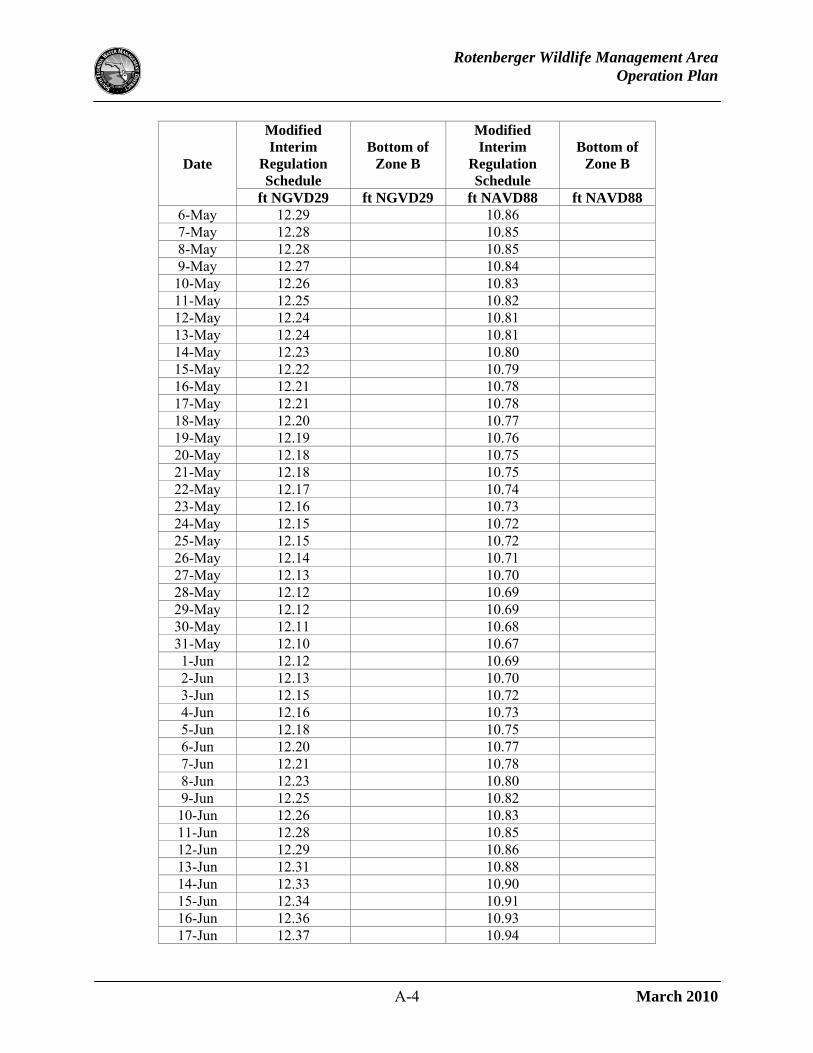
APPENDIX A – MODIFIED INTERIM REGULATION SCHEDULE DAILY STAGES
Date
Modified Interim
Regulation Schedule
Bottom of Zone B
Modified Interim
Regulation Schedule
Bottom of Zone B
ft NGVD29 ft NGVD29 ft NAVD88 ft NAVD88 1-Jan 13.25 13.00 11.82 11.57 2-Jan 13.24 13.00 11.81 11.57 3-Jan 13.23 13.00 11.80 11.57 4-Jan 13.23 13.00 11.80 11.57 5-Jan 13.22 13.00 11.79 11.57 6-Jan 13.21 13.00 11.78 11.57 7-Jan 13.20 13.00 11.77 11.57 8-Jan 13.20 13.00 11.77 11.57 9-Jan 13.19 13.00 11.76 11.57
10-Jan 13.18 13.00 11.75 11.57 11-Jan 13.17 13.00 11.74 11.57 12-Jan 13.17 13.00 11.74 11.57 13-Jan 13.16 13.00 11.73 11.57 14-Jan 13.15 13.00 11.72 11.57 15-Jan 13.14 13.00 11.71 11.57 16-Jan 13.14 13.00 11.71 11.57 17-Jan 13.13 13.00 11.70 11.57 18-Jan 13.12 13.00 11.69 11.57 19-Jan 13.11 13.00 11.68 11.57 20-Jan 13.11 13.00 11.68 11.57 21-Jan 13.10 13.00 11.67 11.57 22-Jan 13.09 13.00 11.66 11.57 23-Jan 13.08 13.00 11.65 11.57 24-Jan 13.07 13.00 11.64 11.57 25-Jan 13.07 13.00 11.64 11.57 26-Jan 13.06 13.00 11.63 11.57 27-Jan 13.05 13.00 11.62 11.57 28-Jan 13.04 13.00 11.61 11.57 29-Jan 13.04 13.00 11.61 11.57 30-Jan 13.03 13.00 11.60 11.57 31-Jan 13.02 13.00 11.59 11.57 1-Feb 13.01 13.00 11.58 11.57 2-Feb 13.01 13.00 11.58 11.57 3-Feb 13.00 13.00 11.57 11.57 4-Feb 12.99 11.56 5-Feb 12.98 11.55 6-Feb 12.98 11.55 7-Feb 12.97 11.54 8-Feb 12.96 11.53 9-Feb 12.95 11.52

Rotenberger Wildlife Management Area Operation Plan
A-2 March 2010
Date
Modified Interim
Regulation Schedule
Bottom of Zone B
Modified Interim
Regulation Schedule
Bottom of Zone B
ft NGVD29 ft NGVD29 ft NAVD88 ft NAVD88 10-Feb 12.95 11.52 11-Feb 12.94 11.51 12-Feb 12.93 11.50 13-Feb 12.92 11.49 14-Feb 12.91 11.48 15-Feb 12.91 11.48 16-Feb 12.90 11.47 17-Feb 12.89 11.46 18-Feb 12.88 11.45 19-Feb 12.88 11.45 20-Feb 12.87 11.44 21-Feb 12.86 11.43 22-Feb 12.85 11.42 23-Feb 12.85 11.42 24-Feb 12.84 11.41 25-Feb 12.83 11.40 26-Feb 12.82 11.39 27-Feb 12.82 11.39 28-Feb 12.81 11.38 29-Feb 12.80 11.37 1-Mar 12.79 11.36 2-Mar 12.79 11.36 3-Mar 12.78 11.35 4-Mar 12.77 11.34 5-Mar 12.76 11.33 6-Mar 12.75 11.32 7-Mar 12.75 11.32 8-Mar 12.74 11.31 9-Mar 12.73 11.30
10-Mar 12.72 11.29 11-Mar 12.72 11.29 12-Mar 12.71 11.28 13-Mar 12.70 11.27 14-Mar 12.69 11.26 15-Mar 12.69 11.26 16-Mar 12.68 11.25 17-Mar 12.67 11.24 18-Mar 12.66 11.23 19-Mar 12.66 11.23 20-Mar 12.65 11.22 21-Mar 12.64 11.21 22-Mar 12.63 11.20 23-Mar 12.63 11.20

Rotenberger Wildlife Management Area Operation Plan
A-3 March 2010
Date
Modified Interim
Regulation Schedule
Bottom of Zone B
Modified Interim
Regulation Schedule
Bottom of Zone B
ft NGVD29 ft NGVD29 ft NAVD88 ft NAVD88 24-Mar 12.62 11.19 25-Mar 12.61 11.18 26-Mar 12.60 11.17 27-Mar 12.60 11.17 28-Mar 12.59 11.16 29-Mar 12.58 11.15 30-Mar 12.57 11.14 31-Mar 12.56 11.13 1-Apr 12.56 11.13 2-Apr 12.55 11.12 3-Apr 12.54 11.11 4-Apr 12.53 11.10 5-Apr 12.53 11.10 6-Apr 12.52 11.09 7-Apr 12.51 11.08 8-Apr 12.50 11.07 9-Apr 12.50 11.07
10-Apr 12.49 11.06 11-Apr 12.48 11.05 12-Apr 12.47 11.04 13-Apr 12.47 11.04 14-Apr 12.46 11.03 15-Apr 12.45 11.02 16-Apr 12.44 11.01 17-Apr 12.44 11.01 18-Apr 12.43 11.00 19-Apr 12.42 10.99 20-Apr 12.41 10.98 21-Apr 12.40 10.97 22-Apr 12.40 10.97 23-Apr 12.39 10.96 24-Apr 12.38 10.95 25-Apr 12.37 10.94 26-Apr 12.37 10.94 27-Apr 12.36 10.93 28-Apr 12.35 10.92 29-Apr 12.34 10.91 30-Apr 12.34 10.91 1-May 12.33 10.90 2-May 12.32 10.89 3-May 12.31 10.88 4-May 12.31 10.88 5-May 12.30 10.87
Rotenberger Wildlife Management Area Operation Plan
A-4 March 2010
Date
Modified Interim
Regulation Schedule
Bottom of Zone B
Modified Interim
Regulation Schedule
Bottom of Zone B
ft NGVD29 ft NGVD29 ft NAVD88 ft NAVD88 6-May 12.29 10.86 7-May 12.28 10.85 8-May 12.28 10.85 9-May 12.27 10.84 10-May 12.26 10.83 11-May 12.25 10.82 12-May 12.24 10.81 13-May 12.24 10.81 14-May 12.23 10.80 15-May 12.22 10.79 16-May 12.21 10.78 17-May 12.21 10.78 18-May 12.20 10.77 19-May 12.19 10.76 20-May 12.18 10.75 21-May 12.18 10.75 22-May 12.17 10.74 23-May 12.16 10.73 24-May 12.15 10.72 25-May 12.15 10.72 26-May 12.14 10.71 27-May 12.13 10.70 28-May 12.12 10.69 29-May 12.12 10.69 30-May 12.11 10.68 31-May 12.10 10.67 1-Jun 12.12 10.69 2-Jun 12.13 10.70 3-Jun 12.15 10.72 4-Jun 12.16 10.73 5-Jun 12.18 10.75 6-Jun 12.20 10.77 7-Jun 12.21 10.78 8-Jun 12.23 10.80 9-Jun 12.25 10.82
10-Jun 12.26 10.83 11-Jun 12.28 10.85 12-Jun 12.29 10.86 13-Jun 12.31 10.88 14-Jun 12.33 10.90 15-Jun 12.34 10.91 16-Jun 12.36 10.93 17-Jun 12.37 10.94

Rotenberger Wildlife Management Area Operation Plan
A-5 March 2010
Date
Modified Interim
Regulation Schedule
Bottom of Zone B
Modified Interim
Regulation Schedule
Bottom of Zone B
ft NGVD29 ft NGVD29 ft NAVD88 ft NAVD88 18-Jun 12.39 10.96 19-Jun 12.41 10.98 20-Jun 12.42 10.99 21-Jun 12.44 11.01 22-Jun 12.45 11.02 23-Jun 12.47 11.04 24-Jun 12.49 11.06 25-Jun 12.50 11.07 26-Jun 12.52 11.09 27-Jun 12.54 11.11 28-Jun 12.55 11.12 29-Jun 12.57 11.14 30-Jun 12.58 11.15 1-Jul 12.60 11.17 2-Jul 12.61 11.18 3-Jul 12.62 11.19 4-Jul 12.63 11.20 5-Jul 12.64 11.21 6-Jul 12.65 11.22 7-Jul 12.66 11.23 8-Jul 12.67 11.24 9-Jul 12.68 11.25 10-Jul 12.69 11.26 11-Jul 12.70 11.27 12-Jul 12.72 11.29 13-Jul 12.73 11.30 14-Jul 12.74 11.31 15-Jul 12.75 11.32 16-Jul 12.76 11.33 17-Jul 12.77 11.34 18-Jul 12.78 11.35 19-Jul 12.79 11.36 20-Jul 12.80 11.37 21-Jul 12.81 11.38 22-Jul 12.82 11.39 23-Jul 12.83 11.40 24-Jul 12.84 11.41 25-Jul 12.85 11.42 26-Jul 12.86 11.43 27-Jul 12.87 11.44 28-Jul 12.88 11.45 29-Jul 12.89 11.46 30-Jul 12.90 11.47

Rotenberger Wildlife Management Area Operation Plan
A-6 March 2010
Date
Modified Interim
Regulation Schedule
Bottom of Zone B
Modified Interim
Regulation Schedule
Bottom of Zone B
ft NGVD29 ft NGVD29 ft NAVD88 ft NAVD88 31-Jul 12.91 11.48 1-Aug 12.93 11.50 2-Aug 12.94 11.51 3-Aug 12.95 11.52 4-Aug 12.96 11.53 5-Aug 12.97 11.54 6-Aug 12.98 11.55 7-Aug 12.99 11.56 8-Aug 13.00 13.00 11.57 11.57 9-Aug 13.01 13.00 11.58 11.57
10-Aug 13.02 13.00 11.59 11.57 11-Aug 13.03 13.00 11.60 11.57 12-Aug 13.04 13.00 11.61 11.57 13-Aug 13.05 13.00 11.62 11.57 14-Aug 13.06 13.00 11.63 11.57 15-Aug 13.07 13.00 11.64 11.57 16-Aug 13.08 13.00 11.65 11.57 17-Aug 13.09 13.00 11.66 11.57 18-Aug 13.10 13.00 11.67 11.57 19-Aug 13.11 13.00 11.68 11.57 20-Aug 13.12 13.00 11.69 11.57 21-Aug 13.13 13.00 11.70 11.57 22-Aug 13.15 13.00 11.72 11.57 23-Aug 13.16 13.00 11.73 11.57 24-Aug 13.17 13.00 11.74 11.57 25-Aug 13.18 13.00 11.75 11.57 26-Aug 13.19 13.00 11.76 11.57 27-Aug 13.20 13.00 11.77 11.57 28-Aug 13.21 13.00 11.78 11.57 29-Aug 13.22 13.00 11.79 11.57 30-Aug 13.23 13.00 11.80 11.57 31-Aug 13.24 13.00 11.81 11.57 1-Sep 13.25 13.00 11.82 11.57 ↓ ↓ ↓ ↓ ↓
31-Dec 13.25 13.00 11.82 11.57

Rotenberger Wildlife Management Area Operation Plan
B-1 March 2010
APPENDIX B – SUMMARY OF CHANGES FROM THE 2004 OPERATION PLAN
1. Added detailed information to the structure reference table. 2. Added additional background information on the history of operations and hydrologic
restoration. 3. Added a summary of the FWC’s farm restoration work which includes degrading berms and
filling canals and ditches over approximately 1,800 acres that were historically utilized for farming and ranching along the eastern border of Rotenberger.
4. Added a Rotenberger location map. 5. Replaced the Rotenberger schematic with an aerial map. 6. Removed water quality sampling information (refer to the STA-5/6 EFA permit for water
quality sampling requirements related to Rotenberger). 7. Added photos of primary inflow and outflow structures. 8. Provided elevations in both the National Geodetic Vertical Datum of 1929 and North
American Vertical Datum of 1988. 9. Updated the description of the Inflow Spreader Canal. 10. Removed the G-410 Priority scheme used in determining the allocation of STA-5 discharges
as it is no longer applicable. Note: The Holey Land Wildlife Management Area inflow pump station (G-200A) is not currently operational.
11. Added a description of the modified interim operations for the G-402A-D outflow culverts evaluated during 2005-2006 and implemented in 2006.
12. Added the modified interim regulation schedule. 13. Provided a description of the process used to develop the modified interim regulation
schedule that occurred during 2008-2009. 14. Added maps of potential muck fire risk at various water levels. 15. Added sections on a) pre-storm operation and b) drought and other non-routine operation. 16. Replaced Appendix I (Interim Rotenberger Operational Schedule - Daily Stages) with
Appendix A (Modified Interim Regulation Schedule Daily Stages) which provides the daily stages of the modified interim regulation schedule in both NGVD29 and NAVD88.
17. Removed Appendix II (Simulated Daily Stage Graphs). 18. Added Appendix B with a summary of changes from the previous operation plan dated
January 2004.