rosenberg international forum: the mackenzie river basinciwr.ucanr.edu/files/168679.pdf ·...
TRANSCRIPT

RosenbeRg inteRnational FoRum:the mackenzie RiveR basinR E P O R T O F T H E R O S E N B E R G I N T E R N AT I O N A L F O R U M ’ S w O R k S H O P O N T R A N S B O U N D A R Y R E L A T I O N S I N T H E M A C k E N Z I E R I V E R B A S I N
j U N E 2013

The Rosenberg International Forum on Water PolicyOn Behalf of The Walter and Duncan Gordon Foundation
RosenbeRg inteRnational FoRum:the mackenzie RiveR basin jUNE 2013
R E P O R T O F T H E R O S E N B E R G I N T E R N AT I O N A L F O R U M ’ S w O R k S H O P O N T R A N S B O U N D A R Y R E L A T I O N S I N T H E M A C k E N Z I E R I V E R B A S I N

4 Rosenberg International Forum
The mackenzie RiveR basin

5The Mackenzie River Basin
table oF contents
0807
10
18
06 22
27
29303538
the stRuctuRe & objectives oF the FoRum
intRoDuction
setting the stage:the mackenzie system
the mackenzie system:the eFFects oF colD on hyDRo-climatic conDitions
executive summaRy
existing science & scientiFic eviDence: WoRRisome signals anD tRenDs
canaDa’s colD amazon:the mackenzie system as a unique global ResouRce
neW knoWleDge neeDeD
managing the mackenzie
conclusions
ReFeRences

6 Rosenberg International Forum
the Mackenzie River is the largest north-
flowing river in North America. It is the
longest river in Canada and it drains a
watershed that occupies nearly 20 per
cent of the country. The river is big and complex.
It is also jurisdictionally intricate with tributary
rivers running through three provinces – British
Columbia, Alberta and Saskatchewan – two
territories – Yukon and the Northwest Territories
– and areas which fall under the jurisdiction of
numerous independent indigenous governments.
Large tributary rivers, the Liard, Peace and
Athabasca drain much of north central Alberta
and parts of the Rocky Mountains in northern
British Columbia. The Peace and Athabasca Rivers
flow to Lake Athabasca, which is drained by the
Slave River, the primary feeder to Great Slave
Lake. The Mackenzie River itself flows from Great
Slave Lake to the Arctic and lies wholly within the
Northwest Territories.
The Mackenzie River Basin is among the most
intact large-scale ecosystems in North America. It
provides significant breeding habitat for migratory
birds and aquatic habitat. Sixty-three per cent of
the Basin is covered by boreal forest, with another
20 per cent covered by wetlands. While the Basin
is relatively undisturbed ecologically, it is at risk
both from a warming climate and development
pressures from the exploitation of hydrocarbons,
non-renewable minerals and hydroelectric
potential. These large forces of change threaten
the ecological integrity of the Basin, its capacity
to provide important environmental services, and
its role as homeland to Aboriginal Peoples who
rely on the land and its resources to provide food,
clothing, water and other necessities of life.
The Mackenzie River Basin is a unique global
resource. It provides benefits not only to residents,
but to populations across Canada, throughout
the Western Hemisphere, and to some extent,
the world over. The Basin contains globally
important natural resources. The Mackenzie
Estuary harbours extraordinary biodiversity and
its biological productivity is enormous when
compared to other ecosystems in the region.
The Mackenzie Delta and other boreal areas
absorb carbon dioxide. There is a clear link
between the freshwater flows of the Mackenzie
and Arctic Ocean circulation. These are
thought to contribute in important ways to the
stabilization of the regional and global climate.
In this respect, the Mackenzie River Basin must
be viewed as part of the global commons. The
challenge of protecting the Basin and conserving
its resources and environmental services is
further complicated by its status as a commons,
and by the need to recognize stakeholders
who are not residents. The problems of the
commons cannot be successfully addressed
unless the population of the Basin and the
constituent governments forthrightly assume the
responsibilities of its stewardship.
The Mackenzie River has not been studied as
extensively as other major rivers of the world.
The scarceness of major studies conducted in
the 1970s means that the working knowledge
of the Mackenzie is relatively minute. Efforts
to protect and preserve the Mackenzie, and
develop its resources in a balanced way, will
require both the full use of all existing science
and the need for additional study. The primary
need is for a perpetual, robust and well-
funded comprehensive monitoring program.
Responsibility for the conduct of this program
should be vested in the Government of Canada.
There are other questions about hydrological,
chemical and biological aquatic regimes in the
Basin that deserve high priority on the research
agenda. Similarly, there are important questions
in the domains of the social science that should
be accorded high priority on the research
agenda.
The Basin’s governance is complicated
by jurisdictional fragmentation. The need to
address this problem arose in the 1990s with
the development of the Mackenzie River Basin
Transboundary Waters Master Agreement of 1997.
The Master Agreement required multi-party
collaboration and co-operation in managing the
land and water resources of the Basin. There
has been little effective follow-through on this
Master Agreement. This report includes a careful
consideration of the obstacles to governance
and offers recommendations for an appropriate
governance structure for the Basin.
One major recommendation is that the
Mackenzie River Basin Board (MRBB),
originally created by the Master Agreement, be
reinvigorated as an independent body charged
with managing and protecting the Basin.
Additional personnel, including representatives
from indigenous communities, will be required
to sharply increase funding support and a
capacity for creating policy based on the best
available science. Bilateral agreements among
the governments represented in the Basin may
be helpful in some instances, but they must be
consistent with the provisions of the overarching
Master Agreement.
The MRBB must devise governance and
management schemes that are comprehensive and
holistic. Piecemeal and/or fragmented approaches
are unlikely to be successful. Management
regimes must also be adaptive because there is
much scientific uncertainty about many of the
Basin’s natural features. Thus, programs that allow
learning from experience and adjust management
regimes to account for such learning, will be
essential. Scientific uncertainty can be addressed
more directly by supporting the aforementioned
monitoring program and by application of the
“precautionary principle.” This principle holds
that the absence of full scientific certainty is
not a valid reason for delaying or postponing
measures that would avoid serious or irreversible
environmental damage.
The MRBB should be supported by an
independent International Science Advisory
Committee. The role of this Committee should be
to ensure that the best possible science is used,
and to develop and prioritize research agendas
to create new scientific information needed
to guide the MRBB in other appropriate ways.
Indigenous peoples should be represented on the
Committee. Additionally, educational programs
should be established to educate the region’s
residents, as well as the larger world, about the
Mackenzie River Basin. Such a program should
also offer training to indigenous peoples to
allow them to have major roles in programs that
manage and protect the Basin.
executive summaRy

7The Mackenzie River Basin
It is important to recognize that traditional
knowledge should be fully utilized as part of the
scientific base upon which policies and plans for
the Basin will be based. Traditional knowledge
forms a continuum with Western scientific
knowledge and the two are complementary and
not mutually exclusive. A number of cultures
throughout the world have applied traditional
knowledge to the management of environmental
changes of precisely the sort that are anticipated
here. The traditional knowledge of the Basin’s
indigenous residents should be sought out and
utilized to the fullest extent possible. Funding to
support participation of indigenous peoples and
the use of traditional knowledge should be made
available in generous amounts.
Enhancing knowledge and communication
within the Basin will be critical, as will
the development of scientific capacity.
The activities of the Board should be fully
transparent and broadly communicated. Input
should be sought from all classes of stakeholder
and there should be full sharing of scientific
information that explicitly includes a thorough
examination of research outcomes that some
interests may not like.
There are also value questions and
judgments which must be addressed in the
making of policies and plans for the Basin.
While science alone cannot fully inform such
judgments, that is not an excuse for ignoring
the need to make the judgments forthrightly
and transparently. Examples of the questions
that should be addressed are: 1) How should
the values and philosophies of traditional
cultures be respected in the fashioning of
balanced management policies? 2) What
rates of economic growth are appropriate for
the Basin and its distinctive regions? 3) How
should extractive industries and hydroelectric
developments be regulated?
The report includes a strong recommendation
that extractive industries be required to post
a significant performance bond before site
development and operations commence. This
ensures that clean-up costs and mitigation
following closure of the site are fully paid by the
industry itself. Failure to require a significant
performance bond or some similar incentive
almost surely means that the legacy of despoiled
environments, toxic wastes and other waste will
continue unabated, and that taxpayers will be left
to bear costs that are properly those of the mining
industry.
intRoDuction
the Rosenberg International Forum on
Water Policy was created in 1996 with
an endowment gift to the University of
California in honour of Richard Rosenberg
upon the occasion of his retirement as Chairman
of the Bank of America. The theme of the Forum
is: Reducing Conflict in the Management of
Water Resources. The Forum meets biennially
at different locations around the globe. Past
Forums have been held in San Francisco, U.S.;
Barcelona, Spain; Canberra, Australia; Ankara,
Turkey; Banff, Canada; Zaragoza, Spain; and
Buenos Aires, Argentina. Attendance at the Forum
is by invitation only and is restricted to 50 water
scholars and senior water managers from around
the world.
In 2006, the Advisory Committee of the
Rosenberg International Forum launched a
second activity subsumed under the general
title of Regional Workshops. These workshops
use small, international, expert panels to
assist governments and other institutions in
addressing regional water issues. The first of
these Workshops, in 2007, reviewed Alberta’s
provincial water strategy, Water for Life,
and the “Groundwater Action Plan” for the
province. The second, in 2008, brought together
water management experts and water policy
scholars from Iran and the United States with
the aim of identifying commonalities in the
challenges of assuring water supply for cities
and agriculture in arid and semi-arid regions
that exist in both countries. A third Regional
Rosenberg Workshop was held in Yellowknife
in Canada’s Northwest Territories in June of
2009, with the purpose of identifying barriers
to the implementation of Northern Voices,
Northern Waters: Towards A Water Resources
Management Strategy for the Northwest
Territories and to recommend examples from
elsewhere from which the government could
benefit as it sets out to integrate the strategy
into larger governance structures.
This document is the report of the fourth
Regional Workshop held in Vancouver, British
Columbia in September 2012. The Vancouver
forum was convened at the request of the Walter
and Duncan Gordon Foundation and hosted
by Simon Fraser University. The Foundation
is committed to addressing various issues
of water policy reform and improvement of
water governance, particularly in the Canadian
North. The purpose of this Regional Rosenberg
Workshop was to provide the latest scientific
information needed to arrive at a transboundary
arrangement that would assure the sustainability
of the system, while at the same time ensuring
that desired social and economic benefits accrue
for each of the jurisdictions that share the Basin.

8 Rosenberg International Forum
the stRuctuRe & objectives oF the FoRum
in July 1997, the governments with jurisdiction
to manage water and the environment in
the Basin signed the Mackenzie River Basin
Transboundary Waters Master Agreement. The
agreement commits all six governments to work
together to manage the water resources of the
entire Basin. The governments with jurisdictional
interests in the Basin are the western provinces –
British Columbia, Alberta and Saskatchewan – as
well as the territories of Yukon and the Northwest
Territories, and the Government of Canada.
As identified in the Master Agreement, relevant
parties in Western Canada have recognized the
need for multi-party transboundary co-operation
in the governance of land and water use (and
management) in the larger Mackenzie River Basin.
However, 15 years have passed, and no progress
has been made with respect to the development of
multi-party co-operation in the Basin. Meanwhile,
population and economic growth have continued
throughout the Basin. Without planning and co-
ordination, such growth, in addition to threatening
the stability and sustainability of the Basin and its
resources, could undermine the purpose of the
agreement and render the benefits of co-operation
unachievable. It was the purpose of this Regional
Rosenberg Workshop to examine the obstacles
to the crafting of a multi-party agreement on the
management of the Mackenzie, and to set forth
recommendations as to what kind of governance
structures might be put into place that allow
all parties to meet their social, economic and
environmental goals, while at the same time
recognizing their individual and collective
obligations as stewards of a globally significant
resource.
As the Rosenberg Forum has already
undertaken independent analyses of the water
strategies of both the Government of Alberta
in 2007 and the Government of the Northwest
Territories in 2009, it has been invited by Canada’s
Walter and Duncan Gordon Foundation and
Simon Fraser University in British Columbia
to convene a panel of experts to identify and
summarize the pertinent scientific principles
and findings that should be acknowledged in the
processes leading ultimately to an agreement
concerning the Mackenzie. The panel was also
asked to identify pertinent legal principles that
may apply.
statement oF taskThe specific assignment to the panel was to
deliberate and prepare a report that responded to
the following questions.
1 What is the state of scientific knowledge of
the Mackenzie River Basin? What are the
important scientific findings that should be
acknowledged in the negotiations leading to
a multi-party agreement? What are the major
scientific questions that need to be addressed to
ensure that the waters and lands of the Basin are
managed in a way that protects their integrity? To
what extent does scientific uncertainty need to be
addressed and specifically acknowledged in any
transboundary agreement? What does science tell
us about the continental and global significance of
the Basin?
2 To what extent does traditional knowledge
supplement or reinforce typical Western
science or social science? To what extent does
traditional knowledge need to be acknowledged
or incorporated in any agreement? Are there
examples of transboundary agreements that rely
upon traditional knowledge?
3 Given the prevailing levels of uncertainty,
what should be the role of adaptive
management in scoping and implementing any
transboundary agreement? What are the positive
and negative lessons that have been learned from
experience with adaptive management? Are there
examples of transboundary agreements that rely
on adaptive management?
4 Is it possible to revamp existing co-
operative governance structures for the
Mackenzie River Basin so as to build upon
rather than infringe upon the jurisdictions of the
federal, provincial, territorial and indigenous
governments? Are there examples where this
has been successfully accomplished in a federal
system? Are there examples of where it has been
attempted but failed to work effectively?
5 Could an existing layer of government or
a regional governmental entity be given
regulatory authority related to the purely basin-
level aspects of such overarching issues as climate
change, cumulative environmental impacts, as
well as transboundary indigenous treaties and
governance agreements? Note that to the extent
that these issues are addressed at all, they tend to
be handled at the provincial/territorial and /or
federal level.
the Regional WoRkshop panelThe Rosenberg International Forum on Water
Policy convened a Regional Workshop of
international experts with appropriately diverse
disciplinary backgrounds and experience. The
names, institutional affiliations and areas of
expertise of the panel members and others
formally involved in the forum are listed below.
Workshop MeMbers
Professor Henry Vaux, Jr., Chair Department of Agricultural and
Natural Resource Economics
University of California, Berkeley
(Natural Resource Economics)
Professor Gordon Christie University of British Columbia
(Law)

9The Mackenzie River Basin
1 The ecologic, hydrologic and climatologic regimes of the Mackenzie River
Basin are at risk from planetary warming. The area is ecologically fragile
and could become more so.
2 The Mackenzie River Basin is a globally important resource. Its biological,
hydrological and climatological properties affect the welfare of people
throughout the Western Hemisphere and, to some extent, globally.
3 The Mackenzie River Basin is less studied than many of the other large
basins of the world. The ambient environment of the Mackenzie is
changing relatively rapidly. These two factors mean that management
of the lands and waters of the Basin will have to occur in the face of
significant uncertainties.
4 The Basin is fragmented jurisdictionally, making holistic management of its
resources nearly impossible. Overarching authority for the management of
the Basin should be vested in a strengthened Mackenzie River Basin Board
(MRBB), authorized by the Mackenzie River Basin Transboundary Waters
Master Agreement of 1997. A reinvigorated MRBB will need significantly
more financial support and will benefit from the advice and counsel of an
independent International Science Advisory Committee.
5 The reinvigorated MRBB should manage the Basin adaptively and
holistically. This will require a perpetual, robust and adequately funded
monitoring program that should be the responsibility of the Canadian
federal government.
6 Adaptive management and the precautionary principle need to be
employed assiduously in managing scientific uncertainty in the
Mackenzie River Basin.
7 Extractive industries should be required to post a substantial
performance bond which would be used to cover the costs of site
clean-up should the enterprise fail financially or otherwise fail to
fully remediate damage and destruction at the site in question. The
performance bond should be secured prior to site development and the
commencement of operations.
8 There are a number of value issues that must be addressed forthrightly
and transparently. They involve the interplay of two distinctly different
cultures within the Basin – issues related to rates and types of appropriate
economic growth, and the oversight and regulation of extractive
industries and hydroelectric development.
Professor Helen Ingram University of California, Irvine
(Political Science)
Professor Stephen MummeColorado State University
(Political Science)
Professor Pamela D. PalmaterCentre for Indigenous Governance
Ryerson University (Law)
Professor John PomeroyUniversity of Saskatchewan
(Hydrology and Climate Science)
Professor Mary PowerUniversity of California, Berkeley (Biology)
Professor David SchindlerUniversity of Alberta
(Biology, Water Chemistry)
Professor Patricia Wouters University of Dundee (Scotland)
(International Law)
Principle ReviewerProfessor Stephen McCaffrey
University of the Pacific
(Law)
suppoRt staFFRobert SandfordUN Water for Life Decade, Canada
Rapporteur & Writer
Deborah HarfordSimon Fraser University
Administrative Officer
panel meeting anD pRocessThe panel met for three days in Vancouver, British Columbia on Sept. 5 to 7, 2012. The first day, a “Day of Discovery,” was focused on the gathering of general and specific information about the Mackenzie River Basin and its associated land resources. The panel heard presentations by representatives of the Canadian federal government, by the premier of the Northwest Territories and from representatives of the government of the Northwest Territories. It also heard from several academics whose expertise is focused on the Basin. The intent
was to supplement the collective knowledge of the panel about present and future conditions in the Mackenzie River Basin.
The second and third days were devoted in their entirety to panel deliberations that were held “in camera.” During these two days the panel outlined its report, deliberated its contents, and identified its ultimate conclusions and findings. Thereafter, the report emerged through a series of drafts that were the focus of comments and interactions on the part of panel members leading to the final draft which was completed in early 2013.
The panel acknowledges and thanks those who participated in and contributed to the “Day of Discovery,” and others who provided detail and helped to clarify points along the way. The panel wishes especially to thank Professor Stephen McCaffrey of the McGeorge School of Law, University of the Pacific, for his careful and insightful review of an advanced draft of the report. Professor McCaffrey was designated at the outset as a peer reviewer for the report. His review resulted in significant improvements in the report, though he bears no responsibility for the final product.
pRinciple FinDings & conclusions

10 Rosenberg International Forum
physical geogRaphy & hyDRologyThe Mackenzie River is the largest north-flowing
river in North America. It is the longest river in
Canada, stretching for 4,241 kilometres. It drains
the largest watershed in Canada, a watershed
that occupies nearly one-fifth of the country. In
addition, the measure of unimpaired discharge
of the Mackenzie at its mouth places it among
the two largest rivers in Canada. By any measure,
the Mackenzie River is a big river. It is also a
complex and unique river both in terms of water
and associated land resources. Moreover, the
Basin is jurisdictionally complex with tributary
rivers running through three Provinces – British
Columbia, Alberta and Saskatchewan – as well
as the territories of Yukon and the Northwest
Territories (Culp, Prowse and Luiker 2005).
As shown in Figure 2, the Mackenzie River
has many tributaries, with the largest being the
Liard, the Peace and the Athabasca. The latter
two rivers drain much of the boreal region of
north-central Alberta and parts of the Rocky
Mountains in northern British Columbia before
coming together at the Peace-Athabasca Delta
near Lake Athabasca, which also receives runoff
from northwestern Saskatchewan. The waters of
Lake Athabasca then flow northward by way of its
outlet, the Slave River.
The Slave River contributes about 77 per
cent of the inflow to Great Slave Lake. The
Mackenzie River itself rises out of the western
end of Great Slave Lake and flows generally
west-northwest for about 300 kilometres,
passing the communities of Fort Providence
and Fort Simpson, where the river turns north.
Other upstream inflows include the Taltson,
Lockhart and Hay Rivers. While the Taltson
and Lockhart Rivers have their origins in the
Northwest Territories, the Hay River is fed by
tributaries that originate in Alberta and British
Columbia.
The Mackenzie’s largest tributary is the Liard
River which joins at Fort Simpson. Thereafter the
main stem begins a northward flow toward the
Arctic and is joined by the North Nahanni River.
The Great Bear River, draining Great Bear Lake,
joins at Tulita. After crossing the Arctic Circle
in a northwesterly direction, the river receives
the waters of the Arctic Red and Peel rivers.
Tributaries that join from the west have their
origins in the mountains of eastern Yukon.
The Mackenzie River Basin is conveniently
divided into two geographical regions based on
subsurface geology. The eastern part of the Basin
is characterized by vast regions of lake-studded
boreal forest underlain by the Precambrian rock
of the Canadian Shield. Some of the largest lakes
in North America are found in this part of the
Basin. By both volume and surface area, Great
Bear Lake, with a surface area of 31,153 sq. km
and a volume of 2,236 cu. km is the largest in the
Basin and third largest on the continent. Great
Slave Lake is slightly smaller, with a surface area
of 28,568 sq. km containing 2,088 cu. km of water.
At its maximum, Great Slave Lake is considerably
deeper than Great Bear Lake, even though the
latter has a deeper mean depth. Though still large
by continental standards, Lake Athabasca is the
third largest in the Basin with an area of 7,800 sq.
km. Six other lakes in the Basin cover more than
1,000 sq. km. Not all of these lakes are natural. The
Williston Lake reservoir, for example, became the
second-largest artificial lake in North America
after it was created behind the W.A.C. Bennett
Dam on the Peace River in British Columbia.
The western part of the Basin contrasts with
the east rather sharply because it is underlain
by sedimentary rock. This rock forms the Rocky
Mountains as well as the Franklin and Mackenzie
ranges. In the western area of the Mackenzie
River Basin, the erosion of the softer geological
substrate creates sediments that are borne away by
the Mackenzie River and its western tributaries.
These sediments contribute in important ways
to the nutrient regime of the Mackenzie River
estuary (Lesack 2012). About 60 per cent of the
unimpaired average flow of the Mackenzie at its
mouth comes from the western half of the Basin,
with the Peace and the Liard contributing 23 per
cent and 27 per cent of the total flow, respectively.
By contrast, eastern portion of the Basin provides
only 25 per cent of the Mackenzie’s discharge.
This is explained by the fact that the eastern Basin
is dominated marshland and large lakes and lacks
snow-capturing mountainous highlands.
The difference between the two portions of
the watershed is accentuated during the spring
freshet. While mountain snow and glacial
melt contribute to raising water levels in the
Mackenzie’s western tributaries, the large lakes in
the eastern portion of the Basin slow springtime
discharges. Break-up of ice jams caused by sudden
increases in temperature can further exacerbate
flood peaks. Thus, for example, an interesting
phenomenon seen in the Peace-Athabasca Delta
is the “mechanical breakup” when melt waters
physically lift the ice without melting it, sweeping
it downstream where it hangs up in narrow bends,
causing water to spill over into the Delta because it
cannot flow down the stream. The resulting floods
are the largest observed in the Peace-Athabasca
Delta (Prowse et al. 2006).
From sources to mouth, the Mackenzie
falls only 156 metres. For much of its distance
the Mackenzie River is a broad, slow-moving
waterway with numerous sandbars and side
channels. The river ranges from two to five
kilometres wide and eight to nine metres deep
in most parts, and is thus easily navigable when
it is not frozen. There are, however, a number of
places where the river narrows to less than half
a kilometre and flows turbulently, such as the
Sans Sault Rapids where Mountain River joins
setting the stage:the mackenzie system➤ See Figure 1. The Geographic Area Encompassed by the Mackenzie River Basin.

11The Mackenzie River Basin
Figure 1. The Geographic Area Encompassed by the Mackenzie River Basin
Figure 2. The Mackenzie River and its sub-basins
legenD:
water flow
SUB-BASINS: PEEL, MACKENZIE MAIN STEM AND GREAT BEAR LAKE, GREAT SLAVE, ATHABASCA, PEACE, LIARD
Mackenzie RIver Basin
Great Bear Lake
Mackenzie River
Peel River
Athabasca River
Lake Athabasca
Slave River
Peace River
Hay RiverLiard River
Nahanni River
Great Slave Lake
Williston Lake
YELLOWKNIFE
FORT MCMURRAY
EDMONTON
WHITEHORSE
INUVIK
GRANDE PRAIRIE
BRITISH COLUMBIA
YUKON
NORTH WEST TERRITORIES
NUNAVUT
ALBERTA
SASKATCHEWAN
12 Rosenberg International Forum
the Mackenzie and at “The Ramparts,” near Fort
Good Hope where the entire flow of the river is
channeled spectacularly through a 40-metre deep
canyon.
At its terminus, the Mackenzie empties into
the Beaufort Sea, which is part of the Arctic
Ocean. The Mackenzie Delta is a spectacular
natural feature that plays an important
role determining adjacent hydrologic and
oceanographic regimes. At its mouth, the river
discharges on average around 313 cu. km of
water each year, accounting for roughly 11 per
cent of the total river flow into the Arctic Ocean.
The mixing of these huge volumes of warmer
freshwater with the cold seawater in its estuary
is thought to have a significant effect on the local
climate in this region of the Beaufort Sea which
in turn appears to influence the circulation of
waters in the Arctic Ocean.
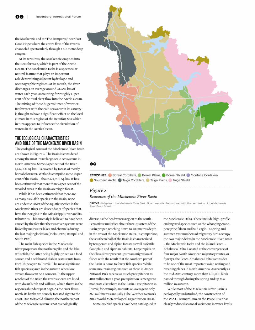
the ecological chaRacteRistics anD Role oF the mackenzie RiveR basinThe ecological zones of the Mackenzie River Basin
are shown in Figure 3. The Basin is considered
among the most intact large-scale ecosystems in
North America. Some 63 per cent of the Basin –
1,137,000 sq. km – is covered by forest, of mostly
boreal character. Wetlands comprise some 18 per
cent of the Basin – about 324,900 sq. km. It has
been estimated that more than 93 per cent of the
wooded areas in the Basin are virgin forest.
While it has been estimated that there are
as many as 53 fish species in the Basin, none
are endemic. Most of the aquatic species in the
Mackenzie River are descendants of species that
have their origins in the Mississippi River and its
tributaries. This anomaly is believed to have been
caused by the fact that the two river systems were
linked by meltwater lakes and channels during
the last major glaciation (Pielou 1992; Rempel and
Smith 1998).
The main fish species in the Mackenzie
River proper are the northern pike and the lake
whitefish, the latter being highly-prized as a food
source and a celebrated dish in restaurants from
Fort Chipewyan to Inuvik. The most significant
fish species spawn in the autumn when low
stream flows can be a concern. In the upper
reaches of the Basin the river’s shores are lined
with dwarf birch and willows, which thrive in the
region’s abundant peat bogs. As the river flows
north, its banks are densely forested right to the
coast. Due to its cold climate, the northern part
of the Mackenzie system is not as ecologically
diverse as the headwaters region to the south.
Permafrost underlies about three-quarters of the
Basin proper, reaching down to 100 metres depth
in the area of the Mackenzie Delta. In comparison,
the southern half of the Basin is characterized
by temperate and alpine forests as well as fertile
floodplain and riparian habitats. Large rapids on
the Slave River prevent upstream migration of
fishes with the result that the southern part of
the Basin is home to fewer fish species. While
some mountain regions such as those in Jasper
National Park receive as much precipitation as
400 millimetres a year, precipitation is meager to
moderate elsewhere in the Basin. Precipitation in
Inuvik, for example, amounts on average to only
265 millimetres annually (The Weather Network
2013; World Meteorological Organization 2013).
Some 215 bird species have been catalogued in
the Mackenzie Delta. These include high-profile
endangered species such as the whooping crane,
peregrine falcon and bald eagle. In spring and
summer, vast numbers of migratory birds occupy
the two major deltas in the Mackenzie River Basin
– the Mackenzie Delta and the inland Peace –
Athabasca Delta. Located at the convergence of
four major North American migratory routes, or
flyways, the Peace-Athabasca Delta is consider
to be one of the most important avian resting and
breeding places in North America. As recently as
the mid-20th century, more than 400,000 birds
passed through during the spring and up to a
million in autumn.
While most of the Mackenzie River Basin is
ecologically undisturbed, the construction of
the W.A.C. Bennett Dam on the Peace River has
clearly reduced seasonal variations in water levels
Figure 3. Ecozones of the Mackenzie River Basin
Credit: ©Map from the Mackenzie River Basin Board website. Reproduced with the permission of the Mackenzie River Basin Board
ECOZONES: Boreal Cordillera, Boreal Plains, Boreal Shield, Montane Cordillera,
Southern Arctic, Taiga Cordillera, Taiga Plains, Taiga Shield

13The Mackenzie River Basin
in both the Peace and Slave River deltas, resulting
in ecological damage. Damage to the former delta,
as well as a reduction in natural habitat in other
parts of the migratory bird range throughout the
continent, are seen to contribute to the steady
reduction of migratory bird populations in the
area, a decline that has been observed since the
1960s.
cultuRal geogRaphyApproximately 400,000 people reside in the
Mackenzie River Basin – representing just over
one per cent of Canada’s population. Ninety
percent of these people live in the Peace and
Athabasca River drainage areas, mainly in
Alberta. In the past decade, the pace of oil sands
development in northern Alberta has increased
substantially and Fort McMurray has become
the largest community in the Basin (Mackenzie
River Basin Board 2012). Boomtowns composed
almost solely of people that have arrived within
a short period of time from elsewhere, such as
Fort McMurray and Grand Prairie, have their
own dynamics that are often at odds with long-
established local sensibilities related to place. The
boomtowns, however, are largely in the southern
part of the Basin.
The distribution of the population in the
Mackenzie River Basin is shown in Figure 4.
As the figure shows, population tends to be
concentrated in the southern part of the Basin.
The cold northern permafrost regions beyond
the Arctic Circle are very sparsely populated, but
are the traditional territory of many of Canada’s
indigenous peoples. This sparse population is
concentrated along the banks of the Mackenzie,
its tributaries and lakes. As a result, much of the
Mackenzie River Basin remains wilderness and
– historically, at least – human activities have had
little influence on water quality and quantity in the
Basin’s major rivers. The exception is found in the
southern part of the Basin where there are several
large boomtowns associated with exploitation of
hydrocarbons and non-renewable resources. The
population data in the table does not show the
extent to which the populations of these places
have grown. For example, the population of Fort
McMurray was almost 73,000 in 2011, and is
expected to increase by more than 80 per cent by
2041 (Alberta Treasury Board and Finance 2012).
The exploding population in these southern-Basin
centers contrasts sharply with the population of
the Northwest Territories.
The Northwest Territories, in which the
Mackenzie proper rises, covers an area of
1,346,106 sq. km, approximately 13 per cent of
Canada’s land mass. As of the 2011 census, it had
a population of 41,462, showing little change
from the 2006 census. The population density of
the Northwest Territories is approximately 0.03
persons per square kilometre. By comparison,
Canada (including the Northwest Territories) has
a corresponding population density of 3.5 persons
per square kilometre, or more than a hundred
times that of the Northwest Territories.
Approximately one half of the people residing
in the Northwest Territories are of aboriginal
descent. Indigenous cultures have lived in the area
for thousands of years. They have been supported
by the land and its resources, which provide
food, clothing, water and other necessities of life.
Over generations these people have developed a
detailed knowledge of the land, animal behavior,
seasonal and climatic changes and ecological
relationships. Today, indigenous peoples maintain
strong bonds to their traditions while adapting to
modern technology and lifestyles. The indigenous
peoples of the Northwest Territories have legally
recognized rights negotiated through land claims
agreements that are uncommon elsewhere in the
Western Hemisphere (Sandford 2012).
Travel in the northern part of the Mackenzie
River Basin can be challenging and expensive.
Canada’s northernmost major railhead is located
at the town of Hay River, on the south shore of
Great Slave Lake. Goods shipped to Hay River
by train and by truck and not meant for local
consumption are loaded onto barges owned by the
Inuit-owned Northern Transportation Company.
During the ice-free season, barge traffic on the
Inuvik
Fort McMurray
Yellowknife
Grande Prairie
Figure 4. Population distribution in the Mackenzie River Basin.Credit: ©Map from the Mackenzie River Basin Board website. Reproduced with the permission of the Mackenzie River Basin Board.
Population Distribution: 1996
0-499, 500-4999, 5000-24999, 25000-50000

14 Rosenberg International Forum
river supplies numerous scattered and isolated
communities and mining operations along its
course. Goods are shipped as far north as the
town of Tuktoyaktuk on the eastern end of the
Mackenzie Delta. From there they are further
distributed among communities along Canada’s
Arctic coast and the numerous islands north
of it. During the winter, the frozen channels of
the Mackenzie River are crisscrossed with ice
roads which often serve the same purpose of
supplying northern communities as barges do in
the summer.
It has been observed that ice roads have to be
built later and close earlier in the year because of
climatic warming. Ice spray technology is being
used more widely to create thick load-bearing ice
on frozen rivers and lakes and ground-penetrating
radar is used to ensure that ice thickness is
adequate to bear the weight of vehicles and to
locate weak spots in the ice. There is concern
that ice roads will not be a reliable alternative
to expensive air freight options in the future if
warming continues.
setting the stage: ResouRce Development acRoss the basinThe greatest economic activity in the Basin is
resource extraction. This includes wood products
and pulp and paper in the Peace River headwaters,
oil and gas in central and northern Alberta and
northwestern British Columbia, uranium in
Saskatchewan, precious metals and diamonds
in the Northwest Territories, and tungsten in
Yukon. The Northwest Territories and Yukon
experienced the highest growth in the mining and
oil and gas extraction sectors from 2002 to 2008.
The threats to environmental integrity posed by
the potential exploitation of each of the resources
vary with the scale of their operations.
There is a long history of abandoned and
orphaned mines in the Mackenzie River Basin.
The most emblematic of these is the Giant Mine.
Located just a few kilometres from Yellowknife,
the Giant Mine opened in 1947. Its name derives
from the fact that it remains the largest gold
mine ever explored in Canada’s history. At full
operation, it employed 700 to 800 people and
for decades was the mainstay of the Yellowknife
economy. Mining gold actually entails the
extraction and processing of arsenopyrite. The
processing or milling separates the gold from the
rock, creating a significant volume of mine tailings
containing high concentrations of arsenic trioxide.
Arsenic trioxide is one of the more poisonous
substances on Earth and is water-soluble, posing
significant potential for contamination of both
surface and ground waters.
The gold milling at the Giant Mine involved
“roasting” to melt the gold out of the ore. In the
early years of the mine, the arsenic trioxide from
the milling simply went up the smokestack and
was rinsed off the surrounding rock by rain and
snowmelt. Soon, however, every living thing
around the mine began to die. Scrubbers were
then put on the roasters to remove the arsenic
trioxide, which was bagged and stored in old
tailings and workings. But soon there was so much
of the deadly poison that special below-ground
storage chambers had to be built. The storage
chambers were called stopes. These stopes were
protected by five to 100 metres of surrounding
permafrost. Some 270,000 tonnes of arsenic
trioxide were disposed of in this way.
The engineering thinking behind this solution
is highly relevant in the context of contemporary
debate over the future management of the
Mackenzie River Basin. It was believed that the
permafrost would protect the stopes, encasing
and freezing the arsenic dust in ice. Not taken
into account, however, was the amount of heat
entering the storage stopes by way of the mine
workings, which eroded the permafrost from
below. Another consideration not taken into
account was that the arsenic trioxide dust was
still warm from the roasting when it was bagged
and stored, which caused permafrost melt to
radiate outward from the stopes. The melting was
further exacerbated by a decision made in the
hard economic times of the early 1980s to permit
open-pit, instead of underground mining, of the
ores. While the decision to allow surface mining
made it cheaper to access the gold-bearing ores,
temporarily saving the economy of Yellowknife,
the open-pit system began to erode the remaining
permafrost from above.
The milling of ore ceased in 1999 and in 2004
the company that owned the Giant Mine declared
itself bankrupt. The principals of the company
went successfully on to other ventures, including
the redevelopment of Pine Point on the south
shore of Great Slave Lake. But the permafrost did
not stop melting. What exists now at Giant Mine
is an enormous tonnage of arsenic trioxide that
is water soluble and therefore potentially highly
mobile. The only thing presently standing in the
way of that mobility is the fact that the dust and
its surroundings are a few degrees below the
freezing point of water. The Government of the
Northwest Territories and the Government of
Canada are now faced with having to artificially
refrigerate the water-soluble arsenic trioxide
stored in the stopes to prevent it from being
mobilized by groundwater. The land surface
around the abandoned mine and even the
tailings can be remediated, but the stopes and
the surrounding permafrost will require constant
The Ice Road between Inuvik and Tuktoyaktuk on the Mackenzie Delta. Photograph courtesy of R.W.Sandford, UN Water for Life Decade, Canada

15The Mackenzie River Basin
artificial refrigeration and monitoring at huge
public cost, possibly forever (Sandford 2009). New
regulations associated with the implementation
of the Northwest Territories’ Northern Voices,
Northern Waters water stewardship strategy
should prevent similar circumstances from
occurring again, at least within the Northwest
Territories. Development upstream of the
Northwest Territories, however, remains a threat
(Government of the Northwest Territories and
Ministry of Indian and Northern Affairs 2010).
As illustrated in Figure 6, oil and gas extraction
in the Mackenzie River Basin is extensive. As a
result of new technologies, subsurface mining
of shale gas is becoming a major resource
development focus. This activity requires the
fracturing of subsurface sedimentary rock
formations to release the methane trapped
therein. There is considerable concern in some
areas of the Basin regarding the long-term effect of
“fracking,” as it is called, on groundwater flows.
The largest resource developments on the
Athabasca River system are Alberta’s oil sands
operations. The website for the Government
of Alberta (2013) identifies the oil sands as the
third-largest proven crude oil reserve in the
world, next to Saudi Arabia and Venezuela. The
website indicates that “through responsible
development, advancement of technology and
significant investment, the Government of Alberta,
in conjunction with industry, seeks to enhance
Alberta’s role as a world-leading energy supplier.
New projects are being added every year, and
production is expected to increase from 1.31 million
barrels per day in 2008 to 3 million barrels per day
Figure 6. Oil and gas development in the Mackenzie River Basin region.Credit: Map provided by the Atlas of Canada.

16 Rosenberg International Forum
in 2018, keeping pace with demand and providing a
sound economic basis for the future.”
Exploitation of the resource potential of the
oil sands in the lower Athabasca Basin in Alberta,
however, poses a recognized threat to aquatic
ecosystem health and stability in the headwaters
of the Mackenzie River. Production has exploded
in the oil sands over the last decade as improved
technology and higher oil prices have established
the existence of a proven reserve of approximately
167 billion barrels of oil. In 2011, there were
over 90 active oil sands projects in Alberta. The
effective monitoring of threats posed by such
large-scale resource development is impeded by
controversy.
Much of the oil sands development to date has
occurred north of Fort McMurray, where bitumen
deposits can be mined at the surface using open-
pit mining practices. Over 600 sq. km are currently
under development. Some 170 sq. km of tailings
ponds are part of the development (Mackenzie
River Basin Board 2012). Outside of the area
where the surface is not mineable, bitumen is
removed from deeply buried oil sands deposits
using in situ methods.
The in situ method of extracting bitumen
from deeper oil sands formations distinguishes
itself from surface mining in that it does not
require the creation of an open pit mine with its
attendant removal of the boreal forest, topsoil
and overburden above the bitumen deposit and
the creation of an open pit mine. Steam-assisted
gravity drainage (SAGD) is the prevalent form of
in situ extraction. SAGD recovery involves the
horizontal drilling of a pair of wells, one at the top
and one at the bottom of the bitumen deposit. In
a manner that more resembles conventional oil
and natural gas production, steam and solvents
are pumped into the upper part of the bitumen
reservoir. This warms and thins the bitumen,
which then drains through gravity to the lower
well where the bitumen-water mixture is captured
and pumped to the surface. In ideal circumstances
solvents are also captured in this way.
Mining and in situ oil sands development have
impacts on air, water, land and people. Surface
mining of oil sands have led to modification
of natural drainage patterns in many tributary
watersheds to the Athabasca River. This, in
conjunction with airborne emissions, has been
shown to affect water quality. In situ extraction
facilities will dominate future oil sands
development. The ever-present potential for
structural failure of the tailing ponds will pose
risks, both large and growing, of environmental
catastrophe. In situ extraction will likely result
in similar or greater levels of habitat destruction.
The impacts of in situ extraction include road,
seismic line, well pad and pipeline development,
all of which affect aquatic and terrestrial habitats
through construction-related effects created
by stream crossings, changes in the water table
that could lead to land subsidence or drying of
wetlands, and the indirect effects of increased
access to fish and wildlife resources these
Figure 7. The W.A.C. Bennett Dam on the upper reaches of the Peace River in British ColumbiaCredit: ©Dave Aharonian. Image provided courtesy of BC Hydro
17The Mackenzie River Basin
rights-of-way may provide. In the case of large
mammals, noise is also a significant factor (Dyer
et al. 2001).
hyDRo-poWeR Development in the basinA hydro-power study has been conducted for
every river in the Basin. The hydro-power
potential of the Mackenzie system has been
deemed to be equal to that of all the rest of Canada
combined. Although the entire main stem of
the Mackenzie River is undammed, many of its
tributaries and headwaters have already been
developed for hydroelectricity production, flood
control and irrigation agriculture. The W.A.C.
Bennett Dam (Figure 7) and Peace Canyon Dam
on the upper Peace River were completed in
1968 and 1980, respectively, for power generation
purposes. The two dams, both owned by BC
Hydro, have a combined capacity of more
than 3,400 megawatts (MW). The reservoir of
W.A.C. Bennett – Williston Lake – is the largest
body of fresh water in British Columbia and
the ninth largest man-made lake in the world,
with a volume of 70.3 cu. km. While Williston’s
flood control operations have reduced flooding
in the Peace River Valley, it has had significant
impacts on wildlife and riparian communities
lower in the Basin, particularly in the Peace-
Athabasca Delta and the delta of the Slave River.
Impacts associated with the decrease in annual
flow fluctuations in the Peace system have had
measureable impacts as far downstream as the
main stem of the Mackenzie.
Agriculture in the Mackenzie River Basin is
mainly concentrated in its southernmost portion,
namely the valleys of the Peace and Athabasca
Rivers. It is widely held that the Peace region
possesses some of the best northern farmland in
Canada. It is likely that warming temperatures
resulting from climate change will mean longer
growing seasons which will make the Peace River
Valley even more attractive for agriculture. Much
of the rest of the Basin, especially in its eastern
portion will never become desirable for farming,
regardless of warming, as it is underlain by the
Canadian Shield, hard bedrock which does not
produce soils suitable for agriculture.
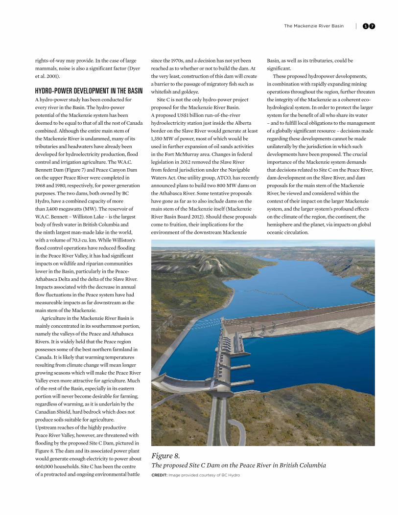
Upstream reaches of the highly productive
Peace River Valley, however, are threatened with
flooding by the proposed Site C Dam, pictured in
Figure 8. The dam and its associated power plant
would generate enough electricity to power about
460,000 households. Site C has been the centre
of a protracted and ongoing environmental battle
since the 1970s, and a decision has not yet been
reached as to whether or not to build the dam. At
the very least, construction of this dam will create
a barrier to the passage of migratory fish such as
whitefish and goldeye.
Site C is not the only hydro-power project
proposed for the Mackenzie River Basin.
A proposed US$1 billion run-of-the-river
hydroelectricity station just inside the Alberta
border on the Slave River would generate at least
1,350 MW of power, most of which would be
used in further expansion of oil sands activities
in the Fort McMurray area. Changes in federal
legislation in 2012 removed the Slave River
from federal jurisdiction under the Navigable
Waters Act. One utility group, ATCO, has recently
announced plans to build two 800 MW dams on
the Athabasca River. Some tentative proposals
have gone as far as to also include dams on the
main stem of the Mackenzie itself (Mackenzie
River Basin Board 2012). Should these proposals
come to fruition, their implications for the
environment of the downstream Mackenzie
Basin, as well as its tributaries, could be
significant.
These proposed hydropower developments,
in combination with rapidly expanding mining
operations throughout the region, further threaten
the integrity of the Mackenzie as a coherent eco-
hydrological system. In order to protect the larger
system for the benefit of all who share its water
– and to fulfill local obligations to the management
of a globally significant resource – decisions made
regarding these developments cannot be made
unilaterally by the jurisdiction in which such
developments have been proposed. The crucial
importance of the Mackenzie system demands
that decisions related to Site C on the Peace River,
dam development on the Slave River, and dam
proposals for the main stem of the Mackenzie
River, be viewed and considered within the
context of their impact on the larger Mackenzie
system, and the larger system’s profound effects
on the climate of the region, the continent, the
hemisphere and the planet, via impacts on global
oceanic circulation.
Figure 8. The proposed Site C Dam on the Peace River in British ColumbiaCredit: Image provided courtesy of BC Hydro

18 Rosenberg International Forum
only 2.5 per cent of the Earth’s water
endowment occurs in the form of
freshwater and only a tiny fraction of that
is available in liquid form for consumptive,
instream and environmental uses (Carpenter
et al. 1992). Shiklomanov (1997) estimated that,
of the tiny portion of the Earth’s freshwater,
approximately 24 per cent, is groundwater at
depths from which economical extraction is
infeasible. Additionally, nearly 74 per cent of
the freshwater supply is found in the world’s
glaciers and perpetual snow. Although the latter
quantities of water are not readily exploitable
for everyday uses, they play a very important
role climatologically. The portion of the planet’s
freshwater assets that are frozen in the form of
ice and snow is called the cryosphere. The vast
expanses of ice, snow and terrain underlain by
permafrost in the Mackenzie River Basin exert
globally significant influences on Earth’s climate.
Thus, for example, the cryosphere can moderate
atmospheric temperatures by as much as 5°C, for
example (Fitzharris 1996).
The amount of snow and ice-covered land
area located in the Northern Hemisphere is
significant. Currently, snow cover in the Northern
Hemisphere ranges from about 46 million sq. km
in January to about 3.8 million sq. km in August.
Almost all of the 9.9 million sq. km-area of Canada,
including all of the Mackenzie River Basin, can be
covered by snow in January. The portion of the
cryosphere within the Basin influences the global
climate system in a number of important ways,
some of which are unique. Cryospheric influences
contribute to the health of life, land, water, and
the weather-climate interface that defines the
climate of not just North America, but of the entire
Western Hemisphere (Rouse et al. 2003; Szeto et
al. 2007). The more important of these influences
are enumerated below and help to explain why
the Basin is a resource that contributes benefits to
populations well outside its borders.
intact ecosystems sloW anD moDeRate climate eFFectsIt is well known that various kinds of
ecosystems generate, capture, purify and release
water at different rates. Forests modulate the
hydrological cycle by absorbing heavy rains,
enhancing the seepage of water into the ground,
which is held firmly in place by tree roots, and
reducing surface run-off. In combination, these
effects moderate the release and availability of
water throughout the year.
If this role is reduced below certain thresholds,
affected systems can no longer act as buffers to
disturbance. We now know that supplying water
to nature is crucial in preventing ecosystems from
changing in undesirable ways. Desertification is
but one example. The careful capture of as much
water as possible in upstream areas by rainwater
harvesting, and through natural processes, has
been proven to assist in maintaining resilience
that prevents or moderates the possible effects
of both flooding and drought, while at the same
time generating greater flow volume downstream
(Safriel 2011).
Research conducted at the University of
Saskatchewan and Environment Canada shows
that intact boreal forests are natural water
managers that will protect the stability of
surface water resources and local climate under
substantial global climate variability (Pomeroy
and Granger 1997; Granger and Pomeroy 1997).
Removal of the boreal forest by harvesting was
found to increase the incidence of both spring
flooding and summer drought and surface
heating. The clear cuts were hydroclimatically
fragile while the intact forest demonstrated
resilience. As one of the largest relatively intact
forest ecosystems in the Western Hemisphere,
the Mackenzie River Basin’s current stability
contributes to global natural system resilience
that moderates climate and freshwater cycling
variability, not just regionally, but continentally
and globally (Broecker 2000).
the mackenzie system has a ReFRigeRating eFFect on the noRtheRn hemispheReThe cryosphere affects the global climate system
through its direct influence on air temperature.
In general, a quarter of the globe is covered
by snow at any given time. Ice and snow cover
have enormous potential powers of reflection.
Snow and ice can reflect as much as 95 per
cent of sunlight that falls on it back into the
atmosphere. This high degree of reflectivity, or
albedo, as it is called, is an important climate
feedback mechanism. Snow cover affects climate
in regions remote from the snow cover itself
because it increases the amount of radiation
lost near the Earth’s surface. Arguably, these
effects are global. Snow cover, atmospheric
circulation and temperature are interrelated to
each other and interact with one another for form
feedback mechanisms (Groisman and Davies
2001). Temperature is a major determinant of
the form and speed through which water moves
through the global hydrological cycle. Water
and temperature are major determinants of
climate and climate exerts a major influence on
ecosystems – and ecosystems define us. There is
not a person on Earth who is not affected by what
ice does (Pollack 2009). Long-term spatial and
temporal change in snow cover in the Mackenzie
system will propagate well beyond that basin to
alter snow and ice cover and other controls of
climate regionally and globally (Groisman and
Davies 2001; Sandford 2012).
the mackenzie system:the eFFects oF colD on hyDRo-climatic conDitions

19The Mackenzie River Basin
Recent research conducted by Wadhams
(2012) indicates that the loss of Arctic ice may
be compounding the heat trapping impacts of
greenhouse gas emissions. The polar ice cap acts
as a giant parasol, reflecting sunlight back into
the atmosphere through the albedo effect. White
ice and snow reflect far more of the sun’s energy
than the open water that is replacing it as the ice
melts. Instead of being reflected away from the
Earth, this energy is absorbed, and contributes
to warming. The extent of sea ice is currently at
its lowest in recent history, causing greater and
greater absorption of warmth (Wadhams 2012).
It is also important to note that a countervailing
force in the Mackenzie arises from the fact that
it serves as a “heat pump” carrying warm water
northward. The importance of this effect is easily
seen by the position of the tree line, which extends
right to the mouth of the river in the Mackenzie
Delta, but ends as far south as Great Bear Lake
in parts of the Basin away from the main stem of
the river. The effect is most pronounced in spring,
when warm waters from the southern parts of
the Basin are carried north, causing a mechanical
breakup of ice on the river long before melting
occurs in downstream parts of the Basin. A similar
effect is seen in late autumn, as the river does not
freeze until the surrounding landscape is much
colder. Overall, the mean annual temperature in
the immediate Mackenzie Valley can be 4-5oC
warmer than outlying parts of the Basin at the
same latitude (Mackay 1963).
Modeling studies may also be instructive.
Brown and Mote (2009) examined the sensitivity
of snowpack models by comparing satellite
measurements of snowpack with simulations from
multiple models. The analysis of trends in the
satellite data on snow cover duration showed that
during the period 1966-2007 the largest declines
in snow cover were concentrated in zones where
seasonal air temperatures were in the range of
−5o to 5oC. The analysis also suggested that the
interaction between snow accumulation rates and
the duration of the snow season is linked non-
linearly to increasing temperature and precipitation
(Brown and Mote 2009). A later analysis of the
Northern Hemisphere spring terrestrial snow cover
extent based on National Oceanic and Atmospheric
Administration data for the April to June period
reveals significant reductions in snow cover extent
in May and June. Successive records for the lowest
June snow cover extent have been set each year
for Eurasia since 2008 and in three of the past
five years for North America. The rate of loss of
June snow cover extent between 1979 and 2011
is estimated at 17.8 per cent per decade which is
greater than the loss of September sea ice extent
(10.6 per cent per decade) over the same period
(Derksen and Brown 2012).
The presence of polar ice has an even greater
refrigerating effect than snow (Holland and Bitz
2003). Researchers are discovering that ice is
the central element in the planet’s thermostat. It
appears that the entire globe is somehow affected
by the moderating influence of ice on global mean
temperatures (Conkling et al. 2011). Arctic ice acts
as a mirror, reflecting as much as 95 per cent of the
sun’s energy but without it, 90 per cent of that energy
will instead be absorbed. This is a concern because
the Arctic ice pack has thinned by 40 per cent in the
last half-century and is still receding. Less Arctic
ice in summer means more ocean water is exposed,
which in turn means more solar radiation will be
absorbed, resulting in ice forming later and later in
the fall. The newly formed sea ice will be thinner
when it melts the following spring. Spring breakup
will come earlier, resulting in a longer warming
season for ocean water. This warming eventually
mixes into the deeper ocean, which leads to sea-level
rise through thermal expansion.
Since temperature variations between the
equator and the poles help shape ocean currents
and jet streams alike, melting at the poles
threatens disruption of global weather patterns.
Figure 9. The distribution of permafrost in the Mackenzie River Basin.Credit: ©Map from the Mackenzie River Basin Board website. Used with the permission of the Mackenzie River Basin Board.

20 Rosenberg International Forum
If the Arctic sea ice disappears it will be for the
first time in 55 million years and thus will be
the largest change in the earth’s surface ever
experienced by human beings. Knowledge of
the Earth’s climate system is still comparatively
limited, so it is difficult to predict what the
ultimate impacts might be. The Mackenzie system
is globally important, in part, because it influences
the changes in the extent and duration of sea
ice in proximity to its mouth. These changes are
now occurring faster than anywhere else in the
Northern Hemisphere (Comiso 2002).
the peRsistence oF peRmaFRostCold regions like the Mackenzie River Basin
also moderate Earth’s climate system by storing
or capping enormous volumes of carbon
under permafrost, preventing its escape to the
atmosphere. Deep permafrost can take 100,000
years to form. Permafrost covers 20 per cent of
the Earth’s surface and is in some places two
kilometres deep. But in some regions, such as the
Mackenzie River Basin, where average annual
temperature is only slightly below freezing,
the permafrost is much thinner. Loss of this
permafrost will release massive quantities of
methane into the atmosphere. Figure 9 shows the
distribution of permafrost across the Basin.
Tarnocai et al. (2009) found that permafrost
contained even more carbon than the peatlands
that overlie it. The carbon inventory that these
authors observed in boreal permafrost suggests
that the boreal forest may be a larger carbon
sink than previously realized, and that the
consequences of melting permafrost may be
releases that are at least double the estimates of
carbon losses from peatlands alone. Schindler and
Lee (2010) used the estimates of Tarnocai et al.
to conclude that boreal carbon stores may be as
much as four times those of tropical forests.
Very little is known about the role that
permafrost plays in the larger geomorphological
context of the Mackenzie River Basin. The work
of Quinton et al. (2009) shows that much of the
permafrost at the southern boundary of its extent
in the Basin has a mean annual temperature of
−0.1 to −0.2°C. In these locales this means that
small temperature changes can have large impacts
on the physical landscapes’ associated biota. The
thawing of permafrost in what are called “peat
plateaus” has led to significant land subsidence.
The impact of such subsidence on roads, bridges
and airport runways, and potentially on pipelines,
is a major threat to existing infrastructure. In parts
of the Arctic, buildings are beginning to tilt and
sink into ground that is no longer solid because the
permafrost is melting (Sandford 2012).
The fact that permafrost is diminishing in
the North is not just a problem for existing and
proposed transport facilities in the Mackenzie
Valley. It is an example of a self-reinforcing
“positive feedback” process in which a small
disturbance can trigger a chain reaction leading
to a large magnitude perturbation. That is,
A produces more of B, which in turn produces
more of A. Warming in the Mackenzie Valley is
causing more permafrost to melt, which releases
greenhouse gases and lowers albedo, causing
more warming. These self-reinforcing chains of
reactions are also accelerating in the region of
the Beaufort Sea. Not only is the hydrology of the
entire Arctic changing, but positive feedbacks
that increase the generation of greenhouse gases
appear to be already accelerating warming.
In the Arctic, the crystalline structure of ice
is similar to a semi-spherical cage (National
Research Council 2004). The form of ice is
found at relatively shallow depths within the
underlying sedimentary deposits. This type of ice
is widespread on the continental shelves and, on
rare occasions, continental deep lakes such as in
Siberia’s Lake Baikal. Such ice is of special interest
because of its capacity to trap methane within the
molecular cage (Sandford 2012).
Drilling into the shelf sediments has yielded
samples of this gas-bearing ice from a great many
sites throughout the circumpolar region. When
ignited, samples put on quite a show – chunks of
ice aflame defy all intuition. Methane, of course, is
an important source of energy in the industrialized
world, but it is also a significant greenhouse gas
when released into the atmosphere. The release of
methane from its subsurface ice cage is therefore
a worry in the context of runaway climate change
Figure 10Relative flow contributions to the Arctic Ocean (discharge in cubic kilometres per year).
Credit: ©2004, ACIA / Map ©Clifford Grabhorn

21The Mackenzie River Basin
and further sea level rise (Sandford 2012).
Methane release from the Arctic seabed
in 2011 significantly exceeded what had been
observed over the preceding 20 years (Semiletov
et al. 2012). Though it does not reside as long in
the atmosphere, methane is up to 21 times more
potent a greenhouse gas than CO2. One potential
consequence of global warming in the Arctic and
yet another positive feedback effect could be the
release of the hundreds of millions of tonnes of
methane presently frozen in permafrost or held
in place on sea floors by the cold temperature of
Arctic seawater. Such release would increase the
capacity of the atmosphere to trap more heat and
further acceleration of global warming would be
the result.
the mackenzie RiveR has a DemonstRable eFFect on sea ice FoRmation anD a pRobable eFFect on the Dynamics oF global ciRculation oF Deep ocean cuRRentsNearly two-thirds of the water flowing into the
Arctic Ocean comes from four rivers as shown
in Figure 10. The Mackenzie is the fourth largest
of these, but is the only large northward flowing
river in the Western Hemisphere (although some
would consider the Yukon a large north-flowing
river). The remainder of the northward flow of
approximately 40 per cent comes from smaller
rivers in other parts of the circumpolar world.
While it appears to contribute only a modest
amount of water to the Arctic, some researchers
think it is more than proportionately important
in terms of its influence on Arctic Ocean currents
(Spence 2012). Of all the Arctic rivers, the
Mackenzie carries the most sediment, especially
in flood. The reason for this is that the great
Russian rivers flow through interior plains,
while the Mackenzie has its origins in upland
mountains. The Mackenzie also brings a great deal
of heat into the Beaufort Sea.
In spring, the turbid water of the estuary flows
out over the land-fast ice to create what researchers
call “Lake Mackenzie.” Stimulated by 24 hour-a-day
sunlight, bacteria and algae proliferate massively in
the freshwater on top of the ice. As the spring melt
progresses, this water and the life within, drains
through “strudel holes” into the ocean (Figure 11).
The “Lake Mackenzie” river water is prevented
from flowing into the Arctic Ocean, however,
by the Stamuki Ridge, a pressure ridge that has
formed at the interface between the land-fast
ice and the sea ice. What results is an 18-metre
nutrient-rich lens of freshwater floating on the top
of the Arctic Ocean (Lesack 2012).
When cold Arctic air freezes sea water in
winter, the salt in that sea water is released into
the waters below making that water heavier
than that which is above it. This denser, saltier
water sinks to become part of what is known
at the Arctic Halocline. Because of the extent
of its freshwater inflows and their influence on
wave height and ice formation, the estuary of the
Mackenzie is one of the few places in the world
where the creation of sea ice allows ocean water to
sink enough to maintain deep-water circulation.
While knowledge of how freshwater flows in sea
ice formations is far from complete, diminished
flows could affect deep water ocean current
circulation (Broecker 2005).
conclusionsThe Mackenzie River Basin has unique hydrologic,
ecologic and climatological features and processes.
Planetary warming threatens the stability of
these processes and the integrity of the Basin
ecosystems. Simultaneously, exploitation of the
Basin’s considerable non-renewable resources and
hydroelectric generating potential has become
more attractive economically as demands for these
resources and energy grow. The threats posed
by global warming mean that the resiliency and
capacity of the Basin for self-repair are in jeopardy.
One major consequence is that development
activities are likely to be even more harmful than
they would be in the absence of planetary warming.
The existence of warming and its potentially
profound impacts on the natural systems of the
Mackenzie River Basin emphasizes the fact that
future development must be undertaken in a
balanced and sensitive way if the capacity of the
Basin to provide environmental services, unique
habitat and a stable homeland for indigenous
peoples, is to be protected and preserved.
Figure 11. “Strudel hole” in offshore iceflow here is strong, causing a drain-hole whirlpool. Photograph courtesy of Dr. Lance Lesack, Simon Fraser University

22 Rosenberg International Forum
lanDmaRk eaRlieR ReseaRchThe Mackenzie River appears to be less well
studied than most other major rivers of the world.
There is, nevertheless, an important body of
research focused on the Mackenzie River Basin.
Some of this research, large in volume, may
be important but is now inaccessible. For this
reason, the working body of knowledge about the
Mackenzie appears relatively small. Nevertheless,
significant research has been conducted there.
Among the major research projects are the
Mackenzie Basin Impact Study conducted under
Environment Canada’s Project Lead Stewart J.
Cohen. Interim Mackenzie Basin Impact Study
Reports were submitted in March of 1993 and
November of 1994. The final report, Mackenzie
Basin Impact Study (MBIS) Final Report was
published in 1997. The four major findings of that
report were consistent with later research findings
presented to the Rosenberg Panel:
1 Most of the regional effects of climate warming
scenarios will be adverse. They include lower
minimum water levels in the region’s waterways
and increased erosion from thawing permafrost,
as well as a rise in the number of forest fires and
landslides and a reduction in the yields of forests.
These effects will probably offset any potential
benefits from a longer growing season. Some of
these changes have been observed during the
recent 35-year warming trend.
2 Most participating stakeholders believe the
region could adapt if the changes occur slowly.
However, rapid warming will make adaptation
considerably more difficult. If vegetation and
wildlife patterns are modified by climate change,
then indigenous peoples’ subsistence lifestyles are
at risk. The effect of long-term climate change on
communities, however, will also be determined
by other factors, including lifestyle choices made
by the region’s inhabitants. Although socio-
economic patterns and determinants are not well
understood, it is possible that subsistence lifestyles
will not be feasible in the future.
3 Increased local and regional control of land
and water resources will help to reduce the
area’s vulnerability and help local residents adapt
to climate change. That, however, may not be
enough to respond effectively to global warming.
Similarly, reducing regional emissions will not be
enough to prevent the climate from changing. If
the governments that signed the convention on
climate change fail to slow the change in climate,
then regional stakeholders may need to intervene
at national and international levels to warn others
about the consequences to the Mackenzie River
Basin.
4 The effect of a change of climate on the
Mackenzie River Basin is more than the sum
of changes to the trees, water and permafrost.
Governments, communities, industries and
people will respond to the combined effects of
climate change on water and land resources.
These responses will be tempered and shaded
by the choices of government officials,
community residents and industry leaders in
response to other issues such as the demands
of the global economy, traditional lifestyles and
political realities. Computer models are one
way to bring together or integrate many parts of
the whole, but these models are limited in their
abilities to describe how regions and people
relate to climate change and other stresses.
The experience of the Mackenzie Basin Impact
Study suggests that an integrated assessment
requires a partnership of stakeholders and
scientists, in which visions are shared and
respected, and information is freely exchanged.
Canada also participated in the Global
Energy and Water Cycle Experiment (GEWEX),
which examined cold regions atmospheric and
hydrological processes with a special focus on
the Mackenzie Basin. The Mackenzie GEWEX
study came to be known as MAGS. The GEWEX-
MAGS study remains relevant and timely in that
it was the first comprehensive study aimed at
understanding and modeling the high-latitude
energy and water cycles that play roles in the
climate system. The research strengthened the
scientific bases for assessing changes to Canada’s
water resources that arise from climate variability
and anthropogenic climate change. Much of the
research conducted since the GEWEX-MAGS
study confirms the trends and concerns it
identified, particularly those related to warming
effects on wildfires, snow, permafrost, lakes, river
ice and stream flow. There is strong scientific
evidence that subtle hydro-climatic changes are
triggering accelerating effects on the Mackenzie
system, and that these same effects are beginning
to manifest themselves further south (Szeto
2002; Szeto et al. 2008). Thus, for example,
Canada’s southern boreal forests are expected
to be increasingly sensitive to change in the 21st
century because hydrology so dramatically affects
vegetation (Bergengren et al. 2011). Changes in the
timing and volumes of stream flow resulting from
a possible shift in the climate regime are expected
to impact forest ecosystem resilience to other
stressors (Peng et al. 2011; Anderegg et al. 2012). In
both the prairie region and in Canada’s northern
boreal forests, adaptation is tied to hydrologic
processes and human activities.
These major studies establish that small
changes in temperature in the Mackenzie
River Basin are likely to have big consequences
over time which will introduce a great deal of
existing science & scientiFic eviDence: WoRRisome signals anD tRenDs

23The Mackenzie River Basin
uncertainty into the management of the system.
A number of troubling positive feedbacks
from increasing mean temperature are already
occurring throughout the Basin. While there
is little clarity about the extent to which these
feedbacks will accelerate over time or exactly how
they will change the future ecology, hydrology
and climate of the Mackenzie, even small changes
clearly matter.
acceleRateD WaRmingSummer weather in the Mackenzie River Basin
comes from the Pacific Ocean in the west, and
occasionally from the south. When southern air
masses collide with Pacific masses in summer, it
can result in large storms. In winter, the weather
comes mostly from the west, cools, and then
moves southward to freeze the Central Great
Plains. Most of the precipitation in the Basin falls
in the mountains.
It is has been observed that temperatures
are sometimes unexpectedly high in the central
Mackenzie River Basin in summer. Winter
temperatures are also rising dramatically. Warm
air has begun to come north earlier in the spring
and often persists longer into the autumn. The
northern regions of the Basin are warming
faster than anywhere else in Canada.
While atmospheric modeling is being
advanced, it is still inadequate as a tool for
determining how much temperature might rise
given a variety of climate change scenarios.
The mean temperature rise in the Mackenzie
River Basin is already beyond the 2˚C mean
annual warming that was agreed upon in
Copenhagen as being undesirable for humanity
to exceed. The most noticeable effects of this
warming relate to changes in the extent and
timing of spring runoff; changes in spring
and fall precipitation; changes in the amount
of precipitation that falls as rain as opposed
to snow; changes in evaporation; changes in
freeze-thaw patterns; and changes in the extent
and depth of lake, river and sea ice. In addition,
plants are leafing out and flowering earlier and
some avian migrations are occurring earlier.
The hydrology of the Northwest Territories
is already changing and all signs indicate these
changes will accelerate over time. This means
that the Northwest Territories water strategy
could become irrelevant in the face of hydro-
climatic changes that are completely outside
human ability to cope. This could happen in
other parts of Canada as well. These changes in
the Mackenzie are a major part of the ongoing
global Arctic ice collapse.
sea ice lossIn 1980, the eight million sq. km of Arctic ice
in summer made up some two per cent of the
Earth’s surface, but by 2007, the area of this
ice had roughly halved (Wadhams 2012). The
same research indicates that since 1979, an
area of sea ice twice the size of Quebec has
been lost, likely creating feedback that further
accelerates ice losses. Thinner ice in one year
leads to easier and quicker melt in the next.
When white, highly reflective ice is melted, the
darker opened water absorbs more solar energy,
diminishing new ice accumulation.
The World Meteorological Organization
(2012) reported that ice cover in the Arctic
between March and September of 2012 had
been reduced by an area of 11.83 million sq. km
(Figure 12). This means that the area of Arctic
sea ice that melted in the summer of 2012 is two
million sq. km larger than the entire landmass
of Canada. The implications of such rapid melt
are manifold. The loss of Arctic sea ice and the
reduction of the extent and duration of snow
cover in the Northern Hemisphere are reducing
the gradient in temperature between Arctic air
masses and those of more temperate regions
to the south that could affect weather patterns
throughout the Western Hemisphere and
around the world.
It has been demonstrated (Wadhams 2012)
that the increased absorption of the sun’s rays
taking place as a result of the loss of Arctic sea
ice is having a warming effect equivalent to
adding about 20 years of additional CO2 through
human emissions. If these estimates are correct
they imply that over recent decades the melting
of the Arctic ice cap put as much heat into the
Earth’s hydro-climatic system as all the human-
generated CO2 during that time. If the ice
continues to decline at the current rate, its loss
could play an even bigger role in changing plants’
climate and water cycle than greenhouse gases.
peRmaFRost lossApproximately half of Canada’s landmass is
underlain by permafrost. The thawing of some
of this permafrost over extensive areas of the
Canadian North is one of the most important
and dramatic manifestations of warming in
Canada. Documented examples include land-
cover transformations occurring at the southern
margin of the permafrost as ground thaw results
in forests collapsing into wetlands and the
widely documented rapid colonization by shrub
species across the pan-Arctic. This ongoing
permafrost thaw feeds back synergistically
with its effects on vegetation, snow cover,
soil moisture, and subsurface permeability.
These changes are transforming the ecology,
surface energy balance and hydrological cycle
of northern regions. Widespread thaw of
permafrost will alter the pattern, timing and
rates of heat, gas and mass exchanges both
vertically and laterally at local and regional
scales. This change will have widespread
impacts on the atmosphere, vegetation
communities, and the Arctic Ocean through
changes in the quantity and timing of runoff
(Quinton 2011; Woo 1992).
RunaWay methane emissionsHuge volumes of methane are trapped within
the permafrost. Methane released from thawing
permafrost migrates up through the sediments
and bubbles into the ocean water above. We
can anticipate some changes in the Mackenzie
from research done in Siberia. Shakhova et al.
(2010) estimate that the Siberian Shelf alone
harbours some 1,400 billion tonnes of methane
in gas hydrates, about twice as much carbon as
is contained in all the trees, grasses and flowers
on the planet. If just one per cent of this escaped
into the atmosphere within a few decades, it
would cause abrupt climate change (Mascarelli
2009; Shakhova et al. 2010).
Recent scientific observations of dramatic
and unprecedented volumes of methane
bubbling to the surface in the Russian Arctic
have been cited as a cause for concern.
Semiletov’s (2012) findings that the methane
emissions from the Russian Arctic were about
eight million tonnes a year, some two to 10
times more than previously predicted. In 2011,
Semiletov and his colleagues conducted an
extensive survey of some 16,000 sq. km of sea off
the East Siberian coast. They used seismic and
acoustic instruments to monitor the “fountains”
or plumes of methane bubbles rising to the sea
surface from beneath the seabed. In a very small
area, the research team counted more than 100
fountains, or torch-like structures, bubbling
through the water column and injecting
methane directly into the atmosphere from the
seabed.
Methane fields on a scale not reported

24 Rosenberg International Forum
before were discovered by Semiletov (2012)
and his colleagues. Among the discoveries were
methane plumes a kilometre, or more, wide,
which emitted highly concentrated quantities
of methane directly to the atmosphere. This was
also the first discovery of seeping structures
deep on the ocean floor, more than 1,000
metres in diameter. More than a hundred such
structures were found in a small area, but there
are likely thousands of them over a wider area.
The deeper sediments of the Beaufort Sea
also contain deep layers of methane hydrate –
an ice-like mixture of water and natural gas. As
the seafloor warms as a result of rising air and
water temperatures, these hydrates decompose,
releasing additional methane gas from the
sediment into the waters of the Beaufort Sea.
In the fall of 2010, a collaborative research
cruise was conducted to the Beaufort Sea on the
Canadian Coast Guard ice breaker Sir Wilfred
Laurier to investigate sites where methane
venting, possibly associated with decomposing
gas hydrate and/or permafrost, was established
as a possibility. During this expedition a small
submersible was used to document the nature
of these seafloor gas vents and the existence of
methane bubbles on several occasions (Paull
et al. 2012). Based on observations, as well as
the contents of sediment cores collected by the
Geological Survey of Canada, the researchers
concluded that the shelf edge in the Beaufort
region is an area of “widespread diffuse
venting” and that “methane permeates the shelf
edge sediments in this region.”
While researchers have begun to
understand where the gas in the Beaufort Sea
is coming from, many other questions remain
unanswered. Research has demonstrated
that undersea landslides are common along
the continental slope of the Beaufort Sea, but
circumstances under which they happen are
not yet clear. Decomposing methane hydrates
have been shown to trigger major landslides
in other deep-sea areas of magnitudes that
could potentially destabilize oil platforms or
pipelines on the seafloor, and have the potential
to generate tsunamis. Adequate research has
yet to be conducted, however, on how the
water temperature, flow rates and circulation
of freshwater inflows of the Mackenzie River
might influence the release of methane from
the floor of the Beaufort Sea. Recent research
results suggest that 85 per cent of the methane
suspended in northern permafrost and on Arctic
seafloors would be released by a warming of
only 3˚C (Mosher 2009; Mosher et al. 2012).
The threat posed by uncontrolled release of
methane hydrates adds additional uncertainty
to the management of the Mackenzie system.
In order to deal with uncertainty, much more
needs to be understood related to cause, effects
and timing of all phenomena related to changes
in the hydrological cycle and energy balance
of northern regions brought about by warming
temperatures.
nitRogen Fixation in the beauFoRt seaRecent research (Blais et al. 2012) has indicated
that global gaseous nitrogen fixation rates may
be underestimated. This research indicates that
critical data are lacking from many regions,
such as the world’s cold oceans, which do not
possess conspicuous diazotrophic cyanobacteria
– known nitrogen-fixing species whose fixation
rates have been used to estimate global nitrogen
fixation rates. This research, which estimated
nitrogen fixation rates at diverse sites in the
Canadian Arctic, including the mouth of the
Mackenzie River, the offshore Beaufort Sea,
Lancaster Sound and Baffin Bay, revealed that
the Mackenzie River is the source of biological
nitrogen fixation. Genetic analysis suggested
this was from freshwater cyanobacteria in the
order Nostocales that contributes new nitrogen
to the nitrogen-depleted surface waters of the
Beaufort Sea. This nitrogen contribution is a
vital foundation of the food web that emanates
from the estuary of the Mackenzie through the
entire Arctic Ocean (Blais et al. 2012).
This first record of nitrogen fixation at high
latitudes yields a greatly refined understanding
of the global nitrogen budget. Virtually nothing,
however, is presently known about how changes
in upstream activities in the Mackenzie system
will alter the nitrogen budget of the Mackenzie
Delta or the food web that is created as its
inflows mix with the waters of the Beaufort Sea.
the eFFect oF WaRming aRctic tempeRatuRes on canaDa’s WesteRn mountainsRising Arctic temperatures are already affecting
the hydrological cycle in other parts of Canada.
Canadian regions that are already undergoing
unprecedented change include permafrost areas
of northern Canada and the Western Cordillera,
Figure 12. Monthly September ice extent for 1979 to 2012 shows a decline of 13% per decade. Credit: National Snow and Ice Data Center.
25The Mackenzie River Basin
as it is known. In Canada’s western mountains
declining spring snow cover and glacier cover
are exhibiting dramatic responses to climate
warming. Glacier coverage has declined by
approximately 25 per cent in the last quarter
century and the spring snow covered period has
decreased by approximately one month in the
Canadian Rockies (Bolch et al. 2010).
Glacial recession in this region is occurring
in tandem with a shift from snow to rain on the
eastern slopes and a decrease in streamflow in
both glaciated and non-glaciated streams in the
headwaters of both the Peace and Athabasca
Rivers (Demuth and Pietroniro 2003; Marshall
et al. 2011; Stahl and Moore 2006). In the
northern half of the Western Cordillera that
feeds the Mackenzie River, however, stream
flow is increasing and peak flows occur much
earlier for reasons that are not fully understood
(Jacques and Sauchyn 2009). Ecosystem
responses to these changes are difficult to
specify in this region because of natural
topographic and geological variability, and the
cumulative effects of pine beetle infestations on
forests already heavily harvested.
Instrumental and proxy records demonstrate
that both the western boreal forest and the
Canadian prairies have experienced large
swings in climate over the past several
centuries, with the greatest extremes of wetness
and dryness over the course of the past 140
years occurring since 2000 (Stewart et al. 2011).
These swings in climate in combination with
agricultural activity have resulted in extensive
soil depletion, the decline of aspen forests and
the widespread disappearance of wetlands and
streams. Groundwater levels have dropped
dramatically, particularly during droughts such
as the one that occurred between 1999 and 2004
(Stewart et al. 2011).
Overall, the greatest increases in temperature
have occurred during winter and spring, with
the biggest increases being in minimum, as
opposed to maximum temperatures (Zhang et
al. 2010). Temperature increases as expressed by
the number of warm days where the maximum
temperature has been in the ninetieth percentile
or higher, and the number of summer days
above 25˚C, have increased over most of the
Mackenzie River Basin in the last half-century
(Vincent and Mekis 2006).
A measured general increase in precipitation
has occurred across Canada since the 1950s.
Nevertheless, there is still considerable
regional variability in rainfall (Insurance
Bureau of Canada 2012). The general increase
in precipitation has been characterized by an
increase in the number of multi-day rain events
as opposed to local convection storms; and
more precipitation falling as rain compared to
snow (Zhang et al. 2010; Shook and Pomeroy
2012). Snow cover duration and the extent of
spring snow cover in the Northern Hemisphere,
including the Mackenzie Basin, have also
declined (Brown and Mote 2009; Schindler
and Donahue 2006). Terrestrial ecosystems
are already responding to the changes. Forests
are being converted to wetlands in areas
where permafrost is thawing; and shrub height
and coverage are already increasing in areas
characterized as tundra.
Over the last 30 to 50 years, mean stream flow
has decreased in many parts of Canada. There
has been a particularly significant reduction
in the south, where spring freshet is occurring
earlier (Zhang et al. 2010). However, earlier and
sometimes higher stream flows are occurring
in the North, which is also experiencing
generally increased winter baseflows. Despite
visibly obvious and instrumentally measureable
changes, evaluation of hydroclimatic trends and
their potential future impacts on ecosystems
and people has been inconsistent. Apart from a
very specific evaluation of the Prairie Drought
of 1999-2004 (Stewart et al. 2011) there has
been little synthesis of observable change in
Earth system properties in the Mackenzie River
Basin or in the biogeographical regions that
adjoin it to the south. Little is known about
compounding ecological effects.
compounDing continental ecological eFFectsThe cold interior region of Western Canada
east of the Continental Divide, from the United
States border extending northward over the
Prairie Provinces to the Northwest Territories
and on to the Arctic Ocean, has one of the
world’s most extreme and variable climates
and is experiencing rapid environmental
change (Spence et al. 2005). Changing
hydrological conditions will affect the entire
region, impacting the climate of the entire
continent. Climate warming and changes in
precipitation patterns have resulted in altered
patterns of snowfall and snowmelt; greater
temporal variability of precipitation; conversion
of snowfall to rainfall (Groisman and Davies
2001); loss of glaciated area (Marshall 2012); and
thawing of permafrost (Arctic Council 2005).
The wide-ranging effects of hydrological change
on terrestrial ecosystems in the Mackenzie and
in adjacent ecosystems include changing Arctic
and alpine tree lines, extreme variability in prairie
wetland extent and variability in the storage of
subsurface water in soil and groundwater. They
also include “browning” of the boreal forest
and prairie aspen woodlands due to changing
hydrological regimes (Goetz et al. 2005; Bunn et
al. 2006); forest conversion to wetlands in areas
of permafrost loss; increased tundra shrub height
and coverage, with associated impacts on snow
accumulation; and melt and ground thaw regimes
throughout the entire region (Sandford 2012).
These atmospheric, cryospheric and ecological
changes have in turn produced changes to water
storage and cycling with lower, earlier and more
variable streamflow issuing from the Western
Cordillera, early and more variable Prairie
streamflow, greater variability in agricultural
and soil moisture (Sauchyn and Kulshreshtha
2007), substantially earlier and sometimes higher
streamflows with greater winter baseflows in
the North (Zhang et al. 2001) and indications
of changes in extreme precipitation events and
resulting flood and drought (Bonsal et al. 2004).
Though these changes are already significant,
and in some cases border on catastrophic, climate
simulations suggest increased warming will lead
to temperatures not seen during the Holocene (the
last 10,000 years) (Sauchyn 2004). In addition,
extremes of high precipitation and drought over
the region will likely exceed those experienced
since records began in the 1800s (Sauchyn and
Kulshreshtha 2007). This rapid rate of change
raises concern that current Earth system models,
developed on historical data and an assumption
of climate stationarity, may not adequately predict
the future (Furgol and Prowse 2008; Rosenberg
2010; Trenberth 2010).
loss oF hyDRological stationaRityClimate change – past and projected – sheds
great doubt on the viability of what hydrologists
call “stationarity.” Stationarity is the notion that
natural climate and hydrologic phenomena
fluctuate within a fixed envelope of certainty.
When this assumption holds, the effects
of weather and climate on urban areas and
agriculture can be predicted and managed with a
relatively high degree of certainty. Unfortunately,
it is now generally accepted that the evidence

26 Rosenberg International Forum
does not support assumptions of climatic
stationarity (Milly et al. 2008). A report issued by
the National Research Council (2011) confirms
the likely serious consequences associated with
the newfound understanding that assumptions
of hydrological stationarity are not valid. The
findings of the National Research Council (2011)
include consensus on the fact that anthropogenic
land cover changes such as deforestation, wetland
destruction, urban expansion, dams, irrigation
projects and other water diversions have
significant impact on the duration and intensity
of floods and drought. They also have a significant
impact on downstream hydrology in all of the
world’s river basins. The report concludes that
“continuing to use the assumption of stationarity
in designing water management systems is, in fact,
no longer practical or even defensible.” Loss of
hydrologic stationarity means that the Mackenzie
and other river basins must be managed under a
great deal more uncertainty than in the past.
otheR WoRRisome thReatsIn addition to these threats posed by planetary
warming, there are a host of other threats to
the region that are rooted in the specter of
unrestrained development, lack of attention to
environmental protection and a lack of will to
acknowledge and recognize the lifestyles of the
Basin’s indigenous peoples. Many of these threats
are already present as the following discussion
of the risks posed by exploitation of the oil sands
indicates. These kinds of risks are likely to grow
rapidly if the scale of development is allowed to
expand without limit. Other kinds of unbridled
development are likely to result in a new panoply
of risks that will have to be dealt with as they
arise. Three of these worrisome risks, including
exploitation of the oil sands, development
of hydroelectric power and the extensive
construction of roads are discussed below.
The panel was of the opinion that the largest
single threat to the Mackenzie River Basin would
be a large breach in the tailings ponds at one of the
sites where surface mining bitumen is conducted.
Some argue that such a breach is unlikely but the
failure of flood control dikes and embankments
that contain wastewaters of various sorts are
almost everyday news. The panel was told that if
such a breach occurred in the winter and tailings
liquid were to get into the Athabasca River
under the ice, it would be virtually impossible to
remediate or clean-up. A 1982 episode was cited in
which a relatively modest spill at an oil sands site
ended up in Lake Athabasca, causing the fishery
to be closed for two years. A large spill, such as
would occur in a major breach of a tailwater pond
dike, could threaten the biological integrity of
the lower Athabasca River, the Peace-Athabasca
Delta, Lake Athabasca, the Slave River and Delta,
Great Slave Lake, the Mackenzie River and Delta,
and perhaps also the Beaufort Sea. It would have
an unprecedented effect on human society in the
Northwest Territories.
Even relatively small hydrocarbon exploitation
operations can create environmental disasters.
Small-scale oil development at Norman Wells on
the Mackenzie River entails the construction of
artificial islands in the river to support drilling
platforms. A spill of virtually any magnitude
would have nowhere to go except the river. Again,
ice would create a particular problem for any
containment in the winter months. In the Norman
Wells case, the picture is complicated further
because the drilling platforms are just upstream
from the Fee Yee (also known as the Ramparts),
where the river is pinched between high cliffs to
form impressive rapids that would mix any spill.
Just downstream from Fee Yee is a large migratory
wildfowl breeding area.
The potential for hydroelectric power
development within the Northwest Territories
and elsewhere in the Mackenzie Basin is
enormous. There is likely to be intense pressures
for large hydropower developments in the
future. It should be recognized, however, that
any dam blocks the passage of migratory fish.
Many of the species valued by indigenous peoples
are migratory, including lake and mountain
whitefish, cisco and char. Reservoir formation
also causes increased methylation of mercury,
leading mercury concentrations in the remaining
fish to rise to levels where eating them more
than once or twice a month creates a substantial
risk of mercury poisoning (Rosenberg et al.
1997). Global emissions of mercury have already
increased atmospheric concentrations by two
or threefold (Fitzgerald and Lomborg 2003),
adding to the mercury problem in northern areas
(Arctic Council 1997). All of this suggests that
development of additional hydroelectric power
is unlikely to be consistent with the lifestyles of
indigenous peoples.
Finally, the panel heard that the construction of
roads and railroads into remote areas may bring
unwanted influences to indigenous communities.
Among them are drugs, alcohol and crime.
Currently, a road connecting the Dempster and
Mackenzie highways is under discussion. A
railroad connecting Valdez, Alaska with the oil
sands is also under consideration. The lesson here
is that mining, production of hydrocarbons and
development of hydroelectric generating facilities
almost always entail construction of roads and/
or railroads. These developments are highly
controversial among the populations of northern
communities, with the potential negative effects
being of central concern.
conclusionsThe evidence, both formal and casual, indicates
that there are a number of worrisome signals
and trends in the Mackenzie River Basin. Many
of these are symptoms and potential symptoms
of planetary warming. Others, however,
are associated with past and prospective
development of non-renewable resources,
hydroelectric power and hydrocarbons. It is
likely that the climatological threats will have
to be managed adaptively. The developmental
threats need to be managed to protect the
livelihood of indigenous and northern peoples
and the capacity of the Basin to provide
environmental services of all types. This
undoubtedly means that future resource
development schemes must be managed in a
balanced way that accounts for a broad range of
values including those of indigenous peoples. As
discussed in the next chapter, it is also true that
the stakeholders in the Basin include people who
do not reside there and people who reside far
from there.
27The Mackenzie River Basin
the Rosenberg Panel examined evidence
from Western science and traditional
and local knowledge and substantiated
five reasons why the Mackenzie system
is a resource of global importance that benefits
people far removed from the physical location
of the Basin.
the mackenzie RiveR basin possesses globally impoRtant natuRal ResouRcesThe prediction that the fabled Northwest
Passage would soon become ice-free as a result
of global warming was first put forward by
climate scientist Jim Hansen in 1981 (Hansen
et al. 1981). Since that time, studies have made
it clear that the melting of Arctic sea ice will
not only create an ocean transportation route
between Europe and Asia that was 7,000
kilometres shorter, but that the opening of
that route will also enhance the economics of
exploiting energy resources and the mineral
wealth of northern regions, not just in Canada,
but throughout the circumpolar world. These
resources are valued in the trillions of dollars.
The Mackenzie River Basin represents an
area of 1.8 million sq. km – one-fifth the area
of Canada – in which these resources remain
highly concentrated, yet largely undeveloped.
The extent and quality of the region’s
renewable and non-renewable resources
will be of global significance as the world
population continues to grow. The exploitation
of these resources will also be vital to the
economy, security and sovereignty of Canada
as well as to the well-being of other nations.
As both environmental and non-renewable
resources become more precious, its careful
management will become more and more
important not just to Canada, but to the world
(Byers 2009; Coates et al. 2008).
the people oF the mackenzie have unique cultuRes, Relationship to place & establisheD constitutional RightsAboriginal cultures are known to have inhabited
the Mackenzie River Basin for thousands of years,
relying on the land and its resources to provide
food, clothing, water and all the necessities of
life, leading to a detailed knowledge of the land,
animal behavior, seasonal and climatic changes
and ecological relationships (Berkes 1999).
Indigenous peoples in the Northwest Territories
today maintain strong ties to their traditional way
of life and cultural traditions, even as they adopt
and embrace modern technology and lifestyles.
The indigenous peoples of the Northwest
Territories have legally recognized constitutional
rights negotiated through land claims agreements
that are uncommon elsewhere (Miltenberger
forthcoming). These rights are unique in the
Western Hemisphere in that the Canadian
constitution enshrines the rights of indigenous
peoples to land and traditional livelihood to which
most other indigenous peoples have lost or are
no longer entitled (Miltenberger forthcoming).
The indigenous peoples of the Mackenzie River
Basin are among the last on Earth to live as they
choose in such an expansive landscape. This is a
landmark in its own right, which in many ways
can be attributed to long and hard-won adaptation
to the region’s cold climate and long, dark winters
as well as low population densities that make for a
less intensive use of resources.
The implementation of land claims and self-
government agreements have not only given
aboriginal groups greater political control, and
the resources to use Western-style scientific
research findings, they have also resulted in
the evolution of co-management bodies that
are more open to the routine use of traditional
knowledge (Miltenberger 2010). In the Mackenzie
River Basin, there is a wealth of locally acquired
knowledge among people who, irrespective of
culture or ethnicity, live in close contact with
the land through agriculture, fishing or other
land-based activities; and who have accumulated
multi-generational lifetimes of observations and
experience with particular environments.
What distinguishes traditional knowledge
is the accumulation of knowledge over many
generations, leading to a broad and deep
understanding of environmental conditions and
patterns over time in a particular area that allow
people to adapt to changing environments as
long as they are in the range experienced by past
generations. Traditional knowledge encompasses
a body of functioning community stories that
remain both coherent and relevant through
constant and iterative re-telling within a society
over time. In this respect, traditional knowledge
is similar to a living literary canon upon which a
society constructs an ideological image of itself
that can be fairly stable in the midst of long-
term change (Bringhurst 2007). The problem,
however, is that the most profound changes that
have begun to affect indigenous and local ways
of living in the North are not incremental. It is
now recognized that the rate and extent to which
the northern landscapes are changing under
the influence of a warming climate may make
even the most enduring traditional knowledge
about those landscapes difficult to sustain and
embrace. If they continue to accelerate, the rate
and extent of change may well undermine part of
the foundation of the meaning and relevance of
the traditional knowledge that currently exists. It
may even undermine the possibility of traditional
knowledge itself, at least as it is known presently
(Diamond 2012; Sandford 2012).
The Mackenzie River Basin is important globally
because the water governance example provided by
canaDa’s colD amazon:the mackenzie system as a unique global ResouRce

28 Rosenberg International Forum
the Northwest Territories clearly demonstrates that
proven ways of managing** watershed sustainably
are both available and threatened (Government of
the Northwest Territories and Ministry of Indian
and Northern Affairs 2010). Thus, for example, the
Northwest Territories may harbor enduring ways of
living on the land and relating the value of water to
accustomed patterns of life. The Mackenzie River
Basin may be one of the last places in the entire
Western Hemisphere where a comprehensive
water strategy could lead to natural river flows,
good water quality and aquatic ecosystem health, as
well as a biodiversity-based planetary life-support
function that permits the perpetuation of ancient
and highly-adapted human cultures in the midst of
rapidly changing global hydro-climatic realities.
the mackenzie estuaRy is one oF the laRgest in the WoRlD anD a planetaRy biological hotspotThe Mackenzie Delta covers an area equivalent
to that of Lake Ontario. Researchers have also
compared the Mackenzie Delta to the Serengeti
in Africa in part because they are roughly the
same area, but principally because both places
have high biodiversity and biological productivity
compared to other ecosystems in their regions.
There are some 45,000 biologically productive lakes
in the area of its estuary formed in thermokarst
depressions underlain by permafrost in the region.
Many of these lakes refill each year, others less
frequently. The entire system is driven by spring
melt freshets. These outflows contribute huge
amounts of nutrients to the Mackenzie system.
During the spring melt, warm water pools form on
the surface of the ice jams on the river. Bacterial and
algae flourish in these pools in the 24 hour-a-day
spring sunlight, and a significant food web develops
around these primary food sources. The Mackenzie
Delta is so productive that, like other boreal areas,
it absorbs CO2 out of the atmosphere, making it
a global carbon sink. The concern is that under
warming conditions, it is possible the Delta will no
longer have the capacity to absorb CO2 in this way,
which could flip the region from a carbon sink into a
carbon source (Kurz et al. 2008).
theRe is a cleaR link betWeen the FReshWateR contRibutions oF the mackenzie, aRctic ocean ciRculation anD Regional anD global climateRecent research outcomes suggest that freshwater
runoff from continents drives clockwise coastal
currents around both North America and Eurasia.
Though much remains unknown, it has been
observed that the main flow of the Arctic Ocean
is from west to east. The inflow begins with
relatively fresh water from the Pacific entering
the Arctic through the Bering Strait (Figure 14).
This inflow is cold in winter and warm in summer.
When the bitter winter winds that blow off the
coast of Alaska freeze this water and send the
resulting ice out to sea, the salt expelled from the
ice dissolves in the water that is left behind. This
heavier, salt-laden water eventually sinks and
spills over the continental shelf into what is called
the Canadian Basin of the Beaufort Sea. When this
water comes into contact with an Atlantic current
composed of warmer, much saltier water moving
counter-clockwise around the Arctic from Fram
Strait in-between Greenland and Spitzbergen,
the lighter, colder water from the west naturally
settles on top. As a result, the warm current
trapped below loses its heat to the overlaying
layer of colder water. None of this warm water
reaches the ice at the surface. Without the cold
blanket of water, not nearly so much ice will form
in the Arctic. But there is more: in the Beaufort
Sea, strong winds push the inflow of relatively
fresh Pacific water – which is made fresher by the
inflow of the great Mackenzie River – into a huge
rotating current called a gyre which circulates in a
clockwise direction over a two million sq. km area
(Struzik 2009).
The Beaufort Gyre is where Arctic freshwater is
concentrated. When these winds weaken, as they
appear to do every decade or so, large volumes
of water leak out of the circulating gyre and pass
through channels between the islands of the Arctic
Archipelago before spilling into two main channels
leading into the North Atlantic (Struzik 2009).
Some researchers have compared the
circulation of surface water in the Arctic Ocean
to an air conditioner that keeps the northern
hemisphere cool (Pollack 2009). Any disruption
in the system that drives the air conditioner, these
researchers argue, not only has the potential
to lead to a change in the temperature, salinity,
chemistry and ultimately the composition of
marine ecosystems in the Arctic Ocean, but
could also affect climate on a global scale. The
temperature differential between the poles and
the equator is the genesis of cold fronts that bring
snow and rain to more southerly climes. If polar
ice shrinks in area, winters will not go away but
will become warmer, making drought and extreme
weather events more common at more southerly
latitudes (Conkling 2011).
the mackenzie RiveR basin is a lynch-pin holDing the ice-WateR-WeatheR-climate nexus oF the continent togetheRAs documented earlier, warming in the
Mackenzie River Basin and throughout the
Arctic has already begun to produce ecological
change. Loss of the insulating effect of snow
and changes in the duration and extent of
snow cover will affect ecological processes in
ways that will create biological winners and
losers as change cascades through trophic
levels. As already noted, increased ecosystem
respiration rates in the Mackenzie could alter
the ecosystem’s annual net carbon exchange
from a sink to a source, resulting in a net release
of CO2 into the atmosphere, creating additional
greenhouse concerns for the region and North
America as a whole.
It is not reasonable to expect that the western
provinces, territories and federal government of
Canada will address global change by themselves.
Rather, inter-governmental collaboration and co-
operation between Canadian levels of government
are necessary to ensure that management of
the land, air, and water resources of the Basin
minimizes, to the extent practicable, the adverse
impacts of both economic development and climate
change. To manage the system for greater total
resilience the broader eco-hydro-climatic regime
has to be considered. This suggests that nothing
less than a basin-wide approach to its management
* * The panel does not use the word “manage” prescriptively to imply human control. Rather, it recognizes that management is defined by the objectives to be pursued. Thus, for example, in the U.S. wilderness, lands are managed so as to protect and preserve their essential wildness.
Figure 14. Ocean Deep Water CirculationCredit: Image courtesy of Dr. Greg Holloway, Institute of Ocean Sciences – Fisheries and Oceans Canada.

29The Mackenzie River Basin
is needed for sustainability and resilience.
Despite its importance, the Mackenzie
River Basin is under threat from unrestrained
development and externally driven climate
change. Integrated water and land management
based on science will be essential if the adverse
effects of global change are to be minimized.
Integrated, science-based management is going
to require additional scientific knowledge and
the co-operation of the various governmental
entities: national, provincial and local.
conclusionsThere are many who hold stakes in the
Mackenzie River Basin. The resident
population, especially indigenous peoples, are
obvious stakeholders. The importance of the
Mackenzie system in influencing broad climatic
regimes, the behaviour of ocean currents and
in providing habitat for migratory birds and
waterfowl, means that stakeholders include
residents of the Western Hemisphere and, to
some extent, the globe itself. Indeed, this fact
means that the Basin is a part of the global
commons and it presents all of the vexing
problems associated with management of the
global commons. These problems are made
even more difficult by virtue of the fact that the
Mackenzie has been less intensively studied
than many other rivers of the world. In looking
to the problems of managing the Basin in the
future, it seems clear that additional science
needs to be done and made available in ways
that will facilitate the fashioning of policies for
governing and managing the Basin.
the previous chapter outlined the extent to
which the Mackenzie River Basin is under
threat from global change. Some of that
threat is magnified by scientific uncertainty.
Some of that uncertainty can be addressed by
extensive and routine monitoring. There will,
however, always be some residual uncertainty that
will have to be managed.
New knowledge and understandings are
needed if the Mackenzie system is to be managed
sustainably for local and regional benefit, as well
for responsible stewardship of a part of the global
commons. The most pressing questions related
to the management and future of the Mackenzie
system concern the nature and direction of
positive feedback processes, especially as they
relate to hydrology. In order to manage the Basin
effectively, we need to know which feedback
processes are critical and how they will charge
and possibly intensify in the future.
Basic questions about the hydrological,
chemical and biological aquatic regimes within
the Basin remain unanswered for lack of adequate
monitoring. Monitoring and tracer studies are
critically needed to understand temporal-spatial
scales and the impacts of both historic and
current resource extraction developments. Major
questions also remain unanswered regarding how
to predict and manage the cumulative impacts of
land-use changes and climate warming. A more
complete understanding of watershed processes
and functions must be developed iteratively.
More effective systems for collaborating and
communicating science to build, maintain and
effectively use monitoring networks are also
critically needed. The influence of the freshwater
inputs of the Mackenzie system on Arctic
currents is yet another area of critically necessary
research. Further research, data-gathering and
the development of collaborative arrangements
to facilitate the exchange of data and science are
needed in the following areas:
neW knoWleDge RequiReD in the aquatic sciences• Monitoring and the routine gathering of knowl-
edge should be accorded the highest priority;
• Monitoring and mapping of patterns of water
and air quality related to the fate and transport of
contaminants;
• Studies of the chemistry, physics and biology of
the three Northern Great Lakes, Lake Athabasca,
Great Slave Lake and Great Bear Lake;
• More complete determination of the flow regime
and definition of the function of linkages between
elements in the Mackenzie system;
• Exploratory research to further define vulner-
able locations and aspects of the landscapes;
• Definition of key spawning and rearing habitats
for fish and other organisms on which they
depend, in both the main stem Mackenzie and its
tributaries;
• Analysis of the effects of feedbacks on the
vulnerability of landscapes to ecological and
hydrological change.
Given that it will likely be impossible to explore
all of these research needs simultaneously, it will
also be important to establish mechanisms related
to how to prioritize the quest for this additional
knowledge.
neW knoWleDge RequiReD in the social sciences• Further clarification of human health threats
related to water quality in the Basin;
• The relationship of people to local environments
in subsistence interaction with landscapes;
• The impacts of combined development, land-
scape change and cumulative effects on Macken-
zie River Basin communities;
• Examination of social elements of the boomtown
phenomenon and their consequences for the
landscape and its indigenous residents;
• The impacts of combined development and cu-
mulative landscape change on local and regional
governance capacity;
• Evaluation of the most appropriate and effective
ways to advance collaborative planning processes
with respect to the future of the Mackenzie system;
• Exploration of impediments to balancing
short-term economic benefits with the long-term
environmental and social costs of development
decisions and evaluation of the potential of dif-
ferent institutional arrangements for redressing
imbalances.
Evaluation of the most appropriate and effec-
tive way to advance legal and legislative structures
in a manner that can preserve Canadian societal
values in the face of rapid landscape change.
neW knoWleDge neeDeD

30 Rosenberg International Forum
managing the mackenzie
the specter of global climate change
and its resulting adverse effects on the
Mackenzie River Basin poses clear threats
to the biological, hydrologic and climatic
integrity of the river and its associated land
resources. Residents of the Basin, the region
and the Canadian state cannot fully address
and resolve the emerging problems of global
change in isolation. They can only do their part
in collaboration with other nations and peoples.
However, at present, business as usual, even
without additional change, threatens the integrity
of the Basin and its capacity to supply resources
and environmental services. There is a clear need
for the Basin to be managed in an effective and
integrated fashion if the environmental services
and other resources that it includes and provides
are to be sustained and protected. This does not
mean that further development of hydroelectricity,
mineral deposits and petroleum-based resources
should be declared “off limits.” Rather, all of the
Basin’s resources need to be actively managed
in a balanced way with particular emphasis on
the protection of the environmental services that
benefit the residents of the Western Hemisphere
and, to some extent, the globe. This will require
that all Canadians, not just the residents of
the Basin, assume full responsibility for the
stewardship of the Basin’s resources. Indeed, the
panel believes that the governments involved need
to be proactive in announcing their willingness
to assume and discharge the responsibilities
of being the stewards of the Mackenzie River
Basin. This includes abiding by international
and transboundary obligations already agreed
to in treaties and agreements that apply to the
Mackenzie.
The management of the waters and land
resources of the Mackenzie River Basin is
complicated by the fragmentation of the overlying
political, legal and administrative jurisdictions.
Three western provinces, including British
Columbia, Alberta and Saskatchewan, as well
as the territories of Yukon and the Northwest
Territories, all lie partly within the basin of the
Mackenzie and its tributaries. In addition, the
Government of Canada and numerous indigenous
groups who enjoy independent sovereignty have
varying responsibilities for the management of
part of or – in the case of the federal government
– all of the Basin. It has long been recognized
that fragmentation of jurisdictions makes the
integrated management of river basins difficult
(National Research Council 1999). Indeed, this
was recognized by the various jurisdictions in
the Basin more than a decade ago. The result
was the Mackenzie River Basin Transboundary
Waters Master Agreement (1997) that required
multi-party collaboration and co-operation in
managing land and water use within the Basin. To
date, there has been little effective follow-through
on that agreement which sets the framework for
enhancing co-operation across the Basin.
integRateD basin management anD the mackenzie RiveR basin boaRDFollowing the example of the National Research
Council findings in New Strategies for America’s
Watersheds (1999) the Rosenberg panel concluded
that effective planning and execution of schemes
to manage the water and land resources of the
Mackenzie River Basin require development
and implementation of strategies of integrated
river basin management. Such integrated
management must entail representation and
meaningful involvement from the various political
jurisdictions and stakeholders in the Basin and the
nation. Involvement should include specifically
appropriate representation of indigenous peoples
through all phases of planning and management.
In addition, planning and management should
be supported by the vigorous pursuit and use
of all relevant scientific knowledge. Moreover,
planning and management should address in
innovative and proactive ways, the considerable
scientific uncertainties about the key hydrologic,
geologic and atmospheric attributes of the Basin,
and manage those uncertainties in innovative
and proactive ways. The panel concludes further
that the Mackenzie River Basin Board (MRBB),
as originally constituted by the Mackenzie River
Basin Transboundary Waters Master Agreement of
1997, when appropriately strengthened and with
full and complete implementation in the spirit
intended, provides a workable and concrete way
forward for achieving integrated management
on a continuing basis. While in the abstract it
is possible to conceive of a better institutional
design of a basin governance framework, political
realities suggest that adoption of an alternative
model would be difficult. Moreover, better designs
do not necessarily lead to better implementation.
Consequently, building on what already exists
offers the best opportunity for improved
management.
The need for an effective Basin-wide governing
body is justified by the presence of numerous
problems and issues that will require collaborative
arrangements, including rules and regulations that
can only arise from an overarching approach that
is inclusive and holistic. Examples of the sorts of
problems that require such an approach, and are
simultaneously unlikely to be solved if left to local
or provincial interests, include:
• The threat to water and air quality posed by
the likely failure of retention ponds at the oil
sands in Alberta and elsewhere, as well as mining
activities throughout the Basin. Responsibility for
the management and protection of water quality
needs to be regional in nature, while responsibility
for monitoring water (as well as other
environmental parameters) should reside with
the federal government. Future agreements and
contracts with developers should acknowledge,
demand and enforce responsibility to leave the
environment unimpaired and unpolluted during
the conduct of their enterprises, and after. One
mechanism for implementing the existence of
such responsibilities would be a requirement that
developers put up a performance bond that would
be forfeited in the event of failure to exercise the
responsibilities outlined above.
• Further development of hydroelectric power
that results in alterations of the flow regimes of
the Mackenzie River and its tributaries. Such
development must be carefully weighed in terms
of both additional energy production and the

31The Mackenzie River Basin
protection of significant environmental values.
• The interests, knowledge and voice of
indigenous populations must be included,
acknowledged and respected in ongoing
management operations. This result is required
by Canadian national law and is, to some extent,
consistent with the need to protect larger global
values.
While the panel is reluctant to stipulate specific
design modifications for the MRBB that should
rightfully emerge from discussions of the parties,
several measures should be seriously considered
in deliberations leading to the strengthening of
the Board.
First, the panel agrees that the mandate of the
MRBB should be strengthened in conjunction
with the spirit and purpose of the Master
Agreement and its overall responsibilities for
integrated river basin management. Specifically,
the MRBB should have final authority (subject
to pertinent national laws) for decisions with
regard to major land and water use practices, as
well as proposals for the further development of
minerals and power that could interfere with the
continued production of important environmental
services. The vesting of such authority in the
MRBB should explicitly require the obligation
to consult provincial, indigenous and other local
government, as well as interested stakeholders.
In the absence of a board with such authority,
management is likely to remain fragmented among
relatively independent and potentially conflicting
interests, which would likely undermine efforts to
accomplish basin-wide integrated management.
Second, to be effective, a strengthened
MRBB will require ongoing financial support
to undergird its planning and management
authorities. The panel was told that current
support for the MRBB totals approximately
$280,000 annually. The panel regards this figure
as totally inadequate. While it is difficult for the
panel to make a specific recommendation as to the
magnitude of financial support, figures in excess
of 10 times the current amount seem like the
minimum that would be required.
Third, the MRBB needs to be a party to,
and have oversight regarding, all bilateral
agreements focused on the management of
the Mackenzie River Basin in accordance with
the provisions of the 1997 Master Agreement.
Such an arrangement would ensure that any
bilateral water management agreements align
with the substantive principles agreed to by all
parties under the Master Agreement. It would
also meet the demands of ecosystem integrity
and ensure that the stewardship responsibilities
for the management and protection of the
Basin are fulfilled. As a general proposition,
the panel concluded that bilateral agreements
must comply with the provisions of the Master
Agreement and must be consistent with the
goals of integrated basin-wide management.
While it is true that there may be circumstances
where bilateral agreements would be helpful in
managing tributary basins, the development of
multiple bilateral agreements would severely
constrain, if not undercut altogether, the capacity
of an overarching board to engage in whole-
basin management. The panel observed that
ad hoc reliance on bilateral agreements could
result in incoherent management across the
Basin with a lack of attention to legal, economic,
environmental, social and cultural interests across
the Basin. A final consideration relates to the
use of science and the development of science to
underpin integrated basin management strategies.
Science developed by parties to serve their own
specific interests, rather than comprehensive
science, will lead to strategies that are less
effective than they could be. At worst, piecemeal
use of science will lead to management regimes
that are totally ineffective.
The importance of science and science-based
management is in no way diminished by the
fact that existing scientific knowledge of the
Mackenzie River Basin is less comprehensive
than would be desirable. Thus, the mission of a
strengthened MRBB must include systematic
ways of strengthening the scientific bases of
management and effective management of
scientific uncertainty coupled with an enhanced
capacity of the Board.
stRengthening the scientiFic baseThe panel agreed that development and
application of the best possible science to inform
Mackenzie River Basin planning and management
processes would be significantly facilitated by
the establishment of an internationally respected
International Science Advisory Committee. This
Committee should have the authority to inform
the MRBB’s deliberations and decisions regarding
the use of available science and in the development
of an agenda of scientific research to further
strengthen the scientific base. The activities of the
Committee should fall into three broad areas:
First, the Committee should ensure that
available science is used to the fullest extent
possible. This means that scientific knowledge
that is both available and pertinent needs to be
identified. Also, there must be methods developed
so that access to such knowledge is readily
available. Beyond identifying the pertinent science
and ensuring that the MRBB and those with
responsibilities for planning and management in
the Mackenzie River Basin have access to it, the
Committee needs to ensure insofar as possible that
such science is used by the MRBB in developing
plans and executing management strategies. All
too frequently, available science is neglected in
modern public decision-making. This occurs
because of ignorance or lack of access to the
science. It also occurs because in some instances
scientific findings are “inconvenient” and are
ignored simply to avoid bother and controversy.
This fact underscores the importance of creating
an International Science Advisory Committee that
is both independent of the MRBB and possesses
the resources and authority to provide effective
scientific guidance to it.
Second, the panel believes that the
International Science Advisory Committee
should be charged with developing a prioritized
research agenda to strengthen the scientific
knowledge about the Mackenzie River Basin.
In addition, a budget of appropriate size should
be made available to the MRBB to support
such research. The panel envisions that the
research to be conducted would be of the highest
priority. The research support should be made
available to highly qualified scientists in the usual
competitive fashion. The International Science
Advisory Committee should oversee the progress
of such research and ensure that the results are
incorporated into the planning and management
activities of the MRBB to the extent possible.
Third, the panel urges that a permanently
funded educational program be created as a core
activity of a strengthened MRBB. The purpose of
this activity should be to inform residents of the
Basin as well as broader national and international
publics about the characteristics the Mackenzie
River Basin, the management issues confronting
those charged with managing the Basin and the
implications of management decision on the broad
availability of the Basin’s resources and services
across Canada and throughout the Western
Hemisphere and the globe. To be effective, such
a program must have a very strong outreach
component. The issue of whether the program
should be housed in a separate institute or college,
or sited in an existing educational institution(s), is

32 Rosenberg International Forum
one that should be determined by the MRBB on
the advice of the International Science Advisory
Committee in appropriate consultation with
local, indigenous, provincial and territorial
governments.
It is important that the education program
entail capacity building from within. Outside
experts typically have generic experience
and are sometimes a poor fit with local needs
and cultures. For example, much of the actual
monitoring activity within the Basin should
be done by locals who have been well trained
in the conduct of appropriate procedures and
protocols. The development of local capacity
presents a unique opportunity to educate a
population of scientists who are comfortable
with both traditional knowledge and Western
science. At present, there are few such persons.
The panel acknowledges that Western science
and traditional knowledge are a continuum,
not separate entities. One is often able to
supply answers where the other cannot. And,
it is important to recognize that traditional
knowledge entails more than just passing down
stories. It is the generation-to-generation passing
on of experiential knowledge and skills that is too
often forgotten.
The panel acknowledges that much of the
important existing scientific information about
the Mackenzie River Basin is lacking. There
was testimony to the effect that less is known
about the Mackenzie than many other major
rivers of the world. Nevertheless, the lack of
scientific information is not a justification for
proceeding without carefully crafted planning
and management schemes. Indeed, one of
the most important gauges of the success of a
strengthened MRBB will be its ability to manage
uncertainty.
aDDRessing unceRtaintyUncertainty arises because existing scientific
information is inadequate and because the
environment is constantly changing. The potential
for global change in the Mackenzie River Basin is
very large and this means that management efforts
will inevitably have to be conducted in a context of
uncertainty. The panel concluded that successful
management of uncertainty in the Mackenzie
would require:
1 a carefully designed and managed basin-wide
monitoring system;
2 employment of the principles of adaptive
management whereby management protocols
and strategies could be periodically adjusted based
upon real-time experience with them; and
3 application of the precautionary principle –
“do no harm” – in instances where failure to
act with precaution might result in significant or
irreversible impacts.
The panel concluded that a perpetual, robust
and adequately funded monitoring program
was a necessary condition if basin-wide, holistic
management of the Mackenzie River Basin is
to succeed. Stated differently, the obligation
to monitor comprehensively and perpetually
(including systematic monitoring of compliance
with the Master Agreement and its subsidiary
bilateral agreements) is at the heart of any
stewardship program for the management of the
Basin. Success in protecting and enhancing the
resource and environmental values of the Basin
will be very hard to achieve, if not impossible,
without an effective, ongoing monitoring program.
Monitoring should not be limited to water quality
but should focus on measures of ecological health
and integrity as well. In the panel’s view, the
federal government should assume responsibility
for long-term basin-wide monitoring. This will
ensure that monitoring protocols are appropriate
and identical across jurisdictional boundaries
within the Basin. It should also ensure monitoring
data are archived centrally and are easily
accessible to all interested parties. Adequate
long-term monitoring lies at the heart of any
effective integrated Basin management plan. The
panel noted, therefore, that it would be difficult to
overestimate its importance.
The panel also concluded that the management
regimes for the Mackenzie River Basin should
be adaptive. Adaptive management quite simply
entails “learning by doing” (Pahl-Wostl 2007).
Adaptive management is particularly appropriate
for systems known to be subject to unpredictable
change. Adaptive management is a systematic
approach to learning wherein management
strategies are designed to be periodically reviewed
and updated as more information becomes
available. It follows then that successful adaptive
management programs require monitoring and
the design of monitoring systems in ways that will
inform the learning process. Pahl-Wostl (2008)
points out that adaptive management systems are
open and participatory, require different kinds
of information (gleaned from monitoring), and
entail interactive learning cycles embedded in the
management approach.
Adaptive management appears to be
particularly well-suited to the circumstances of
the Mackenzie River Basin. There are several
reasons for this:
• The state of the scientific knowledge of
the Basin is incomplete and the environmental
circumstances of the Basin are changing in their
nature and in directions and rates that cannot be
predicted with any confidence.
• Adaptive management requires open
sharing of knowledge and decision making is
participatory. This will be particularly necessary
to ensure success in a basin where resource and
environmental values may conflict and where
there are multiple jurisdictions.
• Adaptive management and monitoring go
hand-in-hand. Both are an equally necessary part
of integrated management of the Basin, where
uncertainty is large and will likely remain so.
The panel urges that upgrading of authorities
for the MRBB carry a mandate for the
development of adaptive management strategies
for the unified management of the Basin.
The panel also discussed the application of the
precautionary principle as a means of managing
uncertainty in the Mackenzie River Basin. The
precautionary principle has many interpretations
but can be generally stated as holding that the
lack of complete scientific uncertainty is a valid
reason for postponing measures that might lead to
environmental degradation (Foster et al. 2000). A
widely-accepted definition of the precautionary
principle is contained in Principle 15 of the
1992 Rio Declaration on Environment and
Development. It reads as follows:
“In order to protect the environment, the
precautionary approach shall be widely applied
by States according to their capabilities. Where
there are threats of serious or irreversible
damage, lack of full scientific certainty shall
not be used as a reason for postponing cost-
effective measures to prevent environmental
degradation” (United Nations 1992: 1).
The panel notes that all of the elements of
this statement are met in the Mackenzie River
Basin. There are threats of serious or irreversible
damage to the climate system and other
environmental elements of the Basin. There is
scientific uncertainty due to the inadequacy of

33The Mackenzie River Basin
existing scientific information and a constantly
changing environment. As the principle holds, this
uncertainty should not result in the failure to take
reasonable preventive measures to protect the
environment of the Basin. The panel concluded
that the need to apply the precautionary principle
in the making of policy and in the creation and
execution of management plans is compelling
in the Mackenzie River Basin and should be
fundamental to any approach for managing
scientific uncertainty in the Basin.
the Role oF inDigenous peoples anD tRaDitional knoWleDgeThe panel wishes to reiterate the importance of
including indigenous peoples in the integrated
basin planning and management activities in
the Mackenzie River Basin. The panel heard
testimony to the effect that indigenous groups
had been prevented from full participation in
MRBB activities in the past because of a lack of
funding to support indigenous participation. In
the panel’s view, the permanent funding support
that is required to strengthen the MRBB must
include support for appropriate representation
of indigenous peoples. This is needed if adaptive
management regimes are to be fully effective,
transparent and participatory. The panel
concluded that it seems clear that the aboriginal
and treaty rights of peoples of the North protected
under section 35 of the Constitution Act, 1982, can
only be adequately respected when indigenous
peoples have opportunities to participate in
decision-making over matters that will clearly
impact their aboriginal and treaty rights.
Similarly, for reasons set forth earlier in this
report, traditional knowledge should be fully
employed as part of the scientific base upon
which policies and plans will be based. It is
notable that traditional ecological knowledge has
been documented as an important contributor
to adaptive management in a wide range of
indigenous cultures (Berkes et al. 2000). A
number of these cultures have applied traditional
knowledge to the management of environmental
changes of precisely the sort that are anticipated
in parts of the Mackenzie River Basin.
goveRning the mackenzie: the legal anD institutional RegimeThe Mackenzie River Basin is governed through
a complex system of interconnected legal
and administrative jurisdictions, duties and
responsibilities.
“Under the Canadian Constitution, control
over water management is divided between
the federal government and the provinces and
territories. The federal government has control
over water on federal land, in the territories,
national parks and on Indian reserves. It also
has jurisdiction over inland and ocean fisheries,
inter-provincial/territorial waterways and
commercial navigation. However, since both
surface and groundwater move across human-
made boundaries and borders, interagency
collaboration is critical” (Holroyd and
Simieritsch 2009: 27).
In addition to this complex matrix of federal,
provincial/territorial and indigenous jurisdictions
over the Mackenzie, Canada is party to a
significant body of international treaties that
have direct bearing on how the Basin is managed,
especially with respect to environmental issues.
This nested system of governances poses
significant challenges for the development of
management systems that are coherent, co-
ordinated and unified.
The Mackenzie River Basin Transboundary
Waters Master Agreement provides the
overarching management framework for the
Basin that must be viewed in terms of the inter-
jurisdictional realities within which it operates.
The Master Agreement sets forth a clear purpose:
“The purpose of this Agreement is to establish
common principles for the cooperative
management of the Aquatic Ecosystem of
the Mackenzie River Basin, to establish
an administrative mechanism to facilitate
application of these principles and to make
provision for Bilateral Water Management
Agreements” (Mackenzie River Basin
Transboundary Waters Master Agreement
1997: 2).
The Master Agreement also sets forth several
key principles that provide the substantive
framework for management, including
provisions that cover the five integral elements
of a transboundary water legal regime: i) scope,
ii) substantive rules, iii) procedural rules, iv)
institutional mechanisms, and iv) dispute
settlement (Global Water Partnership 2013).
While the Master Agreement provides for bilateral
agreements to be concluded between the various
provinces and territories, these should be seen as
supplemental to the Master Agreement. To date,
only one bilateral agreement, between Yukon
and the Northwest Territories, has been entered
into, although a series of others are scheduled to
be finalized in 2013. Importantly, “The Master
Agreement and bilateral agreements do not
supersede the authority over water mandated to
the provinces, territories and federal government”
(Holroyd and Simieritsch 2009: 38). However,
the panel concluded that the Master Agreement
is the preferred instrument for co-ordinating and
integrating basin-wide management.
While bilateral agreements may be useful at
the sub-basin level, the primary framework for
management across the Mackenzie River Basin
is the Master Agreement. Reliance on bilateral
agreements as the focal points for management of
the Basin would be inconsistent with the purpose
articulated in the Master Agreement. The bilateral
agreements tend to provide limited scope for
management, especially when they are founded
solely upon flow percentages and fail to account
for the larger picture. The presence of an inclusive
regional body has proved to be more effective
than reliance on a series of bilateral agreements.
The panel considers that the MRBB should be
supported fully to realize its mandate under the
Master Agreement. This would require enlarging
the membership, the provision of additional
resources and the support of an International
Science Advisory Committee. From a science,
policy and legal perspective, such a governance
regime, operating in an overarching capacity with
a basin-wide perspective and a mandate for the
stewardship of the entire system, is the preferred
way forward and provides the best available
opportunity for addressing the issues identified
in this report. The bilateral agreements provided
for in the Master Agreement must be designed in
ways that support this approach.
The scope of the management regime, as
reflected in the Master Agreement, must take into
account the range of scales relevant to managing
this particular basin. It would be difficult or
impossible for such scales to be addressed
adequately via a series of bilateral agreements.
Thus, for example, a reduction in the flows of
the largest river flowing into the Canadian Arctic
Ocean – the Mackenzie – could affect coastal
currents in ways scientists have determined
could further destabilize global climate, disrupt
marine ecosystems with potential adverse impacts
on fisheries, and bring on droughts that could
devastate the Canadian prairies. These realities

34 Rosenberg International Forum
preclude transboundary agreements among
the provinces or territories that affect the mean
annual flows of the Mackenzie systems as could
be caused by upstream abstractions. International
practice demonstrates that proportional flow
agreements are frequently ineffective and often
fail to provide for future uncertainties such as the
adverse impacts of natural events and change in
global climate patterns. The Colorado River in the
southwestern U.S. is a preeminent example (see,
for example: National Research Council 2007;
Milly et al. 2008; Hundley 2009).
The panel observed that reliance on bilateral
agreements as the central governance architecture
for the Basin simply could not work effectively.
The complex nested legal regimes that apply to
the Basin require considerable co-ordination,
especially within the context of the entire Basin.
Bilateral arrangements concluded under the aegis
of the Master Agreement and an appropriately
mandated MRBB would better suit this situation.
The reasons are numerous. The bilateral
agreements must be consistent with the spirit and
purpose of the Master Agreement, must follow
international best practice, and must provide
the most logical approach to co-ordinating
and implementing a broad range of scientific,
policy and legal challenges related to this basin,
especially within a fragmented governance regime
(Muys et al. 2007; Global Water Partnership and
International Network of Basin Organizations
2012; Global Water Partnership 2013).
The panel recommends that complete
implementation of the Master Agreement as the
overarching and governing legal regime for the
Mackenzie River Basin with an enhanced role
for the MRBB as the central body responsible
for ensuring the co-operative management of
the Basin. The bilateral agreements, provided
for in the Master Agreement, shall be concluded
within the context of, and in accordance with the
principles of that umbrella agreement, as has been
the case with the Yukon-Northwest Territories
Transboundary Water Management Agreement.
Consistent with the Master Agreement, bilateral
agreements should facilitate and enhance the
implementation of the fundamental principles
of the Master Agreement. As the Bilateral Water
Management Agreements Guidance Document
provides:
“The objectives of the bilateral agreements are:
to effect cooperative watershed management
among the jurisdictions which share the water
resources of the Mackenzie River Basin: to
sustain the ecological integrity of the aquatic
ecosystems of the Mackenzie River Basin, and,
to facilitate equitable and sustainable use of
shared water resources by establishing criteria
and desired outcomes that address water
consumption, flows, quality, ground water
management and aquatic ecosystem health
commitments” (Mackenzie River Basin Board
2009: 6).
It also provides that “the bilateral agreements
will commit jurisdictions to work co-operatively
to achieve results in the terms set out in the
agreement.” The Guidance Document clarifies
the role of the MRBB, which is “…to ensure
consistency and coherence among the agreements
and to ensure that collectively the agreements will
result in fulfillment of the terms and principles
of the Master Agreement.” The key principles to
be embodied in the bilateral agreements, must
align “in spirit and purpose” with the Master
Agreement (2009: 6).
The legal regime governing the Basin
includes international obligations agreed to by
Canada under several important Multilateral
Environmental Agreements, which support the
key objectives for the Mackenzie as set forth in the
Master Agreement. For example, Canada’s report
on the Convention on Biodiversity states that:
“Canada is one of the largest countries on the
planet and is the steward of almost 20% of the
world’s wilderness, 20% of its freshwater, 24%
of its wetlands and 10% of its forests. Canada
boasts a wide variety of ecosystems including
arctic ecosystems that cover one quarter of the
country’s landmass and great species diversity
with over 70,000 described species” (United
Nations 2012: 1).
Canada’s commitment to the Convention on
Biodiversity is carried out through a series of
initiatives supported by specific legislation and
includes participation by indigenous peoples. This
undertaking by Canada provides considerable
guidance for managing the resources of the
Mackenzie River Basin especially with regard
to its ecosystem resources. Such activities
could support the efforts of the MRBB (United
Nations 1992). Canada’s participation in
RAMSAR is another example of its international
commitments and signifies the global importance
of the Mackenzie River Basin aquatically and
biologically. There are no fewer than five
RAMSAR sites within the Mackenzie River
Basin, and Canada’s commitments to these sites,
which includes regular reporting, potentially
provides support for and is consistent with the key
principles under the Master Agreement (Holroyd
and Simiertsch 2009).
tRansbounDaRy issuesTransboundary water issues in the Mackenzie
River Basin have at least one special dimension,
one that must be considered in virtually all
policymaking, regulatory and managerial
activities. Most transboundary water issues are
fundamentally issues of allocation – who gets
how much? When? And, occasionally, of what
quality? In the Mackenzie case, the boundary
between the Northwest Territories and the rest
of the Basin demarks a fundamental difference in
cultures with people of mostly European ancestry
in the south and indigenous peoples who have
occupied the land for a thousand years in the
North. The values and philosophies of these two
cultures differ. The southern culture is driven
to a large extent by a philosophy of economic
growth while the northern culture is committed
to a society which emphasizes “traditional
values” centered on a hunter-gatherer, non-wage,
subsistence lifestyle. The panel notes that many of
the issues surrounding the management of water
and associated land resources in the Mackenzie
River Basin cannot be only based on science or
on economics. This is especially true of issue
resolutions that end up defining the terms of co-
existence between the two cultures. Such issues
must be resolved by resorting to value judgments
and value questions, matters about which
scientists have no special expertise to address.
The panel was mindful of the fact that its
collective scientific expertise did not carry with
it special qualifications to address value-laden
issues. Indeed, the panel acknowledged that
such questions lie within the purview of political
leaders and others who have been elected and
appointed precisely to resolve value-laden issues.
The panel was nevertheless concerned that too
often important value questions are not addressed
systematically or transparently, and in some
instances, not addressed at all. Rather than offer
“answers” to some of these questions or issues,
the panel chose to delineate some of the more
important issues for the purpose of underscoring
the need for policymakers to address them in an
open and forthright way.

35The Mackenzie River Basin
The panel recognized that unfettered economic
development is inconsistent with the protection
and preservation of traditional ways of life in
the Northwest Territories. It urges that this be
recognized by the MRBB and other policymaking
bodies as a fundamental principle that must
underlie the making of balanced decisions about
the rate and extent of economic growth in the
Basin.
how should the values and philosophies of traditional cultures be respected in the fashioning of balanced management policies to guide the planning for and management of the resources of the Mackenzie river basin?The panel is of the opinion that the people of
the Northwest Territories are still in a position
to chart their own path, one that has not been
traditionally taken by populations committed
entirely to a philosophy of economic growth.
What rates of economic growth are appropriate for the basin and its distinctive regions? To accomplish this, the Northwest Territories
probably needs to develop slowly and with limits
to economic growth that are arrived at with
due consideration to the ecological and cultural
impacts of such growth.
how should extractive industries and hydroelectric developments be regulated?The panel is mindful of what commonly happens
to states, provinces and regions whose primary
economic activity is centered on extractive
industries. In general, the economic wealth of
such places is withdrawn and residents are left
with the residue of the extractive industry, which
is frequently toxic waste. This has happened
in the Mackenzie River Basin as evidenced by
the Giant Gold Mine. The panel makes two
recommendations below on actions that can be
taken to counter the propensity for extractive
industries to impoverish the region in which they
operate, both spiritually and economically.
The issues identified above ought to be resolved
by the people of the Northwest Territories and
their elected representatives. The panel concluded
that there are at least two methods available for
limiting the growth and overall role of extractive
industries in the Northwest Territories. The
first would be to establish very tight restrictions
on outside investors – foreign investors as
well as investors from outside the Territories.
This has been done for some time with great
effectiveness in the Scandinavian countries. This
simply minimizes the extent to which extractive
industries dominate the economy.
To the extent that extractive industries will
be permitted to operate in Mackenzie River
Basin, the panel urges that the problems of
clean-up that are typically associated with such
industries be addressed forthrightly. Specifically,
the panel recommends that consideration be
given to adopting some method of ensuring that
extractive industries clean-up and remediate
the sites that they occupy when operations are
no longer possible. One means of accomplishing
this would be through a requirement that such
industries put up a performance bond of sufficient
magnitude to pay for site clean-up if the firm
should fail to clean the site as operations wind
down. (In this latter event, the performance
bond would be fully refundable). All of the
Americas are littered with the sites of extractive
industries that decamped, leaving waste – toxic
and otherwise – as well as destroyed landscapes
for the taxpayer to remediate. For Canada, the
Auditor General recently noted that there were
22,000 contaminated sites with a collective
liability of $8 billion. The Auditor noted also that,
to date, $800 million has been spent to remediate
the Giant Mine site in Yellowknife, and expenses
are expected to continue for centuries (Office
of the Auditor General of Canada 2012). There
is no reason to expect that this practice will
not continue in the absence of a performance
bond requirement or some similar mechanism
that ensures that extractive industry has ample
incentive to clean and remediate sites that are to
be abandoned, or provide the funding for such
activities. The panel notes that the size of such
performance bonds should be very substantial
but believes that the resolution of issues about the
size of such performance bonds be determined
by actuaries in accordance with the established
principles of actuarial science.
1. the natuRal Regimes oF the mackenzie RiveR basin aRe at Risk FRom planetaRy WaRming The ecologic, hydrologic and climatic regimes
of the Mackenzie River Basin are at risk from
planetary warming. Changes in these regimes
have already been observed and there is evidence
of accelerating change in some domains. The
basin is ecologically fragile and could become
more so. There are concerns about the loss
of environmental stability and resiliency.
Development pressures of all sorts are likely to
intensify within the Basin and, unless managed
properly, these pressures will intensify the risks
posed by warming.
2. the mackenzie RiveR basin is a globally impoRtant ResouRceThe panel’s observations validate the conclusion
of the Rosenberg Forum’s December, 2009 report
that the water resources of the Mackenzie River
Basin and the Northwest Territories are of global
importance. While the lands and waters of the
Basin do, in fact, form the cultural and economic
foundation of the peoples who live in the region,
they also perform eco-hydrological functions that
bring benefit not just to the rest of Canada and the
Western Hemisphere but, to some extent, to the
globe as a whole. The Basin should be considered
part of the global commons, and the management
challenges it poses are complicated by the large
and diffuse population that benefits from the
environmental services that it provides. It is clear
conclusions

36 Rosenberg International Forum
that the resources in question cannot be managed
in an effective way unless the Basin’s residents and
the Government of Canada assume stewardship
for the beneficial management of the Basin’s
resources.
3. theRe is a neeD FoR basin ResiDents anD canaDian nationals to assume steWaRDship Responsibilities FoR this globally impoRtant ResouRceThe fragmentation of the political jurisdictions
found in the Mackenzie River Basin suggests
that effective management can only occur
through collective action. The residents of the
Basin and, to some extent, all citizens of Canada,
must assume stewardship responsibilities
for the Basin. The commitment to assume
stewardship responsibilities should be forthrightly
acknowledged and assumed. It is virtually a
necessary precursor to the effective management
of the Basin. Without it, the Basin is likely to suffer
the fate of many commons.
4. the FutuRe oF the mackenzie RiveR basin is chaRacteRizeD by much unceRtaintyThe Mackenzie River system has been studied less
than rivers in other regions in warmer climes. In
addition, the Mackenzie River Basin is undergoing
relatively rapid change. These two factors
combine to create high levels of uncertainty that
must be addressed in any effort to manage the
basin in a holistic, integrated way. More science
will be needed.
5.unceRtainties Will RequiRe that the basin be manageD holistically anD aDaptivelyEfforts to manage the Basin in spatially piecemeal
fashion are likely to fail because of neglect of
significant trans-regional interrelationships.
The fragmentation of the underlying political
jurisdictions provides considerable temptation
to manage sub-regionally. This must be resisted.
The Basin must be managed as a whole by
some overarching institution which has the
resources and the funds to manage it holistically.
Given the lack of scientific knowledge, the
Basin must also be managed adaptively in
which progressive management schemes are
deployed experimentally and successive schemes
embody the knowledge learned from experience
with earlier schemes. Holistic and adaptive
management schemes are necessary pre-requisites
for successful management of the water and land
resources of the Basin.
6. the pRecautionaRy pRinciple shoulD be applieD to pRoposals FoR Developments anD actions that coulD aDveRsely impact the bRoaD hyDRo-climatic conDitions oF the Region The precautionary principle holds that the lack
of complete scientific information is not a valid
reason for postponing measures that would
protect the environment. Principle 15 of the
Rio Declaration articulates the precautionary
principle and it is clear that all of the elements
identified in that principle are present in the
Mackenzie River Basin. Application of the
precautionary principle is all the more important
given the relatively high levels of uncertainty that
characterize the various natural processes that are
ongoing within the Basin.
7. a peRpetual, Robust anD Well-FunDeD monitoRing pRogRam must be at the heaRt oF any eFFoRt to manage the basin holistically anD aDaptivelyThe relative lack of scientific information; the
absence of an ongoing robust monitoring program;
and the need to understand how the various
elements of the Basin are behaving and changing
makes the need for a strong, well-designed and
ongoing monitoring program an absolutely
essential precondition for effective management
of the Mackenzie River Basin. Without such
a monitoring program, it will be impossible to
manage the Mackenzie in any informed way. The
monitoring program should be located within
the purview of the Canadian federal government,
which should have the responsibility for the
ongoing conduct of the monitoring program.
8. the legal institutional aRRangements FoR the management oF the basin neeD to be ReinvigoRateD anD stRongly suppoRteDThe Mackenzie River Basin is jurisdictionally
fragmented among three provinces, two
territories, the Canadian federal government and
numerous independent indigenous governments.
A central overarching institution is required if
the Basin is to be managed holistically, and if the
interests of all of the Basin’s beneficiaries are to be
accounted for. The panel urges that the Mackenzie
River Basin Board, created by the Mackenzie River
Basin Transboundary Waters Master Agreement
of 1997, be reinvigorated and clearly assigned
with the necessary planning and management
functions for the complete implementation
of the Master Agreement. Reinvigoration of
the MRBB will require additional personnel,
additional financial resources and perhaps
additional authorities. The specifics of the Board’s
reinvigoration should be worked out by the
various stakeholders in the Basin.
9. bilateRal agReements betWeen vaRious entities may be helpFul, but in all instances they shoulD be consistent With anD subseRvient to the mackenzie RiveR basin tRansbounDaRy WateRs masteR agReement
The panel is clear in its conclusion that the
Mackenzie River Basin could not be managed
effectively and/or optimally via a series of bilateral
agreements. It recognizes and underscores
emphatically the need for a strong MRBB with
overarching responsibilities for planning and
management of the Basin’s resources. The panel
acknowledges that there may be instances
where bilateral agreements are helpful, but
such agreements must be consistent with and
subservient to the Master Agreement.
10. the mRbb Will be stRengtheneD by the appointment oF an inDepenDent, inteRnational science aDvisoRy committeeThe International Science Advisory Committee
should have multiple roles, including ensuring
that the MRBB has access to the most up-to-date
science. It should be developing and prioritizing
a research agenda to generate needed new
scientific information, and it should be ensuring
that policies and plans are based upon the best
available science. Indigenous peoples should be
represented on the International Science Advisory
Committee.
11. theRe is an impoRtant Role FoR local anD tRaDitional knoWleDgeLocal and traditional knowledge must have a place
in the decision-making process through which
the Mackenzie River Basin is to be managed.
The panel notes that traditional knowledge and
Western science are not mutually exclusive, but
rather form a continuum in which answers to
different questions may come from across the
continuum. The panel is also mindful of the
fact that many of the findings from traditional

37The Mackenzie River Basin
knowledge have been replicated dozens of times
over many centuries. The panel also urges that
indigenous peoples be represented at each stage
of planning, management and policymaking
processes. Resources should be made available to
support such representation on a continuing basis.
12. enhancing knoWleDge anD communication is cRiticalThe panel also urges that the riparian neighbours
who share the Mackenzie River strengthen local,
regional, national and international knowledge
dissemination and exchange. The development of
common knowledge about the Basin among the
intended audience will be crucial to the ultimate
sustainability of the Basin. The full sharing of
scientific information must include a thorough
examination of research outcomes that some
interests may not like. Open access standards must
be developed and respected. Information of all
sorts must be transparently available to all who
have interests in the Basin.
13. Developing scientiFic capacity Within the basin is impoRtantIt will be important for the Mackenzie River Basin
to build internal scientific capacity. There is a need
for scientists who have equal levels of comfort
with Western science and traditional knowledge.
There is also a need for Basin residents to
engage in science of both types themselves. It
is not an unreasonable goal to agree that within
a generation, local people will be participating
extensively in the conduct of the monitoring
program and other scientific elements associated
with the management of the Basin.
14. extRactive inDustRies shoulD be RequiReD to post a peRFoRmance bonD as a Way oF ensuRing that they Remain Fully Responsible FoR site clean-up anD RemeDiationThe Mackenzie River Basin contains a number of
large-scale sites containing enormous amounts
of mining and other extractive waste, much of it
toxic. All too frequently, the industries involved in
extraction of non-renewable resources leave the
residues of their activities behind, either because
the enterprise fails financially or because there is
no obligation or incentive to clean and remediate.
In the absence of a performance bond, or some
similar incentive, there is no reason to believe that
such practices will not continue and the taxpayers
will be left to pay the sometimes enormous clean-
up bills from private extractive activities.
15. eFFective policy-making in the basin RequiRes the FoRthRight making anD explication oF ceRtain value juDgmentsThe panel acknowledged that certain value
judgments have to be made in establishing
effective planning and management activities for
the Basin. It also acknowledges that its singular
and collective scientific expertise does not allow
it to provide scientific answers to these questions.
Rather, the panel wishes to emphasize the need
to address and make value judgments, which
may often be difficult in the development of
policy. The panel cautions that the failure to make
such judgments explicitly, and/or the failure to
communicate them forthrightly, will jeopardize
any effort to manage the Basin. It urges the Basin’s
policy makers to address these issues and be very
clear about the conclusions they arrive at.

38 Rosenberg International Forum
Alberta Treasury Board and Finance. 2012.
“Alberta Population Projection: 2012-2041.”
Government of Alberta. www.finance.alberta.
ca/aboutalberta/population_reports/2012-
2041-alberta-population-projections.pdf.
Anderegg, W.R., J.A. Berry, D.D. Smith, J.S. Sperry.
L.D. Anderegg and C.B. Field. 2012. “The
Roles of Hydraulic and Carbon Stress in a
Widespread Climate Induced Forest Die-
off.” Proceedings of the National Academy of
Sciences. 109 (1): 233-237.
Arctic Council. 1997. Arctic Pollution Issues: A
State of the Arctic Environment Report. Oslo,
Norway: Arctic Monitoring and Assessment
Programme.
Arctic Council. 2005. Arctic Climate Impact
Assessment. Cambridge, UK: Cambridge
University Press.
Bergengren, Jon. C., Duane E. Waliser and Yuk
L. Yong. 2011. “Ecological Sensitivity: A
Biospheric View of Climate Change.” Climatic
Change. 107(3): 432 – 457.
Berkes, Fikret. 1999. Sacred Ecology: Traditional
Ecological Knowledge and Resource
Management. Philadelphia, PA: Taylor and
Francis.
Berkes, Fikret., Johan Colding and Carl Folke.
2000. “Rediscovery of Traditional Ecological
Knowledge as Adaptive Management.”
Ecological Applications. 10(5): 1251-1252.
Blais, M., J.-E. Tremblay, A.D. Jungblut, J Gagnon,
J Martin, M. Thaler and C. Lovejoy. 2012.
“Nitrogen Fixation and Identification of
Potential Diazotrophs in the Canadian Arctic.”
Global Biogeochemical Cycles. 26(3): DOI: 10:
1029/2011GB004096.
Bolch, T. et al. 2010. "Landsat-based inventory
of glaciers in western Canada, 1985 - 2005."
Remote Sensing of Environment 114: 127-137.
Bonsal, B., G. Koshida, G.E. O’Brien and E.
Wheaton. 2004. “Droughts.” Chapter 3 in
EnvironmentCanada, Threats to Freshwater
Availability in Canada. Ottawa, ON: Natural
Resources Canada.
Bringhurst, Robert. 2007. The Tree of Meaning: Language, Mind and Ecology. Washington, DC: Shoemaker and Hoard.
Broecker, Wallace. 2000. “Was a Change in Thermohaline Circulation Responsible for the Little Ice Age?” Proceedings of the National Academy of Sciences. 97(4): 1339-1342.
Brown, Ross D. and Phillip Mote. 2009. “The Response of Northern Hemisphere Snow Cover to a Changing.” Journal of Climate. 22(8): 2124-2145.
Bunn, Stuart E., Martin C. Thomas, Stephen K. Hamilton and Samantha J. Capon. 2006. “Flow Variability in Dryland Rivers: Boom, Bust and the Bits in Between.” River Research and Applications. 22 (2): 179-186.
Byers, Michael. 2009. Who Owns the Arctic? Understanding Sovereignty Disputes in the North. Vancouver, BC: Douglas and McIntyre.
Carpenter, S.R., S.G. Fisher, N. B. Grimm and J.F. Kitchell. 1992. “Global Changes and Freshwater Ecosystems.” Annual Review of Ecology and Systematics. 23:119-139.
Coates, Ken S., P. Whitney Lackenbauer, William R. Morrison and Greg Poelzer. 2008. Arctic Front: Defending Canada in the Far North. Toronto: Thomas Allen Publishers).
Cohen, S. J. 1997. “Summary of Results.” Mackenzie Basin Impact Study (MBIS) Final Report: http://
www/msc-smc.ec.qc.ca/airg/research.
Cohen, Stewart J. 1996. “Integrated Regional Assessment of Global Climatic Change: Lessons from the Mackenzie Basin Impact Study (MBIS)” Global and Planetary Change. 11 (4):179-185.
Comiso, J.C. 2002. “A Rapidly Declining Sea Ice
Cover in the Arctic.” Geophysical Research
Letters. 2920:1-4.
Conkling, Phillip W., Richard Alley, Wallace
Broecker and George Denton. 2011. The Fate
of Greenland: Lessons from Abrupt Climate
Change. Cambridge, MA: MIT Press.
Culp, Joseph M., Terry Prowse and Eric Luiker.
2005. “Mackenzie River Basin.” Pp. 805 – 852
in Rivers of North America. Edited by Benke,
Arthur C. and Colbert Cushing. New York:
Academic Press.
Demuth, M.N. and A. Pietroniro. 2003. The
Impacts of Climate Change on the Glaciers
of Canadian Rocky Mountain Eastern Slopes
and Implications for Water Resource- Related
Adaptation in the Canadian Prairies. Prairie
Adaptation Research Collaborative. PARC
Report # P55. Ottawa, ON: Geological Survey
of Canada.
Derksen, C. and R. Brown. 2012. “Spring Snow
Cover Extent Reductions in the 2008-2012
period Exceeding Climate Model Projections.”
Geophysics Research Letters. 39 (16): DOI: 10
1029/2012GL053387.
Diamond, Jared. 2012. The World Until Yesterday:
What We Can Learn from Traditional Societies.
London, UK: Penguin.
Dyer, S.J., J.P. O’Neill and S. Boutin. 2001.
Avoidance of Industrial Development
by Woodland Caribou. Journal of Wildlife
Management. Vol. 65. pp. 531-542.
Fitzgerald, W.F. and C.H. Lomborg. 2003.
“Geochemistry of Mercury in the
Environment” Environmental Geochemistry.
9: 107-148.
Fitzharris, B.B. 1996. The Cryophere: Changes and
Their Impacts. New York, NY: Cambridge
University Press.
ReFeRences

39The Mackenzie River Basin
Foster, Kenneth R., Paolo Vecchia and Michael H.
Repacholi. 2000. “Risk Management: Science
and the Precautionary Principle.” Science.
288(5468): 979-981.
Furgol, C. and T.D. Prowse. 2008. “Northern
Canada.” Pp. 57-118 in From Impacts to
Adaptation: Canada in a Changing Climate.
Edited by Lemmen, D.S., F.J. Warren, J.
Lacroix and E. Bush. Ottawa, ON: Government
of Canada.
Global Water Partnership. 2013. “International Law –
Facilitating Transboundary Water Cooperation.
Technical Paper # 17.” http//www.gwp.org/
The-Challenge/Wheat-is-IWRM/.
Global Water Partnership and International
Network of Basin Organizations 2012.
Handbook for Integrated Water Resources
Management in the Basins of Transboundary
Rivers, Lakes and Aquifers.Stockholm, SW:
Global Water Partnership.
Goetz, S.J., A.G. Blum, G.J. Fiske and R.A.
Houghton. 2005. “Satellite-Observed
Photosynthetic Trends Across Boreal North
America Associated with Climate Fire
Disturbance.” Proceedings of the National
Academy of Sciences. 102(38): 13521-13525.
Government of Alberta. 2013. “Oil Sands:” http://
www.energy.gov.ab.ca/ourbusiness/oilsands.asp.
Government of Canada, Government of
British Columbia, Government of Alberta,
Government of Saskatchewan, Government of
the Yukon and Government of the Northwest
Territories. 1997. Mackenzie River Basin
Transboundary Waters Master Agreement.
Government of the Northwest Territories and
Ministry of Indian and Northern Affairs.
2010. Northern Voices, Northern Waters: NWT
Water Stewardship Strategy. Government of
Northwest Territories: Yellowknife, NWT.
Granger, Raoul J. and John W. Pomeroy. 1997.
“Sustainability of the Western Canadian
Boreal Forest Under Changing Hydrological
Conditions II: Summer Energy and Water
Use.” Pp. 243-250 in Sustainability of Water
Resources Under Increasing Uncertainty.
Edited by Dan Rosbjerg, Nour-Eddine
Boutayeb, Alan Gustad, Zbigniew W.
Kundzewicz and Pater Rasmussen.
Wallingford,UK: IAHS Press.
Groisman, R. and T.D. Davies. 2001. “Snowcover
and the Climate System.” Pp. 1-44 in Snow
Ecology: An Interdisciplinary Examination
of Snow covered Ecosystems. Edited by H.G.
Jones et al. Cambridge, UK: Cambridge
University Press.
Hansen, J., D. Johnson, S. Lacis, S. Lebedeff, P. Lee,
D. Rind and G. Russell. 1981. “Climate Impact
of Increasing Atmospheric Carbon Dioxide.”
Science. 213: 959-966.
Holland, M.M. and C.M. Bitz. 2003. “Polar
Amplification of Change in Coupled Models.”
Climate Dynamics. 21(3-4): 221-232.
Holloway, G. and A. Proshutinsky. 2007. “Role
of tides in Arctic ocean/ice climate.”
Journal of Geophysical Research. 112. doi:
10.1029/2006JC003643.
Holroyd, Peggy and Terra Simieritsch. 2009.
Transboundary Implications of Oil Sands
Development. Alberta, CA: Pembina Institute.
Hundley, Norris, Jr. 2009. Water and the West: The
Colorado River Compact and The Politics of
Water in the American West. 2nd edition. Los
Angeles, CA: University of California Press.
Institute for Catastrophic Loss Reduction. June
2012. “Telling the Weather Story.” Insurance
Bureau of Canada. Toronto, ON.
Jacques, Jeannine-Marie St, and David J. Sauchyn.
2009. “Increasing Winter Baseflow and Mean
Annual Streamflow from Possible Permafrost
Thawing in the Northwest Territories,
Canada.” Geophysical Research Letters. 36(1):
DOI: 10 1029/2008GL035822.
Kurz, W.A., G. Stinson, G.J. Rampley, C.C. Dymond
and E.T. Nielson. 2008. “Risk of Natural
Disturbances Makes Future Contributions of
Canada’s Forests to the Global Carbon Cycle
Highly Uncertain.” Proceedings of the National
Academy of Sciences. 105(5): 1551-1555.
Lesack, Lance. 2012. Personal Communication.
September 6, 2012.
Mackay, J.R. 1963. “The Mackenzie Delta Area.”
Northwest Territories Memorandum #3,
Geographical Branch, Mines and Technical
Surveys. Ottawa, Canada: Government of
Canada: 202.
Mackenzie River Basin Board. 2003. Highlights of
the Mackenzie River Basin Board’s State of the
Aquatic Ecosystem Report. Ft. Smith, NWT:
Mackenzie River Basin Board.
Mackenzie River Basin Board. 2009. Bilateral
Water Management Agreements Guidance
Document. Ft. Smith, NWT: Mackenzie River
Basin Board.
Mackenzie River Basin Board. 2012. Issues
Report: Oil Sands Development, Hydroelectric
Development and Climate Change in the
Mackenzie River Basin. Ft. Smith, NWT:
Mackenzie River Basin Board.
Mackenzie River Basin Transboundary Waters
Master Agreement. 1997.
Marshall, Shawn J. 2012. The Cryosphere.
Princeton, NJ: Princeton University Press.
Marshall, S.J., E. White, M. Demuth, T. Bolch,
R. Wheate, B, Menounos and J. Shea. 2011.
“Glacier Water Resources on the Eastern
Slopes of the Canadian Rocky Mountains.”
Canadian Water Resources Journal. 36(2):
109-134.
Mascarelli, Amanda Leigh. 2009. A Sleeping Giant.
Nature Reports Climate Change. 5 March
2009. DOI: 10 1038/climate.2009.24.
Milly, P.C.D., J. Betancourt, M. Falkenmark. R.M.
Hirsch, Z.W. Kundzewicz, D.P. Lettenmaier
and R.J. Stouffer. 2008. “Stationarity is Dead:
Whither Water Management?” Science. 319:
573-574.
Miltenberger, Michael. Forthcoming. “The
Importance of Traditional Knowledge.”
In Water for the Americas: Challenges and
Opportunities. Edited by Alberto Garrido and
Mordichai Shecter. London, UK: Routledge
Press.

40 Rosenberg International Forum
Mosher, David C. 2009. “International Year of
Planet Earth 7. Oceans: Submarine Landslides
and Consequent Tsunamis in Canada.”
Geoscience Canada. 36(4): 179-190.
Mosher, David C., John Shimeld, Deborah
Hutchinson, Nina Lebedeva-Ivanova and
C. Borden Chapman. 2012. “Submarine
Landslides in Arctic Sedimentation: Canadian
Basin.” Advances in Natural and Technological
Hazards Research. 31(1): 147-157.
Muys, Jerome, S., George William Shirk and
Marilyn O’Leary, 2007. “Utton Trans-
Boundary Resource Center Model Interstate
Water Compact.” Natural Resources Journal.
47(7): 16-117.
National Research Council. 1999. New Strategies
for America’s Watersheds. Washington, DC:
National Academy Press.
National Research Council. 2004. Charting
the Future of Methane Hydrate Research.
Washington, DC: National Academy Press.
National Research Council. 2007. Colorado
River Basin Water Management, Evaluating
and Adjusting to Hydroclimatic Variability.
Washington, DC: National Academy Press.
National Research Council. 2011. Global Change
and Extreme Hydrology: Testing The
Conventional Wisdom. Washington, DC:
National Academy Press.
Office of the Auditor General of Canada. 2012.
Spring Report of the Commissioner of the
Environment and Sustainable Development.
Ottawa, Canada: Government of Canada.
Pahl-Wostl, C. 2007. “Transition Toward Adaptive
Management of Water Facing Climate
and Global Change”. Water Resources
Management. 21(1): 49-62.
Pahl-Wostl, Claudia. 2008. “Requirements for
Adaptive Water Management”. Pp. 1-22 in
Adaptive and Integrated Water Management:
Coping with Complexity and Uncertainty.
Edited by Pahl-Wostl, C., C.P. Kabat and J.
Moltgen. Heidelberg, Germany: Springer.
Paull, Charles K., Scott R. Dallimore, John E.
Hughes Clarke, Steve Blasco, Alan E. Taylor,
Humfrey Melling, Sven Vagle, Michael
Riedel, Eve Lundsten and Roberto Gwiazda.
December, 2012. “Active Seafloor Gas Vents
on the Shelf and Upper Slope in Canadian
Beaufort Sea.” Unpublished paper presented
at the Fall American Geophysical Union. San
Francisco.
Peng, Changhui, Zhihai Ma, Xiangdong Lei, Qiuan
Zhu, Huai Chen, Weifeg Wang, Shirong Lui,
Weizkong Li, Xiuqan Fang, and Xia Zhou.
2011. “A Drought-Induced Pervasive Increase
in Tree Mortality Across Canada’s Boreal
Forest.” Nature Climate Change.1(9): 467-471.
Pielou, E.C. 1992. After the Ice Age: The Return of
Life to Glaciated North America. Chicago, IL:
University of Chicago Press.
Pollack, Henry. 2009. A World Without Ice. New
York, NY: Avery/Penguin..
Pomeroy, J. W. and R.J. Granger. 1997.
Sustainability of the Western Canadian
Boreal Forest Under Changing Hydrological
Conditions I: Snow Accumulation and
Ablation. In Dan Rosbjerg, Nour-Eddine
Boutayeb, Alan Gustad, Zbigniew W.
Kundzewicz and Pater Rasmussen, eds.
Sustainability of Water Resources under
Increasing Uncertainty. IAHS Publication
# 240 (Wallingford, UK: IAHS Press) pp.
237-242.
Prowse, T.D., S. Beltaos, J. Gardner, J. Gibson, R.
Granger, R. Leconte, D. Peters, A. Pietroniro, L.
Romolo and B. Toth. 2006. “Climate Change,
Flow Regulations and Land Use Effects on
the Hydrology of the Peace-Athabasca-Slave
System: Findings from the Northern Rivers
Ecosystem Initiatives.” Hydrological Processes.
(113): 171-202.
Quinton, W.L., M. Hayashi and L.E.
Chasmer. 2009. “Peatland Hydrology of the
Discontinuous Permafrost in the Northwest
Territories: Overview and Synthesis.”
Canadian Journal of Water Resources. 34(4):
311-328.
Quinton, W.L., M. Hayashi and L.E. Chasmer. 2011. “Permafrost-thaw-induced-land-cover change in the Canadian subarctic: Implications for Water Resources.” Hydrological Processes. 25(1): 152-158.
Rempel, L.L. and D.C. Smith. 1998. Postglacial Fish
Dispersal from the Mississippi Refuge to the
Mackenzie River Basin. Canadian Journal of
Fisheries and Aquatic Science. Vol. 55. No. 4.
pp. 893-899.
Rosenberg, D.N., F. Berkes, F. Bodaly, R.A. Hecky,
C.A. Kelly and J.W.M. Rudd. 1997. “Large
Scale Impacts of Hydrologic Development.”
Environmental Reviews. (2): 27-54.
Rosenberg, N. J. 2010. “Climate Change,
Agriculture, Water Resources: What Do We
Tell Those That Need to Know?” Climate
Change.100: 113-116.
Rouse, W.R., E.M. Blyth, R.W. Crawford, J.R.
Gyahum, J.R. Janowicz, B. Kochtubajda, H.G.
Leighton, P. Marsh, L. Martz, A. Pietroniro,
H. Ritchie, W.M. Schertzer, E.D. Soulis, R.E.
Stewart, G.S. Strong and M.K. Woo. 2003.
“Energy and Water Cycles in a High Latitude,
North-Flowing River System.” Bulletin of the
American Meteorological Society. 84(1): 73-87.
Safriel, Uriel. 2011. “Balancing Water for People
and Nature.” Pp. 135-170 in Water for Food in
a Changing World. Edited by Alberto Garrido
and Helen Ingram. London, UK: Routledge.
Sandford, Robert William. 2009. Restoring the
Flow: Confronting the World’s Water Woes.
Surrey, BC: Rocky Mountain Books.
Sandford, Robert William. 2012. Cold Matters: The
State and Fate of Canada’s Fresh Water. Surrey,
BC: Rocky Mountain Books.
Sauchyn, D. and S. Kulshreshtha. 2007. “The
Prairies.” Pp. 278-238 in From Impacts to
Adaptation: Canada in a Changing Climate.
Edited by D.S. Lehman, F.J., Warren. J. Lacroix
and E. Bush.Ottawa, ON: Government of
Canada.

41The Mackenzie River Basin
Sauchyn, D.J. 2004. “The Paleoclimate Record.”
Pp. 7-9 in Climate Variability and Change
in Canada: Past, Present and Future. ACSD
Science Assessment Series # 2. Edited by Elaine
Barrow, Barrie Maxwell and Phillipe Gachon.
Toronto, ON: Environment Canada.
Schindler, D.W. and P.G. Lee. 2010.
“Comprehensive Conservation Planning to
Protect Biodiversity and Ecosystem Services
in Canadian Boreal Regions Under a Warming
Climate and Increasing Exploitation.”
Biological Conservation. 143: 1371-1386.
Schindler, D.W. and W.F. Donahue. 2006. An
Impending Water Crisis in Canada’s Western
Prairie Provinces. Proceedings of the National
Academy of Sciences. 103(19): 7210-7215.
Semiletov, I., Natalis E. Shakhova, Valentin I
Sergienko, Irina, I. Pipko and Oleg V. Dudarev.
2012. “On Carbon Transport and Fate in
East Siberia Arctic Land-Shelf-Atmosphere
System.” Environmental Research Letters. 7(1):
1-13.
Shakhova, Natalia, Igor Semiletov, Anatoly Salyuk,
Vladimir Yusupov, Dennis Kosmach and
Orjan Gustafsson. 2010. “Extensive Methane
Venting to Atmosphere from Sediments of the
East Siberian Arctic Shelf.” Science. 327(5970):
1246-1260.
Shiklomanov, Igor. 1997. Assessment of Water
Resources and Water Availability in the World.
Geneva: World Meteorological Organization.
Shook, Kevin and John Pomeroy. 2012. “Changes
in the Hydrological Character of Rainfall on
the Canadian Prairies.” Hydrological Processes.
(26): 1752-1766.
Spence, Christopher. 2012. Personal
Communication. September 5.
Spence, C., J.W. Pomeroy and A. Pietroniro. 2005.
Predictions in Ungauged Basins, Approaches for
Canada’s Cold Regions. Cambridge, Canada:
Canadian Water Resources Association.
Stahl, K. and R.D. Moore. 2006. “Influence of
Watershed Glacier Coverage on Summer
Streamflow in British Columbia, Canada.”
Water Resources Research. 42(6): DOI: 10
1029/2006/WR005022.
Stewart, Ronald, John Pomeroy and Rick
Lawrence. 2011. “The Drought Research
Initiative: A Comprehensive Examination
of Drought Over the Canadian Prairies.”
Atmosphere-Ocean.49(4): 298-302.
Struzik, Ed. 2009. The Big Thaw: Travels in the
Melting North. Mississauga, ON: John Wiley &
Sons Canada.
Szeto, K.K. 2002. “Moisture Recycling over the
Mackenzie Basin.” Atmosphere-Ocean. 40 (2):
181-187.
Szeto, K.K., R.E. Stewart, M.K. Yau and J. Gyahum.
2007. “Northern Tales: A Synthesis of MAGS
Atmospheric and Hydrometeorological
Research.” Bulletin of the American
Meteorological Society. 88(4): 1411-1425.
Szeto, K.K., Hang Tran, Murray MacKay, Robert Crawford and Ronald Stewart. 2008.
“Assessing Water and Energy Budgets in the Mackenzie River Basin.” Pp. 286-334 in Cold
Region Atmospheric and Hydrologic Studies:
The Mackenzie Experience. Vol. 1: Atmospheric
Dynamics. Edited by Woo, Ming-ko.
Heidelberg, Germany: Springer.
Tarnocai, C., J.G. Canadell, E.A.G. Schuur, P. Kuhry, G. Mazhitova and S. Zimov. 2009. “Soil Organic Carbon Pools in the Northern Circumpolar Permafrost Region.” Global Biogeochemical Cycles. 23(2): DOI: 10 1029/2008GB003327.
The Weather Network. 2013. “Statistics: Jasper, AB:” http://www.theweathernetwork.
com/statistics/CAAB0173.
Trenberth, Kevin. 2010. “More Knowledge, Less
Certainty.” Nature Reports Climate Change. 4:
20-21. DOI 10 1038/climate.2010.06.
United Nations. 1992. Convention on Biological
Diversity.
United Nations. 1992. Rio Declaration on
Environment and Development. United
Nations General Assembly: Rio de Janeiro,
Brazil.
United Nations, 2012. “Countries Profile:
Canada.” Convention on Biological
Diversity: http://www.cbd.int/countries/
profile/?country=ca#status.
Vincent, Lucie A. and Eva Mekis. 2006. “Changes
in Daily and Extreme Temperature and
Precipitation for Canada over the Twentieth
Century.” Atmosphere-Ocean. 44(2): 177-193.
Wadhams, Peter. 2012. “Arctic Ice Cover, Ice
Thickness and Tipping Points.” AMBIO. 41(1):
23-33.
World Meteorological Organization. 2012.
“2012: Record Arctic Sea Ice Melt, Multiple
Extremes and High Temperatures:” http://
www.wmo.int/pages/mediacentre/press_
releases/pr_966_en.html.
World Meteorological Organization. 2013. “World
Weather Information Service:” http://www.
worldweather.org/056/c00643/htm.
Woo, Ming-ko. 1992. “Hydrology of Northern
North America Under Global Warming.” Pp.
73-86 in Regional Response to Climate Change.
Edited by J.A.A. Jones, Changming Liu, Ming-
ko Woo and Hsiang-Te Kung. Dordrech, The
Netherlands: Kluwer.
Zhang, X., K.D. Harvey. W.D. Hogg and T.R. Yuzyk.
2001. “Trends in Canadian Streamflow.” Water
Resources Research. 37(4): 987-998.
Zhang, Y., S.K. Carey, W.L. Quinton, J.R.
Janowicz, J.W. Pomeroy and G. Flerchinger.
2010. “Comparison of Algorithms and
Parameterisation for Infiltration Into Organic-
Covered Permafrost Soils.” Hydrology and
Earth System Sciences. 14: 729-750.


isbn 9
78
-0-9
73
76
51
-7-5