rising seas - ny sea grant · 2013-11-01 · the potential impacts of rising seas. the damage done...
TRANSCRIPT

Rising Seas
http://ngm.nationalgeographic.com/2013/09/rising-seas/folger-text?rptregcta=reg_free_np&rptregcampaign=20131016_rw_membership_r1p_us_dr_c1#close-modal[10/31/2013 5:59:22 PM]
Steinmetz Photography
George Steinmetz examinesthe potential impacts of risingseas.
The Damage Done
As the world warms, it maysee more storms likeHurricane Sandy.
Photo Gallery
Additional Gallery
Graphic
Published: September 2013Rising Seas
Rising Seas
As the planet warms, the sea rises. Coastlines flood. What will
we protect? What will we abandon? How will we face the
danger of rising seas?
By Tim FolgerPhotographs by George Steinmetz
By the time Hurricane Sandy veered toward the Northeast coast of the
United States last October 29, it had mauled several countries in the Caribbean and
HOME FEATURES PHOTOGRAPHY INSTAGRAMS PROOF FOUND PHENOMENA YOUR SHOT PUZZLES VIDEO ARCHIVES SUBSCRIBE
Feature Article | Gallery: Why Seas Rise | Gallery: Damage Done | Interactive: If All The Ice Melted | Graphic: Superstorm 2100 | Map: Uneven Impacts | Graphic: RisingSeas
Connect: Search
CELEBRATING 125 YEARS »
Home
Current IssueNovember 2013Table of Contents »
Daily News The Magazine Maps Science Education Games Events Blogs Movies Explorers Apps Trips
Video Photography Animals Environment Travel Adventure Television Kids Subscribe Shop
Sign In Join

Rising Seas
http://ngm.nationalgeographic.com/2013/09/rising-seas/folger-text?rptregcta=reg_free_np&rptregcampaign=20131016_rw_membership_r1p_us_dr_c1#close-modal[10/31/2013 5:59:22 PM]
A Superstorm in 2100
What would happen to NewYork if the storm surge hurledat it by a storm like Sandywere riding on a sea that hadrisen five feet higher?
Rising Seas
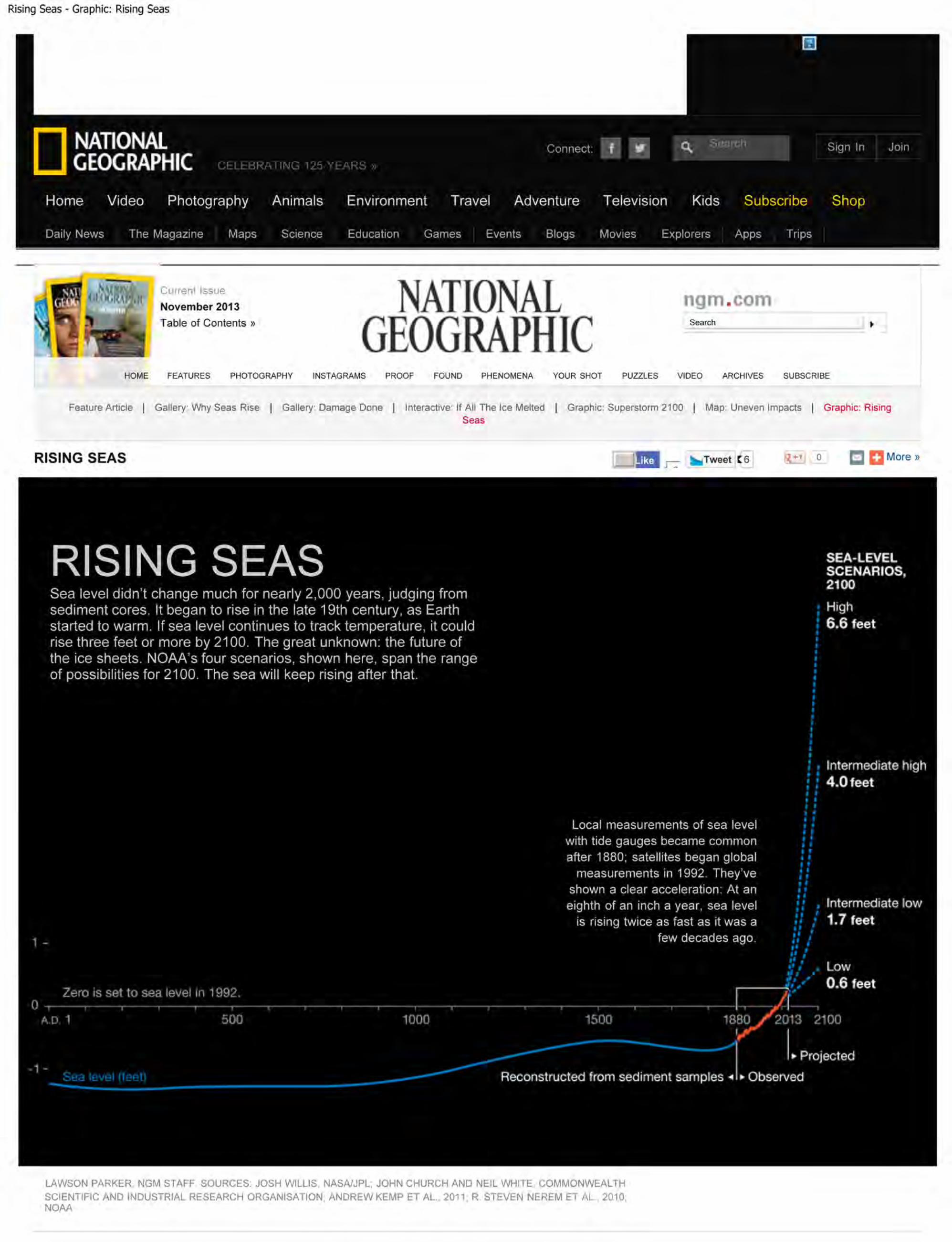
Sea level didn’t change muchfor nearly 2,000 years, but hasbeen rising at an acceleratedrate in the past few decades.
Uneven Impacts
If sea level rises an averageof three feet by 2100, theimpacts will be felt the most invulnerable coastal cities.
Chart
Map
left dozens dead. Faced with the largest storm ever spawned over the Atlantic, New
York and other cities ordered mandatory evacuations of low-lying areas. Not
everyone complied. Those who chose to ride out Sandy got a preview of the future, in
which a warmer world will lead to inexorably rising seas.
Brandon d’Leo, a 43-year-old sculptor and surfer, lives on the Rockaway Peninsula,
a narrow, densely populated, 11-mile-long sandy strip that juts from the western
end of Long Island. Like many of his neighbors, d’Leo had remained at home
through Hurricane Irene the year before. “When they told us the tidal surge from
this storm would be worse, I wasn’t afraid,” he says. That would soon change.
D’Leo rents a second-floor apartment in a three-story house across the street from
the beach on the peninsula’s southern shore. At about 3:30 in the afternoon he went
outside. Waves were crashing against the five-and-a-half-mile-long boardwalk.
“Water had already begun to breach the boardwalk,” he says. “I thought, Wow, we
still have four and a half hours until high tide. In ten minutes the water probably
came ten feet closer to the street.”
Back in his apartment, d’Leo and a neighbor, Davina Grincevicius, watched the sea
as wind-driven rain pelted the sliding glass door of his living room. His landlord,
fearing the house might flood, had shut off the electricity. As darkness fell,
Grincevicius saw something alarming. “I think the boardwalk just moved,” she said.
Within minutes another surge of water lifted the boardwalk again. It began to snap
apart.
Three large sections of the boardwalk smashed against two pine trees in front of
d’Leo’s apartment. The street had become a four-foot-deep river, as wave after wave
poured water onto the peninsula. Cars began to float in the churning water, their
wailing alarms adding to the cacophony of wind, rushing water, and cracking wood.
A bobbing red Mini Cooper, its headlights flashing, became wedged against one of
the pine trees in the front yard. To the west the sky lit up with what looked like
fireworks—electrical transformers were exploding in Breezy Point, a neighborhood
near the tip of the peninsula. More than one hundred homes there burned to the
ground that night.
The trees in the front yard saved d’Leo’s house, and maybe the lives of everyone
inside—d’Leo, Grincevicius, and two elderly women who lived in an apartment
downstairs. “There was no option to get out,” d’Leo says. “I have six surfboards in my
apartment, and I was thinking, if anything comes through the wall, I’ll try to get
everyone on those boards and try to get up the block. But if we’d had to get in that
water, it wouldn’t have been good.”
After a fitful night’s sleep d’Leo went outside shortly before sunrise. The water had
receded, but thigh-deep pools still filled parts of some streets. “Everything was
covered with sand,” he says. “It looked like another planet.”
A profoundly altered planet is what our fossil-fuel-driven civilization is
creating, a planet where Sandy-scale flooding will become more common and more
destructive for the world’s coastal cities. By releasing carbon dioxide and other heat-

Rising Seas
http://ngm.nationalgeographic.com/2013/09/rising-seas/folger-text?rptregcta=reg_free_np&rptregcampaign=20131016_rw_membership_r1p_us_dr_c1#close-modal[10/31/2013 5:59:22 PM]
trapping gases into the atmosphere, we have warmed the Earth by more than a full
degree Fahrenheit over the past century and raised sea level by about eight inches.
Even if we stopped burning all fossil fuels tomorrow, the existing greenhouse gases
would continue to warm the Earth for centuries. We have irreversibly committed
future generations to a hotter world and rising seas.
In May the concentration of carbon dioxide in the atmosphere reached 400 parts per
million, the highest since three million years ago. Sea levels then may have been as
much as 65 feet above today’s; the Northern Hemisphere was largely ice free year-
round. It would take centuries for the oceans to reach such catastrophic heights
again, and much depends on whether we manage to limit future greenhouse gas
emissions. In the short term scientists are still uncertain about how fast and how
high seas will rise. Estimates have repeatedly been too conservative.
Global warming affects sea level in two ways. About a third of its current rise comes
from thermal expansion—from the fact that water grows in volume as it warms. The
rest comes from the melting of ice on land. So far it’s been mostly mountain glaciers,
but the big concern for the future is the giant ice sheets in Greenland and Antarctica.
Six years ago the Intergovernmental Panel on Climate Change (IPCC) issued a report
predicting a maximum of 23 inches of sea-level rise by the end of this century. But
that report intentionally omitted the possibility that the ice sheets might flow more
rapidly into the sea, on the grounds that the physics of that process was poorly
understood.
As the IPCC prepares to issue a new report this fall, in which the sea-level forecast is
expected to be slightly higher, gaps in ice-sheet science remain. But climate
scientists now estimate that Greenland and Antarctica combined have lost on
average about 50 cubic miles of ice each year since 1992—roughly 200 billion metric
tons of ice annually. Many think sea level will be at least three feet higher than today
by 2100. Even that figure might be too low.
“In the last several years we’ve observed accelerated melting of the ice sheets in
Greenland and West Antarctica,” says Radley Horton, a research scientist at
Columbia University’s Earth Institute in New York City. “The concern is that if the
acceleration continues, by the time we get to the end of the 21st century, we could
see sea-level rise of as much as six feet globally instead of two to three feet.” Last
year an expert panel convened by the National Oceanic and Atmospheric
Administration adopted 6.6 feet (two meters) as its highest of four scenarios for
2100. The U.S. Army Corps of Engineers recommends that planners consider a high
scenario of five feet.
One of the biggest wild cards in all sea-level-rise scenarios is the massive Thwaites
Glacier in West Antarctica. Four years ago NASA sponsored a series of flights over
the region that used ice-penetrating radar to map the seafloor topography. The
flights revealed that a 2,000-foot-high undersea ridge holds the Thwaites Glacier in
place, slowing its slide into the sea. A rising sea could allow more water to seep
between ridge and glacier and eventually unmoor it. But no one knows when or if
that will happen.
“That’s one place I’m really nervous about,” says Richard Alley, a glaciologist at Penn
State University and an author of the last IPCC report. “It involves the physics of ice

Rising Seas
http://ngm.nationalgeographic.com/2013/09/rising-seas/folger-text?rptregcta=reg_free_np&rptregcampaign=20131016_rw_membership_r1p_us_dr_c1#close-modal[10/31/2013 5:59:22 PM]
fracture that we really don’t understand.” If the Thwaites Glacier breaks free from its
rocky berth, that would liberate enough ice to raise sea level by three meters—nearly
ten feet. “The odds are in our favor that it won’t put three meters in the ocean in the
next century,” says Alley. “But we can’t absolutely guarantee that. There’s at least
some chance that something very nasty will happen.”
Even in the absence of something very nasty, coastal cities face a twofold threat:
Inexorably rising oceans will gradually inundate low-lying areas, and higher seas
will extend the ruinous reach of storm surges. The threat will never go away; it will
only worsen. By the end of the century a hundred-year storm surge like Sandy’s
might occur every decade or less. Using a conservative prediction of a half meter (20
inches) of sea-level rise, the Organisation for Economic Co-operation and
Development estimates that by 2070, 150 million people in the world’s large port
cities will be at risk from coastal flooding, along with $35 trillion worth of property—
an amount that will equal 9 percent of the global GDP. How will they cope?
“During the last ice age there was a mile or two of ice above us right here,” says
Malcolm Bowman, as we pull into his driveway in Stony Brook, New York, on Long
Island’s north shore. “When the ice retreated, it left a heap of sand, which is Long
Island. All these rounded stones you see—look there,” he says, pointing to some large
boulders scattered among the trees near his home. “They’re glacial boulders.”
Bowman, a physical oceanographer at the State University of New York at Stony
Brook, has been trying for years to persuade anyone who will listen that New York
City needs a harbor-spanning storm-surge barrier. Compared with some other
leading ports, New York is essentially defenseless in the face of hurricanes and
floods. London, Rotterdam, St. Petersburg, New Orleans, and Shanghai have all built
levees and storm barriers in the past few decades. New York paid a high price for its
vulnerability last October. Sandy left 43 dead in the city, of whom 35 drowned; it
cost the city some $19 billion. And it was all unnecessary, says Bowman.
“If a system of properly designed storm-surge barriers had been built—and
strengthened with sand dunes at both ends along the low-lying coastal areas—there
would have been no flooding damage from Sandy,” he says.
Bowman envisions two barriers: one at Throgs Neck, to keep surges from Long
Island Sound out of the East River, and a second one spanning the harbor south of
the city. Gates would accommodate ships and tides, closing only during storms,
much like existing structures in the Netherlands and elsewhere. The southern
barrier alone, stretching five miles between Sandy Hook, New Jersey, and the
Rockaway Peninsula, might cost $10 billion to $15 billion, Bowman estimates. He
pictures a six-lane toll highway on top that would provide a bypass route around the
city and a light-rail line connecting the Newark and John F. Kennedy Airports.
“It could be an asset to the region,” says Bowman. “Eventually the city will have to
face up to this, because the problem is going to get worse. It might take five years of
study and another ten years to get the political will to do it. By then there might have
been another disaster. We need to start planning immediately. Otherwise we’re
mortgaging the future and leaving the next generation to cope as best it can.”
Another way to safeguard New York might be to revive a bit of its past. In the 16th-
floor loft of her landscape architectural firm in lower Manhattan, Kate Orff pulls out

Rising Seas
http://ngm.nationalgeographic.com/2013/09/rising-seas/folger-text?rptregcta=reg_free_np&rptregcampaign=20131016_rw_membership_r1p_us_dr_c1#close-modal[10/31/2013 5:59:22 PM]
a map of New York Harbor in the 19th century. The present-day harbor shimmers
outside her window, calm and unthreatening on an unseasonably mild morning
three months to the day after Sandy hit.
“Here’s an archipelago that protected Red Hook,” Orff says, pointing on the map to a
small cluster of islands off the Brooklyn shore. “There was another chain of shoals
that connected Sandy Hook to Coney Island.”
The islands and shallows vanished long ago, demolished by harbor-dredging and
landfill projects that added new real estate to a burgeoning city. Orff would re-create
some of them, particularly the Sandy Hook–Coney Island chain, and connect them
with sluice gates that would close during a storm, forming an eco-engineered barrier
that would cross the same waters as Bowman’s more conventional one. Behind it,
throughout the harbor, would be dozens of artificial reefs built from stone, rope, and
wood pilings and seeded with oysters and other shellfish. The reefs would continue
to grow as sea levels rose, helping to buffer storm waves—and the shellfish, being
filter feeders, would also help clean the harbor. “Twenty-five percent of New York
Harbor used to be oyster beds,” Orff says.
Orff estimates her “oystertecture” vision could be brought to life at relatively low
cost. “It would be chump change compared with a conventional barrier. And it
wouldn’t be money wasted: Even if another Sandy never happens, you’d have a
cleaner, restored harbor in a more ecologically vibrant context and a healthier New
York.”
In June, Mayor Michael Bloomberg outlined a $19.5 billion plan to defend New York
City against rising seas. “Sandy was a temporary setback that can ultimately propel
us forward,” he said. The mayor’s proposal calls for the construction of levees, local
storm-surge barriers, sand dunes, oyster reefs, and more than 200 other measures.
It goes far beyond anything planned by any other American city. But the mayor
dismissed the idea of a harbor barrier. “A giant barrier across our harbor is neither
practical nor affordable,” Bloomberg said. The plan notes that since a barrier would
remain open most of the time, it would not protect the city from the inch-by-inch
creep of sea-level rise.
Meanwhile, development in the city’s flood zones continues. Klaus Jacob, a
geophysicist at Columbia University, says the entire New York metropolitan region
urgently needs a master plan to ensure that future construction will at least not
exacerbate the hazards from rising seas.
“The problem is we’re still building the city of the past,” says Jacob. “The people of
the 1880s couldn’t build a city for the year 2000—of course not. And we cannot
build a year-2100 city now. But we should not build a city now that we know will
not function in 2100. There are opportunities to renew our infrastructure. It’s not all
bad news. We just have to grasp those opportunities.”
Will New York grasp them after Bloomberg leaves office at the end of this year?
And can a single storm change not just a city’s but a nation’s policy? It has happened
before. The Netherlands had its own stormy reckoning 60 years ago, and it
transformed the country.
The storm roared in from the North Sea on the night of January 31, 1953. Ria Geluk

Rising Seas
http://ngm.nationalgeographic.com/2013/09/rising-seas/folger-text?rptregcta=reg_free_np&rptregcampaign=20131016_rw_membership_r1p_us_dr_c1#close-modal[10/31/2013 5:59:22 PM]
was six years old at the time and living where she lives today, on the island of
Schouwen Duiveland in the southern province of Zeeland. She remembers a
neighbor knocking on the door of her parents’ farmhouse in the middle of the night
to tell them that the dike had failed. Later that day the whole family, along with
several neighbors who had spent the night, climbed to the roof, where they huddled
in blankets and heavy coats in the wind and rain. Geluk’s grandparents lived just
across the road, but water swept into the village with such force that they were
trapped in their home. They died when it collapsed.
“Our house kept standing,” says Geluk. “The next afternoon the tide came again. My
father could see around us what was happening; he could see houses disappearing.
You knew when a house disappeared, the people were killed. In the afternoon a
fishing boat came to rescue us.”
In 1997 Geluk helped found the Watersnoodmuseum—the “flood museum”—on
Schouwen Duiveland. The museum is housed in four concrete caissons that
engineers used to plug dikes in 1953. The disaster killed 1,836 in all, nearly half in
Zeeland, including a baby born on the night of the storm.
Afterward the Dutch launched an ambitious program of dike and barrier
construction called the Delta Works, which lasted more than four decades and cost
more than six billion dollars. One crucial project was the five-mile-long
Oosterscheldekering, or Eastern Scheldt barrier, completed 27 years ago to defend
Zeeland from the sea. Geluk points to it as we stand on a bank of the Scheldt estuary
near the museum, its enormous pylons just visible on the horizon. The final
component of the Delta Works, a movable barrier protecting Rotterdam Harbor and
some 1.5 million people, was finished in 1997.
Like other primary sea barriers in the Netherlands, it’s built to withstand a 1-in-
10,000-year storm—the strictest standard in the world. (The United States uses a 1-
in-100 standard.) The Dutch government is now considering whether to upgrade the
protection levels to bring them in line with sea-level-rise projections.
Such measures are a matter of national security for a country where 26 percent of
the land lies below sea level. With more than 10,000 miles of dikes, the Netherlands
is fortified to such an extent that hardly anyone thinks about the threat from the sea,
largely because much of the protection is so well integrated into the landscape that
it’s nearly invisible.
On a bitingly cold February afternoon I spend a couple of hours walking around
Rotterdam with Arnoud Molenaar, the manager of the city’s Climate Proof program,
which aims to make Rotterdam resistant to the sea levels expected by 2025. About
20 minutes into our walk we climb a sloping street next to a museum designed by
the architect Rem Koolhaas. The presence of a hill in this flat city should have
alerted me, but I’m surprised when Molenaar tells me that we’re walking up the side
of a dike. He gestures to some nearby pedestrians. “Most of the people around us
don’t realize this is a dike either,” he says. The Westzeedijk shields the inner city
from the Meuse River a few blocks to the south, but the broad, busy boulevard on top
of it looks like any other Dutch thoroughfare, with flocks of cyclists wheeling along
in dedicated lanes.
As we walk, Molenaar points out assorted subtle flood-control structures: an

Rising Seas
http://ngm.nationalgeographic.com/2013/09/rising-seas/folger-text?rptregcta=reg_free_np&rptregcampaign=20131016_rw_membership_r1p_us_dr_c1#close-modal[10/31/2013 5:59:22 PM]
underground parking garage designed to hold 10,000 cubic meters—more than 2.5
million gallons—of rainwater; a street flanked by two levels of sidewalks, with the
lower one designed to store water, leaving the upper walkway dry. Late in the
afternoon we arrive at Rotterdam’s Floating Pavilion, a group of three connected,
transparent domes on a platform in a harbor off the Meuse. The domes, about three
stories tall, are made of a plastic that’s a hundred times as light as glass.
Inside we have sweeping views of Rotterdam’s skyline; hail clatters overhead as low
clouds scud in from the North Sea. Though the domes are used for meetings and
exhibitions, their main purpose is to demonstrate the wide potential of floating
urban architecture. By 2040 the city anticipates that as many as 1,200 homes will
float in the harbor. “We think these structures will be important not just for
Rotterdam but for many cities around the world,” says Bart Roeffen, the architect
who designed the pavilion. The homes of 2040 will not necessarily be domes;
Roeffen chose that shape for its structural integrity and its futuristic appeal. “To
build on water is not new, but to develop floating communities on a large scale and
in a harbor with tides—that is new,” says Molenaar. “Instead of fighting against
water, we want to live with it.”
While visiting the Netherlands, I heard one joke repeatedly: “God may have built the
world, but the Dutch built Holland.” The country has been reclaiming land from the
sea for nearly a thousand years—much of Zeeland was built that way. Sea-level rise
does not yet panic the Dutch.
“We cannot retreat! Where could we go? Germany?” Jan Mulder has to shout over
the wind—we’re walking along a beach called Kijkduin as volleys of sleet exfoliate
our faces. Mulder is a coastal morphologist with Deltares, a private coastal
management firm. This morning he and Douwe Sikkema, a project manager with the
province of South Holland, have brought me to see the latest in adaptive beach
protection. It’s called the zandmotor—the sand engine.
The seafloor offshore, they explain, is thick with hundreds of feet of sand deposited
by rivers and retreating glaciers. North Sea waves and currents once distributed that
sand along the coast. But as sea level has risen since the Ice Age, the waves no longer
reach deep enough to stir up sand, and the currents have less sand to spread around.
Instead the sea erodes the coast here.
The typical solution would be to dredge sand offshore and dump it directly on the
eroding beaches—and then repeat the process year after year as the sand washes
away. Mulder and his colleagues recommended that the provincial government try a
different strategy: a single gargantuan dredging operation to create the sandy
peninsula we’re walking on—a hook-shaped stretch of beach the size of 250 football
fields. If the scheme works, over the next 20 years the wind, waves, and tides will
spread its sand 15 miles up and down the coast. The combination of wind, waves,
tides, and sand is the zandmotor.
The project started only two years ago, but it seems to be working. Mulder shows me
small dunes that have started to grow on a beach where there was once open water.
“It’s very flexible,” he says. “If we see that sea-level rise increases, we can increase
the amount of sand.” Sikkema adds, “And it’s much easier to adjust the amount of
sand than to rebuild an entire system of dikes.”

Rising Seas
http://ngm.nationalgeographic.com/2013/09/rising-seas/folger-text?rptregcta=reg_free_np&rptregcampaign=20131016_rw_membership_r1p_us_dr_c1#close-modal[10/31/2013 5:59:22 PM]
Later Mulder tells me about a memorial inscription affixed to the Eastern Scheldt
barrier in Zeeland: “It says, ‘Hier gaan over het tij, de maan, de wind, en wij—Here
the tide is ruled by the moon, the wind, and us.’ ” It reflects the confidence of a
generation that took for granted, as we no longer can, a reasonably stable world.
“We have to understand that we are not ruling the world,” says Mulder. “We need to
adapt.”
With the threats of climate change and sea-level rise looming over us all, cities
around the world, from New York to Ho Chi Minh City, have turned to the
Netherlands for guidance. One Dutch firm, Arcadis, has prepared a conceptual
design for a storm-surge barrier in the Verrazano Narrows to protect New York City.
The same company helped design a $1.1 billion, two-mile-long barrier that protected
New Orleans from a 13.6-foot storm surge last summer, when Hurricane Isaac hit.
The Lower Ninth Ward, which suffered so greatly during Hurricane Katrina, was
unscathed.
“Isaac was a tremendous victory for New Orleans,” Piet Dircke, an Arcadis executive,
tells me one night over dinner in Rotterdam. “All the barriers were closed; all the
levees held; all the pumps worked. You didn’t hear about it? No, because nothing
happened.”
New Orleans may be safe for a few decades, but the long-term prospects for it and
other low-lying cities look dire. Among the most vulnerable is Miami. “I cannot
envision southeastern Florida having many people at the end of this century,” says
Hal Wanless, chairman of the department of geological sciences at the University of
Miami. We’re sitting in his basement office, looking at maps of Florida on his
computer. At each click of the mouse, the years pass, the ocean rises, and the
peninsula shrinks. Freshwater wetlands and mangrove swamps collapse—a death
spiral that has already started on the southern tip of the peninsula. With seas four
feet higher than they are today—a distinct possibility by 2100—about two-thirds of
southeastern Florida is inundated. The Florida Keys have almost vanished. Miami is
an island.
When I ask Wanless if barriers might save Miami, at least in the short term, he
leaves his office for a moment. When he returns, he’s holding a foot-long cylindrical
limestone core. It looks like a tube of gray, petrified Swiss cheese. “Try to plug this
up,” he says. Miami and most of Florida sit atop a foundation of highly porous
limestone. The limestone consists of the remains of countless marine creatures
deposited more than 65 million years ago, when a warm, shallow sea covered what
is now Florida—a past that may resemble the future here.
A barrier would be pointless, Wanless says, because water would just flow through
the limestone beneath it. “No doubt there will be some dramatic engineering feats
attempted,” he says. “But the limestone is so porous that even massive pumping
systems won’t be able to keep the water out.”
Sea-level rise has already begun to threaten Florida’s freshwater supply. About a
quarter of the state’s 19 million residents depend on wells sunk into the enormous
Biscayne aquifer. Salt water is now seeping into it from dozens of canals that were
built to drain the Everglades. For decades the state has tried to control the saltwater
influx by building dams and pumping stations on the drainage canals. These

Rising Seas
http://ngm.nationalgeographic.com/2013/09/rising-seas/folger-text?rptregcta=reg_free_np&rptregcampaign=20131016_rw_membership_r1p_us_dr_c1#close-modal[10/31/2013 5:59:22 PM]
“salinity-control structures” maintain a wall of fresh water behind them to block the
underground intrusion of salt water. To offset the greater density of salt water, the
freshwater level in the control structures is generally kept about two feet higher than
the encroaching sea.
But the control structures also serve a second function: During the state’s frequent
rainstorms their gates must open to discharge the flood of fresh water to the sea.“We
have about 30 salinity-control structures in South Florida,” says Jayantha
Obeysekera, the chief hydrological modeler at the South Florida Water Management
District. “At times now the water level in the sea is higher than the freshwater level
in the canal.” That both accelerates saltwater intrusion and prevents the discharge of
flood waters. “The concern is that this will get worse with time as the sea-level rise
accelerates,” Obeysekera says.
Using fresh water to block the salt water will eventually become impractical, because
the amount of fresh water needed would submerge ever larger areas behind the
control structures, in effect flooding the state from the inside. “With 50 centimeters
[about 20 inches] of sea-level rise, 80 percent of the salinity-control structures in
Florida will no longer be functional,” says Wanless. “We’ll either have to drown
communities to keep the freshwater head above sea level or have saltwater
intrusion.” When sea level rises two feet, he says, Florida’s aquifers may be poisoned
beyond recovery. Even now, during unusually high tides, seawater spouts from
sewers in Miami Beach, Fort Lauderdale, and other cities, flooding streets.
In a state exposed to hurricanes as well as rising seas, people like John Van Leer, an
oceanographer at the University of Miami, worry that one day they will no longer be
able to insure—or sell—their houses. “If buyers can’t insure it, they can’t get a
mortgage on it. And if they can’t get a mortgage, you can only sell to cash buyers,”
Van Leer says. “What I’m looking for is a climate-change denier with a lot of
money.”
Unless we change course dramatically in the coming years, our carbon
emissions will create a world utterly different in its very geography from the one in
which our species evolved. “With business as usual, the concentration of carbon
dioxide in the atmosphere will reach around a thousand parts per million by the end
of the century,” says Gavin Foster, a geochemist at the University of Southampton in
England. Such concentrations, he says, haven’t been seen on Earth since the early
Eocene epoch, 50 million years ago, when the planet was completely ice free.
According to the U.S. Geological Survey, sea level on an iceless Earth would be as
much as 216 feet higher than it is today. It might take thousands of years and more
than a thousand parts per million to create such a world—but if we burn all the fossil
fuels, we will get there.
No matter how much we reduce our greenhouse gas emissions, Foster says, we’re
already locked in to at least several feet of sea-level rise, and perhaps several dozens
of feet, as the planet slowly adjusts to the amount of carbon that’s in the atmosphere
already. A recent Dutch study predicted that the Netherlands could engineer
solutions at a manageable cost to a rise of as much as five meters, or 16 feet. Poorer
countries will struggle to adapt to much less. At different times in different places,
engineering solutions will no longer suffice. Then the retreat from the coast will
begin. In some places there will be no higher ground to retreat to.

Rising Seas
http://ngm.nationalgeographic.com/2013/09/rising-seas/folger-text?rptregcta=reg_free_np&rptregcampaign=20131016_rw_membership_r1p_us_dr_c1#close-modal[10/31/2013 5:59:22 PM]
Buy NG Photos Special Issues
Home Delivery
Subscribe for just $15 a year andhelp fund Society research.
Now on the iPad
Download the latest edition andget exclusive stories, photos, andvideo.
Our Newsletter
Sign up to see our best newphotos and wallpaper. Plus: YourShot updates and magazinefeatures.
By the next century, if not sooner, large numbers of people will have to abandon
coastal areas in Florida and other parts of the world. Some researchers fear a flood
tide of climate-change refugees. “From the Bahamas to Bangladesh and a major
amount of Florida, we’ll all have to move, and we may have to move at the same
time,” says Wanless. “We’re going to see civil unrest, war. You just wonder how—or
if—civilization will function. How thin are the threads that hold it all together? We
can’t comprehend this. We think Miami has always been here and will always be
here. How do you get people to realize that Miami—or London—will not always be
there?”
What will New York look like in 200 years? Klaus Jacob, the Columbia geophysicist,
sees downtown Manhattan as a kind of Venice, subject to periodic flooding, perhaps
with canals and yellow water cabs. Much of the city’s population, he says, will gather
on high ground in the other boroughs. “High ground will become expensive,
waterfront will become cheap,” he says. But among New Yorkers, as among the rest
of us, the idea that the sea is going to rise—a lot—hasn’t really sunk in yet. Of the
thousands of people in New York State whose homes were badly damaged or
destroyed by Sandy’s surge, only 10 to 15 percent are expected to accept the state’s
offer to buy them out at their homes’ pre-storm value. The rest plan to rebuild.
Tim Folger wrote about tsunamis for the February 2012 issue. George Steinmetz hasphotographed 28 stories for the magazine, the last one on Libya.
|
Subscribe to National Geographic magazine »
Subscriptions
Contact Us Terms of Service Privacy Policy RSS Feed Masthead Customer Services NG Style Manual Advertise With Us
© 2013 National Geographic Society. All rights reserved.


Rising Seas - Photo Gallery
http://ngm.nationalgeographic.com/2013/09/rising-seas/sandy-photography#/01-seaside-heights-new-jersey-670.jpg[10/31/2013 6:45:50 PM]
Share
Tweet 6
Photograph by Stephen Wilkes
Superstorm Sandy narrowed New Jersey’s beaches by more than 30 feeton average. At Seaside Heights it swept away the pier under the rollercoaster.
The Damage Done
By the time Sandy struck the Northeast, it had killed 72 people in the Caribbean. It was no longer a hurricane—but it was athousand miles wide, with 80-mile-an-hour winds that drove the sea onto the coast in lethal surges. The final death toll was147. As the world warms, it may see more storms like Sandy. It will certainly see higher seas.
- ADVERTISEMENT -
Celebrating 125 Years
The New Age ofExploration
Every month we'll becelebrating the spirit ofexploration. Join theadventure.
Photo Galleries
Browse through photosof the most memorablemoments in NationalGeographic's 125 years.
Risk Takers
They snare poisonoussnakes, drill intoglaciers, probe catparasites—and alwayspush the limits.
Frame What Matters
HOME FEATURES PHOTOGRAPHY INSTAGRAMS PROOF FOUND PHENOMENA YOUR SHOT PUZZLES VIDEO ARCHIVES SUBSCRIBE
Feature Article | Gallery: Why Seas Rise | Gallery: Damage Done | Interactive: If All The Ice Melted | Graphic: Superstorm 2100 | Map: Uneven Impacts | Graphic: RisingSeas
Connect: Search
CELEBRATING 125 YEARS »
Home
Current IssueNovember 2013Table of Contents »
2Like
Daily News The Magazine Maps Science Education Games Events Blogs Movies Explorers Apps Trips
Video Photography Animals Environment Travel Adventure Television Kids Subscribe Shop
Sign In Join

Rising Seas - Photo Gallery
http://ngm.nationalgeographic.com/2013/09/rising-seas/sandy-photography#/02-new-york-city-night-aerial-670.jpg[10/31/2013 6:46:52 PM]
Share
Tweet 6
0
Photograph by Iwan Baan, Reportage by Getty Images
In Manhattan, Sandy’s surging tide knocked out a Con Ed substation,darkening the city below Midtown. Private generators provided some light,including the blue glow of the new World Trade Center, whose base isthree feet above sea level.
The Damage Done
By the time Sandy struck the Northeast, it had killed 72 people in the Caribbean. It was no longer a hurricane—but it was athousand miles wide, with 80-mile-an-hour winds that drove the sea onto the coast in lethal surges. The final death toll was147. As the world warms, it may see more storms like Sandy. It will certainly see higher seas.
- ADVERTISEMENT -
Celebrating 125 Years
The New Age ofExploration
Every month we'll becelebrating the spirit ofexploration. Join theadventure.
Photo Galleries
Browse through photosof the most memorablemoments in NationalGeographic's 125 years.
Risk Takers
They snare poisonoussnakes, drill intoglaciers, probe catparasites—and alwayspush the limits.
Frame What Matters
HOME FEATURES PHOTOGRAPHY INSTAGRAMS PROOF FOUND PHENOMENA YOUR SHOT PUZZLES VIDEO ARCHIVES SUBSCRIBE
Feature Article | Gallery: Why Seas Rise | Gallery: Damage Done | Interactive: If All The Ice Melted | Graphic: Superstorm 2100 | Map: Uneven Impacts | Graphic: RisingSeas
Connect: Search
CELEBRATING 125 YEARS »
Home
Current IssueNovember 2013Table of Contents »
2Like
Daily News The Magazine Maps Science Education Games Events Blogs Movies Explorers Apps Trips
Video Photography Animals Environment Travel Adventure Television Kids Subscribe Shop
Sign In Join

Rising Seas - Photo Gallery
http://ngm.nationalgeographic.com/2013/09/rising-seas/sandy-photography#/03-rockaway-beach-surfer-670.jpg[10/31/2013 6:47:29 PM]
Share
Tweet 6
Photograph by Davina Grincevicius
After a long day of organizing relief efforts, Brandon d’Leo, a surfer andsculptor, rests in his candlelit apartment in the Rockaway Beachneighborhood of Queens, New York. Like many of his neighbors, d’Leolost electricity for a few days—and heat and hot water for more than twomonths—after Sandy pounded the community.
The Damage Done
By the time Sandy struck the Northeast, it had killed 72 people in the Caribbean. It was no longer a hurricane—but it was athousand miles wide, with 80-mile-an-hour winds that drove the sea onto the coast in lethal surges. The final death toll was147. As the world warms, it may see more storms like Sandy. It will certainly see higher seas.
- ADVERTISEMENT -
Celebrating 125 Years
The New Age ofExploration
Every month we'll becelebrating the spirit ofexploration. Join theadventure.
Photo Galleries
Browse through photosof the most memorablemoments in NationalGeographic's 125 years.
Risk Takers
They snare poisonoussnakes, drill intoglaciers, probe catparasites—and alwayspush the limits.
Frame What Matters
HOME FEATURES PHOTOGRAPHY INSTAGRAMS PROOF FOUND PHENOMENA YOUR SHOT PUZZLES VIDEO ARCHIVES SUBSCRIBE
Feature Article | Gallery: Why Seas Rise | Gallery: Damage Done | Interactive: If All The Ice Melted | Graphic: Superstorm 2100 | Map: Uneven Impacts | Graphic: RisingSeas
Connect: Search
CELEBRATING 125 YEARS »
Home
Current IssueNovember 2013Table of Contents »
2Like
Daily News The Magazine Maps Science Education Games Events Blogs Movies Explorers Apps Trips
Video Photography Animals Environment Travel Adventure Television Kids Subscribe Shop
Sign In Join

Rising Seas - Photo Gallery
http://ngm.nationalgeographic.com/2013/09/rising-seas/sandy-photography#/04-brooklyn-ny-670.jpg[10/31/2013 6:48:09 PM]
Share
Tweet 6
0
BROOKLYN, NEW YORKPhotograph by Kirsten Luce, New York Times/Redux
The Damage Done
By the time Sandy struck the Northeast, it had killed 72 people in the Caribbean. It was no longer a hurricane—but it was athousand miles wide, with 80-mile-an-hour winds that drove the sea onto the coast in lethal surges. The final death toll was147. As the world warms, it may see more storms like Sandy. It will certainly see higher seas.
- ADVERTISEMENT -
Celebrating 125 Years
The New Age ofExploration
Every month we'll becelebrating the spirit ofexploration. Join theadventure.
Photo Galleries
Browse through photosof the most memorablemoments in NationalGeographic's 125 years.
Risk Takers
They snare poisonoussnakes, drill intoglaciers, probe catparasites—and alwayspush the limits.
Frame What Matters
HOME FEATURES PHOTOGRAPHY INSTAGRAMS PROOF FOUND PHENOMENA YOUR SHOT PUZZLES VIDEO ARCHIVES SUBSCRIBE
Feature Article | Gallery: Why Seas Rise | Gallery: Damage Done | Interactive: If All The Ice Melted | Graphic: Superstorm 2100 | Map: Uneven Impacts | Graphic: RisingSeas
Connect: Search
CELEBRATING 125 YEARS »
Home
Current IssueNovember 2013Table of Contents »
2Like
Daily News The Magazine Maps Science Education Games Events Blogs Movies Explorers Apps Trips
Video Photography Animals Environment Travel Adventure Television Kids Subscribe Shop
Sign In Join

Rising Seas - Photo Gallery
http://ngm.nationalgeographic.com/2013/09/rising-seas/sandy-photography#/05-path-station-hoboken-new-jersey-670.jpg[10/31/2013 6:48:32 PM]
Share
Tweet 6
0
PATH STATION, HOBOKEN, NEW JERSEYPhotograph by Port Authority of New York & New Jersey, AFP Photo
The Damage Done
By the time Sandy struck the Northeast, it had killed 72 people in the Caribbean. It was no longer a hurricane—but it was athousand miles wide, with 80-mile-an-hour winds that drove the sea onto the coast in lethal surges. The final death toll was147. As the world warms, it may see more storms like Sandy. It will certainly see higher seas.
- ADVERTISEMENT -
Celebrating 125 Years
The New Age ofExploration
Every month we'll becelebrating the spirit ofexploration. Join theadventure.
Photo Galleries
Browse through photosof the most memorablemoments in NationalGeographic's 125 years.
Risk Takers
They snare poisonoussnakes, drill intoglaciers, probe catparasites—and alwayspush the limits.
Frame What Matters
HOME FEATURES PHOTOGRAPHY INSTAGRAMS PROOF FOUND PHENOMENA YOUR SHOT PUZZLES VIDEO ARCHIVES SUBSCRIBE
Feature Article | Gallery: Why Seas Rise | Gallery: Damage Done | Interactive: If All The Ice Melted | Graphic: Superstorm 2100 | Map: Uneven Impacts | Graphic: RisingSeas
Connect: Search
CELEBRATING 125 YEARS »
Home
Current IssueNovember 2013Table of Contents »
2Like
Daily News The Magazine Maps Science Education Games Events Blogs Movies Explorers Apps Trips
Video Photography Animals Environment Travel Adventure Television Kids Subscribe Shop
Sign In Join

Rising Seas - Photo Gallery
http://ngm.nationalgeographic.com/2013/09/rising-seas/sandy-photography#/06-rodanthe-north-carolina-670.jpg[10/31/2013 6:49:31 PM]
Share
Tweet 6
0
RODANTHE, NORTH CAROLINAPhotograph by Steve Earley, Virginian-Pilot
The Damage Done
By the time Sandy struck the Northeast, it had killed 72 people in the Caribbean. It was no longer a hurricane—but it was athousand miles wide, with 80-mile-an-hour winds that drove the sea onto the coast in lethal surges. The final death toll was147. As the world warms, it may see more storms like Sandy. It will certainly see higher seas.
- ADVERTISEMENT -
Celebrating 125 Years
The New Age ofExploration
Every month we'll becelebrating the spirit ofexploration. Join theadventure.
Photo Galleries
Browse through photosof the most memorablemoments in NationalGeographic's 125 years.
Risk Takers
They snare poisonoussnakes, drill intoglaciers, probe catparasites—and alwayspush the limits.
Frame What Matters
HOME FEATURES PHOTOGRAPHY INSTAGRAMS PROOF FOUND PHENOMENA YOUR SHOT PUZZLES VIDEO ARCHIVES SUBSCRIBE
Feature Article | Gallery: Why Seas Rise | Gallery: Damage Done | Interactive: If All The Ice Melted | Graphic: Superstorm 2100 | Map: Uneven Impacts | Graphic: RisingSeas
Connect: Search
CELEBRATING 125 YEARS »
Home
Current IssueNovember 2013Table of Contents »
2Like
Daily News The Magazine Maps Science Education Games Events Blogs Movies Explorers Apps Trips
Video Photography Animals Environment Travel Adventure Television Kids Subscribe Shop
Sign In Join

Rising Seas - Photo Gallery
http://ngm.nationalgeographic.com/2013/09/rising-seas/sandy-photography#/07-staten-island-ny-670.jpg[10/31/2013 6:50:22 PM]
Share
Tweet 6
0
STATEN ISLAND, NEW YORKPhotograph by Michael Kirby Smith, New York Times/Redux
The Damage Done
By the time Sandy struck the Northeast, it had killed 72 people in the Caribbean. It was no longer a hurricane—but it was athousand miles wide, with 80-mile-an-hour winds that drove the sea onto the coast in lethal surges. The final death toll was147. As the world warms, it may see more storms like Sandy. It will certainly see higher seas.
- ADVERTISEMENT -
Celebrating 125 Years
The New Age ofExploration
Every month we'll becelebrating the spirit ofexploration. Join theadventure.
Photo Galleries
Browse through photosof the most memorablemoments in NationalGeographic's 125 years.
Risk Takers
They snare poisonoussnakes, drill intoglaciers, probe catparasites—and alwayspush the limits.
Frame What Matters
HOME FEATURES PHOTOGRAPHY INSTAGRAMS PROOF FOUND PHENOMENA YOUR SHOT PUZZLES VIDEO ARCHIVES SUBSCRIBE
Feature Article | Gallery: Why Seas Rise | Gallery: Damage Done | Interactive: If All The Ice Melted | Graphic: Superstorm 2100 | Map: Uneven Impacts | Graphic: RisingSeas
Connect: Search
CELEBRATING 125 YEARS »
Home
Current IssueNovember 2013Table of Contents »
2Like
Daily News The Magazine Maps Science Education Games Events Blogs Movies Explorers Apps Trips
Video Photography Animals Environment Travel Adventure Television Kids Subscribe Shop
Sign In Join

Rising Seas - Photo Gallery
http://ngm.nationalgeographic.com/2013/09/rising-seas/sandy-photography#/08-breezy-point-queens-ny-670.jpg[10/31/2013 6:51:07 PM]
Share
Tweet 6
0
BREEZY POINT, QUEENS, NEW YORKPhotograph by JB Nicholas, Splash News/Corbis
The Damage Done
By the time Sandy struck the Northeast, it had killed 72 people in the Caribbean. It was no longer a hurricane—but it was athousand miles wide, with 80-mile-an-hour winds that drove the sea onto the coast in lethal surges. The final death toll was147. As the world warms, it may see more storms like Sandy. It will certainly see higher seas.
- ADVERTISEMENT -
Celebrating 125 Years
The New Age ofExploration
Every month we'll becelebrating the spirit ofexploration. Join theadventure.
Photo Galleries
Browse through photosof the most memorablemoments in NationalGeographic's 125 years.
Risk Takers
They snare poisonoussnakes, drill intoglaciers, probe catparasites—and alwayspush the limits.
Frame What Matters
HOME FEATURES PHOTOGRAPHY INSTAGRAMS PROOF FOUND PHENOMENA YOUR SHOT PUZZLES VIDEO ARCHIVES SUBSCRIBE
Feature Article | Gallery: Why Seas Rise | Gallery: Damage Done | Interactive: If All The Ice Melted | Graphic: Superstorm 2100 | Map: Uneven Impacts | Graphic: RisingSeas
Connect: Search
CELEBRATING 125 YEARS »
Home
Current IssueNovember 2013Table of Contents »
2Like
Daily News The Magazine Maps Science Education Games Events Blogs Movies Explorers Apps Trips
Video Photography Animals Environment Travel Adventure Television Kids Subscribe Shop
Sign In Join

Rising Seas - Photo Gallery
http://ngm.nationalgeographic.com/2013/09/rising-seas/sandy-photography#/09-rockaway-park-queens-ny-670.jpg[10/31/2013 6:54:33 PM]
Share
Tweet 6
0
ROCKAWAY PARK, QUEENS, NEW YORKPhotograph by Ken Cedeno, Corbis
The Damage Done
By the time Sandy struck the Northeast, it had killed 72 people in the Caribbean. It was no longer a hurricane—but it was athousand miles wide, with 80-mile-an-hour winds that drove the sea onto the coast in lethal surges. The final death toll was147. As the world warms, it may see more storms like Sandy. It will certainly see higher seas.
- ADVERTISEMENT -
Celebrating 125 Years
The New Age ofExploration
Every month we'll becelebrating the spirit ofexploration. Join theadventure.
Photo Galleries
Browse through photosof the most memorablemoments in NationalGeographic's 125 years.
Risk Takers
They snare poisonoussnakes, drill intoglaciers, probe catparasites—and alwayspush the limits.
Frame What Matters
HOME FEATURES PHOTOGRAPHY INSTAGRAMS PROOF FOUND PHENOMENA YOUR SHOT PUZZLES VIDEO ARCHIVES SUBSCRIBE
Feature Article | Gallery: Why Seas Rise | Gallery: Damage Done | Interactive: If All The Ice Melted | Graphic: Superstorm 2100 | Map: Uneven Impacts | Graphic: RisingSeas
Connect: Search
CELEBRATING 125 YEARS »
Home
Current IssueNovember 2013Table of Contents »
2Like
Daily News The Magazine Maps Science Education Games Events Blogs Movies Explorers Apps Trips
Video Photography Animals Environment Travel Adventure Television Kids Subscribe Shop
Sign In Join

Rising Seas - Photo Gallery
http://ngm.nationalgeographic.com/2013/09/rising-seas/sandy-photography#/10-union-beach-new-jersey-670.jpg[10/31/2013 7:07:52 PM]
Share
Tweet 6
0
UNION BEACH, NEW JERSEYPhotograph by Ken Cedeno, Corbis
The Damage Done
By the time Sandy struck the Northeast, it had killed 72 people in the Caribbean. It was no longer a hurricane—but it was athousand miles wide, with 80-mile-an-hour winds that drove the sea onto the coast in lethal surges. The final death toll was147. As the world warms, it may see more storms like Sandy. It will certainly see higher seas.
- ADVERTISEMENT -
Celebrating 125 Years
The New Age ofExploration
Every month we'll becelebrating the spirit ofexploration. Join theadventure.
Photo Galleries
Browse through photosof the most memorablemoments in NationalGeographic's 125 years.
Risk Takers
They snare poisonoussnakes, drill intoglaciers, probe catparasites—and alwayspush the limits.
Frame What Matters
HOME FEATURES PHOTOGRAPHY INSTAGRAMS PROOF FOUND PHENOMENA YOUR SHOT PUZZLES VIDEO ARCHIVES SUBSCRIBE
Feature Article | Gallery: Why Seas Rise | Gallery: Damage Done | Interactive: If All The Ice Melted | Graphic: Superstorm 2100 | Map: Uneven Impacts | Graphic: RisingSeas
Connect: Search
CELEBRATING 125 YEARS »
Home
Current IssueNovember 2013Table of Contents »
2Like
Daily News The Magazine Maps Science Education Games Events Blogs Movies Explorers Apps Trips
Video Photography Animals Environment Travel Adventure Television Kids Subscribe Shop
Sign In Join
Rising Seas - Photo Gallery
http://ngm.nationalgeographic.com/2013/09/rising-seas/sandy-photography#/11-hoboken-new-jersey-670.jpg[10/31/2013 7:08:16 PM]
Share
Tweet 6
0
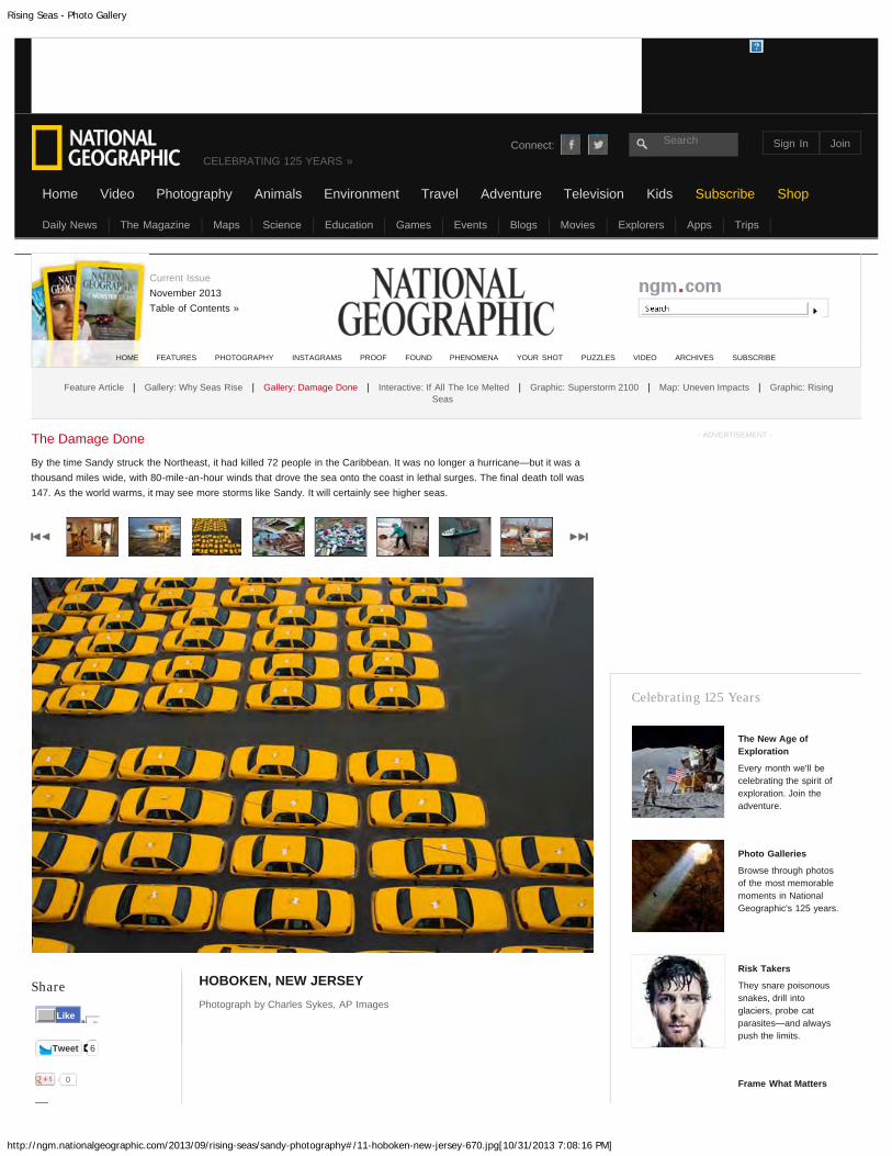
HOBOKEN, NEW JERSEYPhotograph by Charles Sykes, AP Images
The Damage Done
By the time Sandy struck the Northeast, it had killed 72 people in the Caribbean. It was no longer a hurricane—but it was athousand miles wide, with 80-mile-an-hour winds that drove the sea onto the coast in lethal surges. The final death toll was147. As the world warms, it may see more storms like Sandy. It will certainly see higher seas.
- ADVERTISEMENT -
Celebrating 125 Years
The New Age ofExploration
Every month we'll becelebrating the spirit ofexploration. Join theadventure.
Photo Galleries
Browse through photosof the most memorablemoments in NationalGeographic's 125 years.
Risk Takers
They snare poisonoussnakes, drill intoglaciers, probe catparasites—and alwayspush the limits.
Frame What Matters
HOME FEATURES PHOTOGRAPHY INSTAGRAMS PROOF FOUND PHENOMENA YOUR SHOT PUZZLES VIDEO ARCHIVES SUBSCRIBE
Feature Article | Gallery: Why Seas Rise | Gallery: Damage Done | Interactive: If All The Ice Melted | Graphic: Superstorm 2100 | Map: Uneven Impacts | Graphic: RisingSeas
Connect: Search
CELEBRATING 125 YEARS »
Home
Current IssueNovember 2013Table of Contents »
2Like
Daily News The Magazine Maps Science Education Games Events Blogs Movies Explorers Apps Trips
Video Photography Animals Environment Travel Adventure Television Kids Subscribe Shop
Sign In Join

Rising Seas - Photo Gallery
http://ngm.nationalgeographic.com/2013/09/rising-seas/sandy-photography#/12-sabana-perdida-dominican-republic-670.jpg[10/31/2013 7:08:40 PM]
Share
Tweet 6
0
SABANA PERDIDA, DOMINICAN REPUBLICPhotograph by Ricardo Rojas, Reuters
The Damage Done
By the time Sandy struck the Northeast, it had killed 72 people in the Caribbean. It was no longer a hurricane—but it was athousand miles wide, with 80-mile-an-hour winds that drove the sea onto the coast in lethal surges. The final death toll was147. As the world warms, it may see more storms like Sandy. It will certainly see higher seas.
- ADVERTISEMENT -
Celebrating 125 Years
The New Age ofExploration
Every month we'll becelebrating the spirit ofexploration. Join theadventure.
Photo Galleries
Browse through photosof the most memorablemoments in NationalGeographic's 125 years.
Risk Takers
They snare poisonoussnakes, drill intoglaciers, probe catparasites—and alwayspush the limits.
Frame What Matters
HOME FEATURES PHOTOGRAPHY INSTAGRAMS PROOF FOUND PHENOMENA YOUR SHOT PUZZLES VIDEO ARCHIVES SUBSCRIBE
Feature Article | Gallery: Why Seas Rise | Gallery: Damage Done | Interactive: If All The Ice Melted | Graphic: Superstorm 2100 | Map: Uneven Impacts | Graphic: RisingSeas
Connect: Search
CELEBRATING 125 YEARS »
Home
Current IssueNovember 2013Table of Contents »
2Like
Daily News The Magazine Maps Science Education Games Events Blogs Movies Explorers Apps Trips
Video Photography Animals Environment Travel Adventure Television Kids Subscribe Shop
Sign In Join

Rising Seas - Photo Gallery
http://ngm.nationalgeographic.com/2013/09/rising-seas/sandy-photography#/13-mantoloking-new-jersey-670.jpg[10/31/2013 7:09:16 PM]
Share
Tweet 6
0
MANTOLOKING, NEW JERSEYPhotograph by George Steinmetz
The Damage Done
By the time Sandy struck the Northeast, it had killed 72 people in the Caribbean. It was no longer a hurricane—but it was athousand miles wide, with 80-mile-an-hour winds that drove the sea onto the coast in lethal surges. The final death toll was147. As the world warms, it may see more storms like Sandy. It will certainly see higher seas.
- ADVERTISEMENT -
Celebrating 125 Years
The New Age ofExploration
Every month we'll becelebrating the spirit ofexploration. Join theadventure.
Photo Galleries
Browse through photosof the most memorablemoments in NationalGeographic's 125 years.
Risk Takers
They snare poisonoussnakes, drill intoglaciers, probe catparasites—and alwayspush the limits.
Frame What Matters
HOME FEATURES PHOTOGRAPHY INSTAGRAMS PROOF FOUND PHENOMENA YOUR SHOT PUZZLES VIDEO ARCHIVES SUBSCRIBE
Feature Article | Gallery: Why Seas Rise | Gallery: Damage Done | Interactive: If All The Ice Melted | Graphic: Superstorm 2100 | Map: Uneven Impacts | Graphic: RisingSeas
Connect: Search
CELEBRATING 125 YEARS »
Home
Current IssueNovember 2013Table of Contents »
2Like
Daily News The Magazine Maps Science Education Games Events Blogs Movies Explorers Apps Trips
Video Photography Animals Environment Travel Adventure Television Kids Subscribe Shop
Sign In Join

Rising Seas - Photo Gallery
http://ngm.nationalgeographic.com/2013/09/rising-seas/sandy-photography#/14-long-beach-ny-670.jpg[10/31/2013 7:09:38 PM]
Share
Tweet 6
0
LONG BEACH, NEW YORKPhotograph by Andrew Burton, Getty Images
The Damage Done
By the time Sandy struck the Northeast, it had killed 72 people in the Caribbean. It was no longer a hurricane—but it was athousand miles wide, with 80-mile-an-hour winds that drove the sea onto the coast in lethal surges. The final death toll was147. As the world warms, it may see more storms like Sandy. It will certainly see higher seas.
- ADVERTISEMENT -
Celebrating 125 Years
The New Age ofExploration
Every month we'll becelebrating the spirit ofexploration. Join theadventure.
Photo Galleries
Browse through photosof the most memorablemoments in NationalGeographic's 125 years.
Risk Takers
They snare poisonoussnakes, drill intoglaciers, probe catparasites—and alwayspush the limits.
Frame What Matters
HOME FEATURES PHOTOGRAPHY INSTAGRAMS PROOF FOUND PHENOMENA YOUR SHOT PUZZLES VIDEO ARCHIVES SUBSCRIBE
Feature Article | Gallery: Why Seas Rise | Gallery: Damage Done | Interactive: If All The Ice Melted | Graphic: Superstorm 2100 | Map: Uneven Impacts | Graphic: RisingSeas
Connect: Search
CELEBRATING 125 YEARS »
Home
Current IssueNovember 2013Table of Contents »
2Like
Daily News The Magazine Maps Science Education Games Events Blogs Movies Explorers Apps Trips
Video Photography Animals Environment Travel Adventure Television Kids Subscribe Shop
Sign In Join
Rising Seas - Photo Gallery
http://ngm.nationalgeographic.com/2013/09/rising-seas/sandy-photography#/15-staten-island-ny-670.jpg[10/31/2013 7:10:00 PM]
Share
Tweet 6
0
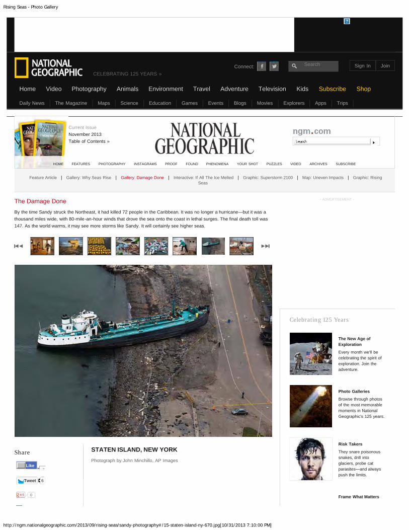
STATEN ISLAND, NEW YORKPhotograph by John Minchillo, AP Images
The Damage Done
By the time Sandy struck the Northeast, it had killed 72 people in the Caribbean. It was no longer a hurricane—but it was athousand miles wide, with 80-mile-an-hour winds that drove the sea onto the coast in lethal surges. The final death toll was147. As the world warms, it may see more storms like Sandy. It will certainly see higher seas.
- ADVERTISEMENT -
Celebrating 125 Years
The New Age ofExploration
Every month we'll becelebrating the spirit ofexploration. Join theadventure.
Photo Galleries
Browse through photosof the most memorablemoments in NationalGeographic's 125 years.
Risk Takers
They snare poisonoussnakes, drill intoglaciers, probe catparasites—and alwayspush the limits.
Frame What Matters
HOME FEATURES PHOTOGRAPHY INSTAGRAMS PROOF FOUND PHENOMENA YOUR SHOT PUZZLES VIDEO ARCHIVES SUBSCRIBE
Feature Article | Gallery: Why Seas Rise | Gallery: Damage Done | Interactive: If All The Ice Melted | Graphic: Superstorm 2100 | Map: Uneven Impacts | Graphic: RisingSeas
Connect: Search
CELEBRATING 125 YEARS »
Home
Current IssueNovember 2013Table of Contents »
2Like
Daily News The Magazine Maps Science Education Games Events Blogs Movies Explorers Apps Trips
Video Photography Animals Environment Travel Adventure Television Kids Subscribe Shop
Sign In Join

Rising Seas - Photo Gallery
http://ngm.nationalgeographic.com/2013/09/rising-seas/sandy-photography#/16-staten-island-ny-670.jpg[10/31/2013 7:10:21 PM]
Share
Tweet 6
0
STATEN ISLAND, NEW YORKPhotograph by Chang W. Lee, New York Times/Redux
The Damage Done
By the time Sandy struck the Northeast, it had killed 72 people in the Caribbean. It was no longer a hurricane—but it was athousand miles wide, with 80-mile-an-hour winds that drove the sea onto the coast in lethal surges. The final death toll was147. As the world warms, it may see more storms like Sandy. It will certainly see higher seas.
- ADVERTISEMENT -
Celebrating 125 Years
The New Age ofExploration
Every month we'll becelebrating the spirit ofexploration. Join theadventure.
Photo Galleries
Browse through photosof the most memorablemoments in NationalGeographic's 125 years.
Risk Takers
They snare poisonoussnakes, drill intoglaciers, probe catparasites—and alwayspush the limits.
Frame What Matters
HOME FEATURES PHOTOGRAPHY INSTAGRAMS PROOF FOUND PHENOMENA YOUR SHOT PUZZLES VIDEO ARCHIVES SUBSCRIBE
Feature Article | Gallery: Why Seas Rise | Gallery: Damage Done | Interactive: If All The Ice Melted | Graphic: Superstorm 2100 | Map: Uneven Impacts | Graphic: RisingSeas
Connect: Search
CELEBRATING 125 YEARS »
Home
Current IssueNovember 2013Table of Contents »
2Like
Daily News The Magazine Maps Science Education Games Events Blogs Movies Explorers Apps Trips
Video Photography Animals Environment Travel Adventure Television Kids Subscribe Shop
Sign In Join

Rising Seas - Photo Gallery
http://ngm.nationalgeographic.com/2013/09/rising-seas/sandy-photography#/17-condemned-house-chesapeake-virginia-670.jpg[10/31/2013 7:10:43 PM]
Share
Tweet 6
0
Photograph by Mark Thiessen, NGM Staff
An orange line sprayed on this condemned house—and on RobbBraidwood of the Chesapeake, Virginia, Office of Emergency Management—marks the typical flood height in the neighborhood. “It doesn’t take amajor storm,” says Braidwood. “Heavy rain and the right wind during ahigh tide will do it.”
The Damage Done
By the time Sandy struck the Northeast, it had killed 72 people in the Caribbean. It was no longer a hurricane—but it was athousand miles wide, with 80-mile-an-hour winds that drove the sea onto the coast in lethal surges. The final death toll was147. As the world warms, it may see more storms like Sandy. It will certainly see higher seas.
- ADVERTISEMENT -
Celebrating 125 Years
The New Age ofExploration
Every month we'll becelebrating the spirit ofexploration. Join theadventure.
Photo Galleries
Browse through photosof the most memorablemoments in NationalGeographic's 125 years.
Risk Takers
They snare poisonoussnakes, drill intoglaciers, probe catparasites—and alwayspush the limits.
Frame What Matters
HOME FEATURES PHOTOGRAPHY INSTAGRAMS PROOF FOUND PHENOMENA YOUR SHOT PUZZLES VIDEO ARCHIVES SUBSCRIBE
Feature Article | Gallery: Why Seas Rise | Gallery: Damage Done | Interactive: If All The Ice Melted | Graphic: Superstorm 2100 | Map: Uneven Impacts | Graphic: RisingSeas
Connect: Search
CELEBRATING 125 YEARS »
Home
Current IssueNovember 2013Table of Contents »
2Like
Daily News The Magazine Maps Science Education Games Events Blogs Movies Explorers Apps Trips
Video Photography Animals Environment Travel Adventure Television Kids Subscribe Shop
Sign In Join

Rising Seas - Photo Gallery
http://ngm.nationalgeographic.com/2013/09/rising-seas/steinmetz-photography#/01-manila-philippines-thermal-expansion-670.jpg[10/31/2013 6:02:15 PM]
Share
Tweet 253
MANILA, PHILIPPINESPhotograph by George Steinmetz
As seawater warms, its volume increases. This thermal expansionaccounts for around a third of the current sea-level rise.
www.georgesteinmetz.com
Why the Seas Rise
Locally, sea level can rise because the land is sinking. Globally, it rises because the total volume of seawater is increasing.Global warming drives that in two basic ways: by warming the ocean and by melting ice on land, which adds more water.Since 1900 global sea level has risen about eight inches. It’s now rising at about an eighth of an inch a year—andaccelerating.
- ADVERTISEMENT -
Celebrating 125 Years
The New Age ofExploration
Every month we'll becelebrating the spirit ofexploration. Join theadventure.
Photo Galleries
Browse through photosof the most memorablemoments in NationalGeographic's 125 years.
Risk Takers
They snare poisonoussnakes, drill intoglaciers, probe catparasites—and alwayspush the limits.
Frame What Matters
HOME FEATURES PHOTOGRAPHY INSTAGRAMS PROOF FOUND PHENOMENA YOUR SHOT PUZZLES VIDEO ARCHIVES SUBSCRIBE
Feature Article | Gallery: Why Seas Rise | Gallery: Damage Done | Interactive: If All The Ice Melted | Graphic: Superstorm 2100 | Map: Uneven Impacts | Graphic: RisingSeas
Connect: Search
CELEBRATING 125 YEARS »
Home
Current IssueNovember 2013Table of Contents »
13Like
Daily News The Magazine Maps Science Education Games Events Blogs Movies Explorers Apps Trips
Video Photography Animals Environment Travel Adventure Television Kids Subscribe Shop
Sign In Join

Rising Seas - Photo Gallery
http://ngm.nationalgeographic.com/2013/09/rising-seas/steinmetz-photography#/02-tahumming-glacier-british-columbia-melting-670.jpg[10/31/2013 6:03:24 PM]
Share
Tweet 253
0
TAHUMMING GLACIER, BRITISH COLUMBIAPhotograph by James Balog, Extreme Ice Survey
Melting mountain glaciers contribute another third. By 2100 they’ll probablyadd a few inches to sea level—but not feet. They don’t contain that muchice.
Why the Seas Rise
Locally, sea level can rise because the land is sinking. Globally, it rises because the total volume of seawater is increasing.Global warming drives that in two basic ways: by warming the ocean and by melting ice on land, which adds more water.Since 1900 global sea level has risen about eight inches. It’s now rising at about an eighth of an inch a year—andaccelerating.
- ADVERTISEMENT -
Celebrating 125 Years
The New Age ofExploration
Every month we'll becelebrating the spirit ofexploration. Join theadventure.
Photo Galleries
Browse through photosof the most memorablemoments in NationalGeographic's 125 years.
Risk Takers
They snare poisonoussnakes, drill intoglaciers, probe catparasites—and alwayspush the limits.
Frame What Matters
HOME FEATURES PHOTOGRAPHY INSTAGRAMS PROOF FOUND PHENOMENA YOUR SHOT PUZZLES VIDEO ARCHIVES SUBSCRIBE
Feature Article | Gallery: Why Seas Rise | Gallery: Damage Done | Interactive: If All The Ice Melted | Graphic: Superstorm 2100 | Map: Uneven Impacts | Graphic: RisingSeas
Connect: Search
CELEBRATING 125 YEARS »
Home
Current IssueNovember 2013Table of Contents »
13Like
Daily News The Magazine Maps Science Education Games Events Blogs Movies Explorers Apps Trips
Video Photography Animals Environment Travel Adventure Television Kids Subscribe Shop
Sign In Join

Rising Seas - Photo Gallery
http://ngm.nationalgeographic.com/2013/09/rising-seas/steinmetz-photography#/03-birthday-canyon-greenland-670.jpg[10/31/2013 6:03:59 PM]
Share
Tweet 253
0
BIRTHDAY CANYON, GREENLANDPhotograph by James Balog, Extreme Ice Survey
It’s a small contributor now, but its surface has started melting in summer—a worrisome sign. The ice sheet contains enough water to raise sealevel nearly 25 feet.
Why the Seas Rise
Locally, sea level can rise because the land is sinking. Globally, it rises because the total volume of seawater is increasing.Global warming drives that in two basic ways: by warming the ocean and by melting ice on land, which adds more water.Since 1900 global sea level has risen about eight inches. It’s now rising at about an eighth of an inch a year—andaccelerating.
- ADVERTISEMENT -
Celebrating 125 Years
The New Age ofExploration
Every month we'll becelebrating the spirit ofexploration. Join theadventure.
Photo Galleries
Browse through photosof the most memorablemoments in NationalGeographic's 125 years.
Risk Takers
They snare poisonoussnakes, drill intoglaciers, probe catparasites—and alwayspush the limits.
Frame What Matters
HOME FEATURES PHOTOGRAPHY INSTAGRAMS PROOF FOUND PHENOMENA YOUR SHOT PUZZLES VIDEO ARCHIVES SUBSCRIBE
Feature Article | Gallery: Why Seas Rise | Gallery: Damage Done | Interactive: If All The Ice Melted | Graphic: Superstorm 2100 | Map: Uneven Impacts | Graphic: RisingSeas
Connect: Search
CELEBRATING 125 YEARS »
Home
Current IssueNovember 2013Table of Contents »
13Like
Daily News The Magazine Maps Science Education Games Events Blogs Movies Explorers Apps Trips
Video Photography Animals Environment Travel Adventure Television Kids Subscribe Shop
Sign In Join

Rising Seas - Photo Gallery
http://ngm.nationalgeographic.com/2013/09/rising-seas/steinmetz-photography#/04-pine-island-glacier-west-antarctica-670.jpg[10/31/2013 6:05:06 PM]
Share
Tweet 253
0
PINE ISLAND GLACIER, WEST ANTARCTICAPhotograph by Maria Stenzel
East Antarctica seems fairly stable. But parts of West Antarctica’s icesheet are being undermined by a warming ocean. Its future, likeGreenland’s, is very uncertain.
Why the Seas Rise
Locally, sea level can rise because the land is sinking. Globally, it rises because the total volume of seawater is increasing.Global warming drives that in two basic ways: by warming the ocean and by melting ice on land, which adds more water.Since 1900 global sea level has risen about eight inches. It’s now rising at about an eighth of an inch a year—andaccelerating.
- ADVERTISEMENT -
Celebrating 125 Years
The New Age ofExploration
Every month we'll becelebrating the spirit ofexploration. Join theadventure.
Photo Galleries
Browse through photosof the most memorablemoments in NationalGeographic's 125 years.
Risk Takers
They snare poisonoussnakes, drill intoglaciers, probe catparasites—and alwayspush the limits.
Frame What Matters
HOME FEATURES PHOTOGRAPHY INSTAGRAMS PROOF FOUND PHENOMENA YOUR SHOT PUZZLES VIDEO ARCHIVES SUBSCRIBE
Feature Article | Gallery: Why Seas Rise | Gallery: Damage Done | Interactive: If All The Ice Melted | Graphic: Superstorm 2100 | Map: Uneven Impacts | Graphic: RisingSeas
Connect: Search
CELEBRATING 125 YEARS »
Home
Current IssueNovember 2013Table of Contents »
13Like
Daily News The Magazine Maps Science Education Games Events Blogs Movies Explorers Apps Trips
Video Photography Animals Environment Travel Adventure Television Kids Subscribe Shop
Sign In Join

Rising Seas - Photo Gallery
http://ngm.nationalgeographic.com/2013/09/rising-seas/steinmetz-photography#/05-new-orleans-devastated-marsh-670.jpg[10/31/2013 6:21:39 PM]
Share
Tweet 253
0
Photograph by George Steinmetz
These cypress trees in a marsh east of New Orleans probably succumbedto salty water seeping in from the Gulf of Mexico even before HurricaneKatrina hit in 2005. But when Katrina’s storm surge breached a nearbylevee, it dealt a devastating blow to the rest of the marsh.
www.georgesteinmetz.com
Why the Seas Rise
Locally, sea level can rise because the land is sinking. Globally, it rises because the total volume of seawater is increasing.Global warming drives that in two basic ways: by warming the ocean and by melting ice on land, which adds more water.Since 1900 global sea level has risen about eight inches. It’s now rising at about an eighth of an inch a year—andaccelerating.
- ADVERTISEMENT -
Celebrating 125 Years
The New Age ofExploration
Every month we'll becelebrating the spirit ofexploration. Join theadventure.
Photo Galleries
Browse through photosof the most memorablemoments in NationalGeographic's 125 years.
Risk Takers
They snare poisonoussnakes, drill intoglaciers, probe catparasites—and alwayspush the limits.
Frame What Matters
HOME FEATURES PHOTOGRAPHY INSTAGRAMS PROOF FOUND PHENOMENA YOUR SHOT PUZZLES VIDEO ARCHIVES SUBSCRIBE
Feature Article | Gallery: Why Seas Rise | Gallery: Damage Done | Interactive: If All The Ice Melted | Graphic: Superstorm 2100 | Map: Uneven Impacts | Graphic: RisingSeas
Connect: Search
CELEBRATING 125 YEARS »
Home
Current IssueNovember 2013Table of Contents »
13Like
Daily News The Magazine Maps Science Education Games Events Blogs Movies Explorers Apps Trips
Video Photography Animals Environment Travel Adventure Television Kids Subscribe Shop
Sign In Join

Rising Seas - Photo Gallery
http://ngm.nationalgeographic.com/2013/09/rising-seas/steinmetz-photography#/06-new-orleans-mrgo-abandoned-channel-670.jpg[10/31/2013 6:22:09 PM]
Share
Tweet 253
0
Photograph by George Steinmetz
This abandoned channel, known as MRGO, was once a shortcut for shipsto the Gulf of Mexico. During Katrina it became a shortcut to New Orleansfor the storm surge. Along with an intersecting channel, the GulfIntracoastal Waterway, it funneled floodwater into the eastern parts of thecity. A new 1.8-mile-long flood barrier now cuts across both channels.
Why the Seas Rise
Locally, sea level can rise because the land is sinking. Globally, it rises because the total volume of seawater is increasing.Global warming drives that in two basic ways: by warming the ocean and by melting ice on land, which adds more water.Since 1900 global sea level has risen about eight inches. It’s now rising at about an eighth of an inch a year—andaccelerating.
- ADVERTISEMENT -
Celebrating 125 Years
The New Age ofExploration
Every month we'll becelebrating the spirit ofexploration. Join theadventure.
Photo Galleries
Browse through photosof the most memorablemoments in NationalGeographic's 125 years.
Risk Takers
They snare poisonoussnakes, drill intoglaciers, probe catparasites—and alwayspush the limits.
Frame What Matters
HOME FEATURES PHOTOGRAPHY INSTAGRAMS PROOF FOUND PHENOMENA YOUR SHOT PUZZLES VIDEO ARCHIVES SUBSCRIBE
Feature Article | Gallery: Why Seas Rise | Gallery: Damage Done | Interactive: If All The Ice Melted | Graphic: Superstorm 2100 | Map: Uneven Impacts | Graphic: RisingSeas
Connect: Search
CELEBRATING 125 YEARS »
Home
Current IssueNovember 2013Table of Contents »
13Like
Daily News The Magazine Maps Science Education Games Events Blogs Movies Explorers Apps Trips
Video Photography Animals Environment Travel Adventure Television Kids Subscribe Shop
Sign In Join

Rising Seas - Photo Gallery
http://ngm.nationalgeographic.com/2013/09/rising-seas/steinmetz-photography#/07-new-orleans-diesel-pumps-670.jpg[10/31/2013 6:22:37 PM]
Share
Tweet 253
0
Photograph by George Steinmetz
The 11 diesel pumps housed in another new storm-surge barrier, this onesouth of New Orleans, can discharge 150,000 gallons of floodwater persecond. In operation since 2011, the barrier helped protect the city’ssuburbs from Hurricane Isaac’s storm surge last year.
www.georgesteinmetz.com
Why the Seas Rise
Locally, sea level can rise because the land is sinking. Globally, it rises because the total volume of seawater is increasing.Global warming drives that in two basic ways: by warming the ocean and by melting ice on land, which adds more water.Since 1900 global sea level has risen about eight inches. It’s now rising at about an eighth of an inch a year—andaccelerating.
- ADVERTISEMENT -
Celebrating 125 Years
The New Age ofExploration
Every month we'll becelebrating the spirit ofexploration. Join theadventure.
Photo Galleries
Browse through photosof the most memorablemoments in NationalGeographic's 125 years.
Risk Takers
They snare poisonoussnakes, drill intoglaciers, probe catparasites—and alwayspush the limits.
Frame What Matters
HOME FEATURES PHOTOGRAPHY INSTAGRAMS PROOF FOUND PHENOMENA YOUR SHOT PUZZLES VIDEO ARCHIVES SUBSCRIBE
Feature Article | Gallery: Why Seas Rise | Gallery: Damage Done | Interactive: If All The Ice Melted | Graphic: Superstorm 2100 | Map: Uneven Impacts | Graphic: RisingSeas
Connect: Search
CELEBRATING 125 YEARS »
Home
Current IssueNovember 2013Table of Contents »
13Like
Daily News The Magazine Maps Science Education Games Events Blogs Movies Explorers Apps Trips
Video Photography Animals Environment Travel Adventure Television Kids Subscribe Shop
Sign In Join

Rising Seas - Photo Gallery
http://ngm.nationalgeographic.com/2013/09/rising-seas/steinmetz-photography#/08-maale-maldives-670.jpg[10/31/2013 6:23:13 PM]
Share Photograph by George Steinmetz
A seawall now protects Maale, capital of the Maldives, an Indian Oceanarchipelago that is the lowest, flattest country on Earth. By 2100 risingseas may force Maldivians to abandon their home. More than 100,000 live
Why the Seas Rise
Locally, sea level can rise because the land is sinking. Globally, it rises because the total volume of seawater is increasing.Global warming drives that in two basic ways: by warming the ocean and by melting ice on land, which adds more water.Since 1900 global sea level has risen about eight inches. It’s now rising at about an eighth of an inch a year—andaccelerating.
- ADVERTISEMENT -
Celebrating 125 Years
The New Age ofExploration
Every month we'll becelebrating the spirit ofexploration. Join theadventure.
Photo Galleries
Browse through photosof the most memorablemoments in NationalGeographic's 125 years.
Risk Takers
They snare poisonoussnakes, drill intoglaciers, probe catparasites—and alwayspush the limits.
Frame What Matters
HOME FEATURES PHOTOGRAPHY INSTAGRAMS PROOF FOUND PHENOMENA YOUR SHOT PUZZLES VIDEO ARCHIVES SUBSCRIBE
Feature Article | Gallery: Why Seas Rise | Gallery: Damage Done | Interactive: If All The Ice Melted | Graphic: Superstorm 2100 | Map: Uneven Impacts | Graphic: RisingSeas
Connect: Search
CELEBRATING 125 YEARS »
Home
Current IssueNovember 2013Table of Contents »
13Like
Daily News The Magazine Maps Science Education Games Events Blogs Movies Explorers Apps Trips
Video Photography Animals Environment Travel Adventure Television Kids Subscribe Shop
Sign In Join

Rising Seas - Photo Gallery
http://ngm.nationalgeographic.com/2013/09/rising-seas/steinmetz-photography#/09-manila-flood-zone-squatters-670.jpg[10/31/2013 6:24:19 PM]
Share Photograph by George Steinmetz
Dangerously exposed to the next typhoon, squatter families crowdwaterfront shanties in Manila, the Philippines. Global sea-level rise isamplified there by rapidly subsiding land.
Why the Seas Rise
Locally, sea level can rise because the land is sinking. Globally, it rises because the total volume of seawater is increasing.Global warming drives that in two basic ways: by warming the ocean and by melting ice on land, which adds more water.Since 1900 global sea level has risen about eight inches. It’s now rising at about an eighth of an inch a year—andaccelerating.
- ADVERTISEMENT -
Celebrating 125 Years
The New Age ofExploration
Every month we'll becelebrating the spirit ofexploration. Join theadventure.
Photo Galleries
Browse through photosof the most memorablemoments in NationalGeographic's 125 years.
Risk Takers
They snare poisonoussnakes, drill intoglaciers, probe catparasites—and alwayspush the limits.
Frame What Matters
HOME FEATURES PHOTOGRAPHY INSTAGRAMS PROOF FOUND PHENOMENA YOUR SHOT PUZZLES VIDEO ARCHIVES SUBSCRIBE
Feature Article | Gallery: Why Seas Rise | Gallery: Damage Done | Interactive: If All The Ice Melted | Graphic: Superstorm 2100 | Map: Uneven Impacts | Graphic: RisingSeas
Connect: Search
CELEBRATING 125 YEARS »
Home
Current IssueNovember 2013Table of Contents »
13Like
Daily News The Magazine Maps Science Education Games Events Blogs Movies Explorers Apps Trips
Video Photography Animals Environment Travel Adventure Television Kids Subscribe Shop
Sign In Join

Rising Seas - Photo Gallery
http://ngm.nationalgeographic.com/2013/09/rising-seas/steinmetz-photography#/10-st-petersburg-russia-flood-barrier-670.jpg[10/31/2013 6:24:53 PM]
Share Photograph by George Steinmetz
Two curved steel gates, each more than 350 feet long, can swing shut toprotect St. Petersburg, Russia, from Baltic Sea storms, which have floodedit repeatedly over the past three centuries. Completed in 2011, the gates
Why the Seas Rise
Locally, sea level can rise because the land is sinking. Globally, it rises because the total volume of seawater is increasing.Global warming drives that in two basic ways: by warming the ocean and by melting ice on land, which adds more water.Since 1900 global sea level has risen about eight inches. It’s now rising at about an eighth of an inch a year—andaccelerating.
- ADVERTISEMENT -
Celebrating 125 Years
The New Age ofExploration
Every month we'll becelebrating the spirit ofexploration. Join theadventure.
Photo Galleries
Browse through photosof the most memorablemoments in NationalGeographic's 125 years.
Risk Takers
They snare poisonoussnakes, drill intoglaciers, probe catparasites—and alwayspush the limits.
Frame What Matters
HOME FEATURES PHOTOGRAPHY INSTAGRAMS PROOF FOUND PHENOMENA YOUR SHOT PUZZLES VIDEO ARCHIVES SUBSCRIBE
Feature Article | Gallery: Why Seas Rise | Gallery: Damage Done | Interactive: If All The Ice Melted | Graphic: Superstorm 2100 | Map: Uneven Impacts | Graphic: RisingSeas
Connect: Search
CELEBRATING 125 YEARS »
Home
Current IssueNovember 2013Table of Contents »
13Like
Daily News The Magazine Maps Science Education Games Events Blogs Movies Explorers Apps Trips
Video Photography Animals Environment Travel Adventure Television Kids Subscribe Shop
Sign In Join
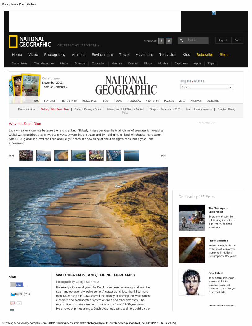
Rising Seas - Photo Gallery
http://ngm.nationalgeographic.com/2013/09/rising-seas/steinmetz-photography#/11-dutch-beach-pilings-670.jpg[10/31/2013 6:36:20 PM]
Share
Tweet 253
0
WALCHEREN ISLAND, THE NETHERLANDSPhotograph by George Steinmetz
For nearly a thousand years the Dutch have been reclaiming land from thesea—and occasionally losing some. A catastrophic flood that killed morethan 1,800 people in 1953 spurred the country to develop the world’s mostelaborate and sophisticated system of dikes and other defenses. Themost critical structures are built to withstand a 1-in-10,000-year storm.Here, rows of pilings along a Dutch beach trap sand and help build up the
Why the Seas Rise
Locally, sea level can rise because the land is sinking. Globally, it rises because the total volume of seawater is increasing.Global warming drives that in two basic ways: by warming the ocean and by melting ice on land, which adds more water.Since 1900 global sea level has risen about eight inches. It’s now rising at about an eighth of an inch a year—andaccelerating.
- ADVERTISEMENT -
Celebrating 125 Years
The New Age ofExploration
Every month we'll becelebrating the spirit ofexploration. Join theadventure.
Photo Galleries
Browse through photosof the most memorablemoments in NationalGeographic's 125 years.
Risk Takers
They snare poisonoussnakes, drill intoglaciers, probe catparasites—and alwayspush the limits.
Frame What Matters
HOME FEATURES PHOTOGRAPHY INSTAGRAMS PROOF FOUND PHENOMENA YOUR SHOT PUZZLES VIDEO ARCHIVES SUBSCRIBE
Feature Article | Gallery: Why Seas Rise | Gallery: Damage Done | Interactive: If All The Ice Melted | Graphic: Superstorm 2100 | Map: Uneven Impacts | Graphic: RisingSeas
Connect: Search
CELEBRATING 125 YEARS »
Home
Current IssueNovember 2013Table of Contents »
13Like
Daily News The Magazine Maps Science Education Games Events Blogs Movies Explorers Apps Trips
Video Photography Animals Environment Travel Adventure Television Kids Subscribe Shop
Sign In Join

Rising Seas - Photo Gallery
http://ngm.nationalgeographic.com/2013/09/rising-seas/steinmetz-photography#/12-netherlands-windmills-and-dikes-670.jpg[10/31/2013 6:37:35 PM]
Share
Tweet 253
0
FLEVOLANDPhotograph by George Steinmetz
Flanked by windmills, this dike protects farmland that is almost entirelybelow sea level. Dikes and continuous pumping keep more than a quarterof the country from reverting to swamp or open water.
www.georgesteinmetz.com
Why the Seas Rise
Locally, sea level can rise because the land is sinking. Globally, it rises because the total volume of seawater is increasing.Global warming drives that in two basic ways: by warming the ocean and by melting ice on land, which adds more water.Since 1900 global sea level has risen about eight inches. It’s now rising at about an eighth of an inch a year—andaccelerating.
- ADVERTISEMENT -
Celebrating 125 Years
The New Age ofExploration
Every month we'll becelebrating the spirit ofexploration. Join theadventure.
Photo Galleries
Browse through photosof the most memorablemoments in NationalGeographic's 125 years.
Risk Takers
They snare poisonoussnakes, drill intoglaciers, probe catparasites—and alwayspush the limits.
Frame What Matters
HOME FEATURES PHOTOGRAPHY INSTAGRAMS PROOF FOUND PHENOMENA YOUR SHOT PUZZLES VIDEO ARCHIVES SUBSCRIBE
Feature Article | Gallery: Why Seas Rise | Gallery: Damage Done | Interactive: If All The Ice Melted | Graphic: Superstorm 2100 | Map: Uneven Impacts | Graphic: RisingSeas
Connect: Search
CELEBRATING 125 YEARS »
Home
Current IssueNovember 2013Table of Contents »
13Like
Daily News The Magazine Maps Science Education Games Events Blogs Movies Explorers Apps Trips
Video Photography Animals Environment Travel Adventure Television Kids Subscribe Shop
Sign In Join

Rising Seas - Photo Gallery
http://ngm.nationalgeographic.com/2013/09/rising-seas/steinmetz-photography#/13-netherlands-dike-watchers-670.jpg[10/31/2013 6:38:18 PM]
Share
Tweet 253
0
KAMPEN, OVERIJSSELPhotograph by George Steinmetz
The control of dikes—and the power to levy taxes to maintain them—restswith community water boards that predate the existence of theNetherlands as a nation. These volunteers are trained to contain a breachwithin three hours.
www.georgesteinmetz.com
Why the Seas Rise
Locally, sea level can rise because the land is sinking. Globally, it rises because the total volume of seawater is increasing.Global warming drives that in two basic ways: by warming the ocean and by melting ice on land, which adds more water.Since 1900 global sea level has risen about eight inches. It’s now rising at about an eighth of an inch a year—andaccelerating.
- ADVERTISEMENT -
Celebrating 125 Years
The New Age ofExploration
Every month we'll becelebrating the spirit ofexploration. Join theadventure.
Photo Galleries
Browse through photosof the most memorablemoments in NationalGeographic's 125 years.
Risk Takers
They snare poisonoussnakes, drill intoglaciers, probe catparasites—and alwayspush the limits.
Frame What Matters
HOME FEATURES PHOTOGRAPHY INSTAGRAMS PROOF FOUND PHENOMENA YOUR SHOT PUZZLES VIDEO ARCHIVES SUBSCRIBE
Feature Article | Gallery: Why Seas Rise | Gallery: Damage Done | Interactive: If All The Ice Melted | Graphic: Superstorm 2100 | Map: Uneven Impacts | Graphic: RisingSeas
Connect: Search
CELEBRATING 125 YEARS »
Home
Current IssueNovember 2013Table of Contents »
13Like
Daily News The Magazine Maps Science Education Games Events Blogs Movies Explorers Apps Trips
Video Photography Animals Environment Travel Adventure Television Kids Subscribe Shop
Sign In Join

Rising Seas - Photo Gallery
http://ngm.nationalgeographic.com/2013/09/rising-seas/steinmetz-photography#/14-floating-houses-east-amsterdam-670.jpg[10/31/2013 6:38:43 PM]
Share
Tweet 253
0
IJBURG, AMSTERDAMPhotograph by George Steinmetz
Small docks and communal walkways link the floating houses built on alake in east Amsterdam. Secured by sliding collars to steel pilings, thehouses can rise and fall during floods and storms.
www.georgesteinmetz.com
Why the Seas Rise
Locally, sea level can rise because the land is sinking. Globally, it rises because the total volume of seawater is increasing.Global warming drives that in two basic ways: by warming the ocean and by melting ice on land, which adds more water.Since 1900 global sea level has risen about eight inches. It’s now rising at about an eighth of an inch a year—andaccelerating.
- ADVERTISEMENT -
Celebrating 125 Years
The New Age ofExploration
Every month we'll becelebrating the spirit ofexploration. Join theadventure.
Photo Galleries
Browse through photosof the most memorablemoments in NationalGeographic's 125 years.
Risk Takers
They snare poisonoussnakes, drill intoglaciers, probe catparasites—and alwayspush the limits.
Frame What Matters
HOME FEATURES PHOTOGRAPHY INSTAGRAMS PROOF FOUND PHENOMENA YOUR SHOT PUZZLES VIDEO ARCHIVES SUBSCRIBE
Feature Article | Gallery: Why Seas Rise | Gallery: Damage Done | Interactive: If All The Ice Melted | Graphic: Superstorm 2100 | Map: Uneven Impacts | Graphic: RisingSeas
Connect: Search
CELEBRATING 125 YEARS »
Home
Current IssueNovember 2013Table of Contents »
13Like
Daily News The Magazine Maps Science Education Games Events Blogs Movies Explorers Apps Trips
Video Photography Animals Environment Travel Adventure Television Kids Subscribe Shop
Sign In Join

Rising Seas - Photo Gallery
http://ngm.nationalgeographic.com/2013/09/rising-seas/steinmetz-photography#/15-abandoned-house-tiengemeten-island-holland-670.jpg[10/31/2013 6:39:09 PM]
Share Photograph by George Steinmetz
An abandoned house still stands on Tiengemeten Island in South Holland,where the government intentionally broke the dikes to create a rare sliceof wilderness in a country shaped by humans.
Why the Seas Rise
Locally, sea level can rise because the land is sinking. Globally, it rises because the total volume of seawater is increasing.Global warming drives that in two basic ways: by warming the ocean and by melting ice on land, which adds more water.Since 1900 global sea level has risen about eight inches. It’s now rising at about an eighth of an inch a year—andaccelerating.
- ADVERTISEMENT -
Celebrating 125 Years
The New Age ofExploration
Every month we'll becelebrating the spirit ofexploration. Join theadventure.
Photo Galleries
Browse through photosof the most memorablemoments in NationalGeographic's 125 years.
Risk Takers
They snare poisonoussnakes, drill intoglaciers, probe catparasites—and alwayspush the limits.
Frame What Matters
HOME FEATURES PHOTOGRAPHY INSTAGRAMS PROOF FOUND PHENOMENA YOUR SHOT PUZZLES VIDEO ARCHIVES SUBSCRIBE
Feature Article | Gallery: Why Seas Rise | Gallery: Damage Done | Interactive: If All The Ice Melted | Graphic: Superstorm 2100 | Map: Uneven Impacts | Graphic: RisingSeas
Connect: Search
CELEBRATING 125 YEARS »
Home
Current IssueNovember 2013Table of Contents »
13Like
Daily News The Magazine Maps Science Education Games Events Blogs Movies Explorers Apps Trips
Video Photography Animals Environment Travel Adventure Television Kids Subscribe Shop
Sign In Join