riparian corridor implementation plan public … study website/presentation_wkshp_2...riparian...
TRANSCRIPT

SALT LAKE CITY
DEPARTMENT OF PUBLIC UTILITIES
Riparian Corridor Implementation Plan
Public Workshop 2 March 28-29, 2012
Facilitated by BIO-WEST, Inc.

Project Overview Riparian Corridor Studies and Management Plans were prepared (2008–2010) for the four Salt Lake City creeks (Red Butte, Emigration, City, Parleys)

Four Riparian Corridors Studied

Project Overview • Plans for each creek include a list of recommended
improvement measures, summarized by stream reach
• This effort involves integrating the recommended measures into a prioritized implementation plan
• Implementation plan will also include Jordan River projects identified through other studies

Project Elements • Establish prioritization criteria/ranking process for projects
identified in existing RCS documents and on Jordan River
• Rank projects and prepare integrated, prioritized list
• Prepare implementation plan (schedule, funding, etc.)
• Establish process to accept/rank/prioritize newly-proposed
projects (projects not in existing RCS documents)
• Educational creek crossing signs for the four creeks

Project Schedule • Project began in November 2011
• Met with Riparian Subcommittee December 1, 2011; January 5, 2012; March 15, 2012
• First round of public workshops held in late February
• Project scheduled for completion in May 2012
• City plans to install signs later this summer

Riparian Area Definition • Zone of influence between aquatic and upland areas
• Sometimes defined as including channel, floodplain, and transition zone
(Illustration by G. Zaimes; based on BLM 1991).

Riparian Corridor – Legal Definition • The RCO applies to the area within 100 feet of the annual high water line (AHWL) of above-ground streams
• “Riparian corridor” definition: the stream plus the 100-foot riparian corridor on each side
• This project involves improvement measures in these corridors

Benefits of Healthy Riparian Corridors • Scenic/Aesthetic
• Recreation
• Floodplain Storage/Flood Damage Reduction
• Water Quality
• Streambank Stability
• Ecological/Habitat

Types of Improvement Measures • Stream cleanup/mechanized trash removal
• Invasive plant removal and control
• Native understory, shrub, and canopy cover revegetation
• Storm drain improvement/runoff management
• Grade control and biotechnical streambank stabilization
• Access control/trail stabilization
• Fill removal/floodplain re-establishment
• Culvert replacement

Input from February Workshops • Prioritization criteria
– Projects that incorporate volunteers should score higher
– Emphasize science-based criteria
– Consider social criteria (community walkability, etc.)
• Ranking and project review process – Address emergency situations such as floods, oil spills etc.
– Integrate with other city planning efforts e.g. East Bench Master Plan etc.
• High value placed on aesthetic, ecological, recreation, and water quality benefits
• Revegetation, weed control, bank stabilization and access improvements are high priorities

Prioritization Criteria • Riparian enhancement
potential
• Relative need
• Location and size
• Type(s) and scale of project benefits – Seven benefit categories
– Immediacy of benefits
– Natural riverine process enhancement
• Initial and long-term costs
• Third party funding
• Volunteer contribution
• Stakeholder and public support
• Project urgency/third-party synergy
• Other factors – Safety or educational benefits
– Inclusion of scientific monitoring
– Contribution to regulatory requirements

Ranking Process • If project is proposed in one
of the RCS study reaches, it is assigned a “base score” based on – Riparian enhancement
potential
– Identified need for project
• Project is then scored using the other criteria – Location (public vs. private)
– Size
– Project benefit(s), by category
– Cost considerations
– Project urgency/opportunity
– Other factors
Step 1: BASE SCORE
Step 2: PROJECT SCORE
Step 3: FINAL SCORE (total)

High Priority Reaches • Looked at base scores
– Riparian enhancement potential
– Identified need for project
• And project scores for first 2 criteria – Location (public vs. private)
– Size
• Preliminary ranking score
Step 1: BASE SCORE
Step 2: PROJECT SCORE
-location -size prelim. score
Step 3: FINAL SCORE (total)

Reach Number Reach Description
Relative Hydrologic Integrity
Relative Extent of Undevelo
ped Corridor Width
Relative Longitudi
nal Integrity/Connecti
vity
Need Base Score
TOTAL BASE
SCORE Public-Private Size
TOTAL: BASE +
PUB/PRI + SIZE
LPC_R02 Middle Parleys Park 3 3 3 2.3 11.3 3 3 17.3
LPC_R01A01B Upper Parleys Park 3 3 3 2.0 11.0 3 3 17.0
LRB_R03 University - Above Chipeta Way 3 3 3 1.6 10.6 3 3 16.6
UCC_R09 Pleasant Valley 3 3 3 1.5 10.5 3 3 16.5
URB_R09 Upper Red Butte Garden 3 3 3 1.2 10.2 3 3 16.2
UCC_R10A Pipeline 3 3 3 1.0 10.0 3 3 16.0
UCC_R10C Water Crest 3 2 3 1.8 9.8 3 3 15.8
LEM_R04 Bonneville Golf Course - Below Storm Outfall Gully 2 3 3 2.5 10.5 3 2 15.5
UCC_R11A Elbow Turn 3 2 3 1.4 9.4 3 3 15.4
LPC_R03 Lower Parleys Park 3 2 3 2.4 10.4 3 2 15.4
LEM_R01 Rotary Glen Park 3 3 2 1.4 9.4 3 3 15.4

High Priority Reaches • Looked at base scores
– Riparian enhancement potential
– Identified need for project
• And project scores for first 2 criteria – Location (public vs. private)
– Size
• Preliminary ranking score
• Complete project scoring – Assume all recommendations
implemented as single hypothetical project
• Compare final scores
Step 1: BASE SCORE
Step 2: PROJECT SCORE
-location -size prelim. score -benefits -costs -other factors
Step 3: FINAL SCORE (total)

Reach Number Reach Description
TOTAL BASE
SCORE PRELIM. SCORE
PROJECT SCORE
FINAL SCORE
LPC_R03 Lower Parleys Park 10.4 15.4 42.0 52.4
LPC_R02 Middle Parleys Park 11.3 17.3 40.0 51.3
LPC_R01A01B Upper Parleys Park 11.0 17.0 40.0 51.0
LEM_R04 Bonneville Golf Course - Below Storm Outfall Gully 10.5 15.5 38.0 48.5
UCC_R10C Water Crest 9.8 15.8 38.0 47.8
UCC_R11A Elbow Turn 9.4 15.4 37.0 46.4
LEM_R01 Rotary Glen Park 9.4 15.4 36.0 45.4
UCC_R10A Pipeline 10.0 16.0 35.0 45.0
UCC_R09 Pleasant Valley 10.5 16.5 34.0 44.5
LRB_R03 University - Above Chipeta Way 10.6 16.6 33.0 43.6
URB_R09 Upper Red Butte Garden 10.2 16.2 32.0 42.2
• Lower Parleys Park has a higher project score – greater benefits, restores riverine process (road/fill removal), addresses listed pollutant (E.coli)
• Pleasant Valley project more limited -weed control, minor access control
• Reaches with low base scores can still receive a high final score if project is well designed

Jordan River Example – 900 S Oxbow • No base score information
available
• Evaluate using project score criteria only
• Project proposed by Salt Lake Parks and Public Lands Division
• Project has received funding through Red Butte oil spill penalty money administered by DWQ
• Involves restoration of native riparian & upland vegetation on meander bend
Step 1: BASE SCORE
Step 2: PROJECT SCORE
Step 3: FINAL SCORE (total)

• Public land, large project
• Moderate aesthetic, habitat, stability, water quality benefits
• Third party funding, uses volunteers, includes monitoring
• Aligns with TMDL, parkway plans

• Project score = 40
• High priority RCS reaches had project scores of 32 to 42
• Ways to improve 900 S. Oxbow score – Floodplain lowering on
inside of bend (flood risk reduction benefit, natural process enhancement, organic matter deposition)
– Include interpretive signs or other educational amenity

Interactive Tool to Improve Overall Project Quality
OVERALL PROJECT
SCORE
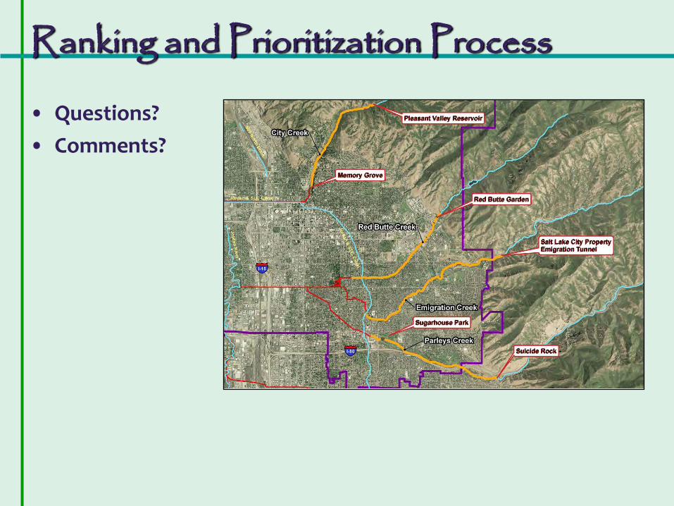
Ranking and Prioritization Process
• Questions?
• Comments?

Creek Crossing Signs
GOAL
Increase public awareness and geographic knowledge of the creeks within Salt Lake City by informing motorists and pedestrians that they are crossing a creek.

Creek Crossing Signs
DESIGN REQUIREMENTS
• Visible and readable by motorists using major roadways
• Also readable and informative for pedestrians
• Scalable design (able to shrink and embed in other City signage)
• Fits in available roadway shoulder space
• Meets SLC Streets guidelines
• Compatible with future Jordan River signage (?)

Creek Crossing Signs
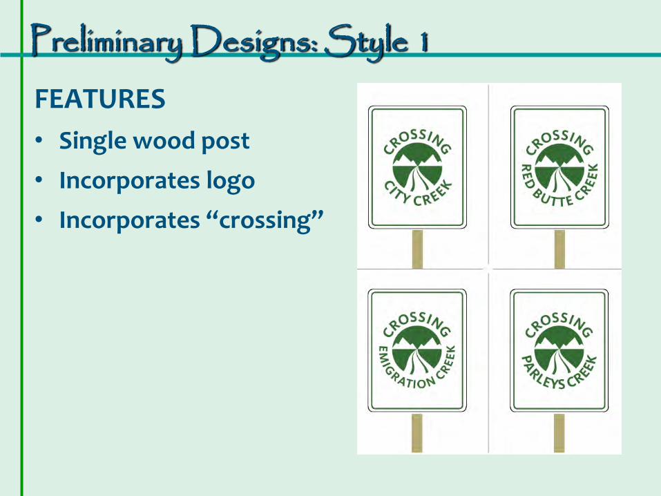
Preliminary Designs: Style 1
FEATURES
• Single wood post
• Incorporates logo
• Incorporates “crossing”

Preliminary Designs: Style 2
FEATURES
• Single wood post
• Incorporates logo
• Incorporates “crossing”
• Background colors vary by creek

Preliminary Designs: Style 3
FEATURES
• Single metal post
• Incorporates logo
• Incorporates “crossing”
• Two stacked signs format

Preliminary Designs: Style 4
FEATURES
• Double metal or wood post
• Identifies watershed

Feedback from Public Workshops: Public Preferences:
• Single-post style
• Text and logo
• Identify Watershed
• “Keep It Pure” logo
• Add “Q-codes”
• Re-design logo so that the Creek does not look like a road
• Idea of including Native American place names
• Jordan R. –coordinate among municipalities

Public Prefers Style 3
• Style 3 (two stacked signs) received the most “votes”
• Subcommittee interested in retaining a text-only option similar to Style 4 but revised to fit a single post

Feedback from Salt Lake City:
Sign Requirements:
• Min. 2’ from roadway
• Min. 7’ from ground
• Heavy gauge aluminum with vinyl cutout
• Clear plastic graffiti barrier
• Telspar galvanized post
• Min. size = 24” x 30”
• Vandal resistant hardware

Revised Designs: Style 1
FEATURES
• Single wood post
• Text only
• Landscape orientation
• Identifies watershed
• Blue background

Revised Designs: Style 2
FEATURES
• Logo
• Two stacked signs
• Identifies watershed
• Q-code and website
• Green background

Revised Designs: Style 3
FEATURES
• Logo (Wasatch silhouette)
• Two stacked signs
• Identifies watershed
• No Q-code or website
• Brown background

Sign Locations

Sign Locations
City Creek Signs:
• N. Bonneville Drive
• Other? (conduit/ underground)
Sign Locations
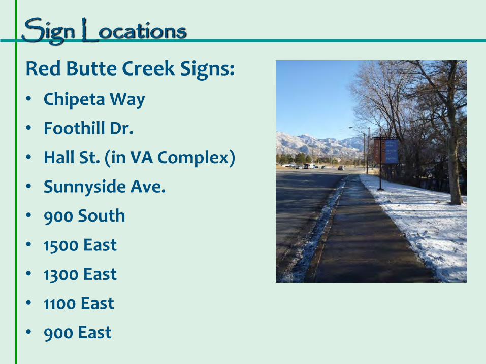
Red Butte Creek Signs:
• Chipeta Way
• Foothill Dr.
• Hall St. (in VA Complex)
• Sunnyside Ave.
• 900 South
• 1500 East
• 1300 East
• 1100 East
• 900 East

Sign Locations
Emigration Creek Signs:
• Crestview Dr.
• Foothill Dr.
• 2100 East
• 1300 South
• 1900 East
• 1700 South
• 1500 East
• 1300 East

Sign Locations
Parleys Creek Signs:
• 2000 East
• 1700 East
• Sugar House Park Road (eastern crossing)
• Sugar House Park Road (western crossing)
• 1300 East

Sign Locations Jordan River Signs:
• 2100 South
• 1700 South
• California Ave. (~1300 S)
• Indiana Ave. (~800 S.)
• 400 South
• North Temple
• 700 North
• 1000 North
• Redwood Road
• Other?

YOUR INPUT IS IMPORTANT! • Provide input on comment form • Vote for your preferred sign option • Ask project staff questions • Comments accepted through April 16

THANK YOU FOR PARTICIPATING
BIO-WEST Contacts: Melissa Stamp 435.881.1549 [email protected] Christopher Sands 435.752.4202 [email protected] For more information go to www.slch20.com