riparian 1998
DESCRIPTION
enfgTRANSCRIPT
Riparian Zone Workshop
A Review and Discussion of Ontario’s Riparian Zone Issues.
PROCEEDINGS
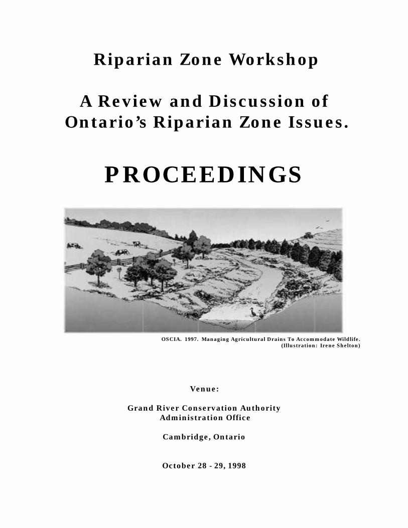
OSCIA. 1997. Managing Agricultural Drains To Accommodate Wildlife. (Illustration: Irene Shelton)
Venue:
Grand River Conservation Authority Administration Office
Cambridge, Ontario
October 28 - 29, 1998
ACKNOWLEDGMENTS
These proceedings were compiled and produced for distribution to the participantsof the Riparian Zone Workshop held on October 28 - 29, 1998. Many thanks to theover 120 participants in this workshop. Summaries of the breakaway sessions, aswell as summaries of the speakers’ papers are included. These thoughts,observations and recommendations will help to mold the next steps in our goal ofRiparian Zone Management.
I wish to thank the members of the Riparian Zone Workshop Committee for theirprofessionalism, enthusiasm and commitment to the concept of riparianmanagement. Their contribution guaranteed the success of this workshop. Onbehalf of the Committee, I would like to extend our gratitude and appreciation to allthe speakers over the duration of the workshop. Their presentations were vital tothe success of the workshop and were key to stimulating lively discussions in thebreakaway sessions.
I would also like to thank the financial supporters and the many contributors -without their assistance this workshop would not have been possible. Our list ofcontributors:
American Fisheries Society - Ontario ChapterDucks Unlimited Canada
Ministry of Natural ResourcesMinistry of the Environment
Ontario Soil and Crop Improvement AssociationRegional Municipality of Waterloo
Soil and Water Conservation Society - Ontario ChapterUniversity of Guelph
Wellington Stewardship Council
Grand River Conservation AuthoritySpecial mention to the GRCA for their provision of staff, office logistics
and workshop facility.
Special thanks goes out to Jennifer Hawkins of the Grand River ConservationAuthority for her work in organizing the logistics for the workshop and thepreparation of these proceedings. Thanks also to Mark Wilson who prepared theLiterature Review.
Jack ImhofWorkshop ChairpersonAquatic EcologistMinistry of Natural ResourcesDecember 3, 1998
TABLE OF CONTENTS
1.0 INTRODUCTION1.1 Introduction ..........................................................................................11.2 Workshop Context ..............................................................................2
2.0 STATE OF THE SCIENCE - WORKSHOP PRESENTATIONS2.1 Existing Tools and Responsibilities:
Policy, Regulation, Planning, Programs, Voluntary ................................3Ala Boyd, MNR
2.2 State of Science - Literature Review .......................................................8Dr. Bill Snodgrass, MTO
Panel Discussion - Ontario Research Findings2.3 Groundwater ........................................................................................12
Dr. Dave Rudolph, University of Waterloo2.4 Non Point Source Pollution .................................................................20
Ryan Stainton, University of Waterloo2.5 Wildlife ...................................................................................................25
Dr. Jane Bowles, University of Western Ontario2.6 Bank Stability ...........................................................................................30
John Parish, Parish Geomorphic Ltd.2.7 Aquatic Habitat ........................................................................................33
Dr. Bruce Kilgour, University of Western Ontario
3.0 STATE OF THE PRACTICE - WORKSHOP PRESENTATIONS3.1 Landowner Perceptions and Acceptance of Riparian Zones ...............39
Sue Sirrs, Rouge Park3.2 Packaging and Selling Riparian Zone Management: .........................43
Issues, Programs and MechanismsIngrid Vanderschot, OSCIA
3.3 Grazing Cattle and Riparian Management: Conflict or Cooperation .....47Peter Doris, Ontario Cattlemen’s Association
Panel Discussion - What We've Done and What We've Learned3.4 Rural Water Quality Program .....................................................49
Tracey Ryan, GRCA3.5 Permanent Cover/Buffer 2002 .....................................................51
Andy Graham, OSCIA3.6 Lincoln Waterways ............................................................................54
Fred High, Lincoln Waterways Working Group3.7 Big Head River Demonstration .....................................................56
Ray Robertson, Grey County3.8 James Berry Drain ............................................................................58
Peter Bryan-Pulham, Township of Norfolk
4.0 KNOWLEDGE GAPS ........................................................................................60Compilation of Day 1 Discussion Groups
5.0 HOW CAN WE BALANCE AND BETTER IMPLEMENT LAND MANAGEMENT IN RIPARIAN ZONES? .....................................................66
Compilation of Day 2 Discussion Groups
6.0 SUMMARY OF DISCUSSION GROUPS6.1 Knowledge Gaps ........................................................................................746.2 How Can We Balance And Better Implement Land Management In Riparian Zones? ........................................................................................76
7.0 CONCLUSIONS ...................................................................................................78WHERE DO WE GO FROM HERE?
APPENDICES
A. Contact List - Committee/Speakers .................................................................80
B. Contact List - Participants ........................................................................................82
C. Workshop Agenda ...................................................................................................89
D. Riparian Zone Applications Tour Notes .................................................................90
E. Soil and Water Conservation Demonstration Farm - HIGHVIEW FARMS .......96(Compliments presentation by Lincoln Waterways Working Group)
F. What You Would Like to See Next! - Comments from Evaluation Forms .......97
Introduction
Riparian Zone Workshop ProceedingsPage 1
1.1 Introduction
The goal of the Riparian Zone Workshop was to bring together those working with allaspects of riparian zones in order to discuss the state of the practice and the state of thescience in riparian zone management. It was also designed to provide a networkingopportunity for all those that attended. From the Committee and Speaker List (AppendixA) and the Participant List (Appendix B), it is evident that we reached a wide variety ofscientists, resource managers and practitioners of various disciplines.
Riparian zones are defined as the three dimensional zone of interaction between terrestrialand aquatic ecosystems. Their control over the functioning of landscape processes is muchgreater than their predicted land areas effect. They represent the final region throughwhich substances pass when moving from the terrestrial to the aquatic ecosystem. Thisgives riparian zones the conclusive opportunity to modify, incorporate, dilute orconcentrate stream-bound materials. Because of these attributes, riparian zones have beenfound to assist in the regulation of landscape geomorphic and hydrologic processes, thecontrol of surface water quality, and the protection and provision of both aquatic andterrestrial habitat.
A strong interest is developing for the management and restoration of functional riparianzones as both productive and valued components of stream corridors and as buffers toecologically damaging upland landuses. Extensive implementation programs are likely tooccur over the next few years and gaps in our understanding of riparian zones, theirfunction, composition and structure need to be addressed by focused research questions inorder to provide sound tools for their design and management.
These proceedings provide an overview of the 2 day workshop and are designed as aworking document from which we will move forward. (See Appendix C - Agenda). It istherefore an interim product that will be formalized in the future with further input andcollaboration.
Section 1.0 includes the introduction and the workshop context. Section 2.0 and 3.0contain speakers notes, often in point form and comments. Care has been taken to ensurethat these represent the presentation and viewpoints given by the speaker. A compilationof the discussion groups entitled ‘Knowledge Gaps’ and ‘How Can We Balance and BetterImplement Land Management in Riparian Zones?’; are presented in sections 4.0 and 5.0.Major themes and concepts from the discussion groups have been compiled into section 6.0.Conclusions and future recommendations are found in section 7.0. The appendices include:contact lists for the committee, speakers and participants, workshop agenda, bus tourinformation and comments from the evaluation forms.
A Literature Review: Overview of the State of the Science. An Examination of theFunctions of Riparian Zones has been prepared as a stand-alone document and will beposted on the Watershed Science Centre website at Trent University(www.trentu.ca\academic\wsc).
Introduction
Riparian Zone Workshop ProceedingsPage 2
1.2 Workshop Context
The Riparian Zone Workshop was organized with the vision of bringing togetherresearchers, managers and practitioners in order to:
• Discuss the state of the science and the state of the practice in riparian zonemanagement;
• Discuss the functional role of riparian zones within watersheds;
• Determine new opportunities, constraints and barriers to the management ofriparian lands;
• Determine what management issues are not being addressed and then identifyadditional research needs required to foster stewardship of riparian lands;
• Provide a means to develop co-operative networks and partnerships betweenresearchers, managers and practitioners;
• Determine how we can better improve our management and understanding ofriparian zones.
Workshop PresentationsAla Boyd
Riparian Zone Workshop ProceedingsPage 3
2.0 STATE OF THE SCIENCEWORKSHOP PRESENTATIONS
2.1 Existing Tools and Responsibilities:Policy, Regulation, Planning, Programs, Voluntary
Ala Boyd, MNR
Riparian Zone Management• Legislative Basis:
• Common Law Aspects• Statutory Context
• Stewardship and Voluntary Activities
Common Law Aspects and Riparian ZonesDefinition of Riparian: “of or on river bank”[f. L. riparius (ripa bank)] Source: OxfordTwo “Riparian” Aspects1) Riparian interests of those features and life occurring “of or on a river bank” and
therefore the watercourse– Watercourse aspects “Aqua currit et debet currere” or water flows naturally and should
be permitted thus to flow2) Riparian Property Rights of land owners who abut river bank
Definition of a WatercourseThe Courts have said, that to constitute a natural watercourse, the channel bank formed bythe flowing of water must present to the eye on casual examination the unmistakableevidence of the frequent action of running water. On another occasion that a watercourse isconstituted in there is sufficient natural and accustomed flow of water to form and maintaina distinct and defined channel. It is not essential that the supply should be continuous orform a perennial living source. It is enough if the water rises periodically and reaches afairly defined channel of permanent character. A natural watercourse does not cease to besuch if at a certain point it spreads out over a level area and flows for a distance withoutdefined banks before flowing again in a defined channel. Often it is the valley throughwhich the stream runs, and not its low level or low water channel, which is the watercourse.
Source: MTO Drainage Management Manual 1997
Riparian Property Rights• Allow right of access to water that abuts his land, the right to fish, the right to receive
water flowing past undiminished in quantity and quality and the opportunity to takeaction against those who interfere with these rights.
• Implied obligation incumbent upon the riparian owner to respect the rights ofupstream/downstream riparian zones.
• Statutes introduced to strengthen established common law principles.Stewardship, Voluntary and Other Resources
Workshop PresentationsAla Boyd
Riparian Zone Workshop ProceedingsPage 4
• Conservation Authorities and Local Municipalities (by-laws)• Stewardship Councils• Ontario Land Care• Ontario Streams• Friends of the River• Advocacy Groups (AFS, SWCS, FON, OFAH)• Wetland Habitat Fund Program• Community Fisheries Involvement Program• Community Wildlife Involvement Program• Great Lakes 2000 Clean Up Fund• Ontario Environmental Farm Plan Program• Eastern Joint Venture Habitat Program• Ducks Unlimited … and many others…..
Potential Management Issues• Delineation of an arbitrary distance from top of bank• Present tools (criteria and setbacks) deal with other issues (e.g. floodplains)• Policy basis for management not explicit for riparian zones• Can be used for riparian zone management with additional guidance
Effectiveness of Approaches• Is the present web of legislation, stewardship activities and resources sufficient and
effective for riparian zone protection and management?• If not, what can we do?
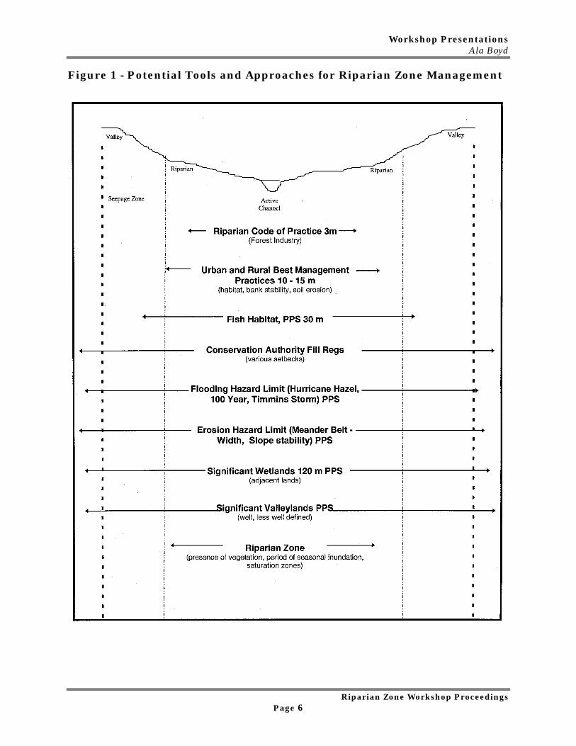
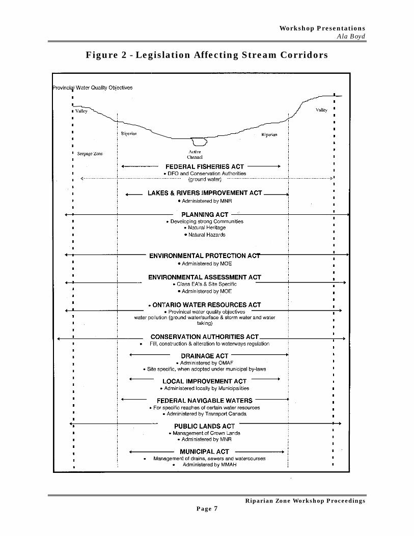
Tables and Figures include:Table 1 - Legislative Influences and Riparian ZonesFigure 1 - Potential Tools and Approaches for Riparian Zone ManagementFigure 2 - Legislation Affecting Stream Corridors

Workshop PresentationsAla Boyd
Riparian Zone Workshop ProceedingsPage 5
Table 1 - Legislative Influences and Riparian Zones
Legislation Potential RiparianManagement Application
Advantage - Disadvantage
ConservationAuthorities Act,Fill, Constructionand Alteration toWaterwaysRegulation
• Management of naturalresources on a watershedbasis
• Provides for regulation ofactivities adjacent towatercourses
• Allows for protection of watercoursesand establishment of a corridor
• Implementation occurs on regulatedwatercourses
• Provides a mechanism for riparian zoneprotection
Planning Act, PPS:1.1.1.e) DevelopingStrongCommunities
• “Coordinated Approach”for ecosystem, watershed,shoreline and riverinehazards
• Riparian zone not explicitly stated as adesired objective
• May be used to provide for riparian zonemanagement within watershed,providing mechanism for continuouscorridor protection
Planning Act, PPS:2.3 NaturalHeritage Policies
• Development notpermitted in Significantwetlands, significantportion of habitat ofendangered andthreatened species
• fish habitat, CanadianShield Wetlands,significant valley lands -no negative impacts on thenatural features
• riverine and coastal wetlands may beconsidered as riparian areas
• not explicitly defined• fish habitat - technical manual
identifies adjacent lands - vegetatedbuffer
• significant valley lands: well defineduse stable top of bank, less well defineduse presence of riparian vegetation,flooding hazard limit, meander beltwidth or highest general level ofseasonal inundation
Planning Act, PPS2.3.3
• “Diversity of naturalfeatures in an area, andthe natural connectionsbetween them should bemaintained, and improvedwhere possible”
• consideration of links, provides basis forlandscape ecology connectivity betweennatural heritage systems
• Provides opportunities for restoration ofnatural features and connections
Planning Act, PPS:3.1 Natural HazardsPolicies
• development directedaway from Great Lakes -St. Lawrence, rivers andstreams impacted byflooding erosion anddynamic beaches
• Provides criteria for developmentsetbacks
• Public health and safety intent
Lakes and RiversImprovement Act
• Regulates activities withinactive channel, does notregulate activities outsidechannel (e.g. placement offill in floodplain)
• protects riparian rights
Others ….
Workshop PresentationsAla Boyd
Riparian Zone Workshop ProceedingsPage 6
Figure 1 - Potential Tools and Approaches for Riparian Zone Management
Workshop PresentationsAla Boyd
Riparian Zone Workshop ProceedingsPage 7
Figure 2 - Legislation Affecting Stream Corridors
Workshop PresentationsDr. Bill Snodgrass
Riparian Zone Workshop ProceedingsPage 8
2.2 State of Science - Literature ReviewDr. Bill Snodgrass, MTO
Master Concepts to Understand the Science and its Design Applications
1. Master UnitThe riparian system is a geomorphic unit which includes the stream and secondary
channels, the stream’s floodplain and those portions of the surrounding lands that areperiodically inundated with water or have hydrophytic vegetation. In essence, it may bedefined as the relatively hydrologically (surface and groundwater) active portion of thestream corridor in contact with the active stream channel.
2. Defining SketchesThe unit is defined longitudinally by its’ planform within the valley. This includes
an understanding of width, length and contiguousness of vegetation as well as the locationand characteristics of lateral flow from the surrounding landscape.
It is also defined by its hydraulic cross-section which identifies the relationshipbetween the riparian zone, its width, elevational characteristics, vegetative forms inrelation to the stream and its various flow elevations.
3. Hydrologic Pathways through the "unit"Water movement through riparian systems can be complex and depends upon the
structure of the zone, its elevations and the flow event. During very high flows such asperiodic floods, water movement into the zone will come from upstream overflooding of thebanks. During more frequent rainfall events, water movement may be lateral from thesurrounding landscape either as surface water, deeper groundwater, vadose (interflow)water or a combination of all of these. In addition, water flow may come into the zone indispersed flow, as sheet flow, as concentrated flow in channels, or as a combination of all ofthese.
4. Desired Vegetation FunctionsThe structure and composition of vegetation within the riparian zone plays an
important role in all aspects of the zones’ functions (i.e. physical, chemical, biological,ecological). The functioning of the riparian zone as well as its composition and structure isalso partly controlled and modified by the dominant adjacent landscape, its vegetatedsystem (i.e. Ecological Land Classification) and the adjacent human landuse gradients.In Ontario, the dominant landuse activities that can alter and modify vegetativecharacteristics of riparian zones include: forestry, agriculture (i.e. row crop monoculture,tiles, drainage, pasturage), urban development and urban landuse management; andothers (golf course, aggregate extraction, base-metal mining).
5. Thinking Process i.e. State of EvolutionThere are many ways in which to view riparian zones and their functioning. Two
thought processes that are current today are found in the USA and in Ontario. The U.S.
Workshop PresentationsDr. Bill Snodgrass
Riparian Zone Workshop ProceedingsPage 9
Stream Corridor Handbook is a manual which assists with the assessment analysis,planning and design of riparian zones along watercourses where they have been degraded.
In Ontario, the soon to be released ‘Adaptive Management of Stream Corridors’manual complements the work done by the US publication and provides detailed steps forthe assessment, analysis, and design of functional stream corridors and channels. TheOntario document presents an integrative design process of 11 steps for geomorpholgists,engineers, biologists/ecologists and planners. Both of these documents consider theriparian zone as a geomorphic/ecological system.
6. Design / Implement System with Adaptive ManagementLong term monitoring required.Adaptive Management may be an appropriate approach.Reference sections - from case studies would be an important component.
STATE OF THE ART / SCIENCE/ PRACTICEFrameworks - from Ontario
- Watersheds (WPI)- Urban - Stream Channel Erosion (MOE)
- most cogent from Riparian Zones
• Overview Charts - Watershed Planning Initiative• Stream Channel Erosion - Overview, Definitions, and Conclusions• Appendix for S.C.E. - Back-up for Conclusions• Tools for Predicting Channel migration• Role of riparian canopy in a solution to controlling channel erosion
STATE OF THE ENVIRONMENTAL ENGINEERING SCIENCE(statements are relative to each other; not absolute)
1. Surface Water Hydrology and Water Quality• Reasonably well defined - several synthesis reports.• Limits - understanding of drainage patterns which generate concentrated flow - for such
flows; little water quality enhancement (removal of pollutants) occurs.• Piped flow systems (urban areas 90-99% of stormwater flow is piped) - little mitigation
through overland flow treatment because overland flow is only a small component. 2. Groundwater Hydrology and Water Quality• Significant amount of new work occurring• Significant new insights into role of perched and transients of flow through the vadose
zone.• Denitrification is significant where groundwater flow occurs laterally through the root -
zone (root zone provides organic matter which is a carbon source for denitrifyingbacteria) - hence root zone is a redox barrier to nitrate transport.
3. Geomorphology
Workshop PresentationsDr. Bill Snodgrass
Riparian Zone Workshop ProceedingsPage 10
There are many questions in this area concerning the relationship between riparianvegetation and geomorphology. For example: what practical width is needed? How cangeomorphic concepts such as entrenchment be used? Is entrenchment appropriate forcertain cross sections and not others?
The literature data on the subject is limited. The data available are more qualitative thanquantitative. A few pertinent observations include:• Classification Systems for Streams differentiate 2 or 3 types of streams based on the
presence or absence of vegetation i.e., with essentially the same channel gradient andbottom material, the channel with different geometrical characteristics.
• One investigation found no effect of vegetation in 5 gravel and sand transporting riversin Western Canada.
• An Iowa investigation found that vegetation had a significant effect in 2 sandbed rivers.• Another investigation found that root-reinforced banks were 4 orders of magnitude more
resistant than non-reinforced banks to channel migration.• Soil strength to resist shear forces is dependent on the plant species.• The importance of riparian vegetation will potentially be explained using the hypothesis
that in streams and small rivers (i.e. 1st order to 4th order):• Flow is the dominant factor and sediment transport is a modifier in controlling
channel erosion.• Effect of vegetation being a modifier.• Contradictions about the effectiveness of vegetation can be resolved by the
difference in bank height.• In relatively flat gradient streams and especially based upon observations from large
basins, vegetation alters the geomorphically stable attributes of a channel's geometryand planform in rivers which experience the stresses of large floodflows.
• In rivers at the outlets of larger basins, sediment supply is a dominant factor in channelform with flow and vegetation being the modifier. Such basin scales have not been ofsignificant concern to channel erosion management in Storm Water Management Model(SWMM) to date.
4. Water Quality Functions of BuffersTypical graphs of effectiveness of width on improvement in water quality - plateau after 15to 30 metres for productivity, shade potential, sediment removal, etc.• Length effects?
5. Aquatic Ecological FunctionsData base on aquatic functions is evolving:• Barton et al. 1985. Need 3 to 5 km of riparian canopy to return warm water habitat to
cool/cold water habitat.• 1995/1996 Habitat data sets - degraded habitats show degree of improvement if riparian
zone is located upstream of measurement site. Have much more data from the past 2summers to be included in the analysis.
• Convenient to differentiate between canopy (provides allocthonous carbon and protectsagainst heating) and wood debris controlled streams.
• Research findings should differentiate type of riparian vegetation, i.e. intact, partiallyintact, open as well as grasses, old field, shrub, mature forest - little understory, lots ofunderstory.
Workshop PresentationsDr. Bill Snodgrass
Riparian Zone Workshop ProceedingsPage 11
• Wood debris controlled streams - establish a significantly more complex stream formthan non-wood debris controlled streams.
6. Wildlife Ecological Functions• Contingent on adjoining lands.• Floodplain (i.e. well-defined valley vs. table lands with an intermittent ditch going
through the lands).• Potential information source - Landscape Scale literature describing patch size; primary
and secondary corridors.
7. Human Ecological Interactions• Design for core wildlife functions plus buffer thickness.• Width of canopy necessary to buffer human activity from wildlife i.e. roadways, salt
spray (1% of roadside concentration at 5m), traffic noise (exponential die off).• Physical effect of having a corridor of trees cut through a woodland or swamp (Hounsell
et al research, Ontario Hydro).• Interior bird habitat - need 100 m to 200 m buffer width.
8 . Other FactorsSoils/Surficial Geological Structure• Role in controlling/influencing type of canopy.• What information about these factors can be gathered from surficial hydrogeology? Fundamental needs to assist Science Synthesis, Management, Design• Long -term monitoring.• Adaptive Management.• Reference Sections- for case studies.
NATURAL CHANNEL INITIATIVE STEPS (NCI)
NCI Step 1. Where is the Channel in its process of evolution?NCI Step 2. What is the disturbance?NCI Step 3. What Future disturbances are likely to occur?NCI Step 4. What are the channel dynamics?NCI Step 5. Stream response to Disturbance?NCI Step 6 Determine Ultimate Configuration of Channel.NCI Step 7 Is Intervention Feasible?NCI Step 8 Define Intervention Options.NCI Step 9 Complete the design.
Workshop PresentationsDr. Dave Rudolph
Riparian Zone Workshop ProceedingsPage 12
PANEL DISCUSSIONONTARIO RESEARCH FINDINGS
2.3 GroundwaterDr. Dave Rudolph, University of Waterloo
Role of the Riparian Zone in Controlling the Distribution and Fate ofAgricultural Nitrogen Near a Small Stream in Southern Ontario
Edwin E. Ceya, *David L. Rudolphb, Ramon Aravenab, and Gary Parkinc
aGolder Associates Ltd., 202 - 2174 Airport Drive, Saskatoon, SK, CanadabDepartment of Earth Science, University of Waterloo, Waterloo, ON, Canada
cDepartment of Land Resource Science, University of Guelph, Guelph, ON, Canada
September 27, 1998Revised version
AbstractUncultivated riparian areas can play an important role in reducing nutrient loading
to streams in agricultural watersheds. Groundwater flow and geochemistry weremonitored in the riparian zone of a small agricultural watershed in southern Ontario.Hydraulic and geochemical measurements were taken along a transect of monitoring wellsextending across the riparian area into an agricultural field. Chloride and nitrateconcentrations in groundwater samples collected from the agricultural field were muchhigher than in samples from the riparian area. A sharp decline in both nitrate andchloride concentrations was observed near the field-riparian zone boundary. It appearsthat increased recharge within the riparian zone, as compared to the artificially drainedfield, caused nitrate-rich groundwater from the field to be diverted downward beneath theriparian zone, thus limiting the input of agrochemicals to the riparian area andconsequently protecting the stream from potential contamination. Geochemical data also indicated that nitrate was attenuated in the downwardmoving groundwater. Patterns of dissolved oxygen concentrations and redox potential inthe subsurface coincided with the pattern defined by groundwater nitrate. These patternsindicated that conditions within the riparian zone and at depth near the field-riparian zoneboundary were conducive to denitrification. A linear relation between the δ15N and δ18Ovalues of nitrate from the monitored transect also supported denitrification as the primarynitrate removal mechanism. This study provides a new conceptual model of how riparianzones may prevent nitrate contamination of streams, and highlights the need for acomplete understanding of both groundwater flow and geochemistry in riparianenvironments.
Keywords: groundwater, agriculture, riparian zone, denitrification, isotopes
Workshop PresentationsDr. Dave Rudolph
Riparian Zone Workshop ProceedingsPage 13
IntroductionNitrate contamination of water resources is widespread in areas of intensive
agricultural activity. The nitrate contamination results from the excessive use of inorganicand organic fertilizers and/or by tillage that releases nitrogen stored in the soils. Inagricultural watersheds in southern Ontario, there is ample documentation of nitratecontamination of groundwater (Gillham, 1991; Ontario Farm Groundwater Quality Survey,1993; Robertson et al., 1996) and surface water (Hill, 1978; Neilsen et al., 1982; Hill,1988). Much of the nitrate contamination in surface water arises from direct groundwaterdischarge and groundwater input by tile-drainage networks. Therefore, the abundance andfate of nitrate in groundwater can have a major influence on surface-water quality.
Most streams in southern Ontario are separated from agricultural fields byuncultivated strips of land, commonly called riparian zones or buffer strips. These riparianzones consist of narrow bands of natural vegetation (trees, shrubs, and grasses) thatremain uncultivated because the land is too wet, too steep, or too difficult to clear foragricultural activity. Numerous studies have shown that riparian zones can play animportant role in reducing nitrate concentrations in groundwater discharging to streams(Peterjohn and Correll, 1984; Jacobs and Gilliam, 1985; Cooper, 1990; Haycock and Pinay,1993; Jordan et al., 1993; Gilliam 1994)
Even with the abundant evidence supporting nitrate removal in riparian areas, therole the riparian zone plays in removing groundwater nitrate remains unclear. Theprimary processes of subsurface nitrate removal within these riparian zones are generallyconsidered to be denitrification (Jacobs and Gilliam, 1985; Cooper, 1990; Lowrance et al.,1995), vegetative uptake (Lowrance, 1992), or dilution (Altman and Parizek, 1995; Komorand Magner, 1996). However, in many studies the exact mechanism of nitrate removal andthe role hydrology plays in nitrate attenuation have not been well established. Hydrologicalcontrols on groundwater flow patterns can have a major influence on the distribution andfate of nitrate. Still, few studies have carefully examined the link between groundwaterflow paths and nitrate concentrations (Hill, 1996). To discern the actual role of riparianzones in removing nitrate from groundwater, a better understanding of the relationbetween groundwater flow and chemistry is required.
A variety of techniques can be used to identify the processes controlling nitrateremoval. Hydrogeochemical data can be used to delineate redox conditions in thesubsurface and infer the occurrence and location of denitrification zones (Postma et al.,1991; Starr and Gillham, 1993). The concentrations of conservative tracers, such aschloride or bromide, relative to nitrate, can establish the importance of dilution indecreasing nitrate concentrations. Measurement of in-situ denitrification rates using theacetylene blocking technique can provide direct evidence of denitrification (Smith et al.,1991; Starr and Gillham, 1993). Fractionation of nitrogen and oxygen isotopes, whichform parts of the NO3- molecule, can provide additional evidence of denitrification anddilution (Mariotti et al., 1988; Böttcher et al., 1990). It may also be possible in the futureto use 15N isotopes to quantify uptake of groundwater nitrate by plants (Komor andMagner, 1996).
This study had two major goals. The first was to examine the relationship betweengroundwater flow and nitrate transport from an agricultural field into a riparian zone. Thesecond was to assess the fate of nitrate and determine the mechanisms of nitrateattenuation within the riparian zone. Our approach includes the use of geochemical andisotopic techniques in combination with detailed groundwater flow measurements near asmall headwater stream in southern Ontario.
Workshop PresentationsDr. Dave Rudolph
Riparian Zone Workshop ProceedingsPage 14
Implications of ResultsMany studies of nitrate retention in the riparian zone have concluded that nitrate is
removed in shallow, organic-rich sediments of the riparian zone as a result ofdenitrification or plant uptake. This conclusion follows the conceptual model that shallow,nitrate-rich, groundwater flows laterally into the riparian zone and nitrate is removedchemically or biologically (Hill, 1996). Many of these studies have ignored the three-dimensional nature of groundwater flow, particularly the vertical component of flow. Insome cases, these studies have been conducted in shallow aquifers that are underlain byimpermeable materials, thereby prohibiting significant vertical groundwater flow. Otherstudies simply have not dealt with groundwater flow in three dimensions.
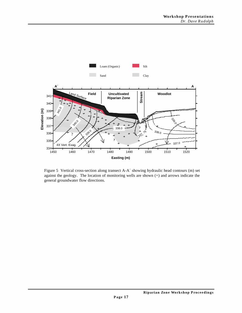
The conceptual model of the riparian zone in this study is much different. Theapparent removal of nitrate in groundwater beneath the uncultivated strip is controlled bygroundwater flow patterns. A hydrologic contrast between the recharge rates on the fieldwhere tile drains intercept a portion of the infiltrating water and in the naturally drainedriparian zone resulted in a large component of vertically downward flow near the field-riparian zone boundary. As a result the high-nitrate, high-chloride groundwater from thefield was forced to flow beneath the sediments of the riparian zone. Groundwater withinthe riparian-zone sediments is relatively poor in nitrate and chloride, and presumablyrepresents a plume of water recharged through the uncultivated strip that has not beencontaminated by agrochemicals.
In addition, it appears that nitrate is attenuated as groundwater flow from the fieldand is directed downward near the field-riparian zone boundary. Nitrate concentrationsdeclined considerably (to below detection limits) with depth in this region, while chlorideconcentrations remained relatively constant. The coincident decline in D.O. concentrationsand Eh in this subsurface region suggest that denitrification is responsible for nitrateremoval with depth. Elevated δ15N values in some deeper, nitrate-poor, groundwatersamples and the strong correlation between δ15N and δ18O values also point todenitrification as the primary nitrate-attenuation mechanism.
This study clearly shows that under the conditions present at this site, the riparianzone can function as a hydraulic “barrier” to the flow of nitrate-contaminated groundwaterto a stream, in addition to the chemical or biological controls found in other riparian-zonestudies. The riparian zone appears to perform a vital role in preventing nitratecontamination in the adjacent stream. Further detailed work is needed to determine howriparian zones function at other locations within this and other watersheds.
ConclusionsThe riparian zone in this study had a major influence on the distribution and fate of
groundwater nitrate. Previous studies of nitrate attenuation in riparian zones haveindicated that nitrate removal occurred primarily in the shallow, organic-rich sediments ofthe riparian zone through denitrification and plant uptake. At this study site, thehydrologic contrast between the tile-drained field and the riparian zone had a controllinginfluence on groundwater flowpaths. The hydraulic-head data and subsurface chlorideconcentrations indicate that the shallow groundwater from the field, which containedrelatively high concentrations of nitrate, was diverted downward as it approached thestream by the nitrate-poor water infiltrating through the riparian zone. The rapiddisappearance of nitrate as it moved vertically coincided with the decrease of D.O. and
Workshop PresentationsDr. Dave Rudolph
Riparian Zone Workshop ProceedingsPage 15
more reducing conditions. Chloride concentrations remained high throughout this samezone, indicating that dilution was not a significant process. These patterns provideevidence to support denitrification as the dominant nitrate-attenuation mechanism.
The δ15N isotope results and the history of fertilizer application indicated that thesources of groundwater nitrate beneath the field were organic (manure) and inorganicfertilizers. Elevated values of δ15N in certain groundwater samples indicated thatdenitrification was prevalent in the subsurface. Additional evidence for denitrification wasthe linear relationship between δ15N and δ18O values of groundwater nitrate samples.Unfortunately, the attenuation of nitrate over short (~1-2 m) intervals prevented thecurrent sampling network from providing sufficient information for correlating nitrate andδ15N data along flowpaths at the field-riparian zone boundary.
This study highlights the importance of understanding the three-dimensionalgroundwater flow field in riparian-zone studies. The study also demonstrates the utility ofcombining physical, chemical, and isotopic techniques in evaluating nitrate dynamics ingroundwater environments. Hydraulic head, geochemical, or isotopic data alone would nothave provided sufficient evidence to understand the role of the riparian zone. Together,though, the data provide a relatively complete picture of relevant processes controlling thedistribution and fate of nitrate in the subsurface.
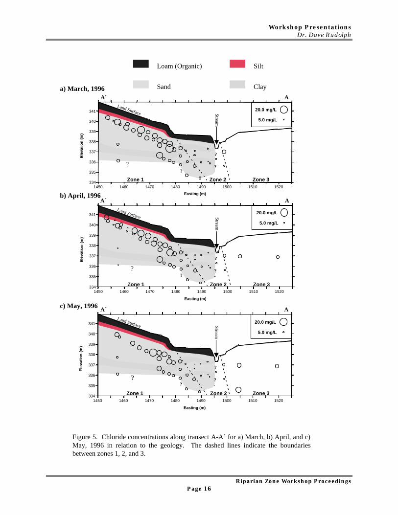
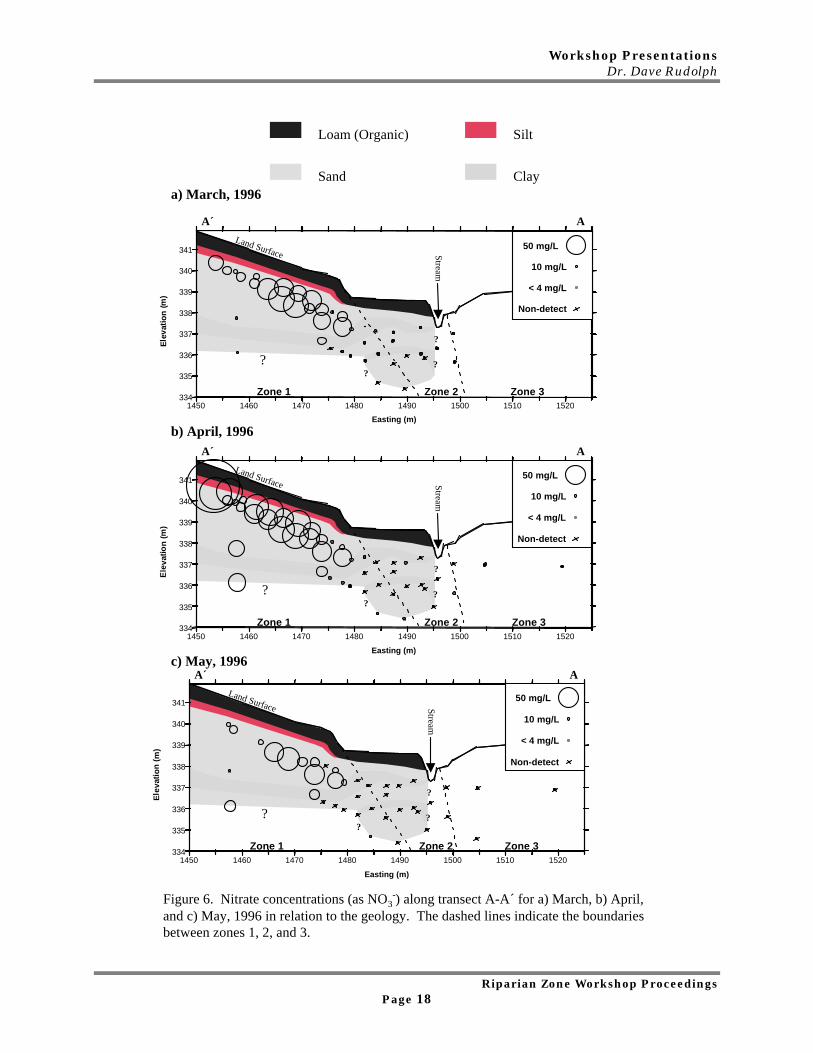
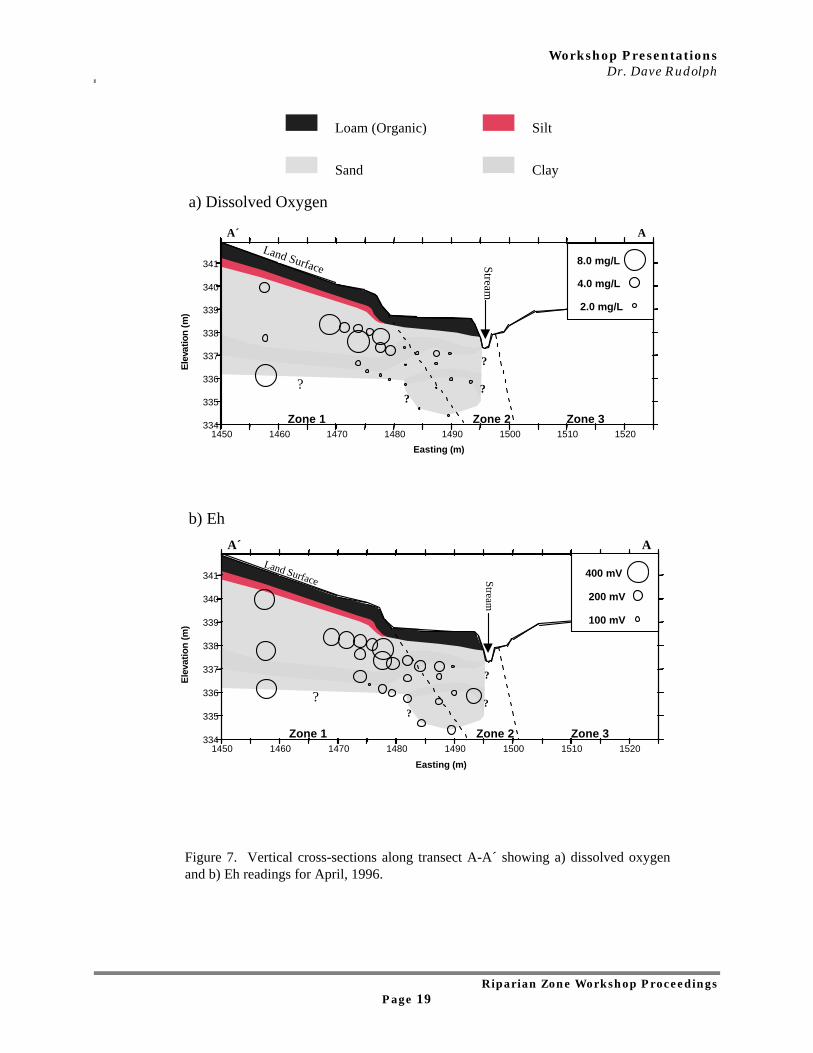
The following four (4) figures represent:
Cross Sections Of Study Site On Kintor Creek Showing Movements And Changes OfVarious Parameters As They Move In The Groundwater From Upland Field To RiparianZone And Stream.
Each figure highlights a different parameter.
Note Figure 7 (page 19) - Eh represents Electric Potential
Workshop PresentationsDr. Dave Rudolph
Riparian Zone Workshop ProceedingsPage 16
?
??
Land Surface Stream
AA´
a) March, 1996
b) April, 1996
Loam (Organic)
Sand
Silt
Clay
c) May, 1996
?
??
Land Surface Stream
AA´
1450 1460 1470 1480 1490 1500 1510 1520
Easting (m)
334
335
336
337
338
339
340
341
Ele
vatio
n (
m)
5.0 mg/L
20.0 mg/L
Zone 1 Zone 2 Zone 3
Figure 5. Chloride concentrations along transect A-A´ for a) March, b) April, and c)May, 1996 in relation to the geology. The dashed lines indicate the boundariesbetween zones 1, 2, and 3.
?
??
Land Surface Stream
AA´
1450 1460 1470 1480 1490 1500 1510 1520
Easting (m)
334
335
336
337
338
339
340
341
Ele
vatio
n (
m)
5.0 mg/L
20.0 mg/L
Zone 1 Zone 2 Zone 3
1450 1460 1470 1480 1490 1500 1510 1520
Easting (m)
334
335
336
337
338
339
340
341
Ele
vatio
n (m
)
5.0 mg/L
20.0 mg/L
Zone 1 Zone 2 Zone 3
?
?
?
Workshop PresentationsDr. Dave Rudolph
Riparian Zone Workshop ProceedingsPage 17
?
??
Loam (Organic)
Sand
Silt
Clay
Figure 5 Vertical cross-section along transect A-A´ showing hydraulic head contours (m) setagainst the geology. The location of monitoring wells are shown (+) and arrows indicate thegeneral groundwater flow directions.
Ele
vati
on
(m
)
Easting (m)
341
338
337
336
335
334
340
339
1450 15001490148014701460 15201510
4X Vert. Exag.
341.
0
338.0
339.0
337.0
340.
0
339.
0338.0
337. 75
Field UncultivatedRiparian Zone
Str
eam WoodlotLand Surface
AA´
?
Workshop PresentationsDr. Dave Rudolph
Riparian Zone Workshop ProceedingsPage 18
?
??
Land Surface Stream
AA´
a) March, 1996
?
??
Land Surface Stream
AA´
b) April, 1996
?
??
Land Surface Stream
AA´c) May, 1996
Figure 6. Nitrate concentrations (as NO3-) along transect A-A´ for a) March, b) April,
and c) May, 1996 in relation to the geology. The dashed lines indicate the boundariesbetween zones 1, 2, and 3.
Loam (Organic)
Sand
Silt
Clay
1450 1460 1470 1480 1490 1500 1510 1520
Easting (m)
334
335
336
337
338
339
340
341
El e
v ati
on
(m
)
Non-detect
< 4 mg/L
10 mg/L
50 mg/L
Zone 1 Zone 2 Zone 3
1450 1460 1470 1480 1490 1500 1510 1520
Easting (m)
334
335
336
337
338
339
340
341
Ele
vatio
n (m
)
Non-detect
< 4 mg/L
10 mg/L
50 mg/L
Zone 1 Zone 2 Zone 3
1450 1460 1470 1480 1490 1500 1510 1520
Easting (m)
334
335
336
337
338
339
340
341
El e
vati
on
(m
)
Non-detect
< 4 mg/L
10 mg/L
50 mg/L
Zone 1 Zone 2 Zone 3
?
?
?
Workshop PresentationsDr. Dave Rudolph
Riparian Zone Workshop ProceedingsPage 19
?
??
Land Surface Stream
AA´
Figure 7. Vertical cross-sections along transect A-A´ showing a) dissolved oxygenand b) Eh readings for April, 1996.
a) Dissolved Oxygen
b) Eh
Loam (Organic)
Sand
Silt
Clay
Easting (m)
?
??
Land Surface Stream
AA´
1450 1460 1470 1480 1490 1500 1510 1520334
335
336
337
338
339
340
341
Ele
vatio
n (
m)
2.0 mg/L
4.0 mg/L
8.0 mg/L
Zone 1 Zone 2 Zone 3
1450 1460 1470 1480 1490 1500 1510 1520
Easting (m)
334
335
336
337
338
339
340
341
Ele
vati
on
(m
)
Zone 1 Zone 2 Zone 3
100 mV
200 mV
400 mV
?
?
Workshop PresentationsRyan Stainton
Riparian Zone Workshop ProceedingsPage 20
2.4 Non Point Source PollutionRyan Stainton, University of Waterloo
The Effect of Riparian Buffers on Nutrient Input to StreamsFrom Shallow Groundwater in Urban and AgriculturalLandscapes
Most studies to date have focused on nitrate transport through riparian zones inagricultural landscapes under similar hydrogeologic settings, forcing shallow lateral flow ofgroundwater through the rooting zone and organic soils of the riparian zone (Table 1) -relatively high efficiency in nitrate reduction.
Sites occurring in more sandy aquifers, where lateral flow through the riparian zone is nothappening, data (Table 2) have shown higher stream side concentrations, with nutrientladen groundwater potentially short-circuiting the riparian zone.
Fewer studies have looked at phosphorus in riparian zones (assumption that P movementin groundwater is not significant due to high adsorption affinity of phosphorus).
Studies looking at phosphorus in riparian zones have most often indicated an increase inconcentration as groundwater flows from adjacent land use, to the stream-side monitoringwells (Table 3).
My study...• 8 sites in total, 3 in agricultural, 4 in urban (residential) and 1 reference (used as a
‘background’ indicator).• 2 agricultural sites are not buffered by riparian zone where 1 is. Two urban sites are
buffered, 2 are not.• Drive point piezometers installed into stream-bed to measure nitrate, total phosphorus
and soluble reactive phosphorus (phosphate) concentrations in shallow groundwaterentering the stream.
• Shallow groundwater entering the stream at this point would have had an opportunityto interact with the riparian zone.
• Overall objective - ‘to investigate the effect of riparian buffers on nutrient input tostreams from shallow ground water in urban and agricultural landscapes’.
• Aim is determine whether there is a significant difference in the concentrations of thestudied nutrients entering the streams, in those buffered vs. non-buffered streamreaches.
Workshop PresentationsRyan Stainton
Riparian Zone Workshop ProceedingsPage 21
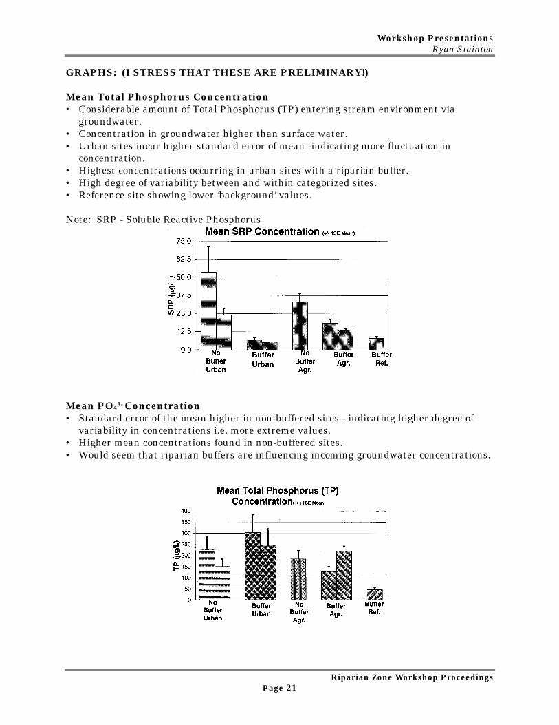
GRAPHS: (I STRESS THAT THESE ARE PRELIMINARY!)
Mean Total Phosphorus Concentration• Considerable amount of Total Phosphorus (TP) entering stream environment via
groundwater.• Concentration in groundwater higher than surface water.• Urban sites incur higher standard error of mean -indicating more fluctuation in
concentration.• Highest concentrations occurring in urban sites with a riparian buffer.• High degree of variability between and within categorized sites.• Reference site showing lower ‘background’ values.
Note: SRP - Soluble Reactive Phosphorus
Mean PO43- Concentration• Standard error of the mean higher in non-buffered sites - indicating higher degree of
variability in concentrations i.e. more extreme values.• Higher mean concentrations found in non-buffered sites.• Would seem that riparian buffers are influencing incoming groundwater concentrations.
Workshop PresentationsRyan Stainton
Riparian Zone Workshop ProceedingsPage 22
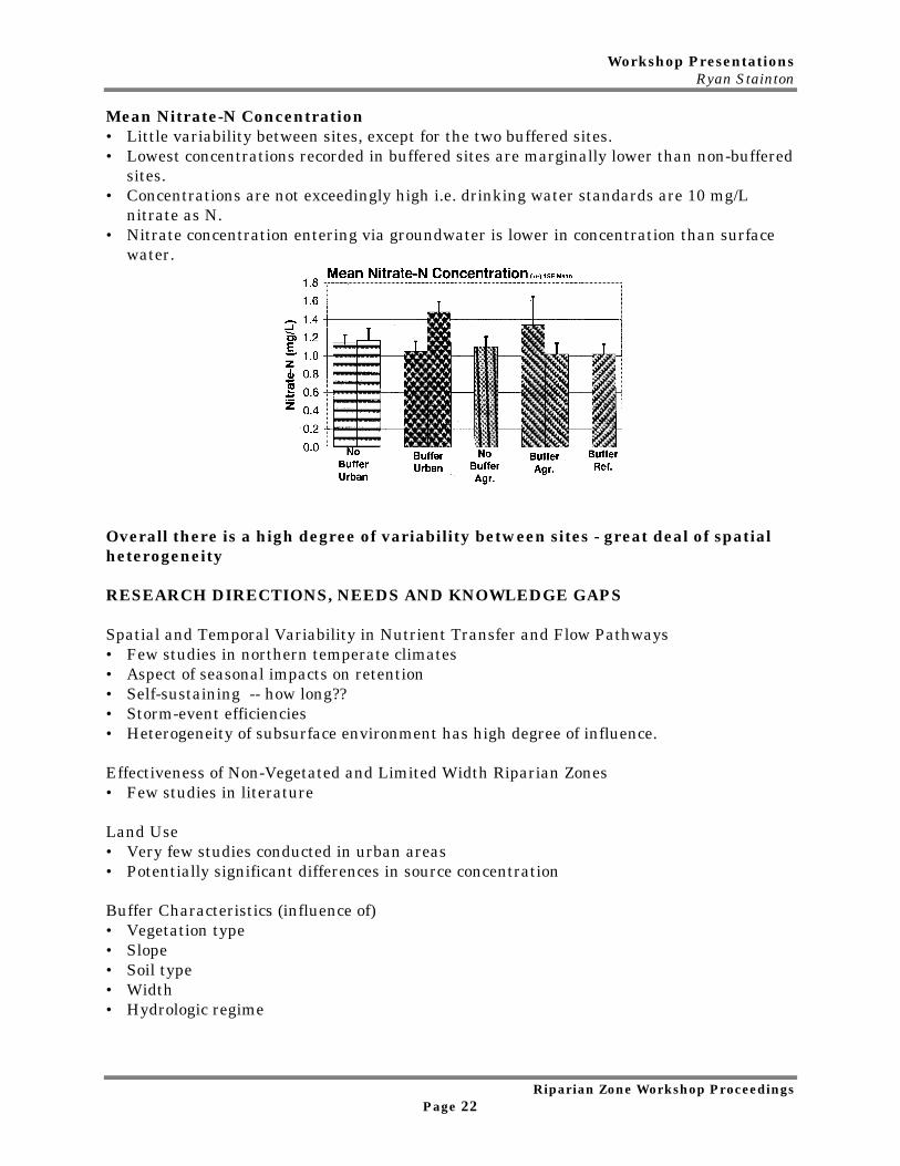
Mean Nitrate-N Concentration• Little variability between sites, except for the two buffered sites.• Lowest concentrations recorded in buffered sites are marginally lower than non-buffered
sites.• Concentrations are not exceedingly high i.e. drinking water standards are 10 mg/L
nitrate as N.• Nitrate concentration entering via groundwater is lower in concentration than surface
water.
Overall there is a high degree of variability between sites - great deal of spatialheterogeneity
RESEARCH DIRECTIONS, NEEDS AND KNOWLEDGE GAPS
Spatial and Temporal Variability in Nutrient Transfer and Flow Pathways• Few studies in northern temperate climates• Aspect of seasonal impacts on retention• Self-sustaining -- how long??• Storm-event efficiencies• Heterogeneity of subsurface environment has high degree of influence. Effectiveness of Non-Vegetated and Limited Width Riparian Zones• Few studies in literature
Land Use• Very few studies conducted in urban areas• Potentially significant differences in source concentration
Buffer Characteristics (influence of)• Vegetation type• Slope• Soil type• Width• Hydrologic regime
Workshop PresentationsRyan Stainton
Riparian Zone Workshop ProceedingsPage 23
Table 1Nitrate in Riparian Zones: Shallow Lateral Flow Paths WithImpermeable Subsurface
Reference RiparianBuffer Type
Input toRiparian
Buffer
Output toStream side
HydrogeologicSetting
NO3--N (mg L-1)Jacobs andGilliam, 1985
47 m Forest 7.9 <0.1 Shallow aquiferover impermeablelayer
16 m Forest 7.3 <0.1Pinay andDecamps, 1988
130 m Deciduousforest
2.8 - 5.2 0 Clay at 4 m
Cooper, 1990 9 m Grass 0.6 0.32(MS) Impermeablelayer at 0.9 - 1 m
0.6 0.03(OS)Osborne andKovacic, 1993
16 m Deciduousforest
11 - 26.5 0.87 Shallow aquiferover dense basaltill at 0.6-1.3 m
39 m Grass 16 - 43 <1 - 2.5No Buffer 6 -- 20 1.5 - 14
Source: Adapted from Hill (1996)
Table 2Nitrate-N in Riparian Zones: Sand Aquifers With Upward Flow Paths
Input to Output to
Riparian Stream-
Riparian Buffer Side Hydrogeologic
Reference Buffer Type NO3--N (mg L-1) Setting
Robertson et al., 1991 20 m Grass 39 0.6-13 Sand Aquifer >10m
Phillips et al., 1993 Deciduous forest 11.0 9 Sand Aquifer 7-20 m
Mander et al., 1995 120 m Fen 1.9 1.6 Glacial sands/clay layers
Correll, Jordan 48 m Deciduousforest
25 17 Sand Aquifer
and Weller, 1997 37 m Cut Grass 25 14 clay at depth
Workshop PresentationsRyan Stainton
Riparian Zone Workshop ProceedingsPage 24
Table 3 - P Concentrations in Riparian Zones
Input to Output
Riparian P Riparian to Stream- Hydrogeologic
Reference Buffer Type Fraction Buffer Side Setting
(µµg L-1)
Peterjohn and 19 m Deciduousforest
TP 15 62 Shallow aquifer
Correll 1984 50 m Deciduousforest
TP 130 247 clay at 1.5 - 3.0 m
Osborne andKovacic, 1993
16 m Deciduousforest
PO43- 13 66 Shallow aquifer
TP 58 122 dense basal till
39 m Grass PO43- 20 40 at 0.6 - 1.3 m
TP 92 91
Akhmetieva, 1994 510 m Pine andDeciduous
PO43- 20 10 Sandy Soils over
Pine andDeciduous forest
PO43- 40 20 dense loam
Mander et al.,1995
120 m Fen PO43- 90 300 Glacial sands/clay
Workshop PresentationsDr. Jane Bowles
Riparian Zone Workshop ProceedingsPage 25
2.5 WildlifeDr. Jane Bowles, University of Western Ontario
RIPARIAN CORRIDORS IN THE LANDSCAPEThe landscape of southern Ontario following European settlement comprises patches ofnaturalized vegetation in a matrix of other land uses.
Three main factors contribute to the distribution of patches in the landscape:• Physiography, topography and soil type• Settlement and survey patterns• River corridors
In southwestern Ontario, most of the largest patches are along river corridors. From alandscape ecology perspective river corridors are important:• Because they provide sanctuary as the only remaining tracts of habitat;• Because they are more connected than other patches and facilitate movement in the
landscape as CORRIDORS; and• For planning purposes they provide a backbone for creating or restoring natural
heritage systems.
RIPARIAN ZONES AS CORRIDORS - WHAT ARE CORRIDORS?
Corridors perform 5 basic functions in the landscape:• Habitat:
Many wildlife species live in corridors and use the corridor habitat for feeding andbreeding. Some species move between the corridor and the matrix in their daily orseasonal movement.
• Conduit:The corridor provides habitat for wildlife to move through the landscape. Much of themovement occurs at the edge of the corridor, at the interface of the corridor and thematrix.
• Filter/Barrier:The corridor can act as a barrier, restricting or diverting wildlife movement, or as afilter, trapping wind, snow, seeds, fungal spores, nutrients etc moving across thematrix.
• Source:The corridor can act as a safe breeding site for wildlife species that later move into thematrix.
• Sink:Wildlife entering the corridor from the matrix may never return, either because theyfind more suitable habitat, or they die in the corridor. Turtles trying to cross the 401 isan example of a corridor (for cars) acting as a sink (for turtles).
Habitat, Conduit and Filter are probably the most important functions of riparian zones.
Workshop PresentationsDr. Jane Bowles
Riparian Zone Workshop ProceedingsPage 26
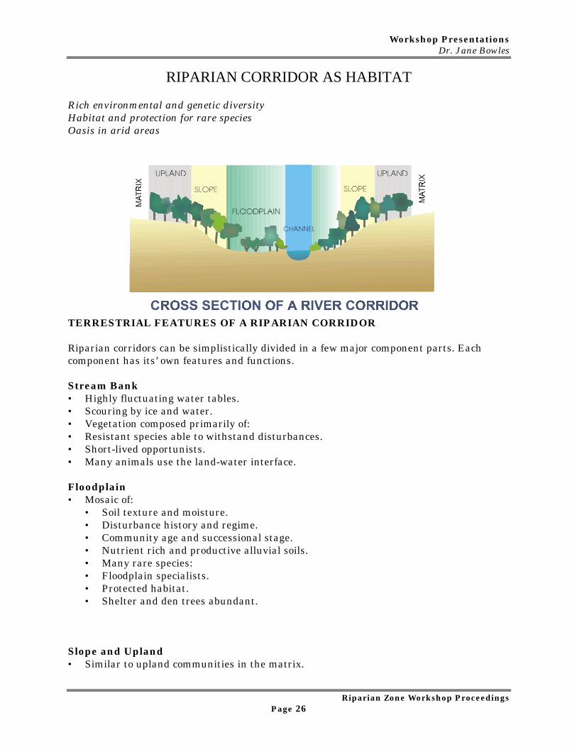
RIPARIAN CORRIDOR AS HABITAT
Rich environmental and genetic diversityHabitat and protection for rare speciesOasis in arid areas
TERRESTRIAL FEATURES OF A RIPARIAN CORRIDOR
Riparian corridors can be simplistically divided in a few major component parts. Eachcomponent has its’ own features and functions.
Stream Bank• Highly fluctuating water tables.• Scouring by ice and water.• Vegetation composed primarily of:• Resistant species able to withstand disturbances.• Short-lived opportunists.• Many animals use the land-water interface.
Floodplain• Mosaic of:
• Soil texture and moisture.• Disturbance history and regime.• Community age and successional stage.• Nutrient rich and productive alluvial soils.• Many rare species:• Floodplain specialists.• Protected habitat.• Shelter and den trees abundant.
Slope and Upland• Similar to upland communities in the matrix.
Workshop PresentationsDr. Jane Bowles
Riparian Zone Workshop ProceedingsPage 27
• Connection to corridor important.• Development of interior habitat in large forest blocks.• Refuge for floodplain species.
HABITAT DIVERSITY IN TIME & SPACEDynamic processes• Flooding• Erosion• Sedimentation• Nutrient flows• Ice and water scours• Life cycles• Population fluctuations• Succession
Spatial variability• Gradients:
• Longitudinal - river source to river mouth• Lateral - adjacent upland to river channel
• Mosaics:• Soil texture• Soil moisture• Water flow• Slope• Aspect• Temperature• Topographic position• Vegetation• Disturbance history
• Landscapes:• Variability in the landscape through which the river passes
The human factorHuman impacts on the landscape have generally led to:• Reduction in the EXTENT of riparian corridors.• Narrowing of riparian zones.• Channelizing streams.• Straightening meanders.
The variability has been reduced by loss of habitat, loss of species and flood control.
Workshop PresentationsDr. Jane Bowles
Riparian Zone Workshop ProceedingsPage 28
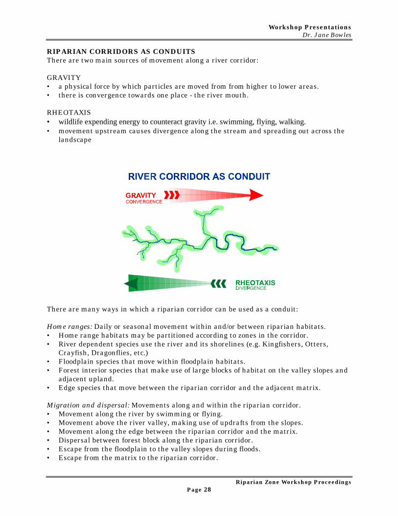
RIPARIAN CORRIDORS AS CONDUITSThere are two main sources of movement along a river corridor:
GRAVITY• a physical force by which particles are moved from from higher to lower areas.• there is convergence towards one place - the river mouth.
RHEOTAXIS• wildlife expending energy to counteract gravity i.e. swimming, flying, walking.• movement upstream causes divergence along the stream and spreading out across the
landscape
There are many ways in which a riparian corridor can be used as a conduit:
Home ranges: Daily or seasonal movement within and/or between riparian habitats.• Home range habitats may be partitioned according to zones in the corridor.• River dependent species use the river and its shorelines (e.g. Kingfishers, Otters,
Crayfish, Dragonflies, etc.)• Floodplain species that move within floodplain habitats.• Forest interior species that make use of large blocks of habitat on the valley slopes and
adjacent upland.• Edge species that move between the riparian corridor and the adjacent matrix.
Migration and dispersal: Movements along and within the riparian corridor.• Movement along the river by swimming or flying.• Movement above the river valley, making use of updrafts from the slopes.• Movement along the edge between the riparian corridor and the matrix.• Dispersal between forest block along the riparian corridor.• Escape from the floodplain to the valley slopes during floods.• Escape from the matrix to the riparian corridor.
Workshop PresentationsDr. Jane Bowles
Riparian Zone Workshop ProceedingsPage 29
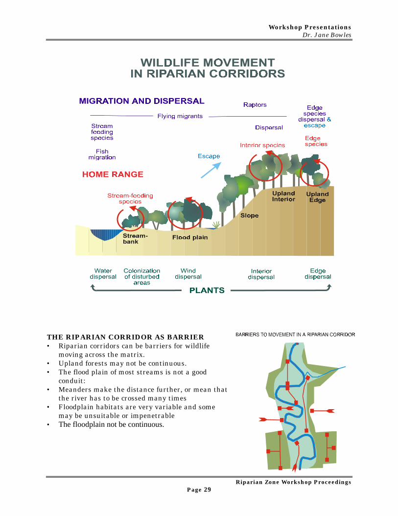
THE RIPARIAN CORRIDOR AS BARRIER• Riparian corridors can be barriers for wildlife
moving across the matrix.• Upland forests may not be continuous.• The flood plain of most streams is not a good
conduit:• Meanders make the distance further, or mean that
the river has to be crossed many times• Floodplain habitats are very variable and some
may be unsuitable or impenetrable• The floodplain not be continuous.
Workshop PresentationsJohn Parish
Riparian Zone Workshop ProceedingsPage 30
2.6 Bank StabilityJohn Parish, PARISH Geomorphic Ltd.
A Summary of Properties and Processes
• This presentation will differ slightly from the previous ones, as I will discuss bankstability from an applied and geomorphic perspective.
• As well, there is less emphasis on Ontario research, although future research needs willbe identified.
• This talk is more of a summary, with few analytical results, mainly due to the fact thatthere is not much in the published literature.
ObjectivesThe following objectives will convey our existing understanding of bank stability and itsrelationship to flows and the riparian zone.
• Discuss what bank stability is• Factors which enhance stability as well as factors which compromise it• What are some of the tools available• What are the needs for future research
Bank Stability‘A bank profile which balances its physical state with the surrounding environment,and the associated natural processes.’
• Also entails the banks resistance to change in shape or position.• Also brings a balance or equilibrium concept into the definition as, depending on the
scale, stable channels and banks still have to experience some erosion.
Physical ControlsClimate
• precipitation• temperature
Climate enhances bank stability through consistency, whereas it can be weakenedby climatic extremes.
Geology• material (size) - boulders, silt and clay enhance stability, sand gravel reduce
stability.• stratigraphy (layers) - stability is enhanced by thicker units and reduced by
‘weak’ zones and when groundwater uses one unit as a conduit.• cohesiveness - typically measured by determining a ‘silt factor’ and there are not
many analytical ways of assessing cohesiveness.• moisture (pore pressure)
Workshop PresentationsJohn Parish
Riparian Zone Workshop ProceedingsPage 31
Modifying Controls - (All these factors act to weaken the bank and reducestability.)Vegetation
• Type - grasses to trees• Density of roots - # of roots; thickness of roots• Depth of roots - lateral and vertical
These vegetation factors add to bank stability by increasing the tensile strength of thebank material as well as increasing the roughness to flow, thereby reducing flow velocity. Animals
• Burrows - worms, swallows, muskrat.• Livestock - accessing the stream
Flow regime
• Includes sediment regime and the amount of fluctuation of each
Physical ProcessesThe above factors and controls are worked and altered by these processes.
Fluvial entrainment/hydraulic quarrying• Includes the actual movement of particles and material from a bank.
Weathering• wet – dry cycles• freeze – thaw
These are more gradual and act as agents to weaken the bank, can also include geo-chemical.
Mass Wasting (Mass wasting is really the effects of gravity)• rotational failures• slumping• Another process is a combination of several of these (i.e. where flows have
created an undercut bank, which eventually fails through slumping).
The results of these processes is the form and shape of a bank and what we typicallymeasure to define stability, including:
• Height – the higher the less stable• Angle – the steeper, the less stable• Undercut – presence / absence• Relationship of root type and quantity of roots to bank height
There is really a lack of direct analytical tools.
ToolsTools provide guidance on data collection and an assessment of stability. This requires an‘experience’ factor.
Workshop PresentationsJohn Parish
Riparian Zone Workshop ProceedingsPage 32
Direct Measures Of Properties• Historic - (migration rates from historic air photos)• Rates of change - (bank erosion measured from pins or repeated surveys) experience
factor
Summary Tools• Bank Stability Dichotomous Key. Reference: Stanfield, Les, M. Jones, M.
Stoneman, B. Kilgour, J. Parish and G. Wichert. Stream Assessment Protocol ForOntario. Vol. 2.1, 1998.
• Bank Erosion Potential. Reference: Rosgen, D. Applied River Morphology. 1996.(some similar parameters, although more reliance on relationships and someparameters are more difficult to measure)
• Tensile Strength of Selected Tree and Shrub Species. Reference: Grey, D and R.Sotir. Biotechnical and Soil Bioengineering Slope Stabilization: a Practical Guide forErosion Control. 1996.
Future Research Needs - Must confess to not being completely aware of all researchactivities within the province§ Erosion processes of cohesive material§ Determination of relationships between modifiers and physical controls§ Development of more analytical and predictive tools§ University of Guelph – School of Engineering. Assessing the effects of vegetation on
banks and controls exerted on channel form. Previously developed an equation topredict bank erosion, modified the Universal Soil Loss Equation.
• MNR has been working on the effects of the age and size of vegetation and the role onbank stability.
Banks are very complicated, as I’ve shown there are a variety of factors which exert aninfluence in a relatively small space. They are difficult to measure and we are uncertainover the inter-relationships. We need to take small steps to help gain a betterunderstanding.
Workshop PresentationsDr. Bruce Kilgour
Riparian Zone Workshop ProceedingsPage 33
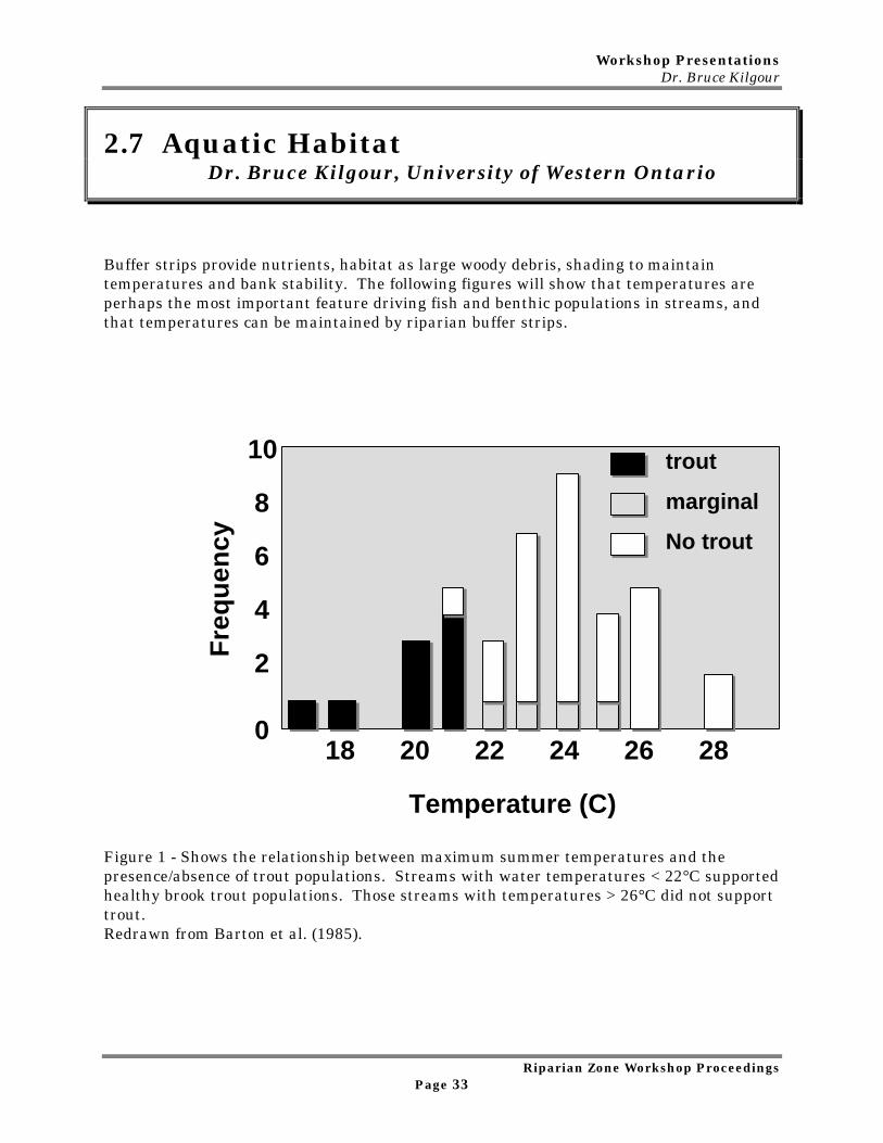
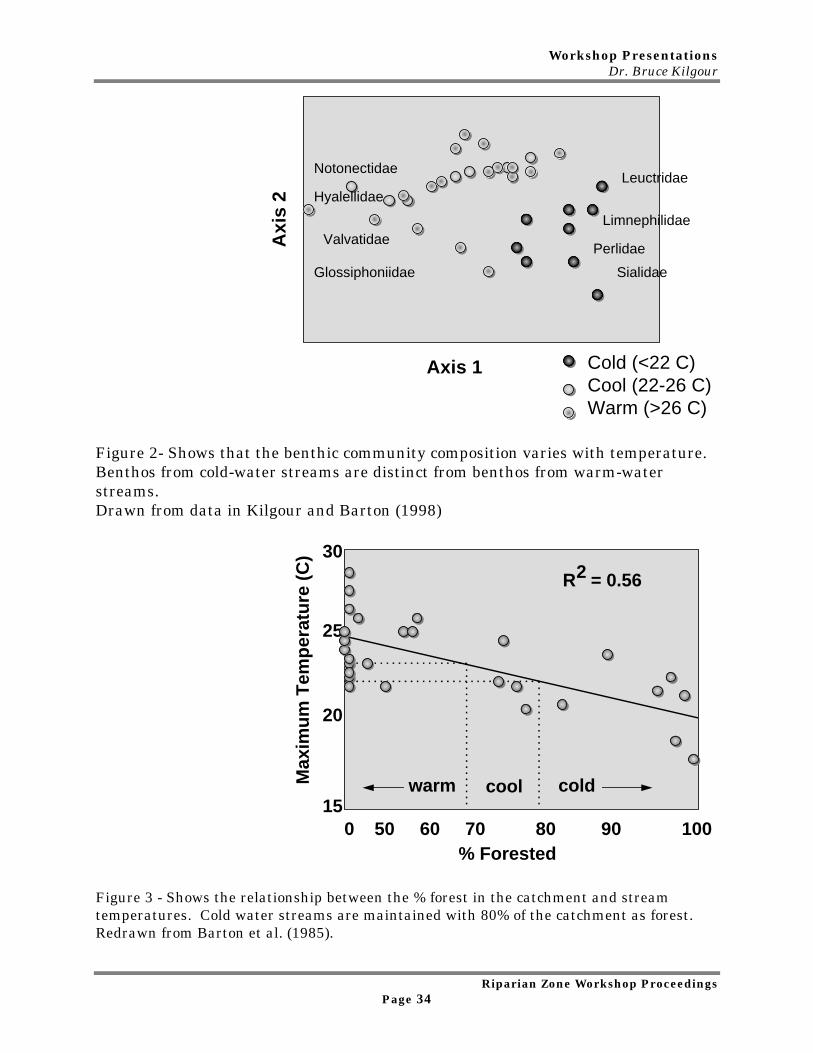
2.7 Aquatic HabitatDr. Bruce Kilgour, University of Western Ontario
Buffer strips provide nutrients, habitat as large woody debris, shading to maintaintemperatures and bank stability. The following figures will show that temperatures areperhaps the most important feature driving fish and benthic populations in streams, andthat temperatures can be maintained by riparian buffer strips.
10
8
6
4
2
0 18 20 22 24 26 28
trout
marginal
No trout
Temperature (C)
Fre
qu
ency
Figure 1 - Shows the relationship between maximum summer temperatures and thepresence/absence of trout populations. Streams with water temperatures < 22°C supportedhealthy brook trout populations. Those streams with temperatures > 26°C did not supporttrout.Redrawn from Barton et al. (1985).
Workshop PresentationsDr. Bruce Kilgour
Riparian Zone Workshop ProceedingsPage 34
Axis 1
Axi
s 2
Notonectidae
Valvatidae
Glossiphoniidae
Leuctridae
Limnephilidae
Perlidae
Sialidae
Hyalellidae
Cold (<22 C)Cool (22-26 C)Warm (>26 C)
Figure 2- Shows that the benthic community composition varies with temperature.Benthos from cold-water streams are distinct from benthos from warm-waterstreams.Drawn from data in Kilgour and Barton (1998)
15
20
25
30
0 50 60 70 80 90 100% Forested
Max
imu
m T
emp
erat
ure
(C
)
warm coldcool
R = 0.562
Figure 3 - Shows the relationship between the % forest in the catchment and streamtemperatures. Cold water streams are maintained with 80% of the catchment as forest.Redrawn from Barton et al. (1985).

Workshop PresentationsDr. Bruce Kilgour
Riparian Zone Workshop ProceedingsPage 35
Max
imu
m T
emp
erat
ure
(C
)
0 1 2 3 4 5 6 7
28
24
20
16
Figure 4 -This slide shows the relationship between the length of riparian buffer strips andstream temperatures. This relationship suggests that riparian buffer strips provide acooling effect.Redrawn from Barton et al. (1985).
Tem
per
atu
re C
han
ge
(C)
Distance from Buffer Strip (km)0 1 2 3 4 5 6
876543210-1-2-3
Figure 5 - Shows the relationship between distance from a buffer strip and watertemperatures in streams. The relationship suggests that stream waters heat up whenriparian buffer strips are absent.Redrawn from Barton et al. (1985).
Workshop PresentationsDr. Bruce Kilgour
Riparian Zone Workshop ProceedingsPage 36
% Wildlands within 100 m
5 10 15 20 25 30 35 40
25
20
15
10
5Wat
er Q
ual
ity
Ind
ex
Stoney Creek, Medway River, Stanton Drain
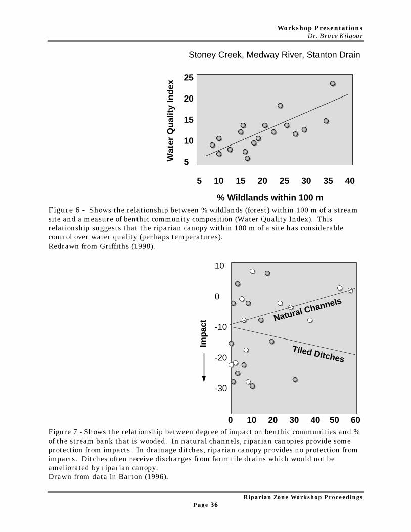
Figure 6 - Shows the relationship between % wildlands (forest) within 100 m of a streamsite and a measure of benthic community composition (Water Quality Index). Thisrelationship suggests that the riparian canopy within 100 m of a site has considerablecontrol over water quality (perhaps temperatures).Redrawn from Griffiths (1998).
Imp
act
Tiled Ditches
Natural Channels
0 10 20 30 40 50 60
10
0
-10
-20
-30
Figure 7 - Shows the relationship between degree of impact on benthic communities and %of the stream bank that is wooded. In natural channels, riparian canopies provide someprotection from impacts. In drainage ditches, riparian canopy provides no protection fromimpacts. Ditches often receive discharges from farm tile drains which would not beameliorated by riparian canopy.Drawn from data in Barton (1996).
Workshop PresentationsDr. Bruce Kilgour
Riparian Zone Workshop ProceedingsPage 37
40
35
30
25
20
15
0 1 2
Cattle Access
IBI
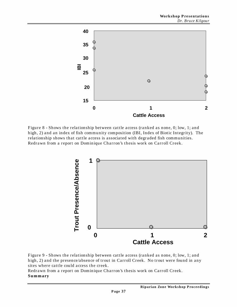
Figure 8 - Shows the relationship between cattle access (ranked as none, 0; low, 1; andhigh, 2) and an index of fish community composition (IBI, Index of Biotic Integrity). Therelationship shows that cattle access is associated with degraded fish communities.Redrawn from a report on Dominique Charron’s thesis work on Carroll Creek.
Tro
ut
Pre
sen
ce/A
bse
nce
0 1 2Cattle Access
1
0
Figure 9 - Shows the relationship between cattle access (ranked as none, 0; low, 1; andhigh, 2) and the presence/absence of trout in Carroll Creek. No trout were found in anysites where cattle could access the creek.Redrawn from a report on Dominique Charron’s thesis work on Carroll Creek.Summary
Workshop PresentationsDr. Bruce Kilgour
Riparian Zone Workshop ProceedingsPage 38
Fish and invertebrates do respond to riparian buffer zones. In southern Ontario, watertemperature is one of the most important habitat features influencing stream benthos andfish. Buffer zones appear to protect the biology of streams by maintaining cool streamtemperatures. Point sources can, however, override the benefits of riparian zones.Finally, exclusion of cattle from streams is obviously beneficial because it prevents thedestruction of in-stream habitat. However, exclusion of cattle from cobble-bottomedstreams may not be warranted since cattle do not tend to access (and thus impair) rockystreams.
Sources
Barton, D.R. 1996. The use of percent model affinity to assess the effects of agriculture onbenthic invertebrate communities in headwater streams of southern Ontario, Canada.Freshwater Biology, 35:397-410.
Barton, D.R., W.D. Taylor and R.M. Biette. 1985. Dimensions of riparian buffer stripsrequired to maintain trout habitat in southern Ontario streams. North American Journalof Fisheries Management, 5:364-378.
Griffiths, R.W. 1998. Mapping the water quality of Ontario streams using satelliteimagery. Ontario Ministry of Municipal Affairs and Housing, Planning and Policy Branch,Toronto, Ontario.
Kilgour, B.W. and D.R. Barton. 1999. Associations between stream fish and benthosacross environmental gradients in southern Ontario. In press, Freshwater Biology.
Charron, D. Ph. D. Thesis, University of Guelph.
Workshop PresentationsSue Sirrs
Riparian Zone Workshop ProceedingsPage 39
3.0 STATE OF THE PRACTICEWORKSHOP PRESENTATIONS
3.1 Landowner Perceptions and Acceptance of Riparian Zones
Sue Sirrs, Rouge Park
BackgroundThis is a review of my experience in landowner contact, with particular regard for riparianlandowners. That experience includes landowners in a wide range of land use scenarios.These scenarios include: rural old order Mennonite farmers in the Grand River watershed;a multitude of landowners in the Rouge River watershed. Landowners on the Rouge Riverincluded: developers, property owners in new subdivisions, tenant farmers and ruralestate owners in Canada’s fastest developing municipalities of Markham and RichmondHill. Additional experience includes undergraduate work in the Ovens-King watershed inAustralia.
I completed a graduate thesis, titled, ‘Participatory Approach to Riparian Corridor Design’,which asked landowners about their perceptions and understanding of the health of thecreek that ran through their property (Carroll Creek, Grand River watershed).
• This was one study of many that were carried out in Carroll Creek. There was aproposal to study the watershed in depth, then fence off the creek and monitorthe regeneration that occurred. My thesis and subsequent work filled a gapbetween researchers interests and those of the local landowners.
• The hypothesis (see Figure 1 Model of Hypothesis and Objectives) was thatlandowners would either perceive a problem with the health of the river or not.If they did perceive a problem, they were asked why they thought the health ofthe river was a concern. Next they were asked about their interest andmotivation in establishing a buffer zone adjacent to the creek. They were alsoasked what rehabilitation actions were required and what assistance they mightneed to do the work. This series of questions for those people who perceived aproblem with the health of the river was to form the basis for an ImplementationPlan.
• For those folks who did not perceive a problem with the health of the river, theywere asked why they thought it was a healthy river system. They were askedwhat would motivate them to establish buffers. This series of questions forpeople who did not perceive a problem with the health of the river was to formthe basis for an Education Plan.
• Results showed that only six landowners perceived a problem with the health of theriver. The remaining 22 landowners felt the creek was fine the way it is. Responses tospecific questions are found in Table 1 Landowner Response.
Workshop PresentationsSue Sirrs
Riparian Zone Workshop ProceedingsPage 40
The Carroll Creek watershed is predominately rural farm land with some ruralresidential lots and few landuse pressures. In contrast, the Rouge River watershed ismany times larger and faces many landuse pressures. Changing landuse has made for avariety of different landowners including developers, speculators, farms in transition,active farms, urban and rural residential landowners as well as estate home owners. Asa result, the issues in the Rouge watershed are also very different. Landowners want toknow how they can get the best price for their land, how to get rid of undesirable newlandowners, how to get rid of frogs because they make too much noise, the list goes onand on.
Conclusions• There is a fundamental lack of understanding and appreciation for Canada’s fresh water
resource. Although people like to own property that backs onto streams and rivers, theyhave little understanding of the role they play in the larger landscape.
• Landowners in rural Carroll Creek watershed had a very different attachment to thelandscape. Because they were long-term residents, they knew that protecting the riverwas important. They had done so in many ways and wanted to show me where they hadstabilized river banks, minimized cattle crossings, etc. Newer landowners were moreconcerned but didn’t have the same ties to the land or understanding of it.
• Landowners in the Rouge watershed are quite another ball game. New landowners arethrilled to have moved to the country. Old timers are trying to sell their lands for thebest price to developers and move further north. Or, they’re trying to stay on theirfarms even though development is starting to surround them. There isn’t the samelong-term commitment to the land that has helped to protect the riparian zone in thepast.
• Landowners for the most part prefer order in the landscape over disorder. Their effortsto tame nature are evident in the classic example of the mowed lawn to the edge of thecreek or pond, i.e. the landowner who removes the floodplain forest, lays sod then putsup a bird feeder on a metal pole to attract birds. These tidy landscapes are lessecologically healthy but seem to be almost universally preferred. People often apologizeand explain that they haven’t had a chance to clean up. There is a job to be done toeducate people about what a healthy riparian zone should look like.
Workshop PresentationsSue Sirrs
Riparian Zone Workshop ProceedingsPage 41
Figure 1 Model of Hypothesis and Objectives
Property owners
PERCEPTION Problem No Problem
⇓ ⇓
UNDERSTANDING Why they perceive Why they don’ta problem perceive a problem
⇓ ⇓
MOTIVATION Understand the Understand What Motivation to Would MotivateEstablish Buffers Them to Establish
Buffers
⇓ ⇓
ACTION Rehabilitation ⇓Activities Required
⇓ ⇓
ASSISTANCE What’s Required to ⇓Facilitate Action?
⇓ ⇓
Basis For An Basis For AnImplementation Education PlanPlan
Adapted from Sirrs. Participatory Approach to Riparian Corridor Design.
Workshop PresentationsSue Sirrs
Riparian Zone Workshop ProceedingsPage 42
Table 1 Landowner Response
Objective 2Motivation
• Lost Property or lost use of property.• Water Quality.• Negative experiences with some landuse practices.
Objective 3Actions
• Bank Stabilization; planting and some use of rocksto stabilize banks.
• Protection from cows; fences and bridges.• Alignment work.• channel straightening.• Protection of existing riparian vegetation.
Objective 4Assistance
• Advice and guidance.• Finances.• Mediation.• Labor.• Plant material.
Objective 5Why Landowners Don’tPerceive a Problem
• The creek is the same as it has always been.• Landowners look after it themselves:
• place field stones in eroded areas,• plant trees,• eliminate detrimental land uses,• already established a buffer zone,• don’t pasture adjacent to the creek.
Objective 6Concerns RegardingEstablishment of BufferZones
• Weeds seeding into agricultural fields.• Fences will wash out in spring.• Fences will mean more work for the farmer.• Long term care of buffer zones.• Fear that won’t be acceptable to have cattle
crossing the creek.• Creek already has a buffer.• Land won’t generate an income.• Pay farmers not to pasture on bottom lands instead
of buying fences.• Trespassers.• Garbage.
Adapted from Sirrs. Participatory Approach to Riparian Corridor Design.
Workshop PresentationsIngrid Vanderschot
Riparian Zone Workshop ProceedingsPage 43
3.2 Packaging and Selling Riparian Zone Management:Issues, Programs and Mechanisms
Ingrid Vanderschot, OSCIA
Analysis of the Ontario Environmental Farm Plan Aggregate Data
The Environmental Farm Plan (EFP) is an initiative of Ontario Farm EnvironmentalCoalition. This study administered by Ontario Soil and Crop Improvement Association willbe looking at the EFP and data that has been collected under this Program. Highlightedhere are: what indications have been given about farmers activities; how best to packageriparian issues and also the challenges of using EFP data for reporting.This particular study of the aggregate data funded by Wildlife Habitat Canada was todetermine specifically what this data could show us with respect to wildlife habitat, whichincluded a look a riparian areas.
EFP• An initiative designed for site specific environmental education and risk assessment for
farmers.• It is a self-assessment, completely voluntary and confidential process which has been
key in the uptake by farmers.• The EFP involves:
• farmers attending a workshop;• completing EFP manual (individual farm evaluation), 4 ratings of poor through
best for series of questions;• developing an action plan to address areas of concern;• attending another workshop to help develop appropriate actions;• peer review;• incentive claims - $1500 for any of the actions.
EFP MANUAL• Work book includes 23 worksheets with 251 questions addressing environmental
concerns from wells, to energy usage, agricultural wastes and natural areas such aswetlands, woodlands, watercourses.
• Aggregate data was collected from the first 2700 EFP completed from across Ontariobetween 1993 -1996. Data includes 1-2 ratings per farm site, barriers to taking actionon these, actions and timeline to action.
• Data also collected for incentive claims includes: what worksheet question and whataction, amount claimed, true cost of action as well as time put in over and above claim.
• Two other studies done: Gallivan and Furman
Workshop PresentationsIngrid Vanderschot
Riparian Zone Workshop ProceedingsPage 44
This study was funded by WHC to see if EFP data could provide insight into:• current management of natural resources• concerns of agricultural community with respect to habitat/ farmer willingness to
participate in habitat programs• barriers to conservation actions• technical and financial needs• habitat benefits resulting from the EFP
One can see that this is backwards rather than asking questions first- seeing what thedata shows.
To do this, we examined the following worksheets:• 15: Soil Management: included questions addressing wind and water erosion
sensitive areas and marginal lands• 19: Field Crop Management: such as sloping areas, crop rotation/cover crops• 21: Streams and Ditches• 22: Wetlands and Wildlife Ponds• 23: Woodlands and Wildlife
There is a concern with taking these questions out of context of entire EFP.
CHALLENGESAlthough the data set was representative when compared with census regionally, by
farm type and farm size (though on average EFP farms were slightly larger because censusincludes any farm of $7,000 gross income). Not as simple as saying that 5% of farmershave cattle in stream, of this 80% will fence out as a result of EFP; or X amount of acreagecovered by EFP’s.
Essentially, the EFP Program is not designed to be able to quantify in this way butalso there are too many variables; subjective in nature; and the database and format ofinformation collected. For example - one question which looks at leaving crop residue afterharvest was interpreted by several as not being able to bale straw and therefore may havegiven themselves a poor rating, followed by indicating in choice of barriers that ‘not apriority’. This could be misinterpreted as a high percentage thinking management for cropresidue is not a priority. (Changes to EFP II reflected changes to clarify this particularquestion). The ‘not a priority’ barrier should be taken in relative context to other issueswithin the EFP. In conclusion, it is NOT a fair environmental indicator to look at EFPdata.
FINDINGS Instead trends in ratings, barriers, actions, timelines, incentive data and otherstudies were examined. Activities were grouped to look for trends, i.e. cropping practices,watercourses, livestock, and wildlife. Overall study can indicate generalities only but doconfirm previous assumptions that farmers are doing a good job with respect to naturalareas according to their own evaluation based on EFP criteria. Also, that there arepredominantly “no barriers” to taking action within EFP context.
• Those questions relating to soil erosion and cropping practices were of greater issuerequiring attention and similarly of greater priority to farmer.
• Across province with the exception of Northern Ontario, the greatest claim area relatesto soil management.
Workshop PresentationsIngrid Vanderschot
Riparian Zone Workshop ProceedingsPage 45
• Implications for habitat will depend on action including: change of crop to forages,planting trees, etc.
• Most common change was switching to no-till or conservation tillage which benefitsriparian areas through reduced runoff and sedimentation.
• Changes concerning tillage were shown to occur more readily and on a quicker timescale.
• Though costly, farmers willing to make change where applicable and feasible - puttingin a lot of their own $.
• More complex farming situations (may involve clay soils) showed more barriers andcomplexity in actions suggesting extra technical support for complex farms and the needfor site specific solutions.
• One of major concerns is water quality.• Across entire province one of major claims made is for wells. The EFP component
addressing water wells was not examined in detail in this study.• In the Streams and Ditches worksheet, claims were made most for bank stabilization,
livestock on watercourses, buffers and erosion at tile outlets respectively.• Willingness to take actions for watercourse bank stability and tile and surface water
entry, though finances are greater barrier.• Farmers quicker to take action for tile outlets and bank stability than for buffers (more
actions were required for buffers according to EFP criteria but less proportional uptake).• Livestock on watercourses is more complex - especially for high-density (low density
minimal concern compared to other questions).• Financial barriers were highest for livestock access out of the questions looked at in this
study. This requires creative program attention/solutions.• Although most farmers indicated restricting livestock access, results showed that partial
reduction of access scheduled for shorter timeline than complete reduction.• Overall results do indicate farmers are doing a good job regarding wildlife, though of
greater concern is soil erosion, livestock and stream and ditch banks.• These indications from EFP data support the notion that farmers while concerned about
water quality, must balance with business aspects of the farm.• Selling riparian management must consider realities of farm business.
PARTICIPATIONA study by Margaret Furman indicated the strengths of the EFP, why farmers participatedand participation on various stages of EFP process. Results concluded that participation isgreater when:
• Involved in past programs;• Participation in EFP will have spin-offs to other programs and visa versa;• There is an awareness of on-site issues;• Confidence in EFP program: self-assessment motivation, workshop leaders
reputation, confidence in technical information;• Motivated by health, concerns for soil and water quality and a desire to learn about
the environment.
Workshop PresentationsIngrid Vanderschot
Riparian Zone Workshop ProceedingsPage 46
Participation is lower when:• Greater complexity of issues on farm - (not as straight forward i.e. No-till, more time
consuming, less directly applicable);• Perception of risk associated with confidentiality;• Motivated by farmer image, fear of penalty, and economic incentive.
The study also found that most actions were not claimed for under incentive programwhich suggests that actions occurring through EFP occur because of education, not becauseof fear to meet legislation.
CONCLUSIONS• Greatest value is educational component through self-assessment - taking ownership
although this is the most difficult to measure.• We can however show this through other findings such as:
• close to 13,000 farmers have participated in EFP• 7,000 have completed the peer review process where the difference represents
those either in process or may choose not to - still educational value.• We’ve learned it’s difficult to get clear answers from a program not designed from the
start to answer these questions. Must design the questions from the start.• However, wouldn’t change how data was collected because the strength of the program
is in the very nature that makes it not quantifiable: site specific, self-assessment, localworkshops, confidential, and voluntary.
• This study did confirm some general trends. That farmers are making positive stepsforward in riparian management but do require support. Best to focus on meeting sitespecific needs through emphasis on soil and water quality protection over strictly thehabitat benefits.
Workshop PresentationsPeter Doris
Riparian Zone Workshop ProceedingsPage 47
3.3 Grazing Cattle and Riparian Management:Conflict or CooperationPeter Doris, Ontario Cattlemen’s Association
Players and Issues ReviewCattle
• Need water to live.• Riparian area provides grass for grazing.• Does clean water improve animal performance?
Farmer• Needs reliable water source especially on distant pastures.• Concerns with initial and operating costs.• Generally “Want to do the right thing”.• Land has value $$.• Respect/credibility.
Public/government• Increasing environmental awareness, which includes water quality.• Sometimes conflicting values (want to do more with less).
Riparian “keeners”• Includes anglers, some farmers, CA, naturalist.• Want “Pristine and Natural” riparian areas.• Exclude other activities• Different means to achieve goal (voluntary program vs. regulations & legislation).
Scoping the Issue• What is the target?
• Water quality (bacteria, nutrients, etc.), fish/wildlife habitat, rural aesthetics.• How are you trying to reach the target?
• Targeted watersheds or universal.• Voluntary incentives vs. regulations.
The Potential for ConflictBe careful what you wish for…• Mandated buffers could create backlash with crop and livestock producers (remember
wetlands issue from early 1990’s).• Remember land has value; mandated buffers = expropriation without compensation.• Likely result in a shift from pasture to cropland up to buffer. Is the cure worse than the
disease?
The Opportunity for Cooperation
Workshop PresentationsPeter Doris
Riparian Zone Workshop ProceedingsPage 48
Riparian and agricultural goals not mutually exclusive.• No-till: benefits environment (less erosion) and reduced costs with similar yields.• Agriculture is a “gray area” with riparian areas (not development but with drainage
issues, tree cutting etc.).• Farmers will often support tree planting and water quality initiatives but $$ are limited. Grazing livestock & riparian issues. Need to:• Integrate livestock production/important goals with riparian/water quality goals.• Expand toolbox of acceptable practices with water quality (fencing, grazing management
strategies, density and site issues - NSWCP project).
Understanding Impacts• Clark, University of Guelph - dry lot vs. grazing, behavior observation, etc.• CURB - little phosphorus, some bacteria• Barton, University of Waterloo - 66% of sites with cattle access had negative impact
based on benthic invertebrates.
Learning From Programs• CURB - targeted areas and cost share.• National Soil Conservation Program - bid to retire “fragile” lands.• Environmental Farm Plan - recognizing the difference between intensive and extensive.• W3 (OCA & OFAH) - importance of initial contact and willingness to undertake projects
with high % of public funding.
Future QuestionsNSWCP project - Can we expand the toolbox?• Why is impact greater on some sites and what management lessons can we learn?• Integrate water quality important with production benefits.• Can we use animal behavior to improve production and water quality?
Future Directions• $$ are limited; continue to see targeting.• Science is getting better at finding “the points” in non point source pollution.• We may see water quantity becoming as big an issue as water quality.• Programs will need 3 components: some public $, integration of agricultural and
environmental benefits through a trustworthy delivery agency.
Workshop PresentationsTracey Ryan
Riparian Zone Workshop ProceedingsPage 49
Panel DiscussionWhat We've Done and What We've Learned
3.4 Rural Water Quality ProgramTracey Ryan, GRCA
• Innovative approach to addressing water quality.• First time a municipality has funded non-point source pollution control.• Viewed as a model for the province.• Locally developed program, in consultation with the agricultural community.• Regional Municipality of Waterloo depends on surface water for up to 25% of their
domestic water.• The River also supplies assimilative capacity for sewage treatment.
Water Quality Issues• Microorganisms, phosphorus, nitrogen, sediment.
Sources of ContaminationPoint Sources
• wastewater treatment plants• industrial sites
Non-Point Sources• runoff from urban areas and rural areas
Rural Sources of Pollution• Storage, handling and spreading of livestock manure.• Stream bank erosion from livestock access to watercourses.• Direct pollution by livestock to watercourses.• Soil erosion.• Faulty septic systems.• Milkhouse waste.
Regulatory Approach• Enforcement is difficult and requires strong political will.• Minimum standards.• Creates friction and opposition.• Acceptable approach to intentional polluters.
Voluntary Approach• Higher performance achieved.• Creates trust and co-operation.• Accepted approach to private land issues.• Recognizes personal responsibility.Funding

Workshop PresentationsTracey Ryan
Riparian Zone Workshop ProceedingsPage 50
• Region of Waterloo committed $1.5 million over 5 years.• $225,000 from NSWCP as well as dollars from GRCA, MOE and OMAFRA.• Matching dollars will be provided by landowners.• Leverage funding from other sources.
Partnerships• Involve farmers at the initial stages and build consensus among all parties.• Create allies and champions of the program.• Develop spokespeople in the community.
Steering Committee• 11 local farm groups, 5 provincial farm groups.• 3 provincial ministries, 1 federal ministry.• 2 lower tier municipalities.• Regional Municipality of Waterloo and GRCA.
Committee Products• Best management practices.• Cost-share payment.• Eligibility guidelines.• Marketing and promotion.• Monitoring. Program Basics• Voluntary• Educational• Financial incentives to cost-share best management practices.
Program Innovations• Cross-compliance with the Environmental Farm Plan.• 3 year performance incentive for non capital best management practices.• In-kind labour allowable for fencing.• Cross compliance between sections of the program.
Time Frames• Planning began December 1996.• Funding committed February 1997.• Steering Committee established August 1997.• Program Launch March 1998.
Proposed Outcomes• Cost-effective.• Improved water quality and ecosystem.• Adopted by other municipalities.• Healthy rural economy.• Sustainable relationships.
Workshop PresentationsAndy Graham
Riparian Zone Workshop ProceedingsPage 51
3.5 Permanent Cover/Buffer 2002Andy Graham, OSCIA
PERMANENT COVER PROGRAMS IN ONTARIO• Funded by Agriculture Canada (now AAFC) between 1990-93 (coincided with Ontario’s
Land Stewardship II).• Delivered and administered by OSCIA.• Permanent Cover Projects retired fragile agriculture land that was subject to:
• Severe wind or water erosion,• Flooding,• Fragile land alongside water.
• Categories for funding consideration:• Grass Buffers (8' - 20').• Grass and Tree Riparian.• Block Plantings on highly erodible land (<20 acre).• Tree Windbreaks (also wetland buffers).
• The Bidding System is what made the program unique. There were no set
compensation rates.• Farmers were offered an upper limit of $10,000 and submitted sealed project BIDS, in
competition with their neighbors for limited county dollars.• Value of one-time payment was based on several things:
• One time out-of-pocket expenses,• Compensation for loss in net revenue,• Less personal contribution.• *Bid selection was done by trained local staff with OSCIA
• Generally, 15 year agreements were signed between landowner and AAFC, whichestablished responsibilities and penalties for defaulting.
RESULTS• Programs were complete sellouts.• Many, many more bids submitted than were approved.• 2000 projects retiring 8100 acres.• Average pay out of $1000/acre (over 15 years, $66/acre/year)• $8 million paid out. • Program also had a demonstration component. These 40 sites served as local examples,
and are still in place. Something you may wish to consider if you’re looking for fieldresearch sites.
A quote from Doug McVicar (who by the way was delighted that we actually came back tothe site after 6 years): “I think more farmers would be willing to participate in similar land retirement projects, ifthere was better communication amongst the various conservation and farm groups.Farmers are looking for ideas, not always compensation.”
Workshop PresentationsAndy Graham
Riparian Zone Workshop ProceedingsPage 52
THE US NATIONAL CONSERVATION BUFFER INITIATIVE Objective - 2 Million miles of buffer by 2002 (equates to up to 7 million acres). • It is all across the US, and is currently in place (began in 1996). • The Buffer Team that has been assembled to fund and promote is most impressive:
• Natural Resource Conservation Service and many, many federal agricultural andwildlife agencies,
• Numerous wildlife conservation and clean water groups (NGO’s), and• Major agricultural Corporations i.e. Cargill, Monsanto, Pioneer Hi-Bred, and
more.• This program has a continuous sign-up.• Offers from farmers and ranchers are automatically accepted, provided the acreage and
producer meet certain eligibility requirements. PROGRAM COMPONENTS:
• Grass Filter (minimum of 25')• Riparian buffer (55' to 150')• Windbreaks, contour buffers, grassed waterways.• Not just streams but also within the field and field edges. This broadens the
definition of Buffer.• Keep in mind this program is intended to build on the CRP.• Alley Cropping - Interesting that alley cropping has been included.• Up to 2000' buffers around community wells.
PROGRAM PURPOSEThis is very interesting, and reveals, I think, why this has received such outstandingagency and corporate support. To purchase environmental benefits for the public. For what?
• Drinking water protection,• Soil erosion control,• Fish and wildlife habitat,• Biodiversity,• More scenic landscapes,• Ensure environmental quality,• Continued farm productivity (profitable).
COMPENSATION FOR FARMERS• Average Annual Cash Rent (based on soil type and reviewed annually)• + 20% incentive (to get their attention)• + 5% for maintenance• Plus 50% cost share on estimate (up-front costs)• These are 10 or 15 year contracts. WISCONSIN• Has 4500 acres enrolled to date between filter and riparian with an average
compensation of $120/acre/year.• General comments from Susan Butler, Program Specialist:
• State wants 80% of named rivers and streams to be buffered by 2002.• 50% of the riparian strip width must be planted to trees. Trees are not favored
along trout streams, in fear of drastically changing stream conditions.• Rental rates are below Wisconsin farmer expectations.
Workshop PresentationsAndy Graham
Riparian Zone Workshop ProceedingsPage 53
• Farmers want option to graze or hay the strips. Want more flexibility inagreements.
• Some want single payment up front, rather than annual pay outs.• Performance to date has been modest at best.
IOWA• Has 100,000 acres enrolled to date equates to 10,000 miles (average 85' width) of which,
80% are filter and riparian with an average compensation is $150/acre/yr.• General comments from Duane Miller, Iowa Resource Conservationist:
• design decisions are ultimately the farmers,• no requirement to put projects on deed,• buffers in no way provide access to public for hunting, fishing, hiking.• “If there were no rental payments, we’d see only 10% of current participation. If
society wants results, they’ve got to be willing to compensate for it.”
Workshop PresentationsFred High
Riparian Zone Workshop ProceedingsPage 54
3.6 Lincoln WaterwaysFred High, Lincoln Waterways Working Group
Fred High is the landowner and host farmer for the Lincoln Waterways Working Group.
The nature of my farm business is diverse and the nature of my farm’s soils andtopography is also diverse. The task of the Lincoln Waterways Working Group (LWWG)has been to develop demonstration projects that meet the needs of the soil and watershedbut also the farm business and the site conditions - plus have projects that other farmerscould use on their property.
Introduction to LWWGLWWG consists of provincial, municipal, agency and individual volunteers.• Linda Barbetti, Ministry of Natural Resources• Donna Speranzini, OMAFRA• Kathy Menyes, Niagara Peninsula Conservation Authority• John Kukalis, Town of Lincoln• Allan Yungblut, Ontario Soil and Crop Improvement Association (OSCIA)• Felix Barbetti, retired MNR Area Manager• Fred High, host farmer and member of Niagara North Chapter of OSCIA
Our Challenge• Group came together through conflict and controversy, much of which was
misinformation.• By working together, we developed a common understanding of our collective objectives.
We set aside individual agendas and have all agreed to leave our agendas at the meetingroom door.
• We used the skills and talents of everyone at the table.• In 1 very busy year, we developed consensus, designed works that met common needs,
found agency and community support and built the water management works thatwould improve soil and water quality on the farm and for the watershed.
What You See At The Farm And What You Don’t See• The ‘Soil and Water Conservation - Demonstration Farm’ brochure (included as
Appendix E) and the display list show the wide range of works that are demonstrated atthe farm.
• It is difficult to appreciate the problems that these works corrected - they were not largesite problems but they contributed to an overall large watershed problem.
• I realized that “I can’t farm my fields when my soil is in Jordan Harbour”.• Other members realized that they had to work with the landowner to see changes made
- they couldn’t come on the farm with a “tell you so” attitude, or “you can find your wayback down the farm lane”.
• We did as much “people work” as “physical work” to share understanding, find ways tocompromise, learn how to teach.
Workshop PresentationsFred High
Riparian Zone Workshop ProceedingsPage 55
The work continues...• We have toured groups from Costa Rica, Toronto, Oxford, Hamilton, Haldimand and all
corners of Niagara through the farm, including: public agencies, interest groups,governments, farms and children.
• Local board of education wrote tour guidebooks, curriculum guides and workbook forteachers and students. These have developed into 4 learning stations (see Appendix E)and we have trained tour guides to help people get the most information andunderstanding from their visit to the farm.
The learning continues…• I have learned that agencies can work together, the farmer does not need to be caught in
the middle but is an equal partner. The farmer is the key decision maker on how landand water is managed when he or she decides to participate and have a project on theirfarm.
• Being willing to learn from others is key.• Conflict can be good - it can bring people together.• We need to have an “open mind” - I was skeptical about being able to accomplish so
much in so little time. However, with everyone working together, the energy, theknowledge, and the resources that each of us brings to the task, a lot can beaccomplished.
• Open mindedness to get involved in a “first” project opens doors to a network of talent,and knowledge leading to participation in seminars and workshops like this - it wouldn’thave happened if there was no involvement.
• Your task is to get involved and to build more opportunities for participation byresearchers, landowners, farm groups and government departments.
Workshop PresentationsRay Robertson
Riparian Zone Workshop ProceedingsPage 56
3.7 Big Head River DemonstrationRay Robertson, Grey County
Goal: To reduce potential conflict between agriculture, wildlife and fisheries: Focusedmainly on fisheries.
Project Highlights• Completed 120 individual projects with 60 landowners.• Farmer driven initiative.• Team approach to delivery.• Partnership - Steering Committee (4 OSCIA, 1 OMAFRA, 1 MNR, 1 CA, 1 Municipality).• Very practical approach.• Knew we couldn’t always achieve 100% solution knew 95% was better than nothing.• Prompt attention to calls. Cheques issued quickly.
Type of Projects• Innovative - tailor made solutions.• Alternative watering facilities - gravity (springs, ponds), solar panels, nose pumps,
restricted access.• Crossings - truck bodies, quarry stone.• Bank stabilization.• Fishery rehabilitation - rock, bio-engineering.
What we Learned• Team work critical - assigned specific responsibilities to each resource person, i.e. bank
stabilization to CA’s, fisheries/bioengineering to MNR, conservation tillage and alternatewatering to OMAFRA.
• Monitoring - before and after pictures really effective• Electro-fishing resulted in a 349% increase in fish numbers. Farmers said we didn’t
even need to test to prove numbers. They could see the increase in fish.• Didn’t monitor water quality.• Projects have to be sustainable and will continue to improve as they mature.• Very successful model both financially and operatively.• Tremendous buy-in and support from the farm community and beyond.• EFP is also a good stepping stone - stimulates the thought process.• Still is real need for assistance to farm community. There is a willingness to improve.• Need for a continuity of programs.
Workshop PresentationsRay Robertson
Riparian Zone Workshop ProceedingsPage 57
Funding and Statistics• Over 900 volunteer hours and 235 in-kind hours.• 12,548 metres of fencing installed.• 35,000 trees planted.• Funding very difficult to obtain, next to impossible. CanAdapt (Adaptive Council) and
Action 21.
Beyond Green Plan FundsMaterial $13,700Labor $48,170Equipment $29,000Other $21,900Total $112,770
Alternate Watering - Average Cost per ProjectGravity $1578Nose pumps $350Energy Fees $954Restricted Access $353
Crossings - Average Cost per ProjectFlatbed $2062Culverts $630Low level $1474Flat slabs $1210Low level gabion stone $845
Bank Stabilization - Average Cost per ProjectField stone $40.42/metreShot rock $34.10/metreBioengineering $4.29/metre
Workshop PresentationsPeter Bryan-Pulham
Riparian Zone Workshop ProceedingsPage 58
3.8 James Berry DrainPeter Bryan-Pulham, Township of Norfolk
One could say the establishment of a buffer zone could indeed be classed as a‘riparian zone’. How wide is a riparian zone? Can this be controlled by a specific numberpicked from years of research or simply dictated by the topography of the land?
The buffers on the James Berry Drain in fact were established at 30 feet widthwhich basically complements our zoning by-law adopted for set-backs on drains for thepurpose of maintenance. Our first mistake was the assumption that just maybe 30’ couldbecome that magic number. Topography has a lot to do with the implementation of abuffer simply from the standpoint of a farming operation. Basically it’s hard to turn atractor with a plow or disc behind it on the side of a steep hill. Or it’s extremely easy tocomplete the same turn on flat ground.
VegetationWhat to do, What to do?The MNR suggested a mixture of birdsfoot trefoil, white dutch clover, creeping red fescueand Kentucky blue grass. This seemed reasonable to me but then again I couldn’t tell thedifference. I do know that weeds that naturally take hold certainly out perform anymixture planted.
ErosionThe erosion along this drain has been reduced drastically with stabilized banks.Specific access points for water entry to the drain has contributed to erosion control. Fielderosion of sediments has been a problem in the past. Buffer strips which have naturalgrasses planted, i.e. the Prairie Aster, stands up to this by holding the sediment on thefield and out of the drain.
Water QualityOur small window of opportunity in testing, i.e. nitrates, seemed to display a decrease inlevels at stations set downstream along the drain. Not conclusive - however exciting tothink the buffer may have acted as a filter.
MaintenanceCertainly a problem which may be perceived as opposed to real, however people in generaldo not like weeds. Perhaps an educational program would help. Cutting these buffersseems to be the only practical method. At least with cutting, the root system remainsintact and healthy. Brush for instance seems to grow thicker with every cutting.
AcceptabilityPresently we’ve established additional buffers along Cranberry Creek Drain and morerecently the Little Otter Creek Drain. A personal willingness by the landowners to makethese buffers work. Good experiences seem to spread slower than bad experiences soremember pick and choose potential areas carefully.
Workshop PresentationsPeter Bryan-Pulham
Riparian Zone Workshop ProceedingsPage 59
SummaryBuffers do keep maintenance costs down. They provide access to the drain when
maintenance is necessary. Planned maintenance can take place in the time framesrecommended by the Department of Fisheries and Oceans and the Ministry of NaturalResources. The area of the buffer must be considered useable by the landowner whetherfor pleasure or worked into their specific operations. This certainly comes true when thereis no financial contributions or incentives available.
Know who you are dealing with. Be specific on terms within an agreement. Thisparticular project recently had a snag regarding fence maintenance. We ended up havingan agreement in writing to secure who is responsible for what. It is now re-visited eachyear for plausible changes.

Discussion GroupsKnowledge Gaps
Riparian Zone Workshop ProceedingsPage 60
4.0 Knowledge GapsCompilation of Day 1 Discussion
The discussion from this sessions questions were recorded and have been compiled into aseries of themes. Care has been taken to ensure that all participant viewpoints are listed.The discussion points remain in a raw state in order to truly represent the opinions ofthose involved. For a complete list of the participants, see Appendix B. The discussion didnot lend itself to be slotted into the asked questions - the following questions were meant toinitiate and guide the discussion.
How clear is research information on riparian zone function? What other aspectsare important to understand? Where it is not clear, what is needed to heightenunderstanding?
Is current research meeting the needs of resource mangers and practitioners? Isit Practical? Does it address the issues?
What are your recommendations for future research and communication?
The following themes emerged from the discussion:• General Research Thoughts• Riparian Definition. What We Need To Consider/Include.• What Practitioners Need?• What Researchers Need?• Management Issues• Regional/Watershed Context• Need to Link...• Linking Research and Communication• Research Questions/Gaps• Monitoring• Restoration/Rehabilitation• Other
General Research Thoughts• Avoid use of fast science - lack of proper literature review to support assumptions.• Dynamic tension - need quick science because of tight timelines.• ‘Don’t look for a global solution - value of the answer is the process.• Are grads pursuing societal questions or their personal interests?• Do we even know the basics?• Is the answer a value or is it a process?• Research is addressing the issues - just not enough research.• How does each type of system react - need to have standards.• In order to have clear research, we must know what scenario it was collected under.• Keep adding to existing research from various disciplines.
Discussion GroupsKnowledge Gaps
Riparian Zone Workshop ProceedingsPage 61
• We tend to want to use a number rather than being innovative. Research is reactionaryto site needs.
• Research is too segmented, looking at one problem at a time.• Research should look at all functions of the riparian zone.• We need to ensure that the 1st and 2nd order streams continue to exist prior to
worrying about riparian zones. We need to recognize the long-term costs of preservingthese ecosystems, i.e. cost/benefit analysis, future maintenance.
Riparian Definition. What We Need to Consider/Include.• Definitions are numerous and confusing to the non-expert.• Buffer width depends on function to be protected - we need to define function!• Eco-tone: interface between land and water. Could easily be applied to riparian areas.• Every discipline looks at buffer in different way. Need to consolidate functions.• Must understand the difference between urban riparian zones and rural riparian zones.• Define buffer vs. riparian zone. Riparian zone: adjacent to water, ecosystems
periodically in touch with water. Buffer zone separates something from something else.• Not enough scientific support for defining outer limits of riparian zones.• Need OMB defense definition. Need scientific legislative/politically definable definition.• Need to have multiple criteria for defining riparian zone.• Unless we can define why we need to protect riparian zones, we will lose them.• Combination of biological/engineering discipline.• Define a critical buffer zone instead of a stream buffer zone i.e. trees protecting stream
should be protected not just the stream.• Include the functional characteristics: vegetation, flow, nutrient uptake, bank stability.• Need to clearly define the needs of the manager, the issues, and the zone.• Need to incorporate hydrology into assessment of functions and processes rather than
focus on a riparian feature. Determine what features are important and preserve them.• Has to be a science - need to get to this state in order to defend at OMB - needs to be
repeatable.• Our knowledge is good, but needs to be more practical - needs to become more
defensible.• Enough knowledge exists to document the need/use of riparian zone by user group i.e.
farmers, biologists.• Must understand controlling parameters before can integrate it into a design.• No framework exists to look at zones or to put it into context.• No uniformity in buffer width - forestry vs. urban. Currently, width is arbitrary.• Technical question or ethical? Need better defense of widths.
What practitioners need?• How do we use existing research and information in discussion with OMB and
developers?• Indirect benefits of riparian can’t be quantified yet must be defensible in court. Need to
be able to quantify and defend if damage is caused.• Interdisciplinary approach to research needed.• Key functional aspects are understood but need to be put under one umbrella.• More detailed research on a watershed basis.• Need a synthesis of all functions for practitioners.• Need criteria that are flexible/site specific. Actually need to go beyond riparian zone.
Discussion GroupsKnowledge Gaps
Riparian Zone Workshop ProceedingsPage 62
• Need for applied research - look for assumptions to challenge.• Need more collaboration and long-term studies.• Need to close gap between data and information.• Need to create knowledgeable information for practical application.• Need to put scientific information into 5-6 parameters that are easily applied by
practitioners.• Research needs to be hooked into practitioner needs.• Is it better to create a riparian zone automatic 10 m buffer or to understand the system
and create riparian based on that?• More variability of buffer width in rural areas. In rural areas, we are still into ‘art’ - we
are missing data - information - knowledge - wisdom.• Need to identify differences between urban and rural factors influencing riparian areas.• Develop appropriate planting plans that suit the application, i.e. maintenance concerns,
aesthetics, high flows.• Develop multi-discipline indices for assessment of restoration goals and longer term
stewardship.
What Researchers Need?• Need multi-disciplinary teams.• Researchers need more access to physical sites.• Time scale is a problem.
Management Issues• Desire to go from regulatory approach to functional approach.• Develop a hierarchy of needs for information. Identify key information needed and
tailor it to different levels and costs of collection. Determine whetherlandowners/cottagers can collect the information vs. a consulting firm.
• Everyone is working off different indicator charts.• Have managers and scientists together give guidance on where to maximize efforts and
how best to focus the few dollars to make most difference.• It is not precise - must create a process. Take research and derive a process tool.• Management has to drive the research because the concept and idea is moving so fast.• Science alone isn’t enough, we need political will.• What objects are we managing for? Is it to buffer nutrients from agricultural land vs.
habitat function. Objects then change buffer requirements.• No congruency - how can you integrate a design when nobody can agree on the process.• Results are so variable that how can we really give a formula without knowing all the
parameters but we don’t have the time or money.• We’ve done a good job of selling the idea of hazards but not riparian zones.• What do we value? Society shouldn’t cover this with scientific/economical questions and
issues. If creeks are valuable, then protect them.
Discussion GroupsKnowledge Gaps
Riparian Zone Workshop ProceedingsPage 63
Regional/Watershed Context• Application of transferability from watersheds with streams and those with lakes
(Northern Ontario vs. Southern Ontario)• Comparing papers is difficult: clarity within regions is available, clarity without regions
is lacking, riparian interaction with the rest of the watershed unknown.• Forest Management Plan occurring in the north needs to be translated to the south.• Need to include riparian issues with other ecosystems (wetlands, woodlands,
agriculture) to have true watershed plan.• Northern climatic conditions are different than many study areas.
Need to Link...• Link educational and research institutions through job placements.• Linking science and researchers to practical application.• With engineers. Need for new drainage engineers report. Why should the engineer
have the end responsibility? Practitioners have the knowledge to design. Couldengineers release this responsibility?
• Need to link biological community research with engineering.• Need to link graduates or college students with real issues. No facilitation here.• Research institutions need to be encouraged to develop partnerships to help agencies.
Linking Research and Communication...• Current research needs to be assimilated and made available to users.• Existing information is not connected and not found easily.• Good science but need to synthesize it and translate it to practitioners.• Inefficient at dissemination of knowledge we have now.• Lots of information available - needs to be synthesized, applicability to Ontario needs to
be assessed.• Identify gaps needed to develop good guidelines.• Lots of theoretical information - need to turn this into management perspectives.• Need communication between researchers and outside of researchers.• Need consolidation of research - what we know. Need interrelationships of components.• Need documentation of successes and failures.• Need for researchers to share their undertakings and then pass this onto practitioners.• We can all benefit from pulling research together and then identifying the gaps.• We need a synthesis of existing information to communicate the science effectively to
each user.• Workshops like this are ways to keep up with the latest information through discussion.
Otherwise looking at one scientific paper and taking it as gospel - without knowing prosand cons and issues surrounding site specifics.
• Is the gap in getting information out of an academic system to a practical system?• Transfer of information is a problem not necessarily the information itself.
Research Questions/Gaps• Tile drains as short circuits of riparian zones. Need to address these discharges. Have
seen some research in Sweden but none in Ontario. There is research on water qualityfrom tile drains but on how tile drains impact buffers needs to be researched. Reviewexisting information on integrated tile drains, i.e. Chesapeake area.
• Need to incorporate tile drains into buffer zones.
Discussion GroupsKnowledge Gaps
Riparian Zone Workshop ProceedingsPage 64
• What motivates people to improve buffer - both rural and urban?• Need research on appropriate vegetation type to suit stream location, maintenance,
aesthetics.• Define what will be lost/gained by establishing riparian zones.• Seasonal overflow from nutrient management and recharge potential (water
quality/quantity).• Need to develop more basic monitoring techniques.• How do we measure value of buffer zone?• Practical riparian buffers that would be compatible with southern Ontario agriculture.• Research components of riparian zone (soil organisms, soil characteristics, drainage).• Link research to human health and social perspective.• More information on biological productivity in riparian zone.• Need basic research on basic parameters to develop recipes.• Need guidance at reach or watershed level i.e. bank stability.• Channel morphology. How to design corridors around different channel types?• Need information on urban context. Currently lots on logging and fish.• Need more information to take to landowners to convince them of the importance of
riparian zones. What’s in it for me?• Need more research for specific settings. Move to predictive capability.• Need to clarify buffer zone effects on phosphorus levels.• Need to research legislative tools and lack of effectiveness, i.e. wetland policies cover
wetland but not wetland area. Need to include sloping area in riparian policy.• Need to understand parameters more clearly in order to apply site specific solutions, i.e.
need to know where nitrates are coming from to know what to do.• Need research on buffer width, trade-off between widths and benefits, types of buffers.• Water overflow - groundwater research needed.• Are abatement measures working? We need some examples of successes and failures.• What are thresholds for sink/source habitats?• What do you use as an indicator: benthic invertebrates, chemistry?• What types of vegetation are best and how should they be maintained? How much
clearing can be done without compromising buffer function?• Are there agricultural uses that can be profitable to landowner and still be functional as
riparian zone?• Need to challenge landowner assumption that they lose productivity with buffer
establishment.• Dry year like this asks the question of storage and recharge. Looking at long-term
benefits, concerns and rehabilitation.• How do urban residential developments offset riparian zones? How to mitigate these
effects? Limiting factors - squirrels, cats, kids, mountain bikes.• How to promote buffers on agricultural land - economic benefits i.e. nut crop?• Need to be able to define balance - optimum economic buffer width.• Research the riparian zone as a functioning unit.• If temperature is the limiting factor, determine buffer strip needs plus corridor
functions.• Need to review the applicability of various abatement technology (i.e. engineered) vs.
natural processes.Monitoring
Discussion GroupsKnowledge Gaps
Riparian Zone Workshop ProceedingsPage 65
• All monitoring programs need deliverables - presently no accountability for objectivesover time.
• Time frame on studies of nutrient attenuation is too short.• Need long term monitoring for new urban riparian areas put into the planning process.• Therefore need monitoring in the long term.• Develop monitoring techniques and results.
Restoration/Rehabilitation• Restoration priorities are not clear for areas that are extremely degraded.• Set out process for restoration based on stable ecosystem nearby.• There are good stream rehabilitation manuals.• There is very little expertise available easily in rehabilitation efforts.
Other• Use % forest cover minimum requirements for healthy catchment basins.• Issue is market failure. Need help for effective policies, programs and better decision
making.• Need to get a forester to explain function of various types of trees with respect to their
ability to maintain for example, slope stability.• Site specific aspects. Must have an understanding of individual site but policies are
standardized. Need adaptability to different activities to know what type of width,vegetation.
• Site specifics make general knowledge difficult.• Need a strategic plan to increase land to certain % forest cover.• Trade off between research and developing a setback number. We need to balance this
with site specific analysis. We need to compromise at times between science and in fieldapplication.
• Voluntary projects are currently based on art not science.• When measuring nitrates in water maybe we are looking at landuse practices from 40
years ago.
Discussion GroupsHow Can We Balance and Better Implement Land Management in Riparian Zones?
Riparian Zone Workshop ProceedingsPage 66
5.0 How Can We Balance and Better Implement Land Management in Riparian Zones?
Compilation of Day 2 Discussion
The discussion from this sessions questions were recorded and have been compiled into aseries of themes under the given questions. This data remains in a raw form in order topresent a true representation of the discussion. Care has been taken to ensure allparticipant viewpoints are listed. For a complete list of participants, see Appendix B.
Is riparian zone management necessary and if so, important to whom and to whatdegree? If not, why?
If riparian zone management is necessary, what implementation tools andvehicles are needed by landowners to increase adoption?
How appropriate are current programs, policies and regulations? What islacking?
IS RIPARIAN ZONE MANAGEMENT NECESSARY AND IF SO, IMPORTANT TOWHOM AND TO WHAT DEGREE? IF NOT, WHY? Important to whom...• To agricultural community/farmers.• To municipalities.• To communities (people).• To fish and wildlife, recreational users, hiking, canoeing, naturalists, anglers/hunters.• To educators (guides, scouts, teachers).• To eco-tourism.• To landowners.• To communities that take water.• Ultimately important to society as a whole! Means different things to different people.• To developers.• Need to manage riparian zones with equal value to other entities (farmer, recreation). Important for...• People don’t know the value and don’t value or understand the interconnectedness.• To ecology, both composition and function.• Wildlife and habitat.• Water quality.• Water quantity.• Farm productivity.• Property value.• Aesthetics.• Community health.
Discussion GroupsHow Can We Balance and Better Implement Land Management in Riparian Zones?
Riparian Zone Workshop ProceedingsPage 67
• Economics (i.e. tourism, recreation, farmers).• Biodiversity.• Long term sustainability. Concerns• Trespassing - liability, vandalizing, trampling.• Possible restrictions on land use.• Loss of productive land.• Not going to pay for public/common good. IF RIPARIAN ZONE MANAGEMENT IS NECESSARY, WHAT IMPLEMENTATIONTOOLS AND VEHICLES ARE NEEDED BY LANDOWNERS TO INCREASEADOPTION?Several themes arose from this question, they are: Communication/Education Plan Urban Rural Community Mediums Demonstration Sites Economics Tools Other Management Issues
Communication/Education Plan• Landowner education is key to change land use or management of riparian zones. Need
to show impact on their lives.• Develop public education program, i.e. elementary/high school, university/college, adult.• Back to School systems - children will take information to parents.• Try to communicate ‘the why’ so contractors know and build their knowledge.• Present benefits for all participants.• Protection - Restoration - Recreation.• How do we reach developers - not just farmers?• Need a COMMUNICATIONS plan. Who is the audience? How to target them?• Need new blood so don’t burn out few that are involved.• Need public support for research. Inter-disciplinary approach to a functional system.• Sell it through the hydrologic function - storm water.• State the objectives of the riparian zone. Translate objectives into a series of
minimums, i.e. with 2 m this will be the effect, with 10 m you get this.• Learn and relay lessons from those projects that have failed.• Show everyone the big picture. Healthy riparian zones = healthy rivers = healthy
watersheds = healthy oceans = clean water = improved human health.• Everyone has a responsibility to participate in protecting riparian zone. Stress global
implications of local action.• Communication - style and presentation among different perceptions, cultural groups,
urban/rural i.e. define beautiful creek!• Clear up misconception that neat, controlled and mowed is beautiful and healthy.• Marketing ⇒ values ⇒ community opinion ⇒ leaders ⇒ politicians ⇒ Members of
Parliament ⇒ Foundations ⇒ Non-Government Organizations.• Develop and implement a course for PPI Professional Planning Institute such as the
Wetland Restoration Course. Need to get information to managers through trainingcourse.
Discussion GroupsHow Can We Balance and Better Implement Land Management in Riparian Zones?
Riparian Zone Workshop ProceedingsPage 68
• Education on natural variability in the ecosystem. Develop forecasting technique usinglanduse and forest cover about how a system would evolve over time.
• Need to get riparian awareness like wetlands.• Need to get young people on track with this. Current curriculum does not allow for this.• We need an education process to get those affected to understand.• Currently there is a lack of a coordinating (champion) body that keeps research
integrated and relevant, keep citizens informed and politicians accountable. We have tolearn from experience (concept of adaptive management) i.e. successes and failures.
• Develop a network. Practitioners need to be kept informed of research.• Need better communication on Drainage Act/Water Resources Act.• Need to establish a group to take leadership and coordination roles.• Need to improve communication - pull together all disciplines.• Develop partnerships with universities and municipalities.• Need to change mindset from geometric to natural.• Need to train engineers in sustainable development and natural channel design. Need
for curriculum change in university course.• Often landowner doesn’t see functional aspects of riparian zone - only weeds. Need to
change this. Urban• Issue of landowner/privacy.• Need to educate urban citizens before will get action in urban riparian zone.• Need riparian zone management in parks and promote benefits to ‘landowner’.• In urban setting - riparian zone is a set-back zone. It looks nice but low function.• Double standard exists. Rural landowners are pressured to keep cattle out of the
streams and develop riparian zone. Urbanites won’t relinquish part of their land forriparian establishment.
• In both urban and rural situations, economics is a strong factor in riparianimplementation.
• Somewhat easier to sell the idea of natural landscape in new developments - depends onlocal municipality and build it in before houses.
• In existing urban development you have to retrofit it in which is very difficult, long-term, deal with previous mistakes, lack of land base.
• UDI - Urban Development Institute (municipal planners). Get into these organizations.• Urban residents are appreciating green space more and may support an increase in
riparian areas.
Rural• Need to convince rural land owners of benefits.• Issue of landowner/privacy.• Need urbanites and farmers to work together.• Rented land - less stewardship - harder to negotiate buffers. Do you work with tenant
farmer or absentee landlord?• Rural landowners have more connection/ownership to land.• Easier to see results in rural settings.• Recognize that rural and urban situations are very different.• In both urban and rural situations, economics is a strong factor in riparian
implementation.
Discussion GroupsHow Can We Balance and Better Implement Land Management in Riparian Zones?
Riparian Zone Workshop ProceedingsPage 69
Community• Peoples concept of time limits their understanding of what the landscape should look
like. Especially taking into account the improvement since the 1960’s.• Local community wants to try and influence politicians except they don’t know where to
push.• Get everyone involved in community projects, even those who don’t own land. People
have to see that they are linked to the watercourse.• Need to acknowledge landowner issues. Without landowners, we can’t do what we want
to do.• Mennonite community has special concerns - require patience.• Source protection programs are a good example how public pays for environmental
protection.• Biggest leap in urban areas is getting designation then develop community stewardship.• Get the voters interested and council has no choice but to follow.• Community involvement is a catalyst to implementation, i.e. school groups, youth
groups, naturalists, etc..• Need human touch - 4-H, Friends of ... etc. will generate more interest.• Need to go beyond site specific. Community outreach will guarantee involvement.• ‘Think watershed, act on a site-specific basis’, neighbors working together will make
things happen, creating a sense of community and pride. Mediums• Need to develop communication mechanisms. Lack of photos/images. Are we talking
about the same thing from the start?• Produce a video on functions (OMAFRA or Town & Country).• Brochures.• Media (local newspapers), magazines, farm publications.• Riparian bulletin/journal.• TV Commercial.• Use testimonials for landowners with projects.• Are web sites effective? Does it get to landowner?• Need a BMP manual. Re-package existing information into a BMP format.• E mail is means to keep the managers connected but not landowners.• Hot lines and websites are helpful for public but must be ongoing and updated.• Workshops are great but need to be initially interested before even going to a workshop
or open house.• Put on workshops like this for farmers but instead of charging, provide an incentive for
attendance.• Need for more workshops focusing on riparian areas and functions of riparian zones.• If multiple landowners are concerned hold an Open House/Public Information Forums.
Use visuals. Soft sell rather than pointing fingers.• Need a centralized list of ongoing or recently completed research.• Directory of all people involved - researchers, community groups and demonstration
projects.• 1-800 number to centralize information: education, research, assistance, programs.• BMP for naturalizing golf courses.
Discussion GroupsHow Can We Balance and Better Implement Land Management in Riparian Zones?
Riparian Zone Workshop ProceedingsPage 70
Demonstration Sites• Demonstration sites go a long way in getting message across.• Combine resources to rehabilitate a small watershed as a real-life example.• Spearhead 1 or 2 landowners to do it right, earn their trust and they will spread the
word.• Ideal situation is to have a good example in each watershed. You need local results to
get uptake in the area - then the landowner spreads the word.• Actions should be suitable to regions i.e. in Eastern Ontario - maintenance, in Durham
Region - improve, in urban areas - mitigate degradation.• To increase public awareness - be visible and do the demonstrations well.• Innovation backed up by demonstration with data describing benefits, if any, to
rural/urban situations.• Benefits are viewed by people who aren’t involved and peer pressure wins them over.• Small projects are important for total cumulative impact. Variations of scale - continuity
for small projects in perspective of big picture.• Signage is important.• Reinventing the wheel isn’t profitable - need to catalogue existing demonstrations. Economics• Define distinction between shareholder and stakeholder. Need to involve shareholder.• Need full cost accounting for ecological function.• Need to show economic benefit to landowner/farmer.
• Promote alternative economic functions, i.e. buffer with Christmas trees/fruittrees.
• Need to collect information on herd health benefits. We presently rely onanecdotal.
• Need to identify benefits, i.e. rotational grazing schemes.• Parallel riparian zones to no-till which was sold on agronomic benefits not
environmental benefits.• Different perspectives on time scale - environmentalists want long-term benefits and
farmers want an annual crop.• Must compromise with landowner to balance landowner costs.• Have there been any objections to corridors because of wildlife, i.e. crop
damage/predators?• Need more creative methods of combining buffers with crops or agroforestry.• Sociological benefit works over dollar value.• Sweat equity by farmer - farmer will manage land.• Tax incentives/rebates.• Develop cost benefit analysis in laymen’s terms.• Green economics - attach value to clean water, clean air.• Issue of Tragedy of Commons (tile drains and landowners). Need to include economics
so as to show true cost of making changes. Who pays? Not just farmer cost, it’s asocietal cost.
• Need to make buffers more attractive economically so it’s an easier sell.• Put a value on functions performed by riparian zones.• Who pays?• There are commonalties with implementation - communicating leading to economics,
data/understanding.
Discussion GroupsHow Can We Balance and Better Implement Land Management in Riparian Zones?
Riparian Zone Workshop ProceedingsPage 71
ToolsLandowners need...• Knowledge.• Materials - education and construction materials.• Technical assistance. Challenge in community projects to get proper technical expertise
on site for major projects• More volunteer coordinators to manage grass roots projects. Coordinators need to be
paid to ensure that priorities are determined and resources maximized.• A streamlined stewardship process - through GRCA or municipal office.• Urban tools of planning - keep what is working and fix what is wrong.• Implementation built from the bottom up. Give the people the tools to implement and
manage the riparian area.• Develop the existing tools that work. Other Management Issues• Not managing riparian zones - we are managing people or human use of riparian zones.• Just as there is no one riparian zone answer - there is no one management plan. Need a
consistent approach rather than a single answer.• Management may or may not be necessary. It may or may not be wanted by landowner.• Landowners have a static view of landscape evolution, i.e. keep it tidy.• What is good riparian management to one is not to another.• Need to get all players at the table despite initial pain involved. Costly for time and
effort but will work in long run. Spread through word of mouth for a common cause.• Need some agreement on language before we are able to communicate, i.e. buffer =
corridor = riparian area?• Analysis of gaps - develop knowledge tools needed.• Are there projects around where buffers were designed with wildlife habitat as the main
criteria? Have these been monitored?• Must be managed within the context and must include other aspects, i.e. flood ponds.• Need suggestions to guide watershed scale planning efforts.• Access is problematic.• Given that buffer zones are established - who manages the zone? Depends on what the
use is.• If buffers are retired, will one agency be assigned to the zones?• Not a quick enough response, i.e. 1998’s dry year should be used as an
education/marketing tool.• Networking keeps you in touch and up-to-date but as people retire/move and with
cutbacks, the network breaks down.• Fixed buffer widths breakdown in small order stream situations. Spatial issue -
functional features are accounted for in large and medium systems. What do we do withsmaller streams?
• If managers and scientists can not determine exact guidelines and widths - how couldthe landowner?
• Need a balance in use and non-use. Can we manage for both natural and humanfunctions?
• Our management has gone ahead of our knowledge.
Discussion GroupsHow Can We Balance and Better Implement Land Management in Riparian Zones?
Riparian Zone Workshop ProceedingsPage 72
• Set guidelines from the other end. Set standards that must be met by the riparian zoneand the width is determined by the landowner in response to the criteria.
• Wildlife and other components are not encompassed in plans for management.• Difference in how we treat rural/urban landowners. Property rights issues.• How do we recognize landowners successful BMP’s?• Kettle of fish - pressure of society vs. compensation to owners.• Social issue - what people perceive of something we use?• Riparian Rights - our responsibility to the land.
HOW APPROPRIATE ARE CURRENT PROGRAMS, POLICIES ANDREGULATIONS? WHAT IS LACKING?
Programs• Is information getting out on what programs are current? NO. Need a 1 800 number to
centralize information: education, assistance, programs.• Need a program to back up regulation and provide positive incentive. Size of buffer/type
of buffer linked to expected results linked to incentives. The more you do the moremoney you receive.
• We don’t fund programs, we fund projects.• Build on the following concept for riparian zones. Wildlife habitat getting money from
duck stamps - a portion of money goes back into environment. Various programs in theUS that are linked to anglers and hunters.
• Money come from syntax for a green fund.• Model the EFP - completely voluntary approach.• Funding for riparian zones should be voluntary and long term. Farmers will choose 50%
of manure storage funding and avoid low return, on-going maintenance projects likeriparian zones.
• Need maintenance payments funded.• Need organization to continue funding.• Municipal governments doing source protection programs should develop a program for
urban taxpayers to help urbanites understand their role in riparian zone management.• Stewardship - people have to feel they have a stake in it. This takes time to mature and
is the real problem of no long-term vision or funding commitments.• Ministries and Farm Groups should lobby for a ‘Buffer 2002’-type program.• US programs - society is renting buffer strips - not sustainable.• CFIP, MNR Stewardship programs - bring people and money together.• Need to create incentives to establish buffers, i.e. tax incentives.• Need to obtain a ‘buy in’ program. Get them to tell you why they (landowner) must do it
and its’ importance.Policies and Regulations• Need an easy to follow document on what legislation kicks in when and where.• Do need legislation to enforce those extreme non-compliers but now municipalities only
need have ‘due regard for’ so even though it is in the policies, its up to municipalities tobe more green or brown.
• Existing policy is obviously not strong enough when blatant destruction of riparianzones is evident.
• Need explicit protection for riparian zones under one act - whether a new act or arevised existing one. Current fines are lunch money for large scale developers.
Discussion GroupsHow Can We Balance and Better Implement Land Management in Riparian Zones?
Riparian Zone Workshop ProceedingsPage 73
• Policies can work with regulation. How do you sort out balance between policies?• Policy ⇒ Regulation ⇒ Legislation. Degree of flexibility in buffer size should reflect
uncertainty in function needs.• Recognize the need for riparian zones. Established that it is desirable and should be left
on the landscape. How do we plan for it?• Regulations are the least favorite in rural areas. Use what you have now. Can protect
riparian zone if they exist. Remember that minimal standards = minimalenvironmental benefits.
• Too much bureaucracy.• Urban development in rural areas. Need to develop more progressive policies, adaptive
management policies, policies/criteria with ‘long’ vision and criteria rather than policy.• Include riparian areas in Planning Act.• Make municipal and regional governments accountable.• Municipal implementation process is a barrier. Zoning by-laws and site plans need to be
flexible. Innovation is discouraged by major delays in the approval process.• Need guidelines/policy/better planning tools.• Need information for planning and for implementation.• Need political/regulatory will to enforce.• Need strong provincial standards - currently what exists is piecemeal.• Tile drains/ditches/Drainage Act - don’t jive. Legislative problem.• Incorporate watershed planning in official plans.• Need data analysis to support policy. What is lacking?• Can’t consider legislation until we have a number. Important to have the right number.
Degree of flexibility needs to relate to the degree of uncertainty.• If we can’t define it - how can we regulate it?• Inter-agency collaboration is needed.• Lacking - how do people know where to go for funds.• Lack of a continuity in programs and follow-up.• Lack of consistency in delivery.• Lack of a water budget for information of general functioning of watersheds..• Lack of cumulative assessment on water taking permits.• Lack of people and money for programs, research, monitoring and analysis.• Lacking a State of the Environment Report.

Discussion GroupsSummary- Knowledge Gaps
Riparian Zone Workshop ProceedingsPage 74
6.0 SUMMARY OF DISCUSSION GROUPS
6.1 Knowledge GapsSummary
Research information provides good theory. However, more quality control is needed to:document findings, provide better definitions for uniformity and clarification of outcomesand synthesize knowledge and information. Scientific research needs to meet the needs ofresource managers and practitioners. We need common standards based on a watershedscale as a context for: developing additional local criteria for adoption and application;implementing frameworks for rural vs. urban and urbanizing contexts; documentation ofsuccesses and failures and full economic analysis of riparian zone as a valuable commodity.
How clear is research information on riparian zone function? What other aspectsare important to understand? Where it is not clear, what is needed to heightenunderstanding? Clarity of Research• For all fields of research - What and how do we define riparian zones?• Researchers conspicuous by their absence during discussions. How can we as managers
and landowners pull them into the process? (i.e. management related research)• Many bits and pieces are available but puzzle is not put together yet.• Researchers may be good at research but not at communicating it to public. Is this their
job? What is missing?• Spatial and temporal gradients
• large rivers to ditches• urban to rural to natural
• Inter-disciplinary approach to the science in order to understand• Thresholds of change• Cause: Effect• Trade-offs: Consequences• Economics, social, physical, water quality and biological
• Are graduates pursuing societal questions or their personal interests?
Discussion GroupsSummary- Knowledge Gaps
Riparian Zone Workshop ProceedingsPage 75
Is current research meeting the needs of resource managers and practitioners?Is it practical? Does it address the issues?
Needs, Practicality, Issues• Apparently not... especially for solutions... but are we asking the right questions? In
many cases, we don’t even know what is out there.• Is the long term answer a ‘#’ or ‘value’, or is the answer a process?
• Dynamic tension between prescription and understanding of functions.• How do we balance functional integrity with human needs? This must lead to
understanding of trade-offs. Costs: benefits to landowners vs. society.
What are your recommendations for future research and communication?
• Technical transfer has broken down in agencies. We need a better/new mechanism toget information out.
• Link managers and rural communities with Universities and students. This can workboth ways - more knowledge to managers and public and better applied research.
• Development of a network of people (researchers, managers, public). I.e. website, chatline
• More research must be published in the popular press and other public outlets.• Critical need for more and better inter-disciplinary research focused on major
management issues.
Communicate - Issues
⇓
Consolidate - Contextual
⇓
Synthesis - Understanding
⇓
GAPS - Issues Unresolved
⇓
New Research
Discussion GroupsSummary- How Can We Balance and Better Implement Land Management in Riparian Zones?
Riparian Zone Workshop ProceedingsPage 76
6.2 How Can We Balance and Better Implement Land Management in Riparian Zones?
Summary
All participants agreed that better management of riparian zones is necessary.Promotional vehicles and implementation tools are needed for landowners andcommunities to increase adoption. We need to develop more innovative approaches forplanning, policy, and “how to” management tools. Current programs need to be morevisible. More demonstration sites need to be developed, including: issues of urban vsrural; generic management tools and better analytical processes. We need more localcriteria and stewardship programs in the larger watershed context for goal setting. Issueof tile drains and field conditions of riparian/buffer zones needs to be addressed i.e. tileoutfalls can “short-circuit” the potential benefits of a riparian zone. There is a need forincentives and influence values (urban vs. rural), professional liabilities, and benefits/tradeoffs for owner.
Is riparian zone management necessary and if so, important to whom and to whatdegree? If not, why?
Important to whom...• To farmers and municipalities, specifically• Ultimately to society as a whole. Means different things to different people.
Important for...• To ecology, both composition and function.• Water quality and water quantity.• Economics.• Ecological health.
Concern of possible land use restrictions placed on land and paying for the common good.
If riparian zone management is necessary, what implementation tools andvehicles are needed by landowners to increase adoption?
• Landowner education is the key to riparian management. Need to show the impactthat riparian zones have on their life.
• Economics and community involvement also play important roles in riparian zoneimplementation and management. Need to show economic benefit tolandowner/farmer/municipality. Perhaps an economic/environmental assessmentmodule on riparian zone management through the Environmental Farm Plan
• Landowners need knowledge, access to materials and technical assistance.• Need to develop a BMP Manual for Riparian Zones.• Need a 1 800 number to centralize resources: education, research, assistance, programs.
Discussion GroupsSummary- How Can We Balance and Better Implement Land Management in Riparian Zones?
Riparian Zone Workshop ProceedingsPage 77
• Not just managing riparian areas - managing people/human use of riparian areas.• Rural/Urban Issue
• Double standard exists between rural and urban landowners concerning propertyrights and riparian zones.
• Need a Communication plan and technical products targeted to differentaudiences - urban, rural, different cultures, etc.
• ‘Tragedy of the Commons’. Who pays? - Not just the landowner, it is a societal cost.
How appropriate are current programs, policies and regulations? What islacking?Programs• Need a program to back up regulation and provide positive incentive.• We don’t fund programs, we fund projects.• Funding should be: voluntary, involve maintenance payments and have long-term
vision.
Policies and Regulations• If we can’t define it - how can we regulate it?• Need explicit protection under one act - whether that be a new act or an existing act.• Too much bureaucracy involved.• Must include riparian areas in the Planning Act.• Watershed Planning into Official Plans.• Need the political/regulatory will to enforce Acts.
Conclusions and Recommendations
Riparian Zone Workshop ProceedingsPage 78
7.0 Conclusions
Where do we go from here?
Building on the success experienced at this workshop and on the feedback that theCommittee has received, there is:
• A strong interest in follow-up workshops. Appendix F lists comments from theEvaluation For on What You Would Like To See Next. A few examples include:
• Working with landowners• Urban context and implementation.• Implementation/stewardship approaches• Development of a BMP and technical materials• Lobbying for a Riparian 2004 type program.• Developing scientifically defensible process of riparian zone assessment (i.e.
widths, length and composition)
• Strong interest in increasing communication and developing research agenda betweenresearchers and managers.
• Interest in developing a riparian chatline/website. This is a future possibility.
Currently, the Watershed Science Centre at Trent University has posted theProceedings and the Literature Review on their website (www.trentu.ca\academic\wsc)
Appendices
Riparian Zone Workshop ProceedingsPage 79
Appendices
A. Contact List - Committee/Speakers
B. Contact List - Participants
C. Workshop Agenda
D. Riparian Zone Applications Tour Notes
E. Soil and Water Conservation Demonstration Farm - HIGHVIEW FARMS(Compliments Presentation by Lincoln Waterways Working Group)
F. What Would You Like To See Next! Comments From Evaluation Form.
Appendix ACommittee and Speaker List
Riparian Zone Workshop ProceedingsPage 80
Committee and Speaker List
COMMITTEEAla BoydMinistry of Natural Resources300 Water Street, Box 7000Peterborough, Ont. K9J 8M5705 [email protected]
John FitzGibbonDept. of Rural Planning and DevelopmentUniversity of GuelphGuelph, Ont. N1G 2W1519 824-4120 [email protected]
Andy GrahamOntario Soil and Crop Improvement Association1 Stone Road WestGuelph, Ont. N1G 4Y2519 [email protected]
Jennifer HawkinsGrand River Conservation Authority400 Clyde Rd, PO Box 729Cambridge, Ont. N1R 5W6519 621-2761 [email protected]
Jack ImhofAquatic EcologistMinistry of Natural Resources1 Stone Road WestGuelph, Ont. N1G 4Y2519 [email protected]
Zdenek NovakSenior Watershed Management Specialist2 St. Clair Ave. West, 12th FloorToronto, Ont. M4V 1L5416 [email protected]
Tracey RyanGrand River Conservation Authority400 Clyde Rd, PO Box 729Cambridge, Ont. N1R 5W6519 621-2761 [email protected]
Mark WilsonR R # 2Branchton, Ont. N0B 1L0519 [email protected]
Mitch WilsonWellington County Stewardship Council1 Stone Road WestGuelph, Ont. N1G 4Y2519 [email protected]
Ted Taylor, OMAFRA1 Stone Road WGuelph, Ontario N1G 4Y2519 [email protected]
SPEAKERSDr. Jane BowlesPlant Sciences, University of Western OntarioR R # 3Thorndale, Ont.519 [email protected]
Ala BoydMinistry of Natural Resources300 Water Street, Box 7000Peterborough, Ont. K9J 8M5705 [email protected]
Peter Bryan-PulhamDrainage Superintendent, Twp of NorfolkPO Box 128 Albert St.Langton, Ont. N0E 1G0519 [email protected] DayWebfoot Farm and Hatchery Ltd.
Appendix ACommittee and Speaker List
Riparian Zone Workshop ProceedingsPage 81
R R # 2Elora, Ont. N0B 1S0519 846-9885
Peter DorisOntario Cattlemen's Association130 Malcolm RoadGuelph, Ont. N1K 1B1519 [email protected]
Andy GrahamOntario Soil and Crop Improvement Association1 Stone Road WestGuelph, Ont. N1G 4Y2519 [email protected]
Fred HighLincoln Waterways3315 Regional Road 24, R R # 1Jordan, Ont. L0R 1S0905 562-4377
Jack ImhofAquatic EcologistMinistry of Natural Resources1 Stone Road WestGuelph, Ont. N1G 4Y2519 [email protected]
Dr. Bruce KilgourUniversity of Western Ontario60 Omar StreetGuelph, Ont. N1H 2V6519 [email protected]
Peter KrauseChairmanGrand River Conservation Authority400 Clyde Rd, PO Box 729Cambridge, Ont. N1R 5W6519 621-2761
John ParishParish Geomorphic Ltd.14 McIntyre Crescent
Georgetown, Ont L7G [email protected]
Ray RobertsonBig Head River Project Managerc/o Grey County SCIA, 181 Toronto St. S.Markdale, Ont. N0C 1H0519 986-2040
Dr. Dave RudolphUniversity of Waterloo, Earth Sciences200 University Avenue WestWaterloo, Ont. N2L 3G1519 885-1211 [email protected]
Tracey RyanGrand River Conservation Authority400 Clyde Rd, PO Box 729Cambridge, Ont. N1R 5W6519 621-2761 [email protected]
Sue SirrsStewardship Program ManagerRouge Park905 [email protected]
Dr. Bill SnodgrassEnvironmental Research, Min. of Transportation3rd Floor, Central Biulding, 1201 Wilson Ave.Downsview, Ont. M3M 1J8416 [email protected]
Ryan StaintonUniversity of Waterloo2288 GlastonburyBurlington, Ont. L7P 4C8519 579 [email protected]
Ingrid VanderschotOntario Soil and Crop Improvement Association1 Stone Road WestGuelph, Ont. N1G 4Y2519 [email protected]
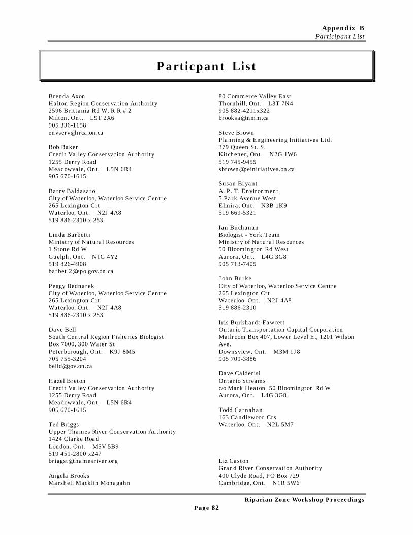
Appendix BParticipant List
Riparian Zone Workshop ProceedingsPage 82
Particpant List
Brenda AxonHalton Region Conservation Authority2596 Brittania Rd W, R R # 2Milton, Ont. L9T 2X6905 [email protected]
Bob BakerCredit Valley Conservation Authority1255 Derry RoadMeadowvale, Ont. L5N 6R4905 670-1615
Barry BaldasaroCity of Waterloo, Waterloo Service Centre265 Lexington CrtWaterloo, Ont. N2J 4A8519 886-2310 x 253
Linda BarbettiMinistry of Natural Resources1 Stone Rd WGuelph, Ont. N1G 4Y2519 [email protected]
Peggy BednarekCity of Waterloo, Waterloo Service Centre265 Lexington CrtWaterloo, Ont. N2J 4A8519 886-2310 x 253
Dave BellSouth Central Region Fisheries BiologistBox 7000, 300 Water StPeterborough, Ont. K9J 8M5705 [email protected]
Hazel BretonCredit Valley Conservation Authority1255 Derry RoadMeadowvale, Ont. L5N 6R4905 670-1615
Ted BriggsUpper Thames River Conservation Authority1424 Clarke RoadLondon, Ont. M5V 5B9519 451-2800 [email protected]
Angela BrooksMarshell Macklin Monagahn
80 Commerce Valley EastThornhill, Ont. L3T 7N4905 [email protected]
Steve BrownPlanning & Engineering Initiatives Ltd.379 Queen St. S.Kitchener, Ont. N2G 1W6519 [email protected]
Susan BryantA. P. T. Environment5 Park Avenue WestElmira, Ont. N3B 1K9519 669-5321
Ian BuchananBiologist - York TeamMinistry of Natural Resources50 Bloomington Rd WestAurora, Ont. L4G 3G8905 713-7405
John BurkeCity of Waterloo, Waterloo Service Centre265 Lexington CrtWaterloo, Ont. N2J 4A8519 886-2310
Iris Burkhardt-FawcettOntario Transportation Capital CorporationMailroom Box 407, Lower Level E., 1201 WilsonAve.Downsview, Ont. M3M 1J8905 709-3886
Dave CalderisiOntario Streamsc/o Mark Heaton 50 Bloomington Rd WAurora, Ont. L4G 3G8
Todd Carnahan163 Candlewood CrsWaterloo, Ont. N2L 5M7
Liz CastonGrand River Conservation Authority400 Clyde Road, PO Box 729Cambridge, Ont. N1R 5W6
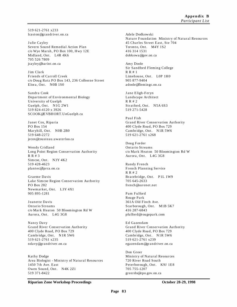
Appendix BParticipant List
Riparian Zone Workshop Proceedings October 28-29, 1998
Page 83
519 621-2761 [email protected]
Julie CayleySevern Sound Remedial Action Planc/o Wye Marsh, PO Box 100, Hwy 12EMidland, Ont. L4R 4K6705 526 [email protected]
Jim ClarkFriends of Carroll Creekc/o Doug Ratz PO Box 143, 236 Colborne StreetElora, Ont. N0B 1S0
Sandra CookDepartment of Environmental BiologyUniversity of GuelphGuelph, Ont. N1G 2W1519 824-4120 x [email protected]
Janet Cox, RipariaPO Box 154Maryhill, Ont. N0B 2B0519 [email protected]
Wendy CridlandLong Point Region Conservation AuthorityR R # 3Simcoe, Ont. N3Y 4K2519 [email protected]
Graeme DavisLake Simcoe Region Conservation AuthorityPO Box 282Newmarket, Ont. L3Y 4X1905 895-1281
Jeanette DavisOntario Streamsc/o Mark Heaton 50 Bloomington Rd WAurora, Ont. L4G 3G8
Nancy DavyGrand River Conservation Authority400 Clyde Road, PO Box 729Cambridge, Ont. N1R 5W6519 621-2761 [email protected]
Kathy DodgeArea Biologist - Ministry of Natural Resources1450 7th Ave. EastOwen Sound, Ont. N4K 2Z1519 371-8422
Adele DodkowskiNature Foundation Ministry of Natural Resources45 Charles Street East, Ste 704Toronto, Ont. M4Y 1S2416 314 [email protected]
Amy DooleSir Sandford Fleming CollegeR R # 1Limehouse, Ont. L0P 1H0905 [email protected]
Jane Eligh-FerynLandscape ArchitectR R # 2Stratford, Ont. N5A 6S3519 271-5428
Paul FishGrand River Conservation Authority400 Clyde Road, PO Box 729Cambridge, Ont. N1R 5W6519 621-2761 x268
Doug ForderOntario Streamsc/o Mark Heaton 50 Bloomington Rd WAurora, Ont. L4G 3G8
Randy FrenchFrench Planning ServiceR R # 2Bracebridge, Ont. P1L 1W9705 [email protected]
Pam FulfordRouge Park361A Old Finch Ave.Scarborough, Ont. M1B 5K7416 [email protected]
Ed GazendamGrand River Conservation Authority400 Clyde Road, PO Box 729Cambridge, Ont. N1R 5W6519 621-2761 [email protected]
Don GreerMinistry of Natural Resources720 River Road SouthPeterborough, Ont. K9J 1E8705 [email protected]
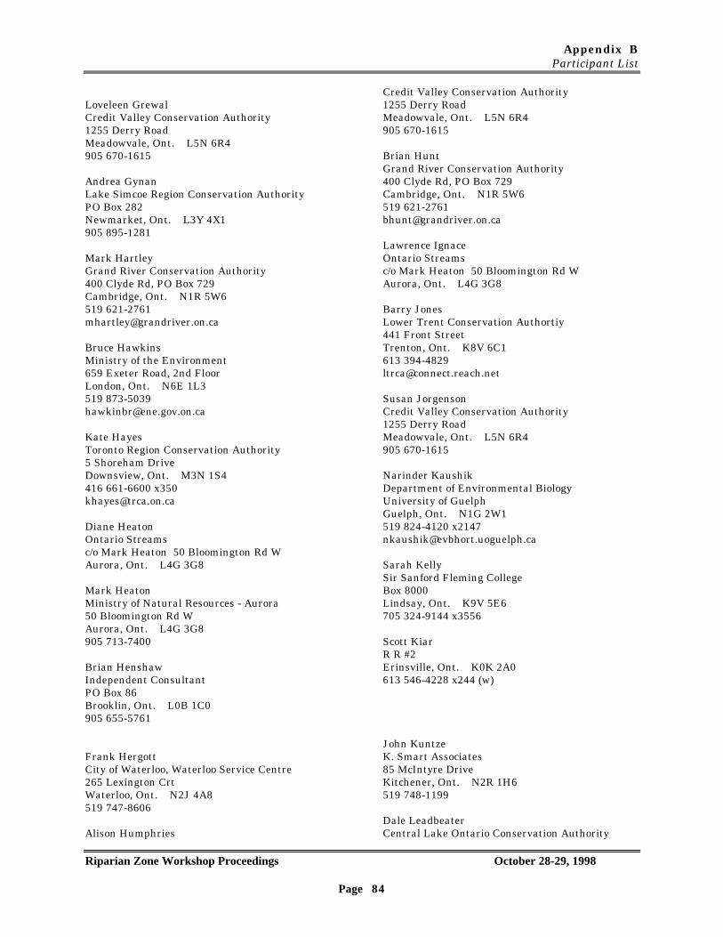
Appendix BParticipant List
Riparian Zone Workshop Proceedings October 28-29, 1998
Page 84
Loveleen GrewalCredit Valley Conservation Authority1255 Derry RoadMeadowvale, Ont. L5N 6R4905 670-1615
Andrea GynanLake Simcoe Region Conservation AuthorityPO Box 282Newmarket, Ont. L3Y 4X1905 895-1281
Mark HartleyGrand River Conservation Authority400 Clyde Rd, PO Box 729Cambridge, Ont. N1R 5W6519 [email protected]
Bruce HawkinsMinistry of the Environment659 Exeter Road, 2nd FloorLondon, Ont. N6E 1L3519 [email protected]
Kate HayesToronto Region Conservation Authority5 Shoreham DriveDownsview, Ont. M3N 1S4416 661-6600 [email protected]
Diane HeatonOntario Streamsc/o Mark Heaton 50 Bloomington Rd WAurora, Ont. L4G 3G8
Mark HeatonMinistry of Natural Resources - Aurora50 Bloomington Rd WAurora, Ont. L4G 3G8905 713-7400
Brian HenshawIndependent ConsultantPO Box 86Brooklin, Ont. L0B 1C0905 655-5761
Frank HergottCity of Waterloo, Waterloo Service Centre265 Lexington CrtWaterloo, Ont. N2J 4A8519 747-8606
Alison Humphries
Credit Valley Conservation Authority1255 Derry RoadMeadowvale, Ont. L5N 6R4905 670-1615
Brian HuntGrand River Conservation Authority400 Clyde Rd, PO Box 729Cambridge, Ont. N1R 5W6519 [email protected]
Lawrence IgnaceOntario Streamsc/o Mark Heaton 50 Bloomington Rd WAurora, Ont. L4G 3G8
Barry JonesLower Trent Conservation Authortiy441 Front StreetTrenton, Ont. K8V 6C1613 [email protected]
Susan JorgensonCredit Valley Conservation Authority1255 Derry RoadMeadowvale, Ont. L5N 6R4905 670-1615
Narinder KaushikDepartment of Environmental BiologyUniversity of GuelphGuelph, Ont. N1G 2W1519 824-4120 [email protected]
Sarah KellySir Sanford Fleming CollegeBox 8000Lindsay, Ont. K9V 5E6705 324-9144 x3556
Scott KiarR R #2Erinsville, Ont. K0K 2A0613 546-4228 x244 (w)
John KuntzeK. Smart Associates85 McIntyre DriveKitchener, Ont. N2R 1H6519 748-1199
Dale LeadbeaterCentral Lake Ontario Conservation Authority
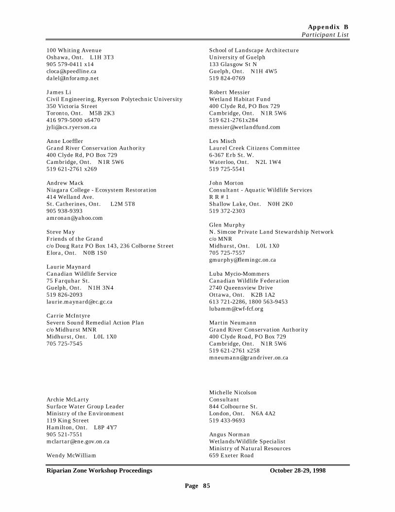
Appendix BParticipant List
Riparian Zone Workshop Proceedings October 28-29, 1998
Page 85
100 Whiting AvenueOshawa, Ont. L1H 3T3905 579-0411 [email protected]@inforamp.net
James LiCivil Engineering, Ryerson Polytechnic University350 Victoria StreetToronto, Ont. M5B 2K3416 979-5000 [email protected]
Anne LoefflerGrand River Conservation Authority400 Clyde Rd, PO Box 729Cambridge, Ont. N1R 5W6519 621-2761 x269
Andrew MackNiagara College - Ecosystem Restoration414 Welland Ave.St. Catherines, Ont. L2M 5T8905 [email protected]
Steve MayFriends of the Grandc/o Doug Ratz PO Box 143, 236 Colborne StreetElora, Ont. N0B 1S0
Laurie MaynardCanadian Wildlife Service75 Farquhar St.Guelph, Ont. N1H 3N4519 [email protected]
Carrie McIntyreSevern Sound Remedial Action Planc/o Midhurst MNRMidhurst, Ont. L0L 1X0705 725-7545
Archie McLartySurface Water Group LeaderMinistry of the Environment119 King StreetHamilton, Ont. L8P 4Y7905 [email protected]
Wendy McWilliam
School of Landscape ArchitectureUniversity of Guelph133 Glasgow St NGuelph, Ont. N1H 4W5519 824-0769
Robert MessierWetland Habitat Fund400 Clyde Rd, PO Box 729Cambridge, Ont. N1R 5W6519 [email protected]
Les MischLaurel Creek Citizens Committee6-367 Erb St. W.Waterloo, Ont. N2L 1W4519 725-5541
John MortonConsultant - Aquatic Wildlife ServicesR R # 1Shallow Lake, Ont. N0H 2K0519 372-2303
Glen MurphyN. Simcoe Private Land Stewardship Networkc/o MNRMidhurst, Ont. L0L 1X0705 [email protected]
Luba Mycio-MommersCanadian Wildlife Federation2740 Queensview DriveOttawa, Ont. K2B 1A2613 721-2286, 1800 [email protected]
Martin NeumannGrand River Conservation Authority400 Clyde Road, PO Box 729Cambridge, Ont. N1R 5W6519 621-2761 [email protected]
Michelle NicolsonConsultant844 Colbourne St.London, Ont. N6A 4A2519 433-9693
Angus NormanWetlands/Wildlife SpecialistMinistry of Natural Resources659 Exeter Road
Appendix BParticipant List
Riparian Zone Workshop Proceedings October 28-29, 1998
Page 86
London, Ont. N6E 1L3519 873-4623
Lorraine NormintonFriends of the Grandc/o Doug Ratz PO Box 143, 236 Colborne StreetElora, Ont. N0B [email protected]
Larry O'GradyWetland Habitat Fundc/o MNR 1 Stone Rd WGuelph, Ont. N1E 5X8519 [email protected]
Sheila O'NealHamilton Harbour Watershed ProjectPO Box 7099, 838 Mineral Springs RoadAncaster, Ont. L9G 3L3905 648-4427 [email protected]
Brian PeterkinSenior Advisor, Conservation Authority SectionMinistry of Natural Resources50 Bloomington Road, R R # 2Aurora, Ont. L4G 3G8905 713 7732
Brad PetersonThe Land Steward59 Essex StreetGuelph, Ont. N1H 3K9519 [email protected]
Mike PetzoldAssessment Biologist, Lake Superior Mgnt UnitMinistry of Natural Resources1235 Queen Street EastSault Ste Marie, Ont. P6A 2E3705 253 8288 [email protected]
Ryan PlummerStudentDept. of Rural Planning and DevelopmentUniversity of GuelphGuelph, Ont. N1G 2W1519 824-4120 x3173
Mariette PrentParish Geomorphic Ltd.14 McIntyre CresGeorgetown, Ont L7G 1N3
Tim RanceBiologist - Durham TeamMinistry of Natural Resources50 Bloomington Rd WestAurora, Ont. L4G 3G8905 713-7405
Doug RatzOntario StreamsPO Box 143, 236 Colborne StreetElora, Ont. N0B 1S0519 846-5902
Dave ReidNorfolk Land Stewardship CouncilC/o OMAFRA, PO Box 587Simcoe, Ont. N3Y 4N5519 [email protected]
Peter RobertsEnvironmental Management UnitOMAFRA1 Stone Rd WestGuelph, Ont. N1G 4Y2519 [email protected]
Glenda RodgersLower Trent Conservation Authortiy441 Front StreetTrenton, Ont. K8V 6C1613 394-3915 [email protected]
Stefan RombergLake Simcoe Region Conservation AuthorityPO Box 282Newmarket, Ont. L3Y 4X1905 895-1281
Ramesh RudraSchool of EngineeringUniversity of GuelphGuelph, Ont. N1G 2W1519 824-4120 [email protected]
Gus RungisGrand River Conservation Authority400 Clyde Rd, PO Box 729Cambridge, Ont. N1R 5W6519 621-2761 x226
Appendix BParticipant List
Riparian Zone Workshop Proceedings October 28-29, 1998
Page 87
Jo-anne RzadkiHamilton Harbour Watershed ProjectPO Box 7099, 838 Mineral Springs RoadAncaster, Ont. L9G 3L3905 648-4427 [email protected]
Paul SavoieFish Habitat BiologistDepartment of Fisheries and Oceans867 Lakeshore RoadBurlington, Ont. L7R 4A6905 336-4637
Chris SimsGamsby and Mannerow Ltd.255 Woodlawn Road West, Ste, 210Guelph, Ont. N1H 8J1519 824-8150
Norm Smith, Science and Technology UnitMinistry of Natural Resources659 Exeter RoadLondon, Ont. N6E 1L3519 [email protected]
Jerry SmitkaYork Region Stewardship Coordinator50 Bloomington RoadAurora, Ont. L4G 3G8905 713-7410
Donna SperanziniOMAFRABox 5000, 4890 Victoria Ave. NVineland, Ont. L0R 2E0905 562-4147
Tiffany SvenssonOntario Federation of Agriculture40 Eglington Ave. E. 5th FloorToronto, Ont. M4P 3B1416 [email protected]
Art TimmermanFish And Wildlife BiologistMinistry of Natural Resources1 Stone Road WestGuelph, Ont. N1G 4Y2519 826-4935
Kevin TrimbleBeak International Incorporated14 Abacus RdBrampton, Ont. L6T 5B7905 794-2325 [email protected]
Ray TuffgarTotten Sims Hubicki Associates30 Dupont EWaterloo, Ont.519 886-2160
Michelle VilleneuveSevern Sound Remedial Action Planc/o Wye Marsh, PO Box 100, Hwy 12EMidland, Ont. L4R 4K6705 526 7809
Anne Marie WeselanToronto Region Conservation Authority5 Shoreham DriveDownsview, Ont. M3N 1S4416 661-6600 x350
John WestwoodMinistry of the Environment659 Exeter Road, 2nd FloorLondon, Ont. N6E 1L3519 [email protected]
Marie WhelanDurham Land Stewardship Councilc/o OMAFRA, 60 van Edward DrivePort Perry, Ont. L9L 1G3905 [email protected]
Laurel Whistance-SmithManager Stewardship and SustainabilityMinistry of Natural Resources300 Water StreetPeterborough, Ont. K9J 3C7705 [email protected]
Hugh WhiteleySchool of EngineeringUniversity of GuelphGuelph, Ont. N1G 2W1519 824-4120 [email protected]
Appendix BParticipant List
Riparian Zone Workshop Proceedings October 28-29, 1998
Page 88
Owen WilliamsStewardship Liason, Ministry of Natural Resources18 Winder Grove NLondon, Ont. N6K 4K6519 [email protected]
Cam WilloxArea Supervisor AuroraMinistry of Natural Resources50 Bloomington Rd WAurora, Ont. L4G 3G8905 [email protected]
Liz YerexGrand River Conservation Authority400 Clyde Rd, PO Box 729Cambridge, Ont. N1R 5W6519 621-2761 [email protected]
Gloria YeungGrand River Conservation Authority400 Clyde Rd, PO Box 729Cambridge, Ont. N1R 5W6519 621-2761 [email protected]
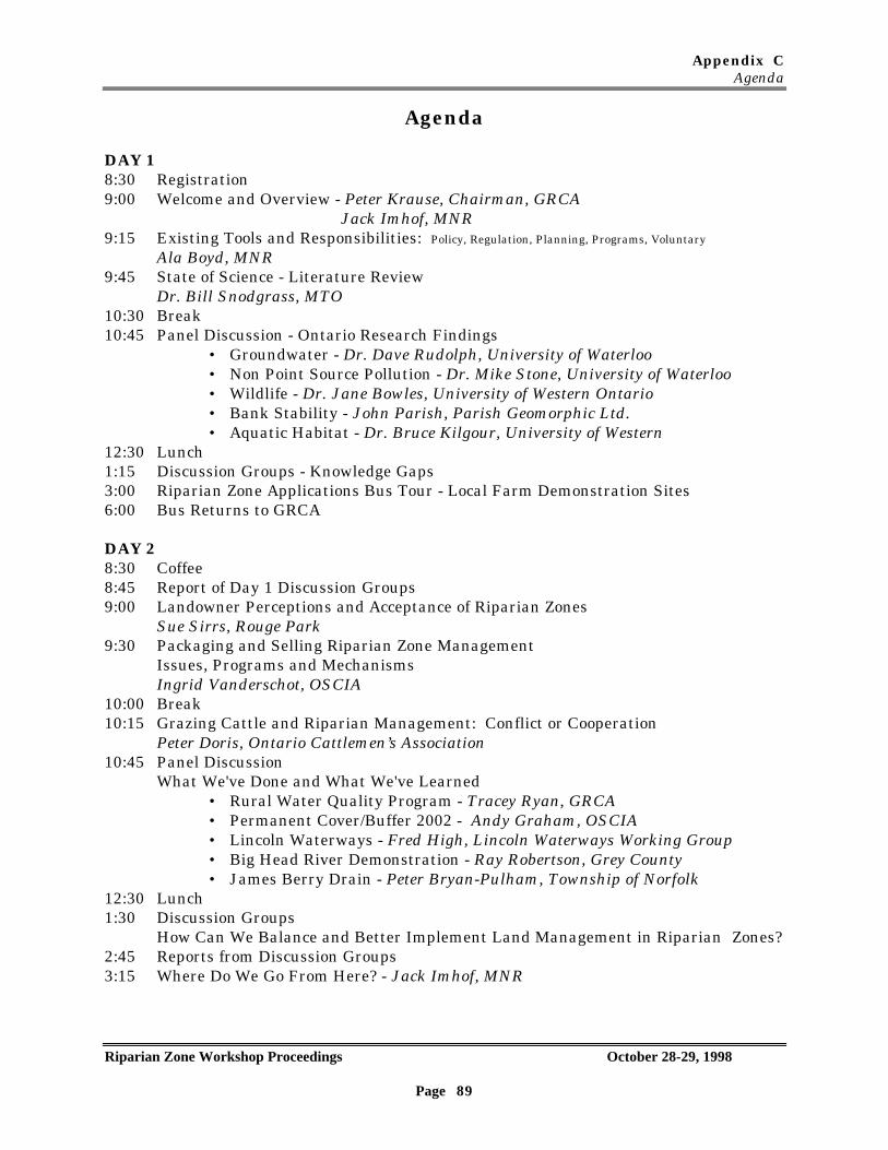
Appendix CAgenda
Riparian Zone Workshop Proceedings October 28-29, 1998
Page 89
Agenda
DAY 18:30 Registration9:00 Welcome and Overview - Peter Krause, Chairman, GRCA
Jack Imhof, MNR9:15 Existing Tools and Responsibilities: Policy, Regulation, Planning, Programs, Voluntary
Ala Boyd, MNR9:45 State of Science - Literature Review
Dr. Bill Snodgrass, MTO10:30 Break10:45 Panel Discussion - Ontario Research Findings
• Groundwater - Dr. Dave Rudolph, University of Waterloo• Non Point Source Pollution - Dr. Mike Stone, University of Waterloo• Wildlife - Dr. Jane Bowles, University of Western Ontario• Bank Stability - John Parish, Parish Geomorphic Ltd.• Aquatic Habitat - Dr. Bruce Kilgour, University of Western
12:30 Lunch1:15 Discussion Groups - Knowledge Gaps3:00 Riparian Zone Applications Bus Tour - Local Farm Demonstration Sites6:00 Bus Returns to GRCA
DAY 28:30 Coffee8:45 Report of Day 1 Discussion Groups9:00 Landowner Perceptions and Acceptance of Riparian Zones
Sue Sirrs, Rouge Park9:30 Packaging and Selling Riparian Zone Management
Issues, Programs and MechanismsIngrid Vanderschot, OSCIA
10:00 Break10:15 Grazing Cattle and Riparian Management: Conflict or Cooperation
Peter Doris, Ontario Cattlemen’s Association10:45 Panel Discussion
What We've Done and What We've Learned• Rural Water Quality Program - Tracey Ryan, GRCA• Permanent Cover/Buffer 2002 - Andy Graham, OSCIA• Lincoln Waterways - Fred High, Lincoln Waterways Working Group• Big Head River Demonstration - Ray Robertson, Grey County• James Berry Drain - Peter Bryan-Pulham, Township of Norfolk
12:30 Lunch1:30 Discussion Groups
How Can We Balance and Better Implement Land Management in Riparian Zones?2:45 Reports from Discussion Groups3:15 Where Do We Go From Here? - Jack Imhof, MNR
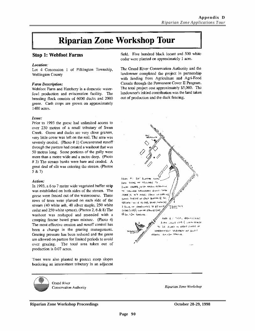
Appendix DRiparian Zone Applications Tour
Riparian Zone Workshop Proceedings October 28-29, 1998
Page 90
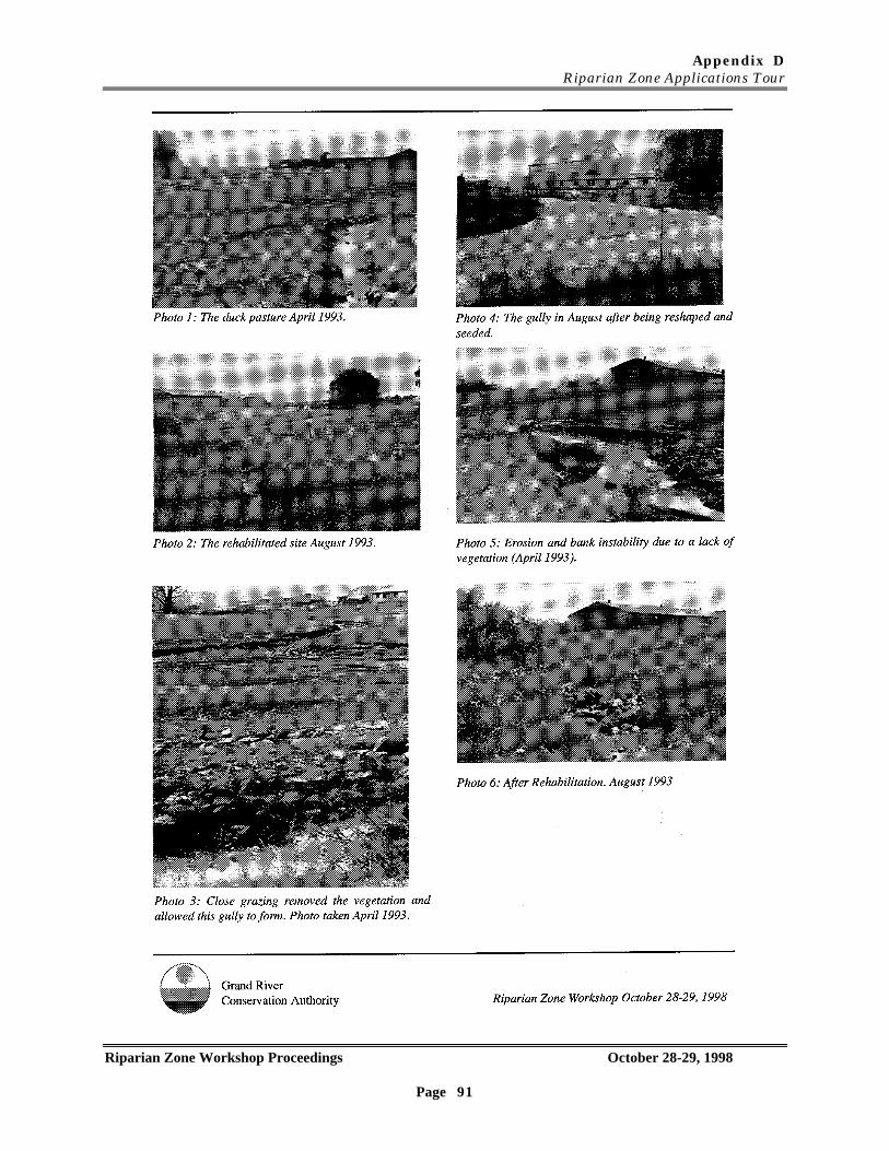
Appendix DRiparian Zone Applications Tour
Riparian Zone Workshop Proceedings October 28-29, 1998
Page 91
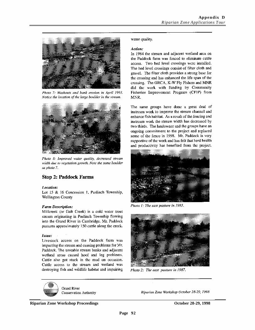
Appendix DRiparian Zone Applications Tour
Riparian Zone Workshop Proceedings October 28-29, 1998
Page 92
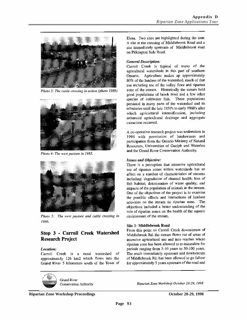
Appendix DRiparian Zone Applications Tour
Riparian Zone Workshop Proceedings October 28-29, 1998
Page 93
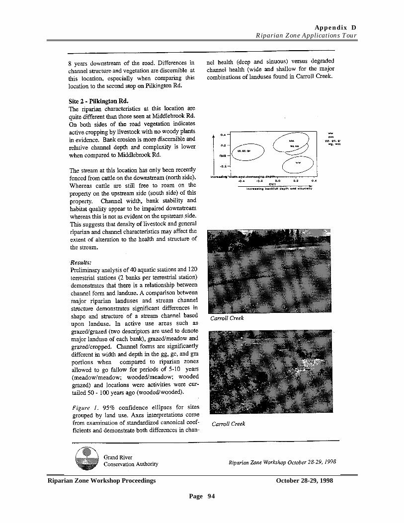
Appendix DRiparian Zone Applications Tour
Riparian Zone Workshop Proceedings October 28-29, 1998
Page 94
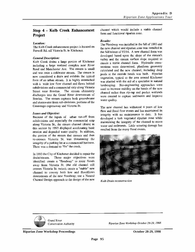
Appendix DRiparian Zone Applications Tour
Riparian Zone Workshop Proceedings October 28-29, 1998
Page 95
Appendix EHighviewFarms
Riparian Zone Workshop Proceedings October 28-29, 1998
Page 96
Appendix E
Soil and Water Conservation Demonstration FarmHIGHVIEW FARMS
(Compliments presentation By Lincoln Waterways Working Group)
Appendix FComments from Evaluation Forms
Riparian Zone Workshop Proceedings October 28-29, 1998
Page 97
What Do You Want Next?Comments From Evaluation Form.
Would you be interested in a follow-up workshop? If so, focusing on what topics?
• Yes (x3).• Yes. May be useful to have a workshop where you work on scenarios to get a better idea
of data needs as well as does and don’ts for implementation.• On implementation schemes, i.e. ways of, where to establish demonstrations.• Yes. Use of riparian zones for water quality improvements.• Yes. Water quality and remedial action implementation.• Yes. Urban riparian buffers.• Yes. Defining specific matched between situations, tools and expectations.• Yes. If focused on practical management techniques.• Yes. Research needs and updates - progress toward design specifications.• Yes. On legislation and regulation.• Yes. More information on research - leading trends and specifics. Would also like a
workshop for non-agricultural areas.• Yes. Focus on programs. Synthesis of knowledge. Political action to direct more $$$ to
the environment.• Yes. On the obvious common messages and issues. Direct right questions to
researchers and academics. Share information (communication, network). Integratevalues (economic and environmental).
• Need to capture details of workshop - get all players to raise common issues.• Yes. More of an urban context, i.e. dealing with developers and contractors.• Helping to strengthen link between practitioners and researchers.• More on the processes of managing a riparian zone, once the data or definition are
found. This way it could narrow down the specific areas.• Sure. I personally would like to know more about the legislation at present which is in
place to guide activities in riparian zones. Would also be interested in a workshop onwhat we know presently about success/appropriateness of certain techniques forrehabilitation.
• Yes, riparian zone tools and which design may be best.• Types of riparian practices i.e. grass buffers, rock banks, rock chutes, trees and shrub
buffers. More in-depth look at what works and is best for the watercourse.• Yes. Urban and rural strategies. Techniques that do and don’t work in riparian
restoration. A look at the restoration side, less focus on the research. Guidelines andprocesses to be considered in riparian design.
• Yes. Hammering out details on guidelines for more focused study on this topic, i.e.rural, urban, public contact, defining riparian and guidelines.
• I would love a workshop detailing ‘progress’ on ideas and suggestions/recommendationsfrom this workshop. Gives us a sense of progress.

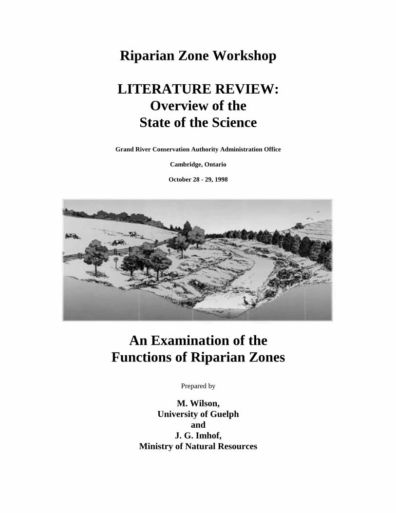
Riparian Zone Workshop
LITERATURE REVIEW:Overview of the
State of the Science
Grand River Conservation Authority Administration Office
Cambridge, Ontario
October 28 - 29, 1998
An Examination of theFunctions of Riparian Zones
Prepared by
M. Wilson,University of Guelph
andJ. G. Imhof,
Ministry of Natural Resources
Riparian Zone Workshop – Literature Review
RIPARIAN ZONE WORKSHOPLiterature Review:
Overview of the State of the Science
INTRODUCTION
In 1971, US and Canadian governments acknowledged a concern over Great Lakes
water quality by initiating a working group to research the relationship between landuse
and water quality (Cywin and Ward, 1971). This concern arose, in part, due to non-point
source pollution from a variety of landuses including agriculture and urbanization. About
20% of the world’s freshwater is found within the Great Lakes and they were found, by the
working group, to receive a wide range of nutrient, sediment, and pesticide loadings
through their watersheds (Coote et al., 1982). Through processes, such as eutrophication
and toxification, these inputs could potentially irreversibly alter the nature of our aquatic
ecosystems.
Over the last 10 years, resource management programs have been developed to
address some of these concerns. Two specific programs, Watershed Planning and the
Natural Channel System program, apply an ecosystem approach to assessment, planning
and management. The objectives of these programs are to determine the cause: effect
relationships between landuses and landscape, valley and river. Some of the goals of these
programs are to: protect property, reduce costs of environmental clean-up and protection
and ensure the sustainability of renewable resources such as water, soil, fish and wildlife.
The Watershed Planning process occurs at a broad scale whereas management of
rivers and their riparian zones and floodplains is the focus of the Natural Channel Systems
program. Extensive research within Ontario and around the world has identified
important properties of rivers, their riparian zones and how they function together. The
management of these functions has been identified as important to the well being of
natural resources, property and water quality in Ontario. Some of the key functions of a
river and its riparian zone/floodplain include: the conveyance and storage of water and
sediment; attenuation of flood flow within flood plains; the provision of bank stability; the
protection, maintenance or enhancement of aquatic and terrestrial habitat; and the
maintenance or improvement of water quality through nutrient uptake and sedimentation.
Controls of these functions, to a great degree, operate within riparian zones.
Riparian Zone Workshop – Literature Review
Riparian zones are defined as the three dimensional zone of interaction between
terrestrial and aquatic ecosystems (Gregory et al., 1991; Swanson et al., 1982; Meehan et
al., 1977). Their control over the functioning of landscape processes is much greater than
their predicted land area effect (Gregory et al., 1991). They represent the final region
through which substances pass when moving from the terrestrial to the aquatic ecosystem.
This gives riparian zones the conclusive opportunity to modify, incorporate, dilute or
concentrate stream bound materials (Osborne and Kovacic, 1993). Because of these
attributes riparian zones have been found to assist in the regulation of landscape
geomorphic and hydrologic processes, the control of surface water quality, and the
protection and provision of both aquatic and terrestrial habitat.
Worldwide interest has been focused on riparian zones and this is evident in the
increasing abundance of literature devoted to the topic. The greater portion of this
literature concerns their important functions as filters of non-point source pollution,
specifically, sediments, nitrogen, and phosphorous. Riparian zones can also regulate
sunlight inputs to the stream thereby moderating stream temperatures, reduce sediment
and nutrient inputs, stabilize geomorphic processes, and provide sources of organic matter
(Osborne and Kovacic, 1993).
The United States government has begun an extensive riparian implementation
program to help reduce waterway pollution. The goal of the program is to restore 2 million
miles of riparian zones by the year 2002. Closer to home, the Regional Municipality of
Waterloo has budgeted $1.5 million over 5 years towards the control of non-point source
pollution and has identified the importance of rural riparian enhancement and restoration
programs to the achievement of its’ goal.
Before any extensive implementation programs occur, many research gaps should
be addressed as well as various related land use and social issues. Osborne and Kovacic
(1993) have identified some research gaps involving the utility and efficiency of these areas
in terms of structure and composition. Gregory et al. (1991) stress that the management of
riparian resources must be approached from an ecosystem perspective, “integrating the
physical processes, that create valley floor landforms, patterns of terrestrial plant
succession, and structural and functional attributes of stream ecosystems”.
This review provides an overview of the ‘natural’ functions and processes of
riparian zones based upon a review of the world literature. It is not exhaustive but will
Riparian Zone Workshop – Literature Review
attempt to provide the reader with an idea of the state of the world science on riparian
zones and their functions. The purpose of this review is to provide a knowledge basis on
which can be built and present new knowledge unearthed during the Riparian Zone
Workshop Researcher Panel Discussion. For additional information on riparian zone form
and function, please review the proceedings of the workshop and the summary of the
various discussion groups.
METHODS
The objective of this review is to provide an overview of the world literature and
determine the major scientific understanding of riparian zones. In addition, some of this
review will summarize examples of widths assigned by research to various functions found
within the riparian zone.
To begin this project, scientific literature, books and articles on riparian zone
functioning was amassed from numerous sources including: reference libraries, journals,
personal libraries, internet sources and searches, and personal libraries. The literature
was reviewed and then separated into functional groupings or categories of functions. Four
categories which encompass the status of riparian zone science were identified:
• Hydrology• Geomorphology• Water Quality and Nutrient Flux• Ecological Characteristics
Within each of these broad categories sub-categories are identified in order to
describe the functioning of riparian zones in conjunction with their landscapes, and the
relationship of these functions with the preservation of water quality and aquatic ecological
processes. The topics have been organized to parallel the hierarchical controls of drainage
basin function and ecological dominance by physical habitat characteristics (Gregory et al.,
1991; Frissell et al., 1986):
• Valley Landforms And Physical Characteristics - Structure• Channel Structure• Physical System And Morphological Effects On Ecosystem Structure And
Function• Ecological Characteristics Of Riparian Areas - Interactions• Riparian Vegetation Effects On The Functioning Of Ecological And Physical
Systems
Riparian Zone Workshop – Literature Review
• Nutrient And Sediment Fluxes Involving The Riparian Zone - BufferingCapabilities
The information for each of these categories has been summarized into a series of
tables for an expedient and effective display of relevant information. An attempt was
made to include information necessary for the interpretation of the importance of the
specific research findings to our conditions in Ontario. The tables are divided into five
columns, which include:
• Research finding (A result of the research or a trend noted through synthesis ofresearch.)
• Location (A listing of the research location or of the extrapolated effect area. This canbe used to assess the findings’ importance to Ontario conditions.)
• Factors (Any important factors which have been identified in influencing theconditions leading to the proposed finding.)
• Reference (The author(s) of the paper from which the finding was found.)• Number of Representative Papers (The number of papers reviewed supporting the
research finding.)
RESULTS
Approximately 200 papers, including annotated bibliographies and books were
reviewed and assessed for the purpose of this review. Tables 2, 3, 4 and 5 summarize
information from papers that were considered state of the science for their category. These
key papers, in our view, summarize some of the key points for each topic within the four
categories. The total number of papers actually used per category is shown in Table 1.
Table 1: Summary of Number of Key Papers Used by Category
Category # of PapersHydrology 16Geomorphology 14Water Quality and Nutrient Flux 8Ecological Characteristics 16
A listing of these papers in addition to the bibliographies used in this work are listed in the
references.
Although fewer papers were used to summarize information on water quality and
nutrient flux in riparian zones, there is exhaustive world literature on this subject. An
example of the extent and scope of this work can be seen in the 60 page bibliography
Riparian Zone Workshop – Literature Review
prepared for the Smithsonian Environmental Research Center by Correll (1997), entitled,
“Vegetated Stream Riparian Zones: Their effects on stream nutrients, sediments and toxic
substances”. This bibliography alone contains 522 citations. Another major paper used is
Martin et al. (1998) from the University of Guelph, which again is a review of the world
literature.
The role of riparian zones in the management, movement and modification of
surface and groundwater also has an extensive literature, especially as it relates to flood
flow attenuation and its’ role in nutrient flux. Less well known appears to be the
interaction of groundwater and surface water as it moves from upland areas into and
through active riparian zones. Some of the most recent work on this appears to be
occurring in southern Ontario.
The field of fluvial geomorphology examines the dynamics of change in channels and
their valleys that result from the movement and storage of sediment and water over time.
Although a fair body of historical work has been done on components of these interactions
(i.e. channel hydraulics and flow), not a great deal has been done on the inter-relationships
between riparian zone structure and composition and its’ role on controlling channel
structure, erosion and in general, bank stability.
Ecological Characteristics of riparian zones are discussed in general terms by a
variety of authors, but only recently has the channel and its’ valley been connected as a
unit for analysis (e.g. Frissell et al.1986; Rosgen 1995; Imhof et al. 1996).
DISCUSSION
Response of landscapes to change induced by human use is well documented but
not well understood. Changes to the stability of river channels, degradation of water
quality, soil loss and collapse of food fish stocks is well documented by Hoffmann (1995) in
11th century medieval Europe. These changes were wrought by a major economic
expansion which saw forested landscape cleared for agricultural production, rivers
dammed for mills and land drainage increased to improve production. The world literature
today provides many more examples and much more understanding of how these changes
in medieval Europe occurred.
Our experiences in Ontario and findings of researchers from other geographical
areas show that to achieve a complete understanding of the functioning of river
Riparian Zone Workshop – Literature Review
ecosystems, effects originating from the terrestrial ecosystem must be considered (Hynes
1975; Frissell et al. 1986; Imhof 1996). In fact, the linkage between a stream and its’
drainage basin began to be recognized as early as the 1940’s. Since then, it has become
extensively acknowledged within various disciplines (Horton, 1945; Leopold, Wolman and
Miller, 1964; Schumm and Lichty, 1965; Hewlett and Nutter, 1970; Likens and Bormann,
1974; Hewlett and Troendle, 1975; Vannote et al., 1980; Schlosser and Karr, 1981; Junk,
Bayley and Sparks, 1989). Influential and prominent examples of the impacts of
terrestrial landscapes on the functioning of aquatic ecosystems can be found in the theories
of both the River Continuum Concept (Vannote et al.1981) and the Flood - Pulse Concept
(Junk et al.1989). The terrestrial-aquatic interaction is recognized in these theories as
exhibiting a powerful control over aquatic community structure.
Non-point source pollution from agricultural areas has been identified as a key
contributing factor to North American water quality problems (Fennessy and Cronk, 1997),
although absolute mechanisms of attenuation, transformation and transport vary based
upon geology, topography, soils, vegetation and climate.
The remainder of this discussion focuses on each of the four categories and
examines briefly what is well known and where our knowledge is weakest. A table has
been prepared for each section to summarize major papers.
Hydrology (Table 2):
Riparian hydrology is far from well understood. We have yet to produce an effective
model to describe the hydrology of riparian zones and floodplains much less a model which
takes into consideration the processes which take place on a yearly or longer term basis.
Research in this field is essential in order to understand water quality issues and nutrient
flux through riparian zones. The integration of surface flow and shallow groundwater
models is needed in order to understand these functions at any reasonable level. Research
needs to focus on both spatial and temporal characteristics of the hydrology of riparian
zones: not only on critical events such as major high flow and low flow events but on the
regime characteristics as well.
Geomorphology (Table 3):
Riparian Zone Workshop – Literature Review
Extensive research has provided a good understanding of the processes involved in
the formation of drainage basins and the processes involved in the formation of floodplains.
Unfortunately, limited information is available on the long-term rates at which riparian
zones and floodplains adjust to changes in hydrology and sediment yield (Table 3). This is
especially problematic in Ontario where many of our rivers, floodplains and riparian zones
are still adjusting to the clearing of the land for agriculture over 100 years ago.
The role of riparian vegetation, composition and structure on bank stability and
channel stability is poorly understood. Some of this complexity may be scale dependent.
For example, the channels in 1st order streams in humid temperate climates may be
considered vegetatively controlled because the root systems have sufficient tensile strength
to withstand the shear stress created by small streams. However, in larger streams,
because of the force and volume of water, the channel form may be controlled by erosive
forces although modified by the vegetation in the riparian zone. The field of bio-
engineering, using natural living materials to stabilize slopes is relatively new to North
America and likely requires an understanding of these circumstances in order to design
appropriate measures for bank stability. More research is needed on the tensile strength
of roots and their role in bank stability.
Another major need is to examine the entire valley or riparian system as a unit.
Although there is discussion of a systems approach to the management of stream corridors
from the USDA and from the Natural Channel Systems initiative in Ontario, little data is
yet available for the management of stream nutrient inputs, hydrology and
geomorphological processes. It is possible that the most appropriate way to view the
riparian system is as a dynamic geomorphic unit of the stream and its valley.
Water Quality and Nutrient Flux (Table 4):
The mechanisms through which riparian zones control water quality and balance
nutrients is generally understood. We can predict to a certain degree of success the effects
of vegetation composition and structure on the degree of nutrient attenuation, although the
specific mechanisms and processes are only now being clarified. Present models do not
account for the effects of long periods of nutrient filtration and uptake. Only recently has
better information on the effectiveness of riparian zones been established (Table 4). More
focused research is required in order to determine widths, lengths and composition of
Riparian Zone Workshop – Literature Review
riparian zones designed to improve water quality. Riparian forests have been proposed as
one means of improving water quality but long-term studies still need to be done to
determine if these forests will continue to perform these water quality functions well after
they mature. Osborne and Kovacic working in a riparian zone with trees in excess of 40
years cannot determine yet what will happen when growth stops and senescence occurs.
Long-term effects of accumulation of nutrients in the riparian zone must be
addressed. Work in the United States suggests that riparian zones and the sub-pavement
of streams are major storage areas of phosphorus. This would suggest that response of
water quality in streams may lag for a long period after the establishment of a functional
riparian zone, even though the riparian zone may be working well. For example, large
runoff events can exacerbate bank erosion and turn over the bed of the stream channel
thereby releasing stored phosphorus into the open stream system. Both processes will
flush not only sediments but soluble nutrients into the stream downstream of the erosion
locations. This remobilization of nutrients may mask the good work the riparian zones are
doing for quite a few years. Monitoring systems need to be able to sort out the
effectiveness of riparian zone restoration techniques in relation to long-term “sinks”.
The question of bacterial denitrification and its’ spatial variability within riparian
zones is just beginning to be addressed from a four dimensional perspective. Information
must be collected in order to estimate the rate of removal of nitrates from groundwater
without riparian vegetation and then with riparian vegetation of specific structure and
composition. The research must also examine these features on a seasonal basis.
Ecological Characteristics (Table 5):
There is a basis understanding of the ecological role of riparian zones in the
management of aquatic systems. Riparian zones provide food for aquatic animals, modify
stream temperature, provide large wood material to the stream that is used as habitat by
fish, etc. Some work has been done on the response of aquatic systems to the removal of
riparian zones. However, little work has been done on the time it takes aquatic systems to
stabilize (biologically, physically and chemically) or return to a healthy functional state
once re-established (Table 5). Work completed on whole watersheds such as Hubbard
Brook in the USA and Carnation Creek in British Columbia suggest that the aquatic
system responds very quickly to loss of riparian zone (e.g. 1-5 years) but recovers very
Riparian Zone Workshop – Literature Review
slowly (e.g. 10-100 years). Imhof et al. (1996) includes a table suggesting the relationship
between scale of the system and disturbance period (see Table 6).
However, less is known about the role of riparian zones in the movement of
terrestrial species and the distribution of vegetated materials. The extent of species
dispersal and migration patterns are fairly unknown and highly theoretical. Although
some literature suggests that riparian zones can function both as corridor and as barrier,
riparian barrier effects are hypothetical and have yet to be proven.
Summary
There is more and more focus on the benefits of riparian zones in the world
literature. Within a watershed context, documents, procedures and science has been
developing on the analysis and management planning for watersheds and stream corridors,
i.e. Ontario’s Watershed Planning Process and Natural Channel System Initiative. The
ecosystem that has been somewhat neglected in the past is the “wetlands” that connect the
stream channel or lake to the upland area, the riparian zone. This literature review
reflects the growing interest in this ecosystem and the important role it appears to play in
many functions important to wildlife, fish and people.
Although a great deal of research has been done on riparian zone form and function,
a clear definition and set of criteria for defining riparian zones are still needed.
Work on the various functions of riparian zones, their width and characteristics is ongoing.
Table 7 has been prepared as a summary of information on effective riparian widths for
different functions. What is missing from the literature in general is a clear description of
the climate, elevation, valley form, valley slope and geology of the study zone in addition to
the length of the zone under study and its contiguousness. All these factors appear to be
important variables in defining how well the riparian zone functions and how well this
information can be extrapolated to other studies.
In general, work is needed to define like-for-like systems. From this type of study,
we should then be able to derive an understanding of how the various functions of the
riparian zone operate together within specific spatial settings. This inter-disciplinary
information is critical if we wish to manage and/or restore riparian zones in Ontario.
Given the possibility of more variable weather conditions over the years due to Global
Climate Change (i.e. more frequent high flow events and more frequent droughts), riparian

Riparian Zone Workshop – Literature Review
zones may act as a system that can help us to adapt and moderate the worst of these
extremes on our property.
Riparian Zone Workshop – Literature Review
References and Bibliographies
Ahola, H. 1989. Vegetated buffer zone project of the Vantaa River Basin. Geografisk Tidsskrift.89:22-25.
Ahola, H. 1989. Vegetated buffer zone examinations of the Vantaa River Basin. Aqua Fennica. 20:65-69.
Aubertin, G.M., and J.H. Patric. 1974. Water quality after clear-cutting a small watershed in WestVirginia. Journal of Environmental Quality. 3:243-249.
Barton, D.R., W.D. Taylor, and R.M. Biette. 1985. Dimension of riparian buffer strips required tomaintain trout habitat in southern Ontario streams. North American Journal of FisheriesManagement. 5:364-78.
Betson, R.P. 1964. What is watershed runoff? Journal of Geophysical Research. 69:1541-1552.
Brazier, J.R., and G.W. Brown. 1973. Buffer strips for stream temperature control. Research Paper No.15. Forest research Laboratory, School of Forestry, Oregon State University, Corvallis, OR.
Brinson, M.M., B.L. Swift, R.C. Plantico, J.S. Barclay. 1981. Riparian Ecosystems: Their ecology andstatus. US Fish and Wildlife Service FWS/OBS 82/17.
Brown, M.T., J. Schaefer, K. Brandt K.. 1990. Buffer Zones for Water, Wetlands, and Wildlife in eastCentral Florida. Centre for Wetlands Publication. 89-07, University of Florida, Gainsville.
Budd, W.W., P.L. Cohen, P.R. Saunders, F.R. Steiner. 1987. Stream Corridor Management in the PacificNorthwest, I. Determination of Stream Corridor Widths. Environmental Management. 11:587-597.
Burt, T.P.. 1992. The Hydrology of Headwater Catchments. In: The Rivers Handbook Vol. 1. P.3-28. Ed.By Calow, P. and G. Petts. London: Blackwell Scientific Publications.
Buttle, J.M. Channel changes following headwater afforestation: the Ganaraska River, Ontario, Canada.Geografiska Annaler. 77A(3):107-118
Chapman, Lyman John. 1908: The Physiography of Southern Ontario. Toronto: University of TorontoPress.
Cooper, A.B. 1990. Nitrate depletion in the riparian zone and stream channel of a small headwatercatchment. Hydrobiologia. 202:13-26.
Cooper, A.B., and J.W. Gilliam. 1987. Phosphorous redistribution from cultivated fields into riparianareas. Soil. Sci. Soc. Am. J.. 51:1600
Coote, D.R., E..M. Macdonald, W.T. Dickinson, R.C. Ostry, and R. Frank. Agriculture and Water qualityin the Canadian Great Lakes Basin: I. Representative Agricultural Watersheds. Journal ofEnvironmental Quality. 11(3): 473-481.
Riparian Zone Workshop – Literature Review
Corbett, E.S., J.A. Lynch,and W.E. Sopper. 1978. Timber harvesting practices and water quality in theeastern United States. Journal Forestry. 76:484-485.
Correll, D.L., D.E. Weller. 1989. Factors limiting processes in freshwater wetlands: An agriculturalprimary stream riparian forest. In: Sharitz R.R. and J.W. Gibbons (eds). Freshwater Wetlandsand Wildlife, pp. 9-23.
Correll, D.L.. 1991. Human impacts on the functioning of landscape boundaries. In: Holland, M.M., P.G.Risser, and R.J. Naimer (eds). Ecotones: The role of landscape boundaries in the managementand restoration of changing environments. Chapman and Hall, New York.
Cross, S.P.. 1985. Responses of small mammals to forest riparian perturbations. In: Johnson, C.D. et al.(eds) Riparian Ecosystems and their Management: Reconciling Conflicting Land Uses. USDA.Forest Service General Technical Report. RM-120, Fort Collins, Colorado.
Cywin, A. and D. Ward. 1971. Agricultural pollution of the Great Lakes basin. U.S. EnvironmentalProtection Agency Rep. No. 1302007/71. U.S. Government Printing Office, Washington, D.C..
Davies P.E., and M. Nelson. 1994. Relationships between riparian buffer widths and the effects oflogging on stream habitat, invertebrate community composition and fish abundance. AustralianJournal of Marine and Freshwater Resources. 45: 1289-1305.
Decamps, H., J. Joachim, and J. Lauga. 1987. The importance for birds of the riparian woodlands withinthe alluvial corridor of the River Garonne, S.W. France. Regulated Rivers: Research andManagement 1:301-316
Dickinson, W.T.. and G.J. Wall. 1977. The Relationship between source - area erosion and sedimentyield. Hydrological Sciences Bull. XXII, 4
Dillaha, T.A., R.B. Reneau, S. Mostaghimi, D. Lee. 1989. Vegetative filter strips for agricultrural non-point source pollution control. Trans. ASAE. 32:513-519.
Dingman, S. L. Physical Hydrology. New Jersey: Prentice Hall.
Doyle, R.C., G.C. Stanton, and D.C. Wolf. 1977. Effectiveness of forest and grass buffer filters inimproving the water quality of manure polluted runoff. American Society of AgricultureEngineers. Paper 77-2501.
Dunne, T., and R.D. Black. 1970. Partial Area contributions to storm runoff in a small New Englandwatershed. Water Resources Research. 6:1296-1311
Dunne, T.. 1978. Field studies of hillslope flow processes. Hillslope Hydrology, p.227-294. Ed. by M.J.Kirby, New York: John Wiley and Sons.
Edwards, W.M., L.K. Owensand R.K. White. 1983. Managing runoff from a small paved beef feedlot.J. Environ. Qual.. 12:281-286.
Erman, D.C., J.C. Newbold, and K.B. Roby. 1977. Evaluation of streamside buffer strips for protectingaquatic organisms. California Water Resources Center, University of California, Davis,California.
Riparian Zone Workshop – Literature Review
Fennessy, M.S. and J.K. Cronk. 1997. The Effectiveness and Restoration Potential of Riparian Ecotonesfor the Management of Nonpoint Source Pollution, Particularly Nitrate. Critical Reviews inEnvironmental Science and Technology, 27(4):285-317.
Frissell, C.A., W.J.Liss, C.E.Warren, and M.C. Hurley. 1986. A hierarchical framework for streamhabitat classification: Viewing streams in a watershed context. Environmental Management, 10:199-214.
Gregory, S.V., F.J. Swanson, W.A. McKee, and K. Cummins. 1991. An ecosystem perspective ofriparian zones. Bioscience. 41(8): 540-551.
Gurtz, M.E., G.R. Marzolf, K.T. Killingbeck, D.L. Smith, and J.V. McArthur. 1988. Hydrologic andriparian influences on the import and storage of coarse particulate matter in a prairie stream. Can.J. Fish. Aquat. Sci. 45: 655-665.
Haycock, N.E., and G. Pinay. 1993. Nitrate retention in grass and poplar vegetated buffer strips duringwinter. J. Environ. Qual. 22:273.
Henderson-Sellers, A. and P.J. Robinson. 1986: Contemporary Climatology. New York. LongmanScientific and Technical.
Hewlett, J.D.. 1961. Watershed management. In: Report for 1961 Southeast Forest Experiment Station.P.62-66 US Forest Service, Ashville, North Carolina.
Hewlett, J.S., and W.L. Nutter. 1970. The varying course source area of streamflow from upland basins.Proceedings of the Symposium on interdisciplinary aspects of Watershed Management. p65-83.American Society of civil engineers, Bozeman, MT.
Hewlett, J.S., and C.A. Troendle. 1975. Non-point and diffused water sources: A variable source areaproblem. Watershed Management. P. 21-45. American Society of civil engineers, Logan, Utah.
Hoek, D. van der. 1987. The input of nutrients from arable lands on nutrient poor grassland and theirimpact on the hydrological aspects of nature management. Ekologia. 6:313-323.
Hoffman R.C.. 1995. Economic Development and aquatic ecosystems in medieval Europe. Prepared for“l’histoire de l’environment” 18th International conference on Historical sciences. Montreal.1995.
Horton, R.E. 1933: The role of infiltration in the hydrologic cycle. Transactions of the AmericanGeophysical Union 14, 446-60.
Horton, R.E. 1945: Erosional development of streams and their discharge basins: Hydrophysicalapproach to quantitative morphology. Bulletin of the geological society of America. 33:835
Hunt, B. 1990. An approximation of the bank storage effect. Water Resources Research 26: 2769-2775.
Hynes H.B.N. 1975. The stream and it’s valley. Verhandlungen, Internationale Vereinigung furtheoretische und Aufewandte Limnologie. 19:1-15.
Riparian Zone Workshop – Literature Review
Imhof J.G. Fitzgibbon J., and W.K. Annable. 1996. A Hierarchical indicator model of for characterizingand evaluating watershed ecosystems for fish habitat. In: J. Kelso (ed) Proceedings: HabitatConservation and Restoration of Great Lakes Ecosystems. Can. J. Fish. Aquat. Sci. 53 (Suppl. 1):312-326.
James, B.R., B.B. Bagley, and P.H. Gallagher. 1990. Riparian zone vegetation effects on nitrateconcentrations in shallow groundwater. Proceedings 1990 Chesapeake Bay ResearchConference.
Johansson, M.E., C. Nilsson, C. Christer and E. Nilsson. 1996. Do rivers function as corridors for plantdispersal? Journal of Vegetation Science. 7:593-598.
Jordon, T.E., D.L. Correll, and D.E. Welter. 1993. Nutrient interception by a riparian forest receivinginputs from adjacent cropland. J.Environ. Qual.. 22:467.
Junk, W.J., P.B. Bayley, and R.E. Sparks 1989. The flood pulse concept in river floodplain systems.Pages 110-127 in D.P. Dodge, ed. Proceedings of the International Large River Symposium.Toronto, Ontario, 14-21 September, 1986. Canadian Special Publication of Fisheries and AquaticSciences 106, Department of Fisheries and Oceans, Ottawa, Ontario, Canada.
Keskitalo, J.. 1990. Occurrence of vegetated buffer zones along brooks in the catchment area of LakeTuuslanjarvi, South Finland. Aqua Fennica. 20:55-64.
Knowles, R. 1982. Microbiol. Rev. 46:43.
Kirkby, M. J. and Chorley, R.J.. 1967. Throughflow, overland flow and erosion. Bulletin of theInternational Association of Scientific Hydrology 12:5-21.
Langbein, W.B. and L.B. Leopold, 1964. Quasi-equilibrium states and in channel morphology. AmericanJournal of Science. 262: 782-794.
Large, A.R.G., and G.E. Petts. 1992. Chapter 21: Rehabilitation of River Margins. In: Calow, P., andG.E. Petts (eds). The Rivers Handbook: Hydrological and Ecological Principles. BlackwellScientific Publications. London.
Lee, D., T.A. Dillaha, and J.H. Sherrard. 1989. Modeling phosphorus transport in grass buffer strips.Journal of Environmental Engineering. 115:409-427.
Leopold, L.B., Wolman, M.G. and Miller, J.P. 1964: Fluvial Processes in Geomorphology. SanFrancisco : W.H. Freeman.
Lewin, J.. 1992. Floodplain Construction and Erosion. In: The Rivers Handbook Vol. 1. p.144-162. Ed.By Calow, P. and G. Petts. London: Blackwell Scientific Publications.
Likens, G.E., and F.H. Borman. 1974. Linkages between terrestrial and aquatic ecosystems. Bioscience.24: 447-456
Little, E.L. 1971. Atlas of the United States Trees. Vol. 1. Conifers and important hardwoods. US ForestService.
Riparian Zone Workshop – Literature Review
Lowrance, R.R., R.L. Todd, and L.E. Asmussen. 1984. Nutrient cycling in an agricultural watershed - I:phreatic movement. J. Environ. Qual. 13:22-27.
Lowrance, R.R.. 1992. Groundwater nitrateand denitrification in a coastal plain riparian forest. J.Environ. Qual. 21:401.
Lynch, J.A. and E.S. Corbett. 1990. Evaluation of best management practices for controlling non-pointpollution from silvacultural operations. Water Resources Bulletin. 26:41-52.
Magette, W.L., R.B. Brinsfield, R.E. Palmer, and J.D. Wood. 1989. Nutrient and sediment removal byvegetated filter strips. Trans. ASAE. 32:663-667.
Malanson, G.P. 1993: Riparian Landscapes. Cambridge. Cambridge University Press.
Martin, T.L., N.K. Kaushik, J.T. Trevors, H.R. Whitely. 1998. Review: Denitrification in temperateclimate riparian zones. In press.
Meehan, W.R., F.J. Swanson, and J.R. Sedell. 1977. Influences of riparian vegetation on aquaticecosystems with particular references to salmonid fishes and their food supply. P. 137-145 in:R.R. Johnson and D.A. Jones (eds) Importance, Preservation, and management of riparianhabitat: A symposium. USDA. Forest Service General Technical Report RM-43. RockyMountain Forest and Range Experiment Station, Fort Collins, CO.
Miller M.H., J.B. Robinson, D.R. Coote, A.C. Spires, and D.W. Draper. 1982. Agriculture and waterquality in the Canadian Great Lakes Basin: Phosphorous. Journal of Environmental Quality.11(3): 487-493.
Ministry of Natural Resources. 1994. Natural Channel Systems: An Approach to Management andDesign. Toronto: Queens Printer for Ontario.
Muscatt, A.D., G.L. Harris, S.W. Bailey, and D.B. Davies. 1993. Buffer zones to improve water quality:A review of their potential use in UK agriculture. Agriculture, Ecosystems and Environment.45:59-77.
Newbold, J.D., D.C. Erman, K.B. Roby. 1980. Effects of logging on macroinvertebrates in streams withand without buffer strips. Can. J. Fish. Aquat. Sci.. 37:1076-1085.
Nilsson, C., A. Ekblad, M.D. Dynesius, S, Backe, M. Gardfjell, B. Carlberg, S. Hellqvist, and R. Jansson.1994. A comparison of species richness and traits of riparian plants between a main river channeland its tributaries. Journal of Ecology. 82:281-295.
Noss, R.F., E.T. Laroe III, J.M. Scott. Endangered ecosystems of the United States: A preliminaryassessment of loss and degradation. U.S. Dept. Of the Interior, National Biological Survey,Washington D.C., 1995.
Novakowski, K.S., and R.W. Gillham. 1988. Field Investigations of the nature of water-table response toprecipitation in shallow water-table environments. Journal of Hydrology. 97:23-32
Osborne, L.L., and D.A. Kovacic. 1993. Riparian Vegetated buffer strips in water quality restoration andstream management. Freshwater Biology. 29:243.
Riparian Zone Workshop – Literature Review
Peterjohn, W.T., and D.L. Correll. 1984. Nutrient Dynamics in an agricultural watershed: Observationson the role of a riparian forest. Ecology. 65:1466.
Petersen, R.C., L.B.M. Petersen, and J. Lacoursiere. 1992. A building block model of for streamrestoration. In: P.J. Boon, P. Calow, and G.E. Petts (eds), River Conservation and Management.Wiley, London, pp.293-309.
Phillips, J.D.. 1989. An evaluation of the factors determining the effectiveness of water quality bufferzones, J. Hydrol.. 107:133.
Pinay, G., and H. Descamps. 1988. The role of riparian woods in regulating nitrogen fluxes between thealluvial aquifer and surface water: A conceptual model. Regulated Rivers: Res. Manage., 2: 507-516.
Rabeni, C.F. 1991. Buffer zones for riparian zone management: A literature review. Department of theArmy, New England Division, Corps of Engineers, Waltham, MA.
Rabeni, C.F., and R.B. Jacobson. 1993. The Restoration of fluvial hydraulics to fish-habitat restoration inlow-gradient alluvial streams. Freshwater Biology. 29:211-220.
Rhodes, J. C.M. Skau, D. Greenlee, D. Brown. 1985. Quantification of nitrate uptake by riparian forestsand wetlands in an undisturbed head watershed. In: Johnson, R.R., et al. (eds) RiparianEcosystems and their Management: Reconciling conflicting uses, pp.175-179. USDA ForestService General Technical Report. RM-120.
Rosgen, D.L. 1985. A stream classification system. In: Riparian Ecosystems and their management:Reconciling conflicting Uses, ed. R.R. Johnson, C.D. Zeibell, P.F. Patton, and R.H. Hamre. U.S.Forest Report M120.
Schlosser, I.J., and J.R. Karr. 1981. Riparian vegetation and channel morphology impact on spatialpatterns of water quality in agricultural watersheds. Environmental Management. 5: 233-243.
Schnabel, R.R.. 1986. Nitrate Concentrations in a small stream as affected by chemical and hydrologicalinteractions in the riparian zones. Water Research Perspectives. (Ed. D.L. Connell), pp. 263-281.Smithsonian Institute Press, Washington, D.C.
Schumm S.A., and R.W. Lichty. 1965. Time, space, and causality in Geomorphology. American Journalof Science. 263: 110-119.
Smith, C.M., R.B. Williamson, A.B. Cooper. 1989. Riparian retirement: The effects on streambankstability and water quality. In: Changing times. Proceedings of the New Zealand Soil and WaterConservation Annual Conference, pp. 27-35. Nelson, New Zealand.
Smith, C.M.. 1992. Riparian afforestation effects on water yields and water quality in pasturecatchments. Journal of Environmental Quality. 21: 237-245.
Speaker, R., K. Moore, and S.V. Gregory. 1984. Analysis of the process of retention of organic matter instream ecosystems. Verhandlungen, Internationale Vereinigung fur theoretische und AufewandteLimnologie. 22: 1835-1841.
Riparian Zone Workshop – Literature Review
Stauffer, D.F., and L.B. Best. 1980. Habitat selection by birds of riparian communities: Evaluatingeffects of habitat alterations. Journal of Wildlife Management. 44:1.
Steedman, R.J. 1988. Modification and assessment of an index of biotic Integrity to quantify streamquality in southern Ontario. Can. J. Fish Aquat. Sci. 45:492-501.
Swanson, F.J, S.V. Gregory, J.R. Sedell, and A.G. Campbell. 1982. Land water interactions: TheRiparian Zone. p. 267-291 in: R.L. Edmonds ed. Analysis of coniferous forest ecosystems in thewestern United States. US/IBP Synthesis series 14, Hutchinson Ross Publishing Co.,Stroudsburg, PA.
Taylor, C.H. The Effect of storm runoff response of seasonal variations in contributing zones in smallwatersheds. Nordic Hydrology. 13(3): 165-182
Troendle, C.A. 1985. Variable Source area models. In: Anderson, M.G., and T.P. Burt (eds)Hydrological Forecasting, pp 347-404. John Wiley and Sons, Chichester.
U.S. Department of Agriculture. 1997. Stream Corridor restoration Handbook. USDA, NaturalResources Conservation Service. Washington D.C.
U.S. Department of the Army. 1991. Buffer strips for Riparian Zone Management (A literature Review).Department of Army, Corps of Engineers, for State of Vermont.
Vannote, R.L., and B.W. Sweeney. 1979. Geographical analysis of thermal equilibria: a conceptualmodel for evaluating the effect of natural and modified thermal regimes on aquatic insectcommunities. The American Naturalist. 115(5): 667-695.
Vannote, R.L., Minshall, G.W., Cummings, K.W., Sedell, J.R., and Cushing, C.E.. 1980. The RiverContinuum Concept. Can. J. Fish Aquat. Sci.. 37:130.
Wall et al. 1982. Agriculture and water quality in the Canadian Great Lakes Basin: Fluvial Sediments.Journal of Environmental Quality. 11(3): 482-486.
Williamson, R.B., R.K. Smith, and J.M. Quinn. 1990. The effects of Riparian Protection on ChannelForm and stability of 6 grazed streams, Southland, New Zealand. Water Quality CentrePublication 19, DSIR, Hamilton, New Zealand.
Wischmeier, W.H., and D.D. Smith. 1978. Predicting Rainfall erosion losses - A guide to conservationplanning. Agric. Handb. No. 537, USDA. U.S. Government Printing Office, Washington, D.C.
Wolman, M.G., and J.P. Miller. 1960. Magnitude and frequency of forces in geomorphic processes.Journal of Geology. 68:54-74.
Riparian Zone Workshop – Literature Review
Annotated Bibliography References:
Correll, D.. 1997. Vegetated stream riparian zones: Their effects on stream nutrients, sediments, andtoxic substances. 7th Edition. Smithsonian Environmental Research Centre. Edgwater, Maryland.
Lammers-Helps, H. and D.M. Robinson, and Soil and Water Conservation Bureau, University of Guelph.1991. Literature review pertaining to buffer strips. Research Subprogram: National SoilConservation Program.
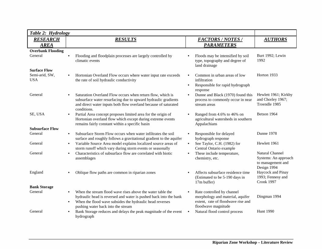
Riparian Zone Workshop – Literature Review
Table 2: HydrologyRESEARCH
AREARESULTS FACTORS / NOTES /
PARAMETERSAUTHORS
Overbank FloodingGeneral • Flooding and floodplain processes are largely controlled by
climatic events• Floods may be intensified by soil
type, topography and degree ofland drainage
Burt 1992; Lewin1992
Surface Flow Semi-arid, SW,USA
• Hortonian Overland Flow occurs where water input rate exceedsthe rate of soil hydraulic conductivity
• Common in urban areas of lowinfiltration
• Responsible for rapid hydrographresponse
Horton 1933
General • Saturation Overland Flow occurs when return flow, which issubsurface water resurfacing due to upward hydraulic gradientsand direct water inputs both flow overland because of saturatedconditions.
• Dunne and Black (1970) found thisprocess to commonly occur in nearstream areas
Hewlett 1961; Kirkbyand Chorley 1967;Troendle 1985
SE, USA • Partial Area concept proposes limited area for the origin ofHortonian overland flow which except during extreme eventsremains fairly constant within a specific basin
• Ranged from 4.6% to 46% onagricultural watersheds in southernAppalachians
Betson 1964
Subsurface Flow General • Subsurface Storm Flow occurs when water infiltrates the soil
surface and roughly follows a gravitational gradient to the aquifer• Responsible for delayed
hydrograph response Dunne 1978
General • Variable Source Area model explains localized source areas ofstorm runoff which vary during storm events or seasonally
• See Taylor, C.H. (1982) forCentral Ontario example
Hewlett 1961
General • Characteristics of subsurface flow are correlated with bioticassemblages
• These include temperature,chemistry, etc.
Natural ChannelSystems: An approachto management andDesign 1994
England • Oblique flow paths are common in riparian zones • Affects subsurface residence time(Estimated to be 5-190 days in17m buffer)
Haycock and Pinay1993; Fennesy andCronk 1997
Bank Storage General • When the stream flood wave rises above the water table the
hydraulic head is reversed and water is pushed back into the bank• When the flood wave subsides the hydraulic head reverses
pushing water back into the stream
• Rate controlled by channelmorphology and material, aquiferextent, rate of floodwave rise andfloodwave magnitude
Dingman 1994
General • Bank Storage reduces and delays the peak magnitude of the eventhydrograph
• Natural flood control process Hunt 1990
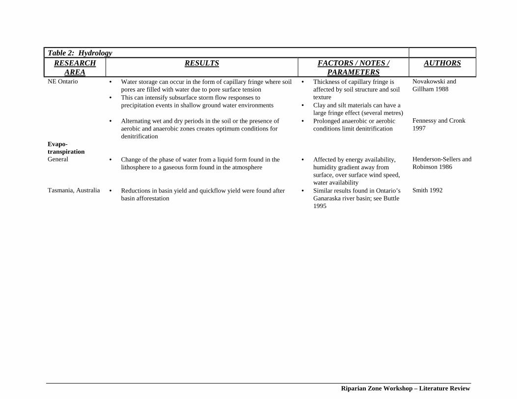
Riparian Zone Workshop – Literature Review
Table 2: HydrologyRESEARCH
AREARESULTS FACTORS / NOTES /
PARAMETERSAUTHORS
NE Ontario • Water storage can occur in the form of capillary fringe where soilpores are filled with water due to pore surface tension
• This can intensify subsurface storm flow responses toprecipitation events in shallow ground water environments
• Thickness of capillary fringe isaffected by soil structure and soiltexture
• Clay and silt materials can have alarge fringe effect (several metres)
Novakowski andGillham 1988
• Alternating wet and dry periods in the soil or the presence ofaerobic and anaerobic zones creates optimum conditions fordenitrification
• Prolonged anaerobic or aerobicconditions limit denitrification
Fennessy and Cronk1997
Evapo-transpirationGeneral • Change of the phase of water from a liquid form found in the
lithosphere to a gaseous form found in the atmosphere• Affected by energy availability,
humidity gradient away fromsurface, over surface wind speed,water availability
Henderson-Sellers andRobinson 1986
Tasmania, Australia • Reductions in basin yield and quickflow yield were found afterbasin afforestation
• Similar results found in Ontario’sGanaraska river basin; see Buttle1995
Smith 1992
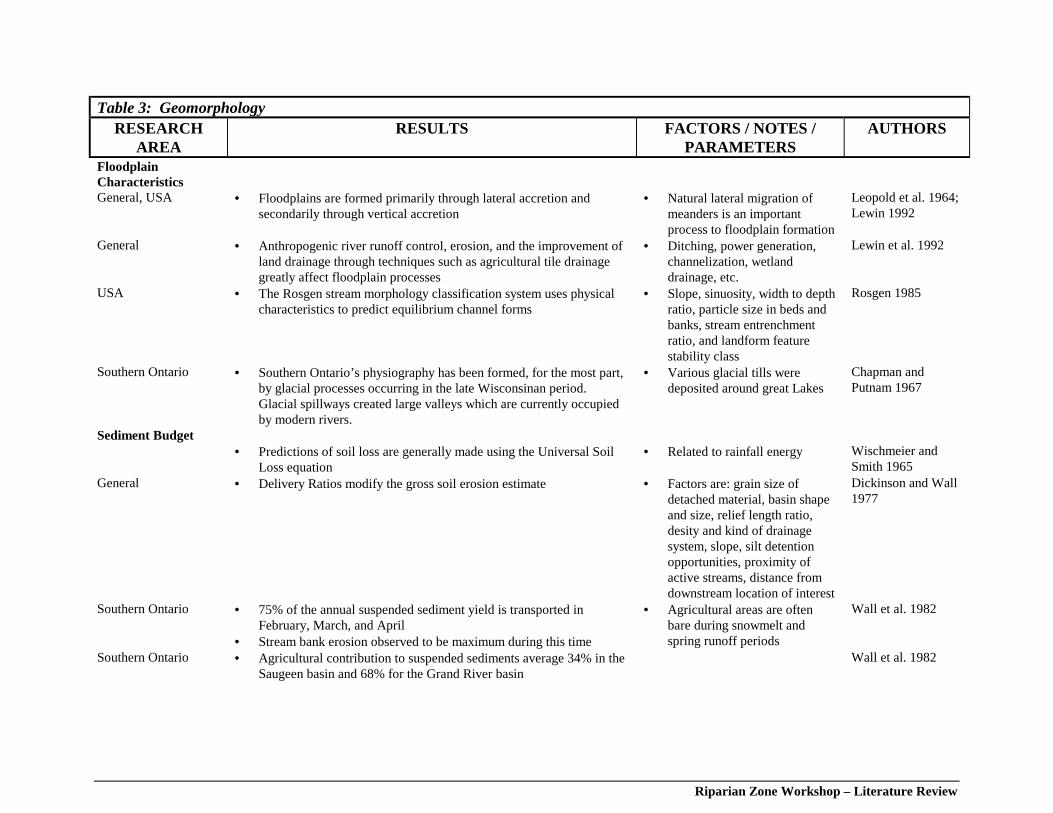
Riparian Zone Workshop – Literature Review
Table 3: Geomorphology RESEARCH
AREA RESULTS FACTORS / NOTES /
PARAMETERS AUTHORS
FloodplainCharacteristics
General, USA • Floodplains are formed primarily through lateral accretion andsecondarily through vertical accretion
• Natural lateral migration ofmeanders is an importantprocess to floodplain formation
Leopold et al. 1964;Lewin 1992
General • Anthropogenic river runoff control, erosion, and the improvement ofland drainage through techniques such as agricultural tile drainagegreatly affect floodplain processes
• Ditching, power generation,channelization, wetlanddrainage, etc.
Lewin et al. 1992
USA • The Rosgen stream morphology classification system uses physicalcharacteristics to predict equilibrium channel forms
• Slope, sinuosity, width to depthratio, particle size in beds andbanks, stream entrenchmentratio, and landform featurestability class
Rosgen 1985
Southern Ontario • Southern Ontario’s physiography has been formed, for the most part,by glacial processes occurring in the late Wisconsinan period.Glacial spillways created large valleys which are currently occupiedby modern rivers.
• Various glacial tills weredeposited around great Lakes
Chapman andPutnam 1967
Sediment Budget • Predictions of soil loss are generally made using the Universal Soil
Loss equation• Related to rainfall energy Wischmeier and
Smith 1965 General • Delivery Ratios modify the gross soil erosion estimate • Factors are: grain size of
detached material, basin shapeand size, relief length ratio,desity and kind of drainagesystem, slope, silt detentionopportunities, proximity ofactive streams, distance fromdownstream location of interest
Dickinson and Wall1977
Southern Ontario • 75% of the annual suspended sediment yield is transported inFebruary, March, and April
• Stream bank erosion observed to be maximum during this time
• Agricultural areas are oftenbare during snowmelt andspring runoff periods
Wall et al. 1982
Southern Ontario • Agricultural contribution to suspended sediments average 34% in theSaugeen basin and 68% for the Grand River basin
Wall et al. 1982
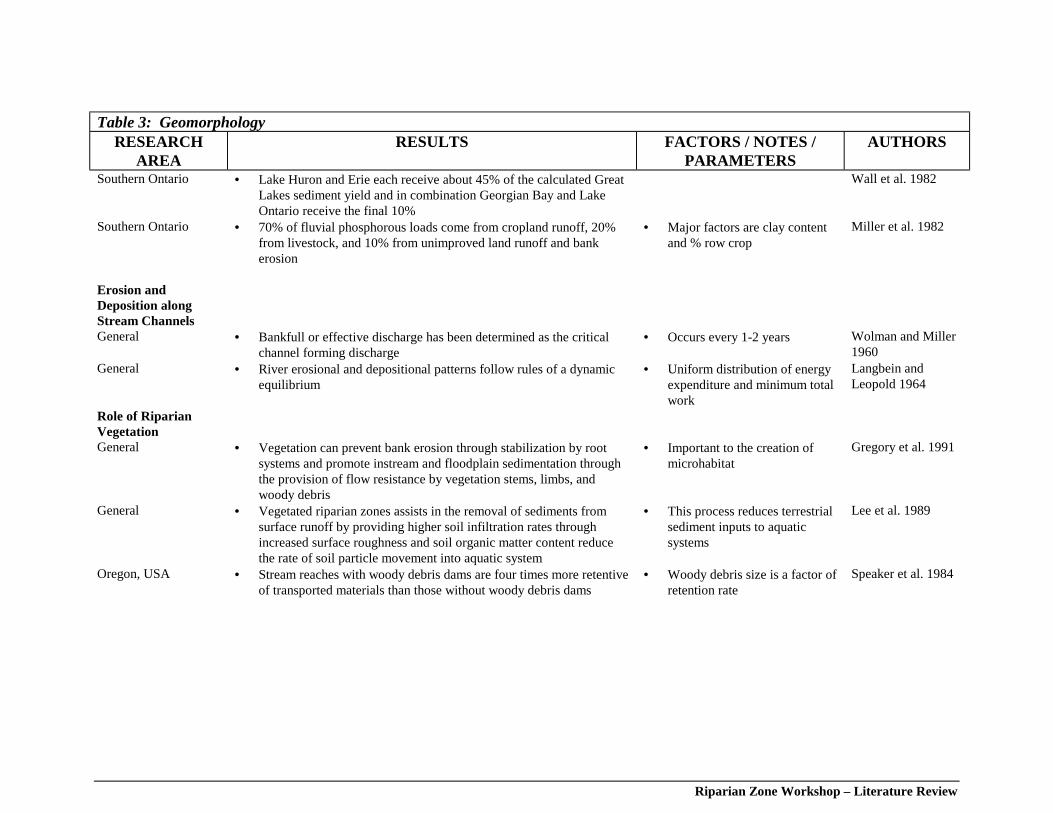
Riparian Zone Workshop – Literature Review
Table 3: Geomorphology RESEARCH
AREA RESULTS FACTORS / NOTES /
PARAMETERS AUTHORS
Southern Ontario • Lake Huron and Erie each receive about 45% of the calculated GreatLakes sediment yield and in combination Georgian Bay and LakeOntario receive the final 10%
Wall et al. 1982
Southern Ontario • 70% of fluvial phosphorous loads come from cropland runoff, 20%from livestock, and 10% from unimproved land runoff and bankerosion
• Major factors are clay contentand % row crop
Miller et al. 1982
Erosion andDeposition alongStream Channels
General • Bankfull or effective discharge has been determined as the criticalchannel forming discharge
• Occurs every 1-2 years Wolman and Miller1960
General • River erosional and depositional patterns follow rules of a dynamicequilibrium
• Uniform distribution of energyexpenditure and minimum totalwork
Langbein andLeopold 1964
Role of RiparianVegetation
General • Vegetation can prevent bank erosion through stabilization by rootsystems and promote instream and floodplain sedimentation throughthe provision of flow resistance by vegetation stems, limbs, andwoody debris
• Important to the creation ofmicrohabitat
Gregory et al. 1991
General • Vegetated riparian zones assists in the removal of sediments fromsurface runoff by providing higher soil infiltration rates throughincreased surface roughness and soil organic matter content reducethe rate of soil particle movement into aquatic system
• This process reduces terrestrialsediment inputs to aquaticsystems
Lee et al. 1989
Oregon, USA • Stream reaches with woody debris dams are four times more retentiveof transported materials than those without woody debris dams
• Woody debris size is a factor ofretention rate
Speaker et al. 1984
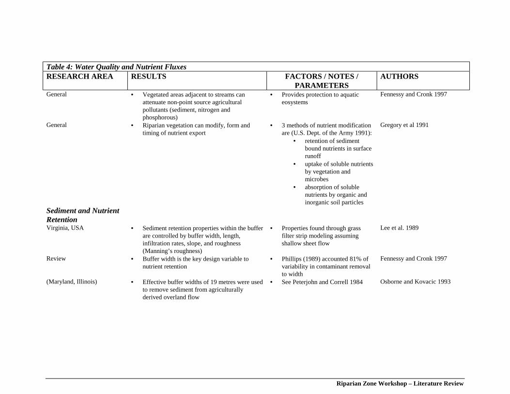
Riparian Zone Workshop – Literature Review
Table 4: Water Quality and Nutrient Fluxes RESEARCH AREA RESULTS FACTORS / NOTES /
PARAMETERS AUTHORS
General • Vegetated areas adjacent to streams canattenuate non-point source agriculturalpollutants (sediment, nitrogen andphosphorous)
• Provides protection to aquaticeosystems
Fennessy and Cronk 1997
General • Riparian vegetation can modify, form andtiming of nutrient export
• 3 methods of nutrient modificationare (U.S. Dept. of the Army 1991):
• retention of sedimentbound nutrients in surfacerunoff
• uptake of soluble nutrientsby vegetation andmicrobes
• absorption of solublenutrients by organic andinorganic soil particles
Gregory et al 1991
Sediment and NutrientRetention
Virginia, USA • Sediment retention properties within the bufferare controlled by buffer width, length,infiltration rates, slope, and roughness(Manning’s roughness)
• Properties found through grassfilter strip modeling assumingshallow sheet flow
Lee et al. 1989
Review • Buffer width is the key design variable tonutrient retention
• Phillips (1989) accounted 81% ofvariability in contaminant removalto width
Fennessy and Cronk 1997
(Maryland, Illinois) • Effective buffer widths of 19 metres were usedto remove sediment from agriculturallyderived overland flow
• See Peterjohn and Correll 1984 Osborne and Kovacic 1993
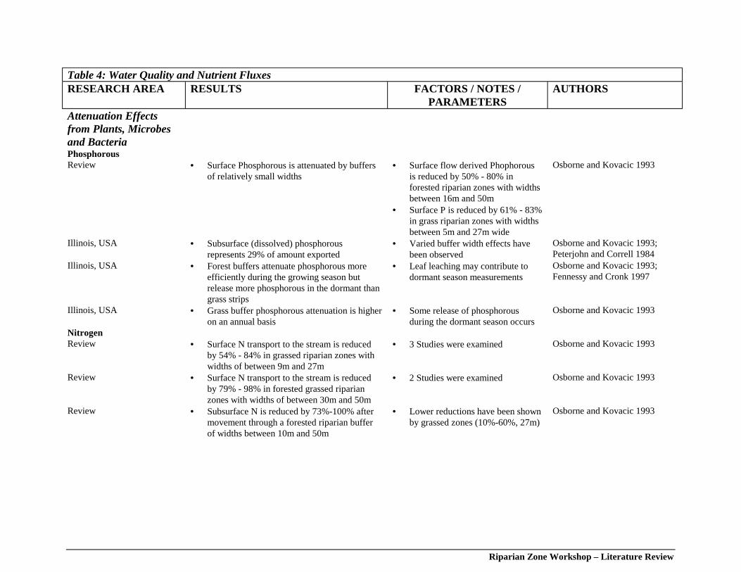
Riparian Zone Workshop – Literature Review
Table 4: Water Quality and Nutrient Fluxes RESEARCH AREA RESULTS FACTORS / NOTES /
PARAMETERS AUTHORS
Attenuation Effectsfrom Plants, Microbesand Bacteria
Phosphorous Review • Surface Phosphorous is attenuated by buffers
of relatively small widths• Surface flow derived Phophorous
is reduced by 50% - 80% inforested riparian zones with widthsbetween 16m and 50m
• Surface P is reduced by 61% - 83%in grass riparian zones with widthsbetween 5m and 27m wide
Osborne and Kovacic 1993
Illinois, USA • Subsurface (dissolved) phosphorousrepresents 29% of amount exported
• Varied buffer width effects havebeen observed
Osborne and Kovacic 1993;Peterjohn and Correll 1984
Illinois, USA • Forest buffers attenuate phosphorous moreefficiently during the growing season butrelease more phosphorous in the dormant thangrass strips
• Leaf leaching may contribute todormant season measurements
Osborne and Kovacic 1993;Fennessy and Cronk 1997
Illinois, USA • Grass buffer phosphorous attenuation is higheron an annual basis
• Some release of phosphorousduring the dormant season occurs
Osborne and Kovacic 1993
Nitrogen Review • Surface N transport to the stream is reduced
by 54% - 84% in grassed riparian zones withwidths of between 9m and 27m
• 3 Studies were examined Osborne and Kovacic 1993
Review • Surface N transport to the stream is reducedby 79% - 98% in forested grassed riparianzones with widths of between 30m and 50m
• 2 Studies were examined Osborne and Kovacic 1993
Review • Subsurface N is reduced by 73%-100% aftermovement through a forested riparian bufferof widths between 10m and 50m
• Lower reductions have been shownby grassed zones (10%-60%, 27m)
Osborne and Kovacic 1993
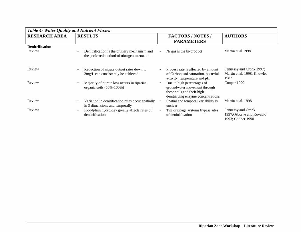
Riparian Zone Workshop – Literature Review
Table 4: Water Quality and Nutrient Fluxes RESEARCH AREA RESULTS FACTORS / NOTES /
PARAMETERS AUTHORS
Denitrification Review • Denitrification is the primary mechanism and
the preferred method of nitrogen attenuation• N2 gas is the bi-product Martin et al 1998
Review • Reduction of nitrate output rates down to2mg/L can consistently be achieved
• Process rate is affected by amountof Carbon, sol saturation, bacterialactivity, temperature and pH
Fennessy and Cronk 1997;Martin et al. 1998; Knowles1982
Review • Majority of nitrate loss occurs in riparianorganic soils (56%-100%)
• Due to high percentages ofgroundwater movement throughthese soils and their highdenitrifying enzyme concentrations
Cooper 1990
Review • Variation in denitification rates occur spatiallyin 3 dimensions and temporally
• Spatial and temporal variability isunclear
Martin et al. 1998
Review • Floodplain hydrology greatly affects rates ofdenitrification
• Tile drainage systems bypass sitesof denitrification
Fennessy and Cronk1997;Osborne and Kovacic1993; Cooper 1990
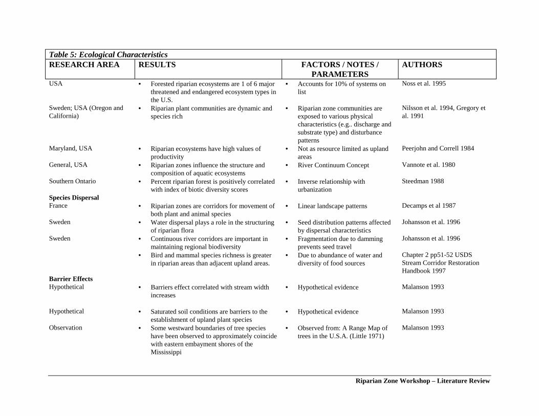
Riparian Zone Workshop – Literature Review
Table 5: Ecological Characteristics RESEARCH AREA RESULTS FACTORS / NOTES /
PARAMETERS AUTHORS
USA • Forested riparian ecosystems are 1 of 6 majorthreatened and endangered ecosystem types inthe U.S.
• Accounts for 10% of systems onlist
Noss et al. 1995
Sweden; USA (Oregon andCalifornia)
• Riparian plant communities are dynamic andspecies rich
• Riparian zone communities areexposed to various physicalcharacteristics (e.g.. discharge andsubstrate type) and disturbancepatterns
Nilsson et al. 1994, Gregory etal. 1991
Maryland, USA • Riparian ecosystems have high values ofproductivity
• Not as resource limited as uplandareas
Peerjohn and Correll 1984
General, USA • Riparian zones influence the structure andcomposition of aquatic ecosystems
• River Continuum Concept Vannote et al. 1980
Southern Ontario • Percent riparian forest is positively correlatedwith index of biotic diversity scores
• Inverse relationship withurbanization
Steedman 1988
Species Dispersal France • Riparian zones are corridors for movement of
both plant and animal species• Linear landscape patterns Decamps et al 1987
Sweden • Water dispersal plays a role in the structuringof riparian flora
• Seed distribution patterns affectedby dispersal characteristics
Johansson et al. 1996
Sweden • Continuous river corridors are important inmaintaining regional biodiversity
• Fragmentation due to dammingprevents seed travel
Johansson et al. 1996
• Bird and mammal species richness is greaterin riparian areas than adjacent upland areas.
• Due to abundance of water anddiversity of food sources
Chapter 2 pp51-52 USDSStream Corridor RestorationHandbook 1997
Barrier Effects Hypothetical • Barriers effect correlated with stream width
increases• Hypothetical evidence Malanson 1993
Hypothetical • Saturated soil conditions are barriers to the
establishment of upland plant species• Hypothetical evidence Malanson 1993
Observation • Some westward boundaries of tree specieshave been observed to approximately coincidewith eastern embayment shores of theMississippi
• Observed from: A Range Map oftrees in the U.S.A. (Little 1971)
Malanson 1993
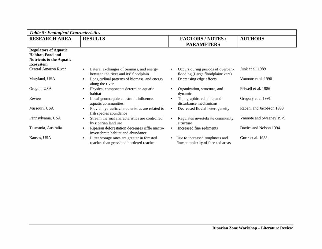
Riparian Zone Workshop – Literature Review
Table 5: Ecological Characteristics RESEARCH AREA RESULTS FACTORS / NOTES /
PARAMETERS AUTHORS
Regulators of AquaticHabitat, Food andNutrients to the AquaticEcosystem
Central Amazon River • Lateral exchanges of biomass, and energybetween the river and its’ floodplain
• Occurs during periods of overbankflooding (Large floodplainrivers)
Junk et al. 1989
Maryland, USA • Longitudinal patterns of biomass, and energyalong the river
• Decreasing edge effects Vannote et al. 1990
Oregon, USA • Physical components determine aquatichabitat
• Organization, structure, anddynamics
Frissell et al. 1986
Review • Local geomorphic constraint influencesaquatic communities
• Topographic, edaphic, anddisturbance mechanisms.
Gregory et al 1991
Missouri, USA • Fluvial hydraulic characteristics are related tofish species abundance
• Decreased fluvial heterogeneity Rabeni and Jacobson 1993
Pennsylvania, USA • Stream thermal characteristics are controlledby riparian land use
• Regulates invertebrate communitystructure
Vannote and Sweeney 1979
Tasmania, Australia • Riparian deforestation decreases riffle macro-invertebrate habitat and abundance
• Increased fine sediments Davies and Nelson 1994
Kansas, USA • Litter storage rates are greater in forestedreaches than grassland bordered reaches
• Due to increased roughness andflow complexity of forested areas
Gurtz et al. 1988

Riparian Zone Workshop – Literature Review
Table 6: A proposed hierarchy for the determination of the scale of measurement for geographic, geomorphic and biotic data collection and analysis withinwatershed systems (some elements modified or adapted from Frissell et al. 1986).
System Level
Linearspatial
scale (m)
Arealspatial
scale (m2) Areal and profile boundaries
Time scaleof
continuouspotential
persistence(years)
Time scale ofpersistence
under humandisturbance
patterns(years)
BioticAssemblage
Scale
Life Activityand scale(variable
time)
Watershed 105 1010 Drainage divides between tertiary watersheds 106-105 104-103 communityspecies
(migratory)
life cyclelife cycle(<20 yrs.)
Subwatershed 104 108 Drainage boundaries of quaternary watersheds withintertiary drainage basins
104-103 102-101 community/species
life cycle(1-8 yrs.)
Reach 103-101 105 Minimum of two full channel wavelengths, and defined byas a specific stream type based on the Rosgen (1993)classification. Active profile boundaries up to 1:20yr flowelevation, passive boundaries to 1:100yr flow elevation.
102-101 101-100 species life cycle/life stage
(0.1-8 yrs.)
Site 101-100 102 Channel segment comprising either a riffle or pool, profileincluding bankside riparian vegetation up to bankfullelevation
100 100-10-1 individual life stage(0.1-0.4 yrs.)
Habitatelement
100-10-1 101 Zones of variable substrate types or characteristics, watervelocity and depth within either a pool, step or riffle.
100-10-1 10-1-10-2 individual activity(10-3-0.1 yrs.)
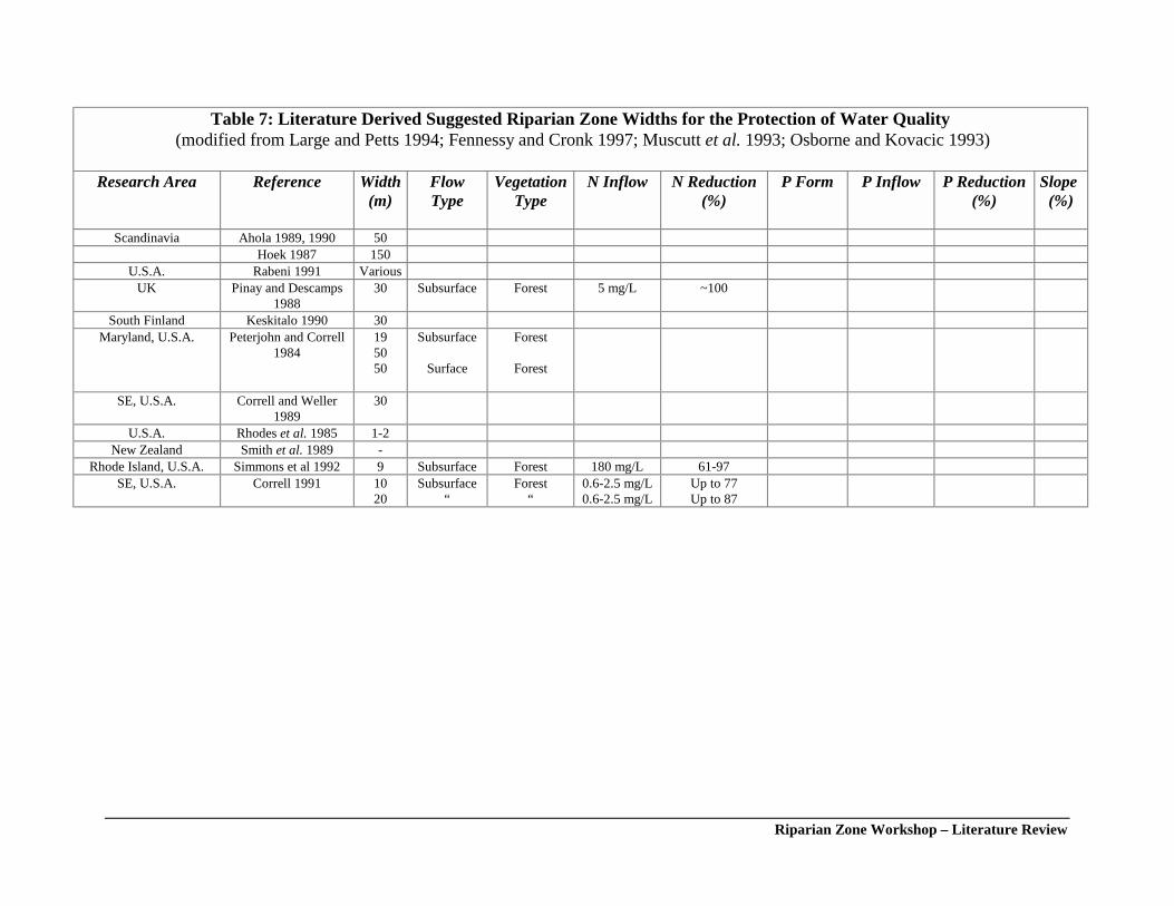
Riparian Zone Workshop – Literature Review
Table 7: Literature Derived Suggested Riparian Zone Widths for the Protection of Water Quality (modified from Large and Petts 1994; Fennessy and Cronk 1997; Muscutt et al. 1993; Osborne and Kovacic 1993)
Research Area Reference Width(m)
FlowType
VegetationType
N Inflow N Reduction(%)
P Form P Inflow P Reduction(%)
Slope(%)
Scandinavia Ahola 1989, 1990 50Hoek 1987 150
U.S.A. Rabeni 1991 VariousUK Pinay and Descamps
198830 Subsurface Forest 5 mg/L ~100
South Finland Keskitalo 1990 30Maryland, U.S.A. Peterjohn and Correll
1984195050
Subsurface
Surface
Forest
Forest
SE, U.S.A. Correll and Weller1989
30
U.S.A. Rhodes et al. 1985 1-2New Zealand Smith et al. 1989 -
Rhode Island, U.S.A. Simmons et al 1992 9 Subsurface Forest 180 mg/L 61-97SE, U.S.A. Correll 1991 10
20Subsurface
“Forest
“0.6-2.5 mg/L0.6-2.5 mg/L
Up to 77Up to 87
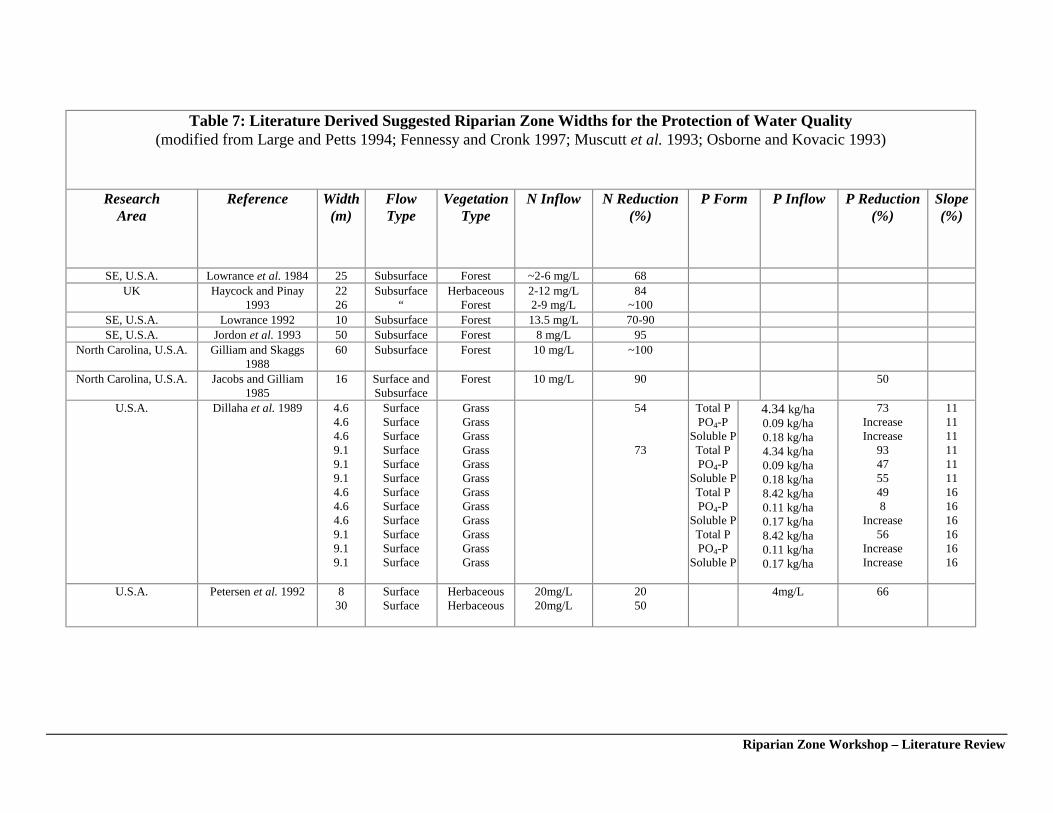
Riparian Zone Workshop – Literature Review
Table 7: Literature Derived Suggested Riparian Zone Widths for the Protection of Water Quality(modified from Large and Petts 1994; Fennessy and Cronk 1997; Muscutt et al. 1993; Osborne and Kovacic 1993)
ResearchArea
Reference Width(m)
FlowType
VegetationType
N Inflow N Reduction(%)
P Form P Inflow P Reduction(%)
Slope(%)
SE, U.S.A. Lowrance et al. 1984 25 Subsurface Forest ~2-6 mg/L 68UK Haycock and Pinay
19932226
Subsurface“
HerbaceousForest
2-12 mg/L2-9 mg/L
84~100
SE, U.S.A. Lowrance 1992 10 Subsurface Forest 13.5 mg/L 70-90SE, U.S.A. Jordon et al. 1993 50 Subsurface Forest 8 mg/L 95
North Carolina, U.S.A. Gilliam and Skaggs1988
60 Subsurface Forest 10 mg/L ~100
North Carolina, U.S.A. Jacobs and Gilliam1985
16 Surface andSubsurface
Forest 10 mg/L 90 50
U.S.A. Dillaha et al. 1989 4.64.64.69.19.19.14.64.64.69.19.19.1
SurfaceSurfaceSurfaceSurfaceSurfaceSurfaceSurfaceSurfaceSurfaceSurfaceSurfaceSurface
GrassGrassGrassGrassGrassGrassGrassGrassGrassGrassGrassGrass
54
73
Total PPO4-P
Soluble PTotal PPO4-P
Soluble PTotal PPO4-P
Soluble PTotal PPO4-P
Soluble P
4.34 kg/ha0.09 kg/ha0.18 kg/ha4.34 kg/ha0.09 kg/ha0.18 kg/ha8.42 kg/ha0.11 kg/ha0.17 kg/ha8.42 kg/ha0.11 kg/ha0.17 kg/ha
73IncreaseIncrease
934755498
Increase56
IncreaseIncrease
111111111111161616161616
U.S.A. Petersen et al. 1992 830
SurfaceSurface
HerbaceousHerbaceous
20mg/L20mg/L
2050
4mg/L 66
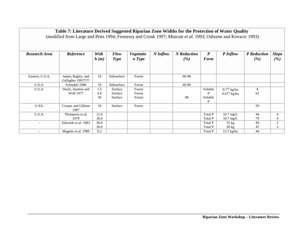
Riparian Zone Workshop – Literature Review
Table 7: Literature Derived Suggested Riparian Zone Widths for the Protection of Water Quality (modified from Large and Petts 1994; Fennessy and Cronk 1997; Muscutt et al. 1993; Osborne and Kovacic 1993)
Research Area Reference Width (m)
FlowType
Vegetation Type
N Inflow N Reduction(%)
PForm
P Inflow P Reduction(%)
Slope(%)
Eastern, U.S.A. James, Bagley, andGallagher 199?????
10 Subsurface Forest 60-98
U.S.A. Schnabel 1986 19 Subsurface Forest 40-90U.S.A. Doyle, Stanton and
Wolf 19771.54.030
SurfaceSurfaceSurface
ForestForestForest 98
SolubleP
SolubleP
0.77 kg/ha0.077 kg/ha
862
U.SA. Cooper and Gilliam1987
16 Surface Forest 50
U.S.A. Thompson et al.1978
12.036.0
Total PTotal P
10.7 mg/L10.7 mg/L
4470
44
- Edwards et al. 1983 30.030.0
Total PTotal P
55 kg28 kg
4947
22
- Magette et al. 1989 9.2 Total P 13.7 kg/ha 44