restoration of giant panda habitat in southwest sichuan, china€¦ · · 2014-11-11restoration...
TRANSCRIPT
Restoration of Giant Panda Habitat in Southwest Sichuan, China
Documents Prepared by:
The Nature Conservancy China Program
Project title Restoration of Giant Panda Habitat in Southwest
Sichuan, China
Version 02
Date of Issue NA
Prepared by Dr. Zhang Xiaoquan
Contact TNC CHINA Beijing Office
B4-2, Qijiayuan Diplomatic Compound,
9 Jianwai Dajie,
Chaoyang District,
Beijing,
PR China 100600
Tel: + 86.8531.9588
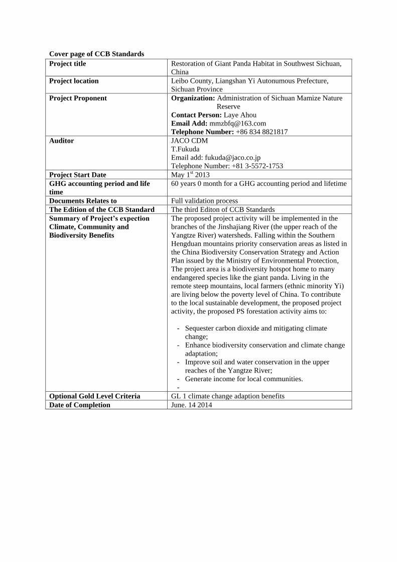
Cover page of CCB Standards
Project title Restoration of Giant Panda Habitat in Southwest Sichuan,
China
Project location Leibo County, Liangshan Yi Autonumous Prefecture,
Sichuan Province
Project Proponent Organization: Administration of Sichuan Mamize Nature
Reserve
Contact Person: Laye Ahou
Email Add: [email protected]
Telephone Number: +86 834 8821817
Auditor JACO CDM
T.Fukuda
Email add: [email protected]
Telephone Number: +81 3-5572-1753
Project Start Date May 1st 2013
GHG accounting period and life
time
60 years 0 month for a GHG accounting period and lifetime
Documents Relates to Full validation process
The Edition of the CCB Standard The third Editon of CCB Standards
Summary of Project’s expection
Climate, Community and
Biodiversity Benefits
The proposed project activity will be implemented in the
branches of the Jinshajiang River (the upper reach of the
Yangtze River) watersheds. Falling within the Southern
Hengduan mountains priority conservation areas as listed in
the China Biodiversity Conservation Strategy and Action
Plan issued by the Ministry of Environmental Protection,
The project area is a biodiversity hotspot home to many
endangered species like the giant panda. Living in the
remote steep mountains, local farmers (ethnic minority Yi)
are living below the poverty level of China. To contribute
to the local sustainable development, the proposed project
activity, the proposed PS forestation activity aims to:
- Sequester carbon dioxide and mitigating climate
change;
- Enhance biodiversity conservation and climate change
adaptation;
- Improve soil and water conservation in the upper
reaches of the Yangtze River;
- Generate income for local communities.
-
Optional Gold Level Criteria GL 1 climate change adaption benefits
Date of Completion June. 14 2014
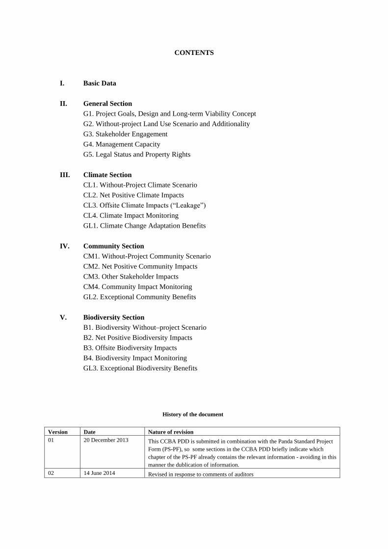
CONTENTS
I. Basic Data
II. General Section
G1. Project Goals, Design and Long-term Viability Concept
G2. Without-project Land Use Scenario and Additionality
G3. Stakeholder Engagement
G4. Management Capacity
G5. Legal Status and Property Rights
III. Climate Section
CL1. Without-Project Climate Scenario
CL2. Net Positive Climate Impacts
CL3. Offsite Climate Impacts (“Leakage”)
CL4. Climate Impact Monitoring
GL1. Climate Change Adaptation Benefits
IV. Community Section
CM1. Without-Project Community Scenario
CM2. Net Positive Community Impacts
CM3. Other Stakeholder Impacts
CM4. Community Impact Monitoring
GL2. Exceptional Community Benefits
V. Biodiversity Section
B1. Biodiversity Without–project Scenario
B2. Net Positive Biodiversity Impacts
B3. Offsite Biodiversity Impacts
B4. Biodiversity Impact Monitoring
GL3. Exceptional Biodiversity Benefits
History of the document
Version Date Nature of revision
01 20 December 2013 This CCBA PDD is submitted in combination with the Panda Standard Project
Form (PS-PF), so some sections in the CCBA PDD briefly indicate which
chapter of the PS-PF already contains the relevant information - avoiding in this
manner the dublication of information.
02 14 June 2014 Revised in response to comments of auditors
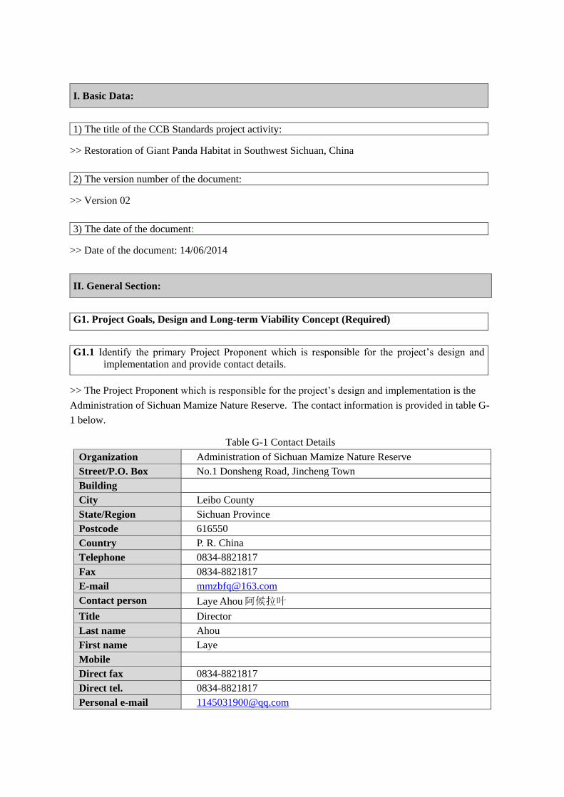
I. Basic Data:
1) The title of the CCB Standards project activity:
>> Restoration of Giant Panda Habitat in Southwest Sichuan, China
2) The version number of the document:
>> Version 02
3) The date of the document:
>> Date of the document: 14/06/2014
G1. Project Goals, Design and Long-term Viability Concept (Required)
G1.1 Identify the primary Project Proponent which is responsible for the project’s design and
implementation and provide contact details.
>> The Project Proponent which is responsible for the project’s design and implementation is the
Administration of Sichuan Mamize Nature Reserve. The contact information is provided in table G-
1 below.
Table G-1 Contact Details
Organization Administration of Sichuan Mamize Nature Reserve
Street/P.O. Box No.1 Donsheng Road, Jincheng Town
Building
City Leibo County
State/Region Sichuan Province
Postcode 616550
Country P. R. China
Telephone 0834-8821817
Fax 0834-8821817
E-mail [email protected]
Contact person Laye Ahou 阿候拉叶
Title Director
Last name Ahou
First name Laye
Mobile
Direct fax 0834-8821817
Direct tel. 0834-8821817
Personal e-mail [email protected]
II. General Section:
G1.2 Define the project’s climate, community and biodiversity objectives.
>> The proposed project activity will be implemented in the branches of the Jinshajiang River (the
upper reach of the Yangtze River) watersheds. Falling within the Southern Hengduan mountains
priority conservation areas as listed in the China Biodiversity Conservation Strategy and Action Plan
issued by the Ministry of Environmental Protection, The project area is a biodiversity hotspot home
to many endangered species like the giant panda. Living in the remote steep mountains, local
farmers (ethnic minority Yi) are living below the poverty level of China. To contribute to the local
sustainable development, the proposed project activity, the proposed forestation activity aims to:
- Sequester carbon dioxide and mitigating climate change;
- Enhance biodiversity conservation and climate change adaptation;
- Improve soil and water conservation in the upper reaches of the Yangtze River;
- Generate income for local communities.
G1.3 Provide the location (country, sub-national jurisdictions(s)) and a brief overview of the basic
physical and social parameters of the project.
Location of the project: see PS-PF section 1.4 for details.
Basic physical parameters: see PS-PF section 1.5.1 for details.
Basic social parameters: The proposed PS project activity is located within Mamize Nature
Reserve in Minzhu Village, Changhe Township, Leibo County, Sichuan Province, China. There is
only one village in the project zone, with 229 residents of 54 households. All villagers are ethnic
minority. Agriculture and husbandry are the main source of income for local communities in the
project area. However, production is subjected to natural disasters such as droughts and floods. Food
productivity is very low and the mean per capita annual income in the project areas is only RMB
502 yuan (US$ 81), which is far below the national poverty line.
G1.4 Define the boundaries of the Project Area where project activities aim to generate net
climate benefits and the Project Zone where project activities are implemented.
>> The shp files of specific geographical positions (longitude, latitude) at each corner of each of 19
parcels, produced by GIS, will be provided to auditor for validation.
The project zone includes Mamize Nature Reserve in Minzhu Village, Changhe Township, Leibo
County, Liangshan Yi Autonomous Prefecture of Sichuan Province. Please also see PS-PF section
1.4 for details.
G1.5 Explain the process of stakeholder identification and analysis used to identify
Communities, Community Groups and Other Stakeholders.
>> PRA processes were adopted in interviewing and consulting with farmer households in the project
zone to understand the local farmers/communities’ preferences, wishes and concerns, so that the
proposed project activity would better respond to their desires for livelihood development.
Comments have also been sought from local government, nature reseres and NGOs. The procedures

and methods applied for the PRA process is detailed in PS-PF section 7.4.1, and the comments
received is summarized in the PS-PF section 7.4.2.
G1.6 List all Communities, Community Groups and Other Stakeholders identified using the
process explained in G 1.5.
>> Communities: Minzhu Village
Other stakeholders: Changhe Townships Government, Forestry Bureau of Leibo County, Sichuan
Forestry Department, Shanshui Conservation Center, The Nature Conservancy.
G1.7 Provide a map identifying the location of Communities and the boundaries of the Project
Area(s), of the Project Zone, including any High Conservation Value areas (identified in
CM1 and B1), and of additional areas that are predicted to be impacted by project
activities identified in CL3, CM3 and B3.
>> The proposed PS project activity is located within Mamize Nature Reserve in Leibo County,
Sichuan Province, with a total area of 500 ha on 19 parcels of lands (Figure G-1 and Figure G-2).
The specific geographical positions (longitude, latitude) at each corner of each of 19 parcels are
provided to DOE during validation as shp files.
Figure G-1 Project location
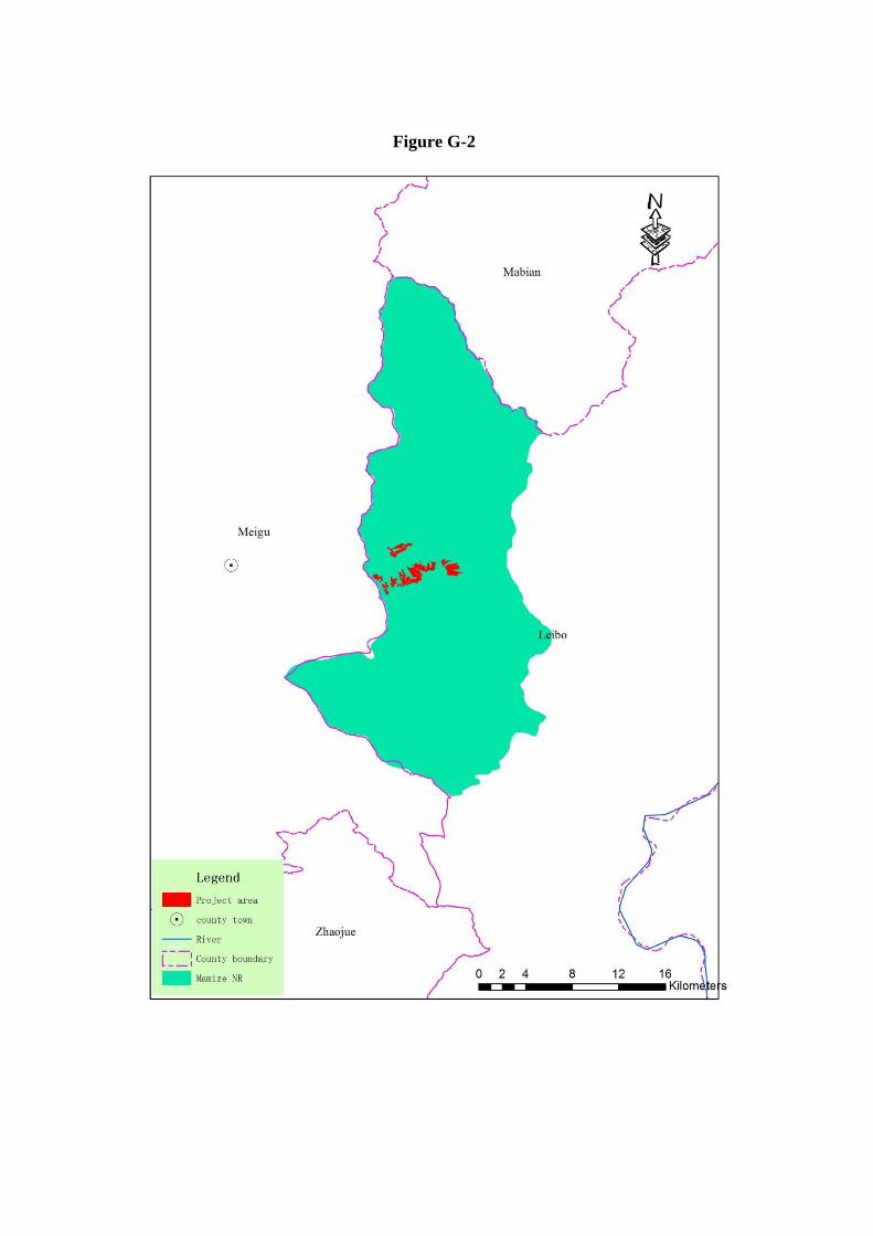
Figure G-2
G1.8 Briefly describe each project activity and the expected outputs, outcomes and impacts of
the activities identifying the causal relationships that explain how the activities will
achieve the project’s predicted climate, community and biodiversity benefits.
>> To achieve the objectives of the proposed project activity, the proposed PS project activity plans
to establish 500 hectare (ha) of forests by direct planting, started from 1 May 2013. The main
planting tree species are spruce (Picea brachytyla (Franch.) Pritz. var. complanata (Mast.) Cheng)
(124.3 ha) and abies (Abies fabri (Mast.) Craib) (375.7 ha). Both species used are native to local,
without any invasive alien species or genetically modified organisms. It is expected to produce
161,881 tCO2 equivalent of emission reduction within 60 years crediting period, with an annual
mean of 2,698 tCO2 equivalent.
Both the operating entity (Mamize Nature Reserve Administration) and local farmers hold a view
that the proposed PS project activity will contribute to enhance biodiversity conservation, reduce soil
erosion and alleviate poverty, thus contribute to sustainable development.
G1.9 Define the project start date and lifetime, and GHG accounting period and biodiversity and
community benefits assessment period if relevant, and explain and justify any differences
between them. Define an implementation schedule, indicating key dates and milestones in
the project’s development.
Starting date: May 1st 2013
Project lifetime: 60 years 0 month
GHG accounting period and biodiversity and community benefits assessment period: 60 years 0
month, same as the project lifetime
Planting period: three years from the project starting date.
Forest management period: from 4th year to the end of the project.
See PS-PF section 1.5.2 for detail techniques for the forestation and forest management.
G1.10 Identify likely natural and human-induced risks26 to the expected climate, community
and biodiversity benefits during the project lifetime and outline measures needed and
taken to mitigate these risks.
>> Risk analysis and countermeasures:
Fire risk: This can be alleviated through:
1) Technical and awareness training to local farmers/communities;
2) Strengthening patrolling and monitoring: 5 permanent patrollers wil be employed
(generally 1 patroller per 100 ha)
3) Enhancing the fire-break belt. This can be incorporated with existing road and temporary
roads construction;
4) Controlling fire source: In the fire-risk season entrance to the project area will be
controlled by establishing entrance approval procedures; and any prescribed burning or
other fire use within or surrounding the project lands shall be approved by local authority.
5) A mixed species arrangements will be adopted to reduce fire risks.
Pest risk: In the project area there has been no outbreak of pest insects and disease in forests
with species to be planted. However, to avoid any pest risk, all seedlings used in the proposed
PS project activities will be bred in local nurseries using seed collected from local seed orchard
or parent trees. All seedlings used shall be certified, quarantined and tagged, i.e., each batch of
seedlings should have quality certificate, quarantine certificate and tag indicating the
production area and quality grade. In addition, there is a complete forest pests monitoring
system from provincial level, county level and town/township level. A mixed species
arrangements will also be adopted to reduce pest risks.
Site preparation: The site preparation will disturb the vegetation and soil in the planting
sites. The main technical measures to be employed in mitigating the impacts are to plant the
trees with low density (1667 trees per hectare), limited small hole site preparation (40 cm in
diameter), retaining the existing vegetation as mush as possible. As a result, the surface area
disturbed by site preparation is estimated to account for 2.1% of the total land surface. The
hole will be dug along the landform contour in triangle form to reduce the soil loss.
Fertilization: In the proposed project activity, no fertilizers will be applied.
Pesticide: improper pesticide application would be harmful to natural environment, including
polluting soil, water and air conditions, as well as the habitat of the wildlife. However under
the proposed project activity, the environmental friendly measures will be adapted such as
mixed species arrangement, seed and seedling quarantine. Especially the biological measures
to control pests and diseases will be adopted. In the project area there has been no outbreak of
pest insects and disease in forests with species to be planted. Therefore, the pesticide
application will not be likely.
Drought: Extreme drought may negatively impact the survival rate of young trees, plantation
productivity (growth rate and timber output), and increase fire risk and pest risk of forest to be
implemented. Countermeasures against this risk include:
1) Those native tree species that are most adaptable to local climatic, soil, water and
temperature conditions will be chosen for the forestation.
2) Primary forests that share the same conditions as those in the project zone will be chosen
as seed trees.
3) The nursery sites will also be located in the vicinity of the planting sites where the
conditions are very much the same.
4) During planting operations, minimal-disturbance planting pits will be prepared. After
planting operations are completed, soils will be timely recovered in the planting pits to
reduce and avoid erosion, and a tiny ridge along down slope side of the pits will be made
to allow more raining water inflow into the pits.
5) In the case of unavoidable natural disasters, rescue measures, such as enrichment planting
will be done in areas where young trees and seedlings are affected so that the loss from
such damages will be minimized to the maximum extent.
None of these risks and/or negative impacts is considered to be significant.
G1.11 Describe the measures needed and taken to maintain and enhance the climate, community
and biodiversity benefits beyond the project lifetime.
>> See description in G.1.10.
G1.12 Demonstrate that financial mechanisms adopted, including actual and projected revenues
from GHG emissions reductions or removals and other sources, provide an adequate
actual and projected flow of funds for project implementation and to achieve the project’s
climate, community and biodiversity benefits..
>> In the proposed project activity, the project proponent will invest in forest establishment
(including site preparation, seedling, planting, weeding, etc.), project preparation (including project
PDD development, validation, registration, verification, etc.) and manage the plantations during the
project lifetime, as well as take the natural and investment risks. The pre-payment of carbon credit at
early stage of the project lifetime will provide an adequate flow of funds for the project
implementation. Therefore, if such financial mechanisms are adopted, it is likely to provide an
adequate flow of funds for project implementation and to achieve the anticipated climate, community
and biodiversi-ty benefits.
G1.13 Specify the Project Area(s) and Communities that may be included under the
programmatic approach, and identify any new Project Area(s) and Communities that have
been included in the project since the last validation or verification against the CCB
Standards
>> N/A
G1.14 Specify the eligibility criteria and process for project expansion under the programmatic
approach and demonstrate that these have been met for any new Project Areas and
Communities that have been included in the project since the last validation or
verification against the CCB Standards.
>> N/A
G1.15 Establish scalability limits,29 if applicable, and describe measures needed and taken to
address any risks to climate, community and biodiversity benefits if the project expands
beyond those limits.
>> N/A
G2. Without-project Land Use Scenario and Additionality (Required)
G2.1 Describe the most likely land-use scenario within the Project Zone in the absence of the
project, describing the range of potential land-use scenarios and the associated drivers of
land use changes and justifying why the land-use scenario selected is most likely.33 It is
allowable for different locations within the Project Zone to have different without-project
land use scenarios
>> Consolidated afforestation and reforestation baseline and monitoring methodology “Afforestation
and reforestation of lands except wetlands” (AR-ACM0003/Version 01.0.0) was followed to identify
the baseline scenario.
The following procedures are used to identify credible alternative land use scenarios to the proposed
PS project activity (refer to PS-PF Section 3):
a) Analyzing the historical and existing land-use / land-cover changes and identifying key factors
that influence the land-use / land-cover change over times: Collected information demonstrates
that the lands to be planted were primary forest in 1950s. However, these forests were destroyed
in 1960s, primarily due to a large scale of commercial logging. In the following decades after
destruction, continuous fuelwood logging as well as overgrazing resulted in continuous
degradation of vegetation. In early 1980s, all project lands were non-forested land and currently
lands are covered by shrub and/or herbaceous plants.
b) Interviews with local farmers and staff from the nature reserve indicate that crown cover of both
tree and non-tree vegetation has been decreasing in recent decades due to commercial logging
followed by overgrazing, and collection of wood for fuel. Soil erosion and stony desertification
have been increasing. Under the current conditions, the land will continue to degrade and soil
erosion as well as stony desertification will accelerate. This will result either in the continued
decrease of the carbon stocks both in living biomass and soils, or at least, maintenance of these
stocks at a low level (see also PS-PF Appendix I.5 for the demonstration of the land
degradation).
c) National, local and sectoral land-use policies or regulations: Since the 1980s, China has
successively issued and revised a series of laws and administrative regulations related to forestry.
These have included, among others, the Regulations for Implementing the Forest Law, the
Regulations for Grain for Green, the Regulations for the Protection of Wild Plants and Animals,
the Regulation for Nature Reserve, the Regulation for Forest Fire Control, and the Regulation
for Forest Diseases and Pests Control, etc. In the 1990s, to encourage forestation, China initiated
a policy that would bring direct benefit to those who planted trees.
To facilitate the restoration of forest resources, the Chinese Government has launched several
programs over the past years, including the Grain for Green Program (started in 2001) that
subsidized farmers to convert cropland on steep slopes to forests (the Grain for Green), the
Intensively Managed Commercial Timber Plantation Base Program (started in 2000), and the
Natural Forest Conservation Program (launched in 1998). However Commercial Timber
Plantation Base Program does not reach to the project counties, and the Natural Forest
Conservation Program is to protect existing natural forest rather than forestation.
d) Regional forestation rate and their relevance to the proposed PS project activity: From 2008 to
2010, 2,848 ha lands have been reforested among which 1,700 ha were planted on cropland
under the Grain for Green Program. The remaining planting were conducted on lands owned by
local communities that have good site conditions and accessibility, for the purpose of timber
plantation and cash tree garden (fruit, chestnut, walnut, etc) which is only viable on, if not
cropland, non-degraded lands with good transportation conditions. There has been not
forestation on state-owned land including lands managed by nature reserves. Therefore, the
forestation in the proposed PS project activity is not the type of or irrelevant to previous
forestation.
The whole project area has been legally planned by local governments for forestry purposes on
which other land uses such as agriculture and grazing are prohibited under China’s well enforced
forest law. Therefore, the identified realistic and credible land-use scenarios that would have
occurred on the land within the proposed project boundary in the absence of the proposed PS project
activity are:
The proposed project not undertaken as a PS project;
Continuation of current barren lands.
G2.2 Document that project benefits including climate, community and biodiversity benefits would
not have occurred in the absence of the project, explaining how existing laws, regulations and
governance arrangements, or lack of laws and regulations and their enforcement, would
likely affect land use and justifying that the benefits being claimed by the project are truly
‘additional’ and would not have occurred without the project. Identify any distinct climate,
community and biodiversity benefits intended for use as offsets and specify how additionality
is established for each of these benefits.
>> Investment barriers indicate that project benefits (the land use scenario “the proposed project not
undertaken as a PS project” as identified in Section G.2.1) would not have occurred in the absence
of the project, as elaborated below.
The project lands are state-owned and managed by Sichuan Mamize Nature Reserve. As a
financially independent accounting enterprise, the nature reserve funded the government can
only maintain the daily management and conservation and there are few alternative funding
sources. There has been no funding for forestation in the reserves for many years. Therefore
they do not have funds available for forestation on these degraded lands in the absence of
the proposed PS project activity.
Debt funding not available for this project activity: There is no opportunity to get long-term
commercial loans from banks for the purpose of forestation in the project area due to the
high risk and the economical unattractiveness of remote, degraded lands.
The Chinese government has been conducting large scale of tree planting campaigns since
the 1980s. In particular, several large-scale forestry programs have been launched in last
decade aiming to restore forest resources. The programs relevant to the project region
include the Grain for Green initiated in 2001, Fast-growth Timber Plantation Program
initiated in 2000, Natural Forest Conservation Program initiated in 1998 and Sheltering
Forest Program in Middle and Upper Reaches of the Yangtze River initiated in late 1980s.
Although these programs had set various overall goals for forestry development, and the
project area is located in the upper reaches of the Yangtze River, few of the programs were
implemented in the remote and severe degraded project area, especially no funding for
forestation in the nature reserve.
The alternative land use scenario “proposed project not undertaken as a PS project” identified can be
eliminated from land use scenarios due to barriers faced. The alternative land use (continued status as
barren land) does not face the above-mentioned barriers.
Agriculture and husbandry are the main source of income for local communities in the project area.
However, production is subjected to natural disasters such as droughts and floods. Food productivity
is very low and the mean per capita annual income in the project areas is only RMB 502 yuan
(US$ 81), which is far below the national poverty line. Due to the consecutive deforestation,
subsequent over-use of fuelwood collection and illegal grazing, most lands are severely degraded and
suffer from serious soil erosions that directly threaten the streams and rivers downstream. Local
communities suffer from drought, flood and other natural hazard. If the current situation remains as it
has been (baseline scenario), the lands will degrade further. The soil erosion, drought and flooding
will become more and more severely, as a result the communities will continue to be poor.
Without project the land-use will be continuation of current barren lands, and the lands will degrade
further. At the same time, the local communities in poverty will bring a higher pressure on the nature
conservation. This will have the huge threat to habitat of wild animals and plants, and negativly
impact the biodiversity.
With the project, the income of local communities would increase and the degradation would be
reverted as a result biodiversity would be enhanced and the nature reserve would be effectively
managed.
G3. Stakeholder Engagement
>>
G3.1 Describe how full project documentation has been made accessible to Communities and Other
Stakeholders, how summary project documentation (including how to access full
documentation) has been actively disseminated to Communities in relevant local or regional
languages, and how widely publicized information meetings have been held with
Communities and Other Stakeholders.
>> The project implementation entity, Administration of Sichuan Mamize Nature Reserve, will take
a lead to distribute key project documents to affected communities and stakeholders (farmer
households, village, county and town/township government). A notification will be prepared in
Chinese. The notification will include following information.
When: starting date and deadline for comments;
Where: path to access the CCB PDD and relevant information;
How: the way to submit comments to CCBA
Sichuan Forestry Department and county forestry bureau will supervise and facilitate the information
distribution. The county forestry bureau in Leibo is the important regional offices. There is a forestry
workstation in each town/township, which is the most grass roots forestry administrative unit and
deal with all of the forestry issues concerned local famer. The workstation always maintains a close
relationship with local community to ensure their management more effective, so as to form a
propaganda and exchange platform of policy and regulations from the national and provincial
government and feedback from communities.
In order to make an easy channel for local forest farmers, public notice boards and community
broadcasts are always used to publicize project information, and some public services counters will
be setup to offer project documentation and publicity material to the local stakeholders. All of project
documentation including summary of CCBA PDD for local stakeholder will be compiled in Chinese.
For illiterate people, oral informing will be applied in addition to broadcast.
One week before the deadline, stakeholders will be reminded by public notice boards and broadcasts
of each community. Participants may submit their comments directly through CCBA website, or
entrust others to submit on behalf of them (especially for illiterate or under-educated farmers).
G3.2 Explain how relevant and adequate information about potential costs, risks and benefits to
Communities has been provided to them in a form they understand and in a timely manner
prior to any decision they may be asked to make with respect to participation in the project.
>>This has been provided during PRA process, see PS-PF section 7.4.1 for detail PRA process.
G3.3 Describe the measures taken, and communications methods used, to explain to Communities
and Other Stakeholders the process for validation and/or verification against the CCB
Standards. by an independent Auditor, providing them with timely information about the
Auditor’s site visit before the site visit occurs and facilitating direct and independent
communication between them or their representatives and the Auditor
>>This has been done during PRA process, see PS-PF section 7.4.1 for detail PRA process.
G3.4 Describe how Communities including all the Community Groups and Other Stakeholders
have influenced project design and implementation through Effective Consultation,
particularly with a view to optimizing Community and Other Stakeholder benefits, respecting
local customs, values and institutions and maintaining high conservation values. Project
proponents must document consultations and indicate if and how the project design and
implementation has been revised based on such input. A plan must be developed and
implemented to continue communication and consultation between the project proponents
and Communities, including all the Community Groups, and Other Stakeholders about the
project and its impacts to facilitate adaptive management throughout the life of the project.
>> To maximize the socio-economic and conservation benefit and respect local customs, the project
was designed with a participatory approach. PRA methods were adopted in interviewing and
consulting with farmer households and nature reserve within and beyond the project area to
understand their preferences, wishes and concerns, so that the proposed project activity would better
respond to their desires for livelihood development, nature conservation and ethnic culture. The
concerns and comments received have been fully considered in the project design. The PRA process,
method and comments and concerned received, and the response are summarized in PS-PF section
7.4.
The local farmers and nature reserve will participate in the project activity throughout the project
lifetime including site preparation, planting, weeding, thinning, harvesting, protection and other
forest management activities, and earning direct benefits during the project lifetime. This ensures the
frequent communication and consultation between project managers and all community groups about
the project and its impacts to facilitate adaptive management throughout the life of the project. In
addition, project stakeholders meeting will be hold at least once a year to facilitate the continuous
communication and consultation.
To ensure the continuance of the communication and consultation process throughout the project
lifetime, following procedures will be implemented:
(1) Staff from the project proponent will periodically communicate with rural community to learn
and solve any concern, conflict, and wishes of local communy and individual farmers;
(2) Forest patrollers employed by the project to conduct daily patrolling on project lands will keep
daily communication with local community, and solve relevant issues if possible. Any
unresolved issues will be reported to the proponent who will immediatly take actions to solve
relevant issues.
(3) The county forestry bureau will conduct periodic communication and consultation with the
project proponent, once a season during forest establishment period (three years after planting)
and thereafter at least once a year during the project lifetime.
G3.5 Demonstrate that all consultations and participatory processes have been undertaken directly
with Communities and Other Stakeholders or through their legitimate representatives,
ensuring adequate levels of information sharing with the members of the groups.
>>See PS-PF Section 7.4.1 for detal PRA process.
G3.6 Describe the measures needed and taken to enable effective participation, as appropriate, of all
Communities, including all the Community Groups, that want and need to be involved in
project design, implementation, monitoring and evaluation throughout the project lifetime,
and describe how they have been implemented in a culturally appropriate and gender
sensitive manner..
>>All farmer households (representatives) have involved the project design (see PS-PF Section 7.4.1
for details) during the PRA process, and participiated in the implementation if wanted. During the
project monitoring and evaluation throughout the project lifetime, similar PRA process will be
carried out.
G3.7 Describe the measures needed and taken to ensure that the project proponent and all other
entities involved in project design and implementation are not involved in or complicit in any
form of discrimination or sexual harassment with respect to the project.

>>During the PRA process, either village meeting and semi-structured interview covered all types of
circumstances, e.g., rich household, poor household, marginalized and distinguished
household, etc. See PS-PF Section 7.4.1 for details.
G3.8 Demonstrate that a clear grievance redress procedure has been formalized to address disputes
with Communities and Other Stakeholders that may arise during project planning,
implementation and evaluation with respect but not limited to, Free, Prior and Informed
Consent, rights to lands, territories and resources, benefit sharing, and participation
>> Corresponding procedures have been formulated to cope with the conflicts and opinions that may
arise amongst the community villagers and other stakeholders in the entire lifetime of the project -
from project development, to project implementation and completion.
(1) Before project implementation starts, experts will be invited to conduct in-depth surveys on
the socio-economics, cultures and histories, ethnic folkways and customs, as well as the
production and livelihood practices in the proposed project areas. They will also project
potential conflicts and grievances that may be encountered during project implementation.
(2) To conduct community surveys, through participatory community interviews and villager
meetings, for an in-depth understanding of the socio-economics, landuse, land tenure,
income sources, status of land resources management, awareness, technical know-how, tree
species of preferences, technology, financial difficulties, farming household participation and
project needs, etc in the communities; and also for identifying the conflicts and grievances
that may potentially arise during project lifetime.
(3) During the project design, the general opinions regarding selection of planting plots, tree
species, forestation techniques and management practise, as well as income sharing
mechanism have been reviewed and adopted when deemed appropriate.
(4) The planting operations and the management of established plantations will avail community
labour. This will allow the community villagers to participate in project implementation and
find out, and seek for solutions to, the conflicts and grievances in the projects.
(5) Those cooperative and supervisory agencies for project implementation, including the
forestry bureau and involved forestry station, the conflicts and grievances arising in the
course of the project will be timely feedbacked and resolved. |
(6) During the project implementation phase, especially after the project design and planting
period, when the project proponent can not keep in touch frequently with all stakeholders,
staff from forest station will periodically contact with rural stakeholder to collect conflicts
and grievances. Forest patrollers employed by project proponent will play an important role
of treating with ordinary conflicts and grievances, and report to township forest stations and
project proponent about unresolved conflicts and grievances. In the same way, the
communities can express their conflicts and grievances to the forest patrollers directly, or to
local forest forest station, in writtern or oral way. Hearing and reporting conflicts and
grievances are one of responsibility of forest patrolling. Upon receiving grievance, project
proponent and local forest agency shall contact and discuss with relevant stakeholders who
have grievance to resolve the grievance. Any unresolved grievance at project proponent level
will be reported to county forestry bureau;
(7) The county forestry bureau, upon receipt of reporting of grievance will immediately
coordinate with project proponent to seek a solution.
(8) A written response to grievances shall be sent to relevant stakeholders within 30 days after
receiving the grievance.
(9) Before the launch of this project, the project proponent has came to an consensus with all
stakeholders to guarantee that either party should undertake an obligation and legal liability
to make this project shape up. So, if there is any conflict or grievance that can not be solved
by negotiation, stakeholders can apply for mediation to the Mediation Committee at village,
township and/or county level. In case mediation can not solve relevant conflict or grievance,
judicial process should be adopted.
There is no third party. The process for hearing responding and resolving stakeholder grievances will
be made available to public on the website of the project proponent. Hard copies of the process plan
will be distributed among local stakeholders by the project proponent, county forestry bureau and
forest station and forest patrollers. At the same time, public notice boards and community broadcasts
will be used to publicize the process. Technical taff from forest station will also explain the process
to local stakeholders, especially to illiterate or under-educated farmers.
G3.9 Describe measures needed and taken to provide orientation and training for the project’s
workers and relevant people from the Communities with an objective of building locally
useful skills and knowledge to increase local participation in project implementation
>> The training to the communities and farmers is an important part of the project activities. The
training aims to build the capacity of community members to actively design, implement, and
monitor project activities. The implementation proponent, project county forestry bureau and its
forestry posts will organize training for local communities to extend the improved forestation
technologies and assist them in understanding and addressing problems during the implementation of
the proposed project activity, both on-site and off-site, which mainly include seed and seedling
selection, nursery management, site preparation, planting and pest and fire management. The
participants have been taught how to participate in project design process through PRA process. The
community representatives conducted field survey with forestry technicians and discussed about tree
species they prefer to plant. Local communities will also be trained through direct participating of the
forest establishment and forest management. Any new employed workers shall be trained. In addition,
the education and training concerning health, safety and security for the farmers will be provided
immediately before on-site activities using instruction developed.
During the project design, a wide range of groups including female, poorers and ethnic minorities
have been invited for consultation process and training. Follow-up training program will be also
given to a range of people expecially under-represented groups. Female, as main labour force in local
communities, and other under-represented groups will have equal opportunity to participate in the
project including labours’ employment and training.
G3.10 Demonstrate that people from the Communities are given an equal opportunity to fill all
work positions (including management) if the job requirements are met. Explain how workers
are selected for positions and where relevant, describe the measures needed and taken to
ensure Community members, including women and vulnerable and/or marginalized people,
are given a fair chance to fill positions for which they can be trained.
>> The proposed project activity will create about 50,000 person-days of temporary employment
opportunities from planting, weeding, thinning, etc. It will also create 5 long-term job positions for
plantation maintenance and management during the project lifetime. Most employment opportunities
will be taken by the local farmers. In case of any position available, information will be posted on
public board of the local village and announced through village broadcast. Any villagers feel free to
apply the posted positions. The ethnic minority groups and female will have equal rights to access the
employment opportunities if the job requirements are met. At the same situation, priority will be
given to members from poor households, ethnic minority and women. In case the number of
positions, e.g., the fixed long-term position for forest patrolling, is limited (less than the number of
applicants), applicants will get the position on rotation basis.
G3.11 Submit a list of all relevant laws and regulations covering worker’s rights in the host country.
Describe measures needed and taken to inform workers about their rights. Provide assurance
that the project meets or exceeds all applicable laws and/or regulations covering worker
rights and, where relevant, demonstrate how compliance is achieved.
>> Rrelevant laws and regulations covering worker’s rights in China include “Labor Law of the
People’s Republic of China” and “China Company Law”. At the time of the employment, a task
contract will be signed with a representative employee (the head of a employee group) following the
Chinese Law for Employment Contract, in which relevant laws and regulations will be mentioned as
the basis of the contract, so that if there is conflict between the employers and workers, the worker
has rights to complain and seek for the local county worker association for arbitration to protect their
interests. The representative employee then will have an oral agreement with each worker in the
group. It should be mentioned that in the culture of the ethnic minority “YI”, oral agreement is a
business-as-usual for the temporary employment.
G3.12 Comprehensively assess situations and occupations that might arise through the
implementation of the project and pose a substantial risk to worker safety. Describe measures
needed and taken to inform workers of risks and to explain how to minimize such risks.
Where worker safety cannot be guaranteed, project proponents must show how the risks are
minimized using best work practices in line with the culture and customary practices of the
communities.
>> Possible risks for the workers include:
Falling rocks triggered during site preparation, transplanting, tending and patrolling may cause
personal injuries;
Forest fires and the suppression operations may bring risks to workers;
All these risks can be minimized by best practices. Safety operation regulations and technical
guidelines will be formulated to copy with possible risks that may harm workers. Training courses
will be organized to raise safety awareness of workers, including teaching workers the best practices
and informing workers of relevant risks and the ways to minimize the risks. All workers shall be
trained before performing specific work. Safety managers will full participate in the filed work to
ensure that such internal control procedures as follow will play a role of avoiding the potential risks:.
A safety assurance staff, which takes charge of safety supervision.
Safety manual will be distributed to workers.
During project implementation, the safety assurance staff will participate in full process of the
supervision of project implementation so that the potential risks can be detected in time and
accidents avoided.
In the field work, it’s prohibited to carry out all kinds of works on a vertical line at the same
time, including soil preparation, tree planting and weeding. Instead, all workers shall work on a
same land contour.
All field works must avoid extreme weather such as in or after rainstorm, extremely high
temperature, and strong wind.
Each working group will be equipped with a portable rescue package to deal with minor injur.
Provide good logistics to ensure that every worker have enough drinking water and food.
G4. Management Capacity
>>
G4.1 Describe the project’s governance structures, and roles and responsibilities of all the entities
involved in project design and implementation.
>> The Administration of Sichuan Mamize Nature Reserve is the project proponent which is
responsible for the project’s design and implementation. However, other organizations and agencies
play important role in the project’s design and implementation, as described below.
Project Design:
As a consultant of the project proponent, The Nature Conservancy (TNC) China technically took a
leading role in the project development by cooperation with Beijing Shanshui Nature Conservation
Center (BSNCC), Sichuan Forestry Inventory and Planning (SFIP), Leibo county forestry bureau.
TNC China: Taking a lead in the overall technical design of the CCB project, coordinating the
project development, training on PS rules and methodology and CCB standard, providing
guidance for baseline survey, and PF and PDD development.
BSNCC: Responsible for coordinating the baseline survey and PRA process, including the
development of relevant SOP of the survey;
SFIP: Responsible for the historic land use map for demonstrating land eligibility, and the
growth curve of the tree species to be planted in proposed project;
County forestry bureau: Responsible for planting and forest management design, providing
logistic support and participating field work of the baseline survey and PRA process, and
coordinating and communicating with local community.
Project Implementation:
The project stakeholders include the Administration of Sichuan Mamize Nature Reserve (ASMNR),
Sichuan Forestry Department (SFD), Forestry Bureau of Liangshan Prefecture, Leibo Forestry
Bureau, local communities surrounding. In addition, The Nature Conservancy (TNC) China
Program, Beijing Shanshui Nature Conservation Center, Sichuan Forestry Inventory and Planning
Institute and Sichuan Research Institute of Forestry will provide technical support and consultation
for the development and implementation of the proposed project.
The responsibilities of relevant stakeholders during the project implementation are described below:
ASMNR: As the project proponent, it will be the implementation proponent of the proposed
project, responsible for domestic approval and international application for registration. Under
the guidance of SFD and by cooperating with county forestry bureau, it takes a lead in
implementing the project activities.
Local communities: The local farmers will earn income through forestation and forest
management related labor.
SFD: SFD will provide guidance for the implementation of the project activities, coordinate
project proponent and project county forestry bureau for supervision and verification, as well
as quality assurance.
Leibo county forestry bureau: Under the supervision and guidance of the Sichuan Forestry
Department and county government, forestry bureau and their forestry stations will be
responsible for guiding forestation and forest management activities in project area, organizing
technical training and instruction and verification, and cooperating on the measuring and
monitoring of emissions reductions.
Other stakeholers: TNC China, BSNCC, SFID and Sichuan Institute of Forestry will provide
technical guidance, consultation and training for the tree planting, forest management and the
measuring and monitoring of emissions reductions.
G4.2 Document key technical skills required to implement the project successfully, including
community engagement, biodiversity assessment and carbon measurement and monitoring
skills. Document the management team’s expertise and prior experience implementing land
management and carbon projects at the scale of this project. If relevant experience is lacking,
the proponents must either demonstrate how other organizations are partnered with to support
the project or have a recruitment strategy to fill the gaps.
>> Key technical skills include techniques for forest establishment and management including
seedlings preparation, site and soil preparation, planting, weeding, forest management, and forest fire
and pest insect and disease control, etc; and skills for biodiversity assessment and carbon
measurement and monitoring.
The project proponent, ASMNR, is a state-owned proponent with major business on forest
management and nature conservation. Over past years it has accumulated rich experience and skill in
forest management and nature reserve management.
The county forestry bureaus and its forestry stations at town/township level have been implementing
forestation, forest management, forestry administration and technical training for local communities,
and have rich experience and skills for forest establishment and management including coordination
with local communities.
TNC China and BSNCC have been working on biodiversity survey and assessment for many years in
China and have developed a set of relevant methods and SOP and accumulated rich experience. TNC
China and BSNCC also worked together for successfully development several CCB and CDM AR
projects in China. They are also involving in the carbon measurement for the first monitoring and
verification of three registered AR CDM projects by providing technical consultation on the SOPs for
field measurement and the carbon credit calculation.
Sichuan Forestry Inventory Institute is responsible for national and local forest inventory in Sichuan
province and has accumulated rich experience in forest inventory..
The Leibo forestry bureau has assisted Sichuan Forestry Inventory Institute in forest inventory and
planning for many years hence accumulated rich relevant experiences.
G4.3 Document the financial health of the implementing organization(s).
>> Administration of Sichuan Mamize Nature Reserve is a financially independent accounting
enterprise, funded the government for the daily management and conservation. In the proposed
project activity, the project proponent will invest in forest establishment (including site preparation,
seedling, planting, weeding, etc.), project preparation (including project PDD development,
validation, registration, verification, etc.) and manage the plantations during the project lifetime, as
well as take the natural and investment risks. The pre-payment of carbon credit at early stage of the
project lifetime will provide an adequate flow of funds for the project implementation. Therefore, if
such financial mechanisms are adopted, it is likely to provide an adequate flow of funds for project
implementation and to achieve the anticipated climate, community and biodiversi-ty benefits.
G5. Legal Status and Property Rights (Required)
>>
G5.1 Describe and map statutory and customary tenure/use/access/management rights to lands,
territories and resources in the Project Zone including individual and collective rights and
including overlapping or conflicting rights. If applicable, describe measures needed and taken
by the project to help to secure statutory rights. Demonstrate that all Property Rights are
recognized, respected, and supported.
>> All project lands are state-owned and managed by the Administration of Sichuan Mamize Nature
Reserve who is also the project proponent. Therefore the project will not encroach uninvited on
private property, community property, or government property.
G5.2 Demonstrate with documented consultations and agreements that a. the project will not
encroach uninvited on private property, community property, or government property, b. the
Free, Prior, and Informed Consent has been obtained of those whose property rights are
affected by the project through a transparent, agreed process. c. appropriate restitution or
compensation has been allocated to any parties whose lands have been or will be affected by
the project
>>See G5.1.
G5.3 Demonstrate that project activities do not lead to involuntary removal or relocation of
Property Rights Holders from their lands or territories, and does not force them to relocate
activities important to their culture or livelihood.
>> The project area is located in remote mountainous regions and lands to be planted are severely
degraded barren lands on which local communities do not rely for their livelihood and culture of the
communities. Therefore, the project will not cause any relocation of people.
G5.4 Identify any illegal activities that could affect the project’s climate, community or biodiversity
impacts (e.g. illegal logging) taking place in the Project Zone and describe measures needed
and taken to reduce these activities so that project benefits are not derived from illegal
activities
>> Currently project lands are state-owned degraded barren lands and are defined for forestry
purpose by local government. There is no pre-project management activity.Therefore no pre-project
activities would affect the project’s climate, community or biodiversity benefits.
G5.5 Identify any ongoing or unresolved conflicts or disputes over rights to lands, territories and
resources and also any disputes that were resolved during the last twenty years where such
records exist, or at least during the last ten years. If applicable, describe measures needed and
taken to resolve conflicts or disputes.64 Demonstrate that no activity is undertaken by the
project that could prejudice the outcome of an unresolved dispute relevant to the project over
lands, territories and resources in the Project Zone.
>> All project lands are state-owned and legally managed by the Administration of Sichuan Mamize
Nature Reserve who is also the project proponents. Therefore the project proponents have clear,
uncontested title to the carbon rights.
G5.6 Submit a list of all national and local laws and regulations in the host country that are relevant
to the project activities. Provide assurance that the project is complying with these and, where
relevant, demonstrate how compliance is achieved
>> China has successively issued and revised a series of laws and administrative regulations related
to forestry. These have included, among others, the Forest Law, the Regulations for Implementing
the Forest Law, the Regulations for Grain for Green, the Regulations for the Protection of Wild
Animals, the Regulations for the Protection of Wild Plants, the Regulation for Nature Reserve, the
Regulation for Forest Fire Control, and the Regulation for Forest Diseases and Pests Control,
Facilitation for Land Tenure Reform of Collective-owned Forestry Land, etc. The recent land tenure
reform policy allows collectively owned lands to be contracted to individual farmer household. The
proposed project will not break relevant laws and regulations. Contrary, this project can help to
facilitate the enforcement of regulations and policies for stopping illegal activities such as grazing.
G5.7 Document that the project has approval from the appropriate authorities, including the
established formal and/or traditional authorities customarily required by the Communities
>> The project proponent was approved by Sichuan Forestry Department and Liangshang Forestry
Bureau (listed in the MOU between TNC and State Forestry Administration).
G5.8 Demonstrate that the Project Proponent(s) has the unconditional, undisputed and
unencumbered ability to claim that the project will or did generate or cause the project’s
climate, community and biodiversity benefits.
>> All project lands are state-owned and legally managed by the project proponents. Therefore the
Project Proponent(s) has the unconditional, undisputed and unencumbered ability to claim that the
project will or did generate or cause the project’s climate, community and biodiversity benefits.
G5.9 Identify the tradable climate, community and biodiversity benefits of the project and
specify how double counting is avoided, particularly for offsets sold on the voluntary
market and generated in a country participating in a compliance mechanism.
>>The carbon credit will be transferred to buyers who pleges a voluntary emition reduction, but will
not use for offsetting of any manadatory climate mitigation compliance either internationally or
domestically.
III. Climate Section
CL1 Without-Project Climate Scenario (Required)
CL1.1 Estimate the total GHG emissions inside the Project Area under the without-project land
use scenario (described in G2) using an Approved or Defensible methodological
approach. The timeframe for this analysis is the project GHG accounting period or the
project lifetime.
>> See PS-PF Section 4.1 for carbon stock changes without the project.
CL2 Net Positive Climate Impacts (Required)
CL2.1 Estimate the total GHG emissions expected from land use activities inside the project area
under the with-project land use scenario using an Approved or Defensible methodological
approach.
>> See PS-PF Section 4.2 for carbon stock changes with the project. There will be no biomass
burning during site preparation, no machinery use, no synthetic fertilizer application as well as no N-
fixing species to be used in the project. Therefore GHG emissions from these emission sources will
not occur.
CL2.2 Demonstrate that the net climate impact of the project is positive. The net climate impact
of the project is the difference between the total GHG emissions or removals in the
withoutproject scenario (including CO2 and non-CO2 GHG emissions) and total GHG
emissions or removals resulting from project activities, minus any project-related negative
offsite climate impacts (‘Leakage’ see CL3).
>> see PS-PF Section 1.6.
CL3 Offsite Climate Impacts (‘Leakage’) (Required)
CL3.1 Determine the types of Leakage that are expected and estimate offsite increases in GHG
emissions due to project activities using an Approved or Defensible methodological
approach. Where relevant, define and justify where Leakage is most likely to take place.
>> Currently all 500 ha of project lands are barren land without any agricultural activity (cropping
and grazing), therefore, the potential leakage due to displacement of pre-project agricultural activities
is zero.
CL3.2 Describe the measures taken to mitigate Leakage.
>> N/A.
CL3.3 Non-CO2 emissions must be included if they are likely to account for more than 20% of
the total Leakage emissions (in terms of CO2-equivalent) following the procedures for
including or excluding non-CO2 emissions described in CL 2.1.
>> No off-site non-CO2 emissions likely occur.
CL4 Climate Impact Monitoring (Required)
CL4.1 Develop and implement a plan for monitoring changes in relevant carbon pools, non-CO2
GHGs and emissions sources and leakage (as identified in CL1, CL2 and CL3).
>> See PS-PF Section 6 for the full monitoring plan. Selected carbon pools and non-CO2 GHGs to
be monitored are presented in table CL-1 and table CL-2 below. The first monitoring will be
conducted in 2018 and the subsequent monitor frequency is once every 5 years after the initial
monitoring.
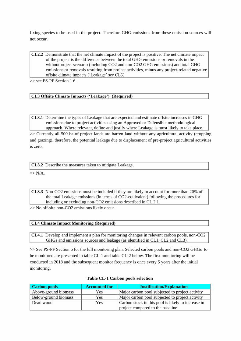
Table CL-1 Carbon pools selection
Carbon pools Accounted for Justification/Explanation
Above-ground biomass Yes Major carbon pool subjected to project activity
Below-ground biomass Yes Major carbon pool subjected to project activity
Dead wood Yes Carbon stock in this pool is likely to increase in
project compared to the baseline.
Carbon pools Accounted for Justification/Explanation
Litter Yes carbon stock in this pool is likely to increase in
project compared to the baseline.
Soil organic carbon Yes carbon stock in this pool is likely to increase in
project compared to the baseline.
Table CL-2 Emission sources and GHGs included in or excluded from accounting
Sources Gas Included/
excluded Justification/Explanation
Burning of
woody biomass
CO2 Excluded Carbon stock decreases due to burning are accounted as a
change in carbon stock
CH4 Included
Burning of woody biomass for the purpose of site
preparation or as part of forest management can lead to
significant levels of emissions of methane
N2O Included
Burning of woody biomass for the purpose of site
preparation or as part of forest management can lead to
significant levels of emissions of nitrous oxide
CL4.2 Disseminate the monitoring plan and any results of monitoring undertaken in accordance
with the monitoring plan, ensuring that they are made publicly available on the internet
and summaries are communicated to the Communities and Other Stakeholders through
appropriate means.
>> The Chinese version of the monitoring plan will be developed upon the completion of the
validation and disseminate within twelve months. The monitoring plan will be made available to
public on the website of the project implementation entity. Hard copies of the monitoring plan will be
distributed among local stakeholders by implementation entity, county forestry bureau and forestry
posts and forest patrollers. At the same time, public notice boards and community broadcasts will be
used to publicize information regarding how to access to the monitoring plan through internet.
Technical staff from county forestry bureau will also explain the monitoring plan to local farmers,
especially to illiterate or under-educated farmers.
GL1. Climate Change Adaptation Benefits (Optional)
GL1.1 Identify likely regional or sub-national climate change and climate variability scenarios
and impacts, using available studies, and identify potential changes in the local land use
scenario due to these climate change scenarios in the absence of the project.
>> Based on the second National Assessment Report of Climate Change in China1, the mean air
temperature in China increased by 0.5-0.80C per 100 years since 1880, and it was 0.23 0C per 10
years from 1951 to 2009. There was no significant change of precipitation in China in last 50 years.
The magnitude and trend of climate changes vary with geographical area. The warming in South
China is much less that North China. Since 1951 the mean air temperature increased by 0.37 0C per
10 years in the Northwest China, 0.300C per 10 years in the Northeat China and 0.22 0C per 10 years
in the North China, while it was 0.12-0.160C per 10 years in the Central and South China. At the
same time, annual precipitation in the North and Northeast China decreased gradually, showing an
apparent increasing trend of temperature and aridity. The intensity and frequency of extreme
1 The Editorial Board of the Second National Assessment Report of Climate Change in China. 2011. The Second National
Assessment Report of Climate Change in China. Chinese Science Press
climatic events (heatwave, snowstorm, rainstorm, drought, etc) increased significant. Especially in
the Southwest China, disasters such as extreme drought, rainstorm, snowstorm and landslide
accounted for 30-40 per cent of the national total. In the north part of China, drought is the
dominant climatic disaster.
By the end of the 21st century, mean air temperature in China will increase by 2.5-4.6 0C, more
significant than global changes. No significant change of precipitation in South China is expected
but intensity and frequency of rainstorm is expected to increase significantly.
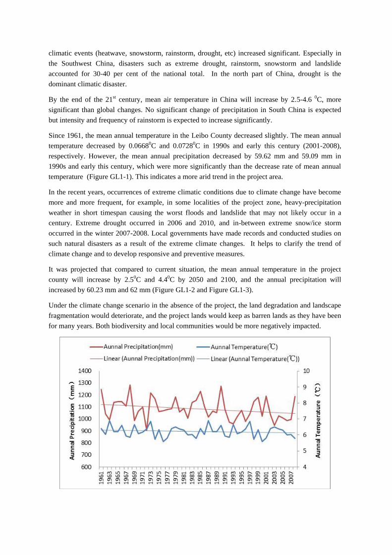
Since 1961, the mean annual temperature in the Leibo County decreased slightly. The mean annual
temperature decreased by 0.06680C and 0.07280C in 1990s and early this century (2001-2008),
respectively. However, the mean annual precipitation decreased by 59.62 mm and 59.09 mm in
1990s and early this century, which were more significantly than the decrease rate of mean annual
temperature (Figure GL1-1). This indicates a more arid trend in the project area.
In the recent years, occurrences of extreme climatic conditions due to climate change have become
more and more frequent, for example, in some localities of the project zone, heavy-precipitation
weather in short timespan causing the worst floods and landslide that may not likely occur in a
century. Extreme drought occurred in 2006 and 2010, and in-between extreme snow/ice storm
occurred in the winter 2007-2008. Local governments have made records and conducted studies on
such natural disasters as a result of the extreme climate changes. It helps to clarify the trend of
climate change and to develop responsive and preventive measures.
It was projected that compared to current situation, the mean annual temperature in the project
county will increase by 2.50C and 4.40C by 2050 and 2100, and the annual precipitation will
increased by 60.23 mm and 62 mm (Figure GL1-2 and Figure GL1-3).
Under the climate change scenario in the absence of the project, the land degradation and landscape
fragmentation would deteriorate, and the project lands would keep as barren lands as they have been
for many years. Both biodiversity and local communities would be more negatively impacted.
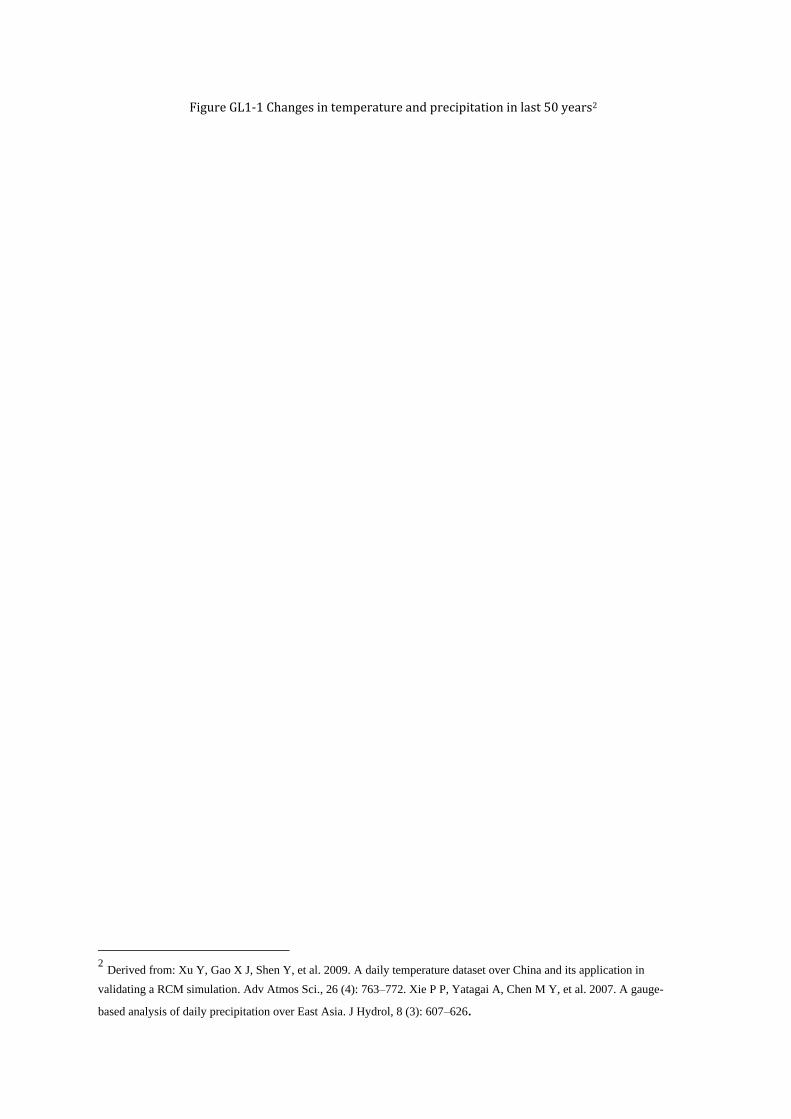
Figure GL1-1 Changes in temperature and precipitation in last 50 years2
2 Derived from: Xu Y, Gao X J, Shen Y, et al. 2009. A daily temperature dataset over China and its application in
validating a RCM simulation. Adv Atmos Sci., 26 (4): 763–772. Xie P P, Yatagai A, Chen M Y, et al. 2007. A gauge-
based analysis of daily precipitation over East Asia. J Hydrol, 8 (3): 607–626.
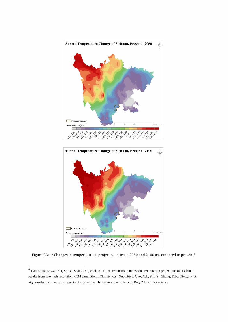
Figure GL1-2 Changes in temperature in project counties in 2050 and 2100 as compared to present3
3 Data sources: Gao X J, Shi Y, Zhang D F, et al. 2011. Uncertainties in monsoon precipitation projections over China:
results from two high resolution RCM simulations. Climate Res., Submitted. Gao, X.J., Shi, Y., Zhang, D.F., Giorgi, F. A
high resolution climate change simulation of the 21st century over China by RegCM3. China Science
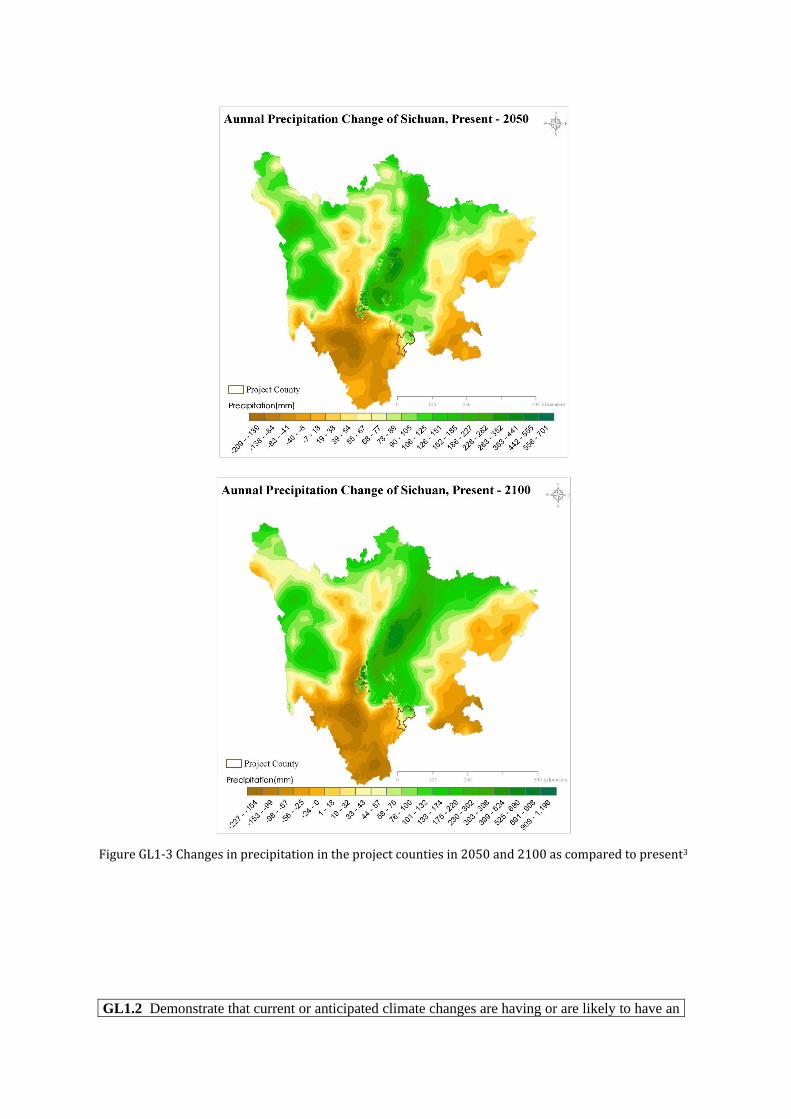
Figure GL1-3 Changes in precipitation in the project counties in 2050 and 2100 as compared to present3
GL1.2 Demonstrate that current or anticipated climate changes are having or are likely to have an
impact on the well-being of Communities and/or the conservation status of biodiversity
in the Project Zone and surrounding regions.
>> The significant increase in temperature and slight increase in precipitation would increase the
aridity under the climate change scenario, which will negative impact the amount of freshwater,
food production and annual net production of grass lands. As the agricultural production constitute
the main source of income of local communities, this will decrease access to resources of
importance for communities’ livelihood and overall well-being (income, food and freshwater).
The expected increase of frequency and intensity of extreme weather (extreme drought, flooding and
ice/snow storm) under the climate change scenario (as presented in Section GL.1.1), may also
causes severe short of freshwater, enormous direct loss of agricultural (food and husbandry)
production in the project areas and its adjacent areas which may severely affect the normal daily
living of community villagers. Extreme drought and ice/snow storm will also degrade or even
completly damage forest ecosystem, as a result decrease access to resources of importance for
communities’ livelihood and overall well-being.
The project area and its adjacent area are located in highly mountainous area. The increase of
temperature under the climate change scenario would result in a shift of major ecosystem (forests
and grassland) toward higher elevation. This would diminish the area of habitat that a lot of rare and
endangered species in the project region rely on. The degradation or damage of ecosystems to be
caused by increasing frequency and intensity of extreme weather (extreme drought and ice/snow
storm) will subject to degrade or damage habitats of rare and endangered species. In addition, the
significant negative impacts on livelihoods and well-being of local communities, as described above,
will increase pressure of local communities on nature reserve management, potentially increase the
tendency of illegal activities (poaching, medicine collecting, logging and grazing) in the nature
reserves, and as a result produce a negative impact on the biodiversity conservation.
GL1.3 Describe measures needed and taken to assist Communities and/or biodiversity to adapt to
the probable impacts of climate change based on the causal model that explains how the
project activities will achieve the project’s predicted adaptation benefits.
>>During the project development, thorough inventories and surveys on the climate, vegetations,
site conditions of the project areas, as well as the economy, cultures, production and livelihood
practices in the adjacent communities of the project areas, have been conducted. We come to
understand that such natural disasters as landslide, droughts and floods, and snow/ice storms, etc., as
a result of extreme climatic changes, are the critical factors that can affect the project
implementation and its benefits. Countermeasures against these risks include:
Those native tree species that are most adaptable to local climatic, soil, water and temperature
conditions will be chosen for the forestation.
Primary forests that share the same conditions as those in the project zone will be chosen as
seed trees.
The nursery sites will also be located in the vicinity of the planting sites where the conditions
are very much the same.
According to site conditions, tree species will be planted in pattern of mixed patches to
enhance soil and water conservation, mitigate fire and disease risk.
During planting operations, minimal-disturbance planting pits will be prepared. Neither
slash-and-burn nor full-tillage will be applied to avoid damaging primary vegetation. No
canals will be opened and gravity irrigation will not be applied so as to avoid changing
surface runoff.
After planting operations are completed, soils will be timely recovered in the planting pits to
reduce and avoid erosion.
In the case of unavoidable natural disasters, rescue measures, such as enrichment planting will
be done in areas where young trees and seedlings are affected so that the loss from such
damages will be minimized to the maximum extent.
As a result, project activities will achieve the project’s predicted adaptation benefits, such as:
The project areas are located within the nature reserve, forestation of these degraded barren
using native species will enhance the connectivity of forest ecosystems and habitats of
wildlife, as a result will enhance adaptation of biodiversity to climate change impacts.
As described in PS-PF Section 7.2 and Section 7.3, the project will increase income and
provide additional employment to the local communities, and help in soil erosion control,
which will decrease communities’ dependency on natural resources and agricultural
production. To be increased income under the project scenario will also alleviate pressure of
local communities on biodiversity conservation.
GL1.4 Include indicators for adaptation benefits for Communities and/or biodiversity in the
monitoring plan. Demonstrate that the project activities assist Communities and/or
biodiversity to adapt to the probable impacts of climate change. Assessment of impacts
of project activities on Communities must include an evaluation of the impacts by the
affected Communities.
>> Indicators for adaptation benefits to be monitored are included in the Section CM4.1 and B.4.1.
III. Community Section
CM1 Without-Project Community Scenario (Required)
CM1.1 Describe the Communities at the start of the project and significant community changes in
the past, including well-being information, and any community characteristics. Describe
the social, economic and cultural diversity within the Communities and the differences
and interactions between the Community Groups.
>>See PS-PF Section 7.2.
CM1.2 Evaluate whether the Project Zone includes any of the following High Conservation
Values (HCVs) related to community well-being and describe the qualifying attributes for
any identified HCVs
>>
a. Areas that provide critical ecosystem services
Due to the vertical climatic feature, there is an apparent vertical vegetation spectrum; with the
increase of the elevation, vegetation shifts one after another. Major vegetation types on the spectrum
are subtropical evergreen broadleaf forest, evergreen coniferous forest, evergreen and deciduous
broadleaf mixed forest, deciduous broadleaf forest, coniferous and broadleaf mixed forest, dark
coniferous forest, subalpine shrub and meadow, alpine meadow.
Due to a large scale of commercial logging, fuelwood harvesting and agricultural cultivation during
1960s~1980s, a great amount of original forest vegetation were destroyed. However, rich ecosystems
left provide home for many species with high conservation value. Some primary forests such as
subtropical evergreen broadleaf forests exist in nature reserve, which is precious at this latitude on
the globe.
The proposed project activity is implemented in the branches of the Jinshajiang River (the upper
reach of the Yangtze River) watersheds. The project zone plays an important role in regulating
hydrological flows of Yangtze River by which alleviating drought risk and reducing flooding risks.
Due to the continued long-term deforestation, followed by subsequent agricultural cultivation,
grazing and over collection of wood for fuel, most of the projects lands are severely degraded and
suffers from serious soil erosion that directly threaten downstream croplands, drinking water sources.
b. Areas that are fundamental for the livelihoods of Communities
The project region is the birthplace of the ethnic minority “YI” and the largest area densely
inhabitated by “YI”. “YI” has been living in the project region for hundreds of years. Therefore the
project zone are fundamental for meeting the basic needs of “YI”, such as food, fuel, medicines and
building materials (see also PS-PF Section 7.2).
c. Areas that are critical for the traditional cultural identity of Communities
There are no cultural relics and/or cultural reserve that have been identified in the project zone. The
project zone is inhabited by “Yi”, one of China’s ethnic minorities. Yi’s livelihood, religious and
cultural traditions are closely relevant to forests. Yi people usually judge living environment in terms
of the existence of forests and water resources or not. Forests are also the symbol of richness and
criteria for Yi people to judge fortune. Forests and water resources hence the criteria for young Yi
girl in the decision of marriage to a young man.
Yi has a unique building culture. Most of Yi houses are made of wood, so called “Pongwu”,
“Muluoluo” or “Wabanwu”. Woods are also material for Yi people’s living and production tools,
such as dishware, drink vessel, loricae, harness and tools for religious ceremonies. Cremation is a
tradition of Yi people in which wood is the only fuel.
Yi people have a tradition of tree planting and forest protection. Local rich or distinguished
households usually plant tree every years. To protect forests and water resources, local Yi people
usually hold a ceremony on which incantation will be used to prevent forests and water from
intervention.
CM1.3 Describe the expected changes in the well-being conditions and other characteristics of
Communities under the without-project land use scenario, including the impact of likely
changes on all ecosystem services in the Project Zone identified as important to
Communities.
>> Agriculture and husbandry are the main source of income for local communities in the project
area. However, production is subjected to natural disasters such as droughts and floods. Food
productivity is very low and the mean per capita annual income in the project areas is only RMB 502
yuan (US$ 81), which is far below the national poverty line. Due to the consecutive deforestation,
subsequent over-use of fuelwood collection and illegal grazing, most lands are severely degraded and
suffer from serious soil erosions that directly threaten the streams and rivers downstream. Local
communities suffer from drought, flood and other natural hazard. If the current situation remains as it
has been (without-project scenario), the lands will degrade further. The soil erosion, drought and
flooding will become more and more severely, as a result the communities will continue to be poor.
CM2 Net Positive Community Impacts (Required)
CM2.1 Use appropriate methodologies to assess the impacts, including predicted and actual,
direct and indirect benefits, costs and risks, on each of the identified Community Groups
(identified in G1.5) resulting from project activities under the with-project scenario.
>> See PS-PF Section 7.2. It should be noted that there is almost no income from the project lands as
the lands are degraded and degrading barren lands under the baseline scenario. Therefore, the income
from the “with project” scenario estimated in PS-PF Section 7.2 is a net benefit compared to the
“without project” scenario.
CM2.2 Describe measures needed and taken to mitigate any negative well-being impacts on
Community Groups and for maintenance or enhancement of the high conservation value
attributes (identified in CM1.2) consistent with the precautionary principle
>> Following specific measures in the project design can ensure the maintenance or enhancement of
the biodiversity and soil and water conservation of the project zone:
Restoration of the degraded and degrading land within or surrounding the nature reserves will
enhance the connectivity of habitats;
Forests will be established by mixing multiple species;
All species to be planted are native to local;
Minimizing disturbance on original vegetation and soil by small hole site preparation;
No fertilizer will be applied;
All on-site activity will be conducted manually;
Income to be created by the project will alleviate the pressure of local communities on forest
ecosystems and wildlife conservation;
Chemical pesticide is not likely to apply (see Section G.3.5 above);
Any seed used will be quarantined;
All seedlings will be cultured at local.
Most of local communities are ethnic minority “Yi” whose living and culture are favour of forests.
Therefore the restoration of native forest ecosystem will maintain and enhance their cultural heritage
in addition to increase income.
CM2.3 Demonstrate that the net well-being impacts of the project are positive for all identified
Community Groups compared with their anticipated well-being conditions under the
withoutproject land use scenario (described in CM1).
>>As described in Section CM1, the project areas are degraded barren land with severe soil erosion
and do not generate income to local communities, as a result under the without-project scenario, the
ecosystem services, livelihood of communities and cultural values provided by the project lands is
weak. Therefore net impact of the project are positive for local communities.
CM2.4 Demonstrate that no High Conservation Values (identified in CM1.2) are negatively
affected by the project..
>> High Conservation Values identified in CM1.2.a: As described in section CM1.2, the project
zone is important for regulating hydrological flows of Yangtze and suffered from severely soil
erosion. Most of the projects lands are severely degraded and suffer from serious soil erosion that
directly threaten downstream croplands, drinking water sources, and downstream waterways.
Forestation on these degraded lands would enhance hydrological service and soil erosion control,
rather than negatively impacted.
High Conservation Values identified in CM1.2.b: All the project lands are degraded and
degrading barren land without management activities. Therefore, the implementation of the project
will not negatively impact the basic needs of local communities. Contrary, most of the communities
in the project zone are living under the national poverty line. Compared to without project scenario,
the project will largely increase income of the local communities through employment and non-
timber forest products, etc (see also PS-PF section 7.2).
High Conservation Values identified in CM1.2.c: As explained in section CM1.2 above,
forestation of degraded barren lands will have no negative impact on traditional cultural of local
communities (mostly “YI” people) and in contrast is consistent with and will enhance culture and
tradition of local ethnic minority.
CM3 Other Stakeholder Impacts (Required)
CM3.1 Identify any potential positive and negative impacts that the project activities are likely to
cause on the well-being of Other Stakeholders..
>> No potential negative offsite stakeholder impacts have been identified. In contract the project will
bring benefits to the offsite communities, e.g., improving local environment, controlling soil erosion
of the project zone as well as regulating hydrological flow beyond the project zone.
CM3.2 Describe the measures needed and taken to mitigate the negative well-being impacts on
Other Stakeholders.
>> N/A.
CM3.3 Demonstrate that the project activities do not result in net negative impacts on the well-
being of Other Stakeholders.
>> The project does not create any negative social and economic impacts within and beyond the
project areas. On the contrary, as part of the seeds and seedlings, as well as labour forces will be
mobilized from the adjacent communities of the project sites, these opportunities will bring them
substantial economic benefits. The project will also bring offset environmental benefits including
improving local environment, controlling soil erosion of the project zone as well as regulating
hydrological flow. Therefore, this project will create positive offsite impacts for the communities
within and beyond the project sites.
CM4 Community Impact Monitoring (Required)
CM4.1 Develop and implement a monitoring plan that identifies community variables to be
monitored, Communities, Community Groups and Other Stakeholders to be monitored,
the types of measurements, the sampling methods, and the frequency of monitoring and
reporting
>> To in-depth track the socia-economic changes resulted from the project activities in the rural
communities and households, and understand issues raised and difficulties encountered during the
project implementation, as well as their opinions and comments on the project activities, so as to
adjust and improve the project activities in a timely manner, a PRA process will be conducted once
every five years after initial monitoring (at the same time of the climate impact monitoring), as
described below.
Procedures:
a) Establishing PRA team: The teams will be set up to conduct the PRA process, which
consists of social experts, project officers, local government officials and technical staff
with various background (forestry, sociology and ecology) from county forestry bureaus
and township forestry posts;
b) Developing SOPs for the field PRA process;
c) Training: A training workshop will be held for discussing and training of PRA teams in
order to ensure all PRA members fully understand the purposes, contents, procedures and
specific methods of the PRA field survey;
d) Preparation: Developing detail PRA field survey plan including responsibility of each
member of PRA team; and contacting with relevant project counties, nature reserves,
forestry farms, towns/townships and local NGOs and informing them PRA plan.
e) PRA survey: conducting PRA survey following SOPs.
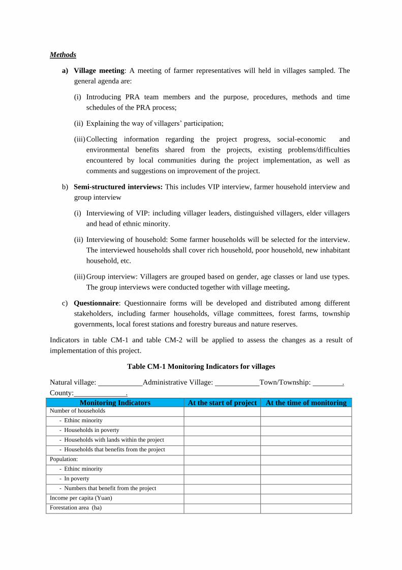
Methods
a) Village meeting: A meeting of farmer representatives will held in villages sampled. The
general agenda are:
(i) Introducing PRA team members and the purpose, procedures, methods and time
schedules of the PRA process;
(ii) Explaining the way of villagers’ participation;
(iii) Collecting information regarding the project progress, social-economic and
environmental benefits shared from the projects, existing problems/difficulties
encountered by local communities during the project implementation, as well as
comments and suggestions on improvement of the project.
b) Semi-structured interviews: This includes VIP interview, farmer household interview and
group interview
(i) Interviewing of VIP: including villager leaders, distinguished villagers, elder villagers
and head of ethnic minority.
(ii) Interviewing of household: Some farmer households will be selected for the interview.
The interviewed households shall cover rich household, poor household, new inhabitant
household, etc.
(iii) Group interview: Villagers are grouped based on gender, age classes or land use types.
The group interviews were conducted together with village meeting.
c) Questionnaire: Questionnaire forms will be developed and distributed among different
stakeholders, including farmer households, village committees, forest farms, township
governments, local forest stations and forestry bureaus and nature reserves.
Indicators in table CM-1 and table CM-2 will be applied to assess the changes as a result of
implementation of this project.
Table CM-1 Monitoring Indicators for villages
Natural village: Administrative Village: Town/Township: .
County: .
Monitoring Indicators At the start of project At the time of monitoring Number of households
- Ethinc minority - Households in poverty - Households with lands within the project - Households that benefits from the project
Population: - Ethinc minority - In poverty - Numbers that benefit from the project
Income per capita (Yuan) Forestation area (ha)
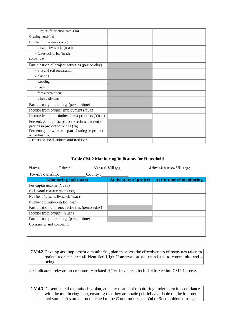
- Project forestation area (ha) Grazing land (ha) Number of livestock (head)
- grazing livestock (head) - Livestock in lot (head)
Road (km) Participation of project activities (person-day)
- Site and soil preparation - planting - weeding - tending - forest protection: - other activities
Participating in training (person-time) Income from project employment (Yuan) Income from non-timber forest products (Yuan) Percentage of participation of ethnic minority
groups in project activities (%)
Percentage of women’s participating in project
activities (%)
Affects on local culture and tradition
Table CM-2 Monitoring Indicators for Household
Name: ________Ethnic:_________ Natural Village: Administrative Village: .
Town/Township: County : .
Monitoring Indicators At the start of project At the time of monitoring
Per capita income (Yuan) fuel wood consumption (ton) Number of grazing livestock (head) Number of livestock in lot (head) Participation of project activities (person-day) Income from project (Yuan) Participating in training (person-time) Comments and concerns:
CM4.2 Develop and implement a monitoring plan to assess the effectiveness of measures taken to
maintain or enhance all identified High Conservation Values related to community well-
being.
>> Indicators relevant to community-related HCVs have been included in Section CM4.1 above.
CM4.3 Disseminate the monitoring plan, and any results of monitoring undertaken in accordance
with the monitoring plan, ensuring that they are made publicly available on the internet
and summaries are communicated to the Communities and Other Stakeholders through
appropriate means.
>>The Chinese version of the monitoring plan will be developed upon the completion of the
validation and disseminate within twelve months. The monitoring plan will be made available to
public on the website of the project implementation entity. Hard copies of the monitoring plan will be
distributed among local stakeholders by implementation entity, county forestry bureau and forestry
posts and forest patrollers. At the same time, public notice boards and community broadcasts will be
used to publicize information regarding how to access to the monitoring plan through internet.
Technical staff from county forestry bureau will also explain the monitoring plan to local farmers,
especially to illiterate or under-educated farmers.
GL2 Exceptional Community Benefits (Optional)
>>No claimment on this point
V. Biodiversity Section
B1 Biodiversity Without–project Scenario (Required)
B1.1 Describe biodiversity within the Project Zone at the start of the project and threats to that
biodiversity, using appropriate methodologies.
>> See PS-PF section 1.5.1. The current biodiversity with the project zone and threats to that
biodiversity were summarized from literatures4. The biodiversity information on project lands was
collected during baseline survey, which covers plants, amphibians, small and large mammals, birds
and insects. Various biodiversity indicators for different biotic communities was used for analysis as
follow.
Flora
5 randomly selected sub-plots (2m×2m) within baseline sampling plots was used to record the
species, population, coverage density or abundance, and frequency to assess the plant diversity.
Fauna
The types and numbers of wild animals and their features that are closely related to the flora, sample
strips was ramdomly selected from different vegetation types. Under the help of GPS, surveyors
move along with the route used for wild animal baseline survey at a speed of 1.5-2 km per hour, and
record the findings on the way. The record include the species and numbers of animals, the sound of
howl/chirp, remnants, traces and etc., and the distance and angles between the recorded place and
the place that animals are appeared, should be also recorded.
Disturbance (threat)
4 Overall plan on Mamize Nature Reserve in Sichuan Province
Human disturbance information was collected during the sampling plot and strips survey. Recorded
information include disturbance types (such as hunter, medicine collector, burning, grazing, tourism
and bamboo flowering etc.), time (current, 1-2 days, 3-10 days and over 10 days) and intensity
(intense, mediam and slight).
Based on baseline survey no protected or endangered species and IUCN species have been found on
the proposed project lands. These lands currently have low biodiversity.
B1.2 Evaluate whether the Project Zone includes any of the following High Conservation Values
(HCVs) related to biodiversity and describe the qualifying attributes for any identified
HCVs
B1.2.a Globally, regionally or nationally significant concentrations of biodiversity values:
a. protected areas
b. threatened species
c. endemic species
d. areas that support significant concentrations of a species during any time in their
lifecycle.
>> Please see PS-PF section 1.5.1 for detail information regarding the project zone, threathened
species and endemic species in the project zone. The project zone does support significant
concentrations of a species during any time in their lifecycle.
B1.2.b Globally, regionally or nationally significant large landscape-level areas where viable
populations of most if not all naturally occurring species exist in natural patterns of
distribution and abundance
>> The project zone fall under the Southern Hengduan mountains priority conservation areas; one of
China’s 32 terrestrial priority conservation areas as listed in the China Biodiversity Conservation
Strategy and Action Plan5, issued by the Ministry of Environmental Protection. The Sichuan Mamize
Nature Reserve is the south end of habitats for Giant Panda.
B1.2.c Threatened or rare ecosystems:
>>There are 18 key ecosystem types in the project regions, among which 12 types are protected
ecosystems in the nature reserves, such as forests ecosystems of Lithocarpus cleistocarpus forests,
Abies forrestii C. C. Rogers, Abies faxoniana Rehd. et Wils, Picea likiangensis (Franch) Pritz var.
balfouriana (Rehd.et Wils.) Hillier ex Slavin, Picea brachytyla (Franch.) Pritz., Pinus densata Mast,
Larix potaninii Batalin, Picea likiangensis (Franch) Pritz, etc6. However, due to high pressure from
local communities, these forest ecosystems have been facing threat.
5 The Ministry of Environmental Protection. 2010. China Biodiversity Conservation Strategy and Action Plan
(2011-2030) 6 TNC. 2012. China biodiversity priority conservation area identification and gap analysis technical report
B1.3 Describe how the without-project land use scenario would affect biodiversity conditions in
the Project Zone
>>As described in PS-PF Appendix 1 section 5, the project lands are degraded and degrading land
and will continue to degrade under the baseline scenario. Therefore biodiversity with the baseline
will remain low or continue to reduce.
B2 Net Positive Biodiversity Impacts (Required)
B2.1 Use appropriate methodologies to estimate changes in biodiversity, including assessment of
predicted and actual, positive and negative, direct and indirect impacts, resulting from
project activities under the with-project scenario in the Project Zone and over the project
lifetime. This estimate must be based on clearly defined and defendable assumptions.
>>The project area is a global hotspot of biodiversity conservation and one of important habitats of
the Giant Panda (see PS-PF Section 1.5.1 for details). Although the Chinese government has
established over 10 nature reserves in this region, Conflicts between biodiversity conservation of the
reserves and economic activities of local communities surrounding (e.g., Chinese medicine
collection, poaching, etc) are very significant, hence the nature reserves have been facing significant
pressure from local communities. The proposed PS project activity will increasing or improve
habitats of protected plants and wildlife by restoring original forest vegetation on severely degraded
and degrading lands within nature reserves using native species. At the same time it will provide
increased income to local communities, as a result reduce the tendency of local communities to
degrade biodiversity through practices such as illegal poaching and NTFP collection (such as
Chinese medicine collection) in the nature reserve, and hence alleviate conflicts between
conservation and economic activities of local communities.
B2.2 Demonstrate that the project’s net impacts on biodiversity in the Project Zone are positive,
compared with the biodiversity conditions under the without-project land use scenario
(described in B1).
>> As described in PS-PF section 1.5.1, there is no protected or endangered species and IUCN
species have been found on the proposed project lands. These lands currently have low biodiversity,
therefore the ‘with project’ scenario will produce the net biodiversity benefit compared to “with
baseline” scenario.
B2.3 Describe measures needed and taken to mitigate negative impacts on biodiversity and any
measures needed and taken for maintenance or enhancement of the High Conservation
Value attributes (identified in B1.2) consistent with the precautionary principle..
>>See Section CM2.2.
B2.4 Demonstrate that no High Conservation Values (identified in B1.2) are negatively affected
by the project.
>> As described in PS-PF section 1.5.1, there is no protected or endangered species and IUCN
species have been found on the proposed project lands. These lands currently have low biodiversity.
On the other hands, the project will bring a high biodiversity benefits (see PS-PF Section 7.3 for
detail description). Therefore, no High Conservation Values identified in B1.2 will be negatively
affected by the project including.
B2.5 Identify all species used by the project and show that no known invasive species are
introduced into any area affected by the project and that the population of any invasive
species does not increase as a result of the project
>> All the tree species used are native to local. These species have been selected through
community participation and none of them belongs to invasive species.
B2.6 Describe possible adverse effects of non-native species117 used by the project on the
region’s environment, including impacts on native species and disease introduction or
facilitation. Justify any use of non-native species over native species
>> No invasive species will be used in the project.
B2.7 Guarantee that no GMOs are used to generate GHG emissions reductions or removals.
>> All seedlings used in the proposed project activities will be bred in local nurseries using seed
collected from local seed orchard or parent trees. No GMOs will be used in the project.
B2.8 Describe the possible adverse effects of, and justify the use of, fertilizers, chemical
pesticides, biological control agents and other inputs used for the project.
>> The project will not use any fertilizer, chemical pesticides and other inputs.
B2.9 Describe the process for identifying, classifying and managing all waste products resulting
from project activities.
>> The potential waste products resulting form the project activities are plastic bags. It is required
that all the plastic bags and other non-decomposition material shall be brought out of the project
sites and drop in classified waste disposal sites.
B3 Offsite Biodiversity Impacts (Required)
B3.1 Identify potential negative impacts on biodiversity that the project activities are likely to
cause outside the Project Zone.
>> No potential negative offsite biodiversity impacts have been identified.
B3.2 Identify potential negative impacts on biodiversity that the project activities are likely to
cause outside the Project Zone.
>> No potential negative offsite biodiversity impacts have been identified.
B3.3 Evaluate unmitigated negative impacts on biodiversity outside the Project Zone and compare
them with the project’s biodiversity benefits within the Project Zone. Justify and
demonstrate that the net effect of the project on biodiversity is positive.
>> No potential negative impacts have been identified due to the environmental-friendly techniques
adopted in the proposed project activity, e.g., avoidance of slash and burn and overall tillage, choice
of native tree species and their mixed spatial arrangement, etc.
B4 Biodiversity Impact Monitoring (Required)
B4.1 Develop and implement a monitoring plan that identifies biodiversity variables to be
monitored, the areas to be monitored, the sampling methods, and the frequency of
monitoring and reporting. Monitoring variables must be directly linked to the project’s
biodiversity objectives and to predicted activities, outcomes and impacts identified in the
project’s causal model related to biodiversity (described in G1.8).
>> It is planned that biodiversity monitoring will be carried out based on a five-year cycle to cover
plants, amphibians, small and large mammals, birds and insects. Various biodiversity indicators for
different biotic communities will be used for analysis as follow.
Flora
5 randomly selected sub-plots (2m×2m) within permanent sampling plots for carbon stock chage
monitoring will be used to monitor the species, population, coverage density or abundance, and
frequency (table B-1) to assess the changes of plant diversity, and the following evaluation index
will be used:
Simpson’s diversity index,D
D=1- 2
1
S
i
i
p
=1- 2
1
( )S
i
i
N
N
Where Ni is the population of species i,N is the total population of all plants in the sample plot。
Shannon-Weiner index,H
H= -1
lnS
i i
i
P P
Where: S is the total amount of species,Pi is the population the inverse proportion of species i in
all plant species.
Table B-1 Field Monitoring Template for Flora Sample Plots
(1) Location: Village Town/township County
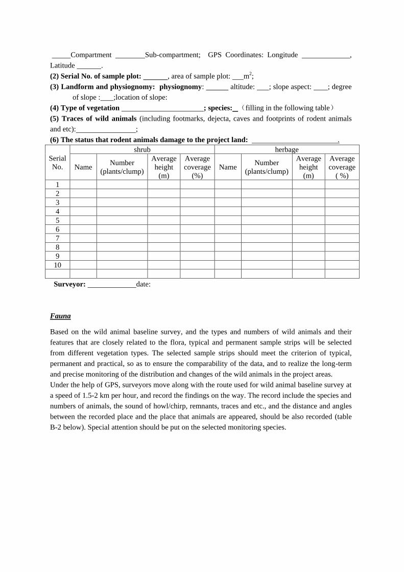
Compartment Sub-compartment; GPS Coordinates: Longitude ,
Latitude .
(2) Serial No. of sample plot: , area of sample plot: m2;
(3) Landform and physiognomy: physiognomy: altitude: ; slope aspect: ; degree
of slope : ;location of slope:
(4) Type of vegetation ; species: (filling in the following table)
(5) Traces of wild animals (including footmarks, dejecta, caves and footprints of rodent animals
and etc): ;
(6) The status that rodent animals damage to the project land: .
Serial
No.
shrub herbage
Name Number
(plants/clump)
Average
height
(m)
Average
coverage
(%)
Name Number
(plants/clump)
Average
height
(m)
Average
coverage
( %)
1
2
3
4
5
6
7
8
9
10
Surveyor: date:
Fauna
Based on the wild animal baseline survey, and the types and numbers of wild animals and their
features that are closely related to the flora, typical and permanent sample strips will be selected
from different vegetation types. The selected sample strips should meet the criterion of typical,
permanent and practical, so as to ensure the comparability of the data, and to realize the long-term
and precise monitoring of the distribution and changes of the wild animals in the project areas.
Under the help of GPS, surveyors move along with the route used for wild animal baseline survey at
a speed of 1.5-2 km per hour, and record the findings on the way. The record include the species and
numbers of animals, the sound of howl/chirp, remnants, traces and etc., and the distance and angles
between the recorded place and the place that animals are appeared, should be also recorded (table
B-2 below). Special attention should be put on the selected monitoring species.
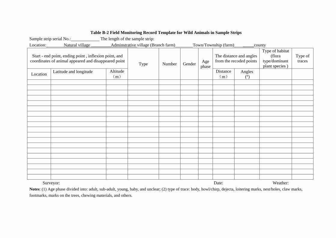
Table B-2 Field Monitoring Record Template for Wild Animals in Sample Strips
Sample strip serial No.: The length of the sample strip:
Location: Natural village _________Adminstrative village (Branch farm) Town/Township (farm) _____county
Start - end point, ending point , inflexion point, and
coordinates of animal appeared and disappeared point Type Number Gender
Age
phase
The distance and angles
from the recoded points
Type of habitat
(flora
type/dominant
plant species )
Type of
traces
Location Latitude and longitude
Altitude
(m)
Distance
(m)
Angles
(°)
Surveyor: Date: Weather:
Notes: (1) Age phase divided into: adult, sub-adult, young, baby, and unclear; (2) type of trace: body, howl/chirp, dejecta, loitering marks, nest/holes, claw marks,
footmarks, marks on the trees, chewing materials, and others.
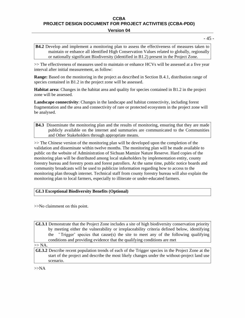
CCBA PROJECT DESIGN DOCUMENT FOR PROJECT ACTIVITIES (CCBA-PDD)
Version 04
- 45 -
B4.2 Develop and implement a monitoring plan to assess the effectiveness of measures taken to
maintain or enhance all identified High Conservation Values related to globally, regionally
or nationally significant Biodiversity (identified in B1.2) present in the Project Zone.
>> The effectiveness of measures used to maintain or enhance HCVs will be assessed at a five year
interval after initial measurement, as follow:
Range: Based on the monitoring in the project as described in Section B.4.1, distribution range of
species contained in B1.2 in the project zone will be assessed.
Habitat area: Changes in the habitat area and quality for species contained in B1.2 in the project
zone will be assessed.
Landscape connectivity: Changes in the landscape and habitat connectivity, including forest
fragmentation and the area and connectivity of rare or protected ecosystem in the project zone will
be analysed.
B4.3 Disseminate the monitoring plan and the results of monitoring, ensuring that they are made
publicly available on the internet and summaries are communicated to the Communities
and Other Stakeholders through appropriate means.
>> The Chinese version of the monitoring plan will be developed upon the completion of the
validation and disseminate within twelve months. The monitoring plan will be made available to
public on the website of Administration of Sichuan Mamize Nature Reserve. Hard copies of the
monitoring plan will be distributed among local stakeholders by implementation entity, county
forestry bureau and forestry posts and forest patrollers. At the same time, public notice boards and
community broadcasts will be used to publicize information regarding how to access to the
monitoring plan through internet. Technical staff from county forestry bureau will also explain the
monitoring plan to local farmers, especially to illiterate or under-educated farmers.
GL3 Exceptional Biodiversity Benefits (Optional)
>>No claimment on this point.
GL3.1 Demonstrate that the Project Zone includes a site of high biodiversity conservation priority
by meeting either the vulnerability or irreplaceability criteria defined below, identifying
the ‘Trigger’ species that cause(s) the site to meet any of the following qualifying
conditions and providing evidence that the qualifying conditions are met
>> NA.
GL3.2 Describe recent population trends of each of the Trigger species in the Project Zone at the
start of the project and describe the most likely changes under the without-project land use
scenario.
>>NA
CCBA PROJECT DESIGN DOCUMENT FOR PROJECT ACTIVITIES (CCBA-PDD)
Version 04
- 46 -
GL3.3 Describe measures needed and taken to maintain or enhance the population status of each
Trigger species in the Project Zone, and to reduce the threats to them based on the causal
model that identifies threats to Trigger species and activities to address them
>> NA
GL3.4 Include indicators of the population trend of each Trigger species and/or the threats to
them in the monitoring plan and demonstrate the effectiveness of measures needed and
taken to maintain or enhance the population status of Trigger species.
>> NA