report on a soil survey and agricultural suitability ... · report on a soil survey and...
TRANSCRIPT
Erf 792, Barclay Hills Development Phase I Soil Report 1
Report on a soil survey and agricultural suitability investigation of the property known as Barclay Property (Farm 792 Worcester)
by F. Ellis September 2006
CONTENTS
1 INTRODUCTION AND TERMS OF REFERENCE 2
2 SURVEY METHOD 2
3 DESCRIPTION OF THE TERRAIN, GEOLOGY AND CLIMATE 2
4 SOILS 2
5 SUITABILITY FOR ANNUAL AND PERENNIAL CROPS 4
6 REFERENCE 5
APPENDIXES
Appendix 1:
Table 1 SOIL FORMS AND FAMILIES RECOGNIZED DURING THE SOIL SURVEY LISTED
ALPHABETICALLY ACCORDING TO SOIL FORM ABBREVIATION SYMBOL 7
Table 2 PROPERTIES DIAGNOSTIC FOR THE SOIL FAMILIES 8
Table 3 SOIL TYPES WITH COMPLETE LIST OF PROFILES AND SOIL CODES 9
Appendix 2:
PHOTOGRAPHS OF SELECTED SOIL FORMS TYPICAL OF THE SURVEY AREA 10
Appendix 3:
STRUCTURE OF SOIL CODE AND EXPLANATION OF SYMBOLS 11
FIGURE
FIGURE 1 SOIL MAP OF ERF 792, BARCLAY HILLS DEVELOPMENT 6
Erf 792, Barclay Hills Development Phase I Soil Report 2
1. INTRODUCTION AND TERMS OF REFERENCE I was instructed by Mr. Nik Wullschleger of Boland Enviro, Worcester to investigate (on behalf of Barclay Estate Development, PO Box 180, Somerset Mall, 7137) the agricultural suitability of the property known as Erf 792, Worcester (Barclay Development Phase I). The property is located to the east and adjacent to the present residential area of Worcester West. The report was necessary for submission to the Department of Agriculture and Tourism, Western Cape Province, to be able to decide whether possible rezoning of the land could take place. 2. SURVEY METHOD Twelve mechanically prepared profile pits were investigated. The soils were classified according to Soil Classification: A Taxonomic system for South Africa (Soil Classification Working Group, 1991) in SOIL FORMS and SOIL FAMILIES. During the demarcation of the mapping units, care was taken to group those profiles together that had more or less the same horizon sequence, depths and physical properties. This subdivision (also called phase subdivision) was achieved by detail coding of individual soil profiles (refer to Appendix 3: Structure of Soil Code and Explanation of Symbols for the symbols used during this survey) 3. DESCRIPTION OF THE TERRAIN, GEOLOGY AND CLIMATE The property lies on a sloping hill (slopes of less than 15% on the middle to lower footslope positions closest to the existing tarred road to steep slopes of more than 15% on the midslope positions towards the northeast. The parent material from which the soils have developed consists of unweathered to partly weathered shales and phyllites of the Nama Group. The long term average annual rainfall measured at the nearby Veld Reserve is 242 mm, with an average annual Class A pan evaporation of 2402 mm. Most rain occurs during the winter months but there is no month where rainfall exceeds evapotranspiration. This is therefore typical of an arid region where irrigation is necessary for agricultural crop production. 4. SOILS The soils were classified and mapped as set out in 2 above. Four soil mapping units (Gs 1, Gs 2, Sw 1 and Km 1) were defined and their boundaries indicated on the map given in Fig. 1. A short description of each map unit, regarding dominant soils and properties is given in Table 1 below.
Erf 792, Barclay Hills Development Phase I Soil Report 3
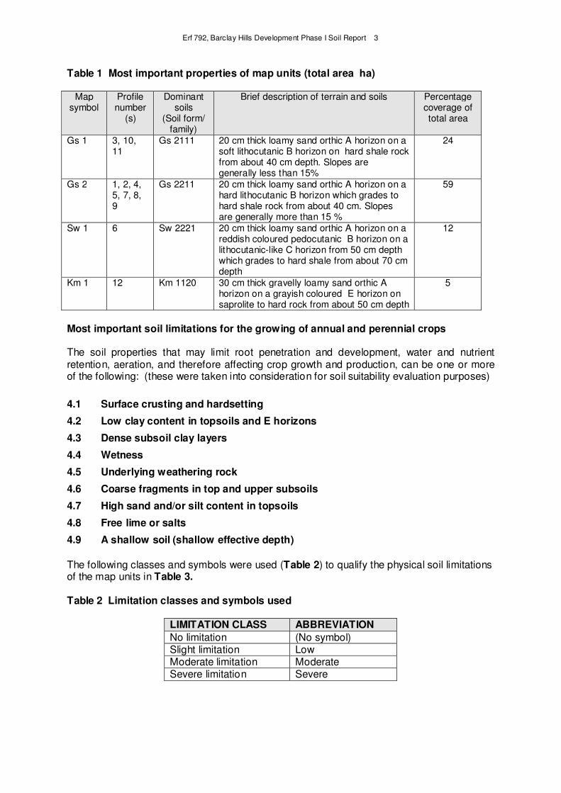
Table 1 Most important properties of map units (total area ha)
Map symbol
Profile number
(s)
Dominant soils
(Soil form/ family)
Brief description of terrain and soils Percentage coverage of total area
Gs 1 3, 10, 11
Gs 2111 20 cm thick loamy sand orthic A horizon on a soft lithocutanic B horizon on hard shale rock from about 40 cm depth. Slopes are generally less than 15%
24
Gs 2 1, 2, 4, 5, 7, 8, 9
Gs 2211 20 cm thick loamy sand orthic A horizon on a hard lithocutanic B horizon which grades to hard shale rock from about 40 cm. Slopes are generally more than 15 %
59
Sw 1 6 Sw 2221 20 cm thick loamy sand orthic A horizon on a reddish coloured pedocutanic B horizon on a lithocutanic-like C horizon from 50 cm depth which grades to hard shale from about 70 cm depth
12
Km 1 12 Km 1120 30 cm thick gravelly loamy sand orthic A horizon on a grayish coloured E horizon on saprolite to hard rock from about 50 cm depth
5
Most important soil limitations for the growing of annual and perennial crops The soil properties that may limit root penetration and development, water and nutrient retention, aeration, and therefore affecting crop growth and production, can be one or more of the following: (these were taken into consideration for soil suitability evaluation purposes)
4.1 Surface crusting and hardsetting
4.2 Low clay content in topsoils and E horizons
4.3 Dense subsoil clay layers
4.4 Wetness
4.5 Underlying weathering rock
4.6 Coarse fragments in top and upper subsoils
4.7 High sand and/or silt content in topsoils
4.8 Free lime or salts
4.9 A shallow soil (shallow effective depth)
The following classes and symbols were used (Table 2) to qualify the physical soil limitations of the map units in Table 3. Table 2 Limitation classes and symbols used
LIMITATION CLASS ABBREVIATION
No limitation (No symbol) Slight limitation Low Moderate limitation Moderate Severe limitation Severe
Erf 792, Barclay Hills Development Phase I Soil Report 4
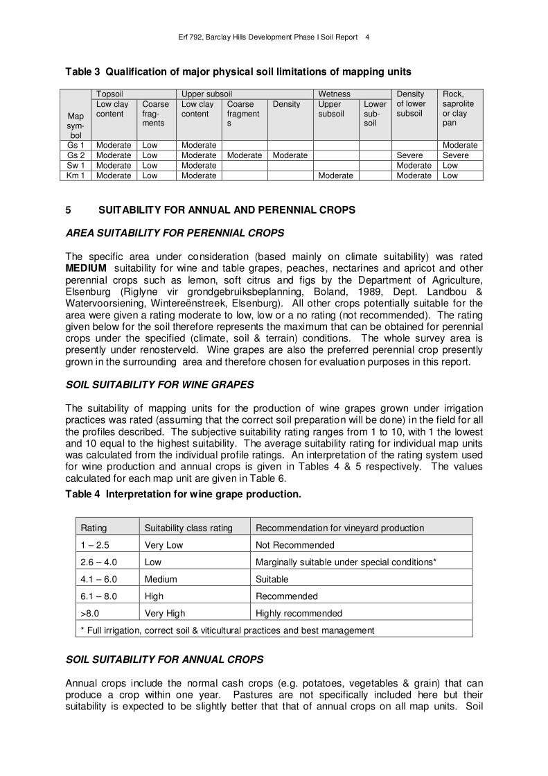
Table 3 Qualification of major physical soil limitations of mapping units
Map sym-bol
Topsoil Upper subsoil Wetness Density of lower subsoil
Rock, saprolite or clay pan
Low clay content
Coarse frag-ments
Low clay content
Coarse fragments
Density Upper subsoil
Lower sub-soil
Gs 1 Moderate Low Moderate Moderate
Gs 2 Moderate Low Moderate Moderate Moderate Severe Severe
Sw 1 Moderate Low Moderate Moderate Low
Km 1 Moderate Low Moderate Moderate Moderate Low
5 SUITABILITY FOR ANNUAL AND PERENNIAL CROPS AREA SUITABILITY FOR PERENNIAL CROPS
The specific area under consideration (based mainly on climate suitability) was rated MEDIUM suitability for wine and table grapes, peaches, nectarines and apricot and other perennial crops such as lemon, soft citrus and figs by the Department of Agriculture, Elsenburg (Riglyne vir grondgebruiksbeplanning, Boland, 1989, Dept. Landbou & Watervoorsiening, Wintereënstreek, Elsenburg). All other crops potentially suitable for the area were given a rating moderate to low, low or a no rating (not recommended). The rating given below for the soil therefore represents the maximum that can be obtained for perennial crops under the specified (climate, soil & terrain) conditions. The whole survey area is presently under renosterveld. Wine grapes are also the preferred perennial crop presently grown in the surrounding area and therefore chosen for evaluation purposes in this report.
SOIL SUITABILITY FOR WINE GRAPES
The suitability of mapping units for the production of wine grapes grown under irrigation practices was rated (assuming that the correct soil preparation will be done) in the field for all the profiles described. The subjective suitability rating ranges from 1 to 10, with 1 the lowest and 10 equal to the highest suitability. The average suitability rating for individual map units was calculated from the individual profile ratings. An interpretation of the rating system used for wine production and annual crops is given in Tables 4 & 5 respectively. The values calculated for each map unit are given in Table 6.
Table 4 Interpretation for wine grape production.
Rating Suitability class rating Recommendation for vineyard production
1 – 2.5 Very Low Not Recommended
2.6 – 4.0 Low Marginally suitable under special conditions*
4.1 – 6.0 Medium Suitable
6.1 – 8.0 High Recommended
>8.0 Very High Highly recommended
* Full irrigation, correct soil & viticultural practices and best management
SOIL SUITABILITY FOR ANNUAL CROPS
Annual crops include the normal cash crops (e.g. potatoes, vegetables & grain) that can produce a crop within one year. Pastures are not specifically included here but their suitability is expected to be slightly better that that of annual crops on all map units. Soil
Erf 792, Barclay Hills Development Phase I Soil Report 5
requirements for annual crops are generally lower than for perennial crops (i.e. soil depth is not so important although coarse fragments are more important) and manipulation of the soil is easier to compensate for possible problems. However, management is becoming very important to achieve success, especially if the soils are more marginal for use. It is assumed that irrigation water is available for production. The same principal of rating as for the perennial crops was followed but the ratings were not done in the field but afterwards.
The values allocated for each map unit are given in Table 5.
Table 5 Interpretation for annual crop production
Rating Suitability class rating Recommendation for annual crop
production
1 – 2.5 Very Low Not Recommended
2.6 – 4.0 Low Marginally suitable
4.1 – 6.0 Medium Suitable
6.1 – 8.0 High Recommended
>8.0 Very High Highly recommended
By using the rating set out in Tables 4 and 5 above and applying it to the map units as given in Table 1, the final suitability per map unit for annual and perennial crop production is given in Table 6 below. Table 6. Suitability of map units for annual and perennial crops
Map symbol
Suitability for annual crops
Suitability for perennial crops
Rating annual crops (average)
Field rating perennial crops (average)
Gs 1 Low Low 4 4
Gs 2 Low Low 3.5 3.75
Sw 1 Low Low 4 4
Km 1 Low Low 4 4
According to this evaluation it can be seen that the property has a low soil suitability for the production of annual or perennial crops under good management including irrigation. 6. REFERENCE SOIL CLASSIFICATION WORKING GROUP, 1991. Soil Classification: A Taxonomic system for South Africa. Mem. on the Agric. Natural Resources of S.Afr. No. 15.
Erf 792, Barclay Hills Development Phase I Soil Report 6
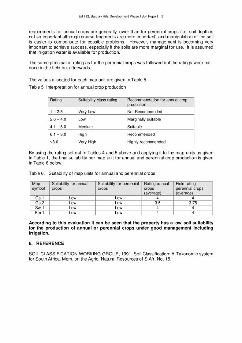
Figure 1 Soil map (dashed area) of Erf 792, Barclay Development Phase I. 1 – 12 are profile numbers with their positions indicated by a dot (.). Map units are Gs 1, Gs 2, Sw 1 and Km 1. See Table 1 for a brief description of the map units and a complete list of each profile described in coded form is given in Appendix 1 with an explanation of the codes in Appendix 3
Erf 792, Barclay Hills Development Phase I Soil Report 7
Appendix 1
Table 1
SOIL FORMS AND FAMILIES IDENTIFIED DURING THE SOIL SURVEY LISTED
ALPHABETICALLY ACCORDING TO SOIL FORM ABBREVIATION SYMBOL
ABBRE- SOIL FORM AND VERTICAL SEQUENCE OF VIATION DIAGNOSTIC HORIZONS AND/OR MATERIALS
Gs GLENROSA FORM
Orthic A
Lithocutanic B SOIL FAMILIES 2000 A horizon bleached 2100 B1 horizon not hard 2110 No signs of wetness in B1 horizon 2111Non-calcareous B horizon 2200 B1 horizon hard
2210 No signs of wetness in B1 horizon 2211 Non-calcareous B horizon 2220 Signs of wetness in B1 horizon
2221 Non-calcareous B horizon
Sw SWARTLAND FORM
Orthic A
Pedocutanic B
Saprolite SOIL FAMILIES 2000 A horizon bleached 2200 B horizon red 2220 Medium/coarse angular B horizon 2221 Non-calcareous B and upper C horizons Cf CARTREF FORM
Orthic A
E horizon
Lithocutanic B SOIL FAMILIES 1000 Colour of E horizon "grey" when moist 1100 B1 horizon not hard
Km KLAPMUTS FORM
Orthic A
E horizon
Pedocutanic B SOIL FAMILIES 1000 Colour of E horizon "grey" when moist
1100 Non-red B horizon
1110 Subangular/fine angular B horizon 1120 – Medium/coarse angular B horizon 1200 Red B horizon 1210 Subangular/fine angular B horizon
Erf 792, Barclay Hills Development Phase I Soil Report 8
Appendix 1
Table 2 PROPERTIES DIAGNOSTIC FOR THE SOIL FAMILIES Bleached orthic A horizon Many A horizons have a bleached "grey" colour in the dry state, as defined for the diagnostic E horizon. Some of these A horizons are underlain by diagnostic subsoil horizons (e.g. E horizon, G horizon) which themselves have undergone reduction and removal of iron. In these soils, the reduced nature of the A horizon is covariant with that of the accompanying subsoil horizon. However, in many cases, these bleached A horizons overlie diagnostic subsoil horizons (e.g. pedocutanic, lithocutanic) which have not suffered marked reducing conditions. In these soils, a distinction is made at family level between members which have and which do not have, bleached A horizons. Bleached A horizons often have moist state colours that are darker (very dark grey 10YR 3/1 is a common moist colour) than the "grey" dry state colours of the diagnostic E horizon. In some cases this diagnostic A horizon has an overall bleached appearance while parts retain the original unbleached colour, presenting a mottled appearance on close inspection. Important to note is that the bleached A is an A (i.e. a topsoil horizon) and not a subsoil horizon as are E and G horizons Luvic B horizon A soil has a luvic B in the following circumstances: - when any part of the A or E horizon has 15% or less, the B1 horizon must contain at least 5% more clay than the A, O or E; - when any part of the A or E horizon has more than 15% clay, the ratio of clay percentage in the B1 to that in the A or E must be 1,3 or greater. The presence of more clay in the B than in the A or E horizon is implicit in the definitions of many soil forms (e.g. Sterkspruit, Estcourt). However, there are several forms (with red apedal, yellow-brown apedal, neocutanic and neocarbonate B horizons) where this is not so, and it is considered necessary to distinguish between members which have markedly more clay in the B than in the A or E horizon from those which do not. The luvic concept is used for this purpose. Signs of wetness These signs consist of grey, low chroma colours, sometimes with blue or green tints, with or without sesquioxide mottles. The latter, if present, may be yellowish brown, olive brown, red or black. The signs of wetness must occur within 1500 mm of the surface and must not be of such a nature or in such a profile position as to qualify as a diagnostic E, G or soft plinthic B horizon or as undifferentiated material with signs of wetness Non-red and red colours in B horizons and stratified alluvium Where iron oxides have imparted a red colour (hues of 5YR, 2.5YR, 10R, 7.5R) to the greater part of an horizon, the resultant soil structure is usually more water stable than similar soil which is not red. In many soil forms the non-red and red distinction is made at family level.
Erf 792, Barclay Hills Development Phase I Soil Report 9
Appendix 1
Table 3
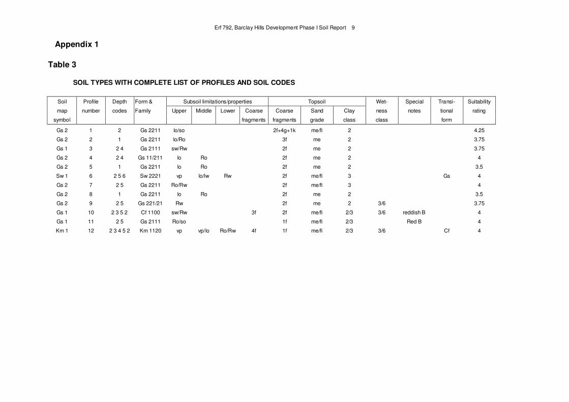
SOIL TYPES WITH COMPLETE LIST OF PROFILES AND SOIL CODES
Soil Profile Depth Form & Subsoil limitations/properties Topsoil Wet- Special Transi- Suitability
map number codes Family Upper Middle Lower Coarse Coarse Sand Clay ness notes tional rating
symbol fragments fragments grade class class form
Gs 2 1 2 Gs 2211 lo/so 2f+4g+1k me/fi 2 4.25
Gs 2 2 1 Gs 2211 lo/Ro 3f me 2 3.75
Gs 1 3 2 4 Gs 2111 sw/Rw 2f me 2 3.75
Gs 2 4 2 4 Gs 11/211 lo Ro 2f me 2 4
Gs 2 5 1 Gs 2211 lo Ro 2f me 2 3.5
Sw 1 6 2 5 6 Sw 2221 vp lo/lw Rw 2f me/fi 3 Gs 4
Gs 2 7 2 5 Gs 2211 Ro/Rw 2f me/fi 3 4
Gs 2 8 1 Gs 2211 lo Ro 2f me 2 3.5
Gs 2 9 2 5 Gs 221/21 Rw 2f me 2 3/6 3.75
Gs 1 10 2 3 5 2 Cf 1100 sw/Rw 3f 2f me/fi 2/3 3/6 reddish B 4
Gs 1 11 2 5 Gs 2111 Ro/so 1f me/fi 2/3 Red B 4
Km 1 12 2 3 4 5 2 Km 1120 vp vp/lo Ro/Rw 4f 1f me/fi 2/3 3/6 Cf 4
Erf 792, Barclay Hills Development Phase I Soil Report 10
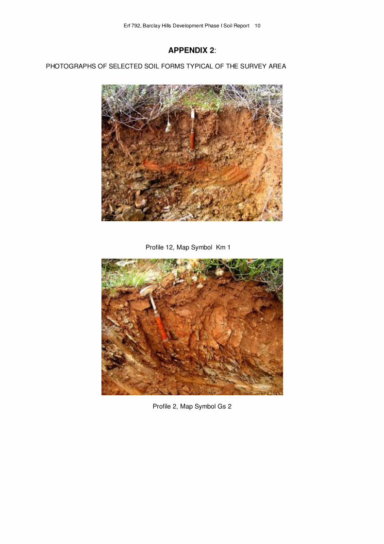
APPENDIX 2: PHOTOGRAPHS OF SELECTED SOIL FORMS TYPICAL OF THE SURVEY AREA
Profile 12, Map Symbol Km 1
Profile 2, Map Symbol Gs 2
Erf 792, Barclay Hills Development Phase I Soil Report 11
APPENDIX 3
STRUCTURE OF SOIL CODE AND EXPLANATION OF SYMBOLS
1 STRUCTURE OF SOIL CODE The code consists of two series of letter-number symbols, separated by a horizontal line, arranged in the following order:
Position to horizontal line For description refer to section
Above the line
Depth of horizons and/or materials Soil form Soil family Subsoil limitations or properties
2.1 2.2 2.3 2.4
Below the line
Coarse fragments in the topsoil horizon and outcrops Texture of topsoil horizon and underlying E or apedal B1 Soil water conditions Changes in soil properties and conditions
3.1 3.2 3.3 3.4
In a Microsoft Word or Excel table the letter-number symbols can be written in a single line with the “above the line” letter-number symbols followed by the “below the line” letter-number symbols. In uncultivated soils the term topsoil horizon refers to the natural A horizon, while for cultivated soils it refers to the upper 150 - 300 mm of the soil profile affected by tillage.
2 CLASSES AND SYMBOLS FOR PROPERTIES ABOVE THE LINE
2.1 Horizon and/or effective depths The depths of all the diagnostic as well as non-diagnostic horizons and/or materials encountered in a profile are coded with a number symbol in front of the soil form symbol. Depth classes and symbols used are:
Depth class (mm) Symbol Depth class (mm) Symbol
0 .- 150 1 750 - 950 7
150 - 250 2 950 - 1 150 8
250 - 350 3 1 150 - 1 350 9
350 - 450 4 1 350 - 1 550 0
450 - 550 5 >1 550 no symbol 550 - 750 6
Depth symbols for diagnostic horizons or materials specified in a particular soil form are arranged from shallow (topsoil transition) to deep (deepest subsoil transition) before the form symbol (e.g. 3 5 Es 1100, where 3 refers to the A/E transition and 5 to the E/B transition). Depth symbols for subsoil limitations or properties (arranged from shallow to deep) appear between the depth symbols for diagnostic horizon transitions and the form symbol (e.g. 3 5 3 Es 1100; the second 3 indicates the depth of a subsoil limitation or property.)
2.2 Soil Form
Soil forms and abbreviations used in the soil code are explained by the Soil Classification Working Group (1991). For example Tu is the abbreviation for a Tukulu form soil.
Erf 792, Barclay Hills Development Phase I Soil Report 12
2.3 Soil family
Soil families are identified by a locality name or coded by means of a four-digit symbol (Soil Classification Working Group, 1991). For example 1120 is the four-digit symbol for the Olivedale soil family of the Tukulu soil form. In the code the four-digit symbol is used directly after the soil form abbreviation symbol; e.g. Tu 1120.
2.4 Subsoil limitations and properties
The depth of soil utilized by plant roots is determined by a variety of soil materials and factors. For example, in the Estcourt soil form the maximum effective root depth is determined by the prismacutanic B. In the Avalon form the depth is restricted seasonally by a fluctuating free water table that leads to the development of the soft plinthic B horizon. In other forms, e.g. Mispah, weathering rock determines the effective depth.
In those forms where the limiting horizon is part of the defined sequence of horizons that is diagnostic of the soil form, the symbol for the limiting material or horizon do not have to be coded. It is, however, recommended that symbols for all diagnostic horizons are included in the code. If the limiting horizon or material is not included in the sequence of diagnostic horizons, the symbol for the specific horizon or material must be specified after the family number in the code. The depth symbol for such horizons is written between the depth symbol for diagnostic horizons and the soil form symbol.
The more important materials that may affect root penetration and water infiltration to a greater or lesser extent are one or more of the following:
•••• Hardpans; irreversibly cemented This is soil material cemented by one or more compounds to such an extent that it does not soften in water.
ba - Bauxite pan: cemented by aluminium hydroxides, e.g. gibbsite.
db - Dorbank: cemented by silica. Calcium carbonate and iron oxide are permissible as
secondary cementing agents. It meets the requirements of a diagnostic dorbank horizon.
hg - Gypsic pan: cemented or indurated by gypsum (calcium sulphate), with or without
other cementing agents. It must contain at least 5 % gypsum. It meets the requirements of petrogypsic horizon as defined in Soil Taxonomy.
hk - Calcrete: cemented by calcium and/or magnesium carbonate. It meets the
requirements of a hardpan carbonate horizon.
hp - Ferricrete: cemented by iron and/or manganese oxides/hydroxides. It meets the
requirements of hard plinthite. If the colour of the ferricrete is predominantly black due manganese accumulation, it should be specified with the symbol mn, e.g. hp1/mn
or - Ortstein: cemented by organic matter, with or without iron and/or aluminium
hydroxides. It meets the requirements of an indurated ortstein podzol B horizon.
pp - Ironpan: a material which largely meets the requirements of a diagnostic placic pan.
si - Silcrete: cemented by silica; no other cementing agent(s) is present.
ms - Hardpans: cemented by compounds other than those mentioned above.
Erf 792, Barclay Hills Development Phase I Soil Report 13
•••• Hardpans; reversibly cemented
These are pans that appear cemented when dry, but soften when left in water overnight.
xp - Fragipan (Afr. brosbank): a subsurface material, usualy mottled, low in organic material with a high bulk density. It appears cemented when dry. It is usually polygonal with bleached fracture planes. It is slowly permeable to water. When moist it shows a moderate to weak brittleness.
The degree of cementation is distinguished in terms of the intensity and continuity of cementation:
1 - Hard: Numerous vertical fracture planes, or vesicular; moderate degree of
cementation; more than 25% of the layer is accessible and penetrable to roots; sufficient fracture planes for free drainage through the pan under normal conditions.
2 - Very hard: Platy and/or massive with occasional vertical fracture planes; moderate to
high degree of cementation; predominantly impenetrable to roots; locally (<25% over a horizontal section) soft enough for root penetration; sporadic accumulation of free water on the pan.
3 - Extremely hard: Massive and/or continuously platy with no fracture planes in which
root development can occur; under normal conditions impermeable to water; regular accumulation of free water on the pan.
Example: A hardpan cemented primarily by iron with vertical cracks approximately 10 mm to 15 mm apart is coded by the symbol hp2.
•••• Moderate to strongly structured, unconsolidated material without signs of wetness
pr - Prismatic clay: a non-gleyed material with a strong prismatic or columnar structure. It
largely meets the requirements of a prismacutanic B horizon.
ve - Coarse blocky clay with vertic properties; numerous slickensides and cracks when
dry. It largely meets the requirements of a vertic A horizon.
vp - Blocky clay: a non-gleyed soil material with a non-uniform non-red colour and a
moderate or stronger structure when moist. It largely meets the requirements of a pedocutanic B horizon
vr - Blocky clay: a non-gleyed soil material with a uniform red colour and a moderate or
stronger structure when moist. It largely meets the requirements of a red structured B horizon
•••• Weaker than moderately structured, unconsolidated material without signs of wetness
al - Alluvial material.
nc - Calcareous unconsolidated material with signs of soil development, e.g. aggregation,
clay illuviation and/or disappearance of original stratification. It largely meets the requirements of a neocarbonate B horizon. Red as well as non-red variants occur.
Erf 792, Barclay Hills Development Phase I Soil Report 14
ne - Non-calcareous unconsolidated material with signs of soil formation, e.g. aggregation,
clay illuviation and/or disappearance of original stratification. It largely meets the requirements of a neocutanic B horizon. Its colour must not qualify for diagnostic red or yellow-brown apedal, although red and yellow-brown variants occur.
ng - An illuvial horizon in which secondary gypsum (calcium sulphate) has accumulated to
a significant extent. It contains at least 5 % total gypsum and 1 % or more secondary visible gypsum crystals. It may be calcareous and has other signs of soil formation, e.g. aggregation, clay illuviation and/or disappearance of original stratification. It largely meets the requirements of a gypsic horizon as defined in Soil Taxonomy. Its colour must not qualify for diagnostic red or yellow-brown apedal, although red and yellow-brown variants occur.
pd - Material which largely meets the requirements of a podzol B horizon.
re - Red, non-calcareous soil material with a structure weaker than moderate blocky or
prismatic. It largely meets the requirements of a red apedal B horizon.
rp - A material in which accumulation of sesquioxides in the form of mottles (usually red,
dark brown, black; occasionally yellow) and/or concretions occur. There are no signs of gleying in the material or the horizon; the matrix is usually red or yellow. In exceptional cases the concretions form a continuous, vesicular indurated layer that can be confused with hardpan ferricrete. Locally such material are described as relic plinthite and are associated with high-lying incised landscapes.
rs - Sandy material which largely meets the requirements of diagnostic regic sand.
sk - Calcareous material which largely meets the requirements of a soft carbonate
horizon.
ye - Brown or yellow-brown, non-calcareous soil material with a structure weaker than
moderate blocky or prismatic. It largely meets the requirements of a yellow-brown apedal B horizon.
Note: The colour of certain of these horizons/materials (e.g. nc and ne) might be important
for land use interpretation and soil suitability evaluation. In such cases the dominant colour should be coded by using the following colour abbreviation symbols: br = brown; brye = brownish yellow; dkbr = dark brown; gr = grey; pl = pale; re = red; rebr = reddish brown; reye = reddish yellow; stbr = strong brown; ye = yellow; yebr = yellowish brown and yere = yellowish red.
For example the combined symbol ne/yere (horizon/material symbol linked to the colour
symbol with forward slash) refers to a yellowish red neocutanic horizon/material.
•••• Unconsolidated material with signs of wetness; predominantly gleyed
gc - Gleyed clay, usually with a firm or firmer consistency; it is firmer than the overlying
horizon. If the structure is prismatic or columnar, it is usually weakly developed; moderate to strong blocks are permitted. It largely meets the requirements of a G horizon.
gl - Gleyed loam, usually with a consistency not firmer than firm; it is usually not firmer
than the overlying horizon. If the structure is prismatic or columnar, it is usually weakly developed; moderate to strong blocks are not permitted. It largely meets the requirements of a G horizon.
gs - Gleyed, coarse textured material, usually friable, non-sticky and non-plastic. It largely
meets the requirements of a sandy E horizon.
•••• Unconsolidated material with signs of wetness; predominantly plinthic
Erf 792, Barclay Hills Development Phase I Soil Report 15
sp - A material in which accumulation of sesquioxides in the form of mottles (usually
yellow, brown; sometimes red, black) and/or concretions occur. The matrix usually has light grey colours because of gleying. It largely meets the requirements of a soft plinthic B horizon.
•••• Unconsolidated material with weakly developed signs of wetness
In certain soils with a sandy to loamy diagnostic red or yellow-brown apedal B horizon or with a red or yellow coloured neocutanic B horizon overlying a gleyed loam (gl), gleyed clay (gc) or saprolite with prominent signs of wetness (lw or sw), the colour value and chroma of the
apedal material below the diagnostic B horizon may decrease significantly. Colour values of 7 to 8 and chromas of 6 to 8 in the dry and moist state are common. Although the lighter colour is an indication of a decrease in free iron, there is no evidence of bleaching and mottling typical of many diagnostic E horizons. These horizons are therefore considered to be more suitable for root development than layers that qualify for gs.
ys - Coarsely textured material, always friable, non-sticky and non-plastic, underlying
apedal chromatic horizons, with a uniform pink to yellow colour with colour values of 7 to 8 and chromas of 6 to 8. It does not show the bleaching and mottling diagnostic for E horizons.
•••• Diagnostic and non-diagnostic material with signs of weathering residual rock
Material in various stages of weathering and alteration that ranges from hard rock to completely homogenized soil that has cutanic character expressed as tongues or prominent colour variegation resulting from residual soil formation and illuviation occurs in many soils. It may occur in soils as diagnostic (e.g. lithocutanic B horizon, saprolite, hard rock) or non-diagnostic horizons or materials. Such materials should always be coded when it occur as a non-diagnostic horizon of material in a soil. At times it may be essential to code it as a diagnostic horizon or material.
Depending on the degree of weathering two kinds of weathering rock are recognized, viz:
Saprolite (or lithocutanic B) is a horizon of weathering rock with general organization in
respect of colour, structure or consistence that is clearly related to the underlying parent rock. With depth it grades into relatively unweathered rock and eventually fresh rock. It does not qualify as a diagnostic soft or hardpan carbonate horizon, dorbank or hard rock.
Hard rock is, in contrast with saprolite, a continuous hard layer of rock, that even in the wet
state, cannot be cut with a spade. The most important examples are igneous, metamorphic and indurated sedimentary rock and silcrete. It is a material that does not qualify as a hard plinthic B horizon, as a hardpan carbonate horizon or as a dorbank.
The following variants are recognized in terms of degree of weathering and wetness:
lo - It conforms to the requirements of saprolite (or lithocutanic B horizon). Less than
70 % of the volume of such a horizon or material consists of rock, fresh or partially weathered, with at least a hard consistence in the dry, moist and wet state. No signs of wetness are present.
lw - Material as defined for lo, except that it contains signs of wetness.
so - It conforms to the requirements of saprolite (or lithocutanic B horizon). More than
70 % of the volume of such a horizon or material consists of rock, fresh or partially weathered, with at least a hard consistence in the dry, moist and wet state. No signs of wetness is present.
sw - Material as defined for so, except that it contains signs of wetness.
Erf 792, Barclay Hills Development Phase I Soil Report 16
Ro - It conforms to the requirements of hard rock. No signs of wetness are present.
Rw - Material as defined for Ro, except that it contains signs of wetness.
The relationship between parent rock and soil properties such as texture, colour and other soil properties is very important. Soil scientists in the wine industry, however, believe that the influence of the lithology of the parent rock (material) on the chemical composition of the soil and the effect that this may have on grape quality, the fermentation process and finally wine quality, should also be taken in consideration. For instance, soils in the Western Cape developed from granite have high potassium levels. The resultant high potassium in the grapes may have a negative effect on fermentation.
For these reasons soil scientists in the wine industry have expressed the need for a more detailed characterization of the parent rock (material) of soils. In the following paragraphs guidelines are given for the characterization of the lithology, degree of weathering and type of change of these materials.
i) Lithology
Igneous rocks IC
Coarse grained/intrusive Basic Gabbro GB
Intermediate Diorite DI
Acid Granite GR
Fine grained/extrusive Basic Dolerite BA
Intermediate Andesite AN
Acid Ryolite RH
Sedimentary rocks SE
Conglomerate CO
Sandstone Unspecified SA
Silica rich QS
Feldspatic FS
Micaceous MS
Calcareous CS
Grauwacke GL
Shale Finely layered SH
Mudstone MU
Siltstone SI
Limestone LI
Ironstone IR
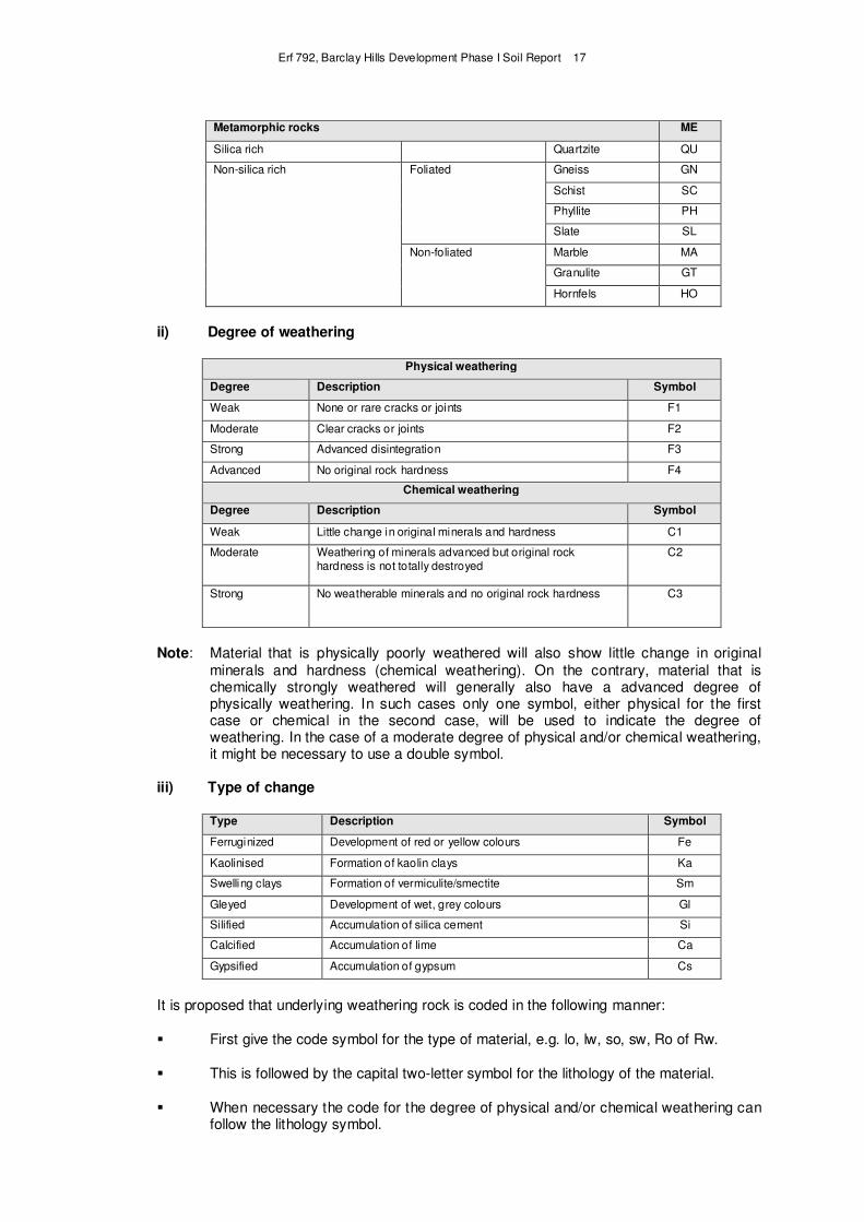
Erf 792, Barclay Hills Development Phase I Soil Report 17
Metamorphic rocks ME
Silica rich Quartzite QU
Non-silica rich Foliated Gneiss GN
Schist SC
Phyllite PH
Slate SL
Non-foliated Marble MA
Granulite GT
Hornfels HO
ii) Degree of weathering
Physical weathering
Degree Description Symbol
Weak None or rare cracks or joints F1
Moderate Clear cracks or joints F2
Strong Advanced disintegration F3
Advanced No original rock hardness F4
Chemical weathering
Degree Description Symbol
Weak Little change in original minerals and hardness C1
Moderate Weathering of minerals advanced but original rock hardness is not totally destroyed
C2
Strong No weatherable minerals and no original rock hardness C3
Note: Material that is physically poorly weathered will also show little change in original
minerals and hardness (chemical weathering). On the contrary, material that is chemically strongly weathered will generally also have a advanced degree of physically weathering. In such cases only one symbol, either physical for the first case or chemical in the second case, will be used to indicate the degree of weathering. In the case of a moderate degree of physical and/or chemical weathering, it might be necessary to use a double symbol.
iii) Type of change
Type Description Symbol
Ferruginized Development of red or yellow colours Fe
Kaolinised Formation of kaolin clays Ka
Swelling clays Formation of vermiculite/smectite Sm
Gleyed Development of wet, grey colours Gl
Silified Accumulation of silica cement Si
Calcified Accumulation of lime Ca
Gypsified Accumulation of gypsum Cs
It is proposed that underlying weathering rock is coded in the following manner:
� First give the code symbol for the type of material, e.g. lo, lw, so, sw, Ro of Rw.
� This is followed by the capital two-letter symbol for the lithology of the material.
� When necessary the code for the degree of physical and/or chemical weathering can follow the lithology symbol.
Erf 792, Barclay Hills Development Phase I Soil Report 18
� When necessary the symbol for the type of change can be the last entry.
� The individual code symbols are separated by a hyphen (-).
As an example, the code for mudstone that conforms to the criteria of a hard lithocutanic B horizon with very few cracks and joints, no signs of wetness but with signs of ferriginization (yellow/red colours), is as follow: so – MU - F1 - Fe.
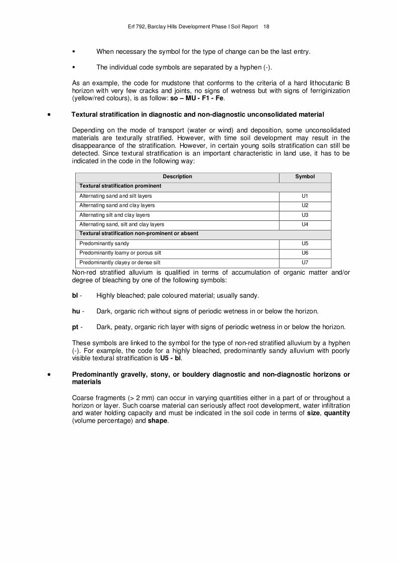
•••• Textural stratification in diagnostic and non-diagnostic unconsolidated material
Depending on the mode of transport (water or wind) and deposition, some unconsolidated materials are texturally stratified. However, with time soil development may result in the disappearance of the stratification. However, in certain young soils stratification can still be detected. Since textural stratification is an important characteristic in land use, it has to be indicated in the code in the following way:
Description Symbol
Textural stratification prominent
Alternating sand and silt layers U1
Alternating sand and clay layers U2
Alternating silt and clay layers U3
Alternating sand, silt and clay layers U4
Textural stratification non-prominent or absent
Predominantly sandy U5
Predominantly loamy or porous silt U6
Predominantly clayey or dense silt U7
Non-red stratified alluvium is qualified in terms of accumulation of organic matter and/or degree of bleaching by one of the following symbols:
bl - Highly bleached; pale coloured material; usually sandy.
hu - Dark, organic rich without signs of periodic wetness in or below the horizon.
pt - Dark, peaty, organic rich layer with signs of periodic wetness in or below the horizon.
These symbols are linked to the symbol for the type of non-red stratified alluvium by a hyphen (-). For example, the code for a highly bleached, predominantly sandy alluvium with poorly visible textural stratification is U5 - bl.
•••• Predominantly gravelly, stony, or bouldery diagnostic and non-diagnostic horizons or materials
Coarse fragments (> 2 mm) can occur in varying quantities either in a part of or throughout a horizon or layer. Such coarse material can seriously affect root development, water infiltration and water holding capacity and must be indicated in the soil code in terms of size, quantity (volume percentage) and shape.
Erf 792, Barclay Hills Development Phase I Soil Report 19
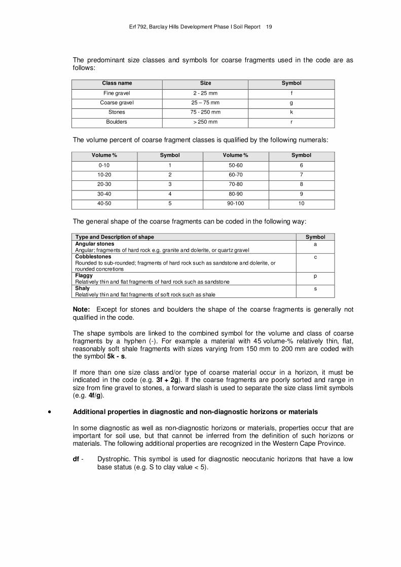
The predominant size classes and symbols for coarse fragments used in the code are as follows:
Class name Size Symbol
Fine gravel 2 - 25 mm f
Coarse gravel 25 – 75 mm g
Stones 75 - 250 mm k
Boulders > 250 mm r
The volume percent of coarse fragment classes is qualified by the following numerals:
Volume % Symbol Volume % Symbol
0-10 1 50-60 6
10-20 2 60-70 7
20-30 3 70-80 8
30-40 4 80-90 9
40-50 5 90-100 10
The general shape of the coarse fragments can be coded in the following way:
Type and Description of shape Symbol
Angular stones Angular; fragments of hard rock e.g. granite and dolerite, or quartz gravel
a
Cobblestones Rounded to sub-rounded; fragments of hard rock such as sandstone and dolerite, or rounded concretions
c
Flaggy Relatively thin and flat fragments of hard rock such as sandstone
p
Shaly Relatively thin and flat fragments of soft rock such as shale
s
Note: Except for stones and boulders the shape of the coarse fragments is generally not
qualified in the code.
The shape symbols are linked to the combined symbol for the volume and class of coarse fragments by a hyphen (-). For example a material with 45 volume-% relatively thin, flat, reasonably soft shale fragments with sizes varying from 150 mm to 200 mm are coded with the symbol 5k - s.
If more than one size class and/or type of coarse material occur in a horizon, it must be indicated in the code (e.g. 3f + 2g). If the coarse fragments are poorly sorted and range in
size from fine gravel to stones, a forward slash is used to separate the size class limit symbols (e.g. 4f/g).
•••• Additional properties in diagnostic and non-diagnostic horizons or materials
In some diagnostic as well as non-diagnostic horizons or materials, properties occur that are important for soil use, but that cannot be inferred from the definition of such horizons or materials. The following additional properties are recognized in the Western Cape Province.
df - Dystrophic. This symbol is used for diagnostic neocutanic horizons that have a low
base status (e.g. S to clay value < 5).
Erf 792, Barclay Hills Development Phase I Soil Report 20
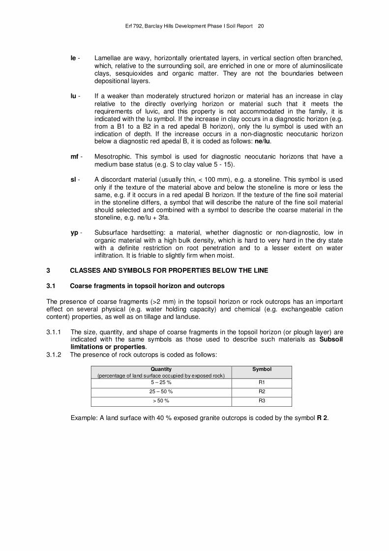
le - Lamellae are wavy, horizontally orientated layers, in vertical section often branched,
which, relative to the surrounding soil, are enriched in one or more of aluminosilicate clays, sesquioxides and organic matter. They are not the boundaries between depositional layers.
lu - If a weaker than moderately structured horizon or material has an increase in clay
relative to the directly overlying horizon or material such that it meets the requirements of luvic, and this property is not accommodated in the family, it is indicated with the lu symbol. If the increase in clay occurs in a diagnostic horizon (e.g. from a B1 to a B2 in a red apedal B horizon), only the lu symbol is used with an indication of depth. If the increase occurs in a non-diagnostic neocutanic horizon below a diagnostic red apedal B, it is coded as follows: ne/lu.
mf - Mesotrophic. This symbol is used for diagnostic neocutanic horizons that have a
medium base status (e.g. S to clay value 5 - 15).
sl - A discordant material (usually thin, < 100 mm), e.g. a stoneline. This symbol is used
only if the texture of the material above and below the stoneline is more or less the same, e.g. if it occurs in a red apedal B horizon. If the texture of the fine soil material in the stoneline differs, a symbol that will describe the nature of the fine soil material should selected and combined with a symbol to describe the coarse material in the stoneline, e.g. ne/lu + 3fa.
yp - Subsurface hardsetting: a material, whether diagnostic or non-diagnostic, low in
organic material with a high bulk density, which is hard to very hard in the dry state with a definite restriction on root penetration and to a lesser extent on water infiltration. It is friable to slightly firm when moist.
3 CLASSES AND SYMBOLS FOR PROPERTIES BELOW THE LINE
3.1 Coarse fragments in topsoil horizon and outcrops
The presence of coarse fragments (>2 mm) in the topsoil horizon or rock outcrops has an important effect on several physical (e.g. water holding capacity) and chemical (e.g. exchangeable cation content) properties, as well as on tillage and landuse.
3.1.1 The size, quantity, and shape of coarse fragments in the topsoil horizon (or plough layer) are indicated with the same symbols as those used to describe such materials as Subsoil limitations or properties.
3.1.2 The presence of rock outcrops is coded as follows:
Quantity
(percentage of land surface occupied by exposed rock)
Symbol
5 – 25 % R1
25 – 50 % R2
> 50 % R3
Example: A land surface with 40 % exposed granite outcrops is coded by the symbol R 2.
Erf 792, Barclay Hills Development Phase I Soil Report 21
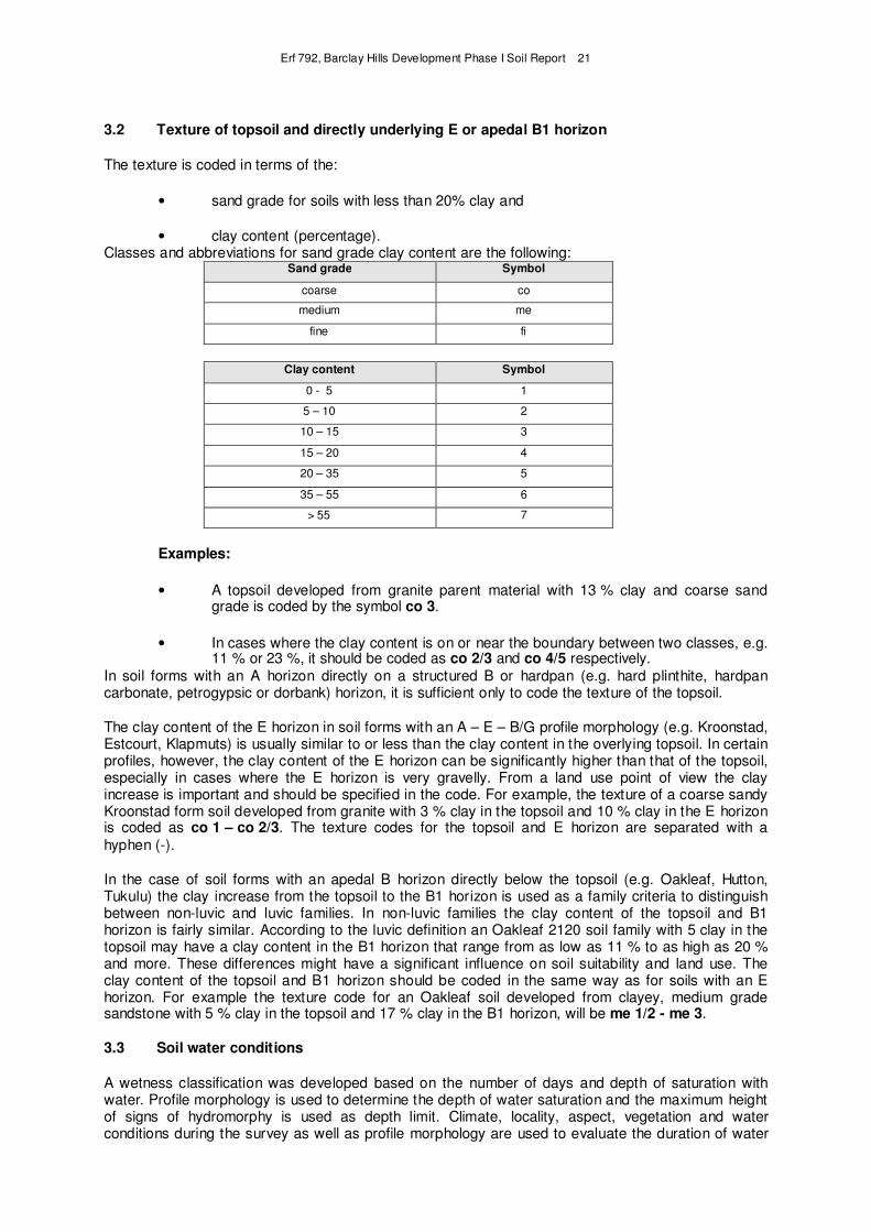
3.2 Texture of topsoil and directly underlying E or apedal B1 horizon
The texture is coded in terms of the:
• sand grade for soils with less than 20% clay and
• clay content (percentage). Classes and abbreviations for sand grade clay content are the following:
Sand grade Symbol
coarse co
medium me
fine fi
Clay content Symbol
0 - 5 1
5 – 10 2
10 – 15 3
15 – 20 4
20 – 35 5
35 – 55 6
> 55 7
Examples:
• A topsoil developed from granite parent material with 13 % clay and coarse sand grade is coded by the symbol co 3.
• In cases where the clay content is on or near the boundary between two classes, e.g. 11 % or 23 %, it should be coded as co 2/3 and co 4/5 respectively.
In soil forms with an A horizon directly on a structured B or hardpan (e.g. hard plinthite, hardpan carbonate, petrogypsic or dorbank) horizon, it is sufficient only to code the texture of the topsoil.
The clay content of the E horizon in soil forms with an A – E – B/G profile morphology (e.g. Kroonstad, Estcourt, Klapmuts) is usually similar to or less than the clay content in the overlying topsoil. In certain profiles, however, the clay content of the E horizon can be significantly higher than that of the topsoil, especially in cases where the E horizon is very gravelly. From a land use point of view the clay increase is important and should be specified in the code. For example, the texture of a coarse sandy Kroonstad form soil developed from granite with 3 % clay in the topsoil and 10 % clay in the E horizon is coded as co 1 – co 2/3. The texture codes for the topsoil and E horizon are separated with a
hyphen (-).
In the case of soil forms with an apedal B horizon directly below the topsoil (e.g. Oakleaf, Hutton, Tukulu) the clay increase from the topsoil to the B1 horizon is used as a family criteria to distinguish between non-luvic and luvic families. In non-luvic families the clay content of the topsoil and B1 horizon is fairly similar. According to the luvic definition an Oakleaf 2120 soil family with 5 clay in the topsoil may have a clay content in the B1 horizon that range from as low as 11 % to as high as 20 % and more. These differences might have a significant influence on soil suitability and land use. The clay content of the topsoil and B1 horizon should be coded in the same way as for soils with an E horizon. For example the texture code for an Oakleaf soil developed from clayey, medium grade sandstone with 5 % clay in the topsoil and 17 % clay in the B1 horizon, will be me 1/2 - me 3.
3.3 Soil water conditions
A wetness classification was developed based on the number of days and depth of saturation with water. Profile morphology is used to determine the depth of water saturation and the maximum height of signs of hydromorphy is used as depth limit. Climate, locality, aspect, vegetation and water conditions during the survey as well as profile morphology are used to evaluate the duration of water

Erf 792, Barclay Hills Development Phase I Soil Report 22
saturation. The expected number of days of saturation during the rainy season in "wet" years is used to determine duration. It is essential for free water to occur in the profile continuously for at least seven (7) days. However, the total number of days with free water need not be continuous.
Diagram for the determination of wetness classes
Depth range of upper boundary Wetness symbol of free water surface (mm)
0 - 300 6 7 8 9
300- 700 3 6 7 8
700 – 1 200 2 3 4 5
> 1 500 1
0 30 90 180 365
Cumulative number of days with free water
Note: The numeral 1 is not used in the code.
Example: A soil with a wetness class symbol of 6 implies that the upper boundary of the free water surface can either be 0 – 300 mm with a maximum cumulative number of 30 days with free water, or a free surface depth of 300 – 700 mm with a cumulative duration of 30 – 90 days with free water.
3.4 Changes in soil properties and conditions
Soils as natural phenomena are subjected at their surface to recent geological processes, such as erosion by wind or water, as well as the deposition of material transported by water, wind or gravity. As a natural agricultural resource soil can also be affected by man for shorter or longer periods. Activities such as grazing of natural veld, normal soil tillage, deep soil preparation and drainage, etc., can cause soils to change to a greater or lesser extent. The changes can vary in permanence and can benefit or adversely affect crop production. It is therefore essential that such phenomena be described and indicated in the soil code.
•••• Recent deposits on the A horizon
al - Recent alluvial material on the A horizon.
ko - Recent colluvium on the A horizon.
ob - A recent geological deposit on the A horizon which does not qualify for al, rs or ko.
rs - Recent aeolian material on the A horizon.
The thickness of the deposit can be indicated after the letter symbol with a depth numerical symbol (refer to Section 2.1), e.g. rs 2 for a 200 mm thick recent aeolian deposit.
Erf 792, Barclay Hills Development Phase I Soil Report 23
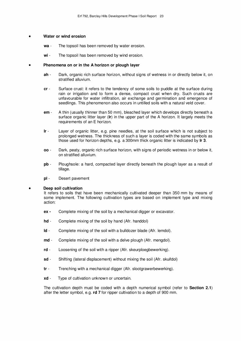
•••• Water or wind erosion
wa - The topsoil has been removed by water erosion.
wi - The topsoil has been removed by wind erosion.
•••• Phenomena on or in the A horizon or plough layer
ah - Dark, organic rich surface horizon, without signs of wetness in or directly below it, on
stratified alluvium.
cr - Surface crust: it refers to the tendency of some soils to puddle at the surface during
rain or irrigation and to form a dense, compact crust when dry. Such crusts are unfavourable for water infiltration, air exchange and germination and emergence of seedlings. This phenomenon also occurs in untilled soils with a natural veld cover.
em - A thin (usually thinner than 50 mm), bleached layer which develops directly beneath a surface organic litter layer (lr) in the upper part of the A horizon. It largely meets the
requirements of an E horizon.
lr - Layer of organic litter, e.g. pine needles, at the soil surface which is not subject to
prolonged wetness. The thickness of such a layer is coded with the same symbols as those used for horizon depths, e.g. a 300mm thick organic litter is indicated by lr 3.
oo - Dark, peaty, organic rich surface horizon, with signs of periodic wetness in or below it,
on stratified alluvium.
pb - Ploughsole: a hard, compacted layer directly beneath the plough layer as a result of
tillage.
pl - Desert pavement
•••• Deep soil cultivation It refers to soils that have been mechanically cultivated deeper than 350 mm by means of some implement. The following cultivation types are based on implement type and mixing action:
ex - Complete mixing of the soil by a mechanical digger or excavator.
hd - Complete mixing of the soil by hand (Afr. handdol)
ld - Complete mixing of the soil with a bulldozer blade (Afr. lemdol).
md - Complete mixing of the soil with a delve plough (Afr. mengdol).
rd - Loosening of the soil with a ripper (Afr. skeurploegbewerking).
sd - Shifting (lateral displacement) without mixing the soil (Afr. skuifdol)
tr - Trenching with a mechanical digger (Afr. slootgrawerbewerking).
xd - Type of cultivation unknown or uncertain.
The cultivation depth must be coded with a depth numerical symbol (refer to Section 2.1) after the letter symbol, e.g. rd 7 for ripper cultivation to a depth of 900 mm.
Erf 792, Barclay Hills Development Phase I Soil Report 24
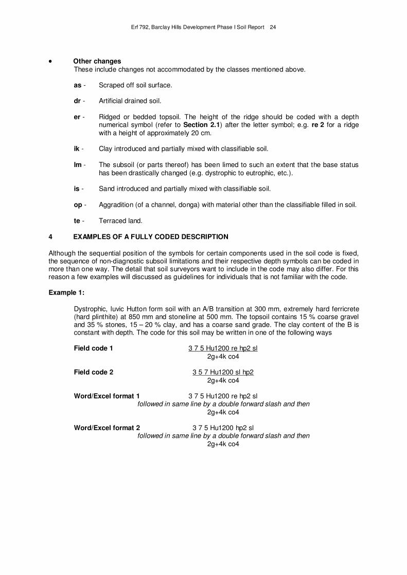
•••• Other changes These include changes not accommodated by the classes mentioned above.
as - Scraped off soil surface.
dr - Artificial drained soil.
er - Ridged or bedded topsoil. The height of the ridge should be coded with a depth numerical symbol (refer to Section 2.1) after the letter symbol; e.g. re 2 for a ridge
with a height of approximately 20 cm.
ik - Clay introduced and partially mixed with classifiable soil.
lm - The subsoil (or parts thereof) has been limed to such an extent that the base status
has been drastically changed (e.g. dystrophic to eutrophic, etc.).
is - Sand introduced and partially mixed with classifiable soil.
op - Aggradition (of a channel, donga) with material other than the classifiable filled in soil.
te - Terraced land.
4 EXAMPLES OF A FULLY CODED DESCRIPTION
Although the sequential position of the symbols for certain components used in the soil code is fixed, the sequence of non-diagnostic subsoil limitations and their respective depth symbols can be coded in more than one way. The detail that soil surveyors want to include in the code may also differ. For this reason a few examples will discussed as guidelines for individuals that is not familiar with the code.
Example 1:
Dystrophic, luvic Hutton form soil with an A/B transition at 300 mm, extremely hard ferricrete (hard plinthite) at 850 mm and stoneline at 500 mm. The topsoil contains 15 % coarse gravel and 35 % stones, 15 – 20 % clay, and has a coarse sand grade. The clay content of the B is constant with depth. The code for this soil may be written in one of the following ways
Field code 1 3 7 5 Hu1200 re hp2 sl
2g+4k co4
Field code 2 3 5 7 Hu1200 sl hp2
2g+4k co4
Word/Excel format 1 3 7 5 Hu1200 re hp2 sl followed in same line by a double forward slash and then
2g+4k co4
Word/Excel format 2 3 7 5 Hu1200 hp2 sl followed in same line by a double forward slash and then
2g+4k co4
Erf 792, Barclay Hills Development Phase I Soil Report 25
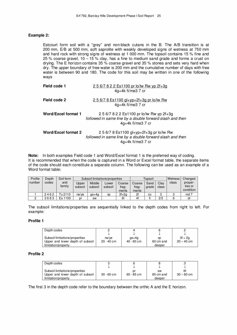
Example 2:
Estcourt form soil with a “grey” and non-black cutans in the B. The A/B transition is at 200 mm, E/B at 500 mm, soft saprolite with weakly developed signs of wetness at 750 mm and hard rock with strong signs of wetness at 1 000 mm. The topsoil contains 15 % fine and 25 % coarse gravel, 10 – 15 % clay, has a fine to medium sand grade and forms a crust on drying. The E horizon contains 35 % coarse gravel and 35 % stones and sets very hard when dry. The upper boundary of free water is 200 mm and the cumulative number of days with free water is between 90 and 180. The code for this soil may be written in one of the following ways
Field code 1 2 5 6/7 8 2 2 Es1100 pr lo/lw Rw yp 2f+3g
4g+4k fi/me3 7 cr
Field code 2 2 5 6/7 8 Es1100 gl+yp+2f+3g pr lo/lw Rw
4g+4k fi/me3 7 cr
Word/Excel format 1 2 5 6/7 8 2 2 Es1100 pr lo/lw Rw yp 2f+3g followed in same line by a double forward slash and then
4g+4k fi/me3 7 cr
Word/Excel format 2 2 5 6/7 8 Es1100 gl+yp+2f+3g pr lo/lw Rw followed in same line by a double forward slash and then
4g+4k fi/me3 7 cr
Note: In both examples Field code 1 and Word/Excel format 1 is the preferred way of coding.
It is recommended that when the code is captured in a Word or Excel format table, the separate items of the code should each constitute a separate column. The following can be used as an example of a Word format table:
Profile number
Depth codes
Soil form and
family
Subsoil limitations/properties Topsoil Wetness class
Changed proper- ties or
condition
Upper subsoil
Middle subsoil
Lower subsoil
Coarse frag-
ments
Coarse frag-
ments
Sand grade
Clay class
1 2 4 6 2 Tu 2110 ne/ye gs+4g vp 3f+2g 2f co 3 3 md 7 2 3 6 8 3 Es 1100 pr sw 6f 4f fi 2/3 6 dr
The subsoil limitations/properties are sequentially linked to the depth codes from right to left. For example:
Profile 1
Depth codes 2 4 6 2 ↓ ↓ ↓ ↓
Subsoil limitations/properties ne/ye gs+4g vp 3f + 2g Upper and lower depth of subsoil limitation/property
20 - 40 cm 40 - 60 cm 60 cm and deeper
20 – 40 cm
Profile 2
Depth codes 3 6 8 3 ↓ ↓ ↓ ↓
Subsoil limitations/properties pr sw 6f Upper and lower depth of subsoil limitation/property
30 - 60 cm 60 - 85 cm 85 cm and deeper
30 – 60 cm
The first 3 in the depth code refer to the boundary between the orthic A and the E horizon.