remote sensing applications to hydrology: soil moisture
TRANSCRIPT

This article was downloaded by: [193.84.36.95]On: 28 March 2014, At: 09:32Publisher: Taylor & FrancisInforma Ltd Registered in England and Wales Registered Number: 1072954 Registeredoffice: Mortimer House, 37-41 Mortimer Street, London W1T 3JH, UK
Hydrological Sciences JournalPublication details, including instructions for authors andsubscription information:http://www.tandfonline.com/loi/thsj20
Remote sensing applications tohydrology: soil moistureT. J. JACKSON a , J. SCHMUGGE a & E. T. ENGMAN ba USDA Agricultural Research Service, Hydrology Laboratory ,Beltsville, Maryland, 20705, USAb NASA/Goddard Space Flight Center, Hydrological SciencesBranch , Greenbelt, Maryland, 20771, USAPublished online: 24 Dec 2009.
To cite this article: T. J. JACKSON , J. SCHMUGGE & E. T. ENGMAN (1996) Remote sensingapplications to hydrology: soil moisture, Hydrological Sciences Journal, 41:4, 517-530
To link to this article: http://dx.doi.org/10.1080/02626669609491523
PLEASE SCROLL DOWN FOR ARTICLE
Taylor & Francis makes every effort to ensure the accuracy of all the information (the“Content”) contained in the publications on our platform. However, Taylor & Francis,our agents, and our licensors make no representations or warranties whatsoever as tothe accuracy, completeness, or suitability for any purpose of the Content. Any opinionsand views expressed in this publication are the opinions and views of the authors,and are not the views of or endorsed by Taylor & Francis. The accuracy of the Contentshould not be relied upon and should be independently verified with primary sourcesof information. Taylor and Francis shall not be liable for any losses, actions, claims,proceedings, demands, costs, expenses, damages, and other liabilities whatsoeveror howsoever caused arising directly or indirectly in connection with, in relation to orarising out of the use of the Content.
This article may be used for research, teaching, and private study purposes. Anysubstantial or systematic reproduction, redistribution, reselling, loan, sub-licensing,systematic supply, or distribution in any form to anyone is expressly forbidden. Terms& Conditions of access and use can be found at http://www.tandfonline.com/page/terms-and-conditions

HydrologicalSciences -Journal- des Sciences Hydrologiques,4l(l) August 1996 5 1 7
Remote sensing applications to hydrology: soil moisture
T. J. JACKSON & J. SCHMUGGE USDA Agricultural Research Service, Hydrology Laboratory, Beltsville, Maryland 20705, USA
E. T. ENGMAN NASA/Goddard Space Flight Center, Hydrological Sciences Branch, Greenbelt, Maryland 20771, USA
Abstract Passive and active microwave remote sensing instruments are capable of measuring the surface soil moisture (0-5 cm) and can be implemented on high altitude platforms, e.g. spacecraft, for repetitive large area observations. The amount of water present in a soil affects its dielectric properties. The dielectric properties, along with several other physical characteristics, determine the microwave measurement. In addition, the significance of the dielectric properties depends upon the sensor design, especially the wavelength. Instruments operating at longer wavelengths ( > 5 cm) have fewer problems with the atmosphere and vegetation, sense a deeper soil layer and maximize soil moisture sensitivity. Another instrument concern is whether to use an active or passive microwave approach. Active approaches, especially synthetic aperture radar, can provide extremely good ground resolution from space (<100 m). Passive methods currently provide much coarser resolution data (> 10 km). The existing data interpretation algorithms for passive data are well tested for bare soil and vegetation and can be applied to a wide range of conditions. At the present time, the active microwave algorithms have not been widely verified. There has been a significant amount of recent research using both active and passive methods as a result of the availability of new sensor systems. With these new instruments have also come greater efforts to integrate the observations in large scale multidisciplinary investigations. A greater emphasis on the spatial distribution and temporal behaviour of soil moisture has produced some very interesting and valuable data sets that demonstrate the potential of a dedicated observing system for scientific and operational studies.
Application de la télédétection à l'hydrologie: l'humidité du sol Résumé En télédétection, les instruments utilisant les micro-ondes actives ou passives sont capables de mesurer l'humidité de la surface des sols (0-5 cm) et peuvent être installés à haute altitude sur des plates-formes telles que des engins spatiaux, afin de réaliser des observations sur de vastes surfaces de façon répétitive. La quantité d'eau présente dans un sol affecte ses propriétés diélectriques. Ce sont ces propriétés diélectriques, de même de quelques autres propriétés physiques qui déterminent la mesure par micro-ondes. L'expression des propriétés diélectriques dépend de plus des caractéristiques du capteur, en particulier de la longueur d'onde à laquelle il travaille. Pour les instruments utilisant les plus grandes longueurs d'onde (> 5 cm), l'atmosphère et la végétation ne posent pas de gros problèmes, la couche de sol explorée est plus épaisse et la sensibilité à la
Open for discussion until 1 February 1997
Dow
nloa
ded
by [
193.
84.3
6.95
] at
09:
32 2
8 M
arch
201
4
518 T. J. Jackson et al.
teneur en eau du sol est maximale. A propos des instruments, il est nécessaire de faire un choix entre l'approche passive et l'approche active. Les méthodes actives, en particulier celle utilisant le radar à ouverture synthétique, peuvent fournir depuis l'espace une excellente résolution au sol (< 100 m). Les méthodes passives ne fournissent à l'heure actuelle que des résolutions plus grossières ( > 10 km). Les algorithmes permettant d'interpréter les données passives ont été bien testés pour des sols nus ou recouverts de végétation et peuvent être utilisés dans des conditions très variées. A l'heure actuelle, les algorithmes concernant les données actives n'ont pas encore été totalement validés. L'utilisation conjointe des méthodes actives et passives, rendue possible par une nouvelle génération de capteurs, a fait l'objet de nombreuses recherches. Avec ces nouveaux instruments de nombreux efforts ont également été entrepris pour intégrer les observations dans le cadre de recherches multidisciplinaires à grande échelle. L'accent mis sur la distribution spatiale et l'évolution temporelle de l'humidité des sols a permis de rassembler de très intéressants ensembles de données de qualité qui prouvent le potentiel d'un système d'observation spécifique pour des études scientifiques ou opérationnelles.
INTRODUCTION
Microwave remote sensing can provide a direct measurement of the surface soil moisture for a range of cover conditions and within reasonable error bounds. Since spatially distributed and multitemporal observations of surface soil moisture are rare, the use of these data in hydrology and other disciplines has not been fully explored or developed. The ability to observe soil moisture frequently over large regions could significantly improve our ability to predict runoff and to partition incoming radiant energy into latent and sensible heat fluxes at a variety of scales up to those used in global circulation models. Temporal observation of surface soil moisture may also provide the information needed to determine key soil parameters such as saturated conductivity (Ahuja et al., 1993). The basis of microwave remote sensing of soil moisture will be presented in this paper along with the advantages and disadvantages of different techniques. Currently available sensor systems will be described. It should be noted that there are no satellite systems in operation that are truly capable of reliable soil moisture measurement. Finally, some recent research highlights utilizing different microwave techniques and platforms will be described.
MICROWAVE REMOTE SENSING
There are two basic approaches used in microwave remote sensing: passive and active. Passive methods measure the natural thermal emission of the land surface at microwave wavelengths using very sensitive detectors. Active methods or radars send and receive a microwave pulse. The power of the received signal is compared to that which was sent to determine the back-scattering coefficient. That coefficient is then related to the characteristics of the target. In the next section, common elements of the two approaches are
Dow
nloa
ded
by [
193.
84.3
6.95
] at
09:
32 2
8 M
arch
201
4
Remote sensing applications to hydrology: soil moisture 519
presented followed by descriptions of the individual techniques. A general advantage of microwave sensors (as opposed to visible and
infrared) is that observations can be made under conditions of cloud cover. In addition, these measurements are not dependent on solar illumination and can be made at any time of the day. The microwave region of the electromagnetic spectrum consists of wavelengths between 1 and 100 cm. This region is subdivided into bands which are often referred to by a lettering system. Some of the relevant bands that are used are: X ( — 0.8 cm), K (~3 cm), C (~5 cm), S (~10 cm), L (-20 cm), and P ( — 50 cm). Within these bands there are small ranges that are protected for applications such as radioastronomy.
Fundamental basis
Fresnel reflection to soil dielectric properties By assuming that the target being observed is a plane surface with surface geometric variations and volume discontinuities much less than the wavelength, only refraction and absorption of the media need to be considered. This permits the use of the Fresnel reflection equations. These equations predict the surface reflectivity as a function of the index of refraction of the target and the viewing angle based on polarization of the sensor (horizontal or vertical). The index of refraction is related to the ratio of the dielectric constants of the two media at the surface of the target.
If the sensor provides a measure of reflectivity and the viewing angle and polarization are defined, it should be possible to estimate the index of refraction. For a land surface, the target consists of an interface of air and soil. Since the dielectric constant of air is a known value, the reflectivity provides a measurement of the dielectric constant of the medium (soil). The Fresnel equations apply when the two media at the interface each have uniform dielectric properties. This is certainly valid for air; however, for a soil surface this will rarely be true. One of the significant issues that has been addressed in recent research is the validity of the Fresnel assumptions for soil surfaces (Jackson et al., 1995a).
Dielectric constant to volumetric soil moisture The dielectric constant of soil is a composite of the values of its components: air, soil and water. Although the dielectric constant is a complex number, for soil mixtures the imaginary part is small and can be ignored for computational purposes without introducing significant error. Values of the real part of the dielectric constant for air and soil particles are 1 and 5, respectively. Water has a value of about 80 at the longer wavelengths considered here (>5 cm). The basic reason microwave remote sensing is capable of providing soil moisture information is this large difference between water and the other components. Since the dielectric constant is a volume property, the volumetric fraction of each component is involved. The computation of the mixture dielectric constant has
Dow
nloa
ded
by [
193.
84.3
6.95
] at
09:
32 2
8 M
arch
201
4
520 T. J. Jackson et al
been the subject of several studies and there are different theories as to the exact form of the mixing equation. A simple linear weighting function is typically used.
The dielectric constant of water mentioned above is that of free water in which the molecules are free to rotate and align with an electrical field. It has been recognized for some time that not all the water in soil satisfies this condition. Schmugge (1980) suggested that some water in the soil had different properties and that for a given soil this was associated with soil texture in much the same way that general procedures are used to estimate 15 bar and 1/3 bar moisture contents based on texture. He proposed that the initial water added to soil below a "transition" moisture had the dielectric properties of frozen water ( ~ 3).
It is generally accepted that four components need to be considered in computing the dielectric constant of soil: air, soil particles, bound water, and free water. To interpret the data correctly it will be necessary to have some knowledge of the soil texture. Based on an estimate of the mixture dielectric constant derived from the Fresnel equations and soil texture, it is possible to then estimate volumetric soil moisture.
Contributing depth of the soil and microwave wavelength There are well known theories describing the reflection resulting from a soil profile with uniform or varying properties (Njoku & Kong, 1977). The computations involve a nonlinear weighting that decays with depth. Some modelling studies have suggested that this dominant depth is 1/10 the wavelength (Wilheit, 1978). Field experiments (Jackson & Schmugge, 1989) suggest that the contributing depth is about 1/4 the wavelength (based on a wavelength range of 2-21 cm).
Passive microwave methods
Passive microwave remote sensing utilizes highly sensitive radiometers that measure the natural thermal radio emission at a particular wavelength. The measurement provided is the brightness temperature, TB, that includes contributions from the atmosphere, reflected cosmic radiation, and the land surface. Atmospheric contributions are negligible at wavelengths >5 cm. Cosmic radiation has a known value.
The brightness temperature of a surface is equal to its emissivity multiplied by its physical temperature. If the physical temperature is estimated independently, emissivity can be determined. Microwave emissivity varies between 0.6 and 0.95 for most land surfaces. At these wavelengths the reflectivity is equal to 1 minus the emissivity which then provides the linkage to the Fresnel equations and soil moisture.
For natural conditions, various degrees of vegetation will be encountered and this affects the microwave measurement. Vegetation reduces the sensitivity of the interpretation algorithm to soil moisture changes. The attenuation increases as wavelength decreases. This is an important reason for using longer
Dow
nloa
ded
by [
193.
84.3
6.95
] at
09:
32 2
8 M
arch
201
4
Remote sensing applications to hydrology: soil moisture 521
wavelengths. As described in Jackson & Schmugge (1989), at longer wavelengths it is possible to correct for vegetation using a vegetation water content related parameter.
An algorithm for estimating surface soil moisture from TB based on the inversion of the Fresnel equations has been presented in Jackson (1993). This algorithm incorporates soil texture, surface roughness and temperature. It also includes corrections for vegetation. It has been applied in a number of ground and aircraft studies using L (21 cm) and S (Il cm) band radiometers.
For longer passive microwave wavelengths ( > 5 cm) the effects of surface roughness are small and the effects of most types of vegetation (with the exception of forests) can be accounted for. A problem with passive microwave methods is spatial resolution. For a given antenna size, the footprint size increases as wavelength and altitude increase. For realistic satellite designs at L band this might result in a footprint as large as 100 km. Recent research has focused on the use of synthetic aperture thinned array radiometers which could decrease the footprint size from satellites to 10 km (Le Vine et al., 1994).
Active microwave methods
An active microwave sensor that measures the sent and received power is called a scatterometer. The measurement provided is the backscattering coefficient (CT°). Through theory described in Ulaby et al. (1986), the <r° can be related to the surface reflectivity. As described for the passive methods, these results can then be used to determine surface soil moisture. For active techniques, the step between the measurement of a° and the soil moisture is somewhat more involved. The geometric properties of the soil surface and any vegetation have a greater effect on these measurements and simple correction procedures are difficult to develop.
The signals sent and received by a radar are usually linearly polarized, either horizontally (H) or vertically (V). Combinations possible are HH, VV, HV and VH. More advanced systems can make all these multipolarization measurements simultaneously.
For bare soils, all models that relate a° to soil moisture require at least two soil parameters, the dielectric constant and the surface height standard deviation (RMS). This means that in order to invert these models, the surface height standard deviation must be determined accurately. Also, because of the high spatial resolution, surface topography must often be accounted for. For a given sensor configuration of wavelength and viewing angle, different results are obtained at different polarizations but depend on these same two variables. Therefore, most approaches to determining soil moisture with active microwave methods utilize dual polarization measurements. With two independent measurements of the two variables, it is possible to solve for both the dielectric constant and the RMS. Algorithms incorporating this approach are presented in Oh et al. (1992) and Dubois et al. (1995).
Dow
nloa
ded
by [
193.
84.3
6.95
] at
09:
32 2
8 M
arch
201
4

522 T. J. Jackson et al.
A comprehensive model that accounts for vegetation has not been proposed. Some modelling efforts have focused on particular types of vegetation (Lin et al., 1994) to develop soil moisture algorithms. The use of multiple frequencies may yield a solution to this problem.
Active microwave sensors on aircraft and spacecraft typically employ synthetic aperture radar (SAR) techniques which utilize the motion of the platform to synthesize larger antennas. Exceptional spatial resolutions with footprints on the order of 20 m can be achieved from satellite altitudes.
CURRENT AND NEAR FUTURE SENSOR SYSTEMS
To a large degree, research and applications utilizing microwave sensors are dependent on the instruments currently available. As the need for soil moisture studies has developed, some new instruments have emerged. Current and near future microwave sensors operating from ground, aircraft and satellite platforms are described in the following sections.
Ground-based platforms
The advantages of ground-based systems include the small sensor footprints (a few metres in size) and the ability to control and measure the target and to collect data continuously. These systems are ideally suited to the study of the fundamental relationships between microwave observables and target variables as well as observing time-dependent hydrological processes such as evaporation and infiltration.
Jackson et al. (1995a) operated a dual wavelength (11 cm and 21 cm single polarization) passive microwave system installed on a boom truck. This system is capable of obtaining either automatic continuous observations over a single target or moving from one target to another to collect specific data sets. A similar system which includes a 21 cm sensor and a number of shorter wavelengths is operated by a French research organization that has focused much of its research on soil moisture related studies (Raju et al., 1995). Truck-based active microwave systems are operated by several groups. These include a NASA Goddard Space Flight Center multipolarization system with wavelengths of 3, 6 and 18 cm (O'Neill et al., 1994). Similar systems that are being used in soil moisture studies are described in Sofko et al. (1989), Oh et al. (1992), and Benallegue et al. (1995).
Aircraft platforms
Aircraft-based microwave instruments are especially useful in studies requiring the mapping of large areas. They can also serve as prototypes of future satellite
Dow
nloa
ded
by [
193.
84.3
6.95
] at
09:
32 2
8 M
arch
201
4
Remote sensing applications to hydrology: soil moisture 523
sensors. In most cases, they will offer better spatial resolution than satellite systems as well as more control over the frequency and timing of coverage.
In the case of passive microwave systems, there are no appropriate satellite systems available for soil moisture studies. Therefore, all large area research must utilize aircraft sensors. In recent years NASA has supported two airborne L band (21 cm) radiometers, the pushbroom microwave radiometer (PBMR) and the electronically scanned thinned array radiometer (ESTAR). The PBMR has been in operation since 1983 in soil moisture studies and has contributed significantly to large area soil moisture research (Schmugge et al., 1992). It collected data for four footprints simultaneously along a flightline and utilized conventional antenna technology. The ESTAR instrument doubles the number of footprints to eight which makes it a more efficient mapping instrument. It is also a prototype for a new synthetic aperture antenna technology that can solve the high altitude-spatial resolution problem described earlier (Le Vine etal., 1994).
Of the active microwave aircraft systems currently operating, the AIRSAR operated by NASA's Jet Propulsion Lab (Dubois et al., 1995) and another developed by the Canadian Centre for Remote Sensing (Livingston et al., 1988) have been the most widely used for soil moisture studies. The AIRSAR is flown on a DC-8 aircraft and provides multipolarization data at wavelengths of 5.66, 23.98 and 68.13 cm. It is very efficient for mapping large areas and provides exceptional spatial resolution. The Canadian system is a multipolarization X and C band SAR.
Satellite systems
Satellite-based sensors offer the advantages of large area mapping and long term repetitive coverage. Revisit time can be a critical problem in studies involving rapidly changing conditions such as surface soil moisture. With very wide swaths it is possible to obtain twice-a-day coverage with a polar orbiting satellite. For most satellites, especially if constant viewing angle is important, the revisit time can be much longer. Optimizing the time and frequency of coverage is a critical problem for soil moisture studies.
Currently, all passive microwave sensors on satellite platforms operate at very short wavelengths (< 1.5 cm). Of particular note is the SSM/I package on the Defense meteorological satellites (Hollinger et al., 1990). These satellites have been in continuous operation since 1987 and provide the following combinations of wavelength and polarizations: 0.3 cm H and V, 0.8 cm H and V, 1.3 cm V, and 1.5 cm H and V. The system was designed for estimating atmospheric parameters primarily over oceans and not land surface conditions. Therefore, interpreting the data to extract surface information will require accounting for atmospheric effects on the measurement. The atmospheric correction needed, the attenuation of vegetation, and the shallow contributing depth of soil for these short wavelengths make the data of limited
Dow
nloa
ded
by [
193.
84.3
6.95
] at
09:
32 2
8 M
arch
201
4
524 T. J. Jackson et al.
value for soil moisture estimation. Spatial resolution is nominally 50 km for ail but the shortest wavelength. The SSM/I utilizes conical scanning which provides measurements at the same viewing angle at all beam positions on a swath. This makes data interpretation more straightforward and simplifies image comparisons.
There are three planned multiple wavelength satellite systems that will include C band (~5 cm) microwave radiometers: PRIRODA, the Multi-frequency Imaging Microwave Radiometer (MIMR), and the Advanced Microwave Scanning Radiometer (AMSR). PRIRODA is a Russian system planned for launch by a US Space Shuttle in 1996 which will be installed on the MIR space station. This will be a research mission with limited data availability. MIMR is a European Space Agency package currently planned for launch in 2000 as part of the Earth Observing System. AMSR will be part of the Japanese ADEOS-II in 1999.
At present there are four radar satellites. ERS-1 was launched by the European Space Agency in 1991 and provides C band VV synthetic aperture radar data. The limitations of this satellite for soil moisture applications include its single polarization and its exact repeat cycle of 35 days. With this kind of temporal coverage the data will be of little value in process studies. ERS-2 was launched in 1995 and is a duplicate of its predecessor. JERS-1 is operated by the Japanese and provides L band HH SAR data and suffers from the same problems as ERS-1.
Some improvement may be provided by the Canadian RADARSAT sensor which was launched in late 1995 and which has a C band HH SAR. However, it has the potential of more frequent coverage due to a wide swath in some of its operating modes.
A multifrequency-multipolarization SAR called SIR-C/X-SAR was flown on the Space Shuttle in 1994. Two missions, one in April and the other in October, provided a large amount and variety of observations for selected test sites, some of which focused on soil moisture.
RECENT CONTRIBUTIONS
Large area multitemporal aircraft mapping
Research on the microwave remote sensing of soil moisture has historically focused on establishing algorithms. The ability to apply this understanding to large heterogeneous areas on a regular basis must be demonstrated. Once reliable multitemporal and spatially distributed soil moisture data can be provided, research can focus on the hydrological information they contain.
Washita'92 was a large scale study of remote sensing and hydrology conducted over the Little Washita watershed in southwest Oklahoma (Jackson et al., 1995b). Data collection during the experiment included passive and active microwave observations. Data were collected over a nine day period in
Dow
nloa
ded
by [
193.
84.3
6.95
] at
09:
32 2
8 M
arch
201
4
Remote sensing applications to hydrology: soil moisture 525
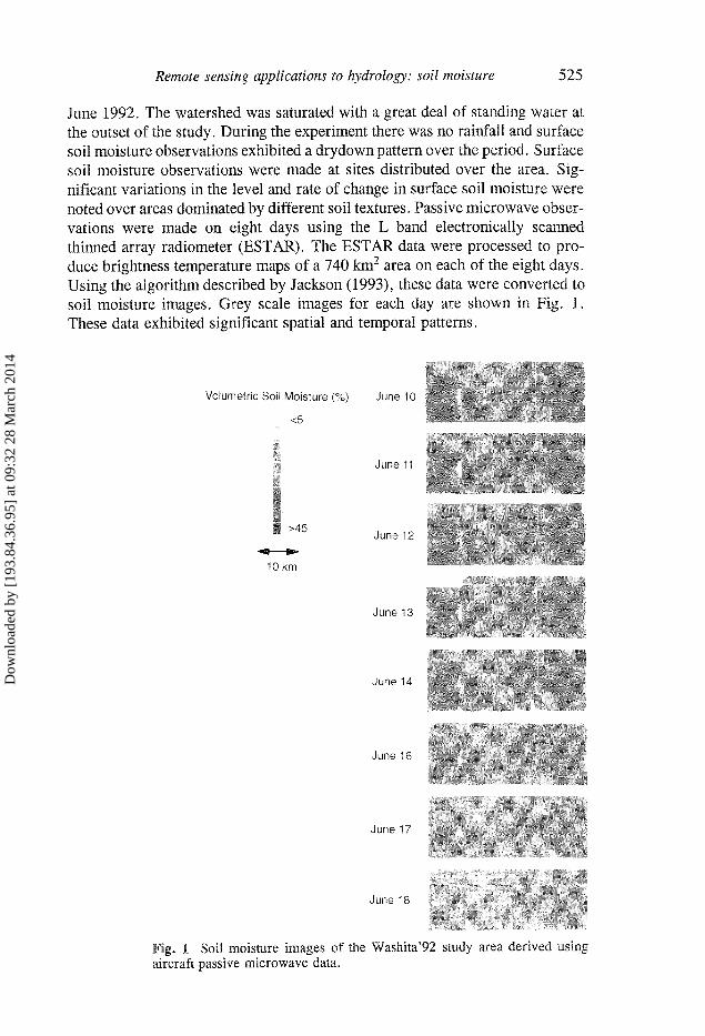
June 1992. The watershed was saturated with a great deal of standing water at the outset of the study. During the experiment there was no rainfall and surface soil moisture observations exhibited a drydown pattern over the period. Surface soil moisture observations were made at sites distributed over the area. Significant variations in the level and rate of change in surface soil moisture were noted over areas dominated by different soil textures. Passive microwave observations were made on eight days using the L band electronically scanned thinned array radiometer (ESTAR). The ESTAR data were processed to produce brightness temperature maps of a 740 km2 area on each of the eight days. Using the algorithm described by Jackson (1993), these data were converted to soil moisture images. Grey scale images for each day are shown in Fig. 1. These data exhibited significant spatial and temporal patterns.
Volumetric Soil Moisture (%) June 10
<5
June 11
> 4 5 June 12
10 km
June 13
June 14
June 16
June 17
June 16
Fig. 1 Soil moisture images of the Washita'92 study area derived using aircraft passive microwave data.
Dow
nloa
ded
by [
193.
84.3
6.95
] at
09:
32 2
8 M
arch
201
4

526 T. J. Jackson et al.
Spatial patterns were clearly associated with soil textures and temporal patterns with drainage and evaporative processes. The relationships between the ground sampled soil moisture and the brightness temperatures were consistent with previous results. An aspect of spatial scaling of soil moisture sensing was investigated using this data set. All the soil moisture samples collected on a given day were averaged for the study area. This same procedure was used for the brightness temperature which was then converted to an emissivity estimate by normalizing with the averaged soil temperature data. This resulted in one pair of emissivity and soil moisture values for each of the eight days. When compared to the Fresnel based predicted relationship there was very good agreement, indicating that the data interpretation algorithms applied within this region and that large scale averaging (740 km2) did not degrade their predictive ability.
During the same experiment described above, the AIRSAR was also flown over the study site a total of seven times. At the present time, the soil moisture algorithms available, even those utilizing multipolarization data, can only be used for bare soils and lightly vegetated conditions. The investigators (Dubois et al., 1995) recognized this and masked out areas that did not satisfy the algorithm conditions using vegetation information derived from visible near-infrared satellite data. They applied the soil moisture algorithm for selected dates to generate soil moisture images similar to the passive microwave results described above. As a byproduct of this procedure, they were also able to produce surface roughness images.
ERS-1 satellite radar studies
The ERS-1 satellite has a C band VV SAR with a nominal incidence angle of 23° and has been in operation since 1991. It provides repeat coverage every 35 days. Based on the early work on soil moisture and so described in Ulaby et al. (1986), there is reason to believe that under the right conditions this satellite might be able to provide surface soil moisture. A number of investigators have evaluated this potential.
Dobson et al. (1992) reported the first set of results which used only a single ERS-1 scene (Michigan, USA) and a few grass fields as ground truth. This was a very limited data set. However the authors augmented their analysis by utilizing a sophisticated radar simulation model. The model was used a priori to predict a relationship between soil moisture and a°. The results supported application to areas of low vegetation.
Sabburg (1994) analysed a single ERS-1 scene for an agricultural area in Australia. The ground truth in this investigation was also very limited. The author utilized an empirical model to establish the soil moisture vs a° relationship a priori. He determined that, for the conditions studied, the surface soil moisture (0-5 cm) could be estimated within 10%.
Since ERS-1 has now been in operation for several years, some results are being reported that include more extensive temporal data sets. Von Poncet
Dow
nloa
ded
by [
193.
84.3
6.95
] at
09:
32 2
8 M
arch
201
4

Remote sensing applications to hydrology: soil moisture 527
& Tapkenhinrichs (1994) used nine ERS-1 scenes collected over 14 months for a study area in Germany. Ground data at six sites were collected at the time of each acquisition for the 0-10 cm surface layer. Analyses indicated that surface roughness variations among the sites had a significant effect on the a°-soil moisture relationship. This was associated with different tillage practices. When the data were grouped using a qualitative assessment of roughness, very good correlations were obtained.
Another extensive ERS-1 study was reported by Cognard et al. (1995). This investigation involved a total of 14 ERS-1 scenes collected over a two year period. The data were collected within the context of a river basin study with 13 test sites. Based on field level analysis, the authors found that the <x°-soil moisture relationship was highly dependent on vegetation and associated tillage conditions. At this level, significant effort would be required to determine soil moisture. A significant improvement was made when the average a° for the basin (12 km2) on each day was compared to the average soil moisture from the 13 sites. However, the sensitivity of a° to soil moisture was very low, about 10% volumetric soil moisture for 1 dB a° . Considering the absolute accuracy of the o° values, this means that a considerable amount of uncertainty must be expected in the soil moisture estimates.
SSM/I satellite studies
The only existing satellite passive microwave system with any potential in 'soil moisture applications is the Special Sensor Microwave/Imager (SSM/I). The limiting feature of the SSM/I for soil moisture related studies is that the frequencies are markedly higher than L band. This will impact two aspects of the data: the contributing depth of the soil and the attenuation of the signal resulting from vegetation. The frequency of coverage is excellent. With three operating satellites, almost daily coverage is available for most of the Earth. In addition, both a.m. and p.m. coverage is often available.
It should be noted that the SSM/I was not designed to retrieve soil moisture (Heymsfield & Fulton, 1992). However, a number of studies have been conducted that have attempted to relate the SSM/I data to soil moisture related parameters. Choudhury (1993) examined the reflectivity patterns of three regions (desert, rainforest and grass savanna) over a two year period using data collected by the SSM/I. Comparisons of the desert and rainforest sites showed the expected theoretical results. The differences correlated well with observed rainfall patterns indicating the possibility that some moisture signal could be present in the data.
Most of the satellite soil moisture related studies have not actually used soil moisture. Instead they have utilized the antecedent precipitation index (API). Teng et al. (1993) examined four years of SSM/I 19 and 37 GHz data collected over a four state region of the midwestern United States. Using API as the soil moisture surrogate, the authors found that the relationship between API and the
Dow
nloa
ded
by [
193.
84.3
6.95
] at
09:
32 2
8 M
arch
201
4

528 T. J. Jackson et al.
19 GHz TB was highly dependent on the geographical location which was in turn correlated with the vegetation level. The sensitivity of this relationship (the slope of the regression) was found to be well correlated with the polarization difference at 37 GHz. The implied procedure for predicting API is to use the polarization difference at 37 GHz to determine the regression parameter and then to predict API using the 19 GHz TB. The limiting factor in this approach is the sensitivity. At some level of vegetation, the sensitivity will be smaller than the uncertainties of other factors, making the API estimates unreliable.
The study reported by Heymsfieid & Fulton (1992) is interesting because it quite clearly shows the limitations of the SSM/I and also the potential of the information if a better soil moisture sensor were available. Data from the SSM/I satellite (19, 37 and 86 GHz) were obtained for Oklahoma and Kansas following a very large rainfall event. Following the event, data for two raingauge stations (one bare and one rangeland) that had received over 13 cm of rainfall were tracked for a period of time. For both locations there was no rainfall for 10 days following the event. At the bare soil site, the effect of the rainfall was large ( > 50°K) at both 19 and 37 Ghz. This range was larger than might have expected and it is also surprising that after 10 days the effects of the rainfall were still evident at these frequencies. This may be the result of low evaporative demand in this region at the time of the study. On the other hand, the effect of the rainfall over the grassland dominated region is much more difficult to detect. This of course suggests that the SSM/I has significant limitations on the types of areas or land covers for which it can be used to estimate soil moisture.
Owe et al. (1992) have conducted possibly the only study that actually attempted to relate satellite microwave observations to surface soil moisture. They utilized data from a C band instrument that was on the Nimbus-7 satellite between 1978 and 1987 called the Scanning Multifrequency Microwave Radiometer. The only factor that might be considered questionable in this study is that the original ground observations of surface soil moisture were based on neutron probe observations of the 0-20 cm soil layer. Averaging over a 150 km2
area for the 6.6 GHz footprint in semiarid southern Africa using three years of observations, the authors found a good relationship between normalized TB and surface soil moisture after adjusting for the normalized difference vegetation index (NDVI). The authors also noted the superiority of "Night-time" observations due to a more uniform soil moisture profile and a stronger correlation of soil and air temperature.
SUMMARY
The ability to monitor surface soil moisture over extended time periods and areas could provide valuable new information for applications in hydrology. Surface soil moisture can be measured using microwave sensors. Depending on the platform and the sensor, the scale of application could range from a few
Dow
nloa
ded
by [
193.
84.3
6.95
] at
09:
32 2
8 M
arch
201
4
Remote sensing applications to hydrology: soil moisture 529
metres to the globe. There are limitations on microwave-based soil moisture sensing. At the
present time it is recognized that at some level of biomass the vegetation will mask the signal from the soil. The use of longer wavelengths can minimize this effect. Passive and active microwave sensors each have advantages and disadvantages. The spatial resolution of passive instruments will limit the range of applications when used on a satellite. Sensitivity to other surface features could limit the usefulness of active systems for direct soil moisture estimation. Selecting the best system will require tradeoffs and prioritizing applications. It may be that the optimal sensor system would include both an active and a passive instrument. This would allow a range of applications and the synergism of the two types of measurements to provide new information.
Widescale research and application will continue to be severely hampered by the limitations of currently available and planned satellite instruments. All these instruments have been designed for some other purpose. Although the optimal systems for soil moisture are known, the priority is not high within the current space agency programs. Discipline groups such as soil science and hydrology must be more aggressive with these agencies to make them recognize the need for appropriate long wavelength microwave sensors in space.
REFERENCES
Ahuja, L. R., Wendroth, O. & Nielson, D. R. (1993) Relationship between the initial drainage of surface soil and average profile saturated hydraulic conductivity. Soil Sci. Soc. Amer. J. 57, 19-25.
Benallegue, M. O., Taconet, O., Vidal-Madjar, D. & Normand, M. (1995) The use of radar backscattering signals for measuring soil moisture and surface roughness. Remote Sens. Envir. 53, 61-68.
Choudhury, B. J. (1993) Reflectivities of selected land surface types at 19 and 37 GHz from SSM/I observations. Remote Sens. Envir. 46, 1-17.
Cognard, A., Loumagne, C , Normand, M., Olivier, P., Ottle, C , Vidal-Madjar, D., Louahala, S. & Vidal, A. (1995) Evaluation of the ERS-1/synthetic aperture radar capacity to estimate surface soil moisture: two-year results over the Naizin watershed. Wat: Resour. Res. 31, 975-982.
Dobson, M. C , Pierce, L., Sarabandi, K., Ulaby, F. T. & Sharik, T. (1992) Preliminary analysis of ERS-1 SAR for forest ecosystem studies. IEEE Trans. Geosci. Remote Sens. 30, 203-211.
Dubois, P. C., van Zyl, J. & Engman, T. (1995) Measuring soil moisture with imaging radars. IEEE Trans. Geosci. Remote Sens. 33, 915-926.
Heymsfield, G. A. & Fulton, R. (1992) Modulation of SSM/I microwave soil radiances by rainfall. Remote Sens. Envir. 29, 187-202.
Hollinger, J. P., Peirce, J. L. & Poe, G. A. (1990) SSM/I instrument evaluation. IEEE Trans. Geosci. Remote Sens. 28, 781-790.
Jackson, T. J. (1993) Measuring surface soil moisture using passive microwave remote sensing. Hydrol. Processes 7, 139-152.
Jackson, T. J. & Schmugge, T. J. (1989) Passive microwave remote sensing system for soil moisture: some supporting research. IEEE Trans. Geosci. Remote Sens. 27, 225-235.
Jackson, T. J., O'Neill, P. E., Kustas, W. P., Bennett, E. & Swift, C. T. (1995a) Passive microwave observation of diurnal soil moisture at 1.4 and 2.65 GHz. Proc. Int. Geoscience & Remote Sensing Symp., 492-494. IEEE no. 95CH35770.
Jackson, T. J., Le Vine, D. M., Swift, C. T., Schmugge, T. J. & Schiebe, F. R. (1995b) Large area mapping of soil moisture using the ESTAR passive microwave radiometer in Washita'92. Remote Sens. Envir. 53, 21-31.
Le Vine, D. M., Griffis, A. J., Swift, C. T. & Jackson, T. J. (1994) ESTAR: a synthetic aperture microwave radiometer for remote sensing applications. Proc. IEEE 82, 1787-1801.
Lin, D. S., Wood, E. F., Saatchi, S. & Seven, K. (1994) Soil moisture estimation over grass covered areas using AIRSAR. Int. J. Remote Sens. 15, 2323-2343.
Livingston, C. E., Gray, A. L., Hawkins, R. K. & Olsen, R. B. (1988) CCRS C/X band airborne SAR: a research and development tool for the ERS-1 time frame. IEEE Aerospace and Electronic Systems 3(19), 11-20.
Dow
nloa
ded
by [
193.
84.3
6.95
] at
09:
32 2
8 M
arch
201
4
530 T. J. Jackson et al.
Njoku, E. G. & Kong, J. (1977) Theory for passive microwave remote sensing of near-surface soil moisture. J. Geophys. Res. 82, 3108-3118.
Oh, Y., Sarabandi, K. & Ulaby, F. T. (1992) An empirical model and an inversion technique for radar scattering from bare soil surfaces. IEEE Trans. Geosci. Remote Sens. 30, 370-381.
O'Neill, P. E., Chauhan, N. S., Jackson, T. J., Le Vine, D. M. & Lang, R. H. (1994) Microwave soil moisture prediction through corn in Washita'92. Proc. IGARSS'94, 1585-1587. IEEE no. 94CH3378-7.
Owe, M., van de Griend, A. A. & Chang, A. T. C. (1992) Surface soil moisture and satellite microwave observations in semiarid southern Africa. War. Resour. Res. 28, 829-839.
Raju, S., Chanzy, A., Wigernon, J. P., Calvet, J. C , Kerr, Y. & Laguerre, L. (1995) Soil moisture and temperature profile effects on microwave emission at low frequencies. Remote Sens. Envir. 54, 85-97.
Sabburg, J. M. (1994) Evaluation of an Australian ERS-1 SAR scene pertaining to soil moisture measurement. In: Proc. Int. Geoscience and Remote Sensing Sytnp., 1424-1426. IEEE no. 0-7803-1497-2/94.
Schmugge, T. J. (1980) Effect of texture on microwave emission from soils. IEEE Trans. Geosci. Remote Sens. GE-18, 353-361.
Schmugge, T. J., Jackson, T. J., Kustas, W .P. & Wang, J. R. (1992) Passive microwave remote sensing of soil moisture: results from HAPEX, FIFE and MONSOON'90. ISPRSJ. Photo. Rem. Sens. 47, 127-143.
Sofko, G. J., Koeler, J. M., McKibben, M. J., Whacker, A. G., Hinds, M. R., Brown, R. J. & Brisco, B. (1989) Ground microwave operations. Canad. J. Remote Sens. 15, 14-27.
Teng, W. L., Wang, J. R. & Doraiswamy, P. C. (1993) Relationship between satellite microwave radiometric data, antecedent precipitation index, and regional soil moisture. Int. J. Remote Sens. 14, 2483-2500.
Ulaby, F. T., Moore, R. K. & Fung, A. K. (1986) Microwave Remote Sensing: Active and Passive, Vol. Ill: From theory to application. Artech House, Dedham, Massachusetts, USA.
Von Poncet, F. & Tapkenhinrichs, M. (1994) Analysis of soil physical parameters and their influence on ERS-1 backscatter. In: Proc. Int. Geosci. Remote Sensing Symposium, 1432-1434. IEEE no. 0-7803-1497-2/94.
Wilheit, T. T. (1978) Radiative transfer in a plane stratified dielectric. IEEE Trans. Geosci. Remote Sens. GE-16, 138-143.
Dow
nloa
ded
by [
193.
84.3
6.95
] at
09:
32 2
8 M
arch
201
4